Embed Size (px)
Citation preview
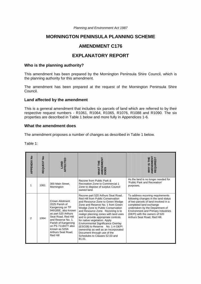
Planning and Environment Act 1987
MORNINGTON PENINSULA PLANNING SCHEME
AMENDMENT C176
EXPLANATORY REPORT Who is the planning authority? This amendment has been prepared by the Mornington Peninsula Shire Council, which is the planning authority for this amendment. The amendment has been prepared at the request of the Mornington Peninsula Shire Council. Land affected by the amendment This is a general amendment that includes six parcels of land which are referred to by their respective request numbers - R1061, R1064, R1065, R1076, R1088 and R1090. The six properties are described in Table 1 below and more fully in Appendices 1-6. What the amendment does The amendment proposes a number of changes as described in Table 1 below. Table 1:
APP
END
IX N
o
REQ
UES
T N
o
LAN
D
AFF
ECTE
D
WH
AT
THE
AM
END
MEN
T D
OES
W
HY
IS T
HE
AM
END
MEN
T R
EQU
IRED
?
1 1061 300 Main Street, Mornington
Rezone from Public Park & Recreation Zone to Commercial 1 Zone to dispose of surplus Council owned land.
As the land is no longer needed for ‘Public Park and Recreation’ purposes.
2 1064
Crown Allotment 2025 Parish of Kangerong on TP 949185E, also known as part 520 Arthurs Seat Road, Red Hill and Reserve No. 1, Parish of Kangerong on PS 711847Y also known as 520A Arthurs Seat Road, Red Hill
Rezone part 520 Arthurs Seat Road, Red Hill from Public Conservation and Resource Zone to Green Wedge Zone and Reserve No. 1 from Green Wedge Zone to Public Conservation and Resource Zone. Rezoning is to realign planning zones with land uses and to provide appropriate controls for native vegetation. Apply Environmental Significance Overlay (ESO28) to Reserve No. 1 in DEPI ownership as well as an Incorporated Document through use of the Schedules to Clauses 52.03 and 81.01.
To address rezoning requirements following changes in the land status of two parcels of land involved in a completed land exchange undertaken by the Department of Environment and Primary Industries (DEPI) with the owners of 520 Arthurs Seat Road, Red Hill.
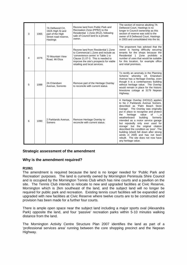
3 1065
7A Dellwood Crt, 192A High St and part of the High Street road reserve, Hastings
Rezone land from Public Park and Recreation Zone (PPRZ) to the Residential 1 Zone (R1Z), following sale of Council land to a private owner.
The section of reserve abutting 7A Dellwood Court, Hastings is no longer in Council ownership as this section of reserve was sold to the owner of 8 Dellwood Court, Hastings in 2003 and consolidated into the lot.
4 1076 70 Mountain View Road, Mt Eliza
Rezone land from Residential 1 Zone to Commercial 1 Zone and include as ‘convenience centre’ in Table 1 to Clause 21.07-3. This is needed to improve the site’s prospects for viable retailing and local services.
The proponent has advised that the owner is having difficulty securing tenants for the shops because the Residential 1 Zone prohibits a number of uses that would be suitable for this location, for example office and retail premises.
5 1088 2A Erlandsen Avenue, Sorrento
Remove part of the Heritage Overlay to reconcile with current status.
To rectify an anomaly in the Planning Scheme whereby 2A Erlandsen Avenue has a Heritage Overlay, even though it is a contemporary building without heritage value. The Overlay would remain in place for the historic limestone cottage at 3179 Nepean Highway.
6 1090 2 Parklands Avenue, Somers
Remove Heritage Overlay to reconcile with current status.
A Heritage Overlay (HO312) applies to No 2 Parklands Avenue Somers, described as ‘Palm Beach Store Garage’. The Overlay was originally put in place to recognise and protect the heritage value of ‘…a weatherboard building formerly intended as a motor service garage but reputedly only ever used for storage’ but the original citation described the condition as ‘poor’. The building (shed) fell down after strong winds in 2005 and has not been rebuilt. The site does not now have any heritage value.
Strategic assessment of the amendment Why is the amendment required? R1061 The amendment is required because the land is no longer needed for ‘Public Park and Recreation’ purposes. The land is currently owned by Mornington Peninsula Shire Council and is occupied by the Mornington Tennis Club which has nine courts and a pavilion on the site. The Tennis Club intends to relocate to new and upgraded facilities at Civic Reserve, Mornington which is 2km southeast of the land, and the subject land will no longer be required for public park and recreation. Existing tennis court facilities will be expanded and upgraded with new facilities at Civic Reserve where twelve courts are to be constructed and provision has been made for a further four courts. There is ample open space near the subject land including a major sports oval (Alexandra Park) opposite the land, and four ‘passive’ recreation parks within 5-10 minutes walking distance from the land. The Mornington Activity Centre Structure Plan 2007 identifies the land as part of a ‘professional services area’ running between the core shopping precinct and the Nepean Highway.
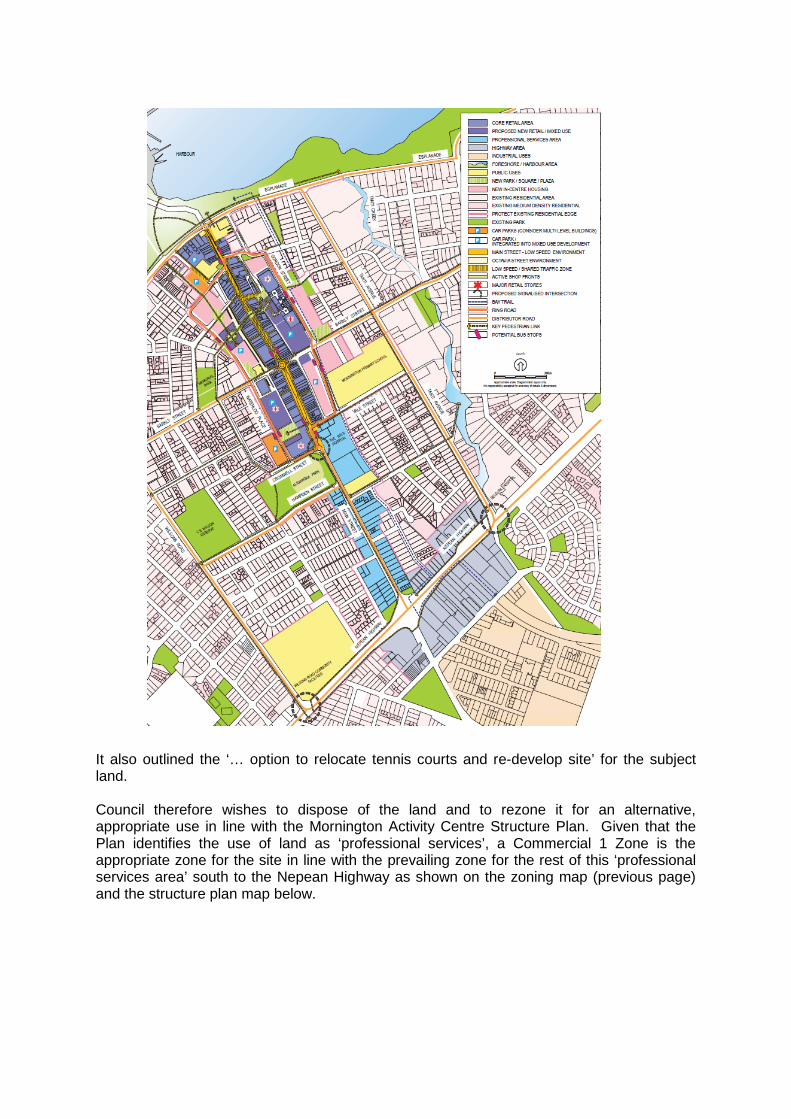
It also outlined the ‘… option to relocate tennis courts and re-develop site’ for the subject land. Council therefore wishes to dispose of the land and to rezone it for an alternative, appropriate use in line with the Mornington Activity Centre Structure Plan. Given that the Plan identifies the use of land as ‘professional services’, a Commercial 1 Zone is the appropriate zone for the site in line with the prevailing zone for the rest of this ‘professional services area’ south to the Nepean Highway as shown on the zoning map (previous page) and the structure plan map below.

Council resolved to sell the land to The Bays Hospital (under the condition that it is rezoned). The funds from the sale will be used to develop new tennis facilities at Civic Reserve. Council has entered a Memorandum of Understanding with The Bays Hospital to sell the land, but subject to rezoning the land to ‘Business 5 Zone’ which was the applicable zone at the time. Statutory provisions to sell the land to the Hospital pursuant to Section 189 of the Local Government Act 1989 have now been carried out, including public notices and notifications. The Bays Hospital adjoins the site to the north and intends to use the land for hospital purposes. Sale of the land cannot proceed until Council and the Hospital enter into a Section 173 Agreement for the land. The Agreement will require that future development is in accordance with structure plan provisions for the area in terms of a ‘strong gateway entrance’ with a ‘landscaped strip’ to provide a ‘green entry’ to the retail core of the centre. The Section 173 Agreement should be expanded to take account of recent changes to the Planning Scheme which came into effect on 15 July 2013. The changes have introduced new Commercial Zones to replace the former Business Zones and will see the transition of Business 5 Zone into a new Commercial 1 Zone. The new Commercial 1 Zone is more flexible and allows more uses than the previous Business 5 Zone which was directed at offices and multi-dwelling units (the Commercial 1 Zone allows for shops and retail premises ‘as of right’). Those previously applicable controls should be retained on the land through the Section 173 Agreement, in order to allay resident concerns that the site might be used for retailing instead of in accordance with the Structure Plan, and to retain the same provisions that were current when the sale price with the hospital was negotiated.
R1064 The amendment is required to address rezoning requirements following changes in the land status of two parcels of land involved in a completed land exchange undertaken by the Department of Environment and Primary Industries (DEPI) with the owners of 520 Arthurs Seat Road, Red Hill. It is noted that Crown Allotment 2025 Parish of Kangerong on TP 949185E has now also been consolidated with Lot 1 on PS 711847Y, 520 Arthurs Seat Road, Red Hill in accordance with the policy framework of the Planning Scheme. As a consequence of the land exchange, a bushland parcel of former freehold land will now be incorporated into the Arthurs Seat State Park through the process of an amendment to the National Parks Act, 1975 and needs to be rezoned to an appropriate public land zone. The exchange has also changed the public land status of a cleared portion of former unreserved Crown land to freehold which needs to be rezoned as GWZ2. The application of the PCRZ and ESO28 to the bushland parcel scheduled to be permanently reserved is consistent with the zoning and overlay controls applied to the existing adjacent parcels of the Arthurs Seat State Park and objectives to conserve and protect sites of conservation significance. The application of GWZ2 to the cleared parcel of former Crown land provides for a zoning that is consistent with adjoining private land. The Incorporated Document has been modified and applied to ensure that subdivision is prohibited on the land added to the PCRZ. This allows compliance with the Metropolitan Green Wedge provisions of the Planning and Environment Act 1987 without requiring ratification of the amendment by both Houses of Parliament.

R1065 The section of reserve abutting 7A Dellwood Court, Hastings is no longer in Council ownership as this section of reserve was sold to the owner of 8 Dellwood Court, Hastings in 2003 and consolidated into the lot. Also, Planning Permit P11/1708 approved the development of a double storey dwelling on the property and subsequently Planning Permit P12/0096 approved the subdivision of land at 7 and 8 Dellwood Court, Hastings from 2 lots to 3 lots. This effectively blocks any access through to Dellwood Court from High Street which was the original purpose of the pedestrian link. Re-establishing the pedestrian link now is likely to incur considerable expense and alternative access is available for all properties via Villawood Drive and Taven Street. The owners of 192 High Street, Hastings have approached Council in relation to purchasing the pedestrian link abutting their property and consolidating this into their lot. R1076 The proponent has advised that the owner is having difficulty securing tenants for the shops because the Residential 1 Zone prohibits a number of uses that would be suitable for this location, for example office and retail premises. One of the existing three shops is used as a café (for which a retrospective planning permit is being sought) which also sells milk, confectionery and newspapers, another shop is used as a hairdressing salon, and the third shop is vacant. The proponents believe that it would be easier to lease the vacant shop if the land was rezoned. Although the range of uses permissible in the Commercial 1 Zone is extensive, there are other similar, small centres in residential areas and it is considered that the proposal has sufficient merit to justify the preparation and exhibition of an amendment. R1088 A single Heritage Overlay (HO177) currently applies to both 3179 Nepean Highway (‘Budgery Gunyah’) and 2A Erlandsen Avenue, Sorrento. The Overlay was originally put in place to recognise and protect the heritage value of the small historic cottage at 3179 Nepean Highway. However, the rear part of the lot (2A Erlandsen Avenue) has been excised from the original lot and a single storey house (in the style of the historic cottage) was constructed on the excised lot following the issue of planning permission and subdivision approval in 1986. Hellier McFarland Development Consultants have initiated this amendment to rectify an anomaly in the Planning Scheme whereby 2A Erlandsen Avenue has a Heritage Overlay, even though it is a contemporary building without heritage value. The Overlay would remain in place for the historic limestone cottage at 3179 Nepean Highway. R1090 A Heritage Overlay (HO312) applies to No 2 Parklands Avenue Somers, described as ‘Palm Beach Store Garage’. The Overlay was originally put in place to recognise and protect the heritage value of ‘…a weatherboard building formerly intended as a motor service garage but reputedly only ever used for storage’ but the original citation described the condition as ‘poor’. The building (shed) fell down after strong winds in 2005 and has not been rebuilt. The site does not now have any heritage value. Council has therefore initiated this request to remove the Heritage Overlay from the property.
How does the amendment implement the objectives of planning in Victoria? The amendment is consistent with the objectives of planning in Victoria below:
• To provide for the fair, orderly, economic and sustainable use and development of land.
• To provide for the protection of natural and man-made resources and the maintenance of ecological processes and genetic diversity.
• To secure a pleasant, efficient and safe working, living and recreational environment for all Victorians and visitors to Victoria.
• To conserve and enhance those buildings, areas or other places which are of scientific, aesthetic, architectural or historical interest, or otherwise of special cultural value.
• To facilitate development in accordance with the objectives set out in the points above. • To balance the present and future interests of all Victorians.
The amendment does this by ensuring appropriate controls over the subject land that provides certainty with respect to development, management and conservation as appropriate. How does the amendment address the environmental, social and economic effects? Environmental effects The amendment will not have adverse environmental effects. Its positive effect will be to protect the richness and diversity of the natural environment by ensuring appropriate planning controls for areas of environmental significance. Social and economic effects The amendment is expected to have positive social and economic effects by giving greater certainty to developers and the community regarding areas suitable for development and areas of cultural and environmental significance that should be conserved and protected. In relation to R1076, it is possible that there would be some increased traffic and noise associated with new uses that would be permitted by a rezoning. However, given the limited extent of the proposal and its potential to provide needed local services, it is considered that the proposal should be exhibited and tested for community feedback in order to better inform a Council decision. Does the amendment address relevant bushfire risk? The changes in the amendment are unlikely to result in any increase in the risks to life, property, community infrastructure and the natural environment from bushfire. The views of the Country Fire Authority (CFA) will be sought as required during exhibition. It is noted that land affected by items R1064 and R1076 is affected by the Bushfire Management Overlay.
Does the amendment comply with the requirements of any Minister’s Direction applicable to the amendment? The amendment is generally consistent with the following Ministerial Directions: Ministerial Direction - The Form and Content of Planning Schemes under section 7(5)
of the Planning and Environment Act 1987. Ministerial Direction No. 1 Potentially Contaminated Land under section 12(2)(a) of
the Act. Ministerial Direction No. 9 Metropolitan Strategy under section 12(2)(a) of the Act. Ministerial Direction No.11 Strategic Assessment of Amendments under section
12(2)(a) of the Act. How does the amendment support or implement the State Planning Policy Framework and any adopted State policy? The amendment is consistent with the State Planning Policy Framework with particular regard to:
Clause 10 – Operation of the State Planning Policy Framework; Clause 11 – Settlement; Clause 12 – Environmental and landscape values; Clause 15 – Built Environment and heritage; Clause 17 – Economic development; and Clause 19 – Infrastructure.
How does the amendment support or implement the Local Planning Policy Framework, and specifically the Municipal Strategic Statement? The amendment implements and supports the Municipal Strategic Statement and in particular the following clause:
Clause 21.07 – Guiding future township development. In relation to R1061, it is consistent with Clause 22.18 – Mornington activity centre. In relation to R1076, it is consistent with Clause 22.12 – Non residential uses in residential zones. In relation to R1088 & R1090, it is consistent with Clause 22.04 – Cultural heritage places. Does the amendment make proper use of the Victoria Planning Provisions? The amendment makes proper use of the Victorian Planning Provisions. How does the amendment address the views of any relevant agency?
The amendment addresses the views of those agencies that have been consulted already. Other agencies will be consulted during exhibition of the amendment. No agencies have yet been consulted regarding R1061 although they were consulted in the preparation of the Structure Plan. If the amendment proceeds to exhibition, VicRoads, Melbourne Water, Department of Transport Planning and Local Infrastructure, Department of Health, and Sport and Recreation will be notified and invited to make submissions.
R1064 implements the outcomes of action taken by the Department of Environment and Primary Industries (DEPI) with the support of Parks Victoria to increase the extent of natural remnant vegetation protected within the Arthurs Seat State Park. Does the amendment address relevant requirements of the Transport Integration Act 2010? Council, as an interface body under the provisions of the Transport Integration Act 2010, has an obligation to have regard to specified matters under that Act. In this case, it is considered that the proposal will have no significant impact on the transport system and will not be inconsistent with the transport system objectives nor the decision making principles of the Act. Resource and administrative costs What impact will the new planning provisions have on the resource and administrative costs of the responsible authority? The items in this amendment are expected to have only a minor impact (if any) on resource and administrative costs. Where you may inspect this Amendment The amendment is available for public inspection, free of charge, during office hours at the following places:
Mornington Peninsula Shire Council www.mornpen.vic.gov.au Hastings Office – 21 Marine Parade, Hastings Mornington Office – 2 Queen Street, Mornington Rosebud Office – 90 Besgrove Street, Rosebud
The amendment can also be inspected free of charge at the Department of Transport, Planning, and Local Infrastructure website at http://www.dpcd.vic.gov.au/planning/publicinspection. Submissions Any person who may be affected by the amendment may make a submission to the planning authority. Submissions about the amendment must be received by 2 June 2014. A submission must be sent to: Private Bag 1000, Rosebud 3939. Panel hearing dates In accordance with clause 4(2) of Ministerial Direction No.15 the following panel hearing dates have been set for this amendment: • directions hearing: To be held in the week of 4 August 2014. • panel hearing: To commence in the week of 1 September 2014.

APPENDIX 1 – 300 MAIN STREET, MORNINGTON (R1061)
Land affected by the amendment
The amendment applies to land known as 300 Main Street, Mornington (otherwise known as Lot 1 PS 715119) and is indicated on the maps below. It has an area of approximately 7800 sqm.
What the amendment does
The amendment rezones the land from Public Park and Recreation Zone to Commercial 1 Zone.
Design and Development Overlay Schedule 13 also covers the land and is not proposed to change. Public Acquisition Overlay covers an approximately 4m wide strip along the street boundary and is not proposed to change.
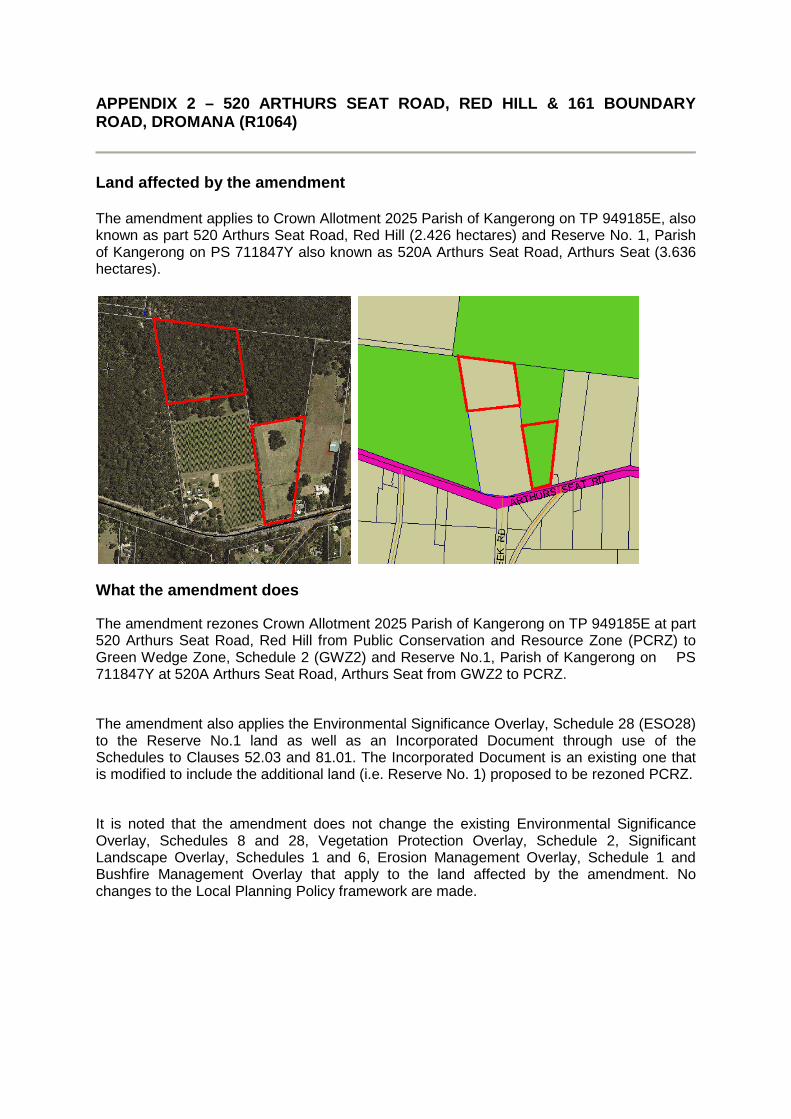
APPENDIX 2 – 520 ARTHURS SEAT ROAD, RED HILL & 161 BOUNDARY ROAD, DROMANA (R1064)
Land affected by the amendment The amendment applies to Crown Allotment 2025 Parish of Kangerong on TP 949185E, also known as part 520 Arthurs Seat Road, Red Hill (2.426 hectares) and Reserve No. 1, Parish of Kangerong on PS 711847Y also known as 520A Arthurs Seat Road, Arthurs Seat (3.636 hectares).
What the amendment does
The amendment rezones Crown Allotment 2025 Parish of Kangerong on TP 949185E at part 520 Arthurs Seat Road, Red Hill from Public Conservation and Resource Zone (PCRZ) to Green Wedge Zone, Schedule 2 (GWZ2) and Reserve No.1, Parish of Kangerong on PS 711847Y at 520A Arthurs Seat Road, Arthurs Seat from GWZ2 to PCRZ.
The amendment also applies the Environmental Significance Overlay, Schedule 28 (ESO28) to the Reserve No.1 land as well as an Incorporated Document through use of the Schedules to Clauses 52.03 and 81.01. The Incorporated Document is an existing one that is modified to include the additional land (i.e. Reserve No. 1) proposed to be rezoned PCRZ.
It is noted that the amendment does not change the existing Environmental Significance Overlay, Schedules 8 and 28, Vegetation Protection Overlay, Schedule 2, Significant Landscape Overlay, Schedules 1 and 6, Erosion Management Overlay, Schedule 1 and Bushfire Management Overlay that apply to the land affected by the amendment. No changes to the Local Planning Policy framework are made.
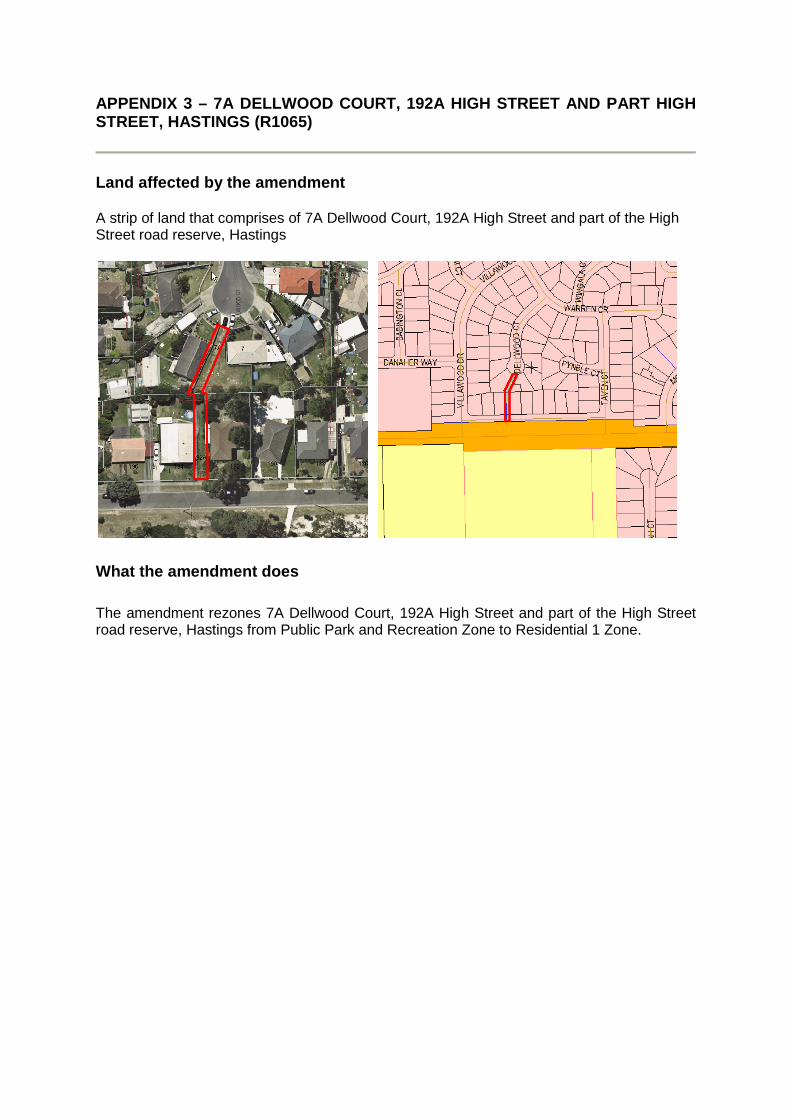
APPENDIX 3 – 7A DELLWOOD COURT, 192A HIGH STREET AND PART HIGH STREET, HASTINGS (R1065)
Land affected by the amendment A strip of land that comprises of 7A Dellwood Court, 192A High Street and part of the High Street road reserve, Hastings
What the amendment does
The amendment rezones 7A Dellwood Court, 192A High Street and part of the High Street road reserve, Hastings from Public Park and Recreation Zone to Residential 1 Zone.
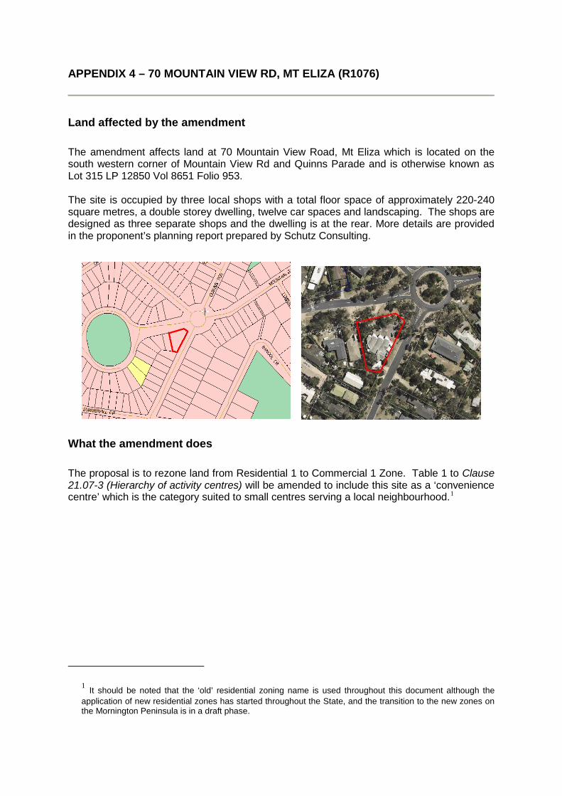
APPENDIX 4 – 70 MOUNTAIN VIEW RD, MT ELIZA (R1076)
Land affected by the amendment
The amendment affects land at 70 Mountain View Road, Mt Eliza which is located on the south western corner of Mountain View Rd and Quinns Parade and is otherwise known as Lot 315 LP 12850 Vol 8651 Folio 953. The site is occupied by three local shops with a total floor space of approximately 220-240 square metres, a double storey dwelling, twelve car spaces and landscaping. The shops are designed as three separate shops and the dwelling is at the rear. More details are provided in the proponent’s planning report prepared by Schutz Consulting.
What the amendment does
The proposal is to rezone land from Residential 1 to Commercial 1 Zone. Table 1 to Clause 21.07-3 (Hierarchy of activity centres) will be amended to include this site as a ‘convenience centre’ which is the category suited to small centres serving a local neighbourhood.1
1 It should be noted that the ‘old’ residential zoning name is used throughout this document although the application of new residential zones has started throughout the State, and the transition to the new zones on the Mornington Peninsula is in a draft phase.
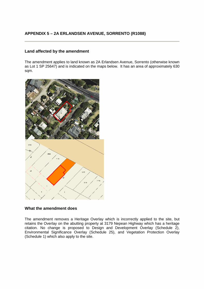
APPENDIX 5 – 2A ERLANDSEN AVENUE, SORRENTO (R1088)
Land affected by the amendment
The amendment applies to land known as 2A Erlandsen Avenue, Sorrento (otherwise known as Lot 1 SP 25647) and is indicated on the maps below. It has an area of approximately 630 sqm.
What the amendment does
The amendment removes a Heritage Overlay which is incorrectly applied to the site, but retains the Overlay on the abutting property at 3179 Nepean Highway which has a heritage citation. No change is proposed to Design and Development Overlay (Schedule 2), Environmental Significance Overlay (Schedule 25), and Vegetation Protection Overlay (Schedule 1) which also apply to the site.

APPENDIX 6 – 2 PARKLANDS AVENUE, SOMERS (R1090)
Land affected by the amendment
The amendment applies to land known as 2 Parklands Avenue, Somers (otherwise known as Lot 1 LP39258) and is indicated on the maps below. It has an area of approximately 1100 sqm.
What the amendment does
The amendment removes a Heritage Overlay which no longer applies to the site because the heritage structure that the Overlay protected fell down in 2005 and has since been removed.