Embed Size (px)
Citation preview
MONO BASIN
FEASIBILITY REPORT
In Response to the Stream Scientists’
“Synthesis of Instream Flow Recommendations” (Synthesis Report)
to The State Water Resources Control Board
and The Los Angeles Department of Water and Power,
April 30, 2010
FINAL DECEMBER 21, 2012
LOS ANGELES DEPARTMENT OF WATER AND POWER


TABLE OF CONTENTS
Los Angeles Department of Water and Power ii December 21, 2012
1.0 EXECUTIVE SUMMARY ........................................................................ 1
2.0 BACKGROUND ................................................................................... 3
3.0 BASELINE OF RESTORATION REQUIREMENTS .......................................... 4
4.0 SUMMARY OF STREAM SCIENTISTS’ FLOW RECOMMENDATIONS ................. 5
5.0 FEASIBILITY OF IMPLEMENTING THE RECOMMENDATIONS .......................... 5
5.1 STRUCTURAL AND OPERATIONAL MODIFICATION ............................................. 6
5.2 SOUTHERN CALIFORNIA EDISON (SCE) ......................................................... 6
5.3 POST-TRANSITION ........................................................................................ 8
5.4 GRANT LAKE RESERVOIR (GRANT LAKE) ...................................................... 12
5.5 RUSH CREEK ............................................................................................. 16
5.6 LEE VINING CREEK ..................................................................................... 18
5.7 5-SIPHONS BYPASS .................................................................................... 19
5.8 PARKER CREEK AND WALKER CREEK .......................................................... 19
5.9 RUSH CREEK FLOW RELEASES COORDINATION ............................................ 20
5.10 MONITORING .............................................................................................. 21
6.0 CONCLUSIONS ................................................................................ 29
APPENDIX A: LADWP’S PROPOSED HYDROGRAPH WITH CALCULATED SEFS
APPENDIX B: CORRESPONDENCES WITH SOUTHERN CALIFORNIA EDISON
APPENDIX C: TERMINATION CRITERIA SUMMARY REPORT AND LADWP’S CONCLUSION


FEASIBILITY REPORT
Los Angeles Department of Water and Power 1 of 29 December 21, 2012
1.0 EXECUTIVE SUMMARY
Pursuant to Decision 1631 and subsequent Water Rights Order 98-05, the Los Angeles Department of Water and Power (LADWP) submits this Mono Basin Feasibility Report to the California State Water Resources Control Board (SWRCB) for consideration. The Report summarizes the feasibility of implementing the SWRCB-appointed Stream Scientists’ new flow and other recommendations for the Mono Basin as proposed in the Synthesis Report (April 2010). The Stream Scientists’ recommendations, as required by SWRCB Decision 1631 and Water Rights Order 98-05, were made solely to benefit the local riparian and trout ecosystem in the Mono Basin. Water Rights Order 98-05, Section 1.b. (2) (a) provides in pertinent parts:
“… Licensee shall implement the recommendation of the monitoring team unless it determines that the recommendation is not feasible. Licensee shall have 120 days after receiving the recommendation from the monitoring team to determine whether to implement the recommendation of the monitoring team. …” Emphasized added.
For this report, LADWP analyzed the feasibility of implementing the new stream flow and monitoring recommendations with respect to technical and financial feasibility as well as reasonableness. This is in accordance with Water Rights Order 98-05 Section 2.4 “Requirements and Evaluation Criteria Governing Restoration Plans Required by Decision 1631”, which is rooted in Decision 1631 Order at 8.f (4) stating:
“The SWRCB will review the final proposed restoration plans based primarily on the following factors: (a) adequacy of the measures proposed to achieve restoration of the fisheries, streams, stream channels, waterfowl habitat and other public trust resources; (b) technical and financial feasibility; and (c) reasonableness.”
In this report, LADWP comments on the feasibility of implementing the stream flow and monitoring recommendations and suggestions made in the Synthesis Report. Analysis and any upgrades/modifications that would be required to implement the recommendations are also presented. The principal comments address export of water from the Mono Basin, management of the Mono Basin system, and the monitoring needs as follows:
1) Analysis of exports from the basin during the post-transition period shows that the long-term export will be approximately 21,700 AF/yr versus the 30,800 AF/yr

FEASIBILITY REPORT
Los Angeles Department of Water and Power 2 of 29 December 21, 2012
as projected in Decision 1631, a difference of 9,100 AF/yr, considering constraints at Grant Lake and Mono Lake as discussed in this report.
2) Managing the Los Angeles Aqueduct and Grant Lake operations, including spilling to achieve the stream ecosystem peak flows, is important, but certain elements such as peak flow magnitudes and Grant Lake elevation at spill levels would present ongoing challenges (e.g., SCE operation, highly variable hydrologic conditions, etc.).
3) In light of the past 12 years of intensive stream monitoring, the proposed monitoring program by the Stream Scientists in the Synthesis Report can further be streamlined as indicated in this report.
In summary, LADWP respectfully requests that the SWRCB, in keeping with the tenor of Decision 1631, strive to maintain a balance between water supply and water for environmental benefit as identified in Section 7.0 of Decision 1631, “Beneficial Uses Served by Water Supply.” Furthermore, prolonged droughts and water shortages in California also make it imperative to have water, an extremely high-valued commodity, available for human needs in such crucial times. Since Decision 1631, LADWP has committed extensive resources to restore the Mono Basin and any call for further substantial commitments should account for balance between water for human needs and water for enhancing and restoring the environment.

FEASIBILITY REPORT
Los Angeles Department of Water and Power 3 of 29 December 21, 2012
2.0 BACKGROUND
The Stream Scientists, Dr. Bill Trush (stream expert) and Mr. Chris Hunter, replaced in 2009 by Mr. Ross Taylor (fishery expert), were charged under Water Rights Order 98-05 (Order 98-05) to evaluate the existing Stream Restoration Flows (SRFs) and baseflow provisions in achieving the goals of “functional and self-sustaining stream system with healthy riparian ecosystem components” and “trout in good condition” for Rush and Lee Vining Creeks in the Mono Lake Basin (Mono Basin). On January 27, 2010, the Stream Scientists submitted a public review draft Synthesis Report. On April 30, 2010, after considering comments by LADWP, stakeholders, and other parties, the Stream Scientists submitted the final Synthesis Report and its appendices, detailing their flow recommendations based on results and analyses of the past 12-years of monitoring for the Mono Basin. Per Order 98-05, the Los Angeles Department of Water and Power (LADWP) had 120 days to evaluate the “feasibility” of the recommendations. The Stream Scientists’ peak flow recommendations go beyond the parameters established in the controlling SWRCB Decision and Order. Also considered as part of the reasonableness factor is the apparent goal of the Stream Scientists’ peak flow recommendations to restore Mono Basin to “pristine” conditions of many years before 1941 when LADWP started diversions, by recommending the mimicking of unimpaired hydrographs for Rush and Lee Vining Creeks. This should not be the restoration goal because by 1941, the ecosystem was already heavily altered by activities of the Southern California Edison (SCE), agricultural operations, and livestock grazing. While pristine conditions may be ideal, they were not the restoration goals of Decision 1631 nor Order WR 98-05. Indeed, the Court of Appeal interpreted Fish and Game Code §5946 and §5937 to require that LADWP must release sufficient water into the streams “to reestablish and maintain the fisheries which existed in them prior to its diversion of water.” California Trout Inc. v. Superior Court (1990) 218 Cal.App.3d 187, 213 (emphasis added). As evidentiary hearings progressed it was recognized that pre-1941 conditions may not be achievable and in some cases not desirable (Order 98-05, page 21 footnote). Over the years transpiring since the SWRCB decisions, a theme of restoration goals, contrary to the court and SWRCB decisions mentioned above, has emerged that places additional responsibilities on LADWP. LADWP is being asked to meet historic unimpaired hydrographs that does not “impaired natural” pre-project hydrographs. This issue is discussed further in Section 3.0 of this report. Given California’s water supply status, it is imperative that LADWP achieves environmental goals in a water efficient manner since surplus water is not available. Mono Basin decisions affect the entire state of California from a water supply perspective. Placing the burden of rectifying all of the historical human activities in the Mono Basin places unfair requirements on LADWP’s ability to exercise its water rights.

FEASIBILITY REPORT
Los Angeles Department of Water and Power 4 of 29 December 21, 2012
3.0 BASELINE OF RESTORATION REQUIREMENTS
The Stream Scientists are requiring LADWP to recreate conditions from prior to the initiation of LADWP’s diversion in 1941, not the “impaired natural” pre-project conditions. The Synthesis Report used modeled unimpaired hydrographs for Rush and Lee Vining creeks as the baseline reference condition. LADWP is being asked to mitigate not only for our diversion impacts but impacts associated with pre-1941 conditions associated with other parties’ activities such as Southern California Edison (SCE) impoundments. For example, LADWP is being requested to mimic unimpaired flows as if SCE facilities were not present. The Stream Scientists’ stream flow recommendations should have been based on impaired natural hydrographs of pre-1941, incorporating the effects of the activities of SCE, agricultural operations, and livestock grazing. LADWP should not be held responsible for the preexisting conditions by the SCE or other parties’ activities. This detracts from our ability to receive a balanced water right decision that recognizes a municipal water supply and balances human needs with that of Mono Basin resources. The SWRCB direction to the Stream Scientists has been (and was reiterated in the recently distributed draft water rights license amendment), directed to use pre-1941 “impaired natural” pre-project conditions as baseline and not unimpaired flows. The Scientists’ stream ecosystem flows (SEFs), developed to reproduce the “unimpaired hydrograph” and return the Mono Basin tributaries to pristine conditions may be an ideal vision, but is not the restoration goal of Decision 1631 or Order 98-05 which the Synthesis Report has stated may never be possible. LADWP is being asked to undo what other entities are doing to the hydrograph even though the conditions of the streams are better now than what existed pre-1941 due to land and flow management changes that LADWP has made in the Basin.
LADWP has revised the Scientists’ recommendations using the flows actually being delivered to its facilities (impaired) and proposes flows that would achieve the same restoration goal as the SEFs were intended for. The proposed flows are tabulated in Appendix A. As acknowledged by the Stream Scientists, LADWP “has demonstrated a strong commitment to the recovery of Mono Lake and its tributary streams while seeking to ensure a supply of water critical to the City of Los Angeles.” With that spirit, LADWP has analyzed the feasibility of implementing the Stream Scientists’ recommendations as summarized in the following sections. For additional guidance regarding “feasibility”, LADWP referred to “Feasibility” as defined in Public Resources Code §21061.1 (commonly known as the California Environmental Quality Act (CEQA)), as “capable of being accomplished in a successful manner within a reasonable period of time, taking into account economic, environmental, legal, social and technological factors.”

FEASIBILITY REPORT
Los Angeles Department of Water and Power 5 of 29 December 21, 2012
4.0 SUMMARY OF STREAM SCIENTISTS’ FLOW RECOMMENDATIONS
A principal element of the Synthesis Report was an evaluation and modification of the previously applied stream flow requirements (e.g., Stream Restoration Flows or SRFs). These flows are runoff year-type dependent that vary for each stream. Stream flow prescriptions consist of multiple elements, including a base flow, transition rates, peak flows, as well as other elements. The basic elements of the stream ecosystem flows (SEFs) proposed in the Synthesis Report are shown in Table 1. Table 1: Summary of Stream Scientists’ Flow Recommendations
Creek Year Type SEF Baseflows SEF Peak Flow
Release April – Sept. Oct. – March Rush Dry 30 27 Dry-Normal I 40 27 Dry-Normal II 40 27 200 cfs for 3 days Normal 40 27 380 cfs for 3 days Wet-Normal 40 27 550* cfs for 3 days Wet 40 27 650* cfs for 5 days Extreme-Wet 40 27 750* cfs for 5 days Lee Vining Dry 30** 16 Apr-Sept: Between
30 - 250 cfs, apply diversion rates; Above 250 cfs, allow peak to pass. Oct-Mar: Bypass Baseflow
Dry-Normal I 30** 16 Dry-Normal II 30** 16 Normal 30** 18-20 Wet-Normal 30** 20-28 Wet 30** 20-30 Extreme-Wet 30** 20-30 Parker & Walker All Flow through conditions *In combination with spill from Grant Lake spillway. **Diversion Rates with 30 cfs as minimum to be sent down the Creek. Above 250 cfs is passed through.
5.0 FEASIBILITY OF IMPLEMENTING THE RECOMMENDATIONS
The feasibility of implementing the various flow recommendations and associated actions has been analyzed from an operational and monitoring standpoint considering the reasonableness of the proposal, as well as its implication to technical and financial feasibility. The major elements that require significant modification are discussed below. A response to the Stream Scientists’ recommendation, in terms of feasibility or need for additional information/study, is also presented. An analysis of LADWPs response concludes each subsection.

FEASIBILITY REPORT
Los Angeles Department of Water and Power 6 of 29 December 21, 2012
5.1 STRUCTURAL AND OPERATIONAL MODIFICATION
Stream Scientists’ Recommendation – In response to stakeholder’s comments submitted for the draft Synthesis Report (January 27, 2010), the Stream Scientists in the final Synthesis Report suggested that if SCE fails to cooperate with LADWP in meeting the peak stream ecosystem flows (SEF), then structural and/or operational modification to Grant Lake Dam provide the only other option for LADWP to reliably provide peak magnitudes to lower Rush Creek. LADWP Response – Not Feasible. Analysis – The SWRCB direction to the Stream Scientists has been (and was reiterated in the recently distributed draft water rights license amendment), to use pre-1941 “impaired natural” pre-project conditions as baseline and not unimpaired flows. The Scientists’ SEFs, developed to mimic the “unimpaired hydrograph” and return the Mono Basin tributaries to pristine conditions may be an ideal vision, but is not the restoration goal of Decision 1631 or Order 98-05 which the Synthesis Report has stated may never be possible. This recommendation is based on a false premise; therefore, it is not reasonable or feasible for LADWP to accept it.
5.2 SOUTHERN CALIFORNIA EDISON (SCE)
Stream Scientists’ Recommendation – Recommendations for Lee Vining and Rush Creek stream flows vary between the two creeks. The recommendation for Lee Vining Creek is formulated as a maximum allowable export based on flows upstream of the diversion structure, and is designed to allow higher and more frequent passing of snowmelt peaks. Grant Lake storage and outlet are used to manage flows during peak flow events. Attaining the necessary snowmelt flood magnitudes for Rush Creek will require assistance by SCE and United States Forest Services (USFS) to release greater peak floods which then could spill from Grant Lake into Rush Creek. Recommended peak flow conditions for various runoff year types are shown in Table 2.

FEASIBILITY REPORT
Los Angeles Department of Water and Power 7 of 29 December 21, 2012
Table 2: Stream Scientists’ Recommended Rush Creek Peak SEF Releases Runoff Year Type
Peak Flow (cfs) Duration (days) Timing Window
Dry None - - Dry-Normal None - - Dry-Normal II 200 3 June 8 – June 22 Normal 380 3 June 19 – July 4
Wet-Normal 380 4
June 26 – July 13 550* 3
Wet 380 5
July 5 – July 19 650* 5
Extreme-Wet 380 8
July 9 – July 22 750* 5
*In combination with spill from Grant Lake LADWP Response – Not Feasible. Analysis – SCE operations were on-going in the Mono Basin before LADWP started diverting in 1941. They have water rights and can control the water that flows to LADWP facilities. LADWP submitted a letter officially requesting comments from SCE on the new recommendations and the feasibility of providing assistance in achieving the high flows. A copy of the Synthesis Report was also enclosed for SCE’s reference. SCE’s response is repeated below (and the full letter is also enclosed in Appendix B):
“These recommendations for the most part are the exact opposite of what is already required in SCE's U.S. Forest Service (USFS) 4(e) conditions and Federal Energy Regulatory Commission (FERC) licenses, which necessitate that we accumulate and hold storage for recreation purposes during the summer months, and then drain the storage during the winter months before the inflows start arriving with the next spring runoff. In addition, these recommendations would conflict with SCE's existing water rights, and with the longstanding contractual arrangements between SCE and LADWP pertaining to the operations of those reservoirs. Consequently, as an initial, generalized response, we have to say that we can not implement the recommendations in the report. Nevertheless, we do not rule out the possibility of attempting to coordinate our operations with you to achieve at least some of the report's recommendations, especially during years of above normal snowpacks when there are unavoidable spill conditions. However, the determinations of any such opportunities would require more specific information in terms of the actual modifications to the existing operations of SCE facilities that would be needed. Accordingly, upon being presented with more detailed requests by either LADWP or the SWRCB, we would be happy to sit down with you and discuss the possibilities at that time.”

FEASIBILITY REPORT
Los Angeles Department of Water and Power 8 of 29 December 21, 2012
As mentioned in Section 3, LADWP has no leverage on SCE activities. SCE have officially informed LADWP (see Appendix B) that they cannot provide the recommended flows as the recommendations are in exact opposite of what is required by Forest Service requirements and FERC licenses not to mention the waste of power generation for their business. They have attended some of the facilitated meetings and informed all stakeholders their stance. SCE operates reservoirs upstream of LADWP’s facilities at Lee Vining and Rush Creeks for hydropower generation purposes; hence flows are modified in magnitude and timing in downstream reaches. Essentially the Stream Scientists are requesting LADWP to undo what SCE does to the hydrograph. The recommended peak flows including spill to augment peak flows for Wet–Normal, Wet, and Extreme-Wet runoff year-types for Rush Creek are only possible if SCE is able to provide water to meet the peak flows within the timing windows. Similarly, for Lee Vining Creek, the Stream Scientists’ recommendation is to allow for higher and more frequent passing of unimpaired snowmelt peaks, which also requires SCE’s cooperation. Recommendations of 550 cfs with spill (Wet-Normal), 650 cfs (Wet), and 750 cfs (Extreme-Wet), as acknowledged in the Synthesis Report, will require SCE to coordinate and time their releases or/and spills from one or more of their reservoirs (Rush Meadows, Gem, and Agnew) so that simultaneous Grant Lake spills can occur. Achieving such cooperation had been difficult in the past as SCE operates under Federal Energy Regulatory Commission (FERC) licenses and United States Forest Services (USFS) recreational requirements for reservoir storage levels requiring certain storage capacity by a certain period. SCE also changes its operations due to upgrades or maintenance work that requires delaying releases of water downstream. It is also important to note that coordination with SCE will not simply require passing flows from upstream of SCE reservoirs to downstream reaches. In many years unimpaired flows may not attain the desired targets identified in the Synthesis Report. This will require SCE to augment stream flow from storage to attain the recommended peak flows below Grant Lake (i.e., lower Rush Creek). Nevertheless, in light of SCE’s above response, LADWP will work with Stream Scientists, stakeholders and SCE’s to detail possible SCE’s operational modifications that would assist in achieving the recommended high peak flows downstream when enough water is available. LADWP is also required to consult with the California State Division of Safety of Dams regarding the spilling of water from the Grant Lake.
5.3 POST-TRANSITION
Post-transition conditions begin when Mono Lake water surface elevation achieves 6,391 feet. Topics addressed herein are: Synthesis Report’s Simulated Post-Transition Diversions and Implications on
Long-Term Mono Basin Export Long-Term Variability Under Historic Hydrology

FEASIBILITY REPORT
Los Angeles Department of Water and Power 9 of 29 December 21, 2012
The following discussion addresses these topics in relation to recommendations and comments in the Synthesis Report that pertain to the post-transition period.
5.3.1 Synthesis Report’s Simulated Post-Transition Diversions and Implications on Long-Term Mono Basin Export
Stream Scientists’ Recommendation – The Synthesis Report’s Section 6.3 presents a summary of Rush Creek and Lee Vining Creek post-transition diversions as a combined annual diversion for each runoff year. Table 3, below, is a reproduction of Table 6-2, which presents this information in the Synthesis Report. Table 3: Synthesis Report’s Table 6-2, Simulated Post-Transition Diversions
Runoff Year Runoff Year
Type
Simulated Future Rush Creek and Lee Vining
Creek Diversions (AF)
Percent of Annual Mono Basin Yield Diverted
1990 Dry 10,467 18% 1991 Dry 19,358 25% 1992 Dry 20,190 28% 1993 Wet-Normal 42,665 30% 1994 Dry 19,984 26% 1995 Extreme-Wet 71,214 33% 1996 Wet-Normal 55,323 34% 1997 Wet-Normal 34,804 24% 1998 Wet 50,116 29% 1999 Normal 27,161 24% 2000 Normal 30,710 27% 2001 Dry-Normal I 30,074 32% 2002 Dry-Normal II 23,959 26% 2003 Dry-Normal I 33,993 32% 2004 Dry-Normal II 27,247 30% 2005 Wet-Normal 64,163 35% 2006 Wet 59,557 32% 2007 Dry 1,825 3% 2008 Normal 10,268 12%
Average: 33,320 26%
LADWP Response – Not Feasible. Post-transition diversions on Table 3 do not represent available export. Post-transition diversions are not feasible because the Stream Scientists flows are inaccurately calculated since they are based on unimpaired pre-1941 hydrographs instead of impaired pre-1941 hydrographs, as mentioned in Section 3 of this report.
Analysis – Table 3 is vague concerning what defines a “diversion” versus an “export.” An analysis to examine the long-term annual average export was completed by LADWP. In this analysis the following assumptions were made:

FEASIBILITY REPORT
Los Angeles Department of Water and Power 10 of 29 December 21, 2012
All SEF’s required by the Synthesis Report have been achieved, with the exception of meeting peak flows in excess of MGORD capacity using Grant Lake spill.
Initial (April 1st) Mono Lake elevation 6391.0 ft above mean-sea-level. Grant Lake storage rules are in place to improved storage management. All Mono Lake elevation export restrictions are applied. Grant Lake minimum storage (i.e., below 11,500 AF of storage) operations were
applied: o All SEF requirements cease and releases are set at flow through
conditions. o Exports are terminated.
The 31-year hydrology from April 1, 1980 to March 31, 2010 (1980 to 2010 runoff years) was employed. Initial findings indicated that the hydrologic sequence notably affected the average long-term annual export volume. To arrive at more robust average long-term annual export volumes and examine the potential range of volumes, multiple hydrologic sequences were examined. Specifically, 31 analyses were completed with the historic hydrology, each starting with a different year from the available record. To complete this assessment the historic hydrology was repeated multiple times, i.e. “wrapped” sequence. The average annual export for each 31 year sequence was calculated. The average long-term annual export was 21,700 AF/yr. The maximum value was 25,300 AF/yr, and the minimum value was 15,000 AF/yr. This analysis indicates two important factors: Long-term average annual export is a function of the hydrologic sequence and
can vary considerably depending on the sequence of runoff year types. Long-term average annual export of 21,700 AF/yr is considerably lower than the
Decision 1631 value of 30,800 AF/yr (“Beneficial Uses Served by Water Diversions”, page 164).
The export discrepancy suggests that the proposed SEF flows would lead to nearly a 30 percent reduction in annual average export from those identified in Decision 1631. These findings illustrate that annual averages and simple mass balances are an inappropriate measure to identify system yield and suggests that SEFs are too high to sustain Decision 1631 post-transition export volumes. Section 6.3 “Annual Yield, SEF Releases, and Export Volumes” of the Synthesis Report presented an average annual diversion volume (also termed “yield” in the Synthesis Report) from Lee Vining Creek and Rush Creek of 33,320 AF (Table 6-2, Synthesis Report, shown above). This annual volume is the sum of two independent mass balance calculations: one for Lee Vining Creek and the other for Rush Creek. Each calculation was considered independently and results reported on an annual basis (Table 6-3, Synthesis Report). Although these values have been updated, the changes are minor and do not have an appreciable impact on this discussion.

FEASIBILITY REPORT
Los Angeles Department of Water and Power 11 of 29 December 21, 2012
The two volumes from Lee Vining (11,437 AF/yr) and Rush Creeks (21,883 AF/yr) were summed in the Synthesis Report and presented as average annual diversion or yield – that water in excess of required stream releases – equal to 33,320 AF/yr. However, this presentation is misleading (the section is titled “Annual Yield, SEF Releases, and Export Volumes”), suggesting that available export may be on the order of 33,320 AF/yr. The analysis included in the Synthesis Report was overly simplistic and neglected several critical elements of operations in the Mono Basin, some of which have been identified in the response to stakeholder’s comments to the draft Synthesis Report. These include:
1) Miscellaneous gains and losses were not included in the analysis; 2) Grant Lake filling and subsequent spill management was assumed to be fully met
from Rush Creek inflows; 3) Grant Lake minimum storage constraints, which have direct effects on both SEFs
and export, were not included; 4) Mono Lake elevation constraints (consistent with rules outlined in the SWRCB
specified Mono Lake elevation conditions), will further constrain export; and 5) Lee Vining Creek diversions into Grant Lake experience evaporation loss and
directly or indirectly support Rush Creek SEFs, reducing the effective “yield” from Lee Vining Creek identified in the Synthesis Report.
When these factors are taken into account, actual exports are estimated to be approximately 21,700 AF/yr1. An additional overarching concern in this analysis was the consideration of hydrology timing and reservoir operations when determining available water for export. The simple mass balancing of flows in Table 6-3 on an annual basis ignored the shorter term (month-to-month, day-to-day, and even sub-daily) variability in the system. Day-to-day operations frequently experience capacity constraints, and the associated shortages that are masked when longer-term (e.g., annual) average values are employed. In sum, the tabulated values in Table 6-3 of the Synthesis Report are theoretical maximum yields for Rush Creek and Lee Vining Creek that cannot be achieved given new operational conditions and legal conditions on Mono Basin operations outlined in Decision 1631. Furthermore, LADWP is concerned that during Wet and Extreme-Wet years excess water that could be available for export cannot be exported due to limited storage and conveyance capacity in downstream facilities. LADWP obtained consulting services of Watercourse Engineering Inc. to create a water balance model called eSTREAM. The model used the Synthesis Report flows to analyze the feasibility of the recommended flows. This model was introduced in the Facilitated Process and has been vetted by a Modeling sub-group consisting of members from each party. Each party has also received a copy of the model for their use. The current model shows that the recommended peak flows are difficult to achieve.
1 Grant storage rules curves are included in this analysis to manage storage.

FEASIBILITY REPORT
Los Angeles Department of Water and Power 12 of 29 December 21, 2012
It also shows that, with or without a modified Grant Lake outlet, the long–term average annual export after Mono Lake reaches 6,391 ft is on the order of 21,700 AF/yr, which is significantly lower than Decision 1631 expected value of 30,800 AF/yr.
5.3.2 Long-Term Variability under Historic Hydrology
Hydrological variability within the Mono Basin is an expected and natural feature. Runoff year designations for the Rush Creek SEFs (template hydrographs) that have the same water year type designation can have substantially different flow timings and volumes. This variability can impact the time it takes Mono Lake to achieve post-transition conditions and the annual exports from the basin (discussed in previous sections). The length of time to attain a Mono Lake level of 6,391 ft will be dependent on not only the future hydrology, but on the sequence of events that will occur in that future hydrology. Dry years will result in falling lake levels, and only in selected normal year types and wetter year types will raise the lake. Such natural variability should be considered in assessing time to attain post-transition conditions and ranges of potential transition periods.
5.4 GRANT LAKE RESERVOIR (GRANT LAKE)
Operations at Grant Lake directly impact the flows in lower Rush Creek and the volumes of water available for export. The major elements of the Synthesis Report that impact Grant Lake are discussed below.
5.4.1 Grant Lake Storage Management
Stream Scientists’ Recommendation – Synthesis Report recommendations regarding Grant Lake storage are limited to specifying three threshold storages/elevations:
1) a minimum storage volume of 11,500 AF; 2) a minimum Grant Lake elevation of 7,100 ft (approximately 20,000 AF storage
volume) should be maintained during July, August, and September of all runoff years; and
3) in Wet-Normal, Wet, and Extreme-Wet runoff years, Grant Lake elevation should be at the spillway elevation (7,130 ft or 47,171 AF) for at least a two week period to facilitate spills.
LADWP Response – Not Feasible. Analysis – The above mentioned threshold values overlook the critical role of actively managing Grant Lake storage throughout the year to (a) facilitate meeting such thresholds should they be adopted, (b) to support SEFs, and (c) to manage storage for water supply (Mono Basin export).
FEASIBILITY REPORT
Los Angeles Department of Water and Power 13 of 29 December 21, 2012
Grant Lake operating rules would assist in management of the system during the post- transition years, particularly in wetter than Normal years when excess water may be available for export. Assessment of rule curves during transition has not been completely investigated, but may be an important element of peak flow management. Analysis of formal Grant Lake operating rules compared to a “no rules” case, identifies the usefulness of flexible management and the possibility of maintaining storage levels, flows, and exports during drier months of certain year types. Additional flexibility is an important attribute of managing operational aspects (SEFs, storage, export) of Grant Lake due to the highly variable hydrologic conditions that naturally occur within the basin.
5.4.2 Grant Lake Spill
Stream Scientists’ Recommendation – Provide additional stream ecosystem flows via spill from Grant Lake in the Wet-Normal and above years.
LADWP Response – Not Feasible. Analysis – LADWP has no leverage on SCE activities (Section 5.2), and the SEFs are inaccurately calculated as described in Section 3.0 of this report, making the Stream Scientists’ recommendations not feasible. The recommendations of providing additional flow to lower Rush Creek via Grant Lake spill cannot be readily and consistently achieved with current facilities without SCE’s assistance. The peak SEFs increase by 100 cfs for each of the wetter year type (Wet-Normal = 550 cfs, Wet = 650 cfs, and Extreme-Wet = 750 cfs). In the 1980 to 2008 hydrology, the peak flows in Rush Creek for each year type were below the proposed SEF peaks indicating that there was insufficient water available in the system to meet these requirements unless SCE is willing to release more water to Rush Creek or the diversion limits from Lee Vining Creek are modified so that additional water could be provided.
For example, in 2006 (a Wet year type), the observed peak flow was 483 cfs on June 7th. The peak SEF requirement associated with a Wet year type is 650 cfs. Even if the full 45 cfs (new diversion table recommendation) were to be diverted from Lee Vining Creek, the total available water of 528 cfs would be over 100 cfs short of the recommended 650 cfs requirement. This simple calculation does not take into consideration evaporation or miscellaneous losses, nor the timing and storage issues associated with SCE operations upstream. (Also, see the comment in Section 5.3.1.)
5.4.3 Grant Lake Level in Restricting Export
Stream Scientists’ Recommendation – The Synthesis Report recommends: 1) no exports before the end of peaking operations; 2) no exports if Grant Lake falls below 11,500 AF; and 3) no exports in July, August, and September when Grant Lake storage falls below 20,000 AF.
LADWP Response – Not Feasible.

FEASIBILITY REPORT
Los Angeles Department of Water and Power 14 of 29 December 21, 2012
Analysis – These three restrictions have not been assessed in light of potential restrictions on short-term (transition) and long-term (post-transition exports). All three of these restrictions have the potential to constrain export opportunities, reducing the annual export of 16,000 AF during transition and compromising the post-transition long-term export volume of 30,800 AF/yr. Export allocations and conditions are specified in Decision 1631 Order 6.a(3) and at this time LADWP is allowed 16,000 AF annually for export, even if Grant Lake falls below 11,500 AF. The Stream Scientists recommendations severely limit exports during dry years and will require drawing from storage to meet requirements in extremely dry years. These conditions are not feasible in light of LADWP’s necessary operations. Terminating export from Mono Basin can adversely affect conditions in the upper Owens River and downstream. Mono Basin exports have historically been an important component of the overall water supply and operations of the Los Angeles Aqueduct. There are a number of environmental projects and conditions that must be accounted for downstream of Mono Basin that could be adversely affected by restrictions of both water supplies and timing of exports. These include Crowley Lake operations, the Owens River Gorge Rewatering, the Lower Owens River Project (LORP), Owens Lake Dust Control Project, irrigation demands, and legal obligations for environmental enhancement projects under the Inyo/LA Agreement and 1997 Memorandum of Understanding.
Mono Basin decisions of the past have also received significant criticisms regarding the failure to recognize down-system impacts of less water. For instance, the Upper Owens River thermal problems are exacerbated during dry years and without exports this situation will only worsen. Spawning runs out of Crowley Lake will be greatly inhibited due to the fish barrier (thermal barrier) created by Hot Creek’s influence on the river and lack of moderating water from above. Irrigation on the Upper Owens River for private ranches and LADWP ranchers also becomes severely restricted. Crowley Lake experiences algal blooms leading to local and downstream water quality issues. Decision 1631 included extensive consideration of balancing Mono Basin environmental issues (both stream flows and Mono Lake levels) with beneficial uses of water supply, and of particular interest were replacement waters when exports were reduced. Prior to adoption of Synthesis Report recommendations, LADWP recommends a thorough examination of potential impacts on Mono Basin exports and consideration of ongoing increases in demands (including downstream Owens River restoration demands: Lower Owens River Project, Owens Lake Dust Control, etc.) and identification of replacement waters if exports fall below Decision 1631’s identified 30,800 AF. Such impacts could have implications at the state level, e.g., deliveries from the Sacramento-San Joaquin Delta, Colorado River, and local supplies would have to be increased to make up the difference. LADWP submitted comments regarding the modifications of the snowmelt bench and peak flow during Dry and Dry-Normal years during the public review period. Those

FEASIBILITY REPORT
Los Angeles Department of Water and Power 15 of 29 December 21, 2012
comments will be repeated here because exports during drier years are crucial from the water supply point of view. Mono Basin export during the post-transition period will be variable, with the largest volumes available in wetter years. However, during these wetter years, export may be reduced due to downstream storage and conveyance capacity limitations. This condition makes drier year exports potentially more important than wetter years from a water supply perspective. The importance of maintaining 16,000 AF/yr during transition and 30,800 AF/yr during post-transition is important for LADWP in meeting near-term and long-term water supply.
5.4.4 Grant Lake Storage for Two Week Period between June 15th-July 15th
Stream Scientists’ Recommendation – Grant Lake storage level should be at the spillway elevation for a two week period between June 15th and July 15th in Wet-Normal and above runoff years.
LADWP Response – Not Feasible.
Analysis – The Synthesis Report proposed SEF requirements for Rush Creek included a controlled or managed spill component (“snowmelt peak (spill)”) in Wet-Normal and above year types. To facilitate these “peak” flows, the Synthesis Report recommends that Grant Lake be maintained at capacity for the two weeks prior to the spill event. In most cases, this would require that Grant Lake be at capacity from mid-June to mid-July. Filling and maintaining Grant Lake at capacity largely depends on conditions in the reservoir (e.g., how much water is in the reservoir on April 1st), the required stream ecosystem flows in April, May and June, the volume of water being provided by the Lee Vining Conduit, and the inflows from Rush Creek. Maintaining Grant Lake at capacity also requires that enough water flow into the reservoir to offset evaporation and other miscellaneous losses (e.g., seepage). From runoff years 1980 to 2008, there have been twelve runoff years that were Wet-Normal or above. In most of these runoff years, achieving the target elevation requires having between 31,500 AF and 45,500 AF already in Grant Lake on April 1st. Having this range of required storage on April 1st is dependent upon operations and hydrological conditions from the previous runoff year. Between April 1st and mid-June, local runoff into Grant Lake from Rush Creek and Lee Vining Conduit inflows can augment Grant Lake storage. Without diversions from Lee Vining, the existing storage in Grant Lake must be higher (typically several 1,000 AF) on April 1st to achieve the spillway elevation by June 15th. Periods when Grant Lake elevation is below the spillway are typically prolonged when diversions from Lee Vining are prohibited. Inflows from Rush Creek, and upstream flows in Lee Vining Creek, are controlled by releases (or spills) from SCE facilities upstream. The 1980 to 2008 flows in Rush Creek were sufficient to achieve capacity storage on June 15th, but were often unable to maintain that storage volume. Typically, when releases are increased to meet peak flow requirements associated with the SEF schedule, the storage in Grant Lake drops below capacity and spills abate. In only three of the twelve runoff years, were storages at the spillway elevation for the entire period coinciding with maximum required release.
FEASIBILITY REPORT
Los Angeles Department of Water and Power 16 of 29 December 21, 2012
Additional challenges in maintaining Grant Lake at spillway elevation, let alone attain the desired peak flows include:
1) Sub-daily variability in Rush Creek inflows due to snowmelt response to meteorological conditions.
2) Routing flows through Grant Lake to spill: the reservoir will attenuate peak inflows.
3) Incidental spill while attempting to hold Grant Lake at the spillway invert, resulting in inefficient use of water. Incidental spill may be due to sub-daily variation in inflow (first point) or due to modest, short-term increases in runoff (e.g., short-term minor peak), variability in Lee Vining Creek diversions, wind, and potentially other factors.
4) If Grant Lake is held below the spillway to account for the aforementioned points, a considerable amount of the primary snowmelt peak may be required to “top off” Grant Lake to attain the spill. Subsequently, sufficient storage must be developed to fill Grant Lake above the spillway (i.e., develop sufficient head) to convey the desired flows.
5.5 RUSH CREEK
The elements of the Synthesis Report pertaining to Rush Creek include Mono Gate One Return Ditch (MGORD), water Releases to Rush Creek and template hydrographs, and long-term variability under historic hydrology are discussed below.
5.5.1 Mono Gate One Return Ditch (MGORD)
Stream Scientists’ Recommendation – A flow of 380 cfs in the MGORD in Normal and above years. LADWP Response – Feasible. Analysis – Some facility improvements will be required to the MGORD.
5.5.2 Water Releases and Template Hydrographs
Stream Scientists’ Recommendation – Stream Scientists have stated that the recommended hydrographs are templates and not the final recommended annual hydrographs. They noted that small-magnitude (such as 3 percent to 6 percent) hydrograph transitions in the Rush Creek SEF cannot necessarily be reproduced in LADWP releases. LADWP Response – Feasible with modification. Analysis – Small daily flow rate releases such as 3 to 6 percent are unreasonable and operationally not feasible. The Stream Scientists have indicated that the recommended

FEASIBILITY REPORT
Los Angeles Department of Water and Power 17 of 29 December 21, 2012
annual hydrographs for Rush Creek must be considered templates and have acknowledged that small-magnitude hydrograph transitions cannot all be feasibly reproduced. LADWP can feasibly operate water releases to lower Rush Creek from Grant Lake using a minimum increment of 10 cubic feet per second (cfs) or 10 percent, whichever is greater. The eight foot gate used to operate release flows from Grant Lake is not suited for small changes in flows. Once the gate is moved during a flow change, the gate must be reseated, and the reseating of the gate by itself can change flows by a few cfs. Also, the method of determining flows can have a margin of error up to a few cfs, again causing problems with achieving a specific flow down MGORD. With very small flow changes, trying to unseat a massive gate, move it slightly, reseat it, and then wait several hours for the flows to travel to MGORD, all in an environment where flow measurement error is greater than the actual flow change, is impractical, especially in light of the inability to define the ecological implications of a given small flow difference (such as between 35 and 41 cfs, for instance). In lieu of the 3 percent to 6 percent small rate of change specified by the SEFs, LADWP proposes keeping the smallest existing ramping rate as prescribed in Order 98-05, which is 10 cfs or 10 percent, whichever is greater. Flow changes of a minimum of 10 cfs increments are the smallest that can practicably be made to the MGORD in a reliable and operationally reasonable fashion. A sample hydrograph with LADWP feasible 10 cfs/10 percent ramping is shown below in Figure 1 for a Normal year type. LADWP would like to note that the recommended new SEFs will require more flow changes than currently done due to more ascension and recession nodes in the hydrographs as well as specific time periods the flow changes have to be made. This would entail more manpower and wear and tear on the outlet gate, potentially resulting in increased maintenance needs. Further, LADWP supports the recommendations that allow for some flexibility in recommended flows. For example, a Rush Creek baseflow recommendation of 27 cfs is the mid-range of 25 to 29 cfs. However, as with the existing ramping schedules, precise flows will still be a challenge as explained earlier and operational flexibility should be allowed when more frequent flow changes are recommended.

FEASIBILITY REPORT
Los Angeles Department of Water and Power 18 of 29 December 21, 2012
Figure 1: Sample Feasible Hydrograph
5.6 LEE VINING CREEK
The major elements of the Synthesis Report on Lee Vining Creek, including window of acceptable flows, and Lee Vining Creek flow diversion rate operations are discussed below.
5.6.1 Window of Acceptable Flows
Stream Scientists’ Recommendation – As a rule-of-thumb, for a given flow release or flow diversion, the recommendation states that no greater than 5 percent change in stage height at Lee Vining Intake bracketing the targeted stage height is acceptable margin of error. For example, a targeted flow release of 40 cfs on Lee Vining Creek has stage height of 1.69 ft (using a stage-discharge rating curve introduced in Chapter 4). A 5 percent bracketing 1.69 ft would equal an upper stage of 1.73 ft and lower stage of 1.65 ft. Converting these upper and lower stage heights back to flow rates gives an upper flow release of 43 cfs and a lower flow release of 37 cfs, for a 6 cfs acceptable range. LADWP Response – Feasible. Analysis – The analyses performed allowing for some variations in flows that translated to a plus/minus allowable stage height change of 2.5 percent (total of 5 percent) are feasible to LADWP.

FEASIBILITY REPORT
Los Angeles Department of Water and Power 19 of 29 December 21, 2012
5.6.2 Lee Vining Creek Flow Diversion Rate Operations
Stream Scientists’ Recommendation – A one cfs increment diversion rate for April 1 to September 30 period for all runoff years (Table 5 and Table 6). LADWP Response – Not Feasible. Analysis – The SWRCB direction to the Stream Scientists has been (and was reiterated in the recently distributed draft water rights license amendment), to use pre-1941 “impaired natural” pre-project conditions as baseline and not unimpaired flows. The Scientists’ stream ecosystem flows (SEFs), developed to mimic the “unimpaired hydrograph” and return the Mono Basin tributaries to pristine conditions may be an ideal vision, but is not the restoration goal of Decision 1631 or Order 98-05 which the Synthesis Report has stated may never be possible. This recommendation is based on a false premise; therefore, it is not reasonable or feasible for LADWP to accept it.
5.7 5-SIPHONS BYPASS
Stream Scientists’ Recommendation – In drier runoff years, if Grant Lake storage falls below 25,000 AF by July 15th, all available Lee Vining Creek diversions should be diverted directly into Rush Creek via the 5-Siphons Bypass to cool Rush Creek through September 15th. LADWP Response – Not Feasible. Analysis –The recommendation is not feasible because the Scientists flows are inaccurately calculated since they are based on unimpaired pre-1941 hydrographs instead of impaired pre-1941 hydrographs, as mentioned in Section 3 of this report. Order 98-05, 1.b(2)(b) had tasked the Stream Scientists to evaluate the effects of augmenting Rush Creek flows with up to 150 cfs from Lee Vining Creek in order to provide SRFs. The Scientists did not do this. Instead, they reduced the use of the Lee Vining Creek water to augment Rush Creek and made the recommendation mentioned above. From and engineering perspective, discharge via the 5-Siphons Bypass of 150 cfs is feasible. From an ecologic perspective, no data has been collected to document impacts at 150 cfs. Given that the flows would be diverted passed the peak flow for a period over two days, detrimental impacts are not anticipated.
5.8 PARKER CREEK AND WALKER CREEK
The main element of the Synthesis Report pertaining to Parker and Walker Creek diversions is discussed below.
FEASIBILITY REPORT
Los Angeles Department of Water and Power 20 of 29 December 21, 2012
5.8.1 Curtailment of Diversion
Stream Scientists’ Recommendation – Curtailment of diversion from Walker and Parker creeks in all year types, including Dry years.
LADWP Response – Not Feasible. Analysis – The Stream Scientists were not charged with developing these flows. Order
98-05 allows LADWP to divert from Walker and Parker Creeks. LADWP will continue to operate in accordance with Order 98-05.
5.9 RUSH CREEK FLOW RELEASES COORDINATION
Stream Scientists’ Recommendation – Coordinate Rush Creek flow releases with Parker and Walker creeks’ hydrograph to augment flood peak magnitude below the Narrows and improve flood peak timing relative to annual woody riparian seed release. LADWP Response – Not Feasible. Analysis – This coordination is challenging because it requires several hydrological and ecological processes to happen simultaneously. If spilling Grant Lake takes priority, then timing with Walker and Parker’s peaks will most likely be infeasible because while waiting to fill Grant Lake, the peaks for Walker and Parker could pass. Additionally, the peak flow timing of Walker, Parker, and Rush Creek may not happen coincident because each year is different and accurately predicting hydrological processes is difficult. In addition, coordinating all three peak flows with peak woody riparian seed release is challenging because the peak seed release period varies from year-to-year. For example, this year (2010), Parker and Walker flows peaked weeks before the cottonwoods and willows put on seed and, as of June 25, 2010, the cottonwoods still had no seeds.
5.9.1 Dry Year Export Modification
Stream Scientists’ Recommendation – 70 cfs for Dry year snow melt bench for Rush Creek. LADWP Response – Not Feasible. Analysis – The SWRCB direction to the Stream Scientists has been (and was reiterated in the recently distributed draft water rights license amendment), to use pre-1941 “impaired natural” pre-project conditions as baseline and not unimpaired flows. The Scientists’ stream ecosystem flows (SEFs), developed to mimic the “unimpaired hydrograph” and return the Mono Basin tributaries to pristine conditions may be an ideal vision, but is not the restoration goal of Decision 1631 or Order 98-05 which the Synthesis Report has stated may never be possible. This recommendation is based on a false premise; therefore, it is not reasonable or feasible for LADWP to accept it.

FEASIBILITY REPORT
Los Angeles Department of Water and Power 21 of 29 December 21, 2012
5.9.2 Dry-Normal Year Modification
Stream Scientists’ Recommendation – Peak flow of 200 cfs for three days in Rush Creek during Dry-Normal Type II and spring snowmelt bench of 80 cfs during Dry-Normal Years. LADWP Response – Not Feasible. Analysis – The SWRCB direction to the Stream Scientists has been (and was reiterated in the recently distributed draft water rights license amendment), to use pre-1941 “impaired natural” pre-project conditions as baseline and not unimpaired flows. The Scientists’ stream ecosystem flows (SEFs), developed to mimic the “unimpaired hydrograph” and return the Mono Basin tributaries to pristine conditions may be an ideal vision, but is not the restoration goal of Decision 1631 or Order 98-05 which the Synthesis Report has stated may never be possible. This recommendation is based on a false premise; therefore, it is not reasonable or feasible for LADWP to accept it.
5.9.3 Runoff Forecasting
Stream Scientists’ Recommendation – A May forecast to improve the accuracy of the runoff year forecast and the year-type designation. LADWP Response – Feasible.
5.10 MONITORING
Mono Basin Parties and the Stream Scientists request that the current various monitoring (i.e., groundwater, temperature, geomorphic, riparian vegetation, photography, surveys, etc.) to be continued with no specified end date. They also request adaptive management to continue for the new recommendations. The proposed monitoring program proposed by the Stream Scientists is more extensive than the original program with no end dates. LADWP has proposed a new monitoring program which will be performed by the qualified in-house staff.
5.10.1 Grant Lake Elevation, Storage Volume, and Water Temperature
Stream Scientists’ Recommendation – To better define Grant Lake water temperature regime and trophic status, water temperature and dissolved oxygen concentrations should be measured at one-meter depth intervals at the deepest part of the reservoir and adjacent to the MGORD’s intake pipe. Depth profiles samples should be collected at least monthly in the summer and once during late winter. Monitoring should last at least three years, or until enough new data is collected to update Cullen and Railsback thermal gradient profiles and the Stream Temp model scenarios. LADWP Response – Not Feasible.

FEASIBILITY REPORT
Los Angeles Department of Water and Power 22 of 29 December 21, 2012
Analysis – LADWP currently monitors and will continue to monitor Grant Lake elevation and storage. Grant Lake will be operated under the hybrid rules which will keep Grant Lake more full; this will ameliorate temperature concerns to the extent practical in Rush Creek. The Hybrid Rules for Grant Lake attempt to meet summer storage targets while optimizing spills. The Hybrid Rules are based on operating rules of the 98-05 Order. These rules maintain a minimum storage of 11,500 AF and summer storage targets of 20,000 AF. These targets enable spillage during the desired period (June 1 through July 31), after which storage drops sharply allowing export to begin.
5.10.2 Stream and Groundwater Hydrology and Temperature Monitoring
Stream Scientists’ Recommendation – Water temperature loggers (and duplicate backup loggers) are currently deployed at six locations along Rush Creek below Grant Lake, and at two locations on Parker, Walker, and Lee Vining creeks. One logger was recently deployed on upper Rush Creek at the ‘Rush Creek at Dam site (Station 5013) LADWP’ gauge. Water temperatures should be measured at one-hour intervals though the year at established thermograph locations as well as several new locations. New locations include: In the Lee Vining Conduit at the head of the 5-Siphons Bypass At the confluence of the 5-Siphons Bypass with Rush Creek, and Rush Creek immediately upstream of Parker Creek.
LADWP Response – Not Feasible. Analysis – Water temperatures loggers have been deployed at the above locations for two years. The water temperature monitoring should be discontinued because LADWP is meeting fisheries termination criteria (see section 5.12.3) and Grant Lake will be operated to optimize water temperature to the extent feasible. Water temperature cannot be controlled by LADWP; therefore it is not reasonable for LADWP to monitor water temperature along the tributaries.
5.10.3 Groundwater Monitoring
Stream Scientists’ Recommendation – Rush Creek 8 Channel piezometers 8C-2 and 8C-8 should continue to be monitored annually with dataloggers recording at hourly intervals. If MLC discontinues their seasonal groundwater monitoring, then LADWP should equip at least one (preferably more) piezometer in the Rush Creek 10-Channel array and one piezometer in the Lee Vining Creek ‘C’ piezometer array with a continuously recording datalogger. Data should be reported annually in tabular and graphic formats. LADWP Response – Not Feasible. Analysis – All groundwater monitoring should be discontinued for the following reasons. At summer’s end 2012, there will be 4-years of continuous monitoring along the 8-Channel that spans a full range of “run-off year types” that includes “Wet”, “Normal” and “Dry”. Subsequently, relationships between stream discharge and groundwater levels along the 8-Channel can be developed for nearly all flow conditions.

FEASIBILITY REPORT
Los Angeles Department of Water and Power 23 of 29 December 21, 2012
These results can be confidently extended to the 10-Channel because of the similarity that exists among the physical variables that drive surface-groundwater exchange (geology, stream channel and valley morphology) at both the 8 and 10 Channels sites. Thus no additional piezometers are required along the 10-Channel. Lastly, Lee Vining Creek met the termination criteria for riparian acreage in both 1989 and 2004 and thus does not warrant the installation of a piezometer and related monitoring.
5.10.4 Streamflow Gauging
Stream Scientists’ Recommendation – Streamflow gauging at current (and future) LADWP sites should continue reporting daily flows and lake elevation metrics on a real-time basis on the LADWP website, and be made available in annual summary format. LADWP Response – Feasible. Analysis – Real time flows will be continuously posted on the LADWP website. As with any other real-time measuring instruments, technical glitches can occur and there may be problems from time-to-time. Mono Lake elevation is currently read on a biweekly basis, and this number will be continuously posted on the website and the summary data are reported in the annual report.
5.10.5 Synoptic Stream Discharge Measurements
Stream Scientists’ Recommendation – Synoptic stream discharge measurements should continue to be conducted on Rush Creek to determine the extent of groundwater recharge or discharge downstream of the Narrows during different seasons and stream flow periods. LADWP Response – Not Feasible. Analysis – Monthly synoptic stream discharge measurements on both Rush and Lee Vining Creeks have been conducted for the last two years and has gathered enough data to know where Rush and Lee Vining Creeks are gaining and losing water. Flows on Rush Creek were sampled below the MGORD from 29 to 73 cfs and below the narrows from 32 to 104 cfs. Flows in Lee Vining Creek were sampled from 14 to 92 cfs. The Stream Scientists’ above question has been answered and synoptic stream discharge measurements are no longer necessary.
5.10.6 Rush Creek County Road Gage
Stream Scientists’ Recommendation – The infrastructure remains in place for the gauging station at the Rush Creek County Road crossing. Installation of a physical infrastructure (e.g., a flume or hardened grade control structure) may be warranted. However, streamflow data from this site, or at a more feasible location very near this site, will be essential for assessing groundwater recharge dynamics during snowmelt

FEASIBILITY REPORT
Los Angeles Department of Water and Power 24 of 29 December 21, 2012
peaks releases and for assessing implications of streamflow accretions and losses during baseflow periods. LADWP Response –Not Feasible. Analysis – The Rush Creek County Road gauging station should not be re-operated. The area is too hydrologically unstable and the cross section changes too much to develop a reliable rating curve. Monthly synoptic stream discharge measurements on Rush Creek over the last two years have identified the gaining and losing sections and groundwater recharge dynamics during snowmelt peak releases. Therefore, a gage is not needed in this vicinity.
5.10.7 Winter Baseflows
Stream Scientists’ Recommendation – It was recommended that at least one more season of winter baseflow monitoring should be conducted during the winter of 2010-2011 at two of the five sections established on Lee Vining Creek and that a new section is studied on Rush Creek. On Lee Vining Creek, the Stream Scientists recommend that pool and riffle transects in Sections D and F are re-occupied during the winter of 2010-2011. On Rush Creek it is recommended that two transects (one pool and one riffle) are established just upstream of the Parker Creek confluence because synoptic flow measurements identified the reach between Highway 395 and Parker Creek as Rush Creek’s greatest losing reach. LADWP Response – Feasible Analysis – LADWP conducted ice monitoring in Lee Vining Creek during the winters of 2009-2010 and 2010-2011 and in Rush Creek during the winter of 2010-2011. Results showed that extensive ice formations, particularly anchor ice, were greatly influenced by occurrence, frequency, and duration of freeze-up periods in Lee Vining Creek. Freeze-up periods are periods which daily average temperature drops below 32°F. Extents of ice formations were much greater during these periods, and ice disappeared between these freeze-up periods. The time-lapse camera revealed anchor ice dislodging and reforming in a daily basis in Lee Vining Creek. Anchor ice mostly disappeared within hours of sunrise. LADWP did not find extensive anchor ice formation in the Rush Creek reach between Highway 395 and Parker Creek most likely due to warmer water temperature released by Grant Lake Reservoir. LADWP concludes that ice formation is mainly driven by winter air temperature regime, and lower winter baseflows will not exacerbate ice conditions in Lee Vining and Rush creeks.
5.10.8 Geomorphic Monitoring Aerial Photography
Stream Scientists’ Recommendation – Obtain high resolution, orthorectified aerial photographs of the Rush and Lee Vining Creek corridors from Grant Lake to Mono Lake (Rush Creek), from Hwy 395 to Mono Lake (Lee Vining Creek), and from the Conduit to Rush Creek for Parker and Walker creeks. Photographs should be true color images (four bands, including Near InfraRed), attain 3.5 cm pixel resolution, and use airborne

FEASIBILITY REPORT
Los Angeles Department of Water and Power 25 of 29 December 21, 2012
GPS/IMU). Photographs should be obtained at 5-year intervals or after all Wet and Extreme-Wet runoff years. LADWP Response – Feasible with modifications. Analysis – Imagery should be one foot or better resolution, in true color as a single 4-band (red, green, blue, near infra-red). These four bands should be collected simultaneously with identical look angles, and precisely registered. The same aerial photo for the riparian vegetation mapping will be used for this geomorphic monitoring. Changes at such a small scale (3.5 cm) over five year period are most likely insignificant in ecologic, hydraulic, geomorphic, and hydrologic sense. Due to shadows and glares, 3.5 cm pixel resolution is less likely to achieve such high accuracy. In addition, LADWP lacks a capacity to store, access, and process such large size data. A 1 ft resolution used during 2009 approximately required 216 GB of storage space. A 3.5 cm pixel resolution would require approximately hundred times more storage capacity (21.6 TB). Microsoft XP operation system only provides the maximum RAM capacity of 4 GB. Thus, 3.5 cm pixel resolution aerial photos would not be able to be processed or accessed. Aerial photos should be obtained at five-year intervals until 10 years after Mono Lake reaches 6391.
5.10.9 Geomorphic Monitoring Ground Photography
Stream Scientists’ Recommendation – Continue photo monitoring at all monumented photo points established by Gary Smith (retired CDFG biologist) and McBain & Trush, on Rush Creek and Lee Vining Creek, at approximately 5-year intervals (less frequency may be required depending on the scale of change from year to year). Photo-monitoring points established along riparian band transects should also be reoccupied at the same 5-year interval, as a means of tracking changes in riparian vegetation structure. LADWP Response – Feasible Analysis – Ground photography will be continued at five year intervals until 2020.
5.10.10 Riffle Crest Elevations
Stream Scientists’ Recommendation – The Stream Scientists recommend that LADWP survey riffle crest thalweg elevations from the Narrows downstream to Mono Lake along Rush Creek and from top of A4 side-channel downstream to Mono Lake along Lee Vining Creek. Survey riffle crest thalweg elevation along Rush Creek side-channels 3D, and Lee Vining Creek A-3 and A-4 side-channels. This information should be collected at 5-year intervals or after all Wet and Extreme-Wet runoff years (along with aerial photography) and will provide the basis for determining the efficacy of maintaining side-channel openings for riparian vegetation recovery. LADWP Response – Not feasible. Analysis – LADWP is following the side channel opening criteria recommended by the Stream Scientists and approved by the SWRCB on October 6, 2008. The side channel

FEASIBILITY REPORT
Los Angeles Department of Water and Power 26 of 29 December 21, 2012
opening criteria states that channel openings must be maintained until 2012 and therefore riffle crest thalweg elevation surveys are not required.
5.10.11 Sediment Bypass Operations
Stream Scientists’ Recommendation – As stated in SWRCB Order 98-05, all sediment should bypass LADWP diversion structures on Parker and Walker Creeks (for the coarser bed material transported). Sediment storage occurs within the forebay pools (for finer bed material transported) and within each creek’s delta (for the coarser bed material transported). LADWP’s pilot operation using sluice pipes to transport sediment passing into the forebays shows promise. Effectiveness of the sluice pipes in passing all new fine sediment deposited will depend on the sequence of runoff year types encountered during pilot operations. LADWP must demonstrate that the sluice pipes effectively transport the fine sediment transported in Wet as well as Dry runoff years. Coarse sediment (gravel and larger) is more likely to deposit in the delta (where each creek enters its forebay) during sediment mobilizing flood flows rather than farther downstream into the forebay. Significant transport will occur in the wettest years when the chance of having a 5-year flood peak and greater is likely, though even drier runoff years can still generate relatively big flood peaks. The Stream Scientists recommend surveying the bed topography of both deltas in 2010 as done for the forebays, then resurveying following the first 5-year or greater flood peak. The most difficult operational guideline is specifying a threshold increase in stored deltaic coarse sediment that would require excavation. Real-time sediment bypass (passing coarse sediment the same year it is deposited) does not appear warranted. However, delaying excavation until a large volume accumulates will likely create problems re-introducing this coarse sediment back into the mainstem channel downstream. Initially a 2 to 5 year time interval is specified, with surveys of the delta used to adjust this frequency if necessary. LADWP Response – Feasible.
Analysis – The sediment bypass operation plan will be followed.
5.10.12 Trout Habitat Surveys
Stream Scientists’ Recommendation – Future habitat typing and pool surveys should occur on Rush and Lee Vining Creeks to monitor pool and deep-run habitats for brown trout. This information should be collected at 5-year intervals or after all Wet and Extreme-Wet runoff years. Because minimal changes in pool frequency occurred from RY2002 to RY2008 in Rush Creek between the bottom of the MGORD and the Narrows, it is recommended that future surveys begin at the base of the Narrows and extend downstream to the Mono Lake delta. All future Lee Vining Creek habitat typing and pool surveys should cover the 10,000 ft of channel originally surveyed in RY2008 and RY2009 (Knudson et al. 2009). Future surveys should classify pools using the Platts et al. (1983) methods and measure maximum pool depths and thalweg riffle crest depths and elevations so that residual pool depths can be computed and compared to previous surveys.

FEASIBILITY REPORT
Los Angeles Department of Water and Power 27 of 29 December 21, 2012
LADWP Response – Not Feasible. LADWP Response – Not Feasible – LADWP should not be responsible for indefinite monitoring since it is not a “reasonable period of time”. Analysis – With both the Rush and the Lee Vining Creek fisheries meeting termination criteria as stated in Decision 1631 and Order 98-07, (see section 5.11.3) trout habitat surveys are not warranted.
5.10.13 Side Channel Maintenance
Stream Scientists’ Recommendation – Continued side-channel entrance maintenance is recommended for Lower Rush Creek 4 and 8 side-channel entrances in Lower Rush Creek to encourage perennial flow. Maintenance at the 3D entrance to encourage perennial flow is also recommended. Entrance maintenance should not continue indefinitely, but have an exit strategy. More than a 2 ft drop in riffle crest thalweg (RCT) elevation between the mainstem channel and side-channel entrance creates an inhospitable environment for woody riparian regeneration in the Lower Rush Creek floodplain. The Stream Scientists recommend a guideline for terminating side-channel entrances when the adjacent mainstem RCT profile has dropped more than 2.0 ft. Although measuring future mainstem RCT elevation change is not difficult, measuring how much RCT elevation change already has occurred is. This can be accomplished by surveying RCT elevations down the entire side channel and adjacent mainstem channel. In addition these abandoned channels are still low, depressional areas in the floodplain that fill with water during high flow events promoting recruitment of woody riparian vegetation which benefits fish from allochtonous inputs and promotes riparian bird habitat as well. LADWP Response – Not Feasible. Analysis – Side-channel maintenance on the 4Bii and the 8 channels follow the protocols recommended by the Stream Scientists and approved by the SWRCB on October 6, 2008. Maintenance of these side-channels terminated in 2012. As an additional side note, an elevation survey conducted by staff of Mono Lake Committee, Department of Fish and Game, and LADWP found that the riffle crest thalweg associated with the 8 Channel entrance was greater than two feet following the 2011 spring high flows.
5.10.14 Riparian Vegetation
Stream Scientists’ Recommendation – Riparian vegetation can be mapped remotely in RY2015 and in RY2020 on 0.5 ft pixel resolution aerial photographs. Additionally, riparian vegetation mapped remotely in RY2020 would be compared with riparian vegetation maps developed in the field the same year. In RY2020, field and remotely developed riparian maps will be evaluated for accuracy. In Dry years, a qualitative visual survey should be conducted of riparian vegetation along streams where piezometers are located to determine whether riparian vigor has been maintained.

FEASIBILITY REPORT
Los Angeles Department of Water and Power 28 of 29 December 21, 2012
Additional study may be warranted to quantify how the patterns of wet and dry years have affected growth rates and vigor in locations where groundwater data were collected. Comparison of growth rates in RY2007 contrasted against growth rates in RY2009 would provide valuable insight into the specific effects that 30 and 80 cfs would have in a dry year (RY2007 did not have the thresholds met, RY2009 did). LADWP Response – Feasible with modifications. Analysis – The termination criteria for some locations along the Rush and Lee Vining Creek are infeasible, and following the recommendations of the Stream Scientists, the riparian ecosystem will be kept similar in size to what was mapped in Runoff Year 2009. In Runoff Year 2025, remotely sensed riparian maps will be evaluated to ensure that riparian vegetation has indeed fluctuated around 10% of acreage mapped in 2009. If the total acreage in 2025 is greater than or within the 10% 2009 acreage, no further mapping efforts will be undertaken. If the 2025 acreage is more than 10% less than it was in 2009, acreage will be re-evaluated remotely again in 2035.
5.10.15 Trout Population Metrics
Stream Scientists’ Recommendation – The fieldwork for long-term monitoring is similar to the existing annual population sampling occurring in September, including: conducting mark-recapture electrofishing in Rush Creek sections and the Lee Vining Creek mainstem section. Continue to implant PIT tags and recapture previously tagged fish for specific growth rate information. Conduct multiple-pass depletion electrofishing on Walker Creek and the Lee Vining Creek side-channel. Continue to implant PIT tags and recapture previously tagged fish for specific growth rate information. Sample the MGORD in even years with mark-recapture electrofishing to generate a population estimate, calculate RSD values, implant PIT tags, and recapture previously tagged fish for specific growth rate information. In odd years, conducting a single electrofishing pass to generate RSD (relative stock density) values, implant PIT tags, and recapture previously tagged fish for specific growth rate information. Annual electrofishing data should still be used to generate population estimates, length-frequency histograms, density estimates, biomass estimates, condition factors, and RSD values. Length and weights measured from recaptured PIT tagged fish will be used to calculate specific growth rates so that actual growth rates may be compared to predicted growth rates. Because individual fish are uniquely identified, growth (length and weight) for each fish can be computed. Annual growth can then be averaged over all fish of a similar age. LADWP Response – Not Feasible. Analysis – After reviewing and analyzing data collected by the stream scientist from 2000-2011, LADWP has met termination criteria for both Rush and Lee Vining Creeks as described in Decision 1631 and Order 98-07 (see section 6.3).

FEASIBILITY REPORT
Los Angeles Department of Water and Power 29 of 29 December 21, 2012
6.0 CONCLUSIONS
The Synthesis Report represents the culmination of a multi-year (i.e. 12 years) process where the Stream Scientists invested considerable time and energy into the development of the stream ecosystem flows (SEFs) and recommendations. This Feasibility Report was designed to present comments and concerns identified by LADWP during its review of the Synthesis Report. While many issues were raised, the principal comments were with regards to exports, management of the system, and monitoring needs. The recommendations provided by the Stream Scientists do not follow the charge of the SWRCB, Decision 1631, or Order 98-05 requests to restore the streams and ecosystem to “impaired natural” pre-project hydrographs. Instead, the recommended SEFs are based on unimpaired natural hydrographs. The difference between the SEF values for unimpaired and impaired natural hydrographs is the reason behind the infeasibility of the Stream Scientists’ recommendations. Therefore, through extensive research, direction from the SWRCB, and assistance from Watercourse Engineering Inc., LADWP has slightly altered the SEFs so that they are based on impaired natural hydrographs to restore the ecosystem. LADWP respectfully requests that SWRCB carefully considers the issues raised in the Feasibility Report. As acknowledged by the Stream Scientists, LADWP “has demonstrated a strong commitment to the recovery of Mono Lake and its tributary streams while seeking to ensure a supply of water for the City of Los Angeles.” All of the major elements of the Feasibility Report highlight the need for flexible operations and requirements in the Mono Basin. As identified in Decision 1631, and within this Report, there are multiple resource needs that depend on water from the Mono Basin. Conditions within Mono Lake and the associated inflowing streams depend on upstream flow and diversion management, as do conditions in the Owens River system downstream of the Mono Basin. When developing new operational requirements in the basin, it is critical to maintain a balance of the in-basin environmental needs, downstream environmental needs, and human water supply needs. The original Decision 1631 strove to provide balance and that theme should be continued. Operational conditions proposed in the Synthesis Report were presented as if the ability to attain specific flows for specific periods, at specific frequencies and specific locations, were not constrained due to natural conditions, facility limitations, or other factors. The eastern Sierra Nevada hydrologic conditions that occurred in spring and early summer of 2010 – with high flows late in the runoff season – seem to be timely reminder of how variable natural conditions can be. Many were surprised by the late runoff and the elevated flows. Perhaps these conditions suggest that a measure of flexibility and adaptability is not just desired, but critical to balance the identified ecosystem function with water supply and hydropower benefits of Mono Basin waters.


APPENDIX A:
LADWP’S PROPOSED HYDROGRAPH WITH CALCULATED SEFS


Table 1
Revised Water Rights License, Permit 5555
Rush Creek
Extreme Wet
Maintain or exceed 380 cfs for 6 days and peak at or above 530 cfs for 2 days (if necessary augmenting from Lee Vining Creek with 150 cfs). LADWP will make every attempt to deliver “best effort water” whenever possible to exceed 530 cfs.
Justification – Following augmentation requirements, 530 cfs is the maximum capacity of LADWP’s facilities. Per Synthesis Report, flows between 400‐500 cfs perform intermediate to significant geomorphic work and can transport in excess of 90% of the sediment load based on bedload data. Tracer rock data from Synthesis Report shows that generally 70‐80% of the substrate is mobilized by 380 cfs. Bedload sampling from Synthesis Report (2010) shows that duration beyond 1.5 days is less important for mobilizing the majority of the substrate and inducing bar development. 2‐day peak duration, rather than 1.5 days, was chosen because LADWP operates on a daily time‐step. Note that approximately 630 cfs is the “impaired natural” peak magnitude.
Wet
Maintain or exceed 380 cfs for 5 days and peak at or above 480 cfs for 2 days (if necessary augmenting from Lee Vining Creek with 100 cfs)
Justification – Following augmentation requirements, 480 cfs is the maximum capacity of LADWP’s facilities. Per Synthesis Report, flows between 400‐500 cfs perform intermediate to significant geomorphic can transport in excess of 90% of the sediment load based on bedload data. Tracer rock data from Synthesis Report shows that generally 70‐80% of the substrate is mobilized by 380 cfs. Bedload sampling from Synthesis Report (2010) shows that duration beyond 1.5 days is less important for mobilizing the majority of the substrate and inducing bar development. 2‐day peak duration, rather than 1.5 days, was chosen because LADWP operates on a daily time‐step. Note that approximately 500 cfs is the “impaired natural” peak magnitude.
Wet/Normal
Maintain or exceed 380 cfs for 3 days and peak at or above 430 cfs for 2 days (if necessary augmenting from Lee Vining Creek with 50 cfs)
Justification – Following augmentation requirements, 430 cfs is the maximum capacity of LADWP’s facilities. Flows between 300‐450 cfs perform intermediate to significant geomorphic work. Bedload sampling from Synthesis Report (2010) shows that duration beyond 1.5 days is less important for mobilizing the majority of the substrate and inducing bar development. 2‐day peak duration, rather than 1.5 days, was chosen because LADWP operates on a daily time‐step. Note that approximately 450 cfs is the “impaired natural” peak magnitude.
Normal
Peak at 380 cfs for 3 days
Justification – Flows in the range of 300 to 350 cfs perform intermediate geomorphic work and are the approximate channel‐forming discharges for Rush Creek. Bedload sampling from Synthesis Report (2010) shows that duration beyond 1.5 days is less important for mobilizing the majority of the substrate and inducing bar development, however a 3‐day duration was chosen to assist with groundwater recharge and floodplain saturation. Note that approximately 300 cfs is the “impaired natural” peak magnitude.
Dry Normal II (75.5%≤RY≤82.5%)
Peak at 200 cfs for 3 days
Justification – No changes from the Synthesis Report (2010) recommendations. Peak magnitude of 200 cfs prioritizes spawning gravel mobilization, the expected geomorphic function of a dry‐normal II year. Data from the Synthesis Report suggest that between 40 and 60 percent of the D31 (28 to 44 mm) particles are transported by flows exceeding 200 cfs in Lower Rush Creek, which suggests that Lower Rush Creek can likely flush and replenish spawning gravels with flows that exceed 200 cf
Dry/Normal I (68.5%≤RY≤75.5%)
No Peak Required
Justification – Base flows more than sufficient (47 cfs) to maintain riparian health. Excess water not available
Dry No Peak Required
Justification – Base flows sufficient (31 cfs) to maintain riparian health with little contraction. Excess water not available

Lee Vining Creek
Extreme Wet
Pass Peak. No diversions above 250 cfs except when augmenting Rush Creek with 150 cfs for 2 days Justification – Per the Synthesis Report, allowing for passage of all flows above 250 cfs will enable higher peaks to reliably pass down Lee Vining and offer more opportunity for channel forming and larger magnitude events to shape the system and transport the available sediment.
Wet
Pass Peak. No diversions above 250 cfs except when augmenting Rush Creek with 100 cfs for 2 daysJustification – Per the Synthesis Report, allowing for passage of all flows above 250 cfs will enable higher peaks to reliably pass down Lee Vining and offer more opportunity for channel forming and larger magnitude events to shape the system and transport the available sediment.
Wet/Normal
Pass Peak. No diversions above 250 cfs except when augmenting Rush Creek with 50 cfs for 2 daysJustification – Per the Synthesis Report, allowing for passage of all flows above 250 cfs will enable higher peaks to reliably pass down Lee Vining and offer more opportunity for channel forming and larger magnitude events to shape the system and transport the available sediment.
Normal
Pass Peak. No diversions above 250 cfsJustification – Per the Synthesis Report, allowing for passage of all flows above 250 cfs will enable higher peaks to reliably pass down Lee Vining and offer more opportunity for channel forming and larger magnitude events to shape the system and transport the available sediment.
Dry/Normal II (75.5%≤RY≤82.5%)
Pass Single Peak of 160 cfs during May or JuneJustification – A peak magnitude of 160 cfs prioritizes flows that target spawning gravel mobilization, stream productivity, riparian maintenance, and trout foraging habitat, the expected functions for dry‐normal II type years.
Dry Normal I (68.5%≤RY≤75.5%)
Pass Single Peak of 80 cfs during May or JuneJustification – A peak magnitude of 80 cfs prioritizes flows that target stream productivity, riparian maintenance, and trout foraging habitat for dry‐normal I type years.
Dry No Peak Required
Justification – Base flows as required by Decision 1631 are more than sufficient (37 cfs) to maintain riparian health with little contraction. Excess water not available
APPENDIX B:
CORRESPONDENCE FROM SOUTHERN CALIFORNIA EDISON


FEASIBILITY REPORT
6.0 APPENDIX
SCE’s response letter to LADWP regarding the Synthesis Report’s high flow recommendations, July 21, 2010.
Los Angeles Department of Water and Power 33 of 34 July 28, 2010

FEASIBILITY REPORT
Los Angeles Department of Water and Power 34 of 34 July 28, 2010
APPENDIX C:
TERMINATION CRITERIA SUMMARY REPORT
AND
LADWP’S CONCLUSION


Appendix C
Termination Criteria for Rush Creek and Lee Vining Creek Restoration
Background
September 28, 1994 the State Water Resources Control Board (SWRCB) adopted Water Right Decision 1631 (D1631). D1631 revised the conditions of Water Right Licenses 10191 and 10192 which allowed the Los Angeles Department of Water and Power (LADWP) to divert water from four tributaries of Mono Lake. D1631 established: 1) minimum flow requirements necessary to maintain fish in good condition below LADWP’s diversion structures; 2) higher flow requirements to be met on a periodic basis for channel maintenance purposes; 3) detailed water diversion criteria intended to regulate water exports from the Mono Basin in a manner that will result in an eventual long-term average water elevation at Mono Lake of approximately 6,392 feet; and 4) described specific pre-1941 stream conditions for Rush Creek and Lee Vining Creek.
A Settlement Agreement signed in 1997 (Settlement Agreement) called for establishment of quantified criteria for determining when stream restoration will be considered complete, i.e. terminated. The three main categories of stream restoration that have termination criteria are the geomorphic qualities of the channels, fisheries, and the riparian ecosystem. Order 98-05 approved the general termination criteria (TC) agreed to in the Settlement Agreement, and a general description of the termination criteria described in Order 98-05 include:
1. Whether fish are in good condition. This includes self-sustaining populations of brown trout similar to those that existed prior to the diversion of water by Los Angeles and which can be harvested in moderate numbers.
2. Whether the stream restoration and recovery process has resulted in a functional and self-sustaining stream system with healthy riparian ecosystem components for which no extensive physical manipulation is required on an ongoing basis.
Order 98-07 amended the termination criteria by adding quantified data as set forth in R-DWP-68B (Attachment A). Order 98-07 also states that “the stream restoration program may be terminated upon approval of the State Water Resources Control Board following public notice and opportunity for public comment” and the SWRCB will base its determination upon consideration of the two above termination criteria.
1. Geomorphic
The geomorphic termination criteria set forth by SWRCB Order 98-07 include the indices of: channel length, channel slope and sinuosity. Numeric values for each criterion were derived from pre-diversion conditions (i.e. before 1941) and displayed in

Attachment A. Termination values for each index were set for individual reaches or fixed segments along the streams and are listed in Tables 1 and 2 along with the most recently available values.
The majority of reaches (5 of 9) on Rush Creek have met both the length and sinuosity criteria and half of the reaches (3 of 6) meet the slope criteria. On Lee Vining Creek no reaches meet the criteria for length, 2 of the 3 reaches meet criteria for slope, and 1 of 3 meet the sinuosity criteria.
McBain and Trush stated in a Memorandum to SWRCB, dated December 21, 2006, that pre-1941 measured values of channel-bed elevation (needed to calculate slope) and valley length (needed to calculate sinuosity) are likely erroneous. Because of this issue, McBain and Trush suggest in this Memorandum that these termination criteria be removed from Order 98-07. McBain and Trush continued by stating that stream length is a more accurate and practical geomorphic criterion than either slope or sinuosity, as it requires only one measured value and it encapsulates the other geomorphic criteria. However, its usefulness as an index of either current or future restoration success is questionable. In the 2006 Memorandum, McBain and Trush declare that even if the termination criterion for length is met, there is no certainty that the main restoration goals in Rush and Lee Vining Creeks will be accomplished. Further they added, that future stream lengths, as well as trends, are impossible to predict because changes in channel length are determined by the complex interactions between stream flow, sediment and riparian vegetation.
The geomorphic termination criteria values stated in Order 98-07 may be inaccurate and may not indicate restoration success. Additionally, these criteria may not capture the full suite of ecological benefits derived from complex stream-morphology. Rush Creek, for instance, supports multiple side-channels immediately below the “8-channel” entrance (see Figures 1 and 2) during high flows. When flooded, these multiple channels likely provide greater shallow groundwater recharge, high flow refugia for fish, and aid in the development of floodplains by capturing fine sediment. Instead of using the geomorphic termination criteria, both aerial and satellite imagery of the streams should be collected in 5 year intervals until Mono Lake elevation reaches 6391 feet. This imagery will provide the ability to track and quantify changes in channel morphology through time.

Figure 1direction
Figure 2and the c
. Oblique viof flow and
. Rush Creecircle is a ref
iew of Rush the circle is
ek during Ocference poin
Creek durina reference
ctober 21, 20nt.
ng October 2e point.
011 high flow
21, 2011 hig
ws. The arr
h flows. The
row denotes
e arrow den
direction of
otes
flow

Table 1. Termination criteria for Rush Creek. 2003 and 2004 values from both McBain & Trush’s 2005 Compliance Report and December 21, 2006 Memorandum to SWRCB, respectively.
Rush Creek Termination Criteria Reach
2 3A 3B 3C 3D 4A 4B 4C 5A
Length (ft)
Termination Criteria 4,820 3,800 3,100 6,940 3,370 3,070 7,810 4,360 7,320
2004 4,820 3,800 2,956 6,964 3,235 3,078 8,071 3,393 7,073
Difference 0 0 144 0 135 0 0 967 247
Slope (ft/ft)
Termination Criteria 1 0.024 0.016 0.014 0.023 0.022 0.014 0.01 0.005 0.007
2003 0.026 0.017 0.016 0.023 0.021 0.017 0.01 0.007 0.008
Difference -(0.002) -(0.001) -(0.002) 0 0.001 -(0.003) 0 -(0.002) -(0.001)
Additional length needed to meet slope
TC 159 200 258 0 0 565 0 1,507 1,149
Sinuosity (ft/ft)
Termination Criteria 1 1.04 1.06 1.19 1.07 1.04 1.19 1.23 2.11 1.39
2003 1.08 1.07 1.27 1.09 1.03 1.17 1.27 1.57 1.27
Difference 0 0 0 0 0.01 0.02 0 0.54 0.12
Additional length needed to meet
sinuosity TC 0 0 0 0 28 54 0 1,172 644
1. McBain’s and Trush’s memorandum to SWRCB states that these TC are erroneous and suggest that these TC be removed from Order 98‐07

Table 2. Termination criteria for Lee Vining Creek. 2003 and 2004 values from both McBain & Trush’s 2005 Compliance Report and December 21, 2006 Memorandum to SWRCB, respectively.
Lee Vining Creek Termination Criteria Reach
1 2 3A 3B 3C
Length (ft)
Termination Criteria 4,500 7,400 3,500 4,200 1,360
2004 n/a 2,112 3,139 3,795 1,210
Difference n/a 5,288 361 405 150
Slope (ft/ft)
Termination Criteria 1 n/a n/a 0.037 0.025 0.021
2003 n/a n/a 0.037 0.026 0.019
Difference n/a n/a 0 -(0.001) 0
Additional length needed to meet slope TC n/a n/a 0 215 0
Sinuosity (ft/ft)
Termination Criteria 1 n/a n/a 1.33 1.15 1.2
2003 n/a n/a 1.12 1.04 1.23
Difference n/a n/a 0.21 0.11 0
Additional length needed to meet sinuosity TC n/a n/a 589 387 0
n/a = no data provided.
1. McBain’s and Trush’s memorandum to SWRCB states that these TC are erroneous and suggest that these TC be removed from Order 98‐07

2. Fisheries
The termination criteria created by D1631 for Rush Creek are that brown trout averaging thirteen to fourteen inches should be regularly observed and that Rush Creek should fairly consistently produced brown trout three-quarters to two pounds in weight. Lee Vining Creek termination criteria require sustained catchable brown trout averaging eight to ten inches in length and some trout reaching thirteen to fifteen inches (Attachment A).
According to the Stream Scientists, “with the stream restoration flows (SRF) stream flow regime in place the past 12 years, and extensive monitoring activities, controlled flow releases, and a wide range of runoff year types the four Mono Lake tributaries are recovering healthy stream ecosystems. Fish populations are reproducing naturally, and are producing large brown and rainbow trout in some locations (Synthesis Report page 20).” In regards to supporting harvest, Lee Vining Creek has supported a two fish harvest from the Lee Vining Conduit to Mono Lake since 1996. Although no harvest is allowed on Rush Creek below Grant Lake at the moment, a local group is working with the California Department of Fish and Game Commission to try and approve a two fish harvest on Rush Creek.
LADWP analyzed raw length and weight data collected by fisheries scientist for years 2000-2011 to determine if Rush Creek had met Order 98-07 termination criteria. To more accurately estimate the population of Rush Creek, analysis of length and weight data were only conducted when all four sampling sections were sampled that were established by the stream scientist in 1998. Upper and County Road sections on Rush Creek have been sampled every year since 2000. The Lower Rush section was sampled from 2000-2007 and was then replaced with the Bottomland section in 2008. The Bottomlands section has been sampled continuously since 2008. The MGORD is sampled every year, however, mark recapture estimates were only conducted in 2001, 2004, 2006, 2008, and 2010. Therefore, analysis of length and weight data was only conducted for those years when mark recapture estimate were conducted on the MGORD.
Using mark recapture data and the modified Peterson estimator’s equation, population estimates were generated for brown trout ≥ 13 inches, for brown trout age 1+, and brown trout ≥ three quarters of a pound. Fish under one year of age were not included in the estimate because they are not considered catchable in terms of angling due to their size, and their numbers would skew the data. To calculate fish density (fish/km) in each sampling area, a weighted average for each size class was calculated by dividing the sum of the population by the sum of the length of the sampling area. To calculate an overall density for Rush Creek the weighted averages for each section were then averaged.

The four sampled sections on Rush Creek produced an average of 56 fish/km that were ≥ 13 inches in length and an average of 601 fish/km that were age 1+ for the five years sampled. With 9% of the fish/km in Rush Creek being ≥ 13 inches approximately one in ten fish caught while fishing would be greater than or equal to the termination criteria in Order 98-07. Rush Creek had the highest density of fish/km ≥ 13 inches in 2006 at 20% and the lowest in 2008 at 4% (Table 3). In the five sampled years, average number of fish ≥ three-quarters of a pound was 74 fish/km. LADWP used the same population estimate of 601 age 1+ fish/km for the weight comparison. The percentage of fish/km in Rush Creek ≥ three-quarters of a pound is 12%. At Rush Creek greater than one in ten fish will meet or exceed Order 98-07 termination criteria weight (Table 4).
Table 3. Percentage of fish/km that met or exceeded the termination criteria size (13 inches) and were age 1+ for Rush Creek by year.
Table 4. Percentage of fish/km that met or exceeded the termination criteria weight (three-quarters of a pound) and were age 1+ for Rush Creek by year.
LADWP analyzed raw length data collected by the fisheries stream scientist for years 2000-2011 to ascertain whether or not Lee Vining Creek has met Order 98-07 termination criteria. Sampling on Lee Vining Creek from 2000-2006 was conducted at four sites. The upper and lower main channel sites were sampled using the mark recapture method, and the A4 and B1 side channels were sampled using the depletion method. In 2007, both the Upper Main Channel and the A4 Side Channel were dropped from the fisheries monitoring. Analysis of length data was calculated for all four sites from 2000-2006 and then for two sites from 2007-2011.
Using mark recapture data, the modified Peterson estimator’s equation, depletion data, and both the two pass depletion and the multiple-pass depletion equations, population estimates were generated for both brown and rainbow trout ≥ 13 inches, ≥ 8 inches, and
fish/km 2001 2004 2006 2008 2010 Average≥ 13 inches 57 23 131 35 35 56
Age 1+ 466 379 644 879 639 601 Percent 12% 6% 20% 4% 5% 9%
fish/km 2001 2004 2006 2007 2010 Average≥ ¾ of a pound
70 19 221 29 30 74
≥ Age 1+ 466 379 644 879 639 601 Percent 15% 5% 34% 3% 5% 12%

age 1+ fish. D1631 states that Lee Vining Creek sustained catchable trout eight to ten inches in length and that some trout reached 13 to 15inches.
Lee Vining Creek produced an average of 134 fish/km that were ≥ 8 inches length and an average of 3 fish/km that were ≥ 13 inches in length for the 12 years sampled. A population estimate for age 1+ was generated to compare termination criteria lengths against the total age 1+ population. Lee Vining Creek produced an average of 354 age 1+ fish during the 12 year sample period. Thirty-eight percent of the age 1+ fish/km are ≥ 8 inches and 1% of the age 1+ fish/km are ≥ 13 inches. Lee Vining Creek had the highest density of 8 inch fish to age 1+ fish in 2006 at 59% and the lowest in 2008 at 23%. Lee Vining Creek had the highest density of 13 inch fish to age 1+ fish in 2006 at 8% and a low of 0% in 2002, 03, 04, 08, and 09 (Table 5).
Table 5. Number of fish/km that met or exceeded termination criteria size (8 and 13 inches) and were age 1+ for Lee Vining by year.
fish/km
2000
2001
2002
2003
2004
2005
2006
2007
2008
2009
2010
2011
Average
≥ 8 inches
128 180 217 148 127 177 23 88 164 162 109 89 134
≥13 inches
4 4 1 0 0 5 3 4 0 2 4 4 3
≥ Age 1+
300 452 527 269 411 369 39 165 698 629 198 187 354
Percent ≥ 8 inches
43%
40%
41%
55%
31%
48%
59%
53%
23%
26%
55%
48%
38%
Percent ≥ 13 inches
1% 1% 0% 0% 0% 1% 8% 2% 0% 0% 2% 1% 1%
In conclusion, the Rush Creek fishery has met Order 98-07 termination criteria requirement of 13 to 14 inch fish being regularly observed with 9% of the population being ≥ 13 inches. Since 12% of the population ≥ three-quarters of a pound, Rush Creek is fairly consistently producing three-quarters to two pound fish. Lee Vining Creek has also met Order 98-07 termination criteria requirement of sustained catchable trout 8 to 10 inches in length with 38% of the population being ≥ 8 inches and some trout reaching 13 to 15 inches. After fifteen years of fish population monitoring on Rush and Lee Vining Creeks following State Water Resources Control Board (SWRCB) Decision 1631 (D1631) and thirteen years following SWRCB Orders 98-05 and 98-07, the Los Angeles Department of Water and Power (LADWP) is asking for approval from the SWRCB to terminate the fisheries monitoring on Rush and Lee Vining Creeks.

3. Riparian
Recovery of all woody riparian vegetation acreages by designated stream reaches stipulated in the termination criteria (Attachment A) are unattainable in an ecologically sustainable way because it would require extensive planting and irrigation efforts, and/or mechanical manipulation of abandoned flood plains and terraces. Further, based on the proximity of many floodplain surfaces to groundwater, the trajectory of riparian vegetation recovery will not likely reach the pre-diversion acreages, at least in the foreseeable future. (Synthesis Report page 124). However, Riparian vegetation along the four Mono Basin tributary streams has greatly improved since 1989. Some locations along the Mono Lake tributaries are beginning to resemble a forest, with multiple age-classes of trees, a stratified canopy with understory and herbaceous layers, and abundant soil-forming leaf-litter (Synthesis Report page 128). Some locations remain classified desert patch types but are in the early stages of transition to riparian vegetation.
In the Synthesis Report, the Stream Scientists indicated that “In the short-term, a modest increase in riparian acreage over the quantity mapped in Runoff Year 2009 is possible. Presently there are locations where woody riparian plants have established that were not mapped as woody riparian patches because the establishing plants were not visible in the aerial photographs used in mapping. Beyond the modest increase in riparian acreage attributable to the maturation of establishing woody plants, riparian vegetation area, quality, and structure will be maintained similar to that mapped in Runoff Year 2009. This most recent mapping acreage (Table 6) is the strongest indication of what the streams, with their regulated magnitudes and duration, peak timing, and overall volumes, are capable of sustaining through natural processes. Riparian vegetation will not fluctuate more than 10% around the area mapped in Runoff Year 2009”. In conclusion, since the termination criteria for some locations along the Rush and Lee Vining Creek are infeasible, and following the recommendations of the Stream Scientists, the riparian ecosystem will be kept similar in size to what was mapped in Runoff Year 2009. In Runoff Year 2025, remotely sensed riparian maps will be evaluated to ensure that riparian vegetation has indeed fluctuated around 10% of acreage mapped in 2009. If the total acreage in 2025 is greater than or within the 10% 2009 acreage, no further mapping efforts will be undertaken. If the 2025 acreage is more than 10% less than it was in 2009, acreage will be re-evaluated remotely again in 2035.
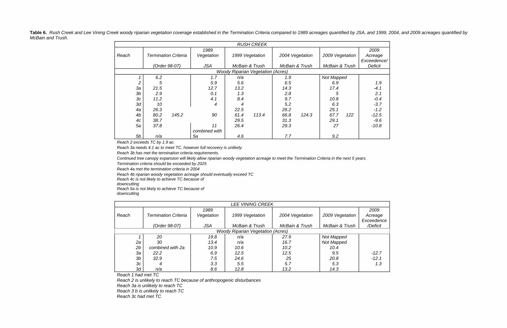
Table 6. Rush Creek and Lee Vining Creek woody riparian vegetation coverage established in the Termination Criteria compared to 1989 acreages quantified by JSA, and 1999, 2004, and 2009 acreages quantified by McBain and Trush.
RUSH CREEK
Reach Termination Criteria 1989
Vegetation 1999 Vegetation 2004 Vegetation 2009 Vegetation 2009
Acreage
(Order 98-07) JSA McBain & Trush McBain & Trush McBain & Trush Exceedence/
Deficit Woody Riparian Vegetation (Acres)
1 6.2 1.7 n/a 1.9 Not Mapped 2 5 5.9 5.6 6.5 6.9 1.9
3a 21.5 12.7 13.2 14.3 17.4 -4.1 3b 2.9 0.1 1.3 2.8 5 2.1 3c 11.2 4.1 8.4 9.7 10.8 -0.4 3d 10 4 4 5.2 6.3 -3.7 4a 26.3
145.2 90 22.5
113.4 26.2
124.3 25.1
122 -1.2
4b 80.2 61.4 66.8 67.7 -12.5 4c 38.7 29.5 31.3 29.1 -9.6 5a 37.8 11 26.4 29.3 27 -10.8
5b n/a combined with 5a 4.6 7.7 9.2
Reach 2 exceeds TC by 1.9 ac. Reach 3a needs 4.1 ac to meet TC, however full recovery is unlikely. Reach 3b has met the termination criteria requirements. Continued tree canopy expansion will likely allow riparian woody vegetation acreage to meet the Termination Criteria in the next 5 years. Termination criteria should be exceeded by 2025 Reach 4a met the termination criteria in 2004 Reach 4b riparian woody vegetation acreage should eventually exceed TC Reach 4c is not likely to achieve TC because of downcutting Reach 5a is not likely to achieve TC because of downcutting
LEE VINING CREEK
Reach Termination Criteria 1989
Vegetation 1999 Vegetation 2004 Vegetation 2009 Vegetation 2009
Acreage
(Order 98-07) JSA McBain & Trush McBain & Trush McBain & Trush Exceedence
/Deficit Woody Riparian Vegetation (Acres)
1 20 19.8 n/a 27.9 Not Mapped 2a 30 13.4 n/a 16.7 Not Mapped 2b combined with 2a 10.9 10.6 10.2 10.4 3a 22.2 6.9 12.5 12.5 9.5 -12.7 3b 32.9 7.5 24.6 25 20.8 -12.1 3c 4 3.3 5.5 5.7 5.3 1.3 3d n/a 8.6 12.8 13.2 14.3
Reach 1 had met TC Reach 2 is unlikely to reach TC because of anthropogenic disturbances Reach 3a is unlikely to reach TC Reach 3 b is unlikely to reach TC Reach 3c had met TC
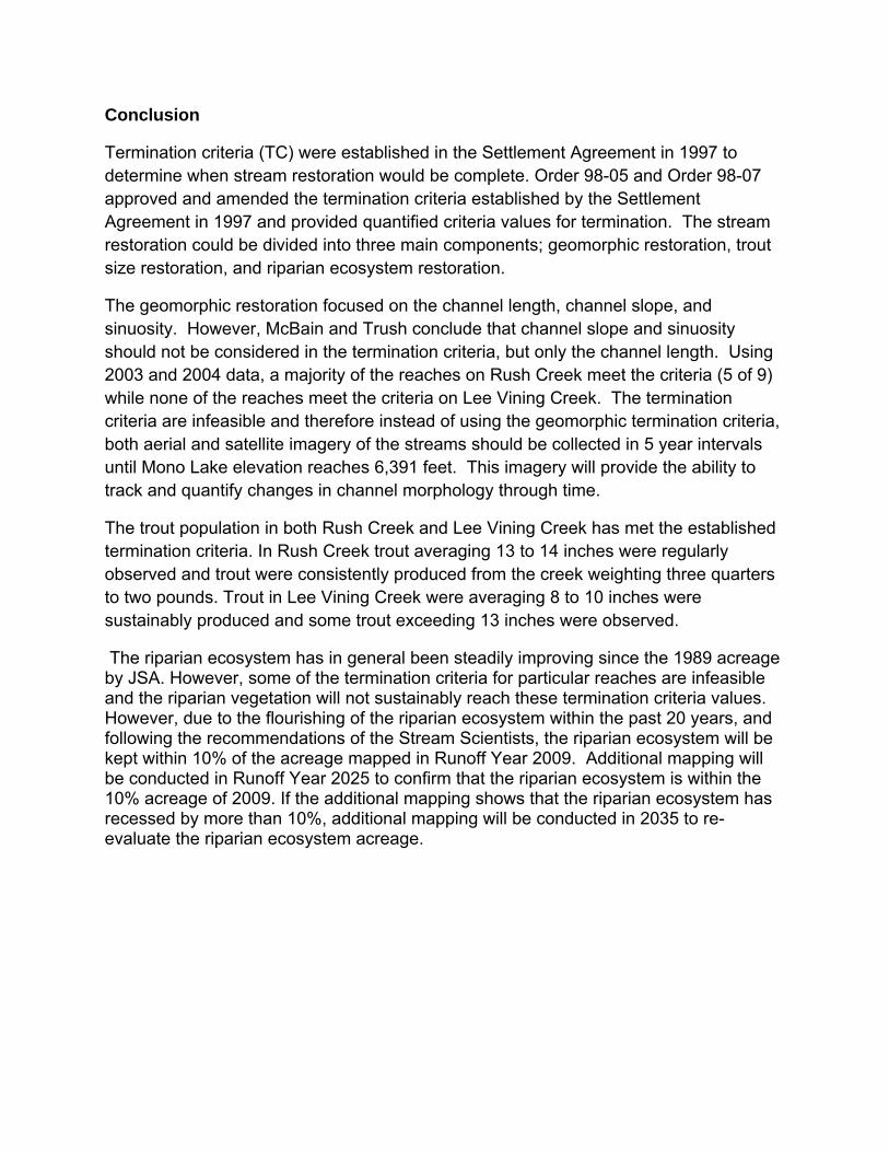
Conclusion
Termination criteria (TC) were established in the Settlement Agreement in 1997 to determine when stream restoration would be complete. Order 98-05 and Order 98-07 approved and amended the termination criteria established by the Settlement Agreement in 1997 and provided quantified criteria values for termination. The stream restoration could be divided into three main components; geomorphic restoration, trout size restoration, and riparian ecosystem restoration.
The geomorphic restoration focused on the channel length, channel slope, and sinuosity. However, McBain and Trush conclude that channel slope and sinuosity should not be considered in the termination criteria, but only the channel length. Using 2003 and 2004 data, a majority of the reaches on Rush Creek meet the criteria (5 of 9) while none of the reaches meet the criteria on Lee Vining Creek. The termination criteria are infeasible and therefore instead of using the geomorphic termination criteria, both aerial and satellite imagery of the streams should be collected in 5 year intervals until Mono Lake elevation reaches 6,391 feet. This imagery will provide the ability to track and quantify changes in channel morphology through time.
The trout population in both Rush Creek and Lee Vining Creek has met the established termination criteria. In Rush Creek trout averaging 13 to 14 inches were regularly observed and trout were consistently produced from the creek weighting three quarters to two pounds. Trout in Lee Vining Creek were averaging 8 to 10 inches were sustainably produced and some trout exceeding 13 inches were observed.
The riparian ecosystem has in general been steadily improving since the 1989 acreage by JSA. However, some of the termination criteria for particular reaches are infeasible and the riparian vegetation will not sustainably reach these termination criteria values. However, due to the flourishing of the riparian ecosystem within the past 20 years, and following the recommendations of the Stream Scientists, the riparian ecosystem will be kept within 10% of the acreage mapped in Runoff Year 2009. Additional mapping will be conducted in Runoff Year 2025 to confirm that the riparian ecosystem is within the 10% acreage of 2009. If the additional mapping shows that the riparian ecosystem has recessed by more than 10%, additional mapping will be conducted in 2035 to re-evaluate the riparian ecosystem acreage.

Attach
R-DWP
ment A
P-68B
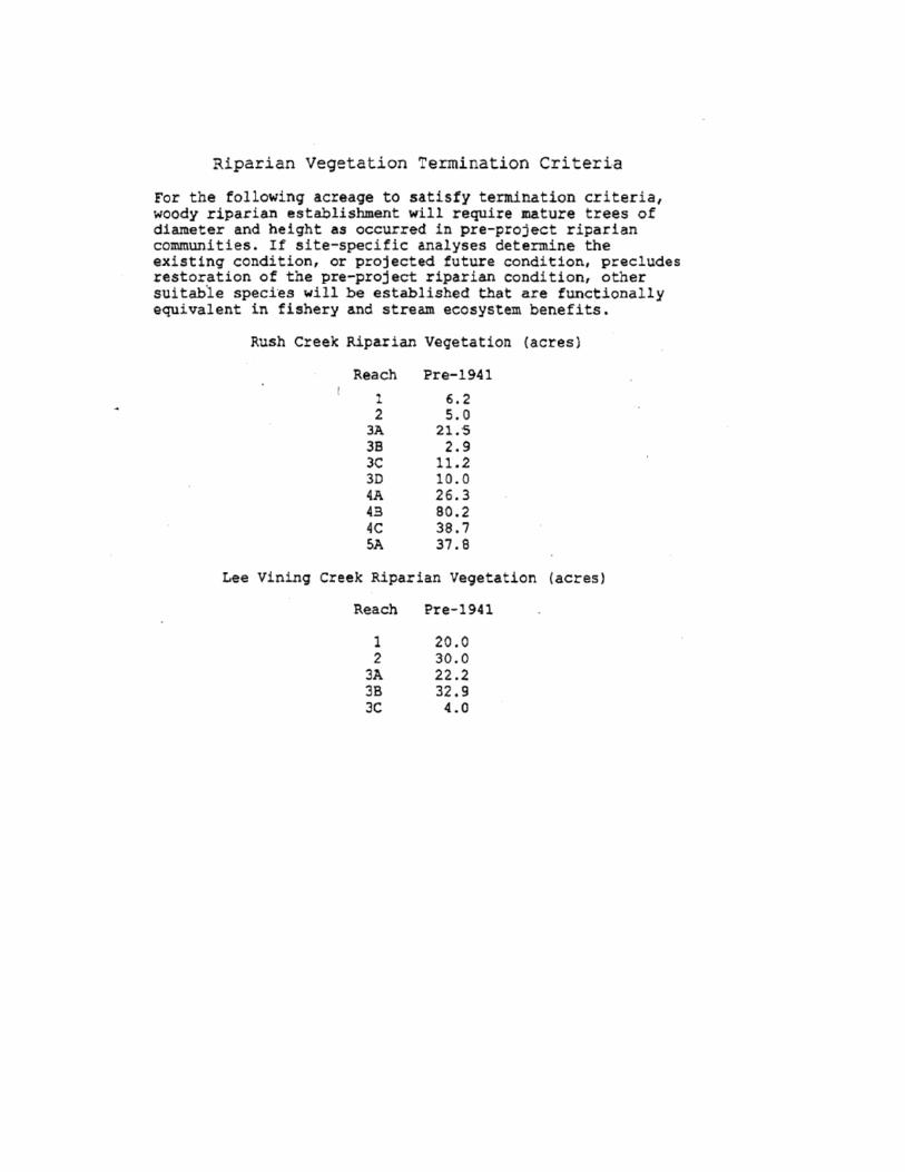


![Synthesis of Mono-Functionalized Cucurbit[n]urils and](https://img.dokumen.tips/doc/110x75/628e841b68035023e675775b/synthesis-of-mono-functionalized-cucurbitnurils-and-.jpg)
