Embed Size (px)
Citation preview

3rd Symposion of the Hohe Tauern National ParkConference Volume for Research in Protected Areas pages 153-157___________________________ September 15th to 17th, 2005, Castle of Kaprun___________________________
Monitoring of visitor flows and visitor needs as a basis for protected area management
Andreas Muhar, Arne Arnberger, Christiane Brandenburg
Abstract
The objective of this paper is to discuss the research and management needs for monitoring of recreational uses in protected areas, to provide an overview of visitor monitoring methods and to demonstrate their practical application in systematic monitoring programs for three specific protected areas with different character, Dürrenstein Wilderness Area, IUCN Cat. Ia/b, Donau-Auen National Park, Cat. II, and Wienerberg Protected Landscape, Cat. V.
Options for data analysis are discussed using three examples: Analysis of trail use intensity, forecast of visitor numbers based on the weather Situation and the day of the week, and identification o fthe social carrying capacity of an urban protected area.
Introduction
Scientific research and monitoring programs in Alpine protected areas, in particular in national parks, frequently focus on ecological aspects such as Vegetation and wildlife. Compared to that, social aspects of park management, such as recreational uses, are not equally recognised as essential components of a research program. Very often, recreational uses of protected areas are, if at all, only investigated with regard to the ecological carrying capacity of the site, but usually not included in a comprehensive research and monitoring framework, which also considers the various social aspects of recreational uses, such as the social carrying capacity, spatial and temporal displacement behaviour as a consequence of crowding, and inter-group conflicts.
Systematically acquired quantitative and qualitative information on recreational use can be relevant for various different aspects of protected area management (Hornback, Eagles 1999, Muhar, Arnberger, Brandenburg 2002, Cessford, Muhar 2003), such as:
Identification ofthe social, economic and political significance ofthe recreational uses
Identification of relations between use levels and physical and social impacts
Evaluation of visitor compliance with use regulations
Identification of problem spots within the protected area
Minimisation of conflicts between user groups
Identification of demand trends and generation of forecasts of visitor numbers and visitor activities
Definition of design Standards for visitor facilities
Provision and allocation of infrastructure and services
Currently there is hardly any standardisation of visitor monitoring schemes throughout the various protected areas in Europe, therefore it is very difficult to compare results from individual areas.
Monitoring methods
A large number of methods for quantitative and qualitative monitoring of recreational uses in protected areas is available (see Tab.l). The choice depends on the data needs for visitor management and on the specific Situation on-site, which may include aspects such as energy supply, susceptibility to vandalism or service intervals. Some methods such as Video observation may also interfere with the visitors' privacy and will therefore not be appropriate in some remote areas.
Contribution received at: 15.07.2005 153
©Hohe Tauern National Park; download unter www.biologiezentrum.at
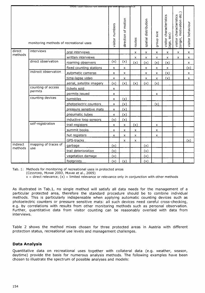
monitoring methods of recreational uses
visi
tor
num
bers
dire
ctio
n of
motion
route
s
spat
ial
dis
trib
ution
grou
p si
ze
visi
tor
chara
cteri
stic
s (a
ge,
sex)
visi
tor
chara
cteri
stic
s (o
rigi
n,
mot
ivat
ion
etc.
)
visi
tor
behavio
ur
directmethods
interviews oral interviews X X X x X X
written interviews X X X X X X
direct observation roaminq observers (x) (x) (X) (x) (x) (x) X
fixed countinq stations X X X X X (x)
indirect observation automatic cameras X X X X (X) X
time-lapse Video X X X X (X) X
aerial, satellite imaqery (X) (X) (X) (X) (X)counting of access permits
tickets sold X
permits issued X X
counting devices turnstiles X (X)
photoelectric counters X (X) (X)
pressure sensitive mats X (X)
pneumatic tubes X (X)
inductive loop sensors M (X)self-registration trail reqisters X X (X) X
summit books X X X X
hut reqisters X X X X
GPS-tracks X X (X)indirectmethods
mapping of traces of use
qarbaqe (*) (X)
trail deterioration (X) (X)
Vegetation damaqe (X) (X)
footprints M (X) (X)
Tab. 1: Methods for monitoring of recreational uses in protected areas (Cessford, Muhar 2003, Muhar et al., 2005)x = direct relevance; (x) = limited relevance or relevance only in conjunction with other methods
As illustrated in Tab.l, no single method will satisfy all data needs for the management of a particular protected area, therefore the Standard procedure should be to combine individual methods. This is particularly indispensable when applying automatic counting devices such as photoelectric counters or pressure sensitive mats: all such devices need careful cross-checking, e.g. by correlations with results from other monitoring methods such as personal observation. Further, quantitative data from visitor counting can be reasonably overlaid with data from interviews.
Table 2 shows the method mixes chosen for three protected areas in Austria with different protection status, recreational use levels and management challenges.
Data Analysis
Quantitative data on recreational uses together with collateral data (e.g. weather, season, daytime) provide the basis for numerous analysis methods. The following examples have been chosen to illustrate the spectrum of possible analyses and models:
154
©Hohe Tauern National Park; download unter www.biologiezentrum.at

Protected Area IUCN-Type
Use levels/types of touristic/recreational uses
Managementchallenqes
Research methods applied
Dürrenstein Wilderness Area (Lower Austria)
Ia/Ib • low use levels• hiking, nature
observation• most visitors from the
region
• exclusion of recreational use in core areas (primary forests)
• minimisation of disturbance of key species (grouse)
• visitor information about protection goals
• stabilisation of visitor numbers at current level
• periodic counting at car parking areas
• periodic counting at trail network nodes
• roaming observers in remote locations
• interviews at mountain hut (routes, motivation, activities)
Donauauen / LobauNational Park (Vienna)
II • high use levels• walking, biking, jogging,
dog walking• most visitors from
neighbouring residential areas
• ecological carrying capacity
• minimisation of wildlife disturbance
• total annual Visitation• guiding of recreational
uses• minimisation of inter-
group conflicts• leashinq of doqs
• permanent time-lapse Video counting at main entrance points
• periodic counting at trail network nodes
• interviews (routes, motivation, activities)
WienerbergProtectedLandscape(Vienna)
V • very high use levels• walking, biking, dog
walking• most visitors from
immediate neighbourhood
• total annual Visitation• social carrying capacity• crowding• minimisation of inter-
group conflicts• leashing of dogs
• permanent time-lapse video counting at trail network nodes
• interviews (motivation, activities, crowding perception,displacement behaviour)
Tab. 2: Combinations of recreation monitoring methods applied in three protected areas with differentVisitation characteristics and m anagem ent challenges (B randenburg 2001, Muhar, Leditznig 2004, Arnberger 2003)
Analysis of trail use intensity
Visitors to the Dürrenstein Wilderness Area were asked to mark on a map the route that they took or planned to take. By linking the route data and other interview results, an analysis of spatial use patterns was possible (Fig. 1). The spatial distribution of visitor use was then linked to the visitor counting data. With the support of such frequency maps the most heavily used paths could be identified, and potential conflicts highlighted between nature conservation and recreational goals.
Fig. 1: Spatial distribution of visitors to the Dürrenstein Wilderness Area, derived from 182 interviews (M uhar, Leditznig 2004)
155
©Hohe Tauern National Park; download unter www.biologiezentrum.at

Forecast of visitor numbers in a national park
In the Danube Floodplains National Park visitor numbers and visitor activities were gathered with permanent time-lapse Video recording systems. Meteorological data were provided by a nearby meteorological registration Station of the Central Institute of Meteorology and Geodynamics in Vienna (ZAMG). In linear regression models the daily totals of the various user groups such as bikers, hikers etc., the differentiation between workday and weekend, the Physiological Equivalent Temperature (PET), the precipitation as well as the type of cloud cover, were included. With the models it was possible to quantify how the visitor types and the daily visitor numbers are influenced by day ofthe week and the weather (B randenburg , 2001).
Extent of interference Total number of
visitors
Bikers Hikers
Workday, weekend and holiday high high highPrecipitation small moderate smallPET high high moderateCloud Cover moderate moderate smallInteraction between weekday and PET
moderate high moderate
Value of model adj.R2 = .745
adj.R2=.769
adj.R2=.629
Tab. 3: Explanatory value of the total number of visitors per day and the user types
Identification ofthe social carrvina caoacitv of an urban protected area
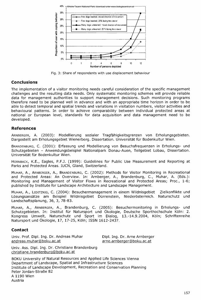
Protected area management requires information about the tolerance thresholds of user groups for encounters and other social factors. A trade-off approach was applied for the recreation area Wienerberg (A rnberger , 2003), using a stated preference model with digitally calibrated images displaying various trail use scenarios including such factors as number of visitors, user type, presence of dogs on or not on a leash, etc (Fig. 2). Social carrying capacities were developed by asking user groups whether the presented recreation scenario was so unacceptable that they would shift their use away from the presented section (Fig. 3). Stated preference results were then linked with Video observation data, resulting in an estimate of the number of hours which are assessed as beyond the limits of social carrying capacity in course of a year.
Fig. 2: Example of systematically manipulated images depicting different levels of six social setting attributes
156
©Hohe Tauern National Park; download unter www.biologiezentrum.at
Number of persons depicted
Fig. 3: Share o f respondents w ith use displacem ent behaviour
Conclusions
The implementation of a visitor monitoring needs careful consideration ofthe specific management challenges and the resulting data needs. Only systematic monitoring schemes will provide reliable data for management authorities to support management decisions. Such monitoring programs therefore need to be planned well in advance and with an appropriate time horizon in order to be able to detect temporal and spatial trends and variations in Visitation numbers, visitor activities and behavioural patterns. In order to achieve comparability between individual protected areas at national or European level, Standards for data acquisition and data management need to be developed.
References
A rnberger, A. (2003): Modellierung sozialer Tragfähigkeitsgrenzen von Erholungsgebieten.Dargestellt am Erholungsgebiet Wienerberg. Dissertation. Universität für Bodenkultur Wien.
B randenburg , C. (2001): Erfassung und Modellierung von Besuchsfrequenzen in Erholungs- und Schutzgebieten - Anwendungsbeispiel Nationalpark Donau-Auen, Teilgebiet Lobau, Dissertation. Universität für Bodenkultur Wien.
Ho r n back , K.E., Eagles, P.F.J. (1999): Guidelines for Public Use Measurement and Reporting at Parks and Protected Areas. IUCN, Gland, Switzerland.
Muhar, A., Arnberger, A., Brandenburg, C. (2002): Methods for Visitor Monitoring in Recreational and Protected Areas: An Overview. In: Arnberger, A., Brandenburg, C., Muhar, A. (Eds.): Monitoring and Management of Visitor Flows in Recreational and Protected Areas; Proc., 1-6; published by Institute for Landscape Architecture and Landscape Management.
M uhar , A., Le d it z n ig , C. (2004): Besuchermanagement in einem Wildnisgebiet Zielkonflikte und Lösungsansätze am Beispiel Wildnisgebiet Dürrenstein, Niederösterreich. Naturschutz und Landschaftsplanung, 36, 3, 78-83.
M uhar , A ., A rnberger, A ., Brandenburg, C. (2005): Besuchermonitoring in Erholungs- und Schutzgebieten. In: Institut für Natursport und Ökologie, Deutsche Sporthochschule Köln: 2. Kongress Umwelt, Naturschutz und Sport im Dialog, 13.-14.9.2004, Köln; Schriftenreihe Natursport und Ökologie, 17, 17-25, Köln; ISSN 1612-2437.
Contact
Univ. Prof. Dipl. Ing. Dr. Andreas Muhar Dipl. Ing. Dr. Arne [email protected] [email protected]
Univ. Ass. Dipl. Ing. Dr. Christiane Brandenburg Christiane. [email protected]. at
BOKU University of Natural Resources and Applied Life Sciences ViennaDepartment of Landscape, Spatial and Infrastructure SciencesInstitute of Landscape Development, Recreation and Conservation PlanningPeter Jordan-Straße 82A 1190 WienAustria
157
©Hohe Tauern National Park; download unter www.biologiezentrum.at