Embed Size (px)
Citation preview
International Journal of Geosciences, 2013, 4, 891-897 http://dx.doi.org/10.4236/ijg.2013.45083 Published Online July 2013 (http://www.scirp.org/journal/ijg)
Modeling Urban Hydrology: A Comparison of New Urbanist and Traditional Neighborhood Design Surface
Runoff
Christopher Andrew Day1, Keith Allen Bremer2 1Department of Geography and Geosciences, University of Louisville, Louisville, USA
2Department of Geography, Texas State University-San Marcos, San Marcos, USA Email: [email protected]
Received April 30, 2013; revised May 31, 2013; accepted June 28, 2013
Copyright © 2013 Christopher Andrew Day, Keith Allen Bremer. This is an open access article distributed under the Creative Com- mons Attribution License, which permits unrestricted use, distribution, and reproduction in any medium, provided the original work is properly cited.
ABSTRACT
Urban development generally leads to an increase in impervious cover resulting in a greater volume of surface runoff following storm activity. However, the type of urban development in place strongly controls the degree of impervious cover generated. Traditional neighborhood designs focus on a medium-to-low urban density spread over larger areas, while new urbanist neighborhood designs incorporate more diversity by increasing urban density across smaller areas. The purpose of this study is to model and compare the potential surface runoff for two urban neighborhoods in Austin, Texas-Circle C Ranch, a traditional neighborhood design, and Mueller, a new urbanist development for a 10-year 24-hour storm scenario. Potential surface runoff was calculated by layering various geospatial datasets representing the physical characteristics of both study sites within the Watershed Modeling System (WMS) to configure the HEC-HMS runoff model. Results initially imply that the higher density new urbanist neighborhood significantly increases total and peak storm runoff compared to the traditional neighborhood. However, a greater number of residential units are avail- able at Mueller over the same area as Circle C Ranch. When taking this into account the increased potential surface runoff is negated at the new urbanist site. Although new urbanist neighborhoods will usually contain more residential units than traditional developments when compared at the same scale, the higher urban density associated with these neighborhoods demand the development of more effective stormwater retention systems to cope with a potential in- crease in surface runoff. Keywords: Urban Hydrology; New Urbanism; Runoff Modeling; Land Use
1. Introduction
Urban development affects the amount of potential sur- face runoff generated during storms by changing the amount of impervious cover across the landscape [1-3]. In addition to increasing surface runoff, urban develop- ment also modifies the volume of groundwater recharge, lowers water tables, increases peak discharge, and de- creases base flow during drier periods [4,5]. These modi- fications depend on the type of urban development in place.
New urbanism is a type of sustainable development that is designed to reduce automobile use, increase walking and cycling, and increase the diversity of land uses while incorporating traditional and new practices of planning at all scales [6]. Moreover, new urbanism is a type of low impact development (LID) that contains
elements such as cluster development and bio-retention. LID can mitigate problems associated with storm water runoff by increasing resilience and utilizing best man- agement practices [7,8]. Traditional neighborhood de- velopment (TND) is limited to the neighborhood scale and incorporates traditional planning practices such as large lot and single family zoning [9]. TND are not con- sidered as LID unless further steps have been taken to implement specific LID features. New urbanism is touted as a more environmentally sustainable development than TND, which will typically contain greater amounts of impervious cover [10].
While research implies that LID does often reduce to- tal stormwater runoff and increase the runoff lag time when compared to TND [11-13], more research needs to be carried out which compare neighborhoods of similar
Copyright © 2013 SciRes. IJG
C. A. DAY, K. A. BREMER 892
size and scale in order to make further accurate assess- ments of LID and their impact on stormwater runoff. Several obstacles pertinent to stormwater runoff have been noted concerning LID planning. Many current zon- ing and regulatory statutes can hinder the implementation of LID concepts and philosophies [14]. These features include minimum street width for public services, con- crete curbs and gutters, the absence of runoff collection ponds due to public health concerns, and other elements that may not fit into the visually pleasing aesthetic design [14]. As a result, a comparison of three urban neighbor- hoods ranging from high-to-low density actually found that the medium density neighborhood displayed the longest peak runoff lag times due to more effective usage of stormwater retention systems [15].
An increase in geospatial and modeling capability has increased the opportunity of analyzing urban develop- ment impacts on stormwater runoff in recent years. Re- mote sensing data coupled with geographic information science (GIS) systems and runoff modeling software have been used more frequently to study the interaction between rainfall events and urban surfaces leading to runoff [16-18]. The purpose of this research is to utilize these techniques to model and compare the potential sur- face runoff for two similar-sized new urbanist and tradi- tional neighborhoods in Austin, Texas.
2. Study Area
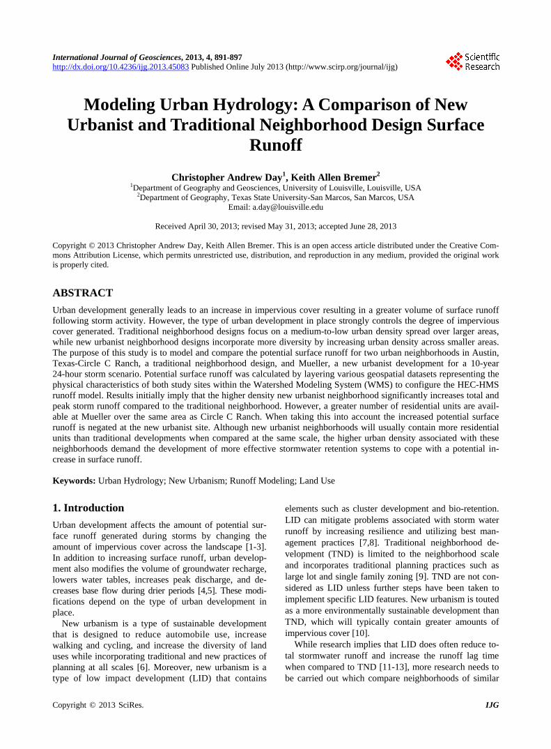
The study area includes two neighborhoods, one new urbanist, and one traditionally developed neighborhood in Austin, Texas (Figure 1). Austin-Mueller (Mueller) is a new urbanist neighborhood located in north-central Austin approximately three miles from downtown Austin on the site of the city’s old Robert Mueller airport. Mueller is the most recent master-planned community in Austin that focuses on new urbanism as a vehicle for sustainability including a mixture of home types, sizes, and price ranges. Circle C Ranch is a traditional neigh- borhood development that originated in the late 1980s. The neighborhood contains mostly single-family homes that are situated on medium to large lots with traditional planning practices in place [19].
Regarding physical characteristics that may impact stormwater runoff, Austin receives, on average, 870 mm precipitation annually [20]. The majority of this total occurs in the months of April and May when violent storms develop from Pacific cold fronts moving rapidly across the south-central Texas region, resulting in severe flooding [21]. Another important factor concerning run- off is the soil which heavily controls the amount of infil- tration-to-surface-runoff ratio during storm events. Soils may be classified into one of four hydrologic groups (A, B, C, D) that reflect their drainage capability. Group A
soils are characterized by high infiltration rates to give low runoff potential following precipitation, while group D soils have low infiltration rates to increase runoff po- tential [22]. Soil coverage across both sites is typical of the south-central Texas region.
Mueller is dominated by the Lewisville and Altoga se- ries soils which range from well-to-moderately drained silty-clay soils underlain by fractured chalk or limestone, classified in the B-C soil hydrologic groups. Smaller in- stances of the Houston Black and Patrick soil series are also present at these sites classified into the moder- ately-to-poorly drained B-D soil hydrologic grouping. At Circle C Ranch, the Tarrant soil series dominates as a stony-clay type soil (hydrologic group C) with the mod- erately well-drained (C group) Speck series present to the south and west of the site [22].
3. Methods
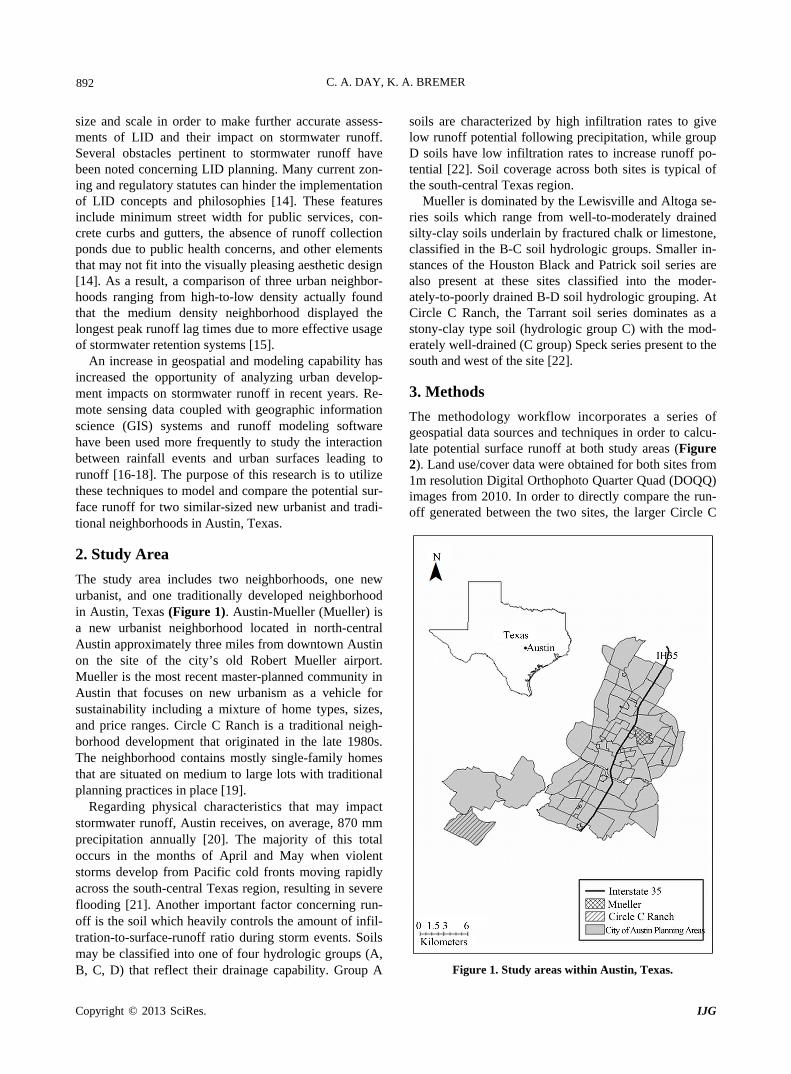
The methodology workflow incorporates a series of geospatial data sources and techniques in order to calcu- late potential surface runoff at both study areas (Figure 2). Land use/cover data were obtained for both sites from 1m resolution Digital Orthophoto Quarter Quad (DOQQ) images from 2010. In order to directly compare the run- off generated between the two sites, the larger Circle C
Figure 1. Study areas within Austin, Texas.
Copyright © 2013 SciRes. IJG
C. A. DAY, K. A. BREMER 893
Figure 2. Methodology workflow. Ranch site was trimmed down to match the area of Mueller, using road boundaries within the sub-division as the new boundaries for Circle C Ranch. This gave two images covering an equal area of 0.7 km2 with the Muel- ler site containing 751 residential units and Circle C Ranch 511.
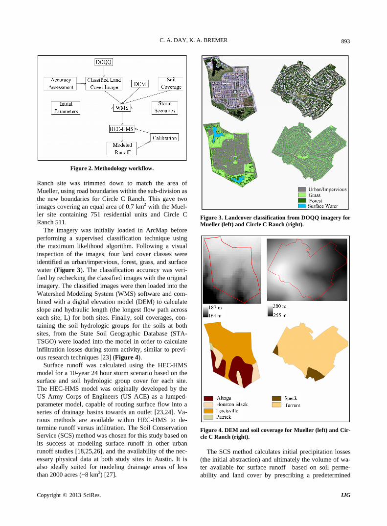
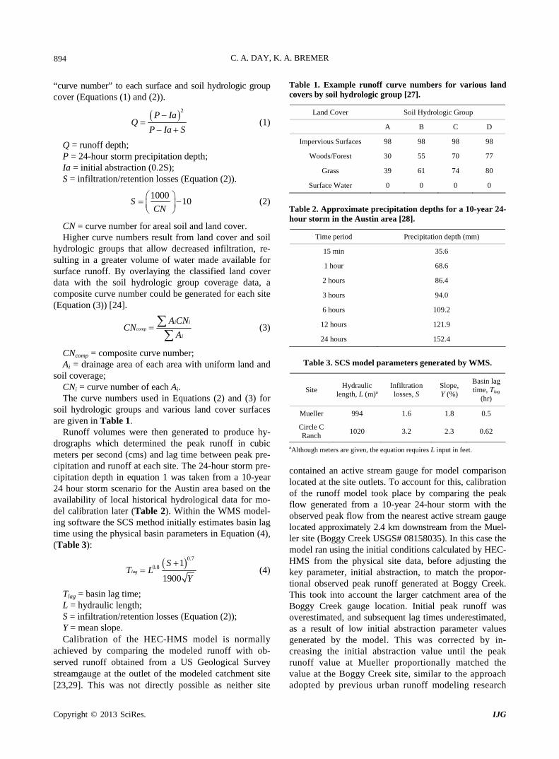
The imagery was initially loaded in ArcMap before performing a supervised classification technique using the maximum likelihood algorithm. Following a visual inspection of the images, four land cover classes were identified as urban/impervious, forest, grass, and surface water (Figure 3). The classification accuracy was veri- fied by rechecking the classified images with the original imagery. The classified images were then loaded into the Watershed Modeling System (WMS) software and com- bined with a digital elevation model (DEM) to calculate slope and hydraulic length (the longest flow path across each site, L) for both sites. Finally, soil coverages, con- taining the soil hydrologic groups for the soils at both sites, from the State Soil Geographic Database (STA- TSGO) were loaded into the model in order to calculate infiltration losses during storm activity, similar to previ- ous research techniques [23] (Figure 4).
Surface runoff was calculated using the HEC-HMS model for a 10-year 24 hour storm scenario based on the surface and soil hydrologic group cover for each site. The HEC-HMS model was originally developed by the US Army Corps of Engineers (US ACE) as a lumped- parameter model, capable of routing surface flow into a series of drainage basins towards an outlet [23,24]. Va- rious methods are available within HEC-HMS to de- termine runoff versus infiltration. The Soil Conservation Service (SCS) method was chosen for this study based on its success at modeling surface runoff in other urban runoff studies [18,25,26], and the availability of the nec- essary physical data at both study sites in Austin. It is also ideally suited for modeling drainage areas of less than 2000 acres (~8 km2) [27].
Figure 3. Landcover classification from DOQQ imagery for Mueller (left) and Circle C Ranch (right).
Figure 4. DEM and soil coverage for Mueller (left) and Cir- cle C Ranch (right).
The SCS method calculates initial precipitation losses (the initial abstraction) and ultimately the volume of wa- ter available for surface runoff based on soil perme- ability and land cover by prescribing a predetermined
Copyright © 2013 SciRes. IJG
C. A. DAY, K. A. BREMER 894
“curve number” to each surface and soil hydrologic group cover (Equations (1) and (2)).
2P Ia
P Ia S
Q (1)
Q = runoff depth; P = 24-hour storm precipitation depth; Ia = initial abstraction (0.2S); S = infiltration/retention losses (Equation (2)).
100010
CN
S (2)
CN = curve number for areal soil and land cover. Higher curve numbers result from land cover and soil
hydrologic groups that allow decreased infiltration, re- sulting in a greater volume of water made available for surface runoff. By overlaying the classified land cover data with the soil hydrologic group coverage data, a composite curve number could be generated for each site (Equation (3)) [24].
comp
i i
i
A CNCN
A
(3)
CNcomp = composite curve number; Ai = drainage area of each area with uniform land and
soil coverage; CNi = curve number of each Ai. The curve numbers used in Equations (2) and (3) for
soil hydrologic groups and various land cover surfaces are given in Table 1.
Runoff volumes were then generated to produce hy- drographs which determined the peak runoff in cubic meters per second (cms) and lag time between peak pre- cipitation and runoff at each site. The 24-hour storm pre- cipitation depth in equation 1 was taken from a 10-year 24 hour storm scenario for the Austin area based on the availability of local historical hydrological data for mo- del calibration later (Table 2). Within the WMS model- ing software the SCS method initially estimates basin lag time using the physical basin parameters in Equation (4), (Table 3):
0.7
0.8 1
1900
ST L
Y
lag (4)
Tlag = basin lag time; L = hydraulic length; S = infiltration/retention losses (Equation (2)); Y = mean slope. Calibration of the HEC-HMS model is normally
achieved by comparing the modeled runoff with ob- served runoff obtained from a US Geological Survey streamgauge at the outlet of the modeled catchment site [23,29]. This was not directly possible as neither site
Table 1. Example runoff curve numbers for various land covers by soil hydrologic group [27].
Land Cover Soil Hydrologic Group
A B C D
Impervious Surfaces 98 98 98 98
Woods/Forest 30 55 70 77
Grass 39 61 74 80
Surface Water 0 0 0 0
Table 2. Approximate precipitation depths for a 10-year 24- hour storm in the Austin area [28].
Time period Precipitation depth (mm)
15 min 35.6
1 hour 68.6
2 hours 86.4
3 hours 94.0
6 hours 109.2
12 hours 121.9
24 hours 152.4
Table 3. SCS model parameters generated by WMS.
Site Hydraulic
length, L (m)ªInfiltration losses, S
Slope, Y (%)
Basin lag time, Tlag
(hr)
Mueller 994 1.6 1.8 0.5
Circle C Ranch
1020 3.2 2.3 0.62
aAlthough meters are given, the equation requires L input in feet.
contained an active stream gauge for model comparison located at the site outlets. To account for this, calibration of the runoff model took place by comparing the peak flow generated from a 10-year 24-hour storm with the observed peak flow from the nearest active stream gauge located approximately 2.4 km downstream from the Muel- ler site (Boggy Creek USGS# 08158035). In this case the model ran using the initial conditions calculated by HEC- HMS from the physical site data, before adjusting the key parameter, initial abstraction, to match the propor- tional observed peak runoff generated at Boggy Creek. This took into account the larger catchment area of the Boggy Creek gauge location. Initial peak runoff was overestimated, and subsequent lag times underestimated, as a result of low initial abstraction parameter values generated by the model. This was corrected by in- creasing the initial abstraction value until the peak runoff value at Mueller proportionally matched the value at the Boggy Creek site, similar to the approach adopted by previous urban runoff modeling research
Copyright © 2013 SciRes. IJG
C. A. DAY, K. A. BREMER 895
[23,29]. Adjustment of the initial abstraction value for Circle C Ranch followed based on the lower CN value for that site (Table 4).
4. Results
The Mueller site contained a much greater proportion of urban/impervious cover, totaling 50% compared to the Circle C Ranch coverage of 36% (Figure 3, Table 5). The impervious area of the Mueller neighborhood is also clustered around a central area, surrounded by non-im- pervious surfaces, which typifies new urbanist develop- ments.
The Circle C Ranch site displays a more uniform spread of all surfaces, with impervious surfaces distrib- uted across the entire site. While Mueller does display 17% more grass coverage, the majority of the Circle C Ranch site is covered in forest, totaling 51% compared to Mueller’s 16%. Mueller also includes 4% surface water coverage in the form of two ponds located to the south and northwest of the site.
Regarding runoff, initially the two hydrographs pro- duced by the model appear similar, but closer inspection reveals three key differences between Mueller and Circle C Ranch in response to the 10-year storm scenario (Fig- ure 5). Firstly, the peak runoff increased by 64% from 0.99cms at Circle C Ranch to 1.55 cm at the Mueller site. Secondly, the storm lag time displayed a lower value by 31 minutes at Mueller, which equated to a 59% decrease in time from Circle C Ranch storm response. Lastly, the runoff coefficient (proportion of rainfall to runoff), in- creased by 5.9% at Mueller, again highlighting that a greater proportion of rainfall during the storm becomes surface runoff at this location. The results suggest that the new urbanist site at Mueller actually generates the greater volume of stormwater runoff (42,000 m3 vs. 35,700 m3 at Circle C Ranch). Furthermore, with both Table 4. Curve numbers and initial abstraction values used in model.
Site Default Initial
Abstraction (Ia) Calibrated Initial Abstraction (Ia)
Curve Number
Mueller 0.2 0.26 86
Circle C Ranch 0.2 0.32 78
Table 5. Proportion of surface cover at Circle C Ranch and Mueller sites.
Surface cover Circle C Ranch Mueller
Impervious 36% 50%
Forest/Woods 51% 16%
Grass 13% 30%
Water 0% 4%
sites displaying similar physical properties in terms of area, relief, hydraulic length and soil hydrologic group characteristics, the greater extent of impervious surface coverage compared to the traditional site at Circle C Ranch is chiefly responsible for this.
However, it must be addressed that new urbanist de- velopments focus on clustered development practices that have a higher density of residential development than a traditional urban development practice over a similar area. In this case Mueller contains 751 residential units compared to Circle C Ranch’s 511, a total differ- ence of 240 units over the 0.7 km2 area. Taking this into account Circle C Ranch would theoretically generate a greater volume of runoff at 69,863 m3 per 1000 units vs. 55,925 m3 per 1000 units at Mueller, a difference of just under 14,000 m3. As a result Circle C Ranch and other similar traditional urban developments, taken as a whole, will likely generate a greater volume of surface runoff than their new urbanist counterparts in terms of their total footprint on the landscape.
Of further note are the landscaped retention systems in place at the Mueller site which are designed to limit the effects of stormwater runoff, practices that are often not included across traditional developments. Bio-retention ponds are key features of new urbanist developments which aim to capture and store excess runoff following storm events. Mueller has two such ponds in place, to the north and south which have been aesthetically land- scaped into the development blueprint. The DEM data- sets used in this study do not capture any of these large- scale landscaping changes implemented at the Mueller site, assuming that the majority of stormwater runoff will follow the original topography and drainage patterns. However the purpose of this paper was to investigate the potential surface runoff generated from this kind of de- velopment in comparison to a traditional neighborhood. The fact that new urbanist sites will often cluster their development in a bid to reduce the overall footprint of the site means that without these kinds of retention sys- tems in place a greater volume of runoff could potentially be generated and lag times reduced following storm events as seen in this study.
5. Conclusions
A modeling framework has been developed to analyze the impacts of urban neighborhood design on storm run- off for the city of Austin, Texas. By layering a series of datasets that represent the physical landscape (land cover, soil, and relief) within the Watershed Modeling System (WMS) the HEC-HMS runoff model has generated peak runoff and storm lag times for a new urbanist and tradi- tional neighborhood. The results imply that when directly comparing these types of urban design on a similar scale, the new urbanist neighborhood has the propensity to
Copyright © 2013 SciRes. IJG

C. A. DAY, K. A. BREMER
Copyright © 2013 SciRes. IJG
896
Figure 5. Modeled runoff hydrographs for Circle C Ranch (top) and Mueller (bottom). generate larger peak flows and shorter lag times as a function of the high density urban footprint associated with this type of neighborhood. Consequently it is im- perative that flood retention or reduction measures are included in these neighborhood designs in order to miti- gate the impacts of potential flooding both within and surrounding these new urbanist neighborhoods. Further- more, while new urbanist neighborhoods have LID ele- ments designed within them to reduce runoff and pollut- ants at a larger scale these results suggest more research is needed to determine how well, at the smaller scale, these elements work with other neighborhood designs and to what level they reduce or increase pollutant run- off.
The methodology employed in this research demon- strates the potential of combining and manipulating a series of datasets within GIS and modeling software to ascertain the potential surface runoff generated within urban areas at the sub-drainage basin scale. However further research should also be conducted that compares potential runoff output from infiltration abstraction me- thods other than the SCS method as employed in this
research. Also with the increase in development of new urbanist neighborhoods within US cities, similar research may be conducted that compares the potential runoff between these neighborhoods. Their non-traditional de- velopment and design often makes them unique from one another and thus could generate significantly different runoff outputs from similar storm scenarios.
REFERENCES [1] D. B. Booth, D. Hartley and R. Jackson, “Forest Cover,
Impervious-Surface Area, and the Mitigation of Storm- water Impacts,” Journal of the American Water Re- sources Association, Vol. 38, No. 2, 2002, pp. 835-845. doi:10.1111/j.1752-1688.2002.tb01000.x
[2] L. B. Leopold, “Hydrology for Urban Planning—A Guide- book on the Hydrological Effects of Urban Land Use,” US Geological Survey, Washington DC, 1968.
[3] C. J. Walsh, A. H. Roy, J. W. Feminella, P. D. Cottinghan, P. M. Groffman and R. P. Morgan, “The Urban Stream Syndrome: Current Knowledge and the Search for a Cure,” Journal of the North American Benthological So- ciety, Vol. 24, No. 3, 2005, pp. 706-723.
C. A. DAY, K. A. BREMER 897
doi:10.1899/04-020.1
[4] K. Gilroy and R. McCuen “Spatio-Temporal Effects of Low Impact Development Practices,” Journal of Hydrol- ogy, Vol. 367, No. 3-4, 2009, pp. 228-236. doi:10.1016/j.jhydrol.2009.01.008
[5] P. M. Groffman, N. J. Boulware, W. C. Zipperer, R. V. Pouyat, L. E. Band and M. F. Colosimo, “Soil Nitrogen Cycle Processes in Urban Riparian Zones,” Environ- mental Science & Technology, Vol. 36, No. 21, 2002, pp. 4547-4552. doi:10.1021/es020649z
[6] J. Dill, “Evaluating a New Urbanist Neighborhood,” Ber- keley Planning Journal, Vol. 19, No. 1, 2006, pp. 59-78.
[7] E. Bedan and J. Clausen, “Stormwater Runoff Quality and Quantity from Traditional and Low Impact Devel- opment watersheds,” Journal of the American Water Re- sources Association, Vol. 45, No. 4, 2009, pp. 998-1008. doi:10.1111/j.1752-1688.2009.00342.x
[8] C. Pyke, M. Warren, T. Johnson, J. LaGro, J. Schar- fenderg, P. Groth, R. Freed, W. Schroeer and E. Main, “Assessment of Low Impact Development for Managing Stormwater with Changing Precipitation Due to Climate Change,” Landscape and Urban Planning, Vol. 103, No. 2, 2011, pp. 166-173. doi:10.1016/j.landurbplan.2011.07.006
[9] O. J. Furuseth, “Neotraditional Planning: A New Strategy for Building Neighborhoods?” Land Use Policy, Vol. 14, No. 3, 1997, pp. 201-213. doi:10.1016/S0264-8377(97)00002-1
[10] P. R. Berke, J. MacDonald, N. White, M. Holmes, D. Line, K. Oury and R. Ryznar, “Greening Development to Protect Watersheds: Does New Urbanism make a Differ- ence?” Journal of the American Planning Association, Vol. 69, No. 4, 2003, pp. 397-413. doi:10.1080/01944360308976327
[11] M. E. Dietz, “Low Impact Development Practices: A Re- view of Current Research and Recommendations for Fu- ture Directions,” Water, Air, and Soil Pollution, Vol. 186, No. 1-4, 2007, pp. 351-363. doi:10.1007/s11270-007-9484-z
[12] J. K. Holman-Dodds, A. A. Bradley and K. W. Potter, “Evaluation of Hydrologic Benefits of Infiltration Based Urban Stormwater Management,” Journal of the Ameri- can Water Resources Association, Vol. 39, No. 1, 2003, pp. 205-215. doi:10.1111/j.1752-1688.2003.tb01572.x
[13] M. J. Hood, J. C. Clausen and G. S. Warner, “Compari- son of Stormwater Lag Times for Low Impact and Tradi- tional Residential Development,” Journal of the Ameri- can Water Resources Association, Vol. 43, No. 4, 2007, pp. 1036-1046. doi:10.1111/j.1752-1688.2007.00085.x
[14] P. A. Davis, “Green Engineering Principals Promote Low- Impact Development,” Environmental and Science Tech- nology, Vol. 39, No. 16, 2005, pp. 338A-344A. doi:10.1021/es053327e
[15] D. Burns, T. Vitvar, J. McDonnell, J. Hassett, J. Duncan and C. Kendall, “Effects of Suburban Development on Runoff Generation in the Croton River Basin, New York, USA,” Journal of Hydrology, Vol. 311, No. 1-4, 2005, pp. 266-281. doi:10.1016/j.jhydrol.2005.01.022
[16] S. D. Khan, “Urban Development and Flooding in Hous- ton Texas, Inferences from Remote Sensing Data using Neural Network Technique,” Environmental Geology, Vol. 47, No. 8, 2005, pp. 1120-1127. doi:10.1007/s00254-005-1246-x
[17] Y. P. Lin, Y. B. Lin, Y. T. Wang and N. M. Hong, “Mo- nitoring and Predicting Land-Use Changes and the Hy- drology of the Urbanized Paochiao Watershed in Taiwan Using Remote Sensing Data, Urban Growth Models and a Hydrological Model,” Sensors, Vol. 8, No. 2, 2008, pp. 658-680. doi:10.3390/s8020658
[18] S. Suriya and B. V. Mudgal, “Impact of Urbanization on Flooding: The Thirusoolam Sub Watershed—A Case Study,” Journal of Hydrology, Vol. 412-413, 2012, pp. 210-219. doi:10.1016/j.jhydrol.2011.05.008
[19] Circle C Ranch, “Circle C Ranch Homeowners Associa- tion,” 2012. http://www.circlecranch.info
[20] National Oceanographic and Atmospheric Administration (NOAA), “National Weather Service Forecast Office, Austin/San Antonio, TX,” 2012. http://www.nws.noaa.gov/climate/xmacis.php?wfo=ewx
[21] R. A. Earl and T. Kimmel, “Means and Extremes: The Weather and Climate of South-central Texas,” In: J. F. Petersen and J. A. Tuason, Eds., A Geographic Glimpse of Central Texas and the Borderlands, National Council for Geographic Education, Pennsylvania, 1995, pp. 31-40.
[22] US Soil Conservation Service (US SCS), “Soil Survey of Travis County, Texas,” US SCS, Austin, 1974. doi:10.1016/j.jenvman.2006.06.023
[23] C. McColl and G. Aggett, “Land Use Forecasting and Hydrologic Model Integration for Improved Land Use Decision Support,” Journal of Environmental Management, Vol. 84, No. 4, 2007, pp. 494-512.
[24] US Army Corps of Engineers (US ACE), “Hydrologic Modeling System HEC-HMS: Technical Reference Ma- nual,” US ACE, Washington DC, 2000.
[25] Y. Guo and M. Markus, “Analytical Probabilistic Approach for Estimating Design Flood Peaks of Small Watersheds,” Journal of Hydrologic Engineering, Vol. 16, No. 11, 2011, pp. 847-857. doi:10.1061/(ASCE)HE.1943-5584.0000380
[26] C. J. Woltemade, “Impact of Residential Soil Disturbance on Infiltration Rate and Stormwater Runoff,” Journal of the American Water Resources Association, Vol. 46, No. 4, 2010, pp. 700-711. doi:10.1111/j.1752-1688.2010.00442.x
[27] US Soil Conservation Service (US SCS), “National En- gineering Handbook, Section 4, Hydrology,” US SCS, Washington DC, 1972.
[28] W. H. Asquith and M. C. Roussel, “Atlas of Depth-Dura- tion Frequency of Precipitation and Annual Maxima for Texas,” Scientific Investigations Report 2004-5041, US Geological Survey, Austin, 2004.
[29] M. R. Knebl, Z. L. Yang, K. Hutchinson and D. R. Maid- ment, “Regional Scale Flood Modeling Using NEXRAD Rainfall, GIS, and HEC-HMS/RAS: A Case Study for the San Antonio River Basin Summer 2002 Storm Event,” Journal of Environmental Management, Vol. 75, No. 4, 2005, pp. 325-336. doi:10.1016/j.jenvman.2004.11.024
Copyright © 2013 SciRes. IJG