Embed Size (px)
Citation preview
Engineering Documentation Report
EDR-OD-01
MLG to MLLW Vertical Datum Conversion
Mississippi River Venice, Louisiana to the Gulf of Mexico
(Vicinity of Southwest Pass) Louisiana
Prepared by: US Army Corps of Engineers
New Orleans District Engineering Division
Prepared by: CEMVN-ED-ST Reviewed by: CEMVN-OD
REVISION 1: 01 May 2017

THIS PAGE INTENTIONALLY LEFT BLANK
1
TABLE OF CONTENTS
LIST OF ACRONYMS .................................................................................................................. 3
1. Introduction ............................................................................................................................. 4
2. Project Summary ..................................................................................................................... 5
3. Vertical Datum Conversion Process ........................................................................................ 7
3.1 Project Datum ................................................................................................................... 7
3.2 Methodology for Establishing Conversion Value ............................................................ 8
4. Project Conversion ................................................................................................................ 11
4.1. Datum Offsets for Mississippi River Gages from Venice, LA to the Gulf of Mexico .. 11
4.2. Datum Offsets for Gage 01480 ...................................................................................... 13
4.3. Datum Offsets for Gage 01670 ...................................................................................... 14
4.4. Datum Offset Chart ........................................................................................................ 15
4.5. Documents to be Updated .............................................................................................. 15
4.6. Future updates to MLLW/NAVD88 .............................................................................. 16
4.7 Summary ........................................................................................................................ 16
REFERENCES ............................................................................................................................. 16
2
LIST OF FIGURES AND TABLES MAPS: MAP 1- Mississippi River- Ship Channel, Gulf to Baton Rouge, LA...........……..…5 MAP 2- Mississippi River Gages from Venice, LA to the Gulf of Mexico …….…..8 TABLES: TABLE 1- Datum Relationships for Mississippi River gages from Venice, LA to the Gulf of Mexico ……… ……………………………………………………………..…..…11 TABLE 2- Corrections for Mississippi River gages from Venice, LA to the Gulf of Mexico ……….………………………………………………………..……………..11
FIGURES: FIGURE 1- Datum Conversion Definition Sketch…………………………………..10 FIGURE 2- Datum Relationships for USACE Gage 01480………………………....12 FIGURE 3- Datum Relationships for USACE Gage 01670…………………………13 FIGURE 4- Datum Offset Chart……………………………………………………..14
APPENDIX: Appendix A- Independent Technical Review (ATR) Certification
3
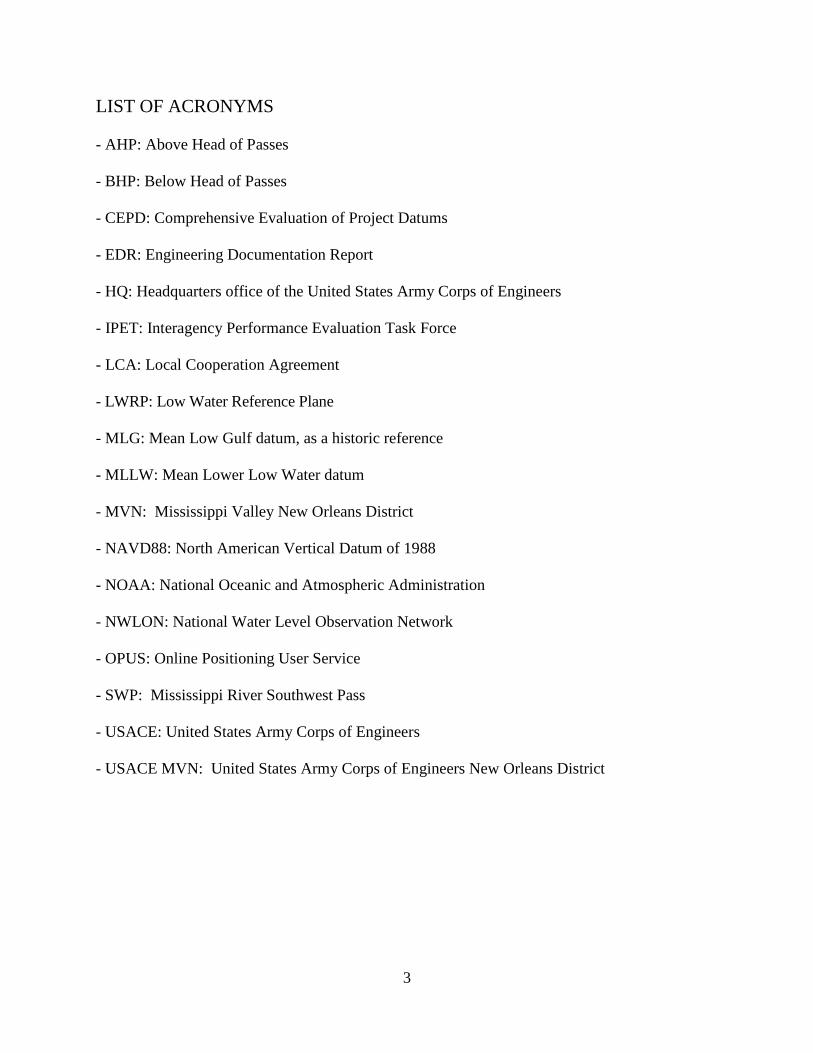
LIST OF ACRONYMS - AHP: Above Head of Passes - BHP: Below Head of Passes - CEPD: Comprehensive Evaluation of Project Datums - EDR: Engineering Documentation Report - HQ: Headquarters office of the United States Army Corps of Engineers - IPET: Interagency Performance Evaluation Task Force - LCA: Local Cooperation Agreement - LWRP: Low Water Reference Plane - MLG: Mean Low Gulf datum, as a historic reference - MLLW: Mean Lower Low Water datum - MVN: Mississippi Valley New Orleans District - NAVD88: North American Vertical Datum of 1988 - NOAA: National Oceanic and Atmospheric Administration - NWLON: National Water Level Observation Network - OPUS: Online Positioning User Service - SWP: Mississippi River Southwest Pass - USACE: United States Army Corps of Engineers - USACE MVN: United States Army Corps of Engineers New Orleans District
4
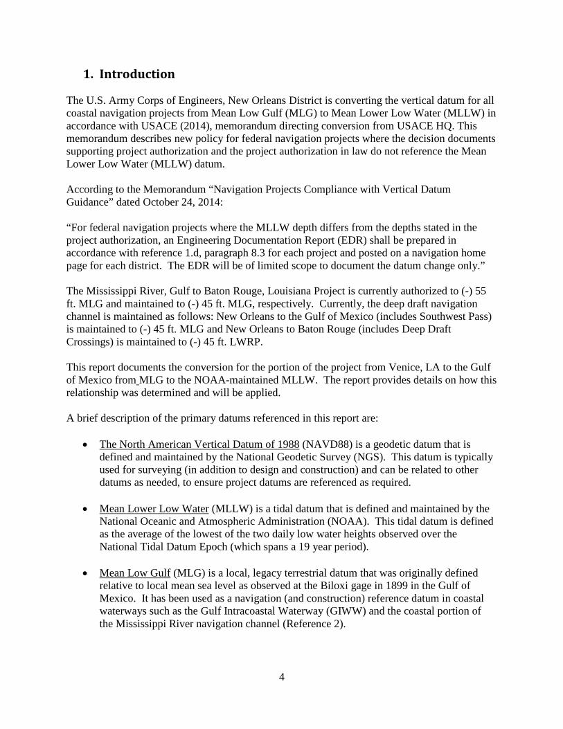
1. Introduction The U.S. Army Corps of Engineers, New Orleans District is converting the vertical datum for all coastal navigation projects from Mean Low Gulf (MLG) to Mean Lower Low Water (MLLW) in accordance with USACE (2014), memorandum directing conversion from USACE HQ. This memorandum describes new policy for federal navigation projects where the decision documents supporting project authorization and the project authorization in law do not reference the Mean Lower Low Water (MLLW) datum. According to the Memorandum “Navigation Projects Compliance with Vertical Datum Guidance” dated October 24, 2014: “For federal navigation projects where the MLLW depth differs from the depths stated in the project authorization, an Engineering Documentation Report (EDR) shall be prepared in accordance with reference 1.d, paragraph 8.3 for each project and posted on a navigation home page for each district. The EDR will be of limited scope to document the datum change only.” The Mississippi River, Gulf to Baton Rouge, Louisiana Project is currently authorized to (-) 55 ft. MLG and maintained to (-) 45 ft. MLG, respectively. Currently, the deep draft navigation channel is maintained as follows: New Orleans to the Gulf of Mexico (includes Southwest Pass) is maintained to (-) 45 ft. MLG and New Orleans to Baton Rouge (includes Deep Draft Crossings) is maintained to (-) 45 ft. LWRP. This report documents the conversion for the portion of the project from Venice, LA to the Gulf of Mexico from MLG to the NOAA-maintained MLLW. The report provides details on how this relationship was determined and will be applied. A brief description of the primary datums referenced in this report are:
• The North American Vertical Datum of 1988 (NAVD88) is a geodetic datum that is defined and maintained by the National Geodetic Survey (NGS). This datum is typically used for surveying (in addition to design and construction) and can be related to other datums as needed, to ensure project datums are referenced as required.
• Mean Lower Low Water (MLLW) is a tidal datum that is defined and maintained by the
National Oceanic and Atmospheric Administration (NOAA). This tidal datum is defined as the average of the lowest of the two daily low water heights observed over the National Tidal Datum Epoch (which spans a 19 year period).
• Mean Low Gulf (MLG) is a local, legacy terrestrial datum that was originally defined
relative to local mean sea level as observed at the Biloxi gage in 1899 in the Gulf of Mexico. It has been used as a navigation (and construction) reference datum in coastal waterways such as the Gulf Intracoastal Waterway (GIWW) and the coastal portion of the Mississippi River navigation channel (Reference 2).
5
2. Project Summary The Mississippi River Ship Channel (MRSC), Gulf to Baton Rouge, Louisiana project is a federal deep draft navigation project, providing deep draft navigation access to ports located along the lower Mississippi River from the Gulf of Mexico to the city of Baton Rouge in Southeast Louisiana. The project area begins near Baton Rouge, Louisiana beginning at river mile (RM) 232.4 Above Head of Passes (AHP) and extends to the Gulf of Mexico ending at RM 22 Below Head of Passes (BHP) (see Map 1). The channel services four of the top ten ports in the United States: the Port of Greater Baton Rouge (Port of Baton Rouge), the Port of South Louisiana, the Port of New Orleans, and the Plaquemines Port, Harbor and Terminal District (Port of Plaquemines). The Port of South Louisiana is the largest port in the nation in terms of tonnage. The non-Federal sponsor is the State of Louisiana, Department of Transportation and Development. Local Cooperation Agreements between the Government and the State of Louisiana were executed for each phase constructed. Numerous federal navigation projects for the construction, operation, and maintenance of multiple sections of the Mississippi River from Baton Rouge to New Orleans, at Southwest Pass, and at South Pass (collectively "existing projects") were authorized in portions of the River and Harbor Act of 1875; River and Harbor Act of 1908; River and Harbor Act of 1925; and the River and Harbor Act of 1937. In 1939, a Report of the Chief of Engineers dated February 25, 1939 recommended to Congress that the existing projects: Mississippi River, Baton Rouge to New Orleans; the Mississippi River, Southwest Pass and the Mississippi River, South Pass, be modified and combined and that a project covering the Mississippi River from New Orleans to the Head of Passes be added thereto, to provide for a single project "Mississippi River, Baton Rouge to the Gulf of Mexico." In addition, the Report recommended the deepening of specific River channels using the Mean Low Gulf datum to specify the channel dimensions. Thereafter, the River and Harbor Act of 1945 authorized the subject "Mississippi River, Baton Rouge to the Gulf of Mexico" Project as provided in the February 25, 1939 Chief's Report (House Document Numbered 215, Seventy-Sixth Congress.) The River and Harbor Act of 1962 amended the Project to provide for dikes and other retaining structures for construction and future maintenance, and the Supplemental Appropriations Act of 1985 (Public Law 99-88) appropriated funding for the Project. The Water Resources Development Act of 1986 authorized the construction of the Project in accordance with the Report of the Chief of Engineers dated April 9, 1983, and also formalized the cost-sharing provisions of the Project. Section 2102 of the Water Resources Reform and Development Act of 2014, amended the applicable cost-share provisions of the Water Resources and Development Act of 1986, to increase the Federal threshold for full Federal channel maintenance responsibilities from 45-feet to 50-feet. The MRSC consists of three routinely dredged reaches to allow for navigation. The first reach is located in the lower Mississippi River reach, and extends from RM 13.4 AHP to RM 22 BHP. This reach includes the portion referred to as Southwest Pass (SWP) which extends from RM 0 (Head of Passes) to RM 22 BHP. The datum conversion documented in this EDR relates to this lower reach of the project from Venice, LA to the Gulf. Maintenance dredging is performed annually south of Venice, LA, and SWP by a combination of hopper dredges and hydraulic
6
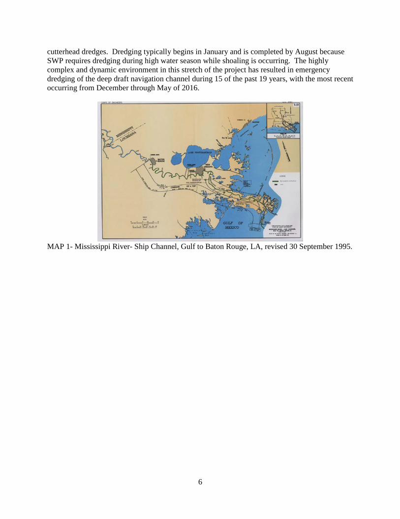
cutterhead dredges. Dredging typically begins in January and is completed by August because SWP requires dredging during high water season while shoaling is occurring. The highly complex and dynamic environment in this stretch of the project has resulted in emergency dredging of the deep draft navigation channel during 15 of the past 19 years, with the most recent occurring from December through May of 2016.
MAP 1- Mississippi River- Ship Channel, Gulf to Baton Rouge, LA, revised 30 September 1995.
7
3. Vertical Datum Conversion Process The datum relationships provided in this report were determined in order to bring the “Mississippi River Ship Channel, Gulf to Baton Rouge” project into compliance with the requirements outlined in ER 1110-2-8160, Policies for Referencing Project Elevation Grades to Nationwide Vertical Datums, and EM 1110-2-6056, Standards and Procedures for Referencing Project Elevation Grades to Nationwide Vertical Datums. These policy documents define the requirement for referencing datums on coastal navigation projects. The following EM excerpt addresses the requirement to establish the relationship to MLLW for projects that are defined to a legacy datum, such as MLG (page 4-2): "USACE projects that are still defined relative to non-standard or undefined legacy datums (e.g., Mean Low Gulf (MLG), Gulf Mean Tide, MSL, NGVD, MLW, COEMLW, etc.) should have technically valid transforms to the NOAA MLLW chart/tidal datum for the area. In isolated cases, the legacy datum may be retained as the reference grade provided its relationship to NOAA MLLW datum is accurately defined based on current gage data at the project site. In such projects, depth data furnished to NOAA and other project users must indicate the primary reference gage, along with the tidal datum epoch period and the relationship between the legacy datum, NOAA MLLW, and NAVD88. Legacy "Low Water" datums must be periodically updated for sea level change and regional subsidence using similar computational techniques established by NOAA for coastal waters.” (Reference 11) The relationships have been defined between the MLG legacy project datum and MLLW and NAVD88 as described in the EM. These datum relationships were used to define a MLLW-MLG conversion value, which converts the currently maintained MLG elevations to MLLW depths. This is only applicable where the project is considered tidally influenced. For ease of use this relationship will be used south of river mile 13.4 AHP and continuing down SWP, as this is the area requiring maintenance dredging. The Low Water Reference Plane (LWRP) shall be referenced above river mile 104.5 AHP for maintenance dredging on the river crossings.
3.1 Project Datum
The River and Harbor Act of 1945 authorized the Project, as provided in the February 25, 1939 Report of the Chief of Engineers (House Document Numbered 215, Seventy-Sixth Congress), which specified MLG as the project datum for the multiple channels within the Project area including the channel from New Orleans to the Gulf. MLG is a local terrestrial datum that was originally defined relative to local mean sea level as observed at the Biloxi gage in 1899 in the Gulf of Mexico. As discussed in EM-1110-2-6056 (Reference 7), most USACE civil projects are, in effect, referenced to a local vertical datum. Many local datums are based on arbitrary, unknown, or perhaps archaic origins. Most hydraulic-based river datums and MSL/MLLW tidal datums are actually local datums when they are not properly modeled or kept updated. MLG was intended to represent the low water level of the Gulf of Mexico, and was defined by District memorandum in 1944 as being 0.78 feet below local mean sea level. At that time, mean sea level was defined by the Sea Level Datum of 1929 (SLD29). SLD29 was created by the US
8
Coast and Geodetic Survey (USC&GS) as the datum to adjust all vertical control to in North America. SLD29 was believed to be a “mean sea level” datum although mean sea level was not the same at each gage. Mean sea level was not developed using the same epoch or period of record at each of the gages. Each gage was, in effect, a "local mean sea level" (LMSL) reference datum. However, over time, with sea level rise and other factors, it was no longer considered a “mean sea level” datum. In 1973, the name of SLD29 was changed to the National Geodetic Vertical Datum of 1929 (NGVD29) because it no longer represented sea level (Reference 7). However, the assumed equivalency of NGVD29 to mean sea level was predominant in both government and academic texts published well after the 1973 redefinition and MLG for this project continued to be locally interpreted as 0.78 ft. below NGVD29. The MLG datum thus became disassociated from sea level. The relationship between reference datums is often complex given they can deviate spatially over a region, due to a variety of reasons. They may also have temporal deviations due to land subsidence or uplift, sea level changes, project reconstruction, periodic readjustments to the datum origin, or to redefined points on the reference surface. This is particularly true for this project due to the magnitude of subsidence in the region. The Survey Section Stream Gaging Unit (SGU) has maintained a series of gages along SWP, which were set and maintained to NGVD29. For ease of use, another series of gages were set to the MLG datum by applying the commonly used 0.78 ft. offset. As NGVD29 benchmarks subsided over time, the gages referenced to MLG also subsided. The MLG gages were not maintained, further disassociating this local terrestrial datum from sea level. The project authorized in 1985 was thus constructed and has been maintained to a legacy local terrestrial datum that was disassociated from mean sea level.
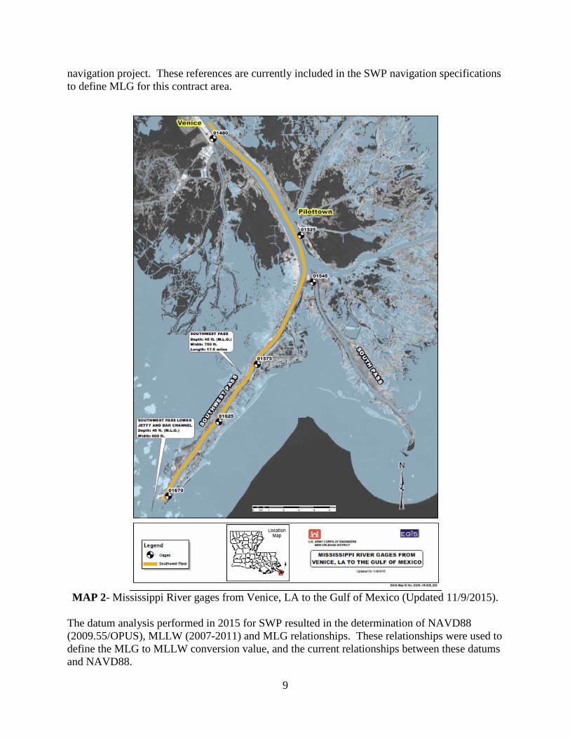
3.2 Methodology for Establishing Conversion Value In 2009 surveys were performed as part of the Comprehensive Evaluation of Project Datums (CEPD) effort to establish the relationship between MLG, MLLW, and NAVD88 for this area. This required surveying the SGU gages, the MLG gages, and NOAA gages in the vicinity. The datum relationships were defined and were documented via the CEPD reporting database. In 2013, NGS published an update to NAVD88 (the 2009.55 epoch) and a new geoid model (GEOID12A). These updates significantly changed the resulting NAVD88 elevations in this area by greater than 1 foot, so new gage surveys were required to reestablish datum relationships on both sets of gages. In 2014 and 2015, several surveys were performed to update the datum relationships (MLG, MLLW, NAVD88), which again required surveying the SGU gages, the MLG gages, and the NOAA gages. These surveys resulted in revised datum relationships. SGU recommended and established consensus for resetting the SGU gages to NAVD88, removing the MLG gages and maintaining the local MLG references by establishing offset values to the SGU gages. In 2015, the SGU gages and the MLG gages along SWP were removed and the current six SGU gages were set to the most up to date NAVD88 reference, NAVD88 (2009.55) (See Map 2). MLG and MLLW offset values were determined for each gage and were supplied for use on the
9
navigation project. These references are currently included in the SWP navigation specifications to define MLG for this contract area.
MAP 2- Mississippi River gages from Venice, LA to the Gulf of Mexico (Updated 11/9/2015).
The datum analysis performed in 2015 for SWP resulted in the determination of NAVD88 (2009.55/OPUS), MLLW (2007-2011) and MLG relationships. These relationships were used to define the MLG to MLLW conversion value, and the current relationships between these datums and NAVD88.
10
The MLLW and NAVD88 datum relationships will have to be periodically updated to incorporate future sea level rise and local subsidence, as well as other factors that may affect these datums (i.e. geoid models, epoch updates). Of note, these periodic updates will not change the MLG to MLLW conversion value. This value will remain constant, which will allow dredging templates to rise over time along with MLLW (due to sea level rise). After the datum analysis was completed in 2015 all gages along SWP that are maintained by the USACE MVN SGU were reset to NAVD88 (2009.55/OPUS). Gage correction values were defined for each gage to adjust gage readings to MLLW (2007-2011) and MLG. These corrections will be considered valid until a new datum analysis for future MLLW adjustments is performed. The MLLW-NAVD88 relationships were determined at two tide stations published by the National Oceanic and Atmospheric Administration (NOAA):
• Pilottown (Station 8760721), and • Pilots Station East (Station 8760922).
These stations are located near USACE gages 01525 and 01670, respectively, so these relationships are referenced at the USACE gages. These MLLW – NAVD88 relationships are referenced to the 2007-2011 modified tidal datum epoch. The MLG – NAVD88 relationships were determined based on surveys of staff gages that were previously set to MLG.
11
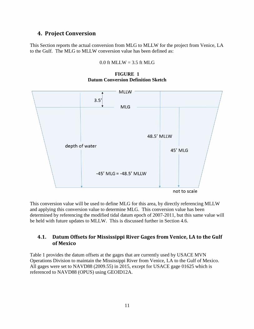
4. Project Conversion This Section reports the actual conversion from MLG to MLLW for the project from Venice, LA to the Gulf. The MLG to MLLW conversion value has been defined as:
0.0 ft MLLW = 3.5 ft MLG
FIGURE 1 Datum Conversion Definition Sketch
This conversion value will be used to define MLG for this area, by directly referencing MLLW and applying this conversion value to determine MLG. This conversion value has been determined by referencing the modified tidal datum epoch of 2007-2011, but this same value will be held with future updates to MLLW. This is discussed further in Section 4.6.
4.1. Datum Offsets for Mississippi River Gages from Venice, LA to the Gulf of Mexico
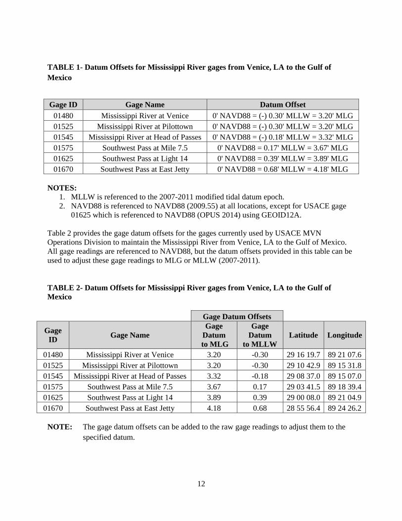
Table 1 provides the datum offsets at the gages that are currently used by USACE MVN Operations Division to maintain the Mississippi River from Venice, LA to the Gulf of Mexico. All gages were set to NAVD88 (2009.55) in 2015, except for USACE gage 01625 which is referenced to NAVD88 (OPUS) using GEOID12A.
12
TABLE 1- Datum Offsets for Mississippi River gages from Venice, LA to the Gulf of Mexico
Gage ID Gage Name Datum Offset
01480 Mississippi River at Venice 0' NAVD88 = (-) 0.30' MLLW = 3.20' MLG 01525 Mississippi River at Pilottown 0' NAVD88 = (-) 0.30' MLLW = 3.20' MLG 01545 Mississippi River at Head of Passes 0' NAVD88 = (-) 0.18' MLLW = 3.32' MLG 01575 Southwest Pass at Mile 7.5 0' NAVD88 = 0.17' MLLW = 3.67' MLG 01625 Southwest Pass at Light 14 0' NAVD88 = 0.39' MLLW = 3.89' MLG 01670 Southwest Pass at East Jetty 0' NAVD88 = 0.68' MLLW = 4.18' MLG
NOTES:
1. MLLW is referenced to the 2007-2011 modified tidal datum epoch. 2. NAVD88 is referenced to NAVD88 (2009.55) at all locations, except for USACE gage
01625 which is referenced to NAVD88 (OPUS 2014) using GEOID12A. Table 2 provides the gage datum offsets for the gages currently used by USACE MVN Operations Division to maintain the Mississippi River from Venice, LA to the Gulf of Mexico. All gage readings are referenced to NAVD88, but the datum offsets provided in this table can be used to adjust these gage readings to MLG or MLLW (2007-2011). TABLE 2- Datum Offsets for Mississippi River gages from Venice, LA to the Gulf of Mexico
Gage Datum Offsets Gage
ID Gage Name Gage
Datum to MLG
Gage Datum
to MLLW Latitude Longitude
01480 Mississippi River at Venice 3.20 -0.30 29 16 19.7 89 21 07.6 01525 Mississippi River at Pilottown 3.20 -0.30 29 10 42.9 89 15 31.8 01545 Mississippi River at Head of Passes 3.32 -0.18 29 08 37.0 89 15 07.0 01575 Southwest Pass at Mile 7.5 3.67 0.17 29 03 41.5 89 18 39.4 01625 Southwest Pass at Light 14 3.89 0.39 29 00 08.0 89 21 04.9 01670 Southwest Pass at East Jetty 4.18 0.68 28 55 56.4 89 24 26.2
NOTE: The gage datum offsets can be added to the raw gage readings to adjust them to the
specified datum.
13
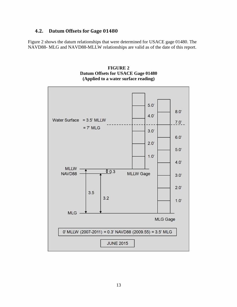
4.2. Datum Offsets for Gage 01480 Figure 2 shows the datum relationships that were determined for USACE gage 01480. The NAVD88- MLG and NAVD88-MLLW relationships are valid as of the date of this report.
FIGURE 2 Datum Offsets for USACE Gage 01480
(Applied to a water surface reading)
14
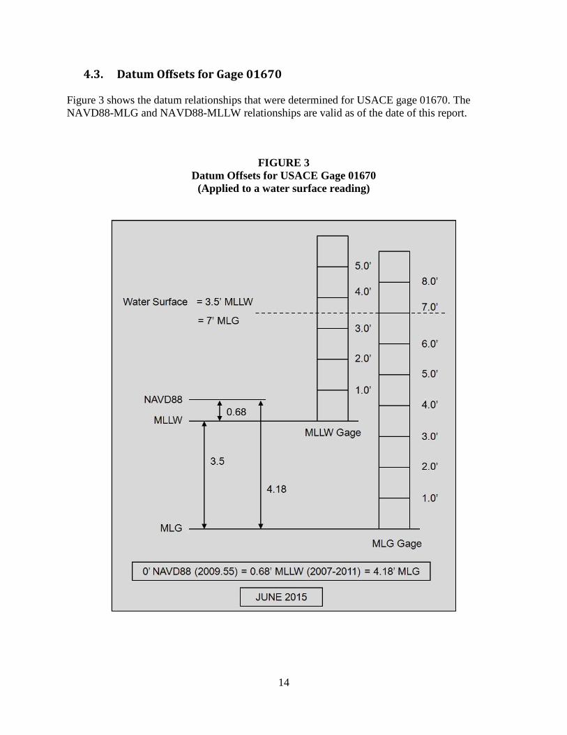
4.3. Datum Offsets for Gage 01670 Figure 3 shows the datum relationships that were determined for USACE gage 01670. The NAVD88-MLG and NAVD88-MLLW relationships are valid as of the date of this report.
FIGURE 3 Datum Offsets for USACE Gage 01670
(Applied to a water surface reading)
15
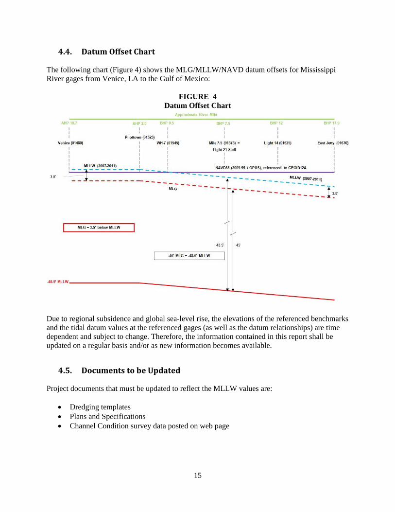
4.4. Datum Offset Chart The following chart (Figure 4) shows the MLG/MLLW/NAVD datum offsets for Mississippi River gages from Venice, LA to the Gulf of Mexico:
FIGURE 4 Datum Offset Chart
Due to regional subsidence and global sea-level rise, the elevations of the referenced benchmarks and the tidal datum values at the referenced gages (as well as the datum relationships) are time dependent and subject to change. Therefore, the information contained in this report shall be updated on a regular basis and/or as new information becomes available.
4.5. Documents to be Updated Project documents that must be updated to reflect the MLLW values are:
• Dredging templates • Plans and Specifications • Channel Condition survey data posted on web page
16
4.6. Future updates to MLLW/NAVD88
The MLLW-NAVD88 datum offsets defined in this report are time dependent and will have to be regularly verified/updated. EM 1110-2-6065 indicates that the periodic reassessments of controlling elevations and datum relationships should be performed at least every five years. These reassessments will not change the MLLW-MLG conversion value, only the MLLW-NAVD88 relationships that will be used to define MLLW for the Mississippi River from Venice, LA to the Gulf of Mexico. It is anticipated that NOAA will publish a modified tidal datum epoch (2012-2016) in FY18, which would require that the MLLW-NAVD88 relationship be updated and the corresponding relationship to MLG be updated accordingly using the conversion value.
4.7 Summary This conversion value will be considered absolute and documents current practices. It will not be redefined for Mississippi River gages from Venice, LA to the Gulf of Mexico. Use of this relationship will be a no-impact change to current dredging practices, as this has been determined using the current relationship to MLG. However, the relationship between MLLW and NAVD88 will need to be periodically updated to incorporate the future sea level rise and local subsidence. Dredging design templates and other associated documents are now updated to directly reference MLLW depths, and the relationship to MLG will be included as a note. Providing the MLG relationship will allow users to relate these project documents back to authorization language as needed.
REFERENCES
1. Comprehensive Evaluation of Project Datums (CEPD) Final Report – Appendix 1, Mississippi River Ship Channel, Gulf to Baton Rouge. Date: 18 December 2013. Updated: 10 July 2015.
2. Mississippi River Baton Rouge to the Gulf of Mexico, Planning Report, New Orleans, Louisiana, District Office, Corps of Engineers, Department of the Army, January 1954, January 1955 and January 56.
3. River & Harbors Act March 1915, Chapter 142, Section 5. 1644 Laws Relating to Improvement of Rivers and Harbors.
4. USACE, 1999. ER 1110-2-1150: Engineering and Design for Civil Work Projects, 31 August 1999.
5. USACE, 2007. EC 1110-2-6065: Engineering and Design, Comprehensive Evaluation of
Project Datums, Guidance for a Comprehensive Evaluation of Vertical Datums on Flood Control, Shore Protection, Hurricane Protection, and Navigation Projects, 1 July 2007.
17
6. USACE, 2009. EC 1110-2-6070: Engineering and Design, Comprehensive Evaluation of
Project Datums, Guidance for a Comprehensive Evaluation of Vertical Datums on Flood Control, Shore Protection, Hurricane Protection, and Navigation Projects, 1 July 2009.
7. USACE, 2010. EM 1110-2-6056: Engineering and Design, Standards and Procedures for Referencing Project Elevation Grades to Nationwide Vertical Datums, 31 December 2010.
8. USACE, 2014. Navigation Project Compliance with Vertical Datum Guidance.
Memorandum from HQUSACE. Dated 24 October 21014.
9. http://www2.mvn.usace.army.mil/eng2/edsd/proj_maps/1-51A.htm
10. ER 1110-2-8160, Policies For Referencing Project Elevation Grades To Nationwide Vertical Datums
11. NOAA, 2014. NOAA Technical Report NOS CO-OPS 068, Implementation of Procedures for Computation of Tidal Datums in Areas with Anomalous Trends in Relative Mean Sea Level
All related supporting documentation may be found in ProjectWise: pw:\\MVN-APPW02.mvn.ds.usace.army.mil:CEMVN01\Documents\Civil Works\Mississippi River - Baton Rouge to the Gulf of Mexico\South West Pass\Engineering Documentation Report
Engineering Documentation Report
pw://MVN-APPW02.mvn.ds.usace.army.mil:CEMVN01/Documents/P%7ba7d3f0a0-4e62-429a-8f3c-15b3f89fa597%7d/