Embed Size (px)
Citation preview

MINNESOTA ARCHITECTURE - HISTORY INVENTORY FORM
Project: Historic Bridge Study - Phase III
Minneapolis, Hennepin County, Minnesota
HE-MPC-01775
Identification SHPO Inventory Number HE-MPC-01775
Historic Name Bridge L5732 Current Name Bridge L5732
Review and Compliance Number
Field # Form (New or Updated) Updated
Address Minnehaha Parkway over Minnehaha Creek near Pleasant Avenue South
Description
City/Twp Minneapolis Linear Feature? No
County Hennepin HPC Status
Legal Desc. Twp 28N Range 24W Sec 15 QQ SESW Resource Type Structure
USGS Quad Minneapolis South Architect/Engineer Board of Park Commissioners
UTM Zone 15 Datum 83 Style Neoclassical
Easting 477808 Northing 4972621 Construction Date 1925
Property ID (PIN) Original Use Transportation
Current Use Transportation
Description
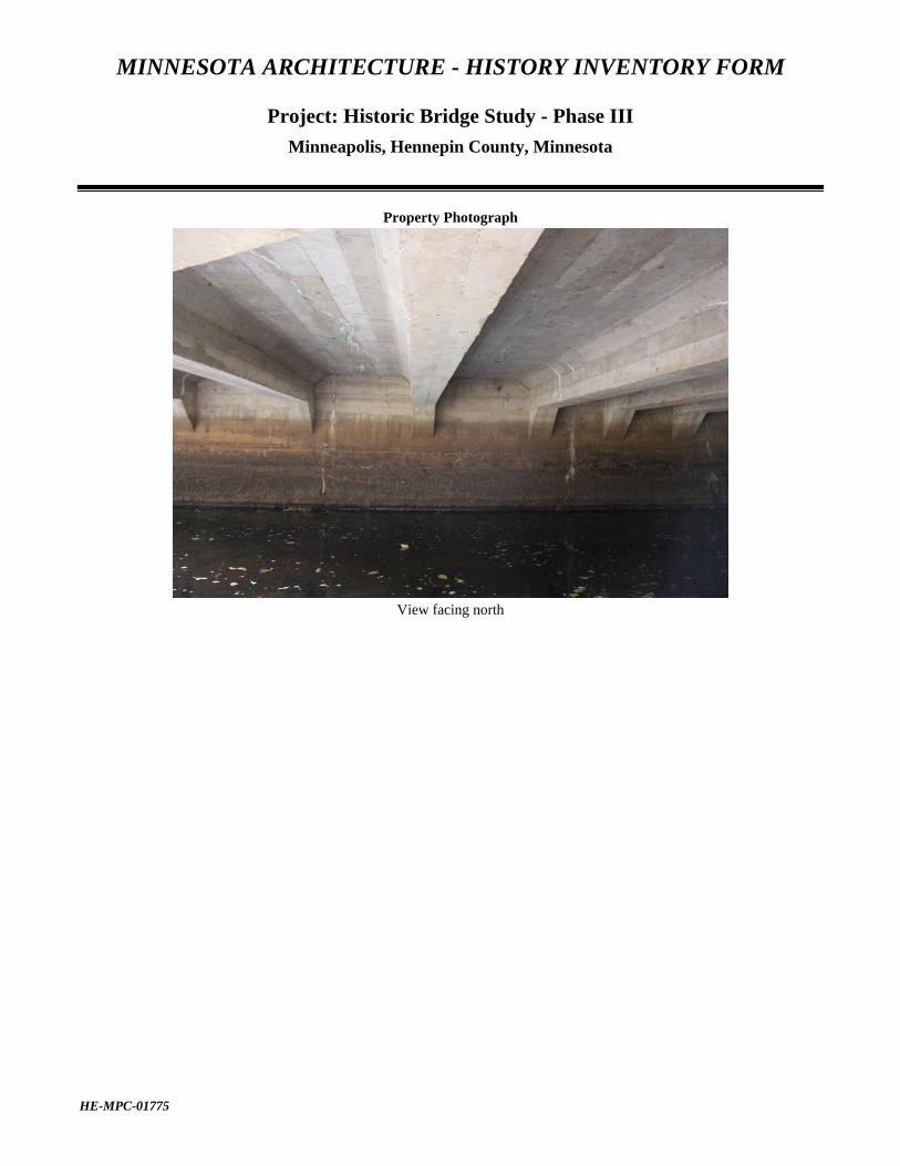
Bridge L5732, built in 1925 by the Board of Park Commissioners, carries Minnehaha Parkway in a northeast-southwest alignment over Minnehaha Creek in the Minnehaha segment of the Grand Rounds in Minneapolis, Hennepin County, Minnesota. At the point of crossing the creek flows in a northwest-southeast direction, requiring a skewed span. This segment of the Grand Rounds is defined by the creek and parkway. The bridge is located near Pleasant Avenue. Other bridges of similar age and design are present along this portion of the parkway, including Bridges L5730 and L5731. A metal wingwall has been added to the northeast corner of the bridge and appears to be attached to a modern reinforced-concrete drainage structure. The purpose of the culverts is unclear since they do not appear to function as their intended use. The immediate surrounding includes dense clusters of trees and residential neighborhoods just beyond the park boundaries. Bridge L5732 is a single-span, cast-in-place, reinforced-concrete, T-beam bridge constructed on a skewed alignment. It has a structure length of 51 feet and a main span length of 45 feet. The 35-foot-wide concrete bridge deck with bituminous surface no longer carries motorized vehicle traffic. The bridge was converted to pedestrian and bicycle traffic in 1976. The bridge displays minimal characteristic details of the Neoclassical style, including recessed panels on the parapet with a simple linear stringcourse below. The superstructure is comprised of a series of identical, equally spaced, T-beams, with a deeper fascia beam of the same design on each side. Each beam is slightly haunched at the bridge seats on the abutments. The haunched ends are angular for the interior beams but curved for the fascia beams, creating one of the few stylistic elements in the bridge. Other than the curve, the fascia beams are completely plain and smooth, without panels or other features. The deep concrete edge of the deck above the fascia beams and abutments are equally plain. Aside from the recessed panels on the parapet and simple

MINNESOTA ARCHITECTURE - HISTORY INVENTORY FORM
Project: Historic Bridge Study - Phase III
Minneapolis, Hennepin County, Minnesota
HE-MPC-01775
linear stringcourse that extends along the base of the parapet, the bridge displays minimal aesthetic details. Portions of the parapet have been painted to cover graffiti. Approximately eight vertical concrete pipe culverts have been installed along the east embankment of Minnehaha Creek south of the bridge.
EVALUATION AND ANALYSIS
Historical Context
Reinforced-Concrete Highway Bridges in Minnesota, 1900-1945 Historical Narrative
Constructed in 1925, Bridge L5732 carries Minnehaha Parkway over Minnehaha Creek, which are elements of the Grand Rounds. It is located near Pleasant Avenue. The Minneapolis Park Board was established in 1883 and hired Horace Cleveland to design the city’s park system that became known as the Grand Rounds. Cleveland was a park designer and advocate who lived in Minneapolis for over a decade in the latter half of the 1800s. Development of the Grand Rounds included the construction of bridges connecting roads and paths between waterways. The Grand Rounds became a series of parkways encircling the city and connecting lakes, rivers, creeks, and other natural features, and continued to be developed and expanded throughout the twentieth century. The park at Minnehaha Falls was an important component of the city’s park system, which the board acquired in 1889 after years of failed attempts by the state to establish a park there. Connecting the new park and the chain of lakes to the west became a priority. The board’s 1889 annual report states: "The most natural route is undoubtedly along the beautiful valley of Minnehaha Creek.” That same year the board began receiving land donations from property owners along the creek. By 1891 the board had prepared a plat of the proposed parkway, a corridor from 200 to 800 feet in width, and had obtained over 80 percent of the land. The initial period of parkway development was led by William Morse Berry, the park system's first full-time superintendent. Minnehaha Parkway was primarily developed during the last decade of the nineteenth century and saw significant improvements during the 1920s and 1930s. The parkway was upgraded after delays caused by World War I, and in the early 1920s the city expanded roadways, realigned routes, added electric lights, footpaths, and ornamental bridges. As part of the upgrade of the parkway in the early 1920s, a new driveway—also named Minnehaha Parkway—was aligned and graded to provide more scenic views closer to Minnehaha Creek, giving “the driving public a full view of that picturesque natural landscape.” The earlier drives were retained and made “more available for their original purpose as service drives for the adjoining residential districts.” The new scenic drive, closer to the creek, required construction of six bridges, three replacing existing wood bridges and three for crossings of the new drive. The Park Commissioners’ 1924 annual report characterized the construction effort: “All these bridges are concrete construction, designed and executed by our Engineering Department and our own working forces. They are all of every pleasing appearance: and their designs appropriate to their respective localities.” Most of the new bridges apparently were under construction in 1924, but remained to be completed the following year when the total had grown from six to nine, according to the 1925 annual report. Bridge L5732 was built during this period of expansion along Minnehaha Parkway and is among the simplest and unornamented of the new bridges. It shares a basic concrete T-beam superstructure type with several other bridges of the period, thus fitting into the general design trend in the Grand Rounds for the first half of the twentieth century. Prior to 1959 the most common bridge forms in the parkway included arch, beam/girder, and slab, and the typical materials

MINNESOTA ARCHITECTURE - HISTORY INVENTORY FORM
Project: Historic Bridge Study - Phase III
Minneapolis, Hennepin County, Minnesota
HE-MPC-01775
used consisted of stone, concrete with stone veneer, and concrete. Bridge L5732 derives its stylistic expression from its parapet, which is a modest interpretation of the Neoclassical style. Since its construction the bridge has had few alterations. The most notable was when it was closed to vehicular traffic in 1976. Aside from this and the addition of a metal wingwall at the northeast corner of the abutment, the bridge does not appear to have other alterations or modifications. Significance
Bridge L5732 was evaluated under the “Reinforced Concrete Highway Bridges in Minnesota, 1900-1945” Multiple Property Documentation Form (Reinforced-Concrete MPDF) for potential significance under the National Register of Historic Places (National Register) Criteria. Registration Requirement 5 of the Reinforced-Concrete MPDF notes a bridge must have outstanding architectural style or ornamentation. Bridge L5732 has minimal aesthetic features that are limited to the recessed panel parapet, stringcourse, and haunched fascia girders. Of these, the parapet is the only architectural element in an otherwise simple and unornamented structure. The fascia girders are slightly larger than the interior girders and their haunches have been given a slight curve instead of the angular interior examples. Overall, the bridge is a carefully designed but an undistinguished example of a typical, small, reinforced-concrete, deck girder structure of the period. As such, it does not rise to the level of “outstanding architectural style or ornamentation” necessary to meet Registration Requirement 5. This analysis concludes that Bridge L5732 does not meet any of the registration requirements and therefore is not individually eligible under this context. Research did not yield any evidence of individual significance under Criterion A or Criterion B. Bridge L5732 is significant as a contributing resource in the previously determined-eligible Grand Rounds Historic District. The Grand Rounds Historic District is significant under National Register Criterion A in the area of Community Planning and Development, and under Criterion C in the area of Landscape Architecture. The period of significance for the district is 1884 to 1942. Bridge L5732 is located within the boundaries of the Minnehaha Segment of the Grand Rounds, which extends along Minnehaha Creek from Lake Harriet to Minnehaha Park. Bridge L5732 is one of several contributing bridges along the Minnehaha Segment that cross over Minnehaha Creek. Bridge L5732 has a period of significance of 1925, which corresponds with the year the bridge was built.
Integrity
Bridge L5732 remains in its original location over Minnehaha Creek and the surroundings remain much the same as the original setting within the boundaries of the park. Beyond the park boundaries the area was developed into residential neighborhoods in the decades following construction. As such, the bridge retains very good integrity of location and setting. Although the bridge no longer carries motorized vehicular traffic, it retains its concrete bridge deck with bituminous surface, which conveys its sense of association and feeling. Aside from the elimination of vehicular traffic, the bridge does not appear to have been altered. As such, the bridge retains integrity of design, workmanship, and materials. Bridge L5732 retains sufficient integrity to convey its significance as a contributing resource to the Grand Rounds Historic District under Criterion A. In accordance with National Register Bulletin 15: How to Apply the National Register Criteria for Evaluation regarding historic districts, the bridge maintains the interrelationship with other resources in the historic district to convey a visual sense of the overall historic environment. Bridge L5732 continues to convey its significance as a contributing resource within the Grand Rounds Historic District.

MINNESOTA ARCHITECTURE - HISTORY INVENTORY FORM
Project: Historic Bridge Study - Phase III
Minneapolis, Hennepin County, Minnesota
HE-MPC-01775
Recommendation
Bridge L5732 is recommended not individually eligible under National Register Criterion A and Criterion C because it does not meet registration requirements within the Reinforced-Concrete MPDF. However, the bridge is considered a contributing element to the determined-eligible Grand Rounds Historic District. The period of significance is 1925, which corresponds with the year the bridge was built. Sources
Board of Park Commissioners. Annual Report 1924. Minneapolis, Minn., 1924. Park Board Files. Minnesota Historical Society.
———. Forty-Third Annual Report. Minneapolis, Minn., 1925. Park Board Files. Minnesota Historical Society.
“Bridge No. L5732, Minnesota Architecture-History Inventory Form,” n.d. Available at State Historic Preservation Office, St. Paul.
Roise, Charlene K. Minnehaha Parkway: An Assessment of Significance. Prepared by Hess, Roise and Company for the Minneapolis Park and Recreation Board, 1999.
Roise, Charlene K., and Denis P. Gardner. Making the City Itself a Work of Art: An Historical Context for the Grand Rounds, Minneapolis. Minneapolis, Minn.: Hess, Roise and Company, 2000.
Wirth, Theodore. Minneapolis Park System 1883-1944: Retrospective Glimpses Into the History of the Board of Park Commissioners of Minneapolis, Minnesota and The City’s Park, Parkway, and Playground System. Board of Park Commissioners of the City of Minneapolis, July 16, 1945.
Consultant’s Recommendation of Eligibility
Not Eligible – Individual; Contributing to Eligible Historic District
Prepared By
Mead & Hunt, Inc.
Date Surveyed
10/27/15

MINNESOTA ARCHITECTURE - HISTORY INVENTORY FORM
Project: Historic Bridge Study - Phase III
Minneapolis, Hennepin County, Minnesota
HE-MPC-01775
Property Photograph
View facing southeast
Property Photograph
View facing northeast

MINNESOTA ARCHITECTURE - HISTORY INVENTORY FORM
Project: Historic Bridge Study - Phase III
Minneapolis, Hennepin County, Minnesota
HE-MPC-01775
Property Photograph
View facing west
Property Photograph
View facing northeast
MINNESOTA ARCHITECTURE - HISTORY INVENTORY FORM
Project: Historic Bridge Study - Phase III
Minneapolis, Hennepin County, Minnesota
HE-MPC-01775
Property Photograph
View facing north

MINNESOTA ARCHITECTURE - HISTORY INVENTORY FORM
Project: Historic Bridge Study - Phase III
Minneapolis, Hennepin County, Minnesota
HE-MPC-01775
Location Map