Embed Size (px)
Citation preview
South of the Lake Alternatives Analysis Report Table of Contents
April 20, 2011 Page i Quandel Consultants, LLC ©
Midwest Regional Rail Initiative Phase 7
South of the Lake Route Alternatives Analysis Report
Prepared for:Indiana Department of TransportationIllinois Department of Transportation
Iowa Department of TransportationMichigan Department of Transportation
Minnesota Department of TransportationMissouri Department of Transportation
Ohio Department of TransportationWisconsin Department of Transportation
Federal Railroad Administration
Prepared by:Quandel Consultants, LLC
Version: April 20, 2011

South of the Lake Alternatives Analysis Report Table of Contents
April 20, 2011 Page i Quandel Consultants, LLC ©
TABLE OF CONTENTS
Executive Summary .......................................................................................................... iii
1.0 Changes in the Corridor Since 2004 and Their Potential Impacts ...................... 1-1
1.1 NS Park Manor Yard ...................................................................................................... 1-1
1.2 Metra/CREATE Project P1 ............................................................................................. 1-2
1.3 CREATE Project P4 ....................................................................................................... 1-2
1.3.1 Design Alternative #1 ................................................................................................. 1-3
1.3.2 Design Alternative #2 ................................................................................................. 1-3
1.4 CREATE Project P2/P3/EW2 ......................................................................................... 1-3
1.5 Majestic Star Casino ...................................................................................................... 1-4
1.6 Norfolk Southern Indiana Gateway Projects .................................................................. 1-4
1.7 Reclaim Access to the Public Lakefront ......................................................................... 1-4
1.8 The Marquette Plan ....................................................................................................... 1-5
1.9 Four City Consortium ..................................................................................................... 1-5
1.10 Gary Chicago International Airport Runway Extension/Airport Expansion ..................... 1-6
2.0 Historic Alternative Passenger Routes to be Evaluated Further Under a Future Formal Environmental Impact Statement (EIS) .............................................................. 2-1
3.0 South of the Lake Corridor Workshop ................................................................ 3-1
4.0 Capital Cost Estimate Update ............................................................................ 4-1
4.1 Segment 1: Chicago Union Station (NS MP 523.0) to Englewood (NS MP 515.8) (7.2 miles)…………… .......................................................................................................................... 4-2
4.3 Segment 3: Grand Crossing (NS MP 513.6) to NS MP 501.8 (11.8 mi.)........................ 4-5
4.4 Segment 4A: Buffington (NS CP 501) to Porter (NS CP 482) at 110 mph (20.3 miles) . 4-7
4.5.1 Segment 4B-1: Buffington (NS CP 501) to Tolleston ............................................... 4-10
4.5.3 Segment 4B-3: Willow Creek (CSX MP 246.7) to Porter (CSX MP 240.1)(NS CP482)……………. .................................................... ……………………………………………4-12
4.6 Route 1: Chicago to Porter .......................................................................................... 4-13
4.7 Route 2: Chicago to Porter .......................................................................................... 4-13
5.0 Track Schematics ............................................................................................... 5-1

South of the Lake Route Alternatives Analysis Report
Table of Contents
April 20, 2011 Page ii Quandel Consultants, LLC ©
Attachments
Attachment 1 – CREATE Project P4 Design Alternatives
Attachment 2 – Meeting Minutes – Gary Airport – 5/3/2010
Attachment 3 – Conceptual Rail Profile – GYA Crosswind Runway
Attachment 4 – List of High Speed Rail Corridors Provided by Richard Cogswell
Attachment 5 – Technical Memorandum & Schematic Map – FRA Suggested & Historic Routes
Attachment 6 – South of the Lake Corridor Workshop – 9/24/2010 - Minutes
Attachment 7 – South of the Lake – Capital Cost Estimate – 2004 Report
Attachment 8 – CSX Schematic – Buffington to Porter via Tolleston & Willow Creek
Attachment 9 – Google Earth Image of Porter, IN
Attachment 10 – Existing and Proposed Track Schematics for Route 1 and Route 2

South of the Lake Route Alternatives Analysis Report
Executive Summary
April 20, 2011 Page iii Quandel Consultants, LLC ©
EXECUTIVE SUMMARY
In 1999, Amtrak, Michigan, and Indiana Departments of Transportation (MDOT and INDOT) commissioned a study to evaluate possible alignments through northeastern Illinois and Northwestern Indiana for new high-speed passenger rail service in the Midwest. The study was undertaken by Charles H. Quandel and Associates with Parsons Brinckerhoff and Proudfoot Associates serving as subconsultants. The team considered previous concepts prepared by HDR Engineering in 1994 and 1996 and concluded that a feasible alignment could be constructed from Chicago to Porter using existing and abandoned rights of way to provide reduced travel times with minimal freight interference. The corridor segments from Chicago Union Station to Buffington Harbor employed rights of way and/or tracks owned by Amtrak, Norfolk Southern (NS), or CSXT. The abandoned rights of way included segments of the former Pennsylvania Railroad, Indiana Harbor Belt and Wabash from the vicinity of Gary Airport to Willow Creek. The currently operational CSXT Michigan Central alignment was employed from Willow Creek to Porter.
In November 2001, Amtrak revised the study objectives to reconsider operating railroad corridors, since the likelihood of obtaining an intact corridor (comprised of abandoned right of way) had diminished with increased development in the region. The report presents the following information:
Inspect and prepare cost estimates for rehabilitating or reconstructing bridges at the Calumet River (NS CP 509) and Indiana Harbor Canal (CSX Hick Bridge).
Develop conceptual plans and cost estimates for track improvements from Chicago to Buffington Harbor using the previously defined Amtrak, NS and CSX rail corridor.
Develop conceptual track plans and cost estimates for infrastructure improvements from Buffington Harbor to Porter using a Norfolk Southern alignment.
Develop conceptual track plans and cost estimates for infrastructure improvements from Buffington Harbor to Porter using a CSX alignment.
Update the capital costs for infrastructure improvements between Porter and Detroit on the route used by Amtrak passenger trains.
The Amtrak, MDOT, and INDOT Final Report was issued in 2004
The purpose of the current MWRRI Phase 7 task is to perform an update of the earlier (1994, 1999 and 2004) reports on the South of the Lake Corridor (SOLC), between Chicago, Illinois and Porter, Indiana. Routes considered under this task include the current “Norfolk Southern” and “CSX” routes, as well as the historic routes discussed in the previous studies. Both the Norfolk Southern and the CSX routes share the track segments between Chicago Union Station and Buffington, IN (NS CP501). At Buffington, the route alternatives provide separate paths to arrive at Porter, IN. In order to accomplish these tasks, the following subtasks will be undertaken:

South of the Lake Route Alternatives Analysis Report
Executive Summary
April 20, 2011 Page iv Quandel Consultants, LLC ©
Evaluate the impact of changes in the corridor that have occurred since 2004. Changes in corridor use that have occurred over the last five years affect the availability of a passenger corridor route between Chicago and Porter, Indiana.
Identify historic alternative passenger routes for further evaluation under a formal Environmental Impact Study.
Convene and facilitate a workshop with stakeholders to identify planned development in the corridor as well as the needs and desires of the respective parties.
Update the capital cost estimates for the two routes identified in the 2004 report using 2010 unit prices and the revised capital cost methodology developed under the MWRRI Phase 7 study.
Prepare track schematics for existing and proposed conditions for these routes. This MWRRI Phase 7 South of the Lake Route Alternative Analysis Report presents the findings of these sub-tasks.

South of the Lake Route Alternatives Analysis Report 1.0-Changes in the Corridor Since 2004 and Their Potential Conflicts
April 20, 2011 Page 1-1 Quandel Consultants, LLC ©
1.0 CHANGES IN THE CORRIDOR SINCE 2004 AND THEIR POTENTIAL IMPACTS
1.1 NS Park Manor Yard The NS Park Manor Yard was expected to be phased out by 2006; traffic changes have occurred and NS has decided to keep the yard in operation, in fact, NS has performed significant rehabilitation on the existing infrastructure.
After Conrail was acquired by and split between NS & CSX in 1999, an agreement was reached where NS would allow CSX use, control & operation of its Park Manor Yard intermodal facility for a defined period of time. During part of the time that the facility was in CSX hands, NS planned to discontinue its use once it regained ownership of the facility. Because of changes in traffic levels and contract demands, NS decided to combine the Park Manor Yard Intermodal Facility would require the use of the facility after all. Since resuming control of the yard, NS has invested considerable sums in capital repairs to the tracks, pavement & underlying bridges, and has plans for further improvements.
Operations at Park Manor Yard include termination and origination of intermodal trains and their cargo, providing a relay point for blocks of intermodal cars received at Park Manor but destined for points both east and west, moving both locomotives and intermodal cars between Park Manor and the nearby NS intermodal facilities at the 47th St, 55th St & 51st St Yard complex just to the north, and providing storage for unloaded intermodal rail cars needed at all of NS’ facilities in the area for reloading in the near term.
Because of the nature of the use of Park Manor Yard, the decision to continue its operation will have the following impacts:
Freight traffic will cross the route of the planned HSR passenger service in the area between Englewood and CP509 to access Park Manor Yard from the NS Chicago Line from both the east and the west
Inter-yard freight movements between NS facilities at Park Manor (railroad north of the NS Chicago Line) and NS 47th/51st/55th St Yard complex (railroad south of the NS Chicago Line) will continue; these inter-yard movements will cross the route of the SOLC
The retention of Park Manor Yard will cause changes to the planned HSR construction between Englewood and CP 509, but will not prevent it. Earlier planning had assumed that HSR could operate on existing track and right of way no longer needed for the operation of Park Manor Yard. Since this is no longer the case, the HSR planning will necessarily need to provide for both passenger and freight operations through an area with less available right of way than originally thought.

South of the Lake Route Alternatives Analysis Report 1.0-Changes in the Corridor Since 2004 and Their Potential Conflicts
April 20, 2011 Page 1-2 Quandel Consultants, LLC ©
1.2 Metra/CREATE Project P1 The Final Design for Metra/CREATE Project P1 has been completed. The construction phase has been initiated. The project has been funded by the American Recovery and Reinvestment Act (ARRA).
CREATE Project P1 is also known as the “Englewood Flyover”. CREATE Project P1 is a plan to elevate Metra’s commuter traffic above the NS Chicago Line – the lines presently and historically have crossed paths and created delays due to traffic conflicts at Englewood.
The construction of the Englewood Flyover will remove existing cross traffic conflicts between the Metra Rock Island District (RID) commuter service and the combined Amtrak Passenger and NS Freight traffic on the Chicago Line by providing a grade separation where Metra will travel above the NS Chicago Line. This separation will allow Metra trains to move through the area with no signal restrictions due to the interlocking, which will have been eliminated on the RID. NS & Amtrak trains will still move through the Englewood Interlocking although it will be an NS Control Point (likely CP 515). The control point will allow freight and passenger traffic to move fluidly through the area, especially with the removal of Metra cross traffic.
There is currently no room for additional trains to operate in and out of the south end of Chicago Union Station during peak commuter hours; Metra BNSF and Southwest Services presently share the use of all available platforms with Amtrak intercity trains. It has been proposed to relocate Metra’s Southwest Service to the LaSalle St Station where there is sufficient room for the both the existing RID trains, the relocated Southwest Service trains and the desired expansion of both to offer additional train frequencies along their routes. The relocation of the Southwest Service away from CUS, as planned under the CREATE Projects P-2/P-3/EW-2 (discussed below), would allow additional intercity passenger trains to operate at that location.
The construction of the Englewood Flyover will allow Metra to move the final leg and operating terminal of its Southwest Service from its present route between 75th St and CUS to LaSalle Street Station operating along the Metra RID from a new connection (CREATE Project P4) near Hamilton Park (vicinity of 74th & Eggleston) in Chicago
Relocation of this service will make room at CUS for additional intercity passenger traffic.
1.3 CREATE Project P4 Create Project P4 has been modified due to the elimination of the Central Corridor from the CREATE Program. The revised EIS is being progressed.
The Central Corridor was a planned freight route, primarily for CN traffic, between Ash St/Brighton Park within the “Western Avenue Corridor” and CNs tracks at Grand Junction. This would allow the removal of CN traffic from the St Charles Airline and the Chicago lakefront area. With the CN purchase of the Elgin Joliet & Eastern Railway (EJ&E), CN provided its own program to facilitate fluid freight movement through
South of the Lake Route Alternatives Analysis Report 1.0-Changes in the Corridor Since 2004 and Their Potential Conflicts
April 20, 2011 Page 1-3 Quandel Consultants, LLC ©
Chicago independent of CREATE, negating the need for a full Central Corridor as originally envisioned.
CREATE Project P4 is intended to allow intercity passenger trains using the CN Chicago Subdivision to access the CUS terminal via NS/HSR improvements between Grand Junction and CUS, complementing the planned freight changes due to the Central Corridor. P4 is still viable without the Central Corridor; in fact, the elimination of the Central Corridor has allowed consideration of alternatives for passenger routing not originally available. Schematic diagrams of the Design Alternatives listed below have been provided as Attachment 1 to this report.
1.3.1 Design Alternative #1
As part of CREATE Project P4, a design alternative has been suggested to provide a new connection from NS Chicago Line to the CN Chicago Subdivision at Grand Crossing, use the CN north to access the St Charles Airline and provide a head end connection between the St. Charles Airline and Amtrak into Union Station. Design elements include:
Retaining St. Charles Airline
Requiring right of way currently in use by Amtrak to build approach embankment between CUS and the St Charles Airline
Avoiding passenger/freight conflicts along NS between Grand Crossing and the St Charles Airline
1.3.2 Design Alternative #2
Design Alternative #2 proposed track changes between CP518 and CP509 on the NS Chicago Line. Design Alternative #2 employs parts of the former CREATE Central Corridor along with new yard and main track configurations throughout the corridor but especially between CP509 and Englewood (including Park Manor Yard). Design elements include:
Significant capital costs required; significant benefit to both NS and HSR would require negotiation of cost sharing or Public Private Partnership
Improvements require neighborhood relocation between 59th Street and 63rd Street – significant property takes
The rehabilitation/replacement of an additional lift bridge at CP509 is called for
Cost estimate is not available
1.4 CREATE Project P2/P3/EW2 The CREATE Project P2/P3/EW2 is underway and should enter Final Design in 2012.
This suite of related projects improves freight fluidity between the BRC Clearing Yard and 80th St by implementing various track and signal improvements (CREATE Project EW2) along with providing dedicated freight and passenger tracks in the 75th St Corridor

South of the Lake Route Alternatives Analysis Report 1.0-Changes in the Corridor Since 2004 and Their Potential Conflicts
April 20, 2011 Page 1-4 Quandel Consultants, LLC ©
and two grade separations (CREATE Projects P2 & P3) to eliminate cross traffic conflicts between through freight movements and Metra’s Southwest Service which necessarily crosses from the south side of the corridor to the north.
Project P3 provides grade separation between Metra & the combined NS Landers Yard and CSX Western Ave Corridor traffic. Project P2 allows Metra Southwest Service traffic to “flyover” the through freight along the BRC and join the Metra Rock Island District (RID) traffic into LaSalle St Station.
CREATE Projects (P1 &) P2/P3/EW2 must be substantially completed to allow the Metra Southwest Service (SWS) to begin operating on the Metra RID to LaSalle Street Station. Without the relocation of the SWS, additional passenger service cannot access CUS
1.5 Majestic Star Casino The Majestic Star Casino at Buffington Harbor, in conjunction with the City of Gary and INDOT, is planning a new connecting bridge between its parking garage/entrance and Cline Avenue. The location of this planned bridge is just east of the existing underpass access at NS MP 501.08.
This roadway connection will be grade separated and pass over the NS Chicago Line very close to the planned location of the HSR flyover from the north side of NS to the south side (NS MP 501.8). If not carefully coordinated, the grade separated structures and/or their approaches will attempt to occupy the same physical space
These plans are in conflict with each other; planning to resolve the conflict should begin as soon as possible.
1.6 Norfolk Southern Indiana Gateway Projects Norfolk Southern’s Indiana Gateway Projects have been awarded ARRA funding; INDOT and FRA have not yet signed the implementing agreement. It is assumed that the projects will be constructed before the South of the lake Corridor construction begins.
These projects were designed to improve freight and passenger fluidity in the NS Chicago Line Corridor for existing passenger service levels and speeds. There are 8 projects of independent utility, 7 along the NS Chicago Line between Burdick and Hammond, IN and 1 along the Amtrak Line just north of Porter, IN.
1.7 Reclaim Access to the Public Lakefront The Cities of East Chicago and Gary have initiated a planning effort to reclaim access to the public lakefront between the East Chicago Marina/Casino complex and the Majestic Star Casino at Buffington Harbor.
The plan calls for consolidation and relocation of the CN (former EJ&E) & IHB Yard operations serving Mittal Steel north of the existing NS Chicago Line. In order to regain the use of the lakefront area, design concepts have been developed that push the railroad yard operations away from the lakefront and toward the existing NS Chicago

South of the Lake Route Alternatives Analysis Report 1.0-Changes in the Corridor Since 2004 and Their Potential Conflicts
April 20, 2011 Page 1-5 Quandel Consultants, LLC ©
Line, as well as south of the NS along the IHB and west of the Indiana Harbor Canal along CN. The relocated yard operations and consolidated tracks will still be required to perform the same service and interchange functions, but with new alignments and service agreements in place to support proposed operations. Amtrak has provided information to the project regarding the HSR plans in the area; the lakefront planning to date has not precluded the construction of the HSR “South of the Lake” Corridor in this area.
Modifications to plans for both the Lakefront Revitalization and the South of the Lake Corridor will likely be required as each concept continues to develop. Potential access to HSR and other transportation elements is a central part of the Lakefront Revitalization.
This effort is considered a part of the Marquette Plan and is supported by the NW Indiana Regional Development Agency (RDA)
1.8 The Marquette Plan The Marquette Plan is a priority of the NW Indiana Regional Development Agency (RDA) and includes:
A comprehensive plan for the Lake Michigan Shoreline, from the Illinois state line to the eastern boundary of Portage
A plan for public recreational access to the shoreline
A plan to recapture 75% of the shoreline for free public access
As a minimum, it will require a setback from the water of at least 200 feet for any NEW structures or facilities not associated with open public access
A plan to provide continuous pedestrian/bicycle trail contiguous to the shoreline to the extent possible, consistent with the long-term Economic Development policy for Northwest Indiana
1.9 Four City Consortium This plan grew out of an agreement between CSX and the Consortium as part of the sale of Conrail. It was part of a broader scheme to create a railroad corridor through NW Indiana to focus railroad development and mitigate crossing related problems
The plan’s goals include:
Reduce traffic on the CSX Barr Sub through East Chicago and Hammond by diverting some Barr Sub traffic onto the CSX Porter Branch
Use the out of service, grade separated Dune Park Branch to detour rail traffic from the Porter Branch onto the Dune Park Branch between Clark Road and Virginia Street in Gary to mitigate traffic problems at grade crossings in the City of Gary
Provide new connections to the Dune Park Branch from the Porter Branch at each end of the proposed detour

South of the Lake Route Alternatives Analysis Report 1.0-Changes in the Corridor Since 2004 and Their Potential Conflicts
April 20, 2011 Page 1-6 Quandel Consultants, LLC ©
Provide a connection to Gary Sugars from the new alignment to allow track abandonment and crossing closures on the NS Gary branch
Incorporate possible high speed passenger service into the planned future use of the grade separated detour route
Plan activity ended in 2009 without being implemented
1.10 Gary Chicago International Airport Runway Extension/Airport Expansion Gary Chicago International Airport (GCIA) Runway Extension/Airport Expansion – the master plan includes extension of runway 12-30 to meet safety requirements and a plan for expansion of the overall facility.
A meeting was held at the GCIA on May 3, 2010 to review the impact of any proposed expansion of Gary Airport on future Midwest Regional Rail Initiative high speed trains operating in the corridor. Minutes are provided as Attachment 2.
The runway extension will require relocation of the CN (former EJ&E) from its present embankment near the end of the runway to a location further west, adjacent to Cline Avenue and the CSX Barr Sub.
A plan for the relocation of CN has been developed by GCIA and preliminary discussions with CN, CSX and NS have been favorable. Negotiations are underway to implement agreements to allow construction to begin.
The plan places CN into the existing CSX Barr Sub corridor, east of the two existing CSX main tracks. The CN tracks begin to rise and turn east to return to the elevated grade of the historic EJ&E alignment between Industrial Highway and Clark Junction. Any HSR plan in this area must accommodate the upward grade change of the CN tracks and the increased width of the railroad corridor in the design of any flyover.
The plan for relocation of CN includes a potential future connection between the CSX Fort Wayne Line and NS CP 501 via the NS Gary Branch and the CSX Barr Sub to remove the need for the historic diamond crossing between CSX & Conrail (PRR) at Clark Junction. The planned HSR “flyover” of the combined CSX & CN tracks at Clark Junction must be coordinated with this potential future connection to avoid conflict.
The “High Case” airport development scenario includes phased extension of the Crosswind Runway 2-20 and the construction of a new parallel runway north of 12-30. In coordination with the Airport Authority, it has been determined that it is possible to construct the high speed rail flyover and the extended crosswind runway without conflict. A conceptual rail profile has been developed to demonstrate the required geometric parameters and is included as Attachment 3.

South of the Lake Route Alternatives Analysis Report 2.0-Historic Alternative Passenger Routes to be Evaluated Further Under a Future Formal
Environmental Impact Statement (EIS)
April 20, 2011 Page 2-1 Quandel Consultants, LLC ©
2.0 HISTORIC ALTERNATIVE PASSENGER ROUTES TO BE EVALUATED FURTHER UNDER A FUTURE FORMAL ENVIRONMENTAL IMPACT STATEMENT (EIS)
On March 10, 2010, representatives of the Midwest Regional Rail Initiative (MWRRI) met with members of the FRA to discuss the status of ongoing work defined under FRA Statement of Work Tasks 1 through 6. Richard Cogswell of FRA re-issued a handout listing possible high speed corridor alternative routes throughout the USA. The handout is provided as Attachment 4. The list was used to prepare a schematic diagram showing potential routes between Chicago Union Station and Porter, IN.
On April 13, 2010, a Technical Memorandum was sent to MWRRI for submittal to FRA by Quandel Consultants outlining discussions and questions pertinent to the FRA suggested routes along with the map of potential route alternatives. The Technical Memorandum is provided as Attachment 5. A schematic map is included in Attachment 5 and depicts the 9 historic routes that could contribute to route alternatives for HSR between Chicago and Porter, IN.
An additional route that will be evaluated in future studies is the South Shore Line. The South Shore Line, operated by the Northern Indiana Commuter Transportation District (NICTD), is an electrically powered commuter line that runs between Chicago’s Millennium Station and the South Bend Regional Airport in South Bend, IN. The South Shore Line right-of-way is adjacent to the Amtrak line from Chicago to Kensington, meets up with CSX near the Gary Metro Center stop until it crosses the CSX line near Millers, and then runs adjacent to NS from Wagner to just east of Burns Harbor.
A future EIS will implement a procedure to further develop and define the universe of route alternatives and screen the alternatives to arrive at potential passenger rail alternatives for further consideration within the NEPA process.

South of the Lake Route Alternatives Analysis Report 3.0-South of the Lake Corridor Workshop
April 20, 2011 Page 3-1 Quandel Consultants, LLC ©
3.0 SOUTH OF THE LAKE CORRIDOR WORKSHOP
On September 24, 2010, a workshop was held to identify planned development in the South of the Lake Corridor as well as begin a discussion of the concerns, needs and desires of the respective parties.
The workshop brought together representatives of a number of parties concerned with development of the corridor including the States of Michigan, Illinois, Indiana, and Ohio, Federal Railroad Administration (FRA), National Park Service (NPS) the Cities of Chicago, IL and Gary, IN, Northwest Indiana Regional Development Authority (RDA), ComEd, Amtrak, Norfolk Southern, CSX, CN, IHB, and Gary/Chicago International Airport.
Introductions were made and the purpose of the meeting was noted. Presentations were made with discussion following regarding definition of the South of the Lake Corridor, Corridor history and previous studies, and current plans and activities that have had or may have impact on the development of the corridor.
A facilitated discussion of the concerns, needs and desires of the respective parties was held and resulted in the identification of the following:
Park Services Issues
o Biology - protection during construction and operation of HSR
o Wildlife – protection during construction and operation of HSR
o Temporary land use – needed during construction of HSR
o Visitor impacts – during construction and operation of HSR
o Noise pollution – during construction and operation of HSR
o Safety – during construction and operation of HSR
o Access – during construction of HSR
Freight RR’s
o Current and future capacity - must be maintained
o Time of day/usage/ freight schedules – must be maintained
MWRRI
o More frequencies
o Increase speeds
o Reliability
o Crossing conflict elimination

South of the Lake Route Alternatives Analysis Report 3.0-South of the Lake Corridor Workshop
April 20, 2011 Page 3-2 Quandel Consultants, LLC ©
o Flexibility to address safety issues in future
o Share use
o Maintenance schedules
The Final Agenda and subsequent Workshop Minutes are provided as Attachment 6 to this report.

South of the Lake Route Alternatives Analysis Report 4.0-Capital Cost Estimate Update
April 20, 2011 Page 4-1 Quandel Consultants, LLC ©
4.0 CAPITAL COST ESTIMATE UPDATE
The 2004 HNTB Detroit-Chicago High Speed Rail Corridor Study Update - “South-of-the-Lake Corridor” included a Capital Cost Estimate. A summary of this estimate is included for reference as Attachment 7. The current effort has updated this earlier Cost Estimate to show values in 2010 dollars and includes the use of the recently updated MWRRI Cost Estimating Methodology for High-Speed Rail on Shared Right-of-Way and associated unit costs.
The 2004 HNTB South of the Lake Reroute Study developed four alternative route options to provide passenger service between CP 501 and Porter. All four corridor alternatives employ Segments 1-3 between Chicago Union Station and CP 501. Two alternatives parallel the existing Norfolk Southern Cleveland-Chicago mainline currently used by Amtrak service. The other two routes use a combination of CSXT alignments and an abandoned rail corridor to the south of the NS corridor. In the balance of this section of discussion, description of the corridor segments and the suggested improvements are taken from the Detroit-Chicago High Speed Rail Corridor Study Update - “South-of-the-Lake Corridor” Study, prepared by HNTB for Amtrak, INDOT & MDOT in 2004. All updates and corrections to the text from this study are shown in italics. The following chart indicates the type of work included within the limits of segments 1, 2, 3, 4A, 4B-1, 4B-2, & 4B-3. Segments 4C & 4D were not included in this update as they were not considered viable in the 2004 report. It is assumed that these 2 segments will be evaluated when the corridor EIS is undertaken. A description of the included segments and the proposed infrastructure improvements follows, along with a cost summary by category.

South of the Lake Route Alternatives Analysis Report 4.0-Capital Cost Estimate Update
April 20, 2011 Page 4-2 Quandel Consultants, LLC ©
Segment 1 Segment 2 Segment 3 Segment 4A Segment 4B-1 Segment 4B-2 Segment 4B-3
Chicago Union Station-
Englewood
Englewood-Grand
Crossing
Grand Crossing - CP
501CP 501- Porter
CP 501- Tolleston
Tolleston- Willow Creek
Willow Creek-Porter
Upgrade/Rehab Existing Main Tracks X XNew Passenger Track(s) X X X X X X
Track Shift to Allow New Track X#15 Turnouts X X#20 Turnouts X X
#20 Crossovers X X X#24 Crossovers X X X
New Diamond(s) X XRefurbish Amtrak Bridge X
New Calumet River Bridge XNew Hick River Bridge X
Refurbish Undergrade Bridge(s) XNew Double Track Bridge(s) XNew Single Track Bridge(s) X
New Embankment & Bridge(s) XCP 501 Flyover X XPorter Flyover X X
Clark Jct. Flyover XWillow Creek Flyover X
Upgrade Centralized Traffic Control (CTC) X X X X X X XPositive Train Control (PTC) X X X X X X X
Chain Link Fence X X X X X X X4 Quadrant Gate(s) X X X X X
Relocate Mineral Springs Road XStreet Closings X
Track on Grade Seperated Structure X
Corridor Segments
Description
4.1 Segment 1: Chicago Union Station (NS MP 523.0) to Englewood (NS MP 515.8) (7.2 miles) This segment extends from Amtrak owned, Chicago Union Station (CUS) to Englewood Junction. Amtrak enters and leaves CUS on two main tracks. However, there is a third main track available if necessary due to train congestion. Amtrak owns the tracks and right of way from Union Station to NS MP 521.3, including the Chicago River South Branch Bridge. Norfolk Southern (NS) owns the tracks and right of way from NS MP 521.3 through Englewood, NS MP 515.8.
The proposed infrastructure design speeds for passenger equipment on this track segment are 45 miles per hour extending south from Union Station for 2 mi and 79 mph south of NS MP 521 to the Englewood curve at NS MP 516.2, where the curvature will restrict speeds to 40-50 mph. The proposed upgraded track design includes rehabilitating the existing main tracks, reconfiguring/upgrading the signal system and installing new turnouts. Multiple infrastructure improvements are required to provide reliable passenger service.
The two mainline tracks will be refurbished from NS MP 523.0 to NS MP 515.8 with a 33% tie renewal and new ballast. The third main track south of Union Station will be upgraded in a similar manner from NS MP 523 to NS MP 522. Two crossovers and a

South of the Lake Route Alternatives Analysis Report 4.0-Capital Cost Estimate Update
April 20, 2011 Page 4-3 Quandel Consultants, LLC ©
single turnout (all #20 turnouts) for 45 mph operation will be installed at NS MP 522 to improve operational flexibility.
It is assumed that the abandonment of the St. Charles Airline, envisioned under the Chicago CREATE Program, has been implemented and has resulted in the elimination of the four (4) CN/NS diamonds at the 21st Street Interlocking at NS MP 520.8. The capital cost estimate included in this report recognizes the reconfiguration required at the 21st Street Interlocking including providing a connection from Amtrak to CN with two #15 turnouts and a connected crossing diamond. A #20 crossover will be installed at NS MP 521 to improve operational flexibility.
The Amtrak bridge over the South Branch of the Chicago River at NS MP 521.5 will be refurbished with new bridge locks, track and bridge ties to permit greater passenger equipment speeds.
A new passenger track will be constructed west of the I-90/94/CTA (Dan Ryan Expressway/CTA Red Line) bridge on the north side of the alignment for use by Amtrak. The track will be extended on a new multi-span bridge over the expressway, CTA & Wentworth Avenue, and separately, a new bridge over 63rd Street.
A placeholder of $150 million is included for acquisition of NS real estate and track, plus freight improvements necessary to allow exclusive passenger traffic use of the two easternmost tracks between Union Station and the I-90/94 bridge.
The full length of the segment will also require upgraded Centralized Traffic Control (CTC) double track signaling for 7.2 mi. and Positive Train Control (PTC) signaling for 5.2 mi. The existing CTC is assumed to require extensive modification to support revised block lengths to optimize capacity for higher speed passenger equipment.
Chain link fence, 10 ft high, will be provided on both sides of the alignment to deter trespassers in this urban area.
Capital Costs for Segment 1 are summarized below by category:

South of the Lake Route Alternatives Analysis Report 4.0-Capital Cost Estimate Update
April 20, 2011 Page 4-4 Quandel Consultants, LLC ©
Segment 1 Capital Cost Amount (1,000's)
Trackwork $8,231
Structures $0
Systems $8,565
Crossings $0
Allocations for Special Elements $175,079
Sub-Total Construction Elements $191,875
Contingency (30%) $57,562
Professional Services and Environmental (24%) $59,865
Total Segment Cost $309,302
Segment Cost Per Mile $26,664
4.2 Segment 2: Englewood Junction Grade Separation (MP 515.8) to Grand Crossing (MP 513.6) (2.4 miles) This segment extends southeast from Englewood Junction to Grand Crossing, a distance of approximately 2.4 miles. The proposed infrastructure design speed is 110 miles per hour.
The proposed alignment requires the construction of two new passenger train tracks from Englewood to Grand Crossing on the north side of the existing NS alignment. These two tracks will occupy the former New York Central (NYC) railroad right of way. A total length of 4.8 mi. of new track will be constructed. It will be necessary to construct one #20 turnout to allow a transition from the new track to the NS line east of Englewood to allow passenger traffic use both the northernmost NS track as well as the new passenger track (constructed on a new bridge to the north of the existing NS bridge) to cross above I-90/94/CTA/Wentworth Avenue.
At Englewood Interlocking, the Norfolk Southern and Metra’s Rock Island District (RID) presently cross at grade using six diamonds (two Metra tracks crossing three NS tracks). A flyover by Metra’s RID has been considered for many years as a way to alleviate congestion at this busy intersection. The CREATE Program includes Project P1, the Englewood Flyover which has received ARRA funding of $133M of an estimated total construction cost of $140M. Presently, the project is proceeding through Final Design and moving toward Construction. The South of the Lake Corridor Study assumes that construction of this flyover will be completed by the CREATE Program in advance of the high speed rail program.
It should be noted that design coordination with NS will be required, since the Park Manor Yard has remained active as an intermodal freight facility. This change is discussed earlier in Section 1.1 of this report.

South of the Lake Route Alternatives Analysis Report 4.0-Capital Cost Estimate Update
April 20, 2011 Page 4-5 Quandel Consultants, LLC ©
A CN connection at Grand Crossing is proposed by CREATE Project P4 and includes construction of 10,000 ft of new track and signals on the former Nickel Plate rail roadbed, which rises to meet the NS/NYC embankment and connects to the freight and passenger corridor occupying the NS right of way between Grand Crossing and Englewood .
Two #24 crossovers are required to allow for movement between the two passenger tracks at high-speed. Between the new tracks and the NS tracks, two #20 crossovers will be constructed to allow the use of all tracks under maintenance outages. Additional #20 turnouts are required at Grand Crossing to connect to the CN for rerouted Amtrak passenger service to Champaign Urbana.
Ten existing bridges on the former NYC right of way will be refurbished to ensure suitability for high speed passenger rail use.
Full CTC and PTC signaling allowing high speed operations will be provided over the 2.4 mi. segment. 10 ft chain link fencing will be provided to deter trespassers.
Capital Costs for Segment 2 are summarized below by category:
Segment 2 Capital Cost Amount (1,000's)
Trackwork $4,482
Structures $25,600
Systems $5,762
Crossings $0
Allocations for Special Elements $0
Sub-Total Construction Elements $42,468
Contingency $12,740
Professional Services and Environmental $13,250
Total Segment Cost $68,458
Segment Cost Per Mile $28,524
4.3 Segment 3: Grand Crossing (NS MP 513.6) to NS MP 501.8 (11.8 mi.) Segment 3 extends from Grand Crossing southeast to NS MP 501.8, a point just west of Buffington Harbor. Two new passenger tracks will be constructed throughout the approximately 11.8 mile route segment. The alignment employs former NYC right of way between Grand Crossing and 100th Street, NS MP 509. From this point east (geographically south), the new passenger tracks will be constructed on the existing CSXT Lake Subdivision. The capital cost estimate anticipates that the existing CSXT tracks will be removed and replaced with new rail, ties, and ballast. This segment is designed with a maximum passenger speed of 110 mph, with speed restrictions of 80

South of the Lake Route Alternatives Analysis Report 4.0-Capital Cost Estimate Update
April 20, 2011 Page 4-6 Quandel Consultants, LLC ©
mph at the new Calumet River Bridge (NS MP 510) and the new Hick Bridge (NS MP 503.5), and 70 mph at the IHB diamonds (NS MP 503).
At the Calumet River (NS MP 510) the historic and out of service NYC double track bridge will be replaced with a new vertical lift bridge at a cost of $28 million in 2002 dollars (updated to $42M in 2010 dollars). As a part of the Detroit-Chicago High Speed Rail Corridor Study Update - “South-of-the-Lake Corridor” Study, prepared by HNTB for Amtrak, INDOT & MDOT in 2004, consultant staff inspected the two unused bridges over the Calumet River in January 2002 and prepared a report, included in that report as Appendix III: Calumet River Bridge Inspection Report.
At NS MP 508.5, one #15 turnout will be installed to provide a CSXT freight access to the power plant tracks.
At NS MP 506, two #24 crossovers will be installed between the two new tracks as well as two #20 crossovers between the northernmost NS track and the southernmost new passenger track. This will allow use of either the NS or new passenger tracks, by either freight or passenger equipment in the event of a bridge outage or track maintenance.
From NS MP 505.5 through 503.5, a freight siding with two #15 turnouts will be constructed for the use of CSXT coal trains.
At Hick (NS MP 503.5) the historic and out of service CSXT double track bascule bridge crossing the Indiana Harbor Canal will be replaced with a new bascule bridge with an increased span length (140’) to allow for the planned widening of the waterway. The estimated cost is $20 million in 2002 dollars (updated to $30M in 2010 dollars). In January 2002, as a part of the Detroit-Chicago High Speed Rail Corridor Study Update - “South-of-the-Lake Corridor” Study, prepared by HNTB for Amtrak, INDOT & MDOT in 2004, consultant staff inspected the CSXT bridge and prepared a report, included in that report as Appendix IV: Indiana Harbor Canal (Hick) Bridge Inspection Report.
At the IHB/NS rail crossing (NS MP 503), east of the Hick Bridge, two crossing diamonds will be installed, as it is very costly to achieve grade separation with the IHB due to the close proximity of the access ramp from Indiana State Route 912 to Mittal Steel and the East Chicago Marina/Casino complex. New flange bearing crossing technology may be considered to allow high speeds and reduced wear.
East of the new Hick Bridge, in the vicinity of NS MP 503, two #24 crossovers will be installed between the two new passenger tracks and two #20 crossovers will be installed between the northernmost NS track and the southernmost new passenger track. This will allow use of either the NS or new passenger tracks, by either freight or passenger equipment in the event of a bridge outage or track maintenance. Again, it is anticipated that NS will cover the cost of one of the #20 crossovers between the high-speed rail system and the NS alignment.
Between Grand Crossing (NS MP 513.6) and NS MP 501.8, 24 existing bridges will be refurbished for the new passenger service.

South of the Lake Route Alternatives Analysis Report 4.0-Capital Cost Estimate Update
April 20, 2011 Page 4-7 Quandel Consultants, LLC ©
Full CTC and PTC signaling allowing high speed operations will be provided over the 11.8 mi. segment. 10 ft chain link fencing will be provided to deter trespassers.
Three roadway/rail grade crossings exist in this segment: Calumet Ave (NS MP 507.1), 117th Street (NS MP 506.0), and Front Street (NS MP 505.6). Each will be fitted with four-quadrant gates. In addition, Lake Street (NS MP 506.6) has been converted to pedestrian use only; a pedestrian crossing warning system will be provided.
Capital Costs for Segment 3 are summarized below by category:
Segment 3 Capital Cost Amount (1,000's)
Trackwork $39,091
Structures $61,440
Systems $12,971
Crossings $1,895
Allocations for Special Elements $72,709
Sub-Total Construction Elements $188,107
Contingency $56,432
Professional Services and Environmental $58,689
Total Segment Cost $303,228
Segment Cost Per Mile $26,140
4.4 Segment 4A: Buffington (NS CP 501) to Porter (NS CP 482) at 110 mph (20.3 miles) Segment 4A provides a route for a double track passenger alignment from the CSXT Lake Subdivision at NS MP 501.8 to Porter using the Norfolk Southern Cleveland-Chicago mainline corridor. The maximum design speed for passenger service on this track segment is 110 miles per hour, except where restricted to approximately 95 mph by curves at NS MP 484.1 and NS MP 484.6. The vertical curves in the flyovers may restrict passenger speeds due to geometric conflicts. Flyovers are provided at CP 501 and Porter (NS MP 483.0). In general, the conceptual design for this alignment provides for a double track constructed within railroad owned right of way for the exclusive use of high speed passenger service.
At MP 501.8, in the vicinity of CP 501, a new passenger track flyover is required to allow the passenger service to transition from the CSXT Lake Sub to the south side of the NS right of way west of Pine Junction. The flyover also provides grade separation with the roadway underpass entrance to Buffington Harbor. The proposed flyover begins at NS MP 501.8 (Sta. 1010+00), crosses the NS mainline at NS MP 501.4 (Sta. 1045+00) at a 20-degree skew and descends to NS MP 500.7 (Sta. 1070+00), west of the EJ&E grade separation at Pine Junction. From this point, the high speed passenger tracks extend along the south side of the NS alignment to NS MP 498.5. It is believed that sufficient

South of the Lake Route Alternatives Analysis Report 4.0-Capital Cost Estimate Update
April 20, 2011 Page 4-8 Quandel Consultants, LLC ©
room exists to fit the two new tracks under the EJ&E grade crossing structure (perhaps not achieving the desired 25 ft track centers to the freight alignment).
Efforts by other parties that may impact the work in this area are discussed earlier in this report in Sections 1.5, 1.7 & 1.10.
At NS MP 498 the tracks ascend to an elevated structure to provide grade separation with a rail connection between NS and CSX. This double track elevated structure continues along the south side of the NS alignment to NS MP 496.5 with no speed restrictions. The structure provides grade separation with the CSX/NS CP 497 crossover (NS MP 497.2), Buchanan St. (NS MP 496.8), and the Calumet River (NS MP 496.6); new undergrade bridges will be required at Broadway St (NS MP 496.1), Virginia St. (NS MP 495.6) and Tennessee St. (NS MP 495.2) to match the existing bridges on the NS alignment. It is anticipated that the IHB Dune Park Branch overhead structure at NS MP 494.6 could be removed, as this line is not in service (but has not been officially abandoned). The total distance of elevated track is approximately 2.5 miles.
At NS MP 493.0 the track alignment section runs through the Indiana Dunes National Lakeshore and is constructed on an embankment traversing wetlands, which are located primarily to the north side of the existing tracks. New double track high speed rail bridges are required at South Lake St. (NS MP 492.5) and Grand Ave. (NS MP 492.2). The embankment will be widened for approximately 1.1 mile to provide greater than 25 ft centers from the NS tracks, allowing unrestricted maintenance of either track under 49 CFR 214.355.
East of Miller at MP 492.1, the Chicago South Shore Railroad alignment runs parallel and on the south side of the NS. Sufficient space exists between the tracks of the two respective railroads to construct a generally at grade two track high speed rail alignment. The National Park Service (NPS) has indicated that the property between the railroads in this area belongs to them (NPS) and that it may harbor the habitat of sensitive species. No documentation of ownership has been provided to date, but NPS has indicated an interest in taking part in any discussions regarding improvements proposed in the general area of the Indiana Dunes National Lakeshore. Grade separations (high speed rail over roadway) will be provided at County Line Rd. (NS MP 490.1), Ogden Dunes Rd. (NS MP 488.3), Continental Can Rd. (NS MP 488.0), Steel Mill Rd. (NS MP 485.2), and US 20 (NS MP 483.1).
A four quadrant gate grade crossing warning system will be provided at Mineral Springs Rd. (NS MP 482.7), as the geometry does not readily permit a grade separation with the existing I-94 overhead bridges located at NS MP 482.6. A similar system will be required at the Indiana Harbor overweight truck access point in Burns Harbor Yard at NS MP 487.0.
New bridges will be provided over Burns Ditch (NS MP 487.7) and the Calumet River (NS MP 484.4). The State of Indiana has constructed a highway overpass at Midwest Steel (NS MP 478.4). Amtrak has provided rail alignment data to the grade separation project team to ensure clearance for the proposed high speed rail alignment.

South of the Lake Route Alternatives Analysis Report 4.0-Capital Cost Estimate Update
April 20, 2011 Page 4-9 Quandel Consultants, LLC ©
Existing highway and railroad overpass structures at CN (former EJ&E (NS MP 500.0), Wilson Rd. (NS MP 486.7), Chicago South Shore Railroad (NS MP 484.9), US Highway 12 (NS MP 484.6) and Interstate 94 (NS MP 482.6) provide sufficient horizontal clearance to fit the new double track high speed rail alignment. Some repositioning of existing tracks or reallocation of tracks may be required to accomplish the objective of constructing new high speed rail tracks without disturbing existing overhead structures.
Under the Highway 12 bridge, the existing NS track must be shifted several feet to allow space for the double track passenger alignment to pass through the existing bridge aperture. Similar shifts may be required at other bridge locations.
Universal #24 crossovers are proposed at NS MP 498.8, NS MP 492.5 and NS MP 483.5 to provide operational flexibility for high density, high speed passenger service.
West of Porter, an approach embankment will elevate the double main passenger tracks to “fly over” Porter (NS MP 482.8). Once elevated, the flyover will split with one track continuing east above the intersecting CSX mainline to provide uninterrupted high speed passenger rail service on the Norfolk Southern Cleveland-Chicago mainline alignment to Ohio. The other main will swing northeast and provide a single track flyover above the NS main tracks and a grade separation with Jackson St. (NS MP 482.1), then descending along an approach embankment to connect with Amtrak’s Michigan Line.
Track sections constructed at grade or on embankment will include protective fencing to deter trespassing. The entire segment will require CTC and PTC signaling, for 20.3 miles.
Capital Costs for Segment 4A are summarized below by category:
Segment 4A Capital Cost Amount (1,000's)
Trackwork $67,072
Structures $236,827
Systems $15,681
Crossings $1,805
Allocations for Special Elements $3,197
Sub-Total Construction Elements $324,583
Contingency $97,375
Professional Services and Environmental $101,270
Total Route Cost .1 $523,227
Route Cost Per Mile 4.3 $26,560
4.5 Segment 4B: Buffington (NS CP 501) to Porter (NS CP 482) at 79 mph on CSXT (21.5 miles)

South of the Lake Route Alternatives Analysis Report 4.0-Capital Cost Estimate Update
April 20, 2011 Page 4-10 Quandel Consultants, LLC ©
Segment 4B provides a high speed rail route through northwestern Indiana using abandoned rail rights of way, CSXT property and the lightly used Michigan Central Line, also owned by CSXT, between Willow Creek and Porter. This route had been proposed by CSXT in a meeting with Amtrak on July 21, 2001. Attachment 8 is a track schematic drawn by CSXT representing their interpretation of this route. The maximum design speed for passenger service on this track segment is 79 miles per hour with some speed restrictions.
4.5.1 Segment 4B-1: Buffington (NS CP 501) to Tolleston
As the passenger service tracks lie to the north of NS in the vicinity of CP501, a two-track fly-over is required to cross over the NS tracks near Buffington Harbor, north of Gary Airport. South of the NS tracks, the proposed alignment occupies the right of way of the former Conrail Fort Wayne Line. This alignment remains at a high elevation, the CSXT Barr Subdivision tracks at Clark Junction. An abrupt descent is required to pass under the existing CN (former EJ&E) elevated track, northwest of Gary Airport. The existing CN bridge provides sufficient horizontal and vertical clearance for the new alignment with little modification. Currently, a plan is being finalized to re-route CN as it passes the Gary Airport to allow for airport safety compliance and eventual expansion. If the re-route is implemented, the CN bridge mentioned above would be removed, however, the potential extension of the existing “crosswind” runway would occupy the same space and could be designed to accommodate the planned HSR alignment if constructed at the existing grade of the out of service Fort Wayne Line track. This is discussed in Section 1.10 of this report and a drawing of the Conceptual Rail Profile is included as Attachment 3.
Four quadrant gate grade crossing warning systems are required at Clark Road, Fifth Ave. and Taft St. Existing structures provide grade separation from the Fort Wayne Line (PRR) grade at I-90, the Chicago South Shore and South Bend Railroad and Fourth Ave.
East of Taft Street at Tolleston, the Fort Wayne Line (PRR) grade intersects the out of service Dune Park Branch owned by Conrail Shared Assets (Conrail). An historic connection in the northeast quadrant can be restored with a relatively abrupt grade rising to meet the Dune Park Branch embankment elevation, while maintaining the crossing at Taft St.
While the CSX schematic depicts several miles of improvements from Tolleston to Ivanhoe, such work is not included under the high speed rail scope and cost estimate.
Capital Costs for Segment 4B-1 are summarized below by category:

South of the Lake Route Alternatives Analysis Report 4.0-Capital Cost Estimate Update
April 20, 2011 Page 4-11 Quandel Consultants, LLC ©
4.5.2 Segment 4B-2: Tolleston to Willow Creek (CSX MP 246.7)
The alignment proceeds eastward on the Dune Park Branch embankment. New track must be constructed and the embankment widened to support two tracks. The existing bridges on the Dune Park Branch alignment must be replaced at Grant St., Harrison St., Madison St., Broadway St., Massachusetts St., and Virginia St. The existing wood timber bridges at Washington St. and Adams St. will be demolished and the railroad embankment restored. In order to transition to meet the grade of the CSXT Porter Branch, property must be acquired and a new embankment must be constructed Ohio St. may be crossed at grade and new four quadrant gates installed.
Sufficient clearance exists under I-90 to construct the two new tracks adjacent to the existing CSXT Porter Branch. Similarly, sufficient clearance exists at the I-80/94 roadway overpass. A new low level, double track bridge is required over Burns Ditch. A series of streets are crossed at grade between I-80/94 and Willow Creek, including Clay St., Gibson St., Grand Blvd., Cemetery St., State Highway 51 and Dombey Rd. Union St. and DeKalb St. would be closed. A new single track bridge is required at Willow Creek and a 6000 ft double track flyover is required at the Willow Creek control point to provide grade separation with the CSXT Garret Subdivision.
Crossings will be closed at DeKalb St, Union St, and Willow Creek Road. Four Quadrant Gates with trapped vehicle detection will be provided at Martin Luther King Drive and Ripley Street. Four Quadrant Gates will be provided at Clay St, Gibson St, Grand Blvd, Pike St, and Dombey Road.
Capital Costs for Segment 4B-2 are summarized below by category:
Segment 4B-1 Capital Cost Amount (1,000's)
Trackwork $15,742
Structures $102,000
Systems $5,172
Crossings $1,791
Allocations for Special Elements $23,941
Sub-Total Construction Elements $148,647
Contingency $44,594
Professional Services and Environmental $46,378
Total Segment Cost $239,619
Segment Cost Per Mile $46,081

South of the Lake Route Alternatives Analysis Report 4.0-Capital Cost Estimate Update
April 20, 2011 Page 4-12 Quandel Consultants, LLC ©
4.5.3 Segment 4B-3: Willow Creek (CSX MP 246.7) to Porter (CSX MP 240.1)(NS CP482)
East of Willow Creek, the route continues along the CSXT Porter Branch (former Michigan Central Line), which is a single track freight railroad. The project would build one new track to provide a two track railroad for passenger and freight service.
Several roadways including Samuelson Rd., Salt Creek Rd., SR 149 and Babcock Rd. cross at grade, warranting four quadrant gate warning systems. A single track bridge structure must be constructed over Salt Creek.
Approaching Porter, the grade rises to provide grade separation with the Norfolk Southern Cleveland-Chicago main line. To allow the approach to the grade separation to achieve the proper grade, Mineral Springs Rd. must be relocated to the west and provided with a four quadrant gate warning system. A connection from the CSX Porter Branch to the NS Cleveland - Chicago mainline is provided at grade, similar to the existing connection.
The double track flyover splits while crossing above the NS double track mainline; a single track segment connects the new passenger track from the flyover to Amtrak’s Michigan Line in the northwest quadrant while the other single track flyover segment connects to the CSXT Grand Rapids Subdivision in the northeast quadrant.
Capital Costs for Segment 4B-3 are summarized below by category:
Segment 4B-2 Capital Cost Amount (1,000's)
$17,891 $17,891
$78,024 $78,024
$17,563 $17,563
$5,971 $5,971
$37,259 $37,259
$178,992 $178,992
$53,698 $53,698
$55,846 $55,846
$288,536 $288,536
$29,872 $29,872

South of the Lake Route Alternatives Analysis Report 4.0-Capital Cost Estimate Update
April 20, 2011 Page 4-13 Quandel Consultants, LLC ©
Segment 4B-3 Capital Cost Amount (1,000's)
Trackwork $17,891
Structures $95,664
Systems $7,139
Crossings $4,180
Allocations for Special Elements $33,346
Sub-Total Construction Elements $47,466
Contingency $47,466
Professional Services and Environmental $49,364
Total Segment Cost $255,049
Segment Cost Per Mile $38,476
4.6 Route 1: Chicago to Porter Route 1 consists of Segments 1, 2, 3, and 4A and generally employs the Norfolk Southern Chicago Line main track right of way to construct a 110 mph mostly grade separated alignment parallel to the existing two main tracks. The conceptual design and cost estimate provide a nominal 30 ft track centerline spacing between the high speed passenger service and the freight service.
A summary of the capital costs for Route 1 is shown in the following table:
Route 1 Capital Cost Amount (1,000's)
Trackwork $125,500
Structures $323,867
Systems $42,980
Crossings $3,700
Allocations for Special Elements $250,985
Sub-Total Construction Elements $747,032
Contingency $224,110
Professional Services and Environmental $233,074
Total Route Cost $1,204,215
Route Cost Per Mile $29,300
4.7 Route 2: Chicago to Porter Route 2 consists of Segments 1, 2, 3, 4B-1, 4B-2, & 4B-3 and employs PRR, IHB and CSXT right of way to construct a 79 mph partially grade separated alignment parallel to the existing tracks. One to two new tracks are constructed to provide nominal 15 ft track

South of the Lake Route Alternatives Analysis Report 4.0-Capital Cost Estimate Update
April 20, 2011 Page 4-14 Quandel Consultants, LLC ©
spacing. It is assumed that both freight and passenger service may be routed to employ any of the tracks in the corridor.
A summary of the capital costs for Route 2 is shown in the following table:
Route 2 Capital Cost Amount (1,000's)
Trackwork $132,236
Structures $362,728
Systems $57,172
Crossings $13,837
Allocations for Special Elements $342,334
Sub-Total Construction Elements $908,308
Contingency $272,492
Professional Services and Environmental $283,392
Total Route Cost $1,464,192
Route Cost Per Mile $34,300
A Google Earth aerial image of Porter, IN is provided in Attachment 9 to help clarify the intersection of the existing NS, Amtrak and CSX lines and how the proposed HSR will continue east toward Detroit/Pontiac.
The next table compares the costs estimated within the 2004 report with the recent update for the routes using 2010 dollars, increasing the contingency from 15% to 30% of construction cost and increasing the soft costs from 16% to 24% of construction cost plus contingency. Additionally, route miles and average cost per mile are shown.
Route Track Segments Total Route Costs (2004)
Total Route Costs (2010)
Average Route Cost/Mile
Route Miles
Route 1 1-2-3-4A $788,550,945 $ 1,204,215,294 $29,442,917 40.9
Route 2 1-2-3-4B-1, 4B-2, 4B3
$663,817,832 $ 1,464,191,955 $34,299,946 42.7
The recent update to the cost estimate makes the following assumptions:
1. CN will have discontinued the use of its tracks between NS/Amtrak 21st St Interlocking and the lakefront and removed its crossing diamonds with NS. CN continues to maintain track connection to Amtrak at 21st St
2. The CREATE Program will have constructed the Flyover at Englewood (P1) and the connection at Grand Crossing (P4)
3. CREATE Projects P2/P3/EW2 will have been completed and the Metra Southwest Service will be operating to and from LaSalle Street Station

South of the Lake Route Alternatives Analysis Report 4.0-Capital Cost Estimate Update
April 20, 2011 Page 4-15 Quandel Consultants, LLC ©
4. NS will have constructed its proposed Indiana Gateway Projects and placed them in service
5. It is possible to construct passenger tracks between Englewood and CP 509 as described in the 2004 HNTB South of the Lake Study despite NS' retention of Park Manor as an active intermodal facility & to do so without impacting existing ComEd towers (such geometric design is outside the scope of this study)
6. The Gary Airport will have successfully relocated the CN tracks currently occupying an embankment at the west end of its primary runway to allow for compliance with FAA safety requirements and potential expansion.

South of the Lake Route Alternatives Analysis Report 5.0-Track Schematics
April 20, 2011 Page 5-1 Quandel Consultants, LLC ©
5.0 TRACK SCHEMATICS
Track Schematics have been prepared for Routes 1 and 2 and are provided as Attachment 10. The schematics include depiction of both the existing and proposed track arrangements. Changes since the 2004 report along with assumptions regarding improvements to be made by other parties upon which the proposed SOLC improvements are based (listed above in Section 4.5 as assumptions) are included in the existing schematic where appropriate. The proposed schematic shows the proposed improvements for the implementation of increased HSR service and speeds in the South of the Lake Corridor. The track segments that comprise the routes are indicated in both existing and proposed view

Attachment 1 – CREATE Project P4 Design Alternatives

Design Alternative #1 – CREATE Project P4 – Using CN between Grand Junction and 18th Street (Amtrak)

Design Alternative #2 – CREATE
Project P4 – Changes to NS Chicago Line between CP509 &
CP518

Attachment 2 – Meeting Materials – Gary Airport – 5/3/2010

Midwest Regional Rail Initiative Technical Steering Committee
Meeting with Gary Airport Authority May 3, 2010 (3:30 PM Central)
Office of Gary Airport Authority 6001 W. Industrial Highway
Gary, IN 46406 Purpose: The purpose of the meeting is to review the impact of any proposed expansion of Gary Airport on future Midwest Regional Rail Initiative high speed trains operating in the corridor. The effected HSR corridors are Chicago to Detroit/Pontiac; Chicago to Ft Wayne/Toledo/Cleveland; and Chicago to Indianapolis/Cincinnati. 1. Introductions
2. Presentation by Gary Airport Authority– Gary Airport Master Plan
3. Presentation by Gary Airport Authority by Gary Airport Consulting Engineer
4. Identification of Impacts on MWRRI High Speed Rail Corridors
5. Evaluation of Impacts
6. Next Steps

Midwest Regional Rail Initiative Phase 7 South of the Lake Corridor
Meeting with Gary Airport Authority Meeting Minutes
FINAL
May 3, 2010
Where: Office of Gary Airport Authority
Time: 3:30 p.m. – 5:30 p.m.
Attendees: Mike Franke – Amtrak Chris Curry – Office of Gary Airport Authority Ken Ross – NGC Bill Hanna - Northwest Indiana Regional Development Authority
Leigh Morris – Indiana DOT Chuck Allen – Norfolk Southern
Charlie Quandel – Quandel Consultants Bob Moore – Quandel Consultants
Melanie Johnson – Quandel Consultants By Phone: Dave Becker– Norfolk Southern Dave Orrison– Norfolk Southern Jeff Harris – Norfolk Southern Mike Riley – Indiana DOT The purpose of the meeting was to review the impact of any proposed expansion of Gary Airport on future Midwest Regional Rail Initiative high speed trains operating in the corridor. Gary Airport Master Plan
Plan includes expanding the crosswind 2-20 runway to bring it up to Airport Code C commercial standards
Runway will be an elevated structure with a proposed 1.1% (up to a maximum of 1.5%) slope to cross over rail lines
Proposed plan allows for minimum of 23’ clearance over proposed high speed rail line on Chicago & Ft. Wayne (CFE)
Chris Curry noted that moving elements can obstruct the Runway Protection Zone, however stationary objects cannot
Ken Ross noted that the runway may be sloped up to 1.5%. The earthen surface adjacent to the runway must be sloped 3% to a distance of 250 ft from the centerline where the slope may be more abrupt as necessary to meet the surrounding terrain
An approximately 500 ft wide runway bridge structure must be constructed to allow the railroad to pass under the runway.
Station Discussion
A location for a proposed Gary Airport station has not been determined Mike Franke suggested that a common station for all three corridors (Chicago-Detroit,
Chicago-Cleveland, and Chicago-Cincinnati) be constructed northwest of Gary Airport with a shuttle to GYY and the South Shore Line.
Chuck Allen suggested that a station could be built within a flyover CN/EJ&E Relocation

The selected relocation of the CN/EJ&E line within the Gary Airport Master Plan is the 1D North Shift
The 1D North Shift proposes that the CN/EJ&E will shift west to allow for the expansion of the main runway, will rise in elevation to pass over the CFE, and will meet the existing CN/EJ&E at its intersection with NS
Will affect high speed rail design because HSR will cross over relocated CN/EJ&E before going under proposed runway
CN/EJ&E Relocation Issues
CSX agreed in the past that they will forego using the CFE line in the vicinity of the crosswind runway if they are allowed access to the NS Sugar Track east of the airport and have access to reconnect west of the airport
There is no documentation of these discussions NS and CSX were in the process of creating an MOU several years ago but talks ceased Ken Ross stated that if CSX does not give up usage of the CFE, the 1D North Shift of
CN/EJ&E will not happen Gary Airport will be funding improvements necessary to move the CSX onto the NS Sugar
Track Charlie Quandel noted that the high speed rail service does not cause the severing of the
CFE and that it is not the cost of the MWRRI to relocate CSX Other Discussions
Charlie stated that to the environmental impact statement (Tier 2 or Project NEPA) will determine where a Gary Airport station will be located
A decision will occur when alignments for the other corridors are selected o Indiana has to get funding to do a Tier 1 EIS on Chicago-Cleveland and Chicago-
Cincinnati Actions:
Ken Ross will provide Quandel Consultants with coordinates of the top of the CN/EJ&E bridge and bottom of the runway structure
Upon receipt of this information, Quandel Consultants will determine if high speed rail lines can travel from the high point above the CN/EJ&E bridge to the low point under the runway at a 2% grade
If necessary, NGC will iteratively increase the slope of the runway up to 1.5% to allow for high speed trains to travel under the runway and adjacent graded surface.
Gary Airport will convene a meeting between CN, CSX, NS, and INDOT to move discussions about an agreement between CSX and NS forward

Crosswind Runway Bridge

Attachment 3 – Conceptual Rail Profile – GYA Crosswind Runway


Attachment 4 – List of High Speed Rail Corridors Provided by Richard Cogswell

From: [email protected] [mailto:[email protected]] Sent: Wednesday, April 14, 2010 1:28 PM To: Adams, Ron - DOT; [email protected] Cc: [email protected]; [email protected]; [email protected]; [email protected]; [email protected]; [email protected] Subject: RE: South of the Lake Corridor All, The whole topic of the South of the Lake routing goes back roughly 15 years with the FRA. Either Congress or the DOT Secretary have designated the following High Speed Rail Corridors that need to go around the south end of Lake Michigan; 1. Chicago – Detroit 2. Chicago – Toledo – Cleveland 3. Chicago – Indianapolis – Cincinnati
Collectively, we are looking at approximately 30 round trips per day (60 total intercity passenger trains) accessing Chicago Union Station on these lines. We have consistently told all involved parties for many years that all historic routes through this area need to be covered in a environmental document that selects the specific desired route for the high speed rail line. More than 10 years ago the FRA compiled a list of historic routes between the end points of the various federally designated high speed rail corridors in the US, which is now being referred to in the questions. FRA has also stated repeatedly that there needs to be a “beltway” type rail passenger station with ready access to the Interstate Highway system and a lot of parking somewhere in the Gary area to serve these routes. FRA first wishes to acknowledge that three historic Chicago rail terminals no longer exist (Central Station, Dearborn Station and Grand Central Station)and that all intercity passenger service needs to operate in and out of Chicago Union Station (CUS). Some of the FRA route descriptions took into account the removal of these stations and assumed connections to the remainder of the historic route at other points. FRA will also agree that some portions of these historic routes are not exactly short or direct, such as the Grand Trunk or Pere Marquette lines and can in all probability be dismissed with a few paragraphs of discussion concerning the basic purpose and need of the project. We also think everyone will agree that, assuming a common corridor is selected from CUS, somewhere in the vicinity of Gary or east of Gary the three main corridors will split into their individual routes. Thus, the South of the Lake study must identify the junction point of each individual corridor and its high speed configuration. It really makes no sense to have a 15 mph diverging junction for a designated high speed corridor. Specific Questions; 1. The Monon wound through a less than direct route from Dearborn Station to Hammond and on
down to Maynard, where it basically became its own railroad. This is why so much discussion has focused on connecting with the old Monon line from Monon to Michigan City at one of several locations east of Gary. FRA assumed a revised route from CUS through Gary, as the “historic” route in this area makes no sense as a “high speed” route.
2. The B&O originally used Central Station via a connection at 67th street. After a fight with the IC, they then built Grand Central Station and accessed it by a very convoluted indirect route through South Chicago. We agree that the convoluted B&O route through South Chicago is useless and that the only rational route out of CUS is the former PRR line through Englewood.
3. It will have to run on the former PRR from CUS through Englewood.

4. In trying to resurrect brain cells from 15 years ago I believe there was a time frame under Conrail when the old PRR line from CP‐501 southeast into Gary was severed or planned to be severed in Gary. After the Conrail breakup, I seem to recall that CSX had to rebuild some tracks in the Gary area in order to reestablish a through route. The route descriptions you are referring to were prepared in the Conrail era and I seem to recall that we had basically given up on ever using the old PRR route through Whiting/Gary, with the numerous grade crossings, and instead assumed that the only viable option was to use the B&O from CP‐501 to Alida and then the old Monon to Wanatah and the PRR. This certainly was never an “historic” routing, but it did get back onto the PRR line. This routing question probably needs to be revisited.
5. As with other lines, the Wabash route into Dearborn Station was less than direct and wound through some major freight yards and junctions. As in item 4, I believe we gave up on the purely “historic” route through Gary to points west and assumed a route from CP‐501 via the B&O to Willow Creek (this should have been listed) and then via the Wabash line to Detroit. The map shows the correct “historic” route; it was not a high speed line from Chicago to Gary. The map shows the “historic” route through Gary that was severed at the time we did the alternative listings.
6. We believe the map is correct. The GTW basically circled around the southwest side of Chicago beyond the tangle of rail lines and freight yards and offered a relatively reliable high speed route. There are various defects with this route relative to the more direct routes.
As we all hopefully get very serious about how to build the necessary capacity for intercity passenger rail around the south side of Lake Michigan without negatively impacting either freight or commuter services, FRA would offer the following list of items that need to be part of the decision making process. 1. At a level of 60 passenger trains per day (typically a 16 hour day), we are effectively talking about
2 tracks primarily dedicated to passenger use. This could be part of a 4 track railroad or it could be a dedicated passenger line with an odd local freight or two operating as required.
2. The passenger terminal in Chicago will be CUS. 3. A “beltway” station in the Gary area with direct access to the Intercity Highway system is a
fundamental requirement. 4. The complexity of rail lines in this area requires serious scale drawings from the beginning of the
analysis through preliminary engineering; no more 8 miles to the inch plans where the lines are a mile wide.
5. The study must determine where and how the three designated high speed corridors, and any other passenger routes, will merge together on their way to CUS.
6. Passenger service reliability through this complex area is probably more important that Maximum Authorized Speed (MAS); the two elements need to be optimized.
From: Adams, Ron - DOT [mailto:[email protected]] Sent: Tuesday, April 13, 2010 4:08 PM To: Cogswell, Richard (FRA); Messenger, Wendy (FRA) Cc: Charlie Quandel ([email protected]); Michael Riley (E-mail); Morris, Leigh E.; Al Johnson; 'TIM HOEFFNER'; 'Franke, Michael' Subject: South of the Lake Corridor Attached are two documents related to Task 2 of our Phase VII agreement with FRA. One is a graphical depiction of potential high‐speed routes into Chicago through the South of the Lake Corridor. The second is a memo prepared by Quandel Consultants, LLC, the MWRRI’s consultant from a meeting

involving MWRRI members and their consultant, Norfolk Southern and Amtrak. At the meeting, NS asked for clarification of several of the proposed routes. We would appreciate it if Mr. Cogswell could respond to the questions, which are based on his handout from the March 10 meeting with MWRRI representatives. This will allow us to continue the discussion with NS and Amtrak about routes into Chicago. Thanks in advance. Ronald E. Adams, P. E. Chief, Railroads & Harbors Section P - 608.267.9284 F - 608.267.3567 [email protected]

Attachment 5 – Technical Memorandum & Schematic Map – FRA Suggested & Historic Routes


Potential HSR Routes – Chicago to Detroit – South of the Lake Corridor


Attachment 6 – South of the Lake Corridor Workshop – 9/24/2010 - Minutes

Final Agenda and Workshop Minutes follow:
Midwest Regional Rail Initiative Phase 7 South of the Lake Reroute
Stakeholder Workshop 28th Floor Conference Center
161 North Clark Street Chicago, IL 60601
September 24, 2010 (9 AM – 3 PM)
FINAL AGENDA
Purpose: The purpose of the workshop is to:
Define a universe of route alternatives Engage the railroad property owners Identify planned improvements or modifications to existing uses Reveal any “showstoppers” i.e., issues that would make one or more routes
unsuitable for consideration as a High Speed Intercity Passenger Rail (HSIPR) alternative
Agenda Item Presenting
1. Introduction MWRRI / FRA 2. Description of Project Study Area Charlie Quandel
2.1 South of the Lake Reroute (SOLR) – Chicago Union Station (CUS) to Porter, IN 2.2 Current and proposed train service 2.3 FRA specified routes
3. Studies to Date 3.1 HDR Study Bob Moore - Quandel
Consultants 3.2 HNTB South of the Lake Reroute Bob Moore - Quandel
Consultants 3.3 Marquette Plan Kathy Brown (Bill Hanna) –
Invited 3.4 Four City Plan Bob Nastal – Quandel
Consultants 4. Current Plans and Initiatives
4.1 MWRRI Tim Hoeffner 4.2 CREATE Passenger Related Projects Mike Franke 4.3 Amtrak Mike Franke 4.4 Association of American Railroads Bill Thompson 4.5 Norfolk Southern (NS) Chuck Allen 4.6 City of Chicago Jeff Sriver 4.7 CSX Steve Potter (invited) 4.8 Canadian National (CN) Paul Ladue 4.9 Gary/Chicago International Airport Ken Ross 4.10 NW Indiana Regional Development Agency (RDA) Leigh Morris/Bill Hanna 4.11 City of Gary Chris Myers (invited)
5. Stakeholder Needs and Desires Facilitated Discussion
6. Project Constraints, both hard and soft

6.1 Significant Bridges Bob Moore 6.1.1 South Branch (21st Street) 6.1.2 Calumet River (95th Street) 6.1.3 Hick (Indiana Harbor) 6.1.4 Buffington Harbor Flyover (NS & CSX) 6.1.5 Casino Roadway over Railroad (Buffington) 6.1.6 Grand Calumet (Gary) 6.1.7 Burns Ditch (Ogden Dunes) 6.1.8 Porter Flyover
6.2 Significant Crossings at Grade Bob Nastal 6.2.1 21st Street (Railroad) 6.2.2 Whiting (Roadway & Pedestrian) 6.2.3 East Chicago (Railroad) 6.2.4 Gary (Roadway) (Railroad) 6.2.5 Willow Creek (Railroad) 6.2.6 Porter (Roadway)
6.3 Other Constraints Charlie Quandel 6.3.1 Whihala Park & Beach (Whiting) 6.3.2 Indiana Dunes National Lakeshore (NPS)
7. Closing Remarks MWRRI/FRA

Midwest Regional Rail Initiative Phase 7 South of the Lake Reroute
Stakeholder Workshop September 24, 2010
161 N. Clark St, Chicago IL
Meeting Minutes
Attending:
Last Name First Name Position Firm or Agency Representing email
Allen Chuck President C. Allen Consulting NS [email protected]
Baker Ray Senior Manager of Engineering CN CN [email protected];
Claflin Jeanette T Bureau of Railroads IDOT IDOT [email protected]
Damron Don Rail Planner ORDC ORDC [email protected];
Diaz‐Perez Luis External Affairs ComEd ComEd luis.diaz‐[email protected]
Davis Wynne Director of Program Planning and Evaluation FRA FRA [email protected]
Edison Chad Transportation Industry Analyst FRA FRA [email protected];
Ehn Eric Management Assistant NPS NPS [email protected];
Franke Mike AVP‐State & Commuter Partnerships Amtrak Amtrak [email protected];
Geeve Will Manager of CREATE ‐ Projects IHB IHB IHB [email protected]
Hoeffner Tim Administrator ‐ Intermodal Policy Division MDOT MDOT [email protected];
Johnson Al Supervisor ‐ Office of High Speed Rail and InnovaMDOT MDOT [email protected];
Klaiber Jim Strategic Planning NS NS [email protected]
Kuhner Scott CSXT Superintendent ‐ CTCO CSX CSX [email protected];
LaDue Paul Regional Director Contracts & Administration CN CN [email protected]
Landry Steve Acting Director Gary Airport Gary Airport [email protected]
Livingston Tom Resident Vice President CSX CSX [email protected];
Messenger Wendy Environmental Protection Specialist FRA FRA [email protected];
Meyers Christopher Director ‐ Department of Planning City of Gary City of Gary [email protected]
Morris Leigh Board Chairman RDA RDA [email protected];
Noblet Lori Environmental Justice Coordinator MDOT MDOT [email protected];
Oresik Phil IHB Superintendent ‐ CTCO IHB IHB [email protected];
Orrison David System Engineer NS NS [email protected]
Riley Mike Rail Office Manager INDOT INDOT [email protected];
Ross Ken NGC Gary Airport [email protected]
Sriver Jeff CDOT CREATE Program Director City of Chicago City of Chicago [email protected];
Zyznieuski Walt Air Quality Specialist IDOT IDOT [email protected]
Quandel Charlie Quandel Consultants MWRRI [email protected]
Moore Bob Quandel Consultants MWRRI [email protected]
Nastal Bob Quandel Consultants MWRRI [email protected]
1.0 Introduction: Charlie Quandel of Quandel Consultants gave the Safety Briefing to all in attendance. He introduced Tim Hoeffner of the Michigan Department of Transportation. Tim welcomed everyone to the meeting. He provided a brief history of the Midwest Regional Rail Initiative and noted the 15 year partnership that MWRRI has enjoyed with the Federal Railroad Administration and Amtrak in the planning and development of the MWRRI. He also expressed appreciation to the freight railroads and other stakeholders for taking time to participate in the workshop. Tim introduced Chad Edison of FRA.

Chad expressed appreciation to the states and freight railroads for working together to address the problems in the corridor and noted that any solution must meet the needs of future passenger service and improve the reliability of freight operations. Charlie Quandel of Quandel Consultants, LLC, program manager for the MWRRI Phase 7 Study, reviewed the agenda and presented the purpose of the workshop to: Define a universe of route alternatives Engage the railroad property owners Identify planned improvements or modifications to existing uses Reveal any “showstoppers” i.e., issues that would make one or more routes unsuitable for
consideration as a High Speed Intercity Passenger Rail (HSIPR) alternative 2.0 Description of Project Study Area Charlie Quandel described the project study area as encompassing several rail routes within a wide corridor between Chicago Union Station and Porter, Indiana that could serve as potential passenger rail routes for future high speed intercity passenger service. He noted that at full implementation the MWRRI could have 62 trains in the corridor between Grand Crossing and Porter. Additionally, 10 trains would be added from Carbondale. The total proposed MWRRI and Amtrak trains using the South Concourse of CUS would be 108 trains. In addition to addressing the current and future train volumes on the passenger routes extending east from Chicago Union Station, he identified the route alternatives recommended by the FRA for consideration under an environmental study and alternatives analysis. 3.0 Studies to Date HDR Study and HNTB South of the Lake Reroute Study: Bob Moore of Quandel Consultants noted that there had been two significant studies in the corridor over the past fifteen years including study performed by HDR in 1994 and 1996 and a study by Quandel Associates and HNTB from 1999-2004. The HDR study identified six possible routes. The Quandel/HNTB study provided an in depth exploration of NS and CSX alternatives. Bob presented the various routes and photos of the existing conditions in the corridor from Chicago Union Station to Porter following the route CUS-Englewood-Grand Crossing-CP501-Miller-Porter.

Marquette Plan: Leigh Morris, representing the Northwest Indiana Regional Development Authority, presented the Marquette Plan which is a plan to reinvigorate the lakefront region from Porter to the Indiana/Illinois State Line.
Four City Consortium Plan: Bob Nastal of Quandel Consultants presented the Four City Consortium Plan, which intended to minimize freight and automotive conflict in the region by reducing traffic on the CSX Barr Sub through East Chicago and Hammond by diverting some Barr Sub traffic onto the CSX Porter Branch and use the out of service, grade separated Dune Park Branch to detour rail traffic from the Porter Branch onto the Dune Park Branch between Clark Road and Virginia Street in Gary to mitigate traffic problems at grade crossings in the City of Gary. 4.0 Current Plans and Initiatives Midwest Regional Rail Initiative Tim Hoeffner presented the details of the MWRRI. He noted that since 1996, the MWRRI advanced from a series of service concepts of increased operating speeds, train frequencies, system connectivity, and high service reliability into a vision for modern high speed intercity passenger rail service. He stated that the major plan elements include the use of more than 3,000 miles of existing rail rights-of-way; operation of a Midwest passenger rail system with Chicago as its hub; introduction of modern train equipment capable of operating at speeds to 110 mph; and general improvements in reliability and on-time performance. He recognized the fact that the freight railroads were owners of the rights of way, and noted that the railroad freight service is an important economic driver in his state of Michigan and stressed the importance of understanding that the move by the states to implement high speed intercity passenger rail service in the Midwest could not degrade the existing or future capacity of the freight railroads that operate in the Midwest.

CREATE Passenger Related Projects: Mike Franke of Amtrak presented the CREATE program, a cooperative effort between regional government agencies, the freight and passenger railroads and FRA which is designed, among other goals, to increase the fluidity and capacity of the rail system in Chicago. Mike identified the key passenger projects affecting the South of the Lake program and noted that the EW-2/P-2/P-3 projects are essential for providing additional capacity in Union Station for intercity trains by relocating the Metra Southwest Service trains to LaSalle Street Station. The P-1 project, a flyover, is essential for eliminating conflicts between intercity passenger and freight service operating on the Norfolk Southern’s Chicago-Cleveland main line with Metra’s Rock Island service. Project P-4 will enable Amtrak’s Chicago-Carbondale-New Orleans service to reach Union Station directly without using the St Charles Air Line which requires a reverse movement.

Amtrak Mike Franke noted that Amtrak is experiencing double digit annual growth in ridership in the Midwest. Equipment availability is becoming a problem. Mike noted that Amtrak is seeking to satisfy the demand for passenger rail service, while respecting the host freight railroads’ franchise and providing for future growth of both modes. Amtrak is currently improving its yard facilities south of Union Station under a recent ARRA program grant. All of Amtrak’s Midwestern fleet is maintained at this site, including the few trains that operate north of Union Station (Empire Builder and Hiawatha Service). Union Station currently has very limited additional capacity during rush hours and offers few through tracks. Off peak capacity is still available. The capacity issues are related both to platform capacity for train placement as well as pedestrian flow through the station. Norfolk Southern (NS)
Chuck Allen of Norfolk Southern observed that final design on the P-1 project was proceeding and that Metra had issued an IFB for preliminary construction work. Chuck also noted that the P-4 project will provides an additional main track from MP 513 west to the stockyards and supports an east side passenger corridor. Chuck provided a brief description of the Indiana Gateway program that NS was planning to construct under the recent ARRA grant. The program includes 8 individual projects totaling $71.4 million intended to eliminate conflicts between the current intercity passenger service and freight traffic. The program will increase the third track to 53% of the distance between Porter and the IL/IN state line, enabling slower freight trains to clear for passing traffic.
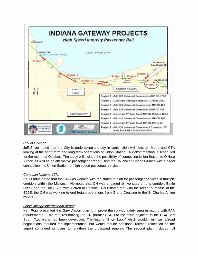
City of Chicago Jeff Sriver noted that the City is undertaking a study in conjunction with Amtrak, Metra and CTA looking at the short term and long term operations of Union Station. A kickoff meeting is scheduled for the month of October. The study will include the possibility of connecting Union Station to O’Hare Airport as well as an alternative passenger corridor using the CN and St Charles Airline with a direct connection into Union Station for high speed passenger service. Canadian National (CN) Paul Ladue noted that the CN was working with the states to plan for passenger services in multiple corridors within the Midwest. He noted that CN was engaged at two sites on this corridor: Battle Creek and the Holly Sub from Detroit to Pontiac. Paul stated that with the recent purchase of the EJ&E, the CN was working to end freight operations from Grand Crossing to the St Charles Airline by 2012. Gary/Chicago International Airport Ken Ross presented the Gary Airport plan to improve the runway safety area in accord with FAA requirements. This requires moving the CN (former EJ&E) to the north adjacent to the CSX Barr Sub. Two plans had been developed. The first, a “Short Loop” which would minimize railroad negotiations required for implementation, but would require additional railroad relocation as the airport continued its plans to lengthen the crosswind runway. The second plan included full

relocation of the CN to address both the current extension of the main runway and the proposed extension of the crosswind runway with the same effort. At this time, the full relocation plan is preferred and negotiations toward an agreement allowing its implementation are continuing
City of Gary Christopher Myers discussed the following:
Plans by the City of Gary, Majestic Star Casino& the State of Indiana to build a roadway bridge from the casino and proposed Gary Marina over the Railroad corridor and the potential conflict with the planned high speed rail flyover at the same approximate location. A coordination meeting was suggested for the very near future.
Planning efforts by the Cities of Gary and East Chicago to “reclaim” the use of the lakefront area between Buffington and the Indiana Harbor area of East Chicago by relocating the CN / IHB rail yards and various utilities into a corridor paralleling the existing NS right of way through the area
5.0 Stakeholder Needs and Desires
Charlie Quandel and Jenny Claflin (IDOT) led a discussion of stakeholder needs and desires related
to the proposed implementation of high speed rail service with the corridor. This discussion resulted
in the following list of needs and desires:
Park Services Issues
Biology - protection during construction and operation of HSR Wildlife – protection during construction and operation of HSR

Temporary land use – needed during construction of HSR Visitor impacts – during construction and operation of HSR Noise pollution – during construction and operation of HSR Safety – during construction and operation of HSR Access – during construction of HSR
Freight RR’s
Current and future capacity - must be maintained Time of day/usage/ freight schedules – must be maintained
MWRRI
More frequencies Increase speeds Reliability Crossing conflict elimination Flexibility to address safety issues in future Share use Maintenance schedules
6.0 Project Constraints
Bob Moore addressed significant bridges required for reliable passenger service operations in the
corridor including:
South Branch (21st Street) (upgrades)
Calumet River (95th Street)
Hick (Indiana Harbor)
Buffington Harbor Flyover (NS & CSX)
Casino Roadway over Railroad (Buffington)
Grand Calumet (Gary)
Burns Ditch (Ogden Dunes)
Porter Flyover
Bob Nastal identified significant crossings at grade including:
21st Street (Railroad)
Whiting (Roadway & Pedestrian)
East Chicago (Railroad)
Gary (Roadway) (Railroad)
Willow Creek (Railroad)
Porter (Roadway)
Bob Nastal identified other constraints as follows:
Whihala Park & Beach (Whiting)
Indiana Dunes National Lakeshore (NPS) - Eric Ehn spoke briefly about NPS’ concerns and
goals related to the development of HSR in NW Indiana. He indicated that early coordination
between ongoing planning efforts and NPS is highly desirable and would be welcomed. Also

noted was the desire of the NPS to obtain portions of the Dune Park Branch right of way that
pass through the Indiana Dunes National Lakeshore.
IHB crossing to Accelor Mittal: Chuck Allen noted that this crossing may present problems for
reliable high speed passenger service as the Accelor Mittal plant track is not signaled
requiring slow freight operations which have the likelihood of blocking the crossing. Neither
a bypass track nor a grade separation is easily constructed at this location.
7.0 Closing Remarks
Tim Hoeffner thanked all participants for attending. Chad Edison noted that the FRA staff
appreciated the presentations and had developed a greater understanding of the complexities of
serving passenger rail and freight in this congested corridor. Chad noted that this meeting
documentation will aid in future studies.

Attachment 7 – South of the Lake – Summary of Capital Cost Estimate – 2004 Report

Detroit-Chicago High Speed Rail Corridor Study Update
“South-of-the-Lake Corridor”
Amtrak Purchase Order S-049-31385
HNTB Project 36152
Segment Segment Description TOTAL
(x 1,000)
1 Chicago Union Station to Englewood $131,474
2 Englewood to Grand Crossing $29,632
3 Grand Crossing to Buffington Harbor (CP501) $104,177
1,2,3 Chicago to CP 501 $265,283
4A CP 501 to Porter, NS - 110 mph $315,297
4D CP 501 to Porter, NS - 79 mph $244,812
1,2,3,4A Chicago to Porter, NS - 110 mph $580,580
1,2,3,4D Chicago to Porter, NS - 79 mph $510,095
4B-1 CP 501 to Tolleston, CSXT $62,806
4B-2 Tolleston to Willow Creek, CSXT $94,194
4B-3 Willow Creek to Porter, CSXT $74,719
4B CP 501 to Porter, CSXT $231,719
1,2,3,4B Chicago to Porter, CSXT - 79 mph $497,002
4C CP 501 to Porter, PRR/IHB/Wabash/CSXT Michigan Central $290,179
1,2,3,4C Chicago to Porter, PRR/IHB/Wabash/CSXT - 79 mph $555,462
Tolleston to Wanatah, CSXT $56,654
Notes Costs in 2002 dollars.
Costs do not include real estate or railroad charges for use of assets.

Attachment 8 – CSX Schematic – Buffington to Porter via Tolleston & Willow Creek


Attachment 9 – Google Earth Image of Porter, IN


Attachment 10 – Existing and Proposed Track Schematics for Route 1 and Route 2