Embed Size (px)
Citation preview

Mid-Semester Lecture Exam
• Vocabulary• Obvious steps within GIS
– Selection and query processes– Working with tables– Classification concepts
• Projections– What are they – what do they change– Coordinates – how are they relevant

Home Work 1
• In ArcToolBox– Coversion Tools
• Import to coverage– Import from interchange file
• Define projection for coverage• In ArcMap
– Data• Export to shapefile
• Project shapefile to whatever you want
Dealing with an exchange format

• Data types – raster vs. vector• How does GIS differ from a mapping or CAD package• The three basic components of ArcGIS• Define vs Projection• Metadata• More questions about coordinates
– What information is critical for a coordinates to be relevant?
• Cardinality • When do you use a join and when relate?

Tables Continued
Adding Fields and Records

There are several data typesThere are two basic types common used:
Text Data Numeric Data
Left Justified Right Justified

Data Types
Text Date Short
Long BLOB
Float
Double
Smith 10/06/2003
14 165734 16.4 3429567.456
It is very important to choose the right data type.

ArcGIS can handle several tabular data formats:
• Coverages use an INFO format. These are an older format, cumbersome, but still frequently used.
• A shapefile uses a .dbf format. Much more sophisticated than an INFO file. We are currently using .dbf files in the lab exercises.
• Geodatabases uses a RDBMS format. Very sophisticated and powerful but more complex. We will use them in a few weeks time.

Very often you need a new field in a table.

Specify the Name and the Data Type
-32,000 to +32,000
-2 billion to + 2 billion
Integers – No Decimals
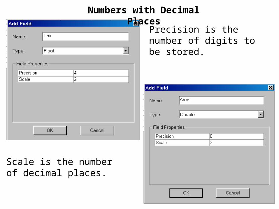
Precision is the number of digits to be stored.
Scale is the number of decimal places.
Numbers with Decimal Places

Date
Text
It is important to specify a length to accommodate your attribute but not too long.

Calculating a Value


The selected records are assigned the calculated value
Notice that text values are enclosed in double quotes

Calculating a Numeric

Convert from one data type to a different data type
Text type
Numeric type

Add a new numeric FIPS field then calculate the text field as a numeric field.

Create a New Table


Open the new table in ArcMap and then add data

You can use ascii files