Embed Size (px)
Citation preview

Price: $325,000
353 Acres South Hiram, Oxford County, Maine
Located in a quiet corner of southern Maine, between Sebago Lake and the White Mountains,
this forest offers long-distance views, gently rolling terrain and town-maintained road frontage.
MERRILL MOUNTAIN FOREST
Fountains Land Inc, 175 Barnstead Road, Suite 4, P.O. Box 25, Pittsfield, NH 03263 Contact: Patrick Hackley ~ [email protected] ~ (603) 435-7428, Ext. 230 ~ Cell (603) 491-3649
www.fountainsland.com
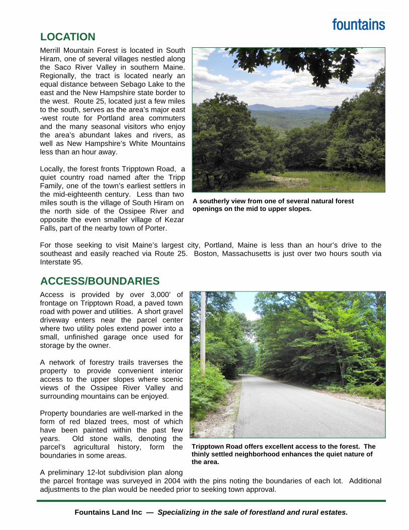
LOCATION
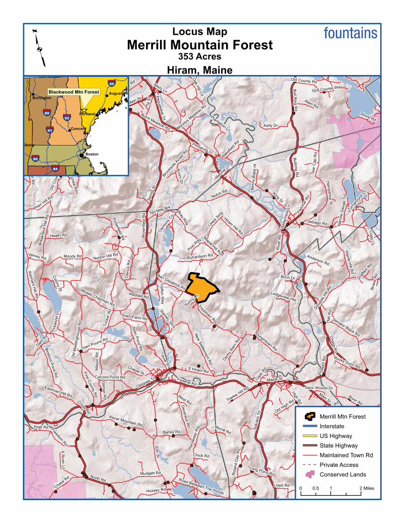
Merrill Mountain Forest is located in South Hiram, one of several villages nestled along the Saco River Valley in southern Maine. Regionally, the tract is located nearly an equal distance between Sebago Lake to the east and the New Hampshire state border to the west. Route 25, located just a few miles to the south, serves as the area’s major east-west route for Portland area commuters and the many seasonal visitors who enjoy the area’s abundant lakes and rivers, as well as New Hampshire’s White Mountains less than an hour away. Locally, the forest fronts Tripptown Road, a quiet country road named after the Tripp Family, one of the town’s earliest settlers in the mid-eighteenth century. Less than two miles south is the village of South Hiram on the north side of the Ossipee River and opposite the even smaller village of Kezar Falls, part of the nearby town of Porter. For those seeking to visit Maine’s largest city, Portland, Maine is less than an hour’s drive to the southeast and easily reached via Route 25. Boston, Massachusetts is just over two hours south via Interstate 95.
ACCESS/BOUNDARIES
Access is provided by over 3,000’ of frontage on Tripptown Road, a paved town road with power and utilities. A short gravel driveway enters near the parcel center where two utility poles extend power into a small, unfinished garage once used for storage by the owner. A network of forestry trails traverses the property to provide convenient interior access to the upper slopes where scenic views of the Ossipee River Valley and surrounding mountains can be enjoyed. Property boundaries are well-marked in the form of red blazed trees, most of which have been painted within the past few years. Old stone walls, denoting the parcel’s agricultural history, form the boundaries in some areas. A preliminary 12-lot subdivision plan along the parcel frontage was surveyed in 2004 with the pins noting the boundaries of each lot. Additional adjustments to the plan would be needed prior to seeking town approval.
A southerly view from one of several natural forest openings on the mid to upper slopes.
Tripptown Road offers excellent access to the forest. The thinly settled neighborhood enhances the quiet nature of the area.
Fountains Land Inc — Specializing in the sale of forestland and rural estates.

SITE DESCRIPTION
The forest enjoys a sunny southerly aspect with gently rolling sloping terrain, then steep near the upper reaches of Bill Merrill Mountain. Elevation ranges from about 650’ above sea level (ASL) near the road to 1,600’ ASL at the summit, providing outstanding long range views towards Portland (southeast) and the White Mountains (southwest). With a few exceptions near the bottom of the slope, soils are predominantly well-drained throughout the parcel. The source of Wadsworth Brook is near the ridgeline and eventually becomes a flowing brook as it parallels the eastern boundary. Interestingly, the brook is named after the famed American poet Henry Wadsworth Longfellow, whose family came from Hiram, Maine. History is also present in the small cemetery located in the southwest corner of the property. A solitary granite headstone marks the resting place of Richard and Betsy Tripp who died just two years apart, both at the age of 84 in the late 1800s. The Tripp family was likely one of the first intrepid settlers who attempted to farm the rocky soil of the area. Although the forest terrain slopes consistently southward towards Tripptown Road, there are several places at mid-slope where the ground is nearly level. The edges of these grassy openings offer excellent habitat for a host of wildlife species including certain songbirds that often occupy the areas for nesting. Conversely, some of these same areas are suitable for potential building sites, with a carefully constructed internal access road or long driveway. Given the tract size and diversity of forest habitat, there’s ample opportunity for both homestead development and wildli fe management to proceed on the property. The forest directly abuts the 939-acre Lowell Barnes Wildlife Management Area, managed by the state Department of Inland Fisheries and Wildlife. A portion of the eastern boundary runs parallel to the management area, which has been set aside for recreation and wildlife management research. As such, the land is closed to hunting but the public is welcome to enjoy the trails, enhancing the peaceful nature and beauty of the area.
Fountains Land Inc — Specializing in the sale of forestland and rural estates.
A stunning view from the top of Bill Merrill Mountain
One of several, small grassy openings at the mid-slope area of the forest.
Wadsworth Brook headwaters are found on the tract and flow through the property.
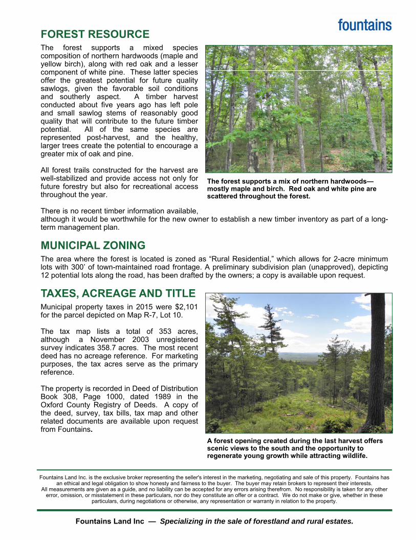
FOREST RESOURCE
The forest supports a mixed species composition of northern hardwoods (maple and yellow birch), along with red oak and a lesser component of white pine. These latter species offer the greatest potential for future quality sawlogs, given the favorable soil conditions and southerly aspect. A timber harvest conducted about five years ago has left pole and small sawlog stems of reasonably good quality that will contribute to the future timber potential. All of the same species are represented post-harvest, and the healthy, larger trees create the potential to encourage a greater mix of oak and pine. All forest trails constructed for the harvest are well-stabilized and provide access not only for future forestry but also for recreational access throughout the year. There is no recent timber information available, although it would be worthwhile for the new owner to establish a new timber inventory as part of a long-term management plan.
MUNICIPAL ZONING The area where the forest is located is zoned as “Rural Residential,” which allows for 2-acre minimum lots with 300’ of town-maintained road frontage. A preliminary subdivision plan (unapproved), depicting 12 potential lots along the road, has been drafted by the owners; a copy is available upon request.
TAXES, ACREAGE AND TITLE Municipal property taxes in 2015 were $2,101 for the parcel depicted on Map R-7, Lot 10. The tax map lists a total of 353 acres, although a November 2003 unregistered survey indicates 358.7 acres. The most recent deed has no acreage reference. For marketing purposes, the tax acres serve as the primary reference. The property is recorded in Deed of Distribution Book 308, Page 1000, dated 1989 in the Oxford County Registry of Deeds. A copy of the deed, survey, tax bills, tax map and other related documents are available upon request from Fountains.
Fountains Land Inc — Specializing in the sale of forestland and rural estates.
The forest supports a mix of northern hardwoods—mostly maple and birch. Red oak and white pine are scattered throughout the forest.
A forest opening created during the last harvest offers scenic views to the south and the opportunity to regenerate young growth while attracting wildlife.
Fountains Land Inc. is the exclusive broker representing the seller's interest in the marketing, negotiating and sale of this property. Fountains has an ethical and legal obligation to show honesty and fairness to the buyer. The buyer may retain brokers to represent their interests.
All measurements are given as a guide, and no liability can be accepted for any errors arising therefrom. No responsibility is taken for any other error, omission, or misstatement in these particulars, nor do they constitute an offer or a contract. We do not make or give, whether in these
particulars, during negotiations or otherwise, any representation or warranty in relation to the property.
Peq
uaw
ket T
rl
Elm
St
Riv
er
Rd
Ossipee Trl
Notch Rd
Bro
wn
fie
ld R
dS
pring S
t
North Rd
Sokokis
Trl
King S
t
S Hiram Rd
Colcord Pond Rd
Pendexte
r R
d
Maple St
Main St
Spec P
ond R
d
Old
County
Rd
Dugway Rd
Porte
rfield
Rd
Misty Ln
Bullrin
g R
d
Bic
kfo
rd P
ond R
d
Tripptown R
d
Hampshire R
d
Bu
ll Rin
g R
d
Sebago Rd
Hig
h Rd
Federal Rd
Richardson Rd
Mudgett Rd Norton Rd
Dou
gla
s H
ill R
d
Cape
Rd
Chase R
d
Pig
St
Banks Rd
Bray R
dg
Wa
rds H
ill Rd
Devere
ux R
d
Kelly Dr
Kezar Mountain Rd
Hiram
Hill R
d
Dariu
s R
d
Shore Rd
Durgintown R
d
Moody Rd
Senator Black Rd
Sawyer Rd
Ham
pshire
St
Po
un
d H
ill R
d
Bre
akneck H
ill R
d
Ken
nard
Hill R
d
Rola
nd D
ay R
d
Pratt Rd
Town Pound Rd
New
Settle
ment R
d
Moses Chapman Rd
Long Pond Rd
Chapel St
Pine S
t
Norton Hill Rd
Old Limington Rd
Porte
r Rd
Pease H
ill Rd
Depo
t R
d
Lewis X
ing
Ma
so
n R
d
Narr
ow
Ga
uge T
rl
Hussey Rd
Tear
Cap R
dFirst C
ounty
Rd
Town Farm Rd
Ha
ley T
ow
n R
d
Cla
rk R
d
Old
Meetin
ghouse R
d
Sam Brown Hill Rd
Allen Rd
Gilm
an
Rd
Ten Mile Brk
Shepherds
River R
d
Plantation Ln
Road Between The Ponds
Hoelz
el Ln
Portland Ln
Phen Hill
Rd
Waddell Rd
Freedom R
d
Wak
efie
ld R
d
Merr
ifie
ld R
d
Bro
okside
Acr
es R
d
Burnt Meadow Rd
Old High R
d
Fle
tcher R
d
Dam
Rd
Lowd Rd
Der
by B
arn
Rd
Towles Hill
Rd
Heath Rd
Tucker
Rd
Rocky Dunn Rd
Ben Gilpatrick Rd
Post R
dgT
rafto
n W
ay
S R
ive
r Ln
Chick Rd
Maple H
ill Run
Hall
RdS
tanley Shrs
Varney Rd
Moodys
Meadow
Rd
Golf Course Way
West Rd
Anderson Rd
Oak H
ill Cir
Morrill Rd
Be
nn
y B
ab
b H
l
Ledgeview Hts
Acorn
Dr
Cross R
d
Colo
ny P
t
Hi V
ista
Rd
Eastman Hill Rd
Wadsw
orth R
d
Sunny Ln
Turn
arou
nd L
n
Ren
nie
Ln
Gra
ffam
Rd
Co
bb
Ln
Cle
mon
s C
v
Birch Dr
Saco Woods Dr
Wild
ern
ess L
n
Bow
ie R
d
Rowe Ln
River Rd
Old County Rd
Main St
Ossipee Trl
Chase R
d
Copyright:© 2009 ESRI
353 AcresHiram, Maine
Merrill Mountain ForestLocus Map
Merrill Mtn Forest
Interstate
US Highway
State Highway
Maintained Town Rd
Private Access
Conserved Lands
0 1 20.5 Miles
fountains
Burlington
Concord
Boston
Portland
AugustaBlackwood Mtn Forest
Albany
95
91
93
90
89
84
Merrill Mountain Forest
Map produced from information supplied by Seller, aerial photography and reference information obtained from ME GIS.Boundary lines portrayed on this map are approximate and could be different than the actual location of boundaries found in the field.
353 AcresHiram, Maine
Tripptown Rd
Sunny Ln
Ben Gilpatrick Rd
Amy's Cir
Husk
y Hvn
1,000 0 1,000500Feet This is Not A Survey
fountains
Merrill Mountain ForestMaintained Town RoadPrivate Gravel Road

Merrill Mountain Forest
Map produced from information supplied by Seller, aerial photography and reference information obtained from ME GIS.Boundary lines portrayed on this map are approximate and could be different than the actual location of boundaries found in the field.
353 AcresHiram, Maine
Tripptown Rd
Sunny Ln
Ben Gilpatrick Rd
Amy's
Cir
Husky H
vn
1,000 0 1,000500
Feet This is Not A Survey
Photos are courtesy of NAIP 2011.
fountains
Merrill Mountain Forest
Maintained Town Road
Private Gravel Road
Dept. of Professional & Financial Regulation Office of Licensing & Registration
MAINE REAL ESTATE COMMISSION 35 State House Station Augusta ME 04333-0035
Are you interested in buying or selling resi-dential real estate in Maine? Before you begin working with a real estate licensee it is important for you to understand that Maine Law provides for different levels of brokerage service to buyers and sellers. You should decide whether you want to be represented in
a transaction (as a client) or not (as a customer). To assist you in deciding which option is in your best interest, please review the following information about real estate brokerage relationships: Maine law requires all real estate brokerage companies and their affiliated licensees (“licensee”) to perform certain basic duties when dealing with a buyer or seller. You can expect a real estate licensee you deal with to pro-vide the following customer-level services:
To disclose all material defects pertaining to the physical condi-tion of the real estate that are known by the licensee;
To treat both the buyer and seller honestly and not knowingly give false information;
To account for all money and property received from or on behalf of the buyer or seller; and
To comply with all state and federal laws related to real estate brokerage activity.
Until you enter into a written brokerage agreement with the licensee for client-level representation you are considered a “customer” and the licen-see may not act as your agent. As a customer, you should not expect the licensee to promote your best interest, or to keep any information you give to the licensee confidential, including your bargaining posi-tion.
If you want a licensee to represent you, you will need to enter into a written listing agreement or a written buyer representation agreement.These agreements create a client-agent rela-tionship between you and the licensee. As a client you can expect the licensee to provide the
following services, in addition to the basic services required of all licen-sees listed above:
To perform the terms of the written agreement with skill and care;
To promote your best interests;
For seller clients this means the agent will put the seller’s interests first and negotiate the best price and terms for the seller;
For buyer clients this means the agent will put the buyer’s interests first and negotiate for the best prices and terms for the buyer; and
To maintain the confidentiality of specific client information, in-cluding bargaining information.
COMPANY POLICY ON CLIENT-LEVEL SERVICES — WHAT YOU NEED TO KNOW
The real estate brokerage company’s policy on client-level services deter-mines which of the three types of agent-client relationships permitted in Maine may be offered to you. The agent-client relationships permitted in Maine are as follows:
The company and all of its affiliated licensees represent you as a client (called “single agency”);The company appoints, with your written consent, one or more of the affiliated licensees to represent you as an agent(s) (called “appointed agency”); or The company may offer limited agent level services as a disclosed dual agent.
WHAT IS A DISCLOSED DUAL AGENT? In certain situations, a licensee may act as an agent for and represent both the buyer and the seller in the same transaction. This is called dis-closed dual agency. The possibilities and consequences of dual agency representation must be explained to you by the licensee. Both the buyer and the seller must consent to this type of representation in writing.
Working with a dual agent is not the same as having your own exclu-sive agent as a single or appointed agent. For instance, when representing both a buyer and a seller, the dual agent must not disclose to one party any confidential information obtained from the other party. Also, a dual agent may not be the advocate for either party and cannot negotiate for nor ad-vise as to the price or terms of the transaction.
THIS IS NOT A CONTRACT
It is important for you to know that this form is not a contract. The licensee's completion of the statement below acknowledges that you have been given the information required by Maine law regarding brokerage relationships so that you may make an informed decision as to the relationship you wish to establish with the licensee/company.
To Be Completed By Licensee
This form was presented on (date)_____________________________
To______________________________________________________ Name of Buyer(s) or Seller(s) ____________________________________________
by______________________________________________________ Licensee's Name
on behalf of_______________________________________________ Company/Agency
MREC Form#3 12/05
Right Now You Are A Customer
To check on the license status of the real estate brokerage company or affiliated licensee go to www.maine.gov/professionallicensing.Inactive licensees may not practice real estate brokerage.
You May Become A Client
Remember! Unless you enter into a written agreement for agency representation, a licensee is not
allowed to represent you!
REAL ESTATE BROKERAGE RELATIONSHIPS FORM
Patrick Hackley
Fountains Land Inc