Embed Size (px)
Citation preview

www.dec.ny.gov May 2018
NYS DEC, REGION 5, DIVISION OF LANDS AND FORESTS
232 Golf Course Road, Warrensburg, NY 12885 [email protected]
VANDERWHACKER MOUNTAIN
WILD FOREST
and
BOREAS PONDS PRIMTIVE AREA
STATE ADMINISTRATIVE AREAS
Draft Amendment
to the
2005 Vanderwhacker Mountain Wild Forest Unit Management Plan
Draft River Area Management Plans
for the
Hudson River and Opalescent River

This page intentionally left blank

Vanderwhacker Mtn. Wild Forest Draft Unit Management Plan Amendment | iii
Contents
I. Introduction ................................................................................................................ 1
A. Purpose of the Amendment ..................................................................................... 1
B. Planning Area Overview .......................................................................................... 3
C. Public Participation and Planning Process .............................................................. 6
D. General Guidelines and Objectives for Management of the Unit ............................ 7
II. Natural Resources ..................................................................................................... 9
A. Soils ........................................................................................................................ 9
B. Topography ............................................................................................................. 9
C. Water Resources .................................................................................................. 10
D. Vegetation ............................................................................................................. 18
E. Wildlife ................................................................................................................... 24
F. Fisheries ................................................................................................................ 40
III. Recreational Resources and Human Uses .......................................................... 41
A.Carrying Capacity ................................................................................................... 41
B. Signage and Education ......................................................................................... 56
C. Roads .................................................................................................................... 57
D. Motorized Access and Parking .............................................................................. 61
E. Bridges, Culverts, and Dams ................................................................................. 72
F. Paddling/Hand Cary Boat Launches ...................................................................... 75
G. Access for People with Disabilities ........................................................................ 81
H. Day Use Areas ...................................................................................................... 83
I. Trail Recreation ...................................................................................................... 87
J. Snowmobile (Multiple-Use) Trails .......................................................................... 97
K. Hiking and Snowshoeing ..................................................................................... 100
L. Cross-Country Skiing ........................................................................................... 103
M. Bicycling ............................................................................................................. 106
N. Equestrian Use .................................................................................................... 109

Contents
iv | Vanderwhacker Mtn. Wild Forest Draft Unit Management Plan Amendment
O. Rock and Ice Climbing ........................................................................................ 112
P. Fishing ................................................................................................................. 114
Q. Hunting and Seasonal Access ............................................................................ 115
R. Camping .............................................................................................................. 116
S. Use Reservations ................................................................................................ 123
T. Historic Boreas Cabin .......................................................................................... 124
U. Phases of Implementation ................................................................................... 129
Appendix A – Management and Policy Considerations ......................................... 139
Appendix B – Discussion of Alternatives ............................................................... 151
Appendix C – Pond Narratives ................................................................................. 163
Appendix D – OPRHP Consultation ......................................................................... 165
Appendix E – Trail Classifications ........................................................................... 167

Vanderwhacker Mtn. Wild Forest Draft Unit Management Plan Amendment | v

vi | Vanderwhacker Mtn. Wild Forest Draft Unit Management Plan Amendment
This page intentionally left blank
Vanderwhacker Mtn. Wild Forest Draft Unit Management Plan Amendment | 1
I. Introduction
A. Purpose of the Amendment
In 2015 the State of New York purchased the 6,060-acre MacIntyre East Tract. The
following year, the State acquired the 20,430-acre Boreas Ponds Tract. These two
parcels were the final pieces of a multi-phased acquisition from the Nature Conservancy
of 65,000 acres of former Finch-Pruyn lands.
As both the largest and final parcel to come into public ownership, and because of the
allure of the property’s namesake—the Boreas Ponds themselves—the Boreas Ponds
Tract has garnered significant attention from local government, interest groups and the
public alike. To accommodate this public interest in a manner that continued to protect
the property’s natural resources, the Department provided limited public access to the
tract soon after it was acquired by the State. This included parking in several locations,
bicycle and equestrian opportunities on a limited number of existing roads, and informal
camping, hiking and paddling throughout the tract.
In February 2018, the Adirondack Park Agency (APA) recommended and the following
month Governor Andrew Cuomo approved a land classification package that added
portions of the Boreas Ponds and MacIntyre East tracts—totaling over 10,000 acres—to
the Vanderwhacker Mountain Wild Forest.
The purpose of this unit management plan (UMP) amendment is to propose additional
recreational opportunities and facilities within and adjacent to the recently-classified wild
forest and primitive lands of the Boreas Ponds and MacIntyre East Tracts in a manner
that maximizes enjoyment and appreciation of the Forest Preserve while continuing to
preserve and protect its natural resources.
While the Boreas Ponds themselves were added to the High Peaks Wilderness Area,
primary access to the ponds originates from the Gulf Brook and Boreas Roads in the
Vanderwhacker Mountain Wild Forest and Boreas Ponds Primitive Area. As such,
consideration for access to the High Peaks Wilderness Area is given in this UMP
amendment. An amendment to the High Peaks Wilderness Area UMP will more
specifically address the type and extent of recreational facilities in the High Peaks
Wilderness Area, including those related to the Boreas Ponds. Both the
Vanderwhacker Mountain and High Peaks UMP amendments discuss the Boreas
Ponds Primitive Area to highlight the interface between the units, however

I. Introduction
2 | Vanderwhacker Mtn. Wild Forest Draft Unit Management Plan Amendment
authorizations for management actions within the Boreas Ponds Primitive Area will
occur in this Vanderwhacker Mountain UMP amendment.
Eight smaller tracts have also been recently added to the Vanderwhacker Mountain
Wild Forest, and this amendment proposes minor access-related improvements to
several of them.
As explained in further detail in the following sections of this plan, the following
management actions are proposed:
Establishing mountain bike, equestrian, hiking and skiing opportunities within the
tracts;
Designating routes for public motor vehicle access, including parking;
Selecting a preferred alternative for the community connection discussed in the
2015 Community Connector Trail Plan for the multiple-use trail that connects
North Hudson and Newcomb;
Maintaining 9.0 miles of Forest Preserve road for motor vehicle access
opportunities;
Maintaining 3.4 miles of additional Forest Preserve roads for seasonal access
and camping during big game hunting season;
Providing access for persons with disabilities to hand-carry launches, equestrian
facilities, and designated tent sites along several roads;
Enhancing paddling opportunities, including providing a hand-carry launch on
LaBier Flow and along the Hudson River;
Designation of various camping opportunities throughout the tract including
roadside, primitive, and water access;
A proposal to maintain the historic cabin at the Four Corners and evaluate
potential future administrative uses until a final disposition for the structure is
determined; and
Designating singletrack mountain bike networks
This document also serves as a River Area Management Plan pursuant to the New
York State Wild, Scenic and Recreational Rivers System Act (WSRRA) and its
implementing regulations (6 NYCRR Part 666). The Opalescent River is designated as
a Wild River where is passes through the Vanderwhacker Mountain Wild Forest. The
Hudson River, south of its junction with the Opalescent River, is designated a
Recreational River where it passes through or borders the MacIntyre East and Hudson
River tracts. Any proposals found in this amendment that fall within the River Areas (½
mile from the bank of each designated river) are compliant with the WSRRSA and its
implementing regulations.
I. Introduction
Vanderwhacker Mtn. Wild Forest Draft Unit Management Plan Amendment | 3
B. Planning Area Overview
Description of Unit
The Vanderwhacker Mountain Wild Forest lies within the counties of Essex, Warren,
and Hamilton in the central Adirondacks. Including the recently classified parcels, the
unit is made up of almost three dozen parcels containing approximately 104,347 Acres.
In the 2018 APA land classification package, approximately 11,312 acres of the
northern portion of the Boreas Ponds Tract were classified as Wilderness and added to
the High Peaks Wilderness Area, with the remaining 9,118 acres to the south were
added to the Vanderwhacker Mountain Wild Forest. The Wilderness and Wild Forest
boundary is generally 500 feet north of Gulf Brook and Boreas Roads. The lands
between Gulf Brook Road and Elk Lake Road along with a 75 foot wide corridor that
follows the northern spur of Boreas Road to within 0.1 miles of the Boreas Ponds Dam
were also classified as Wild Forest. A 10.96-acre Primitive Area known as the Boreas
Ponds Primitive Area was also formed around the dam site at the outlet of Boreas
Ponds. Located in the towns of North Hudson and Newcomb in Essex County, this
newly classified Vanderwhacker Mountain Wild Forest parcel is primarily bounded on
the south by Blue Ridge Road, the east by the Elk Lake Conservation Easement and
Elk Lake Road, and to the north by the High Peaks Wilderness.
The MacIntyre East Tract was also classified in a manner similar to the Boreas Ponds
Tract, with approximately 1,799 acres of the southern part of the parcel classified as
Wild Forest and added to the Vanderwhacker Mountain Wild Forest, while the remaining
4,418 acres to the north was classified as Wilderness and added to the High Peaks
Wilderness. The entire Wild Forest section of MacIntyre East is located in the Town of
Newcomb in Essex County, bounded by the Tahawus Road to the west, the Upper
Hudson Woodlands Conservation Easement to the east, and other private landowners
to the north and south. Notably located at the center of this parcel is the confluence of
the Hudson and Opalescent Rivers. A rail corridor also bisects the Wild Forest section
of the parcel in a north-south orientation.
Eight other acquisitions and one reclassification were also added to the Vanderwhacker
Mountain Wild Forest in the 2018 APA land classification package:
The 47-acre Palmer Pond Tract was purchased in 2006 and is located in the
Town of North Hudson, Essex County, immediately west of the Adirondack
Northway, bordering Blue Ridge Road on the south, Palmer Pond on the west,
and the High Peaks Wilderness Area on the north and east.

I. Introduction
4 | Vanderwhacker Mtn. Wild Forest Draft Unit Management Plan Amendment
The 66-acre Niagara Brook Tract was part of the larger Finch Acquisition and
was sold to the State of New York in 2009. This tract is located on both the north
and south side of Blue Ridge Road approximately 3.5 miles west of the
Adirondack Northway in the Town of North Hudson, Essex County. The tract is
bounded by Vanderwhacker Mountain Wild Forest and the High Peaks
Wilderness Area to the north and private lands to the south.
The 287-acre Hudson River Tract, formerly a Finch parcel, was purchased by
the State of New York in 2014 from The Nature Conservancy in 2014. The parcel
is located in the Town of Newcomb, Essex County, and is made up of two land
parcels that share a common corner. The western parcel is located at the
northwestern end of Campground Road in the Town of Newcomb. Campground
Road makes up the majority of the southern boundary, the Lake Harris
Campground makes up half of the western boundary with the other half bordering
Vanderwhacker Mountain Wild Forest. Vanderwhacker Mountain Wild Forest also
borders the parcel to the north and private lands border to the east. The
Newcomb River flows through the middle of the easternmost parcel and also
includes the confluence of the Newcomb and Hudson River. The parcel also
borders approximately one half of a mile of Hudson River on the south. It also
borders private lands to the south and west and the northern borders are shared
with previously existing Vanderwhacker Mountain Wild Forest.
The 202-acre Vanderwhacker Brook Tract, formerly a Finch parcel, was
purchased from the Open Space Conservancy in 2013. The tract is located on
both the east and west side of the Iowa Pacific railroad line and the Boreas River
approximately 0.7 miles south of State Route 28N in the Town of Minerva, Essex
County.
The two-parcel, 37-acre Raquette Brook Tract is located in the Town of Indian
Lake, Hamilton County on the north side of State Route 28 about 2.4 miles north
of the Warren County line and Thirteenth Road. The parcels are part of a larger
acquisition that abuts existing Forest Preserve land in the Hudson Gorge
Wilderness. However, the parcels are divided by privately owned land which
contains a power line. The lands northeast of the power line, which abut the
Wilderness, were classified as Wilderness and added to the Hudson Gorge
Wilderness. The lands south of the power line and north of State Route 28 were
classified as Wild Forest and added to the Vanderwhacker Mountain Wild Forest.
The 13-acre Minerva Stream Tract is adjacent to an existing Vanderwhacker
Mountain Wild Forest parcel and is located between John Brannon Road and
Irishtown Road in the Town of Minerva, Essex County.
The 114-acre Bullhead Pond Stream Tract is located about one half mile north
of Northwoods Club Road in the Town of Minerva, Essex County. This is about

I. Introduction
Vanderwhacker Mtn. Wild Forest Draft Unit Management Plan Amendment | 5
one quarter mile east of the privately owned Bullhead Pond and is bordered on
three sides by the Vanderwhacker Mountain Wild Forest.
The 249-acre North River Tract is comprised of several parcels between State
Route 28 and the Hudson River near the Hamlet of North River in Warren County,
along with two larger parcels on the east side of the Hudson River. These parcels
border one another but are split by the border between Essex and Warren
Counties.
A 5-acre land reclassification also occurred that involved the Camp Santanoni
Historic Area and Vanderwhacker Mountain Wild Forest. The 2.5-acre farm
garden area and orchard located within the Vanderwhacker Mountain Wild Forest
were transferred to the Historic Area. In exchange, 2.5 wooded acres of the
Historic Area farm complex were transfered to the Vanderwhacker Mountain Wild
Forest.
Location and Access
Boreas Ponds Tract:
The primary access to the Boreas Ponds is via Gulf Brook Road, which extends from
Blue Ridge Road to the vicinity of LaBier Flow. This Forest Preserve entrance is
approximately 5.5 miles from Northway Exit 29, and approximately 17 miles from the
Hamlet of Newcomb. The Blue Ridge Parking Area is located about 300 feet in from
Blue Ridge Road and can accommodate trailered vehicles or up to 10 cars. This parking
area also serves as overflow parking for the Fly Brook Parking Area, and is the only
open parking area on Gulf Brook Road during the winter months and mud season. The
Fly Brook Parking Area is located approximately 3.4 miles from Blue Ridge Road and
can accommodate trailered vehicles or up to 20 cars.
Two additional access points along the Blue Ridge Road corridor are located on Branch
Road and Andrew Brook Road. Branch Road runs along the west side of the Branch
River north of Blue Ridge Road. An 11-car parking lot which can support trailered
vehicles is located at the intersection of Blue Ridge Road and Branch Road. This also
serves as the parking area for the Hoffman Notch Tail in the Hoffman Notch Wilderness
Area to the south. This parking area is located approximately 4 miles from Northway
Exit 29, and 18.5 miles from the Hamlet of Newcomb.
Andrew Brook Road is located on the north side of Blue Ridge Road, approximately 6.5
miles from Northway Exit 29 and 16 miles from the Hamlet of Newcomb. The parking
area here is located approximately 500 feet up Andrew Brook Road and can
accommodate trailered vehicles or up to 5 cars.

I. Introduction
6 | Vanderwhacker Mtn. Wild Forest Draft Unit Management Plan Amendment
The eastern side of the Boreas Ponds Tract is bounded by Elk Lake Road, which is a
town maintained road. Two parking areas exist here, the first one being approximately
1.8 miles north of Blue Ridge Road and the second being 2.6 miles north of Blue Ridge
Rd. The first parking area can support three cars and the second can support trailered
vehicles or up to eight cars.
MacIntyre Tract:
The primary entrance to the MacIntyre Tract is via East River Road, located off the
Tahawus/Upper Works Road in Newcomb, approximately 4.3 miles north of Blue Ridge
Road. East River Road crosses the Hudson River and allows for access to the more
eastern portions of the tract. Currently there is not a parking area located here, but later
sections of this amendment will describe future management actions.
C. Public Participation and Planning Process
Article 27, Section 816 of the Executive Law (known as the Adirondack Park Agency
Act) mandates the Department of Environmental Conservation (Department or DEC) to
develop, in consultation with the Adirondack Park Agency (APA), individual unit
management plans for each unit of land under its jurisdiction classified in the
Adirondack Park State Land Master Plan (APSLMP).
The Department began work on this amendment to Vanderwhacker Mountain Wild
Forest UMP in 2018. A planning team, appointed by the Regional Director including
Department staff from Fisheries, Wildlife, Forest Rangers, Lands and Forests, and
Operations, along with staff from the APA, have gathered and tracked information on
various resources and areas over the years.
Unit Management Plan and Amendments
This document is the fourth amendment to the original April 2005 Vanderwhacker
Mountain Wild Forest Unit Management Plan and Environmental Impact Statement. The
three previous amendments are:
The Community Connector Trail Plan, adopted in 2015, which selected a
preferred route for multiple-use trails connecting the towns of Newcomb, North
Hudson, and Minerva;
An amendment adopted in 2016 that proposed a boat launch on the shore of
Palmer Pond with nearby parking; and
I. Introduction
Vanderwhacker Mtn. Wild Forest Draft Unit Management Plan Amendment | 7
The Essex Chain Lakes Management Complex Plan, also adopted in 2016,
which proposed a suite of actions to provide public recreational opportunities on
recently-acquired State lands, some of which fall within the Vanderwhacker
Mountain Wild Forest. As such, this Plan also acts as an amendment to the
Vanderwhacker Mountain Wild Forest UMP.
Interim Access Plan
In August 2016, the Department released an Interim Access Plan for the entire Boreas
Ponds Tract, including lands that would later become part of the Vanderwhacker
Mountain Wild Forest. The purpose of this plan was to provide limited public access to
the property during the interim period between State acquisition and the adoption of a
UMP amendment that will authorize additional recreational opportunities.
Scoping/Kickoff Meeting
A public scoping meeting was held on Tuesday April 3, 2018 at the Newcomb Central
School in Newcomb NY. Several stations were set up where the public provided
sketched proposals on maps and written comments. There was also an opportunity for
interested persons to present their thoughts publicly to the Department and the
attendees of the meeting. The public comment period following the meeting was open
until April 20, 2018. Various ideas were submitted to the Department both at the
meeting and through written comments during the public comment period. Several
comments about environmental protection and potential recreational opportunities of the
area were submitted and considered.
D. General Guidelines and Objectives for
Management of the Unit
All land covered by this Unit Management Plan amendment is Forest Preserve, and as
such, must be managed in a manner consistent with Article XIV, Section 1 of the New
York State Constitution. The UMP, and the management recommendations found
within, have also been developed pursuant to and consistent with relevant provisions of
the following:
Adirondack Park State Land (APSLMP);
Environmental Conservation Law (ECL);
Executive Law;

I. Introduction
8 | Vanderwhacker Mtn. Wild Forest Draft Unit Management Plan Amendment
Department rules, regulations, policies and guidelines,
State Environmental Quality Review Act (SEQRA); and
Wild, Scenic and Recreational Rivers Act (WSRRA)
Each sub-section of this amendment contains objectives related to specific uses and/or
subjects. The following objectives will apply to the implementation of this UMP as a
whole:
Prepare a work plan for each construction project;
Consult the Adirondack Park Agency (APA) on projects in accordance with the
current DEC/APA Memorandum of Understanding;
Comply with all applicable laws, regulations, and guidelines;
Develop long-term partnerships with communities and other stakeholders for the
stewardship of the unit.
Monitor impacts to natural resources within the unit, and where needed, develop
appropriate measures to address those impacts.
This amendment will provide the guidance necessary for staff to manage the area in a
manner that protects the environment while at the same time providing suitable outdoor
recreation opportunities for the public. Without the development and future
implementation of the UMP amendment, sensitive environmental resources of the unit
could be impacted negatively, resulting in a decrease in the public’s enjoyment of such
resources. Management of the unit pursuant to a UMP allows the Department to
improve public use and enjoyment of the area, avoid user conflicts and prevent overuse
of the resource.
What the UMP Amendment Does Not Do
The proposed management actions identified in this UMP amendment are primarily
confined to the Vanderwhacker Mountain Wild Forest, within or adjacent to lands that
have recently been added to the Forest Preserve. Activities on private property or
nearby State lands that are not in the Vanderwhacker Mountain Wild Forest are beyond
the scope of this document and will generally be discussed only as they relate to uses
of, and impacts to, the Vanderwhacker Mountain Wild Forest.
In addition, this amendment cannot suggest changes to Article XIV, Section 1 of the
New York State Constitution or conflict with statutory mandates or DEC policies. All
proposals must conform to the guidelines and criteria set forth in the APSLMP and
cannot amend the APSLMP itself.

Vanderwhacker Mtn. Wild Forest Draft Unit Management Plan Amendment | 9
II. Natural Resources
A. Soils
From a management perspective, the key characteristic of soil is its erodibility. Highly
erodible soils that are subject to intensive use or modified to remove stabilizing
elements, such as vegetation, can result in significant soil loss, downslope/downstream
sedimentation, and poor trail conditions. All facilities will be laid out to avoid running
slopes, and will be constructed and hardened in a manner to avoid erosion to the
greatest degree possible.
The vast majority of the soils in the Boreas Ponds Tract are very well drained, rocky,
boulder soils that can be susceptible to erosion. Some of the low-lying areas are poorly
drained as well. The soils in the area are an important factor to consider when
developing trails. When constructing trails, well-drained soils are preferred while long
running slopes should be avoided to minimize erosion. The bouldery nature of these
soils can sometimes hinder bicycle and snowmobile trail layout, but this further
emphasizes the need for proper trail placement and sustainable construction.
The northern portion of the MacIntyre Tract and areas along the outside perimeter of the
property features well-drained soils of various type. The bulk of the property lies in the
river bottom and is comprised of the Rumney-Burnt Vly Complex and Podunk very fine
sandy loam. Both of these are poorly drained and prone to flooding, making trail layout
and construction challenging.
B. Topography
The Vanderwhacker Mountain Wild Forest portion of the Boreas Ponds Tract is rolling
terrain that generally gains in elevation as it moves north from Blue Ridge Road.
Although varied, most of the area is around 2,000 feet in elevation. The Branch River is
the largest running lowland area on the property, starting at around 1,750 feet in
elevation near the Forest Preserve boundary on the northeast side of the tract and
descending to approximately 1,200 feet in elevation where it crosses Blue Ridge Road
to the south. The Highest Peak is Ragged Mountain, standing 2,700 feet in elevation.
Another unnamed peak on the far western end of the tract above Vanderwhacker Pond
tops out at approximately 2,680 feet. Overall the topography lends itself well to having
a balance of upland hardwood forests as the elevation ascends and lowland boreal
wetland forests in the drainages and low lying areas throughout the tract.

II. Natural Resources
10 | Vanderwhacker Mtn. Wild Forest Draft Unit Management Plan Amendment
The Vanderwhacker Mountain Wild Forest portion of the MacIntyre East Tract is a river
bottom which is largely a low-lying floodplain developed by the Hudson and Opalescent
Rivers. The area supports various wetland communities like boreal forests and open
sedge-shrub-sphagnum communities.
C. Water Resources Watercourses The Boreas and MacIntyre Tracts are both part
of the Hudson River Watershed, but there are
three smaller watersheds within this area. The
MacIntyre Tract is very near the source of the
Hudson River, and as such is near the upper
end of the watershed. To the east, the Boreas
River drains the majority of the Boreas Ponds
Tact. The Boreas eventually joins the Hudson
near the hamlet of North River. Further east
the Branch River drains Elk Lake, Clear Pond,
and the eastern side of Boreas Mountain. The
Branch eventually flows into the Schroon River
in North Hudson, and the Schroon eventually
drains into the Hudson in Warrensburg in
Warren County.
As mentioned in the Introduction, pursuant to
the Wild, Scenic and Recreational Rivers
System Act (WSSRA), the Opalescent River is
designated as a Wild River where it passes
through the Vanderwhacker Mountain Wild Forest. The Hudson River, south of its
junction with the Opalescent River, is designated a Recreational River where it passes
through or borders the MacIntyre East and Hudson River Tracts.
Ponded Waters Boreas Ponds Tract:
The Vanderwhacker Mountain Wild Forest portion of the Boreas Ponds Tract includes
the southern half of LaBier Flow. This in its natural state is the Boreas River, however
in the late 1800’s a flush dam was constructed on the southern end of what is now
LaBier Flow from LaBier Dam

II. Natural Resources
Vanderwhacker Mtn. Wild Forest Draft Unit Management Plan Amendment | 11
LaBier flow by Finch Pruyn. Firm records of an exact year the dam was installed do not
seem to exist, but anecdotal information suggests it may have been in place and used
as early as 1889, 27 years prior to the construction of the better-known Boreas Dam.
The flush dam was used many times over the years to help flush logs down the Boreas
River eventually bringing them to Glens Falls where they were utilized by the Finch
Pruyn mill. This was eventually replaced with the more permanent steel dam still
present today. The water level fluctuates throughout the year but LaBier flow consists
of approximately 25 acres of ponded water on the Boreas River.
MacIntyre Tract:
The Vanderwhacker Mountain Wild Forest portion of MacIntyre East encompasses most
of Sanford Lake. Although more of a large Stillwater on the Hudson River, it does
encompass approximately 120 acres.
Wetlands
The APSLMP (2016, page 20) defines a wetland as:
“...any land that is annually subject to periodic or continual inundation by
water and commonly referred to as a bog, swamp, or marsh, which is (i)
one acre or more in size, or (ii) located adjacent to a body of water,
including a permanent stream, with which there is a free interchange of
water at the surface, in which case there is no size limitation, and which
(iii) meet the technical definition of 578.3(r) of the Adirondack Park
Agency Rules and Regulations”.
As is true for much of the Adirondack Park, wetlands in the unit are common in the low-
lying, flat areas between hills and mountains where runoff from steep slopes and
groundwater seepage collects and is sometimes confined before entering drainage
systems. These areas are commonly referred to as headwater wetlands and are often
the origins of streams. Many of these headwater wetlands have been created,
expanded, and modified by beaver dams. In most cases, the dams raise the water level,
flooding adjacent upland areas. Depending on the length of time the dams are
maintained, these upland areas can eventually become wetlands, creating hydric soils
and supporting water tolerant vegetation. Remnants of the upland community are often
apparent in these wetlands and may include dead trees such as spruce and fir. Other
wetlands within the tract occur along the floodplains of streams and rivers and within
and adjacent to deepwater habitats of ponds.

II. Natural Resources
12 | Vanderwhacker Mtn. Wild Forest Draft Unit Management Plan Amendment
Forested evergreen wetlands, typically dominated by balsam fir and spruce species, are
the most prevalent wetland cover type on the Boreas and MacIntyre Tracts of the
Vanderwhacker Mountain Wild Forest. Significant examples of these lowland Boreal
Communities are along the Hudson, Opalescent, and Boreas Rivers.
Wetlands of the Vanderwhacker Mountain Wild Forest present both opportunities and
challenges to the public. They have great aesthetic value and offer considerable
opportunity for study and general education. For visitors, the expanses of open space
provided by wetlands supply much-needed visual contrast to the heavily forested
settings that dominate much of the unit. Because they constitute one of the most
productive habitats for fish and wildlife, wetlands afford abundant opportunities for
fishing, hunting, trapping, and wildlife observation and photography. On the other hand,
wetlands are generally ecologically sensitive and are not conducive to heavy
recreational use. Trails placed adjacent to wetlands are often plagued by seasonal wet
spots and locations for new facility development (e.g. trails, primitive campsites, and
lean-tos) are often limited by the presence of wetlands.
Other important ecological functions of wetlands include water quality improvement,
stormwater attenuation, nutrient cycling, and habitat for threatened and endangered
species. In their capacity to receive, store, and slowly release rainwater and meltwater,
wetlands protect water resources by stabilizing flow rates and minimizing erosion and
sedimentation. Many natural and man-made pollutants are removed from water entering
wetland areas. Some of the threatened and endangered species and species of special
concern which may utilize wetlands in the unit include the common loon, bald eagle,
osprey, tiger beetle, snaketail and clubtail dragonflies, and bog turtle. Wetlands also
may contain a number of rare, threatened and endangered plants including the swamp
pink and numerous sedges.
Aquatic Invasive Species
With over 2,300 lakes and ponds, 1,500 miles of rivers, 30,000 miles of brooks and
streams, the Adirondack region is particularly vulnerable to the introduction of aquatic
invasive species (AIS). AIS can cause harm to the environment, human health, and the
economy of a region and can arrive via many pathways, including intentional
introduction (aquaria dumping), cargo transport, and shipping ballast. Once established,
AIS can spread rapidly through connecting waterways or by “hitchhiking” not only on the
propellers, trailers, rudders, motors, etc. of the vessels of recreational boaters and
anglers but also on equipment (trailers, waders) and non-motorized watercraft (kayaks,
canoes, and floats).

II. Natural Resources
Vanderwhacker Mtn. Wild Forest Draft Unit Management Plan Amendment | 13
In 2010 the Department and the Adirondack Park Agency developed Inter-Agency
Guidelines for Implementing Best Management Practices for the Control of Terrestrial
and Aquatic Invasive Species on Forest Preserve Lands in the Adirondack Park (see
appendix A). These Guidelines provide a template for the process through which
comprehensive active terrestrial and aquatic invasive species management will take
place on Forest Preserve lands in the Adirondack Park. The Department shall be
responsible for management of terrestrial and aquatic invasive species on Forest
Preserve lands while the Agency will be responsible for providing review of, and advice
on, APSLMP compliance and permit jurisdiction. The Guidelines are a dynamic
document and are periodically revised to reflect new invasive species threats,
continuing inventory of the Forest Preserve, and evolving invasive species management
techniques.
Efforts should be made to restore and protect the native ecological communities in the
Vanderwhacker Mountain Wild Forest through early detection and rapid response
efforts to eradicate or control existing or newly identified invasive species populations.
Adoption of the Guidelines and implementation through the UMP and site specific work
planning process, gives the Department the basic tools needed to preserve, protect and
restore the natural native ecosystems of the Forest Preserve.
This UMP proposes several water access sites for the launching of non-motorized
watercraft.
Proposed Management
Objectives
Prevent the introduction and spread of AIS into and within the Adirondack region
Protect native aquatic species and their habitats
Protect water-based recreational resources and economy
Educate recreational watercraft operators on steps they need to take to prevent
the spread of AIS and help them understand new regulations requiring them to
take such precautions at all public waters
Foster a sense of responsibility in watercraft operators so they take steps to help
stop the spread of AIS
Protect New York citizens’ investment in publicly-owned waters
Action Steps
Take aquatic invasive species spread prevention actions within the unit. These
measures will vary based on location within the following spectrum:

II. Natural Resources
14 | Vanderwhacker Mtn. Wild Forest Draft Unit Management Plan Amendment
o Make printed materials available at water access locations
o Post signs about the dangers of spreading AIS
o Provide information regarding nearby boat decontamination stations
o Deploy stewards at boat launches to provide education and outreach and
voluntary inspections for boaters
Manage aquatic invasive species pursuant to Inter-Agency Guidelines for
Implementing Best Management Practices for the Control of Terrestrial and
Aquatic Invasive Species on Forest Preserve Lands in the Adirondack Park.
Partner with those organizations involved in fighting invasive species on Forest
Preserve lands.
Train Department staff to identify and document the location of aquatic invasive
species.
When Department staff or partner organizations are engaged in on-site outreach
and education, ensure they have proper training for the prevention of AIS
Work towards a complete comprehensive inventory of the presence and extent of
aquatic invasive species in the unit.

II. Natural Resources
Vanderwhacker Mtn. Wild Forest Draft Unit Management Plan Amendment | 15

II. Natural Resources
16 | Vanderwhacker Mtn. Wild Forest Draft Unit Management Plan Amendment

II. Natural Resources
Vanderwhacker Mtn. Wild Forest Draft Unit Management Plan Amendment | 17

II. Natural Resources
18 | Vanderwhacker Mtn. Wild Forest Draft Unit Management Plan Amendment
D. Vegetation
General Inventory
The lands within the tracts are mostly forested. Plant communities vary depending on
past timber harvesting and environmental factors. The historical management of these
tracts for a sustainable supply of timber is apparent throughout.
The tracts lie in the ecological transition zone between the temperate deciduous forest
and the true boreal forest. The predominant, broad naturally occurring vegetative types
include northern hardwoods, mixed hardwoods, and lowland boreal communities. The
influence of logging over the past century has brought visible effects on the vegetative
cover.
Rare, Threatened and Endangered Plants and Ecological
Communities
In 2000-2001, scientist Jerry Jenkins was commissioned by The Nature Conservancy
for Finch, Pruyn & Co. to complete a biological survey (mainly flora) on Finch-owned
lands in the Adirondack Park. Several sites along the Opalescent and Hudson were
inventoried, revealing several notable communities and species. The upland sites
above the river banks are alluvial forests, while the majority of the lowlands along the
river bottom are lowland boreal forests. Open wetland complexes ranging from 5 to 50
acres are scattered throughout the lowland forests as well. The floodplain here is
generally 0.2 to 0.5 miles wide, well developed, and has several oxbows. Most wetland
communities were sedge-shrub-sphagnum, but one was a low nutrient white cedar-
delicate sedge bog which is a rare wetland type in the Adirondacks, and was noted as
being the most unusual wetland examined in the Jenkins Survey. Some of the most
notable species were arethusa (Arethusa bulbosa), pickerings reedgrass
(Calamagrostis pickeringii), two-seeded sedge (Carex disperma), Michaux’s sedge
(Carex michauxiana), few-flowered sedge (Carex pauciflora), low sedge (Carex
paupercula), slender-flowered sedge (Carex tenuiflora), bog honeysuckle (Lonicera
villosa), alder buckthorn (Rhamnus alnifolia), and pylaes sphagnum (Sphagnum
pylaesii).
The survey also lists a significant “spruce swamp” on the western side of the Boreas
tract as having a moderately high diversity of bryophytes and some significant mosses
and liverworts. These include the NYS rare Campylium radicale, and uncommon
Hylocomnium umbratum and Rhytidiadelphus squarrosus.

II. Natural Resources
Vanderwhacker Mtn. Wild Forest Draft Unit Management Plan Amendment | 19
Terrestrial Invasive Species
The negative impacts of invasive species on natural forests, terrestrial and aquatic
communities are well documented. Colonization and unrestrained growth of invasive
species cause the loss of biodiversity, interruption of normal hydrology, suppression of
native vegetation, and significant aesthetic, human safety and economic impacts.
Terrestrial and aquatic invasive species have been identified at increasing rates of
colonization along roadsides in campgrounds, and in water bodies of the Forest
Preserve. Some of these species have the potential to colonize backcountry lands,
lakes and ponds and degrade natural resources of the Forest Preserve.
The Department is a member and will continue to collaborate with other partners of the
Adirondack Park Invasive Plant Program (APIPP) (Adirondack PRISM) to support
education, inventory, research, control protocol, and control of invasive species. An
inventory and analysis of the current distribution of invasive species on Forest Preserve
lands will provide the necessary information on the present extent of invasive exotics
and provide the basis for long term decision making.
As mentioned under Aquatic Invasive Species, the Department and the APA have
developed Inter-Agency Guidelines for Implementing Best Management Practices for
the Control of Terrestrial and Aquatic Invasive Species on Forest Preserve Lands in the
Adirondack Park (see appendix A). The Guidelines are a dynamic document and are
periodically revised to reflect new invasive species threats, continuing inventory of the
Forest Preserve, and evolving invasive species management techniques.
Efforts should be made to restore and protect the native ecological communities in the
Vanderwhacker Mountain Wild Forest through early detection and rapid response
efforts to eradicate or control existing or newly identified invasive species populations.
Adoption of the Guidelines and implementation through the UMP and site specific work
planning process, gives the Department the basic tools needed to preserve, protect and
restore the natural native ecosystems of the Forest Preserve.
Forest Health
A combination of many factors can influence the health of a plant community. Physical
factors tend to be weather related with notable examples being lightning fires, ice
damage, severe winds, and flooding. Biological factors are variable and include the
effects of disease and insects on the forest environment. Insects and diseases that
affect trees are constant natural forces that shape the forest. While many insects and

II. Natural Resources
20 | Vanderwhacker Mtn. Wild Forest Draft Unit Management Plan Amendment
diseases have negligible or beneficial impacts to forest health, some, especially those
involving invasive exotic species, can be especially damaging.
Several insects and diseases have impacted forest communities within the region
and/or New York State in recent years and continue to pose a threat the health of
forests within unit:
Beech Bark disease – Beech bark disease is an important insect-fungus complex that
has caused extensive mortality of American beech throughout portions of the
Adirondacks. The primary vector, a scale insect, Cryptococcus fagi, attacks the tree
creating entry sites for the fungus, Nectria coccinea var. faginata. Changes in the
percent of beech in the cover type can stimulate shifts in animal populations that utilize
beech mast extensively as a food source. On the other hand, dead and/or dying beech
trees may benefit other wildlife species by providing abundant nesting, feeding, and
potential den locations.
Emerald Ash Borer (Agrilus planipennis) – This exotic, introduced beetle bores into
and kills otherwise healthy ash trees. White ash trees are a minor component although
their value to wildlife and scenic quality should be evaluated to improve interpretations
of value loss following EAB infestations which seem inevitable.
Hemlock woolly adelgid (Adelges tsugae) – This aphid-like insect attacks North
American hemlocks, and can be easily identified by the white woolly masses they form
on the underside of branches at the base of the needles. Juvenile hemlock woolly
adelgid feed on the tree's stored starches, and remain in the same spot for the rest of
their lives, continually feeding and developing into adults. Their feeding severely
damages the canopy of the host tree by disrupting the flow of nutrients to its twigs and
needles. Tree health declines, and mortality usually occurs within 4 to 10 years.
Native to Asia, Hemlock woolly adelgid was introduced to the western United States in
the 1920s. It was first observed in the eastern US in 1951 near Richmond, Virginia after
an accidental introduction from Japan. Hemlock woolly adelgid has since spread along
the East Coast from Georgia to Maine and now occupies nearly half the eastern range
of native hemlocks. Hemlock woolly adelgid was first discovered in New York State in
1985 in the lower Hudson Valley and on Long Island. Since the initial infestation,
hemlock woolly adelgid has continued to spread north to the Capitol Region and west,
through the Catskill Mountains and the Finger Lakes Region, into western NY.
In the summer of 2017, hemlock woolly adelgid was discovered on the Forest Preserve
in the Town of Lake George, the first known occurrence in the Adirondack Park. Due to
the limited extent of the infestation, the Department and its partners were able to treat

II. Natural Resources
Vanderwhacker Mtn. Wild Forest Draft Unit Management Plan Amendment | 21
the area and hopefully eliminate what is believed to be an outlier infestation. Because
of the Lake George infestation, monitoring efforts have increased throughout the
southern Adirondacks.
Balsam Woolly Adelgid (Adelgaes piceae) - The balsam woolly adelgid, a pest of true
firs, was introduced into the United States from Europe or Asia around the turn of the
century. Since that time it has spread throughout the United States and Canada.
Forest Tent Caterpillar (Malacosoma disstria) - The forest tent caterpillar, a native
insect, may be found wherever hardwoods grow. Outbreaks have occurred at 10 to 15
year intervals with the last widespread outbreak in the late 1970's. Portions of St.
Lawrence County were moderately to severely defoliated in 2003 through 2005, with
additional outbreaks reported in northeast Jefferson, Herkimer, Fulton and Hamilton
Counties. Favored hosts are sugar maple and aspen with birch, cherry, and ash also
being utilized.
Gypsy moth (Lymantria dispar) – This introduced invasive insect forest defoliator has
been a resident of the region for over a century. The insect periodically causes extreme
defoliation in red oaks and has caused some scattered mortality. Heavy infestations of
caterpillars can be a severe nuisance to forest users and the hairs on the caterpillars
can be a serious human health risk due to allergic reactions.
Oakwilt (Ceratocystis fagacearum) - This fungus develops in the xylem, the water
carrying cells of trees. All oaks are susceptible to the fungus, but the red oak group
(with pointed leaf tips) often die much faster than white oaks (rounded leaf tips). Red
oaks can take from a few weeks to six months to die and they spread the disease
quickly. White oaks can take years to die and have a lower risk of spreading the
disease.
White pine decline – This disease is caused by several agents of which the most
notable are white pine blister rust (WPBR), Caliciopsis canker, Armillaria root disease,
and several needle casts and blights. White pine decline has recently been listed as a
northeastern forest decline priority as several mature and maturing pine stands are
suffering significant levels of decline on a variety of sites from Maine to Pennsylvania.
Transition forests around wetlands seem particularly vulnerable to white pine decline
agents as these stands seem to suffer more from seasonal droughts.
Spruce decline – There are several insects and diseases that are that can contribute to
severe decline symptoms in spruce stands following drought, competition, extreme
weather or other site related stressors. These agents rarely directly cause severe

II. Natural Resources
22 | Vanderwhacker Mtn. Wild Forest Draft Unit Management Plan Amendment
decline or mortality although Ips bark beetles can be found in local outbreaks that may
expand to a few acres of tree mortality.
Proposed Management
Objectives
Allow natural processes to freely operate to ensure that the succession of native
plant communities is not altered by human use.
Prevent the establishment of non-native invasive vegetation.
Educate natural resource managers, elected officials and the public about the
threat of invasive species and ways to prevent their introduction and transport
into the unit.
Incorporate information in staff training and citizen licensing programs for
hunting, fishing, and boating; and through signage, brochures, and educational
materials; and included in information centers, campgrounds, community
workshops, and press releases.
Protect known locations of sensitive, rare, threatened, and endangered plant
species.
Promote programs and studies that identify rare ecological communities.
Action Steps
Where applicable, manage invasive species and forest pests pursuant to Inter-
Agency Guidelines for Implementing Best Management Practices for the Control
of Terrestrial and Aquatic Invasive Species on Forest Preserve Lands in the
Adirondack Park.
For beech bark disease, conduct aerial surveys with periodic ground checks to
determine the extent and expansion of beech decline and mortality.
For emerald ash borer, survey every three years for the presence of symptoms
via aerial reconnaissance and when appropriate, conduct ground surveys to
verify presence. Collect photographic and/or bark sample evidence and forward
to the Forest Health Diagnostic Laboratory for confirmation.
For hemlock woolly adelgid, survey high priority hemlock stands annually by
employing citizen science surveys and influencing existing professional survey
activities. Develop a priority plan for any potential mitigation efforts needed to
preserve specific hemlock stands. The plan should prepare for potential
mitigation impacts on local and regional forests after the hemlock woolly adelgid
presence has been confirmed.

II. Natural Resources
Vanderwhacker Mtn. Wild Forest Draft Unit Management Plan Amendment | 23
For balsam woolly adelgid, periodically survey for the extent and expansion of
true fir decline symptoms and where symptoms are evident, collect damaged
twig samples and/or photographs and forward them to the Forest Health
Diagnostic Laboratory.
For forest tent caterpillar, employ annual surveys or influence other professional
survey activities to assess the population by evaluating visible defoliation.
Develop a maple regeneration value inventory to assign priorities for further
monitoring or more intensive sampling to predict defoliation and subsequent
maple regeneration impacts.
For gypsy moth, employ annual surveys or influence other professional survey
activities to assess the population by evaluating visible defoliation. Develop a
red oak value inventory to assign priorities for further monitoring or more
intensive sampling to predict defoliation and subsequent red oak decline or
mortality.
For oakwilt, annually monitor for severe, spot or small area decline or mortality in
red oak stands. Where symptoms are evident, collect damaged twig samples
and/or photographs and forward them to the Forest Health Diagnostic
Laboratory.
For white pine decline, employ annual surveys or influence other professional
survey activities to assess the extent of white pine decline symptoms. Collect
damage evidence materials from specifically impacted sites and forward to the
Forest Health Diagnostic Laboratory for evaluation. Prepare damage agent
evaluation and prognosis reports for specific white pine stands.
For spruce decline, periodically survey for the extent and expansion of spruce
decline symptoms and where symptoms are evident, collect damaged twig
samples and/or photographs and forward them to the Forest Health Diagnostic
Laboratory.

II. Natural Resources
24 | Vanderwhacker Mtn. Wild Forest Draft Unit Management Plan Amendment
E. Wildlife
Existing Conditions
Mammals
A wide variety of mammal species inhabit the Boreas and MacIntyre tracts, which are
representative of the High Peaks region and central Adirondacks. However, survey data
are mostly lacking for mammals in these tracts. The Department has conducted moose
and carnivore surveys in the Boreas Ponds area and results of these efforts are
summarized below.
Large and Medium-sized
Mammals
Large and medium-sized
mammals known to occur
within these tracts include
white-tailed deer, moose,
black bear, coyote, raccoon,
red fox, gray fox, bobcat,
fisher, American marten, river
otter, mink, striped skunk,
long-tailed weasel, short-
tailed weasel, beaver,
muskrat, porcupine, and snowshoe hare (Saunders 1988). Of these species, white-
tailed deer, black bear, coyote, raccoon, red fox, gray fox, long-tailed weasel, short-
tailed weasel, bobcat, and snowshoe hare can be hunted. Additionally, these species
(with the exception of white-tailed deer, black bear, and snowshoe hare) along with
fisher, American marten, mink, muskrat, beaver, and river otter can be trapped. Hunting
and trapping activities are highly regulated by NYSDEC, and the Department’s Bureau
of Wildlife collects annual harvest and survey data on many of these species.
White-tailed deer
Important big game species within the area include white-tailed deer and black bear.
Relative abundance of white-tailed deer is generally low in the High Peaks and central
Adirondacks, which is related to decreased productivity in mature second-growth forests
and harsher winter conditions (temperature, snow depth) at higher elevations. From
early spring (April) to late fall (November), deer are distributed generally on their
"summer range". When snow accumulates to depths of 20 inches or more, deer travel
American marten detected with a camera trap near Boreas Ponds, 2015.

II. Natural Resources
Vanderwhacker Mtn. Wild Forest Draft Unit Management Plan Amendment | 25
to their traditional wintering areas. This winter range is characteristically composed of
lowland spruce-fir, cedar or hemlock forests, and to a lesser degree, a combination of
mixed deciduous and coniferous cover types. Often found at lower elevations along
water courses, this habitat provides deer with protective cover from adverse weather
and easier mobility in deep snows (see Critical Habitat section).
Black bear
Black bears are essentially solitary animals and tend to be dispersed throughout the
High Peaks region. The Adirondacks support the largest black bear population in New
York State (4,000 to 5,000 bears). Hikers and campers in this region are likely to
encounter a bear, and negative interactions between black bears and humans, mainly
related to bears stealing food from humans, have been a regular occurrence in the High
Peaks for at least twenty years. In 2005 a new regulation was enacted, requiring all
overnight campers in the Eastern High Peaks Management Zone (Zone C;
https://www.dec.ny.gov/outdoor/33889.html) to use bear-resistant canisters for food,
toiletries, and garbage. In other areas of the Adirondacks, the DEC recommends the
use of bear resistant canisters as well.
Moose
Moose entered the state on a continuous basis in 1980, after having been absent since
the 1860s. Currently, the moose population in the Adirondacks is estimated to be
approximately 400. In the northeastern United States, moose use seasonal habitats
within boreal and mixed coniferous/deciduous forests. The southern distribution of
moose is limited by summer temperatures that make the regulation of body temperature
difficult. Moose select habitat primarily for the most abundant and highest quality forage
(Peek 1997). Disturbances such as wind, fire, logging, tree diseases, and insects create
openings in the forest that result in regeneration of important hardwood browse species
such as white birch, aspen, red maple, and red oak. Typical patterns in moose habitat
selection during the summer include the use of open upland and aquatic areas in early
summer followed by the use of more closed canopy areas (such as upland stands of
mature aspen and white birch) that provide higher quality forage in late summer and
early autumn. After the fall rut and into winter, moose intensively use open areas again
where the highest biomass of woody browse exists (i.e., dormant shrubs). In late winter
when browse quantity and quality are lowest, moose will use closed canopy areas that
represent the best cover available within the range (e.g., closed canopy conifers in
boreal forest). From late spring through fall, moose commonly are associated with
aquatic habitats such as lakes, ponds, and streams. However, use of aquatic habitats
can vary geographically over their range. It is believed that moose use aquatic habitats
II. Natural Resources
26 | Vanderwhacker Mtn. Wild Forest Draft Unit Management Plan Amendment
primarily to forage on highly palatable plants, however, moose may also use these
areas for relief from insects and high temperatures.
The Bureau of Wildlife has conducted aerial moose surveys in the Adirondacks during
the winters of 2015-2018. During the winters of 2015 and 2016, staff surveyed 11
transects that were partially within the Boreas and MacIntyre tracts; however, no moose
were observed during these surveys.
American marten
American marten populations in New York State are geographically-isolated within the
higher elevations of the central Adirondacks (in general, ≥ 2,000 ft.). In this area,
martens use a variety of second-growth and old-growth forest stand types (deciduous,
mixed, and coniferous) that are structurally complex (heavy canopy cover, downed
woody debris). Structural complexity influences all aspects of marten life history,
including acquisition of prey, rearing kits, escaping avian and mammalian predators,
and thermoregulation. Additionally, these higher elevations are characterized by harsh
abiotic conditions (low temperatures, deep snowpack) and low productivity that favor
martens over other carnivores that prey on and compete with them (for example, fisher,
coyote, and fox). Recent research using species distribution models have revealed that
most of the central Adirondacks (approximately 3,500 mi2) represent suitable marten
habitat. Moreover, the High Peaks and West Canada Lakes region contained the largest
core areas of high-quality marten habitat (i.e., greatest probability of use). Bureau of
Wildlife staff have conducted carnivore surveys using track plates and camera traps
within the Boreas tract and detected American martens, fishers, weasels, and coyotes.
Small Mammals
The variety of habitats that occur within the Adirondack region are home to an
impressive diversity of small mammals. These mammals inhabit the lowest elevations to
those as high as 4,400 feet (Southern bog lemming). Most species are found in forested
habitat (coniferous, deciduous, mixed forest) with damp soils, organic muck, or soils
with damp leaf mold. However, some species (e.g., hairy-tailed mole) like dry to moist
sandy loam soils and others (e.g., white-footed mouse) prefer the drier soils of oak-
hickory, coniferous, or mixed forests. Small mammals of the Adirondack region are
found in alpine meadows (e.g., long-tailed shrew), talus slides and rocky outcrops (e.g.,
rock vole), grassy meadows (e.g., meadow vole, meadow jumping mouse), and riparian
habitats (e.g., water shrew). It is likely that many, if not most, of the small mammal
species listed below inhabit the Boreas and MacIntyre tracts (Table 1). An exception
may be the Northern bog lemming, a species whose southernmost range extends just

II. Natural Resources
Vanderwhacker Mtn. Wild Forest Draft Unit Management Plan Amendment | 27
into the northern portion of Adirondack Park; only one recently-verified specimen exists
(Saunders 1988). All listed species are known to occur within Adirondack Park.
Table 1. Small mammal species recorded within Adirondack Park (data based on
museum specimens; Saunders 1988). Number of towns represents the number of
towns in which each species was recorded.
Common Name Scientific Name Number of
Towns
Star-nosed mole Condylura crestata 6
Hairy-tailed mole Parascalops breweri 11
Short-tailed shrew Blarina brevicauda 31
Pygmy shrew Sorex hoyi 1
Long-tailed shrew Sorex dispar 7
Smoky shrew Sorex fumeus 18
Water shrew Sorex palustris 10
Masked shrew Sorex cinereus 25
Deer mouse Peromyscus maniculatus 26
White-footed mouse Peromyscus leucopus 14
Southern red-backed vole Clethrionomys gapperi 32
Meadow vole Microtus pennsylvanicus 31
Yellownose vole Microtus chrotorrhinus 6
Woodland vole Microtus pinetorum 1
Southern bog lemming Synaptomys cooperi 12
Northern bog lemming Synaptomys borealis 1
Meadow jumping mouse Zapus hudsonicus 22
Woodland jumping mouse Napaeozapus insignis 25
II. Natural Resources
28 | Vanderwhacker Mtn. Wild Forest Draft Unit Management Plan Amendment
Birds
The avian community of the Boreas and MacIntyre tracts varies seasonally. Some
species remain within the area year-round, but the majority of species utilize the area
during the breeding season and for migration. The first Breeding Bird Atlas Project
(BBA) conducted during 1980-1985 (Andrle and Carroll, 1988) and the Breeding Bird
Atlas 2000 Project (2000-2005) documented 129 and 128 species, respectively, in atlas
blocks within, or partially within these tracts. It is important to recognize that atlas blocks
overlap and extend beyond the boundaries of the Boreas and MacIntyre tracts.
Therefore, these data do not necessarily reflect what is found on the tracts, but on the
atlas blocks. It is probable that some species were detected only on private lands
adjacent to the state lands. However, the BBA data should provide a good indication of
the species found throughout these tracts and adjacent region. Species that were
detected were similar to those described for the Vanderwhacker Mountain Wild Forest.
Birds Associated with Boreal Forest
These tracts contain high elevation and lowland boreal forest habitats that are
significant for a variety of birds. In total, boreal forest comprises approximately 3,964
acres of these tracts. This acreage includes approximately 1,200 acres of lowland
boreal forest, which occurs primarily along the Hudson River south of Tahawus. The
state endangered Spruce Grouse prefers lowland boreal forests, where it selects
immature or uneven-aged spruce-fir habitats. Potential Spruce Grouse habitat closely
aligns with lowland boreal forest within these tracts; however, contemporary data (1984)
indicate that the single occurrence record for this species was from a BBA survey block
along Blue Ridge Road and between the Elk Lake and Gulf Brook roads. This area
contains limited lowland boreal forest.
The Boreas and MacIntyre tracts contain approximately 2,764 acres of high elevation
boreal forest (≥ 2,800 feet elevation) which are mostly contiguous with higher elevations
in the High Peaks and Dix Mountain Wilderness Areas. Most of this area exists within
the Boreas Range (1,466 acres) and Santanoni Mountains (972 acres). High elevation
spruce-fir forest is especially important as breeding habitat for Bicknell’s Thrush, a
special concern species in New York that has been documented in BBA survey blocks
within both tracts. Throughout the range of this species, montane forest between 2,900
ft. and 4,700 ft. that is dominated by stunted balsam fir and red spruce is the primary
breeding habitat for this species (Atwood et al. 1996). Bicknell’s Thrush also utilize fir
waves and natural disturbances as well as areas of dense regeneration along the edges
of ski slopes. The species is most common on the highest ridges of the Adirondacks,
preferring young or stunted dense stands of balsam fir up to 9 ft. in height. Here they lay
their eggs above the ground in the dense conifer thickets.

II. Natural Resources
Vanderwhacker Mtn. Wild Forest Draft Unit Management Plan Amendment | 29
In an effort designed to protect birds associated with high elevation boreal forest and
their habitats, New York State designated the Adirondack mountain summits above
2,800 feet in Essex, Franklin, and Hamilton counties as the Adirondack Subalpine
Forest Bird Conservation Area (BCA) in November 2001. The New York State Bird
Conservation Area Program, established in September 1997, was designed to
safeguard and enhance bird populations and their habitats on selected state lands and
waters.
Of 27 bird species associated with boreal forest that occur in New York (Tim Post,
NYSDEC, personal communication), 25 have been documented in BBA survey blocks
within, or partially within, these tracts. During the two BBA projects, 16 species of
lowland boreal forest birds, 4 species of high elevation boreal forest birds, and 5
species commonly associated with boreal forest have been documented in survey
blocks within, or partially within the unit (Table 2). Some notable differences in boreal
bird species composition were recorded between the two atlas periods; Spruce Grouse
were documented in the first atlas project but not the second, and Cape May Warbler,
Palm Warbler, and Pine Sisken were documented in the second atlas project but not the
first. American Three-toed Woodpecker and Connecticut Warbler were not detected
during either BBA project.
Table 2. Bird species associated with boreal forest as documented by the New York
State Breeding Bird Atlas projects (1980-1985 and 2000-2005) and occurring in atlas
blocks within, or partially within, the Boreas and MacIntyre tracts.
Common Name Scientific Name
Lowland Boreal Forest Species
Spruce Grousea Falcipennis canadensis
Black-backed Woodpecker Picoides acticus
Olive-sided Flycatcher Contopus cooperi
Boreal Chickadee Poecile hudsonicus
Ruby-crowned Kinglet Regulus calendula
Cape May Warbler Dendroica tigrina
Bay-breasted Warbler Dendroica castanea

II. Natural Resources
30 | Vanderwhacker Mtn. Wild Forest Draft Unit Management Plan Amendment
Common Name Scientific Name
Rusty Blackbird Euphagus carolinus
White-throated Sparrow Zonotrichia albicollis
Yellow-bellied Flycatcher Empidonax flaviventris
Gray Jay Persisoreus canadensis
Palm Warbler Dendroica palmarum
Lincoln’s Sparrow Melospiza lincolnii
White-winged Crossbill Loxia leucoptera
Red Crossbill Loxia curvirostra
Pine Siskin Carduelis pinus
High Elevation Boreal Forest Species
Bicknell’s Thrushb Catharus bicknelli
Blackpoll Warbler Dendroica striata
Winter Wren Troglodytes
Swainson’s Thrush Catharus ustulatus
Species Commonly Associated with Boreal Forest
Evening Grosbeak Coccothraustes vespertinus
Blackburnian Warbler Dendroica fusca
Magnolia Warbler Dendroica magnolia
Northern Parula Parula americana
Tennessee Warbler Vermivora peregrina
aEndangered species.
bSpecial Concern species.

II. Natural Resources
Vanderwhacker Mtn. Wild Forest Draft Unit Management Plan Amendment | 31
Other Bird-Habitat Associations
In additional to boreal and mixed-boreal forests, other habitats types of importance
include deciduous forests, lakes, ponds, streams, bogs, beaver meadows, and shrub
swamps.
Birds associated with marshes, ponds, lakes, and streams include: common loon, pied-
billed grebe, great blue heron, green-backed heron, American bittern, and a variety of
waterfowl. The most common ducks include the mallard, American black duck, wood
duck, hooded merganser, and common merganser. Other species of waterfowl migrate
through the region following the Atlantic Flyway.
Bogs, beaver meadows, shrub swamps, and any areas of natural disturbance provide
important habitat for species that require or prefer openings and early successional
habitats. Species such as Alder and Olive-sided Flycatchers, American Woodcock,
Lincoln Sparrow, Nashville Warbler, Chestnut-sided Warbler, Brown Thrasher, Blue-
winged Warbler, Yellow Warbler, Common Yellowthroat, Indigo Bunting, Eastern
Towhee, and Field Sparrow rely on these habitats and are rarely found in mature
forests. These species, as a suite, are declining more rapidly throughout the Northeast
than species that utilize more mature forest habitat. Habitat for these species is, and will
be, very limited within these tracts.
Birds that prefer forest habitat are numerous, including many neotropical migrants.
Some species prefer large blocks of contiguous forest (e.g., Northern Goshawk), others
prefer blocks of forest with adjacent openings, and many prefer forest with a relatively
thick shrub layer. The forest currently is maturing, and will eventually become old
growth forest dominated by large trees.
Songbirds are a diverse group filling different niches in the Adirondacks. The most
common species found throughout the deciduous or mixed forest include the Ovenbird,
Red-eyed Vireo, Yellow-bellied Sapsucker, Black-capped Chickadee, Blue Jay, Downy
Woodpecker, Brown Creeper, Wood Thrush, Black-throated Blue Warbler, Pileated
Woodpecker, and Black and White Warbler. The Golden-crowned Kinglet, Purple Finch,
Pine Siskin, Red and White-winged Crossbill and Black-throated Green Warbler are
additional species found in the coniferous forest and exhibit preference for this habitat.
Birds of prey common to the area include the Barred Owl, Great Horned Owl, Eastern
Screech-owl, Northern Goshawk, Red-tailed Hawk, Sharp-shinned Hawk, and Broad-
winged Hawk.
Game birds include upland species such as turkey, ruffed grouse and woodcock, as
well as a variety of waterfowl. Ruffed grouse and woodcock prefer early successional
II. Natural Resources
32 | Vanderwhacker Mtn. Wild Forest Draft Unit Management Plan Amendment
habitats and their habitat within the area is limited due to the limited amount of timber
harvesting. Turkey are present in low numbers and provide some hunting opportunities.
Waterfowl are common along the waterways and marshes and provide hunting
opportunities.
Amphibians and Reptiles
The New York State Amphibian and Reptile Atlas Project (1990-1999) confirmed the
presence of 23 species of reptiles and amphibians in USGS Quadrangles within, or
partially within the Boreas and MacIntyre tracts. It is important to note that quadrangles
(the survey sample unit) overlap and extend beyond the land boundaries of these tracts.
Therefore, recorded species do not necessarily reflect what was found on the tracts, but
on the quadrangles. Some species may have been found on private lands adjacent to
the state lands. However, these data should provide a good indication of the species
found throughout the area. These included three species of turtles, four species of
snakes, nine species of frogs and toads, and seven species of salamanders (Table 3).
These species are classified as protected wildlife and some may be harvested during
open hunting seasons. Of the 23 confirmed species, one was classified as special
concern (wood turtle) and none were classified as endangered or threatened. Three
occurrences of wood turtle were documented in quadrangles within, or partially within,
the tracts.
Table 3. Amphibian and reptile species recorded in USGS Quadrangles within, or
partially within, the Boreas and MacIntyre tracts during the New York State Amphibian
and Reptile Atlas Project, 1990-1999.
Common Name Scientific Name
Spotted Salamander Ambystoma maculatum
Red-spotted Newt Notophthalmus v. viridescens
Northern Dusky Salamander Desmognathus fuscus
Allegheny Dusky Salamander Desmognathus ochrophaeus
Northern Redback Salamander Plethodon cinereus
Northern Spring Salamander Gyrinophilus p. porphyriticus
Northern Two-lined Salamander Eurycea bislineata

II. Natural Resources
Vanderwhacker Mtn. Wild Forest Draft Unit Management Plan Amendment | 33
Common Name Scientific Name
Eastern American Toad Bufo a. americanus
Northern Spring Peeper Pseudacris c. crucifer
Gray Treefrog Hyla versicolor
Bullfrog Rana catesbeiana
Green Frog Rana clamitans melanota
Mink Frog Rana septentrionalis
Wood Frog Rana sylvatica
Northern Leopard Frog Rana pipiens
Pickerel Frog Rana palustris
Common Snapping Turtle Chelydra s. serpentina
Wood Turtlea Glyptemys insculpta
Painted Turtle Chrysemys picta
Northern Redbelly Snake Storeria o. occiptomaculata
Common Garter Snake Thamnophis sirtalis
Northern Ringneck Snake Diadophis punctatus edwardsi
Smooth Green Snake Liochlorophis vernalis
bSpecial Concern species.
Endangered, Threatened, and Special Concern Species
New York has classified species at risk into three categories, endangered, threatened,
and species of special concern (6 NYCRR §182). The following section indicates the
protective status of some vertebrates that may be in the unit:
Endangered: Any species that is either native and in imminent danger of extirpation or
extinction in New York; or is listed as endangered by the US Department of Interior.

II. Natural Resources
34 | Vanderwhacker Mtn. Wild Forest Draft Unit Management Plan Amendment
Threatened: Any species that is native and likely to become endangered within the
foreseeable future in New York; or is listed as threatened by the US Department of the
Interior.
Special Concern: Native species not yet recognized as endangered or threatened, but
for which documented concern exists for their continued welfare in New York. Unlike the
first two categories, they receive no additional legal protection under the Environmental
Conservation Law; but, they could become endangered or threatened in the future and
should be closely monitored.
The following table lists endangered, threatened, and special concern species that were
detected in survey blocks within, or partially within, the Boreas and MacIntyre tracts.
Table 4. New York State-listed endangered, threatened, and special concern species
documented in survey blocks within, or partially within, the Boreas and MacIntyre tracts.
Bird data were collected during the 1980-1985 and 2000-2005 Breeding Bird Atlas
projects. Amphibian and reptile data were collected during the New York State
Amphibian and Reptile Atlas Project (1990-1999). Species detected through other
surveys are noted.
Breeding Bird Atlas Project
Common Name
Scientific Name 1980-1985 2000-2005
Endangered
Peregrine Falcon Falco peregrinus x
Spruce Grouse Falcipennis canadensis x
Threatened
Northern Harrier Circus cyaneus x x
Bald Eagle Haliaeetus
leucocephalus
x
Special Concern
American Bittern Botaurus lentiginosus x x

II. Natural Resources
Vanderwhacker Mtn. Wild Forest Draft Unit Management Plan Amendment | 35
Common Loona Gavia immer x x
Cooper's Hawk Accipiter cooperii x x
Osprey Pandion haliaetus x x
Sharp-shinned Hawk Accipiter striatus x x
Northern Goshawk Accipiter gentilis x x
Common Nighthawk Chordeiles minor x
Red-shouldered Hawk Buteo lineatus x x
Horned Lark Eremophila alpestris x
Golden-winged
Warbler
Vermivora chrysoptera x
Bicknell’s Thrusha Catharus bicknelli x x
Wood Turtleb Clemmys insculpta
x
aAlso documented by New York Natural Heritage Program (NYNHP) staff. Bicknell’s Thrush were
detected just to the east of the Boreas tract on private lands.
bSpecial Concern species.
Extirpated and Formerly Extirpated Species
Moose, elk, wolf, cougar, Canada lynx, bald eagle, golden eagle, and peregrine falcon
all inhabited the Adirondacks prior to European settlement. All of these species were
extirpated from the Adirondacks, mostly as a result of large-scale landscape changes
during the nineteenth century. Unregulated harvest also led to the decline of some
species, such as moose, wolf, elk, beaver, American marten, and fisher. More recently
some birds fell victim to the widespread use of DDT.
Projects to re-establish the Peregrine Falcon, Bald Eagle, and Canada lynx have been
implemented. Efforts to reintroduce the Peregrine Falcon and the Bald Eagle through
"hacking" programs began in 1981 and 1983, respectively. These projects have been
Amphibian and Reptile Atlas Project

II. Natural Resources
36 | Vanderwhacker Mtn. Wild Forest Draft Unit Management Plan Amendment
remarkably successful within New York. Bald Eagles are becoming more common, and
Peregrines are recovering. Both species are now found in portions of the Adirondacks.
Golden Eagles are generally considered to have always been rare breeders within the
state. A total of 83 Canada lynx were released into Adirondack Park from 1989 to 1991
by the SUNY College of Environmental Science and Forestry as part of their Adirondack
Wildlife Program. Lynx dispersed widely from the release area and mortality was high,
especially mortality caused by vehicle-animal collisions. The Wildlife Conservation
Society conducted lynx surveys in the High Peaks region in 1998-99; however, these
surveys failed to detect this species. It is generally accepted that the lynx restoration
effort was not successful and that there are no lynx from the initial releases or through
natural reproduction of released animals remaining in the Adirondacks. Lynx are legally
protected as a game species with no open season as well as being listed as threatened
on both the Federal and State level.
The wolf and eastern cougar are still considered to be extirpated from NYS. Reports of
wolves are generally considered to be misidentified coyotes; however, recent genetic
evidence indicates that coyotes in New York are hybrids comprised of western coyote,
gray wolf, Eastern wolf, and domestic dog. This hybridization likely occurred as western
coyotes dispersed north of the Great Lakes and past the Algonquin Park region of
Canada at some point prior to entering New York State in the 1920s and 1930s.
Periodic sightings of cougars are reported from the Adirondacks, but the source of these
individuals is believed to be from released captive individuals. An exception to this
general consensus occurred in 2010 when a wild male subadult cougar dispersed from
South Dakota through New York (Lake George) and was killed by a collision with a
vehicle in Connecticut (see Kerwin 2012;
http://www.dec.ny.gov/docs/administration_pdf/1012consmagweb.pdf and Hawley et al.
2016; https://www.fs.fed.us/rm/pubs_journals/2016/rmrs_2016_hawley_j001.pdf).
Critical Habitat
Deer Wintering Areas
The maintenance and protection of deer wintering areas (or deer yards) are important in
maintaining northern deer populations. These areas provide deer with relief from the
energetic demands of deep snow and cold temperatures at a time when limited fat
reserves are being used to offset reduced energy intake (i.e., nutritionally, winter
browse is poor). Previous researchers have demonstrated that deer consistently choose
wintering areas which provide relief from environmental extremes over areas that may
provide more abundant forage (Severinghaus 1953; Verme 1965). These observations
are consistent with the fact that the nutritional value of winter browse is poor due to low

II. Natural Resources
Vanderwhacker Mtn. Wild Forest Draft Unit Management Plan Amendment | 37
digestibility and that deer can expend more energy obtaining browse than the energy
gained by its consumption (Mautz 1978).
Severinghaus (1953) outlined several habitat components of deer yards, including
topography and forest cover type (i.e., presence of conifers). The most important
characteristic of an Adirondack deer yard is the habitat configuration making up a “core”
and travel corridors to and from the core. The core is typically an area, or areas, of
dense conifer cover used by deer during severe winter weather conditions. Travel
corridors are dense but narrow components which allow access to food resources
(hardwood browse) in milder conditions. Use of wintering areas by deer can vary over
time depending on winter severity and deer population density. Although Severinghaus
(1953) reported that some Adirondack deer yards have been used since the early
1800's, recent research suggests that the location of some current deer yards may
overlap very little (or not at all) with their historical counterparts mapped in the 1950's
and 1960's by DEC (Hurst 2004). Therefore, planning for the protection of deer
wintering areas relative to recreational activities in the unit should consider the dynamic
nature of these areas (not the static representation of historical boundaries) and seek to
update our understanding of wintering areas currently used by deer.
Historical Deer Wintering Habitat
Potential deer wintering areas have been identified within the tracts from historical aerial
surveys conducted by NYSDEC in the 1950’s and 1960’s; one area was verified via field
surveys in the 1970’s and 1980’s (indicated below). These general areas were located
within extensive wetland complexes and riparian forest and include:
1. To the east of Boreas Ponds and LaBier Flow and along Casey Brook and
extending north to Upper Ausable Lake,
2. Adjacent to the Hudson River south of Tahawus (verified via field surveys), and
3. Adjacent to The Branch, in the Andrew Brook/Fly Pond region, and in the Brant
Brook and Dudley Brook areas.
Guidelines for Protection of Deer Wintering Areas
Research on wildlife responses to winter recreation (e.g., cross‐country skiing, foot
travel, and snowmobiling) is limited. Studies conducted on mule deer (Freddy et al.
1986) and elk (Cassirer et al.
1992) suggest that these species can be disturbed by these activities. However, when
planning the location of recreational trails, general guidelines for protecting deer
wintering areas can be followed which should reduce the potential for disturbance.

II. Natural Resources
38 | Vanderwhacker Mtn. Wild Forest Draft Unit Management Plan Amendment
Activities which substantially diminish the quality or characteristics of the site should be
avoided, but this does not mean human use is always detrimental. Pass through trails,
and other recreational uses can be compatible with deer wintering areas if they are
carefully considered. Recreational planning which affords protection of core sections
and avoids fragmenting travel corridors are acceptable in many situations. Certain
types of recreation such as cross‐country skiing are not presently considered to
significantly impact deer yards, particularly if the traffic along trails is not prone to
stopping or off trail excursions. These types of trails in or adjacent to deer wintering
areas can provide a firm, packed surface readily used by deer for travel during periods
of deep snow. They can also create access for free-roaming dogs if the location is close
to human habitation; thus, trails should avoid deer yards in these situations. High levels
of cross‐country ski use can increase the energy demands of deer within the yard due
to increased movement.
In summary, general guidelines for protecting deer wintering areas include:
Within travel corridors between core wintering areas, avoid placement of trails
within a 100 foot
buffer on either side of streams,
Avoid placement of trails through core segments of deer yards to reduce
disturbance associated
with users stopping to observe deer,
Trails should not traverse core segments of deer yards in areas adjacent to
densely populated areas such as hamlets, villages, or along roadsides developed
with human habitation because they provide access to free roaming dogs,
In areas with nearby human habitation, avoid land uses which result in remnant
trails, roadways or other access lanes which facilitate accessibility to free‐
roaming dogs.
Proposed Management
Wildlife Management Guidelines
The legal foundation for wildlife and fisheries management in New York State is
embodied in Article 11 of the Environmental Conservation Law (ECL). Article 11
authorizes DEC to insure the perpetuation of fish and wildlife species and their habitats
and to regulate hunting and trapping through the issuance of licenses, the
establishment of hunting and trapping seasons and manner of taking, and the setting of
harvest limits. Game species will continue to be managed by appropriate regional or
statewide hunting or trapping seasons.

II. Natural Resources
Vanderwhacker Mtn. Wild Forest Draft Unit Management Plan Amendment | 39
Objectives:
While all the objectives and management actions outlined below are important, a priority
should be placed on increasing our understanding of the occurrence and distribution of
several wildlife species and critical habitats within these tracts. This priority is reflected
under the list of potential management action projects outlined below.
Perpetuate, support, and expand a variety of wildlife recreational opportunities,
including sustainable hunting and trapping and wildlife observation and
photography as desirable uses of wildlife resources.
Meet the public’s desire for information about wildlife and its conservation, use,
and enjoyment.
Assure that wildlife populations are of appropriate size and adequately protected
to meet the demands placed on them, including consumptive and
non-consumptive uses.
Increase our understanding of the occurrence, distribution, and ecology of game
and nongame wildlife species and their habitats.
Minimize wildlife damage and nuisance problems.
Management Actions:
Manage and protect wildlife through enforcement of the Environmental
Conservation Law and applicable Rules and Regulations.
Support traditional use of the tract’s wildlife resources, particularly activities
designed to perpetuate hunting and trapping programs and education efforts.
Active management of wildlife populations will be accomplished primarily through
hunting and trapping regulations developed by the DEC Bureau of Wildlife for
individual or aggregate Wildlife Management Units.
Regulations will be based on data collected from hunters/trappers, wildlife
surveys, and research, as well as input from our constituents.
Monitor critical habitats for potential human disturbance. Human disturbance
impacts to critical habitats will be mitigated through appropriate measures (e.g.,
temporary closing of climbing routes, posting and/or gating entrances to caves
that serve as bat hibernacula, and implementing standard guidelines for
protecting deer wintering yards).
Continue to monitor and inventory wildlife populations and their habitats,
particularly species classified as endangered, threatened, special concern, rare,
or game. Examples of important wildlife monitoring programs that we should
continue include those for Peregrine Falcons, American martens, and boreal
birds.

II. Natural Resources
40 | Vanderwhacker Mtn. Wild Forest Draft Unit Management Plan Amendment
Continue aerial surveys for moose, monitor existing radio-collared moose, and
continue collaring new individuals on an opportunistic basis.
Support future statewide and regional survey efforts that increase our
understanding of the occurrence and distribution of flora, fauna, and significant
ecological communities (e.g., Mammal Atlas, Breeding Bird Atlas, New York
Natural Heritage Program surveys).
Re-establish or augment, to the extent possible, self-sustaining wildlife
populations of species that are extirpated, endangered, threatened or of special
concern in habitats where their existence will be compatible with other elements
of the ecosystem and human use of the area.
Provide information, advice and/or direct assistance to requests for relief from, or
solutions to reduce or alleviate problems with nuisance wildlife.
Provide information to user groups on avoiding problems associated with black
bears. Encourage the voluntary use of bear-resistant food canisters in other
areas.
Assess problems associated with beaver-flooded trails and roads. Work with
area trappers and encourage trapping at nuisance sites during the open beaver
trapping season.
Provide information, advice, and assistance to individuals, groups, organizations,
and agencies interested in wildlife resources and whose actions may affect these
resources.
F. Fisheries
The 2005 Vanderwhacker Mountain Wild Forest UMP provided an inventory of the
fisheries resource in the area and recommendations for its management. This UMP
amendment proposes to apply those recommendations, where appropriate, to the
recently acquired lands of the unit as well.
Discussion and management recommendations related to hunting and fishing can be
found in Section III of this plan.

Vanderwhacker Mtn. Wild Forest Draft Unit Management Plan Amendment | 41
III. Recreational Resources and
Human Uses
This Unit Management Plan Amendment proposes the development of wildland
recreational facilities in the Vanderwhacker Mountain Wild Forest, working in concert
with the High Peaks Wilderness Complex UMP Amendment. Each section below builds
on the planning process as well as the recreational experience of the user. In addition
to official documents, which inform the UMP process, the Planning Team applied
principles and strategies that are currently considered norms in the field of Wildland
Recreation Management.
There are 6 best management practices that are identified as essential in successful
wildland management. Essentials for Wildlands Management include: planning,
education and outreach, front country infrastructure, backcountry infrastructure, limits on
use when all else fails and resources both personnel and funding.
As part of the comprehensive process of managing the Vanderwhacker Mountain Wild
Forest and adjacent units, many of the proposals in this amendment will follow a
process of conditional implementation, which is done though a data-based phasing
process. Where these conditional management actions are listed, the Department will
evaluate current conditions as part of considering the implementation of these
proposals. While authorization for these conditional proposals is being sought at this
time, some may never move forward if the natural resource conditions or human use
patterns don’t support their implementation. The Department will adhere to the 6
Wildland Management BMPs and successfully build and manage recreation facilities
that don’t negatively impact the natural resources or wild experience of the user.
A. Carrying Capacity
The Vanderwhacker Mountain Wild Forest, like any other natural area in our Forest
Preserve, cannot withstand ever-increasing and unlimited visitor use without suffering
the eventual loss of its essential natural and wild character. However, the underlying
question of how much use and of what type the whole area - or any particular site or
area within it - can withstand before the impacts of such use cause degradation of the
very resource or experience, remains. Such understanding and determinations are a
wildland manager’s most important and challenging responsibility. Our primary goal
throughout this amendment is to strike and maintain a proper balance of making sure a

III. Recreational Resources and Human Uses
42 | Vanderwhacker Mtn. Wild Forest Draft Unit Management Plan Amendment
natural area’s "carrying capacity" is not exceeded while concurrently providing for visitor
use and enjoyment.
DEC is committed to providing a framework that allows an informed and evolving
process to help guide the management of the lands in, and surrounding the newly
classified Boreas Ponds and MacIntyre Tracts. Utilizing a phased approach for
developing access points and recreational infrastructure that is tied to monitoring the
Carrying Capacity through utilizing the Limits of Acceptable Change (LAC) framework
will ensure that the wild character of the area and user experience is kept intact.
Proposed Management Action Steps outlined in this plan will follow a phased approach
with decisions to implement successive phases informed by wild land monitoring,
planning and utilization of the LAC framework. Monitoring will inform land managers on
the need to address any unacceptable changes in the current phase, or the benefits that
can be seen by proceeding to the next phase.
Background
Defining the amount and type of use that an area can withstand before negative impacts
to the resource or user experience occur is a significant challenge. Relative differences
in ecosystem sensitivities to disturbances need to be considered in recreational
planning. Avoiding sensitive sites or taking precautions in the layout and design of any
facility can drastically reduce negative impacts associated with use. Individual locations
that can withstand more usage should be considered to help balance the overall
carrying capacity of the unit.
The term "carrying capacity" in public lands management, where public recreation is the
leading use, means the amount of use that any single facility or the entire complex can
handle without degrading the resource or the perceived experience of the user. Given
the many variables associated with measuring carrying capacity, it can be a challenging
concept to both understand and measure. While it can be helpful to establish upper-
level thresholds for use, there is not an exact science on how to consistently set these
thresholds across all variables. Taking steps to address the micro-level of carrying
capacity, such as addressing erosion and compaction of trails and campsites, may not
always address the greater concept of carrying capacity that occurs at the whole-unit
level.
Essentially, this is because the relationship between the amount of use and the
resultant amount of impact is not linear. For some types of activities, for instance, most
of the impact occurs with only low levels of use. In the case of trail erosion, once soil

III. Recreational Resources and Human Uses
Vanderwhacker Mtn. Wild Forest Draft Unit Management Plan Amendment | 43
starts to wash away, additional foot travel does not cause the impact upon the trail to
increase proportionately. It has been discovered that visitor behavior, site
resistance/resiliency, type of use, etc. may actually be more important in determining
the amount of impact than the amount of use, although the total amount of use is
certainly still a factor.
More recent carrying capacity studies have relied on the social aspect of recreation, in
that users often have a pre-conceived idea of what type and level of use they want to
experience on a given trip. This could be in the form of number of paddlers on a water
body, hikers passed on the way to a destination, or how much solitude they want to
experience at a primitive tent site, etc.
This makes the manager’s job much more involved than simply counting, redirecting,
and (perhaps) restricting the number of visitors in an area. Influencing visitor behavior
can require a well-planned, multi-faceted educational program. Determining site
resistance/resiliency always requires research (often including much time, legwork and
experimentation). Shaping the types of use impacting an area can call not only for
education, research and development of facilities, but also the formulation and
enforcement of a set of regulations which some users are likely to regard as
objectionable.
Nevertheless, the shortcomings of a simple carrying capacity approach have become so
apparent that the basic question has changed from the old one, "How many is too
many?" to the new, more realistic one, "How much change is acceptable?" The DEC
embraces this change in approach while recognizing the tasks it calls for in developing
the best foundation for management actions. Professionally-informed judgments must
be made such that carrying capacity is given definition in terms of resource and social
conditions that are deemed acceptable; these conditions must be compared with real,
on-the-ground conditions; certain projections must be made, and management policies
and actions must be drafted and enacted with an aim toward maintaining or restoring
the conditions desired.
In the case of the Boreas Ponds and Macintyre Tract, public recreation is a new land
use. Pre-existing data in the form of facility conditions and use numbers do not exist, so
a baseline for which to work from has not been established, therefore we do not know
what the actual carrying capacity of the newly acquired lands is. This introduces
another layer of complexity in the carrying capacity question. A common way to directly
manage the number of recreational users in an area, although varied in success, is
through specifically sized parking areas. This often works well when the parking area
services only one trail, or one hand carry launch etc. The complexity of the issue

III. Recreational Resources and Human Uses
44 | Vanderwhacker Mtn. Wild Forest Draft Unit Management Plan Amendment
increases as multiple facilities are managed through one trailhead. A great example of
this is the Four Corners Parking Area on the Boreas Tract in the Vanderwhacker
Mountain Wild Forest. This parking area could service several user groups
simultaneously, like paddlers for LaBier Flow and Boreas Ponds, hikers for White Lilly
Pond or Allen Mountain, equestrian use along Boreas Road, and primitive camping
throughout the area. This also introduces another consideration, in that management of
the Vanderwhacker Mountain Wild Forest not only has to take into account the carrying
capacity of the lands within the unit itself, but also the neighboring lands like the High
Peaks Wilderness Area.
The motorized access and parking sections in both the Vanderwhacker Mountain Wild
Forest and High Peaks Wilderness Complex UMP amendments, along with access
points on easement lands, describe the size and locations of the proposed parking
areas along with the associated proposals regarding maximum occupancy and roadside
parking. These proposals set a baseline from which to allow access during phase 1 of
implementation. As stated above, environmental sensitivity directly effects the carrying
capacity of an area. Associated hand boat launches, trails and tent sites in phase 1 will
be built from these motorized access and parking proposals. Building each facility in
the most sustainable manner and location possible, along with balancing the design of
each component to enhance the user’s experience, will serve to simultaneously protect
the natural environment and enhance the user’s experience. Upon completion of
construction the monitoring mechanisms described later will commence, which will
guide management decisions related to the various phases.
The intent of this approach is to provide a variety of access to the property and to new
purpose built recreational facilities in a way that allows the Department to keep track of
use numbers and physical changes on the ground. After data is collected and ground
conditions are observed the recreational carrying capacity can better be measured
through several indicators discussed below. Sustainable purpose built facilities are a
key factor in this process, not only to have a strong foundation for recreational use, but
also so we can evaluate the known indicators. Once the condition of facilities is
measured and evaluated through the LAC framework the next steps can be determined
in accordance with the phases set forth below.
The use of this phased approach to develop facilities allows the Department to provide
realistic timelines for the development of sustainable and enjoyable facilities. It also
helps to minimize low-quality facilities that are underused in favor of creating locations
that will help realize and balance all levels of carrying capacity. In order to further
illustrate the succession of the phased approach a schedule of implementation in was
developed. The schedule is initially based on providing access to the tracts, followed by

III. Recreational Resources and Human Uses
Vanderwhacker Mtn. Wild Forest Draft Unit Management Plan Amendment | 45
the construction of basic recreational facilities tailored to specific types of recreation.
Once constructed, each facility will be photo documented to show its original condition,
then periodically photo documented to illustrate changes over time. These photos
coupled with use data collected from register sheets will be evaluated through the LAC
process to illustrate the recreational carrying capacity of specific facilities. From there,
the data collected on these individual facilities will be looked at on a larger scale that
takes into account the entire network of facilities and access points regardless of land
classification. An example of this is the recreational access that parking areas along
Gulf Brook Road provide for facilities like the Boreas Ponds Trail and Boreas Mountain
Trail which serve both the Wild Forest and Wilderness areas.
The phased approach and schedule of implementation integrates and takes into
account the complex nature of the area, which will allow for a more balanced and
systematic approach to address the carrying capacity of the area as a whole. Phase 1
in the schedule provides the strategy to construct the foundation of facilities. The
evaluation of these facilities will guide the phases of this plan, and only after the
condition of these facilities is evaluated, can a determination be made to proceed with,
maintain current, or retract the phases of the schedule. There are various
environmental criteria that can activate the phases of the plan. These may be site
specific or at larger scales and can include things such as campsite compaction and
sprawl, vegetation damage, trail erosion, etc. Social criteria like frequent or high levels
of tent site or trail use without environmental degradation can also prompt the next
phases of the plan. Regardless of the criteria, the main objective is to appropriately
provide sustainable and desirable facilities without exceeding the carrying capacity of
the land on which they are located.
Clearly, a delicate balancing act is called for, and yet just as clearly, the Department’s
management focus must remain on protecting the resource. A central objective of this
amendment is to lay out a strategy for achieving such a balance within the newest
additions to the Vanderwhacker Mountain Wild Forest, the unit as a whole, and the
surrounding lands like the High Peaks Wilderness Complex. This strategy reflects
important guidelines and principles, and it along with the guidelines and principles - has
directed the development of the management proposals detailed below and in the
following sections of this amendment.
Recreation Research Findings and Management Implications
Any recreational use in the High Peaks Wilderness Complex and Vanderwhacker
Mountain Wild Forest will have some level of adverse environmental impact. Impacts
from hiking and camping typically follow a natural progression. Initial and very light use

III. Recreational Resources and Human Uses
46 | Vanderwhacker Mtn. Wild Forest Draft Unit Management Plan Amendment
may only damage particularly fragile soils and vegetation. However, even at low levels
of use, the groundcover and surface organic litter are damaged. With moderate use, all
but the most resistant plant species are lost on the developed area and mineral soils
may be exposed. High use exposes mineral soils to compaction and erosion, which in
turn expose the roots of trees.
Recreation impacts are related to visitor use levels in a curvilinear fashion. For example,
a study of wilderness campsites in Minnesota found that only 12 nights of campsite use
per year caused substantial impact. However, further increases in use caused little
additional change for most forms of impact (Marion, 1998). Considering the popularity of
camping in the HPWC and VMWF, most, if not all, campsites show evidence of
substantial impact. However, it is also likely that continued use will have little additional
adverse impact on those campsites.
One important implication of the curvilinear use/impact relationship is that nearly all use
must be eliminated to achieve significant reductions in recreational impact. In other
words, the only way to completely eliminate adverse impacts of hiking and camping
throughout the tracts would be to close the area to all public use. However, a more
realistic approach is to minimize impact by managing other factors to help mitigate
adverse environmental impacts. http://www.cnr.vt.edu/forestry/cpsu/Rececol1.gif
Use-Related Factors. Many impacts are the result of uninformed or careless behavior.
Managers can educate and regulate visitors to reduce high impact behavior (e.g.,
building fires, chopping on trees, cutting through switchbacks) and encourage low
impact behavior such as the “leave no trace” program. Large groups have a greater
potential to damage resources than the same number of individuals spread across
smaller groups. Limits on group sizes can be encouraged or required to minimize
resource impacts. A defined camping season which only allows camping for a few
months, rather than throughout the year, may also have some benefit.
Environmental Factors. Managers can encourage recreational use in impact resistant
locations. For example, trails can be located or relocated to avoid wet areas and steep
slopes and tent sites can be located on flat, well drained areas.
http://www.cnr.vt.edu/forestry/cpsu/Rececol2.gif Knowledge of the relative resiliency
(ability to recover) of different vegetation and soil types can be used to select areas
which will quickly recover following recreational trampling. Sites with high resiliency are
also desirable because they usually support dense vegetation which helps confine the
use of tent sites and trails to their desired locations.
Managerial Factors. Managers of some protected areas have sought to minimize
impacts by encouraging visitor dispersal. However, due to the use/impact relationship

III. Recreational Resources and Human Uses
Vanderwhacker Mtn. Wild Forest Draft Unit Management Plan Amendment | 47
and a number of behavioral factors, this impact-minimization strategy has only been
successful in areas which receive low use. Therefore, this strategy would not likely to be
effective in these new tracts because of the potential for high levels of use.
Other Considerations. Most visitors prefer hiking on established trails and camping at
existing campsites. Many visitors enjoy camping close to trails and other groups for
social reasons, while others fear getting lost when away from trails. Areas with rugged
terrain and/or dense vegetation may limit the ability of visitors to hike off-trail or the
number of suitable camping locations necessary to support a dispersed camping policy.
Pre-existing trails and campsites are also more convenient, comfortable, and require
less work to use and maintain. Finally, water and other scenic attractions in the
backcountry will always attract larger numbers of visitors than less interesting areas. In
general, management efforts to alter these natural tendencies will be unsuccessful
without substantial and expensive educational and law enforcement programs (Marion,
1998).
Recreation research shows that visitor containment, or concentration, in the Forest
Preserve offers a promising strategy for minimizing recreation impacts. Trails, which
concentrate use on their treads represent one form of containment. Similarly, mandating
use of designated campsites also contains visitors to sites that have already been
impacted. Campsite rotation programs have also been considered in the past. However,
recovery rates on campsites and trails are considerably lower than initial impact rates,
which mean that a rest-rotation strategy will generally be ineffective (Marion, 1998).
Examples of Cause
The most heavily-used areas will usually show the most effects from use. However,
there are several factors which can mitigate heavy use or amplify the effects of lighter
use. One factor is the condition of a facility at the time that the use occurs. For example,
a few people walking a trail when the trail is wet and soft will cause more damage than
a large number of people using the same trail when it is dry. Another factor to consider
is the skill level and behavior of the users. A large group may not leave any evidence
that they used an area, while a small group or even an individual can, through willful
neglect or ignorance, leave an area permanently altered. A third factor to consider is the
design and location of the improvement that is being used. A properly designed and
located facility will allow for heavy use without having a negative impact on the
resource. Poor facility design or location can lead to amplified deterioration of the
resource.
Many land resource problems tend to expand with time, if they are not addressed. For
example, muddy sections of trails result in an expansion of the muddy area and loss of

III. Recreational Resources and Human Uses
48 | Vanderwhacker Mtn. Wild Forest Draft Unit Management Plan Amendment
vegetation as people, trying to stay dry, walk around the wet areas. Another example is
people who visit a tent site which already has a litter problem are more likely to leave
their own trash behind. For this reason, it is important to take action when a problem
arises
The most noticeable recreation impacts (such as trail erosion, trash, and tree injuries)
receive most of the management focus. Recreation can also result in impacts to
biological communities that are not as noticeable (Larson, et al, 2016), yet these
impacts should still be considered. These impacts are not limited to the physical spot
where the use occurs, but extend for a distance. While major portions of the planning
area receive significant recreational use, there are other areas that see little to no use.
Areas that receive significant use are generally near lakes, ponds and trails. Little used
areas may have herd paths that pass through them, but generally lack developed
facilities. The greater the distance from heavy recreational use, roads, and developed
private property, the more wild character the area will have and impacts to wildlife will
be lesser.
Water Resources
Waterbodies in the High Peaks Wilderness Complex and Vanderwhacker Mountain Wild
Forest are impacted by recreational use. These impacts come from the use that occurs
on the water itself and on the adjacent lands. Primitive tent sites, trails, and parking
areas are examples of facilities on land that could impact an adjacent waterbody.
Different impacts are associate with different recreational uses.
The Department and the Adirondack Park Agency are currently working on developing
carrying capacity guidance for waterbodies. Upon adoption of waterbody carrying
capacity guidance, those standards will be adopted and applied in the units. In the
interim this plan calls for monitoring all the recreational land based uses and actions will
be taken to minimize impacts.
These management concepts form the basis of the proposed management actions
presented in this UMP Amendment. This approach will require flexibility, determination
and patience. It may not be possible to complete all inventories and assessments called
for by this strategy - and by the APSLMP - in this plan’s time frame. It will be important
to show progress in achieving APSLMP goals and in gaining initial managerial
experience and knowledge in applying this strategy to some carrying capacity questions
and issues. Knowledge gained as a result of the implementation of these UMP
amendments will be useful to: 1) revising and refining management actions if evaluation
shows that desired conditions are not being attained or sustained; and 2) creating a
foundation upon which this strategy can eventually be built into a fully-developed,

III. Recreational Resources and Human Uses
Vanderwhacker Mtn. Wild Forest Draft Unit Management Plan Amendment | 49
science-based approach to protecting and managing the resources of the HPWA and
VMWF.
Proposed Management
Management and Planning Concepts
The long-term approach for managing the tracts will use a phased approach for the
implementation of facilities, guided by monitoring following the Limits of Acceptable
Change (LAC). The U.S. Forest Service White Mountain National Forest Wilderness
Appenzix is an impressive model that helped form the Department’s planning process.
Limits of Acceptable Change (LAC)
This method employs carrying capacity concepts, not as prescriptions of the total
number of people who can visit an area, but as prescriptions of the desired resource
and social conditions that should be maintained to minimum standards regardless of
use.
Establishing and maintaining acceptable conditions depends on well-crafted
management objectives which are explicit and draw on managerial experience,
research, inventory data, assessments and projections, public input, and common
sense. When devised in this manner, objectives founded in the LAC Framework models
essentially dictate how much change will be allowed (or encouraged) to occur and
where, as well as how to respond to changes. Indicators (measurable variables that
reflect conditions) are chosen, and standards (representing the bounds of acceptable
conditions) are set, all so that management efforts can be effective in addressing
unacceptable changes. A particular standard may be chosen so as to act as a simple
trigger for management action or it may be chosen to act as a kind of boundary which -
given certain assessments - allows for management action before conditions deteriorate
to the point of no longer meeting the standard.
Even well-conceived and executed efforts can prove ineffective, but the implementation
of LAC will show the land manager if facilities are effectively working in the way that
they were designed. If efforts do prove ineffective, management responses must be
adjusted. Monitoring of resource and social conditions is absolutely critical. LAC models
rely on monitoring to provide systematic and periodic feedback to managers concerning
specific conditions.
In outline, The Department’s approach applies four factors in identifying potential
management actions for an area:

III. Recreational Resources and Human Uses
50 | Vanderwhacker Mtn. Wild Forest Draft Unit Management Plan Amendment
1. The identification of acceptable conditions as defined by measurable indicators;
2. An analysis of the relationship between existing conditions and those desired; 3. Determinations of the necessary management actions needed to achieve
desired conditions; 4. A monitoring program to see if objectives are being met.
A proposed list of management and planning concepts, for which measurable indicators
and monitoring tools can be developed, may be used by the Department for measuring
and evaluating acceptable change within the units:
Condition of vegetation in camping areas and riparian areas near lakes and streams;
Extent of soil erosion on trails and at campsites;
Noncompliant visitor behavior;
Noise on trails, adjacent campsites and other areas where impacts occur;
Conflicts between different user groups;
Diversity and distribution of plant and animal species;
Air and water quality.
The adoption of Indicators and Standards for measuring impacts helps create a
consistent and reliable methodology in monitoring impacts. While LAC will be the main
methodology to guide management decisions and actions, it is important to note the
overall goal is to preserve wild land conditions. [the White Mountain National Forest
Land and Resource Management Plan provides a great example of what the
Department is trying to achieve in establishing a well-rounded and useable method of
informed decision making through monitoring]. Indicators are tools used to assess the
resource or social conditions of a given area and are not always a direct measure of the
actual conditions of a facility. The indicators set standards which act as thresholds to
determine if and what management action will be taken. It is accepted and assumed
that sustainable and purpose built facilities will experience minimal soil compaction and
vegetation loss outside the developed tread or area, and will readily shed water without
holding it or causing erosion. These assumptions need to be re-assessed over time. If
the facilities are maintaining their intended condition then they can either be maintained
as is, or the land manager can proceed to the next phase of the plan. If the condition of
the facility is failing and our assumptions are not being met then corrective adjustments
need to be made, which could involve anything from hardening and re-routes, to taking
a step back to a previous phase of the plan.
Regular and consistent monitoring is critical for this framework to be successful.
Without the regular measurements of the indicators and comparison to the established

III. Recreational Resources and Human Uses
Vanderwhacker Mtn. Wild Forest Draft Unit Management Plan Amendment | 51
standards it is not possible to understand the degree to which we are able to achieve
Wild Character integrity.
Based on the LAC framework outlined above, we chose four categories of indicators as
significant identifiers of resource concerns. Those indicators fall into the categories of
biophysical, social, aesthetic, and ecosystem process. Each is described below, along
with a short excerpt from the Wilderness Definition from the SLMP that served as the
primary (though not entire) focus in determining the scope of that individual indicator.
See the table below for a summary of these indicators.
Biophysical Indicators
These are measures of the effects of human activity on the biological health and quality
of the environment. They are typically large-scale and are often influenced most
significantly by actions and events outside wild lands. These indicators are categorized
distinctly from others because the primary concern is for the health and quality of
ecosystems and ecosystem components such as watersheds, air quality, wildlife and
vegetative populations, rather than for the quality of the human experience.
Social Indicators
These measures are immediate and local, involving direct contact among wild land
users and between wild land users and agency personnel. These indicators are distinct
from others because they are strictly a measure of how people affect other people, and
the primary concern is for the human experience in terms of type, quality, and frequency
of interaction with others. For example, do users change their route or destination as a
result of other users on a trail, or do users not use a facility like a lean-to or tent site
because its over use is resulting in degradation? These experiences may have a direct
link to the quality of the ecosystem or the appearance of the surrounding landscape.
Aesthetic Indicators
These are measures of how direct human effects on the immediate landscape affect the
human experience of the area as wild land. They typically are local in scope, are
constrained to an immediate area, and result primarily from recreational use.
These indicators are distinct because the primary concern is for the human experience
derived from the the immediate, local landscape. These are measures of both human-
caused impacts to a biophysical resource and the resulting effects of those impacts on
the wild land experience. However, these types of impacts are unlikely to have lasting,
significant effects on the larger-scale health of ecosystem components. As such, the

III. Recreational Resources and Human Uses
52 | Vanderwhacker Mtn. Wild Forest Draft Unit Management Plan Amendment
driving force to mitigate them stems from the human experience, which often results in
these corrective measures being easily achievable through public will.
Ecosystem Process Indicators
These measures of process and change on the land occur separately from the direct
influence of human action. They are usually broad scale and large in scope. These
indicators are distinct from others because in many cases there is no direct human
involvement in the process affecting change on the land. However, in recognizing the
need for baseline data to inform management decisions, these processes should be
monitored closely to understand natural change in the area.
Wild Land Management Process Application
Biophysical Indicators
Indicators may include air quality, water quality, threatened and endangered species,
invasive species, and indicator species (see Table below). * Though invasive species
and indicator species concerns are often part of ecosystem processes (and are listed as
such here), they will be treated in this plan as biophysical issues.
Standards will be common to all zones to preserve the wild character of the area.
Management Actions may not affect individual sites, depending on the scope and
source of the exceeded standard.
Though in many cases the effects and actions available to manage and administer wild
lands in terms of these indicators are site-specific and within control of managers, they
are sometimes beyond the manager’s administrative scope (e.g., air quality issues).
Standards are set, and methods to measure and ensure that these standards are met
involve other federal or state laws, other federal and state agencies, and other
disciplines.
Social Indicators
Indicators may include number of contacts per given segment of trail per survey period,
number of contacts per given destination point per survey period, assessments of visitor
experience, and perception of crowding at determined destination points (see table
below).
Standards are based on use trends as monitored at the same locations and the same
times from year to year. A range of survey locations will be determined across the unit.

III. Recreational Resources and Human Uses
Vanderwhacker Mtn. Wild Forest Draft Unit Management Plan Amendment | 53
Management Actions triggered by exceeding standards will include a focused
examination of management actions, policies, and general recreation trends that may
underlie the specific issue. The level of tolerance and restriction represented by
management actions may differ by zone. There are tools available to manage and
administer wild lands in terms of these indicators, however they are sometimes judged
to be ineffective. Because of their often seemingly arbitrary nature, numerical standards
in these cases are extremely difficult to set and even more challenging to justify; visitors
in some areas have indicated a greater acceptance of higher use levels than increased
managerial regulation. Nevertheless, management actions may involve implementation
of use restrictions or limitations.
Aesthetic Indicators
Indicators include campsite density, campsite size, and frequency of litter and exposed
human waste (see Table below).
Standards are set for each indicator and often vary by area.
Management Actions activated by an excess of standards will often involve direct
manipulation of campsites, an increase in managerial presence in the affected area,
and in extreme situations may involve the implementation of use restrictions or use
limitations.
We have many tools to manage and administer wild lands in terms of these indicators.
Furthermore, clear standards may be set based on the values used to determine current
and desired resource conditions. Management actions to mitigate impacts in these
areas are usually justifiable and commonly acceptable to visitors.
Ecosystem Process Indicators
Indicators may include ecological indicator species, natural fire, natural disturbance, and
invasive species (see Table below).
Standards and Management Actions are largely dictated by a Wildland Monitoring Plan.
Upon approval of the UMP Amendments, land managers for the High Peaks Wilderness
and Vanderwhacker Mountain Wild Forest will take the concepts discussed to create a
Wildland Monitoring Plan that will be used in conjunction with the Work Planning
process to implement proposals. Tools to monitor wild lands in terms of these indicators
are largely based in the natural sciences. These processes must be carefully monitored
to increase understanding of wild land conditions.

III. Recreational Resources and Human Uses
54 | Vanderwhacker Mtn. Wild Forest Draft Unit Management Plan Amendment
Objectives
Utilize a phased approach to facility implementation that is informed by the LAC
Framework.
o Proposals in this document that are intended as subsequent phases are
referred to as conditional actions.
Collect baseline data related to recreational use and the physical condition of the
newly acquired lands.
Establish and implement a regular and reoccurring Monitoring Program based on
LAC and other available methods to help track changes to the unit over time.
Use the latest best management practices (BMPs) available in the siting and
construction of all facilities
Provide consistent messaging with partners to help educate users.
The Department is committed to implementing a Carrying Capacity based phased approach through this UMP Amendment. To ensure the success of the proposed process, the Department will devote the necessary staffing resources to make sure all 6 of the BMPs for Wildland Management are given the resources needed. Quality data derived through this process will lead the

III. Recreational Resources and Human Uses
Vanderwhacker Mtn. Wild Forest Draft Unit Management Plan Amendment | 55
Department in making the best decisions available to protect the resource and user experience.
Action Steps
Develop the Wildland Monitoring Plan that will be utilized in the High Peaks
Wilderness and Vanderwhacker Wild Forest to monitor the implementation
process.
Collect and tally trail register information on an annual basis
Monitor facilities like parking areas, tent sites, and high-use trail areas on a
periodic basis for comparison over time. These monitoring efforts will involve
data collection through photo documentation, visual observations, use number
data, etc.
Use a phased approach when constructing new facilities. This allows the
Department to evaluate and ensure the social and environmental carrying
capacities are not being exceeded, and ensure there is a public desire for
additional facilities before they are constructed. If monitoring efforts show the
limits of acceptable change are being exceeded then management adjustments
will be made, and the next phases of the plan will not be considered until
corrective measures are successfully completed. This could hold or bring the
management back to a previous phase.
Site facilities in locations that provide long-term sustainability, keep overall
maintenance to a minimum, and enhance the user experience
Design, locate, and construct all new structures and improvements in ways that
will minimize the potential for soil erosion.
Monitor the site conditions at all facilities. If unacceptable change occurs,
provide restoration to secure the disturbed areas in a manner that prevents
erosion.
Close, relocate, or restrict use of unit facilities, as appropriate, to reduce negative
impacts to resources caused by recreational use.
Provide educational materials the public can find through signage on site and
also on the Departments website before their visit.
Emphasize information and education as the primary means to reduce impacts
and slow unacceptable levels of change.
Provide outreach through on the ground interactions with Department
representatives like staff, Assistant Forest Rangers, SCA Back Country
Stewards, and volunteers.

III. Recreational Resources and Human Uses
56 | Vanderwhacker Mtn. Wild Forest Draft Unit Management Plan Amendment
B. Signage and Education
History
The Department and Partner Organizations have tried various methods to provide
signage and educational efforts to help the visitors understand a variety of topics
including rules, preparedness and interpretation. These have included signs, maps,
posters, Assistant Forest Rangers on backcountry patrol, SCA Backcountry Stewards,
WCS Bear stewards and our Forest Rangers to do outreach and education.
Existing Conditions
The Signage for the newly classified lands added to the Forest Preserve is sparse as
the classification indicated what the needs were. Basic permissive signage has been
put up and some boundary signage to help get the public to these new lands.
There are currently 2 Forest Rangers that cover the lands in Newcomb and North
Hudson.
Proposed Management
Objectives
Provide users with appropriate information at the start of their hikes and at locations in the backcountry covering natural resource protection, personal preparedness, directional assistance as well as rules to follow.
Improve the opportunity for on the ground in person educational and information.
Provide consistent messaging with partners to help educate users.
Utilize communication technologies to protect the natural resources, educate people on wilderness values and empower individual preparedness to help visitors have an enhanced wilderness experience.
Action Steps
Install a location map at each trail register to help orient users regarding
additional land classifications or locations of specialized rules.
Integrate the leave no trace (LNT) Principals and wilderness ethics into all
messages

III. Recreational Resources and Human Uses
Vanderwhacker Mtn. Wild Forest Draft Unit Management Plan Amendment | 57
Provide consistent trailhead signage across all trailheads to help reinforce key
educational and informational messages.
Install trailhead registers or kiosks at all parking areas.
Install Interior Educational Signage Boards at key points with the purpose of
providing outreach about; land ownership changes, land classification changes,
rules and regulations and educational material. This consistent signage at
trail/boundary interfaces will help educate visitors.
Appropriate Trail Directional Signage provided along trails.
Campsite Signage that provides educational and regulatory information.
Past Ownership Signage or interior Boundary Signage will be removed as it is
located.
Provide appropriate staffing levels so the Department can provide education and outreach messages to users at popular trailheads and in the backcountry.
DEC will take the lead and work with partners in local government, the tourism
and recreation industry, advocacy groups, schools and other interested parties to
effectively spread outreach and education to focus improving the public
understanding of topics such as:
o Forest Preserve classifications;
o Leave No Trace principles and Wilderness Ethics;
o Rules and regulations pertaining to the Vanderwhacker Mountain Wild
Forest and other Forest Preserve lands;
o User Preparedness and backcountry safety.
C. Roads
History
The original access to the Boreas Ponds area was via a military road constructed after
the War of 1812 to connect Port Henry and Sacketts Harbor. Later, a tote road, known
as LaBier Road, was constructed along the Boreas River and connected Blue Ridge
Road to Boreas Clearing, which is now the site of the historic log cabin. LaBier Road
was used to transport loggers into the area and also the primary supply route from

III. Recreational Resources and Human Uses
58 | Vanderwhacker Mtn. Wild Forest Draft Unit Management Plan Amendment
Newcomb to bring grain, food, and other
necessities into the logging camps. LaBier
Road also made the construction of Boreas
and LaBier dams possible in 1889. Evidence of
this road can still be seen today in the form of
re-vegetated road grades and even sections of
telephone line.
Years of logging in the area expanded the
seasonal haul road system that fed logs to
Boreas Ponds and LaBier Flow. This
eventually brought about the completion of
Boreas Road in 1932, which stretched from Newcomb to Boreas Clearing and is still
used today. In 1965, Gulf Brook Road was constructed between Boreas Road and Blue
Ridge Road.
Existing Conditions
The roads on the Boreas Ponds Tract are generally described as follows:
Gulf Brook Road – 5.9 miles running between Blue Ridge Road and the four
corner intersection north of LaBier Dam.
Boreas Road – 4.3 miles running from Boreas Dam to the western property line
with private property.
Branch Road – 2.6 miles running from Blue Ridge Road north to the Elk Lake
property line.
Andrew Brook Road – 0.1 miles between Blue Ridge Road and the Andrew
Brook Parking Area.
East River Road – 1.8 miles from Tahawus, across the Hudson River and north
to the Upper Hudson Woodlands Conservation Easement boundary.
Historically, the roads within the Boreas Ponds and MacIntyre tracts have been used
somewhat sporadically and have received the same type of maintenance. When
logging operations in the area dictated the need for maintenance, the roads were
repaired and made usable for their purpose. When operations were complete the roads
in use were brought to an acceptable standard for occasional lessee use, typically with
high clearance four-wheel drive vehicles, and were then only minimally maintained to
allow for occasional recreational access. Other than the Gulf Brook Road, the Nature
Conservancy did little or no maintenance on the roads during their 10-year ownership of
the property. The roads on these tracts have never been tested for ongoing public use
Branch Road looking south

III. Recreational Resources and Human Uses
Vanderwhacker Mtn. Wild Forest Draft Unit Management Plan Amendment | 59
and especially not for general use by passenger cars. In 2016 and 2017, Gulf Brook
was opened to a parking area approximately 3.2 miles in from Blue Ridge Road. It
quickly became evident that improvements were needed, especially when considering
the typically deep frost levels in the area. For the proposals below to be viable,
extensive work will need to be performed to bring the roads up to a usable and
sustainable standard. This will include the cleaning of existing ditches and culverts,
replacement of numerous other culverts, grading and proper crowning of the road itself
and the addition of gravel to raise and smooth many areas. Beyond the initial
improvements necessary, ongoing blowdown removal and biannual maintenance will be
needed. Annual spring maintenance will include blowdown removal, brushing, grading
and re-crowning, culvert cleaning and repair, cleaning clogged ditch lines and raking.
The annual mid-season maintenance will ideally take place in the dry conditions
typically seen in August, and would include raking and ditch and culvert inspections.
The estimated maintenance work for Gulf Brook, Boreas, Branch, and East River roads
is estimated to cost $14,000 annually. This estimate is based on normal anticipated
maintenance and does not cover significant repairs that will be necessary, such as
occasional culvert and bridge replacements. For these major repairs, especially when
outside contractors are necessary to complete the work, the cost will be significantly
higher.
The maintenance activities are not only necessary for ongoing public motor vehicle
access, but are also an important tool to keep a running inventory of road, bridge and
culvert conditions. In addition to routine maintenance, there will need to be more in-
depth road construction will be needed as sections of road, bridges and culverts fail
over time. Estimated costs have not been developed at this time, but depending on the
project, costs could be significant.
Proposed Management
Objectives
Improve and maintain road conditions to primary access points and parking lots
for use by the public.
Reduce negative impacts to the resource by ensuring motor vehicle use is
restricted to designated and maintained roads.
Action Steps
Maintain the entire 5.9-mile length of Gulf Brook Road (from Blue Ridge Road to
the four corners) to a standard acceptable for three-season public motor vehicle
and horse and wagon use.

III. Recreational Resources and Human Uses
60 | Vanderwhacker Mtn. Wild Forest Draft Unit Management Plan Amendment
Maintain the 0.8-mile section of Boreas Road between the four corners and the
parking area before Boreas Dam to a standard acceptable for three-season
public motor vehicle and horse and wagon use.
The remaining 0.1-mile section of Boreas road from the parking lot to Boreas
Dam will be maintained as an administrative road.
Maintain the remaining 3.4 miles of Boreas Road to the west of the four corners
as an administrative road, and gated near the four corners. However, public
motor vehicle access will be allowed during big game hunting season as road
conditions permit. The gate will be opened in the fall and remain open until the
close of the season in early December or when road conditions start to
deteriorate or become a health and safety risk. Boreas Road will be open for
horse and wagon use. Horse and wagon users intending to access the western
portion of Boreas Road will be able to call the Department prior to their trip to
obtain a combination to the gate.
Install a gate across the old forest road to the north of the four corners due to its
proximity to the wilderness boundary. The wilderness boundary is located 500
feet to the north so the remaining portion of the road will be discussed in a future
amendment to the High Peaks Wilderness UMP.
Maintain the 0.1 mile Andrew Brook Road to a standard acceptable for three-
season public motor vehicle use to the parking area and gate.
Maintain 2.2 miles of Branch Road to a gate on the north side of Ragged
Mountain Pond. This will be maintained and managed as a three-season CP-3
“Motorized Access Program for People with Disabilities” (MAPPWD) route. The
remaining 0.4 miles will be maintained as an administrative access road due to
steep grades not being sustainable for public motor vehicle access.
Maintain East River Road between Tahawus Road and the Hudson River Bridge
to a standard acceptable for three-season public motor vehicle use. The East
River Road beyond the Hudson River Bridge will be an administrative access
road. This is a shared roadway with adjacent private lands the Department holds
a Conservation Easement on. Except for foot traffic, the conflicting user interest
and the potential for industrial logging traffic do not make East River Road
beyond the bridge a suitable corridor for public motor vehicle access. Public
access beyond the bridge will be limited to foot traffic only.
Replace damaged or undersized culverts with appropriately sized culverts, and
re-surface and grade Cheney Pond Road. Also install a seasonal gate across
the entrance of the road to protect the resource in inclement conditions.
All proposed actions on the roads mentioned above are intended to provide safe
public access to the tracts for as long as possible each season. Frost typically

III. Recreational Resources and Human Uses
Vanderwhacker Mtn. Wild Forest Draft Unit Management Plan Amendment | 61
starts setting into the road around late October and typically does not completely
leave until around Memorial Day each year. Frost within a seasonal road not
only significantly degrades road conditions, but it is also a health and safety risk.
As wet conditions and frost set into the road bed in the fall, roads will be closed
for the season and will not be re-opened until the frost has completely left the
road bed in the spring. These dates will vary depending on weather each year
so putting a firm opening and closure date is not an option. Likewise, significant
weather events throughout the summer season may result in temporary road
closures. Road closures will be accomplished through the closure of gates and
information on road conditions will be posted on the Department website.
Install barriers, wherever site specific constraints allow, that are passable by
persons with disabilities.
D. Motorized Access and Parking
History
Past owners like the Bloomingdales, Finch Pruyn, The Nature Conservancy and
associated recreational lease holders have accessed the Boreas Ponds and MacIntyre
tracts at several different locations in the past and for various reasons, including general
property management, forest operations, timber harvests and recreation. Many of these
entry points are temporary or seasonal in nature and can be seen along the Blue Ridge,
Elk Lake and Tahawus roads. Other, more prominent, access points were also
developed at East River Road, Branch Road, and perhaps most notably at Gulf Brook
Road.
Existing Conditions
Boreas Ponds Tract:
In 2016 six parking lots were developed to help facilitate access to the Boreas Ponds
Tract. These included two on Elk Lake Road, one at the intersection of Branch and Blue
Ridge Roads, one on Andrew Brook Road, and two on Gulf Brook Road. The Gulf
Brook Road parking areas see the majority of the use. In inclement conditions, motor
vehicles are kept to the first and southernmost 12-car parking area known as the Blue
Ridge Parking Area. In late spring when road conditions improve, motor vehicles are
permitted allowed beyond this lower gate to the inner Gulf Brook Road Parking Area.
This 20-car parking area, known as the Fly Pond Parking Area, brings users to within

III. Recreational Resources and Human Uses
62 | Vanderwhacker Mtn. Wild Forest Draft Unit Management Plan Amendment
approximately 3.5 miles of the Boreas Dam and gets them beyond most of the elevation
gain to the ponds. Both parking areas are suitable for cars and trailered vehicles.
The other 4 parking areas towards the
periphery of the tract are typically used by
people seeking short walks and by
sportsmen. Once trails and other facilities
are developed it is expected these lots will be
used much more frequently. The 11-car
parking area at the intersection of Branch
Road and Blue Ridge Road, known as the
Notch Parking Area, is suitable for use by
trailered vehicles and serves the Ragged
Mountain area. The parking area also serves
as the northern entrance to the Hoffman
Notch Wilderness Area. The parking area on
Andrew Brook Road is located about 500 feet north of Blue Ridge Road and can
accommodate trailered vehicles and 5 cars. The lower Elk Lake Road parking area can
support three cars and is used to access the eastern side of The Branch. The upper Elk
Lake Road parking area can support trailered vehicles and up to eight cars. This may
be used to service the eastern side of The Branch but is more commonly used to
access the Elk Lake Easement and points beyond like Marcy Swamp, Panther Gorge,
and the Colvin Range.
In addition to these parking areas built specifically for the Boreas Ponds Tract there are
also three parking areas located on previously existing Vanderwhacker Mountain Wild
Forest property that service the southern portions of the Boreas Ponds Tract as well.
The most notable is the Wolf Pond/Boreas River Parking Area. This is located at the
intersection of the Boreas River and Blue Ridge Road and services the campsite in the
back of the lot, fishing access and the Wolf Pond Trail and Lean-to. The next is the
intersection of Blue Ridge Road and Cheney Pond Road. This site commonly serves as
a hunter parking area in the fall and skier parking in the winter months. The last site,
the Vanderwhacker Pond Parking Area, is an informal parking lot along Blue Ridge
Road directly south of Vanderwhacker Pond. Across the road from the parking area is a
herd path north to Vanderwhacker pond. This is commonly used by sportsmen that
frequent the pond and surrounding areas.
Upper Elk Lake Road Parking Area, 2016 Photo of parking area (add description)

III. Recreational Resources and Human Uses
Vanderwhacker Mtn. Wild Forest Draft Unit Management Plan Amendment | 63
MacIntyre East Tract:
Access to the MacIntyre East Tract can be gained roadside along Tahawus Road, at the
Sanford Lake Parking Area near the Newcomb Sportsman’s Club, and at the entrance
to East River Road. Currently there is not a designated parking area here, but there is
room to park two to three cars along the shoulder of East River Road before the Hudson
River Bridge.
Palmer Pond Tract:
The Palmer Pond Tract is located immediately west of the Adirondack Northway and
borders Blue Ridge Road on the south, Palmer Pond on the west, and the High Peaks
Wilderness Area (HPWA) on the north and east. This can be located roadside from
Blue Ridge Road near Northway Exit 29.
Niagara Brook Tract:
Currently, parking facilities for the Niagara Brook Tract do not exist, but access can be
achieved by parking along the shoulder of Blue Ridge Road and walking in on Niagara
Brook Road, which is currently only improved to an industrial logging standard.
Hudson River Tract:
Currently parking facilities for the Hudson River Tract do not exist, but access can be
achieved by parking along the shoulder of Campsite Road near the Lake Harris Public
Campground or via the Hudson River.
Vanderwhacker Brook Tract:
The Vanderwhacker Brook Tract is an inholding within pre-existing Vanderwhacker
Mountain Wild Forest lands so nearby parking is not an option here. Access could
however be gained via bushwhack by parking along State Route 28N to the south of its
intersection with Vanderwhacker Brook.
Raquette Brook Tract:
The Raquette Brook Tract does not have a designated parking area developed, but it
borders State Route 28 for roadside access.
Minerva Stream Tract:
The Minerva Stream Tract is located between John Brannon Road and Irishtown Road.
There is not a designated parking area here but it may be accessed where existing
Vanderwhacker Mountain Wild Forest lands are intersected by Irishtown Road. Minerva
Stream will need to be crossed in order to gain full access to the property.

III. Recreational Resources and Human Uses
64 | Vanderwhacker Mtn. Wild Forest Draft Unit Management Plan Amendment
Bullhead Pond Stream Tract:
The Bullhead Pond Tract is located to the west of State Route 28N and bordered on
three sides by existing Vanderwhacker Mountain Wild Forest land and on one side by
private lands. The closest parking area is the Stony Pond Trailhead and the tract can be
accessed via the Lost Pond Mountain Trail.
North River Tract:
The North River parcels along the western side of the Hudson River are accessible from
State Route 28, and are most often used by rafters and kayakers accessing the river.
There are existing several pull-offs between Route 28N and the Hudson River that are
used to access the river, but there are no parking areas located on Wild Forest lands.
There Department of Transportation has three pull-offs between Route 28 and the
Hudson River that are commonly used to access the river of by people seeking a scenic
roadside vista. The larger parcels on the east side of the river may be accessed by
water from the Hudson River, or by land through previously existing Forest Preserve
lands off the end of 14th Road in Minerva.
Proposed Management
A discussion of alternatives related to parking and access that were considered
as part of this UMP amendment can be found in Appendix B.
Objectives
Provide and manage adequate trailhead facilities to both protect resource values
and accommodate visitor needs.
Use parking areas to manage interior use by balancing parking lot capacities with
resource and recreational carrying capacities.
Action Steps
Include improved signage at parking areas and trailhead facilities that will include
maps at trail registers.
Designate accessible parking spots and unloading zones at all significant parking
areas.
Install accessible privies, kiosks, and other accessory structures at all significant
parking areas.
Monitor access points and trails for illegal motorized uses and resource damage.
Where it is occurring, create or install appropriate barrier structures to stop this
illegal use of the Forest Preserve.

III. Recreational Resources and Human Uses
Vanderwhacker Mtn. Wild Forest Draft Unit Management Plan Amendment | 65
Maintain four of the existing six parking lots constructed in 2016 to the current
size and condition. Upper Elk Lake at 10 cars, Hoffman Notch at 10 cars, Blue
Fly Pond at 21 cars, and Andrew Brook Road at 8 cars. All of these parking
areas can accommodate trailered parking as well. The Lower Elk Lake Road lot
will be discussed later.
Add signage on Gulf Brook, Boreas, Branch, Andrew Brook, and East River
roads indicating parking in designated spots only. Parking along shoulder of
Forest Preserve roads on the Boreas Ponds and MacIntyre tracts is not
permitted. If signing the roads against parking proves to be ineffective and
parking along the road shoulder begins to cause congestion, Forest Preserve
encroachment, or health and safety concerns, this UMP amendment is in favor of
supporting a regulation prohibiting parking along the Forest Preserve road
system within the Boreas Ponds and MacIntyre tracts.
The Blue Ridge Parking area can currently accommodate either 10 cars or 3
trailered vehicles before access becomes difficult. The difficult ascent and rocky
nature of Gulf Brook Road beyond the Blue Ridge Parking area makes the Blue
Ridge Parking area very attractive for trailered vehicles, especially horse trailers.
This parking area will be expanded to the east and the west to create more area
for parking outside of the loop. The western side will need tree cutting and
excavation into the bank. The eastern side will need some tree cutting and can
utilize the material being extracted from the west for fill. In addition to the parking
expansion at the top of the hill the overall footprint of Gulf Brook Road between
the parking area and Blue Ridge Road will be widened approximately 15 feet.
This area will include the instillation of new ditches. This area also drops off from
blue ridge road and climbs sharply to the parking area. The upper end of this
slope can be excavated, and the removed material ca be added to the lower
portion of Gulf Brook Road, adjacent to Blue Ridge Road. The additional width
and reduced slopes will allow for linear parking along the access road. When
complete, the parking area will be able to serve 12 cars and four trailered
vehicles. The additional space will also make snow plowing by our partners
more manageable.
Construct a six-car parking area 1/10 of a mile from Boreas Dam. An accessible
informational kiosk, signage, and bike rack will also be installed here. All six
parking spots will meet accessible standards. Parking at the Boreas Dam Parking
Area will be limited to single day use to increase the opportunity the public can
access the parking area. Users seeking longer stays will need to park at the
Four Corners or Fly Pond Parking Areas.

III. Recreational Resources and Human Uses
66 | Vanderwhacker Mtn. Wild Forest Draft Unit Management Plan Amendment
o Four of these spaces will be available by permit that will be issued through
the Reserve America System. Permits will be issued on a first come, first
served basis at no charge. Permittees will obtain a key to access the
parking area at the proposed Frontier Town Campground and Day Use
Area Registration Ticket Booth during open hours or an alternative location.
Permittees will need to have their check-out time clearly posted on their
dashboard and visible through their windshield (as is done on the back of
the campground paperwork for people who are camping). The Forest
Ranger for the area will be able to receive information from the
campground registration booth about who is registered to be parking in the
parking lot and vehicle information for them. The Ranger can then, when
on patrol, know who should be parked in the lot and for how long. To
ensure the return of the key by the appropriate check out time there will
likely need to be an incentive to ensure the timely return of the key and
allow access for the next individual.
o Two spaces will be available to CP-3 permit holders, who will receive the
combination to the gate beyond the Four Corners Parking Area. These
CP-3 spaces cannot be reserved, but are first come, first served like all
other CP-3 opportunities offered throughout the Park. If CP-3 permit
holders want a guaranteed parking space, they can reserve one of the
other four permitted spaces through the Reserve America System.
Construct a new parking area near the Four-Corners area of the Boreas Ponds
Tract. An existing clearing will be improved to accommodate 10-15 cars. One
parking space and an adjacent unloading area will be designated for people with
disabilities and the remaining spaces will be for universal access. Parking
spaces will be marked on site. Grading and fill will be necessary to construct the
parking area to current accessible standards. Once these spots are filled, the Fly
Pond Parking Area will be used for overflow parking. An informational kiosk will
be installed as well.
Construct an unloading area adjacent to Gulf Brook Road near the LaBier Flow
hand launch. This will not be sized for parking, but rather for the unloading and
loading of persons and equipment seeking to use the LaBier Flow hand-carry
launch. For more details, see the Access for Persons with Disabilities section of
this plan.
Construct a four-car parking area on Boreas Road near the Brace Brook gravel
pit. The old access road to the north of the pit will be barricaded to prevent illegal
motorized access. This parking area will only be used when the Boreas Road is
open during big game hunting season (beginning October 1 every year).

III. Recreational Resources and Human Uses
Vanderwhacker Mtn. Wild Forest Draft Unit Management Plan Amendment | 67
Construct a six-car parking area on Boreas Road near the western end of the
road and the private property line. There is an existing opening that can be
improved. The entrance to the Community Connector Trail will be in this vicinity
and will need to have a gate installed to prevent illegal motorized access. This
parking area will only be used when the Boreas Road is open during big game
hunting season.
Since roadside parking is not permitted within the tract, the parking areas
associated with all roadside tent sites along Gulf Brook, Boreas, and Branch
Roads will be open to the general public. There will be six tent sites and
associated parking areas on Gulf Brook Road, six on Boreas Road, and up to
five on Branch Road. These parking areas will be two to three cars in size. In
each of the tent site parking areas, one space will be reserved for camping use
only and the other spaces will be open for general access to other users. Three
of these sites on each road will be built to accessible standards.
The Ragged Mountain Foot Trail and rock climbing will be accessed from Gulf
Brook Road. A new parking area will be constructed approximately 0.8 miles
from Blue Ridge Road and will be able to accommodate eight cars.
The Blue Ridge Mountain Bike Network will be serviced by three parking areas,
two of which are the existing parking areas on Elk Lake Road, and the other will
be the newly constructed Blue Ridge Mountain Bike Parking Area on Blue Ridge
Road. The lower Elk Lake parking area can currently accommodate three cars.
With the addition of a mountain bike network it is expected that use of this
parking area will increase so the parking area will be expanded to accommodate
up to eight cars, one of which will be accessible. The expansion of the lot will
require moving the Old River Road gate further off Elk Lake Road. The Blue
Ridge Mountain Bike Parking Area will be located in an existing opening and will
be constructed to accommodate 10 cars, two of which will be accessible spots.
More discussion on the Blue Ridge Mountain Bike Parking Area can be seen in
the Day-Use section of this plan. Tree cutting excavation and fill will be needed
to improve both of these parking areas, and a new gate will need to be installed
at the trailhead to prevent motor vehicle access on the trail system.
The Gulf Brook Mountain Bike Network will be serviced by three parking areas:
the existing Blue Ridge parking area on Gulf Brook Road and the Andrew Brook
parking area, and a newly constructed 10-car parking area on Gulf Brook Road,
approximately two miles from Blue Ridge Road. This Gulf Brook Mountain Bike
Parking Area will utilize a large open area that was previously used as a log
landing so tree cutting will be minimized, however, grading and excavation will be
necessary to remove the woody debris left behind. The existing cleared area is
much larger than 10 cars, but the parking area will be laid out to accept ingress

III. Recreational Resources and Human Uses
68 | Vanderwhacker Mtn. Wild Forest Draft Unit Management Plan Amendment
and egress by trailered vehicles. The remaining portion of the opening will be
graded and seeded to allow for an open staging area for singletrack and
equestrian users. Facilities will include an accessible kiosk and signage,
equestrian mounting platform, privy, and two picnic tables.
If the Boreas Mountain Tail outlined in the trails section of this amendment is
constructed, then a parking area for up to 10 cars will be established near the
end of Branch Road.
Construct a two-car parking area at each of the accessible campsites proposed
along Branch road. The parking areas for three universally accessible sites will
built to accessible standards.
Construct a 2-car parking area at Bernie Pond on Branch Road.
Construct a two-car parking area at each of the three campsites proposed along
Elk Lake Road.
The existing Boreas River/Wolf Pond Parking Area on Blue Ridge Road will be
improved and updated to a more accessible standard including grading and fill. It
will also be better delineated to provide parking for up to six cars, one of which
will be a designated accessible parking space.
There is an open area off the access road to the Cheney Pond Overlook near
Blue Ridge Road that will be developed to accommodate two cars. Just past this
new parking area there will be a MAPPWD gate installed to allow for CP-3 use of
the remaining portion of road and the tent site on the Cheney Pond Overlook.
Construct a new parking area on East River Road of the MacIntyre East Tract.
This will be located immediately before the Hudson River Bridge and will be
constructed to accommodate 5 cars. There will be one designated accessible
parking space and loading zone and four universal access spaces. Grading, fill,
and limited tree cutting will be necessary to construct this to current accessible
standards.
There is an existing parking lot on Tahawus Road, across from the entrance of
the Newcomb Sportsmen’s Club. This parking area will be improved to service
the hand-carry water access site on Sanford Lake and will accommodate five
cars, one of which will be an accessible site and associated loading zone.
Grading and fill will be necessary to construct this to current accessible
standards.
A parking lot for the southernmost hand-carry launch on the Hudson River will be
constructed on Tahawus road and may accommodate up to five cars.
Construct a three car parking area on the Niagara Brook Tract. There will be one
designated accessible parking space and loading zone and two universal access

III. Recreational Resources and Human Uses
Vanderwhacker Mtn. Wild Forest Draft Unit Management Plan Amendment | 69
spaces. Grading, fill, and limited tree cutting will be necessary to construct this to
current accessible standards.
Construct a new four car parking area along Campground Road in Newcomb on
the Hudson River Tract. This parking area will service the Newcomb Lake to
Harris Lake Trail, along with general access to the Hudson River Tract.

III. Recreational Resources and Human Uses
70 | Vanderwhacker Mtn. Wild Forest Draft Unit Management Plan Amendment
III. Recreational Resources and Human Uses
Vanderwhacker Mtn. Wild Forest Draft Unit Management Plan Amendment | 71
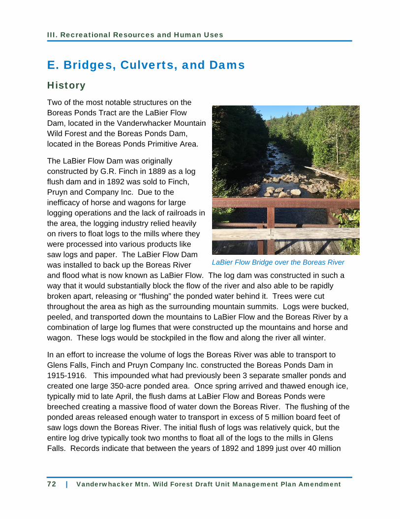
III. Recreational Resources and Human Uses
72 | Vanderwhacker Mtn. Wild Forest Draft Unit Management Plan Amendment
E. Bridges, Culverts, and Dams History Two of the most notable structures on the
Boreas Ponds Tract are the LaBier Flow
Dam, located in the Vanderwhacker Mountain
Wild Forest and the Boreas Ponds Dam,
located in the Boreas Ponds Primitive Area.
The LaBier Flow Dam was originally
constructed by G.R. Finch in 1889 as a log
flush dam and in 1892 was sold to Finch,
Pruyn and Company Inc. Due to the
inefficacy of horse and wagons for large
logging operations and the lack of railroads in
the area, the logging industry relied heavily
on rivers to float logs to the mills where they
were processed into various products like
saw logs and paper. The LaBier Flow Dam
was installed to back up the Boreas River
and flood what is now known as LaBier Flow. The log dam was constructed in such a
way that it would substantially block the flow of the river and also able to be rapidly
broken apart, releasing or “flushing” the ponded water behind it. Trees were cut
throughout the area as high as the surrounding mountain summits. Logs were bucked,
peeled, and transported down the mountains to LaBier Flow and the Boreas River by a
combination of large log flumes that were constructed up the mountains and horse and
wagon. These logs would be stockpiled in the flow and along the river all winter.
In an effort to increase the volume of logs the Boreas River was able to transport to
Glens Falls, Finch and Pruyn Company Inc. constructed the Boreas Ponds Dam in
1915-1916. This impounded what had previously been 3 separate smaller ponds and
created one large 350-acre ponded area. Once spring arrived and thawed enough ice,
typically mid to late April, the flush dams at LaBier Flow and Boreas Ponds were
breeched creating a massive flood of water down the Boreas River. The flushing of the
ponded areas released enough water to transport in excess of 5 million board feet of
saw logs down the Boreas River. The initial flush of logs was relatively quick, but the
entire log drive typically took two months to float all of the logs to the mills in Glens
Falls. Records indicate that between the years of 1892 and 1899 just over 40 million
LaBier Flow Bridge over the Boreas River

III. Recreational Resources and Human Uses
Vanderwhacker Mtn. Wild Forest Draft Unit Management Plan Amendment | 73
board feet of saw logs passed through the LaBier Flush dam. The flush dams were
used several more times throughout the years, with the LaBier Dam eventually being
rebuilt in 1932 and Boreas Dam in 1935. These dams were used every year thereafter
until 1948. The LaBier Dam was replaced with another wooden dam in 1968 and later
replaced with the present steel dam in 1979.
It is unclear as to when the original bridge over the LaBier Dam was constructed, but
Gulf Brook Road between Blue Ridge Road and Boreas Road was constructed in1965
so a bridge was likely to be in place by then. The present bridge was installed with the
steel dam in 1979.
Another notable bridge is the Hudson River Bridge on East River Road. Historic Finch
records indicate the company used this bridge in the late 1920s, though no earlier
records exist from MacIntyre, the previous land owner. The bridge does however, show
up on a 1913 map of the area. This was primarily built for the transport of people and
goods to support the areas logging operations.
Existing Conditions
Currently LaBier Dam obstructs approximately 25 acres of water on the Boreas River.
Before the dam was installed in 1889, the now-flooded area likely looked very similar to
the river below the dam. The Boreas Ponds Dam obstructs approximately 350 acres of
water on the Boreas river. Before the dam was installed in 1915 there were three
distinct ponds which were connected to each other by the Boreas River. Several acres
of wetlands were created when the dam was installed, and these wetlands now serve
as habitat for various wildlife, vegetation and other organisms. The APSLMP allows for
the maintenance and rehabilitation of small scale dams, where the structures are
deemed essential to the administration and/or protection of State lands. As long as the
dam is maintained and does not pose a public health and safety risk, it should remain in
place.
There are currently three motor vehicle bridges on Gulf Brook Road, two on Boreas
Road, and one on East River Road. The two small bridges on Gulf Brook are in fair to
good condition. The LaBier Bridge itself is in good condition, but the abutments are
being undermined and that will need to be addressed in the first year of this plan in
order to maintain public motor vehicle access. A full engineering report should be
sought to ensure proper and sustainable rehabilitation. The small bridge and the Boreas
Dam Bridge on Boreas road are in good condition and suitable for recreational access.
The Hudson River Bridge on East River Road is in good condition and suitable for
administrative access.

III. Recreational Resources and Human Uses
74 | Vanderwhacker Mtn. Wild Forest Draft Unit Management Plan Amendment
Proposed Management
Objectives
Construct and maintain bridges that protect the resource and support the
designated uses of the roads and trails that cross them.
Ensure all bridges, culverts, dams and trails or walkways associated with them
are properly maintained and safe for travel.
Action Steps
Maintain all bridges located on public motor vehicle roads and administrative
roads within the Vanderwhacker Mountain Wild Forest to a standard that
maintains environmental protection and protects the user’s health and safety.
Construct all new trail bridges in a manner that is compliant with the NYSDEC
design standard of its most intensive allowable use (i.e. bridges on class II
snowmobile trails will be constructed to a class II snowmobile bridge design
standard).
Design and construct trail bridges pursuant to the Minimum Requirements
Analysis (MRA, see Appendix A), which serves as guidance for determining
when bridges might be built with non-natural materials for trails in Wild Forest
areas. When the use of non-natural materials may be more desirable than using
natural materials for bridge construction, the Department will follow the MRA to
assess the appropriateness of the proposed bridge design and materials. One
bridge that may benefit from the use of non-natural materials is the bridge over
the Branch River that connects Branch Road to the Blue Ridge Mountain Bike
Network. Any other bridges needed to implement the trails in this plan will be
constructed out of natural materials.
Maintain the Boreas Ponds and LaBier Flow Dams to protect the environmental
resource, above and below the dams including its associated wetlands, and to
facilitate access beyond the dam. Maintenance will include removing the
vegetation from the earthen portion of the dam and making repairs to the dam
itself on a regular and as needed basis. If the above maintenance activities and
improvements are not or cannot be performed, the Department will remove the
impoundment and restore the river channel to its natural state, and stabilize the
site. If the dam is ever removed a new bridge will be constructed to maintain the
current level of public and administrative access.
Complete an engineer inspection and report to determine the need and type of
maintenance to be performed on the LaBier Flow Bridge and Dam. Since the
property was purchased in 2016, the bridge’s abutments have been undermined.

III. Recreational Resources and Human Uses
Vanderwhacker Mtn. Wild Forest Draft Unit Management Plan Amendment | 75
Perform routine inspections by NYS DEC Dam Safety.
Construct several new bridges on the trails proposed in this UMP Amendment.
Examples of these are a bridge over the Branch River which connects Branch
Road to the Blue Ridge Mountain Biking Network, bridges on the Boreas River
Trail, and the Andrew Brook Trail, and snowmobile bridges on the North Hudson
to Newcomb Community Connector Trail. This plan supports all bridge
construction necessary to support the sustainable construction of the trails
proposed in this plan, the replacement of failing bridges throughout the
Vanderwhacker Mountain Wild Forest, and new bridge construction on necessary
re-routes throughout the unit.
F. Paddling/Hand Cary Boat Launches History On the newly acquired lands lessees
and prior property owners have
accessed a variety of waterbodies
throughout the tracts, and have done so
by a variety of means and locations.
This was most notable near the dams
on Boreas Ponds and LaBier Flow, on
Sanford Lake, and where East River
Road crosses the Hudson River.
On pre-existing Forest Preserve, the
Boreas River at its intersection with
Blue Ridge Road was often used to
access the river for fishing, but water
conditions rarely allow for canoe or kayak access.
Existing Conditions Currently, Boreas Ponds sees the most hand-carry use for the Boreas Ponds Tract, and
LaBier Flow sees the most use on the newly classified Vanderwhacker Mountain Wild
Forest property. Official launches have not been built, but the public, along with the
lessees that still have access to the property often use the area around the dams to
hand launch boats, kayaks and canoes for fishing and paddling.
Opalescent River

III. Recreational Resources and Human Uses
76 | Vanderwhacker Mtn. Wild Forest Draft Unit Management Plan Amendment
On the MacIntyre Tract, an informal herd path and hand launch exists on the Hudson
River on the north side of East River Road. The scenic and generally calm waters of
Sanford Lake and the Hudson and Opalescent rivers offer excellent paddling
opportunities. It is likely that with these paddling opportunities, roadside pull offs and
herd paths may develop to Sanford Lake and the Hudson River. In order to protect soil
and water resources and also to aid in recreational access, locating and constructing
water access points and associated parking areas should be done in such a way that
allows for use to be distributed across a broad area. This dispersal of use will also
promote through-paddling opportunities where a car can be staged at one hand launch
site and a vessel can be dropped and launched from another site.
It will be beneficial for the protection of soil and water resources and to aid in
recreational access to site and construct water access points and associated parking
areas in a manner that allows for use to be distributed across a broad area. This
dispersing of use will also promote through-paddling opportunities where a car can be
staged at one hand launch site and a vessel can be dropped and launched from another
site.
The Hudson River from its confluence with the Opalescent River, south to State Route
28N is designated as a recreational river under the Wild, Scenic and Recreational
Rivers System Act. The Opalescent River north of its confluence with the Hudson is
classified as a wild river.
Proposed Management
Objectives
Provide car-top, hand launch facilities where possible, in areas known to have a
demand for water access to attractive features or facilities of the Forest Preserve.
In the construction of new launches, seek routes that would minimize
environmental impacts and maintenance costs by avoiding wetlands, stream
crossings, significant habitats, unstable soils and steep slopes, while taking
advantage of natural features that would contribute to the enjoyment of the
launch by visitors.
Manage the size and location of launch facilities to prevent user congestion on
any one water body or portion of a large water body.
Provide appropriate sanitary facilities at launch sites.
Increase public awareness of the invasive species threat to unit waters from
access sites to water bodies.
III. Recreational Resources and Human Uses
Vanderwhacker Mtn. Wild Forest Draft Unit Management Plan Amendment | 77
Action Steps
An accessible hand-carry boat launch, also suitable for carted boats, will be
developed on the west side of Boreas Ponds Dam. An access route will be
developed from the Boreas Ponds Parking Area, following the existing road to
the intersection with the old lodge access road. At this location the access route
to the Lean-to, which is discussed in the High Peaks Amendment, will go north
and the access route to the hand-carry launch will proceed easterly to the north
of Boreas Road. The access route will drop below the road in order to provide an
accessible grade to the water’s edge. This hand-carry launch and access route
will be laid out and constructed to current accessible standards. To help
preserve the wilderness experience of Boreas Ponds and provide an appropriate
transition area, a natural ramp of stone or aggregate will continue into Boreas
Ponds upstream of the dam to allow for water transitions. The entry into the
water will also be hardened with natural materials to maximize accessibility at the
site.
Develop a hand-carry boat launch on the southern end of LaBier Flow. A short
access route from Gulf Brook Road will be developed to be suitable for fishing
access and a hand-carry boat launch including for carted boats. This access
route and hand-carry launch will be laid out and constructed to the most
accessible degree possible given the site constraints, and will ideally meet or
exceed current specifications for accessible outdoor recreation access routes.
The entry into the water will also be hardened with natural materials so as to
maximize accessibility at the site. The closest parking area will be the four
corners parking area, so an unloading area will be developed along the side of
Gulf Brook Road in order to facilitate the access to the launch.
Construct a hand-carry launch on the southwestern end of Sanford Lake. A short
access route from Tahawus Road will be developed to be suitable for fishing
access and a hand-carry boat launch including for carted boats. This access
route and hand-carry launch will be laid out and constructed to the most
accessible degree possible given the site constraints, and will ideally meet or
exceed current specifications for accessible outdoor recreation access routes.
This standard may not be entirely possible due to fluctuating water levels, but the
slower moving currents of Sanford Lake as compared to the Hudson River below
make it more viable than on the river banks downstream of this site. The mean
water level entry will also be hardened with natural materials so as to maximize
accessibility at the site.
Construct a hand-carry launch from East River Road to the Hudson River. A
short access route from the East River Road Parking Area will be developed to

III. Recreational Resources and Human Uses
78 | Vanderwhacker Mtn. Wild Forest Draft Unit Management Plan Amendment
be suitable for fishing access and a hand-carry boat launch including for carted
boats. This access route and hand-carry launch will be laid out and constructed
to the most accessible degree possible given the site constraints. Due to this
being located on a site that is known to have water levels fluctuate more than
several vertical feet, it is not expected the trail and access will be able to be
maintained using crushed stone fill like in other areas that do not experience
such extreme water fluctuation and ice movement. The access point at the mean
water level will also remain vegetated. If the mean water level access begins to
experience erosion, the bank will be stabilized with large, flat rock in a manner
that facilitates access and armors the bank to prevent erosion.
Construct a hand-carry launch from Tahawus Road to the Hudson River
approximately one mile south of East River Road. A short access route from the
Tahawus Road Parking Area will be developed to be suitable for fishing access
and a hand-carry boat launch’ including for carted boats. This access route and
hand-carry launch will be laid out and constructed to the most accessible degree
possible given the site constraints. Due to this being located on a site that is
known to have water levels fluctuate more than several vertical feet, it is not
expected the trail and access will be able to be maintained using crushed stone
fill like in other areas that do not experience such extreme water fluctuation and
ice movement. The trail will remain as vegetated as possible to prevent erosion.
The access point at the mean water level will also remain vegetated. If the mean
water level access begins to experience erosion the bank will be stabilized with
large, flat rock in a manner that facilitates access and armors the bank to prevent
erosion.

III. Recreational Resources and Human Uses
Vanderwhacker Mtn. Wild Forest Draft Unit Management Plan Amendment | 79

III. Recreational Resources and Human Uses
80 | Vanderwhacker Mtn. Wild Forest Draft Unit Management Plan Amendment

III. Recreational Resources and Human Uses
Vanderwhacker Mtn. Wild Forest Draft Unit Management Plan Amendment | 81
G. Access for People with Disabilities
Existing Conditions
The new parking lots constructed in 2016 are used by people of all abilities. From there
many have accessed the property by a variety of means including horseback, especially
to LaBier Flow and Boreas Dam.
Universal Trail Assessment Process
The Universal Trail Assessment Process (UTAP) is an objective method of measuring
such site conditions as average and maximum grade, minimum trail width, cross slope,
trail length, and surface type. These variables can then be presented at the trailhead
and on our website to allow users to make an informed decision about whether they
would like to use the facility or not.
Roadside Primitive Tent Sites
Accessible camping opportunities will be provided at nine locations adjacent to roads
throughout the Boreas Ponds Tract. Camping at these sites will be managed according
to general State land backcountry camping regulations. The locations of accessible
roadside tent sites will be carefully chosen, in order to provide attractive facilities in
areas that can withstand use. These locations will have stable surfaces and include
parking or equestrian access, a hardened tent location, an accessible privy with a
hardened access route and otherwise comply with the APSLMP. These sites will be
located in appropriate locations along the Gulf Brook Road, Boreas Road and Branch
Road. Exact locations of these sites will be provided on maps, at trailheads, on the DEC
website and through other appropriate informational pathways. Monitoring use and
satisfaction of users will occur to assess and determine long term management of these
sites.
Proposed Management
Objectives
To provide outdoor recreational opportunities to people of all abilities.
Increase access opportunities for people with disabilities where such
development is economically feasible, does not alter the fundamental nature of
existing programs, is compliant with Department regulation and policy, and
conforms to the guidelines of the APSLMP.

III. Recreational Resources and Human Uses
82 | Vanderwhacker Mtn. Wild Forest Draft Unit Management Plan Amendment
Comply with the Americans with Disabilities Act (accessible) of 1990 by
improving access and creating recreational opportunities for people with
disabilities.
Inform users of the location and condition of facilities in the unit, focusing on such
variables as length of trails, average grade, steepest grade, minimum width, etc.,
to allow them to make informed decisions regarding whether they choose to use
a facility or not.
Action Steps
Maintain existing recreational access opportunities for people with disabilities, in
compliance with the Americans with Disabilities Act (accessible) of 1990.
Publicize the locations and details of existing accessible facilities on DEC’s public
website and through other appropriate informational pathways.
Incorporate accessible signage at trailhead access points.
Perform a UTAP assessment of the hand-carry launches specified in this plan.
Construct new facilities to the most accessible degree possible given site
constraints, with the understanding that while many may not fully meet
Americans with Disabilities Act (accessible) standards, the intent is to maximize
the degree of accessibility for the widest range of abilities. These hand-carry
launches, trails, tent sites, etc. would provide opportunities for those seeking
more primitive outdoor experiences than those found in traditional intensive use
campground areas.
Construct a six-car parking area for use by permit as described in the parking
and access alternatives of this plan. Four of these spaces will be open for
universal access and two spaces and an associated unloading zone will be for
people with disabilities. The parking area will be located 1/10 of a mile from
Boreas Dam in an existing clearing. Grading, fill, and limited tree cutting will be
necessary to construct the parking area to current accessible standards
The existing tent site at the Cheney Pond Overlook south of Blue Ridge Road will
be improved to current accessible standards. A gate will be placed across the
access road before the tent site. Motorized Access Program for People With
Disabilities (MAPPWD) permit holders will be able to drive directly in to the tent
site and the general public will be able to park within close proximity to the tent
site. The access road will also be graded and improved. A new parking area will
be installed near Blue Ridge road to accommodate general access for two cars.
At least three tent sites per road will be constructed to current accessible
standards on Gulf Brook, Boreas and Branch roads.

III. Recreational Resources and Human Uses
Vanderwhacker Mtn. Wild Forest Draft Unit Management Plan Amendment | 83
Construct an unloading area adjacent to Gulf Brook Road near the LaBier Flow
hand launch. The hand launch will be constructed to the most accessible degree
possible given the site constraints. There is not adjacent parking here, nor an
accessible trail from the parking area at the four corners to this hand-carry launch
so a firm and stable unloading area will be developed where the hand-carry
launch trail meets Gulf Brook Road in order to facilitate the access to the launch
and the loading and unloading of persons, and their gear. Parking for this site
will be located at the Four Corners Parking Area.
Construct an accessible hand-carry launch on Boreas Ponds to the west of the
Boreas Ponds Dam. An accessible route from the Boreas Ponds Parking Area
will be constructed to connect the Hand-carry launch to the parking area.
Equestrian mounting platforms will be provided at the following locations:
o Blue Ridge Parking Area
o Fly Pond Parking Area
o Gulf Brook Mountain Bicycle Parking Area
o The three accessible tent sites on Boreas Road
o The hand-carry launch on LaBier Flow
Accessible parking spots and unloading zones will be designated at all significant
parking areas.
Accessible privies, kiosks, and other accessory structures will be installed at all
significant parking areas.
H. Day Use Areas
Existing Conditions
There are a series of clearings north of Blue Ridge Road and west of Elk Lake Road
created by past logging operations. Being of significant size and located downslope of
the Blue Ridge Mountain Bike Network, this site lends itself well to facilitating access to
the adjacent trail network and public lands. With the appropriate site work there is room
for a parking area, loading area, privies, and picnic tables.
Proposed Management
Objective
Provide parking, staging for the adjacent trail networks, and picnic tables within
an area for day use only in compliance with APSLMP guidelines for Wild Forest

III. Recreational Resources and Human Uses
84 | Vanderwhacker Mtn. Wild Forest Draft Unit Management Plan Amendment
Areas. It is useful to describe this combination of roadside structures and
improvements as a “Day Use Area” because it conveys to the public the intent to
restrict overnight uses like camping and simultaneously provide improvements
that will protect resources and improve the visitor experience. These sites
should not be confused with areas classified as Intensive Use which also share
the term Day Use Areas, but are more highly developed.
Action Steps
Develop, and codify in regulation, a Mountain Bike Day Use Area to the north of
Blue Ridge Rd. The facility can be largely constructed in a series of existing
clearings and be a part of a mountain biking hub for the Blue Ridge and Gulf
Brook Mountain Bike Networks. The intent is to create an area to prepare for
riding the area’s single track mountain bike networks while protecting the
resource from abuse through roadside group camping. The area could also
prove to be popular among all recreational users of the Forest Preserve in the
area seeking a place to gear up or cool down after their trip. An approximately
30-acre day-use-area would provide sufficient parking and associated facilities
like privies, picnic tables, and informational kiosk, and would be large enough to
discourage roadside camping. A 10-car parking area will be constructed, along
with a loading and un-loading zone. An accessible kiosk and privy will also be
installed to service the parking area. The Blue Ridge Mountain Bike Network will
be directly accessed from the parking area.
Beyond the parking area, 5 picnic tables will be placed in various locations in the
day-use-area. Access paths and light site work may be necessary to connect the
picnic table sites to the main singletrack trail. At least one additional privy will
also be installed in the day use area. As part of the phased approach to
implementation, if the sites around the five picnic tables start to show signs of
overuse or if additional sites are seen as desirable, then five more sites and
tables will be installed to distribute the use.
Designate, and codify in regulation, the 10.96-acre Boreas Ponds Primitive Area
for day-use only. The intent of allowing only day-use is to protect the resource
around the dam by not allowing camping. Facilities like privies and educational
signage will be provided in the day-use area, but picnic tables will not be.

III. Recreational Resources and Human Uses
Vanderwhacker Mtn. Wild Forest Draft Unit Management Plan Amendment | 85

III. Recreational Resources and Human Uses
86 | Vanderwhacker Mtn. Wild Forest Draft Unit Management Plan Amendment

III. Recreational Resources and Human Uses
Vanderwhacker Mtn. Wild Forest Draft Unit Management Plan Amendment | 87
I. Trail Recreation
Note: This section contains a discussion and inventory of the proposed trail
network and the uses (see icons) associated with each trail. The sections
following this one discuss individual uses within the context of the recently-
classified lands.
Existing Conditions
In the past, the trails on the Boreas Ponds and MacIntyre tracts were more road-like in
nature, due to their forest management use, than what we typically think of trails being
today. Due to this, the majority of the old logging and lessee hunting roads in the area
are not viable as a long-term and sustainable option for public recreational use.
Although there may be some exceptions and instances where sections of old logging
roads may be used, for the most part, an entirely new trail system will need to be
developed to maximize environmental protection, sustainability, and user enjoyment.
Proposed Management
Objectives
Provide visitors with a trail system that offers a range of recreational
opportunities in a manner that keeps physical and visual trail and resource
impacts to a minimum and complies with APSLMP guidelines.
Construct and maintain trails in a manner which preserves their classification
(see trail classification chart in Appendix E for additional information) and
prevents impacts such as sedimentation and erosion.
Identify need for trail relocations and/or need for new trails.
Provide a unified system of trail signage and markers on the Vanderwhacker
Mountain Wild Forest. Trail marker colors will describe general direction of trails.
Red markers will be used on trails that primarily run east-west, Blue markers will
be used on trails that primarily run north-south, and Yellow markers will be used
on spur trails, connecting trails, and loop trails.
Allow the previous owner and lessee trails that are not suitable for public
recreational use to revegetate.
Provide appropriate staffing levels so the Department can build and maintain a sustainable purpose built trail network.

III. Recreational Resources and Human Uses
88 | Vanderwhacker Mtn. Wild Forest Draft Unit Management Plan Amendment
Equestrian
Proposed Trails and Uses
Use Icon Legend
Hiking Snowmobiling X-country Skiing
Bicycling Snowshoeing Accessible
1. Newcomb to North Hudson Community Connector Trail
Recommended Uses: Secondary Uses:
Description:
The Newcomb to North Hudson Community Connector Trail (NNHCC) is
intended to provide a recreational connection for multiple user groups between
the towns of Newcomb and North Hudson. The trail will be sited and constructed
to class II snowmobile trail standards outlined in the 2009 Snowmobile
Management Guidance: Snowmobile Trail Siting, Construction and Maintenance
on Forest Preserve Lands in the Adirondack Park (2009 Guidance). Additional
tread development will also be done throughout the trail in order to make the trail
tread sustainable for non-winter hiking, mountain biking, and equestrian use. It is
important to note that horse and wagon use will be limited to areas of this trail
that utilize Forest Preserve roads that are maintained to a road standard, and will
not be permitted on off-road trail segments. Additionally, for the majority of the
distance of trail proposed in this UMP amendment, both warm season and cold‐
season uses will share the same trails. In some locations, however,
environmental constraints such as water and terrain will require the different
seasonal uses to be separated for short distances. Additional information can be
found in the Trail Alternatives section of the 2015 Community Connector Trail
Plan (CCTP).
Several alternatives for the Newcomb to North Hudson Community Connection
were described in the CCTP, however a preferred alternative for the connection
was not established. This UMP Amendment proposes Alternative B in Section 3

III. Recreational Resources and Human Uses
Vanderwhacker Mtn. Wild Forest Draft Unit Management Plan Amendment | 89
of the CCTP to be the preferred alternative, such that the trail will proceed
generally north from the Roosevelt Truck Trail to the western end of Boreas
Road, then east along Boreas Road to its intersection with Gulf Brook Road.
From here the trail will follow Gulf Brook Road to the vicinity of Blue Ridge Road.
New trail construction will be necessary to connect Roosevelt Truck Trail to
Boreas Road and to connect Gulf Brook Road to Sand Pond Road on the
adjacent Conservation Easement to the south of Blue Ridge Road.
2. Boreas Ponds Dam Trail
Primary Uses: Secondary Uses:
Description:
This Class VI Front Country trail will be sited on the Administrative road between
the parking lot in the Vanderwhacker Mountain Wild Forest and the Boreas
Ponds Dam. The first half of this trail will be surfaced as an accessible trail to the
junction with the Boreas Ponds Water Access Trail.
3. Boreas Ponds Accessible Water Access Trail
Primary Uses:
Description:
Construct a class VI Accessible Front Country Trail to Boreas Ponds, along with
an accessible hand-carry launch to the west of the Boreas Ponds Dam. The
accessible route from the Boreas Ponds Dam Access Trail will be constructed to
connect the Hand-carry launch to the Boreas Ponds Dam Trail and Parking Area.

III. Recreational Resources and Human Uses
90 | Vanderwhacker Mtn. Wild Forest Draft Unit Management Plan Amendment
4. Boreas Ponds Trail
Recommended Uses: Secondary Uses: Prohibited Uses:
Description:
Construct a Class V trail connecting Andrew Brook Road to Gulf Brook Road.
This will be approximately four miles long and provide connectivity between the
Blue Ridge Road and the Fly Pond Parking area on Gulf Brook Road. The
greater plan is to continue this connection north of the Fly Pond Parking area into
the High Peaks Wilderness Area and on to Boreas Ponds, which will serve as a
non-motorized connection from Blue Ridge Road to Boreas Ponds.
Approximately two miles of the southern end is an old forest access road into the
tract that will be suitable for mountain bike use and will serve as a connection to
the Gulf Brook Mountain Bike Trail Network described later in this Amendment.
Much of this is constructed with fill and road drainage devices like ditches and
culverts. Areas of this section that do not hold up to trail use over time may be
hardened with existing fill. It is also anticipated that some small re-routes will be
necessary to maintain a sustainable trail. As road-like features like culverts and
ditches fail over time they will be replaced with trail features like waterbars,
turnpikes, broad-based dips, etc. The northern segment will be new trail
construction and connect to Gulf Brook Road in the vicinity of the Fly Pond
Parking Area. The entire trail will be constructed and/or maintained with cross
country skiing in mind as well. The Boreas Ponds Trail will allow for loops of
varying distances and difficulties when paired with the Gulf Brook Mountain Bike
Network. This is also an especially important connection for non-motorized
winter access into Boreas Ponds. Gulf Brook Road will serve as a snowmobile
trail connection between the towns of Newcomb and North Hudson, so users
seeking a non-motorized route to the ponds will be able to park at the Andrew
Brook Parking Area and use the purpose built Boreas Ponds Trail to ski from
Blue Ridge Road to Boreas Ponds without needing to use Gulf Brook Road.

III. Recreational Resources and Human Uses
Vanderwhacker Mtn. Wild Forest Draft Unit Management Plan Amendment | 91
5. Ragged Mountain Trail
Recommended Uses: Secondary Uses: Prohibited Uses:
Description:
Construct a Class IV foot trail that will connect the overlook of Ragged Mountain
to the new Ragged Mountain Parking Area on Gulf Brook Road. Due to its short
length, excellent views and easy access, Ragged Mountain may be a popular
destination. This is also in the immediate vicinity of rock and ice climbing, so
parking at times will have to be shared among multiple uses. More climbing
information can be found later in the rock and ice climbing section.
6. Boreas River Trail
Recommended Uses: Prohibited Uses:
Description:
A foot trail will be constructed and maintained to Class IV secondary trail
standards and will generally follow the east side of the Boreas River from the
Wolf Pond/Boreas River Parking Area on Blue Ridge Road north to the vicinity of
LaBiere Flow. It is thought the proximity of the trail to the river and ease of
access to fishing, combined with the nostalgia of the area’s history, will make this
a popular hike, snowshoe or ski.
7. Wolf Pond Trail
Recommended Uses: Secondary Uses: Prohibited Uses:
Description:
The first segment of the Wolf Pond Trail and lean-to was completed in 2017
pursuant to the 2005 Vanderwhacker Mountain Wild Forest UMP. This connected
the Wolf Pond/Boreas River Parking Area to the outlet of Wolf Pond. This UMP
Amendment proposes continuing the trail to the Andrew Brook Trail. This will be

III. Recreational Resources and Human Uses
92 | Vanderwhacker Mtn. Wild Forest Draft Unit Management Plan Amendment
constructed and maintained to Class IV foot trail standards.
8. Boreas Mountain Trail
Recommended Uses: Secondary Uses: Prohibited Uses:
Description:
In 2012, the Department was gifted a Conservation Easement that included the
recreational right of the public to use the Boreas Mountain Trail across Elk Lake
Property. Historically, this trail was used to access the summit of Boreas
Mountain and the fire tower that previously stood there. The Department has the
right to establish public access here and is allowed to maintain the trail within a
50 foot corridor. Access to this corridor is gained via Branch Road and any one
of the parking areas along the length of the road, including the one at the Day
Use Area. Like many other trails of this era, it is laid out generally up the fall line
of Boreas Mountain, so several improvements must be made and ongoing
maintenance must be undertaken in order to minimize erosion and maximize
user experience. The possibility of a trail located solely on Forest Preserve from
Gulf Brook Road to the summit of Boreas Mountain exists. If this trail is
constructed and user access to the summit of Boreas Mountain is provided, the
trail across the Conservation Easement may not be necessary. Due to these
considerations, the Department will weigh the possibility of a sustainable trail
being laid out and constructed in the High Peaks Wilderness between Boreas
Mountain and Gulf Brook Road. If the trail up from the west is built first, the
Department will evaluate use of that trail and the level of public interest in the
eastern approach proposed in this amendment prior to constructing it. If the
eastern approach trail is built, an additional parking area for up to 10 cars will be
established near the end of Branch Road.

III. Recreational Resources and Human Uses
Vanderwhacker Mtn. Wild Forest Draft Unit Management Plan Amendment | 93
9. Gulf Brook Mountain Bike Trail Network
Recommended Uses: Secondary Uses: Prohibited Uses:
Description:
The over 1,200-acre area west of Gulf Brook Road south of Andrew Brook and
mostly east of the Boreas Ponds Trail is largely located on well drained soils with
northern hardwood forests. This, coupled with the varied terrain that slopes
generally downward toward Blue Ridge Road, lends the area well to singletrack
mountain bike trails. This plan is in favor of establishing an approximately six-
mile network of stacked trails in this area. Six miles of new trail is an
approximation and will vary depending on the exact layout of a sustainable trail.
The northern end of the network will be serviced by a new 10 car parking area
along Gulf Brook Road and the southern end by the Blue Ridge and Andrew
Brook Parking Areas. The trail system, parking areas and tent sites along Gulf
Brook Road are designed to work as a network that incorporates parking, day
use and primitive camping opportunities that can all be accessed by mountain
bike, foot, or ski. The network will also be developed with skiing in mind, so
winter users can take advantage of the system in the winter months. The
stacked nature of the design will also allow for users of different experience
levels to use various portions of the network, with the primary connections to the
parking areas and camping opportunities being generally more forgiving than the
core singletrack trails. The potential for more trails here does exist, especially if
the network were to connect and cross over to the west side of Andrew Brook
Trail, but similar to other proposals, this plan is in favor of taking a phased
approach to the expansion of the network. Use numbers and environmental
impacts of this trail will be monitored and if the desire for additional trails exists,
approximately four additional miles of trail may be constructed.

III. Recreational Resources and Human Uses
94 | Vanderwhacker Mtn. Wild Forest Draft Unit Management Plan Amendment
10. Blue Ridge Mountain Bike Trail Network
Recommended Uses: Secondary Uses: Prohibited Uses:
Description:
The over 800-acre area of Forest Preserve between Elk Lake Road and the
Branch River is largely located on well drained soils with northern hardwood
forests. The terrain here slopes generally downward towards the Branch River
and Blue Ridge Road, which makes the area favorable for a directional descent
singletrack mountain bike trail system. This plan is in favor of using the phased
approach to construct an approximately eight-mile network of stacked trails in
this area. Eight miles of new trail is an approximation and will vary depending on
the exact layout of a sustainable trail.
The upper and lower Elk Lake Road parking areas, Blue Ridge Mountain Bike
Day Use Area, and Branch Road will all have trail connections. The trail system,
parking areas and tent sites along Branch Road are designed to work as a
network that incorporates parking, day use, and primitive camping opportunities
that can all be accessed by mountain bike, foot, or ski. The network will also be
developed with skiing in mind so winter users can take advantage of the system
in the winter months. The stacked nature of the design will also allow for users of
different experience levels to use various portions of the network, with the
primary connections to the parking areas and camping opportunities being
generally more forgiving than the core singletrack trails. The first phase in
construction will be approximately four miles, will concentrate on making the
connections to the parking areas and will be laid out in a manner that will be able
to easily accept additional mileage into the network. The area here is fairly
expansive and there is room to accommodate more than four miles of trail. Use
numbers and environmental impacts of this trail will be monitored and if the
desire for additional trails exists, approximately four additional miles of trail may
be constructed. The second phase will be laid out in a way that connects to the
existing network and will likely appeal to users seeking a more difficult
experience.
More information on the Blue Ridge Mountain Bike Hub can be found in the Day
Use Area section of this plan.

III. Recreational Resources and Human Uses
Vanderwhacker Mtn. Wild Forest Draft Unit Management Plan Amendment | 95
11. Elk Lake to Branch Road Mountain Bike Connection
Recommended Uses: Secondary Uses: Prohibited Uses:
Description:
There is an old logging road formerly known as River Road that stretches
between the lower Elk Lake Road Parking Area and the Branch River, eventually
terminating on the east side of the Branch River near the Elk Lake property
boundary. The lower Elk Lake Parking Area and Old River Road currently leads
to the general area where the Blue Ridge Mountain Bike Trail Network is
proposed, however, increased recreational opportunities like camping at the
Branch Road tent sites could be gained if the Old River Road were connected to
the Branch Road with a new trail and bridge over the Branch River. Old River
Road will be maintained to a Class V trail standard and a new Class V trail
connection between this and Branch Road, including a bridge over the Branch
River, will be constructed. It is important to note Old River Road was initially laid
out and constructed to be intermittently used for forest management purposes
and is not sustainable for public motor vehicle traffic. The sustainability and
appropriateness of old roads being used as trails is highly dependent on how the
road was constructed and the site it was constructed on. This particular road has
been laid out in a generally favorable location for a sustainable trail, and has
been graded and filled over time so there is on-site material to maintain a trail
tread. In addition to being popular for singletrack users, this will also provide a
fairly scenic cross country skiing opportunity.
12. Vanderwhacker Pond Trail
Recommended Uses: Prohibited Uses:
Description:
A foot trail will be constructed and maintained to Class IV secondary trail
standards from the Community Connector Trail to Vanderwhacker Pond. This
trail will avoid the fall line the current herd path is located in and will be
constructed sustainably.

III. Recreational Resources and Human Uses
96 | Vanderwhacker Mtn. Wild Forest Draft Unit Management Plan Amendment
13. Newcomb Lake to Harris Lake
Recommended Uses: Secondary Uses: Prohibited Uses:
Description:
Connect Lake Harris Public Campground and the Newcomb to Minerva
Community Connector trail on Campground Road to Newcomb Lake with a Class
IV foot trail. Historically, there was a trail connecting the outlet of the main body
of Newcomb Lake near the Santanoni Great Camp to the eastern side of Harris
Lake. The trail proceeded generally east from Newcomb Lake on the north side
of the Lower Duck Hole portion of Newcomb Lake. Once around the eastern end
of Lower Duck Hole, the trail followed the Newcomb River south, eventually
crossing the river and heading back to Harris Lake and Campground Road. The
entire trail was approximately four miles long, but over time almost all of it has
been lost and is now revegetated. Connecting a new trail to the existing Lower
Duck Hole Trail will require approximately three miles of new trail construction to
a Class IV foot trail standard, some minor bridging of streams and a bridge over
the Newcomb River. Some of the old trail crosses private property which the
Department now holds a Conservation Easement on. If the new trail cannot be
constructed exclusively on Forest Preserve property due to environmental
constraints, the construction of this trail will be dependent on a Recreation
Management Plan (RMP) for the Conservation Easement to allow such use.
Short access trails will also be constructed to access the campsites proposed
along this new section of trail.
14. LeClaire Hill Trail
Recommended Uses: Secondary Uses: Prohibited Uses:
Description:
LeClaire Hill lies within the High Peaks Wilderness to the north of the Niagara
Brook Tract. If an amendment to the High Peaks Wilderness UMP approves a
trail to the summit of LeClaire Hill, then this UMP Amendment supports the
construction of a trail from the Niagara Brook Parking Area to the High Peaks
Wilderness boundary to connect to LeClaire Hill.

III. Recreational Resources and Human Uses
Vanderwhacker Mtn. Wild Forest Draft Unit Management Plan Amendment | 97
J. Snowmobile (Multiple-Use) Trails
Existing Conditions
Snowmobiling has not been allowed on the Boreas Ponds Tract since being acquired by
the State. The multiple-use trail proposed in this amendment has not been constructed,
but an analysis of alternatives considered for this route was completed by the
Department in 2015, and outlined in the Community Connector Trail Plan for the Towns
of Newcomb, Minerva, and North Hudson.
Proposed Management
In the vicinity of the Boreas Ponds Tract, four different routes were considered in the
Community Connector Trail Plan, but a preferred alternative was not selected because
the State did not yet own the land. Now that the tract has been acquired by the State
and classified—in part—as wild forest, the Department has selected a preferred
alternative using the following criteria:
Minimal overlap with active motor vehicle routes to increase user safety and
enjoyment;
Minimal tree cutting, wetland intrusions, and terrain modifications; and
Utilization of existing, non-conflicting (i.e. not proposed for other winter uses)
trails and/or motor vehicle routes to maximize construction and long-term
maintenance efficiencies
Alternative B from the Community Connector Trail Plan stands out as the preferred
alternative because it clearly meets the above criteria more than the other three
alternatives that were considered. By utilizing the Gulf Brook and Boreas roads, which
are not plowed in the winter, the route a) avoids relying on Blue Ridge Road, which
would create a safety hazard and reduce user enjoyment, b) minimizes new
construction and additional maintenance costs, and c) keeps tree cutting and terrain
modifications to the minimum amount possible when not utilizing Blue Ridge Road.
The additional alternatives that were considered for this section of the Newcomb
to Minerva multiple-use trail are discussed in Appendix B of this amendment.
As described in the Community Connector Trail Plan, the preferred alternative is as
follows (note: the Boreas Road was erroneously identified as part of the Gulf Brook
Road in the 2015 plan, and the distinction between the two roads has been clarified
here):

III. Recreational Resources and Human Uses
98 | Vanderwhacker Mtn. Wild Forest Draft Unit Management Plan Amendment
Roosevelt Truck Trail to Blue Ridge Road (2.3 miles on road)
This alternative proceeds north, generally along the Roosevelt Truck Trail to a
suitable crossing at the Blue Ridge Road. A final crossing location will be
decided in consultation with the APA, Essex County Highway Department and
New York State Department of Transportation.
Blue Ridge Road to Boreas Ponds Tract Boundary (1.8 miles of new trail)
The grade and terrain on the north side of the Blue Ridge Road in this area are
suitable for the construction of a proposed new trail. This segment would avoid
using the shoulder of the Blue Ridge Road.
Boreas Ponds Tract Boundary to Boreas Road (2.1 miles of new trail)
There are existing skid trails on the former Finch‐Pruyn lands within the Boreas
Ponds Tract that could provide a suitable trail from the property boundary
northeast of Vanderwhacker Pond to the Boreas Road. Where these skid trails
cannot be sustainably maintained, new trails would be constructed to connect
the sustainable sections.
Boreas and Gulf Brook roads (8.9 miles on Forest Preserve road)
The Boreas and Gulf Brook roads are existing motor vehicle roads within Boreas
Ponds Tract. If this part of the tract is classified Wild Forest, the Boreas and Gulf
Brook Roads could become a snowmobile route and be maintained exclusively
for winter recreational uses during the colder months (i.e. not plowed). The
design and unpaved surface of the road also mean that motor vehicles will travel
slowly during the warmer months, making the route suitable for other
recreational uses as well.
Objective
Develop a multiple-use community connection trail between the towns of North
Hudson, Newcomb and Minerva
Actions Steps
Design and construct a multiple-use trail as outlined in the preferred alternative
above to a Class II snowmobile trail standard in accordance with the 2009
Snowmobile Management Guidance, and to a standard which will also support
non-winter uses such as hiking, mountain biking, and equestrians.
A new gate will be installed on each side of the Blue Ridge Road trail
crossing. The gates will be installed to be easily navigable by all allowed uses.

III. Recreational Resources and Human Uses
Vanderwhacker Mtn. Wild Forest Draft Unit Management Plan Amendment | 99

III. Recreational Resources and Human Uses
100 | Vanderwhacker Mtn. Wild Forest Draft Unit Management Plan Amendment
K. Hiking and Snowshoeing
Existing Conditions
Hiking and snowshoeing is allowed “at-large” throughout the tracts, but purpose-built
foot trails are currently limited to pre-existing Vanderwhacker Mountain Wild Forest and
High Peaks Wilderness lands. Although hiking will continue to be allowed at-large, this
amendment proposes five trail opportunities for hiking and snowshoeing to be
constructed or upgraded in the Vanderwhacker Mountain Wild Forest, and it allows for
several others within the High Peaks Wilderness Area to be accessed from the Wild
Forest. These, like all of the proposed trails, will be purpose-built trails focusing on
sustainability and user enjoyment.
Proposed Management
Objectives
Design and locate all trails in accordance with DEC guidance and best
management practices that minimize environmental impacts.
Add and enhance hiking and snowshoe trail opportunities as appropriate
throughout the area.
Establish photo point monitoring locations and systematic measuring
methodologies to help monitor trail impacts on all newly constructed, rerouted
and rehabilitated trails. This data will help inform the decision-making process on
future trail decisions.
Action Steps
Construct and maintain the following ADA-compliant Class VI Accessible Front
County Trails:
o Boreas Ponds Dam Water Access Trail
Construct and maintain to a Class V standard:
o Boreas Ponds Trail
Construct and maintain to a Class IV standard:
o Boreas River Trail
o Ragged Mountain Trail
o Wolf Pond Trail (conditional action)
o Newcomb Lake to Harris Lake Trail (conditional action)
o LeClair Hill Trail (conditional action)

III. Recreational Resources and Human Uses
Vanderwhacker Mtn. Wild Forest Draft Unit Management Plan Amendment | 101
Construct and maintain to a Class III standard:
o Vanderwhacker Pond Trail
Construct a trail up the east side of Boreas Mountain from Branch Road to a
Class IV standard. A supporting Recreation Management Plan (RMP) for the Elk
Lake Conservation Easement will be necessary to complete this connection. If a
trail up Boreas Mountain from the west is built first (through the High Peaks
Wilderness Area), the Department will evaluate use of that trail and the level of
public interest in the eastern approach proposed in this amendment prior to
constructing it. This is a conditional action dependent on the phased approach.

III. Recreational Resources and Human Uses
102 | Vanderwhacker Mtn. Wild Forest Draft Unit Management Plan Amendment

III. Recreational Resources and Human Uses
Vanderwhacker Mtn. Wild Forest Draft Unit Management Plan Amendment | 103
L. Cross-Country Skiing
Existing Conditions
Like hiking, skiing is allowed “at-large” throughout the tracts, but purpose-built ski trails
are currently limited to pre-existing Vanderwhacker Mountain Wild Forest and High
Peaks Wilderness lands. Although skiing will continue to be allowed at-large, this
Amendment proposes several new trails be constructed with skiing in mind. These, like
all of the proposed trails, will be purpose-built trails focusing on sustainability and user
enjoyment.
Proposed Management
Objectives
Design and locate all trails in accordance with DEC guidance and trail best
management practices that minimize environmental impacts.
Add and enhance skiing opportunities as appropriate throughout the area.
Action Steps
The following trails will be constructed and/or maintained with tread and drainage
development standards of their first classification (Class IV or V) and the clearing
width and height of a Class VIII ski trail. Except when impractical any bridges will
be built as ski trail bridges:
o Gulf Brook Mountain Bike Network
o Blue Ridge Mountain Bike Network
o Boreas Ponds Trail
o Boreas Ponds Dam Trail
o Boreas River Trail
o Vanderwhacker Pond Tail
o Newcomb Lake to Harris Lake Trail
o LeClaire Hill Trail
The Boreas Ponds Trail mentioned above will be important to establish before or
simultaneously with the Newcomb to North Hudson Community Connector Trail.
Gulf Brook and Boreas roads will likely see consistent snowmobile use
throughout the winter months, so the Boreas Ponds Trail will serve as a non-
motorized connection from Blue Ridge Road to the Fly Pond Parking Area.
Beyond here the trail will tie into the proposals outlined in the High Peaks

III. Recreational Resources and Human Uses
104 | Vanderwhacker Mtn. Wild Forest Draft Unit Management Plan Amendment
Wilderness Complex Amendment, which will extend the non-motorized use to
Boreas Ponds.

III. Recreational Resources and Human Uses
Vanderwhacker Mtn. Wild Forest Draft Unit Management Plan Amendment | 105

III. Recreational Resources and Human Uses
106 | Vanderwhacker Mtn. Wild Forest Draft Unit Management Plan Amendment
M. Bicycling
Existing Conditions
Under the 2016 Interim Access Plan, mountain bikes are allowed from the entrance of
the parcel at Blue Ridge Road 6.7 miles along the Gulf Brook Road and the road to the
dam at Boreas Ponds. Two different proposals for mountain biking opportunities are
discussed elsewhere in this amendment. Mountain biking options include long distance
backcountry touring and stacked loop riding. Both are primarily on singletrack. Other
cycling opportunities are available on certain roads that are open to bikes. Both options
tie into several parking, camping and other recreational opportunities.
Proposed Management
Objectives
Maintain trails to an appropriate standard to minimize resource impacts and
preserve recreational usability.
Educate recreational users about respectful multiple-use trail etiquette.
Evaluate bicycling use and impacts.
Action Steps
Construct and manage single-track mountain biking pursuant to Management
Guidance: Siting, Construction, and Maintenance of Single-track Bike Trails on
Forest Preserve Lands in the Adirondack Park.
Install up-to-date trail maps at kiosks/register boxes.
Install multiple-use trail etiquette signage at all Complex Area parking
areas/trailheads.
Install signage where bicycling is not allowed.
Encourage and support partnerships that help to show and evaluate use of the
area
Allow bicycle use on Gulf Brook, Boreas, Andrew Brook and Branch roads.
Allow bicycle use on the Community Connector Trail.
Construct and maintain the following the single-track mountain bike networks and
their associated facilities discussed in the trails section of this plan:
o Gulf Brook Mountain Bike Network
o Blue Ridge Mountain Bike Network

III. Recreational Resources and Human Uses
Vanderwhacker Mtn. Wild Forest Draft Unit Management Plan Amendment | 107

III. Recreational Resources and Human Uses
108 | Vanderwhacker Mtn. Wild Forest Draft Unit Management Plan Amendment

III. Recreational Resources and Human Uses
Vanderwhacker Mtn. Wild Forest Draft Unit Management Plan Amendment | 109
N. Equestrian Use
Existing Conditions
Pursuant to the 2016 Interim Access Plan, horses are allowed on the property unless
otherwise signed against it. The Blue Ridge, Fly Pond, Andrew Brook, Notch and Upper
Elk Lake parking areas currently offer parking for horse trailers, and the Boreas and
Gulf Brook roads offer enjoyable equestrian riding, but there are not purpose-built trails
in place outside of the existing road system.
An important goal of this Amendment is to provide new equestrian opportunities in the
Vanderwhacker Mountain Wild Forest, and facilitate access to the Boreas Ponds
Primitive Area and High Peaks Wilderness Area. Facilitating a connection between the
towns of North Hudson and Newcomb for longer through rides is also an important
management goal.
Proposed Management
Objectives
Provide recreational opportunities for equestrian trail riders in suitable locations.
Maintain trails to appropriate standards, while minimizing environmental impacts.
Provide information about uses allowed on and appropriate etiquette for multiple-
use trails.
Action Steps
Allow equestrian and horse and wagon use on Gulf Brook, Boreas and Branch
roads.
Allow Equestrian Use on the Community Connector Trail and the Boreas Ponds
Trail.
Allow equestrian use on the Boreas Dam Trail.
Provide equestrian mountain platforms at all equestrian campsites, the Blue
Ridge, Fly Pond and Andrew Brook parking areas, near the LaBier Flow hand-
carry launch, and in the vicinity of the Boreas Ponds Dam.
Provide multiple-use trail etiquette information at all parking areas and trailheads.
Install up-to-date trail maps at all parking areas and trailheads.
Designate and mark horse trails with DEC trail markers.
Install signage where equestrian trail riding is not allowed.

III. Recreational Resources and Human Uses
110 | Vanderwhacker Mtn. Wild Forest Draft Unit Management Plan Amendment
Identify locations for equestrians where water is available for horses and install
signage at these locations. Hitching posts or high lines may also be provided at
these locations.
Promulgate a regulation to prevent horses from entering wetlands and
waterbodies, except through fords on designated trails.

III. Recreational Resources and Human Uses
Vanderwhacker Mtn. Wild Forest Draft Unit Management Plan Amendment | 111

III. Recreational Resources and Human Uses
112 | Vanderwhacker Mtn. Wild Forest Draft Unit Management Plan Amendment
O. Rock and Ice Climbing
Existing Conditions
The Adirondack region remains one of few areas in the country where the placement of
fixed climbing anchors (bolts) is not overly common, but is an increasing practice and a
growing concern. The reputation of the region is one of traditional climbing, where bolts
and pitons are the exception rather than the rule. The use of fixed anchors, particularly
fixed expansion bolts, placed in holes drilled into the rock has been an issue of
controversy in public land management (Access Fund, 2001). Fixed anchors have long
been used by climbers as a method of protection where use of traditional removable
protection (camming devices, chocks and nuts) is not possible. Fixed anchors, including
bolts and slings placed around trees have also been used for rappel anchors. This
practice can provide some level of protection to the natural resource by reducing
damage to trees from girdling, caused when rappel ropes wrapped around trees are
pulled down at the end of a climbing session. When placed indiscriminately, bolts and
related fixed anchors can mar cliff faces and result in visibility impacts from the ground.
The use of fixed anchors, when properly managed, can be an important management
tool to protect the natural resource. Use of fixed anchors for protection on a climb that
might not be possible without the placement of fixed or artificial anchors has
engendered much more controversy both within and outside of the climbing community.
The use of fixed anchors for this purpose in some areas has fundamentally altered the
sport of climbing, resulting in a "climbing gym" atmosphere where numerous bolts are
used to create a route where none previously existed. Like other areas of the Forest
Preserve, fixed anchors have been documented in the Boreas Ponds Tract on Ragged
Mountain. At least five routes are advertised on various climbing websites and
publications. Popular climbing locations within the Boreas Ponds Tract and the
Vanderwhacker Mountain Wild Forest in general must be further inventoried and
monitored.
At this point in time the placement of bolts or other fixed anchors which involve drilling
or defacement of the rock is a violation of Department regulations (6 NYCRR
§190.8(g) -- "No person shall deface, remove, destroy, or otherwise injure in any
manner whatsoever any . . . rock, fossil or mineral . . . excepting under permit from the
Commissioner of Environmental Conservation and the Assistant Commissioner for
State Museum and State Science Service . . ."). The APSLMP does not discuss the
appropriateness of fixed anchors in the Adirondack Forest Preserve.

III. Recreational Resources and Human Uses
Vanderwhacker Mtn. Wild Forest Draft Unit Management Plan Amendment | 113
With the purchase of the Boreas Ponds Tract in 2016 Ragged Mountain saw an almost
immediate use by climbers and has since seen steady use by the rock climbing
community. Recently, it appears that rock climbing has experienced increased
popularity throughout the Adirondacks. Mountaineering groups have formed and
various publications are describing more local climbing routes. Increased interest and
information on rock climbing can provide new and positive recreational opportunities but
could potentially have some negative effects if not handled properly. Currently, informal
trails lead to the climbing locations. As popularity increases and climbing routes are
published through different media outlets, informal trails may increase in number and
impact.
Because the Boreas Ponds Tract is relatively new to public use it is difficult to say how
popular the climbing routes here will be. Without sufficient data on use and the
environmental effects of that use, proposing specific management actions that manage
climbing in the area is difficult. Data regarding the number of users and the
environmental impacts of their use needs to be collected and evaluated over time in
order to make sound management decisions.
Proposed Management
Objectives
Manage visitor use to keep impacts on the resource and experiences of all
visitors at an acceptable level consistent with the concept of wild forest as
described by the APSLMP.
Monitor changes in use and level of use over time.
Provide fair and equitable access to rock and ice climbing resources.
Manage rock climbing sites to minimize environmental impacts.
Keep the effects of visitor use on resources to a minimum.
Action Steps
Stabilize soil at the top and base of climbing routes where erosion is identified as
a problem.
A temporary moratorium will be established relative to the establishment of new,
or replacement of existing, bolts or fixed pitons. The Department will undertake
an inventory of all existing fixed anchors in the unit. The Department will convene
a focus group, including Department and Agency staff, members of the climbing
community, environmental organizations and other interested parties to develop
a park-wide policy on the management of fixed anchors on Forest Preserve
lands. This moratorium will allow the Department to gather use data and monitor

III. Recreational Resources and Human Uses
114 | Vanderwhacker Mtn. Wild Forest Draft Unit Management Plan Amendment
the environmental impacts of the area and will aid in making sound decisions for
the management of climbing routes and their access facilities in the future.
At parking areas near the Ragged Mountain climbing area, kiosks providing
climbing-specific LEAVE-NO-TRACE™ information shall be installed.
Work with climbing interest groups to promote protection of wildlife and wildlife
habitats that are found along climbing routes; this may involve temporary
closures of specific climbing routes.
Monitor popular climbing routes for resource degradation. Construct and
designate sustainable trails to popular climbing destinations where herd paths
are having a negative effect on the resource. These will be improved, re-routed,
or maintained to a Class III standard.
Monitor popularity of climbing routes and numbers of climbers using those
routes. Should large groups be causing resource degradation, this UMP
supports the establishment of a regulation to limit group size to a maximum size
of 10 persons and limited to utilizing a maximum of three roped climbing routes at
any given time.
P. Fishing
Existing Conditions
Department angling regulations are designed to conserve fish populations in individual
waters by preventing over-exploitation. Angling regulations effectively control impacts of
angler use. The Department monitors the effectiveness of angling regulations, stocking
policies, and other management activities by conducting periodic biological and
chemical surveys. Based on analysis of biological survey results, angling regulations
may be changed as necessary to protect the fish populations of the management area.
Statewide angling and special angling regulations provide the protection necessary to
sustain or enhance natural reproduction where it occurs.
In addition to angling regulations, factors at work in the unit which serve to limit use
include remoteness of some ponds and streams from roads; the seasonal nature of
angling in coldwater ponds; and seasonal road closures. Because angler use of back
country streams in the unit is believed to be light, the brook trout populations which they
support can sustain anticipated harvest levels without damaging their capacity to
maintain themselves naturally. When necessary, populations of coldwater gamefish are
maintained or augmented by the Department's annual stocking program. The
warmwater game fish species found in the unit also have proven their ability to maintain
themselves under existing regulations without the need for annual stocking.

III. Recreational Resources and Human Uses
Vanderwhacker Mtn. Wild Forest Draft Unit Management Plan Amendment | 115
Proposed Management
Objectives
Maintain the diversity of coldwater and warmwater fish populations in the unit.
Encourage and promote angler use of the waters in the unit through routine fish
management practices including hotlines, correspondence and contact with the
public by Department staff.
Action Step
Enforce current applicable Statewide and special fishing regulations in the waters
of the Vanderwhacker Mountain Wild Forest.
Q. Hunting and Seasonal Access
Existing Conditions
The tracts provide an opportunity for a variety of wildlife related recreational pursuits.
These include hunting, trapping, bird watching and wildlife photography. A number of
mammals and birds may be hunted or trapped during seasons set annually by the DEC.
These species are identified in the Environmental Conservation Law (ECL), Sections
11-0903 and 11-0908. The DEC has the authority to set hunting and trapping season
dates and bag limits by regulation for all game species. The Boreas Ponds and
MacIntyre tracts are located within Wildlife Management Units (WMU) 5H and 5F.
Wildlife related usage has historically centered around big game hunting, primarily for
deer, although bear hunting, small game hunting and furbearer trapping are also
prominent. Since the State took ownership of the area, white-tailed deer hunting during
the regular big game season has been fairly popular.
Seasonal Motorized Access
The administrative portion of Boreas Road will be open for additional fall seasonal
motorized access that coincides with regular big game hunting season. The gate at the
Four Corners Parking Area will be opened in the fall until early December (road
conditions and weather permitting). This encompasses muzzle loading, archery, and
rifle deer seasons. As noted in the roads section of this plan, Forest Preserve roads are
intended to provide safe public access to the tracts as long as possible each season.
The forest Preserve Roads in the Boreas Ponds Tract tend to build ice in late October
and early November. Slippery conditions coupled with the steep hills along the road

III. Recreational Resources and Human Uses
116 | Vanderwhacker Mtn. Wild Forest Draft Unit Management Plan Amendment
increases public safety concerns. As wet conditions and frost set into the road bed in
the fall, roads will be closed for the season to protect public health and safety and the
road bed. Seasonal camping permit holders will be notified of impending road closures
prior to the closure. Road closures will be accomplished through the closure of gates
and information on road conditions will be posted on the Department website.
Proposed Management
Objectives
Maintain up-to-date public information regarding hunting and trapping
opportunities and any associated regulation changes.
Continue to provide additional fall seasonal access to the area during big game
hunting season.
Action Steps
Open the western segment of Boreas Road in the fall to provide seasonal
motorized access that coincides with regular big game hunting season. This road
will remain open until early December unless unsafe or soft road conditions
dictate otherwise.
Support educational opportunities related to hunting and trapping, and enforce
hunting and trapping regulations.
Evaluate the primitive tent sites along Forest Preserve roads. Those sites that
see little use may be moved to more desirable roadside locations. For relocated
sites, motor vehicle pull offs may be constructed if site conditions warrant.
Assess use levels of the seasonal access on Boreas Road. If use levels remain
relatively low, then the discontinuation of this access route will be considered.
Maintain seasonal access routes, signage, gates, and parking to an appropriate
and usable standard.
R. Camping
Existing Conditions
Although designated primitive tent sites do not currently exist, primitive camping and
campfires are allowed on these tracts pursuant to existing Department camping
regulations (6 NYCRR Section 190.3(b)). Since the acquisition of the tracts several
suitable tent site locations have been identified and are discussed below.

III. Recreational Resources and Human Uses
Vanderwhacker Mtn. Wild Forest Draft Unit Management Plan Amendment | 117
Proposed Management
Objectives
Build and maintain high quality primitive tent sites and lean-tos with associated
infrastructure (access trails, fire rings, privies, cleared level areas for tents, and
occasionally picnic tables).
Provide scenic camping opportunities at regular intervals along trails for multi-day
camping opportunities and for a variety of recreational methods.
Provide primitive camping opportunities for people with disabilities.
Keep designated tent sites properly spaced (out of sight and sound from each
other, and generally one quarter mile apart) to maintain the solitude of the Wild
Forest setting.
Provide favorable designated tent sites in a manner which minimizes impact to
the site while providing an enjoyable experience for the user.
Action Steps
Designate tent sites near two cleared areas along the south side of Blue Ridge
Road to the west of Cheney Pond. These areas often serve as roadside tent
sites, especially during big game season. Both sites have adequate room for
parking, are located in suitable locations and are somewhat near the community
connector trail.
o The westernmost site is currently used for parking and access to a
hunter’s herd path to the north. A tent site and short connector trail will
be constructed beyond the tree line to the south of the parking area.
The parking lot is currently large enough to accommodate four cars. If
encroachment onto the neighboring grassy area or the trail to the tent
site becomes evident the outer limits of the parking area will be
delineated.
o The tent site to the east has a short pull off road approximately 50’ long
and will fit up to two vehicles. The road will be graded and hardened to
support motor vehicle parking and the tent site will be improved to
support ongoing use. Parking will be limited to the access road and will
not be allowed in the tent site itself.
Improve the existing tent site at the Cheney Pond Overlook south of Blue Ridge
Road to meet current accessible standards. A “Motorized Access Program for
People with Disabilities” (MAPPWD) gate will be placed across the access road
within sight of Blue Ridge Road. Permit holders will be able to drive directly in to

III. Recreational Resources and Human Uses
118 | Vanderwhacker Mtn. Wild Forest Draft Unit Management Plan Amendment
the tent site. A two car parking area will be installed between Blue Ridge Road
and the MAPPWD gate for the general public. The access road will also be
graded and improved.
Improve and update the existing tent site by the Boreas River/Wolf Pond parking
area on Blue Ridge Road to a more accessible standard that will allow for
roadside camping.
Construct a new tent site and access trail off Andrew Brook Road. Parking for
the site will be in the existing parking area.
Construct six tent sites along Gulf Brook Road. Of these sites, three will be
constructed to meet current accessible standards. A two to three car parking
area for each site will be constructed. One space in each parking area will be
reserved for campsite use only and the other spaces will be open for general
Forest Preserve access.
Construct six tent sites along Boreas Road between the four corners and the
private land boundary to the west. Of these sites, three will be constructed to
meet current accessible standards. Roadside accessible sites will have
equestrian mounting platforms and high lines for horses. accessible sites located
off the road will have accessible compliant access trails from Boreas Road to the
campsite. Where suitable, the other roadside tent sites may also have similar
equestrian facilities. A two to three car parking area for each site will be
constructed. One space in each parking area will be reserved for campsite use
only and the other spaces will be open for general Forest Preserve access.
Construct up to five accessible tent sites along Branch Road. These will all be
roadside sites with a two-car parking area. There are existing openings along the
road that can be utilized to minimize the amount of tree cutting and site work
necessary. These will likely be attractive tent sites for CP-3 permit holders along
with users of the adjacent Blue Ridge Mountain Bike trails. It is thought that user
created herd paths will be developed from each site due to their proximity to the
Branch River. To maximize sustainability, a class-III foot trail, as identified in
Appendix E, will be developed from each roadside tent site to the river bank. The
river is not generally high enough to be usable by boats so direct water access
and associated hardening will not be necessary. These sites will be monitored
and if bank stabilization is needed in the future it can be installed at that time. A
phased approach will be taken with these tent sites. The three universally
accessible sites will be constructed first. If a greater demand is seen through
either the roadside access or through the mountain bike use discussed in the
trails section, then two additional sites may be constructed.

III. Recreational Resources and Human Uses
Vanderwhacker Mtn. Wild Forest Draft Unit Management Plan Amendment | 119
Construct three tent sites along Elk Lake Road. These sites will have their own
two car parking areas and will likely serve the adjacent mountain bike network
and the HPWA equally well.
Using a phased approach based on use levels, construct up to seven primitive
tent sites along the Boreas River trail. Initially two sites will be constructed and
their use will be monitored. If the sites are being well-used and additional sites
are seen as desirable, then up to three more sites may be constructed. This is a
conditional action and will rely on the phased approach.
Evaluate use-levels along the Boreas River trail, and if needed, build a lean-to in
two of the most popular primitive tent sites along the trail (conditional action).
Using a phased approach based on use levels, construct up to six primitive tent
sites along the Boreas Ponds Trail. Initially two sites will be constructed and their
use will be monitored. If the sites are being well used and additional sites are
seen as desirable, then up to three more sites may be constructed. This is a
conditional action and will rely on the phased approach.
Construct up to three primitive tent sites along the Vanderwhacker Pond area of
the Community Connector Trail between Blue Ridge Road and Boreas Road.
Where suitable for horse use, these sites will have equestrian facilities available.
This is a conditional action and will rely on the phased approach.
Construct one primitive tent site on Vanderwhacker Pond. This will be accessed
by a short class III primitive trail constructed between the community connector
trail and the pond. A class III primitive trail will also connect the campsite to the
water’s edge and will be sited and constructed sustainably. This is a conditional
action and will rely on the phased approach.
Construct a roadside tent sites along Tahawus Road approximately 0.5-mile
north of the Sanford Lake Parking Area. This site will have a two car parking
area and short access trail. This will serve for general roadside camping and
users of the nearby HPWA.
Develop two water-access tent sites near the eastern shore of Sanford Lake.
Access trails from the lake shore to the tent sites will be developed as well. The
closest access to service these sites will be the Sanford Lake Parking Area and
Hand Cary Launch.
Develop up to three primitive tent sites along the Newcomb Lake to Harris Lake
Trail. Two sites to be located on the northern side of Duck Hole were proposed
in the 2015 CCTP. This plan proposes one new tent site beyond the ones
described in the 2015 Community Connector Trail Plan (CCTP). Using the
phased approach two more may be developed later and will be located along the
new section of trail on the east side of the Newcomb River and north side of

III. Recreational Resources and Human Uses
120 | Vanderwhacker Mtn. Wild Forest Draft Unit Management Plan Amendment
Lower Duck Hole. Short access trails may be constructed to access these sites.
This is a conditional action and will rely on the phased approach.

III. Recreational Resources and Human Uses
Vanderwhacker Mtn. Wild Forest Draft Unit Management Plan Amendment | 121

III. Recreational Resources and Human Uses
122 | Vanderwhacker Mtn. Wild Forest Draft Unit Management Plan Amendment

III. Recreational Resources and Human Uses
Vanderwhacker Mtn. Wild Forest Draft Unit Management Plan Amendment | 123
S. Use Reservations
1. Leases
Existing Conditions
There are seven lessees who leased portions of the Boreas Ponds and MacIntyre tracts
from Finch Pruyn prior to the addition of the lands to the Forest Preserve. The clubs
have access and use rights that are different from the general public’s access and use
provisions. Their leases expire on September 30, 2018, and all lessee camp buildings
and property must be removed no later than October 1, 2019.
Proposed Management
Objectives
Ensure compliance with Leaseholder Management Agreement.
Reduce the potential for conflict between lessees and the general public.
Action Steps
Monitor lessees and the general public for compliance with access and use
provisions and restrictions on Forest Preserve lands in the area.
Maintain facilities in a manner that allows The Nature Conservancy and their
lessees to have adequate access to remove their camps by October 1, 2019.
2. Gravel Easement
History
In March 2016, a Deed of Easement was granted to the towns of North Hudson and
Newcomb from The Nature Conservancy for use of two gravel pits on the Boreas Ponds
Tract. The LaBier Flow Pit having an approximate geographic position of N 43°59'32.06"
W73°56'32.06", is located along Gulf Brook Road between the LaBier Dam and the
Four Corners Parking Area. The Brace Brook Pit having an approximate geographic
position of N 43°59'29.11" W 73°57'42.16", is located on the north side of Boreas Road
approximately 1.25 miles west of the Four Corners Parking Area. These two gravel pits
are classified as State Administrative.

III. Recreational Resources and Human Uses
124 | Vanderwhacker Mtn. Wild Forest Draft Unit Management Plan Amendment
Existing Conditions
The towns of North Hudson and Newcomb have a non-exclusive right to access and
mine gravel from the LaBier Flow and Brace Brook Pits. A yearly TRP issued by DEC to
the towns, will outline the areas the gravel may be used. The gravel pits may not
exceed one-acre in size each, and when deemed exhausted by DEC, will be reclaimed.
Upon reclamation of the gravel pits, these State Administrative areas will be reclassified
as wild forest.
Proposed Management
Objective
Ensure compliance with Forest Preserve Regulations, Guidelines, Policies, and terms set forth in the Easement.
Action Steps
Issue TRPs to the towns of Newcomb and Minerva for gravel pit access and
extraction.
Monitor for compliance with TRP standard terms and any applicable special
conditions.
Delineate the boundaries of each gravel pit, which will discourage the lateral
spread of extraction outside the one-acre boundaries.
Monitor gravel pits in consultation with DEC Minerals Staff, and reclaim the pits
when they become exhausted.
T. Historic Boreas Cabin
History
The building now called the Boreas Ponds Cabin or the Boreas Cabin is a log structure
located on Boreas Road just south east of the intersection of Gulf Brook Road and an
unnamed road. The building of whole spruce log construction is roughly 32 feet by 29
feet in size. Logs used to construct it range in size from 8 to 12 inches in diameter. The
roof is metal and has been replaced in the recent past. The interior of the building is
divided into several rooms and appears to have changed many times. The structure
has no basement and no formal foundation.

III. Recreational Resources and Human Uses
Vanderwhacker Mtn. Wild Forest Draft Unit Management Plan Amendment | 125
The history of the cabin is not fully understood. Local tradition stated a purported date
of construction of around 1812. It was thought to have been associated with the Cedar
Point or Military Road, which was partially constructed immediately following the War of
1812. This road was to extend from Port Henry on Lake Champlain to Sackets Harbor
on Lake Ontario. No corroborating information could be found, including period maps or
documents to support this date. Furthermore, the building’s size and style are not
consistent with similar buildings known to be of that age such as the Adsit Cabin in
Willsboro and others.
As part of fulfilling the Department’s obligations under the New York State Historic
Preservation Act research was conducted to ascertain the age and origin of the building.
It does not appear on 19th century atlas or other maps and it is not mentioned in local
histories written during that period. Available historic documentation has the property
being acquired by Finch, Pruyn and Co. soon after the dams that created the Boreas
Ponds were built. The company acquired the property in 1891 and commenced logging
in the area soon thereafter.
Dendrochronology (tree ring dating) was applied to determine the age of the structure.
This work was undertaken by Dr. David J. Barclay (SUNY Cortland) and Dr. John A.
Rayburn (SUNY New Paltz). More than a dozen core samples were collected from
different logs. These produced a conclusion that the logs composing the structure were
cut in the winter of 1891-1892 (Barclay and Rayburn 2016). This is consistent with the
known history of the property and suggest that the building was constructed in
association with logging activity.
Other information available also supports this. The building style is consistent with that
of log buildings appearing in photographs of logging operations from that period.
Surviving photographs of the site show a number of barns and workshops on the site
around 1900. Further, the top logs on the gables of the cabin contain beam pockets
suggesting lean-to roofs. It is likely that this structure is a potentially rare, surviving
example of a 19th century logging camp structure. Such buildings were usually
constructed with the expectation that they would be used for a few years at most. This
structure, probably due primarily to its convenient location in relation to the ponds and
the road network, remained useful, was maintained and therefore survived to the
present. The Office of Parks, Recreation and Historic Preservation determined the
building eligible for inclusion in the State and National Registers of Historic Places on
October 12, 2016.

III. Recreational Resources and Human Uses
126 | Vanderwhacker Mtn. Wild Forest Draft Unit Management Plan Amendment
Existing Conditions
The Department must adhere to §14.09 of the Parks, Recreation, and Historic
Preservation Law, the State Historic Preservation Act (SHPA). This law states, in part,
that DEC “shall fully explore all feasible and prudent alternatives and give due
consideration to feasible and prudent plans which avoid or mitigate adverse impacts on
such property.” According to a recent evaluation by the New York State Office of Parks,
Recreation, and Historic Preservation (OPRHP), the building meet eligibility criteria for
listing on the State Register of Historic Places, and thus are historically significant.
Proposed Management
Ten alternative actions were considered for the disposition of the Boreas Cabin.
A full discussion of these alternatives can be found in Appendix B:
Maintenance
Maintenance and Interpretation Alternative A (preferred alternative)
Maintenance and Interpretation Alternative B
Maintenance and Administrative Use (preferred alternative)
Hut-To-Hut
Demolition
Demolition and Interpretation
Relocation
No-Action Alternative (Abandonment)
Objectives
To protect the Wild Forest character and natural resource quality of the
Adirondack Park, through adherence to the guidelines of the State Land
APSLMP and related law.
To protect the State’s historic resources through adherence to the State Historic
Preservation Act (SHPA).
Comply with SHPA, the APSLMP, ECL, and DEC Rules and Regulations and
Policies.
Action Steps
For the immediate future, maintain the cabin as a historic structure to the level in
which it was acquired and evaluate the public’s interest in the site through visual
observations. Using the phased approach these observations will help guide the
final disposition of the building.

III. Recreational Resources and Human Uses
Vanderwhacker Mtn. Wild Forest Draft Unit Management Plan Amendment | 127
The preferred alternative for the cabin is combination of the Maintenance and
Interpretation Alternative B and the Maintenance and Administrative Use
Alternative. The combination of these alternatives allows for the site to serve a
role in the management and potential emergency services of the area, and offer
natural and historic education to the public. The combination of uses also may
help secure funding for rehabilitation and maintenance while preserving the
historic nature of the site.
If sufficient funding for management and maintenance to implement the preferred
alternatives is not received, and the building falls into disrepair or becomes a
public nuisance, then the Demolition and Interpretation Alternative will become
the preferred alternative.
Continue consulting OPRHP through the implementation of the alternatives.

III. Recreational Resources and Human Uses
128 | Vanderwhacker Mtn. Wild Forest Draft Unit Management Plan Amendment

III. Recreational Resources and Human Uses
Vanderwhacker Mtn. Wild Forest Draft Unit Management Plan Amendment | 129
U. Phases of Implementation
Background
The overall guidance throughout this UMP Amendment is based on implementing the
prescribed management actions in phases that allows land managers to continuously
monitor and evaluate the carrying capacity of the lands affected. The phases are
outlined to provide initial access to facilities, which will then be monitored for use and
impacts to the environment. Once ground use data is collected through monitoring it
will be evaluated to determine if the specific thresholds of each facility have been met in
order to activate the following phase of the plan. With this phased approach it is
understood that the actions in phase 1 will be constructed, and once the carrying
capacity of the area in relation to the phase 1 facilities is evaluated successive phases
may be implemented. Successive phases are conditional and will need to be activated
in order to be constructed. This process will be repeated for each facility outlined
below. Monitoring results, will determine if successive phases will be started, if the
facility will be maintained at its current level of development, or if we need to step back
a phase and re-evaluate our management strategy. Through this process we can
methodically develop opportunities, monitor them and make decisions to realize the
management goals for the area. The full phased schedule of implementation is found
below in the action steps.
Proposed Management
Objectives
Implement the management actions outlined throughout this amendment in
accordance with the schedule of implementation below
Collect baseline data related to recreational use and the physical condition of the
newly acquired lands
Monitor facilities on an ongoing basis and evaluate them through the LAC
process
Use the latest best management practices (BMPs) available in the siting and
construction of all facilities

III. Recreational Resources and Human Uses
130 | Vanderwhacker Mtn. Wild Forest Draft Unit Management Plan Amendment
Action Steps
PHASE 1
Planning
Develop the Wildland Monitoring Program that will be used in association with the Work Planning process to implement the phases of implementation.
Annually collect and tally trail register information.
Begin monitoring program for any new facility built.
Wild Forest Conformance Remove the Lessee camps by September 30, 2019
Complete a dam safety inspection on the LaBier Flow Dam by Department Engineers.
Education and Outreach
Start the education and outreach program to inform the public about land ownership, classification, regulations, and leave-no-trace.
Install signage across the unit at ownership and classification boundaries.
Special Management
Establish the Day Use area proposed in the UMP Amendment. Provide signage and education-outreach efforts.
Promulgate a regulation prohibiting parking outside of a designated parking space.
Promulgate a regulation prohibiting overnight use in the Blue Ridge Day Use Area.
Promulgate a regulation prohibiting camping further than 15 feet from a camping disk while camping in a primitive tent site.
Maintain the condition of the historic cabin near LaBier Flow to the level in which it was acquired and evaluate the public’s interest around the site. In keeping consistent with the phased approach these observations will help guide the final disposition of the building. Establish a photo monitoring program and monitor the site annually.

III. Recreational Resources and Human Uses
Vanderwhacker Mtn. Wild Forest Draft Unit Management Plan Amendment | 131
Access and Parking
Maintain all of the existing parking areas, install trailhead signs and where appropriate install a privy and kiosk/register box. Establish a photo monitoring program and monitor the sites annually.
Upgrade the Gulf Brook, Boreas, and Branch roads to a standard that will support public motor vehicle traffic. This will include the cleaning or replacement of drainage devices, cleaning of ditches, grading the road surface, the addition of fill on the road surface, etc. Once complete, establish a photo monitoring program and monitor the roads annually.
Upgrade the Blue Ridge Parking Area and the section of Gulf Brook Road between the parking area and Blue Ridge Road to accommodate cars and trailered vehicles. Once complete, establish a photo monitoring program and monitor the site annually.
Construct the 6-car Boreas Dam Parking Area and all its appurtenances to an accessible standard. This includes the installation of an administrative gate to service the Boreas Dam and a gate at the 4-corners to service the permit system.
Implement the permit system that will be used to access the Boreas Dam Parking Area.
Construct the 15-car parking area and all its appurtenances in the 4-corners near the intersection of Gulf Brook and Boreas Roads. Once complete, establish a photo monitoring program and monitor the site annually.
Construct the 4-car Brace Brook Parking Area and all its appurtenances.
Construct the 6-car Bunting Parking Area and all its appurtenances near the western end of Boreas Road.
Construct the 10-car Gulf Brook Parking Area and all its appurtenances in the old Elk Lake log landing. This will also include the development of the remaining open area for single-track and equestrian users.
Construct the 8-car Ragged Mountain Parking Area and all its appurtenances.
Construct the 2-car Bernie Pond Parking Area and all its appurtenances.
Construct the 5-car East River Road Parking Area and all its appurtenances.
Upgrade the 6-car Wolf Pond/Boreas River Parking Area
Perform annual and as needed maintenance on the road system within the Boreas Ponds Tract.
Water Access
Construct the hand carry launch near the dam on Boreas Ponds, along with the accessible trail connecting the Parking area to the launch site. Once complete, establish a photo monitoring program and monitor annually.

III. Recreational Resources and Human Uses
132 | Vanderwhacker Mtn. Wild Forest Draft Unit Management Plan Amendment
Construct the hand carry launch on LaBier Flow, along with a staging area on Gulf Brook road and an access trail connecting the staging area to the Hand Cary Launch. Once complete, establish a photo monitoring program and monitor annually.
Construct the hand carry launch on the Hudson River to the north of the East River Road Parking Area, along with an access trail connecting the parking area to the launch. Once complete, establish a photo monitoring program and monitor annually.
Construct the Sanford Lake Parking Area, hand carry launch and access trail. Once complete, establish a photo monitoring program and monitor annually.
Construct the Tahawus Road Parking Area, hand carry launch and access trail. Once complete, establish a photo monitoring program and monitor annually.
Trails
Construct the Newcomb to North Hudson Community Connector Trail. Once complete, establish a photo monitoring program and monitor the trail annually.
Construct the Ragged Mountain Trail. Once complete, establish a photo monitoring program and monitor the trail annually.
Construct the Wild Forest portion of the Boreas Ponds Trail in conjunction with the Wilderness portion of trail to the north. This connection is important to complete before the Community Connector Trail is open to establish a non-motorized connection to Boreas Ponds. Once complete, establish a photo monitoring program and monitor the trail annually.
Camping
Construct the 6 primitive tent sites along Gulf Brook Road. A 3-car parking area, access route, and all the appurtenances will be constructed and installed as well. Once complete, establish a photo monitoring program and monitor the sites annually.
Construct the 6 primitive tent sites along Boreas Road. A 3-car parking area, access route, and all the appurtenances will be constructed and installed, including the equestrian facilities at the three accessible sites.
Construct the 3 primitive tent sites along Elk Lake Road. A 2-car parking area, access route, and all the appurtenances will be constructed and installed as well. Once complete, establish a photo monitoring program and monitor the sites annually.
Construct the 3 accessible tent sites along The Branch Road. A 3-car parking area, access route, and all the appurtenances will be constructed and installed as well. Once complete, establish a photo monitoring program and monitor the sites annually. As part of the phased approach, these sites will be monitored to assess use and changes in condition before the additional allowable sites will be constructed.

III. Recreational Resources and Human Uses
Vanderwhacker Mtn. Wild Forest Draft Unit Management Plan Amendment | 133
Construct the primitive tent sites along Tahawus Road. A 3-car parking area, access route, and all the appurtenances will be constructed and installed. Once complete, establish a photo monitoring program and monitor the sites annually.
Construct the primitive tent site off Andrew Brook Road. An access route from the existing parking area and all the appurtenances will be constructed and installed. Once complete, establish a photo monitoring program and monitor the site annually.
Construct the 2 primitive tent sites off the south side of Blue Ridge road west of Cheney pond. The parking areas, access routes, and all the appurtenances will be constructed and installed at both sites. Once complete, establish a photo monitoring program and monitor the sites annually.
Improve the existing Cheney Pond Overlook tent site to accessible standards. Once complete, establish a photo monitoring program and monitor the site annually.
Improve the existing Blue Ridge/Boreas River tent site at the Wolf Pond Trailhead to accessible standards. Once complete, establish a photo monitoring program and monitor the site annually.
Monitoring
As the facilities described above are constructed they will be monitored for visitor experience, use and condition using our limits of acceptable change guidelines. In utilizing the phased approach this step is paramount to gauge the carrying capacity of the lands these facilities service, and determine when the next phases of the amendment should be implemented.
The facilities described through this phasing will continually be monitored for visitor experience, use and changing condition using our limits of acceptable change guidelines. If the carrying capacity of the facilities or the land where they are located are exceeded, then corrective measures such as site relocation or closures will be implemented.
PHASE 2
Education and Outreach Continue education and outreach programs.
Special Management
Impliment the preferred alternatives for the historic cabin near LaBier Flow. Once complete, establish a photo monitoring program and monitor the site annually.

III. Recreational Resources and Human Uses
134 | Vanderwhacker Mtn. Wild Forest Draft Unit Management Plan Amendment
Access and Parking
Construct the 3-car Niagara Brook/LeClaire Hill Parking Area and all its appurtenances off the edge of Blue Ridge Road. Once complete, establish a photo monitoring program and monitor the site annually.
Construct the 4-car Hudson River Tract Parking Area and all its appurtenances off the edge of Campground Road. Once complete, establish a photo monitoring program and monitor the site annually.
Trails
Construct the Boreas River Trail. Once complete, establish a photo monitoring program and monitor the trail annually.
Construct the Vanderwhacker Pond Connection from the Community Connector Trail. Once complete, establish a photo monitoring program and monitor the trail annually.
Construct the first phase of the Gulf Brook Mountain Bike Trail Network. Once complete, establish a photo monitoring program and monitor the trails annually.
Construct the Blue Ridge Mountain Bike Network, Blue Ridge Mountain Bike Day Use Area Parking area, 5 initial picnic tables and access trails, and the Elk Lake to Branch Road Mountain Bike Connection. Constructing these together as a network will allow for connectivity over a broader area and facilitate camping opportunities. Once complete, establish a photo monitoring program and monitor the sites annually. As part of the phased approach, this system will be monitored to assess use and changes in condition before additional day use facilities will be installed.
Construct the remaining portions of the Newcomb Lake to Harris Lake trail to make the full connection from Campground Road to Newcomb Lake. Once complete, establish a photo monitoring program and monitor the trail annually.
Construct the Wild Forest portion of the LeClaire Trail in conjunction with the Wilderness portion of trail to the north. Once complete, establish a photo monitoring program and monitor the trail annually.
Camping
If monitoring efforts associated with the phased approach determine the carrying capacity of the Boreas Ponds Trail and the Community Connector Trail can withstand more use and there is a public interest for camping opportunities, then the first phase of proposed tent sites will be constructed on each trail. Once sites are complete, establish a photo monitoring program and monitor the sites annually.

III. Recreational Resources and Human Uses
Vanderwhacker Mtn. Wild Forest Draft Unit Management Plan Amendment | 135
Construct the 2 tent sites called for in the 2015 CCTP on the north side of Lower Duckhole. As part of the phased approach these will be constructed prior to the newly proposed sites on this trail. Once complete, establish a photo monitoring program and monitor the sites annually.
Monitoring
As the facilities described above are constructed they will be monitored for visitor experience, use and condition using our limits of acceptable change guidelines. In utilizing the phased approach this step is paramount to gauge the carrying capacity of the lands these facilities service, and determine when the next phases of the amendment should be implemented.
The facilities described through this phasing will continually be monitored for visitor experience, use and changing condition using our limits of acceptable change guidelines. If the carrying capacity of the facilities or the land where they are located are exceeded, then corrective measures such as site relocation or closures will be implemented.
PHASE 3
Education and Outreach Continue education and outreach programs.
Access
If monitoring efforts associated with the phased approach determine the carrying capacity of the Blue Ridge Mountain Bike Day-Use area can withstand additional use and there is public interest in additional picnic tables, access trails and privies will be installed within the day-use area. Once complete, establish a photo monitoring program and monitor the sites annually.
Trails

III. Recreational Resources and Human Uses
136 | Vanderwhacker Mtn. Wild Forest Draft Unit Management Plan Amendment
If monitoring efforts associated with the phased approach determine the carrying capacity of the Boreas Ponds and Wolf Pond Trails can withstand more use and there is a public interest in connecting the trails for a through trip opportunity then the remaining portion of the Wolf Pond Trail needed to make the connection to the Boreas Ponds Trail will be constructed. Once complete, establish a photo monitoring program and monitor the trail annually.
A western approach to Boreas Mountain is proposed in the High Peaks Wilderness Area. This will be monitored for use before an eastern connection across the Elk Lake Conservation Easement from Branch Road will be built. If through this monitoring it is found that the carrying capacity of the western trail is being reached or exceeded, then the eastern connection will be constructed in an effort to distribute the existing use over a broader area and relieve the pressure on the western Boreas Mountain Connection. If constructed, establish a photo monitoring program and monitor the trail annually.
Camping
If monitoring efforts associated with the phased approach determine the carrying capacity of the Boreas River, Vanderwhacker Pond and Newcomb Lake to Harris Lake trails can withstand more use and there is a public interest for camping opportunities then the first phase of proposed tent sites for these trails will be constructed on each trail. Once each site is complete, establish a photo monitoring program and monitor the sites annually.
Construct the 2 primitive tent sites on Sanford Lake. Once complete, establish a photo monitoring program and monitor the sites annually.
If monitoring efforts associated with the phased approach determine the carrying capacity of the Branch Road and Branch River area can withstand more use and there is a public interest in more tent sites then the additional 2 proposed tent sites will be constructed along Branch Road. Once complete, establish a photo monitoring program and monitor the sites annually.
Monitoring
As the facilities described above are constructed they will be monitored for visitor experience, use and condition using our limits of acceptable change guidelines. In utilizing the phased approach this step is paramount to gauge the carrying capacity of the lands these facilities service, and determine when the next phases of the amendment should be implemented.
The facilities described through this phasing will continually be monitored for visitor experience, use and changing condition using our limits of acceptable change guidelines. If the carrying capacity of the facilities or the land where they are located are exceeded, then corrective measures such as site relocation or closures will be implemented.

III. Recreational Resources and Human Uses
Vanderwhacker Mtn. Wild Forest Draft Unit Management Plan Amendment | 137
PHASE 4
Education and Outreach Continue education and outreach programs.
Camping
If monitoring efforts associated with the phased approach individually determine the carrying capacity of the Boreas River, Boreas Ponds, Community Connector and Newcomb Lake to Harris Lake trails can withstand more use and there is a public interest for more tent sites on any of these trails, then the additional proposed tent sites will be constructed.
If monitoring efforts associated with the phased approach determine the carrying capacity of the Boreas River trail and one of its popular tent site locations can withstand more use, and there is a public interest in a lean-to, then the proposed lean-to will be constructed at the most appropriate location that falls within the APSLMP guidelines.
Monitoring The facilities described through this phasing will continually be monitored for visitor experience, use and changing condition using our limits of acceptable change guidelines. If the carrying capacity of the facilities or the land where they are located are exceeded, then corrective measures such as site relocation or closures will be implemented.

III. Recreational Resources and Human Uses
138 | Vanderwhacker Mtn. Wild Forest Draft Unit Management Plan Amendment
This page intentionally left blank

Vanderwhacker Mtn. Wild Forest Draft Unit Management Plan Amendment | 139
Appendix A – Management and
Policy Considerations
Article XIV of the New York State Constitution
The State land which is the subject of this Unit Management Plan Amendment is Forest
Preserve lands protected by Article XIV, Section 1 of the New York State Constitution.
This Constitutional provision, which became effective on January 1, 1895 provides in
relevant part:
“The lands of the state, now owned or hereafter acquired, constituting
the Forest Preserve as now fixed by law, shall be forever kept as wild
forest lands. They shall not be leased, sold or exchanged, or be taken
by any corporation, public or private, or shall the timber thereon be
sold, removed or destroyed.”
Environmental Conservation Law
The body of law that established DEC and authorizes its programs is called the
Environmental Conservation Law (ECL). DEC is responsible for administration and
enforcement of the ECL, and Article 9 of the ECL authorizes, among other things, the
management of the Adirondack and Catskill Forest Preserves and the recreational
facilities contained thereon.
Adirondack Park State Land Master Plan
The Adirondack Park State Land APSLMP (APSLMP) was initially adopted in 1972 by
the Adirondack Park Agency (Agency), with advice from and in consultation with the
Department, pursuant to Executive Law §807, now re-codified as Executive Law §816.
The APSLMP provides the overall general framework for the development and
management of State lands in the Adirondack Park, including those State lands which
are the subject of this UMP.
The APSLMP places State land within the Adirondack Park into the following
classifications: Wilderness, Primitive, Canoe, Wild Forest, Intensive Use, Historic, State
Administrative, Wild, Scenic and Recreational Rivers, and Travel Corridors, and sets

Appendix A - Management and Policy Considerations
140 | Vanderwhacker Mtn. Wild Forest Draft Unit Management Plan Amendment
forth management guidelines for the lands falling within each major classification. The
APSLMP classifies the lands which are the subject of this UMP Amendment as part of
the Vanderwhacker Mountain Wild Forest.
The APSLMP sets forth Guidelines for such matters as: structures and improvements,
ranger stations, the use of motor vehicles, motorized equipment and aircraft, roads, jeep
trails and state truck trails, flora and fauna, recreation use and overuse, boundary
structures and improvements and boundary markings.
Executive Law §816 requires the Department to develop, in consultation with the
Agency, individual Unit Management Plans (UMPs) for each unit of land under the
Department’s jurisdiction which is classified in one of the nine classifications set forth in
the APSLMP. The UMPs must conform to the guidelines and criteria set forth in the
APSLMP. Thus, UMPs implement and apply the APSLMP’s general guidelines for
particular areas of land within the Adirondack Park.
Executive Law §816(1) provides in part that “(u)ntil amended, the master plan for
management of state lands and the individual management plans shall guide the
development and management of state lands in the Adirondack Park.”
Wild Forest Guidelines for Management and Use
From the Adirondack Park State Land APSLMP:
Those areas classified as wild forest are generally less fragile,
ecologically, than the wilderness and primitive areas. Because the
resources of these areas can withstand more human impact, these
areas should accommodate much of the future use of the
Adirondack Forest Preserve. The scenic attributes and the variety of
uses to which these areas lend themselves provide a challenge to
the recreation planner. Within constitutional constraints, those types
of outdoor recreation that afford enjoyment without destroying the
wild forest character or natural resource quality should be
encouraged. Many of these areas are under-utilized. For example,
the crescent of wild forest areas from Lewis County south and east
through Old Forge, southern Hamilton and northern Fulton Counties
and north and east to the Lake George vicinity can and should afford
extensive outdoor recreation readily accessible from the primary
east-west transportation and population axis of New York State.

Appendix A - Management and Policy Considerations
Vanderwhacker Mtn. Wild Forest Draft Unit Management Plan Amendment | 141
Wild Forest Basic Guideline #4: No Material Increase
The original guideline in the Adirondack Park State Land APSLMP reads:
Public use of motor vehicles will not be encouraged and there will
not be any material increase in the mileage of roads and
snowmobile trails open to motorized use by the public in wild forest
areas that conformed to the master plan at the time of its original
adoption in 1972.
In March of 2008, the Agency adopted a resolution which found that existing DEC
policy, which places a limit on the total snowmobile trail mileage on all wild forest units
in the Adirondack Park at 848.88 miles, is consistent with the Wild Forest Basic
Guideline #4. The resolution also outlined the format in which snowmobile trail mileage
should be presented in UMP’s to ensure continued compliance with Basic Guideline #4.
This information is presented below, and only includes mileage within what is currently
classified as the Vanderwhacker Mountain Wild Forest, on roads and trails under DEC’s
jurisdiction.
Vanderwhacker Mountain Wild Forest Snowmobile Trail Mileage
Base Snowmobile Trail Mileage (pre-2018 UMP amendment): 29.7 miles
Proposed Closure Mileage: 0 miles
Proposed New Trail Mileage: 15.1 miles
Total Proposed Trail Mileage (post-2018 UMP Amendment): 44.8 miles
Park-wide Snowmobile Trail Mileage
1972 Mileage Estimated Existing Mileage in All Wild Forest Units
Proposed Net Gain/(Loss) of Mileage in VANDERWHACKER MOUNTAIN WILD FOREST
New Total Estimated Mileage in All Wild Forest Units
Total Allowable Wild Forest Mileage *
*Mileage beyondwhich would be considered a “material increase”
740 788.81 15.1 803.91 848.88

Appendix A - Management and Policy Considerations
142 | Vanderwhacker Mtn. Wild Forest Draft Unit Management Plan Amendment
APA/DEC Memorandum of Understanding
As agencies of the same New York State Executive Department, the Department and
the Agency recognize it is imperative that the specific authorities and program
responsibilities of each are administered as cooperative elements of a coordinated
State government program for the Adirondack Park. The Department and the Agency
each agree that their specific program responsibilities and activities are enhanced by
the involvement and participation of the other, including coordinated policy development
and implementation, as well as sharing of information, technical and other resources.
Revised in 2010, the Memorandum of Understanding between the Adirondack Park
Agency and the Department of Environmental Conservation Concerning the
Implementation of the State Land APSLMP for the Adirondack Park (MOU) outlines the
specific roles and procedures to be followed by each Agency in fulfilling this
commitment. Specific topics covered by the MOU include General Coordination and
Communication, Adirondack Park State Land APSLMP, State Land Classifications, Unit
Management Plans, State Land Project Management, State Land Activity Compliance,
and Interpretation of the Adirondack Park State Land APSLMP.
State Environmental Quality Review Act
The State Environmental Quality Review Act requires that all agencies determine
whether the actions they undertake may have a significant impact on the environment.
The intent of the legislation is to avoid or minimize adverse impact on the resource. The
guidelines established in the APSLMP for developing unit management plans express
these same concerns. Any development within the Vanderwhacker Mountain Wild
Forest presented in the plan must take into consideration environmental factors to
ensure that such development does not degrade that environment. The overall intent of
this UMP Amendment is to identify mitigating measures to avoid or minimize significant
adverse environmental impacts to the natural resources of the State within the unit. Any
reconstruction or development within the confines of this unit will take environmental
factors into account to ensure that such development does not degrade the resource.
SEQRA requires the consideration of environmental factors early in the planning stages
of any proposed actions(s) that are undertaken, funded or approved by a local, regional
or state agency. A Long Environmental Assessment Form (LEAF) is used to identify and
analyze relevant areas of environmental concern based upon the management actions
in the draft UMP amendment.

Appendix A - Management and Policy Considerations
Vanderwhacker Mtn. Wild Forest Draft Unit Management Plan Amendment | 143
As required by SEQRA, during the planning process a range of alternatives were
formulated to evaluate possible management approaches for dealing with certain issues
or problem locations. Department staff considered the no-action and other reasonable
alternatives whenever possible. Potential environmental impacts, resource protection,
visitor safety, visitor use and enjoyment of natural resources, user conflicts, interests of
local communities and groups, as well as short and long-term cost-effectiveness were
important considerations in the selection of proposed actions. Efforts were made to
justify reasons for the proposals throughout the body of the UMP Amendment so the
public can clearly understand the issues and the rationale of the decision making.
Community Connector Trail
The generic potential impacts of snowmobile use and trail construction in the
Adirondack Park were analyzed in the 2006 Snowmobile Plan for the Adirondack
Park/Final Generic Environmental Impact Statement. As provided on page 51 of that
document, “construction of new trails anywhere in the Forest Preserve will require
approval in a UMP and be subject to SEQRA.”
The 2005 Vanderwhacker Mountain Wild Forest UMP/Final Environmental Impact
Statement analyzed alternatives and the potential impacts of the Newcomb to Minerva
Community Connector Trail. The 2015 Community Connector Trail Plan for the Towns
of Newcomb, Minerva, and North Hudson served as a Supplemental Environmental
Impact Statement to the 2005 UMP/FEIS, and built upon the 2005 UMP/FEIS by
evaluating additional alternatives and identifying potential site-specific environmental
impacts associated with the proposals outlined therein.
The Community Connector Trail proposed in this UMP amendment was selected from
one of the alternatives analyzed in the Community Connector Trail Plan. As stated on
page 3 of that document, any future UMP amendments (including this one) that are
needed to finalize the route selection of the entire three-town Community Connector
Trail system would rely on the SEQR analysis provided in the Community Connector
Trail Plan.
State Historic Preservation Act
The State Historic Preservation Act (SHPA) of 1980 declares it to be the policy of the
State to promote the protection, enhancement, use, reuse and conservation of historic
resources. Similarly, the New York State Public Buildings Law Article 4-B declares it to
be the policy of the State for State agencies to act as good stewards of historic

Appendix A - Management and Policy Considerations
144 | Vanderwhacker Mtn. Wild Forest Draft Unit Management Plan Amendment
properties under their jurisdiction and to hold those properties in trust for future
generations.
The National Historic Preservation Act of 1966 and SHPA established the National and
State Registers of Historic Places, which are the official lists of buildings, structures,
districts, objects, and sites significant in the history, architecture, archeology,
engineering, and culture of New York and the nation. The Commissioner of the Office of
Parks Recreation and Historic Preservation (OPRHP) makes the determination whether
a property meets the criteria for listing found in 9 NYCRR §427.3. The same eligibility
criteria are used for both the State and National Registers.
In consultation with the OPRHP, State agencies are required to consider potential
impacts to historic properties listed or eligible for listing in the National and/or State
Register for Historic Places early in the planning process and prior to undertaking,
approving, permitting or funding of any project. State agencies must fully explore all
feasible and prudent alternatives that avoid or mitigate adverse impacts to historic
properties.
Wild, Scenic, and Recreational Rivers Act and
Regulations
In 1972, the State Legislature passed the Wild, Scenic and Recreational Rivers System
Act (Rivers Act) in order to protect and maintain certain designated rivers in their free-
flowing condition and natural setting. Pursuant to section 666.6[f] of title 6 of the Official
Compilation of Codes, Rules and Regulations of the State of New York (6 NYCRR),
upon the designation of a river in this system and until final boundaries are established,
the provisions of 6 NYCRR Part 666 are applicable within one-half mile of each bank of
the river. None of the river segments in the Vanderwhacker Mountain Wild Forest are
known to have a current use which is in conflict with either the Rivers Act or its
implementing regulations. Section 666.7 provides that “management plans will be
developed by Department of Environmental Conservation for designated river areas to
recommend specific actions to protect and enhance all river corridor resources.” This
UMP Amendment will also serve as the River Management Plan for those segments of
designated rivers located within the Vanderwhacker Mountain Wild Forest planning
area.
A wild river is “a river or section of river that is free of diversions and impoundments,
inaccessible to the general public except by water, foot or horse trail, and with a river
area primitive in nature and free of any man-made development except foot bridges.”

Appendix A - Management and Policy Considerations
Vanderwhacker Mtn. Wild Forest Draft Unit Management Plan Amendment | 145
(APSLMP, page 49). The Hudson River near the confluence with the Boreas River, and
the entire Opalescent River are classified as wild rivers.
A scenic river is “a river or section of river that is free of diversions or impoundments
except for log dams, with limited road access and with a river area largely primitive and
undeveloped, or that is partially or predominantly used for agriculture, forest
management and other dispersed human activities that do not substantially interfere
with public use and enjoyment of the river and its shore.” (APSLMP, page 49). The
Hudson River from the vicinity of State Route 28N to its confluence with the Cedar
River, the Hudson River from its confluence with the Boreas River to the County line
near the Hamlet of North River, and the Boreas River from Lester Flow to its confluence
with the Hudson River are classified as scenic rivers.
A recreational river is “a river or section of river that is readily accessible by road or
railroad, that may have development in the river area and that may have undergone
some diversion or impoundment in the past.” (APSLMP, page 49). The Hudson River
from its confluence with the Opalescent River south to the vicinity of State Route 28N in
Newcomb is classified as a recreational river.
Snowmobile Management Guidance
In 2009 the DEC drafted the Management Guidance: Snowmobile Trail Siting,
Construction and Maintenance on Forest Preserve Lands in the Adirondack Park. The
Management Guidance established a trail classification system, which is described as
follows:
Class II (Community Connector Trails) - Snowmobile trails or trail segments that
serve to connect communities and provide the main travel routes for snowmobiles within
a unit are Community Connector Trails. These trails are located in the periphery of wild
forest or other Forest Preserve areas. They are always located as close as possible to
motorized travel corridors, given safety, terrain and environmental constraints, and only
rarely are any segments of them located further than one mile away from the nearest of
these corridors. They are not duplicated or paralleled by other snowmobile trails. Some
can be short, linking communities to longer Class II trails that connect two or more other
communities.
Class I (Secondary Snowmobile Trails) - All other snowmobile trails that are not
Community Connector Trails are Secondary Snowmobile Trails. These trails are
located in the periphery of wild forest and other Forest Preserve areas where
snowmobile trails are designated. They may be spur trails—perhaps leading to

Appendix A - Management and Policy Considerations
146 | Vanderwhacker Mtn. Wild Forest Draft Unit Management Plan Amendment
population areas and services such as repair shops, service stations, restaurants and
lodging—, short loop trails or longer recreational trails. If directly connected to Class II
trails, new and rerouted Class I trails are always located as close as possible to - and
no farther than one mile from - motorized travel corridors, although some - with high
recreational value - may be located beyond one mile and may approach a remote
interior area.
Snowmobile Use on Roads – Designated snowmobile routes can exist on Forest
Preserve roads, such as the Chain Lakes Road (South). DEC management of all such
roads for motor vehicle use, including snowmobiles, is guided by the DEC “CP-38
Forest Preserve Roads” policy.
Invasive Species Management Guidance
In 2007 the Department and the Adirondack Park Agency developed Inter-Agency
Guidelines for Implementing Best Management Practices to Control Invasive Species on
DEC Administered Lands of the Adirondack Park Guidelines. These Guidelines
describe the process through which any active invasive species management will take
place on DEC administered lands in the Adirondack Park. The Guidelines provide Best
Management Practices (BMPs) that describe what management practices are allowed
and when they can be implemented, who is authorized to implement them, and which
species can be targeted. Species or techniques that are not included in the guidance
may be addressed by the Department on a case-by-case basis in consultation with the
Agency. The Guidelines are a living document and are updated periodically.
Reference to the Guidelines are included in UMPs as they are drafted or revised. UMPs
also include available inventory information on the distribution of invasive species on or
in close proximity to the Unit.
The Guidelines also describe a process by which the Department may enter into
partnership agreements with and facilitate individuals or groups to manage invasive
species on DEC administered lands using the listed BMPs. Partnership agreements will
be accompanied with a site-specific or Rapid Response Work Plan (Work Plan) for the
invasive species management activity and include provisions for monitoring control
efficacy and native plant recovery. As noted above, the site-specific or Rapid Response
Work Plan will provide detail regarding the selected management options on a site-
specific basis.

Appendix A - Management and Policy Considerations
Vanderwhacker Mtn. Wild Forest Draft Unit Management Plan Amendment | 147
Mountain Bike Trail Guidance
In 2018 the DEC drafted the Management Guidance: Siting, Construction and
Maintenance of Single-track Bike Trails on Forest Preserve Lands in the Adirondack
Parks Management Guidance.
The Management Guidance provides guidelines solely for the management of DEC
single-track bicycle trails on wild forest lands. It is intended to help land managers
consistently design, construct and maintain bike trails and bike trail networks that
protect natural resources and wild forest character while also providing a valuable
recreational opportunity.
Minimum Requirements Analysis (MRA)
The Minimum Requirements Analysis (MRA) is a structured process to evaluate multiple
criteria as part of planning for trail bridges within areas classified as Wild Forest by the
Adirondack Park State Land APSLMP. The MRA is similar to the Minimum
Requirements Decision Guide (MRDG) used by managers on Federal public lands
designated as Wilderness. This MRDG is a process for land managers to identify,
analyze, and select management actions that are the minimum necessary for
stewardship of Wilderness. Like the MRDG, the MRA is designed to assist Forest
Preserve planners and managers in making appropriate decisions. The guiding
principle—for both decision making models—is that only the minimum tools, regulation,
or force necessary to achieve established objectives are justified.
The MRA enables an objective evaluation of criteria when possible. The selection of a
bridge design, however, is also based on considerations that have a varying degree of
measurability. A selection will be made only after careful consideration of each
alternative by APA and DEC staff of both the quantifiable and non-quantifiable criteria.
Americans with Disabilities Act
The Americans with Disabilities Act of 1990 (accessible), along with the Architectural
Barriers Act of 1968 (ABA) and the Rehabilitation Act of 1973; Title V, Section 504,
have had a profound effect on the manner by which people with disabilities are afforded
equality in their recreational pursuits. The accessible is a comprehensive law
prohibiting discrimination against people with disabilities in employment practices, use
of public transportation, use of telecommunication facilities and use of public
accommodations. Title II of the accessible requires, in part, that reasonable

Appendix A - Management and Policy Considerations
148 | Vanderwhacker Mtn. Wild Forest Draft Unit Management Plan Amendment
modifications must be made to the services and programs of public entities, so that
when those services and programs are viewed in their entirety, they are readily
accessible to and usable by people with disabilities. This must be done unless such
modification would result in a fundamental alteration in the nature of the service,
program or activity or an undue financial or administrative burden.
Title II also requires that new facilities, and parts of facilities that are newly constructed
for public use, are to be accessible to people with disabilities. In rare circumstances
where accessibility is determined to be structurally impracticable due to terrain, the
facility, or part of facility is to be accessible to the greatest extent possible and to people
with various types of disabilities.
Consistent with accessible requirements, the DEC incorporates accessibility for people
with disabilities into the planning, construction and alteration of recreational facilities and
assets supporting them. This Unit Management Plan Amendment incorporates an
inventory of all the recreational facilities or assets supporting the programs and services
available on the unit, and an assessment of the programs, services and facilities on the
unit to determine the level of accessibility provided. In conducting this assessment, DEC
employs guidelines which ensure that programs are accessible, including buildings,
facilities, and vehicles, in terms of architecture and design, transportation and
communication to individuals with disabilities.
Any new facilities, assets and accessibility improvements to existing facilities or assets
proposed in this Unit Management Plan Amendment are identified in the section
containing proposed action steps.
The DEC is not required to make each of its existing facilities and assets accessible as
long as the DEC programs, taken as a whole, are accessible.
For copies of any of the above mentioned laws or guidelines relating to accessibility,
contact the DEC Universal Access Program Coordinator at 518-402-9428 or
Partnerships and Volunteers
Temporary Revocable Permits
The DEC issues Temporary Revocable Permits (TRP) in its sole discretion for the
temporary use of State lands and conservation easement lands for activities that have
negligible or no permanent impact on the environment. Historically, TRPs have been
issued for lean-to construction, cross country races, forest insect research, wildlife

Appendix A - Management and Policy Considerations
Vanderwhacker Mtn. Wild Forest Draft Unit Management Plan Amendment | 149
research, town road maintenance and utility line right-of-way work among many other
purposes. Through the TRP review process, DEC avoids conflicting uses of State land
and situations that could threaten health, public safety, or integrity of natural resources.
TRP authorization does not provide exemption to any existing State laws and
regulations. To hold any event, a sponsoring organization must request permission in
writing at least 30 days in advance of the date of the proposed activity. The TRP
applicant or sponsoring organization must provide proof of liability insurance. TRPs
often have specific stipulations pertinent to the activity in question and TRPs are
authorized by DEC policy.
Volunteer Stewardship Agreements
Many great things are accomplished on State lands through the volunteering of
individuals and groups. There are instances where coordinating work through the DEC
proves challenging due to logistics, staffing, or funding levels. In some of these
instances, great work is able to be accomplished through the generosity of these
volunteers.
The current DEC procedure that facilitates the use of volunteers to carry out work on
State land is called a Volunteer Stewardship Agreement (VSA). When a work project
seems to be a good fit for volunteers and there is an individual or group willing to take
on this project. the relevant Department land manager will help the potential volunteers
through the VSA process, which consists of an application and a final agreement. This
process is necessary, as it lays out the details of the project to make sure that the final
project is true to the intent of management of the area. The VSA also provides
volunteers with liability and workers compensation insurance coverage while they are
working on State land.
Student Conservation Association
DEC has an ongoing partnership with the Student Conservation Association (SCA) for
trail crews and backcountry stewards. SCA trail crews provide labor to complete
implementation of projects on State lands, including: trail construction, primitive tent site
construction, bridge work, rehabilitation and maintenance of facilities, and much more.
These crews allow DEC to accomplish a large amount of work. The backcountry
stewards spend their time traversing the backcountry, protecting resources, monitoring
usage, and providing public outreach. Both of these programs are indispensable in
helping the DEC to accomplish its management objectives.

Appendix A - Management and Policy Considerations
150 | Vanderwhacker Mtn. Wild Forest Draft Unit Management Plan Amendment
This page intentionally left blank

Vanderwhacker Mtn. Wild Forest Draft Unit Management Plan Amendment | 151
Appendix B – Discussion of
Alternatives
Parking – Boreas Ponds Tract
Background
DEC is proposing to provide public motor vehicle access to the Boreas Ponds on the
lands classified as Vanderwhacker Mountain Wild Forest as follows. Each established
parking lot will include at least one parking space that meets accessibility standards.
1. Blue Ridge Road Parking Area
Parking for 10 vehicles and 5 vehicles with Trailers just outside of the first
gate at the Blue Ridge Road
2. Elk Lake Landing Parking Area
Parking for up to 10 vehicles 1.8 miles in from the Blue Ridge Road
3. Fly Pond Parking Area
Parking for 20 vehicles 3.2 miles in from the Blue Ridge Road
4. Four Corners Parking Area
Parking for 10-15 vehicles 6 miles in from the Blue Ridge Road
5. Boreas Dam Parking Area
PERMITTED parking for 6 vehicles (see alternatives below)
6. Parking along the Gulf Brook Road at primitive tent sites
7. Parking along the Boreas Road during fall hunting season
The preferred alternative (Alternative 1) is to allow public motor vehicle access to a 10-
15 vehicle Parking Area at the Four Corners. The UMP Amendment will propose
parking for 10 vehicles at the Four Corners Parking Area at the outset with the
understanding that the Department may expand this parking area to accommodate up
to 15 vehicles, based upon demand and resource impacts. A gate will be installed to
limit public motor vehicle access beyond the Four Corners Parking Area.
A permit system will be used to allow public motor vehicle access beyond the Four
Corners Parking Area to a six-car Boreas Dam Parking Area. Four of the six parking
spots would be made available for persons of all ages and abilities and the other two
will be designated for CP-3 permit holders only. All six parking spots will meet
accessible standards.

Appendix B – Discussion of Alternatives
152 | Vanderwhacker Mtn. Wild Forest Draft Unit Management Plan Amendment
Permit System
Permits for the four parking spots available for persons of all ages and abilities at the
Boreas Dam Parking Area will be issued through the Reserve America System. Permits
will be issued on a first come, first serve basis at no charge. Permittees will obtain a
key to access the Boreas Ponds Parking Area at the Frontier Town Campground and
Day Use Area Registration Ticket Booth during open hours, or at an alternative location.
Permittees will need to have their check-out time clearly posted on their dashboard and
visible through their windshield (as is done on the back of the campground paperwork
for people who are camping). The Forest Ranger for the area will be able to receive
information from the campground registration booth about who is registered to park at
this location and vehicle information for them. The Ranger can then, when on patrol,
know who should be parked in the lot and for how long. To ensure the return of the key
by the appropriate check out time there will likely need to be an incentive to ensure the
timely return of the key and allow access for the next individual.
All CP-3 permit holders will receive the combination to the gate beyond the Four
Corners Parking Area for access to the two CP-3 parking spots at the Boreas Dam
Parking Area. These CP-3 spaces cannot be reserved, but are first come- first serve
like all other CP-3 opportunities offered throughout the Park. If CP-3 permit holders
want a guaranteed parking space, they can reserve one of the other four permitted
spaces through the Reserve America System.
Length of stay
Parking at the Boreas Dam Parking Area will be limited to single day use in order to
increase the opportunity the public can access the parking area. Users seeking longer
stays will need to park at the Four Corners or Fly Pond Parking Areas.
Alternatives
Alternative 1 – Preferred Alternative - Public motor vehicle access to a 10-15 vehicle
parking area at the Four Corners where there would be a gate regulating motor vehicle
access to Boreas Dam. 10-15 vehicles can park at the Four Corners and a permit
system will be in place to allow limited motor vehicle access beyond the Four Corners to
a six-car Boreas Dam Parking Area. Four of the six parking spots would be for
universal access and the other two would be reserved for CP-3 permit holders. The
users permit will need to be displayed on the dash of the user’s vehicle. Parking here
will be limited to single day use in order to increase the opportunity the public can
access the parking area.

Appendix B – Discussion of Alternatives
Vanderwhacker Mtn. Wild Forest Draft Unit Management Plan Amendment | 153
Alternative 2 - Use the same permit system described in Alternative 1, but the gate
would be placed at the existing Fly Pond Parking Area 3.2 miles in from Blue Ridge
Road. The Four Corners Parking Area will provide parking for 10-15 vehicles, one of
which will be reserved for CP-3 permit holders. Under this system up to 14 keys could
be handed out initially; ten for the Four Corners Parking Areas and four for the Boreas
Dam Parking Area. Each permit would be for a specific parking spot and permits will
need to be displayed on the dash of each car. Permitted parking will be limited to single
day use in order to increase the opportunity the public can access the parking area.
Alternative 3 - Place a gate at the existing Fly Pond Parking Area 3.2 miles in from
Blue Ridge Road and issue up to six permits for parking at the Boreas Dam Parking
Area. This would allow general public motor vehicle access in to Fly Pond, but limit
public motor vehicle access beyond that point to a maximum of six cars per day.
Permitted parking will be limited to single day use in order to increase the opportunity
the public can access the parking area.
Alternative 4 - Construct both the Four Corners and Boreas Ponds parking areas, and
allow unrestricted access to these parking areas. The Four Corners Parking Area will
be a 10-15 vehicle lot and the Boreas Ponds Parking Area will be a six-vehicle lot.
There would not be a permit system with this alternative which means that a regulation
prohibiting parking along the road shoulder is necessary to minimize congestion and
encroachment as much as possible.
Alternative 5 – Maintain status quo/take no action alternative. This alternative relies on
the existing parking scheme outlined in the Interim Access Plan, where the public can
drive motor vehicles to the Fly Pond Parking Area, 3.2 miles from the Blue Ridge Road.
Overflow parking is located at the Blue Ridge Parking Area.
Parking – MacIntyre East Tract
Alternatives
Maintain Status Quo/Take No Action
Currently access to the MacIntyre Tract is limited to roadside access along Tahawus
Road from which users can either bushwhack to the Hudson River or hike along East
River Road approximately 0.6 miles to the Forest Preserve boundary. Hiking the
privately owned northern leg of East River Road is not an option at this time. The
Department holds a Conservation Easement here but there is not an approved
Recreation Management Plan (RMP) outlining public access. Herd paths to the Hudson

Appendix B – Discussion of Alternatives
154 | Vanderwhacker Mtn. Wild Forest Draft Unit Management Plan Amendment
River have already started to occur, which could lead to sustainability and erosion
problems in the future. This option allows limited access and poses a safety concern
with parking along the shoulder of a busy road.
Alternative 1 – Preferred Alternative- Construct roadside parking facilities and
hand-carry launches along Tahawus Road
This alternative is in favor of creating roadside parking facilities at strategic locations.
There are informal parking areas on East River Road near the Hudson River Bridge and
on Tahawus Road near the southern end of Sanford Lake, both of which have informal
herd paths to the Hudson River. These parking areas would be developed to support
recreational use. Hand-carry launches and access trails from the parking areas would
also be developed in place of the existing herd paths. Purpose built facilities would
increase the ease of access and the sustainability of the sites, thereby reducing erosion.
Approximately one mile south of East River Road another parking area and hand-carry
launch will be developed to provide sustainable access to the river and create an
opportunity to paddle through from one of the other proposed launches. A two-car
parking area and campsite will be developed approximately ½ mile north of the Sanford
Lake Hand-carry Parking Area. This will likely be used as an overnight staging site for
late arriving High Peak users. East River Road will be used as an administrative road
by the Department. Public access to the east of the Hudson River will end at the private
land boundary. If in the future an RMP for the existing conservation easement allows
for public access to the north along East River Road, then this UMP Amendment is
supportive of that.
Alternative 2- Roadside parking facilities and hand-carry launches along Tahawus
Road and motor vehicle access along East River Road.
This alternative proposes the same access as Alternative 1, but with public motor
vehicle access through the private lands gate and along East River Road. The east-
west section of East River Road is largely within a flood plain with flashy water levels.
The public safety concerns here combined with a lack of public access to the north on
the existing conservation easement make this an unfavorable alternative.
Community Connector Trail
In the 2015 Community Connector Trail Plan for the Towns of Newcomb, Minerva, and
North Hudson, the Department selected a preferred route for multiple-use trails that
would connect the three communities. Near the Boreas Ponds Tract, however, which
was not owned by the State at that time, four different routes were considered but a
Appendix B – Discussion of Alternatives
Vanderwhacker Mtn. Wild Forest Draft Unit Management Plan Amendment | 155
preferred alternative was not selected. Now that the land has been acquired by the
State and a wild forest classification allows for the placement of a snowmobile route
within the Boreas Ponds Tract, the Department has selected a preferred alternative.
Alternatives
The following alternative routes were discussed in the Community Connector Trail Plan
for the Towns of Newcomb, Minerva, and North Hudson (note: the Boreas Road was
erroneously identified as part of the Gulf Brook Road in the 2015 plan, and the
distinction between the two roads has been clarified here):
Alternative A
Roosevelt Truck Trail to Blue Ridge Road (1.8 miles on roads, 2.1 miles of new trail in
Forest Preserve, 0.6 miles on existing snowmobile trail)
The Roosevelt Truck Trail is an old road that has been maintained to a 12‐foot width to
provide access to DEC programs for persons with mobility impairments. Instead of
going all the way to Blue Ridge Road in this location, a new trail will be constructed on
the south side of the Blue Ridge Road in the vicinity of “unnamed hill.” This trail will
require numerous small stream crossings and possible wetland permitting, but will hold
snow longer, is vegetated predominately by mature northern hardwoods (which are
easier to work around than younger evergreen trees), is less than a mile from an
existing motor vehicle road, and will eliminate two major stream crossings on the
shoulder of Blue Ridge Road. The proposed trail will connect with the Cheney Pond‐
Irishtown Trail and then continue north along the Cheney Pond Road. The Cheney
Pond‐Irishtown Trail and Cheney Pond Road are currently designated as snowmobile
trails. Before reaching the Blue Ridge Road, the route will follow a new proposed trail
heading east across State land to a point where the Blue Ridge Road intersects private
land.
A GIS model indicates potential deer yard habitat along this trail segment. As the 2005
Vanderwhacker Mountain Wild Forest UMP suggests, this is a very large potential deer
yarding area. Additionally, the proposed trail intersects the edge of the deer yard
model, and as such, trail use may not greatly impact deer yarding habitat. The vast
majority of the trail is located in Northern Hardwoods, which is not desirable yarding
habitat.
Blue Ridge Road/Forest Preserve/Private Land (2.2 miles on county highway, 1.4 miles
of new trail on Forest Preserve, 1.7 miles on private land)

Appendix B – Discussion of Alternatives
156 | Vanderwhacker Mtn. Wild Forest Draft Unit Management Plan Amendment
Once along the Blue Ridge Road and across Wolf Creek, the trail will head
northeasterly onto Vanderwhacker Mountain Wild Forest, staying north of the private
lands along Blue Ridge Road. The trail will then proceed in an easterly direction,
continuing onto the Boreas Ponds Tract, and connecting with old woods roads, then
heading southeast until reaching the Blue Ridge Road. The route then parallels Blue
Ridge Road for another 0.6 miles until reaching the end of Section 3.
Alternative B – Preferred Alternative
Roosevelt Truck Trail to Blue Ridge Road (2.3 miles on road)
This alternative proceeds north, generally along the Roosevelt Truck Trail to a suitable
crossing at the Blue Ridge Road. A final crossing location will be decided in
consultation with the APA, Essex County Highway Department and New York State
Department of Transportation.
Blue Ridge Road to Boreas Ponds Tract Boundary (1.8 miles of new trail on Forest
Preserve)
The grade and terrain on the north side of the Blue Ridge Road in this area are suitable
for the construction of a proposed new trail. This segment would avoid using the
shoulder of the Blue Ridge Road.
Boreas Ponds Tract Boundary to Boreas Road (2.1 miles of new trail on Forest
Preserve)
There are existing skid trails on the former Finch‐Pruyn lands within the Boreas Ponds
Tract that could provide a suitable trail from the property boundary northeast of
Vanderwhacker Pond to the Boreas Road. Where these skid trails cannot be
sustainably maintained, new trails would be constructed to connect the sustainable
sections.
Boreas and Gulf Brook Roads (8.9 miles on road on future Forest Preserve)
The Boreas and Gulf Brook Roads are existing motor vehicle roads within the Boreas
Ponds Tract. Currently owned by the Nature Conservancy, this tract is slated for
acquisition by the state sometime in the next few years. If this part of the tract is
classified Wild Forest, the Boreas and Gulf Brook Roads could become a snowmobile
route and be maintained exclusively for winter recreational uses during the colder
months (i.e. not plowed). The design and unpaved surface of the roads also mean that
motor vehicles will travel slowly during the warmer months, making the route suitable for
other recreational uses as well.

Appendix B – Discussion of Alternatives
Vanderwhacker Mtn. Wild Forest Draft Unit Management Plan Amendment | 157
Alternative C
Roosevelt Truck Trail to Blue Ridge Road (2.0 miles on roads, 1.1 miles of new trail in
VMWF, 0.6 miles on existing snowmobile trail)
The majority of this segment will be identical to the first segment in Alternative A. Where
the route leaves the Cheney Pond Road in Alternative A to head east across State land,
this alternative will follow a route near the northern terminus of the Cheney Pond Road
to be constructed from the Cheney Pond Road to a suitable crossing at the Blue Ridge
Road. A final crossing location will be decided in consultation with APA, Essex County
Highway Department and New York State Department of Transportation.
Blue Ridge Road to Boreas Ponds Tract (2.2 miles of new trail on VMWF)
Similar to Alternative B but beginning further to the east on Blue Ridge Road. There are
existing skid trails on the former Finch‐Pruyn lands within the Boreas Ponds Tract that
could provide a suitable trail from the property boundary northeast of Vanderwhacker
Pond to the Gulf Brook Road. Where these skid trails cannot be sustainably maintained,
new trails would be constructed to connect the sustainable sections.
Forest Preserve Boundary to Boreas Road
Same as Alternative B
Boreas and Gulf Brook Roads
Same as Alternative B
Alternative D
Roosevelt Truck Trail to Blue Ridge Road
Same as Alternative A
Blue Ridge Road/Forest Preserve/Private Land (4.8 miles on road)
This option proposes to build a trail corridor generally following the Blue Ridge Road
using the Vanderwhacker Mountain Wild Forest, the shoulder of the Blue Ridge Road,
along with private lands if appropriate agreements can be made with landowners. This
segment will continue until reaching the Blue Ridge Road Conservation Easement
where it is located on the south side of Blue Ridge Road. The trail will either have to
proceed across two private properties that are subject to trail agreements, or proceed
along the side of Blue Ridge Road during these stretches, and possibly others in order
to avoid wet areas and terrain constraints. It also may not be entirely safe to mix the

Appendix B – Discussion of Alternatives
158 | Vanderwhacker Mtn. Wild Forest Draft Unit Management Plan Amendment
multiple user groups along a county highway for proposed extended distances. While
this option is not desirable from a public safety, user experience, and private land
restriction standpoint, the wilderness restrictions to the south make this the most viable
choice at the current time.
Boreas Cabin
Ten alternative actions are under consideration for the disposition of the Boreas Cabin,
and are outlined below.
Alternatives
Maintenance Alternative
Preserve the building without providing interpretation. Implementation of this alternative
will ensure the preservation of the building and its historical significance, and may serve
to keep financial costs down through the absence of interpretive, monitoring and
enforcement costs associated with increased visitation. The financial cost of
implementing this alternative has not yet been determined.
Maintenance and Interpretation Alternative A – Preferred Alternative
Preserve the building and provide limited interpretation. This might include installation of
interpretive signage/panels describing the history of the building and who used it and
the nearby lands, as well as its historical context. This would be achieved through a
limited number of outdoor panels without providing public access to the building’s
interior. The cost of implementing this alternative would include the cost of the
Maintenance Alternative, plus the cost of developing, installing, and maintaining outdoor
interpretive signage.
Maintenance and Interpretation Alternative B
Preserve the building, open it to the public, and provide indoor interpretation as a
historical museum for logging camp tradition, hunting camp tradition and log/river driving
exhibits. The obvious disadvantage to this alternative is the financial cost - not only of
maintenance, but of interpretation, monitoring, and enforcement, which could be
prohibitive, especially if a volunteer organization is not willing to “adopt” the project and
establish some appropriate, inventive, consequential and lasting use.
Maintenance and Administrative Use Alternative – Preferred Alternative
Preserve the building and use for administrative purposes. The use of this building as a
caretaker or Backcountry Steward outpost has obvious advantages for a management

Appendix B – Discussion of Alternatives
Vanderwhacker Mtn. Wild Forest Draft Unit Management Plan Amendment | 159
presence in the area and also to help facilitate potential search and rescue efforts in the
area. The ongoing administrative use will also be a valuable tool to secure the
necessary funding to modify and maintain the building for such use. As long as the
structures exterior is maintained in such a way that preserves its historic nature it may
still be eligible for listing on the State Register of Historic Places. This will also allow for
the interior to be modified to adequately support such use.
All maintenance alternatives will require that the building be maintained in a manner that
does not disturb the existing wild forest character of the state land. For any of the
maintenance alternatives to be implemented, a full engineering inspection must be
performed to determine necessary repairs and approximate financial costs.
Hut-To-Hut Alternative
Incorporate the building into a hut-to-hut/snowmobile/bike/equestrian touring system.
Within this use category is an array of possible sub-options involving the use of the
building in various ways and to varying degrees for any of the above purposes. This
would enhance the overall tourism economy, but would have budgetary impacts from
staffing and maintenance. This option also has numerous legal issues, including
housing the public on the Forest Preserve.
Demolition Alternative
Demolish the building and dispose of the materials in an appropriate manner. This
alternative demands a one-time financial cost for destruction and disposal, but no future
monetary costs. Although unlikely, the building could be surplussed, potentially reducing
the financial cost to the State of implementing this alternative. Any disposition involving
demolition would be an adverse impact under the State Historic Preservation Act.
Demolition and Interpretation Alternative
Use the building site as a natural/cultural history outdoor exhibit, after the building is
demolished. This would eliminate any budgetary obstacles from ongoing maintenance
of the building and still provide for interpretation.
Relocation Alternative
Disassemble the building and re-build it at another, non-Forest Preserve location. A
local government would move the building from state land and use it for tourism
information and/or interpretation. In this way, the building would be preserved and used
in a worthwhile way. The Frontier Town Campground proposal may provide an
opportunity for the Town of North Hudson to move the building to a site adjacent to the
Frontier Town Area and use it for tourism information or education.

Appendix B – Discussion of Alternatives
160 | Vanderwhacker Mtn. Wild Forest Draft Unit Management Plan Amendment
A disadvantage to this alternative is that relocation will likely make the building ineligible
for listing on the State Register of Historic Places.
No Action (Abandonment) Alternative
This strategy will lead to the eventual collapse and loss of the building. In this state, it
may become an attractive nuisance, due to its proximity to Boreas Road and the
associated public access; making this an irresponsible alternative. Furthermore, this
alternative would be considered an adverse impact under 9 NYCRR 428.7(a)(4), which
reads, in part, “[i]n determining whether an undertaking will have an adverse impact on
eligible or registered property, the commissioner [of OPRHP] shall consider whether the
undertaking is likely to cause... neglect of the property resulting in its deterioration or
destruction.”
Summary
The financial costs associated with the above alternatives have not yet been
determined, but the No Action alternative can be ruled out immediately, nonetheless.
The No Action alternative is irresponsible, because the time may soon come when even
low level maintenance will not be enough to keep the building intact, and it would
become an attractive nuisance. Eventually, it will require rehabilitative work, and a
decision regarding its future should be made sooner rather than later. This would also
be considered an adverse impact under 9 NYCRR 428.7(a)(4).
The Demolition Alternative is acceptable, but since the building has been found to have
historical significance, the Department has a heightened responsibility to preserve it and
will have to consult with OPRHP to determine mitigation, which might include detailed
documentation prior to demolition.
The Maintenance Alternative is also acceptable, but the monetary cost of extensive
maintenance may be high. Maintenance and Interpretation Alternative A is considered
slightly preferable to the Maintenance Alternative, because limited outdoor interpretation
could potentially add little cost to the overall financial cost of maintenance, yet this
alternative could perform an important role not only in preserving, but in interpreting a
State historic resource. The financial costs of interpretation associated with
Maintenance and Interpretation Alternative B are too great. Providing indoor
interpretation will be too great a financial drain for a site of this scale and location. The
Maintenance and Administrative Use Alternative allows the site to play a key role in the
management and potential emergency services of the area, while preserving the historic
nature of the site. The Hut-To-Hut Alternative would have budgetary impacts from
staffing and maintenance. This option also has numerous legal issues for the use of
buildings on Forest Preserve. The Relocation Alternative is acceptable and may prove
Appendix B – Discussion of Alternatives
Vanderwhacker Mtn. Wild Forest Draft Unit Management Plan Amendment | 161
to be less costly to the state in the long run, if there is an interest by a local organization
or government. However, the financial cost of relocation by a local organization or
government may be prohibitive. Furthermore, relocation will automatically render the
buildings ineligible for listing on the state register.

Appendix B – Discussion of Alternatives
162 | Vanderwhacker Mtn. Wild Forest Draft Unit Management Plan Amendment
This page intentionally left blank

Vanderwhacker Mtn. Wild Forest Draft Unit Management Plan Amendment | 163
Appendix C – Pond Narratives
Vanderwhacker WF additions
Upper Hudson Watershed:
Fly Pond (UH561A)
Though listed in our database as a 12-acre pond, Fly Pond now looks to be a wetland
with very little open water based on aerial photos. It is located approximately one mile
northeast of Wolf Pond and borders Andrew Brook. We have no fish or water chemistry
data for this waterbody.
This water will be managed to preserve its aquatic community for its intrinsic value.
Management Class: Unknown
Sanford Lake (UH710)
Sanford Lake is an approximately 120-acre waterbody that is a natural wide spot in the
Hudson River. The long and narrow lake is accessed from the Tahawus Road that runs
alongside. The most recent fisheries survey in 2000 captured white sucker,
pumpkinseed and largemouth bass. That survey used larger-mesh netting to target and
collect bigger fish. A more comprehensive sampling, and the only other data of record,
was conducted in 1932 and documented the following fish species: brook trout, northern
pike, golden shiner, common shiner, blacknose dace, creek chub, white sucker, brown
bullhead, rock bass, pumpkinseed, smallmouth bass and yellow perch. Acidity levels
from the 1932 survey were good with a pH of 6.2. The lake appears to be a warmwater
fishery with limited management options given that it is part of a river system.
Sanford Lake is not currently stocked and will continue to be managed as a warmwater
fishery. The lake should be surveyed in the future to assess fish species composition to
update our database. Ice fishing is allowed on this water.
Management Class: Warmwater

Appendix C – Pond Narratives
164 | Vanderwhacker Mtn. Wild Forest Draft Unit Management Plan Amendment
Unnamed Water (UH457A)
Officially unnamed, this small pond (about 2 acres) is known locally as Bernie Pond. It
is located next to The Branch, one-half mile west of the Elk Lake Road. No fish data
are available for this waterbody, though water chemistry samples were collected in
1998. The pond was found to be 17 feet deep with excellent pH (7.4) and acid
neutralizing capacity (144 µeq/l) values. Although water temperatures were suitable for
brook trout, dissolved oxygen levels were marginal.
A fisheries survey should be completed in the future to determine species assemblage
and reassess water chemistry conditions.
Management Class: Unknown
Unnamed Water (UH710A)
Pond #710A in the Upper Hudson drainage is located just east of the Opalescent River.
It is a seven-acre waterbody that appears to be shallow and heavily vegetated based on
aerial photos. We have no fish or water chemistry data for this pond.
This water will be managed to preserve its aquatic community for its intrinsic value.
Management Class: Unknown

Vanderwhacker Mtn. Wild Forest Draft Unit Management Plan Amendment | 165
Appendix D – OPRHP Consultation
17 October 2016
Mr. Charles E. Vandrei
Agency Historic Preservation Officer, Division of Lands and Forests
New York State Department of Environmental Conservation
625 Broadway, Albany, NY 12233-4255
Re: Boreas Ponds Log Cabin
Town of North Hudson, Essex County
Determination of National Register of Historic Places eligibility
Dear Mr. Vandrei,
Thank you for requesting the comments of the Division for Historic Preservation of the Office of Parks,
Recreation and Historic Preservation (OPRHP). We have reviewed the provided documents in
accordance with the New York State Historic Preservation Act of 1980 (Section 14.09 of the New York
Parks, Recreation and Historic Preservation Law). These comments are those of the Division for
Historic Preservation and relate only to Historic/Cultural resources. They do not include potential
environmental impacts to New York State Parkland that may be involved in or near your project. Such
impacts must be considered as part of the environmental review of the project pursuant to the State
Environmental Quality Review Act (New York Environmental Conservation Law Article 8) and its
implementing regulations (6 NYCRR Part 617).
It is the opinion of the Division for Historic Preservation that the Boreas Ponds Cabin, located in the
Town of North Hudson, Essex County, satisfies the criteria for listing on the State and National Registers
of Historic Places; our office’s determination of eligibility is attached as part of this correspondence. If
you have any further questions, please feel free to contact me at (518) 268-2167.
Sincerely,
William E. Krattinger
Historic Preservation Program Analyst
e-mail: [email protected]
enc: Determination of Eligibility via e-mail only

166 | Vanderwhacker Mtn. Wild Forest Draft Unit Management Plan Amendment
Eligibility Determination/New York State and National Registers of Historic Places
Boreas Ponds Log Cabin, North Hudson, Essex County, New York
William Krattinger
12 October 2016
Statement of Significance
The Boreas Ponds Log Cabin, located in the Adirondack Mountain region at the southern end of Boreas
Ponds in the Town of North Hudson, Essex County, is eligible for listing on the New York State and
National Registers of Historic Places (S/NRHP). Constructed ca. 1891-92 as determined by
dendrochronological analysis, the building represents a rare and relatively late example of traditional
log-wall construction, a method of construction much employed in developing and frontier areas of New
York State in the eighteenth and nineteenth centuries for domestic and utilitarian purposes. The building
in question appears to have been constructed sometime immediately after the purchase of the
surrounding forested land by the Finch, Pruyn and Company, which occurred in November 1891; these
lands were acquired by the company from G.R. Finch. Between 1892 and 1899, this area was harvested
for its softwood saw logs; among the species harvested was spruce, the material which was used to
construct the log walls of the cabin. It is presumed that this building was erected in association with this
timbering operation; by 1900 images show that the present site included several other buildings and
barns, which were used by hunting and fishing parties into the early 1930s. A second phase of lumbering
of the surrounding forest was undertaken from 1937 to 1949, at which time softwood pulpwood was
harvested.
The building satisfies S/NRHP Criteria C, in the area of Architecture, as an intact and representative
example of log wall construction utilizing traditional techniques, particularly as expressed in the half-
dovetail corner joinery of the walls. The original log membrane survives and by all indications without
alteration, punctuated by door and window apertures. It remains a late example of this traditional and
straightforward construction system, characterized in this instance by notched corner joinery and
chinking which created a weathertight horizontal joint between the logs. The roof frame is of more recent
age and is not original to the first-phase of construction; the date of its introduction is not presently
known. At the time it was built the cabin presumably functioned in one of three capacities—as a
bunkhouse, kitchen, or mess hall—or perhaps some combination of the three. Given the
dendrochronological results of the logs used to build its walls, and more specifically the date they were
felled, it may be presumed that the cabin was erected in some measure to sustain the workforce that was
engaged with the harvesting operations initiated by Finch, Pruyn and Company in 1892.
Additional significance is likely warranted in association with the building’s historic use, under S/NRHP
Criterion A, in association with the history of the logging industry in the Adirondacks, given the
building’s presumed direct association with this aspect of the region’s history; however, more primary
source documentation and context will be necessary to establish that case definitively.

Vanderwhacker Mtn. Wild Forest Draft Unit Management Plan Amendment | 167
Appendix E – Trail Classifications
Trail Type
Marking Tread and Tread Width
Trail Corridor
Bridges/ Ladders
Design and Maintenance
Class I Unmarked
Route
None
Intermittently apparent, relatively
undisturbed, organic soil
horizon
Intermittently apparent
No side cutting
None Natural obstructions will be present, large logs left and water courses crossed
without aid.
Class II Path
Intermittent
Intermittently apparent,
compaction of duff, mineral
soils occasionally
exposed
Visible w/ some
obstructions
Minimal side
cutting, blowdown removal only to define route
None Same as Class I trails, if social trails develop provide routing and marking to minimize
impacts.
Class III Primitive
Trail
Trail markers, signs at
junctions with other trails
Apparent, soil compaction, minor natural
material hardening, 14”
– 18” wide
3’ wide, 10’ high
Blowdown removal 2-
3 years, side cutting
to define trail
Bridges to protect
resource, 2’-3’ wide.
Ladders only to protect
exceptionally steep sections if reroute not
possible
Purpose built trails routed and built to
shed water. Existing trails drainage installed to halt
erosion. Heavily eroded sections of
trails considered for reroute vs hardening in place. Minimize
bog bridging through reroutes or turnpiking.
Class IV Secondary
Trail
Trail Markers, signs at
junctions with other trails,
basic information
signs
Likely worn and possibly eroded. Rocks exposed and little to no duff. Natural material trail hardening. 18” – 24” wide
4’ wide, 12’ high
Annual blowdown removal,
side cutting to define
trail
Greater allowance for bridges to protect resources, 2’-4’ wide.
Ladders on exceptionally
steep rock faces if
reroute not possible.
Purpose built trails routed and built to
shed water and hardened to be
sustainable. Existing trails drainage installed to halt
erosion. Heavily eroded sections of
trails considered for reroute vs hardening
in place. Minimize bog bridging through
reroutes or turnpiking.
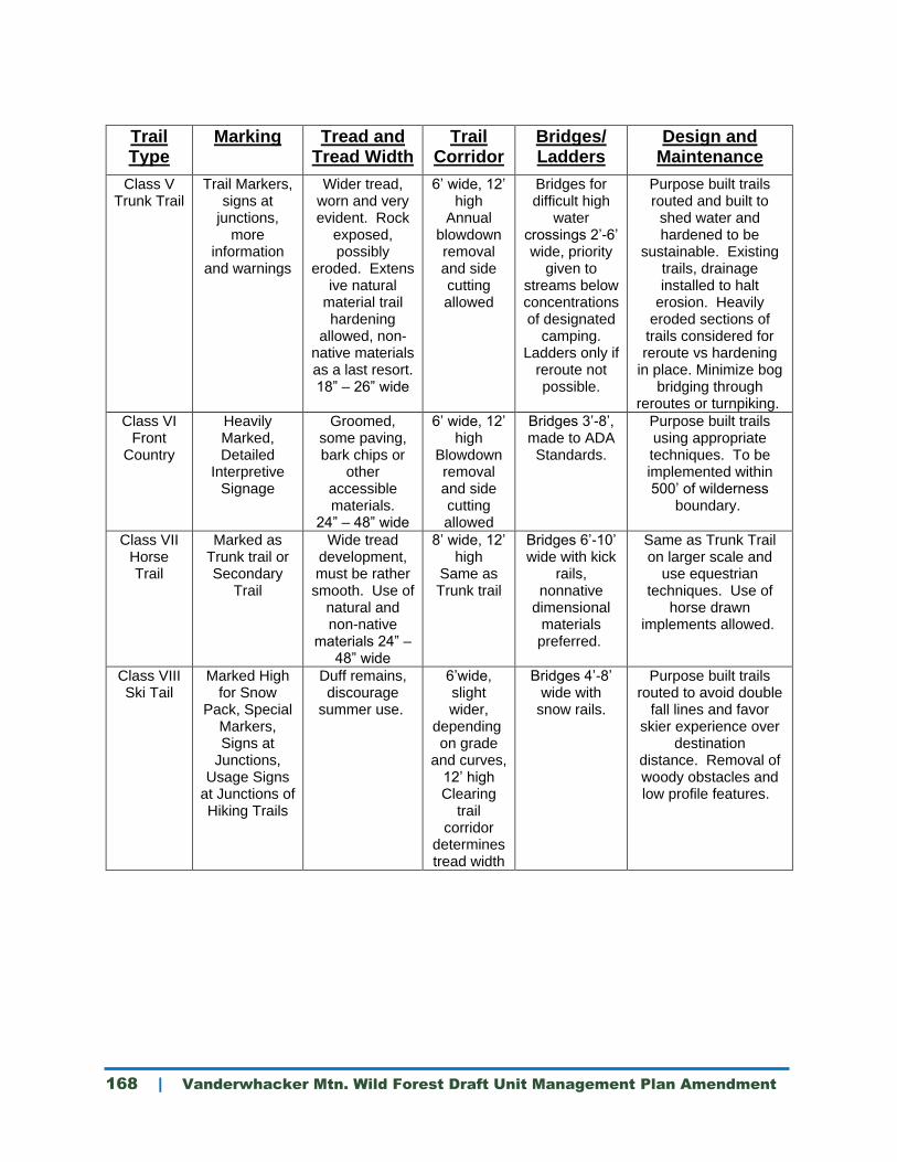
168 | Vanderwhacker Mtn. Wild Forest Draft Unit Management Plan Amendment
Trail Type
Marking Tread and Tread Width
Trail Corridor
Bridges/ Ladders
Design and Maintenance
Class V Trunk Trail
Trail Markers, signs at
junctions, more
information and warnings
Wider tread, worn and very evident. Rock
exposed, possibly
eroded. Extensive natural
material trail hardening
allowed, non-native materials as a last resort. 18” – 26” wide
6’ wide, 12’ high
Annual blowdown removal and side cutting allowed
Bridges for difficult high
water crossings 2’-6’ wide, priority
given to streams below concentrations of designated
camping. Ladders only if
reroute not possible.
Purpose built trails routed and built to
shed water and hardened to be
sustainable. Existing trails, drainage installed to halt
erosion. Heavily eroded sections of
trails considered for reroute vs hardening
in place. Minimize bog bridging through
reroutes or turnpiking.
Class VI Front
Country
Heavily Marked, Detailed
Interpretive Signage
Groomed, some paving, bark chips or
other accessible materials.
24” – 48” wide
6’ wide, 12’ high
Blowdown removal and side cutting allowed
Bridges 3’-8’, made to ADA Standards.
Purpose built trails using appropriate techniques. To be implemented within 500’ of wilderness
boundary.
Class VII Horse Trail
Marked as Trunk trail or Secondary
Trail
Wide tread development, must be rather smooth. Use of
natural and non-native
materials 24” – 48” wide
8’ wide, 12’ high
Same as Trunk trail
Bridges 6’-10’ wide with kick
rails, nonnative
dimensional materials preferred.
Same as Trunk Trail on larger scale and
use equestrian techniques. Use of
horse drawn implements allowed.
Class VIII Ski Tail
Marked High for Snow
Pack, Special Markers, Signs at
Junctions, Usage Signs
at Junctions of Hiking Trails
Duff remains, discourage
summer use.
6’wide, slight wider,
depending on grade
and curves, 12’ high Clearing
trail corridor
determines tread width
Bridges 4’-8’ wide with
snow rails.
Purpose built trails routed to avoid double
fall lines and favor skier experience over
destination distance. Removal of woody obstacles and low profile features.