Embed Size (px)
Citation preview

Melbourne Metro EES Report to Panel
Arden Station Precinct
Traffic and Transport Review
Expert // Chris Coath
Client // George Weston Foods Pty Ltd
Instructed by // Emily Johnstone, Allens
Reference // V103510
Hearing Date // 22/08/16
Report Date // 12/08/16
© GTA Consultants (GTA Consultants (VIC) Pty Ltd) 2016
The information contained in this document is confidential and
intended solely for the use of the client for the purpose for which it has
been prepared and no representation is made or is to be implied as
being made to any third party. Use or copying of this document in
whole or in part without the written permission of GTA Consultants
constitutes an infringement of copyright. The intellectual property
contained in this document remains the property of GTA Consultants. VC
AT
Evid
en
ce
(150630 v
2.6
)
Melbourne | Sydney | Brisbane
Canberra | Adelaide | Perth
Gold Coast | Townsville
Melbourne Metro EES Report to Panel
Arden Station Precinct
Traffic and Transport Review
Issue: Final 12/08/16
Client: George Weston Foods Pty Ltd
Reference: V103510
GTA Consultants Office: VIC

V103510 // 12/08/16
Traffic and Transport Review // Issue: Final
Melbourne Metro EES Report to Panel, Arden Station Precinct
Table of Contents
1. Introduction 1
1.1 Melbourne Metro Project Overview 1
1.2 Environmental Effects Statement Process 1
1.3 References 3
1.4 Tests, Experiments & Assistance 3
1.5 Expert Witness Details 3
2. Purpose of Report 4
2.1 Appointment & Scope 4
2.2 Review Area 5
2.3 Review Limitations 5
3. Arden Macaulay Structure Plan 6
4. GWF Operational Characteristics 8
4.1 Overview 8
4.2 Vehicle Access and Truck Types 9
4.3 GWF Parking Requirements (on-street reliance) 10
5. Arden Station Construction & Post Implementation Attributes 11
5.1 Preamble 11
5.2 Station Characteristics – Legacy Layout 12
5.3 Construction Strategy 14
5.4 Construction Activity – Traffic & Parking Estimate 15
6. Arden Transport Network 17
6.1 Existing Conditions 17
6.2 Laurens Street Closure 24
7. Transport Matters for Consideration 26
7.1 Preamble 26
7.2 Construction 26
7.3 Post Implementation 32
8. Summary of Opinion & Other Statements 34
8.1 Summary of Opinion 34
8.2 Other Statements 34
Appendices
A: Chris Coath – Curriculum Vitae
B: GWF Site Access Swept Path Assessments

V103510 // 12/08/16
Traffic and Transport Review // Issue: Final
Melbourne Metro EES Report to Panel, Arden Station Precinct
Figures
Figure 1.1: MMRP – Project Station Map 1
Figure 1.2: MMRP Precincts 2
Figure 4.1: Location of GWF buildings within Arden Precinct 8
Figure 4.2: GWF Loading Operation Summary Diagram 9
Figure 5.1: Arden Station Legacy Layout & Configuration 12
Figure 5.2: Laurens Street Design Treatment 13
Figure 5.3: Construction Area Extents – Arden Station 14
Figure 5.4: Proposed Construction Traffic Routes 15
Figure 6.1: VicRoads Approved B-Double Network 19
Figure 6.2: VicRoads SmartRoads Network Operating Plan around Arden Station 20
Figure 6.3: Arden Street/Macaulay Road/ Dryburgh Street – AM Peak Hour 21
Figure 6.4: Arden Street/Macaulay Road/ Dryburgh Street – PM Peak Hour 21
Figure 6.5: Arden Street/Laurens Street – AM Peak Hour 21
Figure 6.6: Arden Street/Laurens Street – PM Peak Hour 21
Figure 6.7: Laurens Street/Queensberry Street – AM Peak Hour 21
Figure 6.8: Laurens Street/Queensberry Street – PM Peak Hour 21
Figure 6.9: Laurens Street/Miller Street – AM Peak Hour 22
Figure 6.10: Laurens Street/Miller Street – PM Peak Hour 22
Figure 6.11: AM Peak Period – Observed Queues 23
Figure 6.12: PM Peak Period – Observed Queues 23
Figure 6.13: Surveyed Parking Area Extents 24
Figure 6.14: Extent of Works 25
Figure 6.15: Park Concept Plan 25
Figure 7.1: Alternate Weigh Bridge Location 30
Tables
Table 3.1: Summary of Employment Forecasts for Arden Macaulay 6
Table 3.2: Summary of Population Forecasts for Arden Macaulay 6
Table 4.1: GWF Truck Delivery Operations movements per week 10
Table 5.1: Melbourne Metro Workforce Generation Estimate - Arden Station Precinct 15
Table 6.1: Road Network Characteristics 17
Table 6.2: Summary of Observed Network Performance Characteristics 22
Table 6.3: On-Street Public Car Parking Survey Results 24

V103510 // 12/08/16
Traffic and Transport Review // Issue: Final
Melbourne Metro EES Report to Panel, Arden Station Precinct 1
1. Introduction
1.1 Melbourne Metro Project Overview
The Melbourne Metro Rail Project (MMRP) is a fully funded ($10.9B) project of state significance
designed to significantly increase the capacity of the metropolitan railway system. The MMRP
includes the following key components:
Two rail tunnels between South Kensington and South Yarra, through Melbourne's
Central Business District (CBD). These lines will create a connection to the existing
Sunbury and Cranbourne/ Pakenham railway lines.
A total five new train stations will be constructed at the following locations as outlined in
Figure 1.1.
Figure 1.1: MMRP – Project Station Map
Source: www.metrotunnel.vic.gov.au
Following completion of the project, the MMRP will free up the existing City Loop allowing
additional trains to operate on the Upfield, Craigieburn, Sunbury, Frankston, Cranbourne,
Pakenham, Werribee and Sandringham lines. Specifically, it is estimated that the project will
deliver additional capacity for approximately 40,000 passengers during each peak period, ease
overcrowding in the inner core of the existing rail network whilst relieving tram overcrowding and
congestions issues within the Melbourne CBD and its immediate vicinity.
Construction of the MMRP is expected to commence in late 2018 and finish in 2026. It is expected
to create 3,900 jobs across the state of Victoria with 4700 jobs supported at the peak of its
construction.
1.2 Environmental Effects Statement Process
The MMRP is currently being assessed via an Environment Effects Statement (EES) process. The EES
allows for an overarching and integrated assessment of impacts of the project and draws on the
1
V103510 // 12/08/16
Traffic and Transport Review // Issue: Final
Melbourne Metro EES Report to Panel, Arden Station Precinct 2
findings of a number of supporting documentation and studies before any approval or conditions
are granted. The EES process also allows for a comprehensive public engagement program to
seek input from the community and other stakeholders which will help confirm the ultimate
delivery of the MMRP including considerations throughout the construction period.
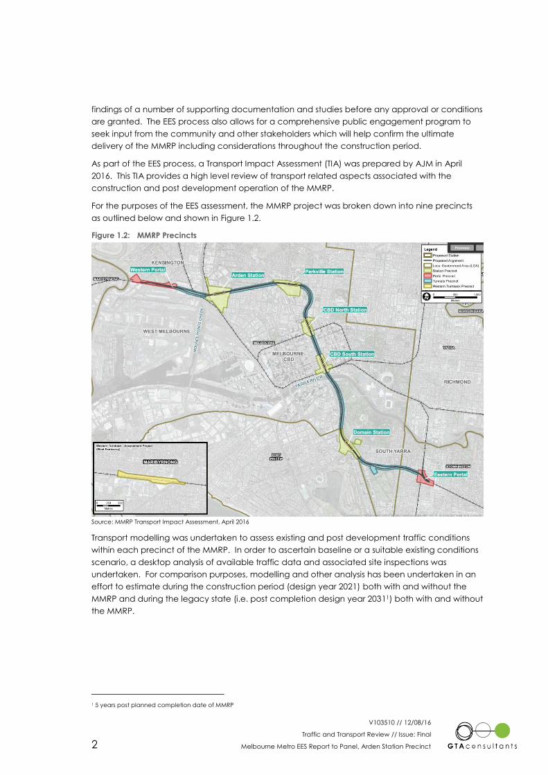
As part of the EES process, a Transport Impact Assessment (TIA) was prepared by AJM in April
2016. This TIA provides a high level review of transport related aspects associated with the
construction and post development operation of the MMRP.
For the purposes of the EES assessment, the MMRP project was broken down into nine precincts
as outlined below and shown in Figure 1.2.
Figure 1.2: MMRP Precincts
Source: MMRP Transport Impact Assessment, April 2016
Transport modelling was undertaken to assess existing and post development traffic conditions
within each precinct of the MMRP. In order to ascertain baseline or a suitable existing conditions
scenario, a desktop analysis of available traffic data and associated site inspections was
undertaken. For comparison purposes, modelling and other analysis has been undertaken in an
effort to estimate during the construction period (design year 2021) both with and without the
MMRP and during the legacy state (i.e. post completion design year 20311) both with and without
the MMRP.
1 5 years post planned completion date of MMRP

V103510 // 12/08/16
Traffic and Transport Review // Issue: Final
Melbourne Metro EES Report to Panel, Arden Station Precinct 3
1.3 References
In preparing this evidence, reference has been made to the following:
Melbourne Planning Scheme
Submission from George Weston Food to Melbourne Metro EES (letter dated 5 July 2016)
Melbourne Metro Rail Project, Transport Impact Assessment prepared by AJM, April
2016, including appendices.
George Weston Food Limited operational data provided to GTA Consultants
Melbourne Metro Rail Project Traffic Review of EES on Behalf of George Weston Foods
Limited prepared by Ratio Consultants dated 8 August 2016
traffic and car parking surveys undertaken by GTA Consultants as referenced in the
context of this report
an inspection of the site and its surrounds
other documents as nominated.
1.4 Tests, Experiments & Assistance
In preparing this evidence, I received assistance from the following people:
Mr John Kiriakidis – Director – BE (Civil & Computing) (Hons)
Mr Simon Beardall – Associate – BAppSc(Geomatics)(Hons)
Mr Joshua Haigh – Consultant – BEng(Civil)(Hons)
1.5 Expert Witness Details
Christopher Coath BE (Civil) (Hons), MIEAust CPEng NPER, MVPELA
Director – GTA Consultants (Vic) Pty Ltd
L25, 55 Collins Street, Melbourne
Areas of Expertise: Traffic Engineering & Transport Planning
I have a Bachelor of Engineering Degree and am a specialist traffic engineering and transport
planner with over 14 years of experience encompassing an extensive range of car parking
strategies, land use planning and design, integrated transport plans, traffic and transport
planning, masterplan development, traffic engineering impact assessments, transport research
and expert presentations at VCAT and Panel hearings.
I have extensive experience in managing a variety of large projects. I have been intimately
involved in the preparation of a number of major development proposals including the
Melbourne Convention Centre and South Wharf Precinct. A particular focus and passion of my
work has been in developing best practice car parking strategies which have included works at a
number of city and town centre locations with examples including Kew Junction, Footscray CBD,
Box Hill, Dandenong CBD, Doncaster Hill, Bendigo CBD, Liverpool CBD, Newcastle CBD, Fyshwick,
Parliamentary Zone (ACT) and Rosny Park and Bellerive.
Further details of my experience are provided in Appendix A.
1.6 Relationship to Applicant
I have no ongoing private or business relationship with the applicant, and have been retained to
provide expert witness services at this hearing for a mutually agreed fee.

V103510 // 12/08/16
Traffic and Transport Review // Issue: Final
Melbourne Metro EES Report to Panel, Arden Station Precinct 4
2. Purpose of Report
2.1 Appointment & Scope
GTA Consultants (GTA) was engaged by George Weston Food Limited (GWF) to provide traffic
engineering and transport planning evaluation services in relation to the Melbourne Metro
Environmental Effects Statement (EES) and its impacts on GWF operations and assets within the
Arden Station precinct.
GWF are concerned with the potential impact of the MMRP both during construction and post
construction on the day-to-day operation of its manufacturing operations (flour mill) and
associated services. Specifically, GWF’s concerns pertain to impacts generated by increased
traffic and the loss of an existing weighbridge on Laurens Street, car parking and general
transport activity on existing levels of service on the precinct road network and general road
safety.
GTA has been requested to undertake a review of the EES material and identify any areas of
legitimate concern around short-comings or omissions associated with the Melbourne Metro
project and in particular the EES documentation (including transport impact assessment
prepared by AJM) and identify any possible recommendations which can / should be made to
better inform any EES review and protect the operational interests of GWF as they relate to the
discipline of traffic and transport planning.
I have been retained by GWF to prepare and present expert traffic and transport evidence at
the upcoming Melbourne Metro Rail Project Inquiry and Advisory Committee (IAC), scheduled to
commence 22 August 2016.
Prior to preparing this evidence I was briefed by Emily Johnstone (Allens) regarding the matter via
oral and written instructions.
This evidence sets out an assessment of the anticipated parking, traffic and transport implications
of the proposed MMRP as it relates to GWF’s operations within the Arden Precinct, including
consideration of the:
i existing traffic and parking conditions surrounding the site
ii Arden-Macaulay Structure Plan and land use outcomes associated with that Strategic
document on the short-term, medium term and long-term transport outcomes for
Arden-Macaulay
iii impacts to on-street parking conditions in the vicinity of the Arden Station precinct and
GWF operations as a result of the MMRP
iv appropriateness of the proposed construction traffic vehicle access routes in the
vicinity of the Arden Station precinct and GWF operations
v impacts to GWF site specific operations associated with the removal of the existing
Cockerill weigh bridge located at 103 Laurens Street
vi traffic generation characteristics of the MMRP, including construction traffic anticipated
to be generated by the project
vii anticipated transport impact of the MMRP on the surrounding road network both during
the construction phase and legacy phase (i.e. post completion of the project).
2
V103510 // 12/08/16
Traffic and Transport Review // Issue: Final
Melbourne Metro EES Report to Panel, Arden Station Precinct 5
2.2 Review Area
This evidence has been prepared to have specific regard to the potential impact of the MMRP
both during construction and post construction on the day-to-day operation of GWF facilities and
infrastructure within the Arden Station precinct only.
2.3 Review Limitations
It is noted that, due to time constraints, no detailed interrogation of any modelling outputs
contained within TIA prepared in support of the EES submission have been made. As such, I have
relied on the outputs contained within the TIA (and associated modelling inputs) in forming my
opinion and recommendations.

V103510 // 12/08/16
Traffic and Transport Review // Issue: Final
Melbourne Metro EES Report to Panel, Arden Station Precinct 6
3. Arden Macaulay Structure Plan
The EES at Chapter 3 of the Transport Impact Assessment sets out a range of legislation, policy
and guidelines that have helped inform the technical documentation and findings. A review of
the nominated reference documents contained at Chapter 3 as well as those outlined in
additional detail at Appendix A indicate the absence of any specific consideration around the
Arden-Macaulay Structure Plan 2012 (adopted February 2012). This document was subject to a
Planning Scheme Amendment (C190) which sought to:
“implement new land use and development controls into the Melbourne Planning Scheme as
recommended within the Arden-Macaulay Structure Plan”.
The Amendment was considered by a Ministerially Appointed panel which heard submissions in
June and July 2015. As an outcome of the Panel Hearing a series of recommendations were
formed and these were set out in their report of 23 October 20152.
City of Melbourne’s Future Melbourne Committee was set to consider the panel’s
recommendations at its 2 August 2016 meeting.
The report submitted to Council nominates the population and employment growth forecasts set
out in Table 3.1 and Table 3.2 noting that these forecasts represent an update of those originally
set out in the 2012 Structure Plan. The original 2012 forecasts were limited to those associated with
Stage 1 of the Structure Plan (or for Macaulay only)3. As I appreciate it, the revised figures now
include estimates for Arden Central in association with the delivery of Arden Station.
Table 3.1: Summary of Employment Forecasts for Arden Macaulay
Precinct Employment Change
2011 2031 2051 2011-2031 2031-2051
Arden 3,000 9,000 34,000 6,000 25,000
Macaulay 3,000 5,000 9,500 2,000 4,000
Table 3.2: Summary of Population Forecasts for Arden Macaulay
Precinct Employment Change
2011 2031 2051 2011-2031 2031-2051
Arden 500 5,000 15,000 4,500 10,000
Macaulay 3,000 5,000 10,000 2,500 5,000
In comparison to estimates set out in the 2012 Structure Plan, the above figures contemplate an
additional increase in employment of 14,000 jobs (23,000 to 31,000) and 4,000 residents (18,000 to
22,000) by 2051.
Table 3.1 and Table 3.2 indicate significant uplift in population and employment numbers within
the precinct between 2011 and ultimately 2051 as a consequence of the Amendment. The
extent to which these changes have been considered under the EES is unclear given that the EES
states at Section 4.4 of the Transport Impact Assessment:
2 This report can be accessed via:
http://dsewebapps.dse.vic.gov.au/Shared/ats.nsf/(attachmentopen)/560814F4EE310ECFCA257EEE001273E1/$File/Melbourne+C19
0+Panel+Report.pdf?OpenElement
3 Source: Agenda Item 6.3, @ August 2016, Report to the Future Melbourne (Planning) Committee.
3

V103510 // 12/08/16
Traffic and Transport Review // Issue: Final
Melbourne Metro EES Report to Panel, Arden Station Precinct 7
“……Each mode has been assessed as part of this analysis taking into consideration the growth in
population and employment (based on the VITM transport models) and the associated increase
in travel demands in the vicinity of Melbourne Metro.”
It appears that the population and employment estimates set out in Tables 3.1 and 3.2 are only
recent i.e. nominated in the Report to the Future (Planning Committee) 2 August 2016 and
therefore unlikely to have been included in the base case VITM model relied upon for the EES
evaluation. Clarity should be provided by the Melbourne Metro Rail Authority (MMRA) as to what
extent have the forward looking employment and population projections been considered in the
Strategic Model and the various assessment scenarios.

V103510 // 12/08/16
Traffic and Transport Review // Issue: Final
Melbourne Metro EES Report to Panel, Arden Station Precinct 8
4. GWF Operational Characteristics
4.1 Overview
George Weston Foods (GWF) is a food manufacturing company with operations spread across
the country including the MAURI ANZ Flour Mill located on Laurens Street in North Melbourne.
GWF undertakes a number of operations at the Laurens Street premises including the processing
of grain and subsequent distribution of goods to the broader Victorian market.
GWF employs approximately 50 full time staff (and up to 10 casual staff) at the Mill located at 24-
78 Laurens Street. Its operations spread over a 24-hour period, 7 days per week and also rely on
the use of an existing weigh bridge located at 103 Laurens Street managed by Cockerill
Transport. GWF lease a parcel of land located at 67 Laurens Street to accommodate staff car
parking demands. This off-street parking area accommodates in the order of 20 informal car
parking spaces. It is understood from information provided by GWF, that when having regard for
the nature of site shifts, a peak of 52 staff are present on site at any one time. Both the GWF Mill
and the weighbridge are shown in Figure 4.1.
Figure 4.1: Location of GWF buildings within Arden Precinct
Source: Nearmap
4

V103510 // 12/08/16
Traffic and Transport Review // Issue: Final
Melbourne Metro EES Report to Panel, Arden Station Precinct 9
4.2 Vehicle Access and Truck Types
Vehicle access to the GWF on-site loading facilities are provided via a number of crossovers on
the eastern side of Laurens Street. In order to accommodate the loading requirements, trucks
reverse into the loading docks. Rigid trucks and semi-trailers are able to undertake this
manoeuvre fully within the Laurens Street carriage way. However, B-Double trucks are required to
utilise the currently vacant land located immediately to the north of the leased off street car park
at 67 Laurens Street. These manoeuvres are summarised in Figure 4.2. This Figure also
demonstrates the use of the Cockerill Transport weigh bridge facility.
Figure 4.2: GWF Loading Operation Summary Diagram
Source: Ratio Consultants
Swept path diagrams of these arrangements are presented in Appendix B.
Operational data including a vehicle log of truck arrivals and departures to the site have been
provided to GTA. This information indicates the following:

V103510 // 12/08/16
Traffic and Transport Review // Issue: Final
Melbourne Metro EES Report to Panel, Arden Station Precinct 10
Table 4.1: GWF Truck Delivery Operations movements per week
Truck Type Grain
Operations
Mill/Mixing
Operations
Flour
Operations
Distribution
(Palletised) Total
B-Double 60 7 - 16 83
19m Semi Trailer - 8 49 28 85
Rigid Truck - - 21 58 79
Total 60 15 70 102 247
A review of the operational data also indicates the following:
Approximately 250 truck movements are generated by the GWF site per week.
The split between B-Double, 19m semi-trailer and medium rigid trucks is generally even.
The average time it takes for a truck to reverse into the on-site loading bays is
approximately 5 minutes.
Approximately 50% of all truck movements generated by the GWF operations are
required to use the Weighbridge located at 103 Laurens Street. The trucks are weighed
both upon arrival to the site and pre dispatch from the site.
In some instances, trucks are unable to access the on-site loading bays immediately
upon arrival to the site. The operational data provided to GTA indicates that between
the 21 July 2016 and 1 August 2016, 123 trucks were required to wait on Laurens Street
within the existing on-street loading zones along the sites eastern frontage. This
represents 90% of all trucks arriving to the site over the nominated period.
An average wait time of 10 minutes was recorded for those trucks that are required to
prop within the on-street loading areas before accessing the site.
4.3 GWF Parking Requirements (on-street reliance)
As identified above, GWF North Melbourne facility employs approximately 50 full time staff plus up
to 10 casual staff, operating a 24 hours per day, 7 days per week facility.
In this regard advice from the GWF indicates that this equates to a peak of 52 employees on site
at any one time.
It is understood from discussions with GWF that a high journey to work mode split to car exists due
to the 24-hour operation of the site. As a comparison ABS Journey to Work mode split data for
North Melbourne indicates a mode split to car of approximately 65%. It could be reasonable to
adopt a mode split to car of 75% for the purpose of analysis.
On this basis a peak car parking demand in the order of 39 vehicles is expected to be generated
by the development.
A provision of in the order of 20 spaces are available on the leased site from VicTrack on the
western side of Laurens Street, resulting in a reliance on in the order of 19 spaces within the
surrounding on-street network.

V103510 // 12/08/16
Traffic and Transport Review // Issue: Final
Melbourne Metro EES Report to Panel, Arden Station Precinct 11
5. Arden Station Construction & Post
Implementation Attributes
5.1 Preamble
Chapter 8 of the EES sets out an assessment of the transport connectivity impacts associated with
the construction and operation of the Melbourne Metro and relies on Technical Appendices A
through G to substantiate a range of findings.
Chapter 8.1.1 of the EES provides some generalised observations around the main construction
generated impacts including:
i truck activity associated with spoil removal and equipment transfer
ii the temporary closure of a number of major roads to facilitate the build
iii the presence of a large construction workforce which would need to drive or be
transported to and from the workplace, which could potentially have an impact on the
local and wider road network at times.
As it relates to the Arden Station precinct, items 1 and 3 are of greater significance given the
absence of any road closures proposals in association with the delivery of this Station and the
limited impact by proposed road closures nearby associated with Parkville Station.
The following sections set out a review of the material provided in the EES as it relates to
specifically to Arden Station and sets my appreciation of the construction approach and
considerations relevant to any post implementation outcomes.
Under Chapter 8 of the EES, Arden Station is identified as Precinct 3. The documentation identifies
the Arden Station Precinct as:
“one of the major sites for the construction of Melbourne Metro, more truck activity would be
anticipated at this site than in other precincts. Activity at this site would extend over a period of
4years with 24hour, 7-day operations and an average of approximately 260 trucks trips each day
for spoil removal and materials and equipment delivery. At peak activity, this could increase to
around 360 truck movements per day”4
The EES goes on to note that the forecast level of construction workers for the Melbourne Metro
project for the Arden Station precinct is 421 workers representing by far the largest workforce at
any of the precinct locations5. The EES goes on to note that traffic and transport activity
associated with precinct site workers are not included in the forecast truck activity6.
On managing impacts, the EES notes under its performance requirements at Section 8.6.6 of the
Transport Impact Assessment, the requirement for the project to consider and prepare transport
management plans (TMPs) for a range of impacts on road transport, public transport, active
transport and travel demand management during the construction phase.
The EES nominates a range of considerations and in some cases references a need to consult
with key transport agencies on TMP content. The need to consider input from others, other than
agencies, whom are likely to be effected in the precinct is considered later in this review.
4 Section 8.10, page 8-28.
5 Table 8-1, EES Transport Impact Assessment.
6 Technical Appendix D, Section 8, Page 62, Paragraph 1
5

V103510 // 12/08/16
Traffic and Transport Review // Issue: Final
Melbourne Metro EES Report to Panel, Arden Station Precinct 12
5.2 Station Characteristics – Legacy Layout
A review of the EES indicates that significant works will be performed to deliver the Arden Station
as part of Melbourne Metro. An outline of the proposed layout and configuration of the station is
provided below in Figure 5.1.
Figure 5.1: Arden Station Legacy Layout & Configuration
Figure 5.1 shows the proposed station box in red with the entrance structure in green interfacing
with Laurens Street. Provisions for future stations entrances are provided roughly at its mid-point to
the north and south, these align with work completed under the Arden Macaulay Structure Plan
including the provision of direct and connected north-south bus and bicycle routes through the
precinct.
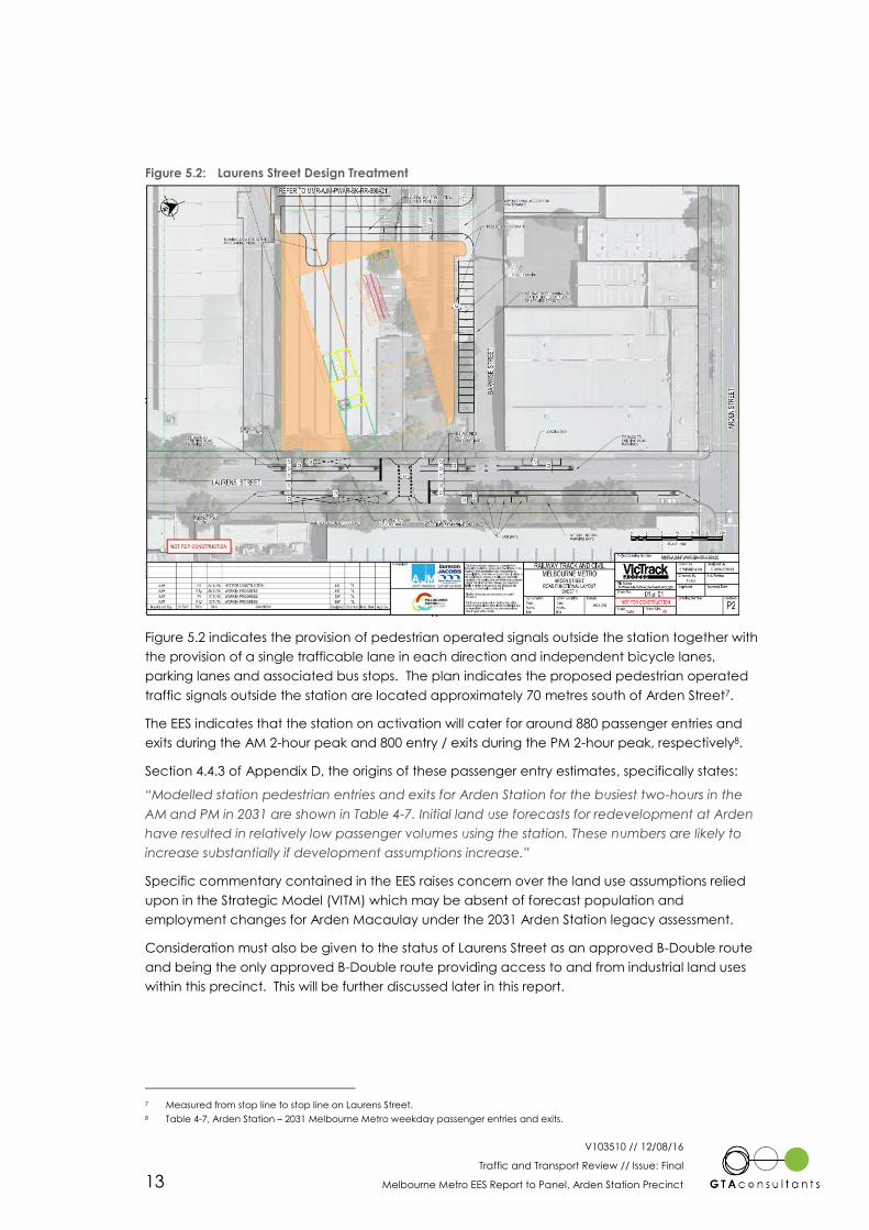
The design interface with Laurens Street is provided in Figure 5.2 for reference.
V103510 // 12/08/16
Traffic and Transport Review // Issue: Final
Melbourne Metro EES Report to Panel, Arden Station Precinct 13
Figure 5.2: Laurens Street Design Treatment
Figure 5.2 indicates the provision of pedestrian operated signals outside the station together with
the provision of a single trafficable lane in each direction and independent bicycle lanes,
parking lanes and associated bus stops. The plan indicates the proposed pedestrian operated
traffic signals outside the station are located approximately 70 metres south of Arden Street7.
The EES indicates that the station on activation will cater for around 880 passenger entries and
exits during the AM 2-hour peak and 800 entry / exits during the PM 2-hour peak, respectively8.
Section 4.4.3 of Appendix D, the origins of these passenger entry estimates, specifically states:
“Modelled station pedestrian entries and exits for Arden Station for the busiest two-hours in the
AM and PM in 2031 are shown in Table 4-7. Initial land use forecasts for redevelopment at Arden
have resulted in relatively low passenger volumes using the station. These numbers are likely to
increase substantially if development assumptions increase.”
Specific commentary contained in the EES raises concern over the land use assumptions relied
upon in the Strategic Model (VITM) which may be absent of forecast population and
employment changes for Arden Macaulay under the 2031 Arden Station legacy assessment.
Consideration must also be given to the status of Laurens Street as an approved B-Double route
and being the only approved B-Double route providing access to and from industrial land uses
within this precinct. This will be further discussed later in this report.
7 Measured from stop line to stop line on Laurens Street.
8 Table 4-7, Arden Station – 2031 Melbourne Metro weekday passenger entries and exits.

V103510 // 12/08/16
Traffic and Transport Review // Issue: Final
Melbourne Metro EES Report to Panel, Arden Station Precinct 14
5.3 Construction Strategy
High level construction plans set out an outline of the site area extents being relied upon during
construction to deliver Arden Station. These extents are provided at Figure 5.3.
Figure 5.3: Construction Area Extents – Arden Station
Figure 5.3 sets out the proposed temporary construction work site in yellow, the excavation area
in grey and the Station Precinct in light green.
A range of access routes are currently proposed to/from the Arden Precinct as outlined below
and shown in Figure 5.4.
Red Line: Route 1 – Laurens Street, Miller Street, Anderson Street, Victoria Street,
Dryburgh Street, Dynon Road
Blue Lines:
Route 2a – Queensberry Street, Dryburgh Street, Dynon Road
Route 2b – Laurens Street, Arden Street, Dryburgh Street, Dynon Road
Grey Line: Arden Northern Route – Laurens Street, Arden Street, Macaulay Road,
Boundary Road
Purple Line: Arden to Western Portal – Route 1,2,3a or 3b, Dynon Road, Kensington
Road, Childers Street
Light Blue Line: Arden to Parkville/CBD Stations – Laurens Street, Arden Street
Brown: Citylink Access

V103510 // 12/08/16
Traffic and Transport Review // Issue: Final
Melbourne Metro EES Report to Panel, Arden Station Precinct 15
Laurens Street, Arden Street, Macaulay Road, Boundary Road, Racecourse Road
or Flemington Road
Route 1, 2a,2b
Figure 5.4: Proposed Construction Traffic Routes
5.4 Construction Activity – Traffic & Parking Estimate
Section 5.1 of this report sets out the level of truck activity likely to be generated through spoil
removal and equipment delivery. Separate to this activity and in the absence of any specific
detail around the management of Melbourne Metro workforce stationed at the Arden Precinct, it
is estimated using characteristics established at Section 4 of this report that the demands set out
in Table 5.1 will be generated.
Table 5.1: Melbourne Metro Workforce Generation Estimate - Arden Station Precinct
Category Predicted Workforce Estimated Rate of
Demand Estimated Demand
Car Parking 421 persons
0.64 cars per worker [1] 270 car spaces
Traffic Generation 3 vte/worker with car 810 vte/day
[1] Source: ABS Journey to Work data for North Melbourne
Table 5.1 indicates an unconstrained parking demand of 270 car parking spaces and around 810
vehicle trip ends per day on a typical day of construction. In the event that the workforce is
segregated into shifts (most likely three), the peak level of demand (for parking) is estimated to
be less than the total estimate but noting that periodic overlaps will occur at shift change.
Irrespective of the precise level of demand, it is evident from this assessment that the proposed
construction works at the Arden Precinct are significant and will need to be carefully considered
given:

V103510 // 12/08/16
Traffic and Transport Review // Issue: Final
Melbourne Metro EES Report to Panel, Arden Station Precinct 16
i There is no indication in the EES that any significant worker car parking will be provided
in the construction area.
ii Parking within the public on-street resource is saturated at present and serving existing
businesses and operations currently in the area.
iii Any traffic activity (spoil / delivery trucks or worker traffic) generated during either of
the respective AM and PM road network peak hours will add activity to a transport
network which is currently struggling to cope with existing underlying demands.
Discussion in respect of these issues for the Panel’s consideration are set out in Section 7 of this
report.

V103510 // 12/08/16
Traffic and Transport Review // Issue: Final
Melbourne Metro EES Report to Panel, Arden Station Precinct 17
6. Arden Transport Network
6.1 Existing Conditions
6.1.1 Road Network
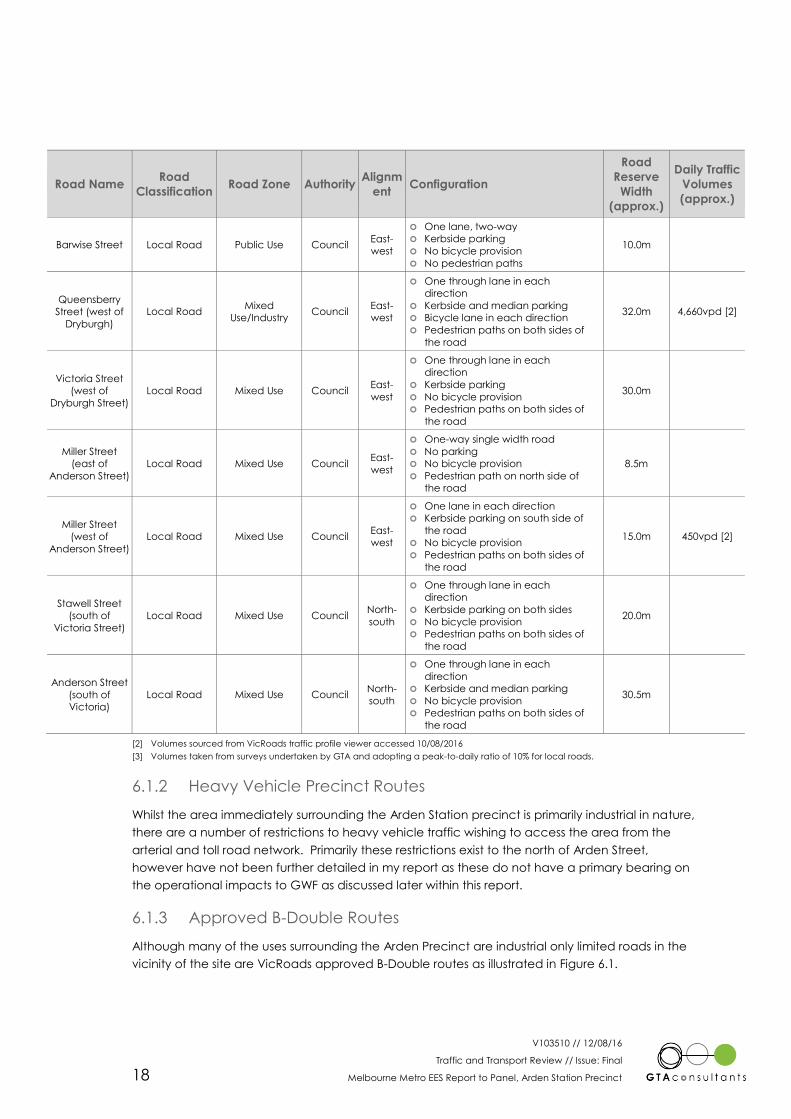
Table 6.1 outlines the characteristics of key roads within the Arden Precinct area.
Table 6.1: Road Network Characteristics
Road Name Road
Classification Road Zone Authority
Alignm
ent Configuration
Road
Reserve
Width
(approx.)
Daily Traffic
Volumes
(approx.)
Arden Street Major Road Industry/Mixed
Use Council
East-
west
Two through lanes in each
direction
Kerbside parking
Bicycle lane in each direction
Pedestrian paths on both sides of
the road
30.0m 5,600vpd [1]
Boundary Road Primary Arterial Road Zone 1 VicRoads North-
south
One through lane in each
direction
Kerbside parking
No bicycle provision
Pedestrian paths on both sides of
the road
21.0m 5,800vpd [1]
Macaulay Road
(East of
boundary)
Primary Arterial Road Zone 1 VicRoads North-
south
One through lanes in each
direction
Kerbside parking
Bicycle lane in each direction
Pedestrian paths on both sides of
the road
30.0m 9,500vpd [1]
Macaulay Road
(West of
Boundary Road)
Major Road Industry Council East-
west
One through lane in each
direction
Kerbside parking
Bicycle lane in each direction
Pedestrian paths on both sides of
the road
19.5m 6,500vpd [1]
Dynon Road
(east of
Dryburgh Street)
Primary Arterial Road Zone 1 VicRoads East-
west
Two through lanes in each
direction
No parking
No bicycle provision
No pedestrian paths
20.0m 16,000vpd [1]
Laurens Street Local Road Industry/Mixed
Use/Public Use Council
North-
south
One through lane in each
direction
Kerbside parking
Bicycle lane in each direction
Pedestrian paths on both sides of
the road
20.0m 4,295vpd [2]
Dryburgh Street Primary Arterial Road Zone 1 VicRoads North-
south
Two through lanes in each
direction
Kerbside parking
Bicycle lane in each direction
Pedestrian paths on both sides of
the road
31.0m 8,100vpd [1]
Munster Terrace Local Road Industry/Mixed
Use Council
North-
south
One through lane in each
direction
Kerbside and median parking
No bicycle provision
Pedestrian paths on both sides of
the road
30.0m
6
V103510 // 12/08/16
Traffic and Transport Review // Issue: Final
Melbourne Metro EES Report to Panel, Arden Station Precinct 18
Road Name Road
Classification Road Zone Authority
Alignm
ent Configuration
Road
Reserve
Width
(approx.)
Daily Traffic
Volumes
(approx.)
Barwise Street Local Road Public Use Council East-
west
One lane, two-way
Kerbside parking
No bicycle provision
No pedestrian paths
10.0m
Queensberry
Street (west of
Dryburgh)
Local Road Mixed
Use/Industry Council
East-
west
One through lane in each
direction
Kerbside and median parking
Bicycle lane in each direction
Pedestrian paths on both sides of
the road
32.0m 4,660vpd [2]
Victoria Street
(west of
Dryburgh Street)
Local Road Mixed Use Council East-
west
One through lane in each
direction
Kerbside parking
No bicycle provision
Pedestrian paths on both sides of
the road
30.0m
Miller Street
(east of
Anderson Street)
Local Road Mixed Use Council East-
west
One-way single width road
No parking
No bicycle provision
Pedestrian path on north side of
the road
8.5m
Miller Street
(west of
Anderson Street)
Local Road Mixed Use Council East-
west
One lane in each direction
Kerbside parking on south side of
the road
No bicycle provision
Pedestrian paths on both sides of
the road
15.0m 450vpd [2]
Stawell Street
(south of
Victoria Street)
Local Road Mixed Use Council North-
south
One through lane in each
direction
Kerbside parking on both sides
No bicycle provision
Pedestrian paths on both sides of
the road
20.0m
Anderson Street
(south of
Victoria)
Local Road Mixed Use Council North-
south
One through lane in each
direction
Kerbside and median parking
No bicycle provision
Pedestrian paths on both sides of
the road
30.5m
[2] Volumes sourced from VicRoads traffic profile viewer accessed 10/08/2016
[3] Volumes taken from surveys undertaken by GTA and adopting a peak-to-daily ratio of 10% for local roads.
6.1.2 Heavy Vehicle Precinct Routes
Whilst the area immediately surrounding the Arden Station precinct is primarily industrial in nature,
there are a number of restrictions to heavy vehicle traffic wishing to access the area from the
arterial and toll road network. Primarily these restrictions exist to the north of Arden Street,
however have not been further detailed in my report as these do not have a primary bearing on
the operational impacts to GWF as discussed later within this report.
6.1.3 Approved B-Double Routes
Although many of the uses surrounding the Arden Precinct are industrial only limited roads in the
vicinity of the site are VicRoads approved B-Double routes as illustrated in Figure 6.1.

V103510 // 12/08/16
Traffic and Transport Review // Issue: Final
Melbourne Metro EES Report to Panel, Arden Station Precinct 19
Figure 6.1: VicRoads Approved B-Double Network
While B-Double vehicles may not be relied upon for construction activities these vehicles and
routes have an important role in the operation of GWF.
6.1.4 SmartRoads
SmartRoads is a VicRoads policy which sets ‘modal’ priorities on the road network and underpins
many of the strategies significant to the operational directions that support broader strategies
around land use and transport. The policy recognises that:
“There is no single solution to managing congestion on our roads. Sustainable management of
congestion will require an integrated approach involving better management of the existing
network, building new infrastructure, visionary land use planning, encouraging sustainable
transport modes, and changes in behaviour by individuals, businesses and a level of government.”9
All road users will continue to have access to all roads. However, certain routes will be managed
to work better for cars while others for public transport, cyclists and pedestrians during the various
9 Sourced from VicRoads

V103510 // 12/08/16
Traffic and Transport Review // Issue: Final
Melbourne Metro EES Report to Panel, Arden Station Precinct 20
peak and off-peak periods. In this regard, the following is noted by VicRoads for the various modes
assigned to roads across the network that form part of the Network Operating Plans:
“Facilitate good pedestrian access into and within activity centres in periods of high
demand
Prioritise trams and buses on key public transport routes that link activity centres during
morning and afternoon peak periods
Encourage cars to use alternative routes around activity centres to reduce the level of
‘through’ traffic
Encourage bicycles through further developing the bicycle network
Prioritise trucks on important transport routes that link freight hubs and at times that
reduce conflict with other transport modes”
The SmartRoads network within the general Arden Precinct Area is shown in Figure 6.2.
Figure 6.2: VicRoads SmartRoads Network Operating Plan around Arden Station
Figure 6.2 indicates that Macaulay Road and Dryburgh Street form the principal traffic routes
through the area with Arden Street and Macaulay Road forming key roads required to support
bicycle activity.
6.1.5 Traffic Activity
GTA undertook traffic movements counts at the following intersections on Tuesday 2 August 2016,
during the AM (8:00am-9:00am) and PM (5:00pm-6:00pm) peak hours:
Arden Street/Macaulay Road/Dryburgh Street
Arden Street/Laurens Street
Laurens Street/Queensberry Street/Vehicle Access
Laurens Street/Miller Street
The results of these traffic counts are presented in Figure 6.3 to Figure 6.10.

V103510 // 12/08/16
Traffic and Transport Review // Issue: Final
Melbourne Metro EES Report to Panel, Arden Station Precinct 21
Figure 6.3: Arden Street/Macaulay Road/
Dryburgh Street – AM Peak Hour Figure 6.4: Arden Street/Macaulay Road/
Dryburgh Street – PM Peak Hour
Figure 6.5: Arden Street/Laurens Street
– AM Peak Hour Figure 6.6: Arden Street/Laurens Street
– PM Peak Hour
Figure 6.7: Laurens Street/Queensberry Street
– AM Peak Hour Figure 6.8: Laurens Street/Queensberry Street
– PM Peak Hour
2 16 = 2 12 9
12 506 " 45 807 257
Arden Street 22 60 ? 8 $ 9 Arden Street
: # ; < 155 5
44 252 120 ! 330 9
6 8 29 > 32 5
AM Peak Hour total vehicle volumes
8:00am-9:00am truck volumes
Mac
aula
y R
oad
Dry
bu
rgh
Str
eet
0 27 = 0 4 1
1 386 " 42 359 176
Arden Street 1 57 ? 8 $ 9 Arden Street
: # ; < 234 1
84 575 85 ! 643 7
5 2 15 > 31 1
PM Peak Hour total vehicle volumes
5:00pm-6:00pm truck volumes
Mac
aula
y R
oad
Dry
bu
rgh
Str
eet
35 614 "
8 472 ? Arden Street
: ; ! 368 16
54 15 > 54 3
2 3
total vehicle volumes
AM Peak Hour truck volumes
8:00am-9:00am
Lau
ren
s St
reet
1 458 "
1 54 ?
: ; ! 821 9
170 23 > 17 3
3 1
total vehicle volumes
PM Peak Hour truck volumes
5:00pm-6:00pm
total vehicle movements
trucks
0 1 = 1 6 6
0 3 " 8 158 370
Access 0 2 ? 8 $ 9 Queensberry Street
: # ; < 27 0
3 60 13 ! 33 0
1 3 1 > 19 1
AM Peak
8:00am-9:00am
Lau
ren
s St
reet
Lau
ren
s St
reet
total vehicle movements
trucks
1 2 = 0 2 0
0 3 " 9 139 363
Access 0 2 ? 8 $ 9 Queensberry Street
: # ; < 29 2
2 50 10 ! 16 0
0 1 2 > 17 2
PM Peak
5:00pm-6:00pm
Lau
ren
s St
reet
Lau
ren
s St
reet
V103510 // 12/08/16
Traffic and Transport Review // Issue: Final
Melbourne Metro EES Report to Panel, Arden Station Precinct 22
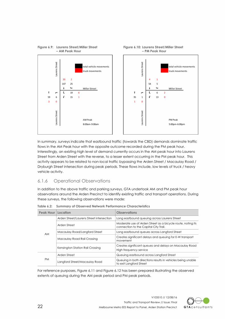
Figure 6.9: Laurens Street/Miller Street
– AM Peak Hour Figure 6.10: Laurens Street/Miller Street
– PM Peak Hour
In summary, surveys indicate that eastbound traffic (towards the CBD) demands dominate traffic
flows in the AM Peak hour with the opposite outcome recorded during the PM peak hour.
Interestingly, an existing high level of demand currently occurs in the AM peak hour into Laurens
Street from Arden Street with the reverse, to a lesser extent occurring in the PM peak hour. This
activity appears to be related to non-local traffic bypassing the Arden Street / Macaulay Road /
Dryburgh Street intersection during peak periods. These flows include, low levels of truck / heavy
vehicle activity.
6.1.6 Operational Observations
In addition to the above traffic and parking surveys, GTA undertook AM and PM peak hour
observations around the Arden Precinct to identify existing traffic and transport operations. During
these surveys, the following observations were made:
Table 6.2: Summary of Observed Network Performance Characteristics
Peak Hour Location Observations
AM
Arden Street/Laurens Street intersection Long eastbound queuing across Laurens Street
Arden Street Moderate use of Arden Street as a bicycle route, noting its
connection to the Capital City Trail.
Macaulay Road/Langford Street Long eastbound queues across Langford Street
Macaulay Road Rail Crossing Creates significant delays and queuing for E-W transport
movement
Kensington Station Rail Crossing Creates significant queues and delays on Macaulay Road
High frequency service
PM
Arden Street Queuing eastbound across Langford Street
Langford Street/Macaulay Road Queuing in both directions results in vehicles being unable
to exit Langford Street
For reference purposes, Figure 6.11 and Figure 6.12 has been prepared illustrating the observed
extents of queuing during the AM peak period and PM peak periods.
total vehicle movements
truck movements
20 2
147 25
$ 9 Miller Street
# ; < 19 6
59 6 > 15 1
3 0
AM Peak
8:00am-9:00am
Lau
ren
s St
reet
Lau
ren
s St
reet
total vehicle movements
truck movements
4 1
54 5
$ 9 Miller Street
# ; < 6 2
35 1 > 13 0
1 0
PM Peak
5:00pm-6:00pm
Lau
ren
s St
reet
Lau
ren
s St
reet

V103510 // 12/08/16
Traffic and Transport Review // Issue: Final
Melbourne Metro EES Report to Panel, Arden Station Precinct 23
Figure 6.11: AM Peak Period – Observed Queues
Figure 6.12: PM Peak Period – Observed Queues
6.1.7 On-street Public Car Parking
To determine the existing availability of car parking within the vicinity of the site GTA has
undertaken spot car parking demand surveys on Tuesday 2 August at 9:00am and 11:00am.
Surveys were informed by a comprehensive car parking inventory prepared for the area
bounded generally by Arden Street to the north, Lothian Street to the east, Dynon Road to the
south and Laurens Street to the west. The area surveyed is shown in Figure 6.13.

V103510 // 12/08/16
Traffic and Transport Review // Issue: Final
Melbourne Metro EES Report to Panel, Arden Station Precinct 24
Figure 6.13: Surveyed Parking Area Extents
The inventoried area indicates that on-street car parking is for the most part unrestricted in
nature. The existing restrictions respond to needs associated with the land uses currently
operating in the area and in particular employee / staff parking requirements which are presently
accommodated on individual sites within the precinct.
The results of surveys are summarised in Table 6.3, and indicate that parking demands in short-
term (signed) areas are high (73%-83%) whilst demand for long-term car parking in the area is
very high (or saturated). Notably, the unrestricted car parking supply surveyed represents 57% of
the available supply.
Table 6.3: On-Street Public Car Parking Survey Results
Date Tuesday 2 August 2016
Restriction Short-term [1] Long-term [2] Total
Time 9:00am 11:00am 9:00am 11:00am 9:00am 11:00am
Supply 313 313 411 411 724 724
Demand 230 261 408 408 638 669
Vacancies 83 52 3 3 86 55
Occupancy 73% 83% 99% 99% 88% 92%
[1] Short-term = greater than 1P (e.g. parking suitable for visitors)
[2] Long-term = greater than 8P (e.g. parking suitable for staff)
6.2 Laurens Street Closure
As part of the City of Melbourne’s ‘West Melbourne parks expansion’, Laurens Street south of
Millers Street is proposed to be closed to traffic to allow for the creation of a new public park. In
this regard Melbourne City Council anticipates the construction works will commence in
September 2016. The proposed expansion is shown in Figure 6.14 and Figure 6.15.

V103510 // 12/08/16
Traffic and Transport Review // Issue: Final
Melbourne Metro EES Report to Panel, Arden Station Precinct 25
The extent to which this network change has been accounted for in the modelling undertaken as
part of the EES Transport Impact Assessment is unclear.
Figure 6.14: Extent of Works
Figure 6.15: Park Concept Plan

V103510 // 12/08/16
Traffic and Transport Review // Issue: Final
Melbourne Metro EES Report to Panel, Arden Station Precinct 26
7. Transport Matters for Consideration
7.1 Preamble
The TIA identifies that traffic disruptions in the Arden Station Precinct would likely arise from:
“Truck access and movement to be based on 24-hour operation and site operation to
be 7-days per week to support TBM [Tunnel Boring Machine] operations and spoil
removal
Potential use of the site for ‘truck call forward operations’, where trucks are docked at
the Arden construction work site until relevant CBD work sites are ready to receive them
To support the construction of the east end of the station box, it is expected that parts
of Laurens Street would need to be occupied for the duration of this phase of the
construction.”
These are explored further in the following sections to more specifically consider their potential
impact on GWF operations, and appropriate mitigating works that are required in order to
minimise their impact.
7.2 Construction
7.2.1 Network Capacity & Safety
The Melbourne Metro Rail Project Transport Impact Assessment at Section 8.6.3 (Operational
Analysis) notes:
“No modelling has been undertaken for the Arden precinct, as the data or site observations
indicate that base volumes are low and modelling is not required to support the assessment. The
site already accommodates construction type industries and truck movements. As the Arden
station precinct is planned to be one of the major construction activity sites for the construction
of Melbourne Metro, it would necessarily generate more truck activity than other sites. Access
route options to/from the site have been investigated and a number of options are proposed to
minimise the reliance on any particular routes, and thereby minimise the impact on the residents
living along those routes. Nevertheless, the activity at this site (for both spoil removal and other
construction related activities generated by this site) would extend for a period of around four
years with 24-hour, 7-day operations at around 260 truck movements (on average) per day.”
It is also noted that peak average daily truck trips will increase to 364 movements per day for a
period lasting up to 6 months.
In considering these statements from the Traffic Impact Assessment a number of comments are
made:
As discussed within Section 6.1.6 of this report, congestion was observed along Arden
Street in particular during the AM peak period with queuing of eastbound vehicles
extending from the Arden Street / Macaulay Street / Dryburgh Street intersection
through the Arden Street / Laurens Street intersection. This congestion significantly
limited the ability for vehicles to turn right out of Laurens Street into Arden Street.
No quantification has been provided of the level of traffic that is generated by the
current industrial land uses that are located along Laurens Street that will be replaced
by the construction site. Further the assessment implies that the movements associated
with existing businesses will simply no longer exist. While some movements may be
7

V103510 // 12/08/16
Traffic and Transport Review // Issue: Final
Melbourne Metro EES Report to Panel, Arden Station Precinct 27
removed from the site itself, movements such as those to and from the Cockerill
Transport facility using the weigh bridge facility would still be required to be undertaken
within the general precinct at a relocated weigh bridge facility.
The Traffic Impact Assessment Report acknowledges that the Arden precinct will
generate more truck activity than other sites.
The discussion focusses on truck movement and does not have regard for additional
traffic that will be generated by staff driving to and from the site.
It is acknowledged in earlier sections of the Traffic Impact Assessment (Section 8.6.3,
Truck Movements) that the additional truck movements would cause some disruption.
While a number of truck routes are proposed on the local network, these local routes
(routes 1, 2A and 2B) are consolidated once reaching Dryburgh Street and travelling on
Dynon Road to and from CityLink. The addition of right turn truck movements on
Dryburgh Street to Dynon Road will be controlled only by a filtered intersection signal
control. This is considered to represent a potential safety and capacity issue.
As discussed earlier within this report at Section 3 it is unclear if the uplift in development
associated with the Arden Macaulay Structure Plan and subsequent traffic impacts has
been included within the current transport modelling undertaken.
It is unclear if the implications of the closure of Laurens Street at Millers Street (as
discussed earlier at Section 6.2) and the subsequent redistribution of traffic has been
considered. This redistribution of traffic is likely to add additional turning movements to
the intersection of Victoria Street and Queensberry Street with Dryburgh Street. This may
make the use of these intersections for construction traffic less desirable.
The operation of local intersections and the ability to access the surrounding arterial road
network is important to the operation of local businesses. In particular the operation of Laurens
Street is critical to the operation of the GWF facility being the only approved B-Double access
route to and from their site.
On this basis it is considered important that detailed traffic impact modelling be undertaken of
key connection points of the local network to the arterial road network, and suitable mitigating
measures be put in place, to ensure that the operation of the network is not impacted by the
construction activities. Any such modelling must also have regard for the future population and
employment growth anticipated by the Arden Macaulay Structure Plan.
In addition, further analysis and review is recommended of the intersection Dryburgh Street and
Dynon Road to ensure this intersection operates safely and with suitable capacity.
Recommendation: Detailed traffic modelling be undertaken of key connection points with the
arterial road network and suitable mitigating measures be put in place to ensure that the
operation of the existing network is not impacted by the construction activities. Modelling must
also have regard for the future population and employment growth anticipated by the Arden
Macaulay Structure Plan.
Recommendation: Further analysis and review is recommended of the intersection Dryburgh
Street and Dynon Road to ensure this intersection operates safely and with suitable capacity.
7.2.2 Laurens Street Loading Operations
Delays & Conflict
Construction Vehicle Route 1 is identified to travel along Laurens Street between Queensberry
Street and Miller Street directly past the GWF facility.
V103510 // 12/08/16
Traffic and Transport Review // Issue: Final
Melbourne Metro EES Report to Panel, Arden Station Precinct 28
As identified within Section 4.2, vehicles accessing the GWF include in the order of 250 vehicles
per week or some 35 vehicles per day.10 While the number of vehicles accessing the site is
relatively low in the context of the overall network, the operation of vehicle access is important to
be considered.
As described earlier these vehicles are required to reverse into on-site loading bays using Laurens
Street and (for B-Double vehicles) the site opposite on the western site of Laurens Street. This site
on the opposite side of Laurens Street is understood to be under the control of VicTrack.
Vehicles undertaking these manoeuvres have been recorded to take in the order of 5 minutes
per vehicle to suitably manoeuvre into the site.
Vehicle volumes accessing the Arden Station precinct are indicated to be 364 movements per
day during the peak period. Dividing this across the 24 hours of operation this would equate to in
the order 15 vehicle movements per hour.
At this time no indication has been provided as to which routes will be more frequently utilised in
order to access the Arden Station precinct. Assuming an even distribution across 5 potential
access routes could result in an additional 3 vehicle movements per hour travelling along each of
the 5 primary routes (including Route 1).
While in principle the vehicle volumes do not give rise to significant traffic impacts, having regard
to road safety the nature of existing loading vehicle movements accessing the GWF facility, in
particular reversing movements across Laurens Street it would be desirable that no additional
vehicles be encouraged to utilise Route 1 and travel past the GWF site.
Further from an amenity perspective the use of this route - Laurens Street, Miller Street, Anderson
Street and Victoria Street is not considered desirable for a number of reasons including:
This is the most circuitous access route requiring increased turning movements at
unsignalised intersections.
This route has the steepest gradients increasing the need for vehicle braking and
acceleration which could impact on local safety and amenity of residential dwellings
along the route.
As discussed within Section 6.2 works are being undertaken by the City of Melbourne to
improve the amenity of the area by creating additional parkland through the closure of
Laurens Street, south of Miller Street. The addition of construction vehicles past this park
would contradict the improvements being made.
On this basis it is recommended that Route 1 is not used as a construction route to minimise any
impact or conflict on GWF operations.
From a capacity perspective, it is recommended that further investigations be undertaken to
confirm that these movements proposed to use Route 1 could be accommodated within the
other construction routes.
Recommendation: Construction Vehicle Route 1 is not used as a construction route to minimise
any impact or conflict on GWF operations.
Weighbridge
VicTrack land immediately west of Laurens Street has historically been leased and relied upon by
a number surrounding businesses. In this regard, a weigh bridge has been incorporated within
the Cockerill Transport site which is used by GWF and other local companies.
10 Vehicle numbers exclude staff vehicles

V103510 // 12/08/16
Traffic and Transport Review // Issue: Final
Melbourne Metro EES Report to Panel, Arden Station Precinct 29
The Construction Concept Design plan prepared by the MMRA (Drawing No MMR-AJM-UGAA-
MP-NN-500295 Rev C1, Dated 20 April 2016) illustrates the entire VicTrack site as a temporary
construction work site.
Based on this, the Arden Station construction site is indicated to occupy the weighing bridge
area currently relied on for GWF operations.
The loss of a weigh bridge facility is understood to have significant impact to the operational and
economic performance of GWF with regard to the loss of productivity and loss of accuracy of
volumes. It is understood that the implications of a potential weigh bridge site on Footscray Road
(some 3km away) could reflect an additional 30 to 40 minutes in additional time to weigh & load.
The basis for this not only relates to the time in driving between sites but the doubling up of time in
weighing.
It must be acknowledged that desirably a weigh bridge facility would be located within the GWF
site to provide a facility entirely under their control.
However, the ability to provide such a facility is difficult, if not impossible, given that the site is built
to the boundary and the sites façade is heritage controlled making it difficult to create any form
of further access or modifications to the building.
As such it would be desirable if the existing weigh bridge facility would be able to be retained if
possible without impacting on the MMRA operations. This would continue to allow a forward in
forward out operation from the weigh bridge to Laurens Street maintaining safe operations as far
as practicable
Should this not be able to be retained it would be desired that MMRA work with GWF to establish
a suitable alternate weigh bridge location. Preferably such a location could be found on
Laurens Street and could include parts of the VicTrack land immediately to the south of the
Station Construction precinct.
While the relocation of a weigh bridge facility is not technically the responsibility of the MMRA to
provide, it would be considered to in keeping with the objectives of the EES which indicate the
“Need to manage disruptions and delays for residents, businesses and travellers during the
construction of the project.”
A potential location for such a facility could be located opposite the main GWF loading dock
facility alongside the cark park lot leased from VicTrack. This land while under the control of
VicTrack, is located outside of the identified Station Construction Area. While detailed design
investigations of this area have been undertaken it is expected that a weigh bridge could be
accommodated without cutting down trees and there would still be suitable space for trucks to
pass.
This proposed weigh bridge location is shown in Figure 7.1.

V103510 // 12/08/16
Traffic and Transport Review // Issue: Final
Melbourne Metro EES Report to Panel, Arden Station Precinct 30
Figure 7.1: Alternate Weigh Bridge Location
This would allow vehicles to enter forward from Laurens Street onto the Weigh bridge. Vehicles
would then reverse from the weigh bridge across Laurens Street and into the existing loading
docks. A weigh bridge in such a location would also potentially act as a staging area for B-
Double movements and may indeed work to reduce vehicle movements within Laurens Street.
I am advised that GWF understands & accepts it will incur costs to prepare the access road as
well as any make goods as required.
Recommendation: Maintain the existing weigh bridge facility located on the VicTrack Land on
the western side of Laurens Street.
Recommendation: In the absence of the above recommendation not being achieved the MMRA
work with GWF to establish a suitable alternate weigh bridge location. Preferably such a location
could be found on Laurens Street and could include parts of the VicTrack land immediately to the
south of the Station Construction precinct.
Alternate Weigh Bridge
location

V103510 // 12/08/16
Traffic and Transport Review // Issue: Final
Melbourne Metro EES Report to Panel, Arden Station Precinct 31
Recommendation: GWF be included as a key stakeholder during the detailed assessment of the
occupation of land to the west of Laurens Street currently relied upon for day-to-day operations.
Space Allocation
The traffic impact assessment report indicates the following components of construction activities
which have the potential to impact the allocation of road space along Laurens Street:
“Potential use of the site for ‘truck call forward operations’, where trucks are docked at
the Arden construction work site until relevant CBD work sites are ready to receive them
To support the construction of the east end of the station box, it is expected that parts
of Laurens Street would need to be occupied for the duration of this phase of the
construction.”
On-street loading bays on Laurens Street have an important role to the operation of GWF.
Information provided by GWF indicates that in the order of 90% of arrival vehicles to GWF are
required to park within Laurens Street while they wait for a loading bay to become available. An
average wait time within the loading bay is understood to be in the order of 10 minutes.
Further the heritage constraints of the site make it difficult for any modifications to site access
points.
As such any reallocation of road space along Laurens Street has the potential to impact the
operations of the site whether it be through the loss of adjacent parking that has been afforded
to the site or in restricting access to the site.
It is unclear from the TIA how each of these elements could impact the provision of kerb space
and as such create potential impacts to the GWF site:
Call Forward
Will vehicles be stored within the site or along Laurens Street while waiting to be
called to other CBD sites.
Laurens Street Occupation
Will the occupation of Laurens Street impact parking availability and holding of
vehicles for GWF in loading zones.
Will it reduce the availability of turning space for vehicle access,
Will it restrict access (vehicle or pedestrian) to any access point to the site.
Given these uncertainties further details are required to be incorporated within more detailed
Construction Traffic Management Plans to be prepared and it be ensured that any call forward
operations and occupation of Laurens Street does not impact on the operation of GWF facilities.
Given the potential implications on site operations it is considered relevant that GWF be included
as a key stakeholder during the development of the detailed traffic and construction
management plans for the area.
Recommendation: Detailed Construction Traffic Management Plans be prepared which ensure
that any call forward operations and occupation of Laurens Street does not impact on the
operation of GWF facilities.
Recommendation: GWF be included as a key stakeholder during the development of the
detailed traffic and construction management plans which impact the operation of Laurens
Street.

V103510 // 12/08/16
Traffic and Transport Review // Issue: Final
Melbourne Metro EES Report to Panel, Arden Station Precinct 32
7.2.3 Managing Parking
As identified within Section 4.3 of this report, GWF North Melbourne has a reliance on in the order
of 19 parking spaces within the surrounding on-street network.
Initially it must be acknowledged that drivers do not have a right to on-street parking.
However, a reliance has traditionally occurred and been allowed to occur through Council
maintaining unrestricted parking in the area.
In the setting of ‘construction management’ it would be considered fair and reasonable that
priority be afforded to existing staff parking in the area over construction workers. Particularly
given the very high utilisation of this parking by staff of the area already.
While schemes such as shuttle services could be set up to limit construction staff driving to the site,
in reality if unrestricted parking remains available in the area it is likely that construction staff will
seek to utilise this parking. In this instance whereby construction activities will occur 24/7 it would
be regularly expected that construction staff would arrive prior to permanent staff of the area.
As such consideration should be given to the development of a staff parking permit scheme and
associated on-street restriction to provide priority to existing staff to utilise existing unrestricted
parking areas.
It is recognised that such restrictions may not be expected to exist long term in the legacy state,
however in considering the construction principles it is relevant that strategies be put in place to
protect the parking needs of the existing employees and businesses of the area.
Recommendation: Consideration be given to the development of a staff parking permit scheme
and associated on-street restriction to protect the parking needs of existing employees and
businesses of the area.
7.3 Post Implementation
7.3.1 Laurens Street Operations/B-Double Routes
As indicated in Section 5.2, and Figure 5.2 the TIA depicts the proposed ultimate design of
Laurens Street.
The design treats the north entry to Laurens Street providing kerb side parking and on-street cycle
lanes which is consistent with its current operation. The design also introduces a signalised
pedestrian crossing approximately 70m south of Arden Street.
It is unclear from the TIA of the level of analysis and consideration that has accompanied the
design of this station interface. In this regard the following is noted:
As identified in Section 6.1.3 Laurens Street forms the approved B-Double route which
provides access to the industrial land uses along Laurens Street. This is critical to GWF
operations. While there is likely to be a changing dynamic to this overall precinct as the
Arden Macaulay Structure Plan is realised it must be ensured that the B-Double route is
maintained or re-provided in another form that does not disadvantage the operation
of businesses that will remain in this precinct and rely on B-Double access.
As identified within Section 6.1.5 there is a number of significant traffic movements
between Arden Street and Laurens Street. The introduction of the signalised pedestrian
crossing creates the potential of queuing of vehicles back toward Arden Street and
potentially into Arden Street. It needs to be ensured that appropriate traffic analysis

V103510 // 12/08/16
Traffic and Transport Review // Issue: Final
Melbourne Metro EES Report to Panel, Arden Station Precinct 33
has been undertaken to ensure network capacity is not compromised by the
introduction of the pedestrian operated signals.
Having regard to the above, further detailed analysis and consideration of the design of Laurens
Street in its legacy state is required to ensure this does not compromise the functionality of the
road network serving for existing businesses.
Recommendation: Further detailed analysis and consideration of the design of Laurens Street in
its legacy state is required to ensure this does not compromise the functionality of the road
network serving for existing businesses.
7.3.2 Managing Parking
It is recognised that staff parking permit schemes discussed in Section 7.2.3 would not be
expected to be retained in the legacy state. In addition, it would further not be expected that
the existing unrestricted parking within the area would be retained in the context of a station
precinct which could give rise to increased commuter traffic driving to the area to use the rail
facilities.
Having further regard to the Arden Macaulay Structure Plan and the development projections for
the area, it is considered to be relevant that a parking strategy be prepared to identify the
appropriate management of on-street parking resources.
While such a strategy is not required to be prepared as a matter of urgency, a plan at least in
conceptual terms should be considered to allow longer term planning by employees of the area.
Such a plan would also clarify any expectations that may be set should an employee permit
scheme be introduced that such a scheme would not be expected to be ongoing.
Recommendation: A car parking strategy be prepared for the Arden Precinct to appropriately
manage on-street parking resources in the legacy state.

V103510 // 12/08/16
Traffic and Transport Review // Issue: Final
Melbourne Metro EES Report to Panel, Arden Station Precinct 34
8. Summary of Opinion & Other Statements
8.1 Summary of Opinion
Based on the analysis and discussions presented within this report, it is my opinion that further
detailed analysis and considerations are required to ensure that existing precinct users are not
inappropriately impacted by the construction activities and legacy state of the Melbourne Metro
Rail Project.
Specifically, the following recommendations are provided:
i Detailed traffic modelling be undertaken of key connection points with the arterial road
network and suitable mitigating measures be put in place to ensure that the operation
of the existing network is not impacted by the construction activities. Modelling must
also have regard for the future population and employment growth anticipated by the
Arden Macaulay Structure Plan.
ii Further analysis and review is recommended of the intersection Dryburgh Street and
Dynon Road to ensure this intersection operates safely and with suitable capacity.
iii Construction Vehicle Route 1 is not used as a construction route to minimise any impact
or conflict on GWF operations.
iv Maintain the existing weigh bridge facility located on the VicTrack Land on the western
side of Laurens Street.
v In the absence of the above recommendation not being achieved the MMRA work
with GWF to establish a suitable alternate weigh bridge location. Preferably such a
location could be found on Laurens Street and could include parts of the VicTrack land
immediately to the south of the Station Construction precinct.
vi GWF be included as a key stakeholder during the detailed assessment of the
occupation of land to the west of Laurens Street currently relied upon for day-to-day
operations.
vii Detailed Construction Traffic Management Plans be prepared which ensure that any
call forward operations and occupation of Laurens Street does not impact on the
operation (vehicular / pedestrian) of GWF facilities.
viii GWF be included as a key stakeholder during the development of the detailed traffic
and construction management plans which impact the operation of Laurens Street.
ix Consideration be given to the development of a staff parking permit scheme and
associated on-street restriction to protect the parking needs of existing employees and
businesses of the area.
x Further detailed analysis and consideration of the design of Laurens Street in its legacy
state is required to ensure this does not compromise the functionality of the road
network serving for existing businesses.
xi A car parking strategy be prepared for the Arden Precinct to appropriately manage
on-street parking resources in the legacy state.
8.2 Other Statements
i No opinion provided in this evidence is provisional.
ii No questions or statements outside of my expertise have been addressed in this
evidence.
iii This evidence is not incomplete or inaccurate.
8
V103510 // 12/08/16
Traffic and Transport Review // Issue: Final
Melbourne Metro EES Report to Panel, Arden Station Precinct 35
Declaration
I have made all the inquiries that I believe are desirable and appropriate and that no matters of
significance that I regard as relevant have, to my knowledge, been withheld from the
Committee.
____________________
Chris Coath
Director
12 August 2016

V103510 // 12/08/16
Traffic and Transport Review // Issue: Final
Melbourne Metro EES Report to Panel, Arden Station Precinct
Appendix A
Chris Coath – Curriculum Vitae
Ap
pe
nd
ix A

Chris Coath Director -Traffic & Transport
www.gta.com.au
Melbourne 03 9851 9600
Sydney 02 8448 1800
Brisbane 07 3113 5000
Canberra 02 6263 9400
Adelaide 08 8334 3600
Gold Coast 07 5510 4814
Townsville 07 5510 2765
Perth 08 6316 4634
Chris completed his Civil Engineering degree with Honours at Monash University prior to joining
GTA Consultants in 2002. Chris has over 13 years’ experience in traffic and transport planning,
traffic including parking strategy / policy, master plan development, traffic engineering impact
assessments, car parking layout and access design, intersection and subdivision design, car
parking management and travel green plans and complex data collection and analysis.
His experience includes managing projects in Victoria, New South Wales, Queensland
Australian Capital Territory and Tasmania.
Chris also presents expert testimony on traffic and parking matters before the Victorian Civil and
Administrative Tribunal and Planning Panels.
Specialist Skills
— Traffic and Transport Planning
— Car Parking Strategy and Management
— Master Planning and Structure Planning
Project Experience
Traffic and Transport Planning
Melbourne Convention Centre Development
South Wharf Development
Melbourne Theatre Company theatre and
Melbourne Recital Centre
Shrine of Remembrance Redevelopment
Mercy Hospital Redevelopment, East Melb
Providence Residential Subdivision, Greenvale
Mount Scopus Memorial College, St Kilda East
& Burwood
Frankston Private Hospital Expansion
Crown Casino Porte Cochere redevelopments
Car Parking Strategy and Management
Bendigo CBD Parking Precinct Plan
Dandenong CAD Parking Strategy
Bangkok Intelligent Parking System Study
Doncaster Hill Parking Precinct Plan
Melbourne City Council Fee Parking Strategy
Master Planning and Structure Planning
Keystone Business Park, Armstrong Creek
Richmond Precinct Redevelopment
Victoria Street East and Doonside Street
Precinct, Priority Development Panel Input
Bacchus Marsh Structure Plan
Swan Street Structure Plan
Expert Evidence
Manningham Civic Precinct and Community
Hub – Ministers Hearing
Greenvale West R3 Precinct Structure Plan –
Panel Hearing
601 Victoria Street, High Density Mixed Use
Development – VCAT Hearing
Professional Background
2001 – Present: GTA Consultants
Chris has extensive experience in managing a
variety of large projects throughout Australia
for both the public and private business sector.
This includes a wide variety of land use types
including (but not limited to) low medium and
high density residential, shopping centres,
aged care, retail, office, restaurant and
community / entertainment facilities.
Chris has been responsible for a number of
significant design and traffic and parking
impact assessment projects such as the
Melbourne Convention Centre and South
Wharf developments, the Southbank Cultural
Precinct and the Melbourne Theatre
Company theatre and Melbourne Recital
Centre.
Chris has also expert knowledge of parking
strategy and policy, preparing many large car
parking strategies with experience including
Bangkok, Dandenong, Doncaster Hill, City of
Liverpool, and Fyshwick.
In addition Chris has prepared a number of
significant masterplanning and traffic strategy
documents including Keystone Business Park
(Armstrong Creek North East Industrial
Precinct) and Shepparton Freight Logistics
Centre and has undertaken investigations
culminating the preparation of a number of
research documents including Guidelines for
Fire and Emergency Vehicle Access and Car
Parking Research for Bunning Building Supplies.
Office
Melbourne
Qualifications
BE(Honours)(Civil)
Monash University
Memberships and Affiliations
Engineers Australia
Chartered Professional Engineer
(MIEAust CPEng)
Victorian Planning and Environmental
Law Association (VPELA)
Transport Australia society
Industry Roles
Member of Transport Australia society,
Victorian Committee
Recent Papers and Presentations
PIA, PLANET Course 2012-2015: “Traffic
and Parking Assessments”
AITPM National Conference 2011:
“Parking: A Basis or Burden to Liveable
and Accessible Communities”
AITPM Technical Seminar, July 2012:
“Parking Overlay – Setting a New Base”
RMIT, Integrated Transport Planning
Lecture 2014: “Car Parking Strategy”
VPELA Young Professionals Development
Series 2015: “Expert Reports, What to
Look For”

V103510 // 12/08/16
Traffic and Transport Review // Issue: Final
Melbourne Metro EES Report to Panel, Arden Station Precinct
Appendix B
GWF Site Access Swept Path Assessments
Ap
pe
nd
ix B

PM S 19
MA
USTR
OA
DS 2013 (A
U)
PM S 19MAUSTROADS 2013 (AU)
(c) 2014 Transoft Solutions, Inc. All rights reserved.
PM S 19
MA
USTR
OA
DS 2013 (A
U)
(c)
2014
Tra
nsoft Soluti
ons, In
c.
All rights re
serv
ed.
0SCALE
10/08/2016
ON
To
m.Napiorko
wski
PL
OTTE
D B
Y :
AT
2:59:08 P
M
A3
0DESIGNED
APPROVED BY DATE ISSUED
DESIGN CHECK
DRAWING NO. SHEET ISSUEOF
CAD FILE NO.
V103510-01-P1.dgn
WARNING
GIVEN THAT ALL EXISTING SERVICES ARE SHOWN.
SHOULD BE PROVEN ON SITE. NO GUARANTEE IS
APPROXIMATE ONLY AND THEIR EXACT POSITION
THE LOCATIONS OF UNDERGROUND SERVICES ARE
BEWARE OF UNDERGROUND SERVICES
PRELIMINARY PLAN
WITHOUT NOTIFICATION
ONLY SUBJECT TO CHANGE
FOR DISCUSSION PURPOSES
08 6169 1000Perth
07 4722 2765Townsville
07 5510 4814Gold Coast
08 8334 3600Adelaide
02 6243 9400Canberra
07 3113 5000Brisbane
02 8448 1800Sydney
03 9851 9600Melbourne
nsultantscowww.gta.com.au
GTA
PM S 19MAUSTROADS 2013 (AU)
(c) 2014 Transoft Solutions, Inc. All rights reserved.
PM S 19
MA
USTR
OA
DS 2013 (A
U)
PM S 19
MA
USTR
OA
DS 2013 (A
U)
(c)
2014
Tra
nsoft Soluti
ons, In
c.
All rights re
serv
ed.
SWEPT PATH KEY
ASSUMED SPEED 10km/h
FROM VEHICLE BODY500mm CLEARANCE
VEHICLE BODY PATH
VEHICLE TYRE PATH
VEHICLE CENTRE LINE
PM S 19M
Tractor Width
Trailer Width
Tractor Track
Trailer Track
Lock to Lock Time
Steering Angle
Articulating Angle
2.50
2.50
2.50
2.50
6.0
27.8
70.0
metres
0.20
1.40 9.50
13.704.20
1.60 5.30
:
:
:
:
:
:
:
COMMERCIAL
COMMERCIALCOMMERCIAL
COMMERCIAL
COMMERCIAL
COMMERCIAL
VACANT
COMMERCIAL
VACANT
COMMERCIAL
T. NAPIORKOWSKI
C. COATH 10 AUGUST 2016
N/A
5 10
MELWAY MAP REF 43 / C6
1:500
GEORGE WESTON FOODS LIMITED
19m SEMI-TRAILER SWEPT PATH
LAURENS ST,
NORTH MELBOURNE
V103510-01-03 03 05 P1

PM S 19MAUSTROADS 2013 (AU)
(c) 2014 Transoft Solutions, Inc. All rights reserved.
PM S 19
MA
USTR
OA
DS 2013 (A
U)
PM S 19
MA
USTR
OA
DS 2013 (A
U)
(c)
2014
Tra
nsoft Soluti
ons, In
c.
All rights re
serv
ed.
0SCALE
10/08/2016
ON
To
m.Napiorko
wski
PL
OTTE
D B
Y :
AT
2:59:11
PM
A3
0DESIGNED
APPROVED BY DATE ISSUED
DESIGN CHECK
DRAWING NO. SHEET ISSUEOF
CAD FILE NO.
V103510-01-P1.dgn
WARNING
GIVEN THAT ALL EXISTING SERVICES ARE SHOWN.
SHOULD BE PROVEN ON SITE. NO GUARANTEE IS
APPROXIMATE ONLY AND THEIR EXACT POSITION
THE LOCATIONS OF UNDERGROUND SERVICES ARE
BEWARE OF UNDERGROUND SERVICES
PRELIMINARY PLAN
WITHOUT NOTIFICATION
ONLY SUBJECT TO CHANGE
FOR DISCUSSION PURPOSES
08 6169 1000Perth
07 4722 2765Townsville
07 5510 4814Gold Coast
08 8334 3600Adelaide
02 6243 9400Canberra
07 3113 5000Brisbane
02 8448 1800Sydney
03 9851 9600Melbourne
nsultantscowww.gta.com.au
GTA
PM S 19MAUSTROADS 2013 (AU)
(c) 2014 Transoft Solutions, Inc. All rights reserved.
PM S 19
MA
USTR
OA
DS 2013 (A
U)
PM S 19
MA
USTR
OA
DS 2013 (A
U)
(c)
2014
Tra
nsoft Soluti
ons, In
c.
All rights re
serv
ed.
SWEPT PATH KEY
ASSUMED SPEED 10km/h
FROM VEHICLE BODY500mm CLEARANCE
VEHICLE BODY PATH
VEHICLE TYRE PATH
VEHICLE CENTRE LINE
PM S 19M
Tractor Width
Trailer Width
Tractor Track
Trailer Track
Lock to Lock Time
Steering Angle
Articulating Angle
2.50
2.50
2.50
2.50
6.0
27.8
70.0
metres
0.20
1.40 9.50
13.704.20
1.60 5.30
:
:
:
:
:
:
:
ST
RE
ET
LA
UR
EN
S
COMMERCIAL
COMMERCIALCOMMERCIAL
COMMERCIAL
COMMERCIAL
COMMERCIAL
VACANT
COMMERCIAL
VACANT
COMMERCIAL
ST
RE
ET
LA
UR
EN
S
T. NAPIORKOWSKI
C. COATH 10 AUGUST 2016
N/A
5 10
MELWAY MAP REF 43 / C6
1:500
GEORGE WESTON FOODS LIMITED
19m SEMI-TRAILER SWEPT PATH
LAURENS ST,
NORTH MELBOURNE
V103510-01-04 04 05 P1

B-DOUBLE 26MAUSTROADS 2013 (AU)
(c) 2014 Transoft Solutions, Inc. All rights reserved.
B-DOUBLE 26M
AUSTROADS 2013 (AU)
B-
DO
UB
LE 26
MA
USTR
OA
DS 2013 (A
U)
(c)
2014
Tra
nsoft Soluti
ons, In
c.
All rights re
serv
ed.
0SCALE
10/08/2016
ON
To
m.Napiorko
wski
PL
OTTE
D B
Y :
AT
2:59:13 P
M
A3
0DESIGNED
APPROVED BY DATE ISSUED
DESIGN CHECK
DRAWING NO. SHEET ISSUEOF
CAD FILE NO.
V103510-01-P1.dgn
WARNING
GIVEN THAT ALL EXISTING SERVICES ARE SHOWN.
SHOULD BE PROVEN ON SITE. NO GUARANTEE IS
APPROXIMATE ONLY AND THEIR EXACT POSITION
THE LOCATIONS OF UNDERGROUND SERVICES ARE
BEWARE OF UNDERGROUND SERVICES
PRELIMINARY PLAN
WITHOUT NOTIFICATION
ONLY SUBJECT TO CHANGE
FOR DISCUSSION PURPOSES
08 6169 1000Perth
07 4722 2765Townsville
07 5510 4814Gold Coast
08 8334 3600Adelaide
02 6243 9400Canberra
07 3113 5000Brisbane
02 8448 1800Sydney
03 9851 9600Melbourne
nsultantscowww.gta.com.au
GTA
B-DOUBLE 26MAUSTROADS 2013 (AU)
B-DOUBLE 26MAUSTROADS 2013 (AU)
(c) 2014 Transoft Solutions, Inc. All rights reserved.
B-
DO
UB
LE 26
MA
USTR
OA
DS 2013 (A
U)
(c)
2014
Tra
nsoft Soluti
ons, In
c.
All rights re
serv
ed.
B-
DO
UB
LE 26
MA
USTR
OA
DS 2013 (A
U)
(c)
2014
Tra
nsoft Soluti
ons, In
c.
All rights re
serv
ed.
B-DOUBLE 26MAUSTROADS 2013 (AU)
(c) 2014 Transoft Solutions, Inc. All rights reserved.
B-DOUBLE 26MAUSTROADS 2013 (AU)
SWEPT PATH KEY
ASSUMED SPEED 10km/h
FROM VEHICLE BODY500mm CLEARANCE
VEHICLE BODY PATH
VEHICLE TYRE PATH
VEHICLE CENTRE LINE
:
:
:
:
:
:
:
B-DOUBLE 26M
Tractor Width
Trailer Width
Tractor Track
Trailer Track
Lock to Lock Time
Steering Angle
Articulating Angle
metres
2.50
2.50
2.50
2.50
6.0
23.4
70.0
1.40 4.50 0.45
0.00
3.00 8.05
1.40 8.05 0.00 9.15
12.50
ST
RE
ET
LA
UR
EN
S
COMMERCIAL
COMMERCIAL
VACANT
VACANT
COMMERCIAL
ST
RE
ET
LA
UR
EN
S
COMMERCIAL
VACANT
COMMERCIAL
ST
RE
ET
LA
UR
EN
S
COMMERCIAL
T. NAPIORKOWSKI
C. COATH 10 AUGUST 2016
N/A
5 10
MELWAY MAP REF 43 / C6
1:500
GEORGE WESTON FOODS LIMITED
26m B-DOUBLE SWEPT PATH
LAURENS ST,
NORTH MELBOURNE
V103510-01-05 05 05 P1

Melbourne
A Level 25, 55 Collins Street
PO Box 24055
MELBOURNE VIC 3000
P +613 9851 9600
Brisbane
A Level 4, 283 Elizabeth Street
BRISBANE QLD 4000
GPO Box 115
BRISBANE QLD 4001
P +617 3113 5000
Adelaide
A Suite 4, Level 1, 136 The Parade
PO Box 3421
NORWOOD SA 5067
P +618 8334 3600
Townsville
A Level 1, 25 Sturt Street
PO Box 1064
TOWNSVILLE QLD 4810
P +617 4722 2765
Sydney
A Level 6, 15 Help Street
CHATSWOOD NSW 2067
PO Box 5254
WEST CHATSWOOD NSW 1515
P +612 8448 1800
Canberra
A Tower A, Level 5,
7 London Circuit
Canberra ACT 2600
P +612 6243 4826
Gold Coast
A Level 9, Corporate Centre 2
Box 37, 1 Corporate Court
BUNDALL QLD 4217
P +617 5510 4800
F +617 5510 4814
Perth
A Level 2, 5 Mill Street
PERTH WA 6000
P +618 6169 1000
www.gta.com.au www.gta.com.au