Embed Size (px)
Citation preview
Space, Time, Place
Third International Conference on Remote Sensing in Archaeology
17th-21st August 2009 Tiruchirappalli, Tamil Nadu, India
Edited by
Maurizio Forte Stefano Campana
Claudia Liuzza
BAR International Series 2118 2010
Published by Archaeopress Ltd Publishers of British Archaeological Reports Gordon House 276 Banbury Road Oxford OX2 7ED England [email protected] www.archaeopress.com BAR S2118 Space, Time, Place: Third International Conference on Remote Sensing in Archaeology, 17th-21st August 2009, Tiruchirappalli, Tamil Nadu, India © Archaeopress and the individual authors 2010 ISBN 978 1 4073 0659 9 Printed in England by 4edge Ltd, Hockley All BAR titles are available from: Hadrian Books Ltd 122 Banbury Road Oxford OX2 7BP England [email protected] The current BAR catalogue with details of all titles in print, prices and means of payment is available free from Hadrian Books or may be downloaded from www.archaeopress.com
333
Investigating megalithic astronomy: the role of remote sensing
Srikumar M. Menon,1 Mayank N. Vahia2
1 Lecturer, Faculty of Architecture, Manipal Institute of Technology, Manipal
2 Professor, Department of Astronomy and Astrophysics, Tata Institute of Fundamental Research, Mumbai and Centre for Excellence in Basic Science, Mumbai
Abstract Megaliths in the Indian subcontinent are believed to be the constructions, sepulchral and otherwise, of iron-using cultures that date between 1500 BC to 200 AD. They are an enigmatic class of monuments, varying in scale, form and typology, but exhibiting similarities over large geographical regions. They vary from the simple marked burial to large alignments that comprise of a few thousand stones spread over a few acres. We have been investigating these monuments for about two years in order to understand the knowledge systems possessed by their authors, especially in mathematics, geometry and space-time concepts. We have studied monuments that fall into the major typologies that exist, out of the nearly 3000 known megalithic sites that exist in south India. We present the preliminary results from some of these surveys and make the case for studying as many of the remaining sites as early as possible. In today’s scenario of increased pressure from development, many megalithic sites are vanishing rapidly. There is a clear need to document these sites as quickly as possible. Since many of these sites are in remote areas, physical surveys of these are taxing and time-consuming. Also, several of the alignment sites, like Hanamsagar are spread out over a very large area, which makes it time-consuming to survey. Hence a case is made for studying these sites initially from high-resolution remote sensing imagery. Another point that emerges is the importance of remote sensing in the landscape level study of the planning of these monuments, site selection criteria etc. We also make a case that studying the remote sensing imagery before undertaking the ground survey also helps plan the survey better, incorporating even other features near the site that otherwise would have been missed. Keywords Megaliths, Iron Age, Archaeoastronomy, Ancient knowledge systems, Ancient astronomy.
Introduction – the megaliths of south India Megaliths have captured the imagination of the lay public and the archaeologist and antiquarian alike for ages because of their ‘curious and bold appearance on the surface’ of the earth (Sundara 1975). Megalithism seems to be a ‘world phenomenon’ – their occurrence from the shores of England to that of Japan testifies to this (Moorti 2008). Almost throughout the Old World, these ancient stone structures have been noticed and various theories have been propounded to account for these. However, Moorti (2008) cautions that “it may be safer to outline the distribution of megalithic monuments but forming opinions on their spread is nothing less than walking on a hotbed of controversies.” On the Indian subcontinent, the area between the Vidarbha region of Maharashtra and the tip of the southern peninsula constitutes the major zone of the burial style denoted by the various types of megaliths (Chakrabarti 1999). Till recently, megaliths were supposed – quite wrongly – to have formed an independent cultural entity in this region. However, it is now clear, especially after the excavations of sites like Watgal in Karnataka and Bhawar in Vidarbha, that it is nothing more than a burial style which emerged in the context of the Neolithic-Chalcolithic of its distribution area and formed part of its cultural milieu for a long time. Generally, it is
associated with iron but there is also a possibility of its beginning in the pre-iron stage. It is well-known that in India, the Deccan or Peninsular India contains a very large number of megalithic structures – since the first reports of “Pandu Coolies” in Kerala by Babington (1823). In the decades that followed, hundreds of megalithic sites have been discovered in southern India. Several of them have been excavated, studied and classified; among them the most celebrated study being that of Brahmagiri. Brahmagiri has been intensively explored by M. H. Krishna in 1940 (Krishna 1942, Ghosh 1989). Later on R. E. M. Wheeler excavated the site on behalf of the Archaeological Survey of India in 1947 (Wheeler 1947, Ghosh 1989). Since those days, studies of Indian megaliths have come along way and a lot of these sites have been systematically studied, though megaliths continue to be one of the most perplexing problems in South Asian archaeology, as mentioned earlier (Ehrich 1992). The etymology of the word “megalith” comes from the words “megathos” – referring to the scale and “lithoi” – referring to the material. Thus, megalith literally means “built of large stones”. This terminology arose because the earliest monuments belonging to this category to be noticed were the ones with the most impressive surface markers. As we shall see, not all the monuments that are today categorized as “megaliths” are built of large stones! The usage of the term “megalithic” can, however, be justified because of its antiquity
SRIKUMAR M. MENON AND MAYANK N. VAHIA
334
and continued popular use. The term denotes in the present context a socio-religious expression of burying the deceased in a grave (which may or may not have a lithic appendage) accompanied by certain specific cultural traits of the period under reference (Moorti 2008, Moorti 1994). A large majority of these monuments are funerary in nature. However, the funerary aspect of this tradition is not entirely a new feature of the Iron Age. The antiquity of burial practice in India dates back to the Mesolithic period and marked burials begin in the Neolithic (Agrawal (ref)). Though evidence for an antecedent stage of “megalithism” is found in the pre-Iron Age context, this tradition became very popular in the Iron Age and continued to survive into the Early Historic and even later periods. Though a few megalithic sites have been reported from North India, (e.g. Burzahom, Gurfkral in Kashmir; Gagrigol in Kumaon area), by far the large majority of megaliths are found in the southern part of the country. The various megalithic types encountered are stone circles, dolmens, dolmenoid cists and cist burials, pit burials etc., apart from menhirs, stone alignments and avenues, as well as rock-cut chambers and the unique topikals and kudaikals of Kerala. In fact, in spite of this apparently bewildering variety of typologies one finds distributed all over the subcontinent, they can be classified into a few broad categories. For a detailed classification of Indian megaliths, the reader is referred to Moorti (2008) and Moorti (1994). Basically, he classifies all megaliths into sepulchral – which contain the mortal remains of one or more human beings and non-sepulchral, which has no human remains associated with them. In the former category belong pit burials (unlined excavations where the remains are buried with a variety of surface markers like cairns or boulder circles etc.) and chamber burials (pits lined with stone slabs, often with a surmounting cap-stone, again with a variety of surface markers). In the non-sepulchral category fall megaliths like dolmens, menhirs, stone alignments and avenues. However, it may be pointed out that sometimes variations may be seen – such as menhirs being non-sepulchral in Karnataka and markers for pit burials in Kerala (Sundara 1975). In India, the megalithic period is supposed to coincide with the Iron Age – roughly 1500 BC to around 200 AD, with some amount of overlap with the early historic period. This seems to be based primarily on the occurrence of iron tools and implements among the burial goods found along with human remains in a large number of megaliths. This is by no means a sound means of dating all types of megaliths – especially those non-sepulchral in nature, such as stone alignments and avenues. In fact, Sundara (1975) even wonders whether the above mentioned typologies belong to the south Indian megalithic complex at all.
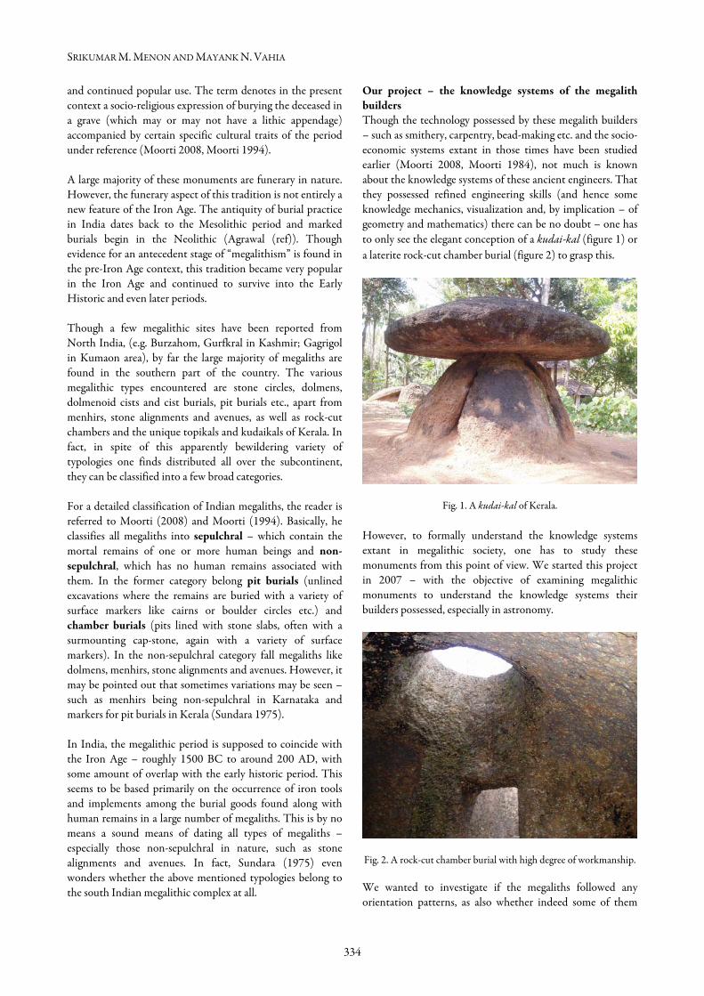
Our project – the knowledge systems of the megalith builders Though the technology possessed by these megalith builders – such as smithery, carpentry, bead-making etc. and the socio-economic systems extant in those times have been studied earlier (Moorti 2008, Moorti 1984), not much is known about the knowledge systems of these ancient engineers. That they possessed refined engineering skills (and hence some knowledge mechanics, visualization and, by implication – of geometry and mathematics) there can be no doubt – one has to only see the elegant conception of a kudai-kal (figure 1) or a laterite rock-cut chamber burial (figure 2) to grasp this.
Fig. 1. A kudai-kal of Kerala. However, to formally understand the knowledge systems extant in megalithic society, one has to study these monuments from this point of view. We started this project in 2007 – with the objective of examining megalithic monuments to understand the knowledge systems their builders possessed, especially in astronomy.
Fig. 2. A rock-cut chamber burial with high degree of workmanship. We wanted to investigate if the megaliths followed any orientation patterns, as also whether indeed some of them
INVESTIGATING MEGALITHIC ASTRONOMY: THE ROLE OF REMOTE SENSING
335
Site visited Typologies of megaliths on site 1. Brahmagiri, Karnataka Chamber burials, pit burials 2. Marayoor, Kerala Dolmens, rock art 3. Burzahoma, Kashmir Neolithic/megalithic pit burials, menhirs 4. Bandipur, Karnataka Chamber burials (previously unreported site) 5. Hire Benkal, Karnataka Chamber burials, dolmens 6. Onake Kindi, Karnataka Rock art 7. Nilaskal, Karnataka Avenue (?) 8. Baise, Karnataka Avenue (?) 9. Hergal, Karnataka Avenue (?) 10. Mumbaru, Karnataka Avenue (?) 11. Thrissur, Kerala Rock-cut chamber burials, urn burials 12. Aihole, Karnataka Chamber burials, dolmens 13. Bachinagudda, Karnataka Chamber burials, dolmens 14. Hanamsagar, Karnataka Avenue 15. Kyaddigeri, Karnataka Chamber burials (destroyed) 16. Chik Benkal, Karnataka Chamber burials (dilapidated) 17. Vibhutihalli, Karnataka Avenue 18. Bheemarayanagudi, Karnataka Avenue (disturbed) 19. Gudde Maradi, Karnataka Avenue (?) (Destroyed) 20. Santhekkatte, Karnataka Menhir(?) were designed to keep track of celestial events on the local horizon. Our plan was to study all classes of megalithic monuments and examine their orientations. From literature we short-listed sites typical of each category of megaliths, preferably in different geographical regions. Reconnaissance visits were to be made to each of these sites to assess the condition in which they survived and to make preliminary measurements, especially orientations. Promising sites were to be short-listed and detailed measurements made, including horizon surveys. From the above, we would try to conclude if any orientational preferences existed and indeed, if any class of monuments were intended to keep track of celestial events like solstices and equinoxes. Sites visited so far We have mainly studied the following classes of megalithic monuments, mainly in Karnataka and Kerala so far. The orientations of the various types of megaliths were measured. Some of the sites were found to be heavily disturbed (Chik Benkal, parts of Brahmagiri) or completely destroyed (Kyaddigeri), making visits to these worthless from the point of collecting data.One site at Bandipur, which turned up during our studies, was subsequently confirmed as previously unreported. The sites at Nilaskal, Baise, Hergal and Mumbaru were suspected to be avenues after reconnaissance, in spite of claims to the contrary in literature (hence the ‘?’ above), so Nilaskal and Baise were visited twice
more and surveys made of the menhirs. Preliminary results As mentioned earlier, orientations were measured at all the sites, wherever possible. In the case of sites with very large number of monuments (Hire Benkal, Hanamsagar, Vibhutihalli), only a few random monuments were measured. In the case of the sepulchral megaliths, it was found that they were largely oriented towards east and west within the annual ranges of sunrise/sunset. This means that the tombs faced sunrise or sunset on some day of the year. Maybe they were oriented to face sunrise or sunset at the time of construction. However, it must be mentioned that the megaliths on Meguti Hill at Aihole faced every direction on the compass – indicating that maybe they were just intended to face downhill – a case of topography rather than celestial events dictating orientation. Stylistically, the Aihole megaliths seem to be older than the Hire Benkal type. Among the non-sepulchral type, the avenue seems like a potential candidate for astronomical use. Two kinds of avenues were encountered during our surveys. The first consisted of grids (according to Allchin (1956), Paddayya (1995), Rao (2005) etc.) of rough, undressed stones of varying dimensions in large numbers (Hanamsagar, Vibhutihalli etc.). The second was made of quarried stone slabs or natural elongated stone slabs of lenticular cross-section, erected oriented north-south and in formation (Nilaskal, Baise, Hergal and Mumbaru). The latter were
SRIKUMAR M. MENON AND MAYANK N. VAHIA
336
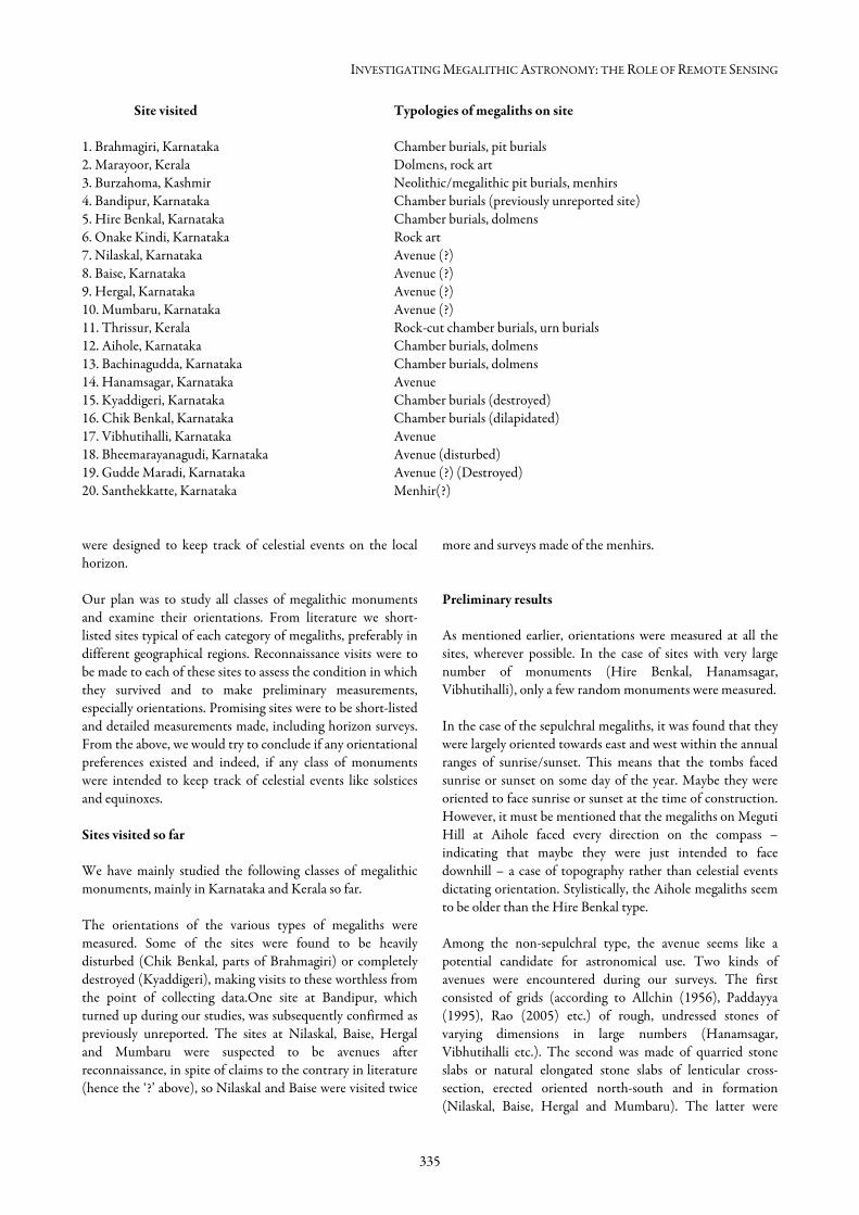
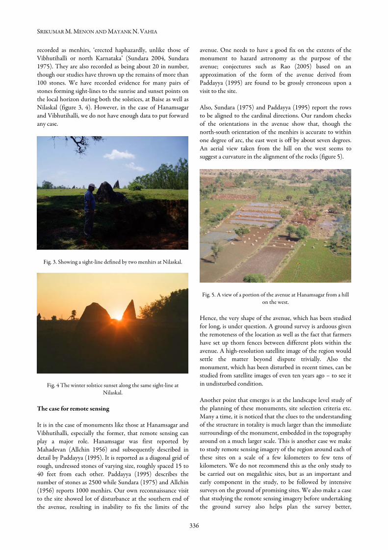
recorded as menhirs, ‘erected haphazardly, unlike those of Vibhutihalli or north Karnataka’ (Sundara 2004, Sundara 1975). They are also recorded as being about 20 in number, though our studies have thrown up the remains of more than 100 stones. We have recorded evidence for many pairs of stones forming sight-lines to the sunrise and sunset points on the local horizon during both the solstices, at Baise as well as Nilaskal (figure 3, 4). However, in the case of Hanamsagar and Vibhutihalli, we do not have enough data to put forward any case.
Fig. 3. Showing a sight-line defined by two menhirs at Nilaskal.
Fig. 4 The winter solstice sunset along the same sight-line at Nilaskal.
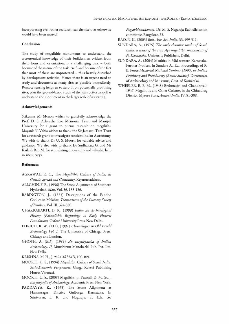
The case for remote sensing It is in the case of monuments like those at Hanamsagar and Vibhutihalli, especially the former, that remote sensing can play a major role. Hanamsagar was first reported by Mahadevan (Allchin 1956) and subsequently described in detail by Paddayya (1995). It is reported as a diagonal grid of rough, undressed stones of varying size, roughly spaced 15 to 40 feet from each other. Paddayya (1995) describes the number of stones as 2500 while Sundara (1975) and Allchin (1956) reports 1000 menhirs. Our own reconnaissance visit to the site showed lot of disturbance at the southern end of the avenue, resulting in inability to fix the limits of the
avenue. One needs to have a good fix on the extents of the monument to hazard astronomy as the purpose of the avenue; conjectures such as Rao (2005) based on an approximation of the form of the avenue derived from Paddayya (1995) are found to be grossly erroneous upon a visit to the site. Also, Sundara (1975) and Paddayya (1995) report the rows to be aligned to the cardinal directions. Our random checks of the orientations in the avenue show that, though the north-south orientation of the menhirs is accurate to within one degree of arc, the east west is off by about seven degrees. An aerial view taken from the hill on the west seems to suggest a curvature in the alignment of the rocks (figure 5).
Fig. 5. A view of a portion of the avenue at Hanamsagar from a hill on the west.
Hence, the very shape of the avenue, which has been studied for long, is under question. A ground survey is arduous given the remoteness of the location as well as the fact that farmers have set up thorn fences between different plots within the avenue. A high-resolution satellite image of the region would settle the matter beyond dispute trivially. Also the monument, which has been disturbed in recent times, can be studied from satellite images of even ten years ago – to see it in undisturbed condition. Another point that emerges is at the landscape level study of the planning of these monuments, site selection criteria etc. Many a time, it is noticed that the clues to the understanding of the structure in totality is much larger than the immediate surroundings of the monument, embedded in the topography around on a much larger scale. This is another case we make to study remote sensing imagery of the region around each of these sites on a scale of a few kilometers to few tens of kilometers. We do not recommend this as the only study to be carried out on megalithic sites, but as an important and early component in the study, to be followed by intensive surveys on the ground of promising sites. We also make a case that studying the remote sensing imagery before undertaking the ground survey also helps plan the survey better,
INVESTIGATING MEGALITHIC ASTRONOMY: THE ROLE OF REMOTE SENSING
337
incorporating even other features near the site that otherwise would have been missed. Conclusion The study of megalithic monuments to understand the astronomical knowledge of their builders, as evident from their form and orientation, is a challenging task – both because of the nature of the task itself, and because of the fact that most of these are unprotected – thus heavily disturbed by development activities. Hence there is an urgent need to study and document as many sites as possible immediately. Remote sensing helps us to zero in on potentially promising sites, plan the ground-based study of the sites better as well as understand the monument in the larger scale of its setting. Acknowledgements Srikumar M. Menon wishes to gratefully acknowledge the Prof. D. S. Achyutha Rao Memorial Trust and Manipal University for a grant to pursue research on megaliths. Mayank N. Vahia wishes to thank the Sir Jamsetji Tata Trust for a research grant to investigate Ancient Indian Astronomy. We wish to thank Dr U. S. Moorti for valuable advice and guidance. We also wish to thank Dr Sudhakara G. and Mr Kailash Rao M. for stimulating discussions and valuable help in site surveys. References AGRAWAL, R. C., The Megalithic Culture of India: its
Genesis, Spread and Continuity, Keynote address. ALLCHIN, F. R., (1956) The Stone Alignments of Southern
Hyderabad, Man, Vol. 56, 133-136. BABINGTON, J., (1823) Descriptions of the Pandoo
Coolies in Malabar, Transactions of the Literary Society of Bombay, Vol. III, 324-330.
CHAKRABARTI, D. K., (1999) India: an Archaeological History (Palaeolithic Beginnings to Early Historic Foundations, Oxford University Press, New Delhi.
EHRICH, R. W. (ED.), (1992) Chronologies in Old World Archaeology Vol. I, The University of Chicago Press, Chicago and London.
GHOSH, A. (ED), (1989) An encyclopaedia of Indian Archaeology, II, Munshiram Manoharlal Pub. Pvt. Ltd. New Delhi.
KRISHNA, M. H., (1942) ARMAD, 100-109. MOORTI, U. S., (1994) Megalithic Culture of South India:
Socio-Economic Perspectives, Ganga Kaveri Publishing House, Varanasi.
MOORTI, U. S., (2008) Megaliths, in Pearsall, D. M. (ed.), Encyclopedia of Archaeology, Academic Press, New York.
PADDAYYA, K., (1995) The Stone Alignment at Hanamsagar, District Gulbarga, Karnataka, In Srinivasan, L. K. and Nagaraju, S., Eds., Sri
Nagabhinandanam, Dr. M. S. Nagaraja Rao felicitation committee, Bangalore, 23.
RAO, N. K., (2005) Bull. Astr. Soc. India, 33, 499-511. SUNDARA, A., (1975) The early chamber tombs of South
India: a study of the Iron Age megalithic monuments of N. Karnataka, University Publishers, Delhi.
SUNDARA, A., (2004) Menhirs in Mid-western Karnataka: Further Notices, In Sundara A., Ed., Proceedings of R. B. Foote Memorial National Seminar (1995) on Indian Prehistory and Protohistory (Recent Studies), Directorate of Archaeology and Museums, Govt. of Karnataka.
WHEELER, R. E. M., (1948) Brahmagiri and Chandravalli 1947: Megalithic and Other Cultures in the Chitaldrug District, Mysore State, Ancient India, IV, 81-308.


![Legends, Megaliths And Astronomy In Corsica Island · The megalithic culture of Corsica [1,2, 8,9,10,11,14,15] flourished in the first half of the fourth millennium B.C. As regards](https://img.dokumen.tips/doc/110x75/5f340ccd5337e756ad0ebeae/legends-megaliths-and-astronomy-in-corsica-island-the-megalithic-culture-of-corsica.jpg)