Embed Size (px)
Citation preview
2004Massachusetts Bays Symposium
A regional symposium hosted byThe Massachusetts Bays Program
Boston, MassachusettsMay 6 and 7, 2004
Proceedings
Commonwealth of MassachusettsMitt Romney, Governor
Kerry Healey, Lieutenant Governor
Executive Office of Environmental AffairsEllen Roy Herzfelder, Secretary
Massachusetts Office of Coastal Zone ManagementSusan Snow-Cotter, Director
The Massachusetts Bays Program is a cooperative venture of the MassachusettsExecutive Office of Environmental Affairs/Coastal Zone Management and the U.S.
Environmental Protection Agency.
The Massachusetts Bays Program
251 Causeway Street, Suite 800Boston, MA 02114
(617) 626-1230www.massbays.org
Jan Smith, Executive Director
Printed on Recycled Paper
This information is available in alternate formats upon request.
This project is funded by the Massachusetts Environmental Trust.
i
The Massachusetts Bays Program is a partnership of citizens, communities, and government that strives to protect andenhance the coastal health and heritage of Massachusetts and Cape Cod Bays.
The Massachusetts Bays Program (MBP) was launched in 1988 to address the mounting threats to the health ofMassachusetts and Cape Cod Bays. In 1990, the U.S. Environmental Protection Agency (EPA) accepted the MBP into theNational Estuary Program, which was established to identify nationally significant estuaries threatened by pollution,development, or overuse, and to promote the preparation of comprehensive management plans to ensure their health. TheMBP developed a Comprehensive Conservation and Management Plan (CCMP) for the Bays region with the help of nearly300 individuals representing a wide array of private, government, and community interests. This large network of partners,called the Management Conference, directs and implements the MBP. The final CCMP, published in 1996 and revised in2003, is a blueprint for coordinated management and protection of the Bays’ resources. It features 17 action planscontaining 87 specific actions for preventing pollution, preserving habitat, and restoring the Bays’ degraded resources.
To ensure that each of the MBP’s 50 communities receives its share of attention, the Program partners with watershedassociations and Regional Planning Agencies to provide regional coordinators in five subregions: Upper North Shore, SalemSound, Metro Boston, South Shore and Cape Cod. This unique structure enables MBP staff to identify and solveenvironmental problems that require a local focus. Thanks to this effective and efficient partnership, the MBP leveragessignificant funding to conduct a wide variety of local and regional projects benefiting the Bays, from coordinating volunteersto help monitor the success of wetland restoration projects to helping local officials reduce land use impacts on theircommunity’s coastal resources.
About the Massachusetts Bays Program

ii
The Massachusetts Bays Program would like to thank the following organizations, agencies, and people:
The Massachusetts Environmental Trust for its generous support in funding the printing of this proceedingsdocument as well as the accompanying State of the Bays Report 2004.
The Massachusetts Office of Coastal Zone Management, U.S. Environmental Protection Agency, Battelle, andSalem Sound Coastwatch for their generous financial and staff support.
All of the speakers who presented their important work at the conference.
The Federal Reserve Bank of Boston for the use of its wonderful facility.
Final report compilation by Peter Hanlon, Christian Krahforst, and Jan Smith (Massachusetts Bays Program)
ACKNOWLEDGEMENTS
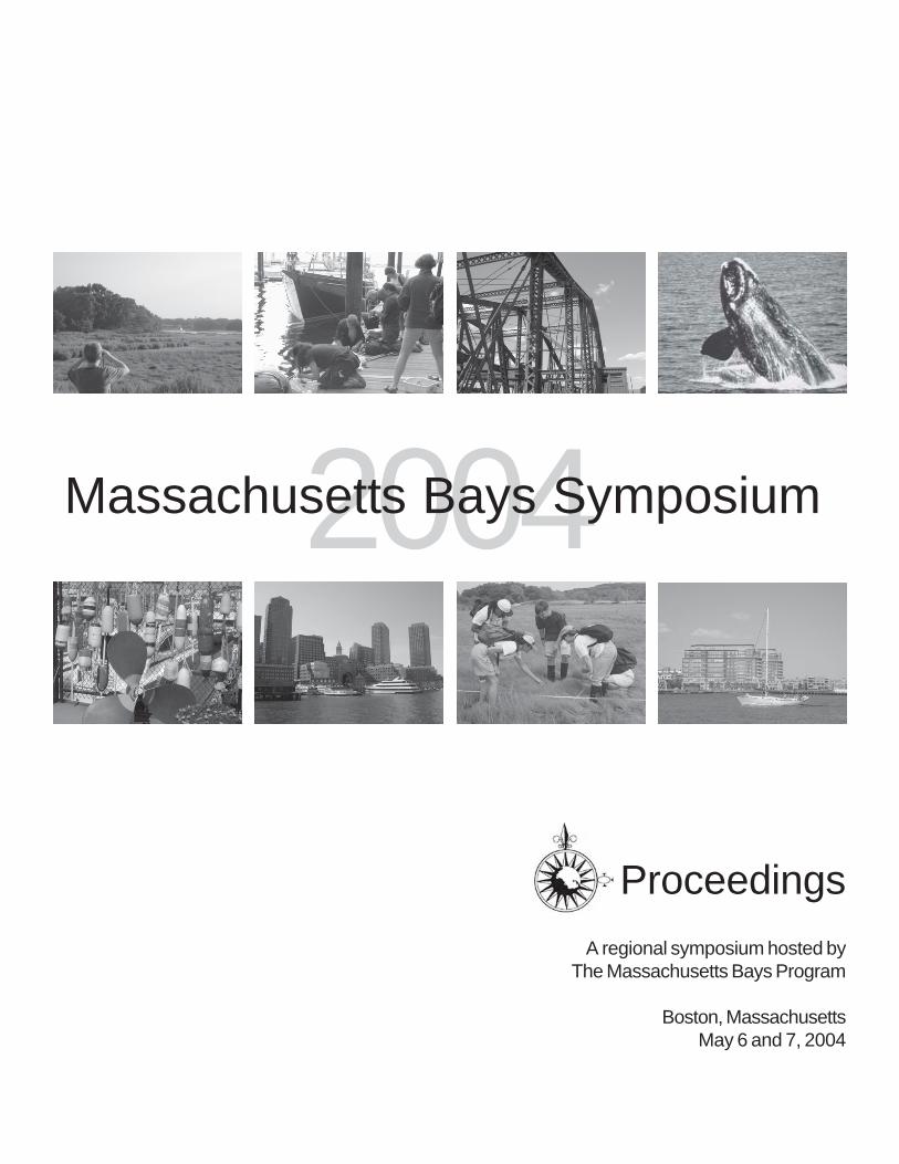
Cover photos:
Top Row (from left to right): Shannon Weigle; Peter Hanlon; Ben Fertig; NOAA Photo Library
Bottom Row (from left to right): Ben Fertig; Ben Fertig; MBP Archives; Ben Fertig
Massachusetts Bays Symposium logo designed by Arden Miller
iii
2004CONTENTS Massachusetts Bays Symposium
Introduction and Opening RemarksJan Smith, Executive Director, Massachusetts Bays Program
Ellen Roy Herzfelder, Secretary, Massachusetts Executive Office of Environmental AffairsIra Leighton, Deputy Administrator, U.S. Environmental Protection Agency, Region I
OffshorePhysical Oceanography of Massachusetts Bay
Christian Krahforst, Massachusetts Bays Program
Modelling the Massachusetts Bay SystemDr. Mingshun Jiang, University of Massachusetts - Boston
Twelve Years of Water Quality Monitoring in Massachusetts and Cape Cod BaysDr. Michael Michelson, Massachusetts Water Resources Authority
Offshore Benthic HabitatDr. Kenneth Keay, Massachusetts Water Resources Authority
Endangered Right WhalesDr. Stormy Mayo, Center for Coastal Studies
Massachusetts Marine Fisheries’ Inshore Bottom Trawl SurveySteven Correia, Massachusetts Division of Marine Fisheries
Land UseWhat is the Massachusetts Bays Region?
Peter J. Hanlon, Massachusetts Bays Program
Losing Ground: At What Cost?Jack Clarke, Massachusetts Audubon Society
Integrating Land Use and Water Quality Data to Access Status and Trends in NonpointSource Pollution in the Parker Watershed
Jay Baker, Massachusetts Office of Coastal Zone Management
Beyond Buildout: One Coastal Community's Call to ActionAlan Macintosh and Jerrard Whitten, Merrimack Valley Planning Commission
2
4
6
14
20
28
30
40
46
56
70
78
Day OneMay 6, 2004
Management Panel ILinking management of our Offshore Waters with Land Use
Moderated by Dr. Carlton Hunt, Battelle- with -
Jack Wiggin, Urban Harbors Institute.Dr. Joe Costa, Buzzards Bay Project.
Dr. Dennis Ducsik, Massachusetts Office of Coastal Zone Management.Vivien Li, The Boston Harbor Association.
iv
Ocean Management Task ForceSusan Snow-Cotter, Massachusetts Office of Coastal Zone Management
EstuaryBoston Harbor: What a Change a Decade Makes
Dr. Andrea Rex and David Taylor, Massachusetts Water Resources Authority
Coastal Wetland Assessment and Restoration in MassachusettsBruce Carlisle, Massachusetts Office of Coastal Zone Management
Invasive SpeciesDr. Judith Pederson, MIT Sea Grant
Anadromous Fish RunsDr. Michael Armstrong, Massachusetts Division of Marine Fisheries
Embayment Water QualityAndrew Gottlieb, Massachusetts Department of Environmental Protection
Contaminants in Boston HarborChristian Krahforst, Massachusetts Bays Program
CONTENTS
Management Panel IIThe Next Decade: Emerging Issues for the Massachusetts BaysModerated by Christian Krahforst, Massachusetts Bays Program
- with -Dr. Gordon Wallace, University of Massachusetts-Boston
Susan Snow-Cotter, Massachusetts Office of Coastal Zone ManagementDr. Judith Pederson, MIT Sea Grant
Dr. Robert Buchsbaum, Massachusetts Audubon Society
ConclusionsNext Steps
Jan Smith, Massachusetts Bays Program
AppendicesAppendix A: Attendees
Appendix B: Agenda
Day TwoMay 7, 2004
2004Massachusetts Bays Symposium
82
88
94
106
108
118
126
134
137
139
143

v
On May 6 and 7, 2004, the Massachusetts Bays National Estuary Program convened the first Massachusetts Bays Symposiumsince 1994. The symposium brought together experts from throughout the region to describe the current condition of theMassachusetts and Cape Cod Bays, to review progress made in protecting and restoring the Bays over the past ten years,and to strengthen scientific partnerships. Scientists, resource managers, and policy experts from numerous universities andgovernment and nonprofit organizations participated in the two-day event along with over 100 attendees.

M a s s a c h u s e t t s B a y s P r o g r a m
vi
M a s s a c h u s e t t s B a y s S y m p o s i u m 2 0 0 4
1
D a y O n eMay 6, 2004
M a s s a c h u s e t t s B a y s P r o g r a m
2
I n t r o d u c t i o n
The workshop began with a welcome and introduction by Mr. Jan Smith, Executive Director of the Massa-chusetts Bays Program (MBP). Mr. Smith provided a brief statement about the National Estuary Program(NEP) and Massachusetts Bays in the role of the NEP. The Massachusetts Bays joined the NEP in 1990and developed a Comprehensive Conservation and Management Plan (CCMP) in 1996. The CCMP servesas a blueprint for the protection and restoration of Massachusetts and Cape Cod Bays. Nearly a decade haspassed since the last symposium was held and MBP is looking forward to the valuable outcome that willfurther help protect the health and resources of Massachusetts Bays.
Mr. Smith stated that the goals of the current workshop included 1) Providing a summary of the currentstate of the Massachusetts Bays; 2) Determining the next steps needed to support the future of the Massa-chusetts Bays; and 3) Beginning to develop a plan to coordinate and integrate efforts. He also introduced thenew Massachusetts Bays Estuary Association; a non-profit organization that is supporting the MassachusettsBays Program. Opening statements were given by Secretary Ellen Roy Herzfelder, Massachusetts ExecutiveOffice of Environmental Affairs (EOEA) and Ira Leighton, Deputy Administrator of the EPA New En-gland Region.
Secretary Herzfelder stated that Massachusetts is 45th in size in the nation and that 50 percent of thepopulation of Massachusetts lives within the coastal zone. With such a large population living within thecoastal zone, human activities are directly affecting the coast and ocean. Secretary Herzfelder reported thatMassachusetts Governor, Mitt Romney is looking at the leadership role that Massachusetts could play inenvironmental and economic growth and has a crucial role in the stewardship of coastlines and bays. Thereare many programs that are working towards the goal of Massachusetts sustaining environmental and eco-nomic growth. One such program is the Boston Harbor Cleanup Project. Due to a huge effort of thisproject, the Charles River is now fishable and swimmable and she emphasized that it is important to build onthis success. Several groups have been formed to help continue this success, such as the Ocean Manage-ment Task Force, the Bays Initiative, and the Water Quality Initiative. The Bays Initiative has put the spotlight on Bay issues and created new legislation for business that want to create new developments. Inaddition to the Bays Initiative, the Water Quality Initiative has also brought focus on Bay issues by concen-trating on the quantity and quality of water and stormwater related issues.
Jan Smith, Executive DirectorMassachusetts Bays Program
Ellen Roy Herzfelder, Secretary,Massachusetts Executive Office of Environmental Affairs
Ira Leighton, Deputy Administrator,U.S. Environmental Protection Agency, Region I

M a s s a c h u s e t t s B a y s S y m p o s i u m 2 0 0 4
3
Mr. Leighton noted that the challenge and theme of managing the Massachusetts and Cape Cod Bays isdealing with the competing use of resources. For example, the development of gas pipelines and the cre-ation of reefs. The Massachusetts Bays are widely used for human activity while also supporting the localeconomy; it brings in $1.5 billion in travel and tourism and supports 81,000 jobs. Mr. Leighton acknowl-edged that there are many efforts that are working towards managing the Massachusetts Bays’ resources.One example of this successful management is the Boston Harbor cleanup, which is a tremendous effort thatis incorporating several issues into the project, such as: stormwater and combined sewer overflows (CSO)management issues, cleaner marine engines, a regional clean marina initiative, clean beach initiatives, ad-vancing the pace of the National Pollution Discharge Elimination System (NPDES) permits, and wastewaterplant upgrades. He also discussed the National Coastal Condition and PEW Report which assessed thenational coastal condition and reported that 31 percent of the coast and 41 percent of aquatic life areimpaired by human use, and shellfish contamination and closings must be reduced. There has been $4million invested into the Massachusetts Bays so far, and a half million dollars is going to be invested thisyear alone. Another topic Mr. Leighton discussed was that there has been $1.1 million spent on monitoringfor the Beach Initiative in New England. One benefit of the Beach Initiative is that results of the beachmonitoring are to be reported to the public in a timely manner. This information will help to educate thepublic with knowledge of their local beaches. However, there are still too many beach closures and it isimportant to demonstrate the successful beaches. One type of effort would be to showcase flagship beachesto help support the Beach Initiative.
After these opening statements, the Massachusetts Bays Program introduced the 2004 State of the Baysreport. The report discusses 14 questions related to changes in the past ten years plus major efforts high-lighted in focus studies. The questions and focus studies that are discussed in the 2004 State of the Baysreport are the main topics for sessions presented at the Symposium. The presentation sessions on Day Onewere Offshore and Land Use followed by a Management Panel and Discussion on linking the managementof offshore water with land use. On Day Two the presentation sessions were focused on Estuaries followedby a Management Panel and Discussion on emerging issues.
I n t r o d u c t i o n
M a s s a c h u s e t t s B a y s P r o g r a m
4
Christian KrahforstMassachusetts Bays Program
251 Causeway Street, Suite 800Boston, MA 02114
(617) [email protected]
Mr. Krahforst opened his presentation stating that a meaningful assessment of the "condition" or "state" of theMassachusetts and Cape Cod Bays requires a good understanding of the processes that affect circulation and mixing inthe Bays. This understanding is also paramount for sound management and directing appropriate monitoring. BecauseMassachusetts Bay is part of the larger Gulf of Maine, much of the conditions that prevail in the Gulf proper aresignificant to setting the conditions for Massachusetts Bay. The Massachusetts Bays Program initiated the first system-wide description of the mechanisms controlling circulation and mixing in the bays in the early 1990's (Geyer et. al.,1992). Much of the physical oceanographic work that followed augments the key findings of this work, some ofwhich are:
• Strong seasonal stratification in the bays;• Weak, persistent counter-clockwise flow within the Bays;• Flushing or water residence time is largely the result of mean through flow of northern water from the Gulf
of Maine.
Efforts to better understand the functionality of the Bays were mostly the result of needs associated with the then-proposed transfer of waste effluent from the confines of Boston Harbor to the new outfall site in westernMassachusetts Bay. More recent efforts that link to the broader regional perspective along with a broad overview ofthe general physical oceanography of Massachusetts Bay were presented.
O f f s h o r e
Physical Oceanography of Massachusetts Bay

M a s s a c h u s e t t s B a y s S y m p o s i u m 2 0 0 4
5
O f f s h o r e
M a s s a c h u s e t t s B a y s P r o g r a m
6
O f f s h o r e
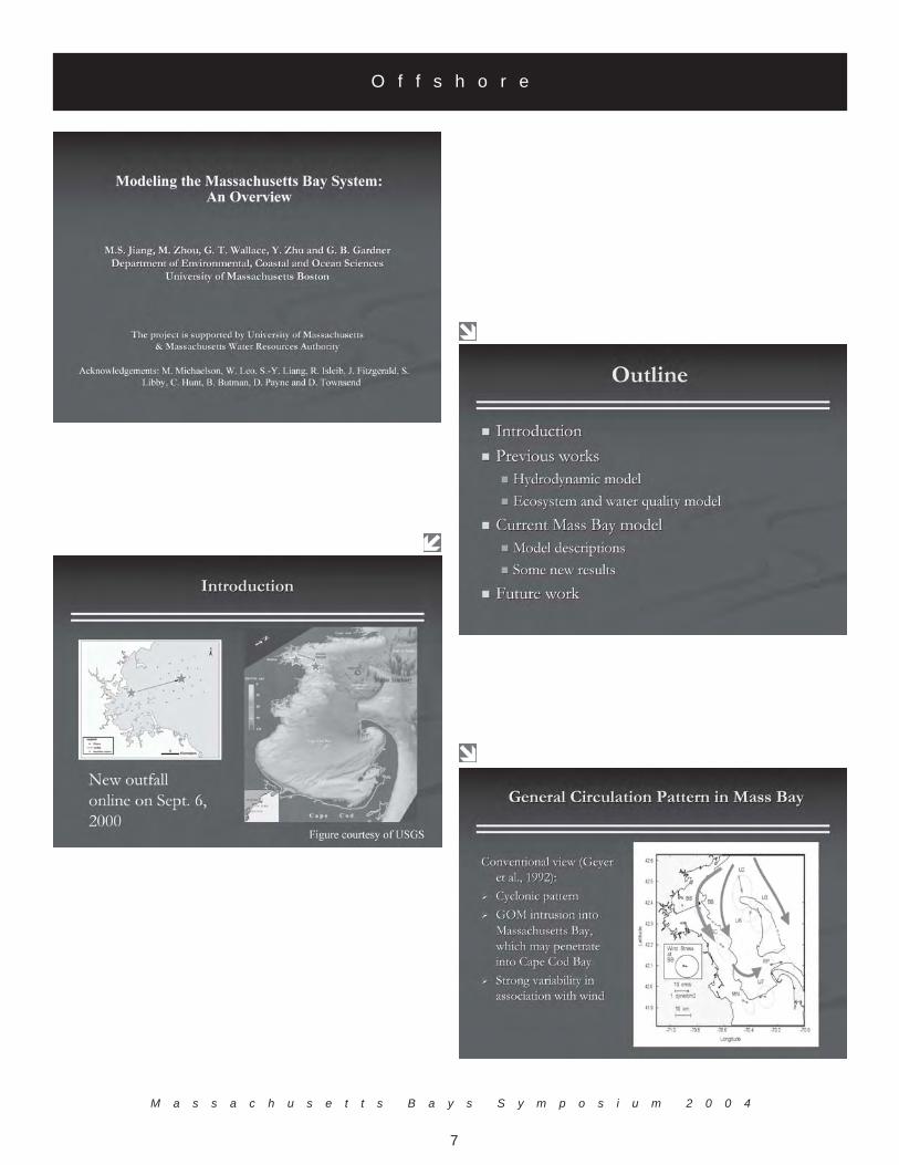
Modelling the Massachusetts Bay System
Dr. Mingshun JiangDepartment of Environmental, Earth and Ocean Sciences,
University of Massachusetts Boston100 Morrissey Blvd.Boston, MA 02125
(617) [email protected]
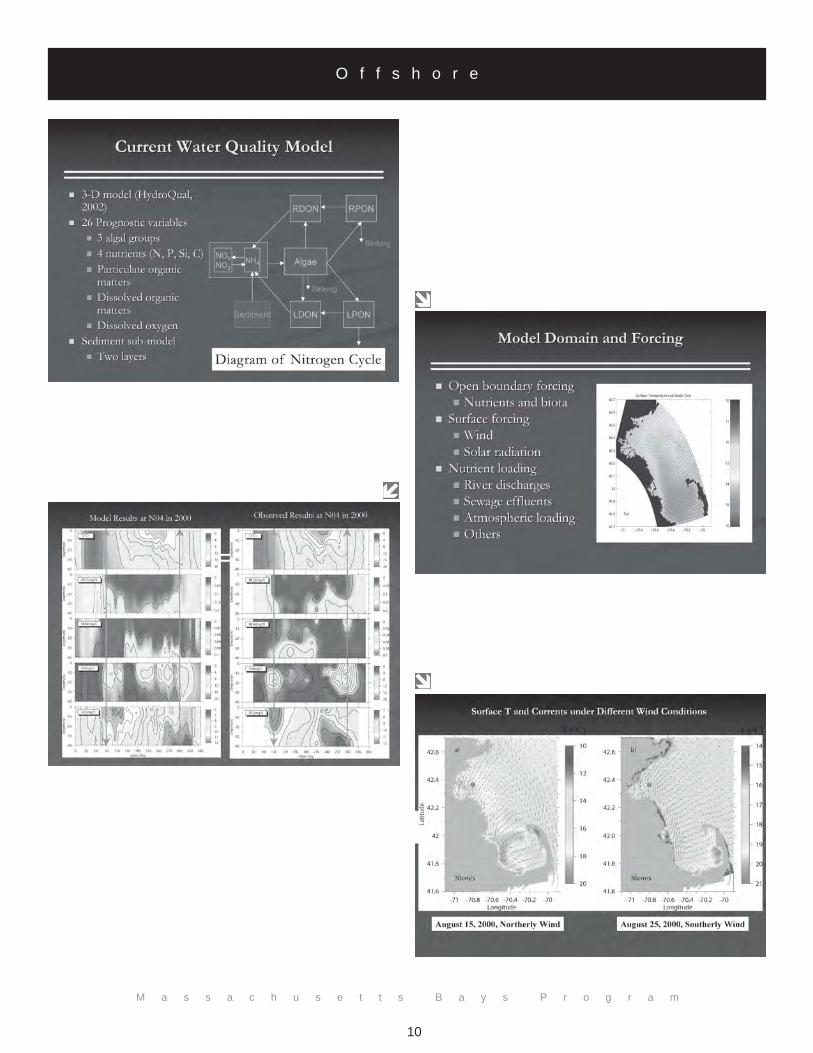
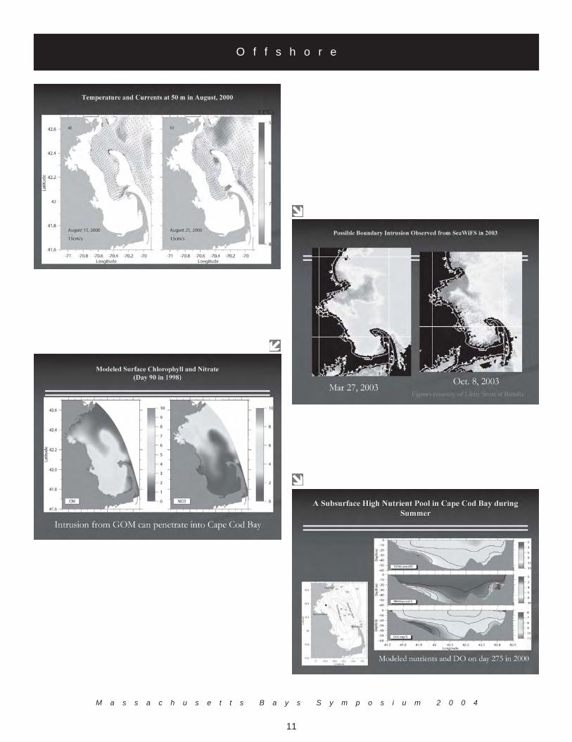
As a semi-enclosed coastal embayment, Massachusetts Bays system is strongly influenced by the atmosphericforcing, anthropogenic inputs and open boundary forcing from the Gulf of Maine. Dr. Jiang presented abrief overview of the previous and on-going efforts in modeling the hydrodynamic processes, ecosystem andwater quality in the Massachusetts Bay system. Findings from these works related to the environmentalissues are:• The summer upwelling/downwelling have strong influences on the transport direction of biota
boundary fluxes and bottom water renewal in Massachusetts Bay;• The ecosystem in Massachusetts Bay is strongly influenced by the GOM water intrusion;• A high nutrient pool found in central Cape Cod Bay during late summer may be the result of
predominantly southward transport of organic matter coupled with relatively long residence times inCape Cod Bay.
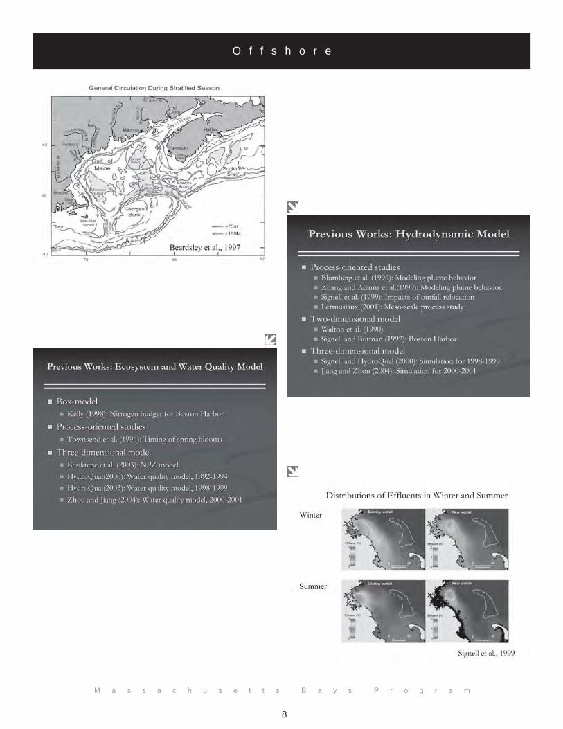
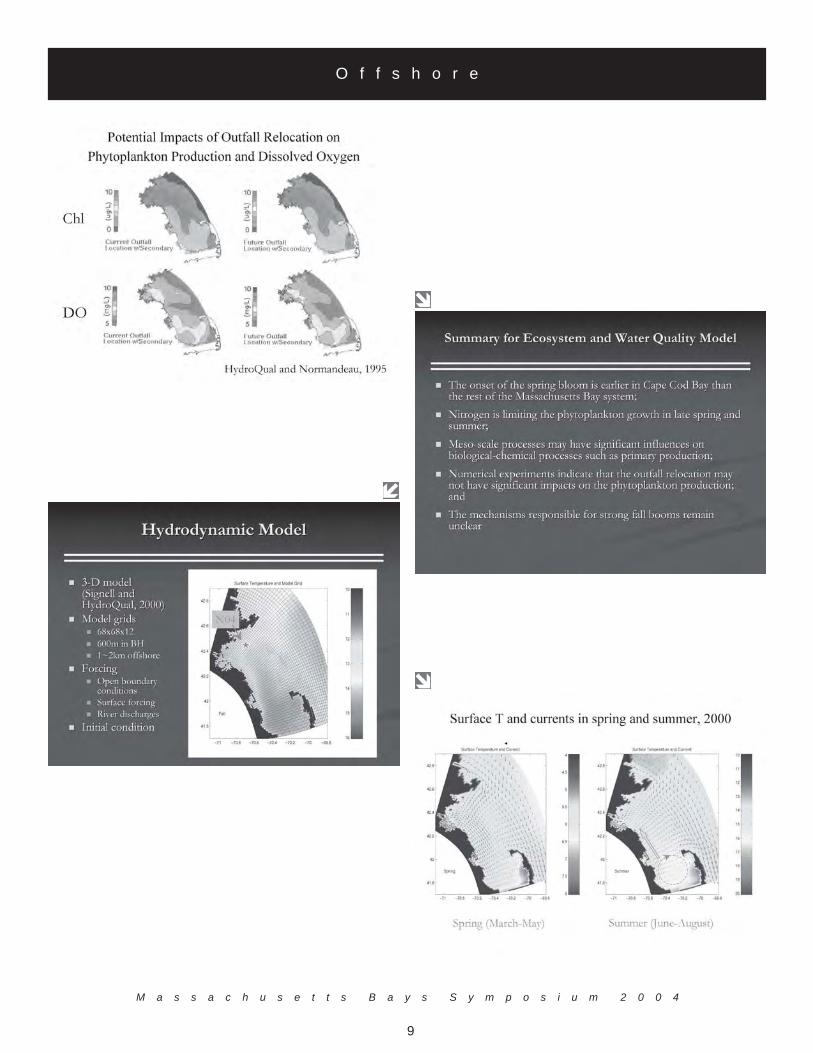
As of 2004, the Massachusetts Bays water quality model is a three-dimensional model containing 26prognostic variables that include 3 phytoplankton groups, nutrients (N, P, Si, and C), particulate anddissolved organic matter, dissolved oxygen, and has a two-layer sediment sub-model. Summaries from thecoupled ecosystem-water quality model are:• The onset of the spring bloom is earlier in Cape Cod Bay than the rest of the Massachusetts Bays
system;• Nitrogen appears limiting to phytoplankton growth in the late spring and summer;• Meso-scale processes may have significant influences on biological-chemical processes such as
primary production;• Numerical experiments indicate that the relocation of Boston's municipal wastewater discharge to
western Massachusetts Bay may not have significant impacts on phytoplankton productivity;• The mechanisms responsible for strong fall blooms remain unclear
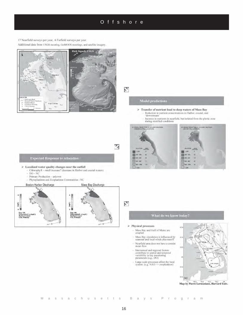
Dr. Jiang also discussed future research that is needed to continue to understand the complex system ofMassachusetts Bays. Future research should include: more process-oriented studies for understanding betterthe short-term processes of coupled physical-biological-chemical events, improved characterization of inter-annual ecosystem variability, better representation of zooplankton in the biological model for MassachusettsBay, data assimilation and development of near real-time forecast system. The Massachusetts Bay modelhas monitoring needs as well: enhanced temporal and spatial coverage, particularly, for the open boundaryarea.
M a s s a c h u s e t t s B a y s S y m p o s i u m 2 0 0 4
7
O f f s h o r e
M a s s a c h u s e t t s B a y s P r o g r a m
8
O f f s h o r e
M a s s a c h u s e t t s B a y s S y m p o s i u m 2 0 0 4
9
O f f s h o r e
M a s s a c h u s e t t s B a y s P r o g r a m
10
O f f s h o r e
M a s s a c h u s e t t s B a y s S y m p o s i u m 2 0 0 4
11
O f f s h o r e

M a s s a c h u s e t t s B a y s P r o g r a m
12
O f f s h o r e

M a s s a c h u s e t t s B a y s S y m p o s i u m 2 0 0 4
13
O f f s h o r e

M a s s a c h u s e t t s B a y s P r o g r a m
14
O f f s h o r e
Twelve Years of Water Quality Monitoring in Massachusetts and Cape Cod Bays
Dr. Michael Mickelson, Massachusetts Water Resource Authority,Dr. Scott Libby and Dr. Carlton Hunt (Battelle)
Charlestown Navy Yard100 First Ave
Boston, MA 02129(617) 788-1170
http://www.mwra.state.ma.us
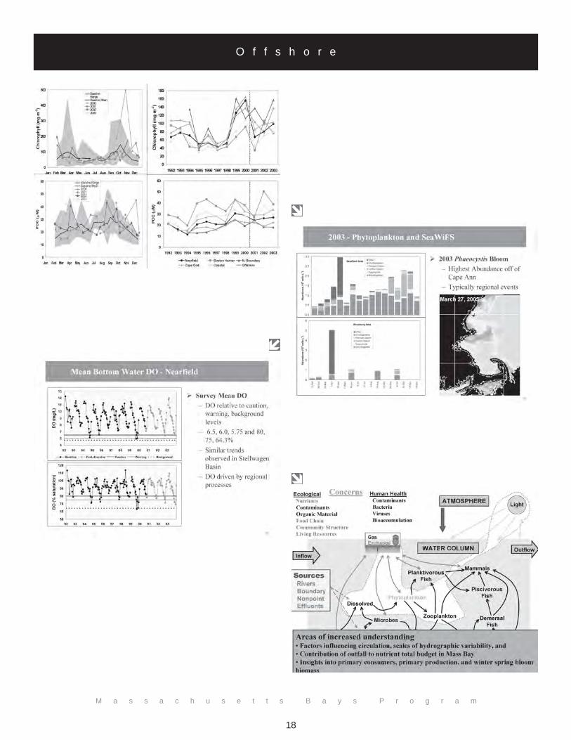
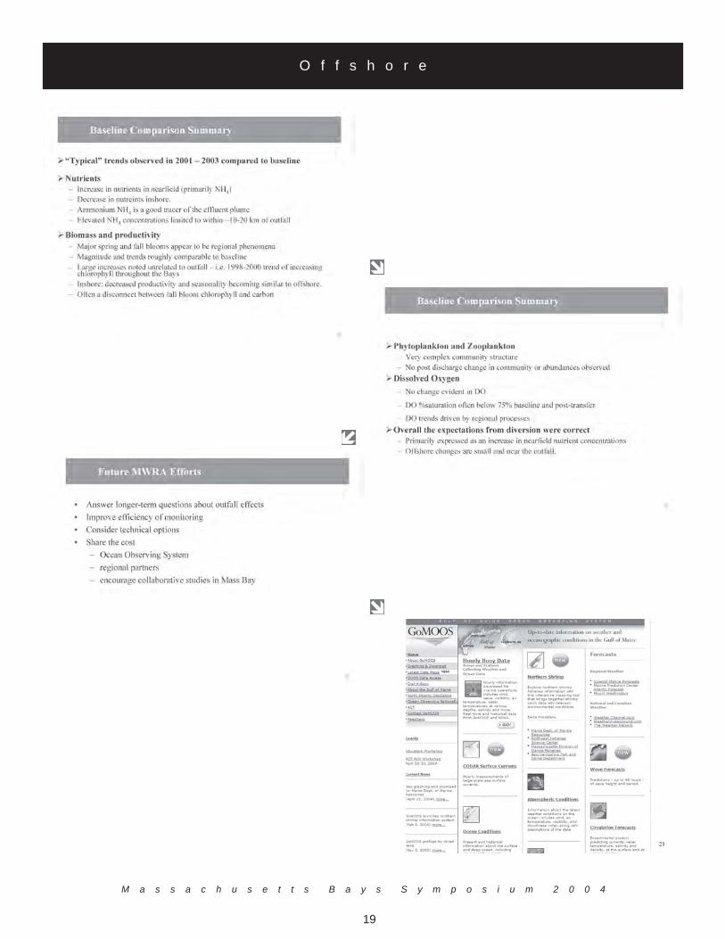
The Massachusetts Water Resource Authority (MWRA) has collected water quality data in Massachusettsand Cape Cod Bays for the Harbor and Outfall Monitoring (HOM) Program since 1992. Dr. Mickelsonpresented results from monitoring efforts that were designed to support the HOM Program's mission toassess the environmental effects of the relocation of effluent discharge from Boston Harbor to westernMassachusetts Bay. A monitoring plan was developed and included parameters that are ecologicallyimportant, respond early to perturbation, indicate longer-term response, and provide explanatoryinformation. The data from 1992 through September 5, 2000 were collected to establish baseline waterquality conditions and to provide the means to detect significant departures from the baseline after the Bayoutfall became operational. This data was then compared to the data collected after the Bay outfall wentonline on September 6, 2000. In general, typical trends emerged when the baseline data were compared tothe 2001 to 2003 data. There was an increase in nutrients in the nearfield region of the Bay outfall.However, there was a measurable decrease in nutrients inshore. Phytoplankton and zooplankton observedin the nearfield outfall region showed no post discharge change in community structure or abundance.Studies have shown that dissolved oxygen (DO) trends are driven by meso-scale processes and no DOchange is evident. Changes from the outfall are primarily expressed as an increase in nearfield nutrientconcentrations with offshore changes being small and localized.
Over the course of the HOM program, a general sequence of water quality events has become evident eventhough the timing and year-to-year manifestations of these events are variable. Dr. Mickelson noted thatthere has been little change in the timing or magnitude of these events in comparison to baseline data sincethe Bay outfall became operational. Further, knowledge gained through monitoring, modeling, and researchhas substantially increased the understanding of the variability of the Massachusetts Bays System, thefactors that drive variability, and relationships among stressors (causes) and responses (effects). FutureMWRA efforts include: answering long-term questions about the outfall effects, improving efficiency ofmonitoring efforts, consideration of technical options, and sharing the cost of ecosystem monitoring withother organizations.

M a s s a c h u s e t t s B a y s S y m p o s i u m 2 0 0 4
15
O f f s h o r e
M a s s a c h u s e t t s B a y s P r o g r a m
16
O f f s h o r e

M a s s a c h u s e t t s B a y s S y m p o s i u m 2 0 0 4
17
O f f s h o r e
M a s s a c h u s e t t s B a y s P r o g r a m
18
O f f s h o r e
M a s s a c h u s e t t s B a y s S y m p o s i u m 2 0 0 4
19
O f f s h o r e

M a s s a c h u s e t t s B a y s P r o g r a m
20
O f f s h o r e
Offshore Benthic Habitat
Kenneth KeayMassachusetts Water Resources Authority
Charlestown Navy Yard100 First Ave
Boston, MA 02129(617) 788-1170
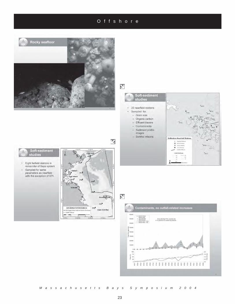
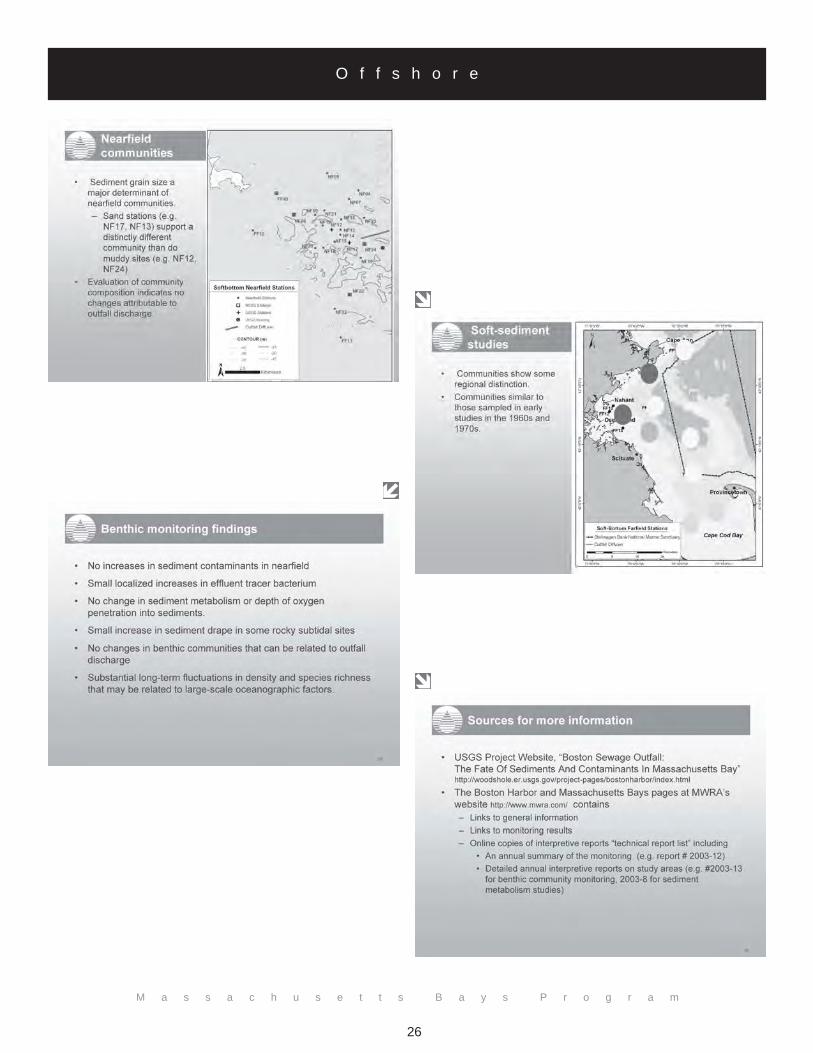
Benthic (seafloor) habitats in the Massachusetts Bays system vary from a complex patchwork of rock, gravel,sand and mud bottoms in Boston Harbor and western Massachusetts Bay to broad expanses of sand andmud in Cape Cod Bay and Stellwagen Basin. Offshore soft-sediment infaunal studies by the MassachusettsWater Resources Authority (MWRA) over the past 12 years document species-rich communities similar tothose observed in early studies in the late 1960s and early 1970s. The benthic infauna of the MassachusettsBays includes communities that are a mixture of nearshore and offshore components. Polychaetes are themost abundant in terms of numbers of individuals and species in the Bays. Around 450 species of benthicinvertebrates have been identified from the Bays through 2003 and the fauna is typical of both mud andsand substrates. Mr. Keay also pointed out that there are dozens of species not previously described.
Since monitoring began in 1992, fluctuations in the biodiversity of the Bays infauna suggest that the com-munities may be responding to decade-scale variability in the regional oceanography, though the causativefactors remain unknown and are currently under investigation. Mr. Keay noted if environmental conditionsdeteriorate, benthic organisms have no choice but to adapt to the changing environment. Since the outfallhas gone online there are have been several changes observed in benthos of Massachusetts Bays. Near thedischarge, there has been an increase in Clostridium perfringens, the total abundance in the infaunal commu-nity has increased, and PAHs levels are elevated due to the presence of coal-tar by products. However, Mr.Keay remarked that there have been no changes in the sediment in the nearfield or farfield regions (relativeto the outfall site) since the outfall came online. The benthic biodiversity model questioned whether theoutfall has an effect and the data states that the change has not been large.Many benthic monitoring findings have been established about the effects of the outfall on MassachusettsBays, the findings include:• No increases in sediment contaminants in nearfield region of the Bay outfall;• Small localized increases in the MWRA effluent tracer bacterium;• No change in sediment metabolism or depth of oxygen penetration into sediments;• Small increase in sediment drape in some rocky subtidal sites;• No changes in benthic communities that can be related to outfall discharge;• Substantial long-term fluctuations in density and species richness that may be related to large-scale
oceanographic factors.
Mr. Keay also discussed important findings observed by the U. S. Geological Survey (USGS) in relation tosediments in Massachusetts Bays. Major repositories of fine sediments are in depositional sites in BostonHarbor, Stellwagen Basin, and Cape Cod Bay. Trace metal concentrations in Harbor sediments have de-creased since the late 1970s. Major storms are the primary factor in the transport of fine sediments andassociated contaminants within the system. Lastly, analysis of sediment traps in the vicinity of the newoutfall allows detection of a subtle MWRA effluent signature not detectable in the seafloor.

M a s s a c h u s e t t s B a y s S y m p o s i u m 2 0 0 4
21
O f f s h o r e

M a s s a c h u s e t t s B a y s P r o g r a m
22
O f f s h o r e
M a s s a c h u s e t t s B a y s S y m p o s i u m 2 0 0 4
23
O f f s h o r e

M a s s a c h u s e t t s B a y s P r o g r a m
24
O f f s h o r e

M a s s a c h u s e t t s B a y s S y m p o s i u m 2 0 0 4
25
O f f s h o r e
M a s s a c h u s e t t s B a y s P r o g r a m
26
O f f s h o r e

M a s s a c h u s e t t s B a y s S y m p o s i u m 2 0 0 4
27
O f f s h o r e
M a s s a c h u s e t t s B a y s P r o g r a m
28
O f f s h o r e
Endangered Right Whales
Dr. Charles MayoCenter for Coastal Studies
P.O. Box 1036Provincetown, MA 02657
(508) [email protected]
In the 1700s, the North Atlantic right whale (Eubalaena glacialis) population was hunted to near extinction. Today, thereare about 350 right whales in the world. There are three factors to the success of right whales: status, threats, and foodand feeding habits. Whales are in the Massachusetts Bays for socialization, nursing of calves, and feeding. Cape CodBay is of particular interest for the right whales, noted Dr. Mayo, because it is a significant feeding ground in winter.Many threats to right whales have been identified. For example, they can become entangled in discarded fishing nets orinjured or killed when struck by ships. The rate of reduction is decreasing but threats are increasing with humanpopulation growth.
To help conserve whales, it is important to understand their behavior and their feeding habits. While feeding in theregion, most right whales work in the area of eastern Cape Cod Bay and can feed up to 24 hours a day. Theimportance of zooplankton to the success of right whales was proven in recent studies. Feeding is triggered by up to11 taxa of zooplankton, and the food source is variable from year to year. When searching for food, the whales usearea-restricted searching based on zooplankton abundance, therefore the feeding pattern is a path through the area ofsearching. To understand the system, zooplankton sampling should be done within a few meters of that path, but forbackground it is important to sample far from the path as well. Cape Cod Bay has had problems because it wasfound to have zooplankton biomass levels that may not be conducive to feeding. 2002 saw the fewest whales sighted,shortest residency, least feeding, and earliest departure in nineteen years of study. Dr. Mayo stated that the collapse ofbay sightings of right whales has caused significant concern that whales are leaving the bays. There has been a closeassociation between food quality on the winter feeding ground of Cape Cod Bay and calving success of thepopulation two years later. The low quality of the food resource through the 1990’s associated with low rates ofcalving may also be related to low survival rates.
Conclusions:• Cape Cod Bay appears to be supplying a portion of the energy needs of as many as 100 right whales that visit
the embayment each year.• There is a relationship between measures of food availability in Cape Cod Bay and calving of the right whales.• The distribution of right whales within the bays of Massachusetts reflects the distribution of the planktonic
foods.• Though we can demonstrate how the addition of sewage effluent (from the MWRA outfall) to the bays
system might affect right whales, there are no indications that sewage discharge has had detrimental impacts.

M a s s a c h u s e t t s B a y s S y m p o s i u m 2 0 0 4
29
O f f s h o r e
M a s s a c h u s e t t s B a y s P r o g r a m
30
O f f s h o r e
Massachusetts Marine Fisheries’ Inshore Bottom Trawl Survey
Steven CorreiaMassachusetts Division of Marine Fisheries
251 Causeway Street, Suite 400Boston, MA 02114
(617) [email protected]
Massachusetts has conducted inshore bottom trawl surveys during May and September from 1978 to the present. Mr.Correia presented the survey design and methodology along with biomass indices for five of the most prominentspecies in Cape Cod and Massachusetts Bays.
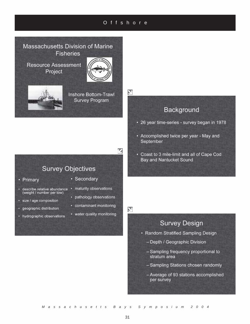
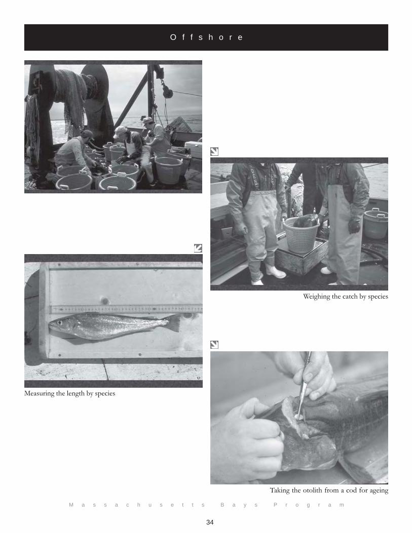
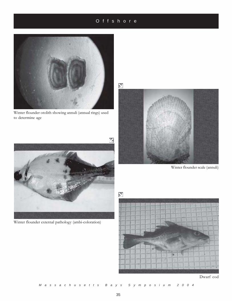
Two surveys are conducted annually. The spring survey occurs in May when many species are spawning inMassachusetts waters. This survey tracks the adult biomass indices of many species. The fall survey occurs inSeptember when many species utilize state waters as a nursery ground, thus the fall survey catch is dominated byyounger fish (ages 0 and 1). The fall survey is more useful for providing indices of year class strength for many speciesthan the spring survey. The primary objectives of the surveys are relative abundance, size/age/maturity composition,geographic distribution of finfish species, and taking hydrographic observations. Secondary objectives for the surveysinclude taking pathology observations and contaminant and water quality monitoring. The survey design is stratifiedrandom with sampling strata defined by depth and geographic region. On average, 93 stations are sampled per survey.Spring surveys average 69 species with a total catch of 15, 000 kg and 69,000 individuals per survey. Fall surveysaverage 88 species with a total catch of 28,000 kg and 23,000 individuals per survey.
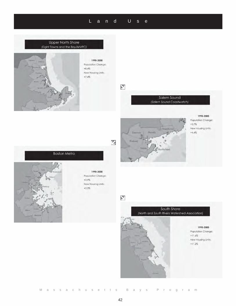
Mr. Correia discussed trends of numerous species in the survey (see following slides), and other applications for surveydata, such as providing data for defining essential fish habitat. Data from the surveys are used to develop trends inbiomass and abundance (stock assessments), evaluate potential area closures, help management decide on mesh size/minimum size restrictions, and provide geographic distributions used to define essential fish habitat.
M a s s a c h u s e t t s B a y s S y m p o s i u m 2 0 0 4
31
O f f s h o r e

M a s s a c h u s e t t s B a y s P r o g r a m
32
O f f s h o r e
Survey stratified by depth and region
Station locations
RV Gloria Michelle

M a s s a c h u s e t t s B a y s S y m p o s i u m 2 0 0 4
33
O f f s h o r e
Net being set out
Emptying cod-end on deck
Unsorted catch in the checker
Sorting the catch by species
M a s s a c h u s e t t s B a y s P r o g r a m
34
O f f s h o r e
Weighing the catch by species
Measuring the length by species
Taking the otolith from a cod for ageing
M a s s a c h u s e t t s B a y s S y m p o s i u m 2 0 0 4
35
O f f s h o r e
Winter flounder otolith showing annuli (annual rings) usedto determine age
Winter flounder scale (annuli)
Winter flounder external pathology (ambi-coloration)
Dwarf cod

M a s s a c h u s e t t s B a y s P r o g r a m
36
O f f s h o r e

M a s s a c h u s e t t s B a y s S y m p o s i u m 2 0 0 4
37
O f f s h o r e

M a s s a c h u s e t t s B a y s P r o g r a m
38
O f f s h o r e
Bubble plot—size of bubble proportional to number at age
Wolffish abundance—note decline in abundance over time
M a s s a c h u s e t t s B a y s S y m p o s i u m 2 0 0 4
39
O f f s h o r e
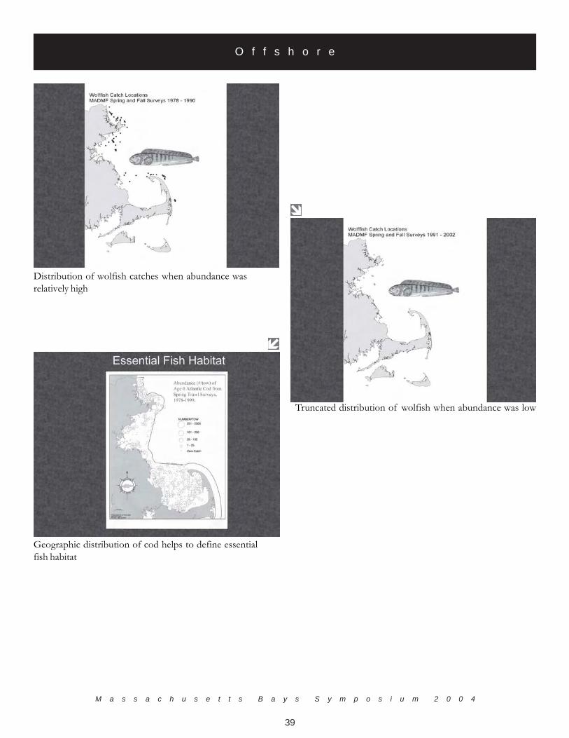
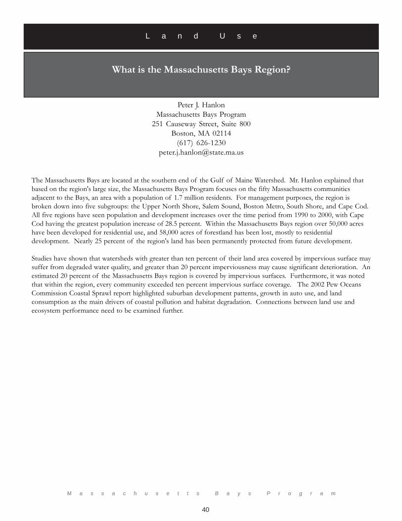
Truncated distribution of wolfish when abundance was low
Distribution of wolfish catches when abundance wasrelatively high
Geographic distribution of cod helps to define essentialfish habitat
M a s s a c h u s e t t s B a y s P r o g r a m
40
Peter J. HanlonMassachusetts Bays Program
251 Causeway Street, Suite 800Boston, MA 02114
(617) [email protected]
M a s s a c h u s e t t s B a y s P r o g r a m
What is the Massachusetts Bays Region?
The Massachusetts Bays are located at the southern end of the Gulf of Maine Watershed. Mr. Hanlon explained thatbased on the region's large size, the Massachusetts Bays Program focuses on the fifty Massachusetts communitiesadjacent to the Bays, an area with a population of 1.7 million residents. For management purposes, the region isbroken down into five subgroups: the Upper North Shore, Salem Sound, Boston Metro, South Shore, and Cape Cod.All five regions have seen population and development increases over the time period from 1990 to 2000, with CapeCod having the greatest population increase of 28.5 percent. Within the Massachusetts Bays region over 50,000 acreshave been developed for residential use, and 58,000 acres of forestland has been lost, mostly to residentialdevelopment. Nearly 25 percent of the region's land has been permanently protected from future development.
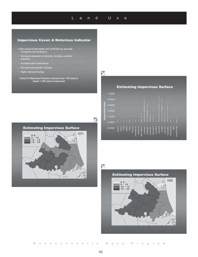
Studies have shown that watersheds with greater than ten percent of their land area covered by impervious surface maysuffer from degraded water quality, and greater than 20 percent imperviousness may cause significant deterioration. Anestimated 20 percent of the Massachusetts Bays region is covered by impervious surfaces. Furthermore, it was notedthat within the region, every community exceeded ten percent impervious surface coverage. The 2002 Pew OceansCommission Coastal Sprawl report highlighted suburban development patterns, growth in auto use, and landconsumption as the main drivers of coastal pollution and habitat degradation. Connections between land use andecosystem performance need to be examined further.
L a n d U s e

M a s s a c h u s e t t s B a y s S y m p o s i u m 2 0 0 4
41
M a s s a c h u s e t t s B a y s S y m p o s i u m 2 0 0 4
L a n d U s e
M a s s a c h u s e t t s B a y s P r o g r a m
42
L a n d U s e

M a s s a c h u s e t t s B a y s S y m p o s i u m 2 0 0 4
43
L a n d U s e

M a s s a c h u s e t t s B a y s P r o g r a m
44
L a n d U s e

M a s s a c h u s e t t s B a y s S y m p o s i u m 2 0 0 4
45
M a s s a c h u s e t t s B a y s P r o g r a m
46
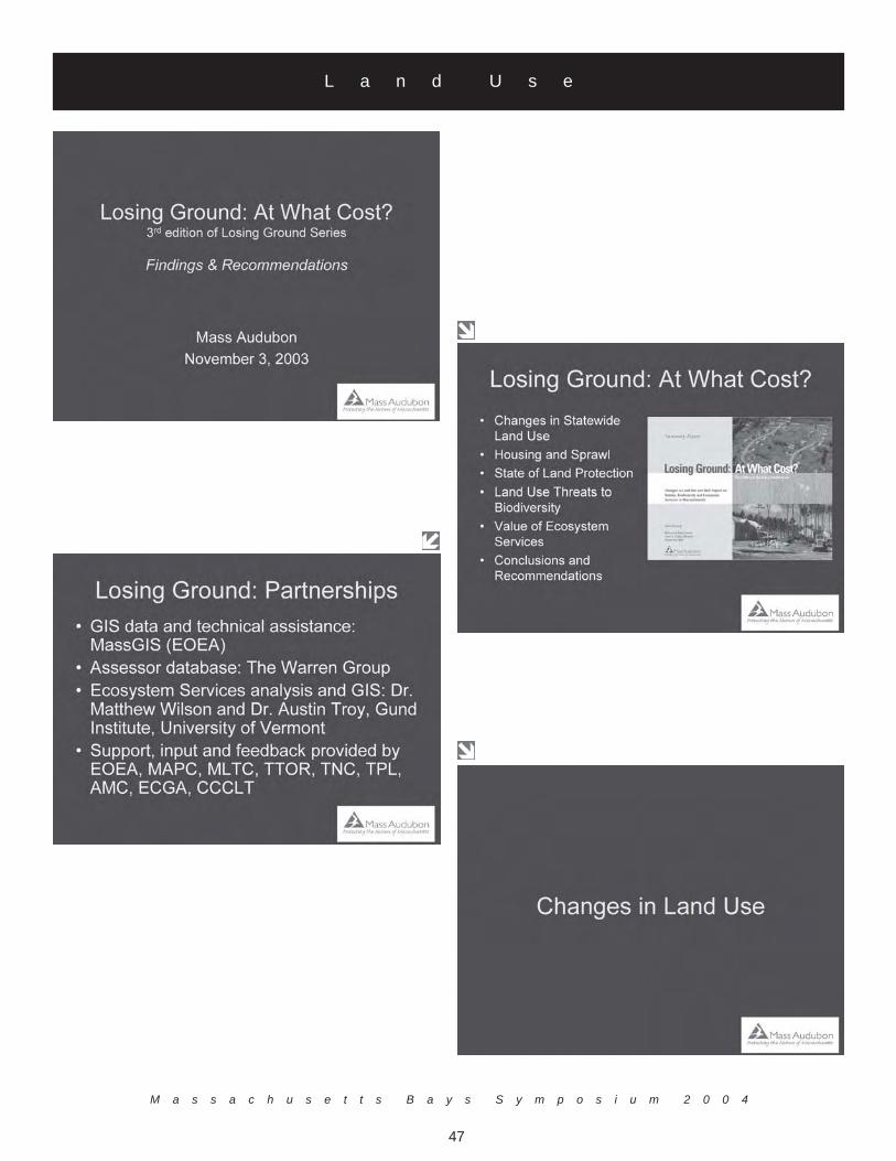
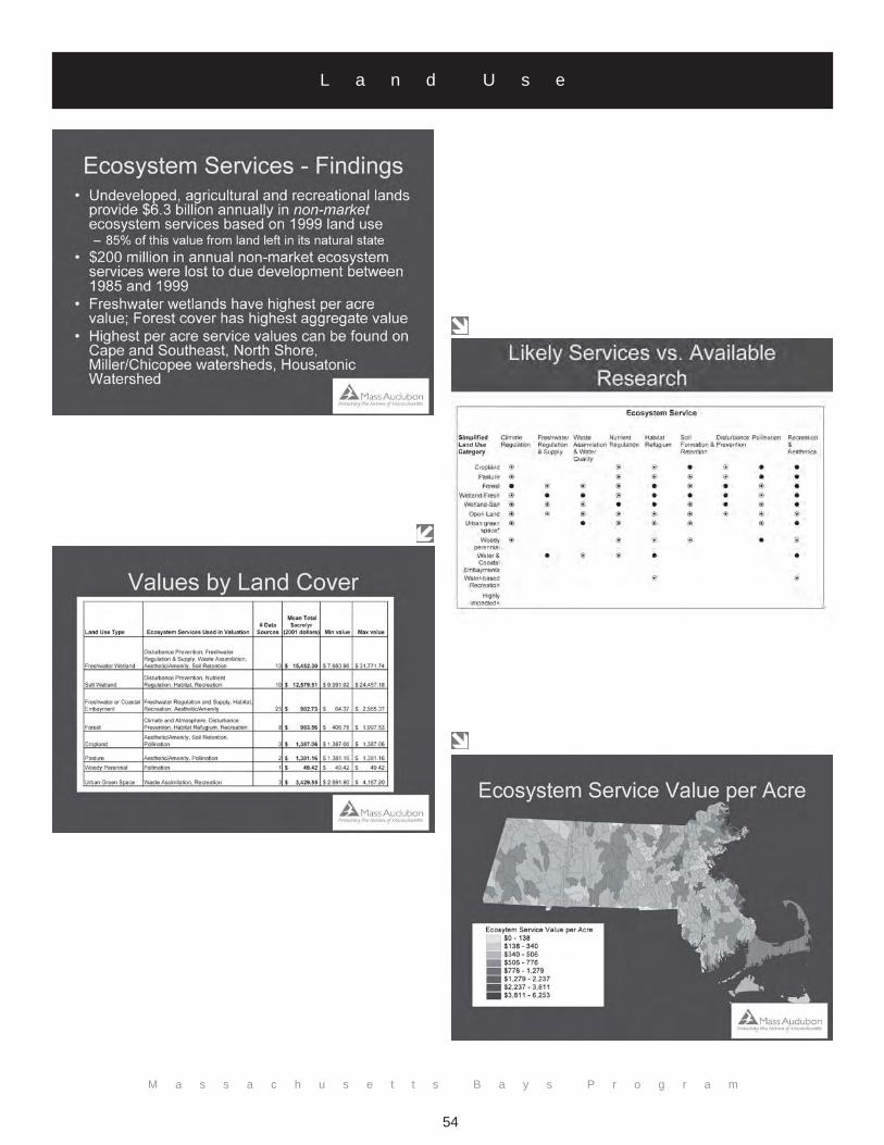
Losing Ground: At What Cost?
Jack ClarkeMassachusetts Audubon Society
208 South Great RoadLincoln, MA 01773
(781) [email protected]
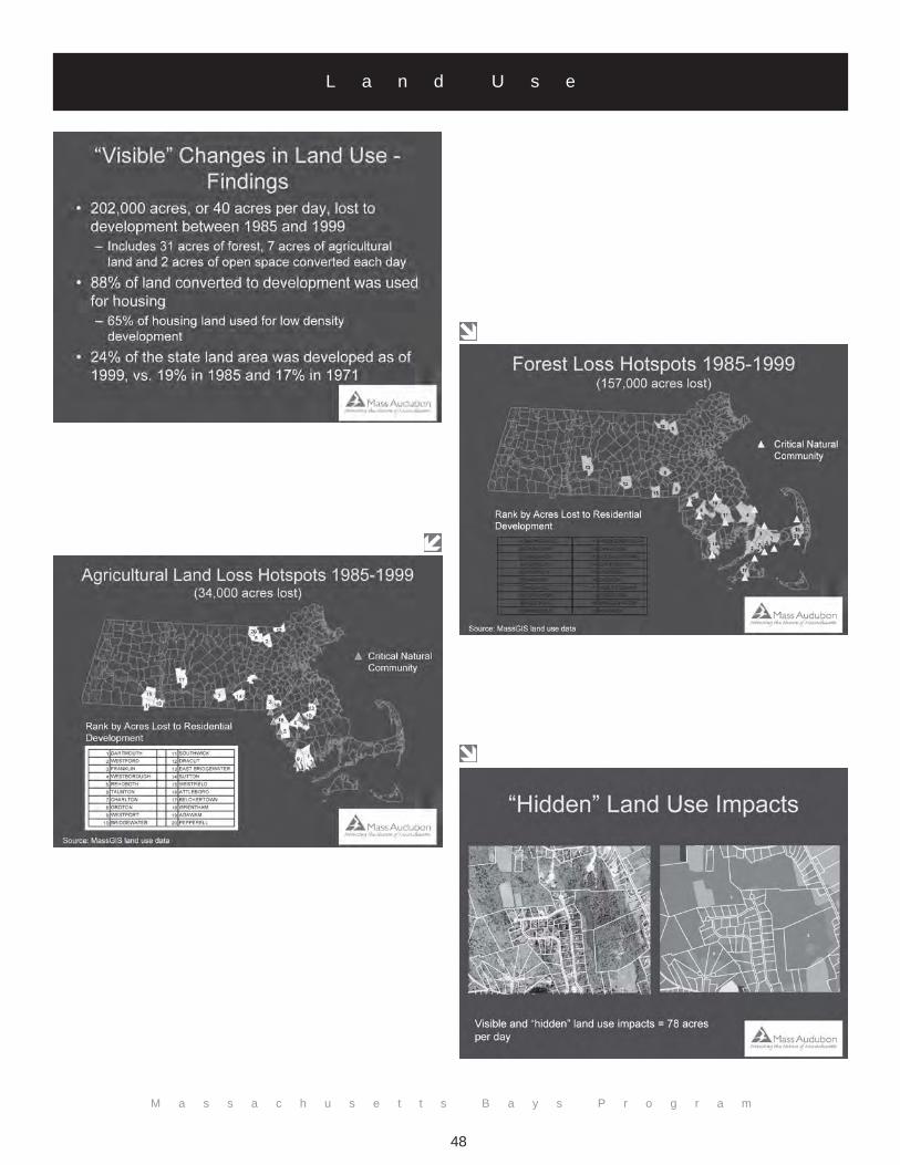
The relationship of land development with the coast is illustrated by recent growth within coastal Massachusettscommunities. According to a new Mass Audubon report, Losing Ground: At What Cost? (the latest edition in its LosingGround series), low density, large lot residential development continues to consume forest and agricultural land inecologically sensitive areas. The report is based on research into changes in land use and their impact on habitat,biodiversity, and ecosystem services in Massachusetts.
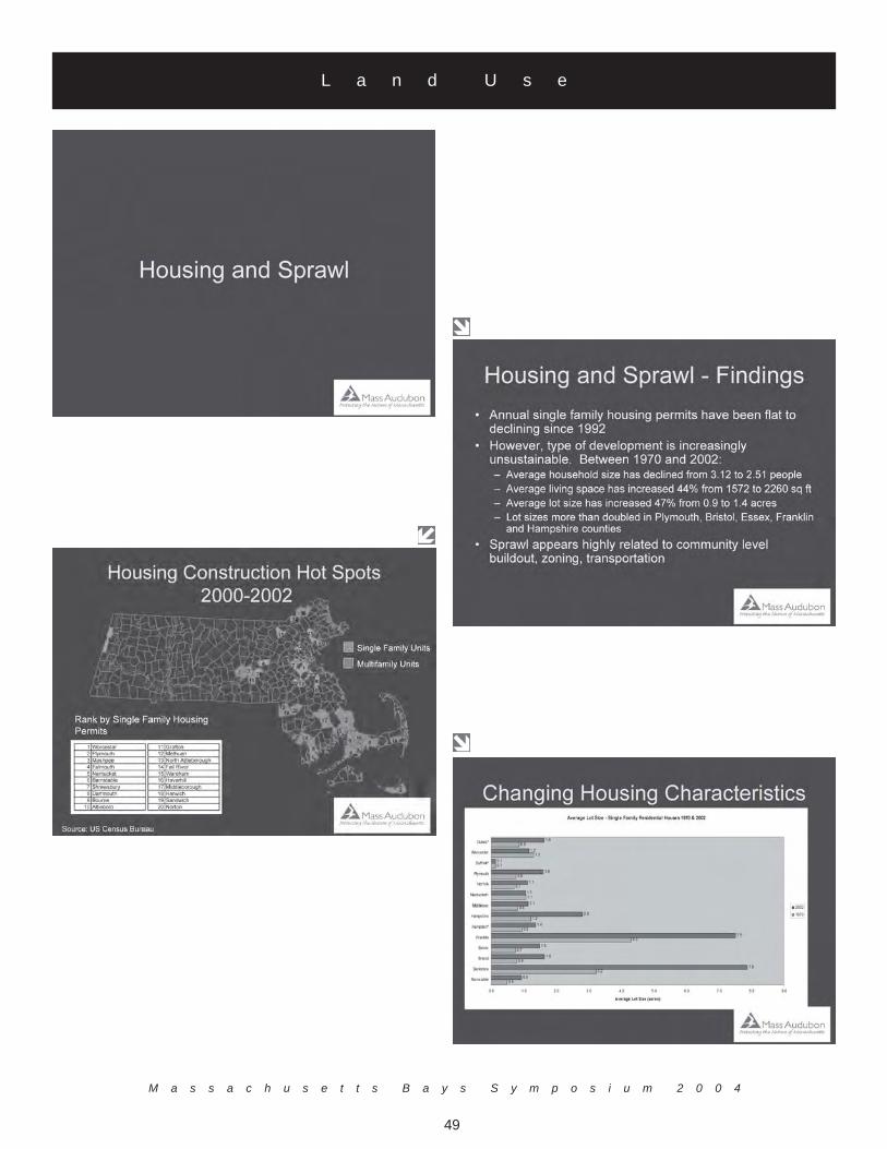
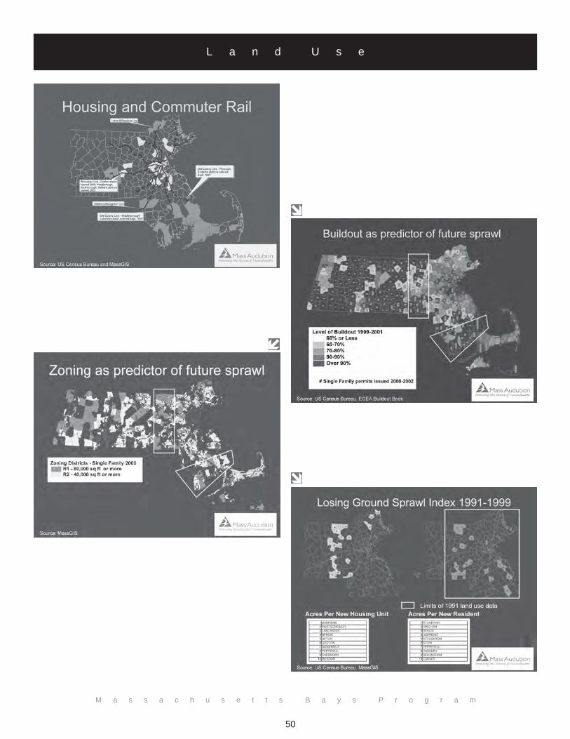
Mr. Clarke stated that while the state has seen little or no growth in single-family housing starts, residential developmentrepresents a growing proportion of land consumption. Forty acres of habitat are lost per day in Massachusetts, 88percent of which is for housing. The average living area for new homes increased 44 percent between 1970 and 2002,while average lot sizes increased 47 percent in the same period. Average lot sizes more than doubled in Plymouth,Bristol, Essex, Franklin, and Hampshire counties. Particularly inefficient land consumption involving a large number ofacres per new housing unit or new permanent resident could be seen in a “sprawl frontier” running through WorcesterCounty and north of the Cape Cod Canal. This new type of development is unsustainable.
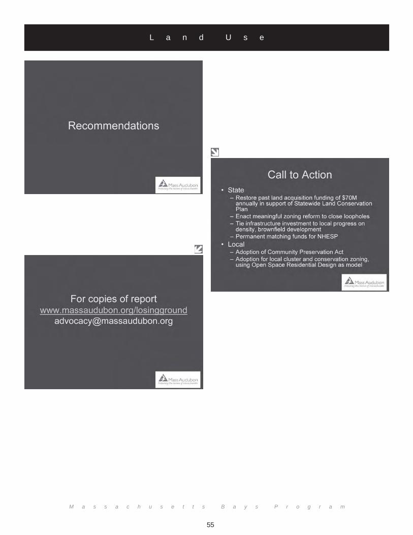
There are five million acres of land in Massachusetts; one million acres are protected and one million acres aredeveloped. This leaves three million acres open for development and Mass Audubon is calling to protect at least halfof the three million acres. The growth due to the expansion of the commuter railway system is creating a mountingneed to create a plan for housing development growth. Mr. Clarke emphasized that this is a warning to thegovernment that help with growth issues is desperately needed. The last administration in the White House budgeted$70 million dollars to deal with the growth issue, that budget has been reduced to just $18 million under the currentadministration. Mr. Clarke emphasized that it is important to focus on sustainable development, smart growth, zoningreform, and creating an infrastructure for planning for development.
L a n d U s e
M a s s a c h u s e t t s B a y s S y m p o s i u m 2 0 0 4
47
L a n d U s e
M a s s a c h u s e t t s B a y s P r o g r a m
48
L a n d U s e
M a s s a c h u s e t t s B a y s S y m p o s i u m 2 0 0 4
49
L a n d U s e
M a s s a c h u s e t t s B a y s P r o g r a m
50
L a n d U s e

M a s s a c h u s e t t s B a y s S y m p o s i u m 2 0 0 4
51
L a n d U s e

M a s s a c h u s e t t s B a y s P r o g r a m
52
L a n d U s e

M a s s a c h u s e t t s B a y s S y m p o s i u m 2 0 0 4
53
L a n d U s e
M a s s a c h u s e t t s B a y s P r o g r a m
54
L a n d U s e
M a s s a c h u s e t t s B a y s P r o g r a m
55
L a n d U s e
M a s s a c h u s e t t s B a y s P r o g r a m
56
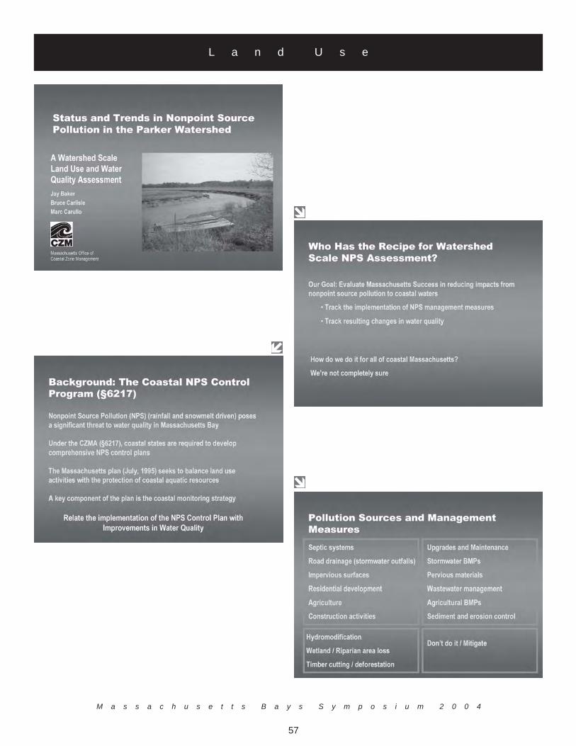
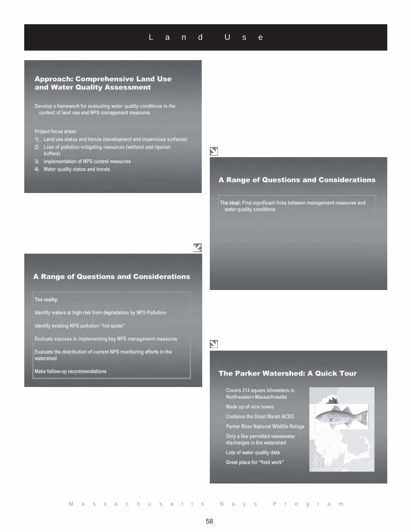
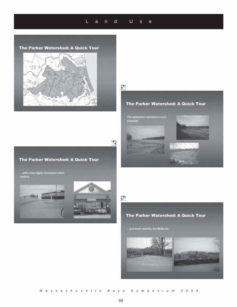
Integrating Land Use and Water Quality Data to Assess Status and Trends inNonpoint Source Pollution in the Parker Watershed
Jay BakerMassachusetts Office of Coastal Zone Management
251 Causeway Street, Suite 800Boston, MA 02114
(617) [email protected]
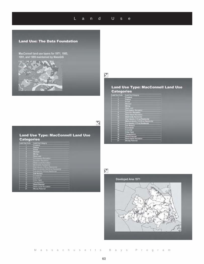
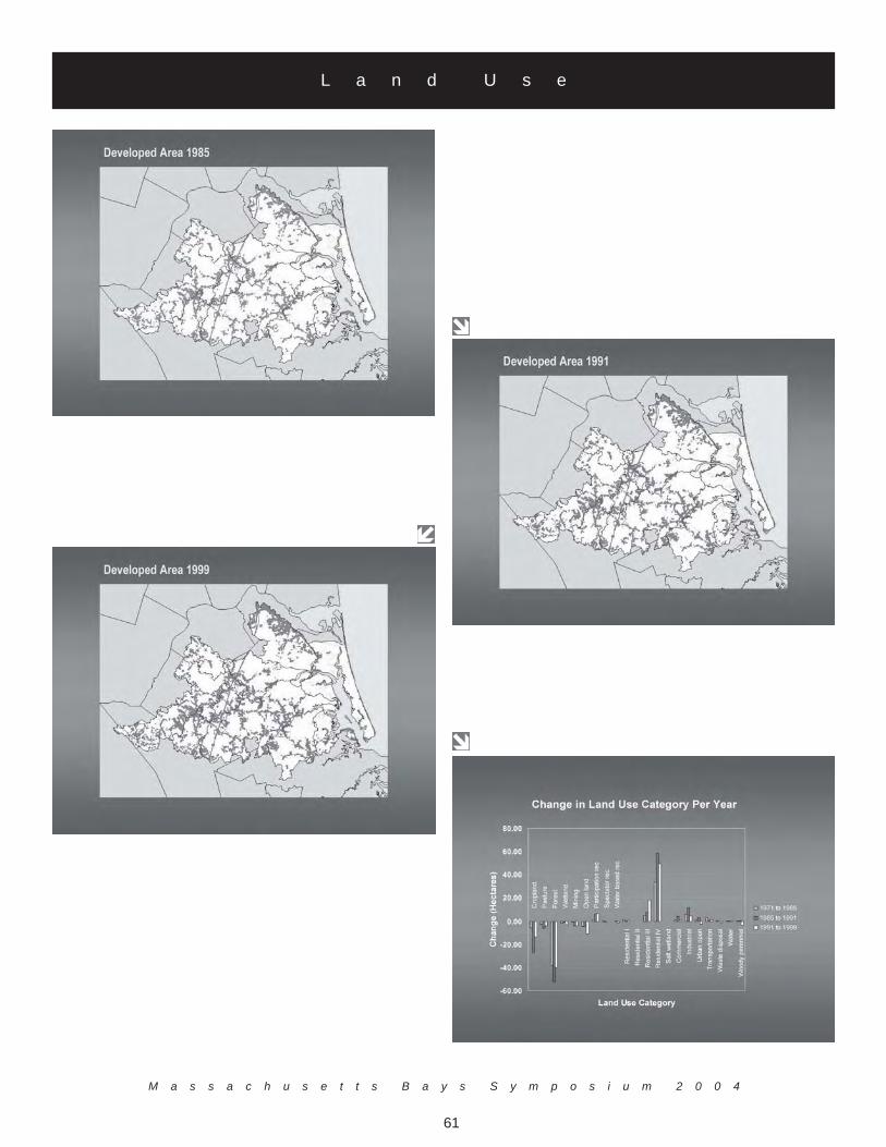
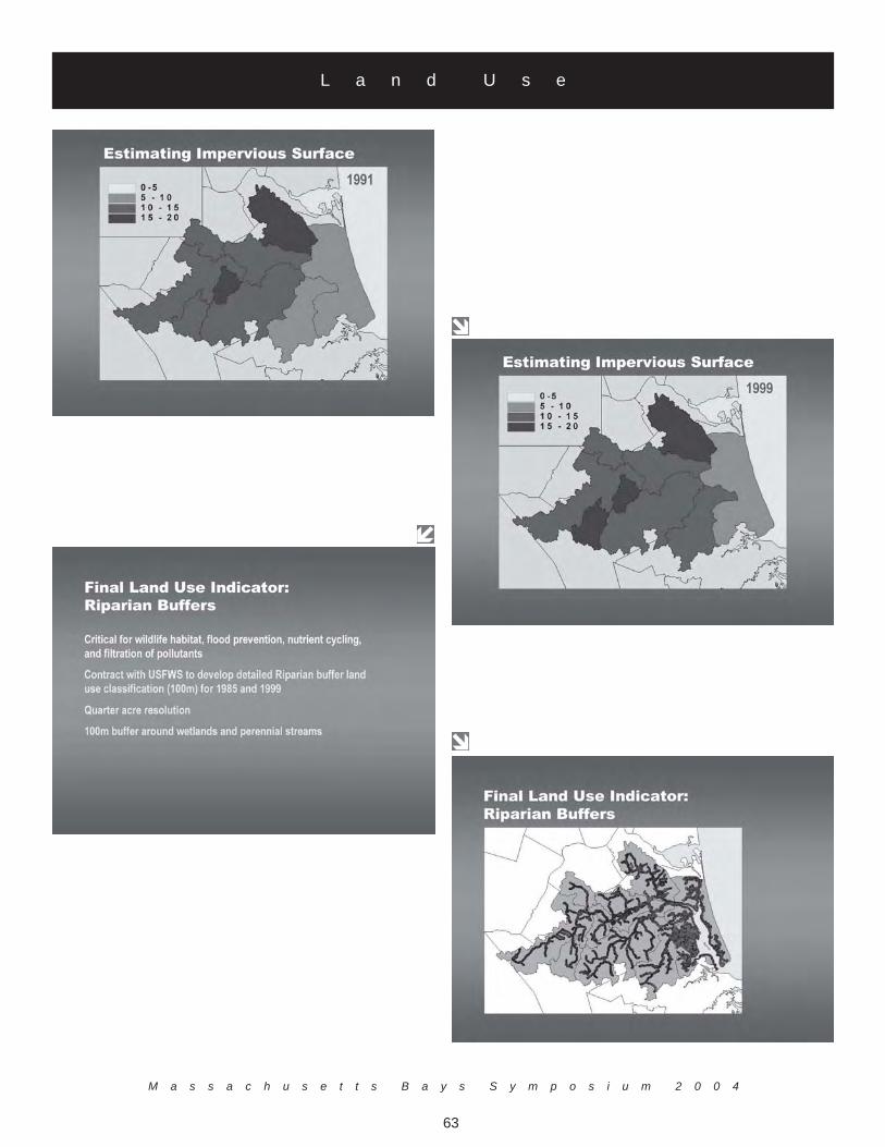
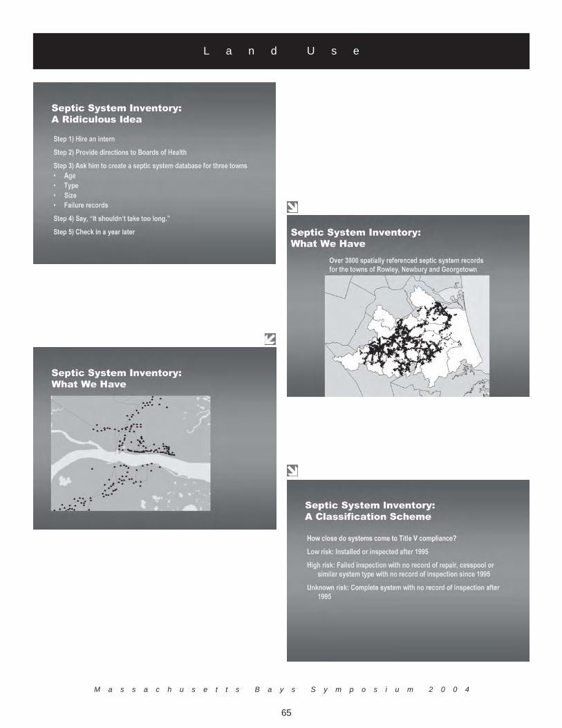
Mr. Baker discussed how land use affects water quality and how tracking long-term changes in water quality can help inthe management of nonpoint source (NPS) pollution. As part of the Massachusetts Coastal Nonpoint PollutionControl Program (1995), CZM and partner agencies have identified a suite of management measures to controlnonpoint source pollution. Control measures range from the proper maintenance of septic systems, to the protectionof riparian buffers, and include both enforceable and voluntary pollution mitigation practices. A major component ofthis program is the NPS Monitoring Strategy, which seeks to track the implementation of these management measuresand resulting changes in water quality. The difficulty in making the links between best management practices, land usepatterns, and water quality trends has led CZM to undertake a pilot monitoring project in the Parker Watershed, which isbeing used to develop a methodology to conduct comprehensive NPS assessments at the watershed scale. Mr. Baker'spresentation provided a preliminary overview of project results, including land use trends in the Parker Watershed,progress in implementing key management measures, and an overview of water quality conditions in the Parker. Projectresults have revealed a need for standardized, digital reporting of monitoring data, as well as a shared approach tomonitoring water quality changes in coastal watersheds. Two important land use characteristics were incorporated intothe analysis, impervious cover and riparian buffers. Impervious cover limits the amount of stormwater and runoff thatcan percolate through the soil resulting in decreased adsorption of nutrients, microbes, and other pollutants, increasedwater temperatures of local water bodies, decreased groundwater recharge, and higher intensity flooding. Riparianbuffers are critical for wildlife habitat, flood prevention, nutrient cycling, and filtration of pollutants. Additional NPSindicators were also identified, including the type, age and location of septic systems, stormwater outfalls, and agricul-tural operations.
Based on the analysis, the study was able to show general relationships between poor water quality (elevated levels offecal coliform and lowered dissolved oxygen), increasing impervious surface and development, and loss of riparianbuffers: The study was also able to identify water quality "hot spots" and their relationship to changes in land use overtime.
The results of the project relate to the Massachusetts Bays in many instances. The study suggests that even the mostpristine watersheds, such as the Parker, are seeing water quality impairments as a result of development practices. Also,over the past 20 years, there has been a disproportionate level of development within riparian buffers. Further, it is verydifficult to gain a complete understanding of pollution mitigation efforts and overall water quality as a result of thedisparate methods used for collecting and storing water quality and management measure information, suggesting thatan effort should be made to develop more standardized methods and digital tools for conducting watershed andsubwatershed scale assessments.
L a n d U s e
M a s s a c h u s e t t s B a y s S y m p o s i u m 2 0 0 4
57
L a n d U s e
M a s s a c h u s e t t s B a y s P r o g r a m
58
L a n d U s e
M a s s a c h u s e t t s B a y s S y m p o s i u m 2 0 0 4
59
L a n d U s e
M a s s a c h u s e t t s B a y s P r o g r a m
60
L a n d U s e
M a s s a c h u s e t t s B a y s S y m p o s i u m 2 0 0 4
61
L a n d U s e
M a s s a c h u s e t t s B a y s P r o g r a m
62
L a n d U s e
M a s s a c h u s e t t s B a y s S y m p o s i u m 2 0 0 4
63
L a n d U s e

M a s s a c h u s e t t s B a y s P r o g r a m
64
L a n d U s e
M a s s a c h u s e t t s B a y s S y m p o s i u m 2 0 0 4
65
L a n d U s e

M a s s a c h u s e t t s B a y s P r o g r a m
66
L a n d U s e

M a s s a c h u s e t t s B a y s S y m p o s i u m 2 0 0 4
67
L a n d U s e

M a s s a c h u s e t t s B a y s P r o g r a m
68
L a n d U s e

M a s s a c h u s e t t s B a y s S y m p o s i u m 2 0 0 4
69
L a n d U s e
M a s s a c h u s e t t s B a y s P r o g r a m
70
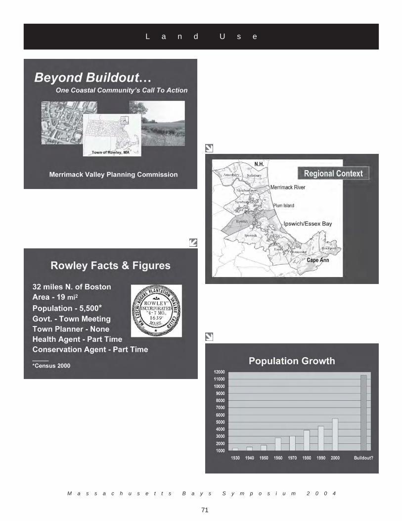
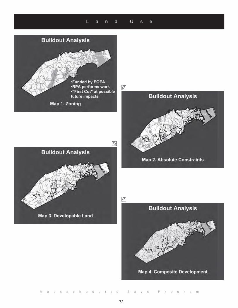
Beyond Buildout: One Coastal Community's Call to Action
Alan Macintosh and Jerrard Whitten Merrimack Valley Planning Commission
160 Main StreetHaverhill, MA 01830
(978) [email protected] and [email protected]
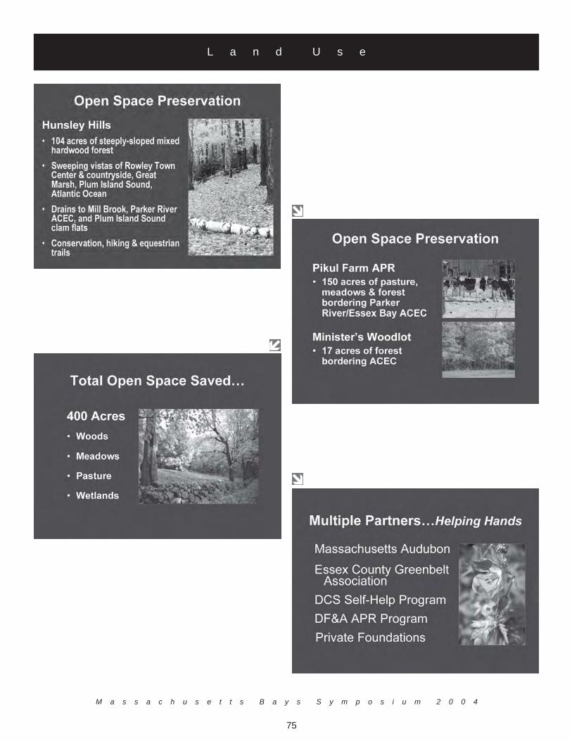
The Massachusetts Executive Office of Environmental Affairs (EOEA) and the Merrimack Valley PlanningCommission (MVPC) recently estimated the future land use and environmental impacts of current zoning and otherlocal control measures of the town of Rowley, MA, through a buildout analysis process. In response to the buildoutforecast, Rowley officials and residents have taken a number of positive actions, including but not limited to:preparation of a town-wide master plan; adoption of a Green Neighborhoods-style open space residential developmentbylaw (with built-in developer incentives); adoption of the Community Preservation Act; adoption of a local wetlandsprotection bylaw; acquisition and preservation of several key watershed parcels; development and implementation of aseptic data management system (in progress); and identification and mapping of stormwater pollution “hotspots.”
The Rowley Master Plan examined key community issues/challenges and developed action strategies aimed at bettermanaging land use and urban sprawl, diversifying the local economy, preserving community character, and protectingthe environment. The plan embraced principles of smart growth and sustainable development, and integrated theseprinciples into the action recommendations. The Open Space Residential Development Bylaw established a creativeland development option as an alternative to conventional subdivision design. Key bylaw provisions include aninteractive process between town boards and prospective developers, preserving at least 50 percent of a site as openspace, protecting unique or fragile habitats, lowering site development costs, decreasing infrastructure maintenancecosts, enhancing community character and sense of “neighborhood”, and providing opportunities for trails and otherpublic amenities. One tangible measure of success from these initiatives has been the preservation of 400 acres ofprime open space, including mixed forest, meadows, pasture, and wetlands.
The Local Wetlands Bylaw and accompanying regulations afford greater protection to Rowley’s expansive coastal andinland wetlands. Key bylaw provisions include stricter performance standards within buffer zones, heightenedprotection for vernal pools, and a higher fee structure to support Conservation Commission enforcement activities. Auser-friendly, Access-based Septic Data Management System, developed by MVPC and CZM for the Rowley Board ofHealth, will enhance the town’s capacity to record, retrieve, query, analyze, and update key Title 5 septic systeminformation.
In the face of mounting development pressure along the coast (and the adverse impacts that typically ensue), Mr.Macintosh explained that communities are not powerless. Through timely, focused action, communities can anticipateand avert unwanted impacts and help to shape a future that is in keeping with the residents’ shared community vision.Rowley, a small but rapidly growing coastal community with limited personnel and financial resources, is an example ofwhat can be accomplished when a few dedicated people decide to make a difference. Their experience can serve toinspire and galvanize other communities into positive action.
L a n d U s e
M a s s a c h u s e t t s B a y s S y m p o s i u m 2 0 0 4
71
L a n d U s e
M a s s a c h u s e t t s B a y s P r o g r a m
72
L a n d U s e

M a s s a c h u s e t t s B a y s S y m p o s i u m 2 0 0 4
73
L a n d U s e

M a s s a c h u s e t t s B a y s P r o g r a m
74
L a n d U s e
M a s s a c h u s e t t s B a y s S y m p o s i u m 2 0 0 4
75
L a n d U s e

M a s s a c h u s e t t s B a y s P r o g r a m
76
L a n d U s e

M a s s a c h u s e t t s B a y s S y m p o s i u m 2 0 0 4
77
L a n d U s e

M a s s a c h u s e t t s B a y s P r o g r a m
78
Linking Management of Our Offshore Waters with Land Use
Dr. Carlton Hunt, Battelle (moderator)Dr. Joe Costa, The Buzzards Bays Project
Dr. Dennis Ducsik, Massachusetts Office of Coastal Zone ManagementVivien Li, The Boston Harbor Association
Jack Wiggin, Urban Harbors Institute
Following the first day of sessions, the first panel discussion of the workshop was held. This panel wasaimed at responding to the questions "Can we link the discussion of managing offshore waters and land use?Have we tried to make the link, and how successful have we been?" The format of the panel involved briefresponses to the question by the members and then group discussions.
Mr. Jack Wiggin.Mr. Wiggin stated that the linkage has been made between managing offshore waters and land use. Over thelast decade, the linkage has manifested and there is a strong basis for stating that what takes place on theland does affect the water. These linkages have helped to create the Water Shore Initiative. One issue thatwas identified was that municipalities have been limited in focus to land use changes.
Dr. Joe Costa.Dr. Costa stated that many other groups are also doing similar work and are trying to make the same linkage.He stated that the Buzzards Bay Project has an ecosystem where it is easier to make the case than theMassachusetts Bays Program. That is, Buzzards Bay has warmer water and shallower depths, and land-basednitrogen inputs have been clearly linked to coastal water degradation, such as loss of eelgrass. Stormwaterclosures are also the principal cause of shellfish bed closures. The science is getting better and is helping toidentify management strategies. The management of stormwater has led to less shellfish closures due to highfecal coliform counts. More effort is needed, especially to manage impervious surfaces, and to implementstate and local control to manage nitrogen. In the next 10 years, there will be lots of challenges, and theEPA is becoming tougher on requiring action. To receive grants, it is increasingly important to have aWatershed Management Plan in place. In the past, the NEP Comprehensive Conservation and ManagementPlans would qualify but this will no longer be the case. Each town will now need to develop new bayspecific Watershed Management Plans to justify funding. Certainly there are linkages between offshorewaters and land use, but the real challenge is developing and implementing management plans to achieveenvironmental benefits.
Dr. Dennis Ducsik.Dr. Ducsik indicted that considerable reduction of stormwater flows to waterways could be achievedthrough "retrofit" measures at the household level, and drew a parallel with advances made in reducing homeenergy consumption. He emphasized that the focus of stormwater mitigation is usually on new develop-ment projects with little attention to existing individual structures. In this regard, fairly simple measurescould be implemented to attain 20 to 30 percent reduction in most cases, and as much as a 50 to 70 percentreduction in many others. Dr. Ducsik acknowledged that generally people know that they should conservewater but progress needs to be made in raising a parallel awareness of the need for stormwater conservation.
M a n a g e m e n t P a n e l I
M a s s a c h u s e t t s B a y s S y m p o s i u m 2 0 0 4
79
There is already strong evidence and data to support stormwater conservation but a grassroots educationcampaign is still lacking. A key question is: how can we create incentives for this type of conservation, sinceat present stormwater "disposal" is essentially free to the individual property owner.
Ms. Vivien Li.Ms. Li began with a discussion on the recent Boston Conservation Commission Meeting about the proposednew runway at Logan Airport. She stated that there are no environmental laws or practices that are in placefor the airport. However, each individual airline has the responsibility to have practices in place. The largerdevelopment of a new runway needs to be reviewed and should mirror other development growth in towns.
Management Panel I - Discussion.Following the responses to the above question the Management Panel addressed questions and commentsfrom the group.
How do you manage the system as a holistic approach?The panel responded with many answers including that in 1992 Mass Port applied for NPDES permits andthe permits have still not been updated. The process of applying and receiving permits takes too long.Whether the development is large or small, permits should be in place to manage water quality. There arenew rules by the EPA for NPDES permits, Phase One and Phase Two. Anyone who develops five acres ofland must have a stormwater plan. This year, however, even if one acre of land is going to be developed astormwater plan must be in place. The compliance rate for these construction permits is probably only onepercent and compliance for "industrial" sites, including marinas may only be 15 to 20 percent. There arerequirements to manage stormwater on the books for the marinas and other sites, but there is little effort toenforce compliance with the program. Some developers submit the required paperwork but there is littlereview of the stormwater management plans. Individual towns are doing better on their municipalstormwater plans, and the state works more closely with municipalities. At this time, EPA managesstormwater from the top down, with increasing burden placed on the local governments. Stormwater man-agement costs towns money to enforce but they lack the necessary staff or funding to effectively implementthese programs.
Discussion continued further on the issue of permitting. Municipal Conservation Commissions have theauthority to issue state wetland permits. They can also adopt more stringent local wetlands bylaw, and eveninclude provisions for a fee to have engineers review permit applications. However, in many cases municipalofficials need to more carefully read and implement their local regulationsif they wish to make projects moreenvironmentally sound. Local officials and the public must recognize that regulations are not created asobstacles to kill projects but rather to make them more environmentally acceptable and to incorporateenvironmentally sustainable measures into practice.
M a n a g e m e n t P a n e l I

M a s s a c h u s e t t s B a y s P r o g r a m
80
Where does a local person go to find out about regulations?The response from the panel was that at the municipal planning staff may not have the time or capacity toconduct a detailed review or update of their regulations. Regional planning agencies can help municipalboards with such efforts, but are underutilized.
What is the land interface to regional monitoring?The panels' response was that there are various groups undertaking regional monitoring, not just the munici-palities. These programs may be collecting large amounts of data to answer more regional questions. Theseefforts should be expanded to address broader ocean impacts to evaluate stressors from the land. The OceanCommission Report highlighted the need for NEPs to promote watershed management beyond municipalboundaries.
The real challenge for monitoring programs is managing the information and translating it into implementa-tion actions to address the many issues involved. The emerging smart growth agenda should be embraced asthe focus for the future. For example, municipal Department of Public Works (DPWs) can be a part of theproblem and the solution. In Worcester, the DPW runs the water utilities and is a proactive agency. Thiscan be effective because DPWs are closer to the homeowner and can help focus the public on stormwaterrunoff issues and water conservation issues, as well as disseminate this information to the public.
Automobile traffic volume has increased four percent with the rate of population growth, is the increase of traffic increasingwater quality affects?The panel response stated that waterfront development should include green space as part of its requiredopen space area. However, even where such regulations are adopted, loopholes may exist where for ex-ample, paved surfaces might be considered open space. It is desirable for new development to keep 50percent (or more) of the land as open space but parking lots certainly need to be differentiated from greenspaces. It was also added that sprawl development is tied to traffic increase and that better transportationalternatives need to be incorporated into society. One suggestion offered was a gasoline tax to make trans-port expensive, but others do not see this as an effective solution. Currently most stormwater runoff oftenenters marine water directly without treatment. Part of the solution is to store more stormwater runoff sothat it can be cleaned by stormwater treatment system. In Rockport, MA, areas of salt marsh were beingsmothered by sediments from stormwater discharge, but controls were put in place treating the runoffreducing sediment discharges to the marshes.
If it is important to link the grassroots level to the system, how do you deal with watershed, stormwater, and sewer systems?The answer from the panel was that smart growth has to be from the bottom up, not from the state down. Asolution might be to change regulations so that hurdles to environmentally-responsible development are notthere and at the same time encourage smart growth principles such as smaller streets and no curbs whichcould both save developers money and be good for the environment. If the state changes its thinking on itsstormwater regulations and policies, the local governments will follow. At the local level, thinking needs tobe more creative. To be successful we must understand local regulations and recognize that the hardest partof implementation is often the political process. Cities and towns will need to be more proactive, rather thanreactive to achieve environmental improvements in the long-term.
M a n a g e m e n t P a n e l I

M a s s a c h u s e t t s B a y s S y m p o s i u m 2 0 0 4
81
D a y T w oMay 7, 2004
M a s s a c h u s e t t s B a y s P r o g r a m
82
I n t r o d u c t i o n
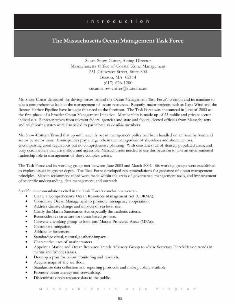
Ms. Snow-Cotter discussed the driving forces behind the Ocean Management Task Force’s creation and its mandate totake a comprehensive look at the management of ocean resources. Recently, major projects such as Cape Wind and theBoston Harbor Pipeline have brought this need to the forefront. The Task Force was announced in June of 2003 asthe first phase of a broader Ocean Management Initiative. Membership is made up of 23 public and private sectorindividuals. Representatives from relevant federal agencies and state and federal elected officials from Massachusettsand neighboring states were also asked to participate as ex-officio members.
Ms. Snow-Cotter affirmed that up until recently ocean management policy had been handled on an issue by issue andsector by sector basis. Municipalities play a large role in the management of shorelines and shoreline uses,encompassing good regulations but no comprehensive planning. With coastlines full of densely populated areas, andbusy ocean waters that are shallow and accessible, Massachusetts needed to use this occasion to take an environmentalleadership role in management of these complex waters.
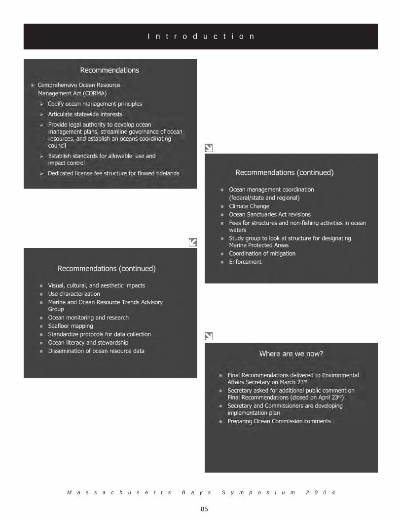
The Task Force and its working group met between June 2003 and March 2004. Six working groups were establishedto explore issues in greater depth. The Task Force developed recommendations for guidance of ocean managementprinciples. Sixteen recommendations were made within the areas of governance, management tools, and improvementof scientific understanding, data management, and outreach.
Specific recommendations cited in the Task Force’s conclusions were to:• Create a Comprehensive Ocean Resources Management Act (CORMA).• Coordinate Ocean Management to promote interagency cooperation.• Address climate change and impacts of sea level rise.• Clarify the Marine Sanctuaries Act, especially the aesthetic criteria.• Reconsider fee structure for ocean-based projects.• Convene a working group to look into Marine Protected Areas (MPAs).• Coordinate mitigation.• Address enforcement.• Standardize visual, cultural, aesthetic impacts.• Characterize uses of marine waters.• Appoint a Marine and Ocean Resource Trends Advisory Group to advise Secretary Herzfelder on trends in
marine and fisheries issues.• Develop a plan for ocean monitoring and research.• Acquire maps of the sea floor.• Standardize data collection and reporting protocols and make publicly available.• Promote ocean literacy and stewardship.• Disseminate ocean resource data to the public.
Susan Snow-Cotter, Acting DirectorMassachusetts Office of Coastal Zone Management
251 Causeway Street, Suite 800Boston, MA 02114
(617) [email protected]
The Massachusetts Ocean Management Task Force
M a s s a c h u s e t t s B a y s S y m p o s i u m 2 0 0 4
83
I n t r o d u c t i o n
M a s s a c h u s e t t s B a y s P r o g r a m
84
I n t r o d u c t i o n169 Waterman Street, Providence, RI 02906(401) 455-0761
M a s s a c h u s e t t s B a y s S y m p o s i u m 2 0 0 4
85
I n t r o d u c t i o n

M a s s a c h u s e t t s B a y s P r o g r a m
I n t r o d u c t i o n

M a s s a c h u s e t t s B a y s S y m p o s i u m 2 0 0 4
87
I n t r o d u c t i o n
M a s s a c h u s e t t s B a y s P r o g r a m
88
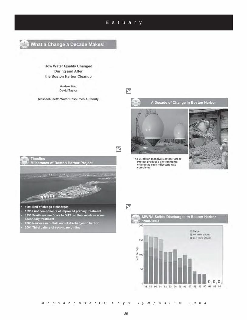
Boston Harbor: What a Change a Decade Makes
Dr. Andrea Rex and Mr. David TaylorMassachusetts Water Resources Authority
Charlestown Navy Yard100 First Ave
Boston, MA 02129(617) 788-1170
[email protected] and [email protected]
1992 marked the first year that discharges to Boston Harbor significantly decreased; MWRA's Boston HarborProject ended discharges of solid waste sludge from greater Boston's sewage to Boston Harbor. Instead, thesludge was processed into fertilizer. By 1998, when the failing Nut Island Treatment Plant in Quincy wasclosed down, MWRA was treating most of the wastewater to secondary standards. In September 2000,treatment plant discharges to the harbor ended with the start-up of the ocean outfall diffuser in westernMassachusetts Bay. Simultaneously with the construction of new sewage treatment facilities, MWRA hasbeen planning and constructing projects to control combined sewer overflows (CSOs). Of 25 CSO projects,costing $645 million, fourteen have been completed, and six more are under construction. By the comple-tion of these projects in 2011, 95 percent of the CSO discharge will be treated.
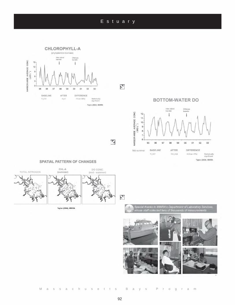
MWRA bacteria monitoring (161 stations and more than 40,000 samples collected since 1987) shows howthe waters of the harbor have responded to these changes. Average (geometric mean) Enterococus countsdecreased markedly from 1987 to 2003. One highly visible change in Boston Harbor is that most areas, eventhose formerly chronically polluted, are now considered safe for swimming. Dr. Taylor noted that a statisti-cally significant (about 30 percent) reduction in the amount of nitrogen has been observed in the harbor.Summer chlorophyll decreased by approximately 35 percent and summer bottom dissolved oxygen increasednearly 10 percent after September 2000, when harbor discharges ended.
E s t u a r y
M a s s a c h u s e t t s B a y s S y m p o s i u m 2 0 0 4
89
E s t u a r y

M a s s a c h u s e t t s B a y s P r o g r a m
90
E s t u a r y

M a s s a c h u s e t t s B a y s S y m p o s i u m 2 0 0 4
91
E s t u a r y
M a s s a c h u s e t t s B a y s P r o g r a m
92
E s t u a r y

M a s s a c h u s e t t s B a y s S y m p o s i u m 2 0 0 4
93
E s t u a r y

M a s s a c h u s e t t s B a y s P r o g r a m
94
Coastal Wetland Assessment and Restoration in Massachusetts:
Bruce CarlisleMassachusetts Office of Coastal Zone Management
251 Causeway Street, Suite 800Boston, MA 02114
(617) [email protected]
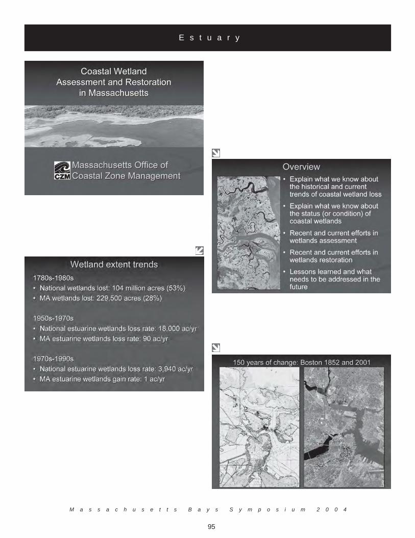
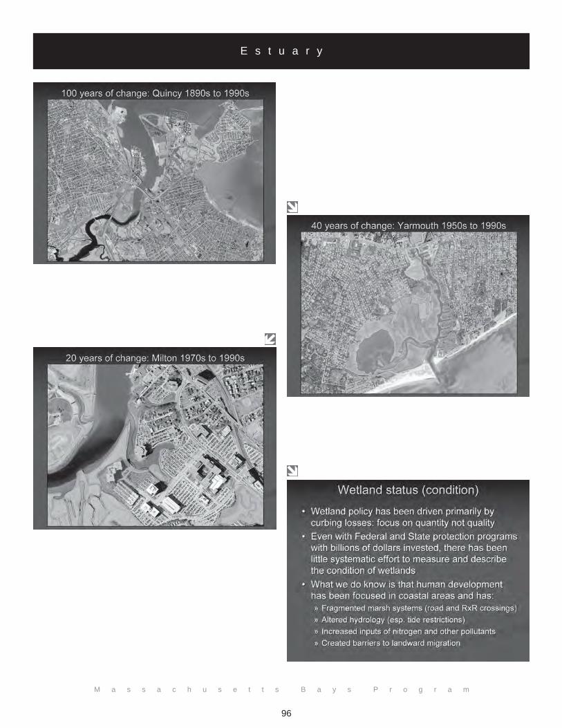
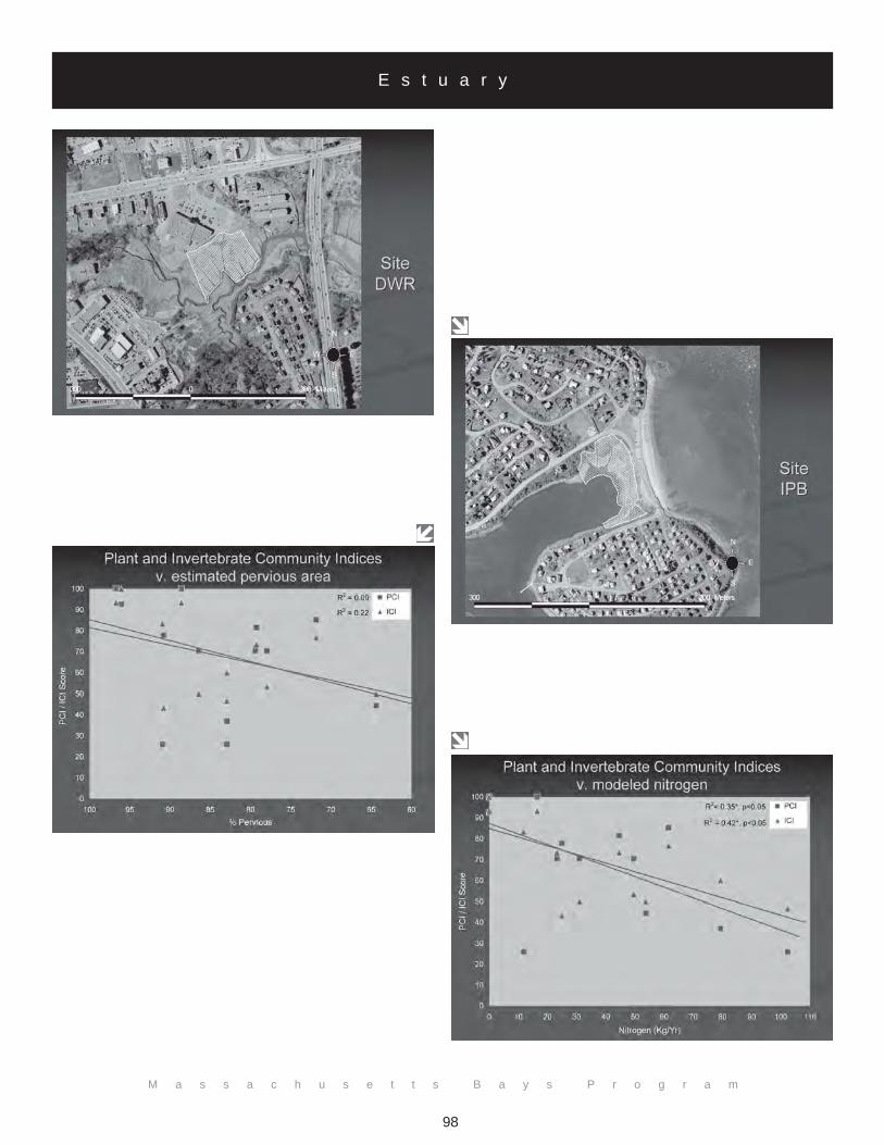
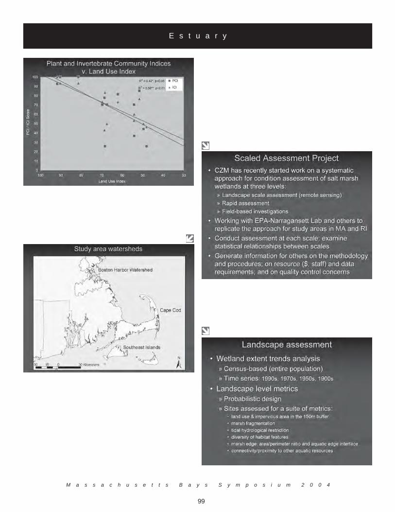
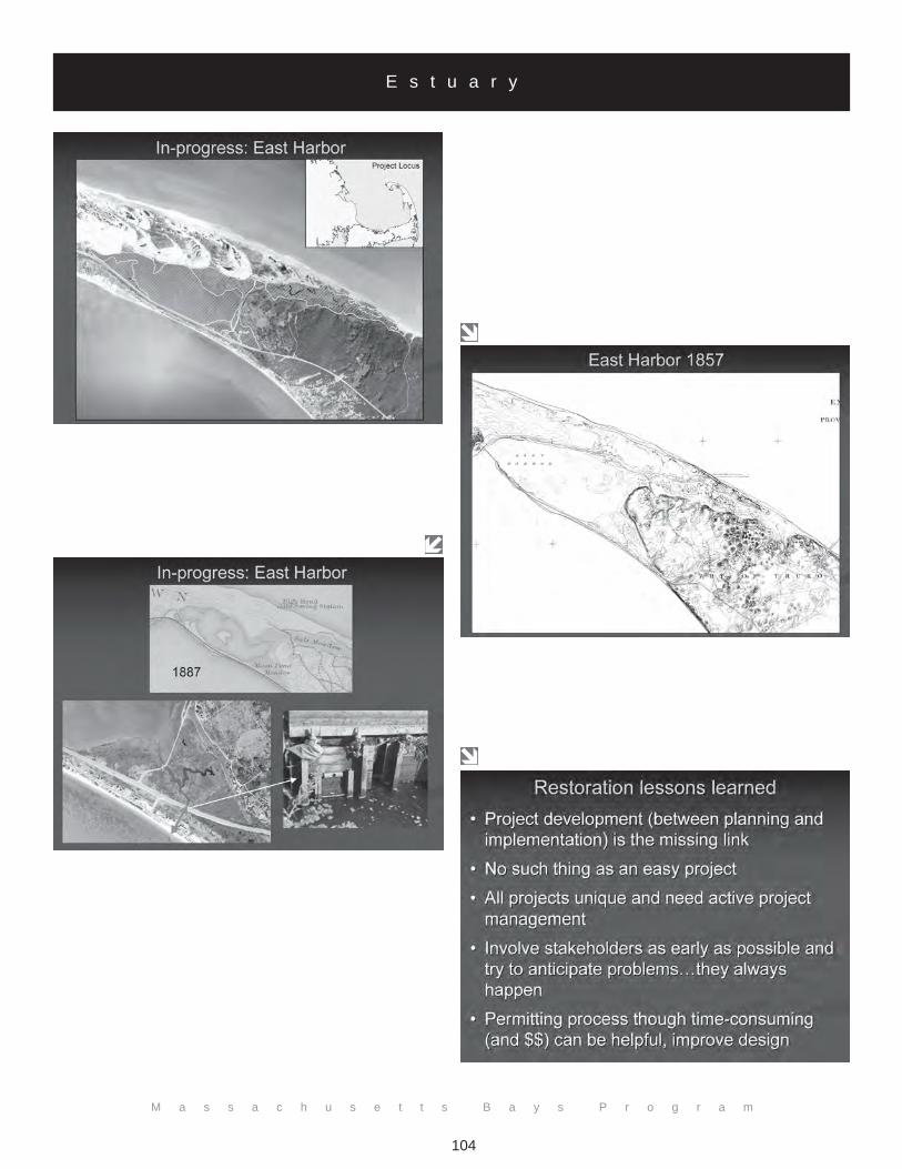
Wetlands have been particularly susceptible to destruction and degradation from direct and indirect human activities,especially estuarine marshes. Since the colonial era and through the 1950s, Massachusetts has suffered significant lossesof estuarine wetlands, mostly due to urbanization. Rates of loss have slowed over the past 20 years, but human distur-bance continues to adversely affect habitat quality, causing shifts in marsh community structure and function. Through itsWetlands Assessment and Wetlands Restoration Programs, the Massachusetts Office of Coastal Zone Management isworking with a host of partners to address historic losses and ongoing degradation. The history of National wetlandpolicy typically focused on quantity rather than quality. Over a 200-year window, 30 percent of wetlands have been lostin Massachusetts. Wetlands are important because they are the interface between land and water. Despite strongFederal and state wetlands programs and billions of dollars of public investment in wetland protection, there has beenlittle systematic effort to measure and describe the condition of wetlands. Consequently, little is known about thecondition or health of wetlands. For example, in a recent National Water Inventory Report, condition was reported foronly four percent of the Nations' wetlands; only a small fraction of this assessment was derived from actual data, mostwas professional judgment.
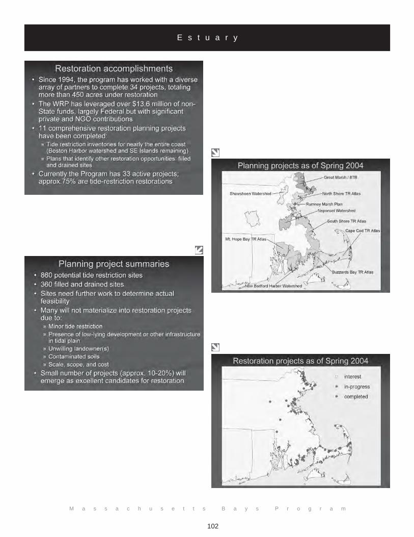
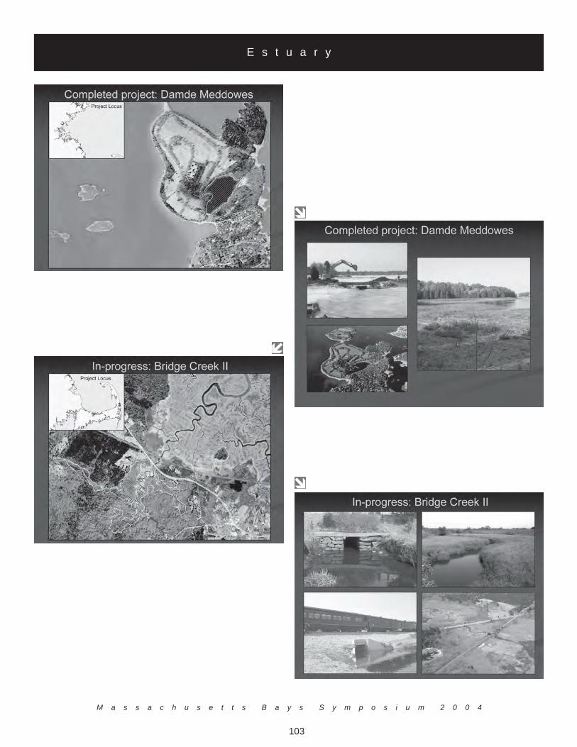
The Wetland Assessment Program's goal is to develop techniques to assess the quality of coastal wetlands in order toidentify wetland condition, inventory sites, evaluate restoration potential and monitor restoration response. The Wet-lands Restoration Program works proactively within a network of public agencies and private partners for funding andcoordination assistance. Mr. Carlisle described how the Wetlands Restoration Program helps to coordinate potentialprojects for restoration. He noted that many wetlands are in need of restoration but that many sites are not suitable forprojects at this time based on their size or quality.
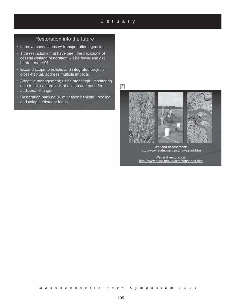
Mr. Carlisle identified several needs for the future of wetland restoration. For one, there is a need to improve connec-tions with transportation agencies in order to get at opportunities associated with infrastructure work being planned.Second, although tidal restoration projects have been the backbone of much of wetlands restoration, these types ofprojects are getting fewer, harder, and more expensive. Furthermore, there is strong need to work to expand the scopeof wetlands restoration to holistic and integrated projects, such as cross-habitats and addressing multiple impacts.Additionally, adaptive management should be more regularly practiced; as a concept and principle it is widely discussed,but in reality it is underused. This type of iterative management involves acquiring solid monitoring data and projectimplementation information and taking a hard look at the project efforts to date to see if additional changes are needed.Finally, the time has come to engage in more thought and dialogue regarding the concept of restoration banking (asopposed to mitigation banking) Restoration banking involves the pooling of resources, such as those generated bywetland enforcement, natural resources damages and other funds, to draw on and use to support the state, Federal andprivate funds on a project by project basis.
E s t u a r y
M a s s a c h u s e t t s B a y s S y m p o s i u m 2 0 0 4
95
E s t u a r y
M a s s a c h u s e t t s B a y s P r o g r a m
96
E s t u a r y

M a s s a c h u s e t t s B a y s S y m p o s i u m 2 0 0 4
97
E s t u a r y
M a s s a c h u s e t t s B a y s P r o g r a m
98
E s t u a r y
M a s s a c h u s e t t s B a y s S y m p o s i u m 2 0 0 4
99
E s t u a r y

M a s s a c h u s e t t s B a y s P r o g r a m
100
E s t u a r y

M a s s a c h u s e t t s B a y s S y m p o s i u m 2 0 0 4
101
E s t u a r y
M a s s a c h u s e t t s B a y s P r o g r a m
102
E s t u a r y
M a s s a c h u s e t t s B a y s S y m p o s i u m 2 0 0 4
103
E s t u a r y
M a s s a c h u s e t t s B a y s P r o g r a m
104
E s t u a r y
M a s s a c h u s e t t s B a y s S y m p o s i u m 2 0 0 4
105
E s t u a r y
M a s s a c h u s e t t s B a y s P r o g r a m
106
Invasive Species
Dr. Judith Pederson MIT Sea Grant
E38-300, 292 Main StreetCambridge, MA 02139
(617) [email protected]
Bioinvaders are taken from any region and brought to another. Dr. Pederson pointed out that evidence hasshown that this is an economic issue as well as an ecological one. One example cited was the invasion ofgreen crabs which originated in Europe, and have cost $44 million per year in shellfish and plant loss. MITSea Grant performed rapid assessment surveys in 2000 and 2003 to get a sense of the distribution of speciesthroughout the Massachusetts coast. Generally ten percent of the populations in their surveys were intro-duced or "cryptogenic" species.
MIT Sea Grant compared areas within Massachusetts using similar rapid assessment surveys. In differentareas results showed what appeared to be various underlying causes for the invasive species within thepopulation on a specific site. Results also suggested that healthy communities have less biomass ofinvasives than disrupted areas. Ballast water is a growing issue for invasive species and, to be successful,coordination must take place between Canada and the United States, specifically for the Gulf of Maine andMassachusetts Bay to deal with this issue. Dr. Pederson also suggested that the legislature needs to be madeaware of the problem and that early detection and monitoring is the key to prevention.
E s t u a r y

M a s s a c h u s e t t s B a y s S y m p o s i u m 2 0 0 4
107
E s t u a r y
M a s s a c h u s e t t s B a y s P r o g r a m
108
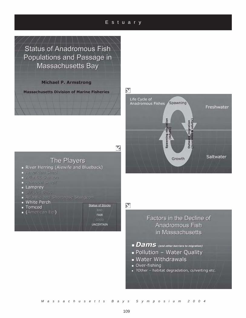
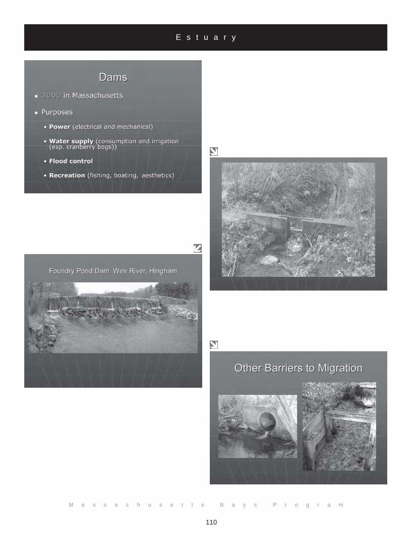
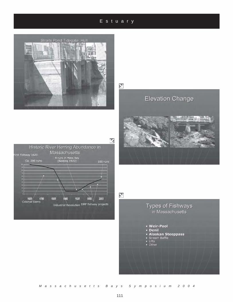
Anadromous Fish Runs
Dr. Michael ArmstrongMassachusetts Division of Marine Fisheries
30 Emerson Ave.Gloucester, MA 01930
(978) [email protected]
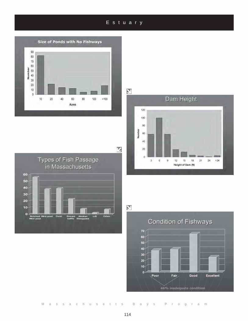
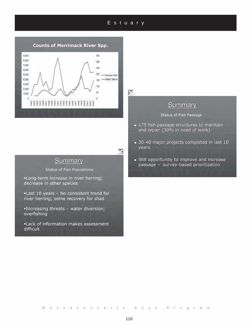
The destruction of spawning habitat through dam construction, water pollution and diversion, and overfish-ing depleted most anadromous fish species in the early 1900s. Anadromous fish come into fresh water tospawn, so it is critical to their survival that they can make it to fresh water and that juveniles can get out.Dr. Michael Armstrong noted that humans have done significant damage to fish runs, but restoration effortshave increased the population levels of many species. A recent survey of Massachusetts coastal streamsdocumented 175 fish ladders of various types; the most of any state in the country. Fish ladders providepassage around dams and other obstructions and help restore spawning habitat for anadromous fish (thereare 17 species in Massachusetts). About half of the ladders documented are in need of repair either becauseof deteriorating condition or because they do not provide efficient passage of fish. Further increases inpopulation size will require repair of old and inefficient ladders and construction of new ladders wherewarranted. Many species of anadromous fish continue to have stressed populations. Alewife and bluebackpopulations around the Massachusetts coast fluctuate widely within individual runs with many showingrecent declines but others holding steady. American shad have shown a dramatic increase in abundance inthe Merrimack River in recent years owing to an improvement in water quality and fish passage. However,only about ten percent of the fish pass through each of the ladders on the Merrimack River. Dr. Armstrongpointed out that much money has been spent on the survival of some of the anadromous species, especiallysalmon. Yet, throughout the state millions are put into the river each year but only about 150 make it backto spawn. The American eel populations appear to be in decline in Massachusetts. Variability of fish popu-lation numbers is tremendous among spawning runs and years. It is difficult to know how many fish areleaving, dying at sea, or not making it back for other reasons.
The Massachusetts Division of Marine Fisheries (DMF) has the authority to require anyone with a dam onhis or her property to provide a pathway for fish, however this does not often happen on smaller waterways.In the past 30 years the DMF has worked on over 100 projects and continues to look for more.
E s t u a r y
M a s s a c h u s e t t s B a y s S y m p o s i u m 2 0 0 4
109
E s t u a r y
M a s s a c h u s e t t s B a y s P r o g r a m
110
E s t u a r y
M a s s a c h u s e t t s B a y s S y m p o s i u m 2 0 0 4
111
E s t u a r y

M a s s a c h u s e t t s B a y s P r o g r a m
112
E s t u a r y

M a s s a c h u s e t t s B a y s S y m p o s i u m 2 0 0 4
113
E s t u a r y
M a s s a c h u s e t t s B a y s P r o g r a m
114
E s t u a r y

M a s s a c h u s e t t s B a y s S y m p o s i u m 2 0 0 4
115
E s t u a r y
M a s s a c h u s e t t s B a y s P r o g r a m
116
E s t u a r y

M a s s a c h u s e t t s B a y s S y m p o s i u m 2 0 0 4
117
E s t u a r y

M a s s a c h u s e t t s B a y s P r o g r a m
118
Embayment Water Quality
Andrew GottliebMassachusetts Department of Environmental Protection
One Winter StreetBoston, MA 02108
Mr. Andrew Gottlieb presented the Massachusetts' Estuaries Project as a collaborative effort between theMA Department of Environmental Protection (DEP) and the University of Massachusetts (UMASS)/Dartmouth School of Marine Science and Technology (SMAST) for the restoration of coastal embaymentsalong the southeast Massachusetts coast. The project involves developing critical nitrogen loads for 89embayments and estuaries (from Duxbury south around Cape Cod, to Buzzards Bay and the Islands). Mr.Gottlieb stated that traditionally DEP presents communities with oversight on environmental problems andprovides the direction for solving these perceived problems. The approach of the Estuaries Project isdifferent, generally enrolling communities that have asked for the DEP's help. The communities identifiedissues with their water quality and want to know how to address it. The DEP created a plan that focused onthe development of defining protective thresholds for each system and outlining meaningful alternatives in amanner that favors a more comprehensive approach to water resource planning. In these cases, municipali-ties are engaged in the processes at the beginning and most are willing to give of their resources.
Thus far, specific projects within the Estuaries Project have been initiated through a process that prioritizes,not by which estuaries have the worst water quality but by which estuaries that have the most water qualitydata, major projects such as wastewater facilities planning, the level of municipal and community engage-ment, and matching support. A ranking of the first 20 estuaries is provided in the accompanying slides.Much time was lost trying to figure out what watersheds were good for this effort.
Some possible wastewater solutions offered by Mr. Gottlieb involved consideration of water resource plan-ning. Firstly, siting of wastewater facilities, alternatives to traditional discharge, and using many smallfacilities rather than one large one with infiltration beds should considered. Finally, Mr. Gottlieb presented acase study on West Falmouth Harbor where 75% of the nitrogen load to the harbor originated from localsubterranean wastewater discharge.
E s t u a r y

M a s s a c h u s e t t s B a y s S y m p o s i u m 2 0 0 4
119
E s t u a r y

M a s s a c h u s e t t s B a y s P r o g r a m
120
E s t u a r y

M a s s a c h u s e t t s B a y s P r o g r a m
121
E s t u a r y

M a s s a c h u s e t t s B a y s P r o g r a m
122
E s t u a r y

M a s s a c h u s e t t s B a y s P r o g r a m
123
E s t u a r y

M a s s a c h u s e t t s B a y s P r o g r a m
124
E s t u a r y

M a s s a c h u s e t t s B a y s S y m p o s i u m 2 0 0 4
125
E s t u a r y
M a s s a c h u s e t t s B a y s P r o g r a m
126
Contaminants in Boston Harbor
Christian KrahforstMassachusetts Bays Program
251 Causeway Street, Suite 800(617) 626-1216
Boston Harbor has been touted as one of the filthiest urban harbors in the nation. The sources of contaminants werelargely attributed to the legacy of growing urbanization, which by 1990 contributed nearly 300 million gallons ofeffluent and 450 thousand gallons of sludge to the narrow confines of Boston Harbor. Sludge loading to the harbor hasbeen altogether removed and since 2000 and the effluent discharge has been moved out into western Massachusetts Bay.Mr. Krahforstsaid it is important to keep in mind that the contemporary source loads are significantly changing and, in many cases,being reduced - even though the amount of freshwater entering the Harbor remains relatively unchanged. Important tocontaminant fate and transport in Boston Harbor is theconsideration of harbor flushing and the amount of harbor water returned with each incoming tide. As tides exchangeharbor water with Massachusetts Bay, some of the "old" harbor water is returned and the harbor is not fully refreshedwith new clean Bay water.
The extent to which Boston Harbor is or was polluted is open for debate. Monitoring scientists distinguish betweencontamination and pollution by the degree to which the health of biota is adversely affected. Contamination is thepresence of noxious material at readily detectable amounts, either in sediments, the air, the water, or accumulated in thebiota. Clear signs of the biological degradation have been shown. Recent assessments of the benthic community haveshown markedly improved communities. Has the Harbor moved from polluted to "merely contaminated" status? Thisquestion remains unanswered. Recent (and past) data in all the compartments of the ecosystem (i.e., sediments, water,organisms) is lacking for meaningful assessment on the condition of the Harbor. What important contaminant sourcesremain or are emerging? New, more recent data from Boston Harbor is becoming available. However, this data mustbe interpreted in light of changing source loads and re-equilibrium with contaminated Harbor sediments. By logicalprogression, the state of the Harbor is therefore rapidly changing as well.
Silver levels in both the water column and sediments may be relatable to understanding the state of the Harbor since itssource is essentially from municipal wastewater discharges. What is the Harbor's influence on Massachusetts Bay? Thereis a need to understand how contaminants move from the watershed to Boston inner harbor and out into the Bay.Before the wastewater effluent was removed from the Harbor, selected contaminant levels in water, sediment, and biotawere elevated. Following recent management initiatives, changes in the benthic communities have been shown, tracemetal levels in Harbor water may have decreased (though not dramatically), and contaminant loading may be undergo-ing readjustment between the water column and underlying sediment. Recent assessments, such as the National CoastalConditions report and from regional blue mussel data, indicate that Boston Harbor still remains one of the mostpolluted estuaries in New England.
Mr. Krahforst stated that he feels the difference between pollution and contamination is very relevant. Toxicity testing isimportant to viewing transport throughout the harbor. Today, Boston Harbor receives a good amount of fresh waterand relatively no effluent discharges and it is believed that contaminant loading from fresh water sources are becomingmore important than previous assessments. He suggested that the research community needs to be pulled in closer tomanagement and that better assessment tools need to be devised to address the issues.
E s t u a r y
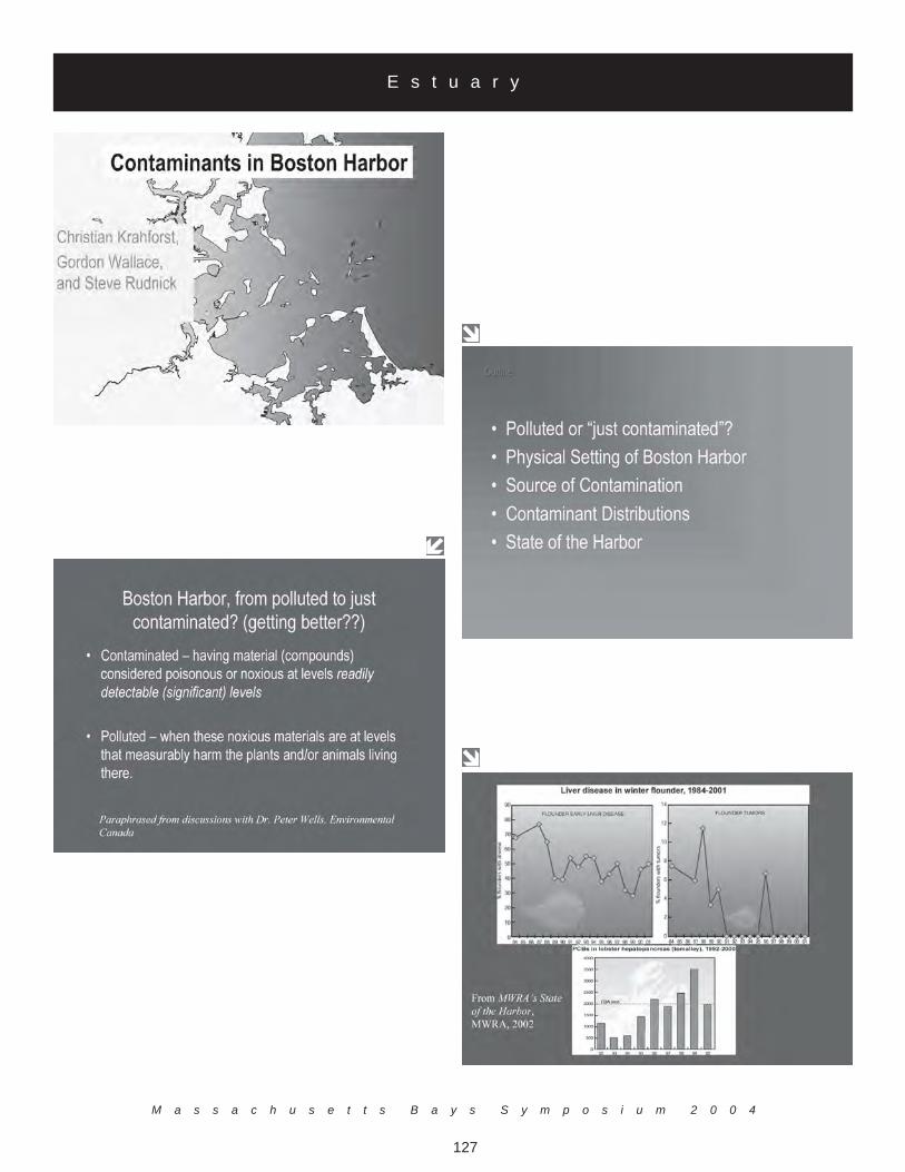
M a s s a c h u s e t t s B a y s S y m p o s i u m 2 0 0 4
127
E s t u a r y

M a s s a c h u s e t t s B a y s P r o g r a m
128
E s t u a r y

M a s s a c h u s e t t s B a y s S y m p o s i u m 2 0 0 4
129
E s t u a r y
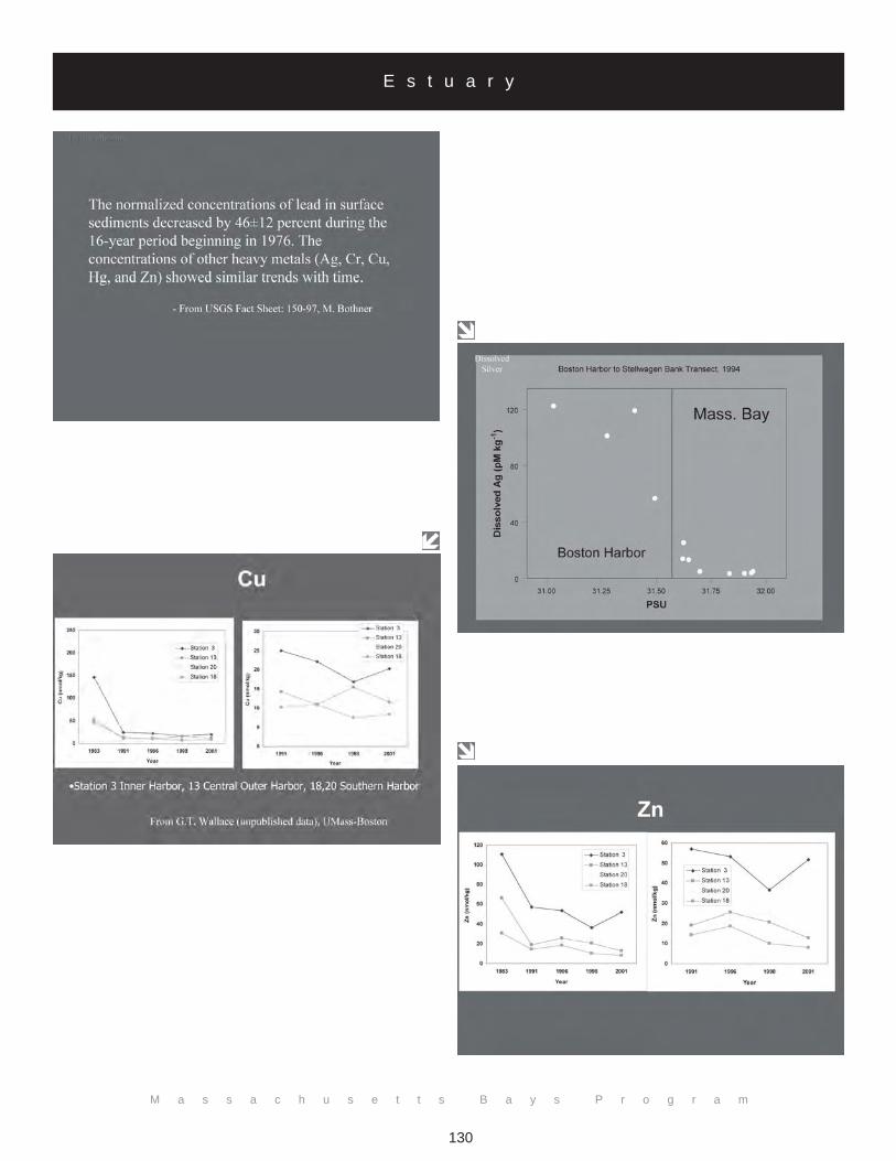
M a s s a c h u s e t t s B a y s P r o g r a m
130
E s t u a r y
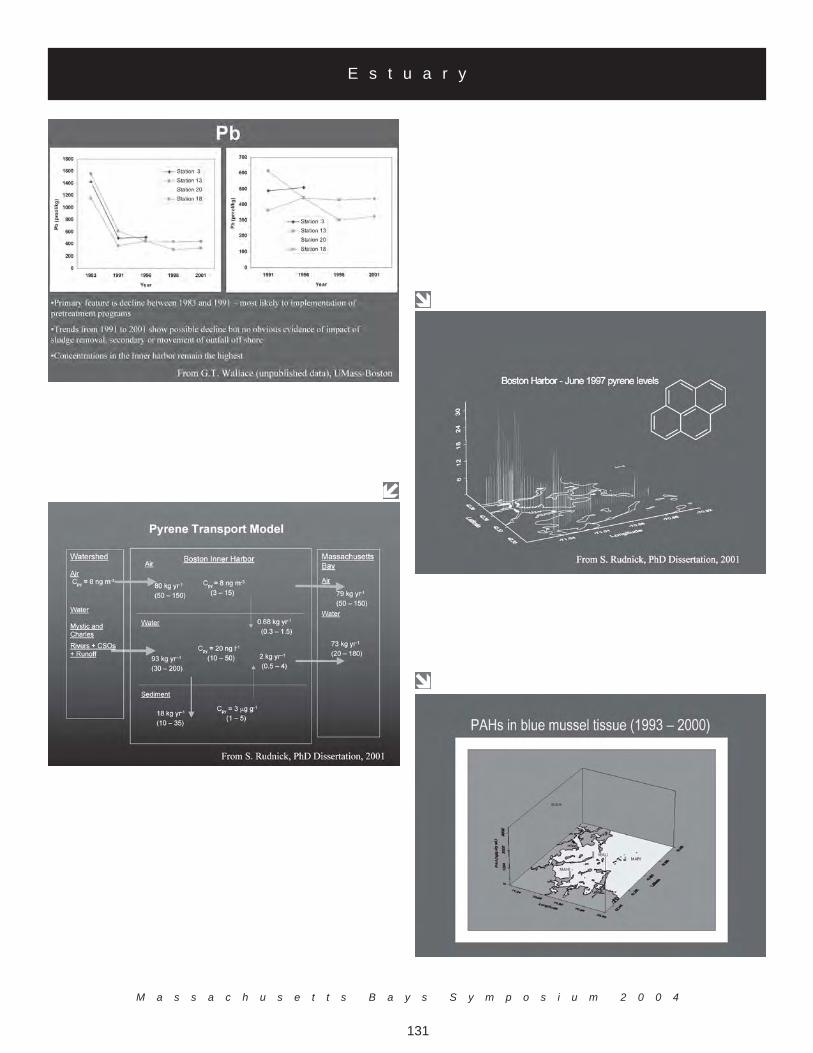
M a s s a c h u s e t t s B a y s S y m p o s i u m 2 0 0 4
131
E s t u a r y

M a s s a c h u s e t t s B a y s P r o g r a m
132
E s t u a r y
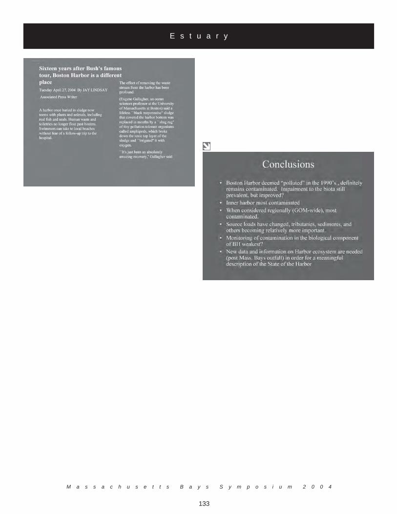
M a s s a c h u s e t t s B a y s S y m p o s i u m 2 0 0 4
133
E s t u a r y
M a s s a c h u s e t t s B a y s P r o g r a m
134
Christian Krahforst, Massachusetts Bays Program (moderator)Dr. Robert Buchsbaum, Massachusetts Audubon Society
Dr. Judith Pederson, MIT Sea GrantMs. Susan Snow-Cotter, Massachusetts Office of Coastal Zone Management
Dr. Gordon Wallace, UMASS-Boston
M a n a g e m e n t P a n e l I I
Following the presentations, the second panel discussion of the workshop was held. The focus of the paneldiscussion was The Next Decade: Emerging Issues for the Massachusetts Bays. Mr. Christian Krahforst,Massachusetts Bays Program served as the moderator. Panel members included Dr. Gordon Wallace,UMASS-Boston, Ms. Susan Snow-Cotter, Massachusetts Office of Coastal Zone Management, Dr. JudithPederson, MIT Sea Grant and Dr. Robert Buchsbaum, Massachusetts Audubon Society. The format of thepanel involved brief responses to the question by the members and then group discussions.
The panel group reached a consensus on priorities of emerging issues within the Massachusetts Bays to focusthe discussion. The priorities are:
• Shellfish issues• Protect and restore coastal habitat• Manage wastewater• Manage stormwater• Land use planning issues• Invasive species• Marine monitoring
Dr. Gordon Wallace.Dr. Wallace identified source identification as a major concern. Good quality data can assist managerstowards gauging acceptable contaminant loading levels. In order to do so toxicity testing needs to be im-proved and then integrated into monitoring programs. Sediment geochronology and contaminant profiles canbe used to relate long-term change with changes in land use and population growth. Dr. Wallace stated thatthere is often an inability to think in the long-term (>50 yrs, about population growth, climate change, andother major causes of ecosystem change) when assessing and anticipating anthropogenic perturbations ofcoastal ecosystems. Monitoring needs to have a close relationship with research. The state needs to con-sider modeling as a tool to examine the potential impacts of anthropogenic activities on coastal watershedsand nearshore waters as a whole. Models can be used to develop scenarios and explore sensitivities of thesystem to perturbations, natural and man-made. The state of the coastline can be examined by efforts suchas the EPA's National Coastal Assessment (NCA) Program. These programs may be able to commit to long-term monitoring and could establish trends but also need to demonstrate flexibility in their design andimplementation. Data sharing has also been an emerging issue. To fully utilize data, there must be aninfrastructure developed so that data can be easily shared between managers and scientists. Intimate in-volvement from non-governmental organizations (NGOs), researchers, and academics in all phases ofecosystem management is important. All groups need federal support, but such support has been substan-tially reduced in recent years and may reduce or even reverse progress in these efforts.
The Next Decade: Emerging Issues for the Massachusetts Bays

M a s s a c h u s e t t s B a y s S y m p o s i u m 2 0 0 4
135
Ms. Susan Snow-Cotter.Ms. Snow-Cotter stated that she felt subtidal habitat management is an emerging issue. The scientific andpolitical support has grown regarding this little seen habitat. Habitat below the waterline traditionally hasnot received much attention but it is significantly affected by coastal development, fossil fuel exploration,and pipelines. Ms. Snow-Cotter also suggested that developers need to take sub-tidal habitats into consider-ation when they build on the coast and should look at projects from a regional approach with restoration,research, and data management in mind.
Dr. Judith Pederson.Dr. Pederson emphasized that Marine Protected Areas (MPAs) are an emerging issue of concern. Currentlythere does not appear to be standard criteria for setting them up or for how to deal with issues affectingthem. Dr. Pederson also discussed invasive species and the need for cause/effect monitoring with a strongscience focus. Included in this is the identification of global warming's effects on biota and educating thepublic on invasive species issues. Information that has been obtained should be presented in a way that willchange minds to look at local extinction and other factors affecting the environment. Another issue that wasidentified is the great need for public education but the focus has often been on preparing another fact sheetwhich are not always the best solution for educating the public. Newspapers, media, signs, and word ofmouth is where the focus needs to be taken, rather than the standard fact sheet. Dr. Pederson ended herstatement with an emphasis on a regional management approach. Massachusetts Bay is part of a much largerregion but local issues can be addressed while taking a larger view.
Dr. Robert Buchsbaum.Dr. Buchsbaum opened his discussion with the notion that we should not necessarily focus on emergingissues but work on old issues because many have not been solved yet. Following this statement, Dr.Buchsbaum noted a number of issues of concern, beginning with the idea of ecosystem management thatlinks terrestrial researchers/managers with marine researchers/managers. He reiterated the need to addressMPAs and touched on a number of other issues that were previously mentioned during the workshop includ-ing: habitat diversity, fishing gear impacts, land-use patterns and their links to ecosystem processes, smartgrowth, buffers around wetlands, wind farms, aquaculture, monitoring and restoration. All of these issueswould benefit from having guiding principles. Thinking bay-wide is important, beyond town and stateborders, which although challenging, is of ongoing importance. Dr. Buchsbaum closed with the suggestionthat public education and outreach is extremely important. The general public should understand the scienceand know what is being done.
M a n a g e m e n t P a n e l I I

M a s s a c h u s e t t s B a y s P r o g r a m
136
Management Panel II - Discussion.Following the responses to the prioritization exercise, the Management Panel addressed questions andcomments from the moderator and audience.
What incentives can you suggest to get people/industry to do the right thing?The discussion was opened with examples of monetary incentive programs that have proven successful -such as the EnergyStar program which offers rebates for buying energy efficient products and a fish tagreturn program in the Bahamas where fishermen get money for returning the tags. It was further suggestedthat a key to preserving habitat is allowing access to it. If it is not readily available people are less likely tomake an effort to protect the marine environment. The Panel also recommended fee or fine programs as anincentive option. In the case of ballast water, boats are supposed to be assessed for compliance and be ableto supply a form to prove it. If you cannot supply the form you can be fined. This has proven to be asuccessful program.
Incentives for developers were advised in order to get them to use green-landscaping/green-neighborhood techniques andsmart growth ideas. In return they could find it easier to get permits or be allowed to build more. Culturalchanges also need to be made. The panel recommended making university students aware that meshingacademic, research, and management into their academic training can result in many unique and interestingopportunities as these fields are connected in practice. Another option would be that teachers could spend ayear in a training program with graduate students to learn how to inspire children to be interested in science.
M a n a g e m e n t P a n e l I I
M a s s a c h u s e t t s B a y s S y m p o s i u m 2 0 0 4
137
C o n c l u s i o n s
The workshop closed with a final discussion of the management panel on action items for the next meeting.The group made a number of suggestions including:
• Create an advisory committee or working group that can focus on biodiversity and eco-management.• Create and distribute outreach materials that let the public and other organizations know what has
been accomplished and to know how the efforts of the Massachusetts Bays Program work fits in tothe broader picture.
• Revive the Marine Science Advisory Board• Bring academics into manager and policy-making decisions to find out what state of the art ap-
proaches or priorities should be. Most academics would not refuse a request to be involved in theprocess.
Finally, the group discussed a schedule and focus for future Massachusetts Bays Symposiums. All panelmembers agreed that it is now important to shift the focus from the bay-wide onto the local level. Topics toexplore were best management practices, Smartgrowth, program evaluations, public involvement/outreachand education.
Conclusions and Next Steps

M a s s a c h u s e t t s B a y s P r o g r a m
138
M a s s a c h u s e t t s B a y s S y m p o s i u m 2 0 0 4
139
A p p e n d i x ASymposium Attendees
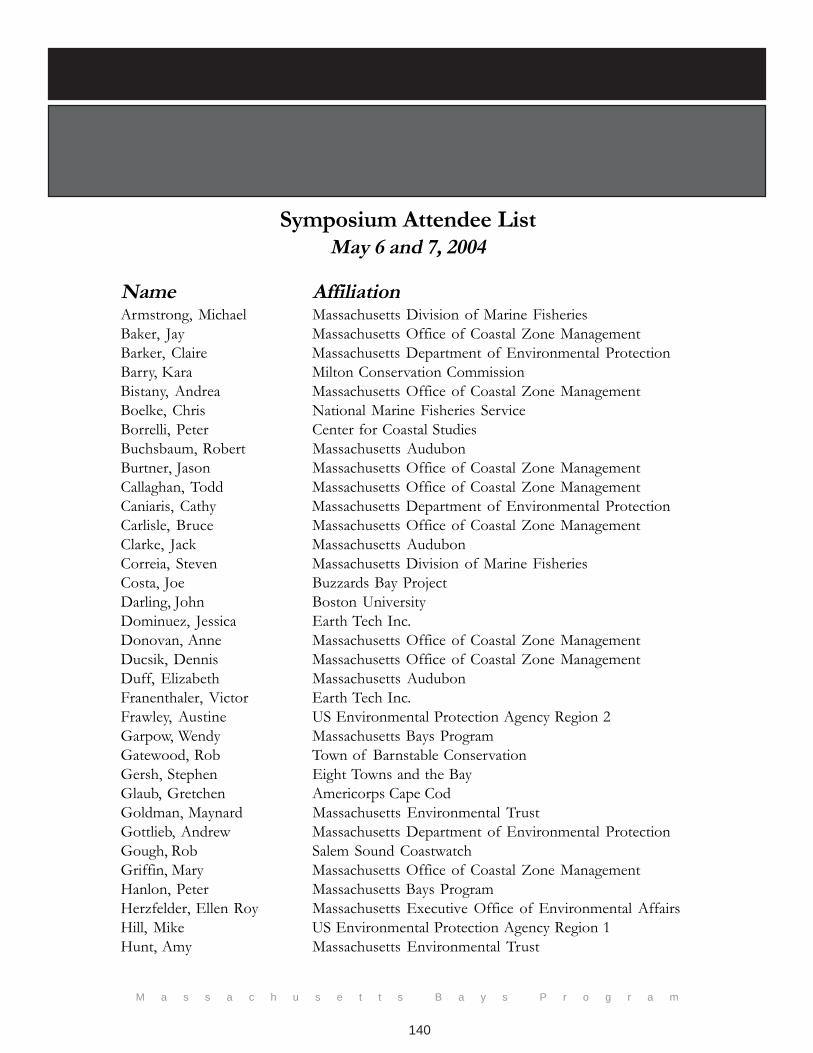
M a s s a c h u s e t t s B a y s P r o g r a m
140
Symposium Attendee ListMay 6 and 7, 2004
Name AffiliationArmstrong, Michael Massachusetts Division of Marine FisheriesBaker, Jay Massachusetts Office of Coastal Zone ManagementBarker, Claire Massachusetts Department of Environmental ProtectionBarry, Kara Milton Conservation CommissionBistany, Andrea Massachusetts Office of Coastal Zone ManagementBoelke, Chris National Marine Fisheries ServiceBorrelli, Peter Center for Coastal StudiesBuchsbaum, Robert Massachusetts AudubonBurtner, Jason Massachusetts Office of Coastal Zone ManagementCallaghan, Todd Massachusetts Office of Coastal Zone ManagementCaniaris, Cathy Massachusetts Department of Environmental ProtectionCarlisle, Bruce Massachusetts Office of Coastal Zone ManagementClarke, Jack Massachusetts AudubonCorreia, Steven Massachusetts Division of Marine FisheriesCosta, Joe Buzzards Bay ProjectDarling, John Boston UniversityDominuez, Jessica Earth Tech Inc.Donovan, Anne Massachusetts Office of Coastal Zone ManagementDucsik, Dennis Massachusetts Office of Coastal Zone ManagementDuff, Elizabeth Massachusetts AudubonFranenthaler, Victor Earth Tech Inc.Frawley, Austine US Environmental Protection Agency Region 2Garpow, Wendy Massachusetts Bays ProgramGatewood, Rob Town of Barnstable ConservationGersh, Stephen Eight Towns and the BayGlaub, Gretchen Americorps Cape CodGoldman, Maynard Massachusetts Environmental TrustGottlieb, Andrew Massachusetts Department of Environmental ProtectionGough, Rob Salem Sound CoastwatchGriffin, Mary Massachusetts Office of Coastal Zone ManagementHanlon, Peter Massachusetts Bays ProgramHerzfelder, Ellen Roy Massachusetts Executive Office of Environmental AffairsHill, Mike US Environmental Protection Agency Region 1Hunt, Amy Massachusetts Environmental Trust
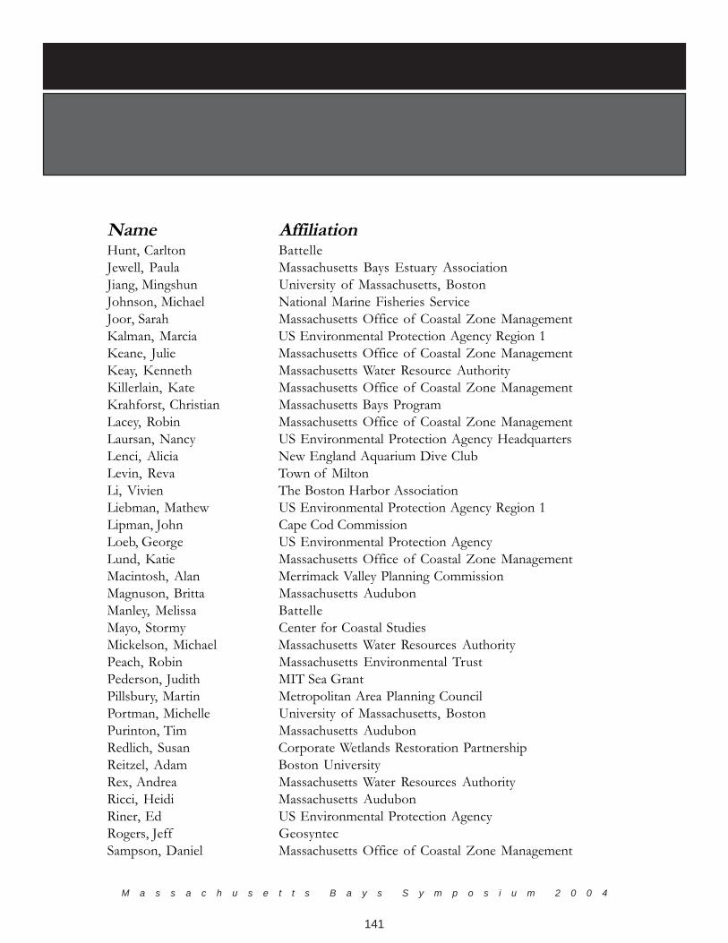
M a s s a c h u s e t t s B a y s S y m p o s i u m 2 0 0 4
141
Name AffiliationHunt, Carlton BattelleJewell, Paula Massachusetts Bays Estuary AssociationJiang, Mingshun University of Massachusetts, BostonJohnson, Michael National Marine Fisheries ServiceJoor, Sarah Massachusetts Office of Coastal Zone ManagementKalman, Marcia US Environmental Protection Agency Region 1Keane, Julie Massachusetts Office of Coastal Zone ManagementKeay, Kenneth Massachusetts Water Resource AuthorityKillerlain, Kate Massachusetts Office of Coastal Zone ManagementKrahforst, Christian Massachusetts Bays ProgramLacey, Robin Massachusetts Office of Coastal Zone ManagementLaursan, Nancy US Environmental Protection Agency HeadquartersLenci, Alicia New England Aquarium Dive ClubLevin, Reva Town of MiltonLi, Vivien The Boston Harbor AssociationLiebman, Mathew US Environmental Protection Agency Region 1Lipman, John Cape Cod CommissionLoeb, George US Environmental Protection AgencyLund, Katie Massachusetts Office of Coastal Zone ManagementMacintosh, Alan Merrimack Valley Planning CommissionMagnuson, Britta Massachusetts AudubonManley, Melissa BattelleMayo, Stormy Center for Coastal StudiesMickelson, Michael Massachusetts Water Resources AuthorityPeach, Robin Massachusetts Environmental TrustPederson, Judith MIT Sea GrantPillsbury, Martin Metropolitan Area Planning CouncilPortman, Michelle University of Massachusetts, BostonPurinton, Tim Massachusetts AudubonRedlich, Susan Corporate Wetlands Restoration PartnershipReitzel, Adam Boston UniversityRex, Andrea Massachusetts Water Resources AuthorityRicci, Heidi Massachusetts AudubonRiner, Ed US Environmental Protection AgencyRogers, Jeff GeosyntecSampson, Daniel Massachusetts Office of Coastal Zone Management

M a s s a c h u s e t t s B a y s P r o g r a m
142
Name AffiliationSchenk, Max Massachusetts Bays Estuary AssociationSchwartz, Jack Massachusetts Division of Marine FisheriesScott, Marcy National Marine Fisheries ServiceShort, Lynda BattelleShumway, Linda BSC GroupSkinner, Tom Massachusetts Office of Coastal Zone ManagementSmith, Jan Massachusetts Bays ProgramSnow-Cotter, Susan Massachusetts Office of Coastal Zone ManagementSoreson, Liz DCR/ACEC ProgramStewart, Ellie Massachusetts Environmental TrustStickney, Christine Planning Director, Town of DuxburyStone, Thomas Woods Hole Research CenterTarr, Ted Eight Towns & the BayTarricone, Kristan Town of Danvers Planning DepartmentTaylor, David Massachusetts Water Resources AuthorityTucker Steve Massachusetts Bays ProgramTyrrelle, Megan Massachusetts Office of Coastal Zone ManagementWallace, Gordon University of Massachusetts, BostonWarren, Barbara Salem Sound CoastwatchWatanabe, Allison US Environmental Protection Agency, Region 1Whitten, Jerrard Merrimack Valley Planning CommissionWiggin, Jack Urban Harbors InstituteWilliams, Tony The Coalition for Buzzards BayWilliams, Vesper Massachusetts Office of Coastal Zone ManagementWohlers, Elza Bentley CollegeWynn, Brion City of Quincy
M a s s a c h u s e t t s B a y s S y m p o s i u m 2 0 0 4
143
A p p e n d i x BSymposium Agenda
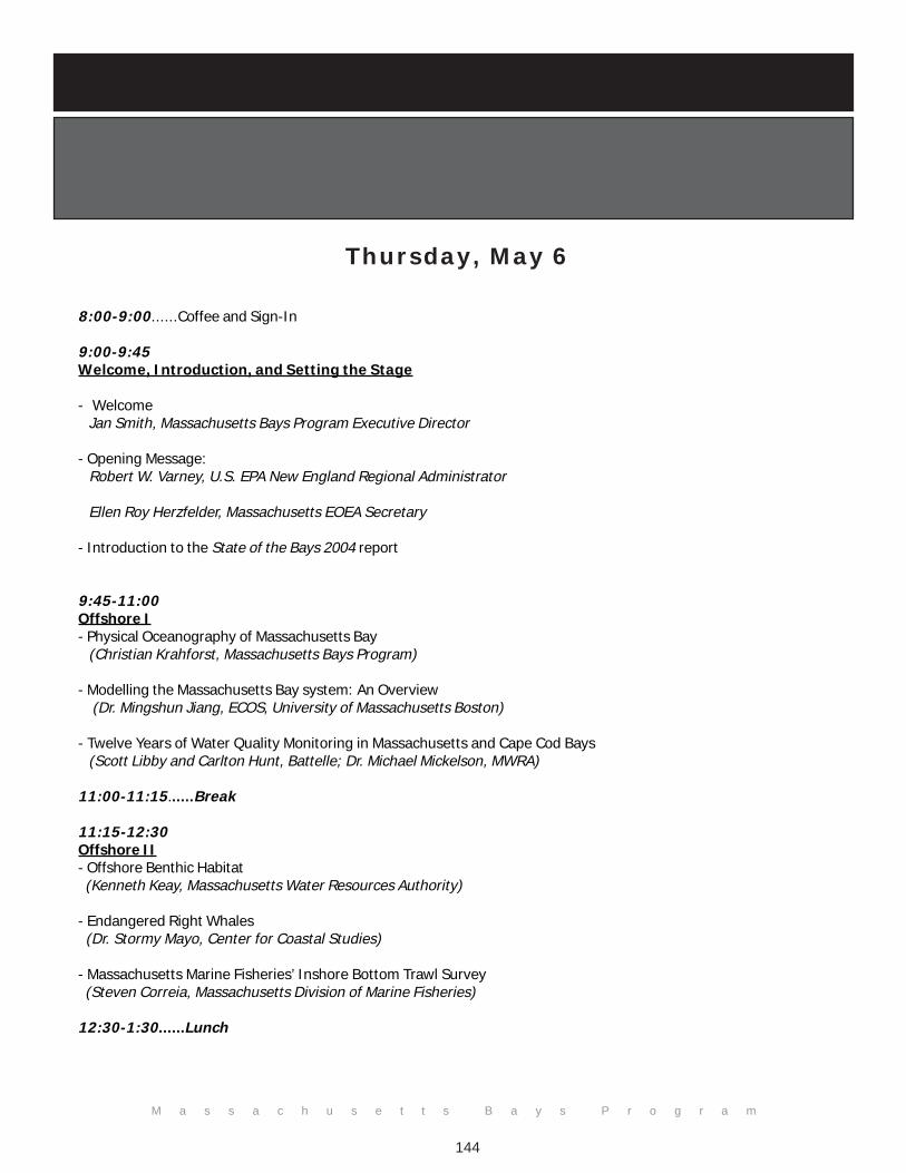
M a s s a c h u s e t t s B a y s P r o g r a m
144
Thursday, May 6
8:00-9:00......Coffee and Sign-In
9:00-9:45Welcome, Introduction, and Setting the Stage
- Welcome Jan Smith, Massachusetts Bays Program Executive Director
- Opening Message: Robert W. Varney, U.S. EPA New England Regional Administrator
Ellen Roy Herzfelder, Massachusetts EOEA Secretary
- Introduction to the State of the Bays 2004 report
9:45-11:00Offshore I- Physical Oceanography of Massachusetts Bay (Christian Krahforst, Massachusetts Bays Program)
- Modelling the Massachusetts Bay system: An Overview (Dr. Mingshun Jiang, ECOS, University of Massachusetts Boston)
- Twelve Years of Water Quality Monitoring in Massachusetts and Cape Cod Bays (Scott Libby and Carlton Hunt, Battelle; Dr. Michael Mickelson, MWRA)
11:00-11:15......Break
11:15-12:30Offshore II- Offshore Benthic Habitat (Kenneth Keay, Massachusetts Water Resources Authority)
- Endangered Right Whales (Dr. Stormy Mayo, Center for Coastal Studies)
- Massachusetts Marine Fisheries’ Inshore Bottom Trawl Survey (Steven Correia, Massachusetts Division of Marine Fisheries)
12:30-1:30......Lunch
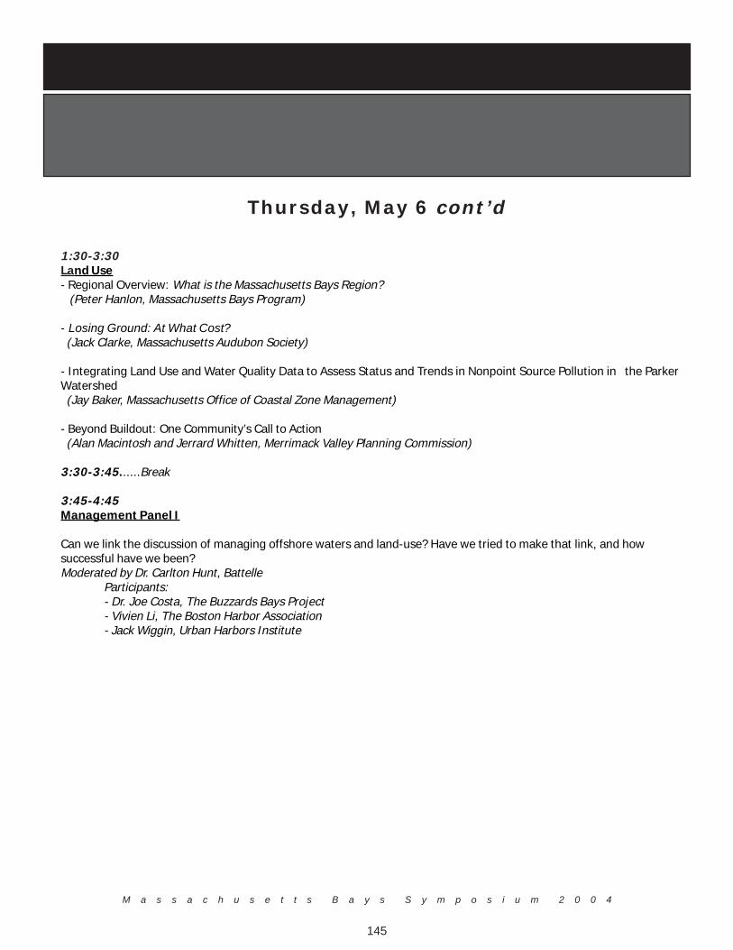
M a s s a c h u s e t t s B a y s S y m p o s i u m 2 0 0 4
145
Thursday, May 6 cont’d
1:30-3:30Land Use- Regional Overview: What is the Massachusetts Bays Region? (Peter Hanlon, Massachusetts Bays Program)
- Losing Ground: At What Cost? (Jack Clarke, Massachusetts Audubon Society)
- Integrating Land Use and Water Quality Data to Assess Status and Trends in Nonpoint Source Pollution in the ParkerWatershed (Jay Baker, Massachusetts Office of Coastal Zone Management)
- Beyond Buildout: One Community’s Call to Action (Alan Macintosh and Jerrard Whitten, Merrimack Valley Planning Commission)
3:30-3:45......Break
3:45-4:45Management Panel I
Can we link the discussion of managing offshore waters and land-use? Have we tried to make that link, and howsuccessful have we been?Moderated by Dr. Carlton Hunt, Battelle
Participants:- Dr. Joe Costa, The Buzzards Bays Project- Vivien Li, The Boston Harbor Association- Jack Wiggin, Urban Harbors Institute
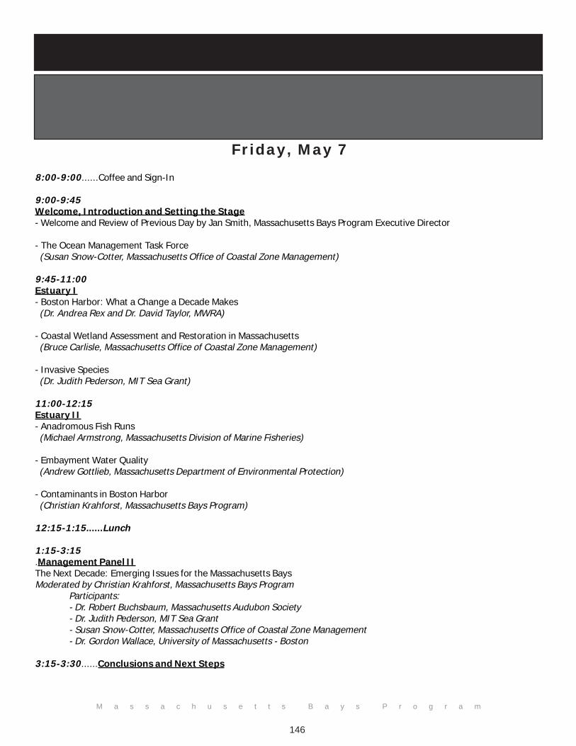
M a s s a c h u s e t t s B a y s P r o g r a m
146
Friday, May 7
8:00-9:00......Coffee and Sign-In
9:00-9:45Welcome, Introduction and Setting the Stage- Welcome and Review of Previous Day by Jan Smith, Massachusetts Bays Program Executive Director
- The Ocean Management Task Force (Susan Snow-Cotter, Massachusetts Office of Coastal Zone Management)
9:45-11:00Estuary I- Boston Harbor: What a Change a Decade Makes (Dr. Andrea Rex and Dr. David Taylor, MWRA)
- Coastal Wetland Assessment and Restoration in Massachusetts (Bruce Carlisle, Massachusetts Office of Coastal Zone Management)
- Invasive Species (Dr. Judith Pederson, MIT Sea Grant)
11:00-12:15Estuary II- Anadromous Fish Runs (Michael Armstrong, Massachusetts Division of Marine Fisheries)
- Embayment Water Quality (Andrew Gottlieb, Massachusetts Department of Environmental Protection)
- Contaminants in Boston Harbor (Christian Krahforst, Massachusetts Bays Program)
12:15-1:15......Lunch
1:15-3:15.Management Panel IIThe Next Decade: Emerging Issues for the Massachusetts BaysModerated by Christian Krahforst, Massachusetts Bays Program
Participants:- Dr. Robert Buchsbaum, Massachusetts Audubon Society- Dr. Judith Pederson, MIT Sea Grant- Susan Snow-Cotter, Massachusetts Office of Coastal Zone Management- Dr. Gordon Wallace, University of Massachusetts - Boston
3:15-3:30......Conclusions and Next Steps

M a s s a c h u s e t t s B a y s S y m p o s i u m 2 0 0 4
147

Massachusetts Bays Program251 Causeway Street, Suite 800
Boston, MA 02114
(617) 626-1230
www.massbays.org