Embed Size (px)
Citation preview

www.gov.uk/natural-england
Marine Conservation Zones Natural England’s advice to Defra on recommended Marine Conservation Zones to be considered for consultation in 2015
December 2014
Natural chalk arch - Cromer shoal © Natural England/Rob Spray

1
Produced by Natural England
Marine Conservation Zones
Natural England’s advice to Defra on recommended
Marine Conservation Zones to be considered for
consultation in 2015
December 2014

Natural England’s advice to Defra on recommended Marine Conservation Zones for consultation in 2015
December 2014
2
Produced by Natural England
Executive summary
Marine Conservation Zones (MCZs) are an important tool in England’s protection of the marine
environment and support the government’s requirements under the Marine and Coastal Access Act 2009
(MCAA). Defra will take decisions regarding MCZs based on sound evidence, and Natural England’s
evidence-based, scientific advice will be used to support these decisions. This will help to ensure that the
government can create successful, well-managed MCZs.
It is important to note that this advice document has been written for Defra to assist it in deciding which
recommended MCZs to designate. As such it is a complex and technical document, intended to be read
by technical and policy experts within Defra who are already familiar with earlier stages of the process. It
explains in detail the specific steps and considerations which Natural England took to produce this
advice. The intended readers in Defra benefit from prior knowledge and experience of the process, which
commenced in 2009.
We recommend that stakeholders less familiar with the overall process but interested in our advice on
specific sites read the separate Site-specific Advice document (Annex 9) which provides a summary of
the advice for each recommended MCZ (rMCZ) which is a candidate for consultation in Tranche 2. It is
intended to help interested stakeholders to more easily view all relevant information on a specific site. For
each rMCZ, the information provided in the tables in Section 4 of this document has been extracted and
any additional advice provided to Defra is explained.
In July 2012, Natural England and the Joint Nature Conservation Committee (JNCC) submitted our
advice package on the recommendations made by the four regional MCZ projects (JNCC and Natural
England, 2012a) and the subsequent amendments report in December 2012 (JNCC and Natural England,
2012b). Since then considerable amounts of new data have become available that are pertinent to
features within the rMCZs. Features refer to species, habitats and geological or geomorphological entities
for which MCZs are identified and managed. This included information provided during a public
consultation conducted by Defra in 2013 on 31 Tranche 1 MCZs, of which 27 were subsequently
designated in November 2013.
Defra has requested that Natural England provide updated advice on a further 29 inshore sites. This is to
help Defra identify sites and their constituent features for public consultation on a second tranche of
rMCZs. This includes 21 of the rMCZs recommended by the regional MCZ projects, and the addition of
12 undesignated features to 8 of the Tranche 1 MCZs designated in 2013, of these we have advised on
five new features in 4 Tranche 1 sites and re-submitted advice on 7 features from 2013 in 4 other sites
which were not designated at that time. We have also provided advice on extra features within the
regional MCZ project recommended sites that were identified through new survey data. JNCC has
provided complementary advice on offshore sites.
This report provides Natural England’s advice for each rMCZ which is a candidate for consultation in
Tranche 2. This advice builds on, but does not repeat, the site-specific information provided in 2011 in the
Selection Assessment Documents compiled by each regional MCZ project and submitted as part of the
Final Recommendations Reports, the site-specific advice given in the 2012 SNCB advice and the
subsequent amendments report.
We have assessed scientific confidence in the evidence for feature presence and extent and we have
recommended a general management approach (GMA) for each feature which is based on the
consideration of feature condition and which includes our assessment of the relative risk of damage to or
deterioration of each feature.

Natural England’s advice to Defra on recommended Marine Conservation Zones for consultation in 2015
December 2014
3
Produced by Natural England
Please note that the term GMA replaces the term conservation objective used in previous advice as it
was subsequently decided by Defra that since the conservation objective for all features being protected
within an MCZ is favourable condition, the term ‘general management approach’ would be used to
describe the approach required to either maintain a feature in, or recover it to, favourable condition.
Key findings from our assessments:
Since our 2012 advice, further data have become available that have increased our understanding of the
presence and extent of the features within the rMCZs. Presence and extent are the technical terms to
describe the location and area covered by a feature within a site. This assessment has used 416
datasets in total, which include dedicated verification surveys for MCZ features.
We assessed confidence in presence and extent for 371 features from 21 rMCZs and two existing
Tranche 1 MCZs. We have also resubmitted unchanged 2013 advice on confidence in presence and
extent for nine undesignated or additional features in six1 existing Tranche 1 MCZs, giving a total of 380.
Of the 371:
205 features are original features proposed by the regional MCZ projects
163 features are new features identified through the feature confidence assessment
process for Tranche 2 sites
Three are new features in designated Tranche 1 sites
Overall this has led to a modest increase in our scientific confidence of feature presence and extent for
those features originally proposed. Section 4.2.1 discusses the reasons for increases and decreases in
confidence in presence and extent. In summary:
25% of assessments for feature presence have increased in confidence, 26% have
decreased and the largest proportion, 49% remain unchanged.
37% of assessments for feature extent have increased in confidence, 22% have decreased
and 41% remain unchanged.
We now have high/high or high/moderate confidence in presence/extent for 44% of original
regional MCZ project features, moderate/moderate confidence in 18%, low confidence
(moderate/low, low/low) in 23% and no confidence in 9%.
We provided updated advice on the GMA for 289 features, excluding those regional MCZ project features
found to have no confidence in presence/extent from the confidence assessment, and those new features
with moderate/low or below confidence in presence/extent. Of the 289, 173 are features recommended
by the regional MCZ projects, 110 are new features, and six were new GMAs for undesignated features
in five Tranche 1 MCZs. We have resubmitted our 2013 GMAs for a further six undesignated features in
three Tranche 1 MCZs.
In summary:
We advise changing the GMA for 25 features in 10 sites; 159 regional MCZ project features
remain unchanged. Of the 25 features, we recommend changing four from recover to maintain in
1 Whilst no new evidence was available for presence/extent for the undesignated or new features in these Tranche 1 MCZs, an
updated vulnerability assessment was carried out on 3 sites as new activity data or information about the pressures on the features
was available.

Natural England’s advice to Defra on recommended Marine Conservation Zones for consultation in 2015
December 2014
4
Produced by Natural England
favourable condition, and 21 from maintain to recover in favourable condition.
We advise a GMA of maintain in favourable condition for 68 of the new features, including three
additional features in Tranche 1 sites. We advise a GMA of recover to favourable condition for the
remaining 48 new features including three features in Tranche 1 sites.
We have identified that 14 of the 21 rMCZs and three new features in existing Tranche 1 MCZs
have features which are at high risk of damage or deterioration.
When compiling our advice we have endeavoured to comply with the Government Chief Scientific
Adviser’s guidelines for preparing scientific advice. Our assessments followed published peer-reviewed
protocols and used the best available evidence at the time. Our advice has been comprehensively
checked and quality assured through our internal systems and has also undergone external peer review
by two independent scientists. Overall we are confident that our advice is a quality-assured product, fit for
purpose, to assist the government to make decisions on the designation of MCZs.
Natural England’s advice to Defra on recommended Marine Conservation Zones for consultation in 2015
December 2014
5
Produced by Natural England
Acknowledgements
The project managers, Sam King and Hester Clack, wish to thank the following individuals for their work
in producing this advice: from the national teams, Josie Allen, Dr Maria Alvarez, Dr Jen Ashworth, Alex
Baker, Ross Bullimore, Jolyon Chesworth, Dr Robert Enever, Laura Gannon, Andy Graham, Dr Emily
Hardman, Dr Vanessa Hernaman, Dr James Highfield, Paul Ivory, Emily Kirkham, Chris Pirie, Kieran
Preston, Dr Leonie Richardson, Ian Saunders and Tom Mullier and the staff of Marine Mapping Ltd and,
from the area teams, Steph Ashman, Jonathon Brennan, Laurence Browning, Hilary Crane, Tim Dixon,
Dr Naomi Downes-Tettmar, Jenni Fincham, Giulietta Holly, Claire Horseman, Lisa Jenner, Dr Emma
Kelman, Martin Kerby, Paul Kirk, Andrew Knights, Paul Lane, Jen Lewis, Charlotte Marshall, Llucia
Mascorda, Jamie McPherson, Angela Moffatt, Marija Nilova, Dr Katherine Nisbet, Melanie Parker, Dr
Kirsty Pickard, Ruth Porter, Christina Relf, Trudy Russell, Dr Catherine Scott, Rob Seebold, Christine
Singfield, Kate Sugar, Fiona Tibbitt, Helena Towers and Emma Veryan, and senior and principal
advisers, Ingrid Chudleigh, Roger Covey, Conor Donnelly, Audrey Jones, Miriam Knollys, Chris Lumb,
Sangeeta McNair and Andy Millar.
Many other staff in Natural England have been involved in writing this advice and have provided a great
amount of input. We would like to thank staff from Natural England’s national teams (Siobhan Browne,
Kevan Cook, Victoria Copley, Alex Fawcett, Dr Chris Gibson, Nikki Hiorns, Mark Johnston, Jan Maclennan,
Duncan Vaughan and Randy Velterop) and team leaders from the national teams (Belinda Chell, Elly Hill,
Joanna Redgwell and Tammy Smalley) and area teams (Stephen Ayliffe, Emma Brown, Clive Doarks,
Lorraine Huggett, David Marshall, Nik Ward and Phil Reynolds).
We thank Professor Jason Hall-Spencer from Plymouth University and Professor Mike Elliott from the
University of Hull who provided expertise as our Independent External Reviewers. In addition thanks to
Pete Brotherton, Lydia Barnes, Richard Wright and Chris Pirie who led the internal quality assurance
process with further review by Director of Marine Jonathan Burney and Executive Director Andrew Wood.
This document should be cited as: Natural England (2014). Natural England’s advice to Defra on
recommended Marine Conservation Zones to be considered for consultation in 2015.

Natural England’s advice to Defra on recommended Marine Conservation Zones for consultation in 2015
December 2014
6
Produced by Natural England
Contents
Executive summary .......................................................................................................................................... 2
Acknowledgements .......................................................................................................................................... 5
Frequently used acronyms ............................................................................................................................. 10
1 Introduction ............................................................................................................................................. 12
1.1 Purpose of this advice ...................................................................................................................... 12
1.2 About Natural England and its role in Marine Conservation Zones ................................................... 12
1.3 About this document ........................................................................................................................ 12
1.4 Standards and principles applied in writing this advice ..................................................................... 13
1.4.1 Quality management process ....................................................................................................... 13
1.5 Understanding confidence levels for the different assessments ....................................................... 14
1.6 Links to JNCC advice ....................................................................................................................... 14
1.7 Recommended Marine Conservation Zones in inshore waters ......................................................... 14
2 Background to this advice ....................................................................................................................... 16
2.1 Regional MCZ projects ..................................................................................................................... 16
2.2 SNCB advice to government July 2012 ............................................................................................ 16
2.3 Additional advice to Defra ................................................................................................................ 16
2.4 SNCB advice amendments report .................................................................................................... 16
2.5 Defra MCZ consultation ................................................................................................................... 17
2.6 Tranche 1 advice reports ................................................................................................................. 17
3 Processes used for compilation of 2014 advice ....................................................................................... 18
3.1 Assessing confidence in feature presence and extent ...................................................................... 18
3.1.1 Aims of this section ....................................................................................................................... 18
3.1.2 Evidence used in 2014 advice ...................................................................................................... 18
3.1.3 Evidence not used and reasons .................................................................................................... 19
3.1.4 Evidence Panel process ............................................................................................................... 20
3.1.5 Assessment of confidence in feature presence and extent ........................................................... 21
3.2 Assessing confidence in condition and advised general management approach .............................. 24

Natural England’s advice to Defra on recommended Marine Conservation Zones for consultation in 2015
December 2014
7
Produced by Natural England
3.2.1 Aims of this section ....................................................................................................................... 24
3.2.2 Overview of the process used to propose the general management approach ............................. 24
3.2.3 Definition and origin of the term ‘general management approach’ ................................................ 24
3.2.4 Conservation Objective Guidance (COG) ..................................................................................... 25
3.2.5 Features considered under the vulnerability assessment process ................................................ 25
3.2.6 Preparation for the vulnerability assessment ................................................................................ 27
3.2.7 Overview of the method used to propose the general management approach .............................. 30
3.2.8 Fisheries vulnerability assessment (VA) ....................................................................................... 31
3.2.9 Application of expert judgement to automated vulnerability assessment (VA) results ................... 32
3.2.10 Assessing scientific confidence in feature condition (Protocol F) .................................................. 33
3.2.11 Quality assurance of vulnerability assessment results .................................................................. 34
3.3 Feature risk assessment .................................................................................................................. 34
3.3.1 Aims of this section ....................................................................................................................... 34
3.3.2 Method ......................................................................................................................................... 34
3.3.3 Activities which trigger a high future risk ....................................................................................... 34
3.4 Advice on the scientific basis to support feature / site designation ................................................... 35
3.4.1 Aims of this section ....................................................................................................................... 35
3.4.2 How the scientific basis to support feature / site designation was assessed ................................. 35
4 Results ................................................................................................................................................... 40
4.1 Aims of this section .......................................................................................................................... 40
4.2 Assessment of confidence in presence and extent of rMCZ features ............................................... 40
4.2.1 Summary of results ....................................................................................................................... 40
4.2.2 Feature-specific considerations. ................................................................................................... 41
4.2.3 Additional features for Tranche 1 sites .......................................................................................... 42
4.2.4 Mobile species .............................................................................................................................. 43
4.2.5 Introduction to Table 1 .................................................................................................................. 43
4.3 Evidence sources used in the development of this advice .............................................................. 101
4.4 Evidence not used.......................................................................................................................... 162
4.5 Results of general management approach and confidence in feature condition (Protocol F score) 168

Natural England’s advice to Defra on recommended Marine Conservation Zones for consultation in 2015
December 2014
8
Produced by Natural England
4.6 Summary of feature risk assessment results .................................................................................. 209
4.6.1 Aim of section ............................................................................................................................. 209
4.6.2 Summary of results ..................................................................................................................... 209
4.6.3 Feature risk assessment results table ......................................................................................... 209
4.6.4 New Tranche 1 features ............................................................................................................. 282
4.7 Advice on the scientific basis to support feature/site designation ................................................... 286
4.7.1 Summary of results ..................................................................................................................... 286
4.7.2 Introduction to Tables 8 and 9 .................................................................................................... 286
4.7.3 Site-level commentary ................................................................................................................ 369
5 Bibliography .......................................................................................................................................... 374
6 Glossary ................................................................................................................................................ 378
Annex 1 Evidence Panel Terms of Reference .............................................................................................. 385
Annex 2 Evidence Panel Minutes ................................................................................................................. 390
Annex 3 Details of the processes for assessing confidence in presence and extent .................................... 396
Annex 4 Tranche 1 features in Tranche 2..................................................................................................... 409
Annex 5 West of Walney .............................................................................................................................. 411
Annex 6 Features with no confidence in presence and extent ...................................................................... 413
Annex 7 Feature Risk Assessment............................................................................................................... 415
Annex 8 Independent External Review ......................................................................................................... 418
Annex 9 Site-specific advice (published as a separate document)
List of Tables
Table 1 Confidence assessment of evidence for presence and extent of rMCZ features ................................ 44
Table 2 Evidence sources used .................................................................................................................. 101
Table 3 Evidence not used ........................................................................................................................... 162
Table 4 Tranche 1 features for which 2013 advice remains current .............................................................. 167
Table 5 General Management Approach and confidence in feature condition (Protocol F score) ................. 169
Table 6 Feature risk assessments ................................................................................................................ 210
Table 7 New Tranche 1 Features and their recommended conservation objectives from 2013 .................... 283
Table 8 Feature data sufficiency assessment ............................................................................................... 288

Natural England’s advice to Defra on recommended Marine Conservation Zones for consultation in 2015
December 2014
9
Produced by Natural England
Table 9 Site data sufficiency assessment ..................................................................................................... 367
Table 10 Site level commentary ................................................................................................................... 370
List of Figures
Figure 1 A step by step approach to determining whether a feature should or should not be designated from a
scientific evidence based perspective ............................................................................................................ 37

Natural England’s advice to Defra on recommended Marine Conservation Zones for consultation in 2015
December 2014
10
Produced by Natural England
Frequently used acronyms
BS – Balanced Seas
BGS – British Geological Survey
BSH – Broad-scale habitat
CCO – Channel Coastal Observatory
Cefas – Centre for Environment, Fisheries and Aquaculture Science
CO – Conservation Objectives
COG – Conservation Objective Guidance
Defra – Department for Environment, Food and Rural Affairs
EA – Environment Agency
EMS – European Marine Site
ENG – Ecological Network Guidance
ERCCIS – Environmental Records Centre for Cornwall and Isles of Scilly
EUNIS – European Nature Information System
FAP – Feature-Activity-Pressure
FOCI – Feature of Conservation Importance
FS – Finding Sanctuary
GI – Geographic Information
GIS – Geographic Information System
GMA – General Management Approach
HIWWT – Hampshire and Isle of Wight Wildlife Trust
HOCI – Habitat of Conservation Importance
ICG-C – OSPAR Intercessional Correspondence Group on Cumulative Effects
IER – Independent Expert Review
IFCA – Inshore Fisheries and Conservation Authority
IOW – Isle of Wight
IQI – Infaunal Quality Index
ISCZ – Irish Sea Conservation Zones
JNCC – Joint Nature Conservation Committee
KWT – Kent Wildlife Trust
MALSF – Marine Aggregate Levy Sustainability Fund
MarLIN – Marine Life Information Network
MCAA – Marine and Coastal Access Act 2009
MCZ – Marine Conservation Zone (pMCZ = proposed Marine Conservation Zone; rMCZ = recommended
Marine Conservation Zone)
MESH – Mapping European Seabed Habitats project
MMO – Marine Management Organisation
MPA – Marine Protected Area
NBN – National Biodiversity Network
NE – Natural England
NG – Net Gain
Nm – Nautical mile
OS – Ordnance Survey
OSPAR – The Convention for the Protection of the Marine Environment of the North-East Atlantic
pCLZ – Proposed Co-location Zone
PSA – Particle size analysis
QA – Quality Assurance
SAC – Special Area of Conservation

Natural England’s advice to Defra on recommended Marine Conservation Zones for consultation in 2015
December 2014
11
Produced by Natural England
SAP – Science Advisory Panel
SNCB – Statutory Nature Conservation Body
SOCI – Species of Conservation Importance
SPA – - Special Protection Area
SSSI – Site of Special Scientific Interest
UID – Unique identifier
UK BAP – UK Biodiversity Action Plan
VA – Vulnerability assessment
VMS – Vessel monitoring system
WFD – Water Framework Directive
WoRMS – World Register of Marine Species

Natural England’s advice to Defra on recommended Marine Conservation Zones for consultation in 2015
December 2014
12
Produced by Natural England
1 Introduction
1.1 Purpose of this advice
This report contains Natural England’s formal advice to Defra on 21 recommended Marine Conservation
Zones (rMCZs) in English inshore waters and the addition of new features to a further eight MCZs
designated in 2013. This advice is the result of analysis of new evidence gathered and/or processed
since July 2012. The advice is designed to enable Defra to make informed decisions about MCZ
designation.
1.2 About Natural England and its role in Marine Conservation Zones
Natural England is a Defra Non-Departmental Public Body and advises government on matters relating to
nature conservation in England and in English territorial waters out to 12nm. Natural England’s remit is
defined in the Natural Environment and Rural Communities Act 2006 (as amended by the Marine and
Coastal Access Act 2009 section 311(1) and (2)).
Natural England has a statutory and advisory role in the identification and delivery of MCZs.
Statutory role: We have a statutory power under section 127 of the Marine and Coastal Access Act
2009 (MCAA) to provide advice and guidance as to:
(a) the matters which are capable of damaging or otherwise affecting any protected
feature(s)
(b) the matters which are capable of affecting any ecological or geomorphological
process on which the conservation of a protected feature(s) is (wholly or in part)
dependent
(c) how any conservation objectives stated for an MCZ may be furthered, or how the
achievement of any such objectives may be hindered
(d) how the effect of any activity or activities on an MCZ(s) may be mitigated
(e) which activities are, or are not, of equivalent environmental benefit (for the purposes
of section 126(7) (c)) to any particular damage to the environment (within the
meaning of that provision).
This advice or guidance may be given either in relation to a particular MCZ or MCZs or generally to
public authorities or more generally. We have a duty to provide this advice to public authorities if
they request it.
Advisory role. We also have a wider role in relation to MCZs:
o Identification of MCZs: Natural England and the Joint Nature Conservation
Committee (JNCC) were asked by Defra to run a stakeholder-led process to identify
MCZs.
o Monitoring of MCZs: section 124(3) of the MCAA provides for the appropriate
authority2 to direct JNCC and Natural England to monitor MCZs.
o Reporting on MCZs and the Marine Protected Area (MPA) network: section 124 of
the MCAA outlines the reporting requirements on the appropriate authority and we
expect to provide advice to inform this. JNCC will assess the MPA network as a
whole.
1.3 About this document
This report provides Natural England’s analysis, for each rMCZ, of confidence in the evidence for feature
2 In the MCZ Project area the appropriate authority is the Secretary of State.

Natural England’s advice to Defra on recommended Marine Conservation Zones for consultation in 2015
December 2014
13
Produced by Natural England
presence and extent, a consideration of feature condition and proposed General Management Approach
(GMA) for each feature and our assessment of the risk to each feature. A further analysis has also been
incorporated considering whether sites and features have sufficient data in order to be designated (JNCC
and Natural England, 2014). This report updates the assessments undertaken for the advice provided in
July 2012 (JNCC and Natural England, 2012a) and the subsequent amendments report in December
2012 (JNCC and Natural England, 2012b) using new evidence from:
processed and submitted results of subtidal and intertidal verification surveys undertaken by the
Centre for Environment, Fisheries and Aquaculture Science (Cefas), the Environment Agency (EA)
and Natural England during 2012 and 2013;
data entered onto Marine Recorder up to a cut-off date of the end of February 2014, including new
Seasearch survey records gathered in 2012 and 2013 and;
data provided independently from spring 2013 up to the data cut-off point.
Annex 9 of this report contains a series of site-specific advice documents. These are ‘stand-alone’ advice
summaries for each rMCZ collated on a site-specific basis in order for readers to quickly view the advice
pertaining to a single rMCZ.
Our advice focuses on evaluating the evidence underpinning the regional MCZ project site / feature
recommendations. It does not discuss in detail social and economic considerations of designating MCZs
as this is outside Natural England’s remit and will be covered in Defra’s Impact Assessment.
1.4 Standards and principles applied in writing this advice
Natural England followed all relevant aspects of the MCZ advice protocols3 when producing this advice.
These cover aspects of assessing confidence, quality assurance, document management and style and
high-level principles. These protocols were developed jointly with JNCC for the July 2012 advice to
government and all technical protocols went through an independent external review process. In addition,
JNCC and Natural England developed supplementary guidance on aspects of the practical application of
Protocol E (JNCC and Natural England, 2013a).
Natural England also has a series of internal standards that Natural England staff follow in delivering
work to ensure all advice provided and all decisions made by Natural England staff meet Natural
England’s Evidence Strategy (Natural England, 2012) and the Government Chief Scientific Adviser’s
Guidelines on the Use of Scientific and Engineering Advice in Policy Making (Government Office for
Science, 2010). These standards include:
Evidence Strategic Standard (Natural England, 2013a)
Analysis of Evidence Standard (Natural England, 2013b)
Communicating and Publishing Evidence (Natural England, 2013c)
1.4.1 Quality management process
The evidence and advice in this report has been through a quality management process. The specific
quality control methods used through each separate confidence assessment process are detailed in
Section 3.
3
http://webarchive.nationalarchives.gov.uk/20140605090108/http://www.naturalengland.org.uk/ourwork/marine/mpa/mcz/mczprojectadviceprotocols.aspx

Natural England’s advice to Defra on recommended Marine Conservation Zones for consultation in 2015
December 2014
14
Produced by Natural England
In addition, Natural England commissioned an external peer review by two independent marine scientists to
quality assure a representative sample of our advice in order to ensure that the protocols had been
correctly applied and that the audit trail and evidence used for decisions was clear (Annex 8).
The output results tables were also internally quality assured by Natural England’s Marine Evidence
Principal Specialist, the Marine Manager for Designations and Deputy Chief Scientist4. This initial report
was reviewed and signed off by Natural England’s Chief Scientist.
In addition this final published document has been further quality assured by the Marine Director and
Executive Director.
1.5 Understanding confidence levels for the different assessments
Throughout this document Natural England provides advice on our confidence in data and judgements.
How confidence is assessed and described can vary between the different assessments.
In Section 4.2 we describe our scientific confidence in the evidence for presence and extent of features.
Confidence here is assessed using Protocol E, which sets out the data that must be present to achieve
different levels of confidence, such as habitat maps or point records (JNCC and Natural England, 2012c).
Where we have low confidence in the evidence for feature presence or extent this may be due to a single
record, habitat maps being based on modelled data only, or records being older than 12 years for
species or temporally variable habitats. Where we have no confidence in the evidence this is due to a
lack of data for presence or conflicting data that show the presence of a different feature instead of the
feature recommended.
In providing our advice on the proposed GMA in Table 5 we have provided advice on our confidence in
the condition of features following Protocol F (JNCC and Natural England, 2012d). Where there is a lack
of direct monitoring evidence, condition is assigned based on the vulnerability assessment process, which
provides a proxy of feature condition. This looks at sensitivity of features to pressures and exposure of
features to pressures. In this assessment we have taken account of the confidence of the sensitivity of
features to pressures, taken from ABPmer (2010). The guidance on describing the vulnerability
assessment process (Natural England and JNCC, 2011) discusses its inherent uncertainties and where
this method is applied our confidence in feature condition is scored as ‘low’.
1.6 Links to JNCC advice
Both JNCC and Natural England have followed the same overarching protocols to assess evidence and
provide advice and have continued working closely together. This has ensured that Defra can be
confident that our advice is produced to the same standard.
The advice from JNCC to Defra will be made available on the JNCC website and is available via the
following link: http://jncc.defra.gov.uk/page-6658
1.7 Recommended Marine Conservation Zones in inshore waters
The 21 rMCZs that this advice covers are listed below as originally presented by the regional projects.
They are listed here in order of regional MCZ project: Balanced Seas, Finding Sanctuary, Irish Sea
Conservation Zones, Net Gain:
4 The Marine Manager for Designations and Deputy Chief Scientist undertook this quality assurance review on behalf of the
Director and Chief Scientist.

Natural England’s advice to Defra on recommended Marine Conservation Zones for consultation in 2015
December 2014
15
Produced by Natural England
The Swale Estuary
Dover to Deal
Dover to Folkestone
Norris to Ryde
The Needles
Bembridge
Yarmouth to Cowes
Utopia
Studland Bay
Mounts Bay
Runnel Stone (Land’s End)
Newquay and The Gannel
Hartland Point to Tintagel
Bideford to Foreland Point
North of Lundy
West of Walney (including proposed co-location zone)
Allonby Bay
Cromer Shoal Chalk Beds
Holderness Inshore
Runswick Bay
Coquet to St Mary’s
The addition of new features is proposed for the following MCZs designated in Tranche 1:
Blackwater, Crouch, Roach and Colne Estuary
Beachy Head West
South Dorset
Chesil Beach and Stennis Ledges
Torbay
Upper Fowey and Pont Pill
The Manacles
Fylde

Natural England’s advice to Defra on recommended Marine Conservation Zones for consultation in 2015
December 2014
16
Produced by Natural England
2 Background to this advice
2.1 Regional MCZ projects
JNCC and Natural England established the MCZ Project in 2008 to develop stakeholder
recommendations on:
the location, size and shape of MCZs;
the features to be protected within the MCZs;
the conservation objectives of the MCZs; and
an assessment of environmental, economic and social impacts of the proposed regional MCZs,
presenting the results in a draft formal Impact Assessment document.
Four independent regional MCZ projects covering the south-west (Finding Sanctuary), Irish Sea (Irish
Sea Conservation Zones), North Sea (Net Gain) and south-east (Balanced Seas) were established to
engage stakeholders to develop their recommendations. In September 2011 the regional MCZ projects
delivered their recommendations to JNCC and Natural England with 108 MCZs and 65 reference areas
recommended (Balanced Seas, 2011; Irish Sea Conservation Zones, 2011; Lieberknecht et al, 2011; Net
Gain, 2011).
2.2 SNCB advice to government July 2012
JNCC and Natural England provided joint formal advice to government in July 2012 (JNCC and Natural
England, 2012a). As summarised by Defra (2011a), Defra requested that our 2012 advice to government
should contain:
Advice on the creation of an ecologically coherent network of MPAs
An overview of the regional MCZ project process used to identify possible MCZs
JNCC and Natural England’s view of the regional MCZ project recommendations
An assessment of the most at risk sites/priority sites for protection
An assessment of the scientific certainty of the regional MCZ project recommendations
That advice document was submitted to Defra alongside the regional MCZ project final recommendation
reports and the regional MCZ project Impact Assessment materials as part of the MCZ Advice Package
on 18 July 2012. It contains our formal advice to government on the science behind the regional MCZ
project recommendations, the quality of the ecological data and our views on the overall regional MCZ
project process. The report runs to over 1,500 pages including technical annexes setting out the detailed
assessments.
2.3 Additional advice to Defra
In 2012, Defra asked JNCC and Natural England to provide further advice on the level of certainty in the
draft conservation objectives of the rMCZ features. Advice was requested for the features in sites which
were good candidates for designation in the first tranche. The advice was requested to provide additional
assurance that the conservation objectives for features in proposed first tranche sites were appropriate.
The assessment to inform this advice was undertaken in July 2012 after agreeing the approach with
Defra’s MPA Network Project Board and was provided to Defra separately from the Statutory Nature
Conservation Body (SNCB)’s statutory advice on MCZs recommended by the regional MCZ projects. The
report was published as supplementary advice in December 2012 (JNCC and Natural England, 2012e).
2.4 SNCB advice amendments report
Following the submission of the July 2012 advice, JNCC and Natural England became aware of some
factual errors and omissions within the advice document. An amendments report was therefore

Natural England’s advice to Defra on recommended Marine Conservation Zones for consultation in 2015
December 2014
17
Produced by Natural England
developed to highlight and address those errors and omissions which could have led to misinterpretation
or misunderstanding of our advice.
As part of the amendments report, Defra requested further detail on the audit trail for the assessment of
our confidence in presence and extent of features using the evidence in the July 2012 advice. As a result
of the audit trail work, for some sites changes were made to the scores for our confidence in presence
and extent of features. Where corrections and changes were likely to alter the information that Defra was
using to make decisions on sites and features for possible designation in 2013, details were passed on to
Defra promptly. This information was therefore available to Defra as it developed its consultation
material. The changes made in this way were included in the amendments report.
The amendments report was published in December 2012 (JNCC and Natural England, 2012b). It should
be noted that the amendments report does not provide an update on new information available for the
recommended MCZs.
2.5 Defra MCZ consultation
On 12 December 2012, Defra launched the 12-week public consultation on Marine Conservation Zones,
proposing 31 rMCZs for possible designation in 2013 (Defra, 2012). The choice of sites put forward by
Defra was based on the levels of confidence in scientific evidence and the balance between the
conservation advantages and the socio-economic costs of designating a site. Defra asked consultees to
provide any new information on the 31 proposed MCZs (pMCZs) and the constituent features that would
support or affect their designation. The consultation closed on 31 March 2013 and following this Defra
forwarded to Natural England those responses that were considered to contain ecological evidence that
would inform the confidence assessments in the proposed features, and also socio-economic information
that would inform the vulnerability assessments. This information, with other evidence supplied since our
earlier advice, was used to inform our 2013 advice on 25 inshore pMCZs (Natural England, 2013d).
2.6 Tranche 1 advice reports
Natural England provided formal advice to government in November 2013 on the 25 inshore pMCZs
(Natural England, 2013d) consulted on in 2013. This advice contains updated assessments for
confidence in the presence and extent of features and vulnerability assessments for all regional project
recommended features within the 25 pMCZs. The updated assessments incorporated newly available
ecological evidence, socio-economic activity evidence and evidence submitted during the consultation
process. Assessments of site risk and confidence in GMA are also included as part of this advice
package.

Natural England’s advice to Defra on recommended Marine Conservation Zones for consultation in 2015
December 2014
18
Produced by Natural England
3 Processes used for compilation of 2014 advice
3.1 Assessing confidence in feature presence and extent
3.1.1 Aims of this section
The aim of this section is to describe how evidence was analysed to assess our confidence in the
presence and extent of proposed features within the rMCZs in English inshore waters being considered
for consultation in Tranche 2. In undertaking this assessment new data have been considered where
available.
This advice focuses on 21 rMCZs which were last evaluated in our 2012 advice. The emphasis in the
2012 advice was to evaluate the evidence underpinning the specific regional MCZ project site / feature
recommendations, whilst in the current advice, as for Tranche 1, further assessments are made of the
confidence in the presence and extent of features within the rMCZs, including for additional features
where evidence now supports this. Throughout this process, the following questions were considered:
1) Is there measurable or verifiable evidence for the presence of the features, ie broad-scale habitats
(BSHs), Features of Conservation Importance (FOCI), geological/geomorphological features of interest,
and non-Ecological Network Guidance (ENG) features, in the site?
2) Is there evidence of the spatial extent or distribution of these features in the site?
3.1.2 Evidence used in 2014 advice
Since our 2012 advice, considerable amounts of new data have become available that are pertinent to
features within the rMCZs. This assessment used evidence available to Natural England which can be
identified under six main categories. These were:
1) Evidence that has become available for analysis since the 2012 advice packages. This
evidence may not have been processed in time for inclusion in previous analyses or not been available due
to specific licence and confidentiality conditions (see Table 29, JNCC and Natural England, 2012a).
2) Defra-funded verification surveys (MB0120). This was a data-gathering exercise led by Cefas in
partnership with Defra, the EA, JNCC and Natural England. ‘Verification surveys’ were conducted at a
number of rMCZs to increase the knowledge of rMCZ features with lower confidence. Not all of the data
collected through these surveys were available before the cut-off period for inclusion in the automated
assessment process.
3) Evidence submitted through responses to the Defra consultation for Tranche 1. Consultation
responses were received during the Tranche 1 consultation period that related to Tranche 2 sites. Those
identified as including pertinent biological and physical data relating to the Tranche 2 sites were forwarded
to the Statutory Nature Conservation Bodies (SNCBs) by Defra. The Tranche 1 public consultation ended
on 31 March 2013.
4) Datasets identified through the Independent Expert Review process (MB0116). The MB0116
contract involved an in-depth review of MCZ ecological evidence led by ABP Marine Environmental
Research Ltd (ABPmer), and was designed to build on and extend the evidence-specific work of the
regional MCZ projects (ABPmer, 2013). This contract was commissioned by Defra following a
recommendation from the independent Science Advisory Panel (SAP) that the evidence base for MCZs
required further review. The report found that the majority of the most relevant data sources had already
been used by the regional MCZ projects. However a number of new data sources not used in the 2012
assessment were found through the MB0116 work and were taken into consideration for the 2014 pre-
consultation advice.

Natural England’s advice to Defra on recommended Marine Conservation Zones for consultation in 2015
December 2014
19
Produced by Natural England
5) New evidence supplied by partner organisations eg Wildlife Trusts. In early 2014 the Wildlife
Trusts and other evidence providers including Seasearch were contacted by Natural England and asked to
supply any datasets that would inform on Tranche 2 sites and features that we may not already have had.
A large number of datasets were received and analysed for their suitability for the confidence assessment
process before being presented to the Evidence Panel for a decision on their inclusion. Those that met the
Evidence Panel criteria were then incorporated into the confidence assessment process (see Section
3.1.4). This data call had a cut-off date of 15 February 2014.
6) Photographic evidence. Photographic evidence supporting rMCZ features was submitted from
several sources including Natural England regional staff, partner organisations, and contractors, as well as
through the Defra Tranche 1 consultation, and supplied during the Tranche 2 pre-consultation period. The
methodology and quality assurance process for this evidence is outlined in Section 3.1.5.
All evidence sources relating to these six categories are detailed in Table 1 in Section 4.2.2, Table 2 in
Section 4.3 and in the Site-specific Advice in Annex 9. For the purposes of the Tranche 2 pre-consultation
process, Natural England considered all data received or notified to us by 15 February 2014. In certain
cases where data were received after the cut-off and contained pertinent ecological information relating to
proposed features, but time did not allow their inclusion in the automated process, these data were used to
inform the confidence assessment through expert judgement. Any changes in confidence as a result of
data received in this manner were quality assured by Natural England’s specialists and an audit of reasons
made.
In order to prepare the data for analysis by the automated confidence assessment tool (see Section
3.1.5.1) data processing and standardisation was carried out by Natural England specialists. As part of this
process a data schema was applied to all input data, defining the data attribution table and standardising
the data fields. All particle size analysis samples were converted to BSHs using the European Nature
Information System (EUNIS)-modified FOLK classification system (Long, 2006); all biotopes supplied were
converted to ENG BSH and habitat FOCI using the JNCC Correlation Table showing relationships between
the Marine Habitat Classifications (2004 and 2006 versions) and Habitats listed for Protection (JNCC,
2009a); where necessary, Mapping European Seabed Habitats (MESH) confidence scores were calculated
for new datasets (MESH, 2007). This process allowed all of the input data to be merged into one single
master geodatabase as well as retaining the necessary information from the original data source. A dataset
unique identifier (UID) was assigned to each dataset which corresponds to the ‘evidence used’ (see Table
2).
It should be noted that where there are multiple overlapping polygonal datasets showing extent of BSHs,
Natural England used only the dataset with the highest confidence to avoid conflicts with less accurate
habitat maps.
3.1.3 Evidence not used and reasons
There were 11 verification surveys undertaken under the Defra contract MB0120 for which the results were
not available in time for inclusion in the pre-consultation confidence assessment analysis as the data were
in the process of being collected or analysed. This affects the following rMCZs: The Swale Estuary, Norris
to Ryde, Yarmouth to Cowes, Mounts Bay, Runnel Stone (Land’s End), Bideford to Foreland Point, Cromer
Shoal Chalk Beds, Holderness Inshore, Runswick Bay, and Coquet to St. Mary’s. The outputs from these
surveys should be available to inform our post-consultation advice.
A number of other datasets from other sources were also not used. These were screened out by the
Evidence Panel because they either were not available in a useable form prior to the data cut-off or did not
inform consideration of proposed features in rMCZs. Evidence screened out for the latter did not contain

Natural England’s advice to Defra on recommended Marine Conservation Zones for consultation in 2015
December 2014
20
Produced by Natural England
ecological information pertaining to MCZ features within the site or represented the opinions of
stakeholders regarding designation of the site in question. Details of the screening process are discussed
in Section 3.1.4 below.
3.1.4 Evidence Panel process
The Natural England MCZ Evidence Panel was first established in May 2013 with the Terms of Reference
being updated in February 2014 (see Annex 1). The role of the Evidence Panel is to assess all new and
other pertinent ecological or physical evidence of relevance to ENG features and/or non-ENG features for
rMCZs. The panel also considered evidence relating to features found in previously designated MCZs that
are proposed for inclusion in the current Tranche. Members of the Evidence Panel were selected for their
knowledge and experience with regard to analysing, interpreting and using evidence for site designations,
and include representatives from Natural England, Cefas and JNCC. Suitability of evidence was
determined using the following agreed screening criteria:
1. The evidence was submitted before a specified data cut-off date.
2. The evidence had not previously been used for production of SNCB Statutory Advice on rMCZs
(which has already been included).
3. The evidence contains physical or ecological information pertinent to ENG features and/or non-ENG
features for an rMCZ, or MCZ features found in previously designated sites, that are proposed for inclusion
in the current tranche.
4. The evidence contains information on a potential MCZ feature.
5. The evidence could be converted into a Geographic Information System (GIS) format by a specified
cut-off date.
6. The evidence is suitable for use in informing the confidence assessments in feature presence and
extent. Suitability for use can include whether the evidence has been interpreted and is in a useable format
eg raw multibeam data that cannot be interpreted prior to the data cut-off date is excluded.
The Evidence Panel convened on 11 March 2014 to assess and agree which datasets identified from the
sources outlined in Section 3.1.2 should be included within Natural England’s MCZ confidence assessment
process. The minutes from the Evidence Panel meeting are available in Annex 2. The outcomes of the
decisions made for each dataset are recorded in the Evidence Panel Audit Log, summarised below and
available on request from Natural England.
Of the 141 datasets identified during the pre-consultation process, 42 datasets were put forward for
inclusion in the automated confidence assessment. The remaining items of evidence were screened out on
account of: 44 not being received by the data cut-off date; 5 not containing new evidence; 49 not being
relevant to a Tranche 2 site or Tranche 1 feature in Tranche 2; and 1 did not contain physical or ecological
information pertinent to ENG features and/or non-ENG features.
A key issue discussed at the Evidence Panel was that in August 2013 Cefas and the EA reported
methodological differences between Cefas and Natural Resources Wales laboratories (formerly National
Laboratory Service, Llanelli) for particle size analysis (PSA). The differences identified led to confidence in
some results provided by the National Laboratory Service being questioned. Further investigation by Cefas
and the EA concluded that PSA samples collected by Natural England contractors from intertidal rMCZs
were likely to be affected by this issue. Following discussion the panel decided that the data would be
retained only at EUNIS level 2 to support identification of the parent features. Further to this decision,
Natural England checked whether contractors had used potentially affected PSA data to validate Phase 1

Natural England’s advice to Defra on recommended Marine Conservation Zones for consultation in 2015
December 2014
21
Produced by Natural England
habitat maps. Where changes had been made on account of the potentially affected PSA data, the
appropriate polygons were reverted back to their original Phase 1 in situ classification and confidences
assessed accordingly.
3.1.5 Assessment of confidence in feature presence and extent
3.1.5.1 Overview of methodology and use of supplementary guidance to Technical Protocol E
Natural England has considered new and existing evidence to assess confidence in the presence and
extent of features for Tranche 2 sites. Importantly Natural England has not only provided advice for the
features put forward by regional MCZ projects but has also identified and provided advice for additional
features where the current evidence base suggests they may be present. This has been done to allow
Defra to consider consulting on features which have been newly identified in recent survey work, or
where the amount of evidence to support their inclusion may have increased. New features have not
been assessed against the viability criteria within the ENG as undertaken by the regional MCZ projects
for their recommended features. However, where Natural England has identified that the spatial extent of
features is likely to be very limited this has been reflected in our advice (see Table 1).
Protocol E was originally written for use when assessing the features recommended by the regional MCZ
projects (JNCC and Natural England, 2012c). The Technical Protocol E supplementary guidance paper
(JNCC and Natural England, 2013a) was produced in order to (a) clarify the text of Protocol E so that it
could be applied to new feature extent information and (b) provide specific guidance on the practical
application of some aspects of Protocol E that had proved difficult and/or where the original text is
ambiguous. Through this process an additional rule was introduced for the BSH and Habitats of
Conservation of Importance (HOCI) confidence assessments to ensure that new high-quality point data
from survey (eg drop-down video, benthic samples etc) could be used to support feature presence and
extent assessments in the absence of habitat maps (JNCC and Natural England, 2013a).
Given the large number of features and datasets in inshore rMCZs, Natural England used an automated
process to undertake an initial analysis of the data, to speed up the process and ensure consistency.
Confidence assessments for the presence and extent of the features were assessed in line with the
criteria outlined in Technical Protocol E and the supplementary guidance paper (JNCC and Natural
England, 2012c; JNCC and Natural England, 2013a), particularly by applying guidance within Tables 2 to
6 of that protocol. Results were recorded for each feature within each rMCZ. For every assessment made
an audit trail of decision making was recorded. There were four possible levels of confidence: no
confidence, low confidence, moderate confidence and high confidence.
During the development of our Tranche 1 advice Natural England developed a procedure to identify
which habitat features do and which do not co-exist in the marine environment, in order to build these
ecological relationships into our automated analyses. Co-existence was subjectively defined as one
HOCI having the potential to occur within 10m of another, but with the additional qualification that we
then used expert judgement to decide whether HOCI could co-exist or not as a consequence of different
depth and substrate requirements. Each HOCI was compared with every other HOCI in a matrix using
Natural England specialist expertise alongside habitat descriptions from: the OSPAR List of Threatened
and/or Declining Species and Habitats (OSPAR, 2008); the UK List of Priority Species and Habitats (UK
Biodiversity Action Plan (BAP)) (BRIG, 2007) and the JNCC Correlation Table showing the relationships
between the Marine Habitat Classifications (2004 and 2006 versions) and Habitats Listed for Protection
(JNCC, 2009a). In addition, a comprehensive literature search for specific references to habitats co-
existing was carried out to identify supporting evidence. On the basis of the level of information on co-
existence, a confidence score was attributed: high, moderate or low.
The quality assurance (QA) for the co-existence matrix applied during Tranche 1 (Natural England,
Natural England’s advice to Defra on recommended Marine Conservation Zones for consultation in 2015
December 2014
22
Produced by Natural England
2013d) sought to verify the results of the co-existence analysis, through repeat scrutiny of each output by
a different (and previously uninvolved) Natural England specialist, using additional corroboratory scientific
literature. Only those feature combinations that were assigned high confidence for co-existence were
used in the automated process to generate confidence for the relevant features.
Natural England and its consultants, Marine Mapping Ltd, used Technical Protocol E to generate
confidence assessment flow charts. These flow charts are shown in Figures A3.1–A3.6 in Annex 3. The
flow charts shown in this advice differ slightly from those published in Natural England’s 2013 advice to
Defra (Natural England, 2013d) as they reflect further discussions between Natural England and JNCC
refining the confidence assessment process, to ensure consistency between both organisations and with
relevant guidance. Fully detailed information of the automated confidence assessment process can also
be found in Annex 3 with directions on how to navigate them.
3.1.5.2 Quality assurance of confidence assessments
As outlined in Section 3.1.5.1 above, given the large number of features and datasets in inshore rMCZs,
Natural England uses an automated process to initially assess confidence in the presence and extent of
features. This automated process has undergone testing and QA conducted by Marine Mapping and a
Natural England Geographic Information (GI) specialist prior to its use in the Tranche 2 confidence
assessment process. The results of this automated process are recorded for each feature for each rMCZ
on geodatabase with BSH and FOCI (HOCI and Species of Conservation Importance (SOCI)). An audit trail
of decision making for each confidence assessment output is available on request from Natural England
and all amendments to the master geodatabase logged.
Following the first run of the automated confidence assessment process undertaken to generate this
advice, the results were subjected to an iterative national and regional internal QA procedure. The aim of
the national QA exercise carried out by Natural England specialists was to check that the automated
confidence assessment process had been carried out correctly, verify the generated outputs, and ensure all
data standards and protocols were adhered to.
The first Tranche 2 national QA workshop was held over 5 days between 17 and 21 March 2014. During
this process each ‘pathway’ within the Protocol E process was scrutinised using a sampling approach to
verify a minimum of 20–25% of the overall outputs, ensuring incorporation of all possible variations in
confidence results (ie low, moderate and high). A record of issues, discussions, decisions and actions was
taken.
Following the first national QA, the first regional QA process was carried out between 2 and 4 April 2014.
The primary aim of the regional workshops was to identify any instances where the outputs might seem to
be at odds with expert local knowledge for further investigation. A record of issues, discussions, decisions
and required actions was taken. To further enable appropriate external scrutiny of the results as well as
consistency between approaches taken by Natural England and JNCC, external representatives from
JNCC and Cefas were invited to attend the regional QA workshops.
A second national QA workshop was held on 8 and 9 May in order to verify all actions identified during the
first national and regional QA procedures. A representative from JNCC again attended the workshop to
ensure consistency in the application of Protocol E. Where changes in confidence had occurred during
previous QA these were checked to verify the output results. The final results were subsequently circulated
to the MCZ site leads and deputies for the second regional QA. Prior to final sign-off of the results, site
leads were asked to pay particular attention to confidence assessments derived solely on the basis of the
presence of two or three survey points and quality assure these confidences based on their site-specific
knowledge and additional scrutiny of the underlying evidence. Furthermore, site leads were asked to

Natural England’s advice to Defra on recommended Marine Conservation Zones for consultation in 2015
December 2014
23
Produced by Natural England
highlight any instances of newly identified SOCI which are specifically referred to in European Marine Site
Regulation 33 / 35 Conservation Advice documents as contributing to or forming part of a Special Area of
Conservation (SAC). Where these links were identified these features were not put forward unless the
SOCI was likely to occur within the rMCZ but outside the boundary of the SAC.
During the QA process several issues were identified that affected the outputs of the confidence
assessment. Multiple records from the same date and location have the potential to artificially elevate
confidence levels. Even though these multiple records might be generated legitimately eg based on
multiple records from quadrats at the same location or dive pairs surveying in the same locality, they cannot
be treated as truly separate records in the context of Protocol E. To account for this, these records were
pooled together manually during the QA process and confidence adjusted accordingly.
Under Protocol E, EUNIS level 2 ‘parent’ feature records can be utilised to infer confidence in EUNIS level
3 broad-scale habitats. However, at present the automated tool reads EUNIS level 2 from all broad-scale
habitat records including those known to have a different EUNIS level 3 classification to that being
scrutinised. This is considered to be a weakness of both the existing protocol and the automated tool and, if
strictly applied, has the potential to result in artificially higher confidences for features that may not be
present within the area concerned. Only moderate confidence can be achieved in this manner but, due to
the high risk of error through assigning confidence based on parent feature in this way, relevant
occurrences were identified and feature confidences manually downgraded from moderate (based on
parent feature) to low.
Another potential artefact of the automated assessment process involving parent features was identified
where certain BSHs can be assigned a higher confidence than each of their constituent habitat FOCI due to
the differences in which confidences are calculated for BSHs and habitat FOCI. For example, A5.6 Subtidal
biogenic reefs were identified at Cromer Shoal Chalk Beds rMCZ with moderate confidence in presence
and extent. However, the habitat FOCI comprising this BSH – ross worm reefs (Sabellaria spinulosa), horse
mussel (Modiolus modiolus) beds, and blue mussel beds – were each only assigned low confidence for
both presence and extent due to limited data availability. Therefore, during the national QA process, the
decision was taken to manually reduce the confidence in A5.6 as it seemed illogical to have moderate
confidence in biogenic reef without there also being moderate confidence in at least one of the component
habitat FOCI.
3.1.5.3 Photographic evidence process QA and decisions of note
Photographic data supporting rMCZ features were incorporated into a geodatabase in order to enable
interrogation and QA. Each photo was assigned a quality score from 1 to 3 based on the geographical
accuracy of the photo location and how well it supported the feature using the criteria outlined in the
Technical Protocol E supplementary guidance paper (JNCC and Natural England, 2013a). Only photos
with a score of ≥2 were used.
Once compiled, the photo geodatabase underwent a quality control process during which Natural
England marine ecologists examined all photos to ascertain whether they supported the features in
question. Only photographic evidence that was scrutinised through this internal review was used for the
assessment. As multiple reviewers were reviewing the photographic data separately, a random sample of
50 photos were assessed by all of the individuals involved in the quality control process to ensure
consistency and address any issues in consistency between reviewers.
In addressing the decisions of the Evidence Panel in regard to the use of PSA data at EUNIS level 2, a
further discussion arose during QA workshops regarding the reliability of identification of sediment
habitats to EUNIS level 3 from still photographs or video in the absence of physical sampling and PSA

Natural England’s advice to Defra on recommended Marine Conservation Zones for consultation in 2015
December 2014
24
Produced by Natural England
analysis. It was agreed that surface / plan view images of sediment habitats alone should not, in general,
be used to support EUNIS level 3 habitat records. It was agreed that, with the exception of intertidal
coarse sediments that could easily be confirmed by inclusion of a scale in images, all sediment habitat
point data derived solely from images would instead be included at EUNIS level 2 and support presence
of the parent habitat.
The photographic data were then incorporated into the confidence assessment process detailed in
Section 3.1.5.1. At regional and national QA workshops the photographic evidence incorporated into the
confidence assessment was reviewed with Natural England’s regional teams to ensure that the results of
the confidence assessment accurately reflected the data submitted for each feature.
3.2 Assessing confidence in condition and advised general management approach
3.2.1 Aims of this section
This section describes the methods and processes used to revise the recommended GMA per feature
and to assess the confidence in condition of features. Information on the GMAs advised in 2012/2013
can be found in Natural England’s advice to Defra on proposed Marine Conservation Zones for
designation, published in July 2012 (JNCC and Natural England, 2012a), December 2012 (JNCC and
Natural England, 2012b) and November 2013 (Natural England, 2013d).
3.2.2 Overview of the process used to propose the general management approach
Taking the results of the work to assess confidence in feature presence and extent (see Section 4.2.2)
those features with a confidence score of at least moderate confidence in presence and moderate
confidence in extent were then taken through the vulnerability assessment (VA) process, described in the
Conservation Objective Guidance (COG) (Natural England and JNCC, 2011) (see Section 3.2.4) to
determine their vulnerability and to assign a GMA (see Section 3.2.3).
Due to the limited availability or absence of direct evidence for the condition of features, the VA process
was conducted for all features using the best available information on the sensitivity of features to
pressures associated with human activities, combined with evidence of exposure to those pressures. This
provided a proxy for feature condition from which GMAs could be derived. Where direct evidence of feature
condition does exist, this was used alongside the VA result.
Following this, an assessment of confidence in the evidence used to assess the feature’s condition was
applied, as described by Protocol F (JNCC and Natural England, 2012d) (Section 3.2.10).
Section 3.2.5 explains which features have gone forward for a VA and advised GMA. This includes the
revision of results from 2012 for features selected for Tranche 2 consideration, as well as the inclusion of
new features not proposed by the regional MCZ projects in 2011.
Both the COG and Protocol F used for this Tranche 2 advice were also used in Tranche 1.
3.2.3 Definition and origin of the term ‘general management approach’
The following definition is taken from Defra’s MCZ Designation Explanatory Note November 2013 (Defra,
2013) “Generally, each MCZ has one conservation objective. The objective applies to all of the features
being protected. The objective is that each of the features being protected be in favourable condition. To
achieve this objective, the general management approach (GMA) required for a feature in an MCZ will
either be for it to be maintained in a favourable condition (if it is currently in this state), or for it to be
recovered to a favourable condition (if it is currently in a damaged state) and then to be maintained in a
favourable condition.” The GMA (ie either for the feature to be maintained in a favourable condition, or for
Natural England’s advice to Defra on recommended Marine Conservation Zones for consultation in 2015
December 2014
25
Produced by Natural England
it to recover to favourable condition) is described in site descriptions published alongside designation
orders and in the SNCB advice. To be clear, the GMA specifically relates to the likely condition of the
feature. Where a GMA is ‘maintain in favourable condition’ a change to management may still be
required in some circumstances in order to prevent a decline in feature condition in the future. Equally
where a GMA is ‘recover’ existing management practices may be sufficient to bring about recovery of
feature condition.
In the July 2012 and October 2013 advice, the GMA was referred to as the Conservation Objective (CO).
As with the GMA, this also referred to the requirement for a feature to be maintained in favourable
condition or for it to recover to favourable condition. It was however subsequently decided by Defra that
since the conservation objective for all features being protected within an MCZ is favourable condition,
the term ‘general management approach’ would be used to describe the approach required to either
maintain a feature in, or recover it to, favourable condition.
The proposed GMA has been revised where new information was available that indicated:
direct evidence informing the condition of a feature;
a change in the known extent of a feature causing a change in apparent exposure to pressure
from existing socio-economic activities;
a change in extent or intensity of pressures from socio-economic activities; or
a combination of the above.
Features where one of the above situations applied required a revised assessment of feature condition.
For features for which there was no change, it was not necessary to undertake a new assessment, and
the conservation objective recommended in 2012 (either in the 2012 Natural England advice or the
amendments report) has been put forward again.
3.2.4 Conservation Objective Guidance (COG)
The COG was produced by JNCC and Natural England in 2011 to set out the process for drafting the
Conservation Objective/General Management Approach for features identified within proposed MCZs.
The Marine and Coastal Access Act 2009 (MCAA) requires designation orders to include this information
for each MCZ. Draft GMAs for proposed MCZs have been refined over the period from the initial
identification of potential MCZs through to their final designation. The GMA will inform the development of
the MCZ recommendations, Impact Assessments and management measures and, therefore, it is
important to ensure the join-up between these linked processes.
3.2.5 Features considered under the vulnerability assessment process
3.2.5.1 Feature categories
Two hundred and ninety-five features were considered under the VA process in 2014. These features were
categorised into four groups depending on status.
Two hundred and eighty-three features present in Tranche 2 rMCZ sites were considered of which 173
were the features recommended by the regional projects (JNCC and Natural England, 2012a), known as
‘Tranche 2 proposed features’ and 110 features were new to the process, known as ‘Tranche 2 new
features’.
Tranche 2, new features are MCZ features where Natural England holds evidence of their presence in
Tranche 2 rMCZs but which have not been recommended by the regional MCZ project; these features have
been assessed for confidence in presence and extent (see Section 4.2.1 for more information on this

Natural England’s advice to Defra on recommended Marine Conservation Zones for consultation in 2015
December 2014
26
Produced by Natural England
process). One hundred and ten of these features achieved higher confidence scores for presence and
extent (moderate and above) and were put forward for a VA.
Twelve features located in MCZs designated in 2013 were considered this year for possible inclusion in the
designation process. These 12 features were further split into two categories: ‘Tranche 1 new features’ and
‘Tranche 1 not designated’. The results for these features are located alongside the Tranche 2 feature
results in Section 4.5 and a list of these features can be found in Annex 4.
The seven ‘Tranche 1 not designated’ features are features that were considered during the 2013
assessment but were not designated either due to insufficient evidence of presence and extent or due to a
change in recommended GMA presented in the 2013 consultation. The advice for these features has been
updated where required and included in this report.
The five ‘Tranche 1 new features’ originate from the process used to identify the ‘Tranche 2 new features’,
but these features are located in the MCZs designated in 2013.
Where we have no confidence that the feature exists we have not provided updated advice/assessments
(see Section 3.2.5.5). New features not previously recommended by the regional MCZ projects, with less
than moderate/moderate confidence in feature presence and extent have also not been assessed as they
were unlikely to progress to consultation.
3.2.5.2 Non-ENG and mobile species
Non-ENG species are those that are not listed in the ENG as features for which an MCZ should be
selected. However, the MCAA allows for all species/habitats to be designated, hence the inclusion of non-
ENG species within Natural England’s advice. For Natural England’s 2012 advice (JNCC and Natural
England, 2012a), Defra requested to defer consideration for designation of non-ENG and mobile species.
For 2014, only one non-ENG feature achieved a suitable confidence score under the confidence
assessment process and was put forward for a VA: black seabream (Spondyliosoma cantharus) for the
Studland Bay rMCZ (FS 15).
3.2.5.3 Geological features
The confidence assessment results provided for geological features are taken from JNCC and Natural
England’s advice to Defra on rMCZ in July 2012 (JNCC and Natural England, 2012a). The regional MCZ
projects, in their 2011 recommendations, assessed the GMAs for each of the four geological features being
proposed in Tranche 2 as maintain. Natural England has not been able to carry out an automated VA for
the four geological features being proposed. Instead, information has been considered about each feature
and the levels of activity on or around them.
Natural England does not hold any geographic/spatial data for the geological features; therefore expert
judgement has been applied to determine whether any activities have increased on or in the vicinity of the
geological features since 2011. Where there has not been any significant change in activity levels, then the
2014 GMA remains unchanged.
Please note all four geological features have retained their original maintain GMAs.
3.2.5.4 Site variation – West of Walney rMCZ
The West of Walney rMCZ has four site variations that have been considered under the confidence
assessment of presence and extent process in 2014. Features for three of the site variations (ICZ 02, ICZ
02a, ICZ 02b) have been included in the VA process in 2014 and the site variation ICZ 02+pCLZ has

Natural England’s advice to Defra on recommended Marine Conservation Zones for consultation in 2015
December 2014
27
Produced by Natural England
been excluded as the three component sites have been assessed separately and should be looked at
together when considering West of Walney with the proposed co-location zone (ISCZ 02+pCLZ). Any
proposed GMA from the VA for an individual site variation also applies to the site variation as a whole
that has the individual site as a component. For further information please see Annex 5.
3.2.5.5 Features with no confidence in presence and extent
Natural England’s assessment of confidence in presence and extent for Tranche 2 determined that 20
features have ‘no confidence’ in presence and extent and are generally excluded from the VA process.
However three of these features have been confirmed anecdotally as being present and/or Natural England
is aware that stakeholders are collecting data targeted specifically at these features. As this information will
be provided after the data cut-off and is as yet unconfirmed, it has not been possible to include it in the
formal assessment of confidence. Therefore separate high-level narrative assessments have been
provided to support Defra’s decision making.
These three features do appear in Table 5 (GMA results) and a manual assessment of vulnerability has
been carried out.
The three features are as follows and further details of this justification can be found in Annex 6:
A5.4 (Subtidal mixed sediments) in Mounts Bay rMCZ
SOCI_19 (Stalked jellyfish (Lucernariopsis cruxmelitensis)) in Mounts Bay rMCZ
SOCI_33 (Undulate ray (Raja undulata)) in Studland Bay rMCZ
3.2.6 Preparation for the vulnerability assessment
3.2.6.1 Feature condition and socio-economic activity evidence stocktake
In preparation for the VA process new evidence available since the regional MCZ projects was collected.
This stocktake looked at evidence informing feature condition, evidence of socio-economic activity in each
rMCZ and responses from the 2013 MCZ consultation that contained socio-economic information pertinent
to Tranche 2 features. This information is available in the GMA Evidence Log included in the supporting
documents.
3.2.6.2 Feature condition
Natural England collated evidence that would potentially provide information on feature condition. Potential
evidence data sources included:
Any monitoring surveys from other adjacent / overlapping designated sites that may contain information on feature condition for MCZ features
Existing MCZ verification survey reports
Photographic evidence
Any relevant data supplied by stakeholders
Any relevant information collected under the Water Framework Directive (WFD) eg Infaunal Quality Index (IQI) data
This information was available during the VA expert judgement phase of the work.
3.2.6.3 Infaunal Quality Index (IQI)
The IQI is the metric used to assess benthic infaunal communities for good ecological status for the WFD
and was used to help inform feature condition (for five feature types – see below) by Natural England
staff during the VA expert judgement. For this process, ‘high’ and ‘good’ ecological status for the WFD
was taken as a proxy for favourable condition in the MCZ and ‘moderate’, ‘poor’ and ‘bad’ were proxy for
unfavourable condition in the MCZ. IQI scores were considered in conjunction with the confidence
associated with the score (assessed using the EA’s VISCOUS tool) and the sample size (Phillips et al,

Natural England’s advice to Defra on recommended Marine Conservation Zones for consultation in 2015
December 2014
28
Produced by Natural England
2014).
IQI data could be applied to five feature types:
1. Intertidal coarse sediment
2. Intertidal sand and muddy sand
3. Subtidal sand and muddy sand
4. Subtidal mixed sediment
5. Subtidal mud and sandy mud
IQI data were available for 10 MCZ Tranche 2 sites:
1. Bideford to Foreland Point
2. Hartland Point to Tintagel
3. Mounts Bay
4. Newquay and the Gannel
5. Norris to Ryde
6. Coquet to St Mary’s
7. Studland Bay
8. Dover to Folkestone
9. The Swale Estuary
10. Yarmouth to Cowes
3.2.6.4 Socio-economic activities
Natural England reviewed consultation responses for socio-economic information that provided information
on activities occurring at their site.
A stocktake of regional and national socio-economic activity spatial data layers used in previous MCZ
assessments to help to determine feature exposure to activities was collated in early 2014. Natural England
also conducted a search for updated national socio-economic activity spatial data layers to replace the
relevant layers used previously. These layers were added to the evidence base for the assessment and
have been listed in the GMA Evidence Log, available on request in the supporting documents. Where
updates were not available, existing activity layers from the regional MCZ projects were used.
3.2.6.5 Revised socio-economic activity categories
In accordance with Natural England’s efforts to improve the quality and consistency of its advice, new
activity categories were developed for the 2014 advice. The revised activity categories developed by
Natural England provide a greater level of detail and include sub-activity categories to allow for a more
accurate VA which is more closely related to the activities taking place. The activity categories used in the
July 2012 advice to Defra were translated into the revised activity categories to allow for comparison with
the 2012 VA results; this translation matrix is provided as a supporting document and includes justifications
of decisions.
3.2.6.6 Revised pressure categories
In order to improve the quality of Natural England’s advice and ensure its UK-wide consistency, the
OSPAR Intercessional Correspondence Group on Cumulative Effects (ICG-C) pressure categories were
used in 2014 in place of the pressure categories used in the 2012 assessment. The categories used
during the 2014 advice and the methodology are described in JNCC (2013)5.
5 http://jncc.defra.gov.uk/pdf/Final_HBDSEG_P-A_Matrix_Paper_28b_Website_edit[1].pdf

Natural England’s advice to Defra on recommended Marine Conservation Zones for consultation in 2015
December 2014
29
Produced by Natural England
In order to allow for the results from the 2014 VA to be compared with the 2012 VA the pressure categories
were translated. The translation matrix is available on request as part of the supporting documents. The
key change between the 2012 and the 2014 pressure categories is the addition of five new categories,
summarised below, plus the climate change pressures have been removed. The rationale for this is
described in Section 3.2.6.8.
Four new pressure categories were used:
D4 – High siltation rate (D5 is now low siltation rate)
O6 – Split into two pressures, O6a for above water collision and O6b for below water collision
O7 – Above water noise
O8 – Vibration
3.2.6.7 Revised Activity x Pressure (AxP) association matrix
An updated Activity x Pressure (AxP) association matrix was developed this year by Natural England that
brings together the revised activity and pressure categories with revisions made to the associations by
sector specialists. This revised matrix was used to create the list of all Feature x Activity x Pressure (FAP)
combinations present in each site and to look up the sensitivity score from the sensitivity matrix. This matrix
replaces the JNCC/OSPAR P-A association matrix (JNCC and Natural England, unpublished).
The SNCBs will publish the overall work on FAP in 2015. A preliminary report by JNCC is available here6.
3.2.6.8 Climate change pressures
As part of the revision to use the standard ICG-C pressure categories the climate change pressures used
during the 2012/13 VAs have been excluded from the 2014 process. This is because the pressures
cannot be either easily assessed or managed at the site level (eg atmospheric climate change caused by
shipping). The removal of climate change pressure categories from the VA was also applied to
assessments from 2012 carried forward due to the lack of new evidence; vulnerability scores were
adjusted to reflect this.
The following pressures have been removed from the vulnerability process for Tranche 2:
• Atmospheric climate change
• pH changes
• Temperature changes – regional/national
• Salinity changes – regional/national
• Water flow (tidal and ocean current) changes – regional/national
• Emergence regime changes (sea level) – regional/national
• Wave exposure changes – regional/national
3.2.6.9 Sensitivity
The sensitivity of features to pressures was taken from the sensitivity matrix presented in the MB0102 Task 3A work (Tillin et al, 2010). Sensitivity is categorised as low, moderate, high or not sensitive.
6 http://jncc.defra.gov.uk/pdf/Final_HBDSEG_P-A_Matrix_Paper_28b_Website_edit[1].pdf

Natural England’s advice to Defra on recommended Marine Conservation Zones for consultation in 2015
December 2014
30
Produced by Natural England
3.2.6.10 Spatial comparison task
The 2014 Tranche 2 VA was carried out for new sites/features or those sites/features where the spatial
relationship between features and activities had changed since 2012. The spatial comparison task
identified when a feature overlaps the same activities as it did in when the 2012 VA was carried out. If this
was the case then an updated VA was not required.
This was done by comparing information/data available in the 2012 VA with that available for the 2014 VA
and identifying sites/features where new information/data had become available in 2014. This could include
information/data on presence or extent of features and on activities taking place over features. If no new
information/data was identified as available then the 2012 VA and GMA was accepted and Feature x
Activity (FxA) combinations within each site where this is the case did not progress to the full VA process.
Tranche 2 new features were not included in the spatial comparison task as they were not covered by the VA process in 2012.
3.2.7 Overview of the method used to propose the general management approach
3.2.7.1 Introduction
Following the process set out in the COG, the decision on whether or not a feature is exposed to a
pressure, together with knowledge of the sensitivity of the feature to that pressure, will lead to a conclusion
about the vulnerability of the feature to that pressure which in turn will lead to a decision on whether a GMA
of maintain in favourable condition or recover to favourable condition should be applied. The stages by
which these decisions were made are explained in the following section, along with any revisions to the
GMA decision process made to the 2012 methodology.
3.2.7.2 Vulnerability assessment (VA)
Due to the absence or limited availability of direct evidence containing information on feature condition, a
vulnerability assessment was conducted on all features. This used the best available information on the
sensitivity of the feature to pressures associated with human activities, combined with evidence of
exposure to those pressures.
This VA process was carried out through an automated database, the output of which was a sensitivity and
exposure score for each feature/activity combination that informed the development of the feature GMAs.
These outputs were assessed by Natural England as part of the ‘expert judgement’ phase of the work and
could be revised using specialist regional knowledge and expert judgement as described below.
3.2.7.3 Exposure rules and guidance document
In order to support the vulnerability assessment, Natural England developed a set of rules and guidance for
feature exposures to activities which could be used throughout the vulnerability assessment process.
These rules and guidance were compiled into a single document, ‘Additional internal guidance on
assessing exposure in the Vulnerability Assessment for Marine Conservation Zone features’. This
document is available on request with the supporting documents.
Natural England staff carrying out the expert judgement phase were able to refer to this document when
reviewing the outputs of the automated database to assist in decisions on whether an MCZ feature is
exposed to a particular pressure or not.
In a few cases adjustments were made automatically by incorporating a rule into the database (see Section
3.2.7.5). In all other cases, expert judgement was applied to adjust any assumptions made by the database
so as to ensure that the vulnerability assessment was specific to particular FAP combinations on specific
sites.

Natural England’s advice to Defra on recommended Marine Conservation Zones for consultation in 2015
December 2014
31
Produced by Natural England
The rules and guidance document is not intended to cover every combination of feature, activity and
pressure. Instead it covers those combinations where:
Natural England’s specialists felt that additional guidance on the application of expert judgement
might be helpful to staff carrying out the VA.
Queries arose during the Tranche 1 VA process.
By developing and applying rules and guidance regarding FxA associations and AxP associations, Natural
England’s specialists were able to contribute their expert judgement at the beginning of the vulnerability
assessment process and therefore improve the quality of the advice through the removal of unnecessary
interactions at an early stage.
3.2.7.4 Feature x Activity (FxA) interaction
In an effort to improve the quality and consistency of this advice, Natural England sector specialists
produced a table of FxA interactions alongside decisions on whether they interact or not (and justifications).
The purpose of this table was to provide upfront filtering of combinations that would not occur. This filtering
was then applied to the database to remove combinations that did not need to be considered further in this
assessment.
The application of this table is recorded in the Audit Log and the affected results are still available for
review and change through the GMA database. This table is available in ‘Additional internal guidance on
assessing exposure in the Vulnerability Assessment for Marine Conservation Zone features’. This
document is available on request with the supporting documents.
3.2.7.5 Fisheries exposure rules
For several FxA combinations, general rules were automatically applied to the MCZ GMA database. These
rules are outlined in the exposure rules and guidance document. By applying these rules directly to the
database it was hoped that the number of adjustments required during the expert judgement phase would
be reduced. These rules were applied to certain pressure/activity-feature combinations, for example pelagic
trawls do not interact with features on the seabed (ie BSH, HOCI and non-mobile SOCI) which means this
feature has a low vulnerability to this activity. However, if the site lead decides that this rule does apply, the
result can be reviewed in the expert judgement phase.
3.2.8 Fisheries vulnerability assessment (VA)
3.2.8.1 Fisheries exposure standardisation
The method for standardising fisheries information followed the same protocol as Tranche 1, and is
described in detail in Annex 6 of the 2012 advice document (JNCC and Natural England, 2012a). The
outputs of the fisheries exposure standardisation comprised an exposure score (high, moderate, low, not
exposed) for each feature for each of six fishing gear types. A database rule (described above) was
applied to static and to pelagic fishing gears. During the VA expert judgement the fisheries exposure
standardisation score was considered in light of local site knowledge. Additionally, as the fisheries data
(Fishermap and Vessel Monitoring System (VMS) for the years 2007 to 2010) used in the fisheries
exposure standardisation analyses were now several years old, Natural England utilised several other
recent datasets (see below) to provide further information on fishing activity (VMS data; Inshore Fisheries
and Conservation Authority (IFCA)/Marine Management Organisation (MMO) sightings data) or on areas
where byelaws prohibited demersal fishing gears (IFCA/European Marine Sites (EMS) byelaw data).
3.2.8.2 Vessel Monitoring System (VMS) data
The MMO operates a satellite vessel monitoring system (VMS), which provides a two-hourly position
report (called ‘ping’ data) for fishing vessels over 15m in length (changed to vessels >12m in 2012). The

Natural England’s advice to Defra on recommended Marine Conservation Zones for consultation in 2015
December 2014
32
Produced by Natural England
ping data collected includes date, time, vessel position (latitude and longitude) and speed, which
provides indirect information on whether a vessel is fishing or travelling. Where possible, the ping data is
linked to fishing gear type, although this information is not available for all ping data.
VMS data for the years 2010 to 2012 were provided to Natural England by the MMO. Data for 2013 were
not released by the MMO as they were still undergoing data processing. Natural England processed the
data into a GIS layer showing ping data by gear type (where that information was recorded) for each
year. These GIS layers were overlaid with the feature GIS to ascertain if the VMS data showed fishing
activity (from vessels >15m in length) in areas that the fisheries exposure standardisation indicated were
not exposed to fishing. The available VMS data did not indicate substantial fishing activity for any site
with a fisheries exposure standardisation score of ‘not exposed’.
3.2.8.3 IFCA/MMO sightings data
Defra commissioned Cefas to conduct a project (MB0117) to analyse fishing vessel sightings data from
IFCA and the MMO surveillance patrols for the years 2010 to 2012. Cefas provided a draft copy of the
results to Natural England in GIS form. The sightings data were used in the same way as the VMS data:
to highlight new fishing activity in areas that the fisheries exposure standardisation indicated were not
exposed to fishing.
3.2.8.4 IFCA/EMS byelaws
Recently introduced IFCA and EMS byelaws prohibit demersal towed gear in areas where highly
sensitive features are found. All IFCAs and the MMO generously provided NE with GIS data for the
byelaws. This information was used to identify where there was complete spatial overlap between the
IFCA/EMS byelaw and the Tranche 2 MCZ feature (ie the entire feature within the MCZ boundary was
protected by the byelaw). The exposure score for demersal towed gears was revised to ‘no exposure’ to
reflect these management measures. For partial overlaps expert judgement was applied by Natural
England fisheries specialists and site leads to revise the exposure level. This is recorded in the MCZ
GMA Audit Log available upon request in the supporting documents.
3.2.8.5 Quality assurance of fisheries vulnerability assessment (VA)
The fisheries exposure standardisation methodology requires complex GIS analyses. The analyses for
2014 were undertaken by the same external contractor that had conducted the analyses for 2013 and
2012. The 2014 fisheries exposure standardisation results received from the contractor were quality
assured by Natural England specialists and as part of the VA expert judgement phase.
3.2.9 Application of expert judgement to automated vulnerability assessment (VA) results
The Tranche 2 pre-consultation advice process for advising a GMA includes an expert judgement phase.
This is an additional process to that used for Tranche 1 advice. Expert judgement is applied to the
automated exposure and sensitivity scores.
A suite of resources was made available to staff involved in the expert judgement phase to assist with
reviewing and modifying exposure and sensitivity results, including the aforementioned exposure rules
and guidance document (Section 3.2.7.3).
As mentioned above, to support the VA process, a GMA database was developed to automate aspects of
the process which done manually take significant time and have the potential for the introduction of
human error. The GMA database allowed for blanket application of the basic VA methodology described
in the COG and Protocol F (see Sections 3.2.4 and 3.2.10 respectively).
The generic output from the GMA database assumes that where a feature overlaps with a particular
activity, then it is exposed to all the pressures associated with that activity. As such there are limitations

Natural England’s advice to Defra on recommended Marine Conservation Zones for consultation in 2015
December 2014
33
Produced by Natural England
to the automated assessment performed in the GMA database. Therefore the output produced by the
GMA database was verified through an expert judgement process to overcome limitations in the
automated process.
Examples of the limitations:
FxA combinations that can be exposed without spatial overlap (ie in buffer zones), or where FxA
combinations overlap spatially but are not exposed due to environmental conditions (ie mid water
trawls on benthic features)
Intensity of an activity / strength of the pressure is not considered when assigning exposure
Local conditions mean feature sensitivities are not suitable for a specific site
The process does not take into account direct evidence of a specific feature in a site when this is
available
Limitations in the fisheries exposure standardisation method can lead to erroneous exposure results
for cells touching the coast
Updated fisheries activity information is not taken into account by the process when available
The automated process does not take into account management/mitigation already taking place
within a site
The expert judgement phase therefore allowed Natural England staff with local specialist knowledge to
modify the automated results of feature sensitivity and exposure in order to improve the quality of the
advice.
Any changes to automated results for exposure or sensitivity were agreed within local teams and with
specialists. Where changes were made as a result of expert judgement, the justification for these
changes was recorded in order to maintain the audit trail.
3.2.9.1 Direct evidence of feature condition
The expert judgement phase included the facility to consider direct evidence of feature condition where
this was available. In the preparatory stages potential direct evidence was gathered by Natural England
staff and recorded in the GMA Evidence Log, which is available upon request in the GMA supporting
documents. The availability of this was noted in the condition evidence inventory for specific features in
specific sites so it could be referred to during the expert judgement phase. The database included the
facility to log the use of the direct evidence where it was considered alongside the VA result in
determining the feature’s GMA.
3.2.9.2 Rationale for change
A ‘rationale for change’ comment has been provided for any feature where the GMA has changed from that advised in the 2012 advice. These are included as part of Table 5.
3.2.10 Assessing scientific confidence in feature condition (Protocol F)
In order to provide an assessment of scientific confidence in feature condition as requested by Defra,
Natural England applied the confidence assessment described in Protocol F (JNCC and Natural England,
2012d).
Protocol F outlines the process for deriving high, moderate or low confidence scores for the assessment
of feature condition undertaken for features within rMCZs. The outcome of this confidence assessment
will be used by Defra in conjunction with other information requested from Natural England to inform the
MCZ decision-making process.
The methodology used in Protocol F is described in detail within the document. In brief, the Protocol F

Natural England’s advice to Defra on recommended Marine Conservation Zones for consultation in 2015
December 2014
34
Produced by Natural England
methodology assigns a confidence score based on whether the feature condition was assessed through
direct evidence, VA, or a combination of direct evidence and VA. The assessment also considers the
quality of the evidence, the result of the VA and the confidence in presence and extent of features.
The majority of the results for ‘confidence in feature condition’ are ‘low confidence’ due to the absence of
direct evidence of feature condition and uncertainties in the use of the VA to estimate feature condition.
3.2.11 Quality assurance of vulnerability assessment results
QA was applied at all stages of the VA process in line with Natural England’s Quality Management
Standard.
During the expert judgement work any changes to exposure or sensitivity were signed off by senior
advisers and specialists as appropriate.
Initial advice results tables and commentary in August 2014 underwent Principal Specialist and Chief
Scientist internal technical review followed by Independent External Review (IER). Comments from these
reviews can be viewed in the IER Audit Log in Annex 8.
3.3 Feature risk assessment
3.3.1 Aims of this section
This section describes the method used to assess the risk of loss of or irreparable damage to a feature in
the short term (ie in terms of the time it takes to get any management measures in place).
These ‘feature risk assessments’ are an assessment of current risk and future risk for each feature that
Natural England provided advice for, including a narrative to comment on high current risk and high
future risk where applicable. Risk scores are high, moderate or low.
3.3.2 Method
For this 2014 advice, a revised risk assessment took place. This process is outlined in Annex 3 of this
paper. Defra asked Natural England to use the process outlined in Annex 3 of the paper ‘MCZ levels of
evidence: Advice on when data supports a feature/site for designation from a scientific, evidence-based
perspective’ (JNCC and Natural England, in prep). This risk assessment is part of the data sufficiency
work described in this paper and provides the answer to Question 2b (see Section 4.7). The risk
assessment replaces the assessment used for advice published in 2012 and 2013, where the relative risk
to each MCZ of damage or deterioration was assessed using the process outlined in Technical Protocol
G (JNCC and Natural England, 2012f).
The revised feature risk assessment consists of two parts:
1. Current risk – determined by the vulnerability score of a feature to one or more pressures
that it is exposed to (see Annex 7 Table A7.1)
2. Future risk – determined by sensitivity to one or more pressures (Annex 7 Table A7.1)
The full details of this approach for assessing feature risk using the data sufficiency results can be found
in Annex 7.
3.3.3 Activities which trigger a high future risk
Defra asked Natural England to produce a list of activities which trigger a high future risk for each
feature.
The activities listed trigger high future risk through causing a pressure to which the generic feature is
highly sensitive. The future risk assessment does not consider likely exposure of the feature on a

Natural England’s advice to Defra on recommended Marine Conservation Zones for consultation in 2015
December 2014
35
Produced by Natural England
particular site and includes all pressures to which a feature is highly sensitive. The list of activities which
are identified as triggering a high future risk therefore contains all activities which the generic feature is
highly sensitive to irrespective of whether they currently occur. Defra will then use this information
together with activity information from regulators to consider which activities are more likely to occur in
future on a specific feature.
Please note that the list does not distinguish which activities provide the greatest future risks; some
activities may be more damaging than others because of the area they affect and level of damage they
may cause. The list of triggering activities also does not indicate which management measures would be
appropriate to mitigate any likely harm to the feature. The list is not intended to be used to inform
management of features and should not be read as an indication that the triggering activities would need
necessarily to be prevented from occurring in proximity to the feature.
3.4 Advice on the scientific basis to support feature / site designation
3.4.1 Aims of this section
Following designation of MCZs in Tranche 1, a need was identified for Natural England and JNCC to
provide Defra with specific advice as to whether an individual feature or a site as a whole has ‘sufficient’
scientific evidence to support its designation. This evidence sufficiency assessment takes account of:
• the outputs of data certainty assessments undertaken under Protocol E (JNCC and Natural
England, 2012c);
• work undertaken by JNCC on ‘Identifying the remaining MCZ site options that would fill “big
gaps” in the existing MPA network’ (JNCC, 2014) supplemented by further advice from
JNCC; and
• vulnerability assessments undertaken under Protocol I (JNCC and Natural England, 2013b).
The background to this assessment process and detailed methodology is provided within the paper ‘MCZ
Levels of Evidence – Advice on when data supports a feature/site for designation from a scientific,
evidence-based perspective’ (JNCC and Natural England, in prep). Section 3.4.2 explains how Natural
England developed this advice.
3.4.2 How the scientific basis to support feature / site designation was assessed
3.4.2.1 Assessment of feature evidence sufficiency
Firstly, Natural England determined whether a feature has enough supporting evidence to underpin its
designation. This was done by answering the sequence of questions set out in Figure 1. Question 1
provides an initial screening of whether a feature has at least moderate confidence in feature presence
and feature extent, based on the application of Technical Protocol E. Where the requirements of Question
1 are not met then Question 2 is posed to identify whether there are additional conservation/ecological
considerations that support the designation of a feature even though data confidence may be limited.
These additional conservation / ecological considerations include:
Whether designation of the feature would contribute towards filling a big gap in the MPA
network (ie by meeting one or more of the big gap filling criteria as outlined in ‘Identifying the
remaining MCZ site options that would fill “big gaps” in the existing MPA network’ (JNCC,
2014); and
Whether a feature is likely to be at high risk of damage if it is not protected immediately.
Features were considered at high risk if:
Feature is highly sensitive (with moderate/high confidence) to one/more pressures; or
Feature is highly vulnerable to one/more pressures.

Natural England’s advice to Defra on recommended Marine Conservation Zones for consultation in 2015
December 2014
36
Produced by Natural England
Depending on the answers to these questions there are four possible outcomes for each feature:
i. Data supports designation of feature
ii. Conservation benefits support the feature designation
iii. Scientific evidence does not justify designation at this stage
iv. Feature should be further considered – the designation decision should be based on consideration
of specific circumstances for the feature and application of the precautionary principle. Answers to each of
these questions and the overall outcome for each feature are provided in Table 8 together with our advice
on whether further data will be available in the near future that is likely to improve confidence in feature
presence / extent. Such evidence could inform decisions for those features where the level of scientific
evidence is currently limited but where the feature if present may be at high risk of damage.
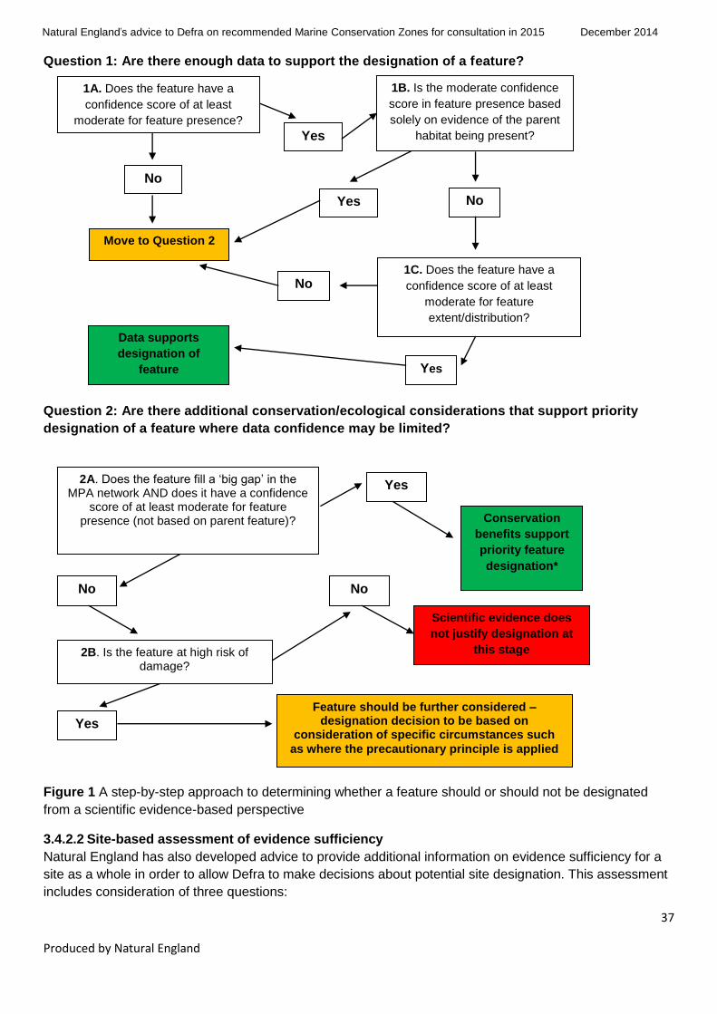
Natural England’s advice to Defra on recommended Marine Conservation Zones for consultation in 2015
December 2014
37
Produced by Natural England
Question 1: Are there enough data to support the designation of a feature?
Question 2: Are there additional conservation/ecological considerations that support priority
designation of a feature where data confidence may be limited?
Figure 1 A step-by-step approach to determining whether a feature should or should not be designated
from a scientific evidence-based perspective
3.4.2.2 Site-based assessment of evidence sufficiency
Natural England has also developed advice to provide additional information on evidence sufficiency for a
site as a whole in order to allow Defra to make decisions about potential site designation. This assessment
includes consideration of three questions:
Yes 2A. Does the feature fill a ‘big gap’ in the MPA network AND does it have a confidence
score of at least moderate for feature presence (not based on parent feature)?
No
Conservation
benefits support
priority feature
designation*
Scientific evidence does
not justify designation at
this stage
Yes
2B. Is the feature at high risk of damage?
No
Feature should be further considered – designation decision to be based on
consideration of specific circumstances such
as where the precautionary principle is applied
1A. Does the feature have a
confidence score of at least
moderate for feature presence?
Yes
No
1B. Is the moderate confidence
score in feature presence based
solely on evidence of the parent
habitat being present?
Move to Question 2
Yes
No 1C. Does the feature have a
confidence score of at least
moderate for feature
extent/distribution?
Yes
No
Data supports
designation of
feature

Natural England’s advice to Defra on recommended Marine Conservation Zones for consultation in 2015
December 2014
38
Produced by Natural England
1. To identify if there are any sites where designation of additional species may be required because
they may provide direct ecological support to features identified for designation.
2. Where it is possible to calculate: What proportion of total site area is covered by features for which
scientific confidence in presence and extent is assessed as being sufficient for designation.
3. A consideration of whether a site as a whole potentially fills a ‘big gap’ in the UK’s contribution to an
ecologically coherent network of MPAs.
The way in which each of these questions has been addressed is explained in turn below:
Consideration of supporting features – In order to assess the first question, SOCI and HOCI were
investigated to highlight any relationship or dependency on other features (BSH, SOCI or HOCI) taking
account of their features definitions from: the OSPAR List of Threatened and/or Declining Species and
Habitats (OSPAR, 2008); the UK List of Priority Species and Habitats (UK BAP) (BRIG, 2007). Feature
dependencies were allocated for each SOCI and HOCI, quality assured by Natural England specialists, and
circulated to MCZ site leads to be used to screen the features being considered for each site to identify any
instances where confidence in a ‘supporting feature’ would be too low for it to be designated based on
usual considerations. No such incidences were identified through this process and, as such, no further
action was required for this stage.
Spatial proportion of sites with sufficient evidence – The spatial proportion of a site covered by features for
which scientific confidence in presence and extent is assessed as being sufficient for designation was
calculated using spatial queries of habitat map data in ArcGIS. However this information has not been
assessed in a number of circumstances where:
• The site overlaps with an SAC, and therefore the site may not have been put forward for all the
potential MCZ features present within the site.
• The site has landward boundaries (such as estuarine sites).
• A feature is being added to an MCZ that is already designated.
• Information on feature extent within the site has been primarily derived from point data, and
therefore the calculation of areas could be misleading.
Ability of sites to fill big gaps – Natural England’s assessment of whether a feature/site could potentially fill
a ‘big gap’ within the network is based on the updated outputs of the ‘Big Gaps’ work undertaken by JNCC
for Defra in 2013/14 (JNCC, 2014). These outputs were cross-referenced with current feature confidence
assessments to identify any instances where features enabling sites to fill big gaps had only low
confidence.
Natural England has also developed a ‘site-level commentary’ summarising a site’s ability to fill big gaps in
the network (Table 10). This is a compilation of: whether the site still fills a big gap in the network taking
account of current confidence; the number of features within the site with at least moderate confidence in
presence and extent; and site area. Following consideration of these parameters Natural England has also
highlighted sites having the potential to make a particularly important contribution to the network.
3.4.2.3 Quality assurance of the advice on the scientific basis to support feature / site designation
Natural England staff developed an automated process using Excel to answer the component questions
required for both Questions 1 and 2 within the ‘data sufficiency’ assessment. This was then used to
interrogate the results of Natural England’s evidence assessment of which 10% of the outputs from this
automated process were manually verified.
Natural England’s advice to Defra on recommended Marine Conservation Zones for consultation in 2015
December 2014
39
Produced by Natural England
The updated big gap analysis undertaken by JNCC (JNCC, 2014) was used to identify which features may
contribute towards filling a big gap at the site level within the network in conjunction with information on new
incoming data that could be used to inform on MCZ features. This information was collated from a variety of
sources including the Natural England Monitoring team, area teams and MCZ site leads as well as partner
organisations and subsequently quality assured by the Evidence Senior Specialist. Natural England’s
evidence specialists verified 20% of the feature gap outputs and at least 20% of the final ‘feature data
sufficiency’ results to validate the results and ensure consistency and coherency in the final results output
for Defra. Specific checks, details and actions were logged.
In relation to the overarching site evidence sufficiency assessment a checklist of feature dependencies and
associated guidance was developed in-house by a senior specialist. This was verified and amended where
necessary following agreement by the MCZ Evidence team prior to being passed to MCZ site leads and
deputies for analysis. A review of the results of the area teams’ work was subsequently conducted by at
least two national specialists and a senior specialist prior to production of the final results.
The areas within rMCZs occupied by features with sufficient evidence were analysed and quantified by a
senior GI specialist using queries in ArcGIS in order to determine the proportion of a given site that was
covered by proposed features. This output was checked in detail by another GI specialist.
Natural England’s advice to Defra on recommended Marine Conservation Zones for consultation in 2015
December 2014
40
Produced by Natural England
4 Results
4.1 Aims of this section
This section provides summaries of the main components of our advice:
Assessment of confidence in presence and extent of features in rMCZs (Section 4.2)
Evidence used for the assessment of confidence (Section 4.3)
List of evidence not used because the results were not ready in time for inclusion in the analysis
(Section 4.4)
General management approach advised (Section 4.5)
Feature risk assessment (Section 4.6)
Advice on the scientific basis to support feature / site designation (Section 4.7)
The summaries of the results consider all rMCZs together and the information is presented in tabular
form. For a summary of the results on a site-by-site basis, refer to Annex 9, which provides further details
and collates all information relating to individual rMCZs.
4.2 Assessment of confidence in presence and extent of rMCZ features
4.2.1 Summary of results
Since our 2012 advice, further data have become available that have improved our understanding of the
presence and extent of the features within the rMCZs. This assessment has used 416 datasets in total,
which include dedicated verification surveys and data provided through Defra’s 2013 Tranche 1 public
consultation.
Confidence in presence and extent was assessed for 371 features from 21 rMCZs and two existing
Tranche 1 MCZs, and we have resubmitted 2013 analysis on confidence in presence and extent for nine
undesignated or additional features within six existing Tranche 1 MCZs, giving an overall total of 380
features. These Tranche 1 features are detailed in Section 4.2.3. Of the 371:
205 features are original features proposed by the regional MCZ projects
163 features are new features identified through the feature confidence assessment process for
Tranche 2 sites
3 are new features in designated Tranche 1 sites
This has led to an increase in our scientific confidence of feature extent for those features originally
proposed:
25% of assessments for feature presence have increased in confidence, 26% have decreased
and the largest proportion, 49% remain unchanged.
37% of assessments for feature extent have increased in confidence, 22% have decreased and
41% remain unchanged.
We now have high/high or high/moderate confidence in presence/extent for 44% of original regional MCZ
project features, moderate/moderate confidence in 18%, low confidence (moderate/low, low/low) in 23%
and no confidence in 9%. The remaining 6% represent features that were not assessed in this analysis
and these were non-ENG highly mobile species and geological features.
Mobile species are discussed in Section 4.2.4 and it should be noted that due to the nature of the four
geological features considered in Tranche 2 the same confidence assessment results have been
provided for 2012. We considered it unlikely that any additional supporting evidence will have become

Natural England’s advice to Defra on recommended Marine Conservation Zones for consultation in 2015
December 2014
41
Produced by Natural England
available since the regional project stage and so the confidence assessment results provided are taken
from our previous advice.
Reasons for increases in confidence include:
Availability of new, generally higher quality survey data, including new data submitted through the
Tranche 1 public consultation or from partner organisations;
The use of existing evidence which was not previously available;
Application of high-quality survey point data within the assessment process, in line with the
Technical Protocol E supplementary paper (JNCC and Natural England, 2013a).
Decreases in confidence assessments also arise for a number of reasons:
Where new data are considered to be of higher quality (eg from verification surveys) this often
increases confidence in feature presence and extent, but it may also reduce confidence for some
features (eg if a previously mapped feature is not found during the new survey).
Age of data: in accordance with Protocol E (JNCC and Natural England, 2102c), where applicable,
if the data used in the 2012 advice have aged beyond the 6 and 12-year cut-offs, confidence in
these data has reduced for some features. This applies only to species of conservation
importance and highly temporally variable habitats of conservation importance.
In the 2012 advice any geo-referenced photographic evidence for intertidal features was assigned
high confidence. In this advice, we have treated photographic evidence as a data point (see
Section 3.1) in line with the Technical Protocol E supplementary paper (JNCC and Natural
England, 2013a). As a result, some features will have reduced in confidence if the number of
photographs of the feature did not meet the Protocol E requirements for high confidence.
The removal of duplicate data points: for some features duplicate data points have been identified
within our data sets. These duplicates result from the same data being submitted by dif ferent
consultees (eg Seasearch data submissions that were already entered onto Marine Recorder). In
some cases the removal of these duplicates resulted in reduced confidence compared to our 2012
assessments.
As discussed in Section 3.1.5.1, those features initially assigned moderate confidence based on
‘parent feature’ data were manually downgraded to low confidence for presence and extent during
the QA processes.
4.2.2 Feature-specific considerations.
As a result of the automated confidence assessment and the subsequent QA processes, Natural England
advises that a number of features should be added to or deleted from the list of those considered for
designation. This is for a number of reasons:
1. Additional features have been identified where the current evidence base suggests they may be
present. Newly identified features that are already protected by existing designations ie SAC or
Sites of Specific Scientific Interest (SSSI), were subsequently removed from this advice following
a regional QA process.
2. In line with previous advice (JNCC and Natural England, 2013c) the designation of the HOCI
Subtidal sands and gravels is not necessary in cases where the BSH Subtidal coarse sediment
and/or Subtidal sand are being designated and wholly cover the proposed HOCI area. The sites
where this occurred were: The Swale Estuary, Dover to Folkestone, Allonby Bay, and Holderness
Inshore.

Natural England’s advice to Defra on recommended Marine Conservation Zones for consultation in 2015
December 2014
42
Produced by Natural England
3. The sea snail Paludinella littorina is no longer considered a distinct species and is now included
under the species Melarhaphe neritoides (World Register of Marine Species (WoRMS) Editorial
Board, 2014). As such it is no longer considered an ENG feature and thus is no longer suitable for
designation as an MCZ feature. The sites where this feature is no longer proposed for designation
are: Bembridge, Runnel Stone (Land’s End), Newquay and the Gannel, and Bideford to Foreland
Point.
4. As per previous designation tranches, European eel (Anguilla anguilla) has been excluded as an
MCZ feature in this advice. This decision has been based on evidence reviewed by Cefas, the EA,
Natural England and Defra which concludes that, given a lack of evidence and understanding of
spawning and nursery / foraging grounds within regional project recommendations and evidence
that European eels lack site fidelity and migrate after spawning into any suitable estuary in
Europe, it is an inappropriate candidate for spatial protection under MCZ designation.
5. Natural England has reviewed the evidence underpinning tide-swept channel features, in
particular newly identified features where the current evidence base suggests they may be
present. The reason for this additional scrutiny is that the MB0102 Report No 16 (Task 2C)
‘Mapping of protected habitats’ (Seeley et al, 2010), explicitly identified and mapped ‘tide-swept
channels’ on the basis of a wider habitat definition than the UK BAP definition which underpinned
the feature’s inclusion as a FOCI habitat. This resulted in large areas of seabed being identified
where there are strong tidal streams but where no well-defined ‘channel’ was present. In
undertaking this review Natural England referred to the original UK BAP definition, and was
informed by awareness of discussions on an updated habitat definition being developed between
the UK conservation agencies. As a result of this review, newly identified features were retained at
three sites within the evidence assessment: The Needles, Newquay and the Gannel and Coquet
to St Mary’s, though in each case the confidence assessment for these features was low/low.
Newly identified tide-swept channel features that did not meet the criteria for there to be some
form of constrained channel are omitted from this advice.
6. A degree of taxonomic uncertainty exists around records of Haliclystus auricula. There are now
known to be two species of Haliclystus in England, H. auricula (Rathke, 1806) and H. octoradiatus
(Lamarck, 1816). These were differentiated in the 1800s but throughout the 1900s appear to have
been combined into one species, H. auricula. In 1997 they were re-separated. Both are listed as
accepted on WoRMS, from at least 2004 onwards. All of the records contributing to our advice are
currently listed as being H. auricula and have been treated as such without further taxonomic
evaluation.
4.2.3 Additional features for Tranche 1 sites
As part of this advice Defra asked Natural England to consider whether any undesignated features
proposed for Tranche 1 or additional features identified during the Tranche 1 confidence assessment
should be considered for designation through Tranche 2. Those proposed features that were not
designated in 2013 but that still had sufficient confidence to be considered in Tranche 2 are as follows:
South Dorset – A4.2 Moderate energy circalittoral rock
Chesil Beach and Stennis Ledges – A3.1 High energy infralittoral rock, A5.1 Subtidal coarse
sediment
Upper Fowey and Pont Pill – A2.2 Intertidal sand and muddy sand

Natural England’s advice to Defra on recommended Marine Conservation Zones for consultation in 2015
December 2014
43
Produced by Natural England
The Manacles – A5.1 Subtidal coarse sediment, A5.4 Subtidal mixed sediments, Pink sea-fan
(Eunicella verrucosa)
The conservation objective for these features changed between the 2012 and 2013 assessments and the
decision was taken to defer them until a later tranche where they could be included in public consultation
with the amended conservation objective.
New features that were identified during the 2013 confidence assessment for Tranche 1 sites and which
are proposed for inclusion in Tranche 2 because they contribute towards the MPA network are as follows:
Blackwater, Crouch, Roach and Colne Estuary – A5.6 Subtidal biogenic reefs
Beachy Head West – A4.1 High energy circalittoral rock, A4.2 Moderate energy circalittoral rock
Torbay – HOCI_15 Peat and clay exposures
Fylde – A5.3 Subtidal mud
For these features the confidence assessments were updated during this tranche where new evidence
was available. This was the case for the features in the rMCZs: Blackwater, Crouch, Roach and Colne
Estuary; Beachy Head West; and Fylde.
4.2.4 Mobile species
For the majority of mobile species recommended for protection by the regional MCZ projects, Defra has
decided to defer consideration for designation (Defra, 2012). These are still listed within Table 1 for
completeness, but updated confidence assessments have not been provided for these species. Defra
have however asked for advice on mobile species in specific rMCZs as follows:
undulate ray (Raja undulata), proposed by the Finding Sanctuary regional MCZ project at
Studland Bay and identified as a new feature at Cromer Shoal Chalk Beds. Following the
automated confidence assessment, a result of ‘no confidence’ was produced for this feature at
Studland Bay; however Natural England has subsequently received some photographic evidence
to support the presence of this species and further research and survey work is being conducted
to identify important areas for the undulate ray off the south coast of England that could support its
designation. It has therefore been included in our advice for Studland Bay.
smelt (Osmerus eperlanus) which was identified as a new feature at The Swale Estuary and
Cromer Shoal Chalk Beds.
black seabream (Spondyliosoma cantharus) are reported in this advice because this feature was
designated in Tranche 1. This feature has been identified as a new feature in the following five
rMCZs: Dover to Folkestone, The Needles, Yarmouth to Cowes, Studland Bay and North of
Lundy.
4.2.5 Introduction to Table 1
Table 1 gives information about the features in each site; feature type (ie BSH, HOCI or SOCI); the 2012
and 2014 assessments of confidence in the evidence for presence and extent of each feature; the
evidence used to determine the current assessment (further detailed in Table 2); any evidence not used
(ie evidence of relevance to the site / feature which was not available in time to use in the 2014
confidence assessment – further detailed in Table 3); and other relevant feature information, for example
whether the feature is highly sensitive. Non-ENG mobile species are included in Table 1 for
completeness purposes and the 2012 assessments of confidence are shown.

Natural England’s advice to Defra on Tranche 2 recommended Marine Conservation Zones December 2014
44
Produced by Natural England
Table 1 Confidence assessment of evidence for presence and extent of rMCZ features
Site name Feature name Feature
type
2012
Advice
presence
2012
Advice
extent
Feature
status
2014
Advice
presence
2014
Advice
extent
2014 Comments
(amalgamated from
national / regional QA
process)
Evidence
used
Evidence
not used
Blackwater,
Crouch,
Roach and
Colne Estuary
Subtidal
biogenic reefs
BSH Moderate1
Moderate1 T1 new
features
High Moderate Decision taken that feature
unlikely to be fully covered
by a Special Area of
Conservation (SAC) / Site
of Special Scientific Interest
(SSSI) so advice will be
given.
D_00236,
D_00407,D_
00410,D_00
412,D_0042
6,D_00427,D
_00429,D_0
0436
The Swale
Estuary
Low energy
intertidal rock
BSH High High Tranche
2 advice
High High D_00256,D_
00355,D_00
377
The Swale
Estuary
Low energy
infralittoral rock
BSH Low Low Tranche
2 advice
No
confidence
No
confidence
The Swale
Estuary
Subtidal sand BSH High Moderate Tranche
2 advice
Moderate Moderate D_00346,D_
00406,D_00
413,D_0041
7,D_00418,D
_00425,D_0
0432,D_004
34
D_00034
The Swale
Estuary
Subtidal mud BSH Moderate Low Tranche
2 advice
High Moderate D_00173,D_
00257,D_00
296,D_0035
5,D_00406,D
_00425,D_0
0432,D_004
34,D_00437
D_00034
The Swale Subtidal mixed BSH Moderate Moderate Tranche High Moderate D_00163,D_ D_00034

Natural England’s advice to Defra on Tranche 2 recommended Marine Conservation Zones December 2014
45
Produced by Natural England
Site name Feature name Feature
type
2012
Advice
presence
2012
Advice
extent
Feature
status
2014
Advice
presence
2014
Advice
extent
2014 Comments
(amalgamated from
national / regional QA
process)
Evidence
used
Evidence
not used
Estuary sediments 2 advice 00173,D_00
257,D_0029
6,D_00346,D
_00355,D_0
0425,D_004
37
The Swale
Estuary
Blue mussel
beds
HOCI Low Low Tranche
2 advice
High High Subtidal Seasearch
photographic evidence
removed as part of
photographic evidence QA
process. Intertidal HOCI_1
polygon and point data
obtained from regional
team advisers.
D_00256,D_
00388
The Swale
Estuary
Peat and clay
exposures
HOCI High Moderate Tranche
2 advice
High Moderate D_00038,D_
00173,D_00
256,D_0035
5
The Swale
Estuary
Ross worm
reefs (Sabellaria
spinulosa)
HOCI Low Low Tranche
2 advice
No
confidence
No
confidence
The Swale
Estuary
Sheltered
muddy gravels
HOCI High High Tranche
2 advice
Low Low D_00256
The Swale
Estuary
Native oyster
(Ostrea edulis)
SOCI Moderate Low Tranche
2 advice
Moderate Low Concern around Intertidal
native oyster records –
records removed and
manually adjusted
confidence to mod/low as
records are dead shells.
D_00345,M_
00004

Natural England’s advice to Defra on Tranche 2 recommended Marine Conservation Zones December 2014
46
Produced by Natural England
Site name Feature name Feature
type
2012
Advice
presence
2012
Advice
extent
Feature
status
2014
Advice
presence
2014
Advice
extent
2014 Comments
(amalgamated from
national / regional QA
process)
Evidence
used
Evidence
not used
The Swale
Estuary
Moderate
energy intertidal
rock
BSH T2 new
features
High High D_00256,D_
00355,D_00
377
The Swale
Estuary
Intertidal coarse
sediment
BSH T2 new
features
High High D_00377
The Swale
Estuary
Intertidal sand
and muddy sand
BSH T2 new
features
High Moderate D_00296,D_
00355,D_00
406,D_0041
3,D_00416,D
_00418,D_0
0425,D_004
32,D_00433
The Swale
Estuary
Intertidal mixed
sediments
BSH T2 new
features
High Moderate D_00256,D_
00425
The Swale
Estuary
Subtidal coarse
sediment
BSH T2 new
features
Moderate Moderate D_00346,D_
00406,D_00
425,D_0043
2
D_00034
The Swale
Estuary
Subtidal
biogenic reefs
BSH T2 new
features
Low Low Manually downgraded to
Low/low as based on
parent feature.
D_00434
The Swale
Estuary
Estuarine rocky
habitats
HOCI T2 new
features
High Moderate D_00256,D_
00355
The Swale
Estuary
Smelt (Osmerus
eperlanus)
SOCI T2 new
features
High High High confidence in
presence. However,
available point records only
support feature presence
and do give evidence of
D_00387

Natural England’s advice to Defra on Tranche 2 recommended Marine Conservation Zones December 2014
47
Produced by Natural England
Site name Feature name Feature
type
2012
Advice
presence
2012
Advice
extent
Feature
status
2014
Advice
presence
2014
Advice
extent
2014 Comments
(amalgamated from
national / regional QA
process)
Evidence
used
Evidence
not used
how the species is using
the site and thus its
ecological importance for
this species.
Dover to Deal Moderate
energy intertidal
rock
BSH High High Tranche
2 advice
High High D_00098,D_
00114,D_00
155,D_0018
0,D_00320,D
_00359,D_0
0361,D_003
76,M_00136
Dover to Deal Intertidal coarse
sediment
BSH High Low Tranche
2 advice
Low Low D_00376,M_
00136
Dover to Deal Intertidal mud BSH High High Tranche
2 advice
Low Low D_00362
Dover to Deal High energy
infralittoral rock
BSH Low Low Tranche
2 advice
No
confidence
No
confidence
Dover to Deal Moderate
energy
infralittoral rock
BSH Low Low Tranche
2 advice
High Moderate D_00022,D_
00098,D_00
114,D_0011
5,D_00155,D
_00163,D_0
0320,M_001
36
Dover to Deal Subtidal coarse
sediment
BSH Low Low Tranche
2 advice
Low Low M_00136
Dover to Deal Subtidal mixed
sediments
BSH Low Low Tranche
2 advice
High Moderate D_00022,D_
00115,D_00
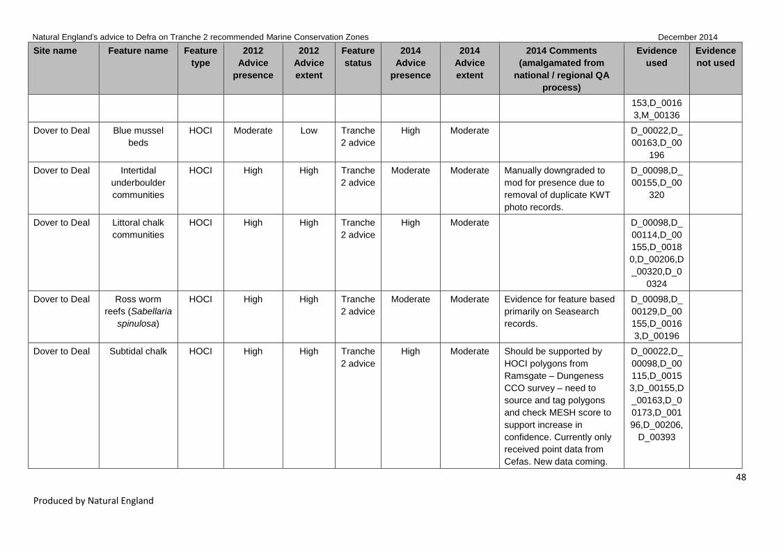
Natural England’s advice to Defra on Tranche 2 recommended Marine Conservation Zones December 2014
48
Produced by Natural England
Site name Feature name Feature
type
2012
Advice
presence
2012
Advice
extent
Feature
status
2014
Advice
presence
2014
Advice
extent
2014 Comments
(amalgamated from
national / regional QA
process)
Evidence
used
Evidence
not used
153,D_0016
3,M_00136
Dover to Deal Blue mussel
beds
HOCI Moderate Low Tranche
2 advice
High Moderate D_00022,D_
00163,D_00
196
Dover to Deal Intertidal
underboulder
communities
HOCI High High Tranche
2 advice
Moderate Moderate Manually downgraded to
mod for presence due to
removal of duplicate KWT
photo records.
D_00098,D_
00155,D_00
320
Dover to Deal Littoral chalk
communities
HOCI High High Tranche
2 advice
High Moderate D_00098,D_
00114,D_00
155,D_0018
0,D_00206,D
_00320,D_0
0324
Dover to Deal Ross worm
reefs (Sabellaria
spinulosa)
HOCI High High Tranche
2 advice
Moderate Moderate Evidence for feature based
primarily on Seasearch
records.
D_00098,D_
00129,D_00
155,D_0016
3,D_00196
Dover to Deal Subtidal chalk HOCI High High Tranche
2 advice
High Moderate Should be supported by
HOCI polygons from
Ramsgate – Dungeness
CCO survey – need to
source and tag polygons
and check MESH score to
support increase in
confidence. Currently only
received point data from
Cefas. New data coming.
D_00022,D_
00098,D_00
115,D_0015
3,D_00155,D
_00163,D_0
0173,D_001
96,D_00206,
D_00393

Natural England’s advice to Defra on Tranche 2 recommended Marine Conservation Zones December 2014
49
Produced by Natural England
Site name Feature name Feature
type
2012
Advice
presence
2012
Advice
extent
Feature
status
2014
Advice
presence
2014
Advice
extent
2014 Comments
(amalgamated from
national / regional QA
process)
Evidence
used
Evidence
not used
Dover to Deal High energy
intertidal rock
BSH T2 new
features
Moderate Moderate D_00114,D_
00155,D_00
320,D_0037
6
Dover to Deal Low energy
intertidal rock
BSH T2 new
features
Moderate Moderate D_00155,D_
00320
Dover to Deal Intertidal sand
and muddy sand
BSH T2 new
features
Low Low D_00114,M_
00136
Dover to Deal High energy
circalittoral rock
BSH T2 new
features
Moderate Moderate D_00115,D_
00163
Dover to Deal Moderate
energy
circalittoral rock
BSH T2 new
features
Moderate Moderate D_00115,D_
00153,D_00
163,M_0013
6
Dover to Deal Subtidal sand BSH T2 new
features
Low Low Manually downgraded to
low/low based on expert
judgement as based on
parent feature alone.
D_00022,D_
00163,M_00
136
Dover to Deal Native oyster
(Ostrea edulis)
SOCI T2 new
features
Moderate Moderate D_00115
Dover to
Folkestone
Moderate
energy intertidal
rock
BSH High High Tranche
2 advice
High High D_00046,D_
00101,D_00
114,D_0015
5,D_00187,D
_00254,D_0
0320,D_003
22,D_00359,
D_00361,D_

Natural England’s advice to Defra on Tranche 2 recommended Marine Conservation Zones December 2014
50
Produced by Natural England
Site name Feature name Feature
type
2012
Advice
presence
2012
Advice
extent
Feature
status
2014
Advice
presence
2014
Advice
extent
2014 Comments
(amalgamated from
national / regional QA
process)
Evidence
used
Evidence
not used
00376,M_00
136
Dover to
Folkestone
Intertidal coarse
sediment
BSH Low Low Tranche
2 advice
High High D_00046,D_
00098,D_00
101,D_0011
4,D_00320,D
_00321,D_0
0376,M_001
36
Dover to
Folkestone
High energy
infralittoral rock
BSH Moderate Moderate Tranche
2 advice
Moderate Moderate D_00155,D_
00163
Dover to
Folkestone
Moderate
energy
infralittoral rock
BSH Low Low Tranche
2 advice
High High D_00023,D_
00098,D_00
101,D_0012
9,D_00140,D
_00155,D_0
0163,D_002
54,D_00320,
D_00321,D_
00322,M_00
136
Dover to
Folkestone
Subtidal coarse
sediment
BSH Low Low Tranche
2 advice
Moderate Moderate D_00115,D_
00140,M_00
136
Dover to
Folkestone
Blue mussel
beds
HOCI Moderate Low Tranche
2 advice
Low Low D_00320
Dover to
Folkestone
Intertidal
underboulder
HOCI High High Tranche
2 advice
High Moderate D_00098,D_
00101,D_00

Natural England’s advice to Defra on Tranche 2 recommended Marine Conservation Zones December 2014
51
Produced by Natural England
Site name Feature name Feature
type
2012
Advice
presence
2012
Advice
extent
Feature
status
2014
Advice
presence
2014
Advice
extent
2014 Comments
(amalgamated from
national / regional QA
process)
Evidence
used
Evidence
not used
communities 114,D_0015
5,D_00187
Dover to
Folkestone
Littoral chalk
communities
HOCI High High Tranche
2 advice
High Moderate D_00098,D_
00101,D_00
114,D_0015
5,D_00254,D
_00320,D_0
0324
Dover to
Folkestone
Peat and clay
exposures
HOCI High Moderate Tranche
2 advice
High High Manually increase
confidence to high/high as
NE verification shows peat
and clay exposures.
D_00442
Dover to
Folkestone
Ross worm
reefs (Sabellaria
spinulosa)
HOCI Moderate Low Tranche
2 advice
Moderate Moderate Evidence for feature based
primarily on Seasearch
records.
D_00098,D_
00163,D_00
173,D_0019
6
Dover to
Folkestone
Subtidal chalk HOCI High High Tranche
2 advice
High Moderate Should be supported by
HOCI polygons from
Ramsgate–Dungeness
CCO survey. Need to
source and tag polygons
and check MESH score to
support increase in
confidence. Currently only
received point data from
Cefas. New data coming.
D_00023,D_
00098,D_00
101,D_0011
5,D_00129,D
_00140,D_0
0153,D_001
55,D_00163,
D_00173,D_
00181,D_00
188,D_0019
6,D_00254,D
_00320,D_0
0321,D_003

Natural England’s advice to Defra on Tranche 2 recommended Marine Conservation Zones December 2014
52
Produced by Natural England
Site name Feature name Feature
type
2012
Advice
presence
2012
Advice
extent
Feature
status
2014
Advice
presence
2014
Advice
extent
2014 Comments
(amalgamated from
national / regional QA
process)
Evidence
used
Evidence
not used
93
Dover to
Folkestone
Short-snouted
seahorse
(Hippocampus
hippocampus)
SOCI Moderate Moderate Tranche
2 advice
Moderate Moderate Possible post-2008 video
records of seahorse from
KWT – to be chased up by
regional advisers.
D_00173,M_
00009
Dover to
Folkestone
Native oyster
(Ostrea edulis)
SOCI High High Tranche
2 advice
High High Records verified with
Wildlife Trust.
D_00098,D_
00115,D_00
163,D_0018
1,M_00004
Dover to
Folkestone
Folkestone
Warren
Geo-
logical
High Moderate Tranche
2 advice
High Moderate
Dover to
Folkestone
High energy
intertidal rock
BSH T2 new
features
High Moderate D_00101,D_
00114,D_00
155,D_0025
4,D_00320,D
_00321
Dover to
Folkestone
Low energy
intertidal rock
BSH T2 new
features
Moderate Moderate D_00155,D_
00254,D_00
320
Dover to
Folkestone
Intertidal sand
and muddy sand
BSH T2 new
features
High High Manually upgrade to
high/high based on manual
application of MESH score
>58 to dataset M_00136
which will increase
confidence based on
protocol.
D_00046,D_
00320,D_00
376,M_0013
6
Dover to
Folkestone
Intertidal mud BSH T2 new
features
Low Low Manually downgraded to
low/low based on expert
D_00362,D_
00376

Natural England’s advice to Defra on Tranche 2 recommended Marine Conservation Zones December 2014
53
Produced by Natural England
Site name Feature name Feature
type
2012
Advice
presence
2012
Advice
extent
Feature
status
2014
Advice
presence
2014
Advice
extent
2014 Comments
(amalgamated from
national / regional QA
process)
Evidence
used
Evidence
not used
judgement as based on
parent feature alone.
Dover to
Folkestone
Intertidal mixed
sediments
BSH T2 new
features
Low Low Manually downgraded to
low/low based on expert
judgement as based on
parent feature alone.
D_00376
Dover to
Folkestone
Low energy
infralittoral rock
BSH T2 new
features
Moderate Low Extent manually
downgraded to low
following spatial check and
expert judgement.
D_00320
Dover to
Folkestone
High energy
circalittoral rock
BSH T2 new
features
Moderate Moderate D_00115,D_
00129,D_00
140,D_0016
3
Dover to
Folkestone
Moderate
energy
circalittoral rock
BSH T2 new
features
High High Manually upgrade to
high/high based on manual
application of MESH score
>58 to dataset M_00136
which will increase
confidence based on
protocol.
D_00023,D_
00115,D_00
129,D_0014
0,D_00153,D
_00163,D_0
0173,D_001
81,M_00136
Dover to
Folkestone
Subtidal sand BSH T2 new
features
High High Manually upgrade to
high/high based on manual
application of MESH score
>58 to dataset M_00136
which will increase
confidence based on
protocol.
D_00023,D_
00115,D_00
140,D_0016
3,D_00173,M
_00136

Natural England’s advice to Defra on Tranche 2 recommended Marine Conservation Zones December 2014
54
Produced by Natural England
Site name Feature name Feature
type
2012
Advice
presence
2012
Advice
extent
Feature
status
2014
Advice
presence
2014
Advice
extent
2014 Comments
(amalgamated from
national / regional QA
process)
Evidence
used
Evidence
not used
Dover to
Folkestone
Subtidal mud BSH T2 new
features
Moderate Moderate D_00023,D_
00115,D_00
140
Dover to
Folkestone
Subtidal mixed
sediments
BSH T2 new
features
High High Manually upgrade to
high/high based on manual
application of MESH score
>58 to dataset M_00136
which will increase
confidence based on
protocol.
D_00023,D_
00115,D_00
129,D_0014
0,D_00153,D
_00163,D_0
0173,M_001
36
Dover to
Folkestone
Black seabream
(Spondyliosoma
cantharus)
non_
ENG
T2 new
features
Low Low D_00129
Beachy Head
West
High energy
circalittoral rock
BSH Moderate1 Moderate
1 T1 new
features
Moderate Moderate D_00231,D_
00246,D_00
250,D_0032
6
Beachy Head
West
Moderate
energy
circalittoral rock
BSH High1 High
1 T1 new
features
High Moderate Extent manually
downgraded to mod due to
lack of matching ground
truthing points/failure to be
considered in automated
process.
D_00132,D_
00144,D_00
156,D_0022
3,D_00238,D
_00246,D_0
0247,D_002
50,D_00326,
M_00161
Norris to Ryde Subtidal mud BSH Low Low Tranche
2 advice
High Moderate D_00031,D_
00186,D_00
346,D_0043
1
D_00002,
D_00011

Natural England’s advice to Defra on Tranche 2 recommended Marine Conservation Zones December 2014
55
Produced by Natural England
Site name Feature name Feature
type
2012
Advice
presence
2012
Advice
extent
Feature
status
2014
Advice
presence
2014
Advice
extent
2014 Comments
(amalgamated from
national / regional QA
process)
Evidence
used
Evidence
not used
Norris to Ryde Seagrass beds HOCI High High Tranche
2 advice
High High D_00065,D_
00094,D_00
160,D_0016
9,D_00366,D
_00379,D_0
0399,D_004
01,D_00404,
D_00443,D_
00456
D_00520
Norris to Ryde Tentacled
lagoon worm
(Alkmaria
romijni)
SOCI Low Low Tranche
2 advice
Low Low M_00026
Norris to Ryde Low energy
intertidal rock
BSH T2 new
features
Moderate Low Extent manually
downgraded to low
following spatial check and
expert judgement.
D_00311 D_00517
Norris to Ryde Subtidal coarse
sediment
BSH T2 new
features
Low Low Manually downgraded to
low/low as no ground
truthing to support feature
polygons within site.
D_00379 D_00002,
D_00011,
M_00018
Norris to Ryde Subtidal sand BSH T2 new
features
Low Low Manually downgraded to
low/low as no ground
truthing to support feature
polygons within site.
D_00346,D_
00379
D_00002,
D_00011,
M_00018
Norris to Ryde Subtidal mixed
sediments
BSH T2 new
features
High High D_00031,D_
00311,D_00
379,M_0019
8
D_00002,
D_00011

Natural England’s advice to Defra on Tranche 2 recommended Marine Conservation Zones December 2014
56
Produced by Natural England
Site name Feature name Feature
type
2012
Advice
presence
2012
Advice
extent
Feature
status
2014
Advice
presence
2014
Advice
extent
2014 Comments
(amalgamated from
national / regional QA
process)
Evidence
used
Evidence
not used
Norris to Ryde Subtidal
macrophyte-
dominated
sediment
BSH T2 new
features
High High Only one point not tagged
for HOCI.
D_00169,D_
00311,D_00
379,D_0045
6
Norris to Ryde Peat and clay
exposures
HOCI T2 new
features
Low Low D_00442
Norris to Ryde Sheltered
muddy gravels
HOCI T2 new
features
High High D_00379,D_
00392
Norris to Ryde Estuarine rocky
habitats
HOCI T2 new
features
Low Low D_00311 D_00517
Norris to Ryde Native oyster
(Ostrea edulis)
SOCI T2 new
features
Moderate Moderate D_00160,D_
00186,D_00
189
The Needles Subtidal mixed
sediments
BSH Low Low Tranche
2 advice
High Moderate D_00092,D_
00106,D_00
125,D_0013
8,D_00221
D_00002,
D_00510
The Needles Seagrass beds HOCI High High Tranche
2 advice
Moderate Moderate D_00094,D_
00106,D_00
138,D_0014
8,D_00169
D_00520
The Needles Stalked jellyfish
(Lucernariopsis
campanulata)
SOCI Low Low Tranche
2 advice
Moderate Moderate Initial automated
confidence result produced
as high/high but
subsequently manually
downgraded to mod/mod
due to duplication of
records resulting in a higher
D_00099,D_
00106,D_00
221

Natural England’s advice to Defra on Tranche 2 recommended Marine Conservation Zones December 2014
57
Produced by Natural England
Site name Feature name Feature
type
2012
Advice
presence
2012
Advice
extent
Feature
status
2014
Advice
presence
2014
Advice
extent
2014 Comments
(amalgamated from
national / regional QA
process)
Evidence
used
Evidence
not used
confidence than should be
attained.
The Needles Peacock's tail
(Padina
pavonica)
SOCI High High Tranche
2 advice
High High M_00015
The Needles Moderate
energy intertidal
rock
BSH T2 new
features
High Low Extent manually
downgraded to low
following spatial check and
expert judgement.
D_00318,D_
00350
The Needles Intertidal coarse
sediment
BSH T2 new
features
Low Low D_00376
The Needles Intertidal sand
and muddy sand
BSH T2 new
features
Low Low D_00376
The Needles Intertidal mud BSH T2 new
features
Low Low D_00376
The Needles Intertidal mixed
sediments
BSH T2 new
features
Low Low D_00376
The Needles High energy
infralittoral rock
BSH T2 new
features
Moderate Low Extent manually
downgraded to low
following spatial check and
expert judgement.
D_00092,D_
00125,D_00
346
D_00002,
D_00510
The Needles Moderate
energy
infralittoral rock
BSH T2 new
features
High Moderate D_00106,D_
00125,D_00
138,D_0025
2,D_00346
D_00002,
D_00510
The Needles Moderate
energy
circalittoral rock
BSH T2 new
features
Moderate Moderate D_00106,D_
00125,D_00
138,D_0034
D_00002,
D_00510

Natural England’s advice to Defra on Tranche 2 recommended Marine Conservation Zones December 2014
58
Produced by Natural England
Site name Feature name Feature
type
2012
Advice
presence
2012
Advice
extent
Feature
status
2014
Advice
presence
2014
Advice
extent
2014 Comments
(amalgamated from
national / regional QA
process)
Evidence
used
Evidence
not used
6
The Needles Subtidal coarse
sediment
BSH T2 new
features
High Moderate D_00092,D_
00125,D_00
346
D_00002,
D_00510
The Needles Subtidal sand BSH T2 new
features
High Moderate D_00092,D_
00106,D_00
138,D_0016
9,M_00198
D_00002,
D_00510
The Needles Subtidal mud BSH T2 new
features
Moderate Moderate D_00092 D_00002,
D_00510
The Needles Subtidal
macrophyte-
dominated
sediment
BSH T2 new
features
Moderate Moderate Only one point not tagged
for HOCI.
D_00092,D_
00106,D_00
138,D_0016
9
The Needles Sheltered
muddy gravels
HOCI T2 new
features
Moderate Moderate D_00092,D_
00125,D_00
221
The Needles Subtidal chalk HOCI T2 new
features
Moderate Moderate D_00106,D_
00125,D_00
138,D_0039
3
The Needles Tide-swept
channels
HOCI T2 new
features
Low Low D_00394
The Needles Native oyster
(Ostrea edulis)
SOCI T2 new
features
High High D_00106,D_
00125,D_00
138,D_0014
8,D_00160,D
_00221

Natural England’s advice to Defra on Tranche 2 recommended Marine Conservation Zones December 2014
59
Produced by Natural England
Site name Feature name Feature
type
2012
Advice
presence
2012
Advice
extent
Feature
status
2014
Advice
presence
2014
Advice
extent
2014 Comments
(amalgamated from
national / regional QA
process)
Evidence
used
Evidence
not used
The Needles Black seabream
(Spondyliosoma
cantharus)
non_
ENG
T2 new
features
Low Low D_00106
Bembridge Subtidal sand BSH Low Low Tranche
2 advice
High High D_00004,D_
00019,D_00
092,D_0012
5,D_00194,D
_00252,D_0
0386,M_000
89
D_00002,
D_00510
Bembridge Subtidal mud BSH High Low Tranche
2 advice
High High D_00004,D_
00019,D_00
092,D_0014
8,D_00232,D
_00431,D_0
0454,M_003
61
D_00002,
D_00510
Bembridge Subtidal mixed
sediments
BSH Low Low Tranche
2 advice
High High D_00004,D_
00019,D_00
092,D_0010
6,D_00125,D
_00138,D_0
0148,D_001
69,D_00232,
D_00252,D_
00431
D_00002,
D_00510
Bembridge Maerl beds HOCI High High Tranche
2 advice
High Moderate D_00092,D_
00125,D_00
138,M_0001

Natural England’s advice to Defra on Tranche 2 recommended Marine Conservation Zones December 2014
60
Produced by Natural England
Site name Feature name Feature
type
2012
Advice
presence
2012
Advice
extent
Feature
status
2014
Advice
presence
2014
Advice
extent
2014 Comments
(amalgamated from
national / regional QA
process)
Evidence
used
Evidence
not used
9
Bembridge Mud habitats in
deep water
HOCI High Low Tranche
2 advice
No
confidence
No
confidence
Two data points removed
due to incorrect tagging.
Bembridge Native oyster
beds (Ostrea
edulis)
HOCI Low Low Tranche
2 advice
No
confidence
No
confidence
Manually downgraded to
‘No data’ as D_00439 does
not meet criteria for oyster
beds and so untagged for
HOCI and tagged for SOCI.
D_00439
Bembridge Ross worm
reefs (Sabellaria
spinulosa)
HOCI Low Low Tranche
2 advice
Low Low D_00232
Bembridge Seagrass beds HOCI High High Tranche
2 advice
Moderate Moderate D_00094,D_
00130,D_00
141,D_0016
9,D_00186,D
_00365,D_0
0386,D_004
00,D_00403
D_00520
Bembridge Sea pens and
burrowing
megafauna
HOCI High Low Tranche
2 advice
Low Low Manually downgraded
confidence to low/low due
to removal of records
tagged for this HOCI as
they do not meet the
definition of this habitat.
D_00232
Bembridge Tentacled
lagoon worm
(Alkmaria
romijni)
SOCI Moderate Moderate Tranche
2 advice
Low Low M_00026

Natural England’s advice to Defra on Tranche 2 recommended Marine Conservation Zones December 2014
61
Produced by Natural England
Site name Feature name Feature
type
2012
Advice
presence
2012
Advice
extent
Feature
status
2014
Advice
presence
2014
Advice
extent
2014 Comments
(amalgamated from
national / regional QA
process)
Evidence
used
Evidence
not used
Bembridge Stalked jellyfish
(Haliclystus
auricula)
SOCI Moderate Moderate Tranche
2 advice
Moderate Moderate D_00099,D_
00141,D_00
177,D_0045
3
Bembridge Long-snouted
seahorse
(Hippocampus
guttulatus)
SOCI Low Low Tranche
2 advice
No
confidence
No
confidence
Bembridge Short-snouted
seahorse
(Hippocampus
hippocampus)
SOCI Moderate Moderate Tranche
2 advice
Moderate Moderate D_00341,M_
00009
Bembridge Starlet sea
anemone
(Nematostella
vectensis)
SOCI Low Low Tranche
2 advice
No
confidence
No
confidence
Bembridge Native oyster
(Ostrea edulis)
SOCI High High Tranche
2 advice
Moderate Moderate D_00169,D_
00177,D_00
186,D_0034
0
Bembridge Peacock's tail
(Padina
pavonica)
SOCI High High Tranche
2 advice
High High D_00141,D_
00189,D_00
342,M_0001
5
Bembridge Lagoon sand
shrimp
(Gammarus
insensibilis)
SOCI Low Low Tranche
2 advice
No
confidence
No
confidence

Natural England’s advice to Defra on Tranche 2 recommended Marine Conservation Zones December 2014
62
Produced by Natural England
Site name Feature name Feature
type
2012
Advice
presence
2012
Advice
extent
Feature
status
2014
Advice
presence
2014
Advice
extent
2014 Comments
(amalgamated from
national / regional QA
process)
Evidence
used
Evidence
not used
Bembridge Subtidal coarse
sediment
BSH T2 new
features
High High Manually upgraded extent
confidence to high based
on expert judgement.
Removed parent feature
flag.
D_00004,D_
00019,D_00
092,D_0012
5,D_00314,D
_00346,M_0
0101
D_00002,
D_00510
Bembridge Subtidal
macrophyte-
dominated
sediment
BSH T2 new
features
High Moderate D_00092,D_
00125,D_00
130,D_0013
8,D_00141,D
_00169,D_0
0314,D_003
86
Bembridge Sheltered
muddy gravels
HOCI T2 new
features
High High D_00092,D_
00125,D_00
138,D_0014
8,D_00386
Bembridge Stalked jellyfish
(Lucernariopsis
campanulata)
SOCI T2 new
features
High High D_00099,D_
00130
Bembridge Common maerl
(Phymatolithon
calcareum)
SOCI T2 new
features
High High Manually upgraded back to
high/high due to error in
omitting records from first
run.
D_00092
Yarmouth to
Cowes
Low energy
intertidal rock
BSH High High Tranche
2 advice
High High D_00091,D_
00141,D_00
198,D_0031
1,D_00318,D
_00376

Natural England’s advice to Defra on Tranche 2 recommended Marine Conservation Zones December 2014
63
Produced by Natural England
Site name Feature name Feature
type
2012
Advice
presence
2012
Advice
extent
Feature
status
2014
Advice
presence
2014
Advice
extent
2014 Comments
(amalgamated from
national / regional QA
process)
Evidence
used
Evidence
not used
Yarmouth to
Cowes
Intertidal coarse
sediment
BSH Moderate Moderate Tranche
2 advice
Low Low Manually downgraded to
low/low based on expert
judgement as based on
parent feature alone.
D_00198,D_
00376
Yarmouth to
Cowes
Moderate
energy
infralittoral rock
BSH Moderate Moderate Tranche
2 advice
Moderate Moderate D_00106,D_
00125,D_00
318
D_00002,
D_00015
Yarmouth to
Cowes
Subtidal coarse
sediment
BSH High High Tranche
2 advice
High Moderate D_00036,D_
00125,D_00
346,D_0037
9
D_00002,
D_00015
Yarmouth to
Cowes
Intertidal
underboulder
communities
HOCI High High Tranche
2 advice
High Moderate D_00318,D_
00453
Yarmouth to
Cowes
Native oyster
beds (Ostrea
edulis)
HOCI High High Tranche
2 advice
No
confidence
No
confidence
Manually downgraded to
‘No data’ as D_00439 does
not meet criteria for oyster
beds and so untagged for
HOCI and tagged for SOCI.
D_00439
Yarmouth to
Cowes
Peat and clay
exposures
HOCI High High Tranche
2 advice
High High D_00091,D_
00099,D_00
106,D_0044
2,D_00453
Yarmouth to
Cowes
Ross worm
reefs (Sabellaria
spinulosa)
HOCI Moderate Moderate Tranche
2 advice
No
confidence
No
confidence
Yarmouth to
Cowes
Seagrass beds HOCI High High Tranche
2 advice
Moderate Moderate D_00094,D_
00125
D_00520

Natural England’s advice to Defra on Tranche 2 recommended Marine Conservation Zones December 2014
64
Produced by Natural England
Site name Feature name Feature
type
2012
Advice
presence
2012
Advice
extent
Feature
status
2014
Advice
presence
2014
Advice
extent
2014 Comments
(amalgamated from
national / regional QA
process)
Evidence
used
Evidence
not used
Yarmouth to
Cowes
Estuarine rocky
habitats
HOCI Low Low Tranche
2 advice
Low Low D_00198
Yarmouth to
Cowes
Native oyster
(Ostrea edulis)
SOCI High High Tranche
2 advice
High High D_00106,D_
00125,D_00
141,D_0014
8,D_00189,D
_00314,D_0
0318,M_000
18
Yarmouth to
Cowes
Lagoon sand
shrimp
(Gammarus
insensibilis)
SOCI Low Low Tranche
2 advice
Low Low M_00024
Yarmouth to
Cowes
Bouldnor Cliff
geological
feature
Geo-
logical
High High Tranche
2 advice
High High
Yarmouth to
Cowes
Moderate
energy intertidal
rock
BSH T2 new
features
High High Very small example of BSH
– consider viability.
D_00091,D_
00141,D_00
318,D_0045
3
D_00516,
D_00517
Yarmouth to
Cowes
High energy
infralittoral rock
BSH T2 new
features
Moderate Moderate D_00379 D_00002,
D_00015
Yarmouth to
Cowes
High energy
circalittoral rock
BSH T2 new
features
Moderate Moderate D_00125,D_
00318,D_00
346
D_00002,
D_00015
Yarmouth to
Cowes
Moderate
energy
circalittoral rock
BSH T2 new
features
High Moderate D_00106,D_
00125,D_00
314,D_0031
D_00002,
D_00015

Natural England’s advice to Defra on Tranche 2 recommended Marine Conservation Zones December 2014
65
Produced by Natural England
Site name Feature name Feature
type
2012
Advice
presence
2012
Advice
extent
Feature
status
2014
Advice
presence
2014
Advice
extent
2014 Comments
(amalgamated from
national / regional QA
process)
Evidence
used
Evidence
not used
8
Yarmouth to
Cowes
Subtidal mud BSH T2 new
features
High Moderate Extent manually
downgraded to mod due to
lack of matching ground
truthing points.
D_00036,D_
00125,D_00
216,D_0029
9,D_00379,D
_00431
D_00002,
D_00015
Yarmouth to
Cowes
Subtidal mixed
sediments
BSH T2 new
features
High High D_00036,D_
00125,D_00
299,D_0031
4,D_00318,D
_00346,D_0
0379,D_004
31,M_00198
D_00002,
D_00015
Yarmouth to
Cowes
Subtidal
biogenic reefs
BSH T2 new
features
Low Low Manually downgraded to
low/low based on expert
judgement as based on
parent feature alone.
D_00431 D_00002,
D_00015
Yarmouth to
Cowes
Littoral chalk
communities
HOCI T2 new
features
High High Very small example of
HOCI – consider viability.
D_00091,D_
00318
Yarmouth to
Cowes
Sheltered
muddy gravels
HOCI T2 new
features
Moderate Moderate Manually downgraded
following applying protocol
clarification from one
ground truth point to two.
D_00125,D_
00379
Yarmouth to
Cowes
Subtidal chalk HOCI T2 new
features
High Moderate D_00106,D_
00125,D_00
314,D_0031
8,D_00393
Yarmouth to Fragile sponge HOCI T2 new Low Low D_00125

Natural England’s advice to Defra on Tranche 2 recommended Marine Conservation Zones December 2014
66
Produced by Natural England
Site name Feature name Feature
type
2012
Advice
presence
2012
Advice
extent
Feature
status
2014
Advice
presence
2014
Advice
extent
2014 Comments
(amalgamated from
national / regional QA
process)
Evidence
used
Evidence
not used
Cowes & anthozoan
communities on
subtidal rocky
habitats
features
Yarmouth to
Cowes
Black seabream
(Spondyliosoma
cantharus)
non_
ENG
T2 new
features
Low Low D_00125
Utopia Fragile sponge
& anthozoan
communities on
subtidal rocky
habitats
HOCI High High Tranche
2 advice
Moderate Moderate Extra data may be available
through Tarmac report for
post-consultation advice.
D_00106,D_
00125,D_00
138,D_0019
4
Utopia Moderate
energy
infralittoral rock
BSH T2 new
features
Low Low D_00346 D_00035,
D_00509
Utopia High energy
circalittoral rock
BSH T2 new
features
Moderate Moderate D_00106,D_
00125,D_00
138,D_0019
4,D_00346
D_00035,
D_00509
Utopia Moderate
energy
circalittoral rock
BSH T2 new
features
High High D_00035,D_
00367
D_00035,
D_00509
Utopia Subtidal coarse
sediment
BSH T2 new
features
Moderate Moderate D_00125,D_
00138,D_00
346,D_0036
7
D_00035,
D_00509
Utopia Subtidal sand BSH T2 new
features
Moderate Moderate D_00367 D_00035,
D_00509

Natural England’s advice to Defra on Tranche 2 recommended Marine Conservation Zones December 2014
67
Produced by Natural England
Site name Feature name Feature
type
2012
Advice
presence
2012
Advice
extent
Feature
status
2014
Advice
presence
2014
Advice
extent
2014 Comments
(amalgamated from
national / regional QA
process)
Evidence
used
Evidence
not used
Utopia Subtidal mud BSH T2 new
features
Low Low Manually downgraded to
low/low based on expert
judgement as based on
parent feature alone.
D_00125 D_00035,
D_00509
Utopia Subtidal mixed
sediments
BSH T2 new
features
Moderate Moderate D_00106,D_
00125,D_00
138
D_00035,
D_00509
Studland Bay Intertidal sand
and muddy sand
BSH Low Low Tranche
2 advice
High High D_00052,D_
00376
Studland Bay Intertidal mud BSH Low Low Tranche
2 advice
Low Low Manually downgraded to
low/low based on expert
judgement as based on
parent feature alone.
D_00376
Studland Bay Subtidal sand BSH High High Tranche
2 advice
Moderate Moderate D_00071,D_
00116,D_00
245,D_0034
6
Studland Bay Subtidal mixed
sediments
BSH High High Tranche
2 advice
Low Low Manually downgraded to
low/low based on expert
judgement as based on
parent feature alone.
D_00245
Studland Bay Seagrass beds HOCI High Moderate Tranche
2 advice
High High D_00052,D_
00071,D_00
116,D_0011
9,D_00131,D
_00142,D_0
0143,D_001
64,D_00191,
D_00070

Natural England’s advice to Defra on Tranche 2 recommended Marine Conservation Zones December 2014
68
Produced by Natural England
Site name Feature name Feature
type
2012
Advice
presence
2012
Advice
extent
Feature
status
2014
Advice
presence
2014
Advice
extent
2014 Comments
(amalgamated from
national / regional QA
process)
Evidence
used
Evidence
not used
D_00245,D_
00364,D_00
438,M_0026
5,M_00266
Studland Bay Short-snouted
seahorse
(Hippocampus
hippocampus)
SOCI Low Low Tranche
2 advice
Low Low Initial results of ‘no
confidence’ amended to
‘low’ based on addition of
one record from 2008.
D_00475
Studland Bay Native oyster
(Ostrea edulis)
SOCI Low Low Tranche
2 advice
Moderate Moderate D_00116,D_
00131,D_00
142,D_0024
5
Studland Bay Undulate ray
(Raja undulata)
SOCI Low Low Tranche
2 advice
No
confidence
No
confidence
Two photos of one
individual received after
data cut-off and will be
included post-consultation.
Studland Bay Moderate
energy intertidal
rock
BSH T2 new
features
High High D_00052,D_
00376
Studland Bay Intertidal coarse
sediment
BSH T2 new
features
High High D_00052
Studland Bay Intertidal mixed
sediments
BSH T2 new
features
Low Low Manually downgraded to
low/low based on expert
judgement as based on
parent feature alone.
D_00376
Studland Bay Low energy
infralittoral rock
BSH T2 new
features
Low Low D_00116,D_
00245
Studland Bay Subtidal coarse BSH T2 new Low Low Manually downgraded to D_00346

Natural England’s advice to Defra on Tranche 2 recommended Marine Conservation Zones December 2014
69
Produced by Natural England
Site name Feature name Feature
type
2012
Advice
presence
2012
Advice
extent
Feature
status
2014
Advice
presence
2014
Advice
extent
2014 Comments
(amalgamated from
national / regional QA
process)
Evidence
used
Evidence
not used
sediment features low/low based on expert
judgement as based on
parent feature alone.
Studland Bay Subtidal
macrophyte-
dominated
sediment
BSH T2 new
features
Moderate Moderate There is one point not
tagged for HOCI.
D_00052,D_
00142,D_00
245,D_0036
4
Studland Bay Sheltered
muddy gravels
HOCI T2 new
features
Low Low D_00245
Studland Bay Subtidal chalk HOCI T2 new
features
Low Low D_00393
Studland Bay Long-snouted
seahorse
(Hippocampus
guttulatus)
SOCI T2 new
features
Moderate Moderate Duplicates in data removed
so confidence now
mod/mod from high/high.
D_00116,D_
00455
Studland Bay Black seabream
(Spondyliosoma
cantharus)
non_
ENG
T2 new
features
Moderate Moderate Although the evidence for
this feature is moderate
based on Protocol E there
is a question mark over
how and whether this
species utilise habitats at
Studland, and therefore
whether this feature should
go forward.
D_00116,D_
00164
Mounts Bay High energy
intertidal rock
BSH High Low Tranche
2 advice
Moderate Moderate D_00038,D_
00376
D_00075,
D_00050
Mounts Bay Moderate
energy intertidal
BSH High Low Tranche
2 advice
Moderate Moderate D_00038,D_
00109,D_00
D_00075,
D_00050

Natural England’s advice to Defra on Tranche 2 recommended Marine Conservation Zones December 2014
70
Produced by Natural England
Site name Feature name Feature
type
2012
Advice
presence
2012
Advice
extent
Feature
status
2014
Advice
presence
2014
Advice
extent
2014 Comments
(amalgamated from
national / regional QA
process)
Evidence
used
Evidence
not used
rock 376
Mounts Bay Intertidal coarse
sediment
BSH High Low Tranche
2 advice
Low Low D_00038,D_
00109,D_00
376
D_00075,
D_00050
Mounts Bay Intertidal sand
and muddy sand
BSH High Low Tranche
2 advice
Low Low D_00029,D_
00038,D_00
109,D_0037
6
D_00075,
D_00050
Mounts Bay Intertidal mixed
sediments
BSH High Low Tranche
2 advice
Low Low D_00038,D_
00376
D_00075,
D_00050
Mounts Bay High energy
infralittoral rock
BSH Low Low Tranche
2 advice
High High D_00029 D_00509
Mounts Bay Subtidal sand BSH Low Low Tranche
2 advice
High High D_00029,D_
00346
D_00509
Mounts Bay Subtidal mixed
sediments
BSH Low Low Tranche
2 advice
No
confidence
No
confidence
Low confidence modelled
dataset covers the feature.
Although recent multibeam
survey data are available
from a CCO survey,
available ground truth data
do not resolve feature thus
habitat maps to further
support feature will not be
able to be produced.
D_00509
Mounts Bay Seagrass beds HOCI Low Low Tranche
2 advice
High Moderate D_00038,D_
00363
Mounts Bay Giant goby
(Gobius cobitis)
SOCI Moderate Moderate Tranche
2 advice
Moderate Moderate M_00045,M_
00228

Natural England’s advice to Defra on Tranche 2 recommended Marine Conservation Zones December 2014
71
Produced by Natural England
Site name Feature name Feature
type
2012
Advice
presence
2012
Advice
extent
Feature
status
2014
Advice
presence
2014
Advice
extent
2014 Comments
(amalgamated from
national / regional QA
process)
Evidence
used
Evidence
not used
Mounts Bay Stalked jellyfish
(Haliclystus
auricula)
SOCI Low Low Tranche
2 advice
Low Low M_00045
Mounts Bay Stalked jellyfish
(Lucernariopsis
cruxmelitensis)
SOCI Low Low Tranche
2 advice
No
confidence
No
confidence
New data coming will
increase confidence in
feature: Shoresearch
surveys (inc. participation
from NE advisers), yet to
be input into Marine
Recorder. Further
photographic evidence
pending from later site visit
by NE advisers and with
species specialist.
Mounts Bay Stalked jellyfish
(Lucernariopsis
campanulata)
SOCI Low Low Tranche
2 advice
Low Low M_00045
Mounts Bay Ocean quahog
(Arctica
islandica)
SOCI Low Low Tranche
2 advice
Low Low Manually downgraded from
mod/mod to low/low as of
four records: one is from
1885, and the LT six-year
record is juvenile leaving
only two records more than
12 years old thus resulting
in low/low.
D_00029,D_
00281,M_00
045
Mounts Bay Moderate
energy
infralittoral rock
BSH T2 new
features
High High D_00029 D_00512
Mounts Bay Peat and clay HOCI T2 new Low Low M_00007
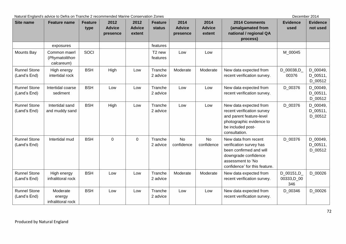
Natural England’s advice to Defra on Tranche 2 recommended Marine Conservation Zones December 2014
72
Produced by Natural England
Site name Feature name Feature
type
2012
Advice
presence
2012
Advice
extent
Feature
status
2014
Advice
presence
2014
Advice
extent
2014 Comments
(amalgamated from
national / regional QA
process)
Evidence
used
Evidence
not used
exposures features
Mounts Bay Common maerl
(Phymatolithon
calcareum)
SOCI T2 new
features
Low Low M_00045
Runnel Stone
(Land’s End)
High energy
intertidal rock
BSH High Low Tranche
2 advice
Moderate Moderate New data expected from
recent verification survey.
D_00038,D_
00376
D_00049,
D_00511,
D_00512
Runnel Stone
(Land’s End)
Intertidal coarse
sediment
BSH Low Low Tranche
2 advice
Low Low New data expected from
recent verification survey.
D_00376 D_00049,
D_00511,
D_00512
Runnel Stone
(Land’s End)
Intertidal sand
and muddy sand
BSH High Low Tranche
2 advice
Low Low New data expected from
recent verification survey
and parent feature-level
photographic evidence to
be included post-
consultation.
D_00376 D_00049,
D_00511,
D_00512
Runnel Stone
(Land’s End)
Intertidal mud BSH 0 0 Tranche
2 advice
No
confidence
No
confidence
New data from recent
verification survey has
been confirmed and will
downgrade confidence
assessment to ‘No
confidence’ for this feature.
D_00376 D_00049,
D_00511,
D_00512
Runnel Stone
(Land’s End)
High energy
infralittoral rock
BSH Low Low Tranche
2 advice
Moderate Moderate New data expected from
recent verification survey.
D_00151,D_
00333,D_00
346
D_00026
Runnel Stone
(Land’s End) Moderate
energy
infralittoral rock
BSH Low Low Tranche
2 advice
Low Low New data expected from
recent verification survey.
D_00346 D_00026

Natural England’s advice to Defra on Tranche 2 recommended Marine Conservation Zones December 2014
73
Produced by Natural England
Site name Feature name Feature
type
2012
Advice
presence
2012
Advice
extent
Feature
status
2014
Advice
presence
2014
Advice
extent
2014 Comments
(amalgamated from
national / regional QA
process)
Evidence
used
Evidence
not used
Runnel Stone
(Land’s End) High energy
circalittoral rock
BSH Low Low Tranche
2 advice
Moderate Moderate New data expected from
recent verification survey.
D_00151,D_
00346
D_00026
Runnel Stone
(Land’s End) Moderate
energy
circalittoral rock
BSH Low Low Tranche
2 advice
Low Low New data expected from
recent verification survey.
D_00346 D_00026
Runnel Stone
(Land’s End) Subtidal coarse
sediment
BSH Low Low Tranche
2 advice
Low Low New data expected from
recent verification survey.
D_00346 D_00026
Runnel Stone
(Land’s End) Subtidal sand BSH Low Low Tranche
2 advice
Low Low New data expected from
recent verification survey.
D_00346 D_00026
Runnel Stone
(Land’s End) Pink sea-fan
(Eunicella
verrucosa)
SOCI Moderate Moderate Tranche
2 advice
Moderate Moderate New data expected from
recent verification survey.
D_00192,D_
00209
Runnel Stone
(Land’s End) Basking shark
(Cetorhinus
maximus)
non_
ENG
High Low Tranche
2 advice
Not
assessed
Not
assessed
Runnel Stone
(Land’s End) Bottlenose
dolphin
(Tursiops
truncatus)
non_
ENG
High 0 Tranche
2 advice
Not
assessed
Not
assessed
Runnel Stone
(Land’s End) Balearic
shearwater
(Puffinus
mauretanicus)
non_
ENG
High Low Tranche
2 advice
Not
assessed
Not
assessed
Runnel Stone
(Land’s End)
Harbour
porpoise
(Phoecoena
non_
ENG
High Low Tranche
2 advice
Not
assessed
Not
assessed

Natural England’s advice to Defra on Tranche 2 recommended Marine Conservation Zones December 2014
74
Produced by Natural England
Site name Feature name Feature
type
2012
Advice
presence
2012
Advice
extent
Feature
status
2014
Advice
presence
2014
Advice
extent
2014 Comments
(amalgamated from
national / regional QA
process)
Evidence
used
Evidence
not used
phoecoena)
Newquay and
The Gannel
High energy
intertidal rock
BSH High Low Tranche
2 advice
High High D_00038,D_
00051,D_00
376
D_00075,
D_00076,
D_00080,
D_00513
Newquay and
The Gannel
Moderate
energy intertidal
rock
BSH High Low Tranche
2 advice
High High D_00038,D_
00051,D_00
357
D_00075,
D_00076,
D_00080,
D_00513
Newquay and
The Gannel
Low energy
intertidal rock
BSH High Low Tranche
2 advice
High High D_00038,D_
00051,D_00
376
D_00075,
D_00076,
D_00080,
D_00513
Newquay and
The Gannel
Intertidal coarse
sediment
BSH High Low Tranche
2 advice
Low Low Manually downgraded to
low/low based on expert
judgement as based on
parent feature alone.
D_00038 D_00075,
D_00076,
D_00080,
D_00513
Newquay and
The Gannel
Intertidal sand
and muddy sand
BSH High Low Tranche
2 advice
High High D_00038,D_
00051,D_00
286,D_0035
7,D_00376
D_00075,
D_00076,
D_00080,
D_00513
Newquay and
The Gannel
Intertidal mud BSH High Low Tranche
2 advice
High High D_00038,D_
00051,D_00
D_00075,

Natural England’s advice to Defra on Tranche 2 recommended Marine Conservation Zones December 2014
75
Produced by Natural England
Site name Feature name Feature
type
2012
Advice
presence
2012
Advice
extent
Feature
status
2014
Advice
presence
2014
Advice
extent
2014 Comments
(amalgamated from
national / regional QA
process)
Evidence
used
Evidence
not used
286,D_0035
7,D_00378
D_00076,
D_00080,
D_00513
Newquay and
The Gannel
Coastal
saltmarshes and
saline reedbeds
BSH High Low Tranche
2 advice
Moderate Moderate D_00038 D_00075,
D_00076,
D_00080,
D_00513
Newquay and
The Gannel
Subtidal coarse
sediment
BSH Low Low Tranche
2 advice
High Moderate We have high confidence in
feature extent in west of
site but not over entire site.
D_00030,D_
00128,D_00
139,D_0034
6
D_00075,
D_00076,
D_00080,
D_00513
Newquay and
The Gannel
Subtidal sand BSH Low Low Tranche
2 advice
High Moderate D_00030,D_
00038,D_00
139
D_00075,
D_00076,
D_00080,
D_00513
Newquay and
The Gannel
Subtidal mud BSH Low Low Tranche
2 advice
No
confidence
No
confidence
D_00075,
D_00076,
D_00080,
D_00513
Newquay and
The Gannel
Giant goby
(Gobius cobitis)
SOCI Low Low Tranche
2 advice
Low Low New data from photos
expected.
D_00270 D_00075,
D_00076,
D_00080,
D_00513

Natural England’s advice to Defra on Tranche 2 recommended Marine Conservation Zones December 2014
76
Produced by Natural England
Site name Feature name Feature
type
2012
Advice
presence
2012
Advice
extent
Feature
status
2014
Advice
presence
2014
Advice
extent
2014 Comments
(amalgamated from
national / regional QA
process)
Evidence
used
Evidence
not used
Newquay and
The Gannel
Native oyster
(Ostrea edulis)
SOCI Low Low Tranche
2 advice
Low Low M_00045 D_00075,
D_00076,
D_00080,
D_00513
Newquay and
The Gannel
Pink sea-fan
(Eunicella
verrucosa)
SOCI Low Low Tranche
2 advice
Low Low M_00045 D_00075,
D_00076,
D_00080,
D_00513
Newquay and
The Gannel
Intertidal mixed
sediments
BSH T2 new
features
High High D_00038,D_
00051
D_00075,
D_00076,
D_00080,
D_00513
Newquay and
The Gannel
High energy
infralittoral rock
BSH T2 new
features
High Moderate D_00030,D_
00128,D_00
139
D_00075,
D_00076,
D_00080,
D_00513
Newquay and
The Gannel
Moderate
energy
infralittoral rock
BSH T2 new
features
High Moderate D_00030,D_
00128,D_00
139
D_00075,
D_00076,
D_00080,
D_00513
Newquay and
The Gannel
High energy
circalittoral rock
BSH T2 new
features
Low Low D_00139 D_00075,
D_00076,
D_00080,
D_00513

Natural England’s advice to Defra on Tranche 2 recommended Marine Conservation Zones December 2014
77
Produced by Natural England
Site name Feature name Feature
type
2012
Advice
presence
2012
Advice
extent
Feature
status
2014
Advice
presence
2014
Advice
extent
2014 Comments
(amalgamated from
national / regional QA
process)
Evidence
used
Evidence
not used
Newquay and
The Gannel
Tide-swept
channels
HOCI T2 new
features
Low Low D_00128 D_00075,
D_00076,
D_00080,
D_00513
Newquay and
The Gannel
Estuarine rocky
habitats
HOCI T2 new
features
High High D_00051 D_00075,
D_00076,
D_00080,
D_00513
Hartland Point
to Tintagel
High energy
intertidal rock
BSH High Low Tranche
2 advice
High High D_00038,D_
00048,D_00
269,D_0037
6
Hartland Point
to Tintagel
Moderate
energy intertidal
rock
BSH High Low Tranche
2 advice
High High D_00038,D_
00048,D_00
376
Hartland Point
to Tintagel
Intertidal coarse
sediment
BSH High Low Tranche
2 advice
High High D_00038,D_
00048,D_00
269,D_0037
6
Hartland Point
to Tintagel
Intertidal sand
and muddy sand
BSH Moderate Low Tranche
2 advice
High High D_00048,D_
00376
Hartland Point
to Tintagel
Intertidal mud BSH 0 0 Tranche
2 advice
Low Low Manually downgraded to
low/low based on expert
judgement as based on
parent feature alone.
D_00376

Natural England’s advice to Defra on Tranche 2 recommended Marine Conservation Zones December 2014
78
Produced by Natural England
Site name Feature name Feature
type
2012
Advice
presence
2012
Advice
extent
Feature
status
2014
Advice
presence
2014
Advice
extent
2014 Comments
(amalgamated from
national / regional QA
process)
Evidence
used
Evidence
not used
Hartland Point
to Tintagel
Intertidal mixed
sediments
BSH Moderate Low Tranche
2 advice
Low Low Manually downgraded to
low/low based on expert
judgement as based on
parent feature alone.
D_00376
Hartland Point
to Tintagel
Coastal
saltmarshes and
saline reedbeds
BSH Moderate Low Tranche
2 advice
No
confidence
No
confidence
Hartland Point
to Tintagel
High energy
infralittoral rock
BSH Low Low Tranche
2 advice
High Moderate D_00024,D_
00048,D_00
334,D_0034
6
Hartland Point
to Tintagel
Subtidal coarse
sediment
BSH Low Low Tranche
2 advice
High High Extent manually increased
to high due to well
distributed sample data
covering >50% of feature
as per Protocol E.
D_00024,D_
00185,D_00
346
Hartland Point
to Tintagel
Subtidal sand BSH Low Low Tranche
2 advice
High High Extent manually increased
to high due to well
distributed sample data
covering >50% of feature
as per Protocol E.
D_00024,D_
00334,D_00
346
Hartland Point
to Tintagel
Fragile sponge
& anthozoan
communities on
subtidal rocky
habitats
HOCI Low Low Tranche
2 advice
High Moderate D_00024,D_
00162,D_00
334
Hartland Point
to Tintagel
Honeycomb
worm reefs
HOCI High Low Tranche
2 advice
High High D_00038,D_
00048,D_00

Natural England’s advice to Defra on Tranche 2 recommended Marine Conservation Zones December 2014
79
Produced by Natural England
Site name Feature name Feature
type
2012
Advice
presence
2012
Advice
extent
Feature
status
2014
Advice
presence
2014
Advice
extent
2014 Comments
(amalgamated from
national / regional QA
process)
Evidence
used
Evidence
not used
(Sabellaria
alveolata)
269
Hartland Point
to Tintagel
Peacock's tail
(Padina
pavonica)
SOCI Low Low Tranche
2 advice
No
confidence
No
confidence
Hartland Point
to Tintagel
Pink sea-fan
(Eunicella
verrucosa)
SOCI Moderate Moderate Tranche
2 advice
Moderate Low D_00162,D_
00334
Hartland Point
to Tintagel
Low energy
intertidal rock
BSH T2 new
features
High High D_00048
Hartland Point
to Tintagel
Moderate
energy
infralittoral rock
BSH T2 new
features
High Moderate D_00024,D_
00334
Hartland Point
to Tintagel
High energy
circalittoral rock
BSH T2 new
features
High Moderate D_00024,D_
00334
Hartland Point
to Tintagel
Moderate
energy
circalittoral rock
BSH T2 new
features
High Moderate D_00024
Hartland Point
to Tintagel
Subtidal mixed
sediments
BSH T2 new
features
Low Low Manually downgraded to
low/low based on expert
judgement as based on
parent feature alone.
D_00024
Hartland Point
to Tintagel
Subtidal
macrophyte-
dominated
sediment
BSH T2 new
features
Low Low Confidence manually
reduced to low/low due to
uncertainty over duplication
of point records.
D_00334
Hartland Point
to Tintagel
Peat and clay
exposures
HOCI T2 new
features
Low Low D_00442

Natural England’s advice to Defra on Tranche 2 recommended Marine Conservation Zones December 2014
80
Produced by Natural England
Site name Feature name Feature
type
2012
Advice
presence
2012
Advice
extent
Feature
status
2014
Advice
presence
2014
Advice
extent
2014 Comments
(amalgamated from
national / regional QA
process)
Evidence
used
Evidence
not used
Bideford to
Foreland Point
High energy
intertidal rock
BSH High Low Tranche
2 advice
High High D_00038,D_
00041,D_00
265,D_0026
7,D_00282,D
_00308,D_0
0309
D_00075
Bideford to
Foreland Point
Moderate
energy intertidal
rock
BSH High Low Tranche
2 advice
High High D_00038,D_
00041,D_00
265,D_0026
7,D_00308,D
_00309
D_00075
Bideford to
Foreland Point
Low energy
intertidal rock
BSH Moderate Low Tranche
2 advice
High High D_00038,D_
00041,D_00
265,D_0030
8,D_00309,D
_00327,D_0
0357
D_00075
Bideford to
Foreland Point
Intertidal coarse
sediment
BSH Moderate Low Tranche
2 advice
High High D_00038,D_
00041
D_00075
Bideford to
Foreland Point
Intertidal sand
and muddy sand
BSH Moderate Low Tranche
2 advice
High High D_00038,D_
00041,D_00
309,D_0035
7
D_00075,
D_00078
Bideford to
Foreland Point
Intertidal mud BSH Moderate Low Tranche
2 advice
No
confidence
No
confidence
Removed polygonal data
so no data for assessment.
D_00075
Bideford to
Foreland Point
Intertidal mixed
sediments
BSH Moderate Low Tranche
2 advice
High High D_00038,D_
00041
D_00075
Bideford to High energy BSH Low Low Tranche High Moderate D_00335,D_ D_00005,

Natural England’s advice to Defra on Tranche 2 recommended Marine Conservation Zones December 2014
81
Produced by Natural England
Site name Feature name Feature
type
2012
Advice
presence
2012
Advice
extent
Feature
status
2014
Advice
presence
2014
Advice
extent
2014 Comments
(amalgamated from
national / regional QA
process)
Evidence
used
Evidence
not used
Foreland Point infralittoral rock 2 advice 00346 D_00514
Bideford to
Foreland Point
Moderate
energy
infralittoral rock
BSH Low Low Tranche
2 advice
High Moderate D_00041,D_
00126,D_00
308,D_0033
5,D_00346
D_00005,
D_00514
Bideford to
Foreland Point
High energy
circalittoral rock
BSH Low Low Tranche
2 advice
High Moderate D_00107,D_
00149,D_00
335,D_0034
6,M_00124
D_00005,
D_00514
Bideford to
Foreland Point
Subtidal coarse
sediment
BSH Low Low Tranche
2 advice
Moderate Moderate D_00149,D_
00335,D_00
346,D_0036
9
D_00005,
D_00514
Bideford to
Foreland Point
Subtidal sand BSH Low Low Tranche
2 advice
High Moderate D_00001,D_
00126,D_00
149,D_0021
4,D_00309,D
_00335,D_0
0346,D_003
57,D_00369
D_00005,
D_00514
Bideford to
Foreland Point
Honeycomb
worm reefs
(Sabellaria
alveolata)
HOCI Low Low Tranche
2 advice
High High Sab.spi polygons corrected
to Sab.alv therefore
confidence increased to
high/high.
D_00041,D_
00309
Bideford to
Foreland Point
Pink sea-fan
(Eunicella
verrucosa)
SOCI Moderate Moderate Tranche
2 advice
Moderate Moderate D_00107,D_
00149,D_00
208,D_0021
4,D_00335
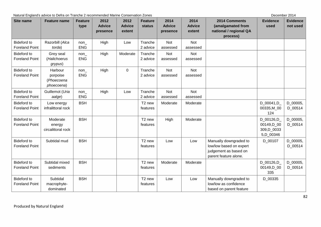
Natural England’s advice to Defra on Tranche 2 recommended Marine Conservation Zones December 2014
82
Produced by Natural England
Site name Feature name Feature
type
2012
Advice
presence
2012
Advice
extent
Feature
status
2014
Advice
presence
2014
Advice
extent
2014 Comments
(amalgamated from
national / regional QA
process)
Evidence
used
Evidence
not used
Bideford to
Foreland Point
Razorbill (Alca
torda)
non_
ENG
High Low Tranche
2 advice
Not
assessed
Not
assessed
Bideford to
Foreland Point
Grey seal
(Halichoerus
grypus)
non_
ENG
High Moderate Tranche
2 advice
Not
assessed
Not
assessed
Bideford to
Foreland Point
Harbour
porpoise
(Phoecoena
phoecoena)
non_
ENG
High 0 Tranche
2 advice
Not
assessed
Not
assessed
Bideford to
Foreland Point
Guillemot (Uria
aalge)
non_
ENG
High Low Tranche
2 advice
Not
assessed
Not
assessed
Bideford to
Foreland Point
Low energy
infralittoral rock
BSH T2 new
features
Moderate Moderate D_00041,D_
00335,M_00
124
D_00005,
D_00514
Bideford to
Foreland Point
Moderate
energy
circalittoral rock
BSH T2 new
features
High Moderate D_00126,D_
00149,D_00
309,D_0033
5,D_00346
D_00005,
D_00514
Bideford to
Foreland Point
Subtidal mud BSH T2 new
features
Low Low Manually downgraded to
low/low based on expert
judgement as based on
parent feature alone.
D_00107 D_00005,
D_00514
Bideford to
Foreland Point
Subtidal mixed
sediments
BSH T2 new
features
Moderate Moderate D_00126,D_
00149,D_00
335
D_00005,
D_00514
Bideford to
Foreland Point
Subtidal
macrophyte-
dominated
BSH T2 new
features
Low Low Manually downgraded to
low/low as confidence
based on parent feature
D_00335

Natural England’s advice to Defra on Tranche 2 recommended Marine Conservation Zones December 2014
83
Produced by Natural England
Site name Feature name Feature
type
2012
Advice
presence
2012
Advice
extent
Feature
status
2014
Advice
presence
2014
Advice
extent
2014 Comments
(amalgamated from
national / regional QA
process)
Evidence
used
Evidence
not used
sediment alone.
Bideford to
Foreland Point
Blue mussel
beds
HOCI T2 new
features
Low Low D_00149
Bideford to
Foreland Point
Intertidal
underboulder
communities
HOCI T2 new
features
Moderate Moderate D_00041
Bideford to
Foreland Point
Littoral chalk
communities
HOCI T2 new
features
High High D_00041,D_
00309
Bideford to
Foreland Point
Estuarine rocky
habitats
HOCI T2 new
features
High High D_00041 D_00075
Bideford to
Foreland Point
Fragile sponge
& anthozoan
communities on
subtidal rocky
habitats
HOCI T2 new
features
Moderate Moderate D_00107,D_
00149,D_00
214
Bideford to
Foreland Point
Native oyster
(Ostrea edulis)
SOCI T2 new
features
Low Low D_00149
Bideford to
Foreland Point
Spiny lobster
(Palinurus
elephas)
SOCI T2 new
features
Moderate Moderate D_00149
North of
Lundy
Moderate
energy
circalittoral rock
BSH Low Low Tranche
2 advice
High High Manually upgraded to
high/high due to expert
judgement as ground
truthing points not included
in database but shown in
report held by NE.
D_00001
North of
Lundy
Subtidal coarse
sediment
BSH Low Low Tranche
2 advice
High High D_00001,M_
00124

Natural England’s advice to Defra on Tranche 2 recommended Marine Conservation Zones December 2014
84
Produced by Natural England
Site name Feature name Feature
type
2012
Advice
presence
2012
Advice
extent
Feature
status
2014
Advice
presence
2014
Advice
extent
2014 Comments
(amalgamated from
national / regional QA
process)
Evidence
used
Evidence
not used
North of
Lundy
Subtidal sand BSH Low Low Tranche
2 advice
High High Manually upgraded to
high/high due to expert
judgement as ground
truthing points not included
in database but shown in
report held by NE.
D_00001
North of
Lundy
Subtidal mixed
sediments
BSH Low Low Tranche
2 advice
No
confidence
No
confidence
North of
Lundy
Ross worm
reefs (Sabellaria
spinulosa)
HOCI T2 new
features
Low Low D_00001
North of
Lundy
Black seabream
(Spondyliosoma
cantharus)
non_
ENG
T2 new
features
Low Low D_00222
West of
Walney
Subtidal sand BSH T2 new
features
Low Low Manually downgraded to
low/low as confidence
based on parent feature
alone.
D_00346 D_00082,
D_00083,
D_00084,
D_00085,
D_00086,
D_00087,
D_00088
West of
Walney
Subtidal mud BSH T2 new
features
High Moderate M_00052 duplicate of
M_00267 so removed.
D_00346,M_
00267
D_00082,
D_00083,
D_00084,
D_00085,
D_00086,
D_00087,
D_00088

Natural England’s advice to Defra on Tranche 2 recommended Marine Conservation Zones December 2014
85
Produced by Natural England
Site name Feature name Feature
type
2012
Advice
presence
2012
Advice
extent
Feature
status
2014
Advice
presence
2014
Advice
extent
2014 Comments
(amalgamated from
national / regional QA
process)
Evidence
used
Evidence
not used
West of
Walney
Mud habitats in
deep water
HOCI T2 new
features
High Moderate M_00052 duplicate of
M_00267 so removed.
New data likely to be
available in future to
improve confidence.
D_00395,M_
00267
D_00082,
D_00083,
D_00084,
D_00085,
D_00086,
D_00087,
D_00088
West of
Walney
Sea pens and
burrowing
megafauna
HOCI T2 new
features
Low Low New data likely to be
available in future to
improve confidence.
D_00395,M_
00048
D_00082,
D_00083,
D_00084,
D_00085,
D_00086,
D_00087,
D_00088
West of
Walney
including
proposed Co-
Location Zone
Subtidal sand BSH High High Tranche
2 advice
Low Low Manually downgraded to
low/low as confidence
based on parent feature
alone.
D_00346 D_00082,
D_00083,
D_00084,
D_00085,
D_00086,
D_00087,
D_00088
West of
Walney
including
proposed Co-
Location Zone
Subtidal mud BSH High High Tranche
2 advice
High Moderate M_00052 duplicate of
M_00267 so removed.
New data likely to be
available in future to
improve confidence.
D_00346,M_
00052,M_00
267
D_00082,
D_00083,
D_00084,
D_00085,
D_00086,
D_00087,
D_00088
West of Mud habitats in HOCI High High Tranche High Moderate M_00052 duplicate of D_00395,M_ D_00082,

Natural England’s advice to Defra on Tranche 2 recommended Marine Conservation Zones December 2014
86
Produced by Natural England
Site name Feature name Feature
type
2012
Advice
presence
2012
Advice
extent
Feature
status
2014
Advice
presence
2014
Advice
extent
2014 Comments
(amalgamated from
national / regional QA
process)
Evidence
used
Evidence
not used
Walney
including
proposed Co-
Location Zone
deep water 2 advice M_00267 so removed. New
data likely to be available in
future to improve
confidence.
00267 D_00083,
D_00084,
D_00085,
D_00086,
D_00087,
D_00088
West of
Walney
including
proposed Co-
Location Zone
Sea pens and
burrowing
megafauna
HOCI High High Tranche
2 advice
Low Low New data likely to be
available in future to
improve confidence.
D_00395,M_
00048
D_00082,
D_00083,
D_00084,
D_00085,
D_00086,
D_00087,
D_00088
Walney and
West Duddon
Sands CLZ
Subtidal mud BSH T2 new
features
High Moderate M_00052 duplicate of
M_00267 so removed.
D_00346,M_
00052,M_00
267
D_00082,
D_00083,
D_00084,
D_00085,
D_00086,
D_00087,
D_00088
Walney and
West Duddon
Sands CLZ
Mud habitats in
deep water
HOCI T2 new
features
Moderate Moderate M_00052 duplicate of
M_00267 so removed.
D_00395,M_
00267
D_00082,
D_00083,
D_00084,
D_00085,
D_00086,
D_00087,
D_00088
Walney and
West Duddon
Sea pens and
burrowing
HOCI T2 new
features
Low Low D_00395,M_
00048
D_00082,
D_00083,

Natural England’s advice to Defra on Tranche 2 recommended Marine Conservation Zones December 2014
87
Produced by Natural England
Site name Feature name Feature
type
2012
Advice
presence
2012
Advice
extent
Feature
status
2014
Advice
presence
2014
Advice
extent
2014 Comments
(amalgamated from
national / regional QA
process)
Evidence
used
Evidence
not used
Sands CLZ megafauna D_00084,
D_00085,
D_00086,
D_00087,
D_00088
Ormonde Co-
Location Zone
Subtidal mud BSH T2 new
features
High High M_00052 duplicate of
M_00267 so removed.
Extent manually increased
to high due to well
distributed sample data
covering >50% of feature
as per Protocol E.
D_00346,M_
00267
D_00082,
D_00083,
D_00084,
D_00085,
D_00086,
D_00087,
D_00088
Ormonde Co-
Location Zone
Mud habitats in
deep water
HOCI T2 new
features
High Moderate M_00052 duplicate of
M_00267 so removed.
D_00395,M_
00267
D_00082,
D_00083,
D_00084,
D_00085,
D_00086,
D_00087,
D_00088
Ormonde Co-
Location Zone
Sea pens and
burrowing
megafauna
HOCI T2 new
features
Low Low D_00395 D_00082,
D_00083,
D_00084,
D_00085,
D_00086,
D_00087,
D_00088
Allonby Bay High energy
intertidal rock
BSH Low Low Tranche
2 advice
High High D_00039,D_
00292,D_00
376

Natural England’s advice to Defra on Tranche 2 recommended Marine Conservation Zones December 2014
88
Produced by Natural England
Site name Feature name Feature
type
2012
Advice
presence
2012
Advice
extent
Feature
status
2014
Advice
presence
2014
Advice
extent
2014 Comments
(amalgamated from
national / regional QA
process)
Evidence
used
Evidence
not used
Allonby Bay Intertidal
biogenic reefs
BSH High Moderate Tranche
2 advice
High High D_00038,D_
00039,D_00
292,D_0035
8
Allonby Bay Subtidal coarse
sediment
BSH High Low Tranche
2 advice
Low Low Manually downgraded to
low/low as confidence
based on parent feature
alone once 107x stills
records have been
removed.
D_00017,D_
00346,D_00
382
D_00505,
D_00506
Allonby Bay Subtidal sand BSH Low Low Tranche
2 advice
Low Low Manually downgraded to
low/low as confidence
based on parent feature
alone once 2x stills records
have been removed.
D_00017,D_
00346,D_00
358,D_0038
2
D_00505,
D_00506
Allonby Bay Blue mussel
beds
HOCI High Low Tranche
2 advice
High High D_00039,D_
00292,D_00
358
Allonby Bay Peat and clay
exposures
HOCI High High Tranche
2 advice
High High Error in level 2 HOCI audit
– column U should have
‘YES’ – changed and
highlighted and now gives
high confidence.
D_00038,D_
00039
Allonby Bay Honeycomb
worm reefs
(Sabellaria
alveolata)
HOCI High Moderate Tranche
2 advice
High High Polygons incorrectly tagged
as HOCI_18 now changed
to HOCI_8.
D_00038,D_
00039,D_00
292,D_0035
8,D_00389
D_00069,
D_00081
Allonby Bay Moderate BSH T2 new High High D_00039

Natural England’s advice to Defra on Tranche 2 recommended Marine Conservation Zones December 2014
89
Produced by Natural England
Site name Feature name Feature
type
2012
Advice
presence
2012
Advice
extent
Feature
status
2014
Advice
presence
2014
Advice
extent
2014 Comments
(amalgamated from
national / regional QA
process)
Evidence
used
Evidence
not used
energy intertidal
rock
features
Allonby Bay Low energy
intertidal rock
BSH T2 new
features
High High D_00039
Allonby Bay Intertidal coarse
sediment
BSH T2 new
features
High High D_00039
Allonby Bay Intertidal sand
and muddy sand
BSH T2 new
features
High Moderate D_00292,D_
00358
Allonby Bay Intertidal mixed
sediments
BSH T2 new
features
Low Low Manually downgraded to
low/low as confidence
based on parent feature
alone.
D_00292,D_
00376
Allonby Bay High energy
infralittoral rock
BSH T2 new
features
Low Low D_00346 D_00505,
D_00506
Allonby Bay Moderate
energy
infralittoral rock
BSH T2 new
features
High Moderate D_00017 D_00505,
D_00506
Allonby Bay Subtidal mixed
sediments
BSH T2 new
features
Moderate Moderate New feature added as
identified by new data but
not included in CA –
mod/mod based on three
quality 3 PSA samples.
D_00017
Allonby Bay Subtidal
biogenic reefs
BSH T2 new
features
Low Low D_00382
Cromer Shoal
Chalk Beds
High energy
infralittoral rock
BSH Low Low Tranche
2 advice
Moderate Moderate D_00103,D_
00117,D_00
134,D_0014
5,D_00346
D_00007

Natural England’s advice to Defra on Tranche 2 recommended Marine Conservation Zones December 2014
90
Produced by Natural England
Site name Feature name Feature
type
2012
Advice
presence
2012
Advice
extent
Feature
status
2014
Advice
presence
2014
Advice
extent
2014 Comments
(amalgamated from
national / regional QA
process)
Evidence
used
Evidence
not used
Cromer Shoal
Chalk Beds
Moderate
energy
infralittoral rock
BSH Low Low Tranche
2 advice
Moderate Moderate D_00103,D_
00134,D_00
145,D_0034
6
D_00007
Cromer Shoal
Chalk Beds
Moderate
energy
circalittoral rock
BSH Low Low Tranche
2 advice
High Moderate D_00021,D_
00103,D_00
117,D_0013
4,D_00145,D
_00346
D_00007
Cromer Shoal
Chalk Beds
Subtidal chalk HOCI High Low Tranche
2 advice
High Moderate D_00021,D_
00103,D_00
117,D_0013
4,D_00145,D
_00166,D_0
0175,D_001
84,D_00193,
D_00203,D_
00210,D_00
393,M_0007
2
D_00007
Cromer Shoal
Chalk Beds
North Norfolk
coast (Subtidal)
Geologi
cal
High Low Tranche
2 advice
High Low
Cromer Shoal
Chalk Beds
High energy
circalittoral rock
BSH T2 new
features
Moderate Moderate D_00117,D_
00134,D_00
145,D_0034
6
D_00007
Cromer Shoal
Chalk Beds
Subtidal coarse
sediment
BSH T2 new
features
Moderate Moderate Manually downgraded
presence to moderate as
stills have been
D_00021,D_
00103,D_00
117,D_0013
D_00007

Natural England’s advice to Defra on Tranche 2 recommended Marine Conservation Zones December 2014
91
Produced by Natural England
Site name Feature name Feature
type
2012
Advice
presence
2012
Advice
extent
Feature
status
2014
Advice
presence
2014
Advice
extent
2014 Comments
(amalgamated from
national / regional QA
process)
Evidence
used
Evidence
not used
downgraded to parent
feature.
4,D_00145,D
_00346
Cromer Shoal
Chalk Beds
Subtidal sand BSH T2 new
features
Moderate Moderate D_00103,D_
00117,D_00
134,D_0014
5,D_00233
D_00007
Cromer Shoal
Chalk Beds
Subtidal mixed
sediments
BSH T2 new
features
Moderate Moderate D_00103,D_
00117,D_00
134,D_0014
5,D_00233
D_00007
Cromer Shoal
Chalk Beds
Subtidal
biogenic reefs
BSH T2 new
features
Low Low Automated confidence
result of mod/mod manually
downgraded to low/low due
to low confidence in
component HOCI.
Evidence for feature based
primarily on Seasearch
records.
D_00117,D_
00134,D_00
179
Cromer Shoal
Chalk Beds
Blue mussel
beds
HOCI T2 new
features
Low Low D_00117
Cromer Shoal
Chalk Beds
Peat and clay
exposures
HOCI T2 new
features
High Moderate D_00021,M_
00072
Cromer Shoal
Chalk Beds
Ross worm
reefs (Sabellaria
spinulosa)
HOCI T2 new
features
Low Low Evidence for feature based
primarily on Seasearch
records.
D_00117
Cromer Shoal
Chalk Beds
Fragile sponge
& anthozoan
communities on
HOCI T2 new
features
Low Low D_00117,D_
00145

Natural England’s advice to Defra on Tranche 2 recommended Marine Conservation Zones December 2014
92
Produced by Natural England
Site name Feature name Feature
type
2012
Advice
presence
2012
Advice
extent
Feature
status
2014
Advice
presence
2014
Advice
extent
2014 Comments
(amalgamated from
national / regional QA
process)
Evidence
used
Evidence
not used
subtidal rocky
habitats
Cromer Shoal
Chalk Beds
Horse mussel
(Modiolus
modiolus)
HOCI T2 new
features
Low Low D_00134
Cromer Shoal
Chalk Beds
Smelt (Osmerus
eperlanus)
SOCI T2 new
features
Low Low M_00128
Cromer Shoal
Chalk Beds
Undulate ray
(Raja undulata)
SOCI T2 new
features
Low Low Likely duplicate data entries
– only one real data point –
downgrade to low/low.
D_00452
Holderness
Inshore
Intertidal mixed
sediments
BSH High Moderate Tranche
2 advice
Low Low D_00376
Holderness
Inshore
Subtidal coarse
sediment
BSH High Moderate Tranche
2 advice
High Moderate D_00226,D_
00227,D_00
293,D_0029
4,D_00346,M
_00090
D_00025,
D_00503,
D_00504
Holderness
Inshore
Subtidal sand BSH Low Low Tranche
2 advice
High Moderate D_00226,D_
00227,D_00
293,D_0034
6,M_00090
D_00025,
D_00503,
D_00504
Holderness
Inshore
Peat and clay
exposures
HOCI Low Low Tranche
2 advice
Low Low D_00442
Holderness
Inshore
Ross worm
reefs (Sabellaria
spinulosa)
HOCI Low Low Tranche
2 advice
Low Low D_00227,D_
00293
D_00025,
D_00503,
D_00504
Holderness
Inshore
Subtidal chalk HOCI Low Low Tranche
2 advice
No
confidence
No
confidence
Downgraded – removed
HOCI tags from Seasearch

Natural England’s advice to Defra on Tranche 2 recommended Marine Conservation Zones December 2014
93
Produced by Natural England
Site name Feature name Feature
type
2012
Advice
presence
2012
Advice
extent
Feature
status
2014
Advice
presence
2014
Advice
extent
2014 Comments
(amalgamated from
national / regional QA
process)
Evidence
used
Evidence
not used
records and BGS Chalk
polygon – not
found/present as
suggested.
Holderness
Inshore
Spurn Head
(Subtidal)
Geologi
cal
High Low Tranche
2 advice
High Low
Holderness
Inshore
Intertidal sand
and muddy sand
BSH T2 new
features
High Moderate D_00285,D_
00374,D_00
376
Holderness
Inshore
High energy
circalittoral rock
BSH T2 new
features
Moderate Moderate Evidence for circalittoral
rock in the site is limited to
point data from two parts of
the site (one of which is
modified by anthropogenic
activity). The geology
dominated by glacial
deposits, notably boulder
clay, as well as patches of
soft clay: there is no
evidence for exposed
bedrock. There may be a
mosaic of subtidal habitats
that grade from soft and
mixed sediments to areas
where higher frequency of
clay exposures, cobbles
and boulders form reefs.
D_00157 D_00025,
D_00503,
D_00504
Holderness
Inshore
Moderate
energy
BSH T2 new
features
Moderate Moderate Evidence for circalittoral
rock in the site is limited to
D_00157,D_
00293
D_00025,
D_00503,

Natural England’s advice to Defra on Tranche 2 recommended Marine Conservation Zones December 2014
94
Produced by Natural England
Site name Feature name Feature
type
2012
Advice
presence
2012
Advice
extent
Feature
status
2014
Advice
presence
2014
Advice
extent
2014 Comments
(amalgamated from
national / regional QA
process)
Evidence
used
Evidence
not used
circalittoral rock point data from two parts of
the site (one of which is
modified by anthropogenic
activity). The geology
dominated by glacial
deposits, notably boulder
clay, as well as patches of
soft clay: there is no
evidence for exposed
bedrock. There may be a
mosaic of subtidal habitats
that grade from soft and
mixed sediments to areas
where higher frequency of
clay exposures, cobbles
and boulders form reefs.
D_00504
Holderness
Inshore
Subtidal mud BSH T2 new
features
High Moderate Tiny EU SeaMap polygon –
however decision to
maintain confidence based
solely on point data.
D_00226,D_
00293,D_00
294,D_0034
6
D_00025,
D_00503,
D_00504
Holderness
Inshore
Subtidal mixed
sediments
BSH T2 new
features
Moderate Moderate D_00157,D_
00226,M_00
091
D_00025,
D_00503,
D_00504
Runswick Bay High energy
infralittoral rock
BSH Moderate Low Tranche
2 advice
Low Low D_00346 D_00033,
D_00504
Runswick Bay Moderate
energy
infralittoral rock
BSH Moderate Low Tranche
2 advice
Moderate Moderate D_00123,D_
00259,D_00
346,D_0035
4
D_00033,
D_00504

Natural England’s advice to Defra on Tranche 2 recommended Marine Conservation Zones December 2014
95
Produced by Natural England
Site name Feature name Feature
type
2012
Advice
presence
2012
Advice
extent
Feature
status
2014
Advice
presence
2014
Advice
extent
2014 Comments
(amalgamated from
national / regional QA
process)
Evidence
used
Evidence
not used
Runswick Bay High energy
circalittoral rock
BSH Moderate Low Tranche
2 advice
Low Low D_00258 D_00033,
D_00504
Runswick Bay Moderate
energy
circalittoral rock
BSH Moderate Low Tranche
2 advice
Moderate Moderate D_00258,D_
00346,D_00
354
D_00033,
D_00504
Runswick Bay Subtidal coarse
sediment
BSH High Low Tranche
2 advice
Low Low Manually downgraded to
low/low as confidence
based on parent feature
alone.
D_00258,D_
00346
D_00033,
D_00504
Runswick Bay Subtidal sand BSH High Low Tranche
2 advice
Moderate Moderate D_00123,D_
00255,D_00
258,D_0034
6,D_00354
D_00033,
D_00504
Runswick Bay Subtidal mixed
sediments
BSH High Low Tranche
2 advice
Low Low Manually downgraded to
low/low as confidence
based on parent feature
alone.
D_00255,D_
00346
D_00033,
D_00504
Runswick Bay Ocean quahog
(Arctica
islandica)
SOCI High High Tranche
2 advice
Moderate Moderate M_00084
Runswick Bay High energy
intertidal rock
BSH T2 new
features
High Moderate D_00259,D_
00284
Runswick Bay Moderate
energy intertidal
rock
BSH T2 new
features
High Moderate D_00123,D_
00259,D_00
376
Runswick Bay Low energy
intertidal rock
BSH T2 new
features
High Moderate D_00123,D_
00259,D_00
284,D_0037

Natural England’s advice to Defra on Tranche 2 recommended Marine Conservation Zones December 2014
96
Produced by Natural England
Site name Feature name Feature
type
2012
Advice
presence
2012
Advice
extent
Feature
status
2014
Advice
presence
2014
Advice
extent
2014 Comments
(amalgamated from
national / regional QA
process)
Evidence
used
Evidence
not used
6
Runswick Bay Intertidal sand
and muddy sand
BSH T2 new
features
Moderate Moderate D_00259,D_
00285,D_00
376
Runswick Bay Intertidal mud BSH T2 new
features
Low Low D_00376,D_
00378
Runswick Bay Intertidal mixed
sediments
BSH T2 new
features
Low Low D_00376
Runswick Bay Low energy
infralittoral rock
BSH T2 new
features
Low Low D_00346 D_00033,
D_00504
Runswick Bay Subtidal mud BSH T2 new
features
Low Low Downgrade manual – only
one point on edge of site –
would not be considered
suitable for mod/mod
confidence – mod/mod
confidence based on parent
feature.
D_00234 D_00033,
D_00504
Runswick Bay Littoral chalk
communities
HOCI T2 new
features
Low Low Downgrade – feature
suggested by biological
community but physical
feature not thought to be
present in the site.
D_00259,D_
00284
Coquet to St
Mary's
Moderate
energy intertidal
rock
BSH High Low Tranche
2 advice
High High D_00038,D_
00043,D_00
261,D_0027
7,D_00376
D_00076
Coquet to St
Mary's
Low energy
intertidal rock
BSH High Low Tranche
2 advice
High High D_00038,D_
00043,D_00
D_00076

Natural England’s advice to Defra on Tranche 2 recommended Marine Conservation Zones December 2014
97
Produced by Natural England
Site name Feature name Feature
type
2012
Advice
presence
2012
Advice
extent
Feature
status
2014
Advice
presence
2014
Advice
extent
2014 Comments
(amalgamated from
national / regional QA
process)
Evidence
used
Evidence
not used
261,D_0027
2,D_00277,D
_00376
Coquet to St
Mary's
Intertidal coarse
sediment
BSH Low Low Tranche
2 advice
High High D_00043,D_
00277,D_00
354,D_0037
6
D_00076
Coquet to St
Mary's
Intertidal sand
and muddy sand
BSH 0 0 Tranche
2 advice
High High D_00043,D_
00261,D_00
272,D_0027
7,D_00347,D
_00354,D_0
0376
D_00076
Coquet to St
Mary's
Intertidal mud BSH High Moderate Tranche
2 advice
High High D_00038,D_
00043,D_00
375,D_0037
6,D_00378
D_00076
Coquet to St
Mary's
Intertidal mixed
sediments
BSH High Moderate Tranche
2 advice
High High D_00038,D_
00043,D_00
261,D_0037
6
D_00076
Coquet to St
Mary's
High energy
infralittoral rock
BSH Moderate Low Tranche
2 advice
Moderate Moderate D_00038,D_
00043,D_00
105,D_0012
2,D_00261
D_00020
Coquet to St
Mary's
Moderate
energy
infralittoral rock
BSH Low Low Tranche
2 advice
High High D_00043,D_
00105,D_00
122,D_0015
D_00020

Natural England’s advice to Defra on Tranche 2 recommended Marine Conservation Zones December 2014
98
Produced by Natural England
Site name Feature name Feature
type
2012
Advice
presence
2012
Advice
extent
Feature
status
2014
Advice
presence
2014
Advice
extent
2014 Comments
(amalgamated from
national / regional QA
process)
Evidence
used
Evidence
not used
9,D_00241,D
_00251,D_0
0260,D_002
61,D_00276,
D_00277,D_
00279,D_00
346,D_0035
4,D_00380
Coquet to St
Mary's
Moderate
energy
circalittoral rock
BSH Low Low Tranche
2 advice
High Moderate D_00105,D_
00122,D_00
137,D_0022
8,D_00241,D
_00251,D_0
0260,D_002
76,D_00277,
D_00346,D_
00354,D_00
380
D_00020
Coquet to St
Mary's
Subtidal coarse
sediment
BSH Moderate Moderate Tranche
2 advice
Moderate Moderate D_00105,D_
00122,D_00
137,D_0026
0,D_00370,D
_00380
D_00020
Coquet to St
Mary's
Subtidal sand BSH Low Low Tranche
2 advice
High Moderate D_00105,D_
00122,D_00
228,D_0024
1,D_00251,D
_00260,D_0
0262,D_002
D_00020

Natural England’s advice to Defra on Tranche 2 recommended Marine Conservation Zones December 2014
99
Produced by Natural England
Site name Feature name Feature
type
2012
Advice
presence
2012
Advice
extent
Feature
status
2014
Advice
presence
2014
Advice
extent
2014 Comments
(amalgamated from
national / regional QA
process)
Evidence
used
Evidence
not used
76,D_00279,
D_00354,D_
00380,D_00
440
Coquet to St
Mary's
Subtidal mud BSH Low Low Tranche
2 advice
Low Low Supported by modelled
data and parent feature –
mainly EU SeaMap and
single point – queried and
downgraded. Mod/mod
confidence based on parent
feature so manually
downgraded.
D_00260,D_
00346
D_00020
Coquet to St
Mary's
Subtidal mixed
sediments
BSH Moderate Moderate Tranche
2 advice
High Moderate D_00251,D_
00255,D_00
262,D_0035
4,D_00370,D
_00380,D_0
0440,D_004
41
D_00020
Coquet to St
Mary's
Intertidal
underboulder
communities
HOCI High Moderate Tranche
2 advice
High High Increased confidence to
High/High from high/mod
as intertidal polygons have
MESH >58.
D_00043,D_
00261,D_00
277
Coquet to St
Mary's
High energy
intertidal rock
BSH T2 new
features
High High D_00038,D_
00043,D_00
122,D_0026
1,D_00277
D_00076
Coquet to St
Mary's
High energy
circalittoral rock
BSH T2 new
features
Moderate Low Extent manually
downgraded to low
D_00260,D_
00279
D_00020

Natural England’s advice to Defra on Tranche 2 recommended Marine Conservation Zones December 2014
100
Produced by Natural England
Site name Feature name Feature
type
2012
Advice
presence
2012
Advice
extent
Feature
status
2014
Advice
presence
2014
Advice
extent
2014 Comments
(amalgamated from
national / regional QA
process)
Evidence
used
Evidence
not used
following spatial check and
expert judgement.
Coquet to St
Mary's
Low energy
circalittoral rock
BSH T2 new
features
Low Low D_00346 D_00020
Coquet to St
Mary's
Littoral chalk
communities
HOCI T2 new
features
Low Low Downgrade – feature
suggested by biological
community but physical
feature not thought to be
present in the site.
D_00277
Coquet to St
Mary's
Mud habitats in
deep water
HOCI T2 new
features
Low Low D_00260 D_00020
Coquet to St
Mary's
Peat and clay
exposures
HOCI T2 new
features
High High Verification survey – data
shown in report but not GI
or MR. Manually increase
confidence to high/high
based on verification
survey report.
D_00442
Coquet to St
Mary's
Ross worm
reefs (Sabellaria
spinulosa)
HOCI T2 new
features
Low Low Evidence for feature based
primarily on Seasearch
records.
D_00122,D_
00277
D_00020
Coquet to St
Mary's
Sheltered
muddy gravels
HOCI T2 new
features
Low Low D_00392
Coquet to St
Mary's
Tide-swept
channels
HOCI T2 new
features
Low Low Manually downgrade to
low/low based on revised
HOCI definition – point data
not located in area that
would qualify as tide-swept
channel therefore
D_00043,D_
00380

Natural England’s advice to Defra on Tranche 2 recommended Marine Conservation Zones December 2014
101
Produced by Natural England
Site name Feature name Feature
type
2012
Advice
presence
2012
Advice
extent
Feature
status
2014
Advice
presence
2014
Advice
extent
2014 Comments
(amalgamated from
national / regional QA
process)
Evidence
used
Evidence
not used
downgrade based on
bathymetry/physiographic
considerations.
Coquet to St
Mary’s
Estuarine rocky
habitats
HOCI T2 new
features
Low Low Manually downgraded due
to being based on
community not geophysical
conditions.
D_00272
Coquet to St
Mary’s
Ocean quahog
(Arctica
islandica)
SOCI T2 new
features
Moderate Moderate D_00443,D_
00449
[1] Please note that the confidence assessment for this feature is from our 2013 advice and not our 2012 advice
4.3 Evidence sources used in the development of this advice
Table 2 lists all the evidence used in the analysis to determine the confidence assessments of evidence for feature presence and extent.
Please note that in Natural England’s Tranche 1 analysis and advice all datasets were assigned an ‘M_’ prefix. However many of these datasets were
actually groups of multiple datasets ie Marine Recorder. For our Tranche 2 analysis and advice the decision was taken to list the individual datasets
comprising these larger groups to allow for easier interrogation of decision making and audit trails. As such, all new datasets and those split out from
previous datasets were assigned ‘D_’ prefixes for this tranche.
Table 2 Evidence sources used
Dataset
UID
MCZ source dataset MCZ original survey Held
digitally
on GIS
database?
Publicly
available?
Location Licence condition
D_00001 2011 Atlantic Array Benthic 2011 Atlantic Array Benthic Yes No Channel Energy Limited, RWE Copyright – RPS –
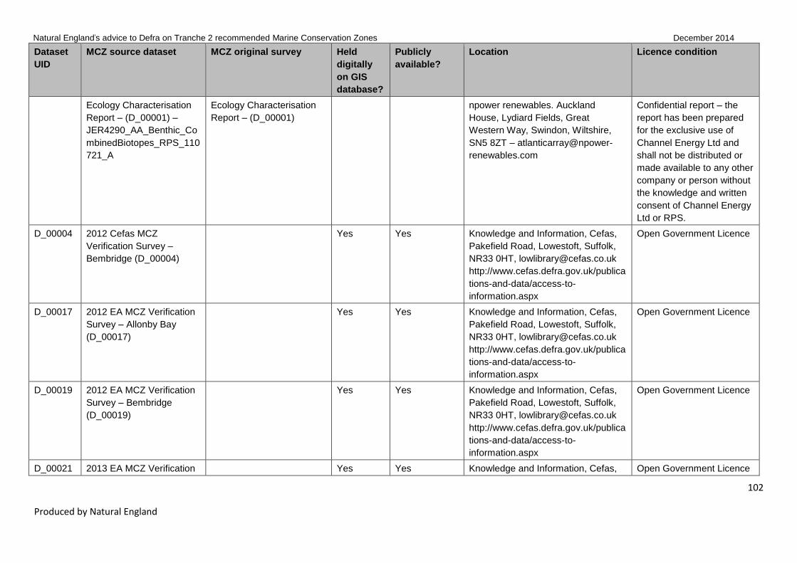
Natural England’s advice to Defra on Tranche 2 recommended Marine Conservation Zones December 2014
102
Produced by Natural England
Dataset
UID
MCZ source dataset MCZ original survey Held
digitally
on GIS
database?
Publicly
available?
Location Licence condition
Ecology Characterisation
Report – (D_00001) –
JER4290_AA_Benthic_Co
mbinedBiotopes_RPS_110
721_A
Ecology Characterisation
Report – (D_00001)
npower renewables. Auckland
House, Lydiard Fields, Great
Western Way, Swindon, Wiltshire,
SN5 8ZT – atlanticarray@npower-
renewables.com
Confidential report – the
report has been prepared
for the exclusive use of
Channel Energy Ltd and
shall not be distributed or
made available to any other
company or person without
the knowledge and written
consent of Channel Energy
Ltd or RPS.
D_00004 2012 Cefas MCZ
Verification Survey –
Bembridge (D_00004)
Yes Yes Knowledge and Information, Cefas,
Pakefield Road, Lowestoft, Suffolk,
NR33 0HT, [email protected]
http://www.cefas.defra.gov.uk/publica
tions-and-data/access-to-
information.aspx
Open Government Licence
D_00017 2012 EA MCZ Verification
Survey – Allonby Bay
(D_00017)
Yes Yes Knowledge and Information, Cefas,
Pakefield Road, Lowestoft, Suffolk,
NR33 0HT, [email protected]
http://www.cefas.defra.gov.uk/publica
tions-and-data/access-to-
information.aspx
Open Government Licence
D_00019 2012 EA MCZ Verification
Survey – Bembridge
(D_00019)
Yes Yes Knowledge and Information, Cefas,
Pakefield Road, Lowestoft, Suffolk,
NR33 0HT, [email protected]
http://www.cefas.defra.gov.uk/publica
tions-and-data/access-to-
information.aspx
Open Government Licence
D_00021 2013 EA MCZ Verification Yes Yes Knowledge and Information, Cefas, Open Government Licence

Natural England’s advice to Defra on Tranche 2 recommended Marine Conservation Zones December 2014
103
Produced by Natural England
Dataset
UID
MCZ source dataset MCZ original survey Held
digitally
on GIS
database?
Publicly
available?
Location Licence condition
Survey – Cromer Shoal
(D_00021)
Pakefield Road, Lowestoft, Suffolk,
NR33 0HT, [email protected]
http://www.cefas.defra.gov.uk/publica
tions-and-data/access-to-
information.aspx
D_00022 2012 EA MCZ Verification
Survey – Dover to Deal
(D_00022)
Yes Yes Knowledge and Information, Cefas,
Pakefield Road, Lowestoft, Suffolk,
NR33 0HT, [email protected]
http://www.cefas.defra.gov.uk/publica
tions-and-data/access-to-
information.aspx
Open Government Licence
D_00023 2012 EA MCZ Verification
Survey – Dover to
Folkestone (D_00023)
Yes Yes Knowledge and Information, Cefas,
Pakefield Road, Lowestoft, Suffolk,
NR33 0HT, [email protected]
http://www.cefas.defra.gov.uk/publica
tions-and-data/access-to-
information.aspx
Open Government Licence
D_00024 2013 EA MCZ Verification
Survey – Hartland Point to
Tintagel (D_00024)
Yes Yes Knowledge and Information, Cefas,
Pakefield Road, Lowestoft, Suffolk,
NR33 0HT, [email protected]
http://www.cefas.defra.gov.uk/publica
tions-and-data/access-to-
information.aspx
Open Government Licence
D_00029 2012 EA MCZ Verification
Survey – Mounts Bay
(D_00029)
Yes Yes Knowledge and Information, Cefas,
Pakefield Road, Lowestoft, Suffolk,
NR33 0HT, [email protected]
http://www.cefas.defra.gov.uk/publica
tions-and-data/access-to-
information.aspx
Open Government Licence

Natural England’s advice to Defra on Tranche 2 recommended Marine Conservation Zones December 2014
104
Produced by Natural England
Dataset
UID
MCZ source dataset MCZ original survey Held
digitally
on GIS
database?
Publicly
available?
Location Licence condition
D_00030 2013 EA MCZ Verification
Survey – Newquay and
The Gannel (D_00030)
Yes Yes Knowledge and Information, Cefas,
Pakefield Road, Lowestoft, Suffolk,
NR33 0HT, [email protected]
http://www.cefas.defra.gov.uk/publica
tions-and-data/access-to-
information.aspx
Open Government Licence
D_00031 2012 EA MCZ Verification
Survey – Norris to Ryde
(D_00031)
Yes Yes Knowledge and Information, Cefas,
Pakefield Road, Lowestoft, Suffolk,
NR33 0HT, [email protected]
http://www.cefas.defra.gov.uk/publica
tions-and-data/access-to-
information.aspx
Open Government Licence
D_00035 2012 EA MCZ Verification
Survey – Utopia
(D_00035)
Yes Yes Knowledge and Information, Cefas,
Pakefield Road, Lowestoft, Suffolk,
NR33 0HT, [email protected]
http://www.cefas.defra.gov.uk/publica
tions-and-data/access-to-
information.aspx
Open Government Licence
D_00036 2012 EA MCZ Verification
Survey – Yarmouth to
Cowes (D_00036)
Yes Yes Knowledge and Information, Cefas,
Pakefield Road, Lowestoft, Suffolk,
NR33 0HT, [email protected]
http://www.cefas.defra.gov.uk/publica
tions-and-data/access-to-
information.aspx
Open Government Licence
D_00038 NE MCZ Verification
Photos
NE Regional Staff MCZ
Verification Photos
Yes Yes Natural England National GI Open Government Licence
D_00039 2013 Natural England
MCZ Verification Survey –
Allonby Bay (D_00039)
Yes Yes Natural England National GI Open Government Licence

Natural England’s advice to Defra on Tranche 2 recommended Marine Conservation Zones December 2014
105
Produced by Natural England
Dataset
UID
MCZ source dataset MCZ original survey Held
digitally
on GIS
database?
Publicly
available?
Location Licence condition
D_00041 2013 Natural England
MCZ Verification Survey –
Bideford to Foreland Point
(D_00041)
Yes Yes Natural England National GI Open Government Licence
D_00043 2013 Natural England
MCZ Verification Survey –
Coquet to St Mary's
(D_00043)
Yes Yes Natural England National GI Open Government Licence
D_00046 2013 Natural England
MCZ Verification Survey –
Dover to Folkestone
(D_00046)
Yes Yes Natural England National GI Open Government Licence
D_00048 2013 Natural England
MCZ Verification Survey –
Hartland Point to Tintagel
(D_00048)
Yes Yes Natural England National GI Open Government Licence
D_00051 2013 Natural England
MCZ Verification Survey –
Newquay and The Gannel
(D_00051)
Yes Yes Natural England National GI Open Government Licence
D_00052 2013 Natural England
MCZ Verification Survey–-
Studland Bay (D_00052)
Yes Yes Natural England National GI Open Government Licence
D_00055 WFD & NE Subtidal
Benthic Infauna Survey
2011 – Solent Maritime
SAC
Yes Yes Natural England National GI –
http://www.geostore.com/environmen
t-agency
EA standard notice –
http://www.environment-
agency.gov.uk/contactus/
D_00064 EA WFD Subtidal Benthic Yes Yes Natural England National GI – EA standard notice –

Natural England’s advice to Defra on Tranche 2 recommended Marine Conservation Zones December 2014
106
Produced by Natural England
Dataset
UID
MCZ source dataset MCZ original survey Held
digitally
on GIS
database?
Publicly
available?
Location Licence condition
Infauna Survey 2012 –
Whitstable Bay
http://www.geostore.com/environmen
t-agency
http://www.environment-
agency.gov.uk/contactus/
D_00065 2011 WFD Intertidal
Seagrass Survey 2011 –
Solent (D_00065) –
WFD_Seagrass_2012_v4
Yes Yes Natural England National GI –
http://www.geostore.com/environmen
t-agency
EA standard notice –
http://www.environment-
agency.gov.uk/contactus/
D_00071 2012 Survey and
monitoring of seagrass
beds at Studland Bay
(D_00071) – Stills Data
Axelsson, M., Allen, C. and
Dewey, S. (2012). Survey
and monitoring of seagrass
beds at Studland Bay,
Dorset – second seagrass
monitoring report. Report
to The Crown Estate and
Natural England by
Seastar Survey Ltd, June
2012
Yes Yes The Crown Estate –
http://www.thecrownestate.co.uk/med
ia/5290/Seastar%20survey%20Studl
and%20Bay%20second%20seagras
s%20monitoring%20report.pdf
Open Access
D_00091 2011 Solent Maritime SAC
intertidal survey –
(D_00091) – Biotope
Polygons
2011 Solent Maritime SAC
intertidal survey –
(D_00091)
Yes Yes Natural England National GI Open Government Licence
D_00092 Marine Recorder new data
2014 02 14
2013 Seastar Survey
South Wight Maritime SAC
Benthic Habitat Mapping
Survey
Yes Yes www.nbn.org.uk Various – See NBN website
D_00094 HIWWT Outlier Positives
2006-2013 points
Hampshire & Isle of Wight
Wildlife Trust. 2009.
Eelgrass survey
Bembridge. Hampshire &
Isle of Wight Wildlife Trust,
Yes No Hampshire & Isle of Wight Wildlife
Trust, Beechcroft House, Vicarage
Lane, Curdridge, Hampshire, SO32
2DP. 01489 774400
Contact – Hampshire & Isle
of Wight Wildlife Trust,
Beechcroft House,
Vicarage Lane, Curdridge,
Hampshire, SO32 2DP.

Natural England’s advice to Defra on Tranche 2 recommended Marine Conservation Zones December 2014
107
Produced by Natural England
Dataset
UID
MCZ source dataset MCZ original survey Held
digitally
on GIS
database?
Publicly
available?
Location Licence condition
Botley 01489 774400
D_00094 HIWWT Outlier Positives
2006-2013 points
Hampshire & Isle of Wight
Wildlife Trust. 2009.
Eelgrass survey Priory
Bay. Hampshire & Isle of
Wight Wildlife Trust, Botley
Yes No Hampshire & Isle of Wight Wildlife
Trust, Beechcroft House, Vicarage
Lane, Curdridge, Hampshire, SO32
2DP. 01489 774401
Contact – Hampshire & Isle
of Wight Wildlife Trust,
Beechcroft House,
Vicarage Lane, Curdridge,
Hampshire, SO32 2DP.
01489 774401
D_00094 HIWWT Outlier Positives
2006-2013 points
Hampshire & Isle of Wight
Wildlife Trust. 2010.
Eelgrass survey Bouldner,
Isle of Wight. Hampshire &
Isle of Wight Wildlife Trust,
Botley
Yes No Hampshire & Isle of Wight Wildlife
Trust, Beechcroft House, Vicarage
Lane, Curdridge, Hampshire, SO32
2DP. 01489 774402
Contact – Hampshire & Isle
of Wight Wildlife Trust,
Beechcroft House,
Vicarage Lane, Curdridge,
Hampshire, SO32 2DP.
01489 774402
D_00094 HIWWT Outlier Positives
2006-2013 points
Hampshire & Isle of Wight
Wildlife Trust. 2010.
Eelgrass survey Thorness
Bay and Gurnard area, Isle
of Wight. Hampshire & Isle
of Wight Wildlife Trust,
Botley
Yes No Hampshire & Isle of Wight Wildlife
Trust, Beechcroft House, Vicarage
Lane, Curdridge, Hampshire, SO32
2DP. 01489 774403
Contact – Hampshire & Isle
of Wight Wildlife Trust,
Beechcroft House,
Vicarage Lane, Curdridge,
Hampshire, SO32 2DP.
01489 774403
D_00094 HIWWT Outlier Positives
2006-2013 points
Hampshire & Isle of Wight
Wildlife Trust. 2010.
Eelgrass survey Thorness
Bay, Isle of Wight.
Hampshire & Isle of Wight
Wildlife Trust, Botley
Yes No Hampshire & Isle of Wight Wildlife
Trust, Beechcroft House, Vicarage
Lane, Curdridge, Hampshire, SO32
2DP. 01489 774404
Contact – Hampshire & Isle
of Wight Wildlife Trust,
Beechcroft House,
Vicarage Lane, Curdridge,
Hampshire, SO32 2DP.
01489 774404
D_00094 HIWWT Outlier Positives
2006-2013 points
Hampshire & Isle of Wight
Wildlife Trust. 2010.
Eelgrass survey Yarmouth,
Yes No Hampshire & Isle of Wight Wildlife
Trust, Beechcroft House, Vicarage
Lane, Curdridge, Hampshire, SO32
Contact – Hampshire & Isle
of Wight Wildlife Trust,
Beechcroft House,

Natural England’s advice to Defra on Tranche 2 recommended Marine Conservation Zones December 2014
108
Produced by Natural England
Dataset
UID
MCZ source dataset MCZ original survey Held
digitally
on GIS
database?
Publicly
available?
Location Licence condition
Isle of Wight. Hampshire &
Isle of Wight Wildlife Trust,
Botley
2DP. 01489 774405 Vicarage Lane, Curdridge,
Hampshire, SO32 2DP.
01489 774405
D_00094 HIWWT Outlier Positives
2006-2013 points
Hampshire & Isle of Wight
Wildlife Trust. 2010.
Seasearch survey Totland
Bay. Hampshire & Isle of
Wight Wildlife Trust, Botley
Yes No Hampshire & Isle of Wight Wildlife
Trust, Beechcroft House, Vicarage
Lane, Curdridge, Hampshire, SO32
2DP. 01489 774406
Contact – Hampshire & Isle
of Wight Wildlife Trust,
Beechcroft House,
Vicarage Lane, Curdridge,
Hampshire, SO32 2DP.
01489 774406
D_00094 HIWWT Outlier Positives
2006-2013 points
Hampshire & Isle of Wight
Wildlife Trust. 2013.
Eelgrass survey Isle of
Wight Hampshire & Isle of
Wight Wildlife Trust, Botley
Yes No Hampshire & Isle of Wight Wildlife
Trust, Beechcroft House, Vicarage
Lane, Curdridge, Hampshire, SO32
2DP. 01489 774407
Contact – Hampshire & Isle
of Wight Wildlife Trust,
Beechcroft House,
Vicarage Lane, Curdridge,
Hampshire, SO32 2DP.
01489 774407
D_00094 HIWWT Outlier Positives
2006-2013 points
HIWWT (2006) Ryde
Sands Intertidal Survey
Yes No Hampshire & Isle of Wight Wildlife
Trust, Beechcroft House, Vicarage
Lane, Curdridge, Hampshire, SO32
2DP. 01489 774408
Contact – Hampshire & Isle
of Wight Wildlife Trust,
Beechcroft House,
Vicarage Lane, Curdridge,
Hampshire, SO32 2DP.
01489 774408
D_00094 HIWWT Outlier Positives
2006-2013 points
HIWWT (2007)
Shoresearch Course
Survey July 2007
Yes No Hampshire & Isle of Wight Wildlife
Trust, Beechcroft House, Vicarage
Lane, Curdridge, Hampshire, SO32
2DP. 01489 774409
Contact – Hampshire & Isle
of Wight Wildlife Trust,
Beechcroft House,
Vicarage Lane, Curdridge,
Hampshire, SO32 2DP.
01489 774409
D_00094 HIWWT Outlier Positives
2006-2013 points
IWNAHS (2006) Sightings
of Zostera spp reported by
Yes No Hampshire & Isle of Wight Wildlife
Trust, Beechcroft House, Vicarage
Contact – Hampshire & Isle
of Wight Wildlife Trust,

Natural England’s advice to Defra on Tranche 2 recommended Marine Conservation Zones December 2014
109
Produced by Natural England
Dataset
UID
MCZ source dataset MCZ original survey Held
digitally
on GIS
database?
Publicly
available?
Location Licence condition
members Lane, Curdridge, Hampshire, SO32
2DP. 01489 774410
Beechcroft House,
Vicarage Lane, Curdridge,
Hampshire, SO32 2DP.
01489 774410
D_00094 HIWWT Outlier Positives
2006-2013 points
Ken Collins (Calshot &
Wootton July 2007)
Yes No Hampshire & Isle of Wight Wildlife
Trust, Beechcroft House, Vicarage
Lane, Curdridge, Hampshire, SO32
2DP. 01489 774411
Contact – Hampshire & Isle
of Wight Wildlife Trust,
Beechcroft House,
Vicarage Lane, Curdridge,
Hampshire, SO32 2DP.
01489 774411
D_00094 HIWWT Outlier Positives
2006-2013 points
Ken Collins (Ryde August
2006)
Yes No Hampshire & Isle of Wight Wildlife
Trust, Beechcroft House, Vicarage
Lane, Curdridge, Hampshire, SO32
2DP. 01489 774412
Contact – Hampshire & Isle
of Wight Wildlife Trust,
Beechcroft House,
Vicarage Lane, Curdridge,
Hampshire, SO32 2DP.
01489 774412
D_00094 HIWWT Outlier Positives
2006-2013 points
Ken Collins (Ryde June
2006)
Yes No Hampshire & Isle of Wight Wildlife
Trust, Beechcroft House, Vicarage
Lane, Curdridge, Hampshire, SO32
2DP. 01489 774413
Contact – Hampshire & Isle
of Wight Wildlife Trust,
Beechcroft House,
Vicarage Lane, Curdridge,
Hampshire, SO32 2DP.
01489 774413
D_00094 HIWWT Outlier Positives
2006-2013 points
Ken Collins (Ryde Shore
August 2006)
Yes No Hampshire & Isle of Wight Wildlife
Trust, Beechcroft House, Vicarage
Lane, Curdridge, Hampshire, SO32
2DP. 01489 774414
Contact – Hampshire & Isle
of Wight Wildlife Trust,
Beechcroft House,
Vicarage Lane, Curdridge,
Hampshire, SO32 2DP.
01489 774414
D_00094 HIWWT Outlier Positives Ken Collins (Ryde Shore Yes No Hampshire & Isle of Wight Wildlife Contact – Hampshire & Isle

Natural England’s advice to Defra on Tranche 2 recommended Marine Conservation Zones December 2014
110
Produced by Natural England
Dataset
UID
MCZ source dataset MCZ original survey Held
digitally
on GIS
database?
Publicly
available?
Location Licence condition
2006-2013 points September 2007) Trust, Beechcroft House, Vicarage
Lane, Curdridge, Hampshire, SO32
2DP. 01489 774415
of Wight Wildlife Trust,
Beechcroft House,
Vicarage Lane, Curdridge,
Hampshire, SO32 2DP.
01489 774415
D_00094 HIWWT Outlier Positives
2006-2013 points
Ken Collins (Totland
August 2006)
Yes No Hampshire & Isle of Wight Wildlife
Trust, Beechcroft House, Vicarage
Lane, Curdridge, Hampshire, SO32
2DP. 01489 774416
Contact – Hampshire & Isle
of Wight Wildlife Trust,
Beechcroft House,
Vicarage Lane, Curdridge,
Hampshire, SO32 2DP.
01489 774416
D_00094 HIWWT Outlier Positives
2006-2013 points
Roger Herbert (2006) Sea
Safari Yarmouth & Norton
Spit
Yes No Hampshire & Isle of Wight Wildlife
Trust, Beechcroft House, Vicarage
Lane, Curdridge, Hampshire, SO32
2DP. 01489 774417
Contact – Hampshire & Isle
of Wight Wildlife Trust,
Beechcroft House,
Vicarage Lane, Curdridge,
Hampshire, SO32 2DP.
01489 774417
D_00094 HIWWT Outlier Positives
2006-2013 points
Roger Herbert (2007)
Marine Week
Yes No Hampshire & Isle of Wight Wildlife
Trust, Beechcroft House, Vicarage
Lane, Curdridge, Hampshire, SO32
2DP. 01489 774418
Contact – Hampshire & Isle
of Wight Wildlife Trust,
Beechcroft House,
Vicarage Lane, Curdridge,
Hampshire, SO32 2DP.
01489 774418
D_00094 HIWWT Outlier Positives
2006-2013 points
Salacia towed video survey
2011
Yes No Hampshire & Isle of Wight Wildlife
Trust, Beechcroft House, Vicarage
Lane, Curdridge, Hampshire, SO32
2DP. 01489 774419
Contact – Hampshire & Isle
of Wight Wildlife Trust,
Beechcroft House,
Vicarage Lane, Curdridge,
Hampshire, SO32 2DP.
01489 774419

Natural England’s advice to Defra on Tranche 2 recommended Marine Conservation Zones December 2014
111
Produced by Natural England
Dataset
UID
MCZ source dataset MCZ original survey Held
digitally
on GIS
database?
Publicly
available?
Location Licence condition
D_00094 HIWWT Outlier Positives
2006-2013 points
Salacia towed video survey
2012
Yes No Hampshire & Isle of Wight Wildlife
Trust, Beechcroft House, Vicarage
Lane, Curdridge, Hampshire, SO32
2DP. 01489 774420
Contact – Hampshire & Isle
of Wight Wildlife Trust,
Beechcroft House,
Vicarage Lane, Curdridge,
Hampshire, SO32 2DP.
01489 774420
D_00098 Kent Wildlife
Trust/Seasearch MCZ
Verification Photos
Yes No Kent Wildlife Trust, Tyland Barn,
Sanling, Maidstone, Kent, ME14 3BD
01622 662012
Contact Bryony Chapman,
Marine Officer, Kent
Wildlife Trust, Tyland Barn,
Sanling, Maidstone, Kent,
ME14 3BD 01622 662012,
Bryony.Chapman@kentwild
life.org.uk
D_00099 Hampshire & Isle of Wight
Wildlife Trust/Seasearch
MCZ Verification Photos
Yes No Hampshire & Isle of Wight Wildlife
Trust, Beechcroft House, Vicarage
Lane, Curdridge, Hampshire, SO32
2DP. 01489 774420
Contact – Hampshire & Isle
of Wight Wildlife Trust,
Beechcroft House,
Vicarage Lane, Curdridge,
Hampshire, SO32 2DP.
01489 774420
D_00101 Marine Recorder new data
2014 02 14
2014 Kent WT
Shoresearch Intertidal
survey
Yes Yes www.nbn.org.uk Various – See NBN website
D_00103 Marine Recorder new data
2014 02 14
2013 Seasearch survey of
the Norfolk coast
Yes Yes www.nbn.org.uk Various – See NBN website
D_00105 Marine Recorder new data
2014 02 14
2013 Seasearch North
East England survey of the
Farne Islands and
Northumberland Coast
Yes Yes www.nbn.org.uk Various – See NBN website

Natural England’s advice to Defra on Tranche 2 recommended Marine Conservation Zones December 2014
112
Produced by Natural England
Dataset
UID
MCZ source dataset MCZ original survey Held
digitally
on GIS
database?
Publicly
available?
Location Licence condition
D_00106 Marine Recorder new data
2014 02 14
2013 Seasearch
Hampshire & Isle of Wight
Yes Yes www.nbn.org.uk Various – See NBN website
D_00107 Marine Recorder new data
2014 02 14
2013 Seasearch Devon
survey of North Devon
Yes Yes www.nbn.org.uk Various – See NBN website
D_00109 Marine Recorder new data
2014 02 14
2013 Seasearch Cornwall
surveys of Penzance to
Land's End
Yes Yes www.nbn.org.uk Various – See NBN website
D_00114 Marine Recorder snapshot
2014_01_28
2013 Kent WT
Shoresearch Intertidal
Survey
Yes Yes www.nbn.org.uk Various – See NBN website
D_00115 Marine Recorder new data
2014 02 14
2013 Kent Seasearch
Sublittoral Survey
Yes Yes www.nbn.org.uk Various – See NBN website
D_00116 Marine Recorder new data
2014 02 14
2013 Dorset Seasearch Yes Yes www.nbn.org.uk Various – See NBN website
D_00117 Marine Recorder snapshot
2013_06_24
2012 Seasearch survey of
the Norfolk coast
Yes Yes www.nbn.org.uk Various – See NBN website
D_00119 Marine Recorder snapshot
2013_06_24
2012 Seasearch survey of
Studland Bay rMCZ
Yes Yes www.nbn.org.uk Various – See NBN website
D_00120 Marine Recorder snapshot
2013_06_24
2012 Seasearch survey of
Essex Coast
Yes Yes www.nbn.org.uk Various – See NBN website
D_00121 Marine Recorder snapshot
2013_06_24
2012 Seasearch survey in
Beachy Head West rMCZ,
Sussex
Yes Yes www.nbn.org.uk Various – See NBN website
D_00122 Marine Recorder snapshot
2013_06_24
2012 Seasearch North
East England survey of St
Mary's to Coquet Island
dMCZ
Yes Yes www.nbn.org.uk Various – See NBN website

Natural England’s advice to Defra on Tranche 2 recommended Marine Conservation Zones December 2014
113
Produced by Natural England
Dataset
UID
MCZ source dataset MCZ original survey Held
digitally
on GIS
database?
Publicly
available?
Location Licence condition
D_00123 Marine Recorder snapshot
2013_06_24
2012 Seasearch North
East England survey of
Runswick Bay dMCZ
Yes Yes www.nbn.org.uk Various – See NBN website
D_00125 Marine Recorder snapshot
2013_06_24
2012 Seasearch
Hampshire and Isle of
Wight
Yes Yes www.nbn.org.uk Various – See NBN website
D_00126 Marine Recorder snapshot
2013_06_24
2012 Seasearch Devon
survey of Bideford to
Foreland Point rMCZ
Yes Yes www.nbn.org.uk Various – See NBN website
D_00128 Marine Recorder snapshot
2013_06_24
2012 Seasearch Cornwall
surveys of North Coast
Yes Yes www.nbn.org.uk Various – See NBN website
D_00129 Marine Recorder snapshot
2013_06_24
2012 Kent Seasearch
Sublittoral Survey
Yes Yes www.nbn.org.uk Various – See NBN website
D_00130 Marine Recorder snapshot
2013_06_24
2012 Intertidal surveys
Hampshire & Isle of Wight
Yes Yes www.nbn.org.uk Various – See NBN website
D_00131 Marine Recorder snapshot
2013_06_24
2012 Dorset Seasearch Yes Yes www.nbn.org.uk Various – See NBN website
D_00132 Marine Recorder snapshot
2013_06_24
2011 Sussex Seasearch
Chichester to Newhaven
Yes Yes www.nbn.org.uk Various – See NBN website
D_00134 Marine Recorder snapshot
2013_06_24
2011 Survey of Norfolk
coast
Yes Yes www.nbn.org.uk Various – See NBN website
D_00136 Marine Recorder snapshot
2013_06_24
2011 Seasearch survey of
the Essex coast
Yes Yes www.nbn.org.uk Various – See NBN website
D_00137 Marine Recorder snapshot
2013_06_24
2011 Seasearch North
East England Survey
Yes Yes www.nbn.org.uk Various – See NBN website
D_00138 Marine Recorder snapshot
2013_06_24
2011 Seasearch
Hampshire and Isle of
Yes Yes www.nbn.org.uk Various – See NBN website

Natural England’s advice to Defra on Tranche 2 recommended Marine Conservation Zones December 2014
114
Produced by Natural England
Dataset
UID
MCZ source dataset MCZ original survey Held
digitally
on GIS
database?
Publicly
available?
Location Licence condition
Wight
D_00139 Marine Recorder snapshot
2013_06_24
2011 Seasearch Cornwall
surveys of North Coast
Yes Yes www.nbn.org.uk Various – See NBN website
D_00140 Marine Recorder snapshot
2013_06_24
2011 Kent Seasearch
Sublittoral Survey
Yes Yes www.nbn.org.uk Various – See NBN website
D_00141 Marine Recorder snapshot
2013_06_24
2011 Intertidal survey
Hampshire & Isle of Wight
Yes Yes www.nbn.org.uk Various – See NBN website
D_00142 Marine Recorder snapshot
2013_06_24
2011 Dorset Seasearch Yes Yes www.nbn.org.uk Various – See NBN website
D_00143 Marine Recorder snapshot
2013_06_24
2011 Dorset Seasearch Yes Yes www.nbn.org.uk Various – See NBN website
D_00144 Marine Recorder snapshot
2013_06_24
2010 Sussex Seasearch
Bracklesham Bay to
Newhaven
Yes Yes www.nbn.org.uk Various – See NBN website
D_00145 Marine Recorder snapshot
2013_06_24
2010 Seasearch survey of
Norfolk Coast
Yes Yes www.nbn.org.uk Various – See NBN website
D_00148 Marine Recorder snapshot
2013_06_24
2010 Seasearch
Hampshire and Isle of
Wight
Yes Yes www.nbn.org.uk Various – See NBN website
D_00149 Marine Recorder snapshot
2013_06_24
2010 Seasearch Devon
survey of North Devon
coast
Yes Yes www.nbn.org.uk Various – See NBN website
D_00151 Marine Recorder snapshot
2013_06_24
2010 MCS Cornwall survey
of South Penwith Area
Yes Yes www.nbn.org.uk Various – See NBN website
D_00153 Marine Recorder snapshot
2013_06_24
2010 Kent Seasearch
Sublittoral Survey
Yes Yes www.nbn.org.uk Various – See NBN website
D_00155 Marine Recorder snapshot Intertidal Chalk survey from Yes Yes www.nbn.org.uk Various – See NBN website

Natural England’s advice to Defra on Tranche 2 recommended Marine Conservation Zones December 2014
115
Produced by Natural England
Dataset
UID
MCZ source dataset MCZ original survey Held
digitally
on GIS
database?
Publicly
available?
Location Licence condition
2013_06_24 Folkestone to Deal, Kent,
2009–2011
D_00156 Marine Recorder snapshot
2013_06_24
2009 Sussex Seasearch
Chichester to Eastbourne
Yes Yes www.nbn.org.uk Various – See NBN website
D_00157 Marine Recorder snapshot
2013_06_24
2009 Seasearch Yorkshire
Easington Dimlington
Survey
Yes Yes www.nbn.org.uk Various – See NBN website
D_00159 Marine Recorder snapshot
2013_06_24
2009 Seasearch North
East survey of the coast
around Tynemouth
Yes Yes www.nbn.org.uk Various – See NBN website
D_00160 Marine Recorder snapshot
2013_06_24
2009 Seasearch
Hampshire and Isle of
Wight
Yes Yes www.nbn.org.uk Various – See NBN website
D_00162 Marine Recorder snapshot
2013_06_24
2009 Seasearch Devon
survey of North Devon
Coast
Yes Yes www.nbn.org.uk Various – See NBN website
D_00163 Marine Recorder snapshot
2013_06_24
2009 Kent Seasearch
Sublittoral Survey
Yes Yes www.nbn.org.uk Various – See NBN website
D_00164 Marine Recorder snapshot
2013_06_24
2009 Dorset Seasearch Yes Yes www.nbn.org.uk Various – See NBN website
D_00165 Marine Recorder snapshot
2013_06_24
2008 Sussex Seasearch
Bracklesham Bay to
Pevensey Bay
Yes Yes www.nbn.org.uk Various – See NBN website
D_00166 Marine Recorder snapshot
2013_06_24
2008 Seasearch survey of
Norfolk
Yes Yes www.nbn.org.uk Various – See NBN website
D_00169 Marine Recorder snapshot
2013_06_24
2008 Seasearch
Hampshire and Isle of
Yes Yes www.nbn.org.uk Various – See NBN website

Natural England’s advice to Defra on Tranche 2 recommended Marine Conservation Zones December 2014
116
Produced by Natural England
Dataset
UID
MCZ source dataset MCZ original survey Held
digitally
on GIS
database?
Publicly
available?
Location Licence condition
Wight
D_00173 Marine Recorder snapshot
2013_06_24
2008 Kent Seasearch
Sublittoral Survey
Yes Yes www.nbn.org.uk Various – See NBN website
D_00174 Marine Recorder snapshot
2013_06_24
2007 Sussex Seasearch
Selsey to Hastings
Yes Yes www.nbn.org.uk Various – See NBN website
D_00175 Marine Recorder snapshot
2013_06_24
2007 Seasearch survey of
Norfolk
Yes Yes www.nbn.org.uk Various – See NBN website
D_00177 Marine Recorder snapshot
2013_06_24
2007 Seasearch
Hampshire and Isle of
Wight
Yes Yes www.nbn.org.uk Various – See NBN website
D_00178 Marine Recorder snapshot
2013_06_24
2007 Natural England Shell
Flat and Lune Deep Survey
Yes Yes www.nbn.org.uk Various –See NBN website
D_00179 Marine Recorder snapshot
2013_06_24
2007 Natural England
Outer Wash Annex I
habitat survey
Yes Yes www.nbn.org.uk Various – See NBN website
D_00180 Marine Recorder snapshot
2013_06_24
Kent Shoresearch Intertidal
Survey 2007
Yes Yes www.nbn.org.uk Various – See NBN website
D_00181 Marine Recorder snapshot
2013_06_24
2007 Kent Seasearch
Sublittoral Survey
Yes Yes www.nbn.org.uk Various – See NBN website
D_00182 Marine Recorder snapshot
2013_06_24
2007 Envision Mapping Ltd
Morecambe Bay, marine
habitats mapping
INCOMPLETE
Yes Yes www.nbn.org.uk Various – See NBN website
D_00183 Marine Recorder snapshot
2013_06_24
2006 Sussex Seasearch
Chichester Harbour to Rye
Bay
Yes Yes www.nbn.org.uk Various – See NBN website
D_00184 Marine Recorder snapshot 2006 Seasearch North Yes Yes www.nbn.org.uk Various – See NBN website

Natural England’s advice to Defra on Tranche 2 recommended Marine Conservation Zones December 2014
117
Produced by Natural England
Dataset
UID
MCZ source dataset MCZ original survey Held
digitally
on GIS
database?
Publicly
available?
Location Licence condition
2013_06_24 Norfolk
D_00185 Marine Recorder snapshot
2013_06_24
2006 Seasearch North
Cornwall
Yes Yes www.nbn.org.uk Various – See NBN website
D_00186 Marine Recorder snapshot
2013_06_24
2006 Seasearch
Hampshire and Isle of
Wight
Yes Yes www.nbn.org.uk Various – See NBN website
D_00187 Marine Recorder snapshot
2013_06_24
Kent Shoresearch Intertidal
Survey 2006
Yes Yes www.nbn.org.uk Various – See NBN website
D_00188 Marine Recorder snapshot
2013_06_24
2006 Kent Seasearch
Sublittoral Survey
Yes Yes www.nbn.org.uk Various – See NBN website
D_00189 Marine Recorder snapshot
2013_06_24
2006 – PMNHS – Isle of
Wight Field Trip
Yes Yes www.nbn.org.uk Various – See NBN website
D_00190 Marine Recorder snapshot
2013_06_24
2005 Sussex Seasearch
Bracklesham Bay to
Eastbourne
Yes Yes www.nbn.org.uk Various – See NBN website
D_00191 Marine Recorder snapshot
2013_06_24
2005 Seasearch survey of
Dorset
Yes Yes www.nbn.org.uk Various – See NBN website
D_00192 Marine Recorder snapshot
2013_06_24
2005 Seasearch Penzance
and Land's End
Yes Yes www.nbn.org.uk Various – See NBN website
D_00193 Marine Recorder snapshot
2013_06_24
2005 Seasearch North
Norfolk
Yes Yes www.nbn.org.uk Various – See NBN website
D_00194 Marine Recorder snapshot
2013_06_24
2005 Seasearch
Hampshire and Isle of
Wight
Yes Yes www.nbn.org.uk Various – See NBN website
D_00195 Marine Recorder snapshot
2013_06_24
Kent Shoresearch Intertidal
Survey 2005
Yes Yes www.nbn.org.uk Various – See NBN website
D_00196 Marine Recorder snapshot 2005 Kent Seasearch Yes Yes www.nbn.org.uk Various – See NBN website

Natural England’s advice to Defra on Tranche 2 recommended Marine Conservation Zones December 2014
118
Produced by Natural England
Dataset
UID
MCZ source dataset MCZ original survey Held
digitally
on GIS
database?
Publicly
available?
Location Licence condition
2013_06_24 Sublittoral Survey
D_00197 Marine Recorder snapshot
2013_06_24
2005 English Nature (EN)
survey of the littoral caves
of the South Wight
maritime SAC
Yes Yes www.nbn.org.uk Various – See NBN website
D_00198 Marine Recorder snapshot
2013_06_24
2005 English Nature (EN)
Solent Intertidal Survey
August to September 2005
Yes Yes www.nbn.org.uk Various – See NBN website
D_00199 Marine Recorder snapshot
2013_06_24
2004 Sussex Seasearch
Bracklesham Bay to Rye
Bay
Yes Yes www.nbn.org.uk Various – See NBN website
D_00202 Marine Recorder snapshot
2013_06_24
2004 Seasearch
Northumberland
Yes Yes www.nbn.org.uk Various – See NBN website
D_00203 Marine Recorder snapshot
2013_06_24
2004 Seasearch North
Norfolk
Yes Yes www.nbn.org.uk Various – See NBN website
D_00204 Marine Recorder snapshot
2013_06_24
2004 Seasearch Isle of
Wight
Yes Yes www.nbn.org.uk Various – See NBN website
D_00206 Marine Recorder snapshot
2013_06_24
2004 Kent Seasearch
Sublittoral Survey
Yes Yes www.nbn.org.uk Various – See NBN website
D_00207 Marine Recorder snapshot
2013_06_24
2003 Sussex Seasearch
Pagham Harbour to
Cuckmere
Yes Yes www.nbn.org.uk Various – See NBN website
D_00208 Marine Recorder snapshot
2013_06_24
2003 Seasearch surveys in
Devon
Yes Yes www.nbn.org.uk Various – See NBN website
D_00209 Marine Recorder snapshot
2013_06_24
2003 Seasearch Penzance
and Land’s End
Yes Yes www.nbn.org.uk Various – See NBN website
D_00210 Marine Recorder snapshot 2003 Seasearch North Yes Yes www.nbn.org.uk Various – See NBN website

Natural England’s advice to Defra on Tranche 2 recommended Marine Conservation Zones December 2014
119
Produced by Natural England
Dataset
UID
MCZ source dataset MCZ original survey Held
digitally
on GIS
database?
Publicly
available?
Location Licence condition
2013_06_24 Norfolk
D_00212 Marine Recorder snapshot
2013_06_24
2003 MCS Members
Dives, Newquay Weekend
Yes Yes www.nbn.org.uk Various – See NBN website
D_00213 Marine Recorder snapshot
2013_06_24
2002 Sussex Seasearch
Bracklesham Bay to
Newhaven
Yes Yes www.nbn.org.uk Various – See NBN website
D_00214 Marine Recorder snapshot
2013_06_24
2002 Seasearch surveys in
Devon
Yes Yes www.nbn.org.uk Various – See NBN website
D_00216 Marine Recorder snapshot
2013_06_24
2002 Seasearch
Hampshire and Isle of
Wight
Yes Yes www.nbn.org.uk Various – See NBN website
D_00218 Marine Recorder snapshot
2013_06_24
2000 Sussex Seasearch
Bracklesham Bay to
Newhaven
Yes Yes www.nbn.org.uk Various – See NBN website
D_00220 Marine Recorder snapshot
2013_06_24
1999 Southern North Sea
and eastern English
Channel Cefas 4m Beam
Trawl Survey (Cory 8-99)
Yes Yes www.nbn.org.uk Various – See NBN website
D_00221 Marine Recorder snapshot
2013_06_24
1999 EN South Wight
Maritime cSAC sublittoral
survey
Yes Yes www.nbn.org.uk Various – See NBN website
D_00222 Marine Recorder snapshot
2013_06_24
1999 Bristol Channel and
Irish Sea Cefas 4m Beam
Trawl Survey (Cory 9-99)
Yes Yes www.nbn.org.uk Various – See NBN website
D_00223 Marine Recorder snapshot
2013_06_24
1998 Sussex Seasearch
Chichester Harbour to Rye
Bay sublittoral survey
Yes Yes www.nbn.org.uk Various – See NBN website
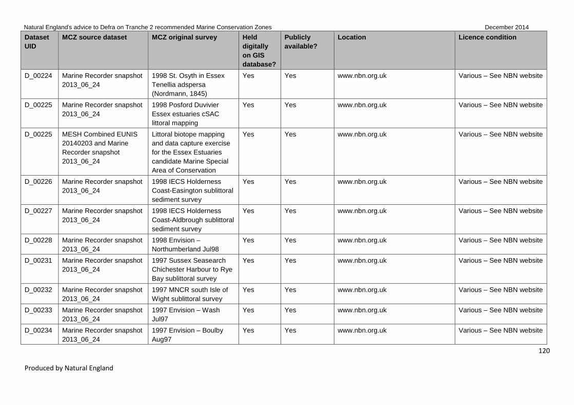
Natural England’s advice to Defra on Tranche 2 recommended Marine Conservation Zones December 2014
120
Produced by Natural England
Dataset
UID
MCZ source dataset MCZ original survey Held
digitally
on GIS
database?
Publicly
available?
Location Licence condition
D_00224 Marine Recorder snapshot
2013_06_24
1998 St. Osyth in Essex
Tenellia adspersa
(Nordmann, 1845)
Yes Yes www.nbn.org.uk Various – See NBN website
D_00225 Marine Recorder snapshot
2013_06_24
1998 Posford Duvivier
Essex estuaries cSAC
littoral mapping
Yes Yes www.nbn.org.uk Various – See NBN website
D_00225 MESH Combined EUNIS
20140203 and Marine
Recorder snapshot
2013_06_24
Littoral biotope mapping
and data capture exercise
for the Essex Estuaries
candidate Marine Special
Area of Conservation
Yes Yes www.nbn.org.uk Various – See NBN website
D_00226 Marine Recorder snapshot
2013_06_24
1998 IECS Holderness
Coast-Easington sublittoral
sediment survey
Yes Yes www.nbn.org.uk Various – See NBN website
D_00227 Marine Recorder snapshot
2013_06_24
1998 IECS Holderness
Coast-Aldbrough sublittoral
sediment survey
Yes Yes www.nbn.org.uk Various – See NBN website
D_00228 Marine Recorder snapshot
2013_06_24
1998 Envision –
Northumberland Jul98
Yes Yes www.nbn.org.uk Various – See NBN website
D_00231 Marine Recorder snapshot
2013_06_24
1997 Sussex Seasearch
Chichester Harbour to Rye
Bay sublittoral survey
Yes Yes www.nbn.org.uk Various – See NBN website
D_00232 Marine Recorder snapshot
2013_06_24
1997 MNCR south Isle of
Wight sublittoral survey
Yes Yes www.nbn.org.uk Various – See NBN website
D_00233 Marine Recorder snapshot
2013_06_24
1997 Envision – Wash
Jul97
Yes Yes www.nbn.org.uk Various – See NBN website
D_00234 Marine Recorder snapshot
2013_06_24
1997 Envision – Boulby
Aug97
Yes Yes www.nbn.org.uk Various – See NBN website

Natural England’s advice to Defra on Tranche 2 recommended Marine Conservation Zones December 2014
121
Produced by Natural England
Dataset
UID
MCZ source dataset MCZ original survey Held
digitally
on GIS
database?
Publicly
available?
Location Licence condition
D_00236 Marine Recorder snapshot
2013_06_24
1997 EN Blackwater
Estuary sublittoral
sediment survey
Yes Yes www.nbn.org.uk Various – See NBN website
D_00237 Marine Recorder snapshot
2013_06_24
1997 Crouch estuary
improvements of the
epifauna
Yes Yes www.nbn.org.uk Various See NBN website
D_00238 Marine Recorder snapshot
2013_06_24
1996 Sussex Seasearch
Beachy Head to Rye Bay
sublittoral survey
Yes Yes www.nbn.org.uk Various – See NBN website
D_00241 Marine Recorder snapshot
2013_06_24
1996 Envision – Amble
Aug96
Yes Yes www.nbn.org.uk Various – See NBN website
D_00245 Marine Recorder snapshot
2013_06_24
1995-2002 Dorset
Seasearch
Yes Yes www.nbn.org.uk Various – See NBN website
D_00246 Marine Recorder snapshot
2013_06_24
1995 Sussex Seasearch
Brighton to Beachy Head
sublittoral survey
Yes Yes www.nbn.org.uk Various – See NBN website
D_00247 Marine Recorder snapshot
2013_06_24
1995 Envision – Sussex
May95
Yes Yes www.nbn.org.uk Various – See NBN website
D_00247 MESH Combined EUNIS
20140203 and Marine
Recorder snapshot
2013_06_24
Sussex Coast (Worthing to
Beachy Head) lifeforms
map
Yes Yes www.nbn.org.uk Various – See NBN website
D_00250 Marine Recorder snapshot
2013_06_24
1994 Sussex Seasearch
Chichester Harbour to
Pevensey Bay sublittoral
survey
Yes Yes www.nbn.org.uk Various – See NBN website
D_00251 Marine Recorder snapshot
2013_06_24
1994 Envision – St. Mary’s
Aug94
Yes Yes www.nbn.org.uk Various – See NBN website

Natural England’s advice to Defra on Tranche 2 recommended Marine Conservation Zones December 2014
122
Produced by Natural England
Dataset
UID
MCZ source dataset MCZ original survey Held
digitally
on GIS
database?
Publicly
available?
Location Licence condition
D_00252 Marine Recorder snapshot
2013_06_24
1994 Envision – I. of Wight
Jun94
Yes Yes www.nbn.org.uk Various – See NBN website
D_00252 MESH Combined EUNIS
20140203 and Marine
Recorder snapshot
2013_06_24
Mapping the distribution of
benthic biotopes around
the Isle of Wight. SE Isle of
Wight, Lifeforms
Yes Yes www.nbn.org.uk Various – See NBN website
D_00252 MESH Combined EUNIS
20140203 and Marine
Recorder snapshot
2013_06_24
Mapping the distribution of
benthic biotopes around
the Isle of Wight. SW Isle
of Wight, Lifeforms
Yes Yes www.nbn.org.uk Various – See NBN website
D_00254 Marine Recorder snapshot
2013_06_24
1993 NHM south-east
England littoral chalk and
greensand survey
Yes Yes www.nbn.org.uk Various – See NBN website
D_00255 Marine Recorder snapshot
2013_06_24
1993 MNCR/AES Blyth to
Flamborough Head
sublittoral sediment survey
Yes Yes www.nbn.org.uk Various – See NBN website
D_00256 Marine Recorder snapshot
2013_06_24
1993 MNCR Swale and
Medway estuaries survey
Yes Yes www.nbn.org.uk Various – See NBN website
D_00257 Marine Recorder snapshot
2013_06_24
1993 MNCR Swale and
Medway estuaries
sublittoral survey
Yes Yes www.nbn.org.uk Various – See NBN website
D_00258 Marine Recorder snapshot
2013_06_24
1993 MNCR Saltburn to
Flamborough Head
sublittoral survey
Yes Yes www.nbn.org.uk Various – See NBN website
D_00259 Marine Recorder snapshot
2013_06_24
1993 MNCR Saltburn to
Flamborough Head littoral
survey
Yes Yes www.nbn.org.uk Various – See NBN website
D_00260 Marine Recorder snapshot 1993 MNCR Newbiggin to Yes Yes www.nbn.org.uk Various – See NBN website

Natural England’s advice to Defra on Tranche 2 recommended Marine Conservation Zones December 2014
123
Produced by Natural England
Dataset
UID
MCZ source dataset MCZ original survey Held
digitally
on GIS
database?
Publicly
available?
Location Licence condition
2013_06_24 Saltburn sublittoral survey
D_00261 Marine Recorder snapshot
2013_06_24
1993 MNCR Newbiggin to
Saltburn littoral survey
Yes Yes www.nbn.org.uk Various – See NBN website
D_00262 Marine Recorder snapshot
2013_06_24
1993 Dove Marine
Laboratory Alnmouth and
Druridge Bays sediment
survey
Yes Yes www.nbn.org.uk Various – See NBN website
D_00265 Marine Recorder snapshot
2013_06_24
1992-95 DWT Morte Bay
littoral survey
Yes Yes www.nbn.org.uk Various – See NBN website
D_00267 Marine Recorder snapshot
2013_06_24
1992-94 DWT Ilfracombe
littoral survey
Yes Yes www.nbn.org.uk Various -–See NBN
website
D_00269 Marine Recorder snapshot
2013_06_24
1992-93 DWT Hartland
Quay littoral survey
Yes Yes www.nbn.org.uk Various – See NBN website
D_00270 Marine Recorder snapshot
2013_06_24
1992-1993 JNCC Gobius
cobitis survey south-west
Britain
Yes Yes www.nbn.org.uk Various – See NBN website
D_00272 Marine Recorder snapshot
2013_06_24
1992 MNCR north-east
England estuaries littoral
survey
Yes Yes www.nbn.org.uk Various – See NBN website
D_00275 Marine Recorder snapshot
2013_06_24
1992 MNCR Blackwater
and Colne estuaries littoral
survey
Yes Yes www.nbn.org.uk Various – See NBN website
D_00276 Marine Recorder snapshot
2013_06_24
1992 MNCR Berwick-on-
Tweed to Newbiggin
sublittoral survey
Yes Yes www.nbn.org.uk Various – See NBN website
D_00277 Marine Recorder snapshot 1992 MNCR Berwick-on- Yes Yes www.nbn.org.uk Various – See NBN website

Natural England’s advice to Defra on Tranche 2 recommended Marine Conservation Zones December 2014
124
Produced by Natural England
Dataset
UID
MCZ source dataset MCZ original survey Held
digitally
on GIS
database?
Publicly
available?
Location Licence condition
2013_06_24 Tweed to Newbiggin littoral
survey
D_00279 Marine Recorder snapshot
2013_06_24
1992 AES NE England
sublittoral survey
Yes Yes www.nbn.org.uk Various – See NBN website
D_00281 Marine Recorder snapshot
2013_06_24
1992 – PMNHS – Cornwall
Field Trip
Yes Yes www.nbn.org.uk Various – See NBN website
D_00282 Marine Recorder snapshot
2013_06_24
1991–93 DWT Saunton
littoral survey
Yes Yes www.nbn.org.uk Various – See NBN website
D_00284 Marine Recorder snapshot
2013_06_24
1991 NRA North Yorkshire
and Humberside littoral
rock survey
Yes Yes www.nbn.org.uk Various – See NBN website
D_00285 Marine Recorder snapshot
2013_06_24
1991 NRA North Yorkshire
& Humberside EC
designated bathing
beaches survey
Yes Yes www.nbn.org.uk Various – See NBN website
D_00286 Marine Recorder snapshot
2013_06_24
1991 NRA Gannel Estuary
littoral survey
Yes Yes www.nbn.org.uk Various – See NBN website
D_00287 Marine Recorder snapshot
2013_06_24
1991 NRA Blackwater
Estuary sublittoral survey
Yes Yes www.nbn.org.uk Various – See NBN website
D_00292 Marine Recorder snapshot
2013_06_24
1991 MNCR inner Solway
Firth littoral survey
Yes Yes www.nbn.org.uk Various – See NBN website
D_00293 Marine Recorder snapshot
2013_06_24
1991 IECS Holderness
Coast-Easington sublittoral
sediment survey
Yes Yes www.nbn.org.uk Various – See NBN website
D_00294 Marine Recorder snapshot
2013_06_24
1991 IECS Holderness
Coast-Atwick sublittoral
sediment survey
Yes Yes www.nbn.org.uk Various – See NBN website

Natural England’s advice to Defra on Tranche 2 recommended Marine Conservation Zones December 2014
125
Produced by Natural England
Dataset
UID
MCZ source dataset MCZ original survey Held
digitally
on GIS
database?
Publicly
available?
Location Licence condition
D_00296 Marine Recorder snapshot
2013_06_24
1990 NRA Swale Estuary
survey
Yes Yes www.nbn.org.uk Various – See NBN website
D_00299 Marine Recorder snapshot
2013_06_24
1990 NRA Newtown
Harbour sublittoral survey
Yes Yes www.nbn.org.uk Various – See NBN website
D_00300 Marine Recorder snapshot
2013_06_24
1990 NRA Milton Creek
(Kent) survey
Yes Yes www.nbn.org.uk Various – See NBN website
D_00301 Marine Recorder snapshot
2013_06_24
1990 NRA Faversham
Creek survey
Yes Yes www.nbn.org.uk Various – See NBN website
D_00302 Marine Recorder snapshot
2013_06_24
1990 NRA Essex/Suffolk
estuaries littoral survey
Yes Yes www.nbn.org.uk Various – See NBN website
D_00308 Marine Recorder snapshot
2013_06_24
1988-91 MNCR Morte
Point and Ilfracombe littoral
survey
Yes Yes www.nbn.org.uk Various – See NBN website
D_00309 Marine Recorder snapshot
2013_06_24
1988 OPRU HRE Taw and
Torridge Estuary survey
Yes Yes www.nbn.org.uk Various – See NBN website
D_00311 Marine Recorder snapshot
2013_06_24
1988 MNCR minor south-
coast inlets in England
survey
Yes Yes www.nbn.org.uk Various – See NBN website
D_00313 Marine Recorder snapshot
2013_06_24
1987–1989 Crouch Estuary
epibenthic survey
Yes Yes www.nbn.org.uk Various – See NBN website
D_00314 Marine Recorder snapshot
2013_06_24
1987 OPRU HRE Newtown
and Bembridge Harbours
survey
Yes Yes www.nbn.org.uk Various – See NBN website
D_00318 Marine Recorder snapshot
2013_06_24
1986 OPRU HRE Solent
survey
Yes Yes www.nbn.org.uk Various – See NBN website
D_00320 Marine Recorder snapshot
2013_06_24
1986 BMNH south-east
England littoral chalk &
Yes Yes www.nbn.org.uk Various – See NBN website

Natural England’s advice to Defra on Tranche 2 recommended Marine Conservation Zones December 2014
126
Produced by Natural England
Dataset
UID
MCZ source dataset MCZ original survey Held
digitally
on GIS
database?
Publicly
available?
Location Licence condition
greensand faunal survey
D_00321 Marine Recorder snapshot
2013_06_24
1986 BMNH Shakespeare
& Abbot's Cliffs (Kent)
littoral fauna survey
Yes Yes www.nbn.org.uk Various – See NBN website
D_00322 Marine Recorder snapshot
2013_06_24
1986 BMNH Shakespeare
& Abbot's Cliffs (Kent)
littoral algal survey
Yes Yes www.nbn.org.uk Various – See NBN website
D_00324 Marine Recorder snapshot
2013_06_24
1985 BMNH Kent &
Sussex littoral chalk-cliff
algal survey
Yes Yes www.nbn.org.uk Various – See NBN website
D_00325 Marine Recorder snapshot
2013_06_24
1985 Blackwater Estuary
oyster fishery survey
Yes Yes www.nbn.org.uk Various – See NBN website
D_00326 Marine Recorder snapshot
2013_06_24
1984-86 MCS Seven
Sisters sublittoral survey,
Sussex
Yes Yes www.nbn.org.uk Various – See NBN website
D_00327 Marine Recorder snapshot
2013_06_24
1984-85 Harris lower
Torridge estuary littoral
survey
Yes Yes www.nbn.org.uk Various – See NBN website
D_00329 Marine Recorder snapshot
2013_06_24
1982-83 MCS Sussex
sublittoral survey
Yes Yes www.nbn.org.uk Various – See NBN website
D_00330 Marine Recorder snapshot
2013_06_24
1982 Burnham-on-Crouch,
Roach at Paglesham and
Brighton oyster survey
Yes Yes www.nbn.org.uk Various – See NBN website
D_00333 Marine Recorder snapshot
2013_06_24
1981 J.G. James, South
Cornwall sublittoral survey
Yes Yes www.nbn.org.uk Various – See NBN website
D_00334 Marine Recorder snapshot
2013_06_24
1979 SWBSS Tintagel
Head to the Devon border
Yes Yes www.nbn.org.uk Various – See NBN website

Natural England’s advice to Defra on Tranche 2 recommended Marine Conservation Zones December 2014
127
Produced by Natural England
Dataset
UID
MCZ source dataset MCZ original survey Held
digitally
on GIS
database?
Publicly
available?
Location Licence condition
survey
D_00335 Marine Recorder snapshot
2013_06_24
1978-79 SWBSS North
Devon survey
Yes Yes www.nbn.org.uk Various – See NBN website
D_00340 Marine Recorder snapshot
2013_06_24
1971 Kent, Hampshire,
Dorset, Devon, Cornwall
Polydora and Ostrea edulis
investigation
Yes Yes www.nbn.org.uk Various – See NBN website
D_00341 Marine Recorder snapshot
2013_06_24
1970-present MarLIN UK
expert sighting records
Yes Yes www.nbn.org.uk Various – See NBN website
D_00342 Marine Recorder snapshot
2013_06_24
1970-80 SMBA/MBA Great
Britain littoral survey
Yes Yes www.nbn.org.uk Various – See NBN website
D_00343 Marine Recorder snapshot
2013_06_24
1970-1971 Blackwater
estuary faunal survey
Yes Yes www.nbn.org.uk Various – See NBN website
D_00344 Marine Recorder snapshot
2013_06_24
1961 Essex, Dorset,
Cornwall observations on
the fertility of the oyster
(Ostrea edulis)
Yes Yes www.nbn.org.uk Various – See NBN website
D_00345 Marine Recorder snapshot
2013_06_24
1953-1955 Kent, Essex,
Dorset, Devon and
Cornwall Ostrea edulis
survey
Yes Yes www.nbn.org.uk Various – See NBN website
D_00346 MESH Combined EUNIS
20140203
EUSeaMap 2012 Yes Yes MESH Project, JNCC –
www.jncc.defra.gov.uk/UKSeaMap
All material variously
copyrighted by MESH
project partners – Contact
Helen Ellwood, Marine
Ecosystems Team:
D_00347 MESH Combined EUNIS Mapping survey of the Yes Yes MESH Project, JNCC – All material variously

Natural England’s advice to Defra on Tranche 2 recommended Marine Conservation Zones December 2014
128
Produced by Natural England
Dataset
UID
MCZ source dataset MCZ original survey Held
digitally
on GIS
database?
Publicly
available?
Location Licence condition
20140203 intertidal biotopes of the
Berwickshire coast
www.jncc.defra.gov.uk/UKSeaMap copyrighted by MESH
project partners – Contact
Helen Ellwood, Marine
Ecosystems Team:
D_00348 MESH Combined EUNIS
20140203
Sublittoral biotope mapping
and data capture exercise
for the Essex Estuaries
candidate Marine Special
Area of Conservation
Yes Yes MESH Project, JNCC –
www.jncc.defra.gov.uk/UKSeaMap
All material variously
copyrighted by MESH
project partners – Contact
Helen Ellwood, Marine
Ecosystems Team:
D_00349 MESH Combined EUNIS
20140203
Solent and South Wight:
mapping of intertidal and
subtidal marine cSACs –
littoral habitats, the Solent
Yes Yes MESH Project, JNCC –
www.jncc.defra.gov.uk/UKSeaMap
All material variously
copyrighted by MESH
project partners – Contact
Helen Ellwood, Marine
Ecosystems Team:
D_00350 MESH Combined EUNIS
20140203
Solent and South Wight:
mapping of intertidal and
subtidal marine cSACs –
habitats, South Wight
Yes Yes MESH Project, JNCC –
www.jncc.defra.gov.uk/UKSeaMap
All material variously
copyrighted by MESH
project partners – Contact
Helen Ellwood, Marine
Ecosystems Team:
D_00351 MESH Combined EUNIS
20140203
Swale survey – mudflat Yes Yes MESH Project, JNCC –
www.jncc.defra.gov.uk/UKSeaMap
All material variously
copyrighted by MESH
project partners – Contact
Helen Ellwood, Marine
Ecosystems Team:

Natural England’s advice to Defra on Tranche 2 recommended Marine Conservation Zones December 2014
129
Produced by Natural England
Dataset
UID
MCZ source dataset MCZ original survey Held
digitally
on GIS
database?
Publicly
available?
Location Licence condition
D_00353 MESH Combined EUNIS
20140203
Swale survey – saltmarsh Yes Yes MESH Project, JNCC –
www.jncc.defra.gov.uk/UKSeaMap
All material variously
copyrighted by MESH
project partners – Contact
Helen Ellwood, Marine
Ecosystems Team:
D_00354 MESH Combined EUNIS
20140203
MNCR Area Summaries –
South-east Scotland and
north-east England
Yes Yes MESH Project, JNCC –
www.jncc.defra.gov.uk/UKSeaMap
All material variously
copyrighted by MESH
project partners – Contact
Helen Ellwood, Marine
Ecosystems Team:
D_00355 MESH Combined EUNIS
20140203
MNCR Area Summaries –
Inlets in eastern England
Yes Yes MESH Project, JNCC –
www.jncc.defra.gov.uk/UKSeaMap
All material variously
copyrighted by MESH
project partners – Contact
Helen Ellwood, Marine
Ecosystems Team:
D_00357 MESH Combined EUNIS
20140203
MNCR Area Summaries –
Inlets in the Bristol Channel
and approaches
Yes Yes MESH Project, JNCC –
www.jncc.defra.gov.uk/UKSeaMap
All material variously
copyrighted by MESH
project partners – Contact
Helen Ellwood, Marine
Ecosystems Team:
D_00358 MESH Combined EUNIS
20140203
MNCR Area Summaries –
Liverpool Bay and the
Solway Firth; Wigtown and
Kirkcudbright Bays
Yes Yes MESH Project, JNCC –
www.jncc.defra.gov.uk/UKSeaMap
All material variously
copyrighted by MESH
project partners – Contact
Helen Ellwood, Marine
Ecosystems Team:

Natural England’s advice to Defra on Tranche 2 recommended Marine Conservation Zones December 2014
130
Produced by Natural England
Dataset
UID
MCZ source dataset MCZ original survey Held
digitally
on GIS
database?
Publicly
available?
Location Licence condition
D_00359 MESH Combined EUNIS
20140203
Chalk platform data, Kent Yes Yes MESH Project, JNCC –
www.jncc.defra.gov.uk/UKSeaMap
All material variously
copyrighted by MESH
project partners – Contact
Helen Ellwood, Marine
Ecosystems Team:
D_00360 MESH Combined EUNIS
20140203
Littoral chalk in East
Sussex
Yes Yes MESH Project, JNCC –
www.jncc.defra.gov.uk/UKSeaMap
All material variously
copyrighted by MESH
project partners – Contact
Helen Ellwood, Marine
Ecosystems Team:
D_00361 MESH Combined EUNIS
20140203
Littoral chalk in Kent Yes Yes MESH Project, JNCC –
www.jncc.defra.gov.uk/UKSeaMap
All material variously
copyrighted by MESH
project partners – Contact
Helen Ellwood, Marine
Ecosystems Team:
D_00362 MESH Combined EUNIS
20140203
Kent mudflats Yes Yes MESH Project, JNCC –
www.jncc.defra.gov.uk/UKSeaMap
All material variously
copyrighted by MESH
project partners – Contact
Helen Ellwood, Marine
Ecosystems Team:
D_00363 MESH Combined EUNIS
20140203
Cornwall Zostera beds
map
Yes Yes MESH Project, JNCC –
www.jncc.defra.gov.uk/UKSeaMap
All material variously
copyrighted by MESH
project partners – Contact
Helen Ellwood, Marine

Natural England’s advice to Defra on Tranche 2 recommended Marine Conservation Zones December 2014
131
Produced by Natural England
Dataset
UID
MCZ source dataset MCZ original survey Held
digitally
on GIS
database?
Publicly
available?
Location Licence condition
Ecosystems Team:
D_00364 MESH Combined EUNIS
20140203
Devon and Dorset map of
Zostera beds
Yes Yes MESH Project, JNCC –
www.jncc.defra.gov.uk/UKSeaMap
All material variously
copyrighted by MESH
project partners – Contact
Helen Ellwood, Marine
Ecosystems Team:
D_00365 MESH Combined EUNIS
20140203
Distribution of Zostera
beds around eastern tip of
Isle of Wight
Yes Yes MESH Project, JNCC –
www.jncc.defra.gov.uk/UKSeaMap
All material variously
copyrighted by MESH
project partners – Contact
Helen Ellwood, Marine
Ecosystems Team:
D_00366 MESH Combined EUNIS
20140203
Distribution of Zostera
beds around Ryde Sands
and Osborne Bay;
northeast Isle of Wight
Yes Yes MESH Project, JNCC –
www.jncc.defra.gov.uk/UKSeaMap
All material variously
copyrighted by MESH
project partners – Contact
Helen Ellwood, Marine
Ecosystems Team:
D_00367 MESH Combined EUNIS
20140203
Facies map Isle of Wight
Nab Tower
Yes Yes MESH Project, JNCC –
www.jncc.defra.gov.uk/UKSeaMap
All material variously
copyrighted by MESH
project partners – Contact
Helen Ellwood, Marine
Ecosystems Team:
D_00369 MESH Combined EUNIS
20140203
The distribution of
sublittoral macrofauna
communities in the Bristol
Yes Yes MESH Project, JNCC –
www.jncc.defra.gov.uk/UKSeaMap
All material variously
copyrighted by MESH
project partners – Contact

Natural England’s advice to Defra on Tranche 2 recommended Marine Conservation Zones December 2014
132
Produced by Natural England
Dataset
UID
MCZ source dataset MCZ original survey Held
digitally
on GIS
database?
Publicly
available?
Location Licence condition
Channel in relation to
substrate
Helen Ellwood, Marine
Ecosystems Team:
D_00370 MESH Combined EUNIS
20140203
TY070 facies interpretation
from 2004 sidescan
Yes Yes MESH Project, JNCC –
www.jncc.defra.gov.uk/UKSeaMap
All material variously
copyrighted by MESH
project partners – Contact
Helen Ellwood, Marine
Ecosystems Team:
D_00374 MESH Combined EUNIS
20140203
Humber Estuary Intertidal
Habitat Status Report
Yes Yes MESH Project, JNCC –
www.jncc.defra.gov.uk/UKSeaMap
All material variously
copyrighted by MESH
project partners – Contact
Helen Ellwood, Marine
Ecosystems Team:
D_00375 MESH Combined EUNIS
20140203
ENSIS (Marine SSSI data) Yes Yes MESH Project, JNCC –
www.jncc.defra.gov.uk/UKSeaMap
All material variously
copyrighted by MESH
project partners – Contact
Helen Ellwood, Marine
Ecosystems Team:
D_00376 MESH Combined EUNIS
20140203
Futurecoast Yes Yes MESH Project, JNCC –
www.jncc.defra.gov.uk/UKSeaMap
All material variously
copyrighted by MESH
project partners – Contact
Helen Ellwood, Marine
Ecosystems Team:
D_00377 MESH Combined EUNIS
20140203
Thames 2100 project data Yes Yes MESH Project, JNCC –
www.jncc.defra.gov.uk/UKSeaMap
All material variously
copyrighted by MESH

Natural England’s advice to Defra on Tranche 2 recommended Marine Conservation Zones December 2014
133
Produced by Natural England
Dataset
UID
MCZ source dataset MCZ original survey Held
digitally
on GIS
database?
Publicly
available?
Location Licence condition
project partners – Contact
Helen Ellwood, Marine
Ecosystems Team:
D_00378 MESH Combined EUNIS
20140203
Intertidal mudflat layer for
England
Yes Yes MESH Project, JNCC –
www.jncc.defra.gov.uk/UKSeaMap
All material variously
copyrighted by MESH
project partners – Contact
Helen Ellwood, Marine
Ecosystems Team:
D_00379 MESH Combined EUNIS
20140203
Survey of the Subtidal
Sediments of the Solent
Maritime SAC
Yes Yes MESH Project, JNCC –
www.jncc.defra.gov.uk/UKSeaMap
All material variously
copyrighted by MESH
project partners – Contact
Helen Ellwood, Marine
Ecosystems Team:
D_00380 MESH Combined EUNIS
20140203
Broad-scale mapping of
the reefs of Berwickshire
and Northumberland.
Lifeforms
Yes Yes MESH Project, JNCC –
www.jncc.defra.gov.uk/UKSeaMap
All material variously
copyrighted by MESH
project partners – Contact
Helen Ellwood, Marine
Ecosystems Team:
D_00382 MESH Combined EUNIS
20140203
Eastern Solway Firth
benthic substrate map
Yes Yes MESH Project, JNCC –
www.jncc.defra.gov.uk/UKSeaMap
All material variously
copyrighted by MESH
project partners – Contact
Helen Ellwood, Marine
Ecosystems Team:
D_00384 MESH Combined EUNIS Outer Thames Estuary Yes Yes MESH Project, JNCC – All material variously

Natural England’s advice to Defra on Tranche 2 recommended Marine Conservation Zones December 2014
134
Produced by Natural England
Dataset
UID
MCZ source dataset MCZ original survey Held
digitally
on GIS
database?
Publicly
available?
Location Licence condition
20140203 Sandbank Study www.jncc.defra.gov.uk/UKSeaMap copyrighted by MESH
project partners – Contact
Helen Ellwood, Marine
Ecosystems Team:
D_00386 2004 English Nature East
Wight Rocky Shores
intertidal mapping
Yes Yes Environment Agency
http://www.geostore.com/environmen
t-agency
EA standard notice –
http://www.environment-
agency.gov.uk/contactus/
D_00387 EA Eel and Smelt
Data_20140305 –
Freshwater
1986 Blackwater Estuary
Catchment, C&B
Navigation (Long Pond),
Heybridge Viaduct Survey
Yes Yes Environment Agency
http://www.geostore.com/environmen
t-agency
EA standard notice –
http://www.environment-
agency.gov.uk/contactus/
D_00387 EA Eel and Smelt
Data_20140305 –
Freshwater
1989 Blackwater Estuary
Catchment, C&B
Navigation (Long Pond),
Heybridge Viaduct Survey
Yes Yes Environment Agency
http://www.geostore.com/environmen
t-agency
EA standard notice –
http://www.environment-
agency.gov.uk/contactus/
D_00387 EA Eel and Smelt
Data_20140305 –
Freshwater
1992 Blackwater Estuary
Catchment, C&B
Navigation (Long Pond),
Heybridge Viaduct Survey
Yes Yes Environment Agency
http://www.geostore.com/environmen
t-agency
EA standard notice –
http://www.environment-
agency.gov.uk/contactus/
D_00387 EA Eel and Smelt
Data_20140305 –
Freshwater
1995 Blackwater Estuary
Catchment, C&B
Navigation (Long Pond),
Heybridge Viaduct Survey
Yes Yes Environment Agency
http://www.geostore.com/environmen
t-agency
EA standard notice –
http://www.environment-
agency.gov.uk/contactus/
D_00387 EA Eel and Smelt
Data_20140305 –
Freshwater
1998 Blackwater Estuary
Catchment, C&B
Navigation (Long Pond),
Heybridge Viaduct Survey
Yes Yes Environment Agency
http://www.geostore.com/environmen
t-agency
EA standard notice –
http://www.environment-
agency.gov.uk/contactus/

Natural England’s advice to Defra on Tranche 2 recommended Marine Conservation Zones December 2014
135
Produced by Natural England
Dataset
UID
MCZ source dataset MCZ original survey Held
digitally
on GIS
database?
Publicly
available?
Location Licence condition
D_00387 EA Eel and Smelt
Data_20140305 –
Freshwater
2001 Blackwater Estuary
Catchment, C&B
Navigation (Long Pond),
Heybridge Viaduct Survey
Yes Yes Environment Agency
http://www.geostore.com/environmen
t-agency
EA standard notice –
http://www.environment-
agency.gov.uk/contactus/
D_00387 EA Eel and Smelt
Data_20140305 –
Freshwater
2004 Blackwater Estuary
Catchment, C&B
Navigation (Long Pond),
Heybridge Viaduct Survey
Yes Yes Environment Agency
http://www.geostore.com/environmen
t-agency
EA standard notice –
http://www.environment-
agency.gov.uk/contactus/
D_00387 EA Eel and Smelt
Data_20140305 –
Freshwater
2007 Blackwater Estuary
Catchment, C&B
Navigation (Long Pond),
Heybridge Viaduct Survey
Yes Yes Environment Agency
http://www.geostore.com/environmen
t-agency
EA standard notice –
http://www.environment-
agency.gov.uk/contactus/
D_00387 EA Eel and Smelt
Data_20140305 –
Freshwater
2010 Blackwater Estuary
Catchment, C&B
Navigation (Long Pond),
Heybridge Viaduct Survey
Yes Yes Environment Agency
http://www.geostore.com/environmen
t-agency
EA standard notice –
http://www.environment-
agency.gov.uk/contactus/
D_00387 EA Eel and Smelt
Data_20140305 –
Freshwater
2011 Torridge, Main River
Torridge, U/S Gidcott Mill
(Sp)(WFDS) Survey
Yes Yes Environment Agency
http://www.geostore.com/environmen
t-agency
EA standard notice –
http://www.environment-
agency.gov.uk/contactus/
D_00387 EA Eel and Smelt
Data_20140305 –
Transitional and Coastal
2001 Blackwater, Bradwell
Power Station Cefas,
Bradwell Power Station
Otter Trawl Survey
Yes Yes Environment Agency
http://www.geostore.com/environmen
t-agency
EA standard notice –
http://www.environment-
agency.gov.uk/contactus/
D_00387 EA Eel and Smelt
Data_20140305 –
Transitional and Coastal
2001 Blackwater, Mill
Creek, Mill Creek Otter
Trawl Survey
Yes Yes Environment Agency
http://www.geostore.com/environmen
t-agency
EA standard notice –
http://www.environment-
agency.gov.uk/contactus/
D_00387 EA Eel and Smelt
Data_20140305 –
2001 Crouch, Inner
Crouch, Inner Crouch Otter
Yes Yes Environment Agency
http://www.geostore.com/environmen
EA standard notice –
http://www.environment-

Natural England’s advice to Defra on Tranche 2 recommended Marine Conservation Zones December 2014
136
Produced by Natural England
Dataset
UID
MCZ source dataset MCZ original survey Held
digitally
on GIS
database?
Publicly
available?
Location Licence condition
Transitional and Coastal Trawl Survey t-agency agency.gov.uk/contactus/
D_00387 EA Eel and Smelt
Data_20140305 –
Transitional and Coastal
2001 Crouch, Mid Crouch
– Upper, Mid Crouch Otter
Trawl Survey
Yes Yes Environment Agency
http://www.geostore.com/environmen
t-agency
EA standard notice –
http://www.environment-
agency.gov.uk/contactus/
D_00387 EA Eel and Smelt
Data_20140305 –
Transitional and Coastal
2001 Crouch, Potton
Island, Potton Island Otter
Trawl Survey
Yes Yes Environment Agency
http://www.geostore.com/environmen
t-agency
EA standard notice –
http://www.environment-
agency.gov.uk/contactus/
D_00387 EA Eel and Smelt
Data_20140305 –
Transitional and Coastal
2001 Crouch, Upper
Crouch, Upper Crouch
Otter Trawl Survey
Yes Yes Environment Agency
http://www.geostore.com/environmen
t-agency
EA standard notice –
http://www.environment-
agency.gov.uk/contactus/
D_00387 EA Eel and Smelt
Data_20140305 –
Transitional and Coastal
2001 Swale, Fowley
Channel, Fowley Channel
Otter Trawl Survey
Yes Yes Environment Agency
http://www.geostore.com/environmen
t-agency
EA standard notice –
http://www.environment-
agency.gov.uk/contactus/
D_00387 EA Eel and Smelt
Data_20140305 –
Transitional and Coastal
2002 Blackwater, Bradwell
Power Station Cefas,
Bradwell Power Station
Otter Trawl Survey
Yes Yes Environment Agency
http://www.geostore.com/environmen
t-agency
EA standard notice –
http://www.environment-
agency.gov.uk/contactus/
D_00387 EA Eel and Smelt
Data_20140305 –
Transitional and Coastal
2002 Blackwater, Mill
Creek, Mill Creek Otter
Trawl Survey
Yes Yes Environment Agency
http://www.geostore.com/environmen
t-agency
EA standard notice –
http://www.environment-
agency.gov.uk/contactus/
D_00387 EA Eel and Smelt
Data_20140305 –
Transitional and Coastal
2002 Crouch, Potton
Island, Potton Island Otter
Trawl Survey
Yes Yes Environment Agency
http://www.geostore.com/environmen
t-agency
EA standard notice –
http://www.environment-
agency.gov.uk/contactus/
D_00387 EA Eel and Smelt
Data_20140305 –
Transitional and Coastal
2002 Crouch, Upper
Crouch, Upper Crouch
Otter Trawl Survey
Yes Yes Environment Agency
http://www.geostore.com/environmen
t-agency
EA standard notice –
http://www.environment-
agency.gov.uk/contactus/
D_00387 EA Eel and Smelt
Data_20140305 –
2002 Swale, Fowley Island,
Fowley Island Otter Trawl
Yes Yes Environment Agency
http://www.geostore.com/environmen
EA standard notice –
http://www.environment-

Natural England’s advice to Defra on Tranche 2 recommended Marine Conservation Zones December 2014
137
Produced by Natural England
Dataset
UID
MCZ source dataset MCZ original survey Held
digitally
on GIS
database?
Publicly
available?
Location Licence condition
Transitional and Coastal Survey t-agency agency.gov.uk/contactus/
D_00387 EA Eel and Smelt
Data_20140305 –
Transitional and Coastal
2003 Blackwater, Bradwell
Power Station Cefas,
Bradwell Power Station
Otter Trawl Survey
Yes Yes Environment Agency
http://www.geostore.com/environmen
t-agency
EA standard notice –
http://www.environment-
agency.gov.uk/contactus/
D_00387 EA Eel and Smelt
Data_20140305 –
Transitional and Coastal
2003 Crouch, Inner
Crouch, Inner Crouch Otter
Trawl Survey
Yes Yes Environment Agency
http://www.geostore.com/environmen
t-agency
EA standard notice –
http://www.environment-
agency.gov.uk/contactus/
D_00387 EA Eel and Smelt
Data_20140305 –
Transitional and Coastal
2003 Crouch, Potton
Island, Potton Island Otter
Trawl Survey
Yes Yes Environment Agency
http://www.geostore.com/environmen
t-agency
EA standard notice –
http://www.environment-
agency.gov.uk/contactus/
D_00387 EA Eel and Smelt
Data_20140305 –
Transitional and Coastal
2003 Swale, Faversham
End, Faversham End Otter
Trawl Survey
Yes Yes Environment Agency
http://www.geostore.com/environmen
t-agency
EA standard notice –
http://www.environment-
agency.gov.uk/contactus/
D_00387 EA Eel and Smelt
Data_20140305 –
Transitional and Coastal
2003 Swale, Fowley Island,
Fowley Island Otter Trawl
Survey
Yes Yes Environment Agency
http://www.geostore.com/environmen
t-agency
EA standard notice –
http://www.environment-
agency.gov.uk/contactus/
D_00387 EA Eel and Smelt
Data_20140305 –
Transitional and Coastal
2003 Swale, Spit End Lily
Bank, Spit End Lily Bank
Otter Trawl Survey
Yes Yes Environment Agency
http://www.geostore.com/environmen
t-agency
EA standard notice –
http://www.environment-
agency.gov.uk/contactus/
D_00387 EA Eel and Smelt
Data_20140305 –
Transitional and Coastal
2004 Crouch, Inner
Crouch, Inner Crouch Otter
Trawl Survey
Yes Yes Environment Agency
http://www.geostore.com/environmen
t-agency
EA standard notice –
http://www.environment-
agency.gov.uk/contactus/
D_00387 EA Eel and Smelt
Data_20140305 –
Transitional and Coastal
2004 Swale, Faversham
End, Faversham End Otter
Trawl Survey
Yes Yes Environment Agency
http://www.geostore.com/environmen
t-agency
EA standard notice –
http://www.environment-
agency.gov.uk/contactus/
D_00387 EA Eel and Smelt
Data_20140305 –
2005 Blackwater, Bradwell
Power Station Cefas,
Yes Yes Environment Agency
http://www.geostore.com/environmen
EA standard notice –
http://www.environment-

Natural England’s advice to Defra on Tranche 2 recommended Marine Conservation Zones December 2014
138
Produced by Natural England
Dataset
UID
MCZ source dataset MCZ original survey Held
digitally
on GIS
database?
Publicly
available?
Location Licence condition
Transitional and Coastal Bradwell Power Station
Otter Trawl Survey
t-agency agency.gov.uk/contactus/
D_00387 EA Eel and Smelt
Data_20140305 –
Transitional and Coastal
2005 Blackwater, Mill
Creek, Mill Creek Otter
Trawl Survey
Yes Yes Environment Agency
http://www.geostore.com/environmen
t-agency
EA standard notice –
http://www.environment-
agency.gov.uk/contactus/
D_00387 EA Eel and Smelt
Data_20140305 –
Transitional and Coastal
2005 Crouch, Bridgemarsh
Island, Bridgemarsh Island
Otter Trawl Survey
Yes Yes Environment Agency
http://www.geostore.com/environmen
t-agency
EA standard notice –
http://www.environment-
agency.gov.uk/contactus/
D_00387 EA Eel and Smelt
Data_20140305 –
Transitional and Coastal
2005 Crouch, East of
Bridgemarsh, East of
Bridgemarsh Otter Trawl
Survey
Yes Yes Environment Agency
http://www.geostore.com/environmen
t-agency
EA standard notice –
http://www.environment-
agency.gov.uk/contactus/
D_00387 EA Eel and Smelt
Data_20140305 –
Transitional and Coastal
2005 Crouch, Potton
Island, Potton Island Otter
Trawl Survey
Yes Yes Environment Agency
http://www.geostore.com/environmen
t-agency
EA standard notice –
http://www.environment-
agency.gov.uk/contactus/
D_00387 EA Eel and Smelt
Data_20140305 –
Transitional and Coastal
2005 Swale, Faversham
End, Faversham End Otter
Trawl Survey
Yes Yes Environment Agency
http://www.geostore.com/environmen
t-agency
EA standard notice –
http://www.environment-
agency.gov.uk/contactus/
D_00387 EA Eel and Smelt
Data_20140305 –
Transitional and Coastal
2005 Swale, Spit End Lily
Bank, Spit End Lily Bank
Otter Trawl Survey
Yes Yes Environment Agency
http://www.geostore.com/environmen
t-agency
EA standard notice –
http://www.environment-
agency.gov.uk/contactus/
D_00387 EA Eel and Smelt
Data_20140305 –
Transitional and Coastal
2006 Blackwater, Bradwell
Power Station Cefas,
Bradwell Power Station
Otter Trawl Survey
Yes Yes Environment Agency
http://www.geostore.com/environmen
t-agency
EA standard notice –
http://www.environment-
agency.gov.uk/contactus/
D_00387 EA Eel and Smelt
Data_20140305 –
Transitional and Coastal
2006 Crouch, Bridgemarsh
Island, Bridgemarsh Island
Otter Trawl Survey
Yes Yes Environment Agency
http://www.geostore.com/environmen
t-agency
EA standard notice –
http://www.environment-
agency.gov.uk/contactus/

Natural England’s advice to Defra on Tranche 2 recommended Marine Conservation Zones December 2014
139
Produced by Natural England
Dataset
UID
MCZ source dataset MCZ original survey Held
digitally
on GIS
database?
Publicly
available?
Location Licence condition
D_00387 EA Eel and Smelt
Data_20140305 –
Transitional and Coastal
2006 Swale, Faversham
End, Faversham End Otter
Trawl Survey
Yes Yes Environment Agency
http://www.geostore.com/environmen
t-agency
EA standard notice –
http://www.environment-
agency.gov.uk/contactus/
D_00387 EA Eel and Smelt
Data_20140305 –
Transitional and Coastal
2008 Crouch, Bridgemarsh
Island, Bridgemarsh Island
Otter Trawl Survey
Yes Yes Environment Agency
http://www.geostore.com/environmen
t-agency
EA standard notice –
http://www.environment-
agency.gov.uk/contactus/
D_00387 EA Eel and Smelt
Data_20140305 –
Transitional and Coastal
2008 Crouch, Inner Roach,
Inner Roach Otter Trawl
Survey
Yes Yes Environment Agency
http://www.geostore.com/environmen
t-agency
EA standard notice –
http://www.environment-
agency.gov.uk/contactus/
D_00387 EA Eel and Smelt
Data_20140305 –
Transitional and Coastal
2008 Crouch, River Roach
Round the Bend, River
Roach Round the Bend
Otter Trawl Survey
Yes Yes Environment Agency
http://www.geostore.com/environmen
t-agency
EA standard notice –
http://www.environment-
agency.gov.uk/contactus/
D_00387 EA Eel and Smelt
Data_20140305 –
Transitional and Coastal
2008 Swale, Faversham
End, Faversham End Otter
Trawl Survey
Yes Yes Environment Agency
http://www.geostore.com/environmen
t-agency
EA standard notice –
http://www.environment-
agency.gov.uk/contactus/
D_00387 EA Eel and Smelt
Data_20140305 –
Transitional and Coastal
2008 Swale, Fowley Bank,
Fowley Bank Otter Trawl
Survey
Yes Yes Environment Agency
http://www.geostore.com/environmen
t-agency
EA standard notice –
http://www.environment-
agency.gov.uk/contactus/
D_00387 EA Eel and Smelt
Data_20140305 –
Transitional and Coastal
2008 Swale, Mouth of
River Swale, Mouth of
River Swale Otter Trawl
Survey
Yes Yes Environment Agency
http://www.geostore.com/environmen
t-agency
EA standard notice –
http://www.environment-
agency.gov.uk/contactus/
D_00387 EA Eel and Smelt
Data_20140305 –
Transitional and Coastal
2008 Swale, Spit End Lily
Bank, Spit End Lily Bank
Otter Trawl Survey
Yes Yes Environment Agency
http://www.geostore.com/environmen
t-agency
EA standard notice –
http://www.environment-
agency.gov.uk/contactus/
D_00387 EA Eel and Smelt
Data_20140305 –
2009 Blackwater, Osea
Island, Osea Island Otter
Yes Yes Environment Agency
http://www.geostore.com/environmen
EA standard notice –
http://www.environment-

Natural England’s advice to Defra on Tranche 2 recommended Marine Conservation Zones December 2014
140
Produced by Natural England
Dataset
UID
MCZ source dataset MCZ original survey Held
digitally
on GIS
database?
Publicly
available?
Location Licence condition
Transitional and Coastal Trawl Survey t-agency agency.gov.uk/contactus/
D_00387 EA Eel and Smelt
Data_20140305 –
Transitional and Coastal
2009 Crouch, Bridgemarsh
Island, Bridgemarsh Island
Otter Trawl Survey
Yes Yes Environment Agency
http://www.geostore.com/environmen
t-agency
EA standard notice –
http://www.environment-
agency.gov.uk/contactus/
D_00387 EA Eel and Smelt
Data_20140305 –
Transitional and Coastal
2009 Crouch, East of
Bridgemarsh, East of
Bridgemarsh Otter Trawl
Survey
Yes Yes Environment Agency
http://www.geostore.com/environmen
t-agency
EA standard notice –
http://www.environment-
agency.gov.uk/contactus/
D_00387 EA Eel and Smelt
Data_20140305 –
Transitional and Coastal
2009 Crouch, Inner Roach,
Inner Roach Otter Trawl
Survey
Yes Yes Environment Agency
http://www.geostore.com/environmen
t-agency
EA standard notice –
http://www.environment-
agency.gov.uk/contactus/
D_00387 EA Eel and Smelt
Data_20140305 –
Transitional and Coastal
2009 Swale, Faversham
End, Faversham End Otter
Trawl Survey
Yes Yes Environment Agency
http://www.geostore.com/environmen
t-agency
EA standard notice –
http://www.environment-
agency.gov.uk/contactus/
D_00387 EA Eel and Smelt
Data_20140305 –
Transitional and Coastal
2009 Swale, Fowley Bank,
Fowley Bank Otter Trawl
Survey
Yes Yes Environment Agency
http://www.geostore.com/environmen
t-agency
EA standard notice –
http://www.environment-
agency.gov.uk/contactus/
D_00387 EA Eel and Smelt
Data_20140305 –
Transitional and Coastal
2009 Swale, Mouth of
River Swale, Mouth of
River Swale Otter Trawl
Survey
Yes Yes Environment Agency
http://www.geostore.com/environmen
t-agency
EA standard notice –
http://www.environment-
agency.gov.uk/contactus/
D_00387 EA Eel and Smelt
Data_20140305 –
Transitional and Coastal
2009 Swale, Spit End Lily
Bank, Spit End Lily Bank
Otter Trawl Survey
Yes Yes Environment Agency
http://www.geostore.com/environmen
t-agency
EA standard notice –
http://www.environment-
agency.gov.uk/contactus/
D_00388 KEIFCA Annual Mussel
Extent Survey
Yes No Kent and Essex IFCA, Paragon
House, Albert Street, Ramsgate,
Kent, CT11 9HD 01834 585310
Contact – Kent and Essex
IFCA, Paragon House,
Albert Street, Ramsgate,
Kent, CT11 9HD 01834

Natural England’s advice to Defra on Tranche 2 recommended Marine Conservation Zones December 2014
141
Produced by Natural England
Dataset
UID
MCZ source dataset MCZ original survey Held
digitally
on GIS
database?
Publicly
available?
Location Licence condition
585310
info@kentandessex-
ifca.gov.uk
D_00389 ABPmer 2012 data
collection – original data –
dataset: MB0102 (was
M_00059)
2002 Mapping, Condition
and Conservation
Assessment of Honeycomb
worm Sabellaria alveolata
Reefs on the Eastern Irish
Sea coast
Yes Yes Via
https://www.gov.uk/government/orga
nisations/department-for-
environment-food-rural-
affairs/about/publication-scheme
Open Government Licence
D_00392 ABPmer 2012 data
collection – original data –
dataset: MB0102 (was
M_00059)
BGS Yes Yes Via
https://www.gov.uk/government/orga
nisations/department-for-
environment-food-rural-
affairs/about/publication-scheme
Open Government Licence
D_00393 ABPmer 2012 data
collection – original data –
dataset: MB0102 (was
M_00059)
Derived from BGS and OS
data by MarLIN
Yes Yes Via
https://www.gov.uk/government/orga
nisations/department-for-
environment-food-rural-
affairs/about/publication-scheme
Open Government Licence
D_00394 ABPmer 2012 data
collection – original data –
dataset: MB0102 (was
M_00059)
Derived from MB0102
layers by MarLIN
Yes Yes Via
https://www.gov.uk/government/orga
nisations/department-for-
environment-food-rural-
affairs/about/publication-scheme
Open Government Licence
D_00395 ABPmer 2012 data
collection – original data –
dataset: MB0102 (was
M_00059)
Map of offshore benthic
communities of the Irish
Sea
Yes Yes Via
https://www.gov.uk/government/orga
nisations/department-for-
environment-food-rural-
affairs/about/publication-scheme
Open Government Licence

Natural England’s advice to Defra on Tranche 2 recommended Marine Conservation Zones December 2014
142
Produced by Natural England
Dataset
UID
MCZ source dataset MCZ original survey Held
digitally
on GIS
database?
Publicly
available?
Location Licence condition
D_00397 ABPmer 2012 data
collection – original data –
dataset: MB0102 (was
M_00059)
GB000325 – UNKNOWN Yes Yes Via
https://www.gov.uk/government/orga
nisations/department-for-
environment-food-rural-
affairs/about/publication-scheme
Open Government Licence
D_00398 ABPmer 2012 data
collection – original data –
dataset: MB0102 (was
M_00059)
GB200002 – UNKNOWN Yes Yes Via
https://www.gov.uk/government/orga
nisations/department-for-
environment-food-rural-
affairs/about/publication-scheme
Open Government Licence
D_00399 MB0116 –
Hampshire_IoW_Zostera_I
nventory_Polygons_region
_MCZ (was M_00160)
Environment Agency 2008,
Ryde Sands Zostera
survey
Yes Yes Environment Agency
http://www.geostore.com/environmen
t-agency
EA standard notice –
http://www.environment-
agency.gov.uk/contactus/
D_00400 MB0116 –
Hampshire_IoW_Zostera_I
nventory_Polygons_region
_MCZ (was M_00160)
Hampshire & Isle of Wight
Wildlife Trust. 2009.
Eelgrass survey
Bembridge. Hampshire &
Isle of Wight Wildlife Trust,
Botley
Yes No Hampshire & Isle of Wight Wildlife
Trust, Beechcroft House, Vicarage
Lane, Curdridge, Hampshire, SO32
2DP. 01489 774420
Contact – Hampshire & Isle
of Wight Wildlife Trust,
Beechcroft House,
Vicarage Lane, Curdridge,
Hampshire, SO32 2DP.
01489 774420
D_00401 MB0116 –
Hampshire_IoW_Zostera_I
nventory_Polygons_region
_MCZ (was M_00160)
Hampshire & Isle of Wight
Wildlife Trust. 2009.
Eelgrass survey Osborne
Bay. Hampshire & Isle of
Wight Wildlife Trust, Botley
Yes No Hampshire & Isle of Wight Wildlife
Trust, Beechcroft House, Vicarage
Lane, Curdridge, Hampshire, SO32
2DP. 01489 774421
Contact – Hampshire & Isle
of Wight Wildlife Trust,
Beechcroft House,
Vicarage Lane, Curdridge,
Hampshire, SO32 2DP.
01489 774421
D_00403 MB0116 –
Hampshire_IoW_Zostera_I
nventory_Polygons_region
Hampshire & Isle of Wight
Wildlife Trust. 2009.
Eelgrass survey Priory
Yes No Hampshire & Isle of Wight Wildlife
Trust, Beechcroft House, Vicarage
Lane, Curdridge, Hampshire, SO32
Contact – Hampshire & Isle
of Wight Wildlife Trust,
Beechcroft House,

Natural England’s advice to Defra on Tranche 2 recommended Marine Conservation Zones December 2014
143
Produced by Natural England
Dataset
UID
MCZ source dataset MCZ original survey Held
digitally
on GIS
database?
Publicly
available?
Location Licence condition
_MCZ (was M_00160) Bay. Hampshire & Isle of
Wight Wildlife Trust, Botley
2DP. 01489 774422 Vicarage Lane, Curdridge,
Hampshire, SO32 2DP.
01489 774422
D_00404 MB0116 –
Hampshire_IoW_Zostera_I
nventory_Polygons_region
_MCZ (was M_00160)
Hampshire & Isle of Wight
Wildlife Trust. 2009.
Eelgrass survey Wootton.
Hampshire & Isle of Wight
Wildlife Trust, Botley
Yes No Hampshire & Isle of Wight Wildlife
Trust, Beechcroft House, Vicarage
Lane, Curdridge, Hampshire, SO32
2DP. 01489 774423
Contact – Hampshire & Isle
of Wight Wildlife Trust,
Beechcroft House,
Vicarage Lane, Curdridge,
Hampshire, SO32 2DP.
01489 774423
D_00406 ABPmer 2012 data
collection – original data –
dataset: BS (was
M_00025)
A249 Improvement
Scheme Swale to
Queenborough
Yes Yes Environment Agency
http://www.geostore.com/environmen
t-agency
EA standard notice –
http://www.environment-
agency.gov.uk/contactus/
D_00407 ABPmer 2012 data
collection – original data –
dataset: BS (was
M_00025)
Blackwater Biotope
Macrobenthic Survey
Yes Yes Environment Agency
http://www.geostore.com/environmen
t-agency
EA standard notice –
http://www.environment-
agency.gov.uk/contactus/
D_00408 ABPmer 2012 data
collection – original data –
dataset: BS (was
M_00025)
Blackwater Outer WFD
Benthic Sampling 2008
Yes Yes Environment Agency
http://www.geostore.com/environmen
t-agency
EA standard notice –
http://www.environment-
agency.gov.uk/contactus/
D_00409 ABPmer 2012 data
collection – original data –
dataset: BS (was
M_00025)
Blackwater Quinquennial
Survey November 1991
Subtidal
Yes Yes Environment Agency
http://www.geostore.com/environmen
t-agency
EA standard notice –
http://www.environment-
agency.gov.uk/contactus/
D_00410 ABPmer 2012 data
collection – original data –
dataset: BS (was
Blackwater Quinquennial
Survey 1996
Yes Yes Environment Agency
http://www.geostore.com/environmen
t-agency
EA standard notice –
http://www.environment-
agency.gov.uk/contactus/

Natural England’s advice to Defra on Tranche 2 recommended Marine Conservation Zones December 2014
144
Produced by Natural England
Dataset
UID
MCZ source dataset MCZ original survey Held
digitally
on GIS
database?
Publicly
available?
Location Licence condition
M_00025)
D_00411 ABPmer 2012 data
collection – original data –
dataset: BS (was
M_00025)
Crouch Quinquennial
Survey 1995
Yes Yes Environment Agency
http://www.geostore.com/environmen
t-agency
EA standard notice –
http://www.environment-
agency.gov.uk/contactus/
D_00412 ABPmer 2012 data
collection – original data –
dataset: BS (was
M_00025)
Crouch Quinquennial
Survey 2000
Yes Yes Environment Agency
http://www.geostore.com/environmen
t-agency
EA standard notice –
http://www.environment-
agency.gov.uk/contactus/
D_00413 ABPmer 2012 data
collection – original data –
dataset: BS (was
M_00025)
EMU – Queenborough
Ecological Survey 2005
Yes Yes Environment Agency
http://www.geostore.com/environmen
t-agency
EA standard notice –
http://www.environment-
agency.gov.uk/contactus/
D_00414 ABPmer 2012 data
collection – original data –
dataset: BS (was
M_00025)
Gunfleet Windfarm
2004/05
Yes Yes Environment Agency
http://www.geostore.com/environmen
t-agency
EA standard notice –
http://www.environment-
agency.gov.uk/contactus/
D_00415 ABPmer 2012 data
collection – original data –
dataset: BS (was
M_00025)
Hythe LSO Survey 1983-
1992
Yes Yes Environment Agency
http://www.geostore.com/environmen
t-agency
EA standard notice –
http://www.environment-
agency.gov.uk/contactus/
D_00416 ABPmer 2012 data
collection – original data –
dataset: BS (was
M_00025)
Impact of Enteromorpha on
Benthos
Yes Yes Environment Agency
http://www.geostore.com/environmen
t-agency
EA standard notice –
http://www.environment-
agency.gov.uk/contactus/
D_00417 ABPmer 2012 data
collection – original data –
dataset: BS (was
Medway and Swale
Estuarine Partnership
Biotope Survey
Yes Yes Environment Agency
http://www.geostore.com/environmen
t-agency
EA standard notice –
http://www.environment-
agency.gov.uk/contactus/

Natural England’s advice to Defra on Tranche 2 recommended Marine Conservation Zones December 2014
145
Produced by Natural England
Dataset
UID
MCZ source dataset MCZ original survey Held
digitally
on GIS
database?
Publicly
available?
Location Licence condition
M_00025)
D_00418 ABPmer 2012 data
collection – original data –
dataset: BS (was
M_00025)
Medway and Swale
Estuarine Partnership Bird
Model Survey
Yes Yes Environment Agency
http://www.geostore.com/environmen
t-agency
EA standard notice –
http://www.environment-
agency.gov.uk/contactus/
D_00419 ABPmer 2012 data
collection – original data –
dataset: BS (was
M_00025)
NMMP site 390 in 1999 Yes Yes Environment Agency
http://www.geostore.com/environmen
t-agency
EA standard notice –
http://www.environment-
agency.gov.uk/contactus/
D_00420 ABPmer 2012 data
collection – original data –
dataset: BS (was
M_00025)
NMMP site 390 in 2000 Yes Yes Environment Agency
http://www.geostore.com/environmen
t-agency
EA standard notice –
http://www.environment-
agency.gov.uk/contactus/
D_00421 ABPmer 2012 data
collection – original data –
dataset: BS (was
M_00025)
NMMP site 390 in 2001 Yes Yes Environment Agency
http://www.geostore.com/environmen
t-agency
EA standard notice –
http://www.environment-
agency.gov.uk/contactus/
D_00422 ABPmer 2012 data
collection – original data –
dataset: BS (was
M_00025)
NMMP site 390 in 2002 Yes Yes Environment Agency
http://www.geostore.com/environmen
t-agency
EA standard notice –
http://www.environment-
agency.gov.uk/contactus/
D_00423 ABPmer 2012 data
collection – original data –
dataset: BS (was
M_00025)
NMMP site 390 in 2003 Yes Yes Environment Agency
http://www.geostore.com/environmen
t-agency
EA standard notice –
http://www.environment-
agency.gov.uk/contactus/
D_00424 ABPmer 2012 data
collection – original data –
dataset: BS (was
NMMP site 390 in 2004 Yes Yes Environment Agency
http://www.geostore.com/environmen
t-agency
EA standard notice –
http://www.environment-
agency.gov.uk/contactus/

Natural England’s advice to Defra on Tranche 2 recommended Marine Conservation Zones December 2014
146
Produced by Natural England
Dataset
UID
MCZ source dataset MCZ original survey Held
digitally
on GIS
database?
Publicly
available?
Location Licence condition
M_00025)
D_00425 ABPmer 2012 data
collection – original data –
dataset: BS (was
M_00025)
North Kent Marshes
Estuarine Invertebrate
surveys
Yes Yes Environment Agency
http://www.geostore.com/environmen
t-agency
EA standard notice –
http://www.environment-
agency.gov.uk/contactus/
D_00426 ABPmer 2012 data
collection – original data –
dataset: BS (was
M_00025)
Quinquennial survey in the
Blackwater in 2004
Yes Yes Environment Agency
http://www.geostore.com/environmen
t-agency
EA standard notice –
http://www.environment-
agency.gov.uk/contactus/
D_00427 ABPmer 2012 data
collection – original data –
dataset: BS (was
M_00025)
Roach Quinquennial
Survey 1995
Yes Yes Environment Agency
http://www.geostore.com/environmen
t-agency
EA standard notice –
http://www.environment-
agency.gov.uk/contactus/
D_00428 ABPmer 2012 data
collection – original data –
dataset: BS (was
M_00025)
Roach Quinquennial
Survey 2000
Yes Yes Environment Agency
http://www.geostore.com/environmen
t-agency
EA standard notice –
http://www.environment-
agency.gov.uk/contactus/
D_00429 ABPmer 2012 data
collection – original data –
dataset: BS (was
M_00025)
Roach Quinquennial
Survey 2005
Yes Yes Environment Agency
http://www.geostore.com/environmen
t-agency
EA standard notice –
http://www.environment-
agency.gov.uk/contactus/
D_00430 ABPmer 2012 data
collection – original data –
dataset: BS (was
M_00025)
Sittingbourne Northern
Distributor Road: Milton
Creek Survey 2003
Yes Yes Environment Agency
http://www.geostore.com/environmen
t-agency
EA standard notice –
http://www.environment-
agency.gov.uk/contactus/
D_00431 ABPmer 2012 data
collection – original data –
dataset: BS (was
Solent WFD benthic survey
2007
Yes Yes Environment Agency
http://www.geostore.com/environmen
t-agency
EA standard notice –
http://www.environment-
agency.gov.uk/contactus/

Natural England’s advice to Defra on Tranche 2 recommended Marine Conservation Zones December 2014
147
Produced by Natural England
Dataset
UID
MCZ source dataset MCZ original survey Held
digitally
on GIS
database?
Publicly
available?
Location Licence condition
M_00025)
D_00432 ABPmer 2012 data
collection – original data –
dataset: BS (was
M_00025)
Swale Habitats Directive
Survey
Yes Yes Environment Agency
http://www.geostore.com/environmen
t-agency
EA standard notice –
http://www.environment-
agency.gov.uk/contactus/
D_00433 ABPmer 2012 data
collection – original data –
dataset: BS (was
M_00025)
Swale impact of
Enteromorpha on benthos
– 2001
Yes Yes Environment Agency
http://www.geostore.com/environmen
t-agency
EA standard notice –
http://www.environment-
agency.gov.uk/contactus/
D_00434 ABPmer 2012 data
collection – original data –
dataset: BS (was
M_00025)
Thames Array benthic grab
survey 2004
Yes Yes Environment Agency
http://www.geostore.com/environmen
t-agency
EA standard notice –
http://www.environment-
agency.gov.uk/contactus/
D_00435 ABPmer 2012 data
collection – original data –
dataset: BS (was
M_00025)
The Outer Thames Estuary
Regional environmental
characterisation
Yes Yes Environment Agency
http://www.geostore.com/environmen
t-agency
EA standard notice –
http://www.environment-
agency.gov.uk/contactus/
D_00436 ABPmer 2012 data
collection – original data –
dataset: BS (was
M_00025)
WFD TW Intercalibration
Survey
Yes Yes Environment Agency
http://www.geostore.com/environmen
t-agency
EA standard notice –
http://www.environment-
agency.gov.uk/contactus/
D_00437 ABPmer 2012 data
collection – original data –
dataset: BS (was
M_00025)
Whitstable Bay WFD
benthic survey 2007
Yes Yes Environment Agency
http://www.geostore.com/environmen
t-agency
EA standard notice –
http://www.environment-
agency.gov.uk/contactus/
D_00438 ABPmer 2012 data
collection – original data –
dataset: MB0102 (was
1999-2006 Poole channel
deepening study
Yes Yes Via
https://www.gov.uk/government/orga
nisations/department-for-
Open Government Licence

Natural England’s advice to Defra on Tranche 2 recommended Marine Conservation Zones December 2014
148
Produced by Natural England
Dataset
UID
MCZ source dataset MCZ original survey Held
digitally
on GIS
database?
Publicly
available?
Location Licence condition
M_00058) environment-food-rural-
affairs/about/publication-scheme
D_00439 ABPmer 2012 data
collection – original data –
dataset: MB0102 (was
M_00058)
2009 Cefas survey of the
Fal and Solent
Yes Yes Via
https://www.gov.uk/government/orga
nisations/department-for-
environment-food-rural-
affairs/about/publication-scheme
Open Government Licence
D_00440 ABPmer 2012 data
collection – original data –
dataset: MB0102 (was
M_00058)
CEND 12/06_BA004_Blyth
Disposal Site 2006_G7A
Yes Yes Via
https://www.gov.uk/government/orga
nisations/department-for-
environment-food-rural-
affairs/about/publication-scheme
Open Government Licence
D_00440 ABPmer 2012 data
collection – original data –
dataset: MB0102 (was
M_00058)
CEND 12/06_BA004_Blyth
Disposal Site 2006_G9B
Yes Yes Via
https://www.gov.uk/government/orga
nisations/department-for-
environment-food-rural-
affairs/about/publication-scheme
Open Government Licence
D_00441 ABPmer 2012 data
collection – original data –
dataset: MB0102 (was
M_00058)
CEND 12/07_BA004_Blyth
Disposal Site 2006_G7A
Yes Yes Via
https://www.gov.uk/government/orga
nisations/department-for-
environment-food-rural-
affairs/about/publication-scheme
Open Government Licence
D_00441 ABPmer 2012 data
collection – original data –
dataset: MB0102 (was
M_00058)
CEND 12/07_BA004_Blyth
Disposal Site 2006_G9A
Yes Yes Via
https://www.gov.uk/government/orga
nisations/department-for-
environment-food-rural-
affairs/about/publication-scheme
Open Government Licence
D_00442 ABPmer 2012 data English Heritage peat Yes Yes Via Open Government Licence

Natural England’s advice to Defra on Tranche 2 recommended Marine Conservation Zones December 2014
149
Produced by Natural England
Dataset
UID
MCZ source dataset MCZ original survey Held
digitally
on GIS
database?
Publicly
available?
Location Licence condition
collection – original data –
dataset: MB0102 (was
M_00058)
records https://www.gov.uk/government/orga
nisations/department-for-
environment-food-rural-
affairs/about/publication-scheme
D_00443 ABPmer 2012 data
collection – original data –
dataset: MB0102 (was
M_00058)
2007-2009 BIOSYS extract
EA WFD seagrass data
Yes Yes Via
https://www.gov.uk/government/orga
nisations/department-for-
environment-food-rural-
affairs/about/publication-scheme
Open Government Licence
D_00443 MB0116 –
Species_FOCI_MCZ (was
M_00099)
Cefas – A1033 CIR3a/02
TY070 disposal site survey
Yes Yes Knowledge and Information, Cefas,
Pakefield Road, Lowestoft, Suffolk,
NR33 0HT, [email protected]
http://www.cefas.defra.gov.uk/publica
tions-and-data/access-to-
information.aspx
Open Government Licence
D_00444 MB0116 –
Species_FOCI_MCZ (was
M_00099)
Cefas – River Crouch
Epifaunal Studies 1987
corrected to 250m tow
length
Yes Yes Knowledge and Information, Cefas,
Pakefield Road, Lowestoft, Suffolk,
NR33 0HT, [email protected]
http://www.cefas.defra.gov.uk/publica
tions-and-data/access-to-
information.aspx
Open Government Licence
D_00445 MB0116 –
Species_FOCI_MCZ (was
M_00099)
Cefas – River Crouch
Epifaunal Studies 2005
corrected to 250m tow
length
Yes Yes Knowledge and Information, Cefas,
Pakefield Road, Lowestoft, Suffolk,
NR33 0HT, [email protected]
http://www.cefas.defra.gov.uk/publica
tions-and-data/access-to-
information.aspx
Open Government Licence
D_00446 MB0116 –
Species_FOCI_MCZ (was
Cefas – River Crouch
Epifaunal Studies 1988
Yes Yes Knowledge and Information, Cefas,
Pakefield Road, Lowestoft, Suffolk,
Open Government Licence

Natural England’s advice to Defra on Tranche 2 recommended Marine Conservation Zones December 2014
150
Produced by Natural England
Dataset
UID
MCZ source dataset MCZ original survey Held
digitally
on GIS
database?
Publicly
available?
Location Licence condition
M_00099) corrected to 250m tow
length
NR33 0HT, [email protected]
http://www.cefas.defra.gov.uk/publica
tions-and-data/access-to-
information.aspx
D_00447 MB0116 –
Species_FOCI_MCZ (was
M_00099)
Cefas – River Crouch
Epifaunal Studies 1989
corrected to 250m tow
length
Yes Yes Knowledge and Information, Cefas,
Pakefield Road, Lowestoft, Suffolk,
NR33 0HT, [email protected]
http://www.cefas.defra.gov.uk/publica
tions-and-data/access-to-
information.aspx
Open Government Licence
D_00448 MB0116 –
Species_FOCI_MCZ (was
M_00099)
Cefas – River Crouch
Epifaunal Studies 1992
corrected to 250m tow
length
Yes Yes Knowledge and Information, Cefas,
Pakefield Road, Lowestoft, Suffolk,
NR33 0HT, [email protected]
http://www.cefas.defra.gov.uk/publica
tions-and-data/access-to-
information.aspx
Open Government Licence
D_00449 MB0116 –
Species_FOCI_MCZ (was
M_00099)
Cefas – TY070 AE1033
2004
Yes Yes Knowledge and Information, Cefas,
Pakefield Road, Lowestoft, Suffolk,
NR33 0HT, [email protected]
http://www.cefas.defra.gov.uk/publica
tions-and-data/access-to-
information.aspx
Open Government Licence
D_00450 MB0116 –
EID14_EUROBIS_MCZ
(was M_00122)
Fautin, D. G. (2010).
Hexacorallians of the
World.
http://geoportal.kgs.ku.edu/
hexacoral/anemone2/index
.cfm
Yes Yes http://www.eurobis.org/eurobissearch
.php
MarBEF log-on required
D_00451 MB0116 – Fish trawl survey: Beam Yes Yes http://www.eurobis.org/eurobissearch MarBEF log-on required

Natural England’s advice to Defra on Tranche 2 recommended Marine Conservation Zones December 2014
151
Produced by Natural England
Dataset
UID
MCZ source dataset MCZ original survey Held
digitally
on GIS
database?
Publicly
available?
Location Licence condition
EID14_EUROBIS_MCZ
(was M_00122)
Trawl survey. ICES
Database of trawl surveys
(DATRAS). The
International Council for
the Exploration of the Sea,
Copenhagen. 2010. Online
source:
http://ecosystemdata.ices.d
k
.php
D_00452 MB0116 –
EID14_EUROBIS_MCZ
(was M_00122)
Fish trawl survey: North
Sea International Bottom
Trawl Survey. ICES
Database of trawl surveys
(DATRAS). The
International Council for
the Exploration of the Sea,
Copenhagen. 2010. Online
source:
http://ecosystemdata.ices.d
k.
Yes Yes http://www.eurobis.org/eurobissearch
.php
MarBEF log-on required
D_00453 MB0116 –
HIWWT_FOCI_Records_1
20502_MCZ (was
M_00126)
HIWWT 2011 rMCZ
Intertidal Survey Isle of
Wight
Yes No Hampshire & Isle of Wight Wildlife
Trust, Beechcroft House, Vicarage
Lane, Curdridge, Hampshire, SO32
2DP. 01489 774419
Contact – Hampshire & Isle
of Wight Wildlife Trust,
Beechcroft House,
Vicarage Lane, Curdridge,
Hampshire, SO32 2DP.
01489 774419
D_00454 MB0116 –
HIWWT_FOCI_Records_1
20502_MCZ (was
HIWWT Seasearch 2010 Yes No Hampshire & Isle of Wight Wildlife
Trust, Beechcroft House, Vicarage
Lane, Curdridge, Hampshire, SO32
Contact – Hampshire & Isle
of Wight Wildlife Trust,
Beechcroft House,

Natural England’s advice to Defra on Tranche 2 recommended Marine Conservation Zones December 2014
152
Produced by Natural England
Dataset
UID
MCZ source dataset MCZ original survey Held
digitally
on GIS
database?
Publicly
available?
Location Licence condition
M_00126) 2DP. 01489 774420 Vicarage Lane, Curdridge,
Hampshire, SO32 2DP.
01489 774420
D_00455 MB0116 –
Various_MBA_MCZ (was
M_00215)
Garrick-Maidment, N.,
Newman, J. and Durant, D.
(2010) Movement of a pair
of Spiny seahorses
(Hippocampus guttulatus)
seen during the summer
2010 at Studland Bay in
Dorset. The Seahorse
Trust, Devon
Yes Yes http://www.theseahorsetrust.org/userf
iles/Movement_of_a_pair_of_Seahor
se_during_the_summer_of_2010.pdf
-
9KhRYpfRqQMwYqeA&bvm=bv.746
49129,d.d2s
Open Access
D_00456 MB0116 –
Various_MBA_MCZ (was
M_00215)
Paul, M., Lefebvre, A.,
Manca, E. and Almos, C.L.
(2011) An acoustic method
for the remote
measurement of seagrass
metrics. Estuarine, Coastal
and Shelf Science. 93, 68–
79
Yes Yes http://eprints.soton.ac.uk/189445/ Available on request
D_00475 Dorset Wildlife Trust
seahorse data submission
Steve Trewhella & Julie
Hatcher sightings records
2004–2010
Yes No Natural England National GI Copyright held by data
owner – Steve Trewhella
M_00004 ABPmer 2012 data
collection – original data –
dataset: BS
Kent Marine Group
Intertidal Surveys 1986–
2003
Yes No Bryony Chapman, Marine Officer,
Kent Wildlife Trust
Contact Bryony Chapman,
Marine Officer, Kent
Wildlife Trust, Tyland Barn,
Sandling, Maidstone, Kent,
ME14 3BD Tel: 01622
662012

Natural England’s advice to Defra on Tranche 2 recommended Marine Conservation Zones December 2014
153
Produced by Natural England
Dataset
UID
MCZ source dataset MCZ original survey Held
digitally
on GIS
database?
Publicly
available?
Location Licence condition
Bryony.Chapman@kentwild
life.org.uk
M_00007 ABPmer 2012 data
collection – original data –
dataset: BS
English Heritage Yes No English Heritage/Natural England
National GI Chris
Pater, Marine Planner, English
Heritage
Contact English
Heritage/Natural England
National GI Chris
Pater, Marine Planner,
English Heritage
chris.pater@english-
heritage.org.uk
M_00009 ABPmer 2012 data
collection – original data –
dataset: BS
Seahorse Trust Yes Yes Natural England National GI/The
Seahorse Trust (registered charity
no. 1086027), 36 Greatwood
Terrace, Topsham, Devon EX3 0EB
Contact The Seahorse
Trust
(registered charity no.
1086027), 36 Greatwood
Terrace, Topsham, Devon
EX3 0EB
M_00015 ABPmer 2012 data
collection – original data –
dataset: BS
R.J.H. Herbert (2010)
PadinaArea. Distribution of
the marine alga Padina
pavonica on the Isle of
Wight. Medina Valley
Yes No Natural England National GI Unpublished Material
M_00018 ABPmer 2012 data
collection – original data –
dataset: BS
Emu Limited. 2007. Survey
of the Subtidal Sediments
of the Solent Maritime
SAC. Unpublished
report to Natural England,
Lyndhurst
Yes Yes Natural England National GI / Natural
England Offices
Unpublished Material
M_00019 ABPmer 2012 data
collection – original data –
Seastar 2010 South Wight
survey still image biotope
Yes Yes Natural England National GI / Natural
England Offices
Unpublished Material
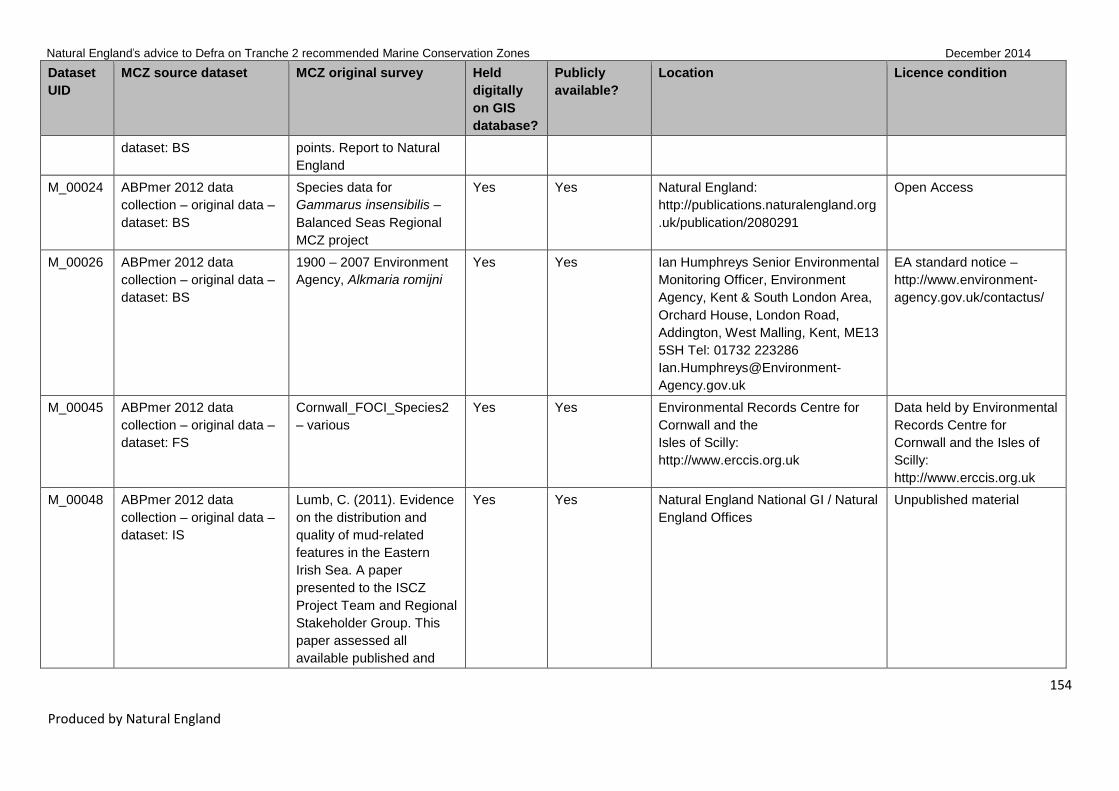
Natural England’s advice to Defra on Tranche 2 recommended Marine Conservation Zones December 2014
154
Produced by Natural England
Dataset
UID
MCZ source dataset MCZ original survey Held
digitally
on GIS
database?
Publicly
available?
Location Licence condition
dataset: BS points. Report to Natural
England
M_00024 ABPmer 2012 data
collection – original data –
dataset: BS
Species data for
Gammarus insensibilis –
Balanced Seas Regional
MCZ project
Yes Yes Natural England:
http://publications.naturalengland.org
.uk/publication/2080291
Open Access
M_00026 ABPmer 2012 data
collection – original data –
dataset: BS
1900 – 2007 Environment
Agency, Alkmaria romijni
Yes Yes Ian Humphreys Senior Environmental
Monitoring Officer, Environment
Agency, Kent & South London Area,
Orchard House, London Road,
Addington, West Malling, Kent, ME13
5SH Tel: 01732 223286
Ian.Humphreys@Environment-
Agency.gov.uk
EA standard notice –
http://www.environment-
agency.gov.uk/contactus/
M_00045 ABPmer 2012 data
collection – original data –
dataset: FS
Cornwall_FOCI_Species2
– various
Yes Yes Environmental Records Centre for
Cornwall and the
Isles of Scilly:
http://www.erccis.org.uk
Data held by Environmental
Records Centre for
Cornwall and the Isles of
Scilly:
http://www.erccis.org.uk
M_00048 ABPmer 2012 data
collection – original data –
dataset: IS
Lumb, C. (2011). Evidence
on the distribution and
quality of mud-related
features in the Eastern
Irish Sea. A paper
presented to the ISCZ
Project Team and Regional
Stakeholder Group. This
paper assessed all
available published and
Yes Yes Natural England National GI / Natural
England Offices
Unpublished material

Natural England’s advice to Defra on Tranche 2 recommended Marine Conservation Zones December 2014
155
Produced by Natural England
Dataset
UID
MCZ source dataset MCZ original survey Held
digitally
on GIS
database?
Publicly
available?
Location Licence condition
unpublished data relating
to mud features within the
Eastern Irish Sea
M_00052 ABPmer 2012 data
collection – original data –
dataset: IS
DONG Energy Irish Sea
survey (2011) DONG
Energy, Irish Sea, Offshore
Windfarm benthic survey
reports)
Yes No DONG Energy / Vattenfall / CMACS Contact DONG Energy –
M_00059 ABPmer 2012 data
collection – original data –
dataset: MB0102
Broad-scale remote survey
and mapping of the
sublittoral habitats and
biota of the Wash, and the
Lincolnshire and the north
Norfolk coasts – lifeforms
and species presence
Yes Yes Via
https://www.gov.uk/government/orga
nisations/department-for-
environment-food-rural-
affairs/about/publication-scheme
Open Government Licence
M_00072 ABPmer 2012 data
collection – original data –
dataset: NG
Natural England
(Seasearch)
PHA1_projected
Yes Yes Natural England National GI Open Government Licence
M_00084 ABPmer 2012 data
collection – original data –
dataset: NG
NESFC_IECS Yes Yes Natural England National GI Open Government Licence
M_00089 ABPmer 2012 data
collection – original data –
dataset: REC
South Coast REC Yes Yes Marine Aggregate Levy Sustainability
Fund
Open Access:
http://www.marinealsf.org.u
k/downloads/MALSF_Data
_Statement.pdf
M_00090 ABPmer 2012 data
collection – original data –
dataset: REC
Humber REC Yes Yes Marine Aggregate Levy Sustainability
Fund
Open Access:
http://www.marinealsf.org.u
k/downloads/MALSF_Data

Natural England’s advice to Defra on Tranche 2 recommended Marine Conservation Zones December 2014
156
Produced by Natural England
Dataset
UID
MCZ source dataset MCZ original survey Held
digitally
on GIS
database?
Publicly
available?
Location Licence condition
_Statement.pdf
M_00091 ABPmer 2012 data
collection – original data –
dataset: REC
Humber REC Yes Yes Marine Aggregate Levy Sustainability
Fund
Open Access:
http://www.marinealsf.org.u
k/downloads/MALSF_Data
_Statement.pdf
M_00095 MB0166 –
JER4290_AA_Benthic_Dra
ftEpifaunaBiotopes_RPS_
110721_A_MCZ
RWE Npower Renewables
Limited
Yes No Channel Energy Limited, RWE
npower renewables. Auckland
House, Lydiard Fields, Great
Western Way, Swindon, Wiltshire,
SN5 8ZT – atlanticarray@npower-
renewables.com
Copyright – RPS –
Confidential report – the
report has been prepared
for the exclusive use of
Channel Energy Ltd and
shall not be distributed or
made available to any other
company or person without
the knowledge and written
consent of Channel Energy
Ltd or RPS
M_00101 ABPmer 2012 data
collection – new data –
dataset: Cefas
Cefas Habitat Data Yes Yes Knowledge and Information, Cefas,
Pakefield Road, Lowestoft, Suffolk,
NR33 0HT, [email protected]
http://www.cefas.defra.gov.uk/publica
tions-and-data/access-to-
information.aspx
Open Government Licence
M_00121 MB0116 –
Essex_Estuaries_SAC_Su
bfeatures_region_MCZ
Essex Estuaries Yes Yes Natural England National GI Open Government Licence
M_00124 MB0116 –
Habmap_points_181109_
MCZ
HABMAP 2009, K.
Mortimer & H. Wilson
Yes Yes National Museum Wales Contact: Andy Mackie,
National Museum Wales:
Andy.Mackie@museumwal
es.ac.uk

Natural England’s advice to Defra on Tranche 2 recommended Marine Conservation Zones December 2014
157
Produced by Natural England
Dataset
UID
MCZ source dataset MCZ original survey Held
digitally
on GIS
database?
Publicly
available?
Location Licence condition
M_00125 MB0116 –
Habmap_biotopes_l3_4_M
CZ
HABMAP 2009, K.
Mortimer & H. Wilson
Yes Yes National Museum Wales Contact: Andy Mackie,
national Museum Wales:
Andy.Mackie@museumwal
es.ac.uk
M_00128 MB0116 –
IBTS_CPUE_Data_MCZ
Yes Yes Department of Biosciences, Wallace
Building, Swansea University,
Singleton Park, Swansea, SA2 8PP
On request from Swansea
University
M_00136 MESH Combined EUNIS
20140203
CCO Ramsgate to
Dungeness
Yes Yes Channel Coastal Observatory,
National Oceanography Centre,
European Way, Southampton, SO14
3ZH. [email protected]
http://www.channelcoast.org/data_m
anagement/online_data_catalogue/
Open Government Licence
M_00161 MB0116 – Sussex IFCA MALSF_2007_Survey_EU
NIS_JNCC_MCZ
Yes Yes Marine Aggregate Levy Sustainability
Fund
Open Access:
http://www.marinealsf.org.u
k/downloads/MALSF_Data
_Statement.pdf
M_00198 ABPmer 2012 data
collection – new data –
dataset:
National_WFD_Benthic_E
A_Data
National_WFD_Benthic_E
A_Data
Yes Yes Environment Agency
http://www.geostore.com/environmen
t-agency
EA standard notice –
http://www.environment-
agency.gov.uk/contactus/
M_00225 MB0116 –
EID_15_16_MCZ
The status, distribution and
ecology of Paludinella
littorina (Delle Chiaje,
1828) (Gastropoda:
Assimineidae) in the British
Isles
Yes No http://www.marbef.org/data/eurobisse
arch.php
MarBEF log-on required

Natural England’s advice to Defra on Tranche 2 recommended Marine Conservation Zones December 2014
158
Produced by Natural England
Dataset
UID
MCZ source dataset MCZ original survey Held
digitally
on GIS
database?
Publicly
available?
Location Licence condition
M_00228 ABPmer 2012 data
collection – new data 4_5
ERCCIS FOCI_April_09 Yes No Environmental Records Centre for
Cornwall and the Isles of Scilly:
http://www.erccis.org.uk
Data held by Environmental
Records Centre for
Cornwall and the Isles of
Scilly:
http://www.erccis.org.uk
M_00229 ABPmer 2012 data
collection – new data 4_5
IECS Habitat polygon data
of Honeycomb worm
Sabellaria alveolata reefs
(as described in MB0116)
Yes Yes IECS University of Hull, Cottingham
Road, Hull, HU6 7RX
Contact IECS University of
Hull, Cottingham Road,
Hull, HU6 7RX
M_00265 MB0116 –
StudlandSeagrassPoint_M
CZ – Marine Biological
Association
Jackson, E.L., Griffiths, C.,
Durkin, O. and Collins, K.
(2012) An assessment of
anthropogenic impact on
angiosperm habitat.
Reference 23599. Report
by The Marine Biological
Association of the UK:
Evidence for Conservation
Management and Policy
Team.
Yes No Natural England National GI N/A
M_00266 MB0116 –
StudlandSeagrassPoly_M
CZ – Marine Biological
Association
Jackson, E.L., Griffiths, C.,
Durkin, O. and Collins, K.
(2012) An assessment of
anthropogenic impact on
angiosperm habitat.
Reference 23599. Report
by The Marine Biological
Association of the UK:
Evidence for Conservation
Yes No Natural England National GI N/A

Natural England’s advice to Defra on Tranche 2 recommended Marine Conservation Zones December 2014
159
Produced by Natural England
Dataset
UID
MCZ source dataset MCZ original survey Held
digitally
on GIS
database?
Publicly
available?
Location Licence condition
Management and Policy
Team.
M_00267 MB0116 –
Walney_Ormonde_2009_E
IA_MCZ
Walney and Ormonde
Offshore Windfarm:
Benthic Survey Report,
November 2009, CMACS
Project No: J3114. Doc
Ref: J3114/11-09v3
Yes No DONG Energy / Vattenfall / CMACS Contact DONG Energy –
M_00273 BOA Oyster survey
Blackwater 2011/13
Yes No Essex Wildlife Trust, Abbotts Hall
Farm, Great Wigborough,
Colchester, Essex, CO5 7RZ
Restricted / confidential –
ownership of this
information remains with
the Essex Wildlife Trust
and the Blackwater
Oysterman's Association in
accordance with the
Confidentiality Agreement
dated 19 June 2013
M_00317 MESH Combined EUNIS
20140203
2013 Natural England
Verification Survey of
Intertidal Sediments within
the Stour & Orwell
Estuaries rMCZ
Yes Yes Natural England National GI Open Government Licence
M_00318 MESH Combined EUNIS
20140203
2013 Natural England
Verification Survey of
Intertidal Sediments within
the Beachy Head West
rMCZ
Yes Yes Natural England National GI Open Government Licence
M_00319 MESH Combined EUNIS
20140203 and Marine
2012 Defra Hythe Bay
rMCZ Site Verification
Yes Yes Natural England National GI Open Government Licence

Natural England’s advice to Defra on Tranche 2 recommended Marine Conservation Zones December 2014
160
Produced by Natural England
Dataset
UID
MCZ source dataset MCZ original survey Held
digitally
on GIS
database?
Publicly
available?
Location Licence condition
Recorder snapshot
2013_06_24
Survey
M_00346 Kaiser, M J. et al (2006)
Distribution and behaviour
of Common Scoter
Melanitta nigra relative to
prey resources and
environmental parameters
Ibis, 148, 110–128
Kaiser, M. J. et al (2006)
Grab surveys of North-west
(2003–2004)
Yes Yes Ibis 148, 11-128
http://www.bou.org.uk/ibis
Subscription required
M_00357 KEIFCA Oyster dredge
survey 2012
Yes No Joss Wiggins, Kent and Essex
Inshore Fisheries and Conservation
Authority, 33–35 High Street,
Brightlingsea, Essex, CO7 0AG
On request – Contact –
Kent and Essex IFCA,
Paragon house, Albert
Street, Ramsgate, Kent,
CT11 9HD 01834 585310
info@kentandessex-
ifca.gov.uk
M_00361 NE Regional Staff MCZ
Verification Photos
Yes Yes Natural England Open Government Licence
M_00363 Titley, I., Spurrier, C.J.H.,
Fererro, T.J. and
Chimonides, P.J. (2010)
Biological survey of the
intertidal chalk reef at
Seaford to Beachy Head
and Brighton to Newhaven
Cliffs Site of Special
Scientific Interest (SSSI)
Yes Yes Natural England offices:
http://publications.naturalengland.org
.uk
N/A
M_00502 Eastern English Channel
REC
Yes Yes Marine Aggregate Levy Sustainability
Fund
Open Access:
http://www.marinealsf.org.u

Natural England’s advice to Defra on Tranche 2 recommended Marine Conservation Zones December 2014
161
Produced by Natural England
Dataset
UID
MCZ source dataset MCZ original survey Held
digitally
on GIS
database?
Publicly
available?
Location Licence condition
k/downloads/MALSF_Data
_Statement.pdf

Natural England’s advice to Defra on Tranche 2 recommended Marine Conservation Zones
December 2014
162
Produced by Natural England
4.4 Evidence not used
Table 3 lists evidence of relevance to Tranche 2 rMCZs which was not available in time to use in the
2014 assessments of confidence, as data were in the process of being collated or analysed.
Table 3 Evidence not used
Survey ID
Survey (identifying name or code)
T2 rMCZs (rMCZ to which the
survey relates)
Data collection methods
Type of data (eg distribution and
abundance of habitats / species, PSA etc)
Reason for non-inclusion
D_00002 CCO Isle of Wight surveys BS 19, BS 20, BS 22, BS 23
Multibeam Distribution of habitats Uninterpreted remote sensing data & not received before data cut-off
D_00005 Cefas MCZ Verification Survey – Bideford to Foreland Point
FS 43 Multibeam Distribution of habitats Not available before data cut-off
D_00007 Cefas MCZ Verification Survey – Cromer Shoal
NG 02 Multibeam Distribution of habitats Not available before data cut-off
D_00011 Cefas MCZ Verification Survey – Norris to Ryde
BS 19 Multibeam Distribution of habitats Not available before data cut-off
D_00015 Cefas MCZ Verification Survey – Yarmouth to Cowes
BS 23 Multibeam Distribution of habitats Not available before data cut-off
D_00020 EA MCZ Verification Survey – Coquet to St. Mary's
NG 13 Multibeam and backscatter grab samples, camera drops
Benthic species abundance, particle size, redox depth, salinity, camera images
Not available before data cut-off
D_00025 EA MCZ Verification Survey – Holderness Inshore
NG 08 Grab samples, camera drops
Benthic species abundance, particle size, redox depth, salinity, camera images
Not available before data cut-off
D_00026 EA MCZ Verification Survey – Land's End
FS 34 Drop-down camera
Camera images Not available before data cut-off
D_00033 EA MCZ Verification Survey – Runswick Bay
NG 11 Grab samples, camera drops
Benthic species abundance, particle size, redox depth, salinity, camera images
Not available before data cut-off
D_00034 EA MCZ Verification Survey – The Swale Estuary
BS 10 Grab samples, camera drops
Benthic species abundance, particle size, redox depth, salinity, camera images
Not available before data cut-off
D_00049 Natural England MCZ Verification Survey – Land's End
FS 34 Lot 1 & Lot 2 (rock & sediment), Phase 1 biotope mapping, Phase 2
Habitat map, species abundance, PSA, heavy metals, organic contaminants
Not available before data cut-off

Natural England’s advice to Defra on Tranche 2 recommended Marine Conservation Zones
December 2014
163
Produced by Natural England
Survey ID
Survey (identifying name or code)
T2 rMCZs (rMCZ to which the
survey relates)
Data collection methods
Type of data (eg distribution and
abundance of habitats / species, PSA etc)
Reason for non-inclusion
transects and sediment cores
D_00050 Natural England MCZ Verification Survey – Mounts Bay
FS 33 Lot 1 & Lot 2 (rock & sediment), Phase 1 biotope mapping, Phase 2 transects and sediment cores
Habitat map, species abundance, PSA, heavy metals, organic contaminants)
Not available before data cut-off
D_00069 NWIFCA Dubmill Point Sabellaria survey 2013
ISCZ 10 Extent and condition of Sabellaria reef
Not available before data cut-off
D_00070 EA Studland Seagrass survey 2013
FS 15 Echo-sounder, drop-down camera
Density and extent of seagrass
Not available before data cut-off
D_00075 CCO Aerial Photography 2001–2013
FS 20, FS 21, FS 23, FS 25, FS 26, FS 33, FS 34, FS 37, FS 39, FS 40, FS 42, FS 43
Aerial photo-graphs
Uninterpreted remote sensing data
D_00076 CCO LIDAR survey 2011–2014
NG 13, FS 20, FS 21, FS 23, FS 25, FS 26, FS 33, FS 34, FS 37, FS 39, FS 40, FS 42, FS 43
LIDAR Uninterpreted remote sensing data
D_00077 North Devon Bioblitz – Woolacombe 2013
FS 43 Not available before data cut-off
D_00078 Biotope Map for Braunton Burrows SSSI ISA 2013
FS 43 Phase 1 biotope mapping
Habitat map of Saunton Sands
Not available before data cut-off
D_00080 Intertidal Discovery Project ERCCIS 2013–2014
FS 37, FS 39, FS 40
Phase 1 biotope mapping
Intertidal biotope maps – field based only, no labwork
Not available before data cut-off
D_00081 Cumbria Wildlife Trust Sabellaria survey 2013
ISCZ 10 Not available before data cut-off
D_00082 Ormonde Windfarm 2013 Post-construction
ISCZ 02 (+pCLZ),
Day grab samples,
Benthic species abundance, particle
Not available before data cut-

Natural England’s advice to Defra on Tranche 2 recommended Marine Conservation Zones
December 2014
164
Produced by Natural England
Survey ID
Survey (identifying name or code)
T2 rMCZs (rMCZ to which the
survey relates)
Data collection methods
Type of data (eg distribution and
abundance of habitats / species, PSA etc)
Reason for non-inclusion
monitoring surveys ISCZ 02 drop camera, sidescan sonar, Multibeam
size, Multibeam backscatter and bathymetry
off
D_00083 Ormonde Offshore Windfarm Adult & Juvenile Fish and Epi-benthic Post-construction Survey 2012
ISCZ 02 (+pCLZ), ISCZ 02
Otter & Beam trawls
Benthic species abundance
Not available before data cut-off
D_00084 Ormonde Windfarm 2012 Post-construction monitoring surveys
ISCZ 02 (+pCLZ), ISCZ 02
Day grab samples, drop camera, side-scansonar, Multibeam
Benthic species abundance, particle size, Multibeam backscatter and bathymetry
Not available before data cut-off
D_00085 CMACS (2012). Walney Offshore Windfarm Year 1 post-construction benthic monitoring technical survey report (2012 survey). Report to Walney Offshore Windfarms (UK) Ltd/DONG Energy. July 2012. J3192
ISCZ 02 (+pCLZ), ISCZ 02
Day grab samples, drop camera, beam trawls
Benthic species abundance, particle size, total organic carbon
Not available before data cut-off
D_00086 1st Year Post-construction Monitoring Report Walney Offshore Windfarm (2013)
ISCZ 02 (+pCLZ), ISCZ 02
Day grab samples, drop camera, beam trawls
Benthic species abundance, particle size, total organic carbon
Not available before data cut-off
D_00087 West of Duddon Sands Offshore Windfarm Pre-construction Monitoring Report Version C (August 2013)
ISCZ 02 (+pCLZ)
Day grab samples, drop camera, side-scansonar, Multibeam
Seabed morphology and scour, benthos monitoring, Annex 1 habitat monitoring, fish monitoring, marine mammal mitigation, bird monitoring, noise and vibration
Not available before data cut-off
D_00088 Walney Extension Offshore Windfarm Volume 1 Environmental Statement
ISCZ 02 (+pCLZ), ISCZ 02
Day grab samples, drop camera, beam trawls
Benthic species abundance, particle size
Not available before data cut-off
D_00503 East Riding of Yorkshire Council
NG8, RA9 Grab samples, Multibeam
Distribution of habitats, PSA
Not available before data cut-off
D_00504 NESFC Prohibited Trawl Area Study
NG8, NG11 Roxann GDA and grab
EUNIS classification, species presence and abundance
Not available before data cut-off
D_00505 Mapped multibeam imagery of the outer
ISCZ 10, ISCZRA H
Multibeam bathymetry
Physical seabed maps outlining areas of scar
Not available before data cut-
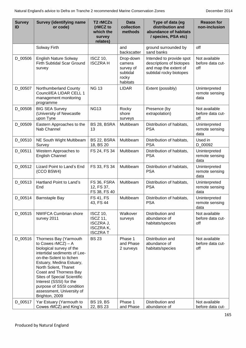
Natural England’s advice to Defra on Tranche 2 recommended Marine Conservation Zones
December 2014
165
Produced by Natural England
Survey ID
Survey (identifying name or code)
T2 rMCZs (rMCZ to which the
survey relates)
Data collection methods
Type of data (eg distribution and
abundance of habitats / species, PSA etc)
Reason for non-inclusion
Solway Firth and backscatter
ground surrounded by sand banks
off
D_00506 English Nature Solway Firth Subtidal Scar Ground survey
ISCZ 10, ISCZRA H
Drop-down camera survey of subtidal rocky habitats
Intended to provide spot descriptions of biotopes and map the extent of subtidal rocky biotopes
Not available before data cut-off
D_00507 Northumberland County Council/EA LIDAR CELL 1 management monitoring programme
NG 13 LIDAR Extent (possibly) Uninterpreted remote sensing data
D_00508 BIG SEA Survey (University of Newcastle upon Tyne
NG13 Rocky shore surveys
Presence (by extrapolation)
Not available before data cut-off
D_00509 Eastern Approaches to the Nab Channel
BS 28, BSRA 13
Multibeam Distribution of habitats, PSA
Uninterpreted remote sensing data
D_00510 NE South Wight Multibeam Survey
BS 22, BSRA 18, BS 20
Multibeam Distribution of habitats, PSA
Used in D_00092
D_00511 Western Approaches to English Channel
FS 24, FS 34 Multibeam Distribution of habitats, PSA
Uninterpreted remote sensing data
D_00512 Lizard Point to Land’s End (CCO BSW4)
FS 33, FS 34 Multibeam Distribution of habitats, PSA
Uninterpreted remote sensing data
D_00513 Hartland Point to Land’s End
FS 36, FSRA 12, FS 37, FS 38, FS 40
Multibeam Distribution of habitats, PSA
Uninterpreted remote sensing data
D_00514 Barnstaple Bay FS 41, FS 43, FS 44
Multibeam Distribution of habitats, PSA
Uninterpreted remote sensing data
D_00515 NWIFCA Cumbrian shore survey 2011
ISCZ 10, ISCZ 11, ISCZRA J, ISCZRA K, ISCZRA T
Walkover surveys
Distribution and abundance of habitats/species
Not available before data cut-off
D_00516 Thorness Bay (Yarmouth to Cowes rMCZ) – A biological survey of the intertidal sediments of Lee-on-the-Solent to Itchen Estuary, Medina Estuary, North Solent, Thanet Coast and Thorness Bay Sites of Special Scientific Interest (SSSI) for the purpose of SSSI condition assessment, University of Brighton, 2009
BS 23 Phase 1 and Phase 2 surveys
Distribution and abundance of habitats/species
Not available before data cut-off
D_00517 Yar Estuary (Yarmouth to Cowes rMCZ) and King’s
BS 19, BS 22, BS 23
Phase 1 and Phase
Distribution and abundance of
Not available before data cut-

Natural England’s advice to Defra on Tranche 2 recommended Marine Conservation Zones
December 2014
166
Produced by Natural England
Survey ID
Survey (identifying name or code)
T2 rMCZs (rMCZ to which the
survey relates)
Data collection methods
Type of data (eg distribution and
abundance of habitats / species, PSA etc)
Reason for non-inclusion
Quay / Brading Marshes to St Helen’s Ledges (Norris to Ryde rMCZ and Bembridge rMCZ) – A biological survey of the intertidal sediments of Brading Marshes to St Helen's Ledges, King's Quay Shore and Yar Estuary Sites of Special Scientific Interest (SSSI), Isle of Wight, for the purpose of SSSI condition assessment, University of Brighton, 2009
2 surveys habitats/species off
D_00518 SSSI IOW lagoon surveys 2010
BS 22, BS 23 Distribution and abundance of habitats/species
Not available before data cut-off
D_00519 SSSI IOW lagoon surveys 2013
BS 22, BS 23 Distribution and abundance of habitats/species
Not available before data cut-off
D_00520 Hampshire & Isle of Wight Wildlife Trust Inventory of Eelgrass Beds in Hampshire and the Isle of Wight 2014 – polygonal data
BS 19, BS 20, BS 22, BS 23
Intertidal walkover survey and subtidal video survey
Distribution of habitats Not available before data cut-off
Table 4 lists features originally proposed for inclusion in Tranche 1 where, due either to changes in
conservation objective or being a new feature proposed for a Tranche 1 site in 2013, they have been
included in Tranche 2 to allow for current conservation objectives and new features with associated
confidences to be included in public consultation. The advice for these features provided in ‘Natural
England’s advice to Defra on proposed Marine Conservation Zones for designation in 2013’ (Natural
England, 2013d) remains current and, as such, no new advice is provided. The 2013 advice for the
Torbay MCZ has been updated to include the new feature ‘Peat and clay exposures’ but the remainder of
the 2013 advice for this site is unchanged.

Natural England’s advice to Defra on Tranche 2 recommended Marine Conservation Zones
December 2014
167
Produced by Natural England
Table 4 Tranche 1 features for which 2013 advice remains current
Site name Feature name Feature type 2013 advice
presence
2013 advice
extent
Feature
status
South Dorset Moderate energy
circalittoral rock
BSH Moderate Moderate Tranche 1 not
designated
Chesil Beach
and Stennis
Ledges
High energy
infralittoral rock
BSH Moderate Moderate Tranche 1 not
designated
Chesil Beach
and Stennis
Ledges
Subtidal coarse
sediment
BSH Moderate Moderate Tranche 1 not
designated
Torbay Peat and clay
exposures7
HOCI Moderate Moderate Tranche 1 new
feature
Upper Fowey
and Pont Pill
Intertidal sand
and muddy sand
BSH Moderate Moderate Tranche 1 not
designated
The Manacles Subtidal coarse
sediment
BSH High High Tranche 1 not
designated
The Manacles Subtidal mixed
sediments
BSH High Moderate Tranche 1 not
designated
The Manacles Pink sea-fan
(Eunicella
verrucosa)
SOCI High High Tranche 1 not
designated
Fylde Subtidal mud BSH High High Tranche 1 new
feature
7 New feature has been added to site and was not included in 2013 advice so this has been updated accordingly and included in
this table

Natural England’s advice to Defra on Tranche 2 recommended Marine Conservation Zones
December 2014
168
Produced by Natural England
4.5 Results of general management approach and confidence in feature condition (Protocol F
score)
Table 5 gives the proposed GMA for each feature within each rMCZ and the results of the assessment of
confidence in feature condition (Protocol F). The methods used to obtain the results in the table are
described in Section 3.2.
Table 5 shows the following:
the recommended conservation objectives given in Defra’s 2012 consultation document
confidence in feature condition (determined using Protocol F) in 2012
the proposed GMA through this advice
confidence in feature condition (determined using Protocol F) in 2013
a brief explanation of the rationale for any changes between the 2012 conservation objective and
the 2014 GMA
Where we currently have no confidence that the feature exists we have not provided updated
assessments (for further information see Annex 6).

Natural England’s advice to Defra on Tranche 2 recommended Marine Conservation Zones
December 2014
169
Produced by Natural England
Table 5 General management approach and confidence in feature condition (Protocol F score)
Feature status
Site code
Site name Feature
code Feature name Feature type CO 2012
Protocol F 2012
GMA 2014
Protocol F 2014
Rationale for change between
2012 CO and 2014 GMA
T1 new feature
BS 03 Blackwater, Crouch, Roach and Colne Estuary
A5.6 Subtidal biogenic reefs
BSH Not Assessed Not Assessed Recover Low New feature
Tranche 2 advice
BS 10 The Swale Estuary
A1.3 Low energy intertidal rock
BSH Maintain Low Maintain Low No change
Tranche 2 advice
BS 10 The Swale Estuary
A5.2 Subtidal sand BSH Maintain Low Maintain Low No change
Tranche 2 advice
BS 10 The Swale Estuary
A5.3 Subtidal mud BSH Recover Low Maintain Low Infaunal Quality Index (IQI) data
8
supports favourable condition of feature and therefore a maintain GMA. Feature is in a moderate energy environment so
8 The Infaunal Quality Index (IQI) is a metric used to assess benthic infaunal communities for Good Ecological Status for the Water Framework Directive (WFD). The IQI combines three
measures performed on a benthic invertebrate sample (number of taxa; AZTI Marine Biotic Index which measures pollution sensitivity; Simpson’s Evenness). For MCZ T2 purposes, the IQI data
could be used for five feature types, with the assumption that ‘High’ and ‘Good’ ecological status for the WFD are proxy for favourable condition in the MCZ, and ‘Moderate’, ‘Poor’, and ‘Bad’ are
proxy for unfavourable condition in the MCZ. G.R. Phillips, A. Anwar, L. Brooks, L.J. Martina, A. C. Miles and A. Prior (2014). ‘Infaunal quality index: Water Framework Directive classification
scheme for marine benthic invertebrates.’ Report: SC080016. Environment Agency.
https://www.gov.uk/government/uploads/system/uploads/attachment_data/file/314673/Water_Framework_Directive_classification_scheme_for_marine_benthic_invertebrates_-_report.pdf
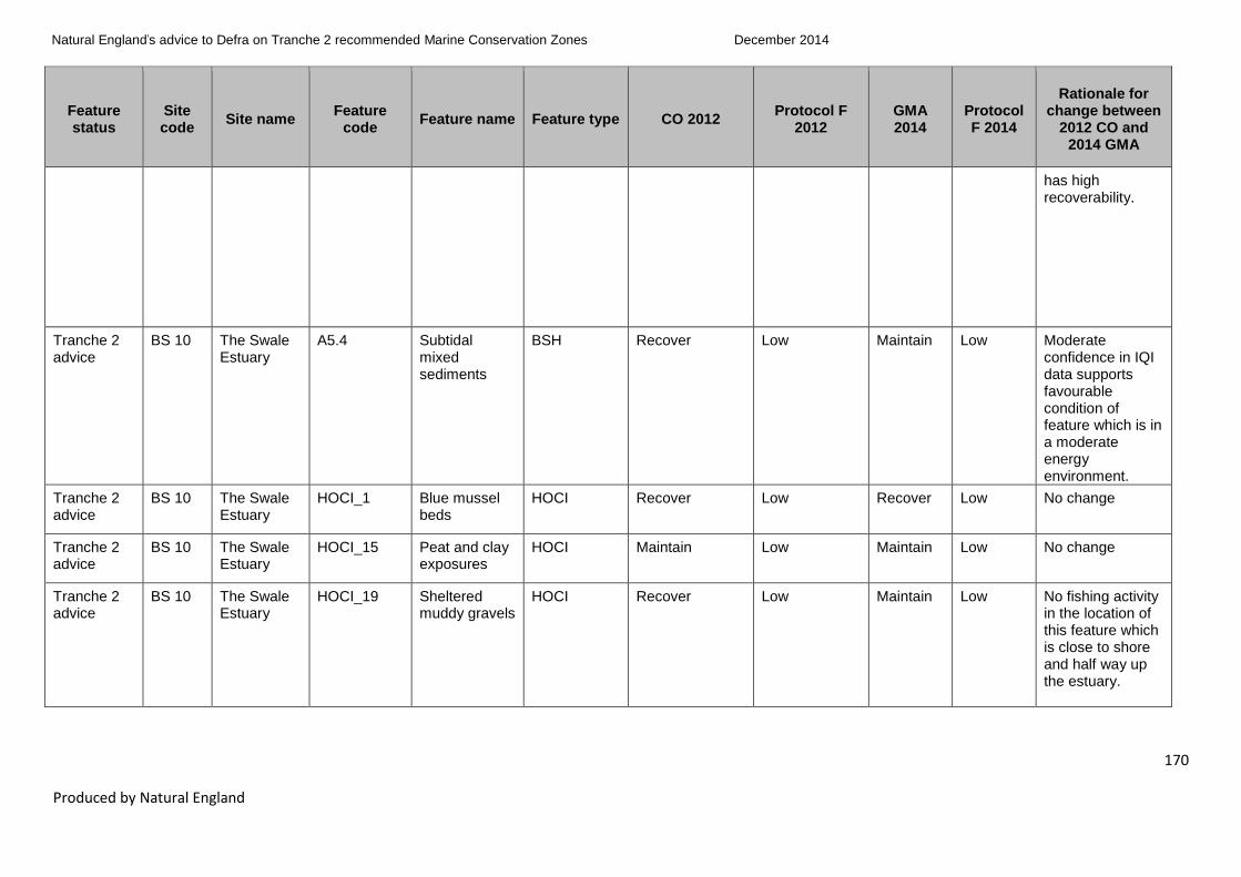
Natural England’s advice to Defra on Tranche 2 recommended Marine Conservation Zones
December 2014
170
Produced by Natural England
Feature status
Site code
Site name Feature
code Feature name Feature type CO 2012
Protocol F 2012
GMA 2014
Protocol F 2014
Rationale for change between
2012 CO and 2014 GMA
has high recoverability.
Tranche 2 advice
BS 10 The Swale Estuary
A5.4 Subtidal mixed sediments
BSH Recover Low Maintain Low Moderate confidence in IQI data supports favourable condition of feature which is in a moderate energy environment.
Tranche 2 advice
BS 10 The Swale Estuary
HOCI_1 Blue mussel beds
HOCI Recover Low Recover Low No change
Tranche 2 advice
BS 10 The Swale Estuary
HOCI_15 Peat and clay exposures
HOCI Maintain Low Maintain Low No change
Tranche 2 advice
BS 10 The Swale Estuary
HOCI_19 Sheltered muddy gravels
HOCI Recover Low Maintain Low No fishing activity in the location of this feature which is close to shore and half way up the estuary.

Natural England’s advice to Defra on Tranche 2 recommended Marine Conservation Zones
December 2014
171
Produced by Natural England
Feature status
Site code
Site name Feature
code Feature name Feature type CO 2012
Protocol F 2012
GMA 2014
Protocol F 2014
Rationale for change between
2012 CO and 2014 GMA
Tranche 2 advice
BS 10 The Swale Estuary
SOCI_22 Native oyster (Ostrea edulis)
SOCI Maintain Low Maintain Low No change
T2 new feature
BS 10 The Swale Estuary
A1.2 Moderate energy intertidal rock
BSH Not Assessed Not Assessed Maintain Low New feature
T2 new feature
BS 10 The Swale Estuary
A2.1 Intertidal coarse sediment
BSH Not Assessed Not Assessed Maintain Low New feature
T2 new feature
BS 10 The Swale Estuary
A2.2 Intertidal sand and muddy sand
BSH Not Assessed Not Assessed Maintain Low New feature
T2 new feature
BS 10 The Swale Estuary
A2.4 Intertidal mixed sediments
BSH Not Assessed Not Assessed Maintain Low New feature
T2 new feature
BS 10 The Swale Estuary
A5.1 Subtidal coarse sediment
BSH Not Assessed Not Assessed Maintain Low New feature
T2 new feature
BS 10 The Swale Estuary
HOCI_5 Estuarine rocky habitats
HOCI Not Assessed Not Assessed Maintain Low New feature
T2 new feature
BS 10 The Swale Estuary
SOCI_32 Smelt (Osmerus eperlanus)
SOCI Not Assessed Not Assessed Maintain Low New feature
Tranche 2 advice
BS 11.1 Dover to Deal
A1.2 Moderate energy intertidal rock
BSH Maintain Low Maintain Low No change
Tranche 2 advice
BS 11.1 Dover to Deal
A2.1 Intertidal coarse sediment
BSH Maintain Low Maintain Low No change
Tranche 2 BS 11.1 Dover to A2.3 Intertidal mud BSH Maintain Low Maintain Low No change

Natural England’s advice to Defra on Tranche 2 recommended Marine Conservation Zones
December 2014
172
Produced by Natural England
Feature status
Site code
Site name Feature
code Feature name Feature type CO 2012
Protocol F 2012
GMA 2014
Protocol F 2014
Rationale for change between
2012 CO and 2014 GMA
advice Deal
Tranche 2 advice
BS 11.1 Dover to Deal
A3.2 Moderate energy infralittoral rock
BSH Maintain Low Maintain Low No change
Tranche 2 advice
BS 11.1 Dover to Deal
A5.1 Subtidal coarse sediment
BSH Maintain Low Maintain Low No change
Tranche 2 advice
BS 11.1 Dover to Deal
A5.4 Subtidal mixed sediments
BSH Maintain Low Maintain Low No change
Tranche 2 advice
BS 11.1 Dover to Deal
HOCI_1 Blue mussel beds
HOCI Maintain Low Maintain Low No change
Tranche 2 advice
BS 11.1 Dover to Deal
HOCI_10 Intertidal underboulder communities
HOCI Maintain Low Maintain Low No change
Tranche 2 advice
BS 11.1 Dover to Deal
HOCI_11 Littoral chalk communities
HOCI Recover Low Maintain Low Local adviser knowledge confirms low levels of activity over this feature.
Tranche 2 advice
BS 11.1 Dover to Deal
HOCI_16 Ross worm reefs (Sabellaria spinulosa)
HOCI Maintain Low Maintain Low No change
Tranche 2 advice
BS 11.1 Dover to Deal
HOCI_20 Subtidal chalk HOCI Maintain Low Maintain Low No change
T2 new feature
BS 11.1 Dover to Deal
A1.1 High energy intertidal rock
BSH Not Assessed Not Assessed Maintain Low New feature

Natural England’s advice to Defra on Tranche 2 recommended Marine Conservation Zones
December 2014
173
Produced by Natural England
Feature status
Site code
Site name Feature
code Feature name Feature type CO 2012
Protocol F 2012
GMA 2014
Protocol F 2014
Rationale for change between
2012 CO and 2014 GMA
T2 new feature
BS 11.1 Dover to Deal
A1.3 Low energy intertidal rock
BSH Not Assessed Not Assessed Maintain Low New feature
T2 new feature
BS 11.1 Dover to Deal
A4.1 High energy circalittoral rock
BSH Not Assessed Not Assessed Maintain Low New feature
T2 new feature
BS 11.1 Dover to Deal
A4.2 Moderate energy circalittoral rock
BSH Not Assessed Not Assessed Maintain Low New feature
T2 new feature
BS 11.1 Dover to Deal
SOCI_22 Native oyster (Ostrea edulis)
SOCI Not Assessed Not Assessed Maintain Low New feature
Tranche 2 advice
BS 11.2 Dover to Folkestone
A1.2 Moderate energy intertidal rock
BSH Maintain Low Maintain Low No change
Tranche 2 advice
BS 11.2 Dover to Folkestone
A2.1 Intertidal coarse sediment
BSH Maintain Low Maintain Low No change
Tranche 2 advice
BS 11.2 Dover to Folkestone
A3.1 High energy infralittoral rock
BSH Maintain Low Maintain Low No change
Tranche 2 advice
BS 11.2 Dover to Folkestone
A3.2 Moderate energy infralittoral rock
BSH Maintain Low Maintain Low No change
Tranche 2 advice
BS 11.2 Dover to Folkestone
A5.1 Subtidal coarse sediment
BSH Maintain Low Maintain Low No change
Tranche 2 advice
BS 11.2 Dover to Folkestone
HOCI_1 Blue mussel beds
HOCI Maintain Low Maintain Low No change

Natural England’s advice to Defra on Tranche 2 recommended Marine Conservation Zones
December 2014
174
Produced by Natural England
Feature status
Site code
Site name Feature
code Feature name Feature type CO 2012
Protocol F 2012
GMA 2014
Protocol F 2014
Rationale for change between
2012 CO and 2014 GMA
Tranche 2 advice
BS 11.2 Dover to Folkestone
HOCI_10 Intertidal underboulder communities
HOCI Maintain Low Maintain Low No change
Tranche 2 advice
BS 11.2 Dover to Folkestone
HOCI_11 Littoral chalk communities
HOCI Maintain Low Maintain Low No change
Tranche 2 advice
BS 11.2 Dover to Folkestone
HOCI_15 Peat and clay exposures
HOCI Maintain Low Maintain Low No change
Tranche 2 advice
BS 11.2 Dover to Folkestone
HOCI_16 Ross worm reefs (Sabellaria spinulosa)
HOCI Maintain Low Maintain Low No change
Tranche 2 advice
BS 11.2 Dover to Folkestone
HOCI_20 Subtidal chalk HOCI Maintain Low Maintain Low No change
Tranche 2 advice
BS 11.2 Dover to Folkestone
SOCI_16 Short-snouted seahorse (Hippocampus hippocampus)
SOCI Maintain Low Maintain Low No change
Tranche 2 advice
BS 11.2 Dover to Folkestone
SOCI_22 Native oyster (Ostrea edulis)
SOCI Maintain Low Maintain Low No change
Tranche 2 advice
BS 11.2 Dover to Folkestone
G2 Folkestone Warren
Geological Maintain Low Maintain Low No change
T2 new feature
BS 11.2 Dover to Folkestone
A1.1 High energy intertidal rock
BSH Not Assessed Not Assessed Maintain Low New feature
T2 new feature
BS 11.2 Dover to Folkestone
A1.3 Low energy intertidal rock
BSH Not Assessed Not Assessed Maintain Low New feature
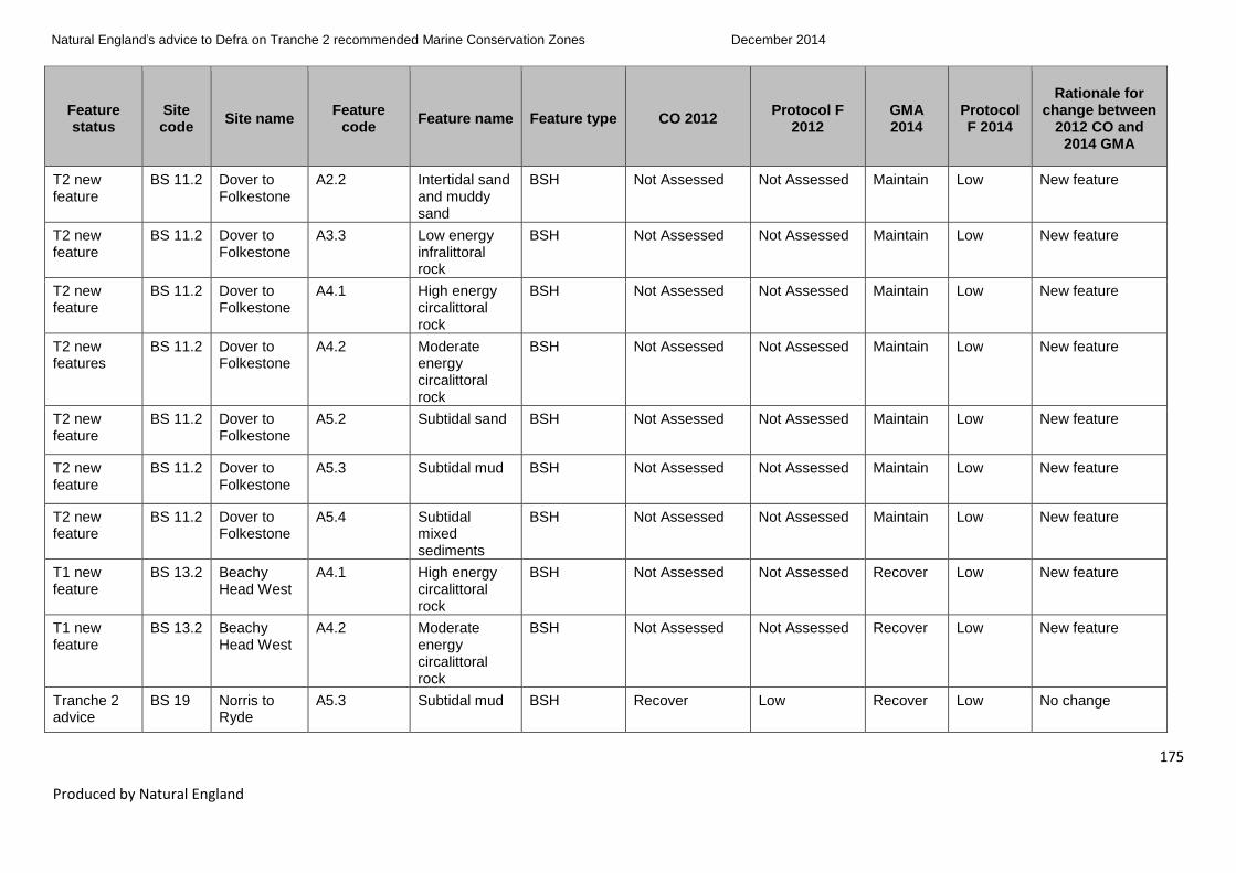
Natural England’s advice to Defra on Tranche 2 recommended Marine Conservation Zones
December 2014
175
Produced by Natural England
Feature status
Site code
Site name Feature
code Feature name Feature type CO 2012
Protocol F 2012
GMA 2014
Protocol F 2014
Rationale for change between
2012 CO and 2014 GMA
T2 new feature
BS 11.2 Dover to Folkestone
A2.2 Intertidal sand and muddy sand
BSH Not Assessed Not Assessed Maintain Low New feature
T2 new feature
BS 11.2 Dover to Folkestone
A3.3 Low energy infralittoral rock
BSH Not Assessed Not Assessed Maintain Low New feature
T2 new feature
BS 11.2 Dover to Folkestone
A4.1 High energy circalittoral rock
BSH Not Assessed Not Assessed Maintain Low New feature
T2 new features
BS 11.2 Dover to Folkestone
A4.2 Moderate energy circalittoral rock
BSH Not Assessed Not Assessed Maintain Low New feature
T2 new feature
BS 11.2 Dover to Folkestone
A5.2 Subtidal sand BSH Not Assessed Not Assessed Maintain Low New feature
T2 new feature
BS 11.2 Dover to Folkestone
A5.3 Subtidal mud BSH Not Assessed Not Assessed Maintain Low New feature
T2 new feature
BS 11.2 Dover to Folkestone
A5.4 Subtidal mixed sediments
BSH Not Assessed Not Assessed Maintain Low New feature
T1 new feature
BS 13.2 Beachy Head West
A4.1 High energy circalittoral rock
BSH Not Assessed Not Assessed Recover Low New feature
T1 new feature
BS 13.2 Beachy Head West
A4.2 Moderate energy circalittoral rock
BSH Not Assessed Not Assessed Recover Low New feature
Tranche 2 advice
BS 19 Norris to Ryde
A5.3 Subtidal mud BSH Recover Low Recover Low No change

Natural England’s advice to Defra on Tranche 2 recommended Marine Conservation Zones
December 2014
176
Produced by Natural England
Feature status
Site code
Site name Feature
code Feature name Feature type CO 2012
Protocol F 2012
GMA 2014
Protocol F 2014
Rationale for change between
2012 CO and 2014 GMA
Tranche 2 advice
BS 19 Norris to Ryde
HOCI_17 Seagrass beds
HOCI Recover Moderate Recover Moderate No change
Tranche 2 advice
BS 19 Norris to Ryde
SOCI_1 Tentacled lagoon worm (Alkmaria romijni)
SOCI Maintain Low Maintain Low No change
T2 new feature
BS 19 Norris to Ryde
A5.4 Subtidal mixed sediments
BSH Not Assessed Not Assessed Recover Low New feature
T2 new feature
BS 19 Norris to Ryde
A5.5 Subtidal macrophyte-dominated sediment
BSH Not Assessed Not Assessed Recover Low New feature
T2 new feature
BS 19 Norris to Ryde
HOCI_19 Sheltered muddy gravels
HOCI Not Assessed Not Assessed Recover Low New feature
T2 new feature
BS 19 Norris to Ryde
SOCI_22 Native oyster (Ostrea edulis)
SOCI Not Assessed Not Assessed Recover Low New feature
Tranche 2 advice
BS 20 The Needles
HOCI_17 Seagrass beds
HOCI Recover Low Recover Low No change
Tranche 2 advice
BS 20 The Needles
SOCI_20 Stalked jellyfish (Lucernariopsis campanulata)
SOCI Maintain Low Maintain Low No change
Tranche 2 advice
BS 20 The Needles
SOCI_23 Peacock’s tail (Padina pavonica)
SOCI Maintain Low Recover Low Current understanding of moderate exposure levels of fisheries dredging/trawling

Natural England’s advice to Defra on Tranche 2 recommended Marine Conservation Zones
December 2014
177
Produced by Natural England
Feature status
Site code
Site name Feature
code Feature name Feature type CO 2012
Protocol F 2012
GMA 2014
Protocol F 2014
Rationale for change between
2012 CO and 2014 GMA
has led to a revised GMA.
T2 new feature
BS 20 The Needles
A1.2 Moderate energy intertidal rock
BSH Not Assessed Not Assessed Maintain Low New feature
T2 new feature
BS 20 The Needles
A3.1 High energy infralittoral rock
BSH Not Assessed Not Assessed Maintain Low New feature
T2 new feature
BS 20 The Needles
A3.2 Moderate energy infralittoral rock
BSH Not Assessed Not Assessed Maintain Low New feature
T2 new feature
BS 20 The Needles
A4.2 Moderate energy circalittoral rock
BSH Not Assessed Not Assessed Maintain Low New feature
T2 new feature
BS 20 The Needles
A5.1 Subtidal coarse sediment
BSH Not Assessed Not Assessed Recover Low New feature
T2 new feature
BS 20 The Needles
A5.2 Subtidal sand BSH Not Assessed Not Assessed Recover Low New feature
T2 new feature
BS 20 The Needles
A5.3 Subtidal mud BSH Not Assessed Not Assessed Recover Low New feature

Natural England’s advice to Defra on Tranche 2 recommended Marine Conservation Zones
December 2014
178
Produced by Natural England
Feature status
Site code
Site name Feature
code Feature name Feature type CO 2012
Protocol F 2012
GMA 2014
Protocol F 2014
Rationale for change between
2012 CO and 2014 GMA
Tranche 2 advice
BS 20 The Needles
A5.4 Subtidal mixed sediments
BSH Maintain Low Recover Low Current understanding of exposure levels of recreational sailing and powerboating and fisheries dredging/trawling has led to a revised GMA.
T2 new feature
BS 20 The Needles
A5.5 Subtidal macrophyte-dominated sediment
BSH Not Assessed Not Assessed Recover Low New feature
T2 new feature
BS 20 The Needles
HOCI_19 Sheltered muddy gravels
HOCI Not Assessed Not Assessed Recover Low New feature
T2 new feature
BS 20 The Needles
HOCI_20 Subtidal chalk HOCI Not Assessed Not Assessed Recover Low New feature
T2 new feature
BS 20 The Needles
SOCI_22 Native oyster (Ostrea edulis)
SOCI Not Assessed Not Assessed Recover Low New feature
Tranche 2 advice
BS 22 Bembridge A5.2 Subtidal sand BSH Maintain Low Recover Low Current understanding of exposure levels of military activities has led to a revised GMA.
Tranche 2 advice
BS 22 Bembridge A5.3 Subtidal mud BSH Recover Low Recover Low No change
Tranche 2 advice
BS 22 Bembridge A5.4 Subtidal mixed
BSH Maintain Low Maintain Low No change

Natural England’s advice to Defra on Tranche 2 recommended Marine Conservation Zones
December 2014
179
Produced by Natural England
Feature status
Site code
Site name Feature
code Feature name Feature type CO 2012
Protocol F 2012
GMA 2014
Protocol F 2014
Rationale for change between
2012 CO and 2014 GMA
sediments
Tranche 2 advice
BS 22 Bembridge HOCI_12 Maerl beds HOCI Recover Low Recover Low No change
Tranche 2 advice
BS 22 Bembridge HOCI_16 Ross worm reefs (Sabellaria spinulosa)
HOCI Recover Low Recover Low No change
Tranche 2 advice
BS 22 Bembridge HOCI_17 Seagrass beds
HOCI Recover Low Recover Low No change
Tranche 2 advice
BS 22 Bembridge HOCI_18 Sea pen and burrowing megafauna communities
HOCI Recover Low Recover Low No change
Tranche 2 advice
BS 22 Bembridge SOCI_1 Tentacled lagoon worm (Alkmaria romijni)
SOCI Maintain Low Maintain Low No change
Tranche 2 advice
BS 22 Bembridge SOCI_14 Stalked jellyfish (Haliclystus auricula)
SOCI Maintain Low Recover Low Current understanding of exposure levels of recreational sailing and powerboating and low levels of shore-based angling has led to a revised GMA.

Natural England’s advice to Defra on Tranche 2 recommended Marine Conservation Zones
December 2014
180
Produced by Natural England
Feature status
Site code
Site name Feature
code Feature name Feature type CO 2012
Protocol F 2012
GMA 2014
Protocol F 2014
Rationale for change between
2012 CO and 2014 GMA
Tranche 2 advice
BS 22 Bembridge SOCI_16 Short-snouted seahorse (Hippocampus hippocampus)
SOCI Maintain Low Recover Low Current understanding of exposure levels of recreational sailing and powerboating has led to a revised GMA.
Tranche 2 advice
BS 22 Bembridge SOCI_22 Native oyster (Ostrea edulis)
SOCI Recover Low Recover Low No change
Tranche 2 advice
BS 22 Bembridge SOCI_23 Peacock’s tail (Padina pavonica)
SOCI Maintain Low Recover Low Current understanding of exposure levels of recreational sailing and powerboating has led to a revised GMA.
T2 new feature
BS 22 Bembridge A5.1 Subtidal coarse sediment
BSH Not Assessed Not Assessed Recover Low New feature
T2 new feature
BS 22 Bembridge A5.5 Subtidal macrophyte-dominated sediment
BSH Not Assessed Not Assessed Recover Low New feature
T2 new feature
BS 22 Bembridge HOCI_19 Sheltered muddy gravels
HOCI Not Assessed Not Assessed Recover Low New feature
T2 new feature
BS 22 Bembridge SOCI_20 Stalked jellyfish (Lucernariopsis
SOCI Not Assessed Not Assessed Recover Low New feature

Natural England’s advice to Defra on Tranche 2 recommended Marine Conservation Zones
December 2014
181
Produced by Natural England
Feature status
Site code
Site name Feature
code Feature name Feature type CO 2012
Protocol F 2012
GMA 2014
Protocol F 2014
Rationale for change between
2012 CO and 2014 GMA
campanulata)
T2 new feature
BS 22 Bembridge SOCI_26 Common maerl (Phymatolithon calcareum)
SOCI Not Assessed Not Assessed Maintain Low New feature
Tranche 2 advice
BS 23 Yarmouth to Cowes
A1.3 Low energy intertidal rock
BSH Maintain Low Maintain Low No change
Tranche 2 advice
BS 23 Yarmouth to Cowes
A2.1 Intertidal coarse sediment
BSH Maintain Low Maintain Low No change
Tranche 2 advice
BS 23 Yarmouth to Cowes
A3.2 Moderate energy infralittoral rock
BSH Recover Low Recover Low No change
Tranche 2 advice
BS 23 Yarmouth to Cowes
A5.1 Subtidal coarse sediment
BSH Maintain Low Recover Low Current understanding of exposure levels of fisheries, maintenance of ports and harbours structures, maintenance of coastal infrastructure (outfalls) and recreational sailing and powerboating has

Natural England’s advice to Defra on Tranche 2 recommended Marine Conservation Zones
December 2014
182
Produced by Natural England
Feature status
Site code
Site name Feature
code Feature name Feature type CO 2012
Protocol F 2012
GMA 2014
Protocol F 2014
Rationale for change between
2012 CO and 2014 GMA
led to a revised GMA.
Tranche 2 advice
BS 23 Yarmouth to Cowes
HOCI_10 Intertidal underboulder communities
HOCI Recover Low Recover Low No change
Tranche 2 advice
BS 23 Yarmouth to Cowes
HOCI_15 Peat and clay exposures
HOCI Recover Moderate Recover Moderate No change
Tranche 2 advice
BS 23 Yarmouth to Cowes
HOCI_17 Seagrass beds
HOCI Recover Low Recover Low No change
Tranche 2 advice
BS 23 Yarmouth to Cowes
HOCI_5 Estuarine rocky habitats
HOCI Maintain Low Recover Low Current understanding of exposure levels of recreational sailing and powerboating has led to a revised GMA.
Tranche 2 advice
BS 23 Yarmouth to Cowes
SOCI_22 Native oyster (Ostrea edulis)
SOCI Maintain Low Recover Low Current understanding of exposure levels of recreational sailing and

Natural England’s advice to Defra on Tranche 2 recommended Marine Conservation Zones
December 2014
183
Produced by Natural England
Feature status
Site code
Site name Feature
code Feature name Feature type CO 2012
Protocol F 2012
GMA 2014
Protocol F 2014
Rationale for change between
2012 CO and 2014 GMA
powerboating moorings has led to a revised GMA.
Tranche 2 advice
BS 23 Yarmouth to Cowes
SOCI_9 Lagoon sand shrimp (Gammarus insensibilis)
SOCI Maintain Low Recover Low Current understanding of exposure levels of recreational sailing and powerboating activities (such as intertidal anchoring / mooring and launching of craft) has led to a revised GMA.
Tranche 2 advice
BS 23 Yarmouth to Cowes
G14 Bouldnor Cliff Geological Maintain Low Maintain Low No change
T2 new feature
BS 23 Yarmouth to Cowes
A1.2 Moderate energy intertidal rock
BSH Not Assessed Not Assessed Recover Low New feature
T2 new feature
BS 23 Yarmouth to Cowes
A3.1 High energy infralittoral rock
BSH Not Assessed Not Assessed Recover Low New feature
T2 new feature
BS 23 Yarmouth to Cowes
A4.1 High energy circalittoral rock
BSH Not Assessed Not Assessed Recover Low New feature
T2 new feature
BS 23 Yarmouth to Cowes
A4.2 Moderate energy
BSH Not Assessed Not Assessed Recover Low New feature

Natural England’s advice to Defra on Tranche 2 recommended Marine Conservation Zones
December 2014
184
Produced by Natural England
Feature status
Site code
Site name Feature
code Feature name Feature type CO 2012
Protocol F 2012
GMA 2014
Protocol F 2014
Rationale for change between
2012 CO and 2014 GMA
circalittoral rock
T2 new features
BS 23 Yarmouth to Cowes
A5.3 Subtidal mud BSH Not Assessed Not Assessed Recover Low New feature
T2 new feature
BS 23 Yarmouth to Cowes
A5.4 Subtidal mixed sediments
BSH Not Assessed Not Assessed Recover Low New feature
T2 new feature
BS 23 Yarmouth to Cowes
HOCI_11 Littoral chalk communities
HOCI Not Assessed Not Assessed Recover Low New feature
T2 new feature
BS 23 Yarmouth to Cowes
HOCI_19 Sheltered muddy gravels
HOCI Not Assessed Not Assessed Recover Low New feature
T2 new feature
BS 23 Yarmouth to Cowes
HOCI_20 Subtidal chalk HOCI Not Assessed Not Assessed Recover Low New feature
Tranche 2 advice
BS 28 Utopia HOCI_7 Fragile sponge & anthozoan communities on subtidal rocky habitats
HOCI Recover Low Recover Low No change
T2 new feature
BS 28 Utopia A4.1 High energy circalittoral rock
BSH Not Assessed Not Assessed Recover Low New feature
T2 new feature
BS 28 Utopia A4.2 Moderate energy circalittoral rock
BSH Not Assessed Not Assessed Recover Low New feature

Natural England’s advice to Defra on Tranche 2 recommended Marine Conservation Zones
December 2014
185
Produced by Natural England
Feature status
Site code
Site name Feature
code Feature name Feature type CO 2012
Protocol F 2012
GMA 2014
Protocol F 2014
Rationale for change between
2012 CO and 2014 GMA
T2 new feature
BS 28 Utopia A5.1 Subtidal coarse sediment
BSH Not Assessed Not Assessed Recover Low New feature
T2 new feature
BS 28 Utopia A5.2 Subtidal sand BSH Not Assessed Not Assessed Recover Low New feature
T2 new feature
BS 28 Utopia A5.4 Subtidal mixed sediments
BSH Not Assessed Not Assessed Recover Low New feature
Tranche 2 advice
FS 15 Studland Bay
A2.2 Intertidal sand and muddy sand
BSH Maintain Low Maintain Low No change
Tranche 2 advice
FS 15 Studland Bay
A2.3 Intertidal mud BSH Maintain Low Maintain Low No change
Tranche 2 advice
FS 15 Studland Bay
A5.2 Subtidal sand BSH Maintain Low Recover Low Current understanding of exposure levels of recreational sailing and powerboating and fisheries dredging/trawling has led to a revised GMA.
Tranche 2 advice
FS 15 Studland Bay
A5.4 Subtidal mixed sediments
BSH Maintain Low Recover Low Current understanding of exposure levels of recreational sailing and powerboating and fisheries dredging/trawling has led to a

Natural England’s advice to Defra on Tranche 2 recommended Marine Conservation Zones
December 2014
186
Produced by Natural England
Feature status
Site code
Site name Feature
code Feature name Feature type CO 2012
Protocol F 2012
GMA 2014
Protocol F 2014
Rationale for change between
2012 CO and 2014 GMA
revised GMA.
Tranche 2 advice
FS 15 Studland Bay
HOCI_17 Seagrass beds
HOCI Recover Moderate Recover Moderate No change
Tranche 2 advice
FS 15 Studland Bay
SOCI_22 Native oyster (Ostrea edulis)
SOCI Maintain Low Recover Low Current understanding of exposure levels of recreational sailing and powerboating and fisheries dredging/trawling has led to a revised GMA.
T2 new feature
FS 15 Studland Bay
A1.2 Moderate energy intertidal rock
BSH Not Assessed Not Assessed Maintain Low New feature
T2 new feature
FS 15 Studland Bay
A2.1 Intertidal coarse sediment
BSH Not Assessed Not Assessed Maintain Low New feature
T2 new feature
FS 15 Studland Bay
A5.5 Subtidal macrophyte-dominated sediment
BSH Not Assessed Not Assessed Recover Low New feature

Natural England’s advice to Defra on Tranche 2 recommended Marine Conservation Zones
December 2014
187
Produced by Natural England
Feature status
Site code
Site name Feature
code Feature name Feature type CO 2012
Protocol F 2012
GMA 2014
Protocol F 2014
Rationale for change between
2012 CO and 2014 GMA
T2 new feature
FS 15 Studland Bay
SOCI_15 Long-snouted seahorse (Hippocampus guttulatus)
SOCI Not Assessed Not Assessed Recover Low New feature
T2 new feature
FS 15 Studland Bay
SOCI_33 Undulate ray (Raja undulata)
SOCI Not Assessed Not Assessed Recover N/A9 New feature
T2 new feature
FS 15 Studland Bay
non_ENG_1 Black seabream (Spondyliosoma cantharus)
non_ENG Not Assessed Not Assessed Maintain Low New feature
T1 new feature
FS 22 Torbay HOCI_15 Peat and clay exposures
HOCI Not Assessed Not Assessed Maintain Low New feature
T1 new feature
FS 29 Upper Fowey and Pont Pill
A2.2 Intertidal sand and muddy sand
BSH Maintain Low Maintain Low No change. Note a 2013 GMA was produced and subsequently reviewed in the 2014 vulnerability assessment process as new evidence on exposure provided by IFCA.
Tranche 2 advice
FS 33 Mounts Bay A1.1 High energy intertidal rock
BSH Maintain Low Maintain Low No change
9For further details see Annex 6 Features with no confidence in presence and extent.

Natural England’s advice to Defra on Tranche 2 recommended Marine Conservation Zones
December 2014
188
Produced by Natural England
Feature status
Site code
Site name Feature
code Feature name Feature type CO 2012
Protocol F 2012
GMA 2014
Protocol F 2014
Rationale for change between
2012 CO and 2014 GMA
Tranche 2 advice
FS 33 Mounts Bay A1.2 Moderate energy intertidal rock
BSH Maintain Low Maintain Low No change
Tranche 2 advice
FS 33 Mounts Bay A2.1 Intertidal coarse sediment
BSH Maintain Low Maintain Low No change
Tranche 2 advice
FS 33 Mounts Bay A2.2 Intertidal sand and muddy sand
BSH Maintain Low Maintain Low No change
Tranche 2 advice
FS 33 Mounts Bay A2.4 Intertidal mixed sediments
BSH Maintain Low Maintain Low No change
Tranche 2 advice
FS 33 Mounts Bay A3.1 High energy infralittoral rock
BSH Maintain Low Maintain Low No change
Tranche 2 advice
FS 33 Mounts Bay A5.2 Subtidal sand BSH Maintain Low Maintain Low No change
Tranche 2 advice
FS 33 Mounts Bay A5.4 Subtidal mixed sediments
BSH Maintain Low Maintain N/A10
No change
Tranche 2 advice
FS 33 Mounts Bay HOCI_17 Seagrass beds
HOCI Maintain Low Maintain Low No change
Tranche 2 advice
FS 33 Mounts Bay SOCI_11 Giant goby (Gobius cobitis)
SOCI Maintain Low Maintain Low No change
Tranche 2 advice
FS 33 Mounts Bay SOCI_14 Stalked jellyfish (Haliclystus
SOCI Maintain Low Maintain Low No change
10
For further details see Annex 6 Features with no confidence in presence and extent.

Natural England’s advice to Defra on Tranche 2 recommended Marine Conservation Zones
December 2014
189
Produced by Natural England
Feature status
Site code
Site name Feature
code Feature name Feature type CO 2012
Protocol F 2012
GMA 2014
Protocol F 2014
Rationale for change between
2012 CO and 2014 GMA
auricula)
Tranche 2 advice
FS 33 Mounts Bay SOCI_19 Stalked jellyfish (Lucernariopsis cruxmelitensis)
SOCI Not Assessed Not Assessed Maintain N/A11
New feature
Tranche 2 advice
FS 33 Mounts Bay SOCI_20 Stalked jellyfish (Lucernariopsis campanulata)
SOCI Maintain Low Maintain Low No change
Tranche 2 advice
FS 33 Mounts Bay SOCI_3 Ocean quahog (Arctica islandica)
SOCI Maintain Low Maintain Low No change
T2 new feature
FS 33 Mounts Bay A3.2 Moderate energy infralittoral rock
BSH Not Assessed Not Assessed Maintain Low New feature
Tranche 2 advice
FS 34 Runnel
Stone
(Land’s
End)
A1.1 High energy intertidal rock
BSH Maintain Low Maintain Low No change
11
For further details see Annex 6 Features with no confidence in presence and extent.

Natural England’s advice to Defra on Tranche 2 recommended Marine Conservation Zones
December 2014
190
Produced by Natural England
Feature status
Site code
Site name Feature
code Feature name Feature type CO 2012
Protocol F 2012
GMA 2014
Protocol F 2014
Rationale for change between
2012 CO and 2014 GMA
Tranche 2 advice
FS 34 Runnel
Stone
(Land’s
End)
A2.1 Intertidal coarse sediment
BSH Maintain Low Maintain Low No change
Tranche 2 advice
FS 34 Runnel
Stone
(Land’s
End)
A2.2 Intertidal sand and muddy sand
BSH Maintain Low Maintain Low No change
Tranche 2 advice
FS 34 Runnel
Stone
(Land’s
End)
A2.3 Intertidal mud BSH Maintain Low Maintain Low No change
Tranche 2 advice
FS 34 Runnel
Stone
(Land’s
End)
A3.1 High energy infralittoral rock
BSH Maintain Low Maintain Low No change
Tranche 2 advice
FS 34 Runnel
Stone
(Land’s
End)
A3.2 Moderate energy infralittoral rock
BSH Maintain Low Maintain Low No change
Tranche 2 advice
FS 34 Runnel
Stone
(Land’s
A4.1 High energy circalittoral rock
BSH Maintain Low Maintain Low No change

Natural England’s advice to Defra on Tranche 2 recommended Marine Conservation Zones
December 2014
191
Produced by Natural England
Feature status
Site code
Site name Feature
code Feature name Feature type CO 2012
Protocol F 2012
GMA 2014
Protocol F 2014
Rationale for change between
2012 CO and 2014 GMA
End)
Tranche 2 advice
FS 34 Runnel
Stone
(Land’s
End)
A4.2 Moderate energy circalittoral rock
BSH Maintain Low Maintain Low No change
Tranche 2 advice
FS 34 Runnel
Stone
(Land’s
End)
A5.1 Subtidal coarse sediment
BSH Maintain Low Maintain Low No change
Tranche 2 advice
FS 34 Runnel
Stone
(Land’s
End)
A5.2 Subtidal sand BSH Maintain Low Maintain Low No change
Tranche 2 advice
FS 34 Runnel
Stone
(Land’s
End)
SOCI_8 Pink sea-fan (Eunicella verrucosa)
SOCI Maintain Low Maintain Low No change
Tranche 2 advice
FS 37 Newquay and The Gannel
A1.1 High energy intertidal rock
BSH Maintain Low Maintain Low No change
Tranche 2 advice
FS 37 Newquay and The Gannel
A1.2 Moderate energy intertidal rock
BSH Maintain Low Maintain Low No change

Natural England’s advice to Defra on Tranche 2 recommended Marine Conservation Zones
December 2014
192
Produced by Natural England
Feature status
Site code
Site name Feature
code Feature name Feature type CO 2012
Protocol F 2012
GMA 2014
Protocol F 2014
Rationale for change between
2012 CO and 2014 GMA
Tranche 2 advice
FS 37 Newquay and The Gannel
A1.3 Low energy intertidal rock
BSH Maintain Low Maintain Low No change
Tranche 2 advice
FS 37 Newquay and The Gannel
A2.1 Intertidal coarse sediment
BSH Maintain Low Maintain Low No change
Tranche 2 advice
FS 37 Newquay and The Gannel
A2.2 Intertidal sand and muddy sand
BSH Maintain Low Maintain Low No change
Tranche 2 advice
FS 37 Newquay and The Gannel
A2.3 Intertidal mud BSH Maintain Low Maintain Low No change
Tranche 2 advice
FS 37 Newquay and The Gannel
A2.5 Coastal saltmarshes and saline reedbeds
BSH Maintain Low Maintain Low No change
Tranche 2 advice
FS 37 Newquay and The Gannel
A5.1 Subtidal coarse sediment
BSH Maintain Low Maintain Low No change
Tranche 2 advice
FS 37 Newquay and The Gannel
A5.2 Subtidal sand BSH Maintain Low Maintain Low No change
Tranche 2 advice
FS 37 Newquay and The Gannel
SOCI_11 Giant goby (Gobius cobitis)
SOCI Maintain Low Maintain Low No change
Tranche 2 advice
FS 37 Newquay and The Gannel
SOCI_22 Native oyster (Ostrea edulis)
SOCI Maintain Low Maintain Low No change
Tranche 2 advice
FS 37 Newquay and The Gannel
SOCI_8 Pink sea-fan (Eunicella verrucosa)
SOCI Maintain Low Maintain Low No change

Natural England’s advice to Defra on Tranche 2 recommended Marine Conservation Zones
December 2014
193
Produced by Natural England
Feature status
Site code
Site name Feature
code Feature name Feature type CO 2012
Protocol F 2012
GMA 2014
Protocol F 2014
Rationale for change between
2012 CO and 2014 GMA
T2 new feature
FS 37 Newquay and The Gannel
A2.4 Intertidal mixed sediments
BSH Not Assessed Not Assessed Maintain Low New feature
T2 new feature
FS 37 Newquay and The Gannel
A3.1 High energy infralittoral rock
BSH Not Assessed Not Assessed Maintain Low New feature
T2 new feature
FS 37 Newquay and The Gannel
A3.2 Moderate energy infralittoral rock
BSH Not Assessed Not Assessed Maintain Low New feature
T2 new feature
FS 37 Newquay and The Gannel
HOCI_5 Estuarine rocky habitats
HOCI Not Assessed Not Assessed Maintain Low New feature
Tranche 2 advice
FS 40 Hartland Point to Tintagel
A1.1 High energy intertidal rock
BSH Maintain Low Maintain Low No change
Tranche 2 advice
FS 40 Hartland Point to Tintagel
A1.2 Moderate energy intertidal rock
BSH Maintain Low Maintain Low No change
Tranche 2 advice
FS 40 Hartland Point to Tintagel
A2.1 Intertidal coarse sediment
BSH Maintain Low Maintain Low No change
Tranche 2 advice
FS 40 Hartland Point to Tintagel
A2.2 Intertidal sand and muddy sand
BSH Maintain Low Maintain Low No change
Tranche 2 advice
FS 40 Hartland Point to Tintagel
A2.3 Intertidal mud BSH Maintain Low Maintain Low No change
Tranche 2 advice
FS 40 Hartland Point to Tintagel
A2.4 Intertidal mixed sediments
BSH Maintain Low Maintain Low No change

Natural England’s advice to Defra on Tranche 2 recommended Marine Conservation Zones
December 2014
194
Produced by Natural England
Feature status
Site code
Site name Feature
code Feature name Feature type CO 2012
Protocol F 2012
GMA 2014
Protocol F 2014
Rationale for change between
2012 CO and 2014 GMA
Tranche 2 advice
FS 40 Hartland Point to Tintagel
A3.1 High energy infralittoral rock
BSH Maintain Low Maintain Low No change
Tranche 2 advice
FS 40 Hartland Point to Tintagel
A5.1 Subtidal coarse sediment
BSH Maintain Low Recover Low Updated exposure assessments indicate that there is exposure (low) to benthic trawling and exposure (low) to dredging within the site.
Tranche 2 advice
FS 40 Hartland Point to Tintagel
A5.2 Subtidal sand BSH Maintain Low Recover Moderate Updated exposure assessments indicate that there is exposure (moderate) to benthic trawling and exposure (low) to dredging within the site.
Tranche 2 advice
FS 40 Hartland Point to Tintagel
HOCI_7 Fragile sponge & anthozoan communities on subtidal rocky habitats
HOCI Maintain Low Recover Moderate Updated exposure assessments indicate that there is exposure (moderate) to benthic trawling and exposure (low) to dredging within the site.

Natural England’s advice to Defra on Tranche 2 recommended Marine Conservation Zones
December 2014
195
Produced by Natural England
Feature status
Site code
Site name Feature
code Feature name Feature type CO 2012
Protocol F 2012
GMA 2014
Protocol F 2014
Rationale for change between
2012 CO and 2014 GMA
Tranche 2 advice
FS 40 Hartland Point to Tintagel
HOCI_8 Honeycomb worm reefs (Sabellaria alveolata)
HOCI Maintain Low Maintain Low No change
Tranche 2 advice
FS 40 Hartland Point to Tintagel
SOCI_8 Pink sea-fan (Eunicella verrucosa)
SOCI Maintain Low Recover Low Updated fisheries exposure assessments indicate that there is exposure (low) to benthic trawling and dredging over the feature.
T2 new feature
FS 40 Hartland Point to Tintagel
A1.3 Low energy intertidal rock
BSH Not Assessed Not Assessed Maintain Low New feature
T2 new feature
FS 40 Hartland Point to Tintagel
A3.2 Moderate energy infralittoral rock
BSH Not Assessed Not Assessed Maintain Low New feature
T2 new feature
FS 40 Hartland Point to Tintagel
A4.1 High energy circalittoral rock
BSH Not Assessed Not Assessed Recover Low New feature
T2 new feature
FS 40 Hartland Point to Tintagel
A4.2 Moderate energy circalittoral rock
BSH Not Assessed Not Assessed Recover Low New feature
Tranche 2 advice
FS 43 Bideford to Foreland Point
A1.1 High energy intertidal rock
BSH Maintain Low Maintain Low No change
Tranche 2 advice
FS 43 Bideford to Foreland
A1.2 Moderate energy
BSH Maintain Low Maintain Low No change

Natural England’s advice to Defra on Tranche 2 recommended Marine Conservation Zones
December 2014
196
Produced by Natural England
Feature status
Site code
Site name Feature
code Feature name Feature type CO 2012
Protocol F 2012
GMA 2014
Protocol F 2014
Rationale for change between
2012 CO and 2014 GMA
Point intertidal rock
Tranche 2 advice
FS 43 Bideford to Foreland Point
A1.3 Low energy intertidal rock
BSH Maintain Low Maintain Low No change
Tranche 2 advice
FS 43 Bideford to Foreland Point
A2.1 Intertidal coarse sediment
BSH Maintain Low Maintain Low No change
Tranche 2 advice
FS 43 Bideford to Foreland Point
A2.2 Intertidal sand and muddy sand
BSH Maintain Low Maintain Low No change
Tranche 2 advice
FS 43 Bideford to Foreland Point
A2.4 Intertidal mixed sediments
BSH Maintain Low Maintain Low No change
Tranche 2 advice
FS 43 Bideford to Foreland Point
A3.1 High energy infralittoral rock
BSH Maintain Low Maintain Low No change
Tranche 2 advice
FS 43 Bideford to Foreland Point
A3.2 Moderate energy infralittoral rock
BSH Maintain Low Maintain Low No change
Tranche 2 advice
FS 43 Bideford to Foreland Point
A4.1 High energy circalittoral rock
BSH Maintain Low Maintain Low No change
Tranche 2 advice
FS 43 Bideford to Foreland Point
A5.1 Subtidal coarse sediment
BSH Maintain Low Maintain Low No change
Tranche 2 advice
FS 43 Bideford to Foreland Point
A5.2 Subtidal sand BSH Maintain Low Recover Moderate Local site knowledge concludes

Natural England’s advice to Defra on Tranche 2 recommended Marine Conservation Zones
December 2014
197
Produced by Natural England
Feature status
Site code
Site name Feature
code Feature name Feature type CO 2012
Protocol F 2012
GMA 2014
Protocol F 2014
Rationale for change between
2012 CO and 2014 GMA
exposure (low) from benthic trawling.
Tranche 2 advice
FS 43 Bideford to Foreland Point
HOCI_8 Honeycomb worm reefs (Sabellaria alveolata)
HOCI Maintain Low Maintain Low No change
Tranche 2 advice
FS 43 Bideford to Foreland Point
SOCI_8 Pink sea-fan (Eunicella verrucosa)
SOCI Maintain Low Maintain Low No change
T2 new feature
FS 43 Bideford to Foreland Point
A3.3 Low energy infralittoral rock
BSH Not Assessed Not Assessed Maintain Low New feature
T2 new feature
FS 43 Bideford to Foreland Point
A4.2 Moderate energy circalittoral rock
BSH Not Assessed Not Assessed Maintain Low New feature
T2 new feature
FS 43 Bideford to Foreland Point
A5.4 Subtidal mixed sediments
BSH Not Assessed Not Assessed Maintain Low New feature
T2 new feature
FS 43 Bideford to Foreland Point
HOCI_10 Intertidal underboulder communities
HOCI Not Assessed Not Assessed Maintain Low New feature
T2 new feature
FS 43 Bideford to Foreland Point
HOCI_11 Littoral chalk communities
HOCI Not Assessed Not Assessed Maintain Low New feature
T2 new feature
FS 43 Bideford to Foreland Point
HOCI_5 Estuarine rocky habitats
HOCI Not Assessed Not Assessed Maintain Low New feature

Natural England’s advice to Defra on Tranche 2 recommended Marine Conservation Zones
December 2014
198
Produced by Natural England
Feature status
Site code
Site name Feature
code Feature name Feature type CO 2012
Protocol F 2012
GMA 2014
Protocol F 2014
Rationale for change between
2012 CO and 2014 GMA
T2 new feature
FS 43 Bideford to Foreland Point
HOCI_7 Fragile sponge & anthozoan communities on subtidal rocky habitats
HOCI Not Assessed Not Assessed Maintain Low New feature
T2 new feature
FS 43 Bideford to Foreland Point
SOCI_24 Spiny lobster (Palinurus elephas)
SOCI Not Assessed Not Assessed Recover Moderate New feature
Tranche 2 advice
FS 45 North of Lundy
A4.2 Moderate energy circalittoral rock
BSH Maintain Low Recover Low Fisheries exposure assessments indicate there are low levels of benthic trawling and dredging in the vicinity of this feature. New ecological data identify the presence of communities which are highly sensitive to some pressures associated with these activities.

Natural England’s advice to Defra on Tranche 2 recommended Marine Conservation Zones
December 2014
199
Produced by Natural England
Feature status
Site code
Site name Feature
code Feature name Feature type CO 2012
Protocol F 2012
GMA 2014
Protocol F 2014
Rationale for change between
2012 CO and 2014 GMA
Tranche 2 advice
FS 45 North of Lundy
A5.1 Subtidal coarse sediment
BSH Maintain Low Recover Low Fisheries exposure assessments indicate there are moderate levels of benthic trawling and low levels of dredging over this feature. New ecological data identify the presence of communities which are highly sensitive to some pressures associated with these activities.
Tranche 2 advice
FS 45 North of Lundy
A5.2 Subtidal sand BSH Maintain Low Maintain Low No change
T2 new feature
ISCZ 02
West of Walney
A5.2 Subtidal sand BSH Recover Low Recover Low New feature due to site variation, but no change from assessment for previous site variation.
T2 new feature
ISCZ 02
West of Walney
A5.3 Subtidal mud BSH Recover Low Recover Low New feature due to site variation, but no change from assessment for previous site

Natural England’s advice to Defra on Tranche 2 recommended Marine Conservation Zones
December 2014
200
Produced by Natural England
Feature status
Site code
Site name Feature
code Feature name Feature type CO 2012
Protocol F 2012
GMA 2014
Protocol F 2014
Rationale for change between
2012 CO and 2014 GMA
variation.
T2 new feature
ISCZ 02
West of Walney
HOCI_13 Mud habitats in deep water
HOCI Recover Low Recover Low New feature due to site variation, but no change from assessment for previous site variation.
T2 new feature
ISCZ 02
West of Walney
HOCI_18 Sea pen and burrowing megafauna communities
HOCI Recover Low Recover Low New feature due to site variation, but no change from assessment for previous site variation.
T2 new feature
ISCZ 02a
Walney and West Duddon Sands CLZ
A5.3 Subtidal mud BSH Recover Low Recover Low New feature due to site variation, but no change from assessment for previous site variation.
T2 new feature
ISCZ 02a
Walney and West Duddon Sands CLZ
HOCI_13 Mud habitats in deep water
HOCI Recover Low Recover Low New feature due to site variation, but no change from assessment for previous site variation.
T2 new feature
ISCZ 02a
Walney and West Duddon Sands CLZ
HOCI_18 Sea pen and burrowing megafauna communities
HOCI Recover Low Recover Low New feature due to site variation, but no change from assessment

Natural England’s advice to Defra on Tranche 2 recommended Marine Conservation Zones
December 2014
201
Produced by Natural England
Feature status
Site code
Site name Feature
code Feature name Feature type CO 2012
Protocol F 2012
GMA 2014
Protocol F 2014
Rationale for change between
2012 CO and 2014 GMA
for previous site variation.
T2 new feature
ISCZ 02b
Ormonde Co-Location Zone
A5.3 Subtidal mud BSH Recover Low Recover Low New feature due to site variation, but no change from assessment for previous site variation.
T2 new feature
ISCZ 02b
Ormonde Co-Location Zone
HOCI_13 Mud habitats in deep water
HOCI Recover Low Recover Low New feature due to site variation, but no change from assessment for previous site variation.
T2 new feature
ISCZ 02b
Ormonde Co-Location Zone
HOCI_18 Sea pen and burrowing megafauna communities
HOCI Recover Low Recover Low New feature due to site variation, but no change from assessment for previous site variation.
T1 new feature
ISCZ 08
Fylde A5.3 Subtidal mud BSH Not Assessed Not Assessed Maintain Low New feature
Tranche 2 advice
ISCZ 10
Allonby Bay A1.1 High energy intertidal rock
BSH Maintain Low Maintain Low No change
Tranche 2 advice
ISCZ 10
Allonby Bay A2.7 Intertidal biogenic reefs
BSH Maintain Low Maintain Low No change
Tranche 2 advice
ISCZ 10
Allonby Bay A5.1 Subtidal coarse sediment
BSH Maintain Low Maintain Low No change

Natural England’s advice to Defra on Tranche 2 recommended Marine Conservation Zones
December 2014
202
Produced by Natural England
Feature status
Site code
Site name Feature
code Feature name Feature type CO 2012
Protocol F 2012
GMA 2014
Protocol F 2014
Rationale for change between
2012 CO and 2014 GMA
Tranche 2 advice
ISCZ 10
Allonby Bay A5.2 Subtidal sand BSH Maintain Low Maintain Low No change
Tranche 2 advice
ISCZ 10
Allonby Bay HOCI_1 Blue mussel beds
HOCI Maintain Low Maintain Low No change
Tranche 2 advice
ISCZ 10
Allonby Bay HOCI_15 Peat and clay exposures
HOCI Maintain Low Maintain Low No change
Tranche 2 advice
ISCZ 10
Allonby Bay HOCI_8 Honeycomb worm reefs (Sabellaria alveolata)
HOCI Maintain Low Maintain Low No change
T2 new feature
ISCZ 10
Allonby Bay A1.2 Moderate energy intertidal rock
BSH Not Assessed Not Assessed Maintain Low New feature
T2 new feature
ISCZ 10
Allonby Bay A1.3 Low energy intertidal rock
BSH Not Assessed Not Assessed Maintain Low New feature
T2 new feature
ISCZ 10
Allonby Bay A2.1 Intertidal coarse sediment
BSH Not Assessed Not Assessed Maintain Low New feature
T2 new feature
ISCZ 10
Allonby Bay A2.2 Intertidal sand and muddy sand
BSH Not Assessed Not Assessed Maintain Low New feature
T2 new feature
ISCZ 10
Allonby Bay A3.2 Moderate energy infralittoral rock
BSH Not Assessed Not Assessed Maintain Low New feature
T2 new feature
ISCZ 10
Allonby Bay A5.4 Subtidal mixed sediments
BSH Not Assessed Not Assessed Maintain Low New feature

Natural England’s advice to Defra on Tranche 2 recommended Marine Conservation Zones
December 2014
203
Produced by Natural England
Feature status
Site code
Site name Feature
code Feature name Feature type CO 2012
Protocol F 2012
GMA 2014
Protocol F 2014
Rationale for change between
2012 CO and 2014 GMA
Tranche 2 advice
NG 02 Cromer Shoal Chalk Beds
A3.1 High energy infralittoral rock
BSH Maintain Low Maintain Low No change
Tranche 2 advice
NG 02 Cromer Shoal Chalk Beds
A3.2 Moderate energy infralittoral rock
BSH Maintain Low Maintain Low No change
Tranche 2 advice
NG 02 Cromer Shoal Chalk Beds
A4.2 Moderate energy circalittoral rock
BSH Maintain Low Maintain Low No change
Tranche 2 advice
NG 02 Cromer Shoal Chalk Beds
HOCI_20 Subtidal chalk HOCI Maintain Low Maintain Low No change
Tranche 2 advice
NG 02 Cromer Shoal Chalk Beds
G7 North Norfolk coast (Subtidal)
Geological Maintain Low Maintain Low No change
T2 new feature
NG 02 Cromer Shoal Chalk Beds
A4.1 High energy circalittoral rock
BSH Not Assessed Not Assessed Maintain Low New feature
T2 new feature
NG 02 Cromer Shoal Chalk Beds
A5.1 Subtidal coarse sediment
BSH Not Assessed Not Assessed Maintain Low New feature
T2 new feature
NG 02 Cromer Shoal Chalk Beds
A5.2 Subtidal sand BSH Not Assessed Not Assessed Maintain Low New feature
T2 new feature
NG 02 Cromer Shoal Chalk Beds
A5.4 Subtidal mixed sediments
BSH Not Assessed Not Assessed Maintain Low New feature

Natural England’s advice to Defra on Tranche 2 recommended Marine Conservation Zones
December 2014
204
Produced by Natural England
Feature status
Site code
Site name Feature
code Feature name Feature type CO 2012
Protocol F 2012
GMA 2014
Protocol F 2014
Rationale for change between
2012 CO and 2014 GMA
T2 new feature
NG 02 Cromer Shoal Chalk Beds
HOCI_15 Peat and clay exposures
HOCI Not Assessed Not Assessed Maintain Low New feature
Tranche 2 advice
NG 08 Holderness Inshore
A2.4 Intertidal mixed sediments
BSH Maintain Low Maintain Low No change
Tranche 2 advice
NG 08 Holderness Inshore
A5.1 Subtidal coarse sediment
BSH Maintain Low Maintain Low No change
Tranche 2 advice
NG 08 Holderness Inshore
A5.2 Subtidal sand BSH Maintain Low Maintain Low No change
Tranche 2 advice
NG 08 Holderness Inshore
HOCI_15 Peat and clay exposures
HOCI Maintain Low Maintain Low No change
Tranche 2 advice
NG 08 Holderness Inshore
HOCI_16 Ross worm reefs (Sabellaria spinulosa)
HOCI Maintain Low Maintain Low No change
Tranche 2 advice
NG 08 Holderness Inshore
G13 Spurn Head (Subtidal)
Geological Maintain Low Maintain Low No change
T2 new feature
NG 08 Holderness Inshore
A2.2 Intertidal sand and muddy sand
BSH Not Assessed Not Assessed Maintain Low New feature
T2 new feature
NG 08 Holderness Inshore
A4.1 High energy circalittoral rock
BSH Not Assessed Not Assessed Maintain Low New feature
T2 new feature
NG 08 Holderness Inshore
A4.2 Moderate energy circalittoral rock
BSH Not Assessed Not Assessed Maintain Low New feature

Natural England’s advice to Defra on Tranche 2 recommended Marine Conservation Zones
December 2014
205
Produced by Natural England
Feature status
Site code
Site name Feature
code Feature name Feature type CO 2012
Protocol F 2012
GMA 2014
Protocol F 2014
Rationale for change between
2012 CO and 2014 GMA
T2 new feature
NG 08 Holderness Inshore
A5.3 Subtidal mud BSH Not Assessed Not Assessed Maintain Low New feature
T2 new feature
NG 08 Holderness Inshore
A5.4 Subtidal mixed sediments
BSH Not Assessed Not Assessed Maintain Low New feature
Tranche 2 advice
NG 11 Runswick Bay
A3.1 High energy infralittoral rock
BSH Maintain Low Maintain Low No change
Tranche 2 advice
NG 11 Runswick Bay
A3.2 Moderate energy infralittoral rock
BSH Maintain Low Maintain Low No change
Tranche 2 advice
NG 11 Runswick Bay
A4.1 High energy circalittoral rock
BSH Maintain Low Maintain Low No change
Tranche 2 advice
NG 11 Runswick Bay
A4.2 Moderate energy circalittoral rock
BSH Maintain Low Maintain Low No change
Tranche 2 advice
NG 11 Runswick Bay
A5.1 Subtidal coarse sediment
BSH Maintain Low Maintain Low No change
Tranche 2 advice
NG 11 Runswick Bay
A5.2 Subtidal sand BSH Maintain Low Maintain Low No change
Tranche 2 advice
NG 11 Runswick Bay
A5.4 Subtidal mixed sediments
BSH Maintain Low Maintain Low No change
Tranche 2 advice
NG 11 Runswick Bay
SOCI_3 Ocean quahog (Arctica
SOCI Maintain Low Maintain Low No change

Natural England’s advice to Defra on Tranche 2 recommended Marine Conservation Zones
December 2014
206
Produced by Natural England
Feature status
Site code
Site name Feature
code Feature name Feature type CO 2012
Protocol F 2012
GMA 2014
Protocol F 2014
Rationale for change between
2012 CO and 2014 GMA
islandica)
T2 new feature
NG 11 Runswick Bay
A1.1 High energy intertidal rock
BSH Not Assessed Not Assessed Maintain Low New feature
T2 new feature
NG 11 Runswick Bay
A1.2 Moderate energy intertidal rock
BSH Not Assessed Not Assessed Maintain Low New feature
T2 new feature
NG 11 Runswick Bay
A1.3 Low energy intertidal rock
BSH Not Assessed Not Assessed Maintain Low New feature
T2 new feature
NG 11 Runswick Bay
A2.2 Intertidal sand and muddy sand
BSH Not Assessed Not Assessed Maintain Low New feature
Tranche 2 advice
NG 13 Coquet to St Mary's
A1.2 Moderate energy intertidal rock
BSH Maintain Low Maintain Low No change
Tranche 2 advice
NG 13 Coquet to St Mary's
A1.3 Low energy intertidal rock
BSH Maintain Low Maintain Low No change
Tranche 2 advice
NG 13 Coquet to St Mary's
A2.1 Intertidal coarse sediment
BSH Maintain Low Maintain Low No change
Tranche 2 advice
NG 13 Coquet to St Mary's
A2.2 Intertidal sand and muddy sand
BSH Maintain Low Maintain Low No change
Tranche 2 advice
NG 13 Coquet to St Mary's
A2.3 Intertidal mud BSH Maintain Low Maintain Low No change
Tranche 2 advice
NG 13 Coquet to St Mary's
A2.4 Intertidal mixed sediments
BSH Maintain Low Maintain Low No change

Natural England’s advice to Defra on Tranche 2 recommended Marine Conservation Zones
December 2014
207
Produced by Natural England
Feature status
Site code
Site name Feature
code Feature name Feature type CO 2012
Protocol F 2012
GMA 2014
Protocol F 2014
Rationale for change between
2012 CO and 2014 GMA
Tranche 2 advice
NG 13 Coquet to St Mary's
A3.1 High energy infralittoral rock
BSH Maintain Low Maintain Low No change
Tranche 2 advice
NG 13 Coquet to St Mary's
A3.2 Moderate energy infralittoral rock
BSH Maintain Low Maintain Low No change
Tranche 2 advice
NG 13 Coquet to St Mary's
A4.2 Moderate energy circalittoral rock
BSH Maintain Low Maintain Low No change
Tranche 2 advice
NG 13 Coquet to St Mary's
A5.1 Subtidal coarse sediment
BSH Maintain Low Maintain Low No change
Tranche 2 advice
NG 13 Coquet to St Mary's
A5.2 Subtidal sand BSH Maintain Low Maintain Low No change
Tranche 2 advice
NG 13 Coquet to St Mary's
A5.3 Subtidal mud BSH Maintain Low Maintain Low No change
Tranche 2 advice
NG 13 Coquet to St Mary's
A5.4 Subtidal mixed sediments
BSH Maintain Low Maintain Low No change
Tranche 2 advice
NG 13 Coquet to St Mary's
HOCI_10 Intertidal underboulder communities
HOCI Maintain Low Maintain Low No change
T2 new feature
NG 13 Coquet to St Mary's
A1.1 High energy intertidal rock
BSH Not Assessed Not Assessed Maintain Low New feature
T2 new feature
NG 13 Coquet to St Mary's
HOCI_15 Peat and clay exposures
HOCI Not Assessed Not Assessed Maintain Low New feature

Natural England’s advice to Defra on Tranche 2 recommended Marine Conservation Zones
December 2014
208
Produced by Natural England
Feature status
Site code
Site name Feature
code Feature name Feature type CO 2012
Protocol F 2012
GMA 2014
Protocol F 2014
Rationale for change between
2012 CO and 2014 GMA
T2 new feature
NG 13 Coquet to St Mary's
SOCI_3 Ocean quahog (Arctica islandica)
SOCI Not Assessed Not Assessed Recover Low New feature

Natural England’s advice to Defra on Tranche 2 recommended Marine Conservation Zones
December 2014
209
Produced by Natural England
4.6 Summary of feature risk assessment results
4.6.1 Aim of section
This section provides the results of the feature risk assessments for future risk and current risk, plus a
narrative for high current risk and high future risk (where applicable). For an outline of the feature risk
assessment methodology see Section 3.3.2.
4.6.2 Summary of results
High current risk = 84 features from 16 sites.
Low current risk = 205 features from 22 sites.
High future risk = 120 features from 26 sites.
Moderate future risk = 163 features.
Six geological features or mobile species were categorised as unknown future risk because the
sensitivity of these features was assessed using expert judgement as these features were not included in
the sensitivity matrix.
4.6.3 Feature risk assessment results table

Natural England’s advice to Defra on Tranche 2 recommended Marine Conservation Zones
December 2014
210
Produced by Natural England
Table 6 Feature risk assessments
Feature status
Site code
Site name Feature
code Feature name
Feature type
Current risk assessment
Current risk narrative
(current activities)
Future risk assessment
Future risk narrative (only where exposure to
high risk pressures is unlikely and/or additional
information)
T1 new features
BS 03 Blackwater, Crouch, Roach and Colne Estuary
A5.6 Subtidal biogenic reefs
BSH High The potential management for the subtidal biogenic reef could greatly conflict with proposed management for the already designated native oyster and native oyster bed features.
High
Tranche 2 advice
BS 10 The Swale Estuary
A1.3 Low energy intertidal rock
BSH Low Moderate
Tranche 2 advice
BS 10 The Swale Estuary
A5.2 Subtidal sand BSH Low High Unaware of any developments or change in activity on the horizon that would result in an increased vulnerability of this feature.
Tranche 2 advice
BS 10 The Swale Estuary
A5.3 Subtidal mud BSH Low Moderate
Tranche 2 advice
BS 10 The Swale Estuary
A5.4 Subtidal mixed sediments
BSH Low Moderate
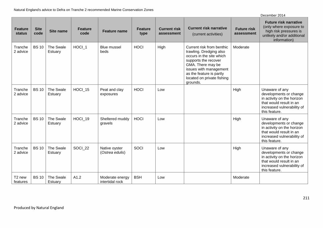
Natural England’s advice to Defra on Tranche 2 recommended Marine Conservation Zones
December 2014
211
Produced by Natural England
Feature status
Site code
Site name Feature
code Feature name
Feature type
Current risk assessment
Current risk narrative
(current activities)
Future risk assessment
Future risk narrative (only where exposure to
high risk pressures is unlikely and/or additional
information)
Tranche 2 advice
BS 10 The Swale Estuary
HOCI_1 Blue mussel beds
HOCI High Current risk from benthic trawling. Dredging also occurs in the site which supports the recover GMA. There may be issues with management as the feature is partly located on private fishing grounds.
Moderate
Tranche 2 advice
BS 10 The Swale Estuary
HOCI_15 Peat and clay exposures
HOCI Low High Unaware of any developments or change in activity on the horizon that would result in an increased vulnerability of this feature.
Tranche 2 advice
BS 10 The Swale Estuary
HOCI_19 Sheltered muddy gravels
HOCI Low High Unaware of any developments or change in activity on the horizon that would result in an increased vulnerability of this feature.
Tranche 2 advice
BS 10 The Swale Estuary
SOCI_22 Native oyster (Ostrea edulis)
SOCI Low High Unaware of any developments or change in activity on the horizon that would result in an increased vulnerability of this feature.
T2 new features
BS 10 The Swale Estuary
A1.2 Moderate energy intertidal rock
BSH Low Moderate

Natural England’s advice to Defra on Tranche 2 recommended Marine Conservation Zones
December 2014
212
Produced by Natural England
Feature status
Site code
Site name Feature
code Feature name
Feature type
Current risk assessment
Current risk narrative
(current activities)
Future risk assessment
Future risk narrative (only where exposure to
high risk pressures is unlikely and/or additional
information)
T2 new features
BS 10 The Swale Estuary
A2.1 Intertidal coarse sediment
BSH Low Moderate
T2 new features
BS 10 The Swale Estuary
A2.2 Intertidal sand and muddy sand
BSH Low Moderate
T2 new features
BS 10 The Swale Estuary
A2.4 Intertidal mixed sediments
BSH Low Moderate
T2 new features
BS 10 The Swale Estuary
A5.1 Subtidal coarse sediment
BSH Low Moderate
T2 new features
BS 10 The Swale Estuary
HOCI_5 Estuarine rocky habitats
HOCI Low Moderate
T2 new features
BS 10 The Swale Estuary
SOCI_32 Smelt (Osmerus eperlanus)
SOCI Low Unknown Future risk narrative not provided for mobile species features as sensitivity to pressures determined by expert judgement only and not currently included in sensitivity matrix.
Tranche 2 advice
BS 11.1
Dover to Deal
A1.2 Moderate energy intertidal rock
BSH Low Moderate
Tranche 2 advice
BS 11.1
Dover to Deal
A2.1 Intertidal coarse sediment
BSH Low Moderate
Tranche 2 advice
BS 11.1
Dover to Deal
A2.3 Intertidal mud BSH Low High Future Dover port expansion likely to result in exposure to pressures that this feature is sensitive to.

Natural England’s advice to Defra on Tranche 2 recommended Marine Conservation Zones
December 2014
213
Produced by Natural England
Feature status
Site code
Site name Feature
code Feature name
Feature type
Current risk assessment
Current risk narrative
(current activities)
Future risk assessment
Future risk narrative (only where exposure to
high risk pressures is unlikely and/or additional
information)
Tranche 2 advice
BS 11.1
Dover to Deal
A3.2 Moderate energy infralittoral rock
BSH Low Moderate
Tranche 2 advice
BS 11.1
Dover to Deal
A5.1 Subtidal coarse sediment
BSH Low Moderate
Tranche 2 advice
BS 11.1
Dover to Deal
A5.4 Subtidal mixed sediments
BSH Low Moderate
Tranche 2 advice
BS 11.1
Dover to Deal
HOCI_1 Blue mussel beds
HOCI Low Moderate
Tranche 2 advice
BS 11.1
Dover to Deal
HOCI_10 Intertidal underboulder communities
HOCI Low Moderate
Tranche 2 advice
BS 11.1
Dover to Deal
HOCI_11 Littoral chalk communities
HOCI Low Moderate
Tranche 2 advice
BS 11.1
Dover to Deal
HOCI_16 Ross worm reefs (Sabellaria spinulosa)
HOCI Low High Future Dover port expansion likely to result in exposure to pressures that this feature is sensitive to.
Tranche 2 advice
BS 11.1
Dover to Deal
HOCI_20 Subtidal chalk HOCI Low High Future Dover port expansion likely to result in exposure to pressures that this feature is sensitive to.
T2 new features
BS 11.1
Dover to Deal
A1.1 High energy intertidal rock
BSH Low Moderate
T2 new features
BS 11.1
Dover to Deal
A1.3 Low energy intertidal rock
BSH Low Moderate

Natural England’s advice to Defra on Tranche 2 recommended Marine Conservation Zones
December 2014
214
Produced by Natural England
Feature status
Site code
Site name Feature
code Feature name
Feature type
Current risk assessment
Current risk narrative
(current activities)
Future risk assessment
Future risk narrative (only where exposure to
high risk pressures is unlikely and/or additional
information)
T2 new features
BS 11.1
Dover to Deal
A4.1 High energy circalittoral rock
BSH Low Moderate
T2 new features
BS 11.1
Dover to Deal
A4.2 Moderate energy circalittoral rock
BSH Low High Future Dover port expansion likely to result in exposure to pressures that this feature is sensitive to.
T2 new features
BS 11.1
Dover to Deal
SOCI_22 Native oyster (Ostrea edulis)
SOCI Low High Future Dover port expansion likely to result in exposure to pressures that this feature is sensitive to.
Tranche 2 advice
BS 11.2
Dover to Folkestone
A1.2 Moderate energy intertidal rock
BSH Low Moderate
Tranche 2 advice
BS 11.2
Dover to Folkestone
A2.1 Intertidal coarse sediment
BSH Low Moderate
Tranche 2 advice
BS 11.2
Dover to Folkestone
A3.1 High energy infralittoral rock
BSH Low Moderate
Tranche 2 advice
BS 11.2
Dover to Folkestone
A3.2 Moderate energy infralittoral rock
BSH Low Moderate
Tranche 2 advice
BS 11.2
Dover to Folkestone
A5.1 Subtidal coarse sediment
BSH Low Moderate
Tranche 2 advice
BS 11.2
Dover to Folkestone
HOCI_1 Blue mussel beds
HOCI Low Moderate
Tranche 2 advice
BS 11.2
Dover to Folkestone
HOCI_10 Intertidal underboulder communities
HOCI Low Moderate

Natural England’s advice to Defra on Tranche 2 recommended Marine Conservation Zones
December 2014
215
Produced by Natural England
Feature status
Site code
Site name Feature
code Feature name
Feature type
Current risk assessment
Current risk narrative
(current activities)
Future risk assessment
Future risk narrative (only where exposure to
high risk pressures is unlikely and/or additional
information)
Tranche 2 advice
BS 11.2
Dover to Folkestone
HOCI_11 Littoral chalk communities
HOCI Low Moderate
Tranche 2 advice
BS 11.2
Dover to Folkestone
HOCI_15 Peat and clay exposures
HOCI Low High Future Dover port expansion likely to result in exposure to pressures that this feature is sensitive to.
Tranche 2 advice
BS 11.2
Dover to Folkestone
HOCI_16 Ross worm reefs (Sabellaria spinulosa)
HOCI Low High Future Dover port expansion likely to result in exposure to pressures that this feature is sensitive to.
Tranche 2 advice
BS 11.2
Dover to Folkestone
HOCI_20 Subtidal chalk HOCI Low High Future Dover port expansion likely to result in exposure to pressures that this feature is sensitive to.
Tranche 2 advice
BS 11.2
Dover to Folkestone
SOCI_16 Short-snouted seahorse (Hippocampus hippocampus)
SOCI Low High Future Dover port expansion likely to result in exposure to pressures that this feature is sensitive to.
Tranche 2 advice
BS 11.2
Dover to Folkestone
SOCI_22 Native oyster (Ostrea edulis)
SOCI Low High Future Dover port expansion likely to result in exposure to pressures that this feature is sensitive to.

Natural England’s advice to Defra on Tranche 2 recommended Marine Conservation Zones
December 2014
216
Produced by Natural England
Feature status
Site code
Site name Feature
code Feature name
Feature type
Current risk assessment
Current risk narrative
(current activities)
Future risk assessment
Future risk narrative (only where exposure to
high risk pressures is unlikely and/or additional
information)
Tranche 2 advice
BS 11.2
Dover to Folkestone
G2 Folkestone Warren
Geological Low Unknown Future risk narrative not provided for geological features as sensitivity to pressures determined by expert judgement only and not currently included in sensitivity matrix.
T2 new features
BS 11.2
Dover to Folkestone
A1.1 High energy intertidal rock
BSH Low Moderate
T2 new features
BS 11.2
Dover to Folkestone
A1.3 Low energy intertidal rock
BSH Low Moderate
T2 new features
BS 11.2
Dover to Folkestone
A2.2 Intertidal sand and muddy sand
BSH Low Moderate
T2 new features
BS 11.2
Dover to Folkestone
A3.3 Low energy infralittoral rock
BSH Low High Future Dover port expansion likely to result in exposure to pressures that this feature is sensitive to.
T2 new features
BS 11.2
Dover to Folkestone
A4.1 High energy circalittoral rock
BSH Low Moderate
T2 new features
BS 11.2
Dover to Folkestone
A4.2 Moderate energy circalittoral rock
BSH Low High
T2 new features
BS 11.2
Dover to Folkestone
A5.2 Subtidal sand BSH Low High Future Dover port expansion likely to result in exposure to pressures that this feature is sensitive to.
T2 new features
BS 11.2
Dover to Folkestone
A5.3 Subtidal mud BSH Low Moderate

Natural England’s advice to Defra on Tranche 2 recommended Marine Conservation Zones
December 2014
217
Produced by Natural England
Feature status
Site code
Site name Feature
code Feature name
Feature type
Current risk assessment
Current risk narrative
(current activities)
Future risk assessment
Future risk narrative (only where exposure to
high risk pressures is unlikely and/or additional
information)
T2 new features
BS 11.2
Dover to Folkestone
A5.4 Subtidal mixed sediments
BSH Low Moderate
T1 new features
BS 13.2
Beachy Head West
A4.1 High energy circalittoral rock
BSH High Current risk from benthic trawling. There is currently a seasonal (May–October) byelaw prohibiting benthic trawling within this site; however it does occur (to unknown levels) the rest of the year. (Note subtidal chalk was designated in this MCZ in 2013 with a maintain GMA; this may need reviewing in light of this feature's assessment.)
Moderate
T1 new features
BS 13.2
Beachy Head West
A4.2 Moderate energy circalittoral rock
BSH High Current risk from benthic trawling. There is currently a seasonal (May–October) byelaw prohibiting benthic trawling within this site; however it does occur (to unknown levels) the rest of the year. (Note subtidal chalk was designated in this MCZ in 2013 with a maintain GMA; this may need reviewing in light of this feature's assessment.)
High
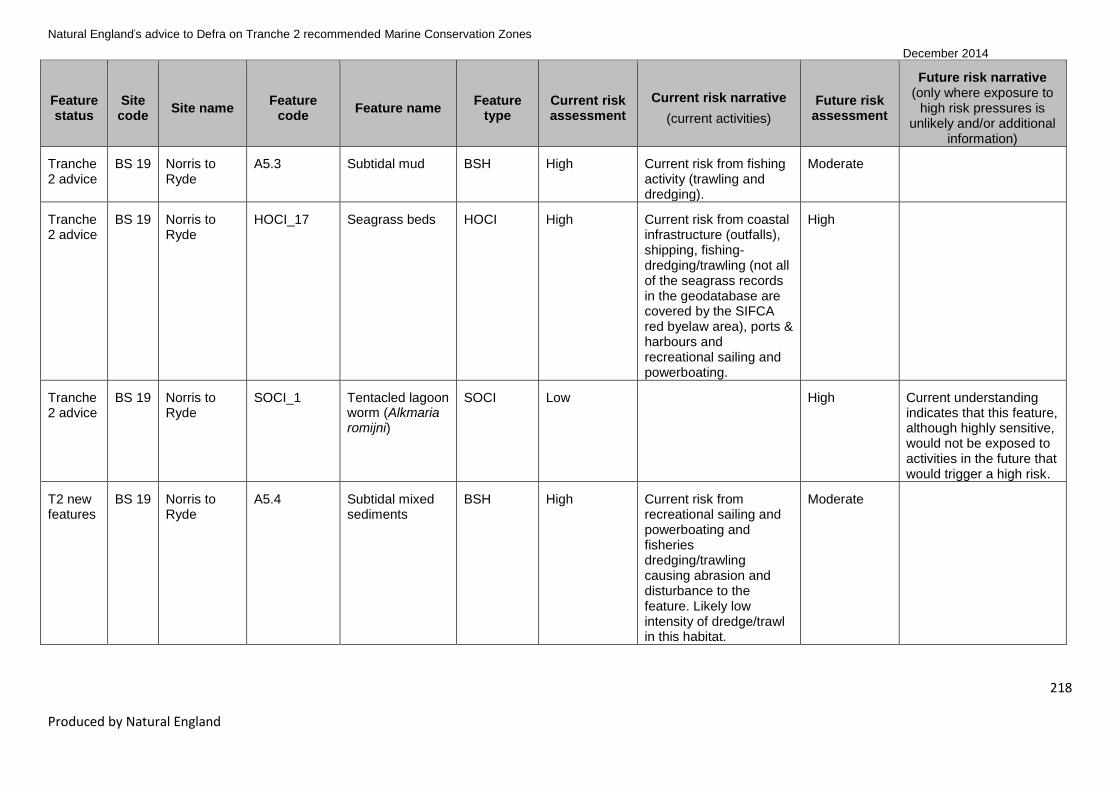
Natural England’s advice to Defra on Tranche 2 recommended Marine Conservation Zones
December 2014
218
Produced by Natural England
Feature status
Site code
Site name Feature
code Feature name
Feature type
Current risk assessment
Current risk narrative
(current activities)
Future risk assessment
Future risk narrative (only where exposure to
high risk pressures is unlikely and/or additional
information)
Tranche 2 advice
BS 19 Norris to Ryde
A5.3 Subtidal mud BSH High Current risk from fishing activity (trawling and dredging).
Moderate
Tranche 2 advice
BS 19 Norris to Ryde
HOCI_17 Seagrass beds HOCI High Current risk from coastal infrastructure (outfalls), shipping, fishing-dredging/trawling (not all of the seagrass records in the geodatabase are covered by the SIFCA red byelaw area), ports & harbours and recreational sailing and powerboating.
High
Tranche 2 advice
BS 19 Norris to Ryde
SOCI_1 Tentacled lagoon worm (Alkmaria romijni)
SOCI Low High Current understanding indicates that this feature, although highly sensitive, would not be exposed to activities in the future that would trigger a high risk.
T2 new features
BS 19 Norris to Ryde
A5.4 Subtidal mixed sediments
BSH High Current risk from recreational sailing and powerboating and fisheries dredging/trawling causing abrasion and disturbance to the feature. Likely low intensity of dredge/trawl in this habitat.
Moderate

Natural England’s advice to Defra on Tranche 2 recommended Marine Conservation Zones
December 2014
219
Produced by Natural England
Feature status
Site code
Site name Feature
code Feature name
Feature type
Current risk assessment
Current risk narrative
(current activities)
Future risk assessment
Future risk narrative (only where exposure to
high risk pressures is unlikely and/or additional
information)
T2 new features
BS 19 Norris to Ryde
A5.5 Subtidal macrophyte-dominated sediment
BSH High Current risk from coastal infrastructure (outfalls), shipping, fishing-dredging/trawling (not all of the seagrass records in the geodatabase are covered by the SIFCA red byelaw area), ports & harbours and recreational sailing and powerboating.
High
T2 new features
BS 19 Norris to Ryde
HOCI_19 Sheltered muddy gravels
HOCI High Current risk from recreational sailing and powerboating and fisheries dredging/trawling causing abrasion and disturbance to the feature. Likely low intensity of dredge/trawl in this habitat.
High
T2 new features
BS 19 Norris to Ryde
SOCI_22 Native oyster (Ostrea edulis)
SOCI High Current risk from recreational sailing and powerboating and fisheries dredging/trawling causing abrasion and disturbance to the feature. Likely low intensity of dredge/trawl in this habitat.
High

Natural England’s advice to Defra on Tranche 2 recommended Marine Conservation Zones
December 2014
220
Produced by Natural England
Feature status
Site code
Site name Feature
code Feature name
Feature type
Current risk assessment
Current risk narrative
(current activities)
Future risk assessment
Future risk narrative (only where exposure to
high risk pressures is unlikely and/or additional
information)
Tranche 2 advice
BS 20 The Needles
HOCI_17 Seagrass beds HOCI High Current risk from coastal infrastructure (outfalls), shipping, fishing-dredging/trawling (not all of the seagrass records in the geodatabase are covered by the SIFCA red byelaw area), ports & harbours and recreational sailing and powerboating.
High
Tranche 2 advice
BS 20 The Needles
SOCI_20 Stalked jellyfish (Lucernariopsis campanulata)
SOCI Low High Current understanding indicates that this feature, although highly sensitive, would not be exposed to activities in the future that would trigger a high risk.
Tranche 2 advice
BS 20 The Needles
SOCI_23 Peacock’s tail (Padina pavonica)
SOCI High Current risk from recreational sailing and powerboating (mooring and launching, recovery and participation) and fisheries dredging/trawling causing abrasion and disturbance to the feature.
High
T2 new features
BS 20 The Needles
A1.2 Moderate energy intertidal rock
BSH Low Moderate
T2 new features
BS 20 The Needles
A3.1 High energy infralittoral rock
BSH Low Moderate

Natural England’s advice to Defra on Tranche 2 recommended Marine Conservation Zones
December 2014
221
Produced by Natural England
Feature status
Site code
Site name Feature
code Feature name
Feature type
Current risk assessment
Current risk narrative
(current activities)
Future risk assessment
Future risk narrative (only where exposure to
high risk pressures is unlikely and/or additional
information)
T2 new features
BS 20 The Needles
A3.2 Moderate energy infralittoral rock
BSH Low Moderate
T2 new features
BS 20 The Needles
A4.2 Moderate energy circalittoral rock
BSH Low High Current understanding indicates that this feature, although highly sensitive, would not be exposed to activities in the future that would trigger a high risk.
T2 new features
BS 20 The Needles
A5.1 Subtidal coarse sediment
BSH High Current risk from recreational sailing and powerboating and fisheries dredging/trawling. The Needles is a westerly facing site of high mobility and high energy. Exposure to dredging and trawling and anchoring events are likely low impact due to high energy nature of site.
Moderate

Natural England’s advice to Defra on Tranche 2 recommended Marine Conservation Zones
December 2014
222
Produced by Natural England
Feature status
Site code
Site name Feature
code Feature name
Feature type
Current risk assessment
Current risk narrative
(current activities)
Future risk assessment
Future risk narrative (only where exposure to
high risk pressures is unlikely and/or additional
information)
T2 new features
BS 20 The Needles
A5.2 Subtidal sand BSH High Current risk from recreational sailing and powerboating (mooring and launching, recovery and participation) and fisheries dredging/trawling causing abrasion and disturbance to the feature.
High The Needles is a westerly facing site of high mobility and high energy. Ongoing exposure to dredging and trawling and anchoring events are likely low impact due to high energy nature of site. Future moorings would be regulated by appropriate authorities.
T2 new features
BS 20 The Needles
A5.3 Subtidal mud BSH High Recover GMA triggered due to mod/high VA for recreational sailing and powerboating (mooring and launching, recovery and participation) and fisheries dredging/trawling. The Needles is a westerly facing site of high mobility and high energy. Exposure to dredging and trawling and anchoring events are likely low impact due to high energy nature of site.
Moderate

Natural England’s advice to Defra on Tranche 2 recommended Marine Conservation Zones
December 2014
223
Produced by Natural England
Feature status
Site code
Site name Feature
code Feature name
Feature type
Current risk assessment
Current risk narrative
(current activities)
Future risk assessment
Future risk narrative (only where exposure to
high risk pressures is unlikely and/or additional
information)
Tranche 2 advice
BS 20 The Needles
A5.4 Subtidal mixed sediments
BSH High Current risk from recreational sailing and powerboating and fisheries dredging/trawling. The Needles is a westerly facing site of high mobility and high energy. Exposure to dredging and trawling and anchoring events are likely low impact due to high energy nature of site.
Moderate
T2 new features
BS 20 The Needles
A5.5 Subtidal macrophyte-dominated sediment
BSH High Risk from recreational sailing and powerboating (mooring and launching, recovery and participation).
High
T2 new features
BS 20 The Needles
HOCI_19 Sheltered muddy gravels
HOCI High Current risk from recreational sailing and powerboating (mooring and launching, recovery and participation) and fisheries dredging/trawling causing abrasion and disturbance to the feature.
High
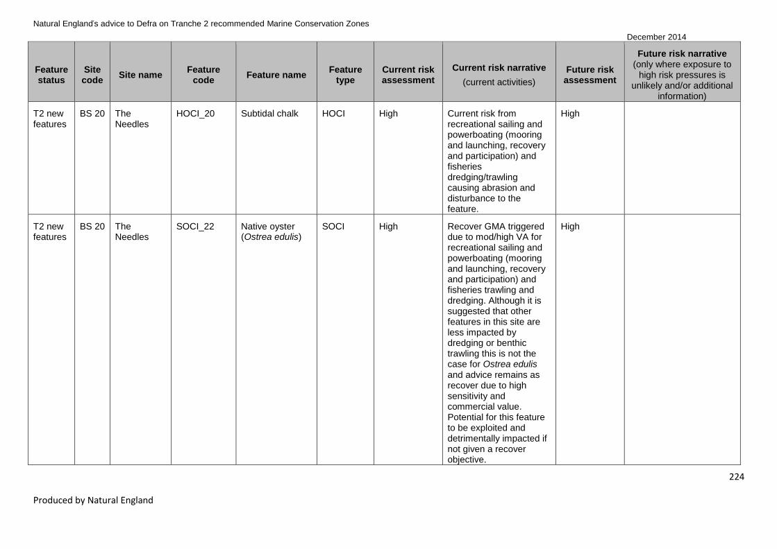
Natural England’s advice to Defra on Tranche 2 recommended Marine Conservation Zones
December 2014
224
Produced by Natural England
Feature status
Site code
Site name Feature
code Feature name
Feature type
Current risk assessment
Current risk narrative
(current activities)
Future risk assessment
Future risk narrative (only where exposure to
high risk pressures is unlikely and/or additional
information)
T2 new features
BS 20 The Needles
HOCI_20 Subtidal chalk HOCI High Current risk from recreational sailing and powerboating (mooring and launching, recovery and participation) and fisheries dredging/trawling causing abrasion and disturbance to the feature.
High
T2 new features
BS 20 The Needles
SOCI_22 Native oyster (Ostrea edulis)
SOCI High Recover GMA triggered due to mod/high VA for recreational sailing and powerboating (mooring and launching, recovery and participation) and fisheries trawling and dredging. Although it is suggested that other features in this site are less impacted by dredging or benthic trawling this is not the case for Ostrea edulis and advice remains as recover due to high sensitivity and commercial value. Potential for this feature to be exploited and detrimentally impacted if not given a recover objective.
High
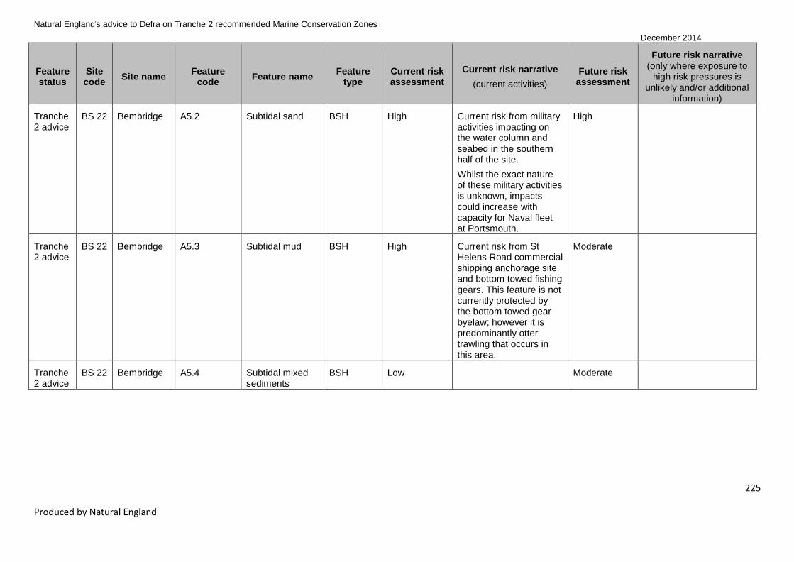
Natural England’s advice to Defra on Tranche 2 recommended Marine Conservation Zones
December 2014
225
Produced by Natural England
Feature status
Site code
Site name Feature
code Feature name
Feature type
Current risk assessment
Current risk narrative
(current activities)
Future risk assessment
Future risk narrative (only where exposure to
high risk pressures is unlikely and/or additional
information)
Tranche 2 advice
BS 22 Bembridge A5.2 Subtidal sand BSH High Current risk from military activities impacting on the water column and seabed in the southern half of the site.
Whilst the exact nature of these military activities is unknown, impacts could increase with capacity for Naval fleet at Portsmouth.
High
Tranche 2 advice
BS 22 Bembridge A5.3 Subtidal mud BSH High Current risk from St Helens Road commercial shipping anchorage site and bottom towed fishing gears. This feature is not currently protected by the bottom towed gear byelaw; however it is predominantly otter trawling that occurs in this area.
Moderate
Tranche 2 advice
BS 22 Bembridge A5.4 Subtidal mixed sediments
BSH Low Moderate

Natural England’s advice to Defra on Tranche 2 recommended Marine Conservation Zones
December 2014
226
Produced by Natural England
Feature status
Site code
Site name Feature
code Feature name
Feature type
Current risk assessment
Current risk narrative
(current activities)
Future risk assessment
Future risk narrative (only where exposure to
high risk pressures is unlikely and/or additional
information)
Tranche 2 advice
BS 22 Bembridge HOCI_12 Maerl beds HOCI High Current risk identified from recreational activities. There is a wreck located within the point records for this feature, which is a popular diving spot along with the adjacent reef ledges therefore risk from anchoring associated with recreational diving.
High
Tranche 2 advice
BS 22 Bembridge HOCI_16 Ross worm reefs (Sabellaria spinulosa)
HOCI High Current risk identified from recreational activities, especially boating. However, no mooring areas overlap with the feature records and there is unlikely to be any anchoring at such a distance from the shore. There is the potential for low level of anchoring from recreational diving.
High

Natural England’s advice to Defra on Tranche 2 recommended Marine Conservation Zones
December 2014
227
Produced by Natural England
Feature status
Site code
Site name Feature
code Feature name
Feature type
Current risk assessment
Current risk narrative
(current activities)
Future risk assessment
Future risk narrative (only where exposure to
high risk pressures is unlikely and/or additional
information)
Tranche 2 advice
BS 22 Bembridge HOCI_17 Seagrass beds HOCI High Current risk from coastal infrastructure. Undetermined pipelines or cables extend into the seagrass beds. Maintenance or removal of these could impact on the feature. Maintenance of buoyed channel and navigational markers could cause disturbance/penetration to the seabed and impact the feature. Recreational sailing and powerboating mooring areas and introduction of invasive non-native species all have potential to impact on the feature.
High
Tranche 2 advice
BS 22 Bembridge HOCI_18 Sea pen and burrowing megafauna communities
HOCI High Current risk from benthic trawling. Potential risk from anchoring at the St Helens Anchorage; however records for this feature are few and currently there is no direct overlap between the anchorage and existing data points.
High

Natural England’s advice to Defra on Tranche 2 recommended Marine Conservation Zones
December 2014
228
Produced by Natural England
Feature status
Site code
Site name Feature
code Feature name
Feature type
Current risk assessment
Current risk narrative
(current activities)
Future risk assessment
Future risk narrative (only where exposure to
high risk pressures is unlikely and/or additional
information)
Tranche 2 advice
BS 22 Bembridge SOCI_1 Tentacled lagoon worm (Alkmaria romijni)
SOCI Low High
Tranche 2 advice
BS 22 Bembridge SOCI_14 Stalked jellyfish (Haliclystus auricula)
SOCI High Current risk from the use of recreational vessels in the area and risk of spread of invasive non-native species.
High
Tranche 2 advice
BS 22 Bembridge SOCI_16 Short-snouted seahorse (Hippocampus hippocampus)
SOCI High Current risk from moorings and anchorages and recreational vessels in the areas of supporting habitat. There is a risk of death by collision with recreational vessels and shipping activity relating to ports and harbours.
High
Tranche 2 advice
BS 22 Bembridge SOCI_22 Native oyster (Ostrea edulis)
SOCI High Current risk from benthic trawling activity and recreational boating through abrasion/penetration and disturbance of the seabed.
High

Natural England’s advice to Defra on Tranche 2 recommended Marine Conservation Zones
December 2014
229
Produced by Natural England
Feature status
Site code
Site name Feature
code Feature name
Feature type
Current risk assessment
Current risk narrative
(current activities)
Future risk assessment
Future risk narrative (only where exposure to
high risk pressures is unlikely and/or additional
information)
Tranche 2 advice
BS 22 Bembridge SOCI_23 Peacock’s tail (Padina pavonica)
SOCI High Current risk from recreational boating activity through anchoring and to a lesser extent from launching and recovery of vessels. Feature is vulnerable to the spread of non-native invasive species through recreational vessel use in the area.
High
T2 new features
BS 22 Bembridge A5.1 Subtidal coarse sediment
BSH High Current risk from coastal infrastructure, shipping anchorages, military activities, and bottom towed fishing gears (although the majority of the feature records are located within the bottom towed gear closed area byelaw). Also some risk posed from high levels of shipping and spread of invasive non-native species although subtidal habitats at low risk from known invasives currently in the area.
Moderate

Natural England’s advice to Defra on Tranche 2 recommended Marine Conservation Zones
December 2014
230
Produced by Natural England
Feature status
Site code
Site name Feature
code Feature name
Feature type
Current risk assessment
Current risk narrative
(current activities)
Future risk assessment
Future risk narrative (only where exposure to
high risk pressures is unlikely and/or additional
information)
T2 new features
BS 22 Bembridge A5.5 Subtidal macrophyte-dominated sediment
BSH High Current risk from coastal infrastructure. Undetermined pipelines or cables extend into the seagrass beds. Maintenance or removal of these could impact on the feature. Maintenance of buoyed channel and navigational markers could cause disturbance/penetration to the seabed and impact the feature. Recreational sailing and powerboating mooring areas and introduction of invasive non-native species all have potential to impact on the feature.
High

Natural England’s advice to Defra on Tranche 2 recommended Marine Conservation Zones
December 2014
231
Produced by Natural England
Feature status
Site code
Site name Feature
code Feature name
Feature type
Current risk assessment
Current risk narrative
(current activities)
Future risk assessment
Future risk narrative (only where exposure to
high risk pressures is unlikely and/or additional
information)
T2 new features
BS 22 Bembridge HOCI_19 Sheltered muddy gravels
HOCI High Current risk from military activities, and recreational sailing and powerboating causing abrasion/penetration to the seabed through overlap with the feature at one point record close to shore. Other point data are located in subtidal waters with no known mooring areas; however impacts from recreational anchoring may occur, especially as one other record is close to a popular wreck and diving location. Risk posed from high levels of shipping and spread of invasive non-native species.
High

Natural England’s advice to Defra on Tranche 2 recommended Marine Conservation Zones
December 2014
232
Produced by Natural England
Feature status
Site code
Site name Feature
code Feature name
Feature type
Current risk assessment
Current risk narrative
(current activities)
Future risk assessment
Future risk narrative (only where exposure to
high risk pressures is unlikely and/or additional
information)
T2 new features
BS 22 Bembridge SOCI_20 Stalked jellyfish (Lucernariopsis campanulata)
SOCI High Current risk from recreational vessels through moorings and anchoring. Recreational vessels pose a risk of the spread of invasive non-native species. The species is found next to an outfall pipe and maintenance of this structure poses a risk of causing abrasion/penetration or disturbance to the seabed or through habitat structure changes due to seabed extraction.
High
T2 new features
BS 22 Bembridge SOCI_26 Common maerl (Phymatolithon calcareum)
SOCI Low High
Tranche 2 advice
BS 23 Yarmouth to Cowes
A1.3 Low energy intertidal rock
BSH Low Moderate
Tranche 2 advice
BS 23 Yarmouth to Cowes
A2.1 Intertidal coarse sediment
BSH Low Moderate

Natural England’s advice to Defra on Tranche 2 recommended Marine Conservation Zones
December 2014
233
Produced by Natural England
Feature status
Site code
Site name Feature
code Feature name
Feature type
Current risk assessment
Current risk narrative
(current activities)
Future risk assessment
Future risk narrative (only where exposure to
high risk pressures is unlikely and/or additional
information)
Tranche 2 advice
BS 23 Yarmouth to Cowes
A3.2 Moderate energy infralittoral rock
BSH High Current risk from recreational sailing and powerboating and fishing activities. Fisheries exposure is low in reality as vessels are unlikely to dredge/trawl in this habitat but recreational sailing and powerboating activities do pose a high current risk to this feature.
Moderate
Tranche 2 advice
BS 23 Yarmouth to Cowes
A5.1 Subtidal coarse sediment
BSH High Current risk from coastal infrastructure, ports & harbours, recreational sailing and powerboating and bottom towed fishing gears. There is also some risk posed from high levels of shipping and recreational vessels and spread of invasive non-native species.
Moderate
Tranche 2 advice
BS 23 Yarmouth to Cowes
HOCI_10 Intertidal underboulder communities
HOCI High Current risk from recreational sailing and powerboating causing abrasion, penetration and disturbance of the intertidal habitat.
Moderate

Natural England’s advice to Defra on Tranche 2 recommended Marine Conservation Zones
December 2014
234
Produced by Natural England
Feature status
Site code
Site name Feature
code Feature name
Feature type
Current risk assessment
Current risk narrative
(current activities)
Future risk assessment
Future risk narrative (only where exposure to
high risk pressures is unlikely and/or additional
information)
Tranche 2 advice
BS 23 Yarmouth to Cowes
HOCI_15 Peat and clay exposures
HOCI High Recover GMA is triggered due to mod/high VA for fishing (dredging/benthic trawling). The peat and clay exposures are both subtidal and intertidal and not covered by the SIFCA byelaw.
High

Natural England’s advice to Defra on Tranche 2 recommended Marine Conservation Zones
December 2014
235
Produced by Natural England
Feature status
Site code
Site name Feature
code Feature name
Feature type
Current risk assessment
Current risk narrative
(current activities)
Future risk assessment
Future risk narrative (only where exposure to
high risk pressures is unlikely and/or additional
information)
Tranche 2 advice
BS 23 Yarmouth to Cowes
HOCI_17 Seagrass beds HOCI High Current risk from maintenance and operation of outfalls and slipways that extend into the seagrass beds through disturbance / penetration of the seabed. Maintenance of navigational channels and markers at Yarmouth and Newtown Harbour and the use of anchorages could cause disturbance/penetration to the seabed and impact the feature. Bottom towed fishing gears also pose a risk to this feature as not all of the seagrass records are covered by the existing SIFCA red byelaw area. Recreational sailing and powerboating have the potential to impact on the feature.
High
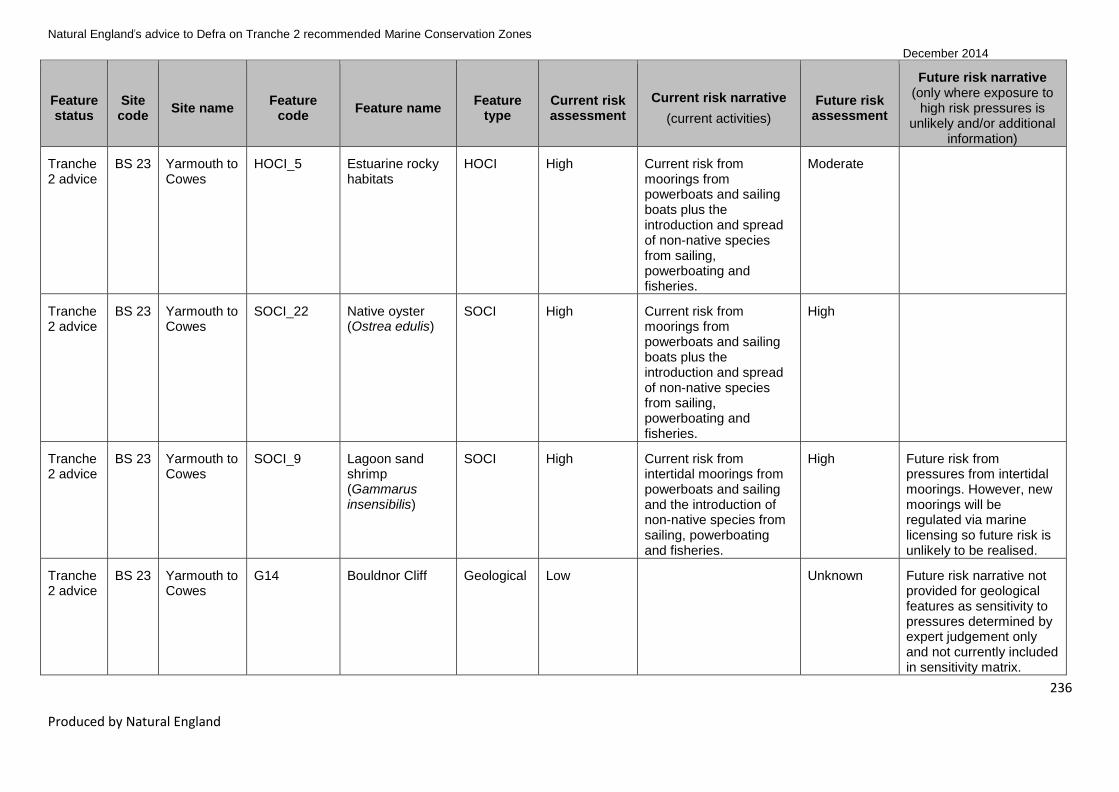
Natural England’s advice to Defra on Tranche 2 recommended Marine Conservation Zones
December 2014
236
Produced by Natural England
Feature status
Site code
Site name Feature
code Feature name
Feature type
Current risk assessment
Current risk narrative
(current activities)
Future risk assessment
Future risk narrative (only where exposure to
high risk pressures is unlikely and/or additional
information)
Tranche 2 advice
BS 23 Yarmouth to Cowes
HOCI_5 Estuarine rocky habitats
HOCI High Current risk from moorings from powerboats and sailing boats plus the introduction and spread of non-native species from sailing, powerboating and fisheries.
Moderate
Tranche 2 advice
BS 23 Yarmouth to Cowes
SOCI_22 Native oyster (Ostrea edulis)
SOCI High Current risk from moorings from powerboats and sailing boats plus the introduction and spread of non-native species from sailing, powerboating and fisheries.
High
Tranche 2 advice
BS 23 Yarmouth to Cowes
SOCI_9 Lagoon sand shrimp (Gammarus insensibilis)
SOCI High Current risk from intertidal moorings from powerboats and sailing and the introduction of non-native species from sailing, powerboating and fisheries.
High Future risk from pressures from intertidal moorings. However, new moorings will be regulated via marine licensing so future risk is unlikely to be realised.
Tranche 2 advice
BS 23 Yarmouth to Cowes
G14 Bouldnor Cliff Geological Low Unknown Future risk narrative not provided for geological features as sensitivity to pressures determined by expert judgement only and not currently included in sensitivity matrix.
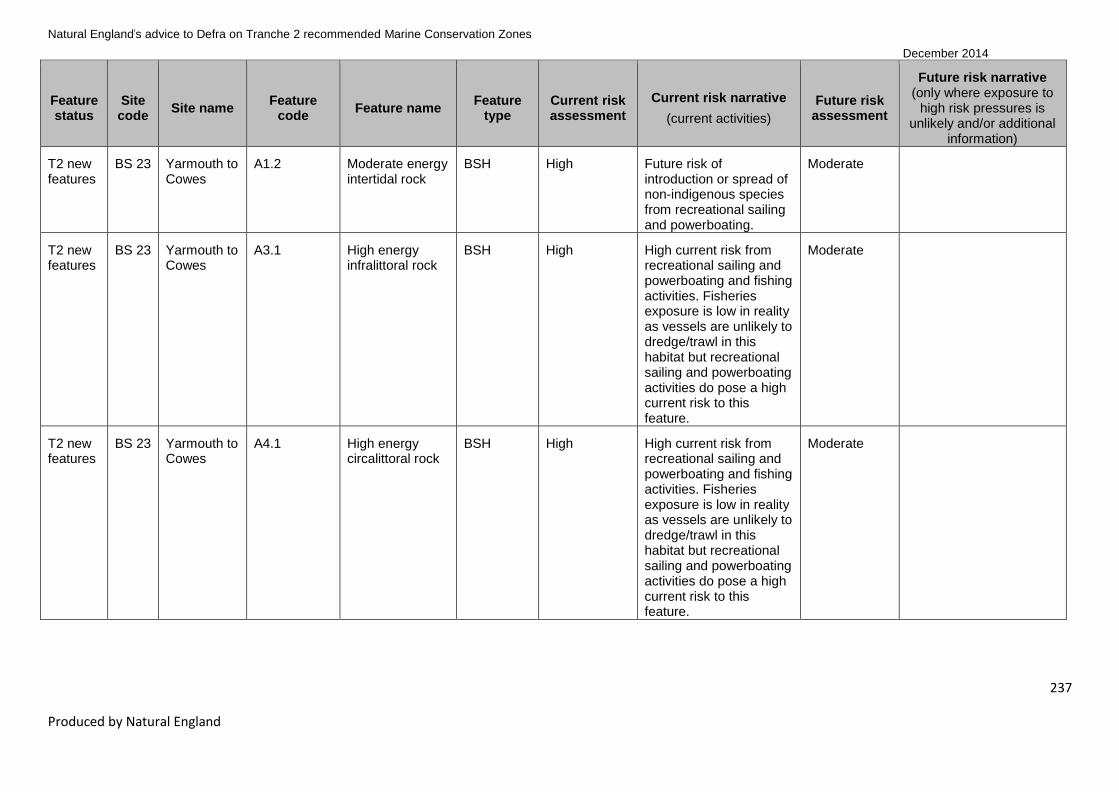
Natural England’s advice to Defra on Tranche 2 recommended Marine Conservation Zones
December 2014
237
Produced by Natural England
Feature status
Site code
Site name Feature
code Feature name
Feature type
Current risk assessment
Current risk narrative
(current activities)
Future risk assessment
Future risk narrative (only where exposure to
high risk pressures is unlikely and/or additional
information)
T2 new features
BS 23 Yarmouth to Cowes
A1.2 Moderate energy intertidal rock
BSH High Future risk of introduction or spread of non-indigenous species from recreational sailing and powerboating.
Moderate
T2 new features
BS 23 Yarmouth to Cowes
A3.1 High energy infralittoral rock
BSH High High current risk from recreational sailing and powerboating and fishing activities. Fisheries exposure is low in reality as vessels are unlikely to dredge/trawl in this habitat but recreational sailing and powerboating activities do pose a high current risk to this feature.
Moderate
T2 new features
BS 23 Yarmouth to Cowes
A4.1 High energy circalittoral rock
BSH High High current risk from recreational sailing and powerboating and fishing activities. Fisheries exposure is low in reality as vessels are unlikely to dredge/trawl in this habitat but recreational sailing and powerboating activities do pose a high current risk to this feature.
Moderate

Natural England’s advice to Defra on Tranche 2 recommended Marine Conservation Zones
December 2014
238
Produced by Natural England
Feature status
Site code
Site name Feature
code Feature name
Feature type
Current risk assessment
Current risk narrative
(current activities)
Future risk assessment
Future risk narrative (only where exposure to
high risk pressures is unlikely and/or additional
information)
T2 new features
BS 23 Yarmouth to Cowes
A4.2 Moderate energy circalittoral rock
BSH High High current risk from recreational sailing and powerboating and fishing activities. Fisheries exposure is low in reality as vessels are unlikely to dredge/trawl in this habitat but recreational sailing and powerboating activities do pose a high current risk to this feature.
High
T2 new features
BS 23 Yarmouth to Cowes
A5.3 Subtidal mud BSH High Current risk from coastal infrastructure (maintenance of outfalls), ports & harbours (maintenance of structures), recreational sailing and powerboating (mooring and launching, recovery and participation) and bottom towed fishing gears.
Moderate

Natural England’s advice to Defra on Tranche 2 recommended Marine Conservation Zones
December 2014
239
Produced by Natural England
Feature status
Site code
Site name Feature
code Feature name
Feature type
Current risk assessment
Current risk narrative
(current activities)
Future risk assessment
Future risk narrative (only where exposure to
high risk pressures is unlikely and/or additional
information)
T2 new features
BS 23 Yarmouth to Cowes
A5.4 Subtidal mixed sediments
BSH High Current risk from coastal infrastructure (outfalls), fishing, shipping (anchorages), ports & harbours (maintenance dredging, anchorages and maintenance of structures) and recreational sailing and powerboating (mooring and launching, recovery and participation).
Moderate
T2 new features
BS 23 Yarmouth to Cowes
HOCI_11 Littoral chalk communities
HOCI High Current risk from recreational sailing and powerboating (mooring and launching, recovery and participation) and fishing activities and the introduction or spread of non-indigenous species.
Moderate

Natural England’s advice to Defra on Tranche 2 recommended Marine Conservation Zones
December 2014
240
Produced by Natural England
Feature status
Site code
Site name Feature
code Feature name
Feature type
Current risk assessment
Current risk narrative
(current activities)
Future risk assessment
Future risk narrative (only where exposure to
high risk pressures is unlikely and/or additional
information)
T2 new features
BS 23 Yarmouth to Cowes
HOCI_19 Sheltered muddy gravels
HOCI High Current risk from coastal infrastructure (outfalls) and ports and harbour structures, maintenance of navigable channels and markers and the use of anchorages, bottom towed fishing gears and recreational sailing and powerboating. There is also some risk posed from shipping and spread of invasive non-native species although subtidal habitats are at low risk from known invasives currently in the area.
High
T2 new features
BS 23 Yarmouth to Cowes
HOCI_20 Subtidal chalk HOCI High Current risk from moorings for powerboats and sailing and the introduction of non-native species from sailing, powerboating and fisheries. The use of recreational vessels and fisheries in the area pose a risk of the spread of invasive non-native species.
High

Natural England’s advice to Defra on Tranche 2 recommended Marine Conservation Zones
December 2014
241
Produced by Natural England
Feature status
Site code
Site name Feature
code Feature name
Feature type
Current risk assessment
Current risk narrative
(current activities)
Future risk assessment
Future risk narrative (only where exposure to
high risk pressures is unlikely and/or additional
information)
Tranche 2 advice
BS 28 Utopia HOCI_7 Fragile sponge & anthozoan communities on subtidal rocky habitats
HOCI High Current risk from pressures associated with fishing dredges. Benthic trawling and static gear (potting) activities were not included within the vulnerability assessment but local adviser knowledge suggests that these activities may be occurring within the site. Natural England advisers have relied on the automated vulnerability assessment in absence of further information to inform exposure levels.
High
T2 new features
BS 28 Utopia A4.1 High energy circalittoral rock
BSH High Current risk from pressures from benthic trawling and fishing dredges. Natural England advisers have relied on the automated vulnerability assessment in absence of further information to inform exposure levels.
Moderate

Natural England’s advice to Defra on Tranche 2 recommended Marine Conservation Zones
December 2014
242
Produced by Natural England
Feature status
Site code
Site name Feature
code Feature name
Feature type
Current risk assessment
Current risk narrative
(current activities)
Future risk assessment
Future risk narrative (only where exposure to
high risk pressures is unlikely and/or additional
information)
T2 new features
BS 28 Utopia A4.2 Moderate energy circalittoral rock
BSH High Current risk from pressures associated with benthic trawling and fishing dredges. Natural England advisers have relied on the automated vulnerability assessment in absence of further information to inform exposure levels.
High
T2 new features
BS 28 Utopia A5.1 Subtidal coarse sediment
BSH High Current risk from pressures associated with aggregate extraction, recreational boating and ports and harbour operation. Natural England advisers have relied on the automated vulnerability assessment in absence of further information to inform exposure levels.
Moderate

Natural England’s advice to Defra on Tranche 2 recommended Marine Conservation Zones
December 2014
243
Produced by Natural England
Feature status
Site code
Site name Feature
code Feature name
Feature type
Current risk assessment
Current risk narrative
(current activities)
Future risk assessment
Future risk narrative (only where exposure to
high risk pressures is unlikely and/or additional
information)
T2 new features
BS 28 Utopia A5.2 Subtidal sand BSH High Current risk from pressures associated with benthic trawling, fishing dredges, aggregate extraction, ports and harbours and recreational boating. Natural England advisers have relied on the automated vulnerability assessment in absence of further information to inform exposure levels.
High
T2 new features
BS 28 Utopia A5.4 Subtidal mixed sediments
BSH High Current risk from pressures associated with benthic trawling, fishing dredges, aggregate extraction, ports and harbours and recreational boating. Natural England advisers have relied on the automated vulnerability assessment in absence of further information to inform exposure levels.
Moderate
Tranche 2 advice
FS 15 Studland Bay
A2.2 Intertidal sand and muddy sand
BSH Low Moderate
Tranche 2 advice
FS 15 Studland Bay
A2.3 Intertidal mud BSH Low High
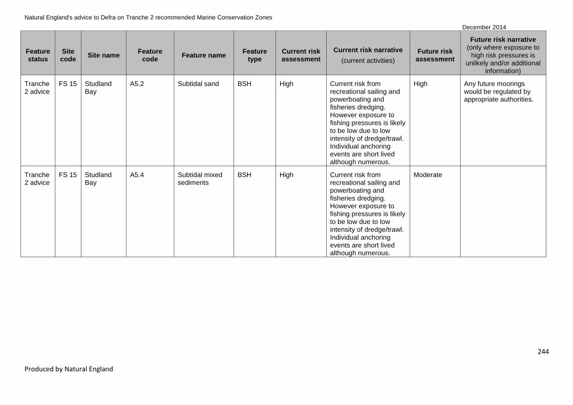
Natural England’s advice to Defra on Tranche 2 recommended Marine Conservation Zones
December 2014
244
Produced by Natural England
Feature status
Site code
Site name Feature
code Feature name
Feature type
Current risk assessment
Current risk narrative
(current activities)
Future risk assessment
Future risk narrative (only where exposure to
high risk pressures is unlikely and/or additional
information)
Tranche 2 advice
FS 15 Studland Bay
A5.2 Subtidal sand BSH High Current risk from recreational sailing and powerboating and fisheries dredging. However exposure to fishing pressures is likely to be low due to low intensity of dredge/trawl. Individual anchoring events are short lived although numerous.
High Any future moorings would be regulated by appropriate authorities.
Tranche 2 advice
FS 15 Studland Bay
A5.4 Subtidal mixed sediments
BSH High Current risk from recreational sailing and powerboating and fisheries dredging. However exposure to fishing pressures is likely to be low due to low intensity of dredge/trawl. Individual anchoring events are short lived although numerous.
Moderate

Natural England’s advice to Defra on Tranche 2 recommended Marine Conservation Zones
December 2014
245
Produced by Natural England
Feature status
Site code
Site name Feature
code Feature name
Feature type
Current risk assessment
Current risk narrative
(current activities)
Future risk assessment
Future risk narrative (only where exposure to
high risk pressures is unlikely and/or additional
information)
Tranche 2 advice
FS 15 Studland Bay
HOCI_17 Seagrass beds HOCI High Current risk from recreational sailing and powerboating and fisheries dredging. However exposure to fishing pressures is likely to be low due to low intensity of dredge/trawl. Individual anchoring events are short lived although numerous.
High
Tranche 2 advice
FS 15 Studland Bay
SOCI_22 Native oyster (Ostrea edulis)
SOCI High Current risk from recreational sailing and powerboating and fisheries dredging/trawling. Fisheries exposure is likely to be low but due to the commercial value and high sensitivity of this species this is high risk.
High
T2 new features
FS 15 Studland Bay
A1.2 Moderate energy intertidal rock
BSH Low Moderate
T2 new features
FS 15 Studland Bay
A2.1 Intertidal coarse sediment
BSH Low Moderate

Natural England’s advice to Defra on Tranche 2 recommended Marine Conservation Zones
December 2014
246
Produced by Natural England
Feature status
Site code
Site name Feature
code Feature name
Feature type
Current risk assessment
Current risk narrative
(current activities)
Future risk assessment
Future risk narrative (only where exposure to
high risk pressures is unlikely and/or additional
information)
T2 new features
FS 15 Studland Bay
A5.5 Subtidal macrophyte-dominated sediment
BSH High Current risk from recreational sailing and powerboating and fisheries dredging. However exposure to fishing pressures is likely to be low due to low intensity of dredge/trawl. Individual anchoring events are short lived although numerous.
High
T2 new features
FS 15 Studland Bay
SOCI_15 Long-snouted seahorse (Hippocampus guttulatus)
SOCI High Current risk from recreational sailing and powerboating and fishing activities causing abrasion, damage or removal of the feature. Bottom gear fisheries exposure likely to be low as unlikely to dredge/trawl in the supporting habitat but the recreational pressures and other fisheries pressures are still valid.
High

Natural England’s advice to Defra on Tranche 2 recommended Marine Conservation Zones
December 2014
247
Produced by Natural England
Feature status
Site code
Site name Feature
code Feature name
Feature type
Current risk assessment
Current risk narrative
(current activities)
Future risk assessment
Future risk narrative (only where exposure to
high risk pressures is unlikely and/or additional
information)
T2 new features
FS 15 Studland Bay
non_ENG_1 Black seabream (Spondyliosoma cantharus)
non_ENG Low Unknown Future risk narrative not provided for non-ENG features as sensitivity to pressures determined by expert judgement only and not currently included in sensitivity matrix.
T1 new features
FS 22 Torbay HOCI_15 Peat and clay exposures
HOCI Low High The feature is highly sensitive to one or more pressures; however on the basis of current knowledge relevant activities are unlikely to reach levels of exposure within the site that would put this feature at high risk of unfavourable condition. Therefore a high future risk of unfavourable condition is not thought to be justified.
T1 new features
FS 29 Upper Fowey and Pont Pill
A2.2 Intertidal sand and muddy sand
BSH Low Moderate
Tranche 2 advice
FS 33 Mounts Bay A1.1 High energy intertidal rock
BSH Low Moderate
Tranche 2 advice
FS 33 Mounts Bay A1.2 Moderate energy intertidal rock
BSH Low Moderate
Tranche 2 advice
FS 33 Mounts Bay A2.1 Intertidal coarse sediment
BSH Low Moderate

Natural England’s advice to Defra on Tranche 2 recommended Marine Conservation Zones
December 2014
248
Produced by Natural England
Feature status
Site code
Site name Feature
code Feature name
Feature type
Current risk assessment
Current risk narrative
(current activities)
Future risk assessment
Future risk narrative (only where exposure to
high risk pressures is unlikely and/or additional
information)
Tranche 2 advice
FS 33 Mounts Bay A2.2 Intertidal sand and muddy sand
BSH Low Moderate
Tranche 2 advice
FS 33 Mounts Bay A2.4 Intertidal mixed sediments
BSH Low Moderate
Tranche 2 advice
FS 33 Mounts Bay A3.1 High energy infralittoral rock
BSH Low Moderate
Tranche 2 advice
FS 33 Mounts Bay A5.2 Subtidal sand BSH Low High The feature is highly sensitive to one or more pressures; however on the basis of current knowledge relevant activities are unlikely to reach levels of exposure within the site that would put this feature at high risk of unfavourable condition. Therefore a high future risk of unfavourable condition is not thought to be justified.

Natural England’s advice to Defra on Tranche 2 recommended Marine Conservation Zones
December 2014
249
Produced by Natural England
Feature status
Site code
Site name Feature
code Feature name
Feature type
Current risk assessment
Current risk narrative
(current activities)
Future risk assessment
Future risk narrative (only where exposure to
high risk pressures is unlikely and/or additional
information)
Tranche 2 advice
FS 33 Mounts Bay HOCI_17 Seagrass beds HOCI Low High The feature is highly sensitive to one or more pressures; however on the basis of current knowledge relevant activities are unlikely to reach levels of exposure within the site that would put this feature at high risk of unfavourable condition. Therefore a high future risk of unfavourable condition is not thought to be justified.
Tranche 2 advice
FS 33 Mounts Bay SOCI_11 Giant goby (Gobius cobitis)
SOCI Low Moderate
Tranche 2 advice
FS 33 Mounts Bay SOCI_14 Stalked jellyfish (Haliclystus auricula)
SOCI Low High The feature is highly sensitive to one or more pressures; however on the basis of current knowledge relevant activities are unlikely to reach levels of exposure within the site that would put this feature at high risk of unfavourable condition. Therefore a high future risk of unfavourable condition is not thought to be justified.

Natural England’s advice to Defra on Tranche 2 recommended Marine Conservation Zones
December 2014
250
Produced by Natural England
Feature status
Site code
Site name Feature
code Feature name
Feature type
Current risk assessment
Current risk narrative
(current activities)
Future risk assessment
Future risk narrative (only where exposure to
high risk pressures is unlikely and/or additional
information)
Tranche 2 advice
FS 33 Mounts Bay SOCI_20 Stalked jellyfish (Lucernariopsis campanulata)
SOCI Low High The feature is highly sensitive to one or more pressures; however on the basis of current knowledge relevant activities are unlikely to reach levels of exposure within the site that would put this feature at high risk of unfavourable condition. Therefore a high future risk of unfavourable condition is not thought to be justified.
Tranche 2 advice
FS 33 Mounts Bay SOCI_3 Ocean quahog (Arctica islandica)
SOCI Low High The feature is highly sensitive to one or more pressures; however on the basis of current knowledge relevant activities are unlikely to reach levels of exposure within the site that would put this feature at high risk of unfavourable condition. Therefore a high future risk of unfavourable condition is not thought to be justified.
T2 new features
FS 33 Mounts Bay A3.2 Moderate energy infralittoral rock
BSH Low Moderate

Natural England’s advice to Defra on Tranche 2 recommended Marine Conservation Zones
December 2014
251
Produced by Natural England
Feature status
Site code
Site name Feature
code Feature name
Feature type
Current risk assessment
Current risk narrative
(current activities)
Future risk assessment
Future risk narrative (only where exposure to
high risk pressures is unlikely and/or additional
information)
Tranche 2 advice
FS 34 Runnel
Stone
(Land’s
End)
A1.1 High energy intertidal rock
BSH Low Moderate
Tranche 2 advice
FS 34 Runnel
Stone
(Land’s
End)
A2.1 Intertidal coarse sediment
BSH Low Moderate
Tranche 2 advice
FS 34 Runnel
Stone
(Land’s
End)
A2.2 Intertidal sand and muddy sand
BSH Low Moderate
Tranche 2 advice
FS 34 Runnel
Stone
(Land’s
End)
A2.3 Intertidal mud BSH Low High
Tranche 2 advice
FS 34 Runnel
Stone
(Land’s
End)
A3.1 High energy infralittoral rock
BSH Low Moderate
Tranche 2 advice
FS 34 Runnel
Stone
(Land’s
End)
A3.2 Moderate energy infralittoral rock
BSH Low Moderate

Natural England’s advice to Defra on Tranche 2 recommended Marine Conservation Zones
December 2014
252
Produced by Natural England
Feature status
Site code
Site name Feature
code Feature name
Feature type
Current risk assessment
Current risk narrative
(current activities)
Future risk assessment
Future risk narrative (only where exposure to
high risk pressures is unlikely and/or additional
information)
Tranche 2 advice
FS 34 Runnel
Stone
(Land’s
End)
A4.1 High energy circalittoral rock
BSH Low Moderate
Tranche 2 advice
FS 34 Runnel
Stone
(Land’s
End)
A4.2 Moderate energy circalittoral rock
BSH Low High The feature is highly sensitive to one or more pressures; however on the basis of current knowledge relevant activities are unlikely to reach levels of exposure within the site that would put this feature at high risk of unfavourable condition. Therefore a high future risk of unfavourable condition is not thought to be justified.
Tranche 2 advice
FS 34 Runnel
Stone
(Land’s
End)
A5.1 Subtidal coarse sediment
BSH Low Moderate

Natural England’s advice to Defra on Tranche 2 recommended Marine Conservation Zones
December 2014
253
Produced by Natural England
Feature status
Site code
Site name Feature
code Feature name
Feature type
Current risk assessment
Current risk narrative
(current activities)
Future risk assessment
Future risk narrative (only where exposure to
high risk pressures is unlikely and/or additional
information)
Tranche 2 advice
FS 34 Runnel
Stone
(Land’s
End)
A5.2 Subtidal sand BSH Low High The feature is highly sensitive to one or more pressures; however on the basis of current knowledge relevant activities are unlikely to reach levels of exposure within the site that would put this feature at high risk of unfavourable condition. Therefore a high future risk of unfavourable condition is not thought to be justified.
Tranche 2 advice
FS 34 Runnel
Stone
(Land’s
End)
SOCI_8 Pink sea-fan (Eunicella verrucosa)
SOCI Low High The feature is highly sensitive to one or more pressures; however on the basis of current knowledge relevant activities are unlikely to reach levels of exposure within the site that would put this feature at high risk of unfavourable condition. Therefore a high future risk of unfavourable condition is not thought to be justified.
Tranche 2 advice
FS 37 Newquay and The Gannel
A1.1 High energy intertidal rock
BSH Low Moderate

Natural England’s advice to Defra on Tranche 2 recommended Marine Conservation Zones
December 2014
254
Produced by Natural England
Feature status
Site code
Site name Feature
code Feature name
Feature type
Current risk assessment
Current risk narrative
(current activities)
Future risk assessment
Future risk narrative (only where exposure to
high risk pressures is unlikely and/or additional
information)
Tranche 2 advice
FS 37 Newquay and The Gannel
A1.2 Moderate energy intertidal rock
BSH Low Moderate
Tranche 2 advice
FS 37 Newquay and The Gannel
A1.3 Low energy intertidal rock
BSH Low Moderate
Tranche 2 advice
FS 37 Newquay and The Gannel
A2.1 Intertidal coarse sediment
BSH Low Moderate
Tranche 2 advice
FS 37 Newquay and The Gannel
A2.2 Intertidal sand and muddy sand
BSH Low Moderate
Tranche 2 advice
FS 37 Newquay and The Gannel
A2.3 Intertidal mud BSH Low High The feature is highly sensitive to one or more pressures; however on the basis of current knowledge relevant activities are unlikely to reach levels of exposure within the site that would put this feature at high risk of unfavourable condition. Therefore a high future risk of unfavourable condition is not thought to be justified.

Natural England’s advice to Defra on Tranche 2 recommended Marine Conservation Zones
December 2014
255
Produced by Natural England
Feature status
Site code
Site name Feature
code Feature name
Feature type
Current risk assessment
Current risk narrative
(current activities)
Future risk assessment
Future risk narrative (only where exposure to
high risk pressures is unlikely and/or additional
information)
Tranche 2 advice
FS 37 Newquay and The Gannel
A2.5 Coastal saltmarshes and saline reedbeds
BSH Low High The feature is highly sensitive to one or more pressures; however on the basis of current knowledge relevant activities are unlikely to reach levels of exposure within the site that would put this feature at high risk of unfavourable condition. Therefore a high future risk of unfavourable condition is not thought to be justified.
Tranche 2 advice
FS 37 Newquay and The Gannel
A5.1 Subtidal coarse sediment
BSH Low Moderate
Tranche 2 advice
FS 37 Newquay and The Gannel
A5.2 Subtidal sand BSH Low High The feature is highly sensitive to one or more pressures; however on the basis of current knowledge relevant activities are unlikely to reach levels of exposure within the site that would put this feature at high risk of unfavourable condition. Therefore a high future risk of unfavourable condition is not thought to be justified.

Natural England’s advice to Defra on Tranche 2 recommended Marine Conservation Zones
December 2014
256
Produced by Natural England
Feature status
Site code
Site name Feature
code Feature name
Feature type
Current risk assessment
Current risk narrative
(current activities)
Future risk assessment
Future risk narrative (only where exposure to
high risk pressures is unlikely and/or additional
information)
Tranche 2 advice
FS 37 Newquay and The Gannel
SOCI_11 Giant goby (Gobius cobitis)
SOCI Low Moderate
Tranche 2 advice
FS 37 Newquay and The Gannel
SOCI_22 Native oyster (Ostrea edulis)
SOCI Low High The feature is highly sensitive to one or more pressures; however on the basis of current knowledge relevant activities are unlikely to reach levels of exposure within the site that would put this feature at high risk of unfavourable condition. Therefore a high future risk of unfavourable condition is not thought to be justified.
Tranche 2 advice
FS 37 Newquay and The Gannel
SOCI_8 Pink sea-fan (Eunicella verrucosa)
SOCI Low High The feature is highly sensitive to one or more pressures; however on the basis of current knowledge relevant activities are unlikely to reach levels of exposure within the site that would put this feature at high risk of unfavourable condition. Therefore a high future risk of unfavourable condition is not thought to be justified.

Natural England’s advice to Defra on Tranche 2 recommended Marine Conservation Zones
December 2014
257
Produced by Natural England
Feature status
Site code
Site name Feature
code Feature name
Feature type
Current risk assessment
Current risk narrative
(current activities)
Future risk assessment
Future risk narrative (only where exposure to
high risk pressures is unlikely and/or additional
information)
T2 new features
FS 37 Newquay and The Gannel
A2.4 Intertidal mixed sediments
BSH Low Moderate
T2 new features
FS 37 Newquay and The Gannel
A3.1 High energy infralittoral rock
BSH Low Moderate
T2 new features
FS 37 Newquay and The Gannel
A3.2 Moderate energy infralittoral rock
BSH Low Moderate
T2 new features
FS 37 Newquay and The Gannel
HOCI_5 Estuarine rocky habitats
HOCI Low Moderate
Tranche 2 advice
FS 40 Hartland Point to Tintagel
A1.1 High energy intertidal rock
BSH Low Moderate
Tranche 2 advice
FS 40 Hartland Point to Tintagel
A1.2 Moderate energy intertidal rock
BSH Low Moderate
Tranche 2 advice
FS 40 Hartland Point to Tintagel
A2.1 Intertidal coarse sediment
BSH Low Moderate
Tranche 2 advice
FS 40 Hartland Point to Tintagel
A2.2 Intertidal sand and muddy sand
BSH Low Moderate

Natural England’s advice to Defra on Tranche 2 recommended Marine Conservation Zones
December 2014
258
Produced by Natural England
Feature status
Site code
Site name Feature
code Feature name
Feature type
Current risk assessment
Current risk narrative
(current activities)
Future risk assessment
Future risk narrative (only where exposure to
high risk pressures is unlikely and/or additional
information)
Tranche 2 advice
FS 40 Hartland Point to Tintagel
A2.3 Intertidal mud BSH Low High The feature is highly sensitive to one or more fishing pressures; however local knowledge indicates that such activities do not happen over the feature. Such fishing activities do not occur in the intertidal zone where this feature exists, therefore a high future risk of unfavourable condition is not thought to be justified.
Tranche 2 advice
FS 40 Hartland Point to Tintagel
A2.4 Intertidal mixed sediments
BSH Low Moderate
Tranche 2 advice
FS 40 Hartland Point to Tintagel
A3.1 High energy infralittoral rock
BSH Low Moderate
Tranche 2 advice
FS 40 Hartland Point to Tintagel
A5.1 Subtidal coarse sediment
BSH High Current risk from the sensitivity of this feature to pressures associated with dredging.
Moderate
Tranche 2 advice
FS 40 Hartland Point to Tintagel
A5.2 Subtidal sand BSH High Current risk from the sensitivity of this feature to pressures associated with benthic trawling and dredging.
High
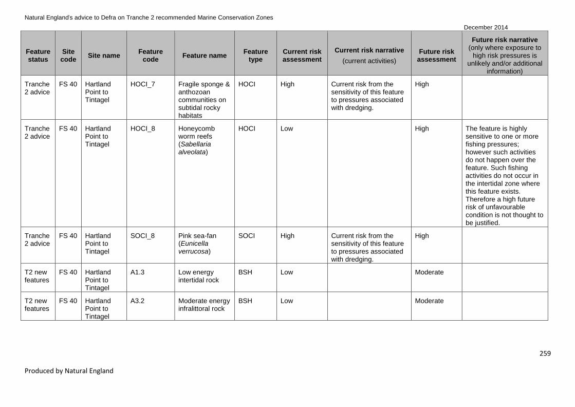
Natural England’s advice to Defra on Tranche 2 recommended Marine Conservation Zones
December 2014
259
Produced by Natural England
Feature status
Site code
Site name Feature
code Feature name
Feature type
Current risk assessment
Current risk narrative
(current activities)
Future risk assessment
Future risk narrative (only where exposure to
high risk pressures is unlikely and/or additional
information)
Tranche 2 advice
FS 40 Hartland Point to Tintagel
HOCI_7 Fragile sponge & anthozoan communities on subtidal rocky habitats
HOCI High Current risk from the sensitivity of this feature to pressures associated with dredging.
High
Tranche 2 advice
FS 40 Hartland Point to Tintagel
HOCI_8 Honeycomb worm reefs (Sabellaria alveolata)
HOCI Low High The feature is highly sensitive to one or more fishing pressures; however such activities do not happen over the feature. Such fishing activities do not occur in the intertidal zone where this feature exists. Therefore a high future risk of unfavourable condition is not thought to be justified.
Tranche 2 advice
FS 40 Hartland Point to Tintagel
SOCI_8 Pink sea-fan (Eunicella verrucosa)
SOCI High Current risk from the sensitivity of this feature to pressures associated with dredging.
High
T2 new features
FS 40 Hartland Point to Tintagel
A1.3 Low energy intertidal rock
BSH Low Moderate
T2 new features
FS 40 Hartland Point to Tintagel
A3.2 Moderate energy infralittoral rock
BSH Low Moderate

Natural England’s advice to Defra on Tranche 2 recommended Marine Conservation Zones
December 2014
260
Produced by Natural England
Feature status
Site code
Site name Feature
code Feature name
Feature type
Current risk assessment
Current risk narrative
(current activities)
Future risk assessment
Future risk narrative (only where exposure to
high risk pressures is unlikely and/or additional
information)
T2 new features
FS 40 Hartland Point to Tintagel
A4.1 High energy circalittoral rock
BSH High Current risk from the sensitivity of this feature to pressures associated with benthic trawling and dredging.
Moderate
T2 new features
FS 40 Hartland Point to Tintagel
A4.2 Moderate energy circalittoral rock
BSH High Current risk from the sensitivity of this feature to pressures associated with benthic trawling and dredging.
High
Tranche 2 advice
FS 43 Bideford to Foreland Point
A1.1 High energy intertidal rock
BSH Low Moderate
Tranche 2 advice
FS 43 Bideford to Foreland Point
A1.2 Moderate energy intertidal rock
BSH Low Moderate
Tranche 2 advice
FS 43 Bideford to Foreland Point
A1.3 Low energy intertidal rock
BSH Low Moderate
Tranche 2 advice
FS 43 Bideford to Foreland Point
A2.1 Intertidal coarse sediment
BSH Low Moderate
Tranche 2 advice
FS 43 Bideford to Foreland Point
A2.2 Intertidal sand and muddy sand
BSH Low Moderate
Tranche 2 advice
FS 43 Bideford to Foreland Point
A2.4 Intertidal mixed sediments
BSH Low Moderate

Natural England’s advice to Defra on Tranche 2 recommended Marine Conservation Zones
December 2014
261
Produced by Natural England
Feature status
Site code
Site name Feature
code Feature name
Feature type
Current risk assessment
Current risk narrative
(current activities)
Future risk assessment
Future risk narrative (only where exposure to
high risk pressures is unlikely and/or additional
information)
Tranche 2 advice
FS 43 Bideford to Foreland Point
A3.1 High energy infralittoral rock
BSH Low Moderate
Tranche 2 advice
FS 43 Bideford to Foreland Point
A3.2 Moderate energy infralittoral rock
BSH Low Moderate
Tranche 2 advice
FS 43 Bideford to Foreland Point
A4.1 High energy circalittoral rock
BSH Low Moderate
Tranche 2 advice
FS 43 Bideford to Foreland Point
A5.1 Subtidal coarse sediment
BSH Low Moderate
Tranche 2 advice
FS 43 Bideford to Foreland Point
A5.2 Subtidal sand BSH High Current risk from the sensitivity of this feature to pressures associated with benthic trawling.
High
Tranche 2 advice
FS 43 Bideford to Foreland Point
HOCI_8 Honeycomb worm reefs (Sabellaria alveolata)
HOCI Low High The feature is highly sensitive to one or more pressures; however on the basis of current knowledge exposure to activities creating these pressures would not occur or be minimal. Therefore a high future risk of unfavourable condition is not thought to be justified.

Natural England’s advice to Defra on Tranche 2 recommended Marine Conservation Zones
December 2014
262
Produced by Natural England
Feature status
Site code
Site name Feature
code Feature name
Feature type
Current risk assessment
Current risk narrative
(current activities)
Future risk assessment
Future risk narrative (only where exposure to
high risk pressures is unlikely and/or additional
information)
Tranche 2 advice
FS 43 Bideford to Foreland Point
SOCI_8 Pink sea-fan (Eunicella verrucosa)
SOCI Low High The feature is highly sensitive to one or more pressures; however on the basis of current knowledge exposure to activities creating these pressures would not occur or be minimal. Therefore a high future risk of unfavourable condition is not thought to be justified.
T2 new features
FS 43 Bideford to Foreland Point
A3.3 Low energy infralittoral rock
BSH Low High The feature is highly sensitive to one or more pressures; however on the basis of current knowledge exposure to activities creating these pressures would not occur or be minimal. Therefore a high future risk of unfavourable condition is not thought to be justified.
T2 new features
FS 43 Bideford to Foreland Point
A4.2 Moderate energy circalittoral rock
BSH Low High
T2 new features
FS 43 Bideford to Foreland Point
A5.4 Subtidal mixed sediments
BSH Low Moderate

Natural England’s advice to Defra on Tranche 2 recommended Marine Conservation Zones
December 2014
263
Produced by Natural England
Feature status
Site code
Site name Feature
code Feature name
Feature type
Current risk assessment
Current risk narrative
(current activities)
Future risk assessment
Future risk narrative (only where exposure to
high risk pressures is unlikely and/or additional
information)
T2 new features
FS 43 Bideford to Foreland Point
HOCI_10 Intertidal underboulder communities
HOCI Low Moderate
T2 new features
FS 43 Bideford to Foreland Point
HOCI_11 Littoral chalk communities
HOCI Low Moderate
T2 new features
FS 43 Bideford to Foreland Point
HOCI_5 Estuarine rocky habitats
HOCI Low Moderate
T2 new features
FS 43 Bideford to Foreland Point
HOCI_7 Fragile sponge & anthozoan communities on subtidal rocky habitats
HOCI Low High The feature is highly sensitive to one or more pressures; however on the basis of current knowledge exposure to activities creating these pressures would not occur or be minimal. Therefore a high future risk of unfavourable condition is not thought to be justified.

Natural England’s advice to Defra on Tranche 2 recommended Marine Conservation Zones
December 2014
264
Produced by Natural England
Feature status
Site code
Site name Feature
code Feature name
Feature type
Current risk assessment
Current risk narrative
(current activities)
Future risk assessment
Future risk narrative (only where exposure to
high risk pressures is unlikely and/or additional
information)
T2 new features
FS 43 Bideford to Foreland Point
SOCI_24 Spiny lobster (Palinurus elephas)
SOCI High Palinurus elephas is highly sensitive to potting and particularly the pressure 'removal of target species'. There is a high level of potting in the site, so this is a current risk to this species.
High Palinurus elephas is highly sensitive to potting and particularly the pressure 'removal of target species'. However the Devon and Severn IFCA are in the process of putting in place a potting permit byelaw that will prohibit anyone taking or landing Palinurus elephas within their district. Therefore a high future risk of unfavourable condition is not thought to be justified.
Tranche 2 advice
FS 45 North of Lundy
A4.2 Moderate energy circalittoral rock
BSH High Current risk from the sensitivity of this feature to pressures associated with benthic trawling and dredging.
High
Tranche 2 advice
FS 45 North of Lundy
A5.1 Subtidal coarse sediment
BSH High Current risk from the sensitivity of this feature to pressures associated with benthic trawling and dredging.
Moderate

Natural England’s advice to Defra on Tranche 2 recommended Marine Conservation Zones
December 2014
265
Produced by Natural England
Feature status
Site code
Site name Feature
code Feature name
Feature type
Current risk assessment
Current risk narrative
(current activities)
Future risk assessment
Future risk narrative (only where exposure to
high risk pressures is unlikely and/or additional
information)
Tranche 2 advice
FS 45 North of Lundy
A5.2 Subtidal sand BSH Low High The feature has moderate exposure to benthic trawling and low exposure to dredging. Site-specific information from Annex 6.4 ‘Sediment and Morphological Regime’ of the Atlantic Array Environmental Statement (2013)
12 shows the
subtidal sand is highly mobile, therefore the sensitivity of the feature to the pressures associated with these activities is considered to be low. It is unlikely the levels of these activities will change significantly therefore the feature is at a lower future risk.
12
Channel Energy Ltd (2013). Atlantic Array Offshore Windfarm Environmental Statement: Volume 3: Offshore Annexes: Annex 6.4: Sediment and Morphological Regime [Online]
http://infrastructure.planningportal.gov.uk/wp-content/ipc/uploads/projects/EN010015/2.%20Post-
Submission/Application%20Documents/Environmental%20Statement/6.3.6.4%20Annex%206.4.pdf

Natural England’s advice to Defra on Tranche 2 recommended Marine Conservation Zones
December 2014
266
Produced by Natural England
Feature status
Site code
Site name Feature
code Feature name
Feature type
Current risk assessment
Current risk narrative
(current activities)
Future risk assessment
Future risk narrative (only where exposure to
high risk pressures is unlikely and/or additional
information)
T2 new features
ISCZ 02
West of Walney
A5.2 Subtidal sand BSH High Current risk from the exposure to pressures related to fishing activities. These activities occur across the site so, despite low confidence levels, it can be reasonably assumed that these features are at risk.
High
T2 new features
ISCZ 02
West of Walney
A5.3 Subtidal mud BSH High Current risk from exposure to pressures related to fishing activities.
Moderate
T2 new features
ISCZ 02
West of Walney
HOCI_13 Mud habitats in deep water
HOCI High Current risk from exposure to pressures related to fishing activities.
High
T2 new features
ISCZ 02
West of Walney
HOCI_18 Sea pen and burrowing megafauna communities
HOCI High Current risk from exposure to pressures related to fishing activities. These activities occur across the site so, despite low confidence levels, it can be reasonably assumed that these features are at risk.
High

Natural England’s advice to Defra on Tranche 2 recommended Marine Conservation Zones
December 2014
267
Produced by Natural England
Feature status
Site code
Site name Feature
code Feature name
Feature type
Current risk assessment
Current risk narrative
(current activities)
Future risk assessment
Future risk narrative (only where exposure to
high risk pressures is unlikely and/or additional
information)
T2 new features
ISCZ 02a
Walney and West Duddon Sands CLZ
A5.3 Subtidal mud BSH High Current risk from exposure to pressures related to fishing activities.
Moderate
T2 new features
ISCZ 02a
Walney and West Duddon Sands CLZ
HOCI_13 Mud habitats in deep water
HOCI High Current risk from exposure to pressures related to fishing activities.
High
T2 new features
ISCZ 02a
Walney and West Duddon Sands CLZ
HOCI_18 Sea pen and burrowing megafauna communities
HOCI High Current risk from exposure to pressures related to fishing activities. These activities occur across the site so, despite low confidence levels, it can be reasonably assumed that these features are at risk.
High
T2 new features
ISCZ 02b
Ormonde Co-Location Zone
A5.3 Subtidal mud BSH High Current risk from exposure to pressures related to fishing activities.
Moderate
T2 new features
ISCZ 02b
Ormonde Co-Location Zone
HOCI_13 Mud habitats in deep water
HOCI High Current risk from exposure to pressures related to fishing activities.
High

Natural England’s advice to Defra on Tranche 2 recommended Marine Conservation Zones
December 2014
268
Produced by Natural England
Feature status
Site code
Site name Feature
code Feature name
Feature type
Current risk assessment
Current risk narrative
(current activities)
Future risk assessment
Future risk narrative (only where exposure to
high risk pressures is unlikely and/or additional
information)
T2 new features
ISCZ 02b
Ormonde Co-Location Zone
HOCI_18 Sea pen and burrowing megafauna communities
HOCI High Current risk from exposure to pressures related to fishing activities. These activities occur across the site so, despite low confidence levels, it can be reasonably assumed that these features are at risk.
High
T1 new features
ISCZ 08
Fylde A5.3 Subtidal mud BSH Low Moderate
Tranche 2 advice
ISCZ 10
Allonby Bay A1.1 High energy intertidal rock
BSH Low Moderate

Natural England’s advice to Defra on Tranche 2 recommended Marine Conservation Zones
December 2014
269
Produced by Natural England
Feature status
Site code
Site name Feature
code Feature name
Feature type
Current risk assessment
Current risk narrative
(current activities)
Future risk assessment
Future risk narrative (only where exposure to
high risk pressures is unlikely and/or additional
information)
Tranche 2 advice
ISCZ 10
Allonby Bay A2.7 Intertidal biogenic reefs
BSH Low High Intertidal features unlikely to be exposed to future increases in fishing activity that may create pressures at the benchmark to which the feature is sensitive. Remote location of site means that recreation occurs at a fairly consistent low level. Sabellaria alveolata reefs are partially protected from bottom towed gear by NW IFCA Byelaw 6. Any intertidal fishery, eg for mussels, that were to become viable would be managed by the NW IFCA. NW IFCA management for mussel fisheries in the district prioritises Sabellaria alveolata reef conservation.
Tranche 2 advice
ISCZ 10
Allonby Bay A5.1 Subtidal coarse sediment
BSH Low Moderate

Natural England’s advice to Defra on Tranche 2 recommended Marine Conservation Zones
December 2014
270
Produced by Natural England
Feature status
Site code
Site name Feature
code Feature name
Feature type
Current risk assessment
Current risk narrative
(current activities)
Future risk assessment
Future risk narrative (only where exposure to
high risk pressures is unlikely and/or additional
information)
Tranche 2 advice
ISCZ 10
Allonby Bay A5.2 Subtidal sand BSH Low High Unlikely to be exposed to future increases in fishing activity that may create pressures at the benchmark to which the feature is sensitive. Consistently low level of fishing in the site. A dredge fishery for eg seed mussel that could potentially occur in the site and overlap the feature would be regulated by the NW IFCA.
Tranche 2 advice
ISCZ 10
Allonby Bay HOCI_1 Blue mussel beds
HOCI Low Moderate
Tranche 2 advice
ISCZ 10
Allonby Bay HOCI_15 Peat and clay exposures
HOCI Low High Intertidal features unlikely to be exposed to future increases in fishing activity that may create pressures at the benchmark to which the feature is sensitive. Remote location of site means that recreation occurs at a fairly consistent low level.

Natural England’s advice to Defra on Tranche 2 recommended Marine Conservation Zones
December 2014
271
Produced by Natural England
Feature status
Site code
Site name Feature
code Feature name
Feature type
Current risk assessment
Current risk narrative
(current activities)
Future risk assessment
Future risk narrative (only where exposure to
high risk pressures is unlikely and/or additional
information)
Tranche 2 advice
ISCZ 10
Allonby Bay HOCI_8 Honeycomb worm reefs (Sabellaria alveolata)
HOCI Low High Intertidal features unlikely to be exposed to future increases in fishing activity that may create pressures at the benchmark to which the feature is sensitive. Remote location of site means that recreation occurs at a fairly consistent low level. Sabellaria alveolata reefs are partially protected from bottom towed gear by NW IFCA Byelaw 6. Any intertidal fishery, eg for mussels, that were to become viable would be managed by the NW IFCA. NW IFCA management for mussel fisheries in the district prioritises Sabellaria alveolata reef conservation.
T2 new features
ISCZ 10
Allonby Bay A1.2 Moderate energy intertidal rock
BSH Low Moderate
T2 new features
ISCZ 10
Allonby Bay A1.3 Low energy intertidal rock
BSH Low Moderate
T2 new features
ISCZ 10
Allonby Bay A2.1 Intertidal coarse sediment
BSH Low Moderate

Natural England’s advice to Defra on Tranche 2 recommended Marine Conservation Zones
December 2014
272
Produced by Natural England
Feature status
Site code
Site name Feature
code Feature name
Feature type
Current risk assessment
Current risk narrative
(current activities)
Future risk assessment
Future risk narrative (only where exposure to
high risk pressures is unlikely and/or additional
information)
T2 new features
ISCZ 10
Allonby Bay A2.2 Intertidal sand and muddy sand
BSH Low Moderate
T2 new features
ISCZ 10
Allonby Bay A3.2 Moderate energy infralittoral rock
BSH Low Moderate
T2 new features
ISCZ 10
Allonby Bay A5.4 Subtidal mixed sediments
BSH Low Moderate
Tranche 2 advice
NG 02
Cromer Shoal Chalk Beds
A3.1 High energy infralittoral rock
BSH Low Moderate
Tranche 2 advice
NG 02
Cromer Shoal Chalk Beds
A3.2 Moderate energy infralittoral rock
BSH Low Moderate
Tranche 2 advice
NG 02
Cromer Shoal Chalk Beds
A4.2 Moderate energy circalittoral rock
BSH Low High
Tranche 2 advice
NG 02
Cromer Shoal Chalk Beds
HOCI_20 Subtidal chalk HOCI Low High
Tranche 2 advice
NG 02
Cromer Shoal Chalk Beds
G7 North Norfolk coast (Subtidal)
Geological Low Unknown Future risk narrative not provided for geological features as sensitivity to pressures determined by expert judgement only and not currently included in sensitivity matrix.
T2 new features
NG 02
Cromer Shoal Chalk Beds
A4.1 High energy circalittoral rock
BSH Low Moderate

Natural England’s advice to Defra on Tranche 2 recommended Marine Conservation Zones
December 2014
273
Produced by Natural England
Feature status
Site code
Site name Feature
code Feature name
Feature type
Current risk assessment
Current risk narrative
(current activities)
Future risk assessment
Future risk narrative (only where exposure to
high risk pressures is unlikely and/or additional
information)
T2 new features
NG 02
Cromer Shoal Chalk Beds
A5.1 Subtidal coarse sediment
BSH Low Moderate
T2 new features
NG 02
Cromer Shoal Chalk Beds
A5.2 Subtidal sand BSH Low High
T2 new features
NG 02
Cromer Shoal Chalk Beds
A5.4 Subtidal mixed sediments
BSH Low Moderate
T2 new features
NG 02
Cromer Shoal Chalk Beds
HOCI_15 Peat and clay exposures
HOCI Low High
Tranche 2 advice
NG 08
Holderness Inshore
A2.4 Intertidal mixed sediments
BSH Low Moderate
Tranche 2 advice
NG 08
Holderness Inshore
A5.1 Subtidal coarse sediment
BSH Low Moderate
Tranche 2 advice
NG 08
Holderness Inshore
A5.2 Subtidal sand BSH Low High Although the feature is highly sensitive to one or more pressures associated with benthic trawling and dredging, it is unlikely these activities would take place because the site is already subject to a byelaw that prohibits all dredging and trawling; as such the feature is at a lower future risk.

Natural England’s advice to Defra on Tranche 2 recommended Marine Conservation Zones
December 2014
274
Produced by Natural England
Feature status
Site code
Site name Feature
code Feature name
Feature type
Current risk assessment
Current risk narrative
(current activities)
Future risk assessment
Future risk narrative (only where exposure to
high risk pressures is unlikely and/or additional
information)
Tranche 2 advice
NG 08
Holderness Inshore
HOCI_15 Peat and clay exposures
HOCI Low High Although the feature is highly sensitive to one or more pressures associated with benthic trawling and dredging, it is unlikely these activities would take place because the site is already subject to a byelaw that prohibits all dredging and trawling; as such the feature is at a lower future risk.
Tranche 2 advice
NG 08
Holderness Inshore
HOCI_16 Ross worm reefs (Sabellaria spinulosa)
HOCI Low High While the feature is highly sensitive to one or more pressures associated with fishing activities (including trawling, traps, anchored nets and lines), it is unlikely based on current knowledge of relevant activities that significant levels of exposure will be reached; as such the feature is at lower future risk.

Natural England’s advice to Defra on Tranche 2 recommended Marine Conservation Zones
December 2014
275
Produced by Natural England
Feature status
Site code
Site name Feature
code Feature name
Feature type
Current risk assessment
Current risk narrative
(current activities)
Future risk assessment
Future risk narrative (only where exposure to
high risk pressures is unlikely and/or additional
information)
Tranche 2 advice
NG 08
Holderness Inshore
G13 Spurn Head (Subtidal)
Geological Low Unknown Future risk narrative not provided for geological features as sensitivity to pressures determined by expert judgement only and not currently included in sensitivity matrix.
T2 new features
NG 08
Holderness Inshore
A2.2 Intertidal sand and muddy sand
BSH Low Moderate
T2 new features
NG 08
Holderness Inshore
A4.1 High energy circalittoral rock
BSH Low Moderate
T2 new features
NG 08
Holderness Inshore
A4.2 Moderate energy circalittoral rock
BSH Low High While the feature is highly sensitive to one or more pressures associated with fishing activities (including trawling, traps, anchored nets and lines) and military activities, it is unlikely based on current knowledge of relevant activities that significant levels of exposure will be reached; as such the feature is at lower future risk.
T2 new features
NG 08
Holderness Inshore
A5.3 Subtidal mud BSH Low Moderate
T2 new features
NG 08
Holderness Inshore
A5.4 Subtidal mixed sediments
BSH Low Moderate

Natural England’s advice to Defra on Tranche 2 recommended Marine Conservation Zones
December 2014
276
Produced by Natural England
Feature status
Site code
Site name Feature
code Feature name
Feature type
Current risk assessment
Current risk narrative
(current activities)
Future risk assessment
Future risk narrative (only where exposure to
high risk pressures is unlikely and/or additional
information)
Tranche 2 advice
NG 11
Runswick Bay
A3.1 High energy infralittoral rock
BSH Low Moderate
Tranche 2 advice
NG 11
Runswick Bay
A3.2 Moderate energy infralittoral rock
BSH Low Moderate
Tranche 2 advice
NG 11
Runswick Bay
A4.1 High energy circalittoral rock
BSH Low Moderate
Tranche 2 advice
NG 11
Runswick Bay
A4.2 Moderate energy circalittoral rock
BSH Low High The feature is highly sensitive to one or more pressures; however on the basis of current knowledge relevant activities are unlikely to reach levels of exposure within the site that would put this feature at high risk of unfavourable condition. Therefore a high future risk of unfavourable condition is not thought to be justified.
Tranche 2 advice
NG 11
Runswick Bay
A5.1 Subtidal coarse sediment
BSH Low Moderate

Natural England’s advice to Defra on Tranche 2 recommended Marine Conservation Zones
December 2014
277
Produced by Natural England
Feature status
Site code
Site name Feature
code Feature name
Feature type
Current risk assessment
Current risk narrative
(current activities)
Future risk assessment
Future risk narrative (only where exposure to
high risk pressures is unlikely and/or additional
information)
Tranche 2 advice
NG 11
Runswick Bay
A5.2 Subtidal sand BSH Low High The feature is highly sensitive to one or more pressures; however on the basis of current knowledge relevant activities are unlikely to reach levels of exposure within the site that would put this feature at high risk of unfavourable condition. Therefore a high future risk of unfavourable condition is not thought to be justified.
Tranche 2 advice
NG 11
Runswick Bay
A5.4 Subtidal mixed sediments
BSH Low Moderate
Tranche 2 advice
NG 11
Runswick Bay
SOCI_3 Ocean quahog (Arctica islandica)
SOCI Low High The feature is highly sensitive to one or more pressures; however on the basis of current knowledge relevant activities are unlikely to reach levels of exposure within the site that would put this feature at high risk of unfavourable condition. Therefore a high future risk of unfavourable condition is not thought to be justified.
T2 new features
NG 11
Runswick Bay
A1.1 High energy intertidal rock
BSH Low Moderate

Natural England’s advice to Defra on Tranche 2 recommended Marine Conservation Zones
December 2014
278
Produced by Natural England
Feature status
Site code
Site name Feature
code Feature name
Feature type
Current risk assessment
Current risk narrative
(current activities)
Future risk assessment
Future risk narrative (only where exposure to
high risk pressures is unlikely and/or additional
information)
T2 new features
NG 11
Runswick Bay
A1.2 Moderate energy intertidal rock
BSH Low Moderate
T2 new features
NG 11
Runswick Bay
A1.3 Low energy intertidal rock
BSH Low Moderate
T2 new features
NG 11
Runswick Bay
A2.2 Intertidal sand and muddy sand
BSH Low Moderate
Tranche 2 advice
NG 13
Coquet to St Mary's
A1.2 Moderate energy intertidal rock
BSH Low Moderate
Tranche 2 advice
NG 13
Coquet to St Mary's
A1.3 Low energy intertidal rock
BSH Low Moderate
Tranche 2 advice
NG 13
Coquet to St Mary's
A2.1 Intertidal coarse sediment
BSH Low Moderate
Tranche 2 advice
NG 13
Coquet to St Mary's
A2.2 Intertidal sand and muddy sand
BSH Low Moderate
Tranche 2 advice
NG 13
Coquet to St Mary's
A2.3 Intertidal mud BSH Low High The feature is highly sensitive to one or more pressures; however on the basis of current knowledge relevant activities are unlikely to reach levels of exposure within the site that would put this feature at high risk of unfavourable condition. Therefore a high future risk of unfavourable condition is not thought to be justified.

Natural England’s advice to Defra on Tranche 2 recommended Marine Conservation Zones
December 2014
279
Produced by Natural England
Feature status
Site code
Site name Feature
code Feature name
Feature type
Current risk assessment
Current risk narrative
(current activities)
Future risk assessment
Future risk narrative (only where exposure to
high risk pressures is unlikely and/or additional
information)
Tranche 2 advice
NG 13
Coquet to St Mary's
A2.4 Intertidal mixed sediments
BSH Low Moderate
Tranche 2 advice
NG 13
Coquet to St Mary's
A3.1 High energy infralittoral rock
BSH Low Moderate
Tranche 2 advice
NG 13
Coquet to St Mary's
A3.2 Moderate energy infralittoral rock
BSH Low Moderate
Tranche 2 advice
NG 13
Coquet to St Mary's
A4.2 Moderate energy circalittoral rock
BSH Low High The feature is highly sensitive to one or more pressures; however on the basis of current knowledge relevant activities are unlikely to reach levels of exposure within the site that would put this feature at high risk of unfavourable condition. Therefore a high future risk of unfavourable condition is not thought to be justified.
Tranche 2 advice
NG 13
Coquet to St Mary's
A5.1 Subtidal coarse sediment
BSH Low Moderate

Natural England’s advice to Defra on Tranche 2 recommended Marine Conservation Zones
December 2014
280
Produced by Natural England
Feature status
Site code
Site name Feature
code Feature name
Feature type
Current risk assessment
Current risk narrative
(current activities)
Future risk assessment
Future risk narrative (only where exposure to
high risk pressures is unlikely and/or additional
information)
Tranche 2 advice
NG 13
Coquet to St Mary's
A5.2 Subtidal sand BSH Low High The feature is highly sensitive to one or more pressures; however on the basis of current knowledge relevant activities are unlikely to reach levels of exposure within the site that would put this feature at high risk of unfavourable condition. Therefore a high future risk of unfavourable condition is not thought to be justified.
Tranche 2 advice
NG 13
Coquet to St Mary's
A5.3 Subtidal mud BSH Low Moderate
Tranche 2 advice
NG 13
Coquet to St Mary's
A5.4 Subtidal mixed sediments
BSH Low Moderate
Tranche 2 advice
NG 13
Coquet to St Mary's
HOCI_10 Intertidal underboulder communities
HOCI Low Moderate
T2 new features
NG 13
Coquet to St Mary's
A1.1 High energy intertidal rock
BSH Low Moderate

Natural England’s advice to Defra on Tranche 2 recommended Marine Conservation Zones
December 2014
281
Produced by Natural England
Feature status
Site code
Site name Feature
code Feature name
Feature type
Current risk assessment
Current risk narrative
(current activities)
Future risk assessment
Future risk narrative (only where exposure to
high risk pressures is unlikely and/or additional
information)
T2 new features
NG 13
Coquet to St Mary's
HOCI_15 Peat and clay exposures
HOCI Low High The feature is highly sensitive to one or more pressures; however on the basis of current knowledge relevant activities are unlikely to reach levels of exposure within the site that would put this feature at high risk of unfavourable condition. Therefore a high future risk of unfavourable condition is not thought to be justified.
T2 new features
NG 13
Coquet to St Mary's
SOCI_3 Ocean quahog (Arctica islandica)
SOCI High Although trawling pressure is low in the site, the feature is highly sensitive to the removal of non-target features and sub-surface penetration. There are four records of this species, currently concentrated in the south-east of the site. Verification surveys may find further records in similar habitats across the wider site.
High

Natural England’s advice to Defra on Tranche 2 recommended Marine Conservation Zones
December 2014
282
Produced by Natural England
4.6.4 New Tranche 1 features
The features listed in Table 7 (below) were not designated in 2013 as part of Tranche 1, though the sites
they are located in were designated in 2013 for other features. These new features have been brought
forward during Tranche 2 for consideration by Defra, and our 2013 advice for these features is
resubmitted below. For details of the evidence underlying the features please see Table 2.
Please note that the following three ‘new Tranche 1 features’ are listed in Table 5 – ‘General
management approach and confidence in feature condition (Protocol F score)’ as a vulnerability
assessment has been carried out in 2014 for them. It was felt for these features that new activity data
and/or information on sensitivity or exposure warranted a review of the GMA. No new evidence has been
provided on presence and extent of these features since 2013, so the existing confidence assessments
have been carried forward.
Fylde MCZ (ISCZ 08) Subtidal mud (A5.3)
Torbay MCZ (FS 22) Peat and clay exposures (HOCI_15)
Upper Fowey and Pont Pill (FS 29) Intertidal sand and muddy sand (A2.2)

Natural England’s advice to Defra on Tranche 2 recommended Marine Conservation Zones
December 2014
283
Produced by Natural England
Table 7 New Tranche 1 features and their recommended conservation objectives from 2013
Feature
status Site code Site name
Feature
code Feature name
Feature
type CO 2012
2013
recommended
conservation
objective
2013
confidence
in
condition
Rationale for
conservation objective
changes in 2013
T1 feature FS 16 South Dorset A4.2 Moderate energy
circalittoral rock
BSH Recover Recover Moderate No change
T1 feature FS 19 Chesil
Beach and
Stennis
Ledges
A3.1 High energy
infralittoral rock
BSH Recover Recover Low No change
T1 feature FS 19 Chesil
Beach and
Stennis
Ledges
A5.1 Subtidal coarse
sediment
BSH Recover Recover Low No change
T1 feature FS 32
The
Manacles
A5.1 Subtidal coarse
sediment
BSH Maintain Recover Low This feature was identified
in the 2012 EA verification
surveys as stable sediment
with pink sea-fan growing
in it. As a result it is likely
to be vulnerable to benthic
trawling which is shown to
overlay this feature in both
the fisheries sensitivity
mapping and through the
consultation information

Natural England’s advice to Defra on Tranche 2 recommended Marine Conservation Zones
December 2014
284
Produced by Natural England
Feature
status Site code Site name
Feature
code Feature name
Feature
type CO 2012
2013
recommended
conservation
objective
2013
confidence
in
condition
Rationale for
conservation objective
changes in 2013
T1 feature FS 32 The
Manacles
A5.4 Subtidal mixed
sediments
BSH Maintain Recover Low Subtidal coarse sediment
was identified in the 2012
EA verification surveys as
stable sediment with pink
sea-fan growing in it.
Subtidal mixed sediments,
directly adjacent to the
subtidal coarse sediment,
is therefore also assumed
to be stable and as a result
it is likely to be vulnerable
to benthic trawling which is
shown to overlay this
feature in both the fisheries
sensitivity mapping and
through the consultation
information

Natural England’s advice to Defra on Tranche 2 recommended Marine Conservation Zones
December 2014
285
Produced by Natural England
Feature
status Site code Site name
Feature
code Feature name
Feature
type CO 2012
2013
recommended
conservation
objective
2013
confidence
in
condition
Rationale for
conservation objective
changes in 2013
T1 feature FS 32 The
Manacles
SOCI_8 Pink sea-fan
(Eunicella verrucosa)
SOCI Maintain Recover Moderate Pink sea-fans were
recorded on subtidal
coarse sediment in the
2012 EA verification
surveys. The feature is
likely to be vulnerable to
benthic trawling which is
shown to overlay this
feature in both the fisheries
sensitivity mapping and
through the consultation
information

Natural England’s advice to Defra on Tranche 2 recommended Marine Conservation Zones
December 2014
286
Produced by Natural England
4.7 Advice on the scientific basis to support feature/site designation
4.7.1 Summary of results
Feature-level data sufficiency considerations:
A total of 369 features were examined during the data sufficiency analysis excluding those in separate
zones in the West of Walney (including proposed co-location zone) rMCZ and geological features. The
features in the separate zones in the West of Walney (including proposed co-location zone) rMCZ are
replicates of those already analysed in the overall site as a whole and therefore did not require a
separate sufficiency assessment. As discussed in Section 4.2.1, geological features were not reassessed
for this advice and therefore did not require a sufficiency assessment as our 2012 advice was deemed
suitable. The non_ENG mobile features are included in Table 8 for completeness only and contribute to
the following figures:
For 228 features the data were considered sufficient to support the designation of the feature.
For one feature the conservation benefits were considered to support priority feature designation.
For 26 features the scientific evidence did not justify designation at this stage.
22 features should be further considered.
92 features were not assessed due to a vulnerability assessment not being conducted.
Site-level data sufficiency considerations:
Across all sites no instances were identified where confidence in a ‘supporting feature’ would be
too low for it to be designated based on usual considerations.
The proportion of total site area where features meet the data sufficiency requirements for
designation was able to be calculated for 13 sites; the average area across these sites meeting
the feature sufficiency criteria was 94%.
Out of the 21 sites being considered for the first time through Tranche 2: 12 are identified as still
filling ‘big gaps’, with a further four sites that ‘may fill a big gap’.
4.7.2 Introduction to Tables 8 and 9
Tables 8 and 9 provide our analysis as to whether a feature or site has enough scientific evidence to
support its designation as described in the guidance note: ‘MCZ Levels of Evidence – Advice on when
data supports a feature/site for designation from a scientific, evidence-based perspective’ (JNCC and
Natural England, 2014).
Table 8 provides the results of the feature-level ‘sufficiency assessment’ process. This draws on the
feature confidence assessments displayed in Table 1, together with information on which features are at
‘high risk’ (on the basis of either current or future risk) from Table 6. Information on which features may
‘contribute to filling a big gap’ in the network based on JNCC’s Big Gap Analysis (JNCC, 2014) was used
and supplemented by further advice from JNCC. Please note: Q2 is only considered for features which
are not already considered sufficient on the basis of Q1 (ie on the basis of their confidence in presence
and extent alone), thus returning an N/A (Not Applicable) result; ‘Not Assessed’ refers to instances where
Q2 was not completed due to vulnerability assessments for these features not being undertaken.
Table 9 provides the results of the site-level ‘sufficiency assessment’ process. Please note that Q2 will
NOT be calculated where a recommended MCZ overlaps with a SAC or where the site is defined by
estuarine landward boundaries (JNCC and Natural England, 2014). The analysis provided therefore used
a cut-off of 10% for SAC overlaps. Where the site overlaps an SAC by >10% Q2 has not been answered.
Additionally, where presence / extent data has been derived primarily from point data or where a feature
is an addition to a Tranche 1 designated site, Q2 has not been answered. In these instances the Q2

Natural England’s advice to Defra on Tranche 2 recommended Marine Conservation Zones
December 2014
287
Produced by Natural England
calculation would be misleading and has therefore not been presented. Where sites are identified as
filling a ‘big gap’ this information can be found in Table 8.

Natural England’s advice to Defra on Tranche 2 recommended Marine Conservation Zones December 2014
288
Produced by Natural England
Table 8 Feature data sufficiency assessment S
ite n
am
e
Featu
re s
tatu
s
Featu
re n
am
e
Featu
re t
yp
e
Q1a. C
on
fid
en
ce s
co
re o
f at
lea
st
mo
dera
te f
or
featu
re p
res
en
ce?
Q1b
. Is
1a b
ased
on
ly o
n p
are
nt
hab
itat
bein
g p
resen
t?
Q1c. C
on
fid
en
ce s
co
re o
f at
lea
st
mo
dera
te f
or
exte
nt
/ d
istr
ibu
tio
n?
Ou
tco
me f
rom
qu
esti
on
1
asse
ssm
en
t: A
re t
he
re e
no
ug
h
data
to
su
pp
ort
featu
re
desig
nati
on
?
Do
es f
eatu
re c
on
trib
ute
to
fillin
g a
‘big
gap
’ in
MP
A n
etw
ork
based
on
JN
CC
Big
Gap
s A
naly
sis
(vers
ion
5)
Q2a:
Do
es t
he
featu
re c
on
trib
ute
to
fillin
g a
‘b
ig g
ap
’ in
th
e n
etw
ork
AN
D h
av
e c
on
fid
en
ce s
co
re o
f at
least
mo
de
rate
fo
r fe
atu
re
pre
sen
ce?
Q2b
: Is
th
e f
eatu
re a
t h
igh
ris
k o
f
dam
ag
e?
Ou
tco
me f
rom
qu
esti
on
2
asse
ssm
en
t: A
re t
he
re a
dd
itio
nal
co
nserv
ati
on
/ e
co
log
ical
co
nsid
era
tio
ns t
hat
su
pp
ort
desig
nati
on
?
Are
new
data
co
min
g t
hat
are
lik
ely
to im
pro
ve f
eatu
re c
on
fid
en
ce
?
Co
mm
en
ts r
eg
ard
ing
‘n
ew
data
co
min
g’
Blackwater, Crouch, Roach and Colne Estuary
T1 new features
Subtidal biogenic
reefs
BSH Yes No Yes Yes Yes N/A N/A N/A
The Swale Estuary
Tranche 2 advice
Low energy intertidal rock
BSH Yes No Yes Yes No N/A N/A N/A
The Swale Estuary
Tranche 2 advice
Low energy infralittoral
rock
BSH No No No Move to Q2
Yes No Not Assessed
Not Assessed
The Swale Estuary
Tranche 2 advice
Subtidal sand
BSH Yes No Yes Yes No N/A N/A N/A
The Swale Estuary
Tranche 2 advice
Subtidal mud BSH Yes No Yes Yes No N/A N/A N/A
The Swale Estuary
Tranche 2 advice
Subtidal mixed
sediments
BSH Yes No Yes Yes No N/A N/A N/A
The Swale Estuary
Tranche 2 advice
Blue mussel beds
HOCI Yes No Yes Yes No N/A N/A N/A
The Swale Tranche Peat and HOCI Yes No Yes Yes No N/A N/A N/A

Natural England’s advice to Defra on Tranche 2 recommended Marine Conservation Zones December 2014
289
Produced by Natural England
Sit
e n
am
e
Featu
re s
tatu
s
Featu
re n
am
e
Featu
re t
yp
e
Q1a. C
on
fid
en
ce s
co
re o
f at
lea
st
mo
dera
te f
or
featu
re p
res
en
ce?
Q1b
. Is
1a b
ased
on
ly o
n p
are
nt
hab
itat
bein
g p
resen
t?
Q1c. C
on
fid
en
ce s
co
re o
f at
lea
st
mo
dera
te f
or
exte
nt
/ d
istr
ibu
tio
n?
Ou
tco
me f
rom
qu
esti
on
1
asse
ssm
en
t: A
re t
he
re e
no
ug
h
data
to
su
pp
ort
featu
re
desig
nati
on
?
Do
es f
eatu
re c
on
trib
ute
to
fillin
g a
‘big
gap
’ in
MP
A n
etw
ork
based
on
JN
CC
Big
Gap
s A
naly
sis
(vers
ion
5)
Q2a:
Do
es t
he
featu
re c
on
trib
ute
to
fillin
g a
‘b
ig g
ap
’ in
th
e n
etw
ork
AN
D h
av
e c
on
fid
en
ce s
co
re o
f at
least
mo
de
rate
fo
r fe
atu
re
pre
sen
ce?
Q2b
: Is
th
e f
eatu
re a
t h
igh
ris
k o
f
dam
ag
e?
Ou
tco
me f
rom
qu
esti
on
2
asse
ssm
en
t: A
re t
he
re a
dd
itio
nal
co
nserv
ati
on
/ e
co
log
ical
co
nsid
era
tio
ns t
hat
su
pp
ort
desig
nati
on
?
Are
new
data
co
min
g t
hat
are
lik
ely
to im
pro
ve f
eatu
re c
on
fid
en
ce
?
Co
mm
en
ts r
eg
ard
ing
‘n
ew
data
co
min
g’
Estuary 2 advice clay exposures
The Swale Estuary
Tranche 2 advice
Ross worm reefs
(Sabellaria spinulosa)
HOCI No No No Move to Q2
No No Not Assessed
Not Assessed
The Swale Estuary
Tranche 2 advice
Sheltered muddy gravels
HOCI No No No Move to Q2
No No Yes Further Consideration
The Swale Estuary
Tranche 2 advice
Native oyster (Ostrea edulis)
SOCI Yes No No Move to Q2
Yes Yes Yes Priority feature designation
The Swale Estuary
T2 new features
Moderate energy
intertidal rock
BSH Yes No Yes Yes No N/A N/A N/A
The Swale Estuary
T2 new features
Intertidal coarse
sediment
BSH Yes No Yes Yes No N/A N/A N/A
The Swale Estuary
T2 new features
Intertidal sand and
muddy sand
BSH Yes No Yes Yes No N/A N/A N/A
The Swale T2 new Intertidal BSH Yes No Yes Yes No N/A N/A N/A

Natural England’s advice to Defra on Tranche 2 recommended Marine Conservation Zones December 2014
290
Produced by Natural England
Sit
e n
am
e
Featu
re s
tatu
s
Featu
re n
am
e
Featu
re t
yp
e
Q1a. C
on
fid
en
ce s
co
re o
f at
lea
st
mo
dera
te f
or
featu
re p
res
en
ce?
Q1b
. Is
1a b
ased
on
ly o
n p
are
nt
hab
itat
bein
g p
resen
t?
Q1c. C
on
fid
en
ce s
co
re o
f at
lea
st
mo
dera
te f
or
exte
nt
/ d
istr
ibu
tio
n?
Ou
tco
me f
rom
qu
esti
on
1
asse
ssm
en
t: A
re t
he
re e
no
ug
h
data
to
su
pp
ort
featu
re
desig
nati
on
?
Do
es f
eatu
re c
on
trib
ute
to
fillin
g a
‘big
gap
’ in
MP
A n
etw
ork
based
on
JN
CC
Big
Gap
s A
naly
sis
(vers
ion
5)
Q2a:
Do
es t
he
featu
re c
on
trib
ute
to
fillin
g a
‘b
ig g
ap
’ in
th
e n
etw
ork
AN
D h
av
e c
on
fid
en
ce s
co
re o
f at
least
mo
de
rate
fo
r fe
atu
re
pre
sen
ce?
Q2b
: Is
th
e f
eatu
re a
t h
igh
ris
k o
f
dam
ag
e?
Ou
tco
me f
rom
qu
esti
on
2
asse
ssm
en
t: A
re t
he
re a
dd
itio
nal
co
nserv
ati
on
/ e
co
log
ical
co
nsid
era
tio
ns t
hat
su
pp
ort
desig
nati
on
?
Are
new
data
co
min
g t
hat
are
lik
ely
to im
pro
ve f
eatu
re c
on
fid
en
ce
?
Co
mm
en
ts r
eg
ard
ing
‘n
ew
data
co
min
g’
Estuary features mixed sediments
The Swale Estuary
T2 new features
Subtidal coarse
sediment
BSH Yes No Yes Yes No N/A N/A N/A
The Swale Estuary
T2 new features
Subtidal biogenic
reefs
BSH No No No Move to Q2
No No Not Assessed
Not Assessed
The Swale Estuary
T2 new features
Estuarine rocky
habitats
HOCI Yes No Yes Yes No N/A N/A N/A
The Swale Estuary
T2 new features
Smelt (Osmerus eperlanus)
SOCI Yes No Yes Yes Yes N/A N/A N/A
Dover to Deal
Tranche 2 advice
Moderate energy
intertidal rock
BSH Yes No Yes Yes No N/A N/A N/A
Dover to Deal
Tranche 2 advice
Intertidal coarse
sediment
BSH No No No Move to Q2
No No No No designation
Dover to Deal
Tranche 2 advice
Intertidal mud
BSH No No No Move to Q2
No No Yes Further Consideration

Natural England’s advice to Defra on Tranche 2 recommended Marine Conservation Zones December 2014
291
Produced by Natural England
Sit
e n
am
e
Featu
re s
tatu
s
Featu
re n
am
e
Featu
re t
yp
e
Q1a. C
on
fid
en
ce s
co
re o
f at
lea
st
mo
dera
te f
or
featu
re p
res
en
ce?
Q1b
. Is
1a b
ased
on
ly o
n p
are
nt
hab
itat
bein
g p
resen
t?
Q1c. C
on
fid
en
ce s
co
re o
f at
lea
st
mo
dera
te f
or
exte
nt
/ d
istr
ibu
tio
n?
Ou
tco
me f
rom
qu
esti
on
1
asse
ssm
en
t: A
re t
he
re e
no
ug
h
data
to
su
pp
ort
featu
re
desig
nati
on
?
Do
es f
eatu
re c
on
trib
ute
to
fillin
g a
‘big
gap
’ in
MP
A n
etw
ork
based
on
JN
CC
Big
Gap
s A
naly
sis
(vers
ion
5)
Q2a:
Do
es t
he
featu
re c
on
trib
ute
to
fillin
g a
‘b
ig g
ap
’ in
th
e n
etw
ork
AN
D h
av
e c
on
fid
en
ce s
co
re o
f at
least
mo
de
rate
fo
r fe
atu
re
pre
sen
ce?
Q2b
: Is
th
e f
eatu
re a
t h
igh
ris
k o
f
dam
ag
e?
Ou
tco
me f
rom
qu
esti
on
2
asse
ssm
en
t: A
re t
he
re a
dd
itio
nal
co
nserv
ati
on
/ e
co
log
ical
co
nsid
era
tio
ns t
hat
su
pp
ort
desig
nati
on
?
Are
new
data
co
min
g t
hat
are
lik
ely
to im
pro
ve f
eatu
re c
on
fid
en
ce
?
Co
mm
en
ts r
eg
ard
ing
‘n
ew
data
co
min
g’
Dover to Deal
Tranche 2 advice
High energy infralittoral
rock
BSH No No No Move to Q2
No No Not Assessed
Not Assessed
Dover to Deal
Tranche 2 advice
Moderate energy
infralittoral rock
BSH Yes No Yes Yes No N/A N/A N/A
Dover to Deal
Tranche 2 advice
Subtidal coarse
sediment
BSH No No No Move to Q2
Yes No No No designation
Dover to Deal
Tranche 2 advice
Subtidal mixed
sediments
BSH Yes No Yes Yes Yes N/A N/A N/A
Dover to Deal
Tranche 2 advice
Blue mussel beds
HOCI Yes No Yes Yes No N/A N/A N/A
Dover to Deal
Tranche 2 advice
Intertidal underboulder communities
HOCI Yes No Yes Yes Yes N/A N/A N/A
Dover to Deal
Tranche 2 advice
Littoral chalk communities
HOCI Yes No Yes Yes No N/A N/A N/A
Dover to Deal
Tranche 2 advice
Ross worm reefs
HOCI Yes No Yes Yes Yes N/A N/A N/A
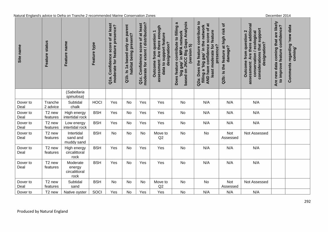
Natural England’s advice to Defra on Tranche 2 recommended Marine Conservation Zones December 2014
292
Produced by Natural England
Sit
e n
am
e
Featu
re s
tatu
s
Featu
re n
am
e
Featu
re t
yp
e
Q1a. C
on
fid
en
ce s
co
re o
f at
lea
st
mo
dera
te f
or
featu
re p
res
en
ce?
Q1b
. Is
1a b
ased
on
ly o
n p
are
nt
hab
itat
bein
g p
resen
t?
Q1c. C
on
fid
en
ce s
co
re o
f at
lea
st
mo
dera
te f
or
exte
nt
/ d
istr
ibu
tio
n?
Ou
tco
me f
rom
qu
esti
on
1
asse
ssm
en
t: A
re t
he
re e
no
ug
h
data
to
su
pp
ort
featu
re
desig
nati
on
?
Do
es f
eatu
re c
on
trib
ute
to
fillin
g a
‘big
gap
’ in
MP
A n
etw
ork
based
on
JN
CC
Big
Gap
s A
naly
sis
(vers
ion
5)
Q2a:
Do
es t
he
featu
re c
on
trib
ute
to
fillin
g a
‘b
ig g
ap
’ in
th
e n
etw
ork
AN
D h
av
e c
on
fid
en
ce s
co
re o
f at
least
mo
de
rate
fo
r fe
atu
re
pre
sen
ce?
Q2b
: Is
th
e f
eatu
re a
t h
igh
ris
k o
f
dam
ag
e?
Ou
tco
me f
rom
qu
esti
on
2
asse
ssm
en
t: A
re t
he
re a
dd
itio
nal
co
nserv
ati
on
/ e
co
log
ical
co
nsid
era
tio
ns t
hat
su
pp
ort
desig
nati
on
?
Are
new
data
co
min
g t
hat
are
lik
ely
to im
pro
ve f
eatu
re c
on
fid
en
ce
?
Co
mm
en
ts r
eg
ard
ing
‘n
ew
data
co
min
g’
(Sabellaria spinulosa)
Dover to Deal
Tranche 2 advice
Subtidal chalk
HOCI Yes No Yes Yes No N/A N/A N/A
Dover to Deal
T2 new features
High energy intertidal rock
BSH Yes No Yes Yes No N/A N/A N/A
Dover to Deal
T2 new features
Low energy intertidal rock
BSH Yes No Yes Yes No N/A N/A N/A
Dover to Deal
T2 new features
Intertidal sand and
muddy sand
BSH No No No Move to Q2
No No Not Assessed
Not Assessed
Dover to Deal
T2 new features
High energy circalittoral
rock
BSH Yes No Yes Yes No N/A N/A N/A
Dover to Deal
T2 new features
Moderate energy
circalittoral rock
BSH Yes No Yes Yes No N/A N/A N/A
Dover to Deal
T2 new features
Subtidal sand
BSH No No No Move to Q2
No No Not Assessed
Not Assessed
Dover to T2 new Native oyster SOCI Yes No Yes Yes No N/A N/A N/A

Natural England’s advice to Defra on Tranche 2 recommended Marine Conservation Zones December 2014
293
Produced by Natural England
Sit
e n
am
e
Featu
re s
tatu
s
Featu
re n
am
e
Featu
re t
yp
e
Q1a. C
on
fid
en
ce s
co
re o
f at
lea
st
mo
dera
te f
or
featu
re p
res
en
ce?
Q1b
. Is
1a b
ased
on
ly o
n p
are
nt
hab
itat
bein
g p
resen
t?
Q1c. C
on
fid
en
ce s
co
re o
f at
lea
st
mo
dera
te f
or
exte
nt
/ d
istr
ibu
tio
n?
Ou
tco
me f
rom
qu
esti
on
1
asse
ssm
en
t: A
re t
he
re e
no
ug
h
data
to
su
pp
ort
featu
re
desig
nati
on
?
Do
es f
eatu
re c
on
trib
ute
to
fillin
g a
‘big
gap
’ in
MP
A n
etw
ork
based
on
JN
CC
Big
Gap
s A
naly
sis
(vers
ion
5)
Q2a:
Do
es t
he
featu
re c
on
trib
ute
to
fillin
g a
‘b
ig g
ap
’ in
th
e n
etw
ork
AN
D h
av
e c
on
fid
en
ce s
co
re o
f at
least
mo
de
rate
fo
r fe
atu
re
pre
sen
ce?
Q2b
: Is
th
e f
eatu
re a
t h
igh
ris
k o
f
dam
ag
e?
Ou
tco
me f
rom
qu
esti
on
2
asse
ssm
en
t: A
re t
he
re a
dd
itio
nal
co
nserv
ati
on
/ e
co
log
ical
co
nsid
era
tio
ns t
hat
su
pp
ort
desig
nati
on
?
Are
new
data
co
min
g t
hat
are
lik
ely
to im
pro
ve f
eatu
re c
on
fid
en
ce
?
Co
mm
en
ts r
eg
ard
ing
‘n
ew
data
co
min
g’
Deal features (Ostrea edulis)
Dover to Folkestone
Tranche 2 advice
Moderate energy
intertidal rock
BSH Yes No Yes Yes No N/A N/A N/A
Dover to Folkestone
Tranche 2 advice
Intertidal coarse
sediment
BSH Yes No Yes Yes No N/A N/A N/A
Dover to Folkestone
Tranche 2 advice
High energy infralittoral
rock
BSH Yes No Yes Yes No N/A N/A N/A
Dover to Folkestone
Tranche 2 advice
Moderate energy
infralittoral rock
BSH Yes No Yes Yes No N/A N/A N/A
Dover to Folkestone
Tranche 2 advice
Subtidal coarse
sediment
BSH Yes No Yes Yes No N/A N/A N/A
Dover to Folkestone
Tranche 2 advice
Blue mussel beds
HOCI No No No Move to Q2
No No No No designation
Dover to Folkestone
Tranche 2 advice
Intertidal underboulder
HOCI Yes No Yes Yes Yes N/A N/A N/A

Natural England’s advice to Defra on Tranche 2 recommended Marine Conservation Zones December 2014
294
Produced by Natural England
Sit
e n
am
e
Featu
re s
tatu
s
Featu
re n
am
e
Featu
re t
yp
e
Q1a. C
on
fid
en
ce s
co
re o
f at
lea
st
mo
dera
te f
or
featu
re p
res
en
ce?
Q1b
. Is
1a b
ased
on
ly o
n p
are
nt
hab
itat
bein
g p
resen
t?
Q1c. C
on
fid
en
ce s
co
re o
f at
lea
st
mo
dera
te f
or
exte
nt
/ d
istr
ibu
tio
n?
Ou
tco
me f
rom
qu
esti
on
1
asse
ssm
en
t: A
re t
he
re e
no
ug
h
data
to
su
pp
ort
featu
re
desig
nati
on
?
Do
es f
eatu
re c
on
trib
ute
to
fillin
g a
‘big
gap
’ in
MP
A n
etw
ork
based
on
JN
CC
Big
Gap
s A
naly
sis
(vers
ion
5)
Q2a:
Do
es t
he
featu
re c
on
trib
ute
to
fillin
g a
‘b
ig g
ap
’ in
th
e n
etw
ork
AN
D h
av
e c
on
fid
en
ce s
co
re o
f at
least
mo
de
rate
fo
r fe
atu
re
pre
sen
ce?
Q2b
: Is
th
e f
eatu
re a
t h
igh
ris
k o
f
dam
ag
e?
Ou
tco
me f
rom
qu
esti
on
2
asse
ssm
en
t: A
re t
he
re a
dd
itio
nal
co
nserv
ati
on
/ e
co
log
ical
co
nsid
era
tio
ns t
hat
su
pp
ort
desig
nati
on
?
Are
new
data
co
min
g t
hat
are
lik
ely
to im
pro
ve f
eatu
re c
on
fid
en
ce
?
Co
mm
en
ts r
eg
ard
ing
‘n
ew
data
co
min
g’
communities
Dover to Folkestone
Tranche 2 advice
Littoral chalk communities
HOCI Yes No Yes Yes No N/A N/A N/A
Dover to Folkestone
Tranche 2 advice
Peat and clay
exposures
HOCI Yes No Yes Yes Yes N/A N/A N/A
Dover to Folkestone
Tranche 2 advice
Ross worm reefs
(Sabellaria spinulosa)
HOCI Yes No Yes Yes Yes N/A N/A N/A
Dover to Folkestone
Tranche 2 advice
Subtidal chalk
HOCI Yes No Yes Yes No N/A N/A N/A
Dover to Folkestone
Tranche 2 advice
Short-snouted seahorse
(Hippocampus
hippocampus)
SOCI Yes No Yes Yes Yes N/A N/A N/A
Dover to Folkestone
Tranche 2 advice
Native oyster (Ostrea edulis)
SOCI Yes No Yes Yes No N/A N/A N/A
Dover to Folkestone
T2 new features
High energy intertidal rock
BSH Yes No Yes Yes No N/A N/A N/A

Natural England’s advice to Defra on Tranche 2 recommended Marine Conservation Zones December 2014
295
Produced by Natural England
Sit
e n
am
e
Featu
re s
tatu
s
Featu
re n
am
e
Featu
re t
yp
e
Q1a. C
on
fid
en
ce s
co
re o
f at
lea
st
mo
dera
te f
or
featu
re p
res
en
ce?
Q1b
. Is
1a b
ased
on
ly o
n p
are
nt
hab
itat
bein
g p
resen
t?
Q1c. C
on
fid
en
ce s
co
re o
f at
lea
st
mo
dera
te f
or
exte
nt
/ d
istr
ibu
tio
n?
Ou
tco
me f
rom
qu
esti
on
1
asse
ssm
en
t: A
re t
he
re e
no
ug
h
data
to
su
pp
ort
featu
re
desig
nati
on
?
Do
es f
eatu
re c
on
trib
ute
to
fillin
g a
‘big
gap
’ in
MP
A n
etw
ork
based
on
JN
CC
Big
Gap
s A
naly
sis
(vers
ion
5)
Q2a:
Do
es t
he
featu
re c
on
trib
ute
to
fillin
g a
‘b
ig g
ap
’ in
th
e n
etw
ork
AN
D h
av
e c
on
fid
en
ce s
co
re o
f at
least
mo
de
rate
fo
r fe
atu
re
pre
sen
ce?
Q2b
: Is
th
e f
eatu
re a
t h
igh
ris
k o
f
dam
ag
e?
Ou
tco
me f
rom
qu
esti
on
2
asse
ssm
en
t: A
re t
he
re a
dd
itio
nal
co
nserv
ati
on
/ e
co
log
ical
co
nsid
era
tio
ns t
hat
su
pp
ort
desig
nati
on
?
Are
new
data
co
min
g t
hat
are
lik
ely
to im
pro
ve f
eatu
re c
on
fid
en
ce
?
Co
mm
en
ts r
eg
ard
ing
‘n
ew
data
co
min
g’
Dover to Folkestone
T2 new features
Low energy intertidal rock
BSH Yes No Yes Yes No N/A N/A N/A
Dover to Folkestone
T2 new features
Intertidal sand and
muddy sand
BSH Yes No Yes Yes No N/A N/A N/A
Dover to Folkestone
T2 new features
Intertidal mud
BSH No No No Move to Q2
No No Not Assessed
Not Assessed
Dover to Folkestone
T2 new features
Intertidal mixed
sediments
BSH No No No Move to Q2
No No Not Assessed
Not Assessed
Dover to Folkestone
T2 new features
Low energy infralittoral
rock
BSH Yes No No Move to Q2
No No Not Assessed
Not Assessed
Dover to Folkestone
T2 new features
High energy circalittoral
rock
BSH Yes No Yes Yes No N/A N/A N/A
Dover to Folkestone
T2 new features
Moderate energy
circalittoral rock
BSH Yes No Yes Yes No N/A N/A N/A
Dover to Folkestone
T2 new features
Subtidal sand
BSH Yes No Yes Yes No N/A N/A N/A

Natural England’s advice to Defra on Tranche 2 recommended Marine Conservation Zones December 2014
296
Produced by Natural England
Sit
e n
am
e
Featu
re s
tatu
s
Featu
re n
am
e
Featu
re t
yp
e
Q1a. C
on
fid
en
ce s
co
re o
f at
lea
st
mo
dera
te f
or
featu
re p
res
en
ce?
Q1b
. Is
1a b
ased
on
ly o
n p
are
nt
hab
itat
bein
g p
resen
t?
Q1c. C
on
fid
en
ce s
co
re o
f at
lea
st
mo
dera
te f
or
exte
nt
/ d
istr
ibu
tio
n?
Ou
tco
me f
rom
qu
esti
on
1
asse
ssm
en
t: A
re t
he
re e
no
ug
h
data
to
su
pp
ort
featu
re
desig
nati
on
?
Do
es f
eatu
re c
on
trib
ute
to
fillin
g a
‘big
gap
’ in
MP
A n
etw
ork
based
on
JN
CC
Big
Gap
s A
naly
sis
(vers
ion
5)
Q2a:
Do
es t
he
featu
re c
on
trib
ute
to
fillin
g a
‘b
ig g
ap
’ in
th
e n
etw
ork
AN
D h
av
e c
on
fid
en
ce s
co
re o
f at
least
mo
de
rate
fo
r fe
atu
re
pre
sen
ce?
Q2b
: Is
th
e f
eatu
re a
t h
igh
ris
k o
f
dam
ag
e?
Ou
tco
me f
rom
qu
esti
on
2
asse
ssm
en
t: A
re t
he
re a
dd
itio
nal
co
nserv
ati
on
/ e
co
log
ical
co
nsid
era
tio
ns t
hat
su
pp
ort
desig
nati
on
?
Are
new
data
co
min
g t
hat
are
lik
ely
to im
pro
ve f
eatu
re c
on
fid
en
ce
?
Co
mm
en
ts r
eg
ard
ing
‘n
ew
data
co
min
g’
Dover to Folkestone
T2 new features
Subtidal mud BSH Yes No Yes Yes No N/A N/A N/A
Dover to Folkestone
T2 new features
Subtidal mixed
sediments
BSH Yes No Yes Yes No N/A N/A N/A
Dover to Folkestone
T2 new features
Black seabream
(Spondyliosoma
cantharus)
non_ ENG
No No No Move to Q2
No No Not Assessed
Not Assessed
Beachy Head West
T1 new features
High energy circalittoral
rock
BSH Yes No Yes Yes Yes N/A N/A N/A
Beachy Head West
T1 new features
Moderate energy
circalittoral rock
BSH Yes No Yes Yes No N/A N/A N/A
Norris to Ryde
Tranche 2 advice
Subtidal mud BSH Yes No Yes Yes Yes N/A N/A N/A
Norris to Ryde
Tranche 2 advice
Seagrass beds
HOCI Yes No Yes Yes No N/A N/A N/A
Norris to Ryde
Tranche 2 advice
Tentacled lagoon worm
SOCI No No No Move to Q2
No No Yes Further Consideration

Natural England’s advice to Defra on Tranche 2 recommended Marine Conservation Zones December 2014
297
Produced by Natural England
Sit
e n
am
e
Featu
re s
tatu
s
Featu
re n
am
e
Featu
re t
yp
e
Q1a. C
on
fid
en
ce s
co
re o
f at
lea
st
mo
dera
te f
or
featu
re p
res
en
ce?
Q1b
. Is
1a b
ased
on
ly o
n p
are
nt
hab
itat
bein
g p
resen
t?
Q1c. C
on
fid
en
ce s
co
re o
f at
lea
st
mo
dera
te f
or
exte
nt
/ d
istr
ibu
tio
n?
Ou
tco
me f
rom
qu
esti
on
1
asse
ssm
en
t: A
re t
he
re e
no
ug
h
data
to
su
pp
ort
featu
re
desig
nati
on
?
Do
es f
eatu
re c
on
trib
ute
to
fillin
g a
‘big
gap
’ in
MP
A n
etw
ork
based
on
JN
CC
Big
Gap
s A
naly
sis
(vers
ion
5)
Q2a:
Do
es t
he
featu
re c
on
trib
ute
to
fillin
g a
‘b
ig g
ap
’ in
th
e n
etw
ork
AN
D h
av
e c
on
fid
en
ce s
co
re o
f at
least
mo
de
rate
fo
r fe
atu
re
pre
sen
ce?
Q2b
: Is
th
e f
eatu
re a
t h
igh
ris
k o
f
dam
ag
e?
Ou
tco
me f
rom
qu
esti
on
2
asse
ssm
en
t: A
re t
he
re a
dd
itio
nal
co
nserv
ati
on
/ e
co
log
ical
co
nsid
era
tio
ns t
hat
su
pp
ort
desig
nati
on
?
Are
new
data
co
min
g t
hat
are
lik
ely
to im
pro
ve f
eatu
re c
on
fid
en
ce
?
Co
mm
en
ts r
eg
ard
ing
‘n
ew
data
co
min
g’
(Alkmaria romijni)
Norris to Ryde
T2 new features
Low energy intertidal rock
BSH Yes No No Move to Q2
No No Not Assessed
Not Assessed
Norris to Ryde
T2 new features
Subtidal coarse
sediment
BSH No No No Move to Q2
No No Not Assessed
Not Assessed Yes M_00018 EMU limited 2007 subtidal sediments Solent SAC survey – point data require input – (MEDIN contract) – to be available post-con-sultation.
Norris to Ryde
T2 new features
Subtidal sand
BSH No No No Move to Q2
Yes No Not Assessed
Not Assessed Yes M_00018 EMU

Natural England’s advice to Defra on Tranche 2 recommended Marine Conservation Zones December 2014
298
Produced by Natural England
Sit
e n
am
e
Featu
re s
tatu
s
Featu
re n
am
e
Featu
re t
yp
e
Q1a. C
on
fid
en
ce s
co
re o
f at
lea
st
mo
dera
te f
or
featu
re p
res
en
ce?
Q1b
. Is
1a b
ased
on
ly o
n p
are
nt
hab
itat
bein
g p
resen
t?
Q1c. C
on
fid
en
ce s
co
re o
f at
lea
st
mo
dera
te f
or
exte
nt
/ d
istr
ibu
tio
n?
Ou
tco
me f
rom
qu
esti
on
1
asse
ssm
en
t: A
re t
he
re e
no
ug
h
data
to
su
pp
ort
featu
re
desig
nati
on
?
Do
es f
eatu
re c
on
trib
ute
to
fillin
g a
‘big
gap
’ in
MP
A n
etw
ork
based
on
JN
CC
Big
Gap
s A
naly
sis
(vers
ion
5)
Q2a:
Do
es t
he
featu
re c
on
trib
ute
to
fillin
g a
‘b
ig g
ap
’ in
th
e n
etw
ork
AN
D h
av
e c
on
fid
en
ce s
co
re o
f at
least
mo
de
rate
fo
r fe
atu
re
pre
sen
ce?
Q2b
: Is
th
e f
eatu
re a
t h
igh
ris
k o
f
dam
ag
e?
Ou
tco
me f
rom
qu
esti
on
2
asse
ssm
en
t: A
re t
he
re a
dd
itio
nal
co
nserv
ati
on
/ e
co
log
ical
co
nsid
era
tio
ns t
hat
su
pp
ort
desig
nati
on
?
Are
new
data
co
min
g t
hat
are
lik
ely
to im
pro
ve f
eatu
re c
on
fid
en
ce
?
Co
mm
en
ts r
eg
ard
ing
‘n
ew
data
co
min
g’
limited 2007 subtidal sediments Solent SAC survey – point data require input – (MEDIN contract) – to be available post-con-sultation.
Norris to Ryde
T2 new features
Subtidal mixed
sediments
BSH Yes No Yes Yes No N/A N/A N/A
Norris to Ryde
T2 new features
Subtidal macrophyte-dominated sediment
BSH Yes No Yes Yes No N/A N/A N/A
Norris to T2 new Peat and HOCI No No No Move to No No Not Not Assessed

Natural England’s advice to Defra on Tranche 2 recommended Marine Conservation Zones December 2014
299
Produced by Natural England
Sit
e n
am
e
Featu
re s
tatu
s
Featu
re n
am
e
Featu
re t
yp
e
Q1a. C
on
fid
en
ce s
co
re o
f at
lea
st
mo
dera
te f
or
featu
re p
res
en
ce?
Q1b
. Is
1a b
ased
on
ly o
n p
are
nt
hab
itat
bein
g p
resen
t?
Q1c. C
on
fid
en
ce s
co
re o
f at
lea
st
mo
dera
te f
or
exte
nt
/ d
istr
ibu
tio
n?
Ou
tco
me f
rom
qu
esti
on
1
asse
ssm
en
t: A
re t
he
re e
no
ug
h
data
to
su
pp
ort
featu
re
desig
nati
on
?
Do
es f
eatu
re c
on
trib
ute
to
fillin
g a
‘big
gap
’ in
MP
A n
etw
ork
based
on
JN
CC
Big
Gap
s A
naly
sis
(vers
ion
5)
Q2a:
Do
es t
he
featu
re c
on
trib
ute
to
fillin
g a
‘b
ig g
ap
’ in
th
e n
etw
ork
AN
D h
av
e c
on
fid
en
ce s
co
re o
f at
least
mo
de
rate
fo
r fe
atu
re
pre
sen
ce?
Q2b
: Is
th
e f
eatu
re a
t h
igh
ris
k o
f
dam
ag
e?
Ou
tco
me f
rom
qu
esti
on
2
asse
ssm
en
t: A
re t
he
re a
dd
itio
nal
co
nserv
ati
on
/ e
co
log
ical
co
nsid
era
tio
ns t
hat
su
pp
ort
desig
nati
on
?
Are
new
data
co
min
g t
hat
are
lik
ely
to im
pro
ve f
eatu
re c
on
fid
en
ce
?
Co
mm
en
ts r
eg
ard
ing
‘n
ew
data
co
min
g’
Ryde features clay exposures
Q2 Assessed
Norris to Ryde
T2 new features
Sheltered muddy gravels
HOCI Yes No Yes Yes No N/A N/A N/A
Norris to Ryde
T2 new features
Estuarine rocky
habitats
HOCI No No No Move to Q2
No No Not Assessed
Not Assessed
Norris to Ryde
T2 new features
Native oyster (Ostrea edulis)
SOCI Yes No Yes Yes No N/A N/A N/A
The Needles Tranche 2 advice
Subtidal mixed
sediments
BSH Yes No Yes Yes No N/A N/A N/A
The Needles Tranche 2 advice
Seagrass beds
HOCI Yes No Yes Yes No N/A N/A N/A
The Needles Tranche 2 advice
Stalked jellyfish
(Lucernariopsis
campanulata)
SOCI Yes No Yes Yes Yes N/A N/A N/A
The Needles Tranche 2 advice
Peacock's tail (Padina
SOCI Yes No Yes Yes Yes N/A N/A N/A

Natural England’s advice to Defra on Tranche 2 recommended Marine Conservation Zones December 2014
300
Produced by Natural England
Sit
e n
am
e
Featu
re s
tatu
s
Featu
re n
am
e
Featu
re t
yp
e
Q1a. C
on
fid
en
ce s
co
re o
f at
lea
st
mo
dera
te f
or
featu
re p
res
en
ce?
Q1b
. Is
1a b
ased
on
ly o
n p
are
nt
hab
itat
bein
g p
resen
t?
Q1c. C
on
fid
en
ce s
co
re o
f at
lea
st
mo
dera
te f
or
exte
nt
/ d
istr
ibu
tio
n?
Ou
tco
me f
rom
qu
esti
on
1
asse
ssm
en
t: A
re t
he
re e
no
ug
h
data
to
su
pp
ort
featu
re
desig
nati
on
?
Do
es f
eatu
re c
on
trib
ute
to
fillin
g a
‘big
gap
’ in
MP
A n
etw
ork
based
on
JN
CC
Big
Gap
s A
naly
sis
(vers
ion
5)
Q2a:
Do
es t
he
featu
re c
on
trib
ute
to
fillin
g a
‘b
ig g
ap
’ in
th
e n
etw
ork
AN
D h
av
e c
on
fid
en
ce s
co
re o
f at
least
mo
de
rate
fo
r fe
atu
re
pre
sen
ce?
Q2b
: Is
th
e f
eatu
re a
t h
igh
ris
k o
f
dam
ag
e?
Ou
tco
me f
rom
qu
esti
on
2
asse
ssm
en
t: A
re t
he
re a
dd
itio
nal
co
nserv
ati
on
/ e
co
log
ical
co
nsid
era
tio
ns t
hat
su
pp
ort
desig
nati
on
?
Are
new
data
co
min
g t
hat
are
lik
ely
to im
pro
ve f
eatu
re c
on
fid
en
ce
?
Co
mm
en
ts r
eg
ard
ing
‘n
ew
data
co
min
g’
pavonica)
The Needles T2 new features
Moderate energy
intertidal rock
BSH Yes No No Move to Q2
No No Not Assessed
Not Assessed
The Needles T2 new features
Intertidal coarse
sediment
BSH No No No Move to Q2
No No Not Assessed
Not Assessed
The Needles T2 new features
Intertidal sand and
muddy sand
BSH No No No Move to Q2
No No Not Assessed
Not Assessed
The Needles T2 new features
Intertidal mud
BSH No No No Move to Q2
No No Not Assessed
Not Assessed
The Needles T2 new features
Intertidal mixed
sediments
BSH No No No Move to Q2
No No Not Assessed
Not Assessed
The Needles T2 new features
High energy infralittoral
rock
BSH Yes No No Move to Q2
No No Not Assessed
Not Assessed
The Needles T2 new features
Moderate energy
infralittoral rock
BSH Yes No Yes Yes No N/A N/A N/A

Natural England’s advice to Defra on Tranche 2 recommended Marine Conservation Zones December 2014
301
Produced by Natural England
Sit
e n
am
e
Featu
re s
tatu
s
Featu
re n
am
e
Featu
re t
yp
e
Q1a. C
on
fid
en
ce s
co
re o
f at
lea
st
mo
dera
te f
or
featu
re p
res
en
ce?
Q1b
. Is
1a b
ased
on
ly o
n p
are
nt
hab
itat
bein
g p
resen
t?
Q1c. C
on
fid
en
ce s
co
re o
f at
lea
st
mo
dera
te f
or
exte
nt
/ d
istr
ibu
tio
n?
Ou
tco
me f
rom
qu
esti
on
1
asse
ssm
en
t: A
re t
he
re e
no
ug
h
data
to
su
pp
ort
featu
re
desig
nati
on
?
Do
es f
eatu
re c
on
trib
ute
to
fillin
g a
‘big
gap
’ in
MP
A n
etw
ork
based
on
JN
CC
Big
Gap
s A
naly
sis
(vers
ion
5)
Q2a:
Do
es t
he
featu
re c
on
trib
ute
to
fillin
g a
‘b
ig g
ap
’ in
th
e n
etw
ork
AN
D h
av
e c
on
fid
en
ce s
co
re o
f at
least
mo
de
rate
fo
r fe
atu
re
pre
sen
ce?
Q2b
: Is
th
e f
eatu
re a
t h
igh
ris
k o
f
dam
ag
e?
Ou
tco
me f
rom
qu
esti
on
2
asse
ssm
en
t: A
re t
he
re a
dd
itio
nal
co
nserv
ati
on
/ e
co
log
ical
co
nsid
era
tio
ns t
hat
su
pp
ort
desig
nati
on
?
Are
new
data
co
min
g t
hat
are
lik
ely
to im
pro
ve f
eatu
re c
on
fid
en
ce
?
Co
mm
en
ts r
eg
ard
ing
‘n
ew
data
co
min
g’
The Needles T2 new features
Moderate energy
circalittoral rock
BSH Yes No Yes Yes Yes N/A N/A N/A
The Needles T2 new features
Subtidal coarse
sediment
BSH Yes No Yes Yes Yes N/A N/A N/A
The Needles T2 new features
Subtidal sand
BSH Yes No Yes Yes No N/A N/A N/A
The Needles T2 new features
Subtidal mud BSH Yes No Yes Yes No N/A N/A N/A
The Needles T2 new features
Subtidal macrophyte-dominated sediment
BSH Yes No Yes Yes No N/A N/A N/A
The Needles T2 new features
Sheltered muddy gravels
HOCI Yes No Yes Yes No N/A N/A N/A
The Needles T2 new features
Subtidal chalk
HOCI Yes No Yes Yes No N/A N/A N/A
The Needles T2 new features
Tide-swept channels
HOCI No No No Move to Q2
No No Not Assessed
Not Assessed

Natural England’s advice to Defra on Tranche 2 recommended Marine Conservation Zones December 2014
302
Produced by Natural England
Sit
e n
am
e
Featu
re s
tatu
s
Featu
re n
am
e
Featu
re t
yp
e
Q1a. C
on
fid
en
ce s
co
re o
f at
lea
st
mo
dera
te f
or
featu
re p
res
en
ce?
Q1b
. Is
1a b
ased
on
ly o
n p
are
nt
hab
itat
bein
g p
resen
t?
Q1c. C
on
fid
en
ce s
co
re o
f at
lea
st
mo
dera
te f
or
exte
nt
/ d
istr
ibu
tio
n?
Ou
tco
me f
rom
qu
esti
on
1
asse
ssm
en
t: A
re t
he
re e
no
ug
h
data
to
su
pp
ort
featu
re
desig
nati
on
?
Do
es f
eatu
re c
on
trib
ute
to
fillin
g a
‘big
gap
’ in
MP
A n
etw
ork
based
on
JN
CC
Big
Gap
s A
naly
sis
(vers
ion
5)
Q2a:
Do
es t
he
featu
re c
on
trib
ute
to
fillin
g a
‘b
ig g
ap
’ in
th
e n
etw
ork
AN
D h
av
e c
on
fid
en
ce s
co
re o
f at
least
mo
de
rate
fo
r fe
atu
re
pre
sen
ce?
Q2b
: Is
th
e f
eatu
re a
t h
igh
ris
k o
f
dam
ag
e?
Ou
tco
me f
rom
qu
esti
on
2
asse
ssm
en
t: A
re t
he
re a
dd
itio
nal
co
nserv
ati
on
/ e
co
log
ical
co
nsid
era
tio
ns t
hat
su
pp
ort
desig
nati
on
?
Are
new
data
co
min
g t
hat
are
lik
ely
to im
pro
ve f
eatu
re c
on
fid
en
ce
?
Co
mm
en
ts r
eg
ard
ing
‘n
ew
data
co
min
g’
The Needles T2 new features
Native oyster (Ostrea edulis)
SOCI Yes No Yes Yes No N/A N/A N/A
The Needles T2 new features
Black seabream
(Spondyliosoma
cantharus)
non_ ENG
No No No Move to Q2
No No Not Assessed
Not Assessed
Bembridge Tranche 2 advice
Subtidal sand
BSH Yes No Yes Yes No N/A N/A N/A
Bembridge Tranche 2 advice
Subtidal mud BSH Yes No Yes Yes Yes IF – Depth 10 – 75m –
mod energy – Probably,
TBC
N/A N/A N/A
Bembridge Tranche 2 advice
Subtidal mixed
sediments
BSH Yes No Yes Yes No N/A N/A N/A
Bembridge Tranche 2 advice
Maerl beds HOCI Yes No Yes Yes Yes N/A N/A N/A
Bembridge Tranche Mud habitats HOCI No No No Move to No No Not Not Assessed

Natural England’s advice to Defra on Tranche 2 recommended Marine Conservation Zones December 2014
303
Produced by Natural England
Sit
e n
am
e
Featu
re s
tatu
s
Featu
re n
am
e
Featu
re t
yp
e
Q1a. C
on
fid
en
ce s
co
re o
f at
lea
st
mo
dera
te f
or
featu
re p
res
en
ce?
Q1b
. Is
1a b
ased
on
ly o
n p
are
nt
hab
itat
bein
g p
resen
t?
Q1c. C
on
fid
en
ce s
co
re o
f at
lea
st
mo
dera
te f
or
exte
nt
/ d
istr
ibu
tio
n?
Ou
tco
me f
rom
qu
esti
on
1
asse
ssm
en
t: A
re t
he
re e
no
ug
h
data
to
su
pp
ort
featu
re
desig
nati
on
?
Do
es f
eatu
re c
on
trib
ute
to
fillin
g a
‘big
gap
’ in
MP
A n
etw
ork
based
on
JN
CC
Big
Gap
s A
naly
sis
(vers
ion
5)
Q2a:
Do
es t
he
featu
re c
on
trib
ute
to
fillin
g a
‘b
ig g
ap
’ in
th
e n
etw
ork
AN
D h
av
e c
on
fid
en
ce s
co
re o
f at
least
mo
de
rate
fo
r fe
atu
re
pre
sen
ce?
Q2b
: Is
th
e f
eatu
re a
t h
igh
ris
k o
f
dam
ag
e?
Ou
tco
me f
rom
qu
esti
on
2
asse
ssm
en
t: A
re t
he
re a
dd
itio
nal
co
nserv
ati
on
/ e
co
log
ical
co
nsid
era
tio
ns t
hat
su
pp
ort
desig
nati
on
?
Are
new
data
co
min
g t
hat
are
lik
ely
to im
pro
ve f
eatu
re c
on
fid
en
ce
?
Co
mm
en
ts r
eg
ard
ing
‘n
ew
data
co
min
g’
2 advice in deep water Q2 Assessed
Bembridge Tranche 2 advice
Native oyster beds (Ostrea
edulis)
HOCI No No No Move to Q2
No No Not Assessed
Not Assessed
Bembridge Tranche 2 advice
Ross worm reefs
(Sabellaria spinulosa)
HOCI No No No Move to Q2
Yes No Yes Further Consideration
Bembridge Tranche 2 advice
Seagrass beds
HOCI Yes No Yes Yes No N/A N/A N/A
Bembridge Tranche 2 advice
Sea pens and
burrowing megafauna
HOCI No No No Move to Q2
Yes No Yes Further Consideration
Bembridge Tranche 2 advice
Tentacled lagoon worm
(Alkmaria romijni)
SOCI No No No Move to Q2
No No Yes Further Consideration
Bembridge Tranche 2 advice
Stalked jellyfish
(Haliclystus auricula)
SOCI Yes No Yes Yes No N/A N/A N/A

Natural England’s advice to Defra on Tranche 2 recommended Marine Conservation Zones December 2014
304
Produced by Natural England
Sit
e n
am
e
Featu
re s
tatu
s
Featu
re n
am
e
Featu
re t
yp
e
Q1a. C
on
fid
en
ce s
co
re o
f at
lea
st
mo
dera
te f
or
featu
re p
res
en
ce?
Q1b
. Is
1a b
ased
on
ly o
n p
are
nt
hab
itat
bein
g p
resen
t?
Q1c. C
on
fid
en
ce s
co
re o
f at
lea
st
mo
dera
te f
or
exte
nt
/ d
istr
ibu
tio
n?
Ou
tco
me f
rom
qu
esti
on
1
asse
ssm
en
t: A
re t
he
re e
no
ug
h
data
to
su
pp
ort
featu
re
desig
nati
on
?
Do
es f
eatu
re c
on
trib
ute
to
fillin
g a
‘big
gap
’ in
MP
A n
etw
ork
based
on
JN
CC
Big
Gap
s A
naly
sis
(vers
ion
5)
Q2a:
Do
es t
he
featu
re c
on
trib
ute
to
fillin
g a
‘b
ig g
ap
’ in
th
e n
etw
ork
AN
D h
av
e c
on
fid
en
ce s
co
re o
f at
least
mo
de
rate
fo
r fe
atu
re
pre
sen
ce?
Q2b
: Is
th
e f
eatu
re a
t h
igh
ris
k o
f
dam
ag
e?
Ou
tco
me f
rom
qu
esti
on
2
asse
ssm
en
t: A
re t
he
re a
dd
itio
nal
co
nserv
ati
on
/ e
co
log
ical
co
nsid
era
tio
ns t
hat
su
pp
ort
desig
nati
on
?
Are
new
data
co
min
g t
hat
are
lik
ely
to im
pro
ve f
eatu
re c
on
fid
en
ce
?
Co
mm
en
ts r
eg
ard
ing
‘n
ew
data
co
min
g’
Bembridge Tranche 2 advice
Long-snouted seahorse
(Hippocampus
guttulatus)
SOCI No No No Move to Q2
Yes No Not Assessed
Not Assessed
Bembridge Tranche 2 advice
Short-snouted seahorse
(Hippocampus
hippocampus)
SOCI Yes No Yes Yes Yes N/A N/A N/A
Bembridge Tranche 2 advice
Starlet sea anemone
(Nematostella
vectensis)
SOCI No No No Move to Q2
No No Not Assessed
Not Assessed
Bembridge Tranche 2 advice
Native oyster (Ostrea edulis)
SOCI Yes No Yes Yes No N/A N/A N/A
Bembridge Tranche 2 advice
Peacock's tail (Padina pavonica)
SOCI Yes No Yes Yes Yes N/A N/A N/A
Bembridge Tranche 2 advice
Lagoon sand shrimp
SOCI No No No Move to Q2
No No Not Assessed
Not Assessed

Natural England’s advice to Defra on Tranche 2 recommended Marine Conservation Zones December 2014
305
Produced by Natural England
Sit
e n
am
e
Featu
re s
tatu
s
Featu
re n
am
e
Featu
re t
yp
e
Q1a. C
on
fid
en
ce s
co
re o
f at
lea
st
mo
dera
te f
or
featu
re p
res
en
ce?
Q1b
. Is
1a b
ased
on
ly o
n p
are
nt
hab
itat
bein
g p
resen
t?
Q1c. C
on
fid
en
ce s
co
re o
f at
lea
st
mo
dera
te f
or
exte
nt
/ d
istr
ibu
tio
n?
Ou
tco
me f
rom
qu
esti
on
1
asse
ssm
en
t: A
re t
he
re e
no
ug
h
data
to
su
pp
ort
featu
re
desig
nati
on
?
Do
es f
eatu
re c
on
trib
ute
to
fillin
g a
‘big
gap
’ in
MP
A n
etw
ork
based
on
JN
CC
Big
Gap
s A
naly
sis
(vers
ion
5)
Q2a:
Do
es t
he
featu
re c
on
trib
ute
to
fillin
g a
‘b
ig g
ap
’ in
th
e n
etw
ork
AN
D h
av
e c
on
fid
en
ce s
co
re o
f at
least
mo
de
rate
fo
r fe
atu
re
pre
sen
ce?
Q2b
: Is
th
e f
eatu
re a
t h
igh
ris
k o
f
dam
ag
e?
Ou
tco
me f
rom
qu
esti
on
2
asse
ssm
en
t: A
re t
he
re a
dd
itio
nal
co
nserv
ati
on
/ e
co
log
ical
co
nsid
era
tio
ns t
hat
su
pp
ort
desig
nati
on
?
Are
new
data
co
min
g t
hat
are
lik
ely
to im
pro
ve f
eatu
re c
on
fid
en
ce
?
Co
mm
en
ts r
eg
ard
ing
‘n
ew
data
co
min
g’
(Gammarus insensibilis)
Bembridge T2 new features
Subtidal coarse
sediment
BSH Yes No Yes Yes No N/A N/A N/A
Bembridge T2 new features
Subtidal macrophyte-dominated sediment
BSH Yes No Yes Yes No N/A N/A N/A
Bembridge T2 new features
Sheltered muddy gravels
HOCI Yes No Yes Yes No N/A N/A N/A
Bembridge T2 new features
Stalked jellyfish
(Lucernariopsis
campanulata)
SOCI Yes No Yes Yes No N/A N/A N/A
Bembridge T2 new features
Common maerl
(Phymatolithon
calcareum)
SOCI Yes No Yes Yes No N/A N/A N/A
Yarmouth to Cowes
Tranche 2 advice
Low energy intertidal rock
BSH Yes No Yes Yes No N/A N/A N/A
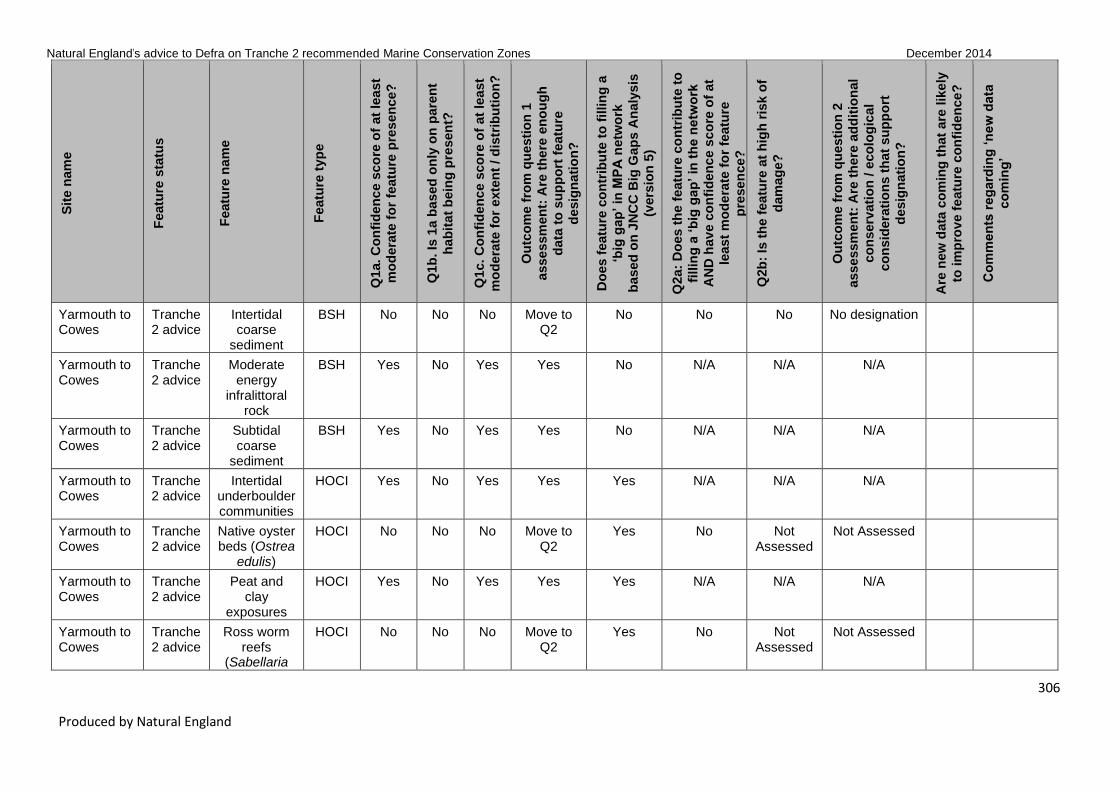
Natural England’s advice to Defra on Tranche 2 recommended Marine Conservation Zones December 2014
306
Produced by Natural England
Sit
e n
am
e
Featu
re s
tatu
s
Featu
re n
am
e
Featu
re t
yp
e
Q1a. C
on
fid
en
ce s
co
re o
f at
lea
st
mo
dera
te f
or
featu
re p
res
en
ce?
Q1b
. Is
1a b
ased
on
ly o
n p
are
nt
hab
itat
bein
g p
resen
t?
Q1c. C
on
fid
en
ce s
co
re o
f at
lea
st
mo
dera
te f
or
exte
nt
/ d
istr
ibu
tio
n?
Ou
tco
me f
rom
qu
esti
on
1
asse
ssm
en
t: A
re t
he
re e
no
ug
h
data
to
su
pp
ort
featu
re
desig
nati
on
?
Do
es f
eatu
re c
on
trib
ute
to
fillin
g a
‘big
gap
’ in
MP
A n
etw
ork
based
on
JN
CC
Big
Gap
s A
naly
sis
(vers
ion
5)
Q2a:
Do
es t
he
featu
re c
on
trib
ute
to
fillin
g a
‘b
ig g
ap
’ in
th
e n
etw
ork
AN
D h
av
e c
on
fid
en
ce s
co
re o
f at
least
mo
de
rate
fo
r fe
atu
re
pre
sen
ce?
Q2b
: Is
th
e f
eatu
re a
t h
igh
ris
k o
f
dam
ag
e?
Ou
tco
me f
rom
qu
esti
on
2
asse
ssm
en
t: A
re t
he
re a
dd
itio
nal
co
nserv
ati
on
/ e
co
log
ical
co
nsid
era
tio
ns t
hat
su
pp
ort
desig
nati
on
?
Are
new
data
co
min
g t
hat
are
lik
ely
to im
pro
ve f
eatu
re c
on
fid
en
ce
?
Co
mm
en
ts r
eg
ard
ing
‘n
ew
data
co
min
g’
Yarmouth to Cowes
Tranche 2 advice
Intertidal coarse
sediment
BSH No No No Move to Q2
No No No No designation
Yarmouth to Cowes
Tranche 2 advice
Moderate energy
infralittoral rock
BSH Yes No Yes Yes No N/A N/A N/A
Yarmouth to Cowes
Tranche 2 advice
Subtidal coarse
sediment
BSH Yes No Yes Yes No N/A N/A N/A
Yarmouth to Cowes
Tranche 2 advice
Intertidal underboulder communities
HOCI Yes No Yes Yes Yes N/A N/A N/A
Yarmouth to Cowes
Tranche 2 advice
Native oyster beds (Ostrea
edulis)
HOCI No No No Move to Q2
Yes No Not Assessed
Not Assessed
Yarmouth to Cowes
Tranche 2 advice
Peat and clay
exposures
HOCI Yes No Yes Yes Yes N/A N/A N/A
Yarmouth to Cowes
Tranche 2 advice
Ross worm reefs
(Sabellaria
HOCI No No No Move to Q2
Yes No Not Assessed
Not Assessed

Natural England’s advice to Defra on Tranche 2 recommended Marine Conservation Zones December 2014
307
Produced by Natural England
Sit
e n
am
e
Featu
re s
tatu
s
Featu
re n
am
e
Featu
re t
yp
e
Q1a. C
on
fid
en
ce s
co
re o
f at
lea
st
mo
dera
te f
or
featu
re p
res
en
ce?
Q1b
. Is
1a b
ased
on
ly o
n p
are
nt
hab
itat
bein
g p
resen
t?
Q1c. C
on
fid
en
ce s
co
re o
f at
lea
st
mo
dera
te f
or
exte
nt
/ d
istr
ibu
tio
n?
Ou
tco
me f
rom
qu
esti
on
1
asse
ssm
en
t: A
re t
he
re e
no
ug
h
data
to
su
pp
ort
featu
re
desig
nati
on
?
Do
es f
eatu
re c
on
trib
ute
to
fillin
g a
‘big
gap
’ in
MP
A n
etw
ork
based
on
JN
CC
Big
Gap
s A
naly
sis
(vers
ion
5)
Q2a:
Do
es t
he
featu
re c
on
trib
ute
to
fillin
g a
‘b
ig g
ap
’ in
th
e n
etw
ork
AN
D h
av
e c
on
fid
en
ce s
co
re o
f at
least
mo
de
rate
fo
r fe
atu
re
pre
sen
ce?
Q2b
: Is
th
e f
eatu
re a
t h
igh
ris
k o
f
dam
ag
e?
Ou
tco
me f
rom
qu
esti
on
2
asse
ssm
en
t: A
re t
he
re a
dd
itio
nal
co
nserv
ati
on
/ e
co
log
ical
co
nsid
era
tio
ns t
hat
su
pp
ort
desig
nati
on
?
Are
new
data
co
min
g t
hat
are
lik
ely
to im
pro
ve f
eatu
re c
on
fid
en
ce
?
Co
mm
en
ts r
eg
ard
ing
‘n
ew
data
co
min
g’
spinulosa)
Yarmouth to Cowes
Tranche 2 advice
Seagrass beds
HOCI Yes No Yes Yes No N/A N/A N/A
Yarmouth to Cowes
Tranche 2 advice
Estuarine rocky
habitats
HOCI No No No Move to Q2
Yes No Yes Further Consideration
Yarmouth to Cowes
Tranche 2 advice
Native oyster (Ostrea edulis)
SOCI Yes No Yes Yes No N/A N/A N/A
Yarmouth to Cowes
Tranche 2 advice
Lagoon sand shrimp
(Gammarus insensibilis)
SOCI No No No Move to Q2
No No Yes Further Consideration
Yarmouth to Cowes
T2 new features
Moderate energy
intertidal rock
BSH Yes No Yes Yes No N/A N/A N/A
Yarmouth to Cowes
T2 new features
High energy infralittoral
rock
BSH Yes No Yes Yes No N/A N/A N/A
Yarmouth to Cowes
T2 new features
High energy circalittoral
rock
BSH Yes No Yes Yes No N/A N/A N/A

Natural England’s advice to Defra on Tranche 2 recommended Marine Conservation Zones December 2014
308
Produced by Natural England
Sit
e n
am
e
Featu
re s
tatu
s
Featu
re n
am
e
Featu
re t
yp
e
Q1a. C
on
fid
en
ce s
co
re o
f at
lea
st
mo
dera
te f
or
featu
re p
res
en
ce?
Q1b
. Is
1a b
ased
on
ly o
n p
are
nt
hab
itat
bein
g p
resen
t?
Q1c. C
on
fid
en
ce s
co
re o
f at
lea
st
mo
dera
te f
or
exte
nt
/ d
istr
ibu
tio
n?
Ou
tco
me f
rom
qu
esti
on
1
asse
ssm
en
t: A
re t
he
re e
no
ug
h
data
to
su
pp
ort
featu
re
desig
nati
on
?
Do
es f
eatu
re c
on
trib
ute
to
fillin
g a
‘big
gap
’ in
MP
A n
etw
ork
based
on
JN
CC
Big
Gap
s A
naly
sis
(vers
ion
5)
Q2a:
Do
es t
he
featu
re c
on
trib
ute
to
fillin
g a
‘b
ig g
ap
’ in
th
e n
etw
ork
AN
D h
av
e c
on
fid
en
ce s
co
re o
f at
least
mo
de
rate
fo
r fe
atu
re
pre
sen
ce?
Q2b
: Is
th
e f
eatu
re a
t h
igh
ris
k o
f
dam
ag
e?
Ou
tco
me f
rom
qu
esti
on
2
asse
ssm
en
t: A
re t
he
re a
dd
itio
nal
co
nserv
ati
on
/ e
co
log
ical
co
nsid
era
tio
ns t
hat
su
pp
ort
desig
nati
on
?
Are
new
data
co
min
g t
hat
are
lik
ely
to im
pro
ve f
eatu
re c
on
fid
en
ce
?
Co
mm
en
ts r
eg
ard
ing
‘n
ew
data
co
min
g’
Yarmouth to Cowes
T2 new features
Moderate energy
circalittoral rock
BSH Yes No Yes Yes No N/A N/A N/A
Yarmouth to Cowes
T2 new features
Subtidal mud BSH Yes No Yes Yes No N/A N/A N/A
Yarmouth to Cowes
T2 new features
Subtidal mixed
sediments
BSH Yes No Yes Yes No N/A N/A N/A
Yarmouth to Cowes
T2 new features
Subtidal biogenic
reefs
BSH No No No Move to Q2
No No Not Assessed
Not Assessed
Yarmouth to Cowes
T2 new features
Littoral chalk communities
HOCI Yes No Yes Yes No N/A N/A N/A
Yarmouth to Cowes
T2 new features
Sheltered muddy gravels
HOCI Yes No Yes Yes No N/A N/A N/A
Yarmouth to Cowes
T2 new features
Subtidal chalk
HOCI Yes No Yes Yes No N/A N/A N/A
Yarmouth to Cowes
T2 new features
Fragile sponge & anthozoan
HOCI No No No Move to Q2
No No Not Assessed
Not Assessed

Natural England’s advice to Defra on Tranche 2 recommended Marine Conservation Zones December 2014
309
Produced by Natural England
Sit
e n
am
e
Featu
re s
tatu
s
Featu
re n
am
e
Featu
re t
yp
e
Q1a. C
on
fid
en
ce s
co
re o
f at
lea
st
mo
dera
te f
or
featu
re p
res
en
ce?
Q1b
. Is
1a b
ased
on
ly o
n p
are
nt
hab
itat
bein
g p
resen
t?
Q1c. C
on
fid
en
ce s
co
re o
f at
lea
st
mo
dera
te f
or
exte
nt
/ d
istr
ibu
tio
n?
Ou
tco
me f
rom
qu
esti
on
1
asse
ssm
en
t: A
re t
he
re e
no
ug
h
data
to
su
pp
ort
featu
re
desig
nati
on
?
Do
es f
eatu
re c
on
trib
ute
to
fillin
g a
‘big
gap
’ in
MP
A n
etw
ork
based
on
JN
CC
Big
Gap
s A
naly
sis
(vers
ion
5)
Q2a:
Do
es t
he
featu
re c
on
trib
ute
to
fillin
g a
‘b
ig g
ap
’ in
th
e n
etw
ork
AN
D h
av
e c
on
fid
en
ce s
co
re o
f at
least
mo
de
rate
fo
r fe
atu
re
pre
sen
ce?
Q2b
: Is
th
e f
eatu
re a
t h
igh
ris
k o
f
dam
ag
e?
Ou
tco
me f
rom
qu
esti
on
2
asse
ssm
en
t: A
re t
he
re a
dd
itio
nal
co
nserv
ati
on
/ e
co
log
ical
co
nsid
era
tio
ns t
hat
su
pp
ort
desig
nati
on
?
Are
new
data
co
min
g t
hat
are
lik
ely
to im
pro
ve f
eatu
re c
on
fid
en
ce
?
Co
mm
en
ts r
eg
ard
ing
‘n
ew
data
co
min
g’
communities on subtidal
rocky habitats
Yarmouth to Cowes
T2 new features
Black seabream
(Spondyliosoma
cantharus)
non_ ENG
No No No Move to Q2
No No Not Assessed
Not Assessed
Utopia Tranche 2 advice
Fragile sponge & anthozoan
communities on subtidal
rocky habitats
HOCI Yes No Yes Yes No N/A N/A N/A
Utopia T2 new features
Moderate energy
infralittoral rock
BSH No No No Move to Q2
No No Not Assessed
Not Assessed Yes Draft Cefas verification report provided 24/07/2014 and will be used post consultatio

Natural England’s advice to Defra on Tranche 2 recommended Marine Conservation Zones December 2014
310
Produced by Natural England
Sit
e n
am
e
Featu
re s
tatu
s
Featu
re n
am
e
Featu
re t
yp
e
Q1a. C
on
fid
en
ce s
co
re o
f at
lea
st
mo
dera
te f
or
featu
re p
res
en
ce?
Q1b
. Is
1a b
ased
on
ly o
n p
are
nt
hab
itat
bein
g p
resen
t?
Q1c. C
on
fid
en
ce s
co
re o
f at
lea
st
mo
dera
te f
or
exte
nt
/ d
istr
ibu
tio
n?
Ou
tco
me f
rom
qu
esti
on
1
asse
ssm
en
t: A
re t
he
re e
no
ug
h
data
to
su
pp
ort
featu
re
desig
nati
on
?
Do
es f
eatu
re c
on
trib
ute
to
fillin
g a
‘big
gap
’ in
MP
A n
etw
ork
based
on
JN
CC
Big
Gap
s A
naly
sis
(vers
ion
5)
Q2a:
Do
es t
he
featu
re c
on
trib
ute
to
fillin
g a
‘b
ig g
ap
’ in
th
e n
etw
ork
AN
D h
av
e c
on
fid
en
ce s
co
re o
f at
least
mo
de
rate
fo
r fe
atu
re
pre
sen
ce?
Q2b
: Is
th
e f
eatu
re a
t h
igh
ris
k o
f
dam
ag
e?
Ou
tco
me f
rom
qu
esti
on
2
asse
ssm
en
t: A
re t
he
re a
dd
itio
nal
co
nserv
ati
on
/ e
co
log
ical
co
nsid
era
tio
ns t
hat
su
pp
ort
desig
nati
on
?
Are
new
data
co
min
g t
hat
are
lik
ely
to im
pro
ve f
eatu
re c
on
fid
en
ce
?
Co
mm
en
ts r
eg
ard
ing
‘n
ew
data
co
min
g’
n Will provide polygonal data of high mesh to support subtidal BSH.
Utopia T2 new features
High energy circalittoral
rock
BSH Yes No Yes Yes No N/A N/A N/A Yes Draft Cefas verification report provided 24/07/2014 and will be used post consultation Will provide polygonal data of high mesh to support subtidal

Natural England’s advice to Defra on Tranche 2 recommended Marine Conservation Zones December 2014
311
Produced by Natural England
Sit
e n
am
e
Featu
re s
tatu
s
Featu
re n
am
e
Featu
re t
yp
e
Q1a. C
on
fid
en
ce s
co
re o
f at
lea
st
mo
dera
te f
or
featu
re p
res
en
ce?
Q1b
. Is
1a b
ased
on
ly o
n p
are
nt
hab
itat
bein
g p
resen
t?
Q1c. C
on
fid
en
ce s
co
re o
f at
lea
st
mo
dera
te f
or
exte
nt
/ d
istr
ibu
tio
n?
Ou
tco
me f
rom
qu
esti
on
1
asse
ssm
en
t: A
re t
he
re e
no
ug
h
data
to
su
pp
ort
featu
re
desig
nati
on
?
Do
es f
eatu
re c
on
trib
ute
to
fillin
g a
‘big
gap
’ in
MP
A n
etw
ork
based
on
JN
CC
Big
Gap
s A
naly
sis
(vers
ion
5)
Q2a:
Do
es t
he
featu
re c
on
trib
ute
to
fillin
g a
‘b
ig g
ap
’ in
th
e n
etw
ork
AN
D h
av
e c
on
fid
en
ce s
co
re o
f at
least
mo
de
rate
fo
r fe
atu
re
pre
sen
ce?
Q2b
: Is
th
e f
eatu
re a
t h
igh
ris
k o
f
dam
ag
e?
Ou
tco
me f
rom
qu
esti
on
2
asse
ssm
en
t: A
re t
he
re a
dd
itio
nal
co
nserv
ati
on
/ e
co
log
ical
co
nsid
era
tio
ns t
hat
su
pp
ort
desig
nati
on
?
Are
new
data
co
min
g t
hat
are
lik
ely
to im
pro
ve f
eatu
re c
on
fid
en
ce
?
Co
mm
en
ts r
eg
ard
ing
‘n
ew
data
co
min
g’
BSH.
Utopia T2 new features
Moderate energy
circalittoral rock
BSH Yes No Yes Yes No N/A N/A N/A Yes Draft Cefas verification report provided 24/07/2014 and will be used post consultation Will provide polygonal data of high mesh to support subtidal BSH.
Utopia T2 new features
Subtidal coarse
sediment
BSH Yes No Yes Yes No N/A N/A N/A Yes Draft Cefas verification report provided 24/07/2014 and will be

Natural England’s advice to Defra on Tranche 2 recommended Marine Conservation Zones December 2014
312
Produced by Natural England
Sit
e n
am
e
Featu
re s
tatu
s
Featu
re n
am
e
Featu
re t
yp
e
Q1a. C
on
fid
en
ce s
co
re o
f at
lea
st
mo
dera
te f
or
featu
re p
res
en
ce?
Q1b
. Is
1a b
ased
on
ly o
n p
are
nt
hab
itat
bein
g p
resen
t?
Q1c. C
on
fid
en
ce s
co
re o
f at
lea
st
mo
dera
te f
or
exte
nt
/ d
istr
ibu
tio
n?
Ou
tco
me f
rom
qu
esti
on
1
asse
ssm
en
t: A
re t
he
re e
no
ug
h
data
to
su
pp
ort
featu
re
desig
nati
on
?
Do
es f
eatu
re c
on
trib
ute
to
fillin
g a
‘big
gap
’ in
MP
A n
etw
ork
based
on
JN
CC
Big
Gap
s A
naly
sis
(vers
ion
5)
Q2a:
Do
es t
he
featu
re c
on
trib
ute
to
fillin
g a
‘b
ig g
ap
’ in
th
e n
etw
ork
AN
D h
av
e c
on
fid
en
ce s
co
re o
f at
least
mo
de
rate
fo
r fe
atu
re
pre
sen
ce?
Q2b
: Is
th
e f
eatu
re a
t h
igh
ris
k o
f
dam
ag
e?
Ou
tco
me f
rom
qu
esti
on
2
asse
ssm
en
t: A
re t
he
re a
dd
itio
nal
co
nserv
ati
on
/ e
co
log
ical
co
nsid
era
tio
ns t
hat
su
pp
ort
desig
nati
on
?
Are
new
data
co
min
g t
hat
are
lik
ely
to im
pro
ve f
eatu
re c
on
fid
en
ce
?
Co
mm
en
ts r
eg
ard
ing
‘n
ew
data
co
min
g’
used post consultation Will provide polygonal data of high mesh to support subtidal BSH.
Utopia T2 new features
Subtidal sand
BSH Yes No Yes Yes No N/A N/A N/A Yes Draft Cefas verification report provided 24/07/2014 and will be used post consultation Will provide polygonal data of high mesh to

Natural England’s advice to Defra on Tranche 2 recommended Marine Conservation Zones December 2014
313
Produced by Natural England
Sit
e n
am
e
Featu
re s
tatu
s
Featu
re n
am
e
Featu
re t
yp
e
Q1a. C
on
fid
en
ce s
co
re o
f at
lea
st
mo
dera
te f
or
featu
re p
res
en
ce?
Q1b
. Is
1a b
ased
on
ly o
n p
are
nt
hab
itat
bein
g p
resen
t?
Q1c. C
on
fid
en
ce s
co
re o
f at
lea
st
mo
dera
te f
or
exte
nt
/ d
istr
ibu
tio
n?
Ou
tco
me f
rom
qu
esti
on
1
asse
ssm
en
t: A
re t
he
re e
no
ug
h
data
to
su
pp
ort
featu
re
desig
nati
on
?
Do
es f
eatu
re c
on
trib
ute
to
fillin
g a
‘big
gap
’ in
MP
A n
etw
ork
based
on
JN
CC
Big
Gap
s A
naly
sis
(vers
ion
5)
Q2a:
Do
es t
he
featu
re c
on
trib
ute
to
fillin
g a
‘b
ig g
ap
’ in
th
e n
etw
ork
AN
D h
av
e c
on
fid
en
ce s
co
re o
f at
least
mo
de
rate
fo
r fe
atu
re
pre
sen
ce?
Q2b
: Is
th
e f
eatu
re a
t h
igh
ris
k o
f
dam
ag
e?
Ou
tco
me f
rom
qu
esti
on
2
asse
ssm
en
t: A
re t
he
re a
dd
itio
nal
co
nserv
ati
on
/ e
co
log
ical
co
nsid
era
tio
ns t
hat
su
pp
ort
desig
nati
on
?
Are
new
data
co
min
g t
hat
are
lik
ely
to im
pro
ve f
eatu
re c
on
fid
en
ce
?
Co
mm
en
ts r
eg
ard
ing
‘n
ew
data
co
min
g’
support subtidal BSH.
Utopia T2 new features
Subtidal mud BSH No No No Move to Q2
No No Not Assessed
Not Assessed Yes Draft Cefas verification report provided 24/07/2014 and will be used post consultation Will provide polygonal data of high mesh to support subtidal BSH.
Utopia T2 new features
Subtidal mixed
sediments
BSH Yes No Yes Yes No N/A N/A N/A Yes Draft Cefas verification report provided

Natural England’s advice to Defra on Tranche 2 recommended Marine Conservation Zones December 2014
314
Produced by Natural England
Sit
e n
am
e
Featu
re s
tatu
s
Featu
re n
am
e
Featu
re t
yp
e
Q1a. C
on
fid
en
ce s
co
re o
f at
lea
st
mo
dera
te f
or
featu
re p
res
en
ce?
Q1b
. Is
1a b
ased
on
ly o
n p
are
nt
hab
itat
bein
g p
resen
t?
Q1c. C
on
fid
en
ce s
co
re o
f at
lea
st
mo
dera
te f
or
exte
nt
/ d
istr
ibu
tio
n?
Ou
tco
me f
rom
qu
esti
on
1
asse
ssm
en
t: A
re t
he
re e
no
ug
h
data
to
su
pp
ort
featu
re
desig
nati
on
?
Do
es f
eatu
re c
on
trib
ute
to
fillin
g a
‘big
gap
’ in
MP
A n
etw
ork
based
on
JN
CC
Big
Gap
s A
naly
sis
(vers
ion
5)
Q2a:
Do
es t
he
featu
re c
on
trib
ute
to
fillin
g a
‘b
ig g
ap
’ in
th
e n
etw
ork
AN
D h
av
e c
on
fid
en
ce s
co
re o
f at
least
mo
de
rate
fo
r fe
atu
re
pre
sen
ce?
Q2b
: Is
th
e f
eatu
re a
t h
igh
ris
k o
f
dam
ag
e?
Ou
tco
me f
rom
qu
esti
on
2
asse
ssm
en
t: A
re t
he
re a
dd
itio
nal
co
nserv
ati
on
/ e
co
log
ical
co
nsid
era
tio
ns t
hat
su
pp
ort
desig
nati
on
?
Are
new
data
co
min
g t
hat
are
lik
ely
to im
pro
ve f
eatu
re c
on
fid
en
ce
?
Co
mm
en
ts r
eg
ard
ing
‘n
ew
data
co
min
g’
24/07/2014 and will be used post consultation Will provide polygonal data of high mesh to support subtidal BSH.
Studland Bay
Tranche 2 advice
Intertidal sand and
muddy sand
BSH Yes No Yes Yes No N/A N/A N/A
Studland Bay
Tranche 2 advice
Intertidal mud
BSH No No No Move to Q2
No No Yes Further Consideration
Studland Bay
Tranche 2 advice
Subtidal sand
BSH Yes No Yes Yes Yes N/A N/A N/A
Studland Bay
Tranche 2 advice
Subtidal mixed
sediments
BSH No No No Move to Q2
No No Yes Further Consideration

Natural England’s advice to Defra on Tranche 2 recommended Marine Conservation Zones December 2014
315
Produced by Natural England
Sit
e n
am
e
Featu
re s
tatu
s
Featu
re n
am
e
Featu
re t
yp
e
Q1a. C
on
fid
en
ce s
co
re o
f at
lea
st
mo
dera
te f
or
featu
re p
res
en
ce?
Q1b
. Is
1a b
ased
on
ly o
n p
are
nt
hab
itat
bein
g p
resen
t?
Q1c. C
on
fid
en
ce s
co
re o
f at
lea
st
mo
dera
te f
or
exte
nt
/ d
istr
ibu
tio
n?
Ou
tco
me f
rom
qu
esti
on
1
asse
ssm
en
t: A
re t
he
re e
no
ug
h
data
to
su
pp
ort
featu
re
desig
nati
on
?
Do
es f
eatu
re c
on
trib
ute
to
fillin
g a
‘big
gap
’ in
MP
A n
etw
ork
based
on
JN
CC
Big
Gap
s A
naly
sis
(vers
ion
5)
Q2a:
Do
es t
he
featu
re c
on
trib
ute
to
fillin
g a
‘b
ig g
ap
’ in
th
e n
etw
ork
AN
D h
av
e c
on
fid
en
ce s
co
re o
f at
least
mo
de
rate
fo
r fe
atu
re
pre
sen
ce?
Q2b
: Is
th
e f
eatu
re a
t h
igh
ris
k o
f
dam
ag
e?
Ou
tco
me f
rom
qu
esti
on
2
asse
ssm
en
t: A
re t
he
re a
dd
itio
nal
co
nserv
ati
on
/ e
co
log
ical
co
nsid
era
tio
ns t
hat
su
pp
ort
desig
nati
on
?
Are
new
data
co
min
g t
hat
are
lik
ely
to im
pro
ve f
eatu
re c
on
fid
en
ce
?
Co
mm
en
ts r
eg
ard
ing
‘n
ew
data
co
min
g’
Studland Bay
Tranche 2 advice
Seagrass beds
HOCI Yes No Yes Yes No N/A N/A N/A
Studland Bay
Tranche 2 advice
Short-snouted seahorse
(Hippocampus
hippocampus)
SOCI No No No Move to Q2
Yes No Yes – this is based on the
risk identified for Hippo-campus
guttulatus at this site
Further Consideration
Yes It is possible that more records may become available that we have not assessed.
Studland Bay
Tranche 2 advice
Native oyster (Ostrea edulis)
SOCI Yes No Yes Yes No N/A N/A N/A
Studland Bay
Tranche 2 advice
Undulate ray (Raja
undulata)
SOCI No No No Move to Q2
Yes No Not Assessed
Not Assessed Yes 2 photos of 1 individual received along with anecdotal evidence to be included post-con-

Natural England’s advice to Defra on Tranche 2 recommended Marine Conservation Zones December 2014
316
Produced by Natural England
Sit
e n
am
e
Featu
re s
tatu
s
Featu
re n
am
e
Featu
re t
yp
e
Q1a. C
on
fid
en
ce s
co
re o
f at
lea
st
mo
dera
te f
or
featu
re p
res
en
ce?
Q1b
. Is
1a b
ased
on
ly o
n p
are
nt
hab
itat
bein
g p
resen
t?
Q1c. C
on
fid
en
ce s
co
re o
f at
lea
st
mo
dera
te f
or
exte
nt
/ d
istr
ibu
tio
n?
Ou
tco
me f
rom
qu
esti
on
1
asse
ssm
en
t: A
re t
he
re e
no
ug
h
data
to
su
pp
ort
featu
re
desig
nati
on
?
Do
es f
eatu
re c
on
trib
ute
to
fillin
g a
‘big
gap
’ in
MP
A n
etw
ork
based
on
JN
CC
Big
Gap
s A
naly
sis
(vers
ion
5)
Q2a:
Do
es t
he
featu
re c
on
trib
ute
to
fillin
g a
‘b
ig g
ap
’ in
th
e n
etw
ork
AN
D h
av
e c
on
fid
en
ce s
co
re o
f at
least
mo
de
rate
fo
r fe
atu
re
pre
sen
ce?
Q2b
: Is
th
e f
eatu
re a
t h
igh
ris
k o
f
dam
ag
e?
Ou
tco
me f
rom
qu
esti
on
2
asse
ssm
en
t: A
re t
he
re a
dd
itio
nal
co
nserv
ati
on
/ e
co
log
ical
co
nsid
era
tio
ns t
hat
su
pp
ort
desig
nati
on
?
Are
new
data
co
min
g t
hat
are
lik
ely
to im
pro
ve f
eatu
re c
on
fid
en
ce
?
Co
mm
en
ts r
eg
ard
ing
‘n
ew
data
co
min
g’
sultation. Cefas study into undulate ray in develop-ment and progressing
Studland Bay
T2 new features
Moderate energy
intertidal rock
BSH Yes No Yes Yes No N/A N/A N/A
Studland Bay
T2 new features
Intertidal coarse
sediment
BSH Yes No Yes Yes No N/A N/A N/A
Studland Bay
T2 new features
Intertidal mixed
sediments
BSH No No No Move to Q2
No No Not Assessed
Not Assessed
Studland Bay
T2 new features
Low energy infralittoral
rock
BSH No No No Move to Q2
No No Not Assessed
Not Assessed
Studland Bay
T2 new features
Subtidal coarse
BSH No No No Move to Q2
Yes No Not Assessed
Not Assessed

Natural England’s advice to Defra on Tranche 2 recommended Marine Conservation Zones December 2014
317
Produced by Natural England
Sit
e n
am
e
Featu
re s
tatu
s
Featu
re n
am
e
Featu
re t
yp
e
Q1a. C
on
fid
en
ce s
co
re o
f at
lea
st
mo
dera
te f
or
featu
re p
res
en
ce?
Q1b
. Is
1a b
ased
on
ly o
n p
are
nt
hab
itat
bein
g p
resen
t?
Q1c. C
on
fid
en
ce s
co
re o
f at
lea
st
mo
dera
te f
or
exte
nt
/ d
istr
ibu
tio
n?
Ou
tco
me f
rom
qu
esti
on
1
asse
ssm
en
t: A
re t
he
re e
no
ug
h
data
to
su
pp
ort
featu
re
desig
nati
on
?
Do
es f
eatu
re c
on
trib
ute
to
fillin
g a
‘big
gap
’ in
MP
A n
etw
ork
based
on
JN
CC
Big
Gap
s A
naly
sis
(vers
ion
5)
Q2a:
Do
es t
he
featu
re c
on
trib
ute
to
fillin
g a
‘b
ig g
ap
’ in
th
e n
etw
ork
AN
D h
av
e c
on
fid
en
ce s
co
re o
f at
least
mo
de
rate
fo
r fe
atu
re
pre
sen
ce?
Q2b
: Is
th
e f
eatu
re a
t h
igh
ris
k o
f
dam
ag
e?
Ou
tco
me f
rom
qu
esti
on
2
asse
ssm
en
t: A
re t
he
re a
dd
itio
nal
co
nserv
ati
on
/ e
co
log
ical
co
nsid
era
tio
ns t
hat
su
pp
ort
desig
nati
on
?
Are
new
data
co
min
g t
hat
are
lik
ely
to im
pro
ve f
eatu
re c
on
fid
en
ce
?
Co
mm
en
ts r
eg
ard
ing
‘n
ew
data
co
min
g’
sediment
Studland Bay
T2 new features
Subtidal macrophyte-dominated sediment
BSH Yes No Yes Yes No N/A N/A N/A
Studland Bay
T2 new features
Sheltered muddy gravels
HOCI No No No Move to Q2
No No Not Assessed
Not Assessed
Studland Bay
T2 new features
Subtidal chalk
HOCI No No No Move to Q2
No No Not Assessed
Not Assessed
Studland Bay
T2 new features
Long-snouted seahorse
(Hippocampus
guttulatus)
SOCI Yes No Yes Yes Yes N/A N/A N/A
Studland Bay
T2 new features
Black seabream
(Spondyliosoma
cantharus)
non_ ENG
Yes No Yes Yes No N/A N/A N/A
Torbay T1 new features
Peat and clay
exposures
HOCI Yes No Yes Yes Yes N/A N/A N/A

Natural England’s advice to Defra on Tranche 2 recommended Marine Conservation Zones December 2014
318
Produced by Natural England
Sit
e n
am
e
Featu
re s
tatu
s
Featu
re n
am
e
Featu
re t
yp
e
Q1a. C
on
fid
en
ce s
co
re o
f at
lea
st
mo
dera
te f
or
featu
re p
res
en
ce?
Q1b
. Is
1a b
ased
on
ly o
n p
are
nt
hab
itat
bein
g p
resen
t?
Q1c. C
on
fid
en
ce s
co
re o
f at
lea
st
mo
dera
te f
or
exte
nt
/ d
istr
ibu
tio
n?
Ou
tco
me f
rom
qu
esti
on
1
asse
ssm
en
t: A
re t
he
re e
no
ug
h
data
to
su
pp
ort
featu
re
desig
nati
on
?
Do
es f
eatu
re c
on
trib
ute
to
fillin
g a
‘big
gap
’ in
MP
A n
etw
ork
based
on
JN
CC
Big
Gap
s A
naly
sis
(vers
ion
5)
Q2a:
Do
es t
he
featu
re c
on
trib
ute
to
fillin
g a
‘b
ig g
ap
’ in
th
e n
etw
ork
AN
D h
av
e c
on
fid
en
ce s
co
re o
f at
least
mo
de
rate
fo
r fe
atu
re
pre
sen
ce?
Q2b
: Is
th
e f
eatu
re a
t h
igh
ris
k o
f
dam
ag
e?
Ou
tco
me f
rom
qu
esti
on
2
asse
ssm
en
t: A
re t
he
re a
dd
itio
nal
co
nserv
ati
on
/ e
co
log
ical
co
nsid
era
tio
ns t
hat
su
pp
ort
desig
nati
on
?
Are
new
data
co
min
g t
hat
are
lik
ely
to im
pro
ve f
eatu
re c
on
fid
en
ce
?
Co
mm
en
ts r
eg
ard
ing
‘n
ew
data
co
min
g’
Mounts Bay Tranche 2 advice
High energy intertidal rock
BSH Yes No Yes Yes No N/A N/A N/A Yes NE contracted intertidal verification survey outputs which will be used post-consultation providing point and polygonal data in support of intertidal features.
Mounts Bay Tranche 2 advice
Moderate energy
intertidal rock
BSH Yes No Yes Yes No N/A N/A N/A Yes NE contracted intertidal verification survey outputs

Natural England’s advice to Defra on Tranche 2 recommended Marine Conservation Zones December 2014
319
Produced by Natural England
Sit
e n
am
e
Featu
re s
tatu
s
Featu
re n
am
e
Featu
re t
yp
e
Q1a. C
on
fid
en
ce s
co
re o
f at
lea
st
mo
dera
te f
or
featu
re p
res
en
ce?
Q1b
. Is
1a b
ased
on
ly o
n p
are
nt
hab
itat
bein
g p
resen
t?
Q1c. C
on
fid
en
ce s
co
re o
f at
lea
st
mo
dera
te f
or
exte
nt
/ d
istr
ibu
tio
n?
Ou
tco
me f
rom
qu
esti
on
1
asse
ssm
en
t: A
re t
he
re e
no
ug
h
data
to
su
pp
ort
featu
re
desig
nati
on
?
Do
es f
eatu
re c
on
trib
ute
to
fillin
g a
‘big
gap
’ in
MP
A n
etw
ork
based
on
JN
CC
Big
Gap
s A
naly
sis
(vers
ion
5)
Q2a:
Do
es t
he
featu
re c
on
trib
ute
to
fillin
g a
‘b
ig g
ap
’ in
th
e n
etw
ork
AN
D h
av
e c
on
fid
en
ce s
co
re o
f at
least
mo
de
rate
fo
r fe
atu
re
pre
sen
ce?
Q2b
: Is
th
e f
eatu
re a
t h
igh
ris
k o
f
dam
ag
e?
Ou
tco
me f
rom
qu
esti
on
2
asse
ssm
en
t: A
re t
he
re a
dd
itio
nal
co
nserv
ati
on
/ e
co
log
ical
co
nsid
era
tio
ns t
hat
su
pp
ort
desig
nati
on
?
Are
new
data
co
min
g t
hat
are
lik
ely
to im
pro
ve f
eatu
re c
on
fid
en
ce
?
Co
mm
en
ts r
eg
ard
ing
‘n
ew
data
co
min
g’
which will be used post-consultation providing point and polygonal data in support of intertidal features.
Mounts Bay Tranche 2 advice
Intertidal coarse
sediment
BSH No No No Move to Q2
No No No No designation Yes NE contracted intertidal verification survey outputs which will be used post-consultation providing point and
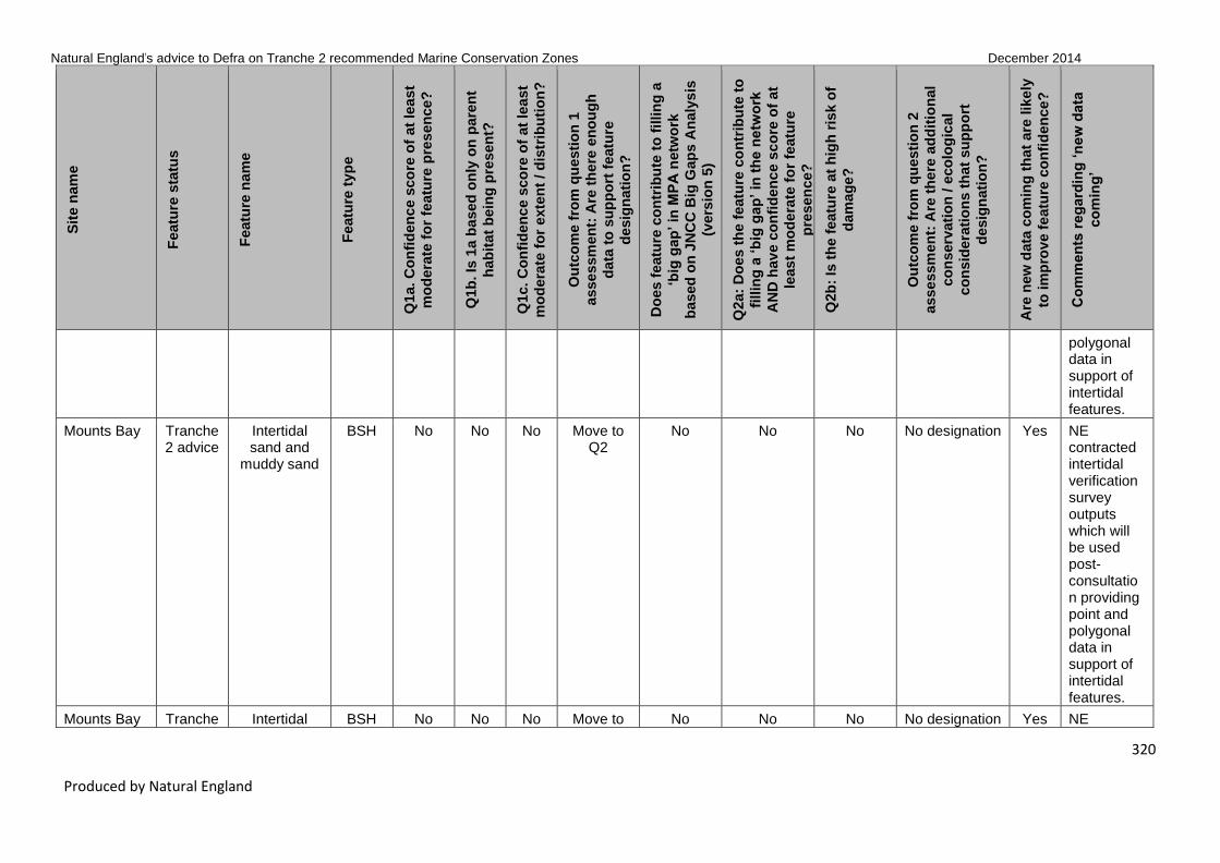
Natural England’s advice to Defra on Tranche 2 recommended Marine Conservation Zones December 2014
320
Produced by Natural England
Sit
e n
am
e
Featu
re s
tatu
s
Featu
re n
am
e
Featu
re t
yp
e
Q1a. C
on
fid
en
ce s
co
re o
f at
lea
st
mo
dera
te f
or
featu
re p
res
en
ce?
Q1b
. Is
1a b
ased
on
ly o
n p
are
nt
hab
itat
bein
g p
resen
t?
Q1c. C
on
fid
en
ce s
co
re o
f at
lea
st
mo
dera
te f
or
exte
nt
/ d
istr
ibu
tio
n?
Ou
tco
me f
rom
qu
esti
on
1
asse
ssm
en
t: A
re t
he
re e
no
ug
h
data
to
su
pp
ort
featu
re
desig
nati
on
?
Do
es f
eatu
re c
on
trib
ute
to
fillin
g a
‘big
gap
’ in
MP
A n
etw
ork
based
on
JN
CC
Big
Gap
s A
naly
sis
(vers
ion
5)
Q2a:
Do
es t
he
featu
re c
on
trib
ute
to
fillin
g a
‘b
ig g
ap
’ in
th
e n
etw
ork
AN
D h
av
e c
on
fid
en
ce s
co
re o
f at
least
mo
de
rate
fo
r fe
atu
re
pre
sen
ce?
Q2b
: Is
th
e f
eatu
re a
t h
igh
ris
k o
f
dam
ag
e?
Ou
tco
me f
rom
qu
esti
on
2
asse
ssm
en
t: A
re t
he
re a
dd
itio
nal
co
nserv
ati
on
/ e
co
log
ical
co
nsid
era
tio
ns t
hat
su
pp
ort
desig
nati
on
?
Are
new
data
co
min
g t
hat
are
lik
ely
to im
pro
ve f
eatu
re c
on
fid
en
ce
?
Co
mm
en
ts r
eg
ard
ing
‘n
ew
data
co
min
g’
polygonal data in support of intertidal features.
Mounts Bay Tranche 2 advice
Intertidal sand and
muddy sand
BSH No No No Move to Q2
No No No No designation Yes NE contracted intertidal verification survey outputs which will be used post-consultation providing point and polygonal data in support of intertidal features.
Mounts Bay Tranche Intertidal BSH No No No Move to No No No No designation Yes NE

Natural England’s advice to Defra on Tranche 2 recommended Marine Conservation Zones December 2014
321
Produced by Natural England
Sit
e n
am
e
Featu
re s
tatu
s
Featu
re n
am
e
Featu
re t
yp
e
Q1a. C
on
fid
en
ce s
co
re o
f at
lea
st
mo
dera
te f
or
featu
re p
res
en
ce?
Q1b
. Is
1a b
ased
on
ly o
n p
are
nt
hab
itat
bein
g p
resen
t?
Q1c. C
on
fid
en
ce s
co
re o
f at
lea
st
mo
dera
te f
or
exte
nt
/ d
istr
ibu
tio
n?
Ou
tco
me f
rom
qu
esti
on
1
asse
ssm
en
t: A
re t
he
re e
no
ug
h
data
to
su
pp
ort
featu
re
desig
nati
on
?
Do
es f
eatu
re c
on
trib
ute
to
fillin
g a
‘big
gap
’ in
MP
A n
etw
ork
based
on
JN
CC
Big
Gap
s A
naly
sis
(vers
ion
5)
Q2a:
Do
es t
he
featu
re c
on
trib
ute
to
fillin
g a
‘b
ig g
ap
’ in
th
e n
etw
ork
AN
D h
av
e c
on
fid
en
ce s
co
re o
f at
least
mo
de
rate
fo
r fe
atu
re
pre
sen
ce?
Q2b
: Is
th
e f
eatu
re a
t h
igh
ris
k o
f
dam
ag
e?
Ou
tco
me f
rom
qu
esti
on
2
asse
ssm
en
t: A
re t
he
re a
dd
itio
nal
co
nserv
ati
on
/ e
co
log
ical
co
nsid
era
tio
ns t
hat
su
pp
ort
desig
nati
on
?
Are
new
data
co
min
g t
hat
are
lik
ely
to im
pro
ve f
eatu
re c
on
fid
en
ce
?
Co
mm
en
ts r
eg
ard
ing
‘n
ew
data
co
min
g’
2 advice mixed sediments
Q2 contracted intertidal verification survey outputs which will be used post-consultation providing point and polygonal data in support of intertidal features.
Mounts Bay Tranche 2 advice
High energy infralittoral
rock
BSH Yes No Yes Yes No N/A N/A N/A Yes NE contracted intertidal verification survey outputs which will

Natural England’s advice to Defra on Tranche 2 recommended Marine Conservation Zones December 2014
322
Produced by Natural England
Sit
e n
am
e
Featu
re s
tatu
s
Featu
re n
am
e
Featu
re t
yp
e
Q1a. C
on
fid
en
ce s
co
re o
f at
lea
st
mo
dera
te f
or
featu
re p
res
en
ce?
Q1b
. Is
1a b
ased
on
ly o
n p
are
nt
hab
itat
bein
g p
resen
t?
Q1c. C
on
fid
en
ce s
co
re o
f at
lea
st
mo
dera
te f
or
exte
nt
/ d
istr
ibu
tio
n?
Ou
tco
me f
rom
qu
esti
on
1
asse
ssm
en
t: A
re t
he
re e
no
ug
h
data
to
su
pp
ort
featu
re
desig
nati
on
?
Do
es f
eatu
re c
on
trib
ute
to
fillin
g a
‘big
gap
’ in
MP
A n
etw
ork
based
on
JN
CC
Big
Gap
s A
naly
sis
(vers
ion
5)
Q2a:
Do
es t
he
featu
re c
on
trib
ute
to
fillin
g a
‘b
ig g
ap
’ in
th
e n
etw
ork
AN
D h
av
e c
on
fid
en
ce s
co
re o
f at
least
mo
de
rate
fo
r fe
atu
re
pre
sen
ce?
Q2b
: Is
th
e f
eatu
re a
t h
igh
ris
k o
f
dam
ag
e?
Ou
tco
me f
rom
qu
esti
on
2
asse
ssm
en
t: A
re t
he
re a
dd
itio
nal
co
nserv
ati
on
/ e
co
log
ical
co
nsid
era
tio
ns t
hat
su
pp
ort
desig
nati
on
?
Are
new
data
co
min
g t
hat
are
lik
ely
to im
pro
ve f
eatu
re c
on
fid
en
ce
?
Co
mm
en
ts r
eg
ard
ing
‘n
ew
data
co
min
g’
be used post-consultation providing point and polygonal data in support of intertidal features.
Mounts Bay Tranche 2 advice
Subtidal sand
BSH Yes No Yes Yes Yes N/A N/A N/A Yes Further recent multibeam survey data are available from a CCO survey; however, with no further ground

Natural England’s advice to Defra on Tranche 2 recommended Marine Conservation Zones December 2014
323
Produced by Natural England
Sit
e n
am
e
Featu
re s
tatu
s
Featu
re n
am
e
Featu
re t
yp
e
Q1a. C
on
fid
en
ce s
co
re o
f at
lea
st
mo
dera
te f
or
featu
re p
res
en
ce?
Q1b
. Is
1a b
ased
on
ly o
n p
are
nt
hab
itat
bein
g p
resen
t?
Q1c. C
on
fid
en
ce s
co
re o
f at
lea
st
mo
dera
te f
or
exte
nt
/ d
istr
ibu
tio
n?
Ou
tco
me f
rom
qu
esti
on
1
asse
ssm
en
t: A
re t
he
re e
no
ug
h
data
to
su
pp
ort
featu
re
desig
nati
on
?
Do
es f
eatu
re c
on
trib
ute
to
fillin
g a
‘big
gap
’ in
MP
A n
etw
ork
based
on
JN
CC
Big
Gap
s A
naly
sis
(vers
ion
5)
Q2a:
Do
es t
he
featu
re c
on
trib
ute
to
fillin
g a
‘b
ig g
ap
’ in
th
e n
etw
ork
AN
D h
av
e c
on
fid
en
ce s
co
re o
f at
least
mo
de
rate
fo
r fe
atu
re
pre
sen
ce?
Q2b
: Is
th
e f
eatu
re a
t h
igh
ris
k o
f
dam
ag
e?
Ou
tco
me f
rom
qu
esti
on
2
asse
ssm
en
t: A
re t
he
re a
dd
itio
nal
co
nserv
ati
on
/ e
co
log
ical
co
nsid
era
tio
ns t
hat
su
pp
ort
desig
nati
on
?
Are
new
data
co
min
g t
hat
are
lik
ely
to im
pro
ve f
eatu
re c
on
fid
en
ce
?
Co
mm
en
ts r
eg
ard
ing
‘n
ew
data
co
min
g’
truth survey work, habitat maps to further resolve features will not be able to be produced.
Mounts Bay Tranche 2 advice
Subtidal mixed
sediments
BSH No No No Move to Q2
No No Not Assessed
Not Assessed Yes Further recent multibeam survey data are available from a CCO survey; however, with no further ground
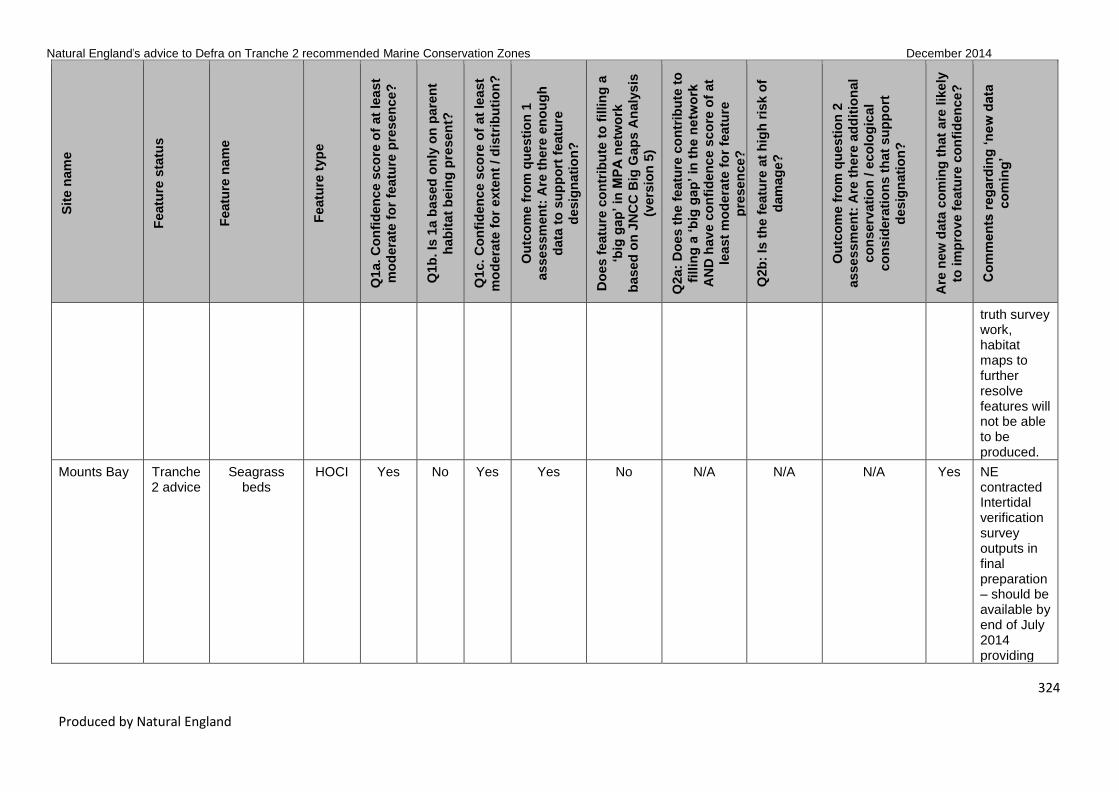
Natural England’s advice to Defra on Tranche 2 recommended Marine Conservation Zones December 2014
324
Produced by Natural England
Sit
e n
am
e
Featu
re s
tatu
s
Featu
re n
am
e
Featu
re t
yp
e
Q1a. C
on
fid
en
ce s
co
re o
f at
lea
st
mo
dera
te f
or
featu
re p
res
en
ce?
Q1b
. Is
1a b
ased
on
ly o
n p
are
nt
hab
itat
bein
g p
resen
t?
Q1c. C
on
fid
en
ce s
co
re o
f at
lea
st
mo
dera
te f
or
exte
nt
/ d
istr
ibu
tio
n?
Ou
tco
me f
rom
qu
esti
on
1
asse
ssm
en
t: A
re t
he
re e
no
ug
h
data
to
su
pp
ort
featu
re
desig
nati
on
?
Do
es f
eatu
re c
on
trib
ute
to
fillin
g a
‘big
gap
’ in
MP
A n
etw
ork
based
on
JN
CC
Big
Gap
s A
naly
sis
(vers
ion
5)
Q2a:
Do
es t
he
featu
re c
on
trib
ute
to
fillin
g a
‘b
ig g
ap
’ in
th
e n
etw
ork
AN
D h
av
e c
on
fid
en
ce s
co
re o
f at
least
mo
de
rate
fo
r fe
atu
re
pre
sen
ce?
Q2b
: Is
th
e f
eatu
re a
t h
igh
ris
k o
f
dam
ag
e?
Ou
tco
me f
rom
qu
esti
on
2
asse
ssm
en
t: A
re t
he
re a
dd
itio
nal
co
nserv
ati
on
/ e
co
log
ical
co
nsid
era
tio
ns t
hat
su
pp
ort
desig
nati
on
?
Are
new
data
co
min
g t
hat
are
lik
ely
to im
pro
ve f
eatu
re c
on
fid
en
ce
?
Co
mm
en
ts r
eg
ard
ing
‘n
ew
data
co
min
g’
truth survey work, habitat maps to further resolve features will not be able to be produced.
Mounts Bay Tranche 2 advice
Seagrass beds
HOCI Yes No Yes Yes No N/A N/A N/A Yes NE contracted Intertidal verification survey outputs in final preparation – should be available by end of July 2014 providing

Natural England’s advice to Defra on Tranche 2 recommended Marine Conservation Zones December 2014
325
Produced by Natural England
Sit
e n
am
e
Featu
re s
tatu
s
Featu
re n
am
e
Featu
re t
yp
e
Q1a. C
on
fid
en
ce s
co
re o
f at
lea
st
mo
dera
te f
or
featu
re p
res
en
ce?
Q1b
. Is
1a b
ased
on
ly o
n p
are
nt
hab
itat
bein
g p
resen
t?
Q1c. C
on
fid
en
ce s
co
re o
f at
lea
st
mo
dera
te f
or
exte
nt
/ d
istr
ibu
tio
n?
Ou
tco
me f
rom
qu
esti
on
1
asse
ssm
en
t: A
re t
he
re e
no
ug
h
data
to
su
pp
ort
featu
re
desig
nati
on
?
Do
es f
eatu
re c
on
trib
ute
to
fillin
g a
‘big
gap
’ in
MP
A n
etw
ork
based
on
JN
CC
Big
Gap
s A
naly
sis
(vers
ion
5)
Q2a:
Do
es t
he
featu
re c
on
trib
ute
to
fillin
g a
‘b
ig g
ap
’ in
th
e n
etw
ork
AN
D h
av
e c
on
fid
en
ce s
co
re o
f at
least
mo
de
rate
fo
r fe
atu
re
pre
sen
ce?
Q2b
: Is
th
e f
eatu
re a
t h
igh
ris
k o
f
dam
ag
e?
Ou
tco
me f
rom
qu
esti
on
2
asse
ssm
en
t: A
re t
he
re a
dd
itio
nal
co
nserv
ati
on
/ e
co
log
ical
co
nsid
era
tio
ns t
hat
su
pp
ort
desig
nati
on
?
Are
new
data
co
min
g t
hat
are
lik
ely
to im
pro
ve f
eatu
re c
on
fid
en
ce
?
Co
mm
en
ts r
eg
ard
ing
‘n
ew
data
co
min
g’
point and polygonal data in support of intertidal features – to be included post con-sultation.
Mounts Bay Tranche 2 advice
Giant goby (Gobius cobitis)
SOCI Yes No Yes Yes Yes N/A N/A N/A
Mounts Bay Tranche 2 advice
Stalked jellyfish
(Haliclystus auricula)
SOCI No No No Move to Q2
No No Yes Further Consideration
Mounts Bay Tranche 2 advice
Stalked jellyfish
(Lucernariopsis
cruxmelitensis)
SOCI No No No Move to Q2
Yes No Not Assessed
Not Assessed Yes Shore-search surveys (inc. participation from NE

Natural England’s advice to Defra on Tranche 2 recommended Marine Conservation Zones December 2014
326
Produced by Natural England
Sit
e n
am
e
Featu
re s
tatu
s
Featu
re n
am
e
Featu
re t
yp
e
Q1a. C
on
fid
en
ce s
co
re o
f at
lea
st
mo
dera
te f
or
featu
re p
res
en
ce?
Q1b
. Is
1a b
ased
on
ly o
n p
are
nt
hab
itat
bein
g p
resen
t?
Q1c. C
on
fid
en
ce s
co
re o
f at
lea
st
mo
dera
te f
or
exte
nt
/ d
istr
ibu
tio
n?
Ou
tco
me f
rom
qu
esti
on
1
asse
ssm
en
t: A
re t
he
re e
no
ug
h
data
to
su
pp
ort
featu
re
desig
nati
on
?
Do
es f
eatu
re c
on
trib
ute
to
fillin
g a
‘big
gap
’ in
MP
A n
etw
ork
based
on
JN
CC
Big
Gap
s A
naly
sis
(vers
ion
5)
Q2a:
Do
es t
he
featu
re c
on
trib
ute
to
fillin
g a
‘b
ig g
ap
’ in
th
e n
etw
ork
AN
D h
av
e c
on
fid
en
ce s
co
re o
f at
least
mo
de
rate
fo
r fe
atu
re
pre
sen
ce?
Q2b
: Is
th
e f
eatu
re a
t h
igh
ris
k o
f
dam
ag
e?
Ou
tco
me f
rom
qu
esti
on
2
asse
ssm
en
t: A
re t
he
re a
dd
itio
nal
co
nserv
ati
on
/ e
co
log
ical
co
nsid
era
tio
ns t
hat
su
pp
ort
desig
nati
on
?
Are
new
data
co
min
g t
hat
are
lik
ely
to im
pro
ve f
eatu
re c
on
fid
en
ce
?
Co
mm
en
ts r
eg
ard
ing
‘n
ew
data
co
min
g’
advisers) yet to be input into Marine Recorder. Further photo-graphic evidence pending from later site visit by NE advisers and with species specialist.
Mounts Bay Tranche 2 advice
Stalked jellyfish
(Lucernariopsis
campanulata)
SOCI No No No Move to Q2
Yes No Yes Further Consideration
Mounts Bay Tranche 2 advice
Ocean quahog
SOCI No No No Move to Q2
No No Yes Further Consideration

Natural England’s advice to Defra on Tranche 2 recommended Marine Conservation Zones December 2014
327
Produced by Natural England
Sit
e n
am
e
Featu
re s
tatu
s
Featu
re n
am
e
Featu
re t
yp
e
Q1a. C
on
fid
en
ce s
co
re o
f at
lea
st
mo
dera
te f
or
featu
re p
res
en
ce?
Q1b
. Is
1a b
ased
on
ly o
n p
are
nt
hab
itat
bein
g p
resen
t?
Q1c. C
on
fid
en
ce s
co
re o
f at
lea
st
mo
dera
te f
or
exte
nt
/ d
istr
ibu
tio
n?
Ou
tco
me f
rom
qu
esti
on
1
asse
ssm
en
t: A
re t
he
re e
no
ug
h
data
to
su
pp
ort
featu
re
desig
nati
on
?
Do
es f
eatu
re c
on
trib
ute
to
fillin
g a
‘big
gap
’ in
MP
A n
etw
ork
based
on
JN
CC
Big
Gap
s A
naly
sis
(vers
ion
5)
Q2a:
Do
es t
he
featu
re c
on
trib
ute
to
fillin
g a
‘b
ig g
ap
’ in
th
e n
etw
ork
AN
D h
av
e c
on
fid
en
ce s
co
re o
f at
least
mo
de
rate
fo
r fe
atu
re
pre
sen
ce?
Q2b
: Is
th
e f
eatu
re a
t h
igh
ris
k o
f
dam
ag
e?
Ou
tco
me f
rom
qu
esti
on
2
asse
ssm
en
t: A
re t
he
re a
dd
itio
nal
co
nserv
ati
on
/ e
co
log
ical
co
nsid
era
tio
ns t
hat
su
pp
ort
desig
nati
on
?
Are
new
data
co
min
g t
hat
are
lik
ely
to im
pro
ve f
eatu
re c
on
fid
en
ce
?
Co
mm
en
ts r
eg
ard
ing
‘n
ew
data
co
min
g’
(Arctica islandica)
Mounts Bay T2 new features
Moderate energy
infralittoral rock
BSH Yes No Yes Yes No N/A N/A N/A
Mounts Bay T2 new features
Peat and clay
exposures
HOCI No No No Move to Q2
No No Not Assessed
Not Assessed
Mounts Bay T2 new features
Common maerl
(Phymatolithon
calcareum)
SOCI No No No Move to Q2
No No Not Assessed
Not Assessed
Runnel
Stone
(Land’s End)
Tranche 2 advice
High energy intertidal rock
BSH Yes No Yes Yes No N/A N/A N/A Yes NE contracted intertidal verification survey outputs in final preparation – should be available by

Natural England’s advice to Defra on Tranche 2 recommended Marine Conservation Zones December 2014
328
Produced by Natural England
Sit
e n
am
e
Featu
re s
tatu
s
Featu
re n
am
e
Featu
re t
yp
e
Q1a. C
on
fid
en
ce s
co
re o
f at
lea
st
mo
dera
te f
or
featu
re p
res
en
ce?
Q1b
. Is
1a b
ased
on
ly o
n p
are
nt
hab
itat
bein
g p
resen
t?
Q1c. C
on
fid
en
ce s
co
re o
f at
lea
st
mo
dera
te f
or
exte
nt
/ d
istr
ibu
tio
n?
Ou
tco
me f
rom
qu
esti
on
1
asse
ssm
en
t: A
re t
he
re e
no
ug
h
data
to
su
pp
ort
featu
re
desig
nati
on
?
Do
es f
eatu
re c
on
trib
ute
to
fillin
g a
‘big
gap
’ in
MP
A n
etw
ork
based
on
JN
CC
Big
Gap
s A
naly
sis
(vers
ion
5)
Q2a:
Do
es t
he
featu
re c
on
trib
ute
to
fillin
g a
‘b
ig g
ap
’ in
th
e n
etw
ork
AN
D h
av
e c
on
fid
en
ce s
co
re o
f at
least
mo
de
rate
fo
r fe
atu
re
pre
sen
ce?
Q2b
: Is
th
e f
eatu
re a
t h
igh
ris
k o
f
dam
ag
e?
Ou
tco
me f
rom
qu
esti
on
2
asse
ssm
en
t: A
re t
he
re a
dd
itio
nal
co
nserv
ati
on
/ e
co
log
ical
co
nsid
era
tio
ns t
hat
su
pp
ort
desig
nati
on
?
Are
new
data
co
min
g t
hat
are
lik
ely
to im
pro
ve f
eatu
re c
on
fid
en
ce
?
Co
mm
en
ts r
eg
ard
ing
‘n
ew
data
co
min
g’
end of July 2014 providing point and polygonal data in support of intertidal features – to be included post con-sultation.
Runnel
Stone
(Land’s End)
Tranche 2 advice
Intertidal coarse
sediment
BSH No No No Move to Q2
No No No No designation Yes NE contracted intertidal verification survey outputs in final preparation – should be available by
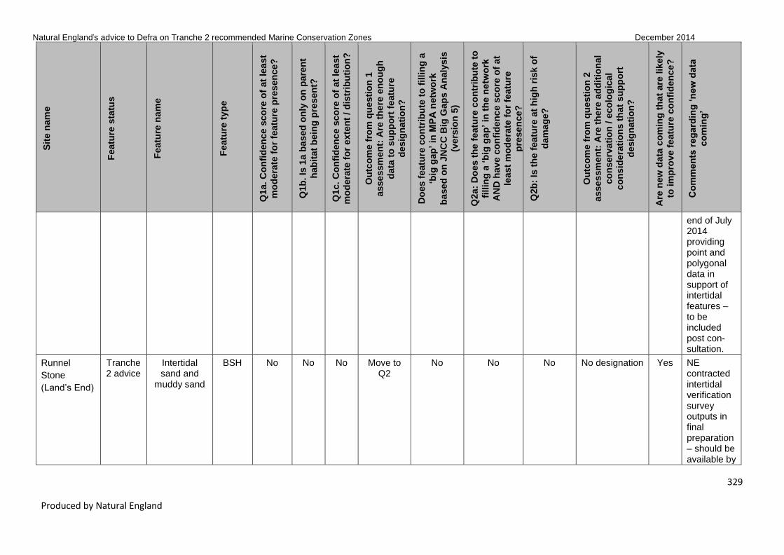
Natural England’s advice to Defra on Tranche 2 recommended Marine Conservation Zones December 2014
329
Produced by Natural England
Sit
e n
am
e
Featu
re s
tatu
s
Featu
re n
am
e
Featu
re t
yp
e
Q1a. C
on
fid
en
ce s
co
re o
f at
lea
st
mo
dera
te f
or
featu
re p
res
en
ce?
Q1b
. Is
1a b
ased
on
ly o
n p
are
nt
hab
itat
bein
g p
resen
t?
Q1c. C
on
fid
en
ce s
co
re o
f at
lea
st
mo
dera
te f
or
exte
nt
/ d
istr
ibu
tio
n?
Ou
tco
me f
rom
qu
esti
on
1
asse
ssm
en
t: A
re t
he
re e
no
ug
h
data
to
su
pp
ort
featu
re
desig
nati
on
?
Do
es f
eatu
re c
on
trib
ute
to
fillin
g a
‘big
gap
’ in
MP
A n
etw
ork
based
on
JN
CC
Big
Gap
s A
naly
sis
(vers
ion
5)
Q2a:
Do
es t
he
featu
re c
on
trib
ute
to
fillin
g a
‘b
ig g
ap
’ in
th
e n
etw
ork
AN
D h
av
e c
on
fid
en
ce s
co
re o
f at
least
mo
de
rate
fo
r fe
atu
re
pre
sen
ce?
Q2b
: Is
th
e f
eatu
re a
t h
igh
ris
k o
f
dam
ag
e?
Ou
tco
me f
rom
qu
esti
on
2
asse
ssm
en
t: A
re t
he
re a
dd
itio
nal
co
nserv
ati
on
/ e
co
log
ical
co
nsid
era
tio
ns t
hat
su
pp
ort
desig
nati
on
?
Are
new
data
co
min
g t
hat
are
lik
ely
to im
pro
ve f
eatu
re c
on
fid
en
ce
?
Co
mm
en
ts r
eg
ard
ing
‘n
ew
data
co
min
g’
end of July 2014 providing point and polygonal data in support of intertidal features – to be included post con-sultation.
Runnel
Stone
(Land’s End)
Tranche 2 advice
Intertidal sand and
muddy sand
BSH No No No Move to Q2
No No No No designation Yes NE contracted intertidal verification survey outputs in final preparation – should be available by

Natural England’s advice to Defra on Tranche 2 recommended Marine Conservation Zones December 2014
330
Produced by Natural England
Sit
e n
am
e
Featu
re s
tatu
s
Featu
re n
am
e
Featu
re t
yp
e
Q1a. C
on
fid
en
ce s
co
re o
f at
lea
st
mo
dera
te f
or
featu
re p
res
en
ce?
Q1b
. Is
1a b
ased
on
ly o
n p
are
nt
hab
itat
bein
g p
resen
t?
Q1c. C
on
fid
en
ce s
co
re o
f at
lea
st
mo
dera
te f
or
exte
nt
/ d
istr
ibu
tio
n?
Ou
tco
me f
rom
qu
esti
on
1
asse
ssm
en
t: A
re t
he
re e
no
ug
h
data
to
su
pp
ort
featu
re
desig
nati
on
?
Do
es f
eatu
re c
on
trib
ute
to
fillin
g a
‘big
gap
’ in
MP
A n
etw
ork
based
on
JN
CC
Big
Gap
s A
naly
sis
(vers
ion
5)
Q2a:
Do
es t
he
featu
re c
on
trib
ute
to
fillin
g a
‘b
ig g
ap
’ in
th
e n
etw
ork
AN
D h
av
e c
on
fid
en
ce s
co
re o
f at
least
mo
de
rate
fo
r fe
atu
re
pre
sen
ce?
Q2b
: Is
th
e f
eatu
re a
t h
igh
ris
k o
f
dam
ag
e?
Ou
tco
me f
rom
qu
esti
on
2
asse
ssm
en
t: A
re t
he
re a
dd
itio
nal
co
nserv
ati
on
/ e
co
log
ical
co
nsid
era
tio
ns t
hat
su
pp
ort
desig
nati
on
?
Are
new
data
co
min
g t
hat
are
lik
ely
to im
pro
ve f
eatu
re c
on
fid
en
ce
?
Co
mm
en
ts r
eg
ard
ing
‘n
ew
data
co
min
g’
end of July 2014 providing point and polygonal data in support of intertidal features – to be included post con-sultation. Parent level photo-graphic evidence will also support feature post con-sultation.

Natural England’s advice to Defra on Tranche 2 recommended Marine Conservation Zones December 2014
331
Produced by Natural England
Sit
e n
am
e
Featu
re s
tatu
s
Featu
re n
am
e
Featu
re t
yp
e
Q1a. C
on
fid
en
ce s
co
re o
f at
lea
st
mo
dera
te f
or
featu
re p
res
en
ce?
Q1b
. Is
1a b
ased
on
ly o
n p
are
nt
hab
itat
bein
g p
resen
t?
Q1c. C
on
fid
en
ce s
co
re o
f at
lea
st
mo
dera
te f
or
exte
nt
/ d
istr
ibu
tio
n?
Ou
tco
me f
rom
qu
esti
on
1
asse
ssm
en
t: A
re t
he
re e
no
ug
h
data
to
su
pp
ort
featu
re
desig
nati
on
?
Do
es f
eatu
re c
on
trib
ute
to
fillin
g a
‘big
gap
’ in
MP
A n
etw
ork
based
on
JN
CC
Big
Gap
s A
naly
sis
(vers
ion
5)
Q2a:
Do
es t
he
featu
re c
on
trib
ute
to
fillin
g a
‘b
ig g
ap
’ in
th
e n
etw
ork
AN
D h
av
e c
on
fid
en
ce s
co
re o
f at
least
mo
de
rate
fo
r fe
atu
re
pre
sen
ce?
Q2b
: Is
th
e f
eatu
re a
t h
igh
ris
k o
f
dam
ag
e?
Ou
tco
me f
rom
qu
esti
on
2
asse
ssm
en
t: A
re t
he
re a
dd
itio
nal
co
nserv
ati
on
/ e
co
log
ical
co
nsid
era
tio
ns t
hat
su
pp
ort
desig
nati
on
?
Are
new
data
co
min
g t
hat
are
lik
ely
to im
pro
ve f
eatu
re c
on
fid
en
ce
?
Co
mm
en
ts r
eg
ard
ing
‘n
ew
data
co
min
g’
Runnel
Stone
(Land’s End)
Tranche 2 advice
Intertidal mud
BSH No No No Move to Q2
No No Yes Further Consideration
Yes NE contracted intertidal verification survey outputs in final preparation – should be available by end of July 2014 providing point and polygonal data in support of intertidal features – to be included post con-sultation.

Natural England’s advice to Defra on Tranche 2 recommended Marine Conservation Zones December 2014
332
Produced by Natural England
Sit
e n
am
e
Featu
re s
tatu
s
Featu
re n
am
e
Featu
re t
yp
e
Q1a. C
on
fid
en
ce s
co
re o
f at
lea
st
mo
dera
te f
or
featu
re p
res
en
ce?
Q1b
. Is
1a b
ased
on
ly o
n p
are
nt
hab
itat
bein
g p
resen
t?
Q1c. C
on
fid
en
ce s
co
re o
f at
lea
st
mo
dera
te f
or
exte
nt
/ d
istr
ibu
tio
n?
Ou
tco
me f
rom
qu
esti
on
1
asse
ssm
en
t: A
re t
he
re e
no
ug
h
data
to
su
pp
ort
featu
re
desig
nati
on
?
Do
es f
eatu
re c
on
trib
ute
to
fillin
g a
‘big
gap
’ in
MP
A n
etw
ork
based
on
JN
CC
Big
Gap
s A
naly
sis
(vers
ion
5)
Q2a:
Do
es t
he
featu
re c
on
trib
ute
to
fillin
g a
‘b
ig g
ap
’ in
th
e n
etw
ork
AN
D h
av
e c
on
fid
en
ce s
co
re o
f at
least
mo
de
rate
fo
r fe
atu
re
pre
sen
ce?
Q2b
: Is
th
e f
eatu
re a
t h
igh
ris
k o
f
dam
ag
e?
Ou
tco
me f
rom
qu
esti
on
2
asse
ssm
en
t: A
re t
he
re a
dd
itio
nal
co
nserv
ati
on
/ e
co
log
ical
co
nsid
era
tio
ns t
hat
su
pp
ort
desig
nati
on
?
Are
new
data
co
min
g t
hat
are
lik
ely
to im
pro
ve f
eatu
re c
on
fid
en
ce
?
Co
mm
en
ts r
eg
ard
ing
‘n
ew
data
co
min
g’
Runnel
Stone
(Land’s End)
Tranche 2 advice
High energy infralittoral
rock
BSH Yes No Yes Yes No N/A N/A N/A Yes EA point data for subtidal habitats to be reported by Cefas by 31/07/2014 – point data only.
Runnel
Stone
(Land’s End)
Tranche 2 advice
Moderate energy
infralittoral rock
BSH No No No Move to Q2
No No No No designation Yes EA point data for subtidal habitats to be reported by Cefas by 31/07/2014 – point data only.
Runnel
Stone
(Land’s End)
Tranche 2 advice
High energy circalittoral
rock
BSH Yes No Yes Yes No N/A N/A N/A Yes EA point data for subtidal habitats to be reported

Natural England’s advice to Defra on Tranche 2 recommended Marine Conservation Zones December 2014
333
Produced by Natural England
Sit
e n
am
e
Featu
re s
tatu
s
Featu
re n
am
e
Featu
re t
yp
e
Q1a. C
on
fid
en
ce s
co
re o
f at
lea
st
mo
dera
te f
or
featu
re p
res
en
ce?
Q1b
. Is
1a b
ased
on
ly o
n p
are
nt
hab
itat
bein
g p
resen
t?
Q1c. C
on
fid
en
ce s
co
re o
f at
lea
st
mo
dera
te f
or
exte
nt
/ d
istr
ibu
tio
n?
Ou
tco
me f
rom
qu
esti
on
1
asse
ssm
en
t: A
re t
he
re e
no
ug
h
data
to
su
pp
ort
featu
re
desig
nati
on
?
Do
es f
eatu
re c
on
trib
ute
to
fillin
g a
‘big
gap
’ in
MP
A n
etw
ork
based
on
JN
CC
Big
Gap
s A
naly
sis
(vers
ion
5)
Q2a:
Do
es t
he
featu
re c
on
trib
ute
to
fillin
g a
‘b
ig g
ap
’ in
th
e n
etw
ork
AN
D h
av
e c
on
fid
en
ce s
co
re o
f at
least
mo
de
rate
fo
r fe
atu
re
pre
sen
ce?
Q2b
: Is
th
e f
eatu
re a
t h
igh
ris
k o
f
dam
ag
e?
Ou
tco
me f
rom
qu
esti
on
2
asse
ssm
en
t: A
re t
he
re a
dd
itio
nal
co
nserv
ati
on
/ e
co
log
ical
co
nsid
era
tio
ns t
hat
su
pp
ort
desig
nati
on
?
Are
new
data
co
min
g t
hat
are
lik
ely
to im
pro
ve f
eatu
re c
on
fid
en
ce
?
Co
mm
en
ts r
eg
ard
ing
‘n
ew
data
co
min
g’
by Cefas by 31/07/2014 – point data only.
Runnel
Stone
(Land’s End)
Tranche 2 advice
Moderate energy
circalittoral rock
BSH No No No Move to Q2
No No Yes Further Consideration
Yes EA point data for subtidal habitats to be reported by Cefas by 31/07/2014 – point data only.
Runnel
Stone
(Land’s End)
Tranche 2 advice
Subtidal coarse
sediment
BSH No No No Move to Q2
No No No No designation Yes EA point data for subtidal habitats to be reported by Cefas by 31/07/2014 – point data only.
Runnel Tranche Subtidal BSH No No No Move to No No Yes Further Yes EA point

Natural England’s advice to Defra on Tranche 2 recommended Marine Conservation Zones December 2014
334
Produced by Natural England
Sit
e n
am
e
Featu
re s
tatu
s
Featu
re n
am
e
Featu
re t
yp
e
Q1a. C
on
fid
en
ce s
co
re o
f at
lea
st
mo
dera
te f
or
featu
re p
res
en
ce?
Q1b
. Is
1a b
ased
on
ly o
n p
are
nt
hab
itat
bein
g p
resen
t?
Q1c. C
on
fid
en
ce s
co
re o
f at
lea
st
mo
dera
te f
or
exte
nt
/ d
istr
ibu
tio
n?
Ou
tco
me f
rom
qu
esti
on
1
asse
ssm
en
t: A
re t
he
re e
no
ug
h
data
to
su
pp
ort
featu
re
desig
nati
on
?
Do
es f
eatu
re c
on
trib
ute
to
fillin
g a
‘big
gap
’ in
MP
A n
etw
ork
based
on
JN
CC
Big
Gap
s A
naly
sis
(vers
ion
5)
Q2a:
Do
es t
he
featu
re c
on
trib
ute
to
fillin
g a
‘b
ig g
ap
’ in
th
e n
etw
ork
AN
D h
av
e c
on
fid
en
ce s
co
re o
f at
least
mo
de
rate
fo
r fe
atu
re
pre
sen
ce?
Q2b
: Is
th
e f
eatu
re a
t h
igh
ris
k o
f
dam
ag
e?
Ou
tco
me f
rom
qu
esti
on
2
asse
ssm
en
t: A
re t
he
re a
dd
itio
nal
co
nserv
ati
on
/ e
co
log
ical
co
nsid
era
tio
ns t
hat
su
pp
ort
desig
nati
on
?
Are
new
data
co
min
g t
hat
are
lik
ely
to im
pro
ve f
eatu
re c
on
fid
en
ce
?
Co
mm
en
ts r
eg
ard
ing
‘n
ew
data
co
min
g’
Stone
(Land’s End) 2 advice sand Q2 Consideration data for
subtidal habitats to be reported by Cefas by 31/07/2014 – point data only.
Runnel
Stone
(Land’s End)
Tranche 2 advice
Pink sea-fan (Eunicella verrucosa)
SOCI Yes No Yes Yes No N/A N/A N/A
Runnel
Stone
(Land’s End)
Tranche 2 advice
Basking shark
(Cetorhinus maximus)
non_ ENG
No No No Move to Q2
No No Not Assessed
Not Assessed
Runnel
Stone
(Land’s End)
Tranche 2 advice
Bottlenose dolphin
(Tursiops truncatus)
non_ ENG
No No No Move to Q2
No No Not Assessed
Not Assessed
Runnel Tranche 2 advice
Balearic shearwater
non_ ENG
No No No Move to Q2
No No Not Assessed
Not Assessed
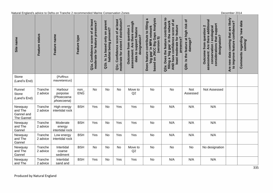
Natural England’s advice to Defra on Tranche 2 recommended Marine Conservation Zones December 2014
335
Produced by Natural England
Sit
e n
am
e
Featu
re s
tatu
s
Featu
re n
am
e
Featu
re t
yp
e
Q1a. C
on
fid
en
ce s
co
re o
f at
lea
st
mo
dera
te f
or
featu
re p
res
en
ce?
Q1b
. Is
1a b
ased
on
ly o
n p
are
nt
hab
itat
bein
g p
resen
t?
Q1c. C
on
fid
en
ce s
co
re o
f at
lea
st
mo
dera
te f
or
exte
nt
/ d
istr
ibu
tio
n?
Ou
tco
me f
rom
qu
esti
on
1
asse
ssm
en
t: A
re t
he
re e
no
ug
h
data
to
su
pp
ort
featu
re
desig
nati
on
?
Do
es f
eatu
re c
on
trib
ute
to
fillin
g a
‘big
gap
’ in
MP
A n
etw
ork
based
on
JN
CC
Big
Gap
s A
naly
sis
(vers
ion
5)
Q2a:
Do
es t
he
featu
re c
on
trib
ute
to
fillin
g a
‘b
ig g
ap
’ in
th
e n
etw
ork
AN
D h
av
e c
on
fid
en
ce s
co
re o
f at
least
mo
de
rate
fo
r fe
atu
re
pre
sen
ce?
Q2b
: Is
th
e f
eatu
re a
t h
igh
ris
k o
f
dam
ag
e?
Ou
tco
me f
rom
qu
esti
on
2
asse
ssm
en
t: A
re t
he
re a
dd
itio
nal
co
nserv
ati
on
/ e
co
log
ical
co
nsid
era
tio
ns t
hat
su
pp
ort
desig
nati
on
?
Are
new
data
co
min
g t
hat
are
lik
ely
to im
pro
ve f
eatu
re c
on
fid
en
ce
?
Co
mm
en
ts r
eg
ard
ing
‘n
ew
data
co
min
g’
Stone
(Land’s End) (Puffinus
mauretanicus)
Runnel
Stone
(Land’s End)
Tranche 2 advice
Harbour porpoise
(Phoecoena phoecoena)
non_ ENG
No No No Move to Q2
No No Not Assessed
Not Assessed
Newquay and The Gannel and The Gannel
Tranche 2 advice
High energy intertidal rock
BSH Yes No Yes Yes No N/A N/A N/A
Newquay and The Gannel
Tranche 2 advice
Moderate energy
intertidal rock
BSH Yes No Yes Yes No N/A N/A N/A
Newquay and The Gannel
Tranche 2 advice
Low energy intertidal rock
BSH Yes No Yes Yes No N/A N/A N/A
Newquay and The Gannel
Tranche 2 advice
Intertidal coarse
sediment
BSH No No No Move to Q2
No No No No designation
Newquay and The
Tranche 2 advice
Intertidal sand and
BSH Yes No Yes Yes No N/A N/A N/A

Natural England’s advice to Defra on Tranche 2 recommended Marine Conservation Zones December 2014
336
Produced by Natural England
Sit
e n
am
e
Featu
re s
tatu
s
Featu
re n
am
e
Featu
re t
yp
e
Q1a. C
on
fid
en
ce s
co
re o
f at
lea
st
mo
dera
te f
or
featu
re p
res
en
ce?
Q1b
. Is
1a b
ased
on
ly o
n p
are
nt
hab
itat
bein
g p
resen
t?
Q1c. C
on
fid
en
ce s
co
re o
f at
lea
st
mo
dera
te f
or
exte
nt
/ d
istr
ibu
tio
n?
Ou
tco
me f
rom
qu
esti
on
1
asse
ssm
en
t: A
re t
he
re e
no
ug
h
data
to
su
pp
ort
featu
re
desig
nati
on
?
Do
es f
eatu
re c
on
trib
ute
to
fillin
g a
‘big
gap
’ in
MP
A n
etw
ork
based
on
JN
CC
Big
Gap
s A
naly
sis
(vers
ion
5)
Q2a:
Do
es t
he
featu
re c
on
trib
ute
to
fillin
g a
‘b
ig g
ap
’ in
th
e n
etw
ork
AN
D h
av
e c
on
fid
en
ce s
co
re o
f at
least
mo
de
rate
fo
r fe
atu
re
pre
sen
ce?
Q2b
: Is
th
e f
eatu
re a
t h
igh
ris
k o
f
dam
ag
e?
Ou
tco
me f
rom
qu
esti
on
2
asse
ssm
en
t: A
re t
he
re a
dd
itio
nal
co
nserv
ati
on
/ e
co
log
ical
co
nsid
era
tio
ns t
hat
su
pp
ort
desig
nati
on
?
Are
new
data
co
min
g t
hat
are
lik
ely
to im
pro
ve f
eatu
re c
on
fid
en
ce
?
Co
mm
en
ts r
eg
ard
ing
‘n
ew
data
co
min
g’
Gannel muddy sand
Newquay and The Gannel
Tranche 2 advice
Intertidal mud
BSH Yes No Yes Yes No N/A N/A N/A
Newquay and The Gannel
Tranche 2 advice
Coastal saltmarshes and saline reedbeds
BSH Yes No Yes Yes No N/A N/A N/A
Newquay and The Gannel
Tranche 2 advice
Subtidal coarse
sediment
BSH Yes No Yes Yes Yes N/A N/A N/A
Newquay and The Gannel
Tranche 2 advice
Subtidal sand
BSH Yes No Yes Yes No N/A N/A N/A
Newquay and The Gannel
Tranche 2 advice
Subtidal mud BSH No No No Move to Q2
No No Not Assessed
Not Assessed
Newquay and The Gannel
Tranche 2 advice
Giant goby (Gobius cobitis)
SOCI No No No Move to Q2
Yes No No No designation Yes New internal photo-graphic evidence of

Natural England’s advice to Defra on Tranche 2 recommended Marine Conservation Zones December 2014
337
Produced by Natural England
Sit
e n
am
e
Featu
re s
tatu
s
Featu
re n
am
e
Featu
re t
yp
e
Q1a. C
on
fid
en
ce s
co
re o
f at
lea
st
mo
dera
te f
or
featu
re p
res
en
ce?
Q1b
. Is
1a b
ased
on
ly o
n p
are
nt
hab
itat
bein
g p
resen
t?
Q1c. C
on
fid
en
ce s
co
re o
f at
lea
st
mo
dera
te f
or
exte
nt
/ d
istr
ibu
tio
n?
Ou
tco
me f
rom
qu
esti
on
1
asse
ssm
en
t: A
re t
he
re e
no
ug
h
data
to
su
pp
ort
featu
re
desig
nati
on
?
Do
es f
eatu
re c
on
trib
ute
to
fillin
g a
‘big
gap
’ in
MP
A n
etw
ork
based
on
JN
CC
Big
Gap
s A
naly
sis
(vers
ion
5)
Q2a:
Do
es t
he
featu
re c
on
trib
ute
to
fillin
g a
‘b
ig g
ap
’ in
th
e n
etw
ork
AN
D h
av
e c
on
fid
en
ce s
co
re o
f at
least
mo
de
rate
fo
r fe
atu
re
pre
sen
ce?
Q2b
: Is
th
e f
eatu
re a
t h
igh
ris
k o
f
dam
ag
e?
Ou
tco
me f
rom
qu
esti
on
2
asse
ssm
en
t: A
re t
he
re a
dd
itio
nal
co
nserv
ati
on
/ e
co
log
ical
co
nsid
era
tio
ns t
hat
su
pp
ort
desig
nati
on
?
Are
new
data
co
min
g t
hat
are
lik
ely
to im
pro
ve f
eatu
re c
on
fid
en
ce
?
Co
mm
en
ts r
eg
ard
ing
‘n
ew
data
co
min
g’
SOCI presence verified by specialists. Will be added post con-sultation.
Newquay and The Gannel
Tranche 2 advice
Native oyster (Ostrea edulis)
SOCI No No No Move to Q2
Yes No Yes Further Consideration
Newquay and The Gannel
Tranche 2 advice
Pink sea-fan (Eunicella verrucosa)
SOCI No No No Move to Q2
No No Yes Further Consideration
Newquay and The Gannel
T2 new features
Intertidal mixed
sediments
BSH Yes No Yes Yes No N/A N/A N/A
Newquay and The Gannel
T2 new features
High energy infralittoral
rock
BSH Yes No Yes Yes No N/A N/A N/A
Newquay and The
T2 new features
Moderate energy
BSH Yes No Yes Yes No N/A N/A N/A

Natural England’s advice to Defra on Tranche 2 recommended Marine Conservation Zones December 2014
338
Produced by Natural England
Sit
e n
am
e
Featu
re s
tatu
s
Featu
re n
am
e
Featu
re t
yp
e
Q1a. C
on
fid
en
ce s
co
re o
f at
lea
st
mo
dera
te f
or
featu
re p
res
en
ce?
Q1b
. Is
1a b
ased
on
ly o
n p
are
nt
hab
itat
bein
g p
resen
t?
Q1c. C
on
fid
en
ce s
co
re o
f at
lea
st
mo
dera
te f
or
exte
nt
/ d
istr
ibu
tio
n?
Ou
tco
me f
rom
qu
esti
on
1
asse
ssm
en
t: A
re t
he
re e
no
ug
h
data
to
su
pp
ort
featu
re
desig
nati
on
?
Do
es f
eatu
re c
on
trib
ute
to
fillin
g a
‘big
gap
’ in
MP
A n
etw
ork
based
on
JN
CC
Big
Gap
s A
naly
sis
(vers
ion
5)
Q2a:
Do
es t
he
featu
re c
on
trib
ute
to
fillin
g a
‘b
ig g
ap
’ in
th
e n
etw
ork
AN
D h
av
e c
on
fid
en
ce s
co
re o
f at
least
mo
de
rate
fo
r fe
atu
re
pre
sen
ce?
Q2b
: Is
th
e f
eatu
re a
t h
igh
ris
k o
f
dam
ag
e?
Ou
tco
me f
rom
qu
esti
on
2
asse
ssm
en
t: A
re t
he
re a
dd
itio
nal
co
nserv
ati
on
/ e
co
log
ical
co
nsid
era
tio
ns t
hat
su
pp
ort
desig
nati
on
?
Are
new
data
co
min
g t
hat
are
lik
ely
to im
pro
ve f
eatu
re c
on
fid
en
ce
?
Co
mm
en
ts r
eg
ard
ing
‘n
ew
data
co
min
g’
Gannel infralittoral rock
Newquay and The Gannel
T2 new features
High energy circalittoral
rock
BSH No No No Move to Q2
No No Not Assessed
Not Assessed
Newquay and The Gannel
T2 new features
Tide-swept channels
HOCI No No No Move to Q2
No No Not Assessed
Not Assessed
Newquay and The Gannel
T2 new features
Estuarine rocky
habitats
HOCI Yes No Yes Yes No N/A N/A N/A
Hartland Point to Tintagel
Tranche 2 advice
High energy intertidal rock
BSH Yes No Yes Yes No N/A N/A N/A
Hartland Point to Tintagel
Tranche 2 advice
Moderate energy
intertidal rock
BSH Yes No Yes Yes No N/A N/A N/A
Hartland Point to Tintagel
Tranche 2 advice
Intertidal coarse
sediment
BSH Yes No Yes Yes No N/A N/A N/A
Hartland Point to
Tranche 2 advice
Intertidal sand and
BSH Yes No Yes Yes No N/A N/A N/A

Natural England’s advice to Defra on Tranche 2 recommended Marine Conservation Zones December 2014
339
Produced by Natural England
Sit
e n
am
e
Featu
re s
tatu
s
Featu
re n
am
e
Featu
re t
yp
e
Q1a. C
on
fid
en
ce s
co
re o
f at
lea
st
mo
dera
te f
or
featu
re p
res
en
ce?
Q1b
. Is
1a b
ased
on
ly o
n p
are
nt
hab
itat
bein
g p
resen
t?
Q1c. C
on
fid
en
ce s
co
re o
f at
lea
st
mo
dera
te f
or
exte
nt
/ d
istr
ibu
tio
n?
Ou
tco
me f
rom
qu
esti
on
1
asse
ssm
en
t: A
re t
he
re e
no
ug
h
data
to
su
pp
ort
featu
re
desig
nati
on
?
Do
es f
eatu
re c
on
trib
ute
to
fillin
g a
‘big
gap
’ in
MP
A n
etw
ork
based
on
JN
CC
Big
Gap
s A
naly
sis
(vers
ion
5)
Q2a:
Do
es t
he
featu
re c
on
trib
ute
to
fillin
g a
‘b
ig g
ap
’ in
th
e n
etw
ork
AN
D h
av
e c
on
fid
en
ce s
co
re o
f at
least
mo
de
rate
fo
r fe
atu
re
pre
sen
ce?
Q2b
: Is
th
e f
eatu
re a
t h
igh
ris
k o
f
dam
ag
e?
Ou
tco
me f
rom
qu
esti
on
2
asse
ssm
en
t: A
re t
he
re a
dd
itio
nal
co
nserv
ati
on
/ e
co
log
ical
co
nsid
era
tio
ns t
hat
su
pp
ort
desig
nati
on
?
Are
new
data
co
min
g t
hat
are
lik
ely
to im
pro
ve f
eatu
re c
on
fid
en
ce
?
Co
mm
en
ts r
eg
ard
ing
‘n
ew
data
co
min
g’
Tintagel muddy sand
Hartland Point to Tintagel
Tranche 2 advice
Intertidal mud
BSH No No No Move to Q2
No No Yes Further Consideration
Hartland Point to Tintagel
Tranche 2 advice
Intertidal mixed
sediments
BSH No No No Move to Q2
No No No No designation
Hartland Point to Tintagel
Tranche 2 advice
Coastal saltmarshes and saline reedbeds
BSH No No No Move to Q2
No No Not Assessed
Not Assessed
Hartland Point to Tintagel
Tranche 2 advice
High energy infralittoral
rock
BSH Yes No Yes Yes No N/A N/A N/A
Hartland Point to Tintagel
Tranche 2 advice
Subtidal coarse
sediment
BSH Yes No Yes Yes Yes N/A N/A N/A
Hartland Point to Tintagel
Tranche 2 advice
Subtidal sand
BSH Yes No Yes Yes Yes N/A N/A N/A
Hartland Point to
Tranche 2 advice
Fragile sponge &
HOCI Yes No Yes Yes No N/A N/A N/A

Natural England’s advice to Defra on Tranche 2 recommended Marine Conservation Zones December 2014
340
Produced by Natural England
Sit
e n
am
e
Featu
re s
tatu
s
Featu
re n
am
e
Featu
re t
yp
e
Q1a. C
on
fid
en
ce s
co
re o
f at
lea
st
mo
dera
te f
or
featu
re p
res
en
ce?
Q1b
. Is
1a b
ased
on
ly o
n p
are
nt
hab
itat
bein
g p
resen
t?
Q1c. C
on
fid
en
ce s
co
re o
f at
lea
st
mo
dera
te f
or
exte
nt
/ d
istr
ibu
tio
n?
Ou
tco
me f
rom
qu
esti
on
1
asse
ssm
en
t: A
re t
he
re e
no
ug
h
data
to
su
pp
ort
featu
re
desig
nati
on
?
Do
es f
eatu
re c
on
trib
ute
to
fillin
g a
‘big
gap
’ in
MP
A n
etw
ork
based
on
JN
CC
Big
Gap
s A
naly
sis
(vers
ion
5)
Q2a:
Do
es t
he
featu
re c
on
trib
ute
to
fillin
g a
‘b
ig g
ap
’ in
th
e n
etw
ork
AN
D h
av
e c
on
fid
en
ce s
co
re o
f at
least
mo
de
rate
fo
r fe
atu
re
pre
sen
ce?
Q2b
: Is
th
e f
eatu
re a
t h
igh
ris
k o
f
dam
ag
e?
Ou
tco
me f
rom
qu
esti
on
2
asse
ssm
en
t: A
re t
he
re a
dd
itio
nal
co
nserv
ati
on
/ e
co
log
ical
co
nsid
era
tio
ns t
hat
su
pp
ort
desig
nati
on
?
Are
new
data
co
min
g t
hat
are
lik
ely
to im
pro
ve f
eatu
re c
on
fid
en
ce
?
Co
mm
en
ts r
eg
ard
ing
‘n
ew
data
co
min
g’
Tintagel anthozoan communities on subtidal
rocky habitats
Hartland Point to Tintagel
Tranche 2 advice
Honeycomb worm reefs (Sabellaria alveolata)
HOCI Yes No Yes Yes Yes N/A N/A N/A
Hartland Point to Tintagel
Tranche 2 advice
Peacock's tail (Padina pavonica)
SOCI No No No Move to Q2
Yes No Not Assessed
Not Assessed
Hartland Point to Tintagel
Tranche 2 advice
Pink sea-fan (Eunicella verrucosa)
SOCI Yes No No Move to Q2
No No Yes Further Consideration
Hartland Point to Tintagel
T2 new features
Low energy intertidal rock
BSH Yes No Yes Yes No N/A N/A N/A
Hartland Point to Tintagel
T2 new features
Moderate energy
infralittoral rock
BSH Yes No Yes Yes No N/A N/A N/A

Natural England’s advice to Defra on Tranche 2 recommended Marine Conservation Zones December 2014
341
Produced by Natural England
Sit
e n
am
e
Featu
re s
tatu
s
Featu
re n
am
e
Featu
re t
yp
e
Q1a. C
on
fid
en
ce s
co
re o
f at
lea
st
mo
dera
te f
or
featu
re p
res
en
ce?
Q1b
. Is
1a b
ased
on
ly o
n p
are
nt
hab
itat
bein
g p
resen
t?
Q1c. C
on
fid
en
ce s
co
re o
f at
lea
st
mo
dera
te f
or
exte
nt
/ d
istr
ibu
tio
n?
Ou
tco
me f
rom
qu
esti
on
1
asse
ssm
en
t: A
re t
he
re e
no
ug
h
data
to
su
pp
ort
featu
re
desig
nati
on
?
Do
es f
eatu
re c
on
trib
ute
to
fillin
g a
‘big
gap
’ in
MP
A n
etw
ork
based
on
JN
CC
Big
Gap
s A
naly
sis
(vers
ion
5)
Q2a:
Do
es t
he
featu
re c
on
trib
ute
to
fillin
g a
‘b
ig g
ap
’ in
th
e n
etw
ork
AN
D h
av
e c
on
fid
en
ce s
co
re o
f at
least
mo
de
rate
fo
r fe
atu
re
pre
sen
ce?
Q2b
: Is
th
e f
eatu
re a
t h
igh
ris
k o
f
dam
ag
e?
Ou
tco
me f
rom
qu
esti
on
2
asse
ssm
en
t: A
re t
he
re a
dd
itio
nal
co
nserv
ati
on
/ e
co
log
ical
co
nsid
era
tio
ns t
hat
su
pp
ort
desig
nati
on
?
Are
new
data
co
min
g t
hat
are
lik
ely
to im
pro
ve f
eatu
re c
on
fid
en
ce
?
Co
mm
en
ts r
eg
ard
ing
‘n
ew
data
co
min
g’
Hartland Point to Tintagel
T2 new features
High energy circalittoral
rock
BSH Yes No Yes Yes No N/A N/A N/A
Hartland Point to Tintagel
T2 new features
Moderate energy
circalittoral rock
BSH Yes No Yes Yes No N/A N/A N/A
Hartland Point to Tintagel
T2 new features
Subtidal mixed
sediments
BSH No No No Move to Q2
No No Not Assessed
Not Assessed
Hartland Point to Tintagel
T2 new features
Subtidal macrophyte-dominated sediment
BSH No No No Move to Q2
No No Not Assessed
Not Assessed
Hartland Point to Tintagel
T2 new features
Peat and clay
exposures
HOCI No No No Move to Q2
No No Not Assessed
Not Assessed
Bideford to Foreland Point
Tranche 2 advice
High energy intertidal rock
BSH Yes No Yes Yes No N/A N/A N/A
Bideford to Foreland
Tranche 2 advice
Moderate energy
BSH Yes No Yes Yes No N/A N/A N/A

Natural England’s advice to Defra on Tranche 2 recommended Marine Conservation Zones December 2014
342
Produced by Natural England
Sit
e n
am
e
Featu
re s
tatu
s
Featu
re n
am
e
Featu
re t
yp
e
Q1a. C
on
fid
en
ce s
co
re o
f at
lea
st
mo
dera
te f
or
featu
re p
res
en
ce?
Q1b
. Is
1a b
ased
on
ly o
n p
are
nt
hab
itat
bein
g p
resen
t?
Q1c. C
on
fid
en
ce s
co
re o
f at
lea
st
mo
dera
te f
or
exte
nt
/ d
istr
ibu
tio
n?
Ou
tco
me f
rom
qu
esti
on
1
asse
ssm
en
t: A
re t
he
re e
no
ug
h
data
to
su
pp
ort
featu
re
desig
nati
on
?
Do
es f
eatu
re c
on
trib
ute
to
fillin
g a
‘big
gap
’ in
MP
A n
etw
ork
based
on
JN
CC
Big
Gap
s A
naly
sis
(vers
ion
5)
Q2a:
Do
es t
he
featu
re c
on
trib
ute
to
fillin
g a
‘b
ig g
ap
’ in
th
e n
etw
ork
AN
D h
av
e c
on
fid
en
ce s
co
re o
f at
least
mo
de
rate
fo
r fe
atu
re
pre
sen
ce?
Q2b
: Is
th
e f
eatu
re a
t h
igh
ris
k o
f
dam
ag
e?
Ou
tco
me f
rom
qu
esti
on
2
asse
ssm
en
t: A
re t
he
re a
dd
itio
nal
co
nserv
ati
on
/ e
co
log
ical
co
nsid
era
tio
ns t
hat
su
pp
ort
desig
nati
on
?
Are
new
data
co
min
g t
hat
are
lik
ely
to im
pro
ve f
eatu
re c
on
fid
en
ce
?
Co
mm
en
ts r
eg
ard
ing
‘n
ew
data
co
min
g’
Point intertidal rock
Bideford to Foreland Point
Tranche 2 advice
Low energy intertidal rock
BSH Yes No Yes Yes No N/A N/A N/A
Bideford to Foreland Point
Tranche 2 advice
Intertidal coarse
sediment
BSH Yes No Yes Yes No N/A N/A N/A
Bideford to Foreland Point
Tranche 2 advice
Intertidal sand and
muddy sand
BSH Yes No Yes Yes No N/A N/A N/A
Bideford to Foreland Point
Tranche 2 advice
Intertidal mud
BSH No No No Move to Q2
No No Not Assessed
Not Assessed
Bideford to Foreland Point
Tranche 2 advice
Intertidal mixed
sediments
BSH Yes No Yes Yes No N/A N/A N/A
Bideford to Foreland Point
Tranche 2 advice
High energy infralittoral
rock
BSH Yes No Yes Yes No N/A N/A N/A
Bideford to Foreland Point
Tranche 2 advice
Moderate energy
infralittoral
BSH Yes No Yes Yes No N/A N/A N/A

Natural England’s advice to Defra on Tranche 2 recommended Marine Conservation Zones December 2014
343
Produced by Natural England
Sit
e n
am
e
Featu
re s
tatu
s
Featu
re n
am
e
Featu
re t
yp
e
Q1a. C
on
fid
en
ce s
co
re o
f at
lea
st
mo
dera
te f
or
featu
re p
res
en
ce?
Q1b
. Is
1a b
ased
on
ly o
n p
are
nt
hab
itat
bein
g p
resen
t?
Q1c. C
on
fid
en
ce s
co
re o
f at
lea
st
mo
dera
te f
or
exte
nt
/ d
istr
ibu
tio
n?
Ou
tco
me f
rom
qu
esti
on
1
asse
ssm
en
t: A
re t
he
re e
no
ug
h
data
to
su
pp
ort
featu
re
desig
nati
on
?
Do
es f
eatu
re c
on
trib
ute
to
fillin
g a
‘big
gap
’ in
MP
A n
etw
ork
based
on
JN
CC
Big
Gap
s A
naly
sis
(vers
ion
5)
Q2a:
Do
es t
he
featu
re c
on
trib
ute
to
fillin
g a
‘b
ig g
ap
’ in
th
e n
etw
ork
AN
D h
av
e c
on
fid
en
ce s
co
re o
f at
least
mo
de
rate
fo
r fe
atu
re
pre
sen
ce?
Q2b
: Is
th
e f
eatu
re a
t h
igh
ris
k o
f
dam
ag
e?
Ou
tco
me f
rom
qu
esti
on
2
asse
ssm
en
t: A
re t
he
re a
dd
itio
nal
co
nserv
ati
on
/ e
co
log
ical
co
nsid
era
tio
ns t
hat
su
pp
ort
desig
nati
on
?
Are
new
data
co
min
g t
hat
are
lik
ely
to im
pro
ve f
eatu
re c
on
fid
en
ce
?
Co
mm
en
ts r
eg
ard
ing
‘n
ew
data
co
min
g’
rock
Bideford to Foreland Point
Tranche 2 advice
High energy circalittoral
rock
BSH Yes No Yes Yes No N/A N/A N/A
Bideford to Foreland Point
Tranche 2 advice
Subtidal coarse
sediment
BSH Yes No Yes Yes No N/A N/A N/A
Bideford to Foreland Point
Tranche 2 advice
Subtidal sand
BSH Yes No Yes Yes No N/A N/A N/A
Bideford to Foreland Point
Tranche 2 advice
Honeycomb worm reefs (Sabellaria alveolata)
HOCI Yes No Yes Yes No N/A N/A N/A
Bideford to Foreland Point
Tranche 2 advice
Pink sea-fan (Eunicella verrucosa)
SOCI Yes No Yes Yes No N/A N/A N/A
Bideford to Foreland Point
Tranche 2 advice
Razorbill (Alca torda)
non_ENG
No No No Move to Q2
No No Not Assessed
Not Assessed
Bideford to Foreland
Tranche 2 advice
Grey seal (Halichoerus
non_ENG
No No No Move to Q2
No No Not Assessed
Not Assessed

Natural England’s advice to Defra on Tranche 2 recommended Marine Conservation Zones December 2014
344
Produced by Natural England
Sit
e n
am
e
Featu
re s
tatu
s
Featu
re n
am
e
Featu
re t
yp
e
Q1a. C
on
fid
en
ce s
co
re o
f at
lea
st
mo
dera
te f
or
featu
re p
res
en
ce?
Q1b
. Is
1a b
ased
on
ly o
n p
are
nt
hab
itat
bein
g p
resen
t?
Q1c. C
on
fid
en
ce s
co
re o
f at
lea
st
mo
dera
te f
or
exte
nt
/ d
istr
ibu
tio
n?
Ou
tco
me f
rom
qu
esti
on
1
asse
ssm
en
t: A
re t
he
re e
no
ug
h
data
to
su
pp
ort
featu
re
desig
nati
on
?
Do
es f
eatu
re c
on
trib
ute
to
fillin
g a
‘big
gap
’ in
MP
A n
etw
ork
based
on
JN
CC
Big
Gap
s A
naly
sis
(vers
ion
5)
Q2a:
Do
es t
he
featu
re c
on
trib
ute
to
fillin
g a
‘b
ig g
ap
’ in
th
e n
etw
ork
AN
D h
av
e c
on
fid
en
ce s
co
re o
f at
least
mo
de
rate
fo
r fe
atu
re
pre
sen
ce?
Q2b
: Is
th
e f
eatu
re a
t h
igh
ris
k o
f
dam
ag
e?
Ou
tco
me f
rom
qu
esti
on
2
asse
ssm
en
t: A
re t
he
re a
dd
itio
nal
co
nserv
ati
on
/ e
co
log
ical
co
nsid
era
tio
ns t
hat
su
pp
ort
desig
nati
on
?
Are
new
data
co
min
g t
hat
are
lik
ely
to im
pro
ve f
eatu
re c
on
fid
en
ce
?
Co
mm
en
ts r
eg
ard
ing
‘n
ew
data
co
min
g’
Point grypus)
Bideford to Foreland Point
Tranche 2 advice
Harbour porpoise
(Phoecoena phoecoena)
non_ENG
No No No Move to Q2
No No Not Assessed
Not Assessed
Bideford to Foreland Point
Tranche 2 advice
Guillemot (Uria aalge)
non_ENG
No No No Move to Q2
No No Not Assessed
Not Assessed
Bideford to Foreland Point
T2 new features
Low energy infralittoral
rock
BSH Yes No Yes Yes No N/A N/A N/A
Bideford to Foreland Point
T2 new features
Moderate energy
circalittoral rock
BSH Yes No Yes Yes No N/A N/A N/A
Bideford to Foreland Point
T2 new features
Subtidal mud BSH No No No Move to Q2
No No Not Assessed
Not Assessed
Bideford to Foreland Point
T2 new features
Subtidal mixed
sediments
BSH Yes No Yes Yes No N/A N/A N/A
Bideford to T2 new Subtidal BSH No No No Move to No No Not Not Assessed

Natural England’s advice to Defra on Tranche 2 recommended Marine Conservation Zones December 2014
345
Produced by Natural England
Sit
e n
am
e
Featu
re s
tatu
s
Featu
re n
am
e
Featu
re t
yp
e
Q1a. C
on
fid
en
ce s
co
re o
f at
lea
st
mo
dera
te f
or
featu
re p
res
en
ce?
Q1b
. Is
1a b
ased
on
ly o
n p
are
nt
hab
itat
bein
g p
resen
t?
Q1c. C
on
fid
en
ce s
co
re o
f at
lea
st
mo
dera
te f
or
exte
nt
/ d
istr
ibu
tio
n?
Ou
tco
me f
rom
qu
esti
on
1
asse
ssm
en
t: A
re t
he
re e
no
ug
h
data
to
su
pp
ort
featu
re
desig
nati
on
?
Do
es f
eatu
re c
on
trib
ute
to
fillin
g a
‘big
gap
’ in
MP
A n
etw
ork
based
on
JN
CC
Big
Gap
s A
naly
sis
(vers
ion
5)
Q2a:
Do
es t
he
featu
re c
on
trib
ute
to
fillin
g a
‘b
ig g
ap
’ in
th
e n
etw
ork
AN
D h
av
e c
on
fid
en
ce s
co
re o
f at
least
mo
de
rate
fo
r fe
atu
re
pre
sen
ce?
Q2b
: Is
th
e f
eatu
re a
t h
igh
ris
k o
f
dam
ag
e?
Ou
tco
me f
rom
qu
esti
on
2
asse
ssm
en
t: A
re t
he
re a
dd
itio
nal
co
nserv
ati
on
/ e
co
log
ical
co
nsid
era
tio
ns t
hat
su
pp
ort
desig
nati
on
?
Are
new
data
co
min
g t
hat
are
lik
ely
to im
pro
ve f
eatu
re c
on
fid
en
ce
?
Co
mm
en
ts r
eg
ard
ing
‘n
ew
data
co
min
g’
Foreland Point
features macrophyte-dominated sediment
Q2 Assessed
Bideford to Foreland Point
T2 new features
Blue mussel beds
HOCI No No No Move to Q2
No No Not Assessed
Not Assessed
Bideford to Foreland Point
T2 new features
Intertidal underboulder communities
HOCI Yes No Yes Yes No N/A N/A N/A
Bideford to Foreland Point
T2 new features
Littoral chalk communities
HOCI Yes No Yes Yes No N/A N/A N/A
Bideford to Foreland Point
T2 new features
Estuarine rocky
habitats
HOCI Yes No Yes Yes No N/A N/A N/A
Bideford to Foreland Point
T2 new features
Fragile sponge & anthozoan
communities on subtidal
rocky habitats
HOCI Yes No Yes Yes No N/A N/A N/A

Natural England’s advice to Defra on Tranche 2 recommended Marine Conservation Zones December 2014
346
Produced by Natural England
Sit
e n
am
e
Featu
re s
tatu
s
Featu
re n
am
e
Featu
re t
yp
e
Q1a. C
on
fid
en
ce s
co
re o
f at
lea
st
mo
dera
te f
or
featu
re p
res
en
ce?
Q1b
. Is
1a b
ased
on
ly o
n p
are
nt
hab
itat
bein
g p
resen
t?
Q1c. C
on
fid
en
ce s
co
re o
f at
lea
st
mo
dera
te f
or
exte
nt
/ d
istr
ibu
tio
n?
Ou
tco
me f
rom
qu
esti
on
1
asse
ssm
en
t: A
re t
he
re e
no
ug
h
data
to
su
pp
ort
featu
re
desig
nati
on
?
Do
es f
eatu
re c
on
trib
ute
to
fillin
g a
‘big
gap
’ in
MP
A n
etw
ork
based
on
JN
CC
Big
Gap
s A
naly
sis
(vers
ion
5)
Q2a:
Do
es t
he
featu
re c
on
trib
ute
to
fillin
g a
‘b
ig g
ap
’ in
th
e n
etw
ork
AN
D h
av
e c
on
fid
en
ce s
co
re o
f at
least
mo
de
rate
fo
r fe
atu
re
pre
sen
ce?
Q2b
: Is
th
e f
eatu
re a
t h
igh
ris
k o
f
dam
ag
e?
Ou
tco
me f
rom
qu
esti
on
2
asse
ssm
en
t: A
re t
he
re a
dd
itio
nal
co
nserv
ati
on
/ e
co
log
ical
co
nsid
era
tio
ns t
hat
su
pp
ort
desig
nati
on
?
Are
new
data
co
min
g t
hat
are
lik
ely
to im
pro
ve f
eatu
re c
on
fid
en
ce
?
Co
mm
en
ts r
eg
ard
ing
‘n
ew
data
co
min
g’
Bideford to Foreland Point
T2 new features
Native oyster (Ostrea edulis)
SOCI No No No Move to Q2
No No Not Assessed
Not Assessed
Bideford to Foreland Point
T2 new features
Spiny lobster (Palinurus elephas)
SOCI Yes No Yes Yes No N/A N/A N/A
North of Lundy
Tranche 2 advice
Moderate energy
circalittoral rock
BSH Yes No Yes Yes Yes N/A N/A N/A
North of Lundy
Tranche 2 advice
Subtidal coarse
sediment
BSH Yes No Yes Yes Yes N/A N/A N/A
North of Lundy
Tranche 2 advice
Subtidal sand
BSH Yes No Yes Yes Yes N/A N/A N/A
North of Lundy
Tranche 2 advice
Subtidal mixed
sediments
BSH No No No Move to Q2
No No Not Assessed
Not Assessed
North of Lundy
T2 new features
Ross worm reefs
(Sabellaria spinulosa)
HOCI No No No Move to Q2
No No Not Assessed
Not Assessed

Natural England’s advice to Defra on Tranche 2 recommended Marine Conservation Zones December 2014
347
Produced by Natural England
Sit
e n
am
e
Featu
re s
tatu
s
Featu
re n
am
e
Featu
re t
yp
e
Q1a. C
on
fid
en
ce s
co
re o
f at
lea
st
mo
dera
te f
or
featu
re p
res
en
ce?
Q1b
. Is
1a b
ased
on
ly o
n p
are
nt
hab
itat
bein
g p
resen
t?
Q1c. C
on
fid
en
ce s
co
re o
f at
lea
st
mo
dera
te f
or
exte
nt
/ d
istr
ibu
tio
n?
Ou
tco
me f
rom
qu
esti
on
1
asse
ssm
en
t: A
re t
he
re e
no
ug
h
data
to
su
pp
ort
featu
re
desig
nati
on
?
Do
es f
eatu
re c
on
trib
ute
to
fillin
g a
‘big
gap
’ in
MP
A n
etw
ork
based
on
JN
CC
Big
Gap
s A
naly
sis
(vers
ion
5)
Q2a:
Do
es t
he
featu
re c
on
trib
ute
to
fillin
g a
‘b
ig g
ap
’ in
th
e n
etw
ork
AN
D h
av
e c
on
fid
en
ce s
co
re o
f at
least
mo
de
rate
fo
r fe
atu
re
pre
sen
ce?
Q2b
: Is
th
e f
eatu
re a
t h
igh
ris
k o
f
dam
ag
e?
Ou
tco
me f
rom
qu
esti
on
2
asse
ssm
en
t: A
re t
he
re a
dd
itio
nal
co
nserv
ati
on
/ e
co
log
ical
co
nsid
era
tio
ns t
hat
su
pp
ort
desig
nati
on
?
Are
new
data
co
min
g t
hat
are
lik
ely
to im
pro
ve f
eatu
re c
on
fid
en
ce
?
Co
mm
en
ts r
eg
ard
ing
‘n
ew
data
co
min
g’
North of Lundy
T2 new features
Black seabream
(Spondyliosoma
cantharus)
non_ ENG
No No No Move to Q2
No No Not Assessed
Not Assessed
West of Walney including proposed Co-Location Zone
Tranche 2 advice
Subtidal sand
BSH No No No Move to Q2
No No Yes Further Consideration
Yes Post con-struction monitoring survey reports and point data from benthic sampling (grab & video) survey to be available for analysis post con-sultation.
West of Walney
Tranche 2 advice
Subtidal mud BSH Yes No Yes Yes Yes N/A N/A N/A Yes Post con-struction

Natural England’s advice to Defra on Tranche 2 recommended Marine Conservation Zones December 2014
348
Produced by Natural England
Sit
e n
am
e
Featu
re s
tatu
s
Featu
re n
am
e
Featu
re t
yp
e
Q1a. C
on
fid
en
ce s
co
re o
f at
lea
st
mo
dera
te f
or
featu
re p
res
en
ce?
Q1b
. Is
1a b
ased
on
ly o
n p
are
nt
hab
itat
bein
g p
resen
t?
Q1c. C
on
fid
en
ce s
co
re o
f at
lea
st
mo
dera
te f
or
exte
nt
/ d
istr
ibu
tio
n?
Ou
tco
me f
rom
qu
esti
on
1
asse
ssm
en
t: A
re t
he
re e
no
ug
h
data
to
su
pp
ort
featu
re
desig
nati
on
?
Do
es f
eatu
re c
on
trib
ute
to
fillin
g a
‘big
gap
’ in
MP
A n
etw
ork
based
on
JN
CC
Big
Gap
s A
naly
sis
(vers
ion
5)
Q2a:
Do
es t
he
featu
re c
on
trib
ute
to
fillin
g a
‘b
ig g
ap
’ in
th
e n
etw
ork
AN
D h
av
e c
on
fid
en
ce s
co
re o
f at
least
mo
de
rate
fo
r fe
atu
re
pre
sen
ce?
Q2b
: Is
th
e f
eatu
re a
t h
igh
ris
k o
f
dam
ag
e?
Ou
tco
me f
rom
qu
esti
on
2
asse
ssm
en
t: A
re t
he
re a
dd
itio
nal
co
nserv
ati
on
/ e
co
log
ical
co
nsid
era
tio
ns t
hat
su
pp
ort
desig
nati
on
?
Are
new
data
co
min
g t
hat
are
lik
ely
to im
pro
ve f
eatu
re c
on
fid
en
ce
?
Co
mm
en
ts r
eg
ard
ing
‘n
ew
data
co
min
g’
including proposed Co-Location Zone
monitoring survey reports and point data from benthic sampling (grab & video) survey to be available for analysis post con-sultation.
West of Walney including proposed Co-Location Zone
Tranche 2 advice
Mud habitats in deep water
HOCI Yes No Yes Yes Yes N/A N/A N/A Yes Post con-struction monitoring survey reports and point data from benthic

Natural England’s advice to Defra on Tranche 2 recommended Marine Conservation Zones December 2014
349
Produced by Natural England
Sit
e n
am
e
Featu
re s
tatu
s
Featu
re n
am
e
Featu
re t
yp
e
Q1a. C
on
fid
en
ce s
co
re o
f at
lea
st
mo
dera
te f
or
featu
re p
res
en
ce?
Q1b
. Is
1a b
ased
on
ly o
n p
are
nt
hab
itat
bein
g p
resen
t?
Q1c. C
on
fid
en
ce s
co
re o
f at
lea
st
mo
dera
te f
or
exte
nt
/ d
istr
ibu
tio
n?
Ou
tco
me f
rom
qu
esti
on
1
asse
ssm
en
t: A
re t
he
re e
no
ug
h
data
to
su
pp
ort
featu
re
desig
nati
on
?
Do
es f
eatu
re c
on
trib
ute
to
fillin
g a
‘big
gap
’ in
MP
A n
etw
ork
based
on
JN
CC
Big
Gap
s A
naly
sis
(vers
ion
5)
Q2a:
Do
es t
he
featu
re c
on
trib
ute
to
fillin
g a
‘b
ig g
ap
’ in
th
e n
etw
ork
AN
D h
av
e c
on
fid
en
ce s
co
re o
f at
least
mo
de
rate
fo
r fe
atu
re
pre
sen
ce?
Q2b
: Is
th
e f
eatu
re a
t h
igh
ris
k o
f
dam
ag
e?
Ou
tco
me f
rom
qu
esti
on
2
asse
ssm
en
t: A
re t
he
re a
dd
itio
nal
co
nserv
ati
on
/ e
co
log
ical
co
nsid
era
tio
ns t
hat
su
pp
ort
desig
nati
on
?
Are
new
data
co
min
g t
hat
are
lik
ely
to im
pro
ve f
eatu
re c
on
fid
en
ce
?
Co
mm
en
ts r
eg
ard
ing
‘n
ew
data
co
min
g’
sampling (grab & video) survey to be available for analysis post con-sultation.
West of Walney including proposed Co-Location Zone
Tranche 2 advice
Sea pens and
burrowing megafauna
HOCI No No No Move to Q2
No No Yes Further Consideration
Yes Post con-struction monitoring survey reports and point data from benthic sampling (grab & video) survey to be available

Natural England’s advice to Defra on Tranche 2 recommended Marine Conservation Zones December 2014
350
Produced by Natural England
Sit
e n
am
e
Featu
re s
tatu
s
Featu
re n
am
e
Featu
re t
yp
e
Q1a. C
on
fid
en
ce s
co
re o
f at
lea
st
mo
dera
te f
or
featu
re p
res
en
ce?
Q1b
. Is
1a b
ased
on
ly o
n p
are
nt
hab
itat
bein
g p
resen
t?
Q1c. C
on
fid
en
ce s
co
re o
f at
lea
st
mo
dera
te f
or
exte
nt
/ d
istr
ibu
tio
n?
Ou
tco
me f
rom
qu
esti
on
1
asse
ssm
en
t: A
re t
he
re e
no
ug
h
data
to
su
pp
ort
featu
re
desig
nati
on
?
Do
es f
eatu
re c
on
trib
ute
to
fillin
g a
‘big
gap
’ in
MP
A n
etw
ork
based
on
JN
CC
Big
Gap
s A
naly
sis
(vers
ion
5)
Q2a:
Do
es t
he
featu
re c
on
trib
ute
to
fillin
g a
‘b
ig g
ap
’ in
th
e n
etw
ork
AN
D h
av
e c
on
fid
en
ce s
co
re o
f at
least
mo
de
rate
fo
r fe
atu
re
pre
sen
ce?
Q2b
: Is
th
e f
eatu
re a
t h
igh
ris
k o
f
dam
ag
e?
Ou
tco
me f
rom
qu
esti
on
2
asse
ssm
en
t: A
re t
he
re a
dd
itio
nal
co
nserv
ati
on
/ e
co
log
ical
co
nsid
era
tio
ns t
hat
su
pp
ort
desig
nati
on
?
Are
new
data
co
min
g t
hat
are
lik
ely
to im
pro
ve f
eatu
re c
on
fid
en
ce
?
Co
mm
en
ts r
eg
ard
ing
‘n
ew
data
co
min
g’
for analysis post con-sultation. Data from Cefas/AFBI Eastern Irish Sea Nephrops surveys also to be made available by JNCC, not available prior to data cut-off.
Fylde13
T1 new features
Subtidal mud BSH Yes No Yes Yes Yes N/A N/A N/A
Allonby Bay Tranche 2 advice
High energy intertidal rock
BSH Yes No Yes Yes No N/A N/A N/A
13
Based on 2013 confidence assessment results

Natural England’s advice to Defra on Tranche 2 recommended Marine Conservation Zones December 2014
351
Produced by Natural England
Sit
e n
am
e
Featu
re s
tatu
s
Featu
re n
am
e
Featu
re t
yp
e
Q1a. C
on
fid
en
ce s
co
re o
f at
lea
st
mo
dera
te f
or
featu
re p
res
en
ce?
Q1b
. Is
1a b
ased
on
ly o
n p
are
nt
hab
itat
bein
g p
resen
t?
Q1c. C
on
fid
en
ce s
co
re o
f at
lea
st
mo
dera
te f
or
exte
nt
/ d
istr
ibu
tio
n?
Ou
tco
me f
rom
qu
esti
on
1
asse
ssm
en
t: A
re t
he
re e
no
ug
h
data
to
su
pp
ort
featu
re
desig
nati
on
?
Do
es f
eatu
re c
on
trib
ute
to
fillin
g a
‘big
gap
’ in
MP
A n
etw
ork
based
on
JN
CC
Big
Gap
s A
naly
sis
(vers
ion
5)
Q2a:
Do
es t
he
featu
re c
on
trib
ute
to
fillin
g a
‘b
ig g
ap
’ in
th
e n
etw
ork
AN
D h
av
e c
on
fid
en
ce s
co
re o
f at
least
mo
de
rate
fo
r fe
atu
re
pre
sen
ce?
Q2b
: Is
th
e f
eatu
re a
t h
igh
ris
k o
f
dam
ag
e?
Ou
tco
me f
rom
qu
esti
on
2
asse
ssm
en
t: A
re t
he
re a
dd
itio
nal
co
nserv
ati
on
/ e
co
log
ical
co
nsid
era
tio
ns t
hat
su
pp
ort
desig
nati
on
?
Are
new
data
co
min
g t
hat
are
lik
ely
to im
pro
ve f
eatu
re c
on
fid
en
ce
?
Co
mm
en
ts r
eg
ard
ing
‘n
ew
data
co
min
g’
Allonby Bay Tranche 2 advice
Intertidal biogenic
reefs
BSH Yes No Yes Yes No N/A N/A N/A
Allonby Bay Tranche 2 advice
Subtidal coarse
sediment
BSH No No No Move to Q2
No No No No designation Yes Survey completed and reporting expected January 2015.
Allonby Bay Tranche 2 advice
Subtidal sand
BSH No No No Move to Q2
No No Yes Further Consideration
Yes Survey completed and reporting expected January 2015.
Allonby Bay Tranche 2 advice
Blue mussel beds
HOCI Yes No Yes Yes No N/A N/A N/A
Allonby Bay Tranche 2 advice
Peat and clay
exposures
HOCI Yes No Yes Yes No N/A N/A N/A

Natural England’s advice to Defra on Tranche 2 recommended Marine Conservation Zones December 2014
352
Produced by Natural England
Sit
e n
am
e
Featu
re s
tatu
s
Featu
re n
am
e
Featu
re t
yp
e
Q1a. C
on
fid
en
ce s
co
re o
f at
lea
st
mo
dera
te f
or
featu
re p
res
en
ce?
Q1b
. Is
1a b
ased
on
ly o
n p
are
nt
hab
itat
bein
g p
resen
t?
Q1c. C
on
fid
en
ce s
co
re o
f at
lea
st
mo
dera
te f
or
exte
nt
/ d
istr
ibu
tio
n?
Ou
tco
me f
rom
qu
esti
on
1
asse
ssm
en
t: A
re t
he
re e
no
ug
h
data
to
su
pp
ort
featu
re
desig
nati
on
?
Do
es f
eatu
re c
on
trib
ute
to
fillin
g a
‘big
gap
’ in
MP
A n
etw
ork
based
on
JN
CC
Big
Gap
s A
naly
sis
(vers
ion
5)
Q2a:
Do
es t
he
featu
re c
on
trib
ute
to
fillin
g a
‘b
ig g
ap
’ in
th
e n
etw
ork
AN
D h
av
e c
on
fid
en
ce s
co
re o
f at
least
mo
de
rate
fo
r fe
atu
re
pre
sen
ce?
Q2b
: Is
th
e f
eatu
re a
t h
igh
ris
k o
f
dam
ag
e?
Ou
tco
me f
rom
qu
esti
on
2
asse
ssm
en
t: A
re t
he
re a
dd
itio
nal
co
nserv
ati
on
/ e
co
log
ical
co
nsid
era
tio
ns t
hat
su
pp
ort
desig
nati
on
?
Are
new
data
co
min
g t
hat
are
lik
ely
to im
pro
ve f
eatu
re c
on
fid
en
ce
?
Co
mm
en
ts r
eg
ard
ing
‘n
ew
data
co
min
g’
Allonby Bay Tranche 2 advice
Honeycomb worm reefs (Sabellaria alveolata)
HOCI Yes No Yes Yes No N/A N/A N/A
Allonby Bay T2 new features
Moderate energy
intertidal rock
BSH Yes No Yes Yes No N/A N/A N/A
Allonby Bay T2 new features
Low energy intertidal rock
BSH Yes No Yes Yes No N/A N/A N/A
Allonby Bay T2 new features
Intertidal coarse
sediment
BSH Yes No Yes Yes No N/A N/A N/A
Allonby Bay T2 new features
Intertidal sand and
muddy sand
BSH Yes No Yes Yes No N/A N/A N/A
Allonby Bay T2 new features
Intertidal mixed
sediments
BSH No No No Move to Q2
No No Not Assessed
Not Assessed
Allonby Bay T2 new features
High energy infralittoral
rock
BSH No No No Move to Q2
No No Not Assessed
Not Assessed
Allonby Bay T2 new Moderate BSH Yes No Yes Yes No N/A N/A N/A
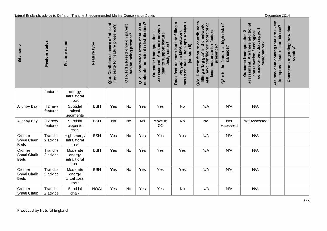
Natural England’s advice to Defra on Tranche 2 recommended Marine Conservation Zones December 2014
353
Produced by Natural England
Sit
e n
am
e
Featu
re s
tatu
s
Featu
re n
am
e
Featu
re t
yp
e
Q1a. C
on
fid
en
ce s
co
re o
f at
lea
st
mo
dera
te f
or
featu
re p
res
en
ce?
Q1b
. Is
1a b
ased
on
ly o
n p
are
nt
hab
itat
bein
g p
resen
t?
Q1c. C
on
fid
en
ce s
co
re o
f at
lea
st
mo
dera
te f
or
exte
nt
/ d
istr
ibu
tio
n?
Ou
tco
me f
rom
qu
esti
on
1
asse
ssm
en
t: A
re t
he
re e
no
ug
h
data
to
su
pp
ort
featu
re
desig
nati
on
?
Do
es f
eatu
re c
on
trib
ute
to
fillin
g a
‘big
gap
’ in
MP
A n
etw
ork
based
on
JN
CC
Big
Gap
s A
naly
sis
(vers
ion
5)
Q2a:
Do
es t
he
featu
re c
on
trib
ute
to
fillin
g a
‘b
ig g
ap
’ in
th
e n
etw
ork
AN
D h
av
e c
on
fid
en
ce s
co
re o
f at
least
mo
de
rate
fo
r fe
atu
re
pre
sen
ce?
Q2b
: Is
th
e f
eatu
re a
t h
igh
ris
k o
f
dam
ag
e?
Ou
tco
me f
rom
qu
esti
on
2
asse
ssm
en
t: A
re t
he
re a
dd
itio
nal
co
nserv
ati
on
/ e
co
log
ical
co
nsid
era
tio
ns t
hat
su
pp
ort
desig
nati
on
?
Are
new
data
co
min
g t
hat
are
lik
ely
to im
pro
ve f
eatu
re c
on
fid
en
ce
?
Co
mm
en
ts r
eg
ard
ing
‘n
ew
data
co
min
g’
features energy infralittoral
rock
Allonby Bay T2 new features
Subtidal mixed
sediments
BSH Yes No Yes Yes No N/A N/A N/A
Allonby Bay T2 new features
Subtidal biogenic
reefs
BSH No No No Move to Q2
No No Not Assessed
Not Assessed
Cromer Shoal Chalk Beds
Tranche 2 advice
High energy infralittoral
rock
BSH Yes No Yes Yes Yes N/A N/A N/A
Cromer Shoal Chalk Beds
Tranche 2 advice
Moderate energy
infralittoral rock
BSH Yes No Yes Yes Yes N/A N/A N/A
Cromer Shoal Chalk Beds
Tranche 2 advice
Moderate energy
circalittoral rock
BSH Yes No Yes Yes Yes N/A N/A N/A
Cromer Shoal Chalk
Tranche 2 advice
Subtidal chalk
HOCI Yes No Yes Yes No N/A N/A N/A

Natural England’s advice to Defra on Tranche 2 recommended Marine Conservation Zones December 2014
354
Produced by Natural England
Sit
e n
am
e
Featu
re s
tatu
s
Featu
re n
am
e
Featu
re t
yp
e
Q1a. C
on
fid
en
ce s
co
re o
f at
lea
st
mo
dera
te f
or
featu
re p
res
en
ce?
Q1b
. Is
1a b
ased
on
ly o
n p
are
nt
hab
itat
bein
g p
resen
t?
Q1c. C
on
fid
en
ce s
co
re o
f at
lea
st
mo
dera
te f
or
exte
nt
/ d
istr
ibu
tio
n?
Ou
tco
me f
rom
qu
esti
on
1
asse
ssm
en
t: A
re t
he
re e
no
ug
h
data
to
su
pp
ort
featu
re
desig
nati
on
?
Do
es f
eatu
re c
on
trib
ute
to
fillin
g a
‘big
gap
’ in
MP
A n
etw
ork
based
on
JN
CC
Big
Gap
s A
naly
sis
(vers
ion
5)
Q2a:
Do
es t
he
featu
re c
on
trib
ute
to
fillin
g a
‘b
ig g
ap
’ in
th
e n
etw
ork
AN
D h
av
e c
on
fid
en
ce s
co
re o
f at
least
mo
de
rate
fo
r fe
atu
re
pre
sen
ce?
Q2b
: Is
th
e f
eatu
re a
t h
igh
ris
k o
f
dam
ag
e?
Ou
tco
me f
rom
qu
esti
on
2
asse
ssm
en
t: A
re t
he
re a
dd
itio
nal
co
nserv
ati
on
/ e
co
log
ical
co
nsid
era
tio
ns t
hat
su
pp
ort
desig
nati
on
?
Are
new
data
co
min
g t
hat
are
lik
ely
to im
pro
ve f
eatu
re c
on
fid
en
ce
?
Co
mm
en
ts r
eg
ard
ing
‘n
ew
data
co
min
g’
Beds
Cromer Shoal Chalk Beds
T2 new features
High energy circalittoral
rock
BSH Yes No Yes Yes No N/A N/A N/A
Cromer Shoal Chalk Beds
T2 new features
Subtidal coarse
sediment
BSH Yes No Yes Yes No N/A N/A N/A
Cromer Shoal Chalk Beds
T2 new features
Subtidal sand
BSH Yes No Yes Yes No N/A N/A N/A
Cromer Shoal Chalk Beds
T2 new features
Subtidal mixed
sediments
BSH Yes No Yes Yes No N/A N/A N/A
Cromer Shoal Chalk Beds
T2 new features
Subtidal biogenic
reefs
BSH No No No Move to Q2
Yes No Not Assessed
Not Assessed
Cromer Shoal Chalk Beds
T2 new features
Blue mussel beds
HOCI No No No Move to Q2
No No Not Assessed
Not Assessed
Cromer Shoal Chalk Beds
T2 new features
Peat and clay
exposures
HOCI Yes No Yes Yes No N/A N/A N/A

Natural England’s advice to Defra on Tranche 2 recommended Marine Conservation Zones December 2014
355
Produced by Natural England
Sit
e n
am
e
Featu
re s
tatu
s
Featu
re n
am
e
Featu
re t
yp
e
Q1a. C
on
fid
en
ce s
co
re o
f at
lea
st
mo
dera
te f
or
featu
re p
res
en
ce?
Q1b
. Is
1a b
ased
on
ly o
n p
are
nt
hab
itat
bein
g p
resen
t?
Q1c. C
on
fid
en
ce s
co
re o
f at
lea
st
mo
dera
te f
or
exte
nt
/ d
istr
ibu
tio
n?
Ou
tco
me f
rom
qu
esti
on
1
asse
ssm
en
t: A
re t
he
re e
no
ug
h
data
to
su
pp
ort
featu
re
desig
nati
on
?
Do
es f
eatu
re c
on
trib
ute
to
fillin
g a
‘big
gap
’ in
MP
A n
etw
ork
based
on
JN
CC
Big
Gap
s A
naly
sis
(vers
ion
5)
Q2a:
Do
es t
he
featu
re c
on
trib
ute
to
fillin
g a
‘b
ig g
ap
’ in
th
e n
etw
ork
AN
D h
av
e c
on
fid
en
ce s
co
re o
f at
least
mo
de
rate
fo
r fe
atu
re
pre
sen
ce?
Q2b
: Is
th
e f
eatu
re a
t h
igh
ris
k o
f
dam
ag
e?
Ou
tco
me f
rom
qu
esti
on
2
asse
ssm
en
t: A
re t
he
re a
dd
itio
nal
co
nserv
ati
on
/ e
co
log
ical
co
nsid
era
tio
ns t
hat
su
pp
ort
desig
nati
on
?
Are
new
data
co
min
g t
hat
are
lik
ely
to im
pro
ve f
eatu
re c
on
fid
en
ce
?
Co
mm
en
ts r
eg
ard
ing
‘n
ew
data
co
min
g’
Cromer Shoal Chalk Beds
T2 new features
Ross worm reefs
(Sabellaria spinulosa)
HOCI No No No Move to Q2
No No Not Assessed
Not Assessed
Cromer Shoal Chalk Beds
T2 new features
Fragile sponge & anthozoan
communities on subtidal
rocky habitats
HOCI No No No Move to Q2
No No Not Assessed
Not Assessed
Cromer Shoal Chalk Beds
T2 new features
Horse mussel
(Modiolus modiolus)
HOCI No No No Move to Q2
No No Not Assessed
Not Assessed
Cromer Shoal Chalk Beds
T2 new features
Smelt (Osmerus eperlanus)
SOCI No No No Move to Q2
No No Not Assessed
Not Assessed
Cromer Shoal Chalk Beds
T2 new features
Undulate ray (Raja
undulata)
SOCI No No No Move to Q2
No No Not Assessed
Not Assessed
Holderness Tranche Intertidal BSH No No No Move to No No No No designation

Natural England’s advice to Defra on Tranche 2 recommended Marine Conservation Zones December 2014
356
Produced by Natural England
Sit
e n
am
e
Featu
re s
tatu
s
Featu
re n
am
e
Featu
re t
yp
e
Q1a. C
on
fid
en
ce s
co
re o
f at
lea
st
mo
dera
te f
or
featu
re p
res
en
ce?
Q1b
. Is
1a b
ased
on
ly o
n p
are
nt
hab
itat
bein
g p
resen
t?
Q1c. C
on
fid
en
ce s
co
re o
f at
lea
st
mo
dera
te f
or
exte
nt
/ d
istr
ibu
tio
n?
Ou
tco
me f
rom
qu
esti
on
1
asse
ssm
en
t: A
re t
he
re e
no
ug
h
data
to
su
pp
ort
featu
re
desig
nati
on
?
Do
es f
eatu
re c
on
trib
ute
to
fillin
g a
‘big
gap
’ in
MP
A n
etw
ork
based
on
JN
CC
Big
Gap
s A
naly
sis
(vers
ion
5)
Q2a:
Do
es t
he
featu
re c
on
trib
ute
to
fillin
g a
‘b
ig g
ap
’ in
th
e n
etw
ork
AN
D h
av
e c
on
fid
en
ce s
co
re o
f at
least
mo
de
rate
fo
r fe
atu
re
pre
sen
ce?
Q2b
: Is
th
e f
eatu
re a
t h
igh
ris
k o
f
dam
ag
e?
Ou
tco
me f
rom
qu
esti
on
2
asse
ssm
en
t: A
re t
he
re a
dd
itio
nal
co
nserv
ati
on
/ e
co
log
ical
co
nsid
era
tio
ns t
hat
su
pp
ort
desig
nati
on
?
Are
new
data
co
min
g t
hat
are
lik
ely
to im
pro
ve f
eatu
re c
on
fid
en
ce
?
Co
mm
en
ts r
eg
ard
ing
‘n
ew
data
co
min
g’
Inshore 2 advice mixed sediments
Q2
Holderness Inshore
Tranche 2 advice
Subtidal coarse
sediment
BSH Yes No Yes Yes No N/A N/A N/A
Holderness Inshore
Tranche 2 advice
Subtidal sand
BSH Yes No Yes Yes No N/A N/A N/A
Holderness Inshore
Tranche 2 advice
Peat and clay
exposures
HOCI No No No Move to Q2
No No Yes Further Consideration
Holderness Inshore
Tranche 2 advice
Ross worm reefs
(Sabellaria spinulosa)
HOCI No No No Move to Q2
No No Yes Further Consideration
Holderness Inshore
Tranche 2 advice
Subtidal chalk
HOCI No No No Move to Q2
No No Not Assessed
Not Assessed
Holderness Inshore
T2 new features
Intertidal sand and
muddy sand
BSH Yes No Yes Yes No N/A N/A N/A
Holderness Inshore
T2 new features
High energy circalittoral
rock
BSH Yes No Yes Yes No N/A N/A N/A

Natural England’s advice to Defra on Tranche 2 recommended Marine Conservation Zones December 2014
357
Produced by Natural England
Sit
e n
am
e
Featu
re s
tatu
s
Featu
re n
am
e
Featu
re t
yp
e
Q1a. C
on
fid
en
ce s
co
re o
f at
lea
st
mo
dera
te f
or
featu
re p
res
en
ce?
Q1b
. Is
1a b
ased
on
ly o
n p
are
nt
hab
itat
bein
g p
resen
t?
Q1c. C
on
fid
en
ce s
co
re o
f at
lea
st
mo
dera
te f
or
exte
nt
/ d
istr
ibu
tio
n?
Ou
tco
me f
rom
qu
esti
on
1
asse
ssm
en
t: A
re t
he
re e
no
ug
h
data
to
su
pp
ort
featu
re
desig
nati
on
?
Do
es f
eatu
re c
on
trib
ute
to
fillin
g a
‘big
gap
’ in
MP
A n
etw
ork
based
on
JN
CC
Big
Gap
s A
naly
sis
(vers
ion
5)
Q2a:
Do
es t
he
featu
re c
on
trib
ute
to
fillin
g a
‘b
ig g
ap
’ in
th
e n
etw
ork
AN
D h
av
e c
on
fid
en
ce s
co
re o
f at
least
mo
de
rate
fo
r fe
atu
re
pre
sen
ce?
Q2b
: Is
th
e f
eatu
re a
t h
igh
ris
k o
f
dam
ag
e?
Ou
tco
me f
rom
qu
esti
on
2
asse
ssm
en
t: A
re t
he
re a
dd
itio
nal
co
nserv
ati
on
/ e
co
log
ical
co
nsid
era
tio
ns t
hat
su
pp
ort
desig
nati
on
?
Are
new
data
co
min
g t
hat
are
lik
ely
to im
pro
ve f
eatu
re c
on
fid
en
ce
?
Co
mm
en
ts r
eg
ard
ing
‘n
ew
data
co
min
g’
Holderness Inshore
T2 new features
Moderate energy
circalittoral rock
BSH Yes No Yes Yes No N/A N/A N/A
Holderness Inshore
T2 new features
Subtidal mud BSH Yes No Yes Yes No N/A N/A N/A
Holderness Inshore
T2 new features
Subtidal mixed
sediments
BSH Yes No Yes Yes No N/A N/A N/A
Runswick Bay
Tranche 2 advice
High energy infralittoral
rock
BSH No No No Move to Q2
Yes No No No designation Yes EA / Cefas verification reporting due 14/11/2014 providing high MESH polygonal and point data in support of subtidal features.
Runswick Tranche Moderate BSH Yes No Yes Yes Yes N/A N/A N/A Yes EA / Cefas

Natural England’s advice to Defra on Tranche 2 recommended Marine Conservation Zones December 2014
358
Produced by Natural England
Sit
e n
am
e
Featu
re s
tatu
s
Featu
re n
am
e
Featu
re t
yp
e
Q1a. C
on
fid
en
ce s
co
re o
f at
lea
st
mo
dera
te f
or
featu
re p
res
en
ce?
Q1b
. Is
1a b
ased
on
ly o
n p
are
nt
hab
itat
bein
g p
resen
t?
Q1c. C
on
fid
en
ce s
co
re o
f at
lea
st
mo
dera
te f
or
exte
nt
/ d
istr
ibu
tio
n?
Ou
tco
me f
rom
qu
esti
on
1
asse
ssm
en
t: A
re t
he
re e
no
ug
h
data
to
su
pp
ort
featu
re
desig
nati
on
?
Do
es f
eatu
re c
on
trib
ute
to
fillin
g a
‘big
gap
’ in
MP
A n
etw
ork
based
on
JN
CC
Big
Gap
s A
naly
sis
(vers
ion
5)
Q2a:
Do
es t
he
featu
re c
on
trib
ute
to
fillin
g a
‘b
ig g
ap
’ in
th
e n
etw
ork
AN
D h
av
e c
on
fid
en
ce s
co
re o
f at
least
mo
de
rate
fo
r fe
atu
re
pre
sen
ce?
Q2b
: Is
th
e f
eatu
re a
t h
igh
ris
k o
f
dam
ag
e?
Ou
tco
me f
rom
qu
esti
on
2
asse
ssm
en
t: A
re t
he
re a
dd
itio
nal
co
nserv
ati
on
/ e
co
log
ical
co
nsid
era
tio
ns t
hat
su
pp
ort
desig
nati
on
?
Are
new
data
co
min
g t
hat
are
lik
ely
to im
pro
ve f
eatu
re c
on
fid
en
ce
?
Co
mm
en
ts r
eg
ard
ing
‘n
ew
data
co
min
g’
Bay 2 advice energy infralittoral
rock
verification reporting due 14/11/2014 providing high MESH polygonal and point data in support of subtidal features.
Runswick Bay
Tranche 2 advice
High energy circalittoral
rock
BSH No No No Move to Q2
Yes No No No designation Yes EA / Cefas verification reporting due 14/11/2014 providing high MESH polygonal and point data in support of

Natural England’s advice to Defra on Tranche 2 recommended Marine Conservation Zones December 2014
359
Produced by Natural England
Sit
e n
am
e
Featu
re s
tatu
s
Featu
re n
am
e
Featu
re t
yp
e
Q1a. C
on
fid
en
ce s
co
re o
f at
lea
st
mo
dera
te f
or
featu
re p
res
en
ce?
Q1b
. Is
1a b
ased
on
ly o
n p
are
nt
hab
itat
bein
g p
resen
t?
Q1c. C
on
fid
en
ce s
co
re o
f at
lea
st
mo
dera
te f
or
exte
nt
/ d
istr
ibu
tio
n?
Ou
tco
me f
rom
qu
esti
on
1
asse
ssm
en
t: A
re t
he
re e
no
ug
h
data
to
su
pp
ort
featu
re
desig
nati
on
?
Do
es f
eatu
re c
on
trib
ute
to
fillin
g a
‘big
gap
’ in
MP
A n
etw
ork
based
on
JN
CC
Big
Gap
s A
naly
sis
(vers
ion
5)
Q2a:
Do
es t
he
featu
re c
on
trib
ute
to
fillin
g a
‘b
ig g
ap
’ in
th
e n
etw
ork
AN
D h
av
e c
on
fid
en
ce s
co
re o
f at
least
mo
de
rate
fo
r fe
atu
re
pre
sen
ce?
Q2b
: Is
th
e f
eatu
re a
t h
igh
ris
k o
f
dam
ag
e?
Ou
tco
me f
rom
qu
esti
on
2
asse
ssm
en
t: A
re t
he
re a
dd
itio
nal
co
nserv
ati
on
/ e
co
log
ical
co
nsid
era
tio
ns t
hat
su
pp
ort
desig
nati
on
?
Are
new
data
co
min
g t
hat
are
lik
ely
to im
pro
ve f
eatu
re c
on
fid
en
ce
?
Co
mm
en
ts r
eg
ard
ing
‘n
ew
data
co
min
g’
subtidal features.
Runswick Bay
Tranche 2 advice
Moderate energy
circalittoral rock
BSH Yes No Yes Yes Yes N/A N/A N/A Yes EA / Cefas verification reporting due 14/11/2014 providing high MESH polygonal and point data in support of subtidal features.
Runswick Bay
Tranche 2 advice
Subtidal coarse
sediment
BSH No No No Move to Q2
Yes No No No designation Yes EA / Cefas verification reporting due 14/11/2014 providing high MESH polygonal

Natural England’s advice to Defra on Tranche 2 recommended Marine Conservation Zones December 2014
360
Produced by Natural England
Sit
e n
am
e
Featu
re s
tatu
s
Featu
re n
am
e
Featu
re t
yp
e
Q1a. C
on
fid
en
ce s
co
re o
f at
lea
st
mo
dera
te f
or
featu
re p
res
en
ce?
Q1b
. Is
1a b
ased
on
ly o
n p
are
nt
hab
itat
bein
g p
resen
t?
Q1c. C
on
fid
en
ce s
co
re o
f at
lea
st
mo
dera
te f
or
exte
nt
/ d
istr
ibu
tio
n?
Ou
tco
me f
rom
qu
esti
on
1
asse
ssm
en
t: A
re t
he
re e
no
ug
h
data
to
su
pp
ort
featu
re
desig
nati
on
?
Do
es f
eatu
re c
on
trib
ute
to
fillin
g a
‘big
gap
’ in
MP
A n
etw
ork
based
on
JN
CC
Big
Gap
s A
naly
sis
(vers
ion
5)
Q2a:
Do
es t
he
featu
re c
on
trib
ute
to
fillin
g a
‘b
ig g
ap
’ in
th
e n
etw
ork
AN
D h
av
e c
on
fid
en
ce s
co
re o
f at
least
mo
de
rate
fo
r fe
atu
re
pre
sen
ce?
Q2b
: Is
th
e f
eatu
re a
t h
igh
ris
k o
f
dam
ag
e?
Ou
tco
me f
rom
qu
esti
on
2
asse
ssm
en
t: A
re t
he
re a
dd
itio
nal
co
nserv
ati
on
/ e
co
log
ical
co
nsid
era
tio
ns t
hat
su
pp
ort
desig
nati
on
?
Are
new
data
co
min
g t
hat
are
lik
ely
to im
pro
ve f
eatu
re c
on
fid
en
ce
?
Co
mm
en
ts r
eg
ard
ing
‘n
ew
data
co
min
g’
and point data in support of subtidal features.
Runswick Bay
Tranche 2 advice
Subtidal sand
BSH Yes No Yes Yes Yes N/A N/A N/A Yes EA / Cefas verification reporting due 14/11/2014 providing high MESH polygonal and point data in support of subtidal features.
Runswick Bay
Tranche 2 advice
Subtidal mixed
sediments
BSH No No No Move to Q2
Yes No No No designation Yes EA / Cefas verification reporting due 14/11/2014

Natural England’s advice to Defra on Tranche 2 recommended Marine Conservation Zones December 2014
361
Produced by Natural England
Sit
e n
am
e
Featu
re s
tatu
s
Featu
re n
am
e
Featu
re t
yp
e
Q1a. C
on
fid
en
ce s
co
re o
f at
lea
st
mo
dera
te f
or
featu
re p
res
en
ce?
Q1b
. Is
1a b
ased
on
ly o
n p
are
nt
hab
itat
bein
g p
resen
t?
Q1c. C
on
fid
en
ce s
co
re o
f at
lea
st
mo
dera
te f
or
exte
nt
/ d
istr
ibu
tio
n?
Ou
tco
me f
rom
qu
esti
on
1
asse
ssm
en
t: A
re t
he
re e
no
ug
h
data
to
su
pp
ort
featu
re
desig
nati
on
?
Do
es f
eatu
re c
on
trib
ute
to
fillin
g a
‘big
gap
’ in
MP
A n
etw
ork
based
on
JN
CC
Big
Gap
s A
naly
sis
(vers
ion
5)
Q2a:
Do
es t
he
featu
re c
on
trib
ute
to
fillin
g a
‘b
ig g
ap
’ in
th
e n
etw
ork
AN
D h
av
e c
on
fid
en
ce s
co
re o
f at
least
mo
de
rate
fo
r fe
atu
re
pre
sen
ce?
Q2b
: Is
th
e f
eatu
re a
t h
igh
ris
k o
f
dam
ag
e?
Ou
tco
me f
rom
qu
esti
on
2
asse
ssm
en
t: A
re t
he
re a
dd
itio
nal
co
nserv
ati
on
/ e
co
log
ical
co
nsid
era
tio
ns t
hat
su
pp
ort
desig
nati
on
?
Are
new
data
co
min
g t
hat
are
lik
ely
to im
pro
ve f
eatu
re c
on
fid
en
ce
?
Co
mm
en
ts r
eg
ard
ing
‘n
ew
data
co
min
g’
providing high MESH polygonal and point data in support of subtidal features.
Runswick Bay
Tranche 2 advice
Ocean quahog (Arctica
islandica)
SOCI Yes No Yes Yes No N/A N/A N/A
Runswick Bay
T2 new features
High energy intertidal rock
BSH Yes No Yes Yes No N/A N/A N/A
Runswick Bay
T2 new features
Moderate energy
intertidal rock
BSH Yes No Yes Yes No N/A N/A N/A
Runswick Bay
T2 new features
Low energy intertidal rock
BSH Yes No Yes Yes No N/A N/A N/A
Runswick Bay
T2 new features
Intertidal sand and
muddy sand
BSH Yes No Yes Yes No N/A N/A N/A

Natural England’s advice to Defra on Tranche 2 recommended Marine Conservation Zones December 2014
362
Produced by Natural England
Sit
e n
am
e
Featu
re s
tatu
s
Featu
re n
am
e
Featu
re t
yp
e
Q1a. C
on
fid
en
ce s
co
re o
f at
lea
st
mo
dera
te f
or
featu
re p
res
en
ce?
Q1b
. Is
1a b
ased
on
ly o
n p
are
nt
hab
itat
bein
g p
resen
t?
Q1c. C
on
fid
en
ce s
co
re o
f at
lea
st
mo
dera
te f
or
exte
nt
/ d
istr
ibu
tio
n?
Ou
tco
me f
rom
qu
esti
on
1
asse
ssm
en
t: A
re t
he
re e
no
ug
h
data
to
su
pp
ort
featu
re
desig
nati
on
?
Do
es f
eatu
re c
on
trib
ute
to
fillin
g a
‘big
gap
’ in
MP
A n
etw
ork
based
on
JN
CC
Big
Gap
s A
naly
sis
(vers
ion
5)
Q2a:
Do
es t
he
featu
re c
on
trib
ute
to
fillin
g a
‘b
ig g
ap
’ in
th
e n
etw
ork
AN
D h
av
e c
on
fid
en
ce s
co
re o
f at
least
mo
de
rate
fo
r fe
atu
re
pre
sen
ce?
Q2b
: Is
th
e f
eatu
re a
t h
igh
ris
k o
f
dam
ag
e?
Ou
tco
me f
rom
qu
esti
on
2
asse
ssm
en
t: A
re t
he
re a
dd
itio
nal
co
nserv
ati
on
/ e
co
log
ical
co
nsid
era
tio
ns t
hat
su
pp
ort
desig
nati
on
?
Are
new
data
co
min
g t
hat
are
lik
ely
to im
pro
ve f
eatu
re c
on
fid
en
ce
?
Co
mm
en
ts r
eg
ard
ing
‘n
ew
data
co
min
g’
Runswick Bay
T2 new features
Intertidal mud
BSH No No No Move to Q2
No No Not Assessed
Not Assessed
Runswick Bay
T2 new features
Intertidal mixed
sediments
BSH No No No Move to Q2
No No Not Assessed
Not Assessed
Runswick Bay
T2 new features
Low energy infralittoral
rock
BSH No No No Move to Q2
No No Not Assessed
Not Assessed Yes EA / Cefas verification reporting due 14/11/2014 providing high MESH polygonal and point data in support of subtidal features.
Runswick Bay
T2 new features
Subtidal mud BSH No No No Move to Q2
Yes No Not Assessed
Not Assessed Yes EA / Cefas verification reporting due 14/11/2014

Natural England’s advice to Defra on Tranche 2 recommended Marine Conservation Zones December 2014
363
Produced by Natural England
Sit
e n
am
e
Featu
re s
tatu
s
Featu
re n
am
e
Featu
re t
yp
e
Q1a. C
on
fid
en
ce s
co
re o
f at
lea
st
mo
dera
te f
or
featu
re p
res
en
ce?
Q1b
. Is
1a b
ased
on
ly o
n p
are
nt
hab
itat
bein
g p
resen
t?
Q1c. C
on
fid
en
ce s
co
re o
f at
lea
st
mo
dera
te f
or
exte
nt
/ d
istr
ibu
tio
n?
Ou
tco
me f
rom
qu
esti
on
1
asse
ssm
en
t: A
re t
he
re e
no
ug
h
data
to
su
pp
ort
featu
re
desig
nati
on
?
Do
es f
eatu
re c
on
trib
ute
to
fillin
g a
‘big
gap
’ in
MP
A n
etw
ork
based
on
JN
CC
Big
Gap
s A
naly
sis
(vers
ion
5)
Q2a:
Do
es t
he
featu
re c
on
trib
ute
to
fillin
g a
‘b
ig g
ap
’ in
th
e n
etw
ork
AN
D h
av
e c
on
fid
en
ce s
co
re o
f at
least
mo
de
rate
fo
r fe
atu
re
pre
sen
ce?
Q2b
: Is
th
e f
eatu
re a
t h
igh
ris
k o
f
dam
ag
e?
Ou
tco
me f
rom
qu
esti
on
2
asse
ssm
en
t: A
re t
he
re a
dd
itio
nal
co
nserv
ati
on
/ e
co
log
ical
co
nsid
era
tio
ns t
hat
su
pp
ort
desig
nati
on
?
Are
new
data
co
min
g t
hat
are
lik
ely
to im
pro
ve f
eatu
re c
on
fid
en
ce
?
Co
mm
en
ts r
eg
ard
ing
‘n
ew
data
co
min
g’
providing high MESH polygonal and point data in support of subtidal features.
Runswick Bay
T2 new features
Littoral chalk communities
HOCI No No No Move to Q2
No No Not Assessed
Not Assessed
Coquet to St Mary's
Tranche 2 advice
Moderate energy
intertidal rock
BSH Yes No Yes Yes No N/A N/A N/A
Coquet to St Mary's
Tranche 2 advice
Low energy intertidal rock
BSH Yes No Yes Yes No N/A N/A N/A
Coquet to St Mary's
Tranche 2 advice
Intertidal coarse
sediment
BSH Yes No Yes Yes No N/A N/A N/A
Coquet to St Mary's
Tranche 2 advice
Intertidal sand and
muddy sand
BSH Yes No Yes Yes No N/A N/A N/A
Coquet to St Tranche Intertidal BSH Yes No Yes Yes No N/A N/A N/A

Natural England’s advice to Defra on Tranche 2 recommended Marine Conservation Zones December 2014
364
Produced by Natural England
Sit
e n
am
e
Featu
re s
tatu
s
Featu
re n
am
e
Featu
re t
yp
e
Q1a. C
on
fid
en
ce s
co
re o
f at
lea
st
mo
dera
te f
or
featu
re p
res
en
ce?
Q1b
. Is
1a b
ased
on
ly o
n p
are
nt
hab
itat
bein
g p
resen
t?
Q1c. C
on
fid
en
ce s
co
re o
f at
lea
st
mo
dera
te f
or
exte
nt
/ d
istr
ibu
tio
n?
Ou
tco
me f
rom
qu
esti
on
1
asse
ssm
en
t: A
re t
he
re e
no
ug
h
data
to
su
pp
ort
featu
re
desig
nati
on
?
Do
es f
eatu
re c
on
trib
ute
to
fillin
g a
‘big
gap
’ in
MP
A n
etw
ork
based
on
JN
CC
Big
Gap
s A
naly
sis
(vers
ion
5)
Q2a:
Do
es t
he
featu
re c
on
trib
ute
to
fillin
g a
‘b
ig g
ap
’ in
th
e n
etw
ork
AN
D h
av
e c
on
fid
en
ce s
co
re o
f at
least
mo
de
rate
fo
r fe
atu
re
pre
sen
ce?
Q2b
: Is
th
e f
eatu
re a
t h
igh
ris
k o
f
dam
ag
e?
Ou
tco
me f
rom
qu
esti
on
2
asse
ssm
en
t: A
re t
he
re a
dd
itio
nal
co
nserv
ati
on
/ e
co
log
ical
co
nsid
era
tio
ns t
hat
su
pp
ort
desig
nati
on
?
Are
new
data
co
min
g t
hat
are
lik
ely
to im
pro
ve f
eatu
re c
on
fid
en
ce
?
Co
mm
en
ts r
eg
ard
ing
‘n
ew
data
co
min
g’
Mary's 2 advice mud
Coquet to St Mary's
Tranche 2 advice
Intertidal mixed
sediments
BSH Yes No Yes Yes No N/A N/A N/A
Coquet to St Mary's
Tranche 2 advice
High energy infralittoral
rock
BSH Yes No Yes Yes Yes N/A N/A N/A
Coquet to St Mary's
Tranche 2 advice
Moderate energy
infralittoral rock
BSH Yes No Yes Yes Yes N/A N/A N/A
Coquet to St Mary's
Tranche 2 advice
Moderate energy
circalittoral rock
BSH Yes No Yes Yes Yes N/A N/A N/A
Coquet to St Mary's
Tranche 2 advice
Subtidal coarse
sediment
BSH Yes No Yes Yes No N/A N/A N/A
Coquet to St Mary's
Tranche 2 advice
Subtidal sand
BSH Yes No Yes Yes Yes N/A N/A N/A
Coquet to St Mary's
Tranche 2 advice
Subtidal mud BSH No No No Move to Q2
Yes No No No designation

Natural England’s advice to Defra on Tranche 2 recommended Marine Conservation Zones December 2014
365
Produced by Natural England
Sit
e n
am
e
Featu
re s
tatu
s
Featu
re n
am
e
Featu
re t
yp
e
Q1a. C
on
fid
en
ce s
co
re o
f at
lea
st
mo
dera
te f
or
featu
re p
res
en
ce?
Q1b
. Is
1a b
ased
on
ly o
n p
are
nt
hab
itat
bein
g p
resen
t?
Q1c. C
on
fid
en
ce s
co
re o
f at
lea
st
mo
dera
te f
or
exte
nt
/ d
istr
ibu
tio
n?
Ou
tco
me f
rom
qu
esti
on
1
asse
ssm
en
t: A
re t
he
re e
no
ug
h
data
to
su
pp
ort
featu
re
desig
nati
on
?
Do
es f
eatu
re c
on
trib
ute
to
fillin
g a
‘big
gap
’ in
MP
A n
etw
ork
based
on
JN
CC
Big
Gap
s A
naly
sis
(vers
ion
5)
Q2a:
Do
es t
he
featu
re c
on
trib
ute
to
fillin
g a
‘b
ig g
ap
’ in
th
e n
etw
ork
AN
D h
av
e c
on
fid
en
ce s
co
re o
f at
least
mo
de
rate
fo
r fe
atu
re
pre
sen
ce?
Q2b
: Is
th
e f
eatu
re a
t h
igh
ris
k o
f
dam
ag
e?
Ou
tco
me f
rom
qu
esti
on
2
asse
ssm
en
t: A
re t
he
re a
dd
itio
nal
co
nserv
ati
on
/ e
co
log
ical
co
nsid
era
tio
ns t
hat
su
pp
ort
desig
nati
on
?
Are
new
data
co
min
g t
hat
are
lik
ely
to im
pro
ve f
eatu
re c
on
fid
en
ce
?
Co
mm
en
ts r
eg
ard
ing
‘n
ew
data
co
min
g’
Coquet to St Mary's
Tranche 2 advice
Subtidal mixed
sediments
BSH Yes No Yes Yes Yes N/A N/A N/A
Coquet to St Mary's
Tranche 2 advice
Intertidal underboulder communities
HOCI Yes No Yes Yes No N/A N/A N/A
Coquet to St Mary's
T2 new features
High energy intertidal rock
BSH Yes No Yes Yes No N/A N/A N/A
Coquet to St Mary's
T2 new features
High energy circalittoral
rock
BSH Yes No No Move to Q2
Yes Yes Not Assessed
Not Assessed
Coquet to St Mary's
T2 new features
Low energy circalittoral
rock
BSH No No No Move to Q2
Yes No Not Assessed
No designation
Coquet to St Mary's
T2 new features
Littoral chalk communities
HOCI No No No Move to Q2
no No Not Assessed
Not Assessed
Coquet to St Mary's
T2 new features
Mud habitats in deep water
HOCI No No No Move to Q2
No No Not Assessed
Not Assessed
Coquet to St Mary's
T2 new features
Peat and clay
exposures
HOCI Yes No Yes Yes No N/A N/A N/A

Natural England’s advice to Defra on Tranche 2 recommended Marine Conservation Zones December 2014
366
Produced by Natural England
Sit
e n
am
e
Featu
re s
tatu
s
Featu
re n
am
e
Featu
re t
yp
e
Q1a. C
on
fid
en
ce s
co
re o
f at
lea
st
mo
dera
te f
or
featu
re p
res
en
ce?
Q1b
. Is
1a b
ased
on
ly o
n p
are
nt
hab
itat
bein
g p
resen
t?
Q1c. C
on
fid
en
ce s
co
re o
f at
lea
st
mo
dera
te f
or
exte
nt
/ d
istr
ibu
tio
n?
Ou
tco
me f
rom
qu
esti
on
1
asse
ssm
en
t: A
re t
he
re e
no
ug
h
data
to
su
pp
ort
featu
re
desig
nati
on
?
Do
es f
eatu
re c
on
trib
ute
to
fillin
g a
‘big
gap
’ in
MP
A n
etw
ork
based
on
JN
CC
Big
Gap
s A
naly
sis
(vers
ion
5)
Q2a:
Do
es t
he
featu
re c
on
trib
ute
to
fillin
g a
‘b
ig g
ap
’ in
th
e n
etw
ork
AN
D h
av
e c
on
fid
en
ce s
co
re o
f at
least
mo
de
rate
fo
r fe
atu
re
pre
sen
ce?
Q2b
: Is
th
e f
eatu
re a
t h
igh
ris
k o
f
dam
ag
e?
Ou
tco
me f
rom
qu
esti
on
2
asse
ssm
en
t: A
re t
he
re a
dd
itio
nal
co
nserv
ati
on
/ e
co
log
ical
co
nsid
era
tio
ns t
hat
su
pp
ort
desig
nati
on
?
Are
new
data
co
min
g t
hat
are
lik
ely
to im
pro
ve f
eatu
re c
on
fid
en
ce
?
Co
mm
en
ts r
eg
ard
ing
‘n
ew
data
co
min
g’
Coquet to St Mary's
T2 new features
Ross worm reefs
(Sabellaria spinulosa)
HOCI No No No Move to Q2
No No Not Assessed
Not Assessed
Coquet to St Mary's
T2 new features
Sheltered muddy gravels
HOCI No No No Move to Q2
No No Not Assessed
Not Assessed
Coquet to St Mary's
T2 new features
Tide-swept channels
HOCI No No No Move to Q2
No No Not Assessed
Not Assessed
Coquet to St Mary's
T2 new features
Estuarine rocky
habitats
HOCI No No No Move to Q2
No No Not Assessed
Not Assessed
Coquet to St Mary's
T2 new features
Ocean quahog (Arctica
islandica)
SOCI Yes No Yes Yes No N/A N/A N/A
[1] Based on 2013 confidence assessment results

Natural England’s advice to Defra on Tranche 2 recommended Marine Conservation Zones
18 August 2014
December 2014
367
Produced by Natural England
Table 9 Site data sufficiency assessment
Site name Q1: Are there grounds for considering
designating more features at this site in order to fully protect one or more features
which do have sufficient
confidence?
Q2: What proportion of total site area do the features meet
requirements for Q1 in the ‘Feature
Assessment’ cover within the site? [Note
proportions are dependent on polygon data
availability, and may be based on
modelled maps]
Comment on Q2 assessment
Q3: Does this site fill a ‘big gap’ in the
network based on revised confidence
assessments in feature presence
and extent?
Blackwater, Crouch, Roach and Colne Estuaries
No Tranche 1 designated MCZ and estuarine site – Q2 has not been calculated
Yes – Available data supports at least one JNCC Big Gaps identified feature for designation
The Swale Estuary No Estuarine site – Q2 has not been calculated
Yes – Available data supports at least one JNCC Big Gaps identified feature for designation
Dover to Deal No 95% Maybe – Available data supports at least one JNCC Big Gaps identified feature for designation
Dover to Folkestone No 99% Maybe
Beachy Head West No Tranche 1 designated MCZ – Q2 has not been calculated
Yes
Norris to Ryde No >10% Overlap with designated SAC & partially estuarine site – Q2 has not been calculated
Yes – Available data supports at least one JNCC Big Gaps identified feature for designation
The Needles No >10% overlap with designated SAC – Q2 has not been calculated
Yes
Bembridge No >10% overlap with designated SAC – Q2 has not been calculated
Yes – Available data supports at least one JNCC Big Gaps identified feature for designation
Yarmouth to Cowes No >10% overlap with No

Natural England’s advice to Defra on Tranche 2 recommended Marine Conservation Zones
18 August 2014
December 2014
368
Produced by Natural England
Site name Q1: Are there grounds for considering
designating more features at this site in order to fully protect one or more features
which do have sufficient
confidence?
Q2: What proportion of total site area do the features meet
requirements for Q1 in the ‘Feature
Assessment’ cover within the site? [Note
proportions are dependent on polygon data
availability, and may be based on
modelled maps]
Comment on Q2 assessment
Q3: Does this site fill a ‘big gap’ in the
network based on revised confidence
assessments in feature presence
and extent?
designated SAC & partially estuarine site – Q2 has not been calculated
Utopia No 96% No, didn’t fill gap originally
Studland Bay No 86% Yes – Available data supports at least one JNCC Big Gaps identified feature for designation and new data coming
Torbay No Tranche 1 designated MCZ – Q2 has not been calculated
Yes
Mounts Bay No 76% Maybe – Available data supports at least one JNCC Big Gaps identified feature for designation
Runnel Stone (Land’s End)
No Assessment based predominantly on point data – Q2 has not been calculated
No, didn’t fill gap originally
Newquay and The Gannel
No Estuarine site – Q2 has not been calculated
No BUT new data coming
Hartland Point to Tintagel
No 98% Yes – Available data supports at least one JNCC Big Gaps identified feature for designation
Bideford to Foreland Point
No 91% No, didn’t fill gap originally
North of Lundy No 100% Maybe – Available data supports at least one JNCC Big Gaps identified

Natural England’s advice to Defra on Tranche 2 recommended Marine Conservation Zones
18 August 2014
December 2014
369
Produced by Natural England
Site name Q1: Are there grounds for considering
designating more features at this site in order to fully protect one or more features
which do have sufficient
confidence?
Q2: What proportion of total site area do the features meet
requirements for Q1 in the ‘Feature
Assessment’ cover within the site? [Note
proportions are dependent on polygon data
availability, and may be based on
modelled maps]
Comment on Q2 assessment
Q3: Does this site fill a ‘big gap’ in the
network based on revised confidence
assessments in feature presence
and extent?
feature for designation
West of Walney including proposed Co-location Zone
No 100% Yes
Fylde14
No Tranche 1 designated MCZ – Q2 has not been calculated
Allonby Bay No Assessment based predominantly on point data – Q2 has not been calculated
No, didn’t fill gap originally
Cromer Shoal Chalk Beds
No 99% Yes – Available data supports at least one JNCC Big Gaps identified feature for designation
Holderness Inshore No 91% No, didn’t fill gap originally
Runswick Bay No 94% No BUT new data coming
Coquet to St Mary's No 97% Yes – Available data supports at least one JNCC Big Gaps identified feature for designation
4.7.3 Site-level commentary
Table 10 presents a site-based commentary based on a site’s ability to fill big gaps in the network, using
information taken from the JNCC Big Gaps Analysis (JNCC, 2014), but updated to take account of any
reduction in confidence in features potentially filling gaps as set out in Table 8. Additionally the table
provides information on the number of features identified with at least moderate confidence in presence and
extent for each site being considered for the first time in Tranche 2, as well as the size of sites (according to
the boundaries recommended by the regional projects). Based on a consideration of ‘gap filling’ ability,
number of features with at least moderate confidence and site area, Natural England has identified those
14
Based on 2013 confidence assessment results

Natural England’s advice to Defra on Tranche 2 recommended Marine Conservation Zones
18 August 2014
December 2014
370
Produced by Natural England
sites that may be regarded as having the potential to make a particularly important contribution to the
network. Where a site is identified as filling a ‘big gap’ in the network, these features are listed in Table 8.
Table 10 Site-level commentary
Site name Does this site still
fill a ‘big gap’ in
the network
based on revised
confidence
assessments in
feature presence
and extent?
Number of
features with at
least moderate
confidence in
both presence
and extent
(Tranche 2 new
sites only)
Site area
(ha)
Additional
comments from
Natural England
highlighting sites
with the potential
to make a
particularly
significant
contribution to
the MPA network
(Tranche 2 new
sites only)
Blackwater,
Crouch, Roach and
Colne Estuaries
Yes – Available
data supports at
least one JNCC
Big Gaps identified
feature for
designation
28,439.7
The Swale Estuary Yes – Available
data supports at
least one JNCC
Big Gaps identified
feature for
designation
13 5,129.9
Dover to Deal Maybe - Available
data supports at
least one JNCC
Big Gaps identified
feature for
designation
13 1,039.3
Dover to
Folkestone
Maybe 20 2,019.5 This site supports
the second largest
number of features
of those sites being
considered for
Tranche 2.
Beachy Head West Yes 2,436.2
Norris to Ryde Yes – Available
data supports at
least one JNCC
Big Gaps identified
feature for
designation
6 1,975
The Needles Yes 13 1,102.1

Natural England’s advice to Defra on Tranche 2 recommended Marine Conservation Zones
18 August 2014
December 2014
371
Produced by Natural England
Site name Does this site still
fill a ‘big gap’ in
the network
based on revised
confidence
assessments in
feature presence
and extent?
Number of
features with at
least moderate
confidence in
both presence
and extent
(Tranche 2 new
sites only)
Site area
(ha)
Additional
comments from
Natural England
highlighting sites
with the potential
to make a
particularly
significant
contribution to
the MPA network
(Tranche 2 new
sites only)
Bembridge Yes – Available
data supports at
least one JNCC
Big Gaps identified
feature for
designation
14 8,482.4 The combination of
big gap filling
ability, number of
features with
reasonable
confidence, and
size, make this site
one of the strong
candidates of the
inshore sites to
contribute to the
network.
Yarmouth to
Cowes
No 16 1,689.1
Utopia No, didn’t fill big
gap originally
6 271.4
Studland Bay Yes – Available
data supports at
least one JNCC
Big Gaps identified
feature for
designation and
new data coming
9 397.4
Torbay Yes 1,985.7
Mounts Bay Maybe - Available
data supports at
least one JNCC
Big Gaps identified
feature for
designation
7 1,124.1
Runnel Stone
(Land’s End)
No, didn’t fill big
gap originally
4 2,004.5
Newquay and The
Gannel
No BUT new data
coming
12 2,141.4

Natural England’s advice to Defra on Tranche 2 recommended Marine Conservation Zones
18 August 2014
December 2014
372
Produced by Natural England
Site name Does this site still
fill a ‘big gap’ in
the network
based on revised
confidence
assessments in
feature presence
and extent?
Number of
features with at
least moderate
confidence in
both presence
and extent
(Tranche 2 new
sites only)
Site area
(ha)
Additional
comments from
Natural England
highlighting sites
with the potential
to make a
particularly
significant
contribution to
the MPA network
(Tranche 2 new
sites only)
Hartland Point to
Tintagel
Yes – Available
data supports at
least one JNCC
Big Gaps identified
feature for
designation
13 30,397.2 The combination of
its size, big gap
filling ability, and
number of features
with reasonable
confidence, make
this site one of the
strong candidates
of the inshore sites
to contribute to the
network.
Bideford to
Foreland Point
No, didn’t fill big
gap originally
21 10,143.4 This site supports
the largest number
of features of sites
being considered
for Tranche 2.
North of Lundy Maybe – Available
data supports at
least one JNCC
Big Gaps identified
feature for
designation
3 35,783.4 This site is the
largest of the
predominantly
inshore sites being
considered for
Tranche 2. It has
the potential to
contribute
significantly to the
proportion of
subtidal sand
protected within the
region.
West of Walney
including proposed
co-location Zone
Yes 2 38,803.7 The combination of
big gap filling ability
and size make this
site one of the
strong candidates
of the inshore sites
to contribute to the
network.
Fylde Yes 26,075

Natural England’s advice to Defra on Tranche 2 recommended Marine Conservation Zones
18 August 2014
December 2014
373
Produced by Natural England
Site name Does this site still
fill a ‘big gap’ in
the network
based on revised
confidence
assessments in
feature presence
and extent?
Number of
features with at
least moderate
confidence in
both presence
and extent
(Tranche 2 new
sites only)
Site area
(ha)
Additional
comments from
Natural England
highlighting sites
with the potential
to make a
particularly
significant
contribution to
the MPA network
(Tranche 2 new
sites only)
Allonby Bay No, didn’t fill big
gap originally
11 3,908.3
Cromer Shoal
Chalk Beds
Yes – Available
data supports at
least one JNCC
Big Gaps identified
feature for
designation
9 32,032.3 The combination of
its size, big gap
filling ability, and
number of features
with reasonable
confidence make
this site one of the
strong candidates
of the inshore sites
to contribute to the
network.
Holderness
Inshore
No, didn’t fill big
gap originally
7 30,896.5
Runswick Bay No BUT new data
coming
8 6,767.1
Coquet to St
Mary's
Yes – Available
data supports at
least one JNCC
Big Gaps identified
feature for
designation
16 19,798.2 The combination of
big gap filling
ability, high number
of features with
reasonable
confidence, and
size make this site
one of the strong
candidates of the
inshore sites to
contribute to the
network.

Natural England’s advice to Defra on Tranche 2 recommended Marine Conservation Zones
18 August 2014
December 2014
374
Produced by Natural England
5 Bibliography
ABPmer (2010). Accessing and developing the required biophysical datasets and data layers for Marine
Protected Areas network planning and wider marine spatial planning purposes. Report No 22 Task 3
Development of a Sensitivity Matrix (pressures-MCZ/MPA features). London: Defra.
ABPmer (2013). In-depth review of evidence supporting the recommended Marine Conservation Zones.
Project Report. MB01Protocol 6 Marine Biodiversity R&D Programme. London: Defra.
Anon (2001). A glossary of Marine Nature Conservation and Fisheries. Bangor: Countryside Council for
Wales.
Balanced Seas (2011). Marine Conservation Zone Project: Final Recommendations:
http://publications.naturalengland.org.uk/publication/1463173?category=1729373
BRIG (2007). Report on the Species and Habitat Review: Report by the Biodiversity Reporting and
Information Group: http://jncc.defra.gov.uk/PDF/UKBAP_Species-HabitatsReview-2007.pdf.
Davies, C., Moss, D. and Hill, M. (2004). EUNIS Habitat Classification. Revised. EEA.
Defra (2007). A Sea Change: A Marine Bill White Paper. London: TSO.
Defra (2010). Guidance on selection and designation of Marine Conservation Zones (Note 1). London:
Department for Environment, Food and Rural Affairs and the Welsh Assembly Government.
Defra (2011a). Timescales and Next Steps. Retrieved from Marine Conservation Zones:
http://archive.defra.gov.uk/environment/marine/documents/protected/mcz-factsheet-timescales.pdf
Defra (2011b). Biodiversity 2020: A strategy for England's wildlife and ecosystem services. London: Defra.
Defra (2012). Marine Conservation Zones: Consultation on proposals for designation in 2013:
https://www.gov.uk/government/uploads/system/uploads/attachment_data/file/82730/mcz-condoc-
121213.pdf.
Defra (2013). Marine Conservation Zones Designation Explanatory Note. November 2013:
https://www.gov.uk/government/uploads/system/uploads/attachment_data/file/259972/pb14078-mcz-
explanatory-note.pdf
Dudley, N. (2008). Guidelines for Applying Protected Area Management Categories. Gland: IUCN.
Government Office for Science (2010). The Government Chief Scientific Adviser’s Guidelines on the Use of
Scientific and Engineering Advice in Policy Making. London: Department for Business, Innovation and
Skills.
Irish Sea Conservation Zones (2011). Final recommendations for Marine Conservation Zones in the Irish
Sea: http://publications.naturalengland.org.uk/publication/1562384?category=1729373
IUCN-WCPA (2008). Establishing rResilient Marine Protected Area Networks – Making It Happen.
Washington: IUCN.
JNCC (2009a). JNCC Correlation Table showing Relationships between Marine Habitat Classifications
(2004 and 2006 versions) and Habitats Listed for Protection:
http://jncc.defra.gov.uk/pdf/EUNIS_Correlation_2006_20090924.pdf

Natural England’s advice to Defra on Tranche 2 recommended Marine Conservation Zones
18 August 2014
December 2014
375
Produced by Natural England
JNCC (2009b). Climate Change Glossary. Joint Nature Conservation Committee:
http://www.jncc.gov.uk/default.aspx?page=4390
JNCC (2013). Paper for HBDSEG Meeting – 9th–10th October 2013. Progress towards the development of
a standardised UK pressure-activities matrix: http://jncc.defra.gov.uk/pdf/Final_HBDSEG_P-
A_Matrix_Paper_28b_Website_edit[1].pdf
JNCC (2014). Identifying the remaining MCZ site options that would fill big gaps in the existing MPA
network around England and offshore waters of Wales & Northern Ireland:
http://jncc.defra.gov.uk/pdf/140224_BigGapsMethod_v8.pdf
JNCC and Natural England (2012a). Marine Conservation Zones Project: JNCC and Natural England's
advice to Defra on recommended Marine Conservation Zones:
http://publications.naturalengland.org.uk/file/4923082.
JNCC and Natural England (2012b). Marine Conservation Zones Project: JNCC and Natural England's
advice to Defra on recommended Marine Conservation Zones. Amendments Report:
http://publications.naturalengland.org.uk/publication/4155197?category=1723382
Natural England and JNCC (2012c). SNCBs' MCZ Advice Project Technical Protocol E – Assessing the
scientific confidence in the presence and extent of features in recommended Marine Conservation Zones:
http://jncc.defra.gov.uk/pdf/120111_SNCB%20MCZ%20Advice_Protocol_Feature%20Evidence%20V5.0.p
df
JNCC and Natural England. (2012d). SNCBs’ MCZ Advice Project Technical Protocol F – Assessing
scientific confidence of feature condition:
http://jncc.defra.gov.uk/pdf/120106_SNCBs%20MCZ%20Advice%20protocol%20F_confidence%20in%20feature%20c
ondition_v5%200_FINAL.pdf
JNCC and Natural England (2012e). Advice on the certainty in conservation objectives for features in recommended Marine Conservation Zones: http://publications.naturalengland.org.uk/file/4166327
JNCC and Natural England. (2012f). SNCB MCZ Advice Project – Assessing risk to recommended Marine
Conservation Zones (Technical Protocol G):
http://jncc.defra.gov.uk/pdf/protocol-G_tcm6-28393.pdf
JNCC and Natural England (2013a). Assessing the scientific confidence in the presence and extent of
features in proposed and recommended Marine Conservation Zones (Technical Protocol E). Guidance on
aspects of the practical application of the Protocol E for MPA work:
http://jncc.defra.gov.uk/pdf/181113%20Protocol%20E%20supplementary%20guidance.pdf
JNCC and Natural England (2013b). SNCBs’ MCZ Advice Project Technical Protocol I – Assessing
certainty in the appropriateness of conservation objectives:
http://publications.naturalengland.org.uk/file/12355102
JNCC and Natural England (2013c). JNCC and Natural England's advice on recommended Marine
Conservation Zones: Supplementary advice on the Marine Conservation Zone Feature of Conservation
Importance: subtidal sands and gravels. URL: http://jncc.defra.gov.uk/page-6229.
JNCC and Natural England (2014). Levels of evidence required for the identification, designation and
management of Marine Conservation Zones: http://jncc.defra.gov.uk/page-5999

Natural England’s advice to Defra on Tranche 2 recommended Marine Conservation Zones
18 August 2014
December 2014
376
Produced by Natural England
Lieberknecht, L., Hooper, T., Mullier, T., Murphy, A., Neilly, M., Carr, H. et al (2011). Finding Sanctuary final
report and recommendations. A report submitted by the Finding Sanctuary stakeholder project to Defra, the
Joint Nature Conservation Committee, and Natural England:
http://publications.naturalengland.org.uk/publication/1561560?category=1729373
Long, D. (2006). BGS detailed explanation of seabed sediment modified folk classification.
MESH (2007). MESH Glossary: http://www.searchmesh.net/default.aspx?page=1898
Natural England (2012). Evidence in Natural England: Our evidence strategy:
http://publications.naturalengland.org.uk/publication/2165645
Natural England (2013a). Natural England Standard: Evidence Strategic Standard:
http://publications.naturalengland.org.uk/publication/7699291?category=3769710
Natural England (2013b). Natural England Standard: Analysis of Evidence:
http://publications.naturalengland.org.uk/publication/7850003?category=3769710
Natural England. (2013c). Natural England Standard: Publishing and Communicating Evidence:
http://publications.naturalengland.org.uk/publication/7698502?category=3769710
Natural England (2013d). Natural England’s advice to Defra on proposed Marine Conservation Zones for
designation in 2013:
http://publications.naturalengland.org.uk/publication/5717839965061120?category=1499649
Natural England and JNCC (2010). The Marine Conservation Zone Project: Ecological Network Guidance:
http://publications.naturalengland.org.uk/file/1737273
Natural England and JNCC (2011). Conservation Objective Guidance. Version 2:
http://publications.naturalengland.org.uk/file/1735281
Net Gain. (2011). Final recommendations: Submission to Natural England and JNCC:
http://publications.naturalengland.org.uk/publication/1466980
NOAA. (2013). National Marine Protected Areas Centre: Glossary:
http://marineprotectedareas.noaa.gov/glossary.html
OSPAR (2008). OSPAR List of threatened and/or declining species and habitats (Reference Number:
2008-6): http://jncc.defra.gov.uk/pdf/08-06e_OSPAR%20List%20species%20and%20habitats.pdf.
Phillips, G. R., Anwar, A., Brooks, L., Martina, L. J., Miles, A. C. and Prior, A. (2014). Infaunal quality index:
Water Framework Directive classification scheme for marine benthic invertebrates. Report: SC080016.
Environment Agency:
https://www.gov.uk/government/uploads/system/uploads/attachment_data/file/314673/Water_Framework_
Directive_classification_scheme_for_marine_benthic_invertebrates_-_report.pdf
Robinson, L., Rogers, S. and Frid, C. (2008). A marine assessment and monitoring framework for
application by UKMMAS and OSPAR – Assessment of Pressures and impacts (Contract No: C-08-0007-
0027 for the Joint Nature Conservation Committee). Liverpool and Lowestoft: University of Liverpool and
Centre for the Environment, Fisheries and Aquaculture Science.
Seeley, B., Higgs, S., Lear, D., Evans, J., Neilly, M., Campbell, M., Wilkes, P. and Adams, L. (2010).
Accessing and developing the required biophysical datasets and data layers for Marine Protected Areas
Natural England’s advice to Defra on Tranche 2 recommended Marine Conservation Zones
18 August 2014
December 2014
377
Produced by Natural England
network planning and wider marine spatial planning purposes: Report No. 16: Mapping of Protected
Habitats (Task 2C). Defra contract MB0102, London: Defra, 2010.
Tillin, H. M., Hull, S. C. and Tyler-Walters, H. (2010). Development of a Sensitivity Matrix (pressures-
MCZ/MPA features). Report to the Department of Environment, Food and Rural Affairs from ABPmer,
Southampton and the Marine Life Information Network (MarLIN) Plymouth: Marine Biological Association of
the UK. .Defra Contract No. MB0102 Task 3A, Report No. 22.
WoRMS Editorial Board (2014). World Register of Marine Species: http://www.marinespecies.org

Natural England’s advice to Defra on Tranche 2 recommended Marine Conservation Zones
18 August 2014
December 2014
378
Produced by Natural England
6 Glossary
Activity: Human social or economic actions or endeavours that may have an effect on the marine
environment, for example fishing or energy production.
Anthropogenic: Caused by humans or human activities; usually used in reference to environmental
degradation (JNCC, 2009b).
Appropriate authority: The appropriate authority is Welsh Ministers (for an area in Wales), Scottish
Ministers (for an area in the Scottish offshore region) and in any other case the Secretary of State.
Benthic: A description for animals, plants and habitats associated with the seabed. All plants and
animals that live in, on or near the seabed are benthos (for example sponges, crabs and seagrass beds)
(Defra, 2007).
Best available evidence: This is one of the Defra MPA network design principles and is described as
follows: ‘Network design should be based on the best information currently available. Lack of full scientific
certainty should not be a reason for postponing proportionate decisions on site selection’ (Defra, 2010).
Biogenic reef: Any structure that has been formed from living material. It is normally used to describe
living structures such as those created by the cold-water coral Lophelia pertusa, colonial worms such as
Sabellaria spp and molluscs, including the horse mussel Modiolus modiolus (Anon, 2001).
Biotope: The physical habitat with its associated, distinctive biological communities. A biotope is the
smallest unit of a habitat that can be delineated conveniently and is characterised by the community of
plants and animals living there (for example, deep sea, Lophelia pertusa reef) (Anon, 2001). Usually,
several biotopes will constitute an ecosystem.
Broad-scale habitat (BSH): These are taken from the EUNIS Level 3 classification (Davies et al, 2004)
and are listed in the Ecological Network Guidance (Natural England and JNCC, 2010).
Catadromous: Fish which spend most of their lives in fresh water and then migrate to the sea to breed.
Circalittoral: The subtidal zone characterised by animal-dominated communities. The depth at which the
circalittoral zone begins is directly dependent on how much light reaches the seabed.
Confidence (of a habitat map): A statement about how reliable a map user thinks the map is given its
purpose. This is not a mathematical definition like accuracy or uncertainty, but is a judgement made by
the map user and may therefore vary for any map. However, this judgement can be supported by
evidence from:
accuracy measures
supporting maps showing underlying evidence used to interpret map
evaluation of all contributing data
independent validation
expert opinion
user support: Generally found to be acceptable by stakeholders and the map has stood the test of
time (MESH, 2007).
Conservation objective: A statement of the nature conservation aspirations for the feature(s) of interest
within a site and an assessment of those human pressures likely to affect the feature(s).

Natural England’s advice to Defra on Tranche 2 recommended Marine Conservation Zones
18 August 2014
December 2014
379
Produced by Natural England
Defra: The UK government department responsible for the environment, for food and farming, and for
rural matters.
Defra marine area: This is defined as English inshore waters and the offshore waters of England, Wales
and Northern Ireland.
Environment: The physical surroundings and climatic conditions that influence the behaviour, growth,
abundance and overall health of a population or species (Anon, 2001).
EUNIS: A European habitat classification system developed by the European Topic Centre on Biological
Diversity, covering all types of habitats from natural to artificial, terrestrial to freshwater and marine.
European marine site: The marine areas of both Special Areas of Conservation (SACs) and Special
Protection Areas (SPAs).
Exposure: The level to which an interest feature or the habitat that supports it is open to a distressing
influence resulting from the possible/likely effects of operations arising from human activities currently
occurring on the site. The assessment of exposure can include the spatial extent, frequency, duration
and intensity of the pressure(s) associated with the activities, where this information is available.
Extent: The area covered by a habitat or community.
Favourable condition: The state of MCZ features (habitats, species, geological and geomorphological)
within a site when all requirements to meet site-specific conservation objectives have been achieved.
For MCZ habitat FOCI and BSHs, favourable condition occurs when, within the site:
i. its extent/area is stable or increasing; and
ii. the specific structure and functions, such as ecological and physico-chemical structure and
functions, which are necessary for its long-term maintenance exist; and
iii. biological diversity of its characteristic communities is maintained such that the quality and
occurrence of habitats and the composition and abundance of species are in line with prevailing
physiographic, geographic and climatic conditions15.
For MCZ species features favourable condition occurs when, within the site:
i. population dynamics data on the species concerned indicate that it is maintaining itself on a long-
term basis as a viable component of its habitat; and
ii. there is sufficient habitat to maintain its population on a long-term basis.
For geological and geomorphological features favourable condition occurs when, within the site:
i. the extent, component elements and integrity of geological and geomorphological features are
maintained or able to evolve within the parameters of natural change; and
ii. the structure, integrity and/or inherent functioning of these features are unimpaired and remain
unobscured other than through natural processes16.
15
This definition is aligned with the Marine Strategy Framework Directive’s biodiversity descriptor.
16 In the marine environment, recovery generally refers to natural recovery through the removal of unsustainable physical, chemical and
biological pressures, rather than direct intervention (as is possible with terrestrial features).

Natural England’s advice to Defra on Tranche 2 recommended Marine Conservation Zones
18 August 2014
December 2014
380
Produced by Natural England
In applying the term ‘favourable condition’ to MCZ features, Natural England and JNCC are
developing draft attributes specific to MCZ features which represent the generic elements above.
It is Natural England and JNCC’s goal to eventually develop targets for each feature’s attributes,
against which favourable condition will be assessed. These targets will be closely linked to the
targets for Good Environmental Status being developed for Marine Strategy Framework Directive
implementation.
The adoption of the term ‘favourable condition’, which is being used for other sites in the MPA
network, will encourage consistency in the use of terminology for conservation objectives and
facilitate the implementation of a common approach across the MPA network. Achieving and
sustaining favourable condition of MPA features will ensure their appropriate contribution to the
progress towards the achievement of Good Environmental Status by 2020 (under the EU Marine
Strategy Framework Directive), and of Favourable Conservation Status (under the EU Habitats
Directive).
Feature: A species, habitat, geological or geomorphological entity for which an MPA is identified and
managed.
Feature of conservation importance (FOCI): A habitat or species that is rare, threatened or declining in
our waters.
General management approach (GMA): Generally, each MCZ has one conservation objective. The
objective applies to all of the features being protected. The objective is that each of the features being
protected be in favourable condition. To achieve this objective, the general management approach (GMA)
required for a feature in an MCZ will either be for it to be maintained in a favourable condition (if it is
currently in this state), or for it to be recovered to a favourable condition (if it is currently in a damaged
state) and then to be maintained in a favourable condition. Note previously GMA was referred to as the
conservation objective. Change to GMA introduced in 2014.
Geographic Information System (GIS): A system of hardware, software, and procedures designed to
support the capture, management, manipulation, analysis, modelling, and display of spatially referenced
data for solving complex planning and management problems (NOAA, 2013).
Geological or geomorphological features of interest: Geological and geomorphological features of
interest may include areas of international geological importance, areas containing exceptional geological
features, or areas that represent a geological or geomorphological feature or process. The Marine and
Coastal Access Act allows for the designation of such features.
Geo-referencing: Aligning geographic data to a known coordinate system so it can be viewed, queried,
and analysed with other geographic data.
Ground truthing: Direct observations and samples of the seabed provide information that can be used
to interpret remotely sensed images; the observations are the 'truth' with regard to the habitats actually
present on the seabed. Observations used in this way provide ground truth data. The process of using
ground truth data for interpretation is often termed ‘ground truthing’. During this process the relationship
between properties of the remote images at the observation/sample sites (in the form of points, irregular
digitised areas or buffer areas around points) is determined. These relationships are then applied to the
whole image to predict the distribution of habitat types (MESH, 2007).
Habitat: The place where an organism lives, as characterised by the physical features. For example
rocky reefs, sandbanks and mud holes all provide particular habitats that are occupied by animals or
algae adapted to live in or on one of them but that probably cannot thrive, or even survive, in others

Natural England’s advice to Defra on Tranche 2 recommended Marine Conservation Zones
18 August 2014
December 2014
381
Produced by Natural England
(Anon, 2001).
Habitat of conservation importance (HOCI): A habitat that is rare, threatened or declining in our
waters.
Impact: The consequence of pressures (for example habitat degradation) where a change occurs that is
different to that expected under natural conditions (Robinson et al, 2008).
Impact Assessment: An Impact Assessment reports on the anticipated environmental, economic and
social costs, benefits and impacts of a proposed policy or range or policies. These impacts are assessed
against a baseline scenario in which the proposed policy interventions do not take place. It is a process
for analysing and selecting policy options and a tool for communicating how preferred options have been
chosen.
Infralittoral zone: The shallowest subtidal zone (closest to the shore) characterised by plant-dominated
communities.
Intertidal: The foreshore or area of seabed between high water mark and low water mark which is
exposed each day as the tide rises and falls. Also called the ‘littoral zone’ (Anon, 2001).
Joint Nature Conservation Committee (JNCC): The statutory adviser to government on UK and
international nature conservation. Its specific remit in the marine environment ranges from 12–200
nautical miles. JNCC delivers the UK and international responsibilities of the four country nature
conservation agencies of the devolved regions, which include Natural England.
Littoral: The edge of the sea, but particularly the intertidal zone (Anon, 2001).
Maerl: Twig-like, calcified red algae that act as keystone species and form a particular habitat (Anon,
2001).
Management measures: Management measures are ways to manage activities in a Marine Protected
Area in order to maintain or improve the condition of its features. Specific measures may include
legislative measures, financial, administrative (for example permits), practical and planning measures,
physical modifications (such as buoys and signs), voluntary codes of practice, and education.
Mapping European Seabed Habitats project (MESH): The MESH project ran between 2004 and 2008
and was made up of a consortium of 12 partners from five European countries led by the JNCC, with
financial support from the EC’s INTERREG IIIB NWE Programme. The MESH partnership drew together
scientific and technical habitat mapping skills, expertise in data collation and management, and proven
practical experience in the use of seabed-habitat maps for environmental management within national
regulatory frameworks.
Marine Aggregate Levy Sustainability Fund (MALSF): From 2002 to 2011, the government imposed a
levy on all primary aggregates production (including marine aggregates) to reflect the environmental
costs of winning these materials. A proportion of the revenue generated was used to provide a source of
funding for research aimed at minimising the effects of aggregate production. This fund, delivered
through Defra, was known as the Aggregates Levy Sustainability Fund (ALSF). The Marine ALSF
supported a wide range of projects exploring ecology, geology and heritage of the seabed around the
UK.
Marine Conservation Zone (MCZ): A type of MPA to be designated under the Marine and Coastal
Access Act. MCZs will protect nationally important marine wildlife, habitats, geology and geomorphology

Natural England’s advice to Defra on Tranche 2 recommended Marine Conservation Zones
18 August 2014
December 2014
382
Produced by Natural England
and can be designated anywhere in English and Welsh inshore and UK offshore waters.
Marine Conservation Zone (MCZ) Project: A project established by Defra, Natural England and the
JNCC to identify and recommend MCZs to government. The MCZ Project was delivered through four
regional MCZ projects covering the South-West, Irish Sea, North Sea and Eastern Channel and worked
with sea-users and interest groups to identify MCZs.
Marine Protected Area (MPA): A generic term to cover all marine areas that are ‘a clearly defined
geographical space, recognised, dedicated and managed, through legal or other effective means, to
achieve the long-term conservation of nature with associated ecosystem services and cultural values ’
(Dudley, 2008). MPAs may vary in their objectives, design, management approach or name (for example
marine reserve, sanctuary, marine park) (IUCN-WCPA, 2008). See also ‘Marine Protected Area network’.
Marine Protected Area (MPA) network: A system of individual MPAs operating cooperatively and
synergistically, at various spatial scales, and with a range of protection levels, in order to fulfil ecological
aims more effectively and comprehensively than individual sites could acting alone. The system will also
display social and economic benefits, though the latter may only become fully developed over long time
frames as ecosystems recover (IUCN-WCPA, 2008).
Metadata: Information about the identification, the extent, the quality, the spatial and temporal schema,
spatial reference, and distribution of digital geographic data.
Natural England: The statutory adviser to government established to conserve and enhance the natural
environment, for its intrinsic value, the wellbeing and enjoyment of people and the economic prosperity
that it brings. Natural England has a statutory remit for England out to 12 nautical miles offshore.
Network: Collection of individual MPAs or reserves operating cooperatively and synergistically, at
various spatial scales and with a range of protection levels that are designed to meet objectives that a
single reserve cannot achieve (IUCN-WCPA, 2008).
Non-ENG feature: Habitats or species which are not listed in the Ecological Network Guidance as
features for which MCZs should be selected. However, the Marine and Coastal Access Act allows for all
habitats and species to be designated within MCZs.
OSPAR: The Convention for the Protection of the Marine Environment of the North-East Atlantic
(http://www.ospar.org).
Parent feature: The EUNIS Level 2 habitat to which the BSH belongs (eg the BSH ‘High energy
circalittoral rock’ belongs to the EUNIS Level 2 habitat ‘Circalittoral rock’ (JNCC and Natural England,
2012c).
Presence (of feature): Refers to a species, habitat, geological or geomorphological entity being located
within a site.
Pressure: The mechanism through which an activity has an effect on any part of the ecosystem (eg
physical abrasion caused by trawling). Pressures can be physical, chemical or biological and the same
pressure can be caused by a number of different activities (Robinson et al, 2008). The nature of the
pressure is determined by activity type, intensity and distribution.
Recovery: The absence of pressures to which the feature is sensitive, combined with evidence of
ongoing improvement of the condition of the feature until a favourable stable state has been reached.
Regional MCZ project: Any one of the four projects that have been set up to deliver the MCZ Project

Natural England’s advice to Defra on Tranche 2 recommended Marine Conservation Zones
18 August 2014
December 2014
383
Produced by Natural England
(covering English inshore and English, Welsh and Northern Irish offshore waters), namely Finding
Sanctuary (south-west), Irish Sea Conservation Zones (Irish Sea), Net Gain (North Sea) and Balanced
Seas (south-east).
Regional stakeholder group: A group of sea-users, regulators and interest groups that will decide upon
the MCZ recommendations of the regional MCZ projects. (Note: Finding Sanctuary calls its regional
stakeholder group the ‘Steering Group’; Net Gain calls its regional stakeholder group the ‘Stakeholder
Advisory Panel’.)
Risk: The concept of the current level of possible loss, damage or deterioration of an interest feature,
habitat and a site caused by an anthropogenic activity.
Risk Assessment: A judgement and statement on the expected loss, damage or deterioration of an
interest feature, habitat or site caused by anthropogenic activity.
Science Advisory Panel (SAP): The SAP was employed to provide the scientific knowledge, advice and
judgement necessary to assist the regional MCZ projects in identifying MCZs and the Secretary of State
in designating these sites as a contribution to an ecologically coherent network. Members and the Chair
of the SAP were appointed by Defra.
Sensitivity: A measure of tolerance (or intolerance) of a species or habitat to damage from an external
factor and the time taken for its subsequent recovery. See
http://www.marlin.ac.uk/sensitivityrationale.php for further information.
Site of Special Scientific Interest (SSSI): Sites designated under the Wildlife and Countryside Act 1981
(as amended 1985, and superseded by the Countryside and Rights of Way Act 2000, and the Nature
Conservation (Scotland) Act (2004)).
Special Area of Conservation (SAC): A protected site designated under the European Habitats
Directive for species and habitats of European importance, as listed in Annex I and II of the Directive.
Species of conservation importance (SOCI): Habitats and species that are rare, threatened or
declining in our waters.
Stakeholders: Individuals (including members of the public), groups of individuals, organisations, or
political entities interested in and/or affected by the outcome of management decisions. Stakeholders
may also be individuals, groups, or other entities that are likely to have an effect on the outcome of
management decisions.
Statutory Nature Conservation Body (SNCB): A collective term for the Countryside Council for Wales,
the JNCC, Natural England, Northern Ireland’s Council for Nature Conservation and the Countryside
(which generally works through the Northern Ireland Environment Agency) and Scottish Natural Heritage.
Substrate: The surface or medium on which an organism grows or is attached (eg seabed sediment).
Subtidal: Depths greater than the intertidal zone (Anon, 2001).
UK Biodiversity Action Plan (UK BAP): The UK BAP was the government’s response to the
Convention on Biological Diversity (CBD) signed in 1992. The UK BAP included a number of specific
plans for species and habitats afforded priority conservation action. More recently devolution has meant
that country level strategies have been produced (eg the England Biodiversity Strategy (Defra, 2011b)).
Uncertainty: The degree to which the measured value of some quantity is estimated to vary from the

Natural England’s advice to Defra on Tranche 2 recommended Marine Conservation Zones
18 August 2014
December 2014
384
Produced by Natural England
true value. Uncertainty can arise from a variety of sources, including limitations on the precision or
accuracy of a measuring instrument or system; measurement error; the integration of data that uses
different scales or that describe phenomena differently; conflicting representations of the same
phenomenon; the variable, unquantifiable, or indefinite nature of the phenomenon being measured; or
the limits of human knowledge. Uncertainty is the opposite of confidence (MESH, 2007).
Viability: The ability of an MPA to maintain the integrity of the features (ie population of the species or
condition and extent of the habitat) for which it is designated, and to ensure individual sites are self -
sustaining throughout natural cycles of variation.
Vulnerability: A measure of the degree of exposure of a receptor to a pressure to which it is sensitive.

Natural England’s advice to Defra on Tranche 2 recommended Marine Conservation Zones December 2014
385
Produced by Natural England
Annex 1 Evidence Panel Terms of Reference
Natural England Marine Conservation Zone
Evidence Panel
Terms of Reference
Version 1.4

Natural England’s advice to Defra on Tranche 2 recommended Marine Conservation Zones December 2014
386
Produced by Natural England
Build status
Version Date Author (s) Reason/Comments Sections
1.4 10 Apr 14 Leonie Richardson Updated following the pre-consultation
evidence panel as per the Evidence Panel minutes / Actions
2.1 / 4.0
1.3 26 Feb 14 Leonie Richardson Updated with Comments from JA All
1.2 06 Feb 14 Leonie Richardson Updated with comments from CP/IS All
1.1 24 Jan 14 Leonie Richardson Adaptations to original for generic
applicability to further MCZ tranches All
0.6 6 Sep 13 Leonie Richardson
Charlotte Moffat Minor updates for inclusion with
Supporting Evidence All
0.5 7 Jun 13 Paul Ivory Updated with comments from
Evidence Panel All
0.4 16 May 13 Jen Ashworth,
Sue Wells Updated with comments from RW All
0.3 13 May 13 Jen Ashworth Updated with comments from
SW/RE/IS All
0.2 04 Feb 13 Jen Ashworth Updated with comments from
IS/RE/SW All
0.1 21 Jan 13 Jen Ashworth
Initial draft All
Distribution
Copy Version Issue Date Issued To
Electronic 1.3 06 Mar 14 Jen Ashworth, John Bleach, Mike Young, Ollie Payne,
Alice Ramsay, David Limpenny, Suzanne Ware, Joanna Murray, Chris Pirie, Ian Saunders, James Highfield
Electronic 1.3 26 Feb 14 Jen Ashworth, Chris Pirie, Ian Saunders, James Highfield
Electronic 1.2 09 Feb 14 Jen Ashworth, Richard Wright, Sam King, Lydia Barnes
Electronic 1.1 28 Jan 14 Chris Pirie, Ian Saunders
Electronic 0.6 Nov 13 Submitted to Defra as Supporting Evidence
Electronic 0.5 13 Jun 13 Rob Enever, John Bleach, Paul Ivory, Ian Saunders, Mike
Young, Richard Wright, Sam King, Ollie Payne, Alice Ramsay, David Limpenny, Caroline Cotterell, Sue Wells
Electronic 0.4 16 May 13 Richard Right, Caroline Cotterell, Paul Ivory
Electronic 0.3 13 May 13 Jen Ashworth, Rob Enever, John Bleach, Paul Ivory, Ian
Saunders, Mike Young, Richard Wright, Sam King

Natural England’s advice to Defra on Tranche 2 recommended Marine Conservation Zones December 2014
387
Produced by Natural England
Electronic 0.2 04 Feb 13 Amy Ridgeway Hannah Carr, Alice Ramsay, Sue Wells,
Rob Enever, Ian Saunders, Chris Pirie, Mike Young
Electronic 0.1 21 Jan 13 Rob Enever, Ian Saunders
Terms of Reference
1.0 Rationale
The Natural England Marine Conservation Zone (MCZ) Evidence Panel was first established in May 2013
to review new and other pertinent ecological and physical evidence of relevance to MCZs recommended
through the regional MCZ projects and subsequently being considered for designation by The Department
for the Environment, Food and Rural Affairs (Defra). For the purpose of these Terms of Reference, ‘new’
evidence relates to evidence that has not previously been used for production of SNCB Statutory Advice on
recommended MCZs. This evidence could have a bearing on the confidence in the presence and extent of
potential features and therefore decisions on designation, including features, objectives or boundaries. This
document updates the original Evidence Panel Terms of Reference to enable generic applicability for
further MCZ tranches and to take account of experience during Tranche 1.
2.0 Role and Aims
The role of the Evidence Panel is to assess all new physical or ecological evidence of relevance to
Ecological Network Guidance (ENG) features and/or non-ENG features for a recommended MCZ, or MCZ
features found in previously designated sites, that are proposed for inclusion in the current MCZ tranche,
and thus its suitability for inclusion in Natural England’s MCZ confidence assessment process.
Furthermore, the panel will review the final outputs arising from the confidence assessment process to
ensure the correct application of protocols used and agree any manual changes made following sense
checks of the data. Suitability of evidence will be determined by a combination of data quality assessments
based on the MESH confidence assessment (MESH Project, 2007) and expert judgement from members of
the Evidence Panel against agreed criteria outlined in Section 2.1. The Evidence Panel process aims to:
Maintain a list of all evidence considered and not considered by the panel
Provide clear advice with a rationale for whether evidence will be included in the confidence assessment and further advice to Defra
Ratify and quality assure any use of expert judgement when applying Protocol E (and the associated supplementary guidance)
Maintain clear records of the meetings of the panel, with attendees listed. If additional expert advice is sought from outside the panel then this advice will also be recorded
Provide reports to the Natural England MCZ designation project manager and Defra as required
2.1 Screening Criteria
The screening criteria agreed and applied by the Evidence Panel in May 2013 (with minor adaptations to
ensure continued relevance), is as follows:
1. The evidence was submitted before a specified data cut-off date 2. The evidence had not previously been used for production of SNCB Statutory Advice on
recommended MCZs 3. The evidence contains physical or ecological information pertinent to Ecological Network Guidance
(ENG) features and/or non-ENG features for a recommended MCZ, or MCZ features found in previously designated sites, that are proposed for inclusion in the current tranche
4. The evidence contains information on a potential MCZ feature

Natural England’s advice to Defra on Tranche 2 recommended Marine Conservation Zones December 2014
388
Produced by Natural England
5. The evidence could be converted into a Geographic Information System (GIS) format by a specified cut-off date
6. The evidence is suitable for use in informing the confidence assessments in feature presence and extent
3.0 Membership
Members of the Evidence Panel have been selected for their skills and experience with regard to analysing,
interpreting and using evidence for site designations. In order to support consistency of approach between
Natural England and the Joint Nature Conservation Committee (JNCC), particularly in relation to sites that
span the 12nm boundary, JNCC are invited to sit on the panel.
The Evidence Panel consists of:
Jen Ashworth (Chair; Principal Specialist Marine Evidence)
John Bleach (Work Stream Lead for Monitoring, Data and Evidence)
Mike Young (Senior Specialist Marine Monitoring)
Ollie Payne (JNCC)
Alice Ramsay (JNCC)
David Limpenny (Cefas)
Suzanne Ware (Cefas)
IER representative (TBC for Tranche 2 post-consultation evidence panel onwards) In addition to the panel members, Natural England MCZ Evidence and GI staff will also attend the Evidence
Panel meetings in order to present the evidence, explain any decisions made and act as secretariat to the
panel:
Ian Saunders (Senior Adviser Marine Geographic Information and Data Management)
Chris Pirie (Senior Specialist Marine Evidence)
James Highfield (Specialist Marine Evidence)
Leonie Richardson (Secretariat, Specialist Marine Evidence) In order to ensure the provision of robust scientific advice, additional expert opinion will be sought, if
required, from Natural England’s senior specialists, Natural England regional advisers for local site issues,
and JNCC for cross 12nm site issues. Members of the Evidence Panel may enter into dialogue with
individual stakeholders who have provided data, as appropriate, and such dialogue will be recorded. There
may be a need to co-opt deputies if members are unavailable – nominated deputies will be agreed with the
Chair of the panel.
4.0 Reporting Structure
Taking into consideration lessons learnt from Tranche 1 of the MCZ process, and in line with Natural
England’s continued commitment to quality assurance, the Evidence Panel for further tranches will convene
on at least three separate occasions in order to:
1) Assess the suitability of all evidence for inclusion in the confidence assessment process for Natural England’s advice to Defra prior to the formal government consultation: This process will review evidence from all data sources including but not restricted to: national datasets such as MESH and Marine Recorder; volunteer survey data (eg Seasearch and Shoresearch); Natural England and Defra-funded survey programmes (eg MB0120) and datasets identified through the in-depth review of evidence supporting MCZ recommendations (MB0116). A spreadsheet of all evidence received alongside Natural England’s MCZ Evidence and GI teams’ outline recommendations will be circulated to panel members prior to convening.

Natural England’s advice to Defra on Tranche 2 recommended Marine Conservation Zones December 2014
389
Produced by Natural England
2) Assess the suitability of all evidence for inclusion in the confidence assessment process for Natural England’s advice to Defra following the formal government consultation: This process will review all consultation responses supplied by Defra that contain ecological and physical evidence as well as any additional evidence arising from sources outlined in Point 1 above that have not previously been included as data sources for the proposed site, or features within or close to proposed boundaries. Evidence for consideration must be auditable and transparent. Evidence packs, compiled by evidence specialists, will be provided in advance of the meeting listing and, where relevant, summarising evidence for consideration, in addition to Natural England’s MCZ Evidence and GI teams’ outline recommendations, in order to allow panel members the opportunity to raise any concerns or request further information on specific datasets.
3) Review of final outputs from the confidence assessment process: This process will review
the final results of the post-consultation confidence assessment process to: ensure the correct application of protocols used, for example where there is a conflict in overlapping data; and assess any manual changes made as a result of sense checks carried out through our National and Area Team QA procedures. A spreadsheet of results and, where necessary, an explanation of any changes, will be provided in advance of a pre-arranged meeting to determine panel consensus prior to submission of Natural England’s advice to Defra.
A clear and robust audit trail of decisions during the Evidence Panel procedure will be kept. This information will be ratified by the Chair following panel agreement. All correspondence and meeting minutes will be stored in TRIM. The Secretariat will provide a single point of contact for the formal disclosure of advice from the panel to its customer organisations. Individual panel members should not disclose partial or incomplete advice being developed by the panel without written permission from the Chair.
5.0 Natural England Standards
Natural England has a series of internal standards to ensure all advice provided and decisions made meet
Natural England’s Evidence Standards (Natural England, 2012) and the Government Chief Scientific
Adviser’s Guidelines on the Use of Scientific and Engineering Advice in Policy Making (Government Office
for Science, 2010). These standards include:
Evidence Strategic Standard (Natural England, 2013a): http://publications.naturalengland.org.uk/publication/7699291?category=3769710
Analysis of Evidence Standard (Natural England, 2013b): http://publications.naturalengland.org.uk/publication/7850003?category=3769710
Communicating and Publishing Evidence (Natural England, 2013c): http://publications.naturalengland.org.uk/publication/7698502?category=3769710
Quality Management Standard: http://publications.naturalengland.org.uk/publication/7783711
6.0 References
MESH Project (2007). Confidence Assessment Scoring System. (Online) URL: http://www.searchmesh.net/default.aspx?page=1635)

Natural England’s advice to Defra on Tranche 2 recommended Marine Conservation Zones December 2014
390
Produced by Natural England
Annex 2 Evidence Panel Minutes
Natural England Marine Conservation Zone Evidence Panel Tranche 2 Pre-consultation Teleconference / Webinar
11:00 am to 2:30 pm Tuesday 11 March 2014 Evidence Panel members present: Jen Ashworth JA Chair; Principal Specialist Marine Evidence John Bleach JB Work Stream Lead for Monitoring, Data and Evidence Mike Young MY Senior Specialist Marine Monitoring Ollie Payne OP JNCC, Senior MPA Adviser David Limpenny DL Cefas, MPA Programme Manager Suzanne Ware SW Cefas, Benthic ecologist In addition to panel members, the following people attended: Ian Saunders IS Senior Adviser Marine GI & Data Management Chris Pirie CP Senior Specialist Marine Evidence James Highfield JH Specialist Marine Evidence Ben Green BG Specialist Marine Evidence and Monitoring Leonie Richardson LR Secretariat, Specialist Marine Evidence Emily Kirkham EK Secretariat, Lead Adviser, MPA Designations Joanna Murray JM Cefas Observer Claire Mason CM Cefas Sedimentologist (from item 4) 1.0 Welcome The Chair welcomed everyone to the Natural England (NE) Marine Conservation Zone (MCZ) Tranche 2 Pre-consultation Evidence Panel teleconference / webinar and explained the purpose of the panel, the membership and roles. 2.0 Review and Agree Terms of Reference 2.1 Screening Criteria In response to a query from SW about whether any changes have been made to the screening criteria following Tranche 1, JH outlined that screening criteria 1 and 5 had been largely combined due to the cut-off date being designed with the ability to convert data to GI in mind. Action 1: LR to update Terms of Reference to clarify that the ‘Review of final outputs from the confidence assessment process’ stage of the Evidence Panel will be carried out post-consultation only. The panel agreed that following the minor changes outlined in Action 1 above and Action 3 (Section 3.2 below) the Terms of Reference and screening criteria are fit for purpose. 2.2 Conflicts of Interest Cefas noted that prior to accepting panel membership, it raised a potential conflict of interest with regard to data that Cefas has been responsible for collecting (directly or indirectly). However, prior to the panel NE and Defra agreed that this should not pose a conflict of interest, supported by the following reasons: for the most part, the Evidence Panel will be reviewing suitability of evidence collected outside of the MCZ data collection programme and it was felt that Cefas expertise in reviewing this data would be of significant benefit; and the data collection programme was jointly designed to ensure it would meet applicable screening criteria and Cefas would be well placed to comment on how / whether evidence has been appropriately reflected in the confidence assessment outputs. It was also noted that an Expert Independent
Natural England’s advice to Defra on Tranche 2 recommended Marine Conservation Zones December 2014
391
Produced by Natural England
Review (EIR) of NE advice for Tranche 2 will be carried out, in which Cefas would not be involved, thus providing a fully independent review of the results. 3.0 Presentation: Screening Criteria and Data Analysis (JH and IS) JH and IS outlined how the screening criteria are applied and the data analysed. 3.1 Slide 2: Pre-consultation Evidence: Clarification that ‘Evidence not used’ during Tranche 1 includes: surveys not completed / analysed by the data cut-off, or where additional metadata was not available in time for the 2013 advice. Evidence which was screened out as not being relevant to Tranche 1 sites but which is now relevant to potential Tranche 2 sites is included in the Evidence Panel Audit Log spreadsheet. 3.2 Slide 3: Data Screening: Action 2: LR to update Slide 3 with exact terminology used in Terms of Reference to avoid any ambiguity. Action 3: LR to update Screening Criterion 3 in Terms of Reference. 4.0 PSA issue (CP)
Presentation of Paper: Marine Conservation Zone Particle Size Analysis Samples – Quantifying
Errors due to varying methodologies and assigning confidence ratings under Protocol E (CP)
4.1 Following a request from Cefas and agreement by the Chair, Claire Mason (CM), Cefas
Sedimentologist / PSA Analyst joined the teleconference to assist with technical understanding of the PSA
paper and recommendations.
4.2 Following a query raised by DL, Claire Mason agreed with the assumption made in the paper that if a
particle greater than 1000 um is identified in the PSA data the sample must have been dry-sieved.
4.3 CP highlighted to the panel that the methodology outlined in the paper was carried out with Natural
England in conjunction with the Environment Agency. The process is specifically designed to identify risk
categories.
4.4 Concerns were raised by the panel with the proposed methodology for dealing with the PSA issues,
particularly around assumptions made. CM / Cefas raised concerns over reliance on using derived
statistics which assume the PSA data is unimodal / normally distributed. Any element of polymodal
distribution would therefore lead to spurious results.
4.5 DL / Cefas queried how NE proposed to deal with the cumulative effect of both scenarios (ie the
sample was not sieved and was also sub-sampled incorrectly). Whilst NE have not specifically identified
any samples where both issues occurred, Cefas’ understanding is that there were some instances of
samples being affected by both scenarios.
4.6 BG highlighted the intertidal nature of most of the samples under consideration by NE. SW raised a
potential concern over the use of comparative data from two different domains and the associated
assumptions required to do this.
4.7 SW raised a further concern with Appendix 2 and highlighted that the broad-scale habitats are derived
from the relative proportions of gravel, sand and mud fractions rather than assessing each fraction
independently. The methods outlined by NE have taken this into consideration.
4.8 JB highlighted that it would be useful to have an indication of the overall effect of these decisions on
the results of our confidence assessment process. JH noted that preliminary indications suggest that, in
many cases, confidence will not be overly reduced due to other existing high-quality data; however, this

Natural England’s advice to Defra on Tranche 2 recommended Marine Conservation Zones December 2014
392
Produced by Natural England
cannot be fully ascertained until a more in-depth analysis is carried out following completion of the initial
confidence assessment outputs.
4.9 SW raised another concern over the contribution of PSA data to polygonal classification: the polygons
will have been interpreted based on underlying data which itself may have included PSA samples.
4.10 CM asked whether revised high risk data was now better matched with the photographic evidence. CP responded that this has not been ascertained as the photo evidence was used as described in Section 2.4 of the paper and not in a way that would answer this specific question. 4.11 In view of the issues raised, the Chair summarised five potential options for dealing with the PSA data:
i. Disregard this specific issue and retain affected samples as high confidence according to Protocol E as they are based on PSA data
ii. Accept the suggested quality assignment process / outcome outlined by NE in the paper iii. Propose some alternative / modified analysis and quality assignment iv. Exclude all potentially affected points v. Remove all potentially affected points and all potentially associated polygons where affected point
data may have had some bearing on their allocation (this option was added in light of concerns raised by SW in 4.9).
Action 4: CP to email panel members with further details / context / fall-back options around the five potential options discussed in 4.11 above. Action 5: Panel members to respond to the five potential options by 17 March 2014. 5.0 Review / Agree suitability of all new evidence 5.1 Discussion around the cut-off date specified in the Audit Log of 15 February 2014. Whilst this was agreed internally as the cut-off date for receipt of evidence for inclusion in the confidence assessment process, where prior knowledge of incoming datasets was received (specifically Cefas surveys), NE attempted to include as many datasets as possible until the absolute cut-off coinciding with the start of the geodatabase creation. Action 6: NE MCZ Evidence team to clarify data cut-off date and explanation around any exceptions for auditing purposes. 5.2 A query was raised by the panel over the presence in the Audit Log of blank spreadsheet cells in column K ‘Data suitable for confidence assessment’. This is where data have already been screened out for other reasons, and have therefore not been specifically checked for suitability for inclusion in the confidence assessment. Action 7: JH to clarify the associated spreadsheet cover note to explain where blanks occur in column K of the Evidence Panel Audit Log. 5.3 Clarification from CP that for Bembridge, Bideford and Cromer verification surveys the data was not received by NE prior to the start of the geodatabase creation stage, in which case it could not have been included regardless of data cut-off date. 5.4 The NE MCZ Evidence and GI teams confirmed that they cannot accept any further datasets pre-consultation due to the time required to process the data prior to the next run of the geodatabase. Outstanding datasets will be incorporated into the process post-consultation. 5.5 MB0120 Cefas Verification Survey datasets: Panel agreed with all screening criteria applied for these datasets.

Natural England’s advice to Defra on Tranche 2 recommended Marine Conservation Zones December 2014
393
Produced by Natural England
Action 8: JH to correct Hartland Point to Tintagel dataset with regard to output (minor filtering issue on spreadsheet). 5.6 Environment Agency MCZ Verification Survey datasets (inshore surveys including deliverables not based on shape files): Panel agreed with all screening criteria applied for these datasets. 5.7 Chesil Beach and Stennis Ledges: Currently blank for column K (Suitable for confidence assessment) on Audit Log. This was a Tranche 1 site and appeared on the ‘Evidence not used’ list in our 2013 advice. Dataset has been included here as features are being proposed in Tranche 2. Action 9: JH to clarify outstanding evidence sets from Tranche 1 in Audit Log. Data are suitable for confidence assessments, but will not be included in confidence assessment process for Tranche 2. Note already made in column O of the Audit Log. 5.8 Natural England Verification Surveys: Panel agreed with all screening criteria applied for these datasets, assuming final decisions around the PSA issue are observed. 5.9 Other surveys / datasets carried out by NE contractors (not specifically MCZs): NE Intertidal Benthic Infauna Survey 2011–12: Essex Estuaries and Swale. Screened out as not containing ecological information relevant to a recommended Tranche 2 feature. CP suggested this dataset be screened back in if it potentially informs on other ENG features that may be present in the site but have not been recommended, as long as they are not already covered by an existing SAC. Panel agreed. Action 10: JH to update the Audit Log to reflect panel decision on NE Intertidal Benthic Infauna Survey 2011–12: Essex Estuaries and Swale. 5.10 D_00067/M_00266 – MAIA Study – A guide to assessing and managing anthropogenic impact on marine angiosperm habitat (2012). Anthropogenic impact on seagrass within Studland Bay. Decisions made by NE and recorded on NE Decisions Log including background to the report. Concerns only affect one small part of the whole survey, specifically data from 1997; most of the data in the study is derived from 2008. Panel agreed that, regardless of potential issues with the 1997 data, as no issues have been raised with the 2008 data, the 2008 data should be included in the confidence assessment. 5.11 JA asked for clarification on why NE internally generated datasets A50: English Nature Solway Firth Subtidal Scar Ground Survey and A52: NE South Wight Multibeam Survey have been screened out on account of not being submitted in time. JH explained that these only exist in paper report form at present and therefore data have not been extracted sufficiently for inclusion at this stage. The reports can be used to support features during regional QA, but not formally included at this stage. 5.12 Dataset D_00001 – Atlantic Array Benthic Ecology Characterisation Report (2011). Background to study outlined in Decisions Log. Combined data layer broken; draft data layers overlap and, due to the nature of the process, would conflict if both used in confidence assessment. NE MCZ Evidence & GI teams recommend using infaunal over epifaunal biotope layer in the confidence assessment. Concerns from the panel that, whilst this layer provides the best information available at the current time, it may mask other existing features (eg rock). Panel agreed that for the pre-consultation phase we should use the infaunal data layer as the best available evidence but, if possible, prior to production of our advice, NE MCZ Evidence and GI should go back to the contractors to try to obtain the combined data layer or supporting point data. If this is not possible, it should be flagged in our advice that we also have polygonal data supporting other features eg rocky habitat. Action 11: NE MCZ Evidence and GI teams to track down original combined layer from contractors. 5.13 D_00094 – Hampshire & the Isle of Wight Wildlife Trust (HIWWT) Seagrass Survey Data 2006–2013. Background to study and recommendations from NE MCZ Evidence team outlined in Decisions Log. Where data points are uncertain (ie percentage cover listed as <10%) or where specified units are not available,

Natural England’s advice to Defra on Tranche 2 recommended Marine Conservation Zones December 2014
394
Produced by Natural England
panel agreed that these should be removed and improved data sought from the Wildlife Trust during the consultation process. Action 12: JH to remove uncertain / unspecified data points from HIWWT Seagrass Survey Data 2006–2013. Action 13: NE to liaise with HIWWT to allow, where possible, submission of improved data through consultation process. 6.0 The Chair summarised the Evidence Panel process and key decisions made and thanked the Panel for their contributions. Action 14: NE MCZ Evidence team to update Evidence Panel Audit Log for all decisions / comments made by the panel and circulate to panel members to confirm agreement. 6.1 Close Action Log
Action ID
Action Completed Comments
1 LR to update Terms of Reference to clarify that the ‘Review of final outputs from the confidence assessment process’ stage of the Evidence Panel will be carried out post-consultation only.
02/04/14
2 LR to update Slide 3 of ‘Screening Criteria & Data Analysis’ presentation with exact terminology used in Terms of Reference to avoid any ambiguity.
02/04/14
3 LR to update Screening Criterion 3 in Terms of Reference.
10/04/14
4 CP to email panel members with further details / context / fall-back options around the five potential options for addressing the PSA issue discussed in 4.11 above.
11/03/14
5 Panel members to respond to the five potential PSA options by 17 March 2014.
17/03/14 Decision was made to not include in the confidence assessments any samples potentially affected by the PSA issues at EUNIS level 3 to minimise any risk of misidentification. However, the data will be retained at EUNIS level 2 to support identification of the parent features.
6 NE MCZ Evidence team to clarify data cut-off date and explanation around any exceptions for auditing purposes.
01/04/14 NE considered all data received or notified to us by 15 February 2014. In the interests of utilising the most up-to-date / comprehensive evidence base possible: where data were either notified by 15 February 2014 but scheduled to be incoming shortly afterwards (but prior to the first run of the geodatabase on 26 February 2014) or where follow-up on
Natural England’s advice to Defra on Tranche 2 recommended Marine Conservation Zones December 2014
395
Produced by Natural England
technical issues was required, and NE MCZ Evidence and GI staff were able to process the data against resource plans and prior to 26 February 2014, data was included in the pre-consultation confidence assessment process.
7 JH to clarify cover note to explain blanks in column K of the Evidence Panel Audit Log.
28/03/14
8 JH to correct Hartland Point to Tintagel dataset with regard to output (minor filtering issue on spreadsheet).
28/03/14
9 JH to clarify outstanding evidence sets from Tranche 1 in Audit Log. Data are suitable for confidence assessments, but will not be included in confidence assessment as not needed. Note already made in column O.
28/03/14
10 JH to update the Audit Log to reflect panel decision on NE Intertidal Benthic Infauna Survey 2011–12: Essex Estuaries and Swale.
28/03/14
11 NE MCZ Evidence and GI teams to track down original combined layer from contractors for Atlantic Array.
Yes This will be included in the second run of the geodatabase.
12 JH to remove uncertain / unspecified data points from HIWWT Seagrass Survey Data 2006–2013.
02/04/14
13 NE to liaise with HIWWT to allow, where possible, submission of improved data through consultation process.
Ongoing
14 NE MCZ Evidence team to update Evidence Panel Audit Log for all decisions / comments made by the panel and circulate to panel members to confirm agreement.
10/04/14

Natural England’s advice to Defra on Tranche 2 recommended Marine Conservation Zones December 2014
396
Produced by Natural England
Annex 3 Details of the processes for assessing confidence in presence and
extent
A3.1 Details of the processes for assessing confidence in presence and extent
Natural England’s assessment of marine evidence was performed through an automated analysis of the
data. Natural England and Marine Mapping Ltd used Technical Protocol E and the supplementary paper
(JNCC and Natural England, 2012c; JNCC and Natural England, 2013a), to generate confidence
assessment flow charts (Figures A3.1–A3.6). These confidence flow charts have been amended from those
used in our 2013 advice (Natural England, 2013d) as they reflect ongoing discussions between Natural
England and JNCC to further improve the confidence assessment process and synchronise the
methodologies used by both organisations to allow for greater consistency. The data were taken from
source and where possible did not rely on any previous extractions or manipulations of data. The audit trail
associated with the confidence assessment enables the user to follow how data were applied to the
protocol questioning, and ultimately how they contributed to a given feature’s confidence assessment. In
addition to the judgements of high, moderate and low confidence for presence assessments, ‘no
confidence’ judgements were determined where there was no evidence of the habitat or species present in
the site.
A3.2 Decision trees used during confidence assessment
Figures A3.1–3.6 are a visual representation of questions asked of the data during the automated
confidence assessment process for each of the feature types under examination: BSHs, HOCI, and SOCI.
They represent a clear and structured decision trail in using the best available evidence to determine
confidence levels in the presence and extent of each feature.

Natural England’s advice to Defra on Tranche 2 recommended Marine Conservation Zones December 2014
397
Produced by Natural England
Figure A3.1 Decision tree for determining the confidence in the presence of broad-scale habitat features
High
Moderate
Low
Q1: Are there polygonal data with a
MESH score >58 (that, if subtidal
feature, contains >= 2 matching survey
points)?
Q2: Are there >= 5 survey points (quality
2 or 3) with total quality score >= 15 (>=
2 points with survey quality score of 3)?
Q5: Are there >= 2 survey points (quality
2 or 3) with total quality score >= 6?
Q7: Are there >= 5 survey points
referring to the parent feature (EUNIS
L2, quality 2 or 3) with total quality score
>=15 (>=2 points with survey quality
score of 3)?
Q6: Are there polygonal data with a
MESH score >58 for the parent feature
(EUNIS level 2)?
Q3: Are there >= 2 matching survey
points within the polygon data and
>=90% agreement of points with
relevant feature polygons?
Q8: Are there >= 2 matching survey
points within the polygon data and
>=50% agreement of survey points with
relevant feature polygons?
?
Q9: Are there >= 2 survey points referring to
the parent feature (EUNIS L2) within the
polygon data and >=90% agreement of
points with relevant feature polygons?
Q4: Are there subtidal polygonal data
with MESH score >58 with no survey
points?
Also flag manual check where
no or only 1 matching ground
truthing points are present
Moderate
based on
parent feature
Moderate
Moderate
based on
parent feature

Natural England’s advice to Defra on Tranche 2 recommended Marine Conservation Zones December 2014
398
Produced by Natural England
Figure A3.2 Decision tree for determining the confidence in the extent of broad-scale habitat features
Q1e: Is the combined area of
polygonal data with MESH score >
58 (with at least 2 matching survey
point within site if subtidal) PLUS the
portions of other polygonal data with
overlapping point data (as defined in
Annex 1) >=50% of the feature
area?
High
Q5: Are there >= 2 matching
ground truthing points (quality 2 or
3) with total quality score >=6?
Moderate
Low
Q7: Are there >= 5 ground truthing
points representing the parent feature
(EUNIS L2, quality 2 or 3) with total
quality score >=15 (>=2 points with
survey quality score of 3)?
Q4: Are there any polygonal data
with a MESH score >58?
Q2e: Is the combined area of polygonal data with
MESH score > 58 representing the parent feature
PLUS the portions of other polygonal data
representing the parent feature with overlapping
point data (as defined in Annex 1) >=50% of the
feature area?
Q3e: Are there
intertidal data with a
MESH score >58?
Manual check point
density where dependent
on overlapping point data
(convex hulls).
Manual check of point
density where dependent
on overlapping point data
(convex hulls).
Flag manual check where
moderate confidence is
based on only 2 or 3 data
points.
Moderate based
on parent
feature

Natural England’s advice to Defra on Tranche 2 recommended Marine Conservation Zones December 2014
399
Produced by Natural England
Figure A3.3a Decision tree for determining the confidence in the presence of HOCI using polygonal data
All polygon data
Q1: Are there >=2
ground truthing point
records for this feature
inside the polygons?
Low
Q2: Are there other
HOCI records in the
feature polygon that
can’t co-exist with the
feature being assessed?
High
Q3: Is the habitat
highly temporally
variable?
Q4: Are there >=2
matching ground truthing
point records < 6 YO?
Moderate
Low
Q3: Is the habitat
highly temporally
variable?
Q6: Do >=90% of
points within the
HOCI polygons
agree with habitat
type?
Q7: Do >=50% of
points within the
HOCI polygons
agree with habitat
type?
Q6: Do >=90% of
points within the
HOCI polygons agree
with habitat type?
High
Q7: Do >=50% of
points within the HOCI
polygons agree with
habitat type?
Q4: Are there >=2
matching ground truthing
point records < 6 YO?
Low
Q5: Are there >=2 matching
ground truthing point
records < 12 YO?
Q5: Are there >=2
matching ground
truthing point records <
12 YO?
Also flag
manual
check
Q0: Are there
polygonal data with a
MESH score >58 (with
>=1 matching ground
truthing point if
subtidal?
Also flag manual
check where only
1 ground truthing
point present (2
required for high
confidence).

Natural England’s advice to Defra on Tranche 2 recommended Marine Conservation Zones December 2014
400
Produced by Natural England
Point and polygon + point data to be assessed separately, then the highest confidence chosen per feature
Figure A3.3b Decision tree for determining the confidence in the presence of HOCI using point data
Moderate
All point data
Qp2: Are there >=2
point records?
High
Low
Q3: Is the habitat
highly temporally
variable?
Qp7: Are there >=2
points <12 YO?
Low
Moderate
Qp3: Is the total
quality score >=15
points?
Qp5: Is the total
quality score >=6
points?
Qp3: Is the total quality
score >=15 points?
Qp6: Are there >=2
points with quality score
of 3 that are <6YO?
Qp5: Is the total
quality score >=6
points?
Qp4: Are there >=2
points with quality score
of 3?

Natural England’s advice to Defra on Tranche 2 recommended Marine Conservation Zones December 2014
401
Produced by Natural England
Figure A3.4 Decision tree for determining the confidence in the extent/distribution of HOCI
Note: Protocol E does not mention highly temporally variable habitats in HOCI extent
High
Low Qe2: Are there >=1 matching
point records available within
the polygon?
Moderate
Qp5: Are there >= 2 matching ground
truthing points (quality 2 or 3) with total
quality score >=6?
Is there habitat map from
survey (e.g. polygonal data
with a MESH score >58 that,
if subtidal feature, contains >=
1 survey point) that covers
>=50% of the feature?
Qe3: Is the combined
habitat map from survey
and sample data well
distributed over more than
50% of the feature?
Are the sample data
well distributed over
more than 50% of the
feature?
Moderate
Qe1: Are there polygonal
data for the habitat?
Qe4: Is the feature intertidal
and has MESH score >58?
High
Flag for manual check
where moderate
confidence is based on
only 2 or 3 data points.

Natural England’s advice to Defra on Tranche 2 recommended Marine Conservation Zones December 2014
402
Produced by Natural England
Figure A3.5 Decision tree for determining the confidence in the presence of SOCI
Note: Low quality data are screened out of these assessment processes as they are not considered to be
of sufficient quality to materially add to our confidence
Q2: Are all
records >12 YO?
Q1: Is there >1
record?
Low
Moderate
Q3: Are there >=2
data points collected
by specialist?
Q4: Are there >=5
specialist records < 6
years old?
High

Natural England’s advice to Defra on Tranche 2 recommended Marine Conservation Zones December 2014
403
Produced by Natural England
Figure A3.6 Decision tree for determining the confidence in the distribution of SOCI
High
Low
Moderate
Q1: Are there >= 2 records?
Q3: Are >= 2 records <12
YO?
Q2: Are >= 2 records <6
YO?
Low
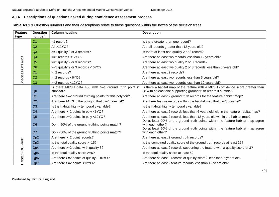
Natural England’s advice to Defra on Tranche 2 recommended Marine Conservation Zones December 2014
404
Produced by Natural England
A3.4 Descriptions of questions asked during confidence assessment process
Table A3.1 1 Question numbers and their descriptions relate to those questions within the boxes of the decision trees
Feature type
Question number
Column heading Description
Specie
s F
OC
I a
udit
Q1 >1 record? Is there greater than one record?
Q2 All >12YO? Are all records greater than 12 years old?
Q3 >=1 quality 2 or 3 records? Is there at least one quality 2 or 3 record?
Q4 >=2 records <12YO? Are there at least two records less than 12 years old?
Q5 >=2 quality 2 or 3 records? Are there at least two quality 2 or 3 records?
Q6 >=5 quality 2 or 3 records < 6YO? Are there at least five quality 2 or 3 records less than 6 years old?
Q1 >=2 records? Are there at least 2 records?
Q2 >=2 records <6YO? Are there at least two records less than 6 years old?
Q3 >=2 records <12YO? Are there at least two records less than 12 years old?
Habitat F
OC
I aud
it
Q0 Is there MESH data >58 with >=1 ground truth point if subtidal?
Is there a habitat map of the feature with a MESH confidence score greater than 58 with at least one supporting ground truth record if subtidal?
Q1 Are there >=2 ground truthing points for this polygon? Are there at least 2 ground truth records for the feature habitat map?
Q2 Are there FOCI in the polygon that can't co-exist? Are there feature records within the habitat map that can’t co-exist?
Q3 Is the habitat highly temporally variable? Is the habitat highly temporally variable?
Q4 Are there >=2 points in poly <6YO? Are there at least 2 records less than 6 years old within the feature habitat map?
Q5 Are there >=2 points in poly <12YO? Are there at least 2 records less than 12 years old within the habitat map?
Q6 Do >=90% of the ground truthing points match? Do at least 90% of the ground truth points within the feature habitat map agree with each other?
Q7 Do >=50% of the ground truthing points match? Do at least 50% of the ground truth points within the feature habitat map agree with each other?
Qp2 Are there >=2 point records? Are there at least 2 ground truth records?
Qp3 Is the total quality score >=15? Is the combined quality score of the ground truth records at least 15?
Qp4 Are there >=2 points with quality 3? Are there at least 2 records supporting the feature with a quality score of 3?
Qp5 Is the total quality score >=6? Is the total quality score at least 6?
Qp6 Are there >=2 points of quality 3 <6YO? Are there at least 2 records of quality score 3 less than 6 years old?
Qp7 Are there >=2 points <12YO? Are there at least 2 feature records less than 12 years old?

Natural England’s advice to Defra on Tranche 2 recommended Marine Conservation Zones December 2014
405
Produced by Natural England
Feature type
Question number
Column heading Description
Qe1 Are there polygonal data available? Has the feature been mapped?
Qe2 Are there >=1 ground truthing points? Is there at least 1 ground truth point supporting the feature habitat map?
Qe3 Does sample data cover >=50% of feature? Do the feature ground truth records cover at least 50% of the habitat map?
Qe4 Is the habitat intertidal and has MESH score >58? Is the habitat map for an intertidal feature and does it have a MESH confidence score above 58?
Bro
ad-S
cale
Ha
bitat a
ud
it
Q1 Polygonal data with MESH >58 and >=2 survey points if subtidal?
Is there a habitat map of the feature with a MESH confidence score greater than 58 with, if a subtidal feature, at least two supporting ground truth records?
Q2 Quality score >=15 and >=2 points with quality score 3? Is the combined quality score of the ground truth records at least 15? And do at least 2 of those records have a quality score of 3?
Q3 >=2 points in survey data and >=90% agreement? Are there at least 2 ground truth records and do the records have at least 90% agreement?
Q4 Are there polygonal data with MESH >58? Is there a habitat map of the feature with a MESH confidence score greater than 58?
Q5 Quality score >=6? Is the combined quality score of the ground truth records at least 6?
Q6 Parent feature polygon with MESH >58? Is there a habitat map of the parent feature with a MESH confidence score greater than 58?
Q7 Quality score >=15 and >=2 points with quality score 3 for parent feature?
Is the combined quality score of the ground truth records at least 15? And do at least 2 of those records, at parent feature-level, have a quality score of 3?
Q8 >=2 points in survey data and >=50% agreement? Are there at least 2 ground truth records with at least 50% feature agreement?
Q9 >=2 points in survey data and >=90% agreement for parent feature?
Are there at least 2 ground truth records with at least 90% parent feature agreement?
Q1e Is combined area of MESH58 and points (EUNIS L3) >=50% of area
Is the combined area of the feature habitat map(s) with MESH confidence greater than 58 and feature ground truth point cover greater than 50% of the mapped feature?
Q2e Is combined area of MESH58 and points (EUNIS L2) >=50% of area
Is the combined area of the feature habitat map(s) with MESH confidence greater than 58 and parent feature ground truth point cover greater than 50% of the mapped feature?
Q3e Is the feature intertidal and has MESH score >58? Is the habitat map for an intertidal feature and, if so, does it have a MESH confidence score greater than 58?
.

Natural England’s advice to Defra on Tranche 2 recommended Marine Conservation Zones December 2014
406
Produced by Natural England
A3.5 Co-existing features
Habitat features that are known to co-exist were precluded as data records that would otherwise have, through a computer-based analysis, incorrectly counted as records that conflicted with the feature type being analysed. To that end, Natural England used the co-existence matrix below to ensure that percentage agreement of point data used in habitat feature assessments are correct (see Section 3.1.5.1). Only feature combinations that had strong evidence for co-existence with each other have been assigned a ‘Yes’. Evidence from site-specific examples or published literature was used to evidence the decisions. A full audit trail underpinning the decisions within the co-existence matrix below can be made available on request to Natural England.
Table A3.2 Habitat features that co-exist (Yes) and do not co-exist (No) together in the marine environment
Feature name
Blu
e m
ussel b
eds
Cold
-wate
r cora
l re
efs
Cora
l gard
en p
ote
ntial
Deep s
ea s
po
nge a
ggre
gations
pote
ntial
Estu
ari
ne r
ocky h
abitats
File
sh
ell
beds
Fra
gile
spo
nge &
anth
ozoa
n
com
mu
nitie
s o
n s
ubtid
al ro
cky
hab
itats
Sab
ella
ria a
lveo
lata
reefs
Mod
iolu
s m
odio
lus b
eds
Inte
rtid
al un
derb
ou
lder
com
mu
nitie
s
Litto
ral ch
alk
com
mu
nitie
s
Maerl
be
ds
Mud h
ab
itats
in d
ee
p w
ate
r
Ostr
ea e
du
lis b
eds
Peat
an
d c
lay e
xposure
s
Sab
ella
ria s
pin
ulo
sa
re
efs
Sea
gra
ss b
eds
Sea p
en
an
d b
urr
ow
ing
mega
fau
na c
om
mu
nitie
s
She
ltere
d m
uddy g
ravels
Subtid
al ch
alk
Subtid
al sa
nds a
nd g
ravels
Tid
e-s
wep
t chan
ne
ls
Blue mussel beds Yes No No No No No No No No No No No No No No Yes Yes No Yes No Yes Yes
Cold-water coral reefs No Yes Yes Yes No No Yes No No No No No No No No No No No No No No No
Coral garden potential No Yes Yes Yes Yes No Yes No No No No No No No Yes No No No No Yes Yes Yes
Deep sea sponge aggregations potential No Yes Yes Yes No No Yes No No No No No Yes No No No No No No No No No
Estuarine rocky habitats No No Yes No Yes No Yes No No Yes Yes Yes No No No No No No No Yes No Yes
File shell beds No No No No No Yes No No Yes No No Yes No No No No No No Yes No Yes Yes
Fragile sponge & anthozoan communities on subtidal rocky habitats No Yes Yes Yes Yes No Yes No Yes No No No No No Yes No No No No Yes No Yes

Natural England’s advice to Defra on Tranche 2 recommended Marine Conservation Zones December 2014
407
Produced by Natural England
Feature name
Blu
e m
ussel b
eds
Cold
-wate
r cora
l re
efs
Cora
l gard
en p
ote
ntial
Deep s
ea s
po
nge a
ggre
gations
pote
ntial
Estu
ari
ne r
ocky h
abitats
File
sh
ell
beds
Fra
gile
spo
nge &
anth
ozoa
n
com
mu
nitie
s o
n s
ubtid
al ro
cky
hab
itats
Sab
ella
ria a
lveo
lata
reefs
Mod
iolu
s m
odio
lus b
eds
Inte
rtid
al un
derb
ou
lder
com
mu
nitie
s
Litto
ral ch
alk
com
mu
nitie
s
Maerl
be
ds
Mud h
ab
itats
in d
ee
p w
ate
r
Ostr
ea e
du
lis b
eds
Peat
an
d c
lay e
xposure
s
Sab
ella
ria s
pin
ulo
sa
re
efs
Sea
gra
ss b
eds
Sea p
en
an
d b
urr
ow
ing
mega
fau
na c
om
mu
nitie
s
She
ltere
d m
uddy g
ravels
Subtid
al ch
alk
Subtid
al sa
nds a
nd g
ravels
Tid
e-s
wep
t chan
ne
ls
Sabellaria alveolata reefs No No No No No No No Yes No Yes Yes No No No Yes Yes No No No Yes No No
Modiolus modiolus beds No No Yes No No Yes Yes No Yes No No No Yes No No No No No Yes No Yes Yes
Intertidal underboulder communities No No No No Yes No No Yes No Yes Yes No No No Yes No No No No No No Yes
Littoral chalk communities No No No No Yes No No Yes No Yes Yes No No No No No No No No No No Yes
Maerl beds No No No No Yes Yes No No No No No Yes No No No No Yes No No Yes Yes Yes
Mud habitats in deep water No No No No No No No No Yes No No No Yes Yes No No No Yes No No No No
Ostrea edulis beds No No No No No No No No No No No No Yes Yes No No No Yes Yes No Yes No
Peat and clay exposures No No Yes No No No Yes Yes No Yes No No No No Yes No Yes No No No Yes Yes
Sabellaria spinulosa reefs No No No No No No No Yes No No Yes No No No No Yes No No No Yes Yes No
Seagrass beds No No No No No No No No No No No Yes No No Yes No Yes No Yes No Yes No
Sea pen and burrowing megafauna communities No No No No No No No No No No No No Yes Yes No No No Yes No No No No
Sheltered muddy gravels Yes No No No No Yes No No Yes No No No No Yes No No Yes No Yes No No No
Subtidal chalk No No Yes No Yes No Yes Yes No No No Yes No No No Yes No No No Yes Yes No

Natural England’s advice to Defra on Tranche 2 recommended Marine Conservation Zones December 2014
408
Produced by Natural England
Feature name
Blu
e m
ussel b
eds
Cold
-wate
r cora
l re
efs
Cora
l gard
en p
ote
ntial
Deep s
ea s
po
nge a
ggre
gations
pote
ntial
Estu
ari
ne r
ocky h
abitats
File
sh
ell
beds
Fra
gile
spo
nge &
anth
ozoa
n
com
mu
nitie
s o
n s
ubtid
al ro
cky
hab
itats
Sab
ella
ria a
lveo
lata
reefs
Mod
iolu
s m
odio
lus b
eds
Inte
rtid
al un
derb
ou
lder
com
mu
nitie
s
Litto
ral ch
alk
com
mu
nitie
s
Maerl
be
ds
Mud h
ab
itats
in d
ee
p w
ate
r
Ostr
ea e
du
lis b
eds
Peat
an
d c
lay e
xposure
s
Sab
ella
ria s
pin
ulo
sa
re
efs
Sea
gra
ss b
eds
Sea p
en
an
d b
urr
ow
ing
mega
fau
na c
om
mu
nitie
s
She
ltere
d m
uddy g
ravels
Subtid
al ch
alk
Subtid
al sa
nds a
nd g
ravels
Tid
e-s
wep
t chan
ne
ls
Subtidal sands and gravels Yes No Yes No No Yes No No Yes No No Yes No Yes Yes Yes Yes No No Yes Yes Yes
Tide-swept channels Yes No Yes No Yes Yes Yes No Yes Yes Yes Yes No No Yes No No No No No Yes Yes

Natural England’s advice to Defra on Tranche 2 recommended Marine Conservation Zones December 2014
409
Produced by Natural England
Annex 4 Tranche 1 features in Tranche 2
Table A4.1 Overview of features advised on
Feature Description Number of features
advised on
Tranche 1 new feature Features from Tranche 1 sites not proposed during Tranche
1 process
5
Tranche 1 not
designated
Features from Tranche 1 sites not designated during Tranche
1 process
7
Tranche 2 new feature Features not proposed by regional MCZ projects 110
Tranche 2 advice Features proposed by regional MCZ projects and selected for
Tranche 2
173
Table A4.2 New features in Tranche 1 sites
Feature status Site
code Site name
Feature
code Feature name
Feature
type
Tranche 1 new
feature BS 03
Blackwater, Crouch, Roach and
Colne Estuary A5.6 Subtidal biogenic reefs BSH
Tranche 1 new
feature BS 13.2 Beachy Head West A4.1
High energy circalittoral
rock BSH
Tranche 1 new
feature BS 13.2 Beachy Head West A4.2
Moderate energy
circalittoral rock BSH
Tranche 1 new
feature FS 22 Torbay HOCI_15
Peat and clay
exposures HOCI
Tranche 1 new
feature
ISCZ
08 Fylde A5.3 Subtidal mud BSH

Natural England’s advice to Defra on Tranche 2 recommended Marine Conservation Zones December 2014
410
Produced by Natural England
Table A4.3 Features which were not designated in 2013 but for which advice was produced
Feature status Site
code Site name
Feature
code Feature name
Feature
type
Tranche 1 not designated FS 16 South Dorset A4.2 Moderate energy
circalittoral rock
BSH
Tranche 1 not designated FS 19 Chesil Beach and
Stennis Ledges
A3.1 High energy infralittoral
rock
BSH
Tranche 1 not designated FS 19 Chesil Beach and
Stennis Ledges
A5.1 Subtidal coarse
sediment
BSH
Tranche 1 not designated FS 32 The Manacles A5.1 Subtidal coarse
sediment
BSH
Tranche 1 not designated FS 32 The Manacles A5.4 Subtidal mixed
sediments
BSH
Tranche 1 not designated FS 29 Upper Fowey and Pont
Pill17
A2.2
Intertidal sand and
muddy sand BSH
Tranche 1 not designated FS 32 The Manacles SOCI_8 Pink sea-fan (Eunicella
verrucosa)
SOCI
17
GMA revised in 2014.
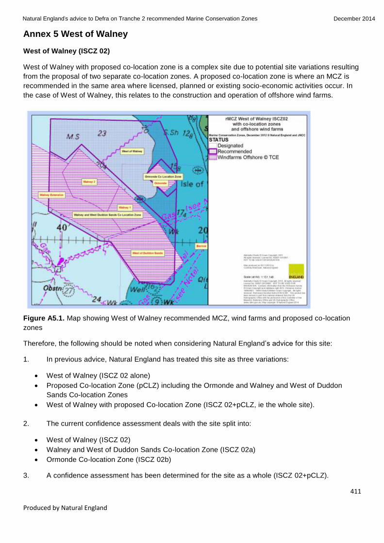
Natural England’s advice to Defra on Tranche 2 recommended Marine Conservation Zones December 2014
411
Produced by Natural England
Annex 5 West of Walney
West of Walney (ISCZ 02)
West of Walney with proposed co-location zone is a complex site due to potential site variations resulting
from the proposal of two separate co-location zones. A proposed co-location zone is where an MCZ is
recommended in the same area where licensed, planned or existing socio-economic activities occur. In
the case of West of Walney, this relates to the construction and operation of offshore wind farms.
Figure A5.1. Map showing West of Walney recommended MCZ, wind farms and proposed co-location
zones
Therefore, the following should be noted when considering Natural England’s advice for this site:
1. In previous advice, Natural England has treated this site as three variations:
West of Walney (ISCZ 02 alone)
Proposed Co-location Zone (pCLZ) including the Ormonde and Walney and West of Duddon
Sands Co-location Zones
West of Walney with proposed Co-location Zone (ISCZ 02+pCLZ, ie the whole site).
2. The current confidence assessment deals with the site split into:
West of Walney (ISCZ 02)
Walney and West of Duddon Sands Co-location Zone (ISCZ 02a)
Ormonde Co-location Zone (ISCZ 02b)
3. A confidence assessment has been determined for the site as a whole (ISCZ 02+pCLZ).

Natural England’s advice to Defra on Tranche 2 recommended Marine Conservation Zones December 2014
412
Produced by Natural England
4. However a vulnerability assessment was only carried out for the following:
West of Walney (ISCZ 02)
Walney and West of Duddon Sands Co-location Zone (ISCZ 02a)
Ormonde Co-location Zone (ISCZ 02b)
5. West of Walney with proposed Co-location Zone (ISCZ 02+pCLZ) does not have its own
vulnerability assessment as the three component sites have been assessed separately. To determine a
whole site vulnerability assessment these three component sites should be looked at as a whole. Any
proposed GMA from the vulnerability assessment for a component site within a larger site also applies to
the site as a whole.
6. A number of features are showing as Tranche 2 new features in the vulnerability assessment
tables. This is because the assessment of the site variation is new. The features appear to be new as
there has been no previous assessment for eg Subtidal mud in ISCZ 02b, because there have been no
previous assessments for anything in ISCZ 02b. The features assessed are still those recommended for
the site by the regional MCZ project; no extra features have been identified for the site based on the
current evidence.

Natural England’s advice to Defra on Tranche 2 recommended Marine Conservation Zones December 2014
413
Produced by Natural England
Annex 6 Features with no confidence in presence and extent
Features with no confidence in presence and extent
See Section 3.2.5.5 for background
A5.4 Subtidal mixed sediments – Mounts Bay rMCZ
Situation summary: Subtidal mixed sediments are a proposed feature of the rMCZ which originally came
forward during the regional MCZ project process. Assessment of confidence in this feature’s presence and
extent using Protocol E resulted in a no confidence score for both presence and extent.
Confidence in presence and extent for this feature has been reduced to no confidence in 2014 (from low
confidence in 2012) following the 2012 Environment Agency subtidal verification survey (MB0120). This
survey found a sediment complex of subtidal coarse sediment (A5.1) and subtidal mixed sediments (A5.4),
observed via drop-down video transects. No particle size analysis samples exist for either sediment
category however and, therefore, due to the very similar nature of these substrates, subtidal coarse and
mixed sediments were described as a sediment complex. It should be noted that subtidal coarse sediment
(A5.1) is not a proposed feature of the site. We are unaware of any future evidence collection surveys that
may confirm the presence of subtidal mixed sediments (A5.4) but this cannot be ruled out and we therefore
advise the GMA below should Defra wish to progress this feature.
General management approach: As there is currently no confidence in the presence or extent of this
feature, Natural England was unable to conduct a vulnerability assessment to assign a GMA for this
feature.
Spatial distribution of the A5.1/A5.4 complex has however been mapped. Based on this distribution and
known exposure to activities, Natural England can advise a GMA of maintain at this stage. This is further
supported by the fact that adjacent proposed features subtidal sand (A5.2) and high energy infralittoral rock
(A3.1), which have been assessed in the 2014 vulnerability assessment, also have a recommended GMA
of maintain.
SOCI_19 Stalked jellyfish (Lucernariopsis cruxmelitensis) – Mounts Bay rMCZ
Situation summary: The stalked jellyfish (Lucernariopsis cruxmelitensis) is a proposed feature of the rMCZ
which originally came forward during the regional MCZ project process. Assessment of confidence in this
feature’s presence and extent using Protocol E resulted in a no confidence score for both presence and
extent.
We are, however, now aware of new data indicating that the feature exists in the site. The feature has been
observed within the site in 2014 by stakeholders and Natural England advisers and geo-referenced photo
evidence exists. This evidence, however, missed the formal data cut-off for Natural England’s pre-
consultation advice to Defra and was not able to be considered. Confidence in feature presence and extent
is therefore likely to improve once the new data are taken into account. We advise that this feature is
considered further, being mindful of the significant data collection activity being undertaken by stakeholders
(notably Cornwall Wildlife Trust) in the belief that there will be an opportunity for submission of this prior to /
during formal consultation.
General management approach: As there is no currently available spatial distribution data for this feature,
Natural England was unable to conduct a vulnerability assessment to assign a GMA for this feature.
Based on local knowledge of the feature’s distribution within the site and known exposure to activities,
however, Natural England is comfortable in recommending a GMA of maintain at this stage. This is further
Natural England’s advice to Defra on Tranche 2 recommended Marine Conservation Zones December 2014
414
Produced by Natural England
supported by the fact that similar proposed features (including the stalked jellyfish Lucernariopsis
campanulata and Haliclystus auricula), which have been assessed in the 2014 vulnerability assessment,
also have a recommended GMA of maintain.
SOCI_33 Undulate ray (Raja undulata) – Studland Bay rMCZ
Situation summary: The undulate ray (Raja undulata) is a proposed feature of the rMCZ which originally
came forward during the regional MCZ project process. Assessment of confidence in this feature’s
presence and extent using Protocol E resulted in a no confidence score for both presence and extent,
based on data available at the time of assessment.
We do however now have anecdotal information suggesting that the feature exists in the site. The feature
has been observed within the site by at least two stakeholders and they have provided a small number of
unreferenced photos of the feature. The Wildlife Trust has noted that they have records of what they
believe are undulate ray egg cases washed up in the area, although we have not confirmed that these are
undulate ray and also cannot confirm that they have not come from outside the site. Defra are currently
leading on a project to gather more data on the feature in order to establish whether there are grounds for
greater confidence in the feature within Studland Bay and Poole Bay as a whole. This project however has
not reported yet and therefore cannot be taken into account in the confidence assessment for our pre-
consultation advice to Defra. Confidence in feature presence and extent may well improve once the new
data are taken into account.
We suggest that it would still therefore be reasonable for this species to be taken forward to consultation,
should Defra wish to progress the site, being mindful of the significant data collection activity being
undertaken by Defra.
General management approach: As there is no current spatial distribution data for this feature, Natural
England was unable to conduct a vulnerability assessment to assign a GMA for this feature.
Based on local knowledge of the feature’s distribution within the site and known exposure to activities,
Natural England is however comfortable in recommending a GMA of recover at this stage. We consider
recover is appropriate due to the activities which occur within the area, primarily trawling, which it is likely
the species would be sensitive to. The species is also thought to be breeding in the seagrass bed; the
seagrass bed feature, due to pressures from mooring, anchoring and bottom towed fishing gear is likely to
have a recover objective. This is further supported by the fact that proposed features within the site that
inhabit the same habitat, along with the BSH itself (including seahorse Hippocampus guttulatus and the
seagrass beds), which have been assessed in the 2014 vulnerability assessment, also have a
recommended GMA of recover.

Natural England’s advice to Defra on Tranche 2 recommended Marine Conservation Zones December 2014
415
Produced by Natural England
Annex 7 Feature Risk Assessment
Background
Risk in this context refers to risk of loss of or irreparable damage to a feature in the short term (ie in
terms of the time it takes to get any management measures in place). It is provided by JNCC and Natural
England to inform Defra’s decision making with regard to those sites selected for public consultation and
ultimately for designation as an MCZ.
Rationale
This assessment provides information on site risk that captures risk to the individual features within sites.
It captures both those features currently at risk of damage or deterioration (ie highly vulnerable features),
and the risk with respect to highly sensitive features which are not currently considered to be vulnerable
to ongoing activities but would be at high risk of loss or irrevocable damage should particular activities
occur in the future.
Approach
The approach makes use of the vulnerability assessments for each feature, sensitivity information
provided in the MB0102 sensitivity matrix and the combined feature sensitivity, pressures and activities
matrix developed by JNCC and Natural England in consultation with industry representatives and
academics.
For each site, two risk scores (future and current) have been provided for each feature being advised on.
An assessment of future risk for each feature has been undertaken based on feature sensitivity to
pressures, which is extracted from the MB0102 sensitivity matrix. Future risk is categorised as high (red),
moderate (amber) or low (green) depending on how sensitive a feature is to pressures; if a feature is
highly sensitive to one or more pressures it will be assigned a high future risk score (see below for all
categories of future risk).
The assessment of future risk does not incorporate any consideration of exposure of features to
pressures from ongoing activities or any judgement of the likelihood of activities occurring in the future.
An assessment of current risk for each feature within a site has been undertaken based on the outputs
of the vulnerability assessment. In contrast to future risk, current risk incorporates a consideration of
exposure to pressures from ongoing activities. A feature is considered vulnerable to a pressure where it
is both sensitive to and exposed to that pressure. Vulnerability, and hence risk of damage or
deterioration, increases with increasing sensitivity and exposure. Vulnerability to a pressure is
categorised into low, moderate or high and this has been used to assess feature risk. Features which are
assessed as highly vulnerable to one or more pressures are considered to be at higher risk of damage or
deterioration and are classed as at high (red) risk.
While the assessment of current risk incorporates consideration of exposure to pressures from ongoing
activities, it does not include any judgement of the likelihood of new / different activities occurring beyond
the immediate future (as this is captured by future risk).

Natural England’s advice to Defra on Tranche 2 recommended Marine Conservation Zones December 2014
416
Produced by Natural England
Table A7.1 Categories for future risk and current risk
Future risk Current risk
High
Feature is highly sensitive (with
moderate/high confidence) to
one/more pressures.
High
Feature is highly vulnerable to one/more
pressures.
Moderate
Feature is moderately sensitive (with
moderate/high confidence) to
one/more pressures; or
Feature is highly sensitive (with low
confidence) to one/more pressures.
Moderate
Feature is moderately vulnerable to
one/more pressures.
Low
Feature is moderately sensitive (with
only low confidence) to one/more
pressures; or
Feature is not moderately/highly
sensitive to any pressures.
Low
Feature is not moderately or highly
vulnerable to any pressures.
Outputs
The future and current risk scores for all the features being advised on are provided within Table 6.
Additional information on the assessment of risk not covered in the information above
Future risk provides information requested by Defra to assist it in determining whether features are likely
to be damaged if activities were to take place on the site in the future. It is not intended to be used to
inform consideration of management measures, which is outside the scope of this advice.
Natural England has provided a narrative for future high risk features where it is considered on the basis
of local knowledge unlikely that high future risks will in actuality be realised.
Defra will use the future risk assessment in combination with socio-economic and activity data provided
by the Impact Assessment and regulators, to make a judgement on the likelihood that the activities will
occur in the future. This enables Defra, for example, to take account of developments which are expected
but not yet formally in the licensing system. Defra will use this information to inform its decision making
on features to take forward to consultation.
Current risk score can be lower than the future risk score
Due to the methods of determining current and future risk, it is possible for the future risk score to be
higher than the current risk score. This is because the current risk score is determined taking into

Natural England’s advice to Defra on Tranche 2 recommended Marine Conservation Zones December 2014
417
Produced by Natural England
consideration actual exposure to pressures from ongoing (current) activities on a feature. Future risk only
takes into account general sensitivity to pressures, which may or may not be occurring over a feature in a
site at a given time.
For example, for the BSH Subtidal sand in Allonby Bay (ISCZ 10), the current risk is low and the future
risk is high. The feature is sensitive to pressures associated with a dredge fishery. The vulnerability
assessment determined that the feature is not exposed to these pressures so current risk of loss of or
irreparable damage to a feature in the short term is low. The feature is however generally sensitive to
pressures associated with dredge fishing and therefore the future risk of loss of or irreparable damage to
a feature in the short term is high. Note that in this specific example Natural England has provided Future
Risk Narrative to advise that the future risk is unlikely to be realised and has provided an explanation for
this reasoning.

Natural England’s advice to Defra on Tranche 2 recommended Marine Conservation Zones December 2014
418
Produced by Natural England
Annex 8 Independent External Review
Independent Expert Review and internal technical review of Natural England’s summary advice to Defra on Tranche 2 recommended
Marine Conservation Zones (rMCZs)
Audit Log 13 August 2014
Introduction
This audit log summarises comments from the Independent Expert Review and internal technical review of Natural England’s summary advice to Defra on
Tranche 2 rMCZs, and Natural England’s response to the comments. The advice reviewed will be provided to Defra on 18 August 2014. A further version of
the advice, suitable for publication and containing more detail on the methodology used will be produced late autumn 2014.
The reviewers were:
Professor Jason Hall-Spencer (JHS), Professor of Marine Biology, School of Marine Science and Engineering, Plymouth University
Professor Mike Elliott (ME), Director, Institute of Estuarine and Coastal Studies and Professor of Estuarine & Coastal Sciences, University of Hull
Dr Angela Moffat (AM), Principal Specialist, Marine Programme, Natural England
Dr Peter Brotherton (PB), Deputy Chief Scientist, Science and Evidence, Natural England
Natural England action:
1. Agree and amend the 18 August advice. 2. Agree and amend the published version of the advice. 3. Disagree and note why. This may be for example where it falls outside the remit of our advice, or where we feel the reviewer has not understood a
protocol.
No. Advice document
version
Section / Table
Comment From who?
Reviewer proposed action
Natural England action (1,2 or 3 – see above)
Action owner
Date completed
1 1.0 General
There are several sections where outstanding actions are highlighted.
JHS Complete the outstanding work that has been flagged as required to complete the report.
1 ‘Rationales for change’ in GMA section completed.
Chris/ Hester/
Sam
13/08/14
2 1.0 General
Use of the term
general
AM Provide explanation for general management
1 Provided
Hester
13/08/14

Natural England’s advice to Defra on Tranche 2 recommended Marine Conservation Zones December 2014
419
Produced by Natural England
No. Advice document
version
Section / Table
Comment From who?
Reviewer proposed action
Natural England action (1,2 or 3 – see above)
Action owner
Date completed
management
approach (GMA).
approach (GMA) and how it relates to previous advice and terminology such as conservation objectives. This definition must make clear that the GMA is about the feature rather than the management.
3 1.1 General The advice should
be much clearer that
some of the features
originally proposed
for a site can now be
dropped especially
as they are
mentioned in tables
but then omitted
from the maps in
Annex 2.
ME 1 Improve introduction to feature maps. Clarify: ‘no confidence’ features are not mapped; ‘new features identified for which confidence has been assessed’ rather than ‘being recommended’ (recommendations by regional projects); oysters not mapped as commercially sensitive (see comment 86 below). Also relates to ME comments 84 and 100 below.
Andy / Leonie
07/08/14 Introductory text added to Annex 2
4 1.1 General (Clarity
of advice)
Work is impressive;
however it may be
that the authors are
now too close to the
topic such that they
are taking aspects
ME The preambles to each section of the report have been kept to a minimum such that not all aspects are explained as a self-contained document. For example, there is a greater
1 / 2 Improvements carried out for initial advice and further explanation to be provided in published advice.
Leonie/ Hester
07/08/14

Natural England’s advice to Defra on Tranche 2 recommended Marine Conservation Zones December 2014
420
Produced by Natural England
No. Advice document
version
Section / Table
Comment From who?
Reviewer proposed action
Natural England action (1,2 or 3 – see above)
Action owner
Date completed
for granted. They
need to step back
and read the
document as an
informed lay reader.
need to explain the column headings, acronyms, means of determining entries into cells in spreadsheets and the logic behind certain parts.
5 1.0 General Executive summary needed
JHS Provide an executive summary
1 Executive summary produced and incorporated into our initial advice document.
Emily 08/08/2014
6 1.0 General Reference list and acronym list needed
JHS Provide these 2 A reference list and list of acronyms will be produced for our published advice in the autumn.
Emily 17/10/2014
7 1.1 General Overall work
complies with
Natural England
standards and MCZ
protocols and
evidence of audit
process is visible.
However, the non-
consultation
evidence audit log is
not easy to cross-
refer to individual
sites.
ME There are recent developments in the QA of marine decision making that could be considered in the future (eg Cormier et al (Eds) (2013). Marine and Coastal Ecosystem-based Risk Management Handbook. ICES Cooperative Research Report, No. 317, March 2013, International Council for the Exploration of the Sea, Copenhagen, 60pp, ISBN 978-87-7472-115-1.).
2 / 3 Column E in the Audit Log lists ‘Site concerned’ but does so using regional project codes. Agree this could be further clarified to read actual sites (although there is a look-up tab in the spreadsheet). EP Audit Log likely to be only supporting document so not essential and time dependent. Our ‘Evidence used’ tables will provide a lot more specific information in the published advice – the Audit Log
Leonie 13/08/2014

Natural England’s advice to Defra on Tranche 2 recommended Marine Conservation Zones December 2014
421
Produced by Natural England
No. Advice document
version
Section / Table
Comment From who?
Reviewer proposed action
Natural England action (1,2 or 3 – see above)
Action owner
Date completed
basically shows a trail of evidence approved (or not) by the Evidence Panel. All evidence approved should then appear in our ‘Evidence used’ section of the advice (locatable via UID which is consistent with both spreadsheets).
8
1.0 General
No clear text on what sorts of activities are incompatible with nature conservation within rMCZs. The advice could be clearer on this using evidence-based case studies to illustrate examples of known damaging activities.
JHS Add a section that spells out, using case studies, some examples of activities that are incompatible with nature conservation within rMCZs with reference to the scientific evidence on human impacts to UK coastal waters.
3 Falls outside remit of our advice. Detail can be found in FAP database (includes references).
Hester
9
1.1 General Issues around
presentation of
materials to be
reviewed. Tables
unwieldy to
navigate.
ME Evidence should be presented in a logical report with appendices rather than having to navigate in and out of spreadsheets and notes. Present report, annexes and tables in interactive .pdf format or embedding HTML links.
2/3 Our published advice to be produced in the autumn will be presented as a logical report with all relevant appendices. We will not however be able to produce interactive tables/ipdfs due to time constraints.
Emily 17/10/2014

Natural England’s advice to Defra on Tranche 2 recommended Marine Conservation Zones December 2014
422
Produced by Natural England
No. Advice document
version
Section / Table
Comment From who?
Reviewer proposed action
Natural England action (1,2 or 3 – see above)
Action owner
Date completed
10 1.1 General Presentation of sites ME Presenting the sites in the MCZ initial advice draft report and annexes in a geographically logical order, eg clockwise around the coast, would have been preferable. At present, the order appears to convey a selection procedure or a desire to start the sequence with the SE of England.
3 Internal discussions have concluded that we will not change the order of sites as this is the ordering that has always been used in the past (since the regional projects), therefore order retained for consistency.
Emily 13/08/14
11 1.1 General (Tranche 2 sites)
Designation process
fails to tackle way in
which different
features in a site are
being combined and
treated – for
example, a site can
be designated for
particular HOCI,
SOCI, BSH or
geological features
and each of these
has a conservation
objective (or now a
GMA) and is treated
separately but NE
needs to indicate
what will be the
ME 3 GMAs are provided per feature and not per site. Published advice will include methods.
Hester 13/08/14

Natural England’s advice to Defra on Tranche 2 recommended Marine Conservation Zones December 2014
423
Produced by Natural England
No. Advice document
version
Section / Table
Comment From who?
Reviewer proposed action
Natural England action (1,2 or 3 – see above)
Action owner
Date completed
GMA of the site.
12 1.1 General (Tranche 2 sites)
Disagreement on
naming of Utopia
(flippant and
inaccurate feel for
designations
process).
ME Advises renaming site. 3 Utopia is the name proposed by the regional project and therefore we are not able to change this.
Emily 13/08/14
13
1.1 General (Rational
e and evidence supportin
g conclusio
ns)
Process
underpinned by a
detailed rationale.
However, it is not
possible to see
whether any new
features emerged at
the sites chosen and
the tables in the
advice report
suggest that this
was not the case.
ME 3 Where advice has been provided on new features, this is specified in ‘Feature status’ within Table 1. No further action required.
Emily 13/08/14
14 1.0 All Tables
The sequence of listed features swaps around between tables.
JHS Make table listings consistent.
1 Completed. All tables follow ordering in Table 1.
Leonie/Hester
07/08/14
15 1.1 Section 1.1
Ensure that the advice is published as paper and electronic searchable
ME Publish as interactive .pdf file.
2 /3 Our published advice to be produced in the autumn will include all relevant appendices and hyperlinks
Emily 17/10/2014

Natural England’s advice to Defra on Tranche 2 recommended Marine Conservation Zones December 2014
424
Produced by Natural England
No. Advice document
version
Section / Table
Comment From who?
Reviewer proposed action
Natural England action (1,2 or 3 – see above)
Action owner
Date completed
information; try to minimise the amount of cross-referencing to other documents.
to published papers. We will not however be able to produce interactive tables/ipdfs due to time constraints.
16 1.1 Section 1.1
The footnote no. 1 is not yet available so I have not yet checked the published means of determining whether a feature is scientifically / evidence defendable.
ME 2 This paper is not yet publicly available, but was provided to the reviewers as supporting evidence. Relevant sections of this document could be appended to our published advice in the autumn.
Emily
17 1.1 Section 1.1
It is grammatically correct to use the term data as the plural (cf. datum) but this does not seem to be the habit in the SNCB.
ME Change of style (‘are’ not ‘is’ sufficient data; ‘data support’ not ‘data supports’).
1/2 This has been checked and revised in our initial advice. The published version to be produced in the autumn will be checked by professional proof readers.
Emily / proof
readers
11/08/14
18 1.1 Section 1.2
Re. data used – it is of concern that many data have recently been collected but are not available for use – does this represent a waste of funding? This will be raised at consultation and
ME See the comments below (Comment 19, 20) – it becomes apparent that the evidence not used relates to particular types of surveys (video, swath bathymetry).
3 There appears to be some misunderstanding here. Data not used will be used post-consultation (where applicable) but where not received prior to the cut-off could not be included in the pre-consultation advice. Explanation provided to ME.
Chris / Leonie
06/08/14
Natural England’s advice to Defra on Tranche 2 recommended Marine Conservation Zones December 2014
425
Produced by Natural England
No. Advice document
version
Section / Table
Comment From who?
Reviewer proposed action
Natural England action (1,2 or 3 – see above)
Action owner
Date completed
needs defending. Comment likely to be removed from review.
19 1.1 Section 1.2
New features (identified since the MCZ projects) are assumed and regarded as being of low confidence this is unusual given that recent extensive fieldwork using up-to-date and professional methods should produce a higher confidence than older and other types of evidence.
ME This is under-selling the recent evidence and should be tackled earlier rather than as a response to criticism later.
2 Clarify where and how new features have been identified. Elaborate that new features have been added on the basis of consideration of all available evidence including new dedicated verification surveys as well as other information which may now be available. Explanation required for ME that new evidence may not necessarily increase confidence. Details on new features added to 3.1.5.1 Overview of methodology and use of supplementary guidance to Technical Protocol E of the Published Advice.
James / Ross
01/12/14
20 1.1 Section 1.2
Similarly, new features are not assessed against the viability criteria as used by the regional MCZ projects and following the ENG – this seems unusual
2 As above
James / Ross
01/12/14

Natural England’s advice to Defra on Tranche 2 recommended Marine Conservation Zones December 2014
426
Produced by Natural England
No. Advice document
version
Section / Table
Comment From who?
Reviewer proposed action
Natural England action (1,2 or 3 – see above)
Action owner
Date completed
given the importance of the new features – why was this the case? (lack of time or resources?).
21 1.1 Section 1.2
Is Chart 1 being included or just cross referred?
ME Include Chart 1 here. 3 Refers to Data Sufficiency charts referenced in separate document. Discussed and felt not appropriate to reproduce charts in our advice; however it may be useful to append (in a separate folder) relevant documents to our advice to aid clarity).
Chris / Leonie
06/08/14
22 1.1 Section 1.2
The change of conservation objectives to GMA will increase confusion for readers not as familiar with the SNCB discussions.
ME Include an explanation here to show the logic for the change (it is mentioned later in the advice) (see comment 5).
1 Complete
Hester 13/08/14
23 1.1 Section 1.4
Agree fully that there may (but not always should) be low confidence in single records (often but not always the case), habitat maps based on modelling (physical-habitat-
ME All areas and features are to some extent variable and some records >12 years are valuable and should not be discounted. In the report make the distinction between spatially variable and temporally variable.
2/3 Whilst we agree older records can be valuable, we have to follow Protocol E. For published advice: briefly summarise which features temporal data restrictions apply to – a very small proportion of overall
Chris 01/12/14

Natural England’s advice to Defra on Tranche 2 recommended Marine Conservation Zones December 2014
427
Produced by Natural England
No. Advice document
version
Section / Table
Comment From who?
Reviewer proposed action
Natural England action (1,2 or 3 – see above)
Action owner
Date completed
biological feature modelling is not yet sufficiently developed), or old, uncertain records for highly variable features.
number. of features. This is not well understood generally.
24 1.1 Section 1.4
Re. no confidence – due to no or conflicting data – this begs the question as to why the feature has ever been included – it suggests that the MCZ regional projects were not sufficiently selective.
ME This criticism needs to be addressed earlier rather than later.
2/3 Our evidence base is greatly improved through verification surveys etc. Does not necessarily mean regional projects were not sufficiently selective, rather our current understanding has changed due to additional evidence. Provide greater clarity in published advice around possible reasons for declines in confidence eg improved survey data, increased scrutiny applied to whether data meet feature definitions, QA criteria etc.
Chris 01/12/14
25 1.0 Table 1
Table 1 has feature names listed in a different order from those that are listed in Tables 3 and 4 which makes cross checking tricky, eg
JHS Reformat tables so that they are in a consistent order.
1 Complete – see row 14 above.
Leonie/ Hester
06/08/14

Natural England’s advice to Defra on Tranche 2 recommended Marine Conservation Zones December 2014
428
Produced by Natural England
No. Advice document
version
Section / Table
Comment From who?
Reviewer proposed action
Natural England action (1,2 or 3 – see above)
Action owner
Date completed
The Swale Estuary ‘Moderate energy intertidal rock’ comes after the HOCIs but would be better in with the BSHs.
26 1.0 Table 1 Improving clarity of
table.
AM Provide a brief explanation at the head of the table stating that the datasets allied to the codes for the ‘evidence used’ and ‘evidence not used’ are set out in Tables 2 and 3.
1 Agree and completed.
Leonie
08/08/14
27 1.0 Table 1 Improving clarity of
comments column in
table.
AM Must be made clear that the comments for Tranche 2 new features refer to expert judgement applied to the 2014 assessment whereas some of the comments for Tranche 2 advice features apply to the change from 2012 advice to the 2014 advice.
2 Following call between CP, SK, AM and LR re. PB comments on same issue. Agreed that this will not be done for initial advice. Nor will it be done systematically for all features for final advice; we intend to review changes in confidence for features where evidence may have been affected by time cut-offs and specifically identify any instances where this may be the case in the table. For other changes, we will apply generic text comment along the lines of:
Ross / James
01/12/14

Natural England’s advice to Defra on Tranche 2 recommended Marine Conservation Zones December 2014
429
Produced by Natural England
No. Advice document
version
Section / Table
Comment From who?
Reviewer proposed action
Natural England action (1,2 or 3 – see above)
Action owner
Date completed
'Confidence assessments have been undertaken using current information and assessment protocols resulting in a change from 2012 advice’.
28 1.1 Table 1 Explain all the
headings in the
tables and indicate
how the subjective
terms are arrived at.
ME 1 Agree and completed
Leonie 08/08/14
29 1.1 Table 1 If the document is to
be stand-alone then
explain the
acronyms
ME 1 Agree and completed
Leonie 08/08/14
30 1.1 Table 1 Indicate or embed
the electronic source
of the evidence
ME 3 Disagree. I think this is unnecessary. This would make the document far too large. Table 1 provides details of codes for evidence used. Table 2 specifically explains these codes.
Chris / Leonie
08/08/14
31 1.0 Table 1 (The
Needles)
For stalked jellyfish,
the presence/extent
assessment has
changed from
AM Check that comments are correct for stalked jellyfish and seagrass beds.
1 Clarification provided in the comments
James 08/08/14

Natural England’s advice to Defra on Tranche 2 recommended Marine Conservation Zones December 2014
430
Produced by Natural England
No. Advice document
version
Section / Table
Comment From who?
Reviewer proposed action
Natural England action (1,2 or 3 – see above)
Action owner
Date completed
low/low in 2012 to
moderate/moderate
in 2014. The
comment suggests
that the confidence
has been manually
downgraded. This
comment does not
appear to align
either with the
information in Table
1 or with the
underlying
spreadsheet.
Looking at the
underlying
spreadsheet, it is
possible that the
comment should
actually apply to the
feature above
(seagrass beds).
32 1.0 Table 1 (Cromer
Shoal Chalk beds)
In at least one case
(subtidal biogenic
reefs) the comment
does not appear to
align with the
underlying
AM Check comments link correctly with features.
1 Amended automated output score. Comment added to reflect this.
James 08/08/14
Natural England’s advice to Defra on Tranche 2 recommended Marine Conservation Zones December 2014
431
Produced by Natural England
No. Advice document
version
Section / Table
Comment From who?
Reviewer proposed action
Natural England action (1,2 or 3 – see above)
Action owner
Date completed
spreadsheet. For
subtidal biogenic
reefs the comment is
that the confidence
has been manually
downgraded to
low/low but it is not
clear from the
underlying
spreadsheet that
there was ever an
assessment of
anything other than
low/low. There is a
similar issue for
subtidal coarse
sediments.
33 1.0 Table 2 No explanation of the difference between ‘D’ and ‘M’ codes. Report D_00391 is used as new evidence for the presence of Ross worm reefs, a 2009 JNCC report for pSAC status off the Wash.
JHS It would be useful if the legend from Table 2 explained the coding system used for such surveys and the used of ‘D’ and ‘M’ codes. Please check Ross worm reef evidence as report D_00291 is for a site in the North Sea.
1 Clarification of D&M codes provided in Table footnote. Ross worm reefs evidence removed (projection error).
James 08/08/14
34 1.1 Table 2 Table 2 is very extensive but one is
ME It would be better to put the true name of the
1/3 Agree there is some
Leonie 08/08/14

Natural England’s advice to Defra on Tranche 2 recommended Marine Conservation Zones December 2014
432
Produced by Natural England
No. Advice document
version
Section / Table
Comment From who?
Reviewer proposed action
Natural England action (1,2 or 3 – see above)
Action owner
Date completed
not sure why the insert in column 2 (dataset) should be often repeated in column 3 (comment).
dataset and survey in column 2 and then save column 3 for real comments, including a view of the adequacy of the data. Column 2 should give all the main features of the survey.
unnecessary repetition in column 3 which should be removed for initial advice. Additional comments should only be added to column 3 if there is relevant information, but we will not be giving a view of the adequacy of the data – this has been through the Evidence Panel, it was either agreed suitable for use or not. Column 3 (not 2 as suggested) could be used to provide additional survey detail, but unlikely we will have time to do this pre-consultation.
35 1.0 Table 3 Without intimate knowledge of the regional project reports it is not possible to know what the rMCZ codes relate to (eg BS 19, BS 20).
JHS The report either needs a Table explaining the BS, FS, NG and ISCZ codes or better still use the names for the sites that are consistent with the rest of the advice in this report.
1 Agree. Change regional codes to site names in table for increased clarity.
Leonie 08/08/14
36 1.0 Table 3 It is not easy to cross-check whether Table 3 includes new surveys as the old regional project site codes are used.
JHS It might be useful to update regional project codes with the site names used in the rest of this advice to Defra.
1 Regional codes replaced by site names
Leonie 08/08/14

Natural England’s advice to Defra on Tranche 2 recommended Marine Conservation Zones December 2014
433
Produced by Natural England
No. Advice document
version
Section / Table
Comment From who?
Reviewer proposed action
Natural England action (1,2 or 3 – see above)
Action owner
Date completed
37 1.0 Table 3 If Table 3 may include information for sites that are not on the Tranche 2 list of rMCZs.
JHS Check, and if Table 3 includes information for sites that are not on the Tranche 2 list of rMCZs then delete those.
1 Non-Tranche 2 relevant sites removed and sentence added to introduction to this effect
Leonie 07/08/14
38 1.0 Table 3 It is possible that Defra staff will not know what all the methods that are tabulated here.
JHS A short description of items like LIDAR might be helpful.
2 Chris 01/12/14
39 1.1 Table 3 Table 3 gives the evidence not used but requires some explanation as to why the evidence was not used. In report any data and evidence awaited are mentioned and comment is even included that suggestions to Defra have been made without waiting for the new evidence. Hence it is concluded that the evidence not used and identified in Section 2.3 was the result of it failing to meet the protocol guidelines.
ME This requires explanation especially as much of the evidence excluded (certainly for the case areas chosen) is of the same type (swath bathymetry and video). This is anomalous when photographic evidence is used elsewhere and in many conventional grab and core surveys, swath bathymetry and video would have been used to support habitat characterisation (eg the REC surveys).
3 Evidence team has looked into this / discussed further with ME. Evidence failing to meet protocol guidelines is an incorrect deduction. Clarification added. No further action required.
Chris 06/08/14

Natural England’s advice to Defra on Tranche 2 recommended Marine Conservation Zones December 2014
434
Produced by Natural England
No. Advice document
version
Section / Table
Comment From who?
Reviewer proposed action
Natural England action (1,2 or 3 – see above)
Action owner
Date completed
40 1.1 Table 3 How does the reader access the raw data – can the report give the instructions regarding an electronic link to aid with accessing the information quickly? The dataset identifying code does not seem too detailed, eg Marine Recorder Snapshot – this might not give the impression to the external reader of a detailed list and supporting evidence.
ME Further cross-referencing is needed.
2 Further information on location of data and licence condition etc. will be provided for published advice (already on our list). Some entries may require some additional explanation (eg MR snapshot).
Chris 01/12/14
41 1.1 Table 3 (Holdern
ess Inshore)
Evidence not used as indicated in Table 1: D00025, E00001 and E00002, are given in Table 3 – this evidence is mostly grab sampling with video and single or multibeam swath bathymetry. It is surprising that this has not been used in combination with ground truthing
ME New evidence is from reputable sources and most were obtained for impact assessments or single surveys (eg REC, pipeline surveys, marine archaeology); it is not clear if any were of repeated surveys hence giving any information about the stability of features. Some of the evidence is from surveys more than two decades ago but is still regarded as
1 / 3 Evidence team has discussed this further and with ME. Misunderstanding over evidence not used (table introduction states clearly that ‘results were not available in time for inclusion into the CA as they were in the process of being collated or analysed’. Further clarity added to main text to stress definition of ‘evidence not used’.
Chris 06/08/14

Natural England’s advice to Defra on Tranche 2 recommended Marine Conservation Zones December 2014
435
Produced by Natural England
No. Advice document
version
Section / Table
Comment From who?
Reviewer proposed action
Natural England action (1,2 or 3 – see above)
Action owner
Date completed
especially when the extent of the feature is being considered.
being valid (cf. the comment/procedure regarding excluding data older than 12 years).
42 1.1 Table 3 (The
Swale Estuary)
Evidence not used was from detailed benthic surveys especially for the MCZ process and using grab and camera work. As this survey was commissioned especially for this purpose then it is surprising it had not been used.
ME See comment 19 1/3 See comments above re. misunderstanding of ‘evidence not used’. Clarification provided. Further clarity added to main text.
Chris 08/08/14
43 1.1 Table 3 (North of Lundy)
Evidence D_00391 is mentioned as the source of Sabellaria information but this study relates to North Sea sites Inner Dowsing etc. pSAC.
ME Check to see what Lundy supporting information was taken from that study.
1 Addressed in previous actions
James 08/08/14
44 1.0 Table 4
The ‘rationale for changes in 2014’ is not provided
JHS The rationale for any changes in GMA should be in the final document.
1 Complete
Hester 13/08/14
45 1.0 Table 4
Unclear what ‘recover’ and ‘maintain’ mean. ‘Maintain’ reads to me at present as ‘do
JHS Spell out to Defra, with a few worked examples, what ‘recover’ and ‘maintain’ will mean for the proposed Tranche 2
1 Section 2.4 text outlines focus of ‘maintain’ and ‘recover’. However doesn’t include specific worked
Hester 13/08/14

Natural England’s advice to Defra on Tranche 2 recommended Marine Conservation Zones December 2014
436
Produced by Natural England
No. Advice document
version
Section / Table
Comment From who?
Reviewer proposed action
Natural England action (1,2 or 3 – see above)
Action owner
Date completed
nothing’, ie allow everything that is going on to continue as the condition of the site is deemed to be fine. In fact there is very little information on site condition as the sites have not been monitored yet we know from scientific studies of human impacts in UK waters that various activities alter the ecology of marine sites. Hunting wildlife in particular is known to have huge ecological impacts on natural systems.
rMCZs. examples in terms of management action, which is out of the scope of our advice.
46 1.0 Table 4
For me, the advice to Defra is not clear on what ‘recover’ means.
JHS Provide Defra with advice on what can be done to recover habitats of conservation interest, with case studies of where this has been shown to work if possible.
3 Outside scope of advice
Hester 13/08/14
47 1.0 Table 4
Where there is low confidence in the condition of a
JHS Provide a rationale for why this is not the case if such instances occur in the final
1 & 3 GMA explanation in section 2.4 of initial advice.
Hester 13/08/14

Natural England’s advice to Defra on Tranche 2 recommended Marine Conservation Zones December 2014
437
Produced by Natural England
No. Advice document
version
Section / Table
Comment From who?
Reviewer proposed action
Natural England action (1,2 or 3 – see above)
Action owner
Date completed
feature I would advise that this should automatically trigger a recover GMA to be precautionary.
advice. Spell out clearly the process for both maintain and recover and explain that Protocol F generally requires that where vulnerability is used as a proxy for direct condition evidence then a feature should have low confidence in condition; but the ‘maintain’ bit is a direct consequence of the vulnerability assessment.
Further detailed explanation to be provided in published advice.
48 1.0 Table 4
I am surprised that all of the 2013 management approaches proposed for the 11 features within the Holderness Inshore rMCZ are set to ‘Maintain’. I would have thought that as there is low confidence in the condition of these features a precautionary approach would be to set ‘recover’ as the GMA.
JHS Provide a rationale for why this is not the case. We know that the ecology of habitats such as those off Holderness have been fundamentally altered by fishing, yet the advice here seems to be to allow these activities to remain as they are and therefore maintain these features in an ecologically altered state. If this is the advice from Natural England then the rationale should be spelled out to Defra, or if it isn’t then some statements to the contrary are also necessary.
2 / 3 Following VA will have resulted in maintain, the methodology for which will be in our published advice. Area team commented: Existing management is in
place to safeguard these
BSH from such activities.
The Holderness Inshore
rMCZ boundaries are
aligned with the existing
Prohibited Trawl Area off
the Holderness coast, which
was implemented in 1999.
Therefore there would not
be any benthic impacts
Hester 13/08/14

Natural England’s advice to Defra on Tranche 2 recommended Marine Conservation Zones December 2014
438
Produced by Natural England
No. Advice document
version
Section / Table
Comment From who?
Reviewer proposed action
Natural England action (1,2 or 3 – see above)
Action owner
Date completed
associated through this
activity. Additionally, the
crustacean fisheries, which
target crabs & lobster
through potting, would not
have a significant impact on
the BSH due to small scale
nature of the activity.
49 1.0 Table 4
Particular attention is needed for the advice on feature-specific ‘maintain’, ‘recover’, ‘green’, ‘amber’ and ‘red’ assessments.
JHS Provide a rationale for advice on management and current and future risks to the sites.
3 Out of scope of advice
Hester 13/08/14
50 1.0 Table 4
The main text does not make it sufficiently clear that a lack of current monitoring data should not provide an impediment to designation.
JHS Provide a rationale for this, explaining that there is a wealth of scientific information on human impacts to UK marine species, habitats and ecosystems. Use a few detailed case studies to illustrate examples of known damaging activities.
2/3 Incorporate into description of VA in published advice (or outlined in COG). Case studies to illustrate damaging activities are outside the scope of this advice.
Hester 13/08/14
51 1.0 Table 4
There is insufficient advice to Defra about the fact that
JHS A section is needed on future-proofing MCZs with management goals that
3 Outside the scope of this advice and falls more within
Hester
13/08/14

Natural England’s advice to Defra on Tranche 2 recommended Marine Conservation Zones December 2014
439
Produced by Natural England
No. Advice document
version
Section / Table
Comment From who?
Reviewer proposed action
Natural England action (1,2 or 3 – see above)
Action owner
Date completed
features within MCZs are bound to alter in response to the weather, hydrography, sea level rise, changes in water chemistry and so on. I fear substantial amounts of money could be spent on monitoring features that will change for reasons out with the control of local managers and that insufficient resources will be directed at alleviating pressures that can be controlled.
alleviate damaging human activities and allow nature to recover and respond naturally within the MCZs. Anything that involves monitoring the extent and status of specific habitats rings alarm bells with me as this is expensive and may be pointless if insufficient effort is placed upon effective management of damaging activities.
the scope of the conservation advice project in producing conservation advice ‘packages’ for sites post-designation. Share JHS comment with Defra?
52 1.0 Table 4
Does Defra need to be advised that any industry wanting to use any rMCZ would need to carry out an EIA.
JHS Provide Defra with this advice somewhere in the text if appropriate.
3 Out of scope.
Hester
53
1.0 Table 4
Order of features in table.
AM It would be easier to
navigate the table if the
features for each site were
listed in the same order as
1 Completed. Discussed and agreed to remain as is (consistent with regional project / T1 decisions).
Leonie/ Hester
08/08/14

Natural England’s advice to Defra on Tranche 2 recommended Marine Conservation Zones December 2014
440
Produced by Natural England
No. Advice document
version
Section / Table
Comment From who?
Reviewer proposed action
Natural England action (1,2 or 3 – see above)
Action owner
Date completed
those in Table 1.
54 1.0 Table 4
Bearing in mind that
Defra will not have
access to the
underlying database
when they receive
this advice, I would
advise that the final
comments column of
this table should be
completed at the
very least for
Tranche 2 advice
features where the
2014 proposed GMA
differs from the 2012
conservation
objective.
AM Complete comments
where GMA differs
between 2012 and 2014.
1 Completed
Hester 13/08/14
55 1.1 Table 4
Note: ME refers to Table 4 which is the GMA, confidence in feature
Refers to the loss or
irreparable damage.
ME Need to define the
timescale for ‘irreparable’
given that most habitats
recover from most
pressures.
1 Description of risk assessment taken from Annex 3 of the draft paper ‘MCZ levels of evidence: Advice on when data supports a feature/site for designation from a scientific, evidence-based perspective’.
Hester 13/08/14

Natural England’s advice to Defra on Tranche 2 recommended Marine Conservation Zones December 2014
441
Produced by Natural England
No. Advice document
version
Section / Table
Comment From who?
Reviewer proposed action
Natural England action (1,2 or 3 – see above)
Action owner
Date completed
condition (Protocol F score) and feature risk assessment in Version 1.1
Authors of this draft paper to take this comment into account.
56 1.1 Table 4 Note: ME refers to Table 4 which is the GMA, confidence in feature condition (Protocol F score) and feature risk assessment in Version 1.1.
The Risk
Assessment is
created by an
automated system
together with other
information but this
is not specific and
the advice would
benefit from more
explanation.
ME More explanation about
Risk Assessment process.
1 Further text provided in Section 2.5
Hester / Sam
13/08/14
57 1.1 Table 4
Reader will not
immediately see the
ME Further links have to be
given (these are
2 For published advice
Hester 01/12/14

Natural England’s advice to Defra on Tranche 2 recommended Marine Conservation Zones December 2014
442
Produced by Natural England
No. Advice document
version
Section / Table
Comment From who?
Reviewer proposed action
Natural England action (1,2 or 3 – see above)
Action owner
Date completed
Note: ME refers to Table 4 which is the GMA, confidence in feature condition (Protocol F score) and feature risk assessment in Version 1.1.
links to the
vulnerability
assessments
combining feature
sensitivity, pressures
and activity matrix.
embedded in
accompanying material).
58 1.1 Table 4
Note: ME refers to Table 4 which is the GMA, confidence in feature condition (Protocol F score)
Analysis looks at
existing pressures
but not future, new
ones although the
final column in the
Table 4 appears to
indicate that new
pressures have
been included.
ME Check the logic behind
this.
3 Future risk explanation, Section 2.5
Hester / Sam
13/08/14

Natural England’s advice to Defra on Tranche 2 recommended Marine Conservation Zones December 2014
443
Produced by Natural England
No. Advice document
version
Section / Table
Comment From who?
Reviewer proposed action
Natural England action (1,2 or 3 – see above)
Action owner
Date completed
and feature risk assessment in Version 1.1.
59 1.1 Table 4
Note: ME refers to Table 4 which is the GMA, confidence in feature condition (Protocol F score) and feature risk assessment in Version 1.1.
Annex 1 is an
impressive list of the
activities and the
way they are likely to
affect the features
(HOCI, SOCI, BSH
and Geological
features.
ME Check that activities do
lead to pressures and also
be aware that there are
more reports appearing in
OSPAR and in European
projects which aim to
provide definitive lists of
activities, pressures and
impacts (eg ODEMM,
DEVOTES, KnowSeas).
3 Future risk explanation, Section 2.5
Hester / Sam
13/08/14
60 1.1 Table 4 (The
Swale Estuary)
NE should exercise
caution and ensure
that the IQI is
relevant for this
ME Similar issue for smelt
(Osmerus). The future risk
is unknown – as the
analysis does not predict
3 Future risk explanation, Section 2.5
Hester / Sam
13/08/14

Natural England’s advice to Defra on Tranche 2 recommended Marine Conservation Zones December 2014
444
Produced by Natural England
No. Advice document
version
Section / Table
Comment From who?
Reviewer proposed action
Natural England action (1,2 or 3 – see above)
Action owner
Date completed
Note: ME refers to Table 4 which is the GMA, confidence in feature condition (Protocol F score) and feature risk assessment in Version 1.1.
particular area and
this region of an
estuary. For mussel
beds the aim is to
recover but with low
confidence and
therefore current
high risk – it is not
clear what the
reason for this is or
whether the
pressures are likely
to change. Despite
this, the future risk is
moderate given no
proposed
developments – the
SNCB need to be
aware of raising
non-issues merely to
reject them.
or incorporate new
activities (as indicated in
the preamble to 2.4) then
why raise this? It could be
raised for all areas and all
features.
61 1.1 Table 4 (North of Lundy)
Note: ME refers to Table 4 which is
Change for
circalittoral rock and
coarse sediment
from GMA maintain
to recover with low
confidence but high
current and future
ME This needs checking for
this and the other sites.
Does this show the
uncertainty in the
automated calculation of
risk, etc.?
1 / 3 Examples checked. Existing results and commentary are correct. Expert judgement reduced the high/mod sensitivity of the subtidal sand feature to
Hester 13/08/14

Natural England’s advice to Defra on Tranche 2 recommended Marine Conservation Zones December 2014
445
Produced by Natural England
No. Advice document
version
Section / Table
Comment From who?
Reviewer proposed action
Natural England action (1,2 or 3 – see above)
Action owner
Date completed
the GMA, confidence in feature condition (Protocol F score) and feature risk assessment in Version 1.1.
risk because of
benthic trawling and
dredging
(presumably this
was written after the
Atlantic Array OWF
proposal was
cancelled). In
contrast, subtidal
sand stays at GMA
maintain with low
current risk but with
a high future risk.
One cannot see why
(a) the future risk
should change, and
(b) why the risk for
this habitat is not at
the same risk level
from fishing as other
BSH at this site.
low as evidence that in a high energy environment. It was determined that subtidal sand behaves differently to the other two features which do have a recover GMA and are more sensitive to the pressure from fishing activity. Risk narratives also checked. See section 2.5 in advice document for explanation as to how risk narratives determined.
62 1.1 Table 4 (Holdern
ess Inshore)
Note: ME
All features remain
as GMA maintain
with low scientific
confidence and low
present risk
ME Where a high future risk is
identified the narrative
disagrees with it – the
features are sensitive to
pressures but the reader
3 In this example expert judgement has been applied by the Area Team to state that the high future risk is not likely to be
Hester / Sam
13/08/14

Natural England’s advice to Defra on Tranche 2 recommended Marine Conservation Zones December 2014
446
Produced by Natural England
No. Advice document
version
Section / Table
Comment From who?
Reviewer proposed action
Natural England action (1,2 or 3 – see above)
Action owner
Date completed
refers to Table 4 which is the GMA, confidence in feature condition (Protocol F score) and feature risk assessment in Version 1.1.
assessment but the
future risk is high,
moderate or
unknown.
cannot see the evidence
for the increased
pressures.
realised.
63 1.0 Table 5
It appears that work on the ‘Risk narratives’ is incomplete.
JHS Complete work on risk narratives. If time is too short for that, prioritise those where the current risk and future risk has changed.
1 Clearer explanation re risk narratives provided in initial advice document Section 2.5. Including explanation for why current and future risk might change.
Hester 13/08/14
64 1.0 Table 5
No explanation as to why perceived risks alter from now and into the future
JHS Provide explanatory text for risks, eg why North Lundy is at risk from the use of mobile demersal gear
1 Text provided in initial advice document as to how future risk can be higher than current risk.
Hester 13/08/14
65 1.0 Table 5
The advice on Holderness Inshore
JHS This is clearly confusing and needs to be
1 Issues investigated with
Hester 13/08/14

Natural England’s advice to Defra on Tranche 2 recommended Marine Conservation Zones December 2014
447
Produced by Natural England
No. Advice document
version
Section / Table
Comment From who?
Reviewer proposed action
Natural England action (1,2 or 3 – see above)
Action owner
Date completed
features conflicts dramatically within the Table about risks to features
addressed in an objective manner that is consistent within and between sites.
local team and advice document (Table 4) updated accordingly.
66 1.0 Table 5 The risk narrative
needs to be
completed for all
future red risks,
particularly where
either the future risk
level or cause differs
from the current risk
level or cause eg
Cromer Shoal Chalk
Beds moderate
energy circalittoral
rocks.
AM Complete missing risk narratives. For Bembridge subtidal mud the level of risk stated in risk narrative and the risk assessment columns differs. Dover to Folkestone the red current risk assessment narrative has not been completed.
1 Risk narratives reviewed and updated.
Hester 13/08/14
67 1.1 Table 5
Note: ME refers to Table 5 which is the ‘Feature data sufficiency assessment’
Table 5 shows
where the
information and
outputs from the
previous tables are
included although
there are
improvements
needed to the table.
ME The Q1 and Q2 references need to be clarified given the columns for Q1a–c and Q2a–b – does this suggest a composite question created in the mind of the reader?
1 Tables reorganised and additional explanation provided in introduction to make them ‘stand-alone’.
Chris 07/08/14

Natural England’s advice to Defra on Tranche 2 recommended Marine Conservation Zones December 2014
448
Produced by Natural England
No. Advice document
version
Section / Table
Comment From who?
Reviewer proposed action
Natural England action (1,2 or 3 – see above)
Action owner
Date completed
(Table 7 in v 1.0)
68 1.1 Table 5
Note: ME refers to Table 5 which is the ‘Feature data sufficiency assessment’ (Table 7 in v 1.0)
There is the need to
clarify the use of N/A
(not applicable) from
‘not assessed’ as
indicated in the
column. It is
assumed here that
N/A is not applicable
but there needs to
be explanation
indicating why this is
the case for the
entries. Check that
N/A is used
consistently
throughout the table.
ME Clarify usage of N/A 1 Tables reorganised and additional explanation provided in introduction to make them ‘stand-alone’.
Chris 07/08/14
69 1.1 Table 5
Note: ME refers to Table 5 which is the ‘Feature data sufficiency assessm
As a general
comment linking to
the management of
the sites, there is the
need to indicate the
means of managing
the site in its entirety
rather than focusing
on its component
ME 3 Approach to advice is currently feature-specific. ME view noted.
Hester 13/08/14

Natural England’s advice to Defra on Tranche 2 recommended Marine Conservation Zones December 2014
449
Produced by Natural England
No. Advice document
version
Section / Table
Comment From who?
Reviewer proposed action
Natural England action (1,2 or 3 – see above)
Action owner
Date completed
ent’ (Table 7 in v 1.0)
parts.
70 1.0 Table 5 (The
Needles)
The red risk
narrative for several
of the features eg
subtidal coarse
sediment states that
‘future moorings
would be regulated’.
AM Check whether we know this is the case in which case the text is fine, or if it’s actually that we would advise that future moorings be regulated, in which case the text should be altered as we don’t make the management decision.
1 On review these features were ‘moderate future risk’ therefore no narrative required.
Hester 13/08/14
71 1.1 Table 5 (Swale
Estuary)
Note: ME refers to Table 5 which is the ‘Feature data sufficiency assessment’ (Table 7 in v 1.0)
The reader can
follow the logic
across the columns
to some extent but
there is the need to
explain this further
for the lay reader.
ME The preamble to the section requires further stand-alone instructions.
1 Tables reorganised and additional explanation provided in introduction to make them ‘stand-alone’.
Chris 07/08/14
72 1.1 Table 5 (Swale
The Swale Estuary
appears to have a
ME Check whether this devalues the designation
1 Completed
Chris 06/08/14

Natural England’s advice to Defra on Tranche 2 recommended Marine Conservation Zones December 2014
450
Produced by Natural England
No. Advice document
version
Section / Table
Comment From who?
Reviewer proposed action
Natural England action (1,2 or 3 – see above)
Action owner
Date completed
Estuary)
Note: ME refers to Table 5 which is the ‘Feature data sufficiency assessment’ (Table 7 in v 1.0)
focus on the low
energy infralittoral
rock, the edible
oyster and the
cucumber smelt
Osmerus of which
the oyster is at a
high risk of damage.
Following the
comment above, it is
not understood why
Osmerus should be
N/A for several
aspects.
of the site.
73 1.1 Table 5 (Swale
Estuary)
Note: ME refers to Table 5 which is the ‘Feature data sufficiency assessm
For clarification,
there is the need to
emphasise that
there is not double-
counting in the ‘low
energy infralittoral
rock’ and ‘estuarine
rock habitats’.
ME At present these have different entries but NE should consider the logic in such cases.
1 Evidence checked: confidences differ therefore remain as is. No further action required.
Chris 06/08/14

Natural England’s advice to Defra on Tranche 2 recommended Marine Conservation Zones December 2014
451
Produced by Natural England
No. Advice document
version
Section / Table
Comment From who?
Reviewer proposed action
Natural England action (1,2 or 3 – see above)
Action owner
Date completed
ent’ (Table 7 in v 1.0)
74 1.1 Table 5 (Swale
Estuary)
Note: ME refers to Table 5 which is the ‘Feature data sufficiency assessment’ (Table 7 in v 1.0)
Many of the
columns/questions
have the entry ‘no’
then NE should
determine whether
this will call into
question the value /
relevance /
dependability of the
site designation.
ME 3 The data sufficiency process itself addresses this issue in part. Most of the Swale features come out at ‘Yes’ for Question 1 (most occurrences of ‘No’ relate to parent feature column) which suggests better confidence. No action required.
Chris 08/08/14
75 1.1 Table 5 (North of Lundy)
Note: ME refers to Table 5 which is the ‘Feature data sufficiency
The entries defend
the choice of
features and the
confidence in their
presence and
extent, that they fill a
‘big’ gap in the MPA
network. However,
not all entries which
have respective ‘yes’
answers lead to the
ME Provide explanation for this.
1 Possible misunderstanding of the sufficiency process. The N/As are due to Question 1 having a ‘yes’ answer and therefore don’t move to Question 2. Should be resolved through additional explanation of sufficiency criteria in table introduction.
Same issue as picked up by
Chris 06/08/14.

Natural England’s advice to Defra on Tranche 2 recommended Marine Conservation Zones December 2014
452
Produced by Natural England
No. Advice document
version
Section / Table
Comment From who?
Reviewer proposed action
Natural England action (1,2 or 3 – see above)
Action owner
Date completed
assessment’ (Table 7 in v 1.0)
conclusion that the
feature fills both
criteria together and
is at low risk of
damage, hence a
N/A entry.
AM. Included in previous actions.
76 1.1 Table 5 (North of Lundy)
Note: ME refers to Table 5 which is the ‘Feature data sufficiency assessment’ (Table 7 in v 1.0)
This site apparently
is defendably
designated for its
moderate energy
circalittoral rock,
subtidal coarse sand
and subtidal sand.
.
ME NE should consider if that is the appropriate conclusion to be reached from the table.
1 Evidence checked and agreed no further action required.
Chris 06/08/14.
77 1.1 Table 5 (Holdern
ess Inshore)
Note: ME
This shows
confidence in the
presence and extent
for some of the
HOCI and BSH but
ME There needs to be some commentary regarding the overall conclusions for the site and especially what it brings to the network.
1 /3 Following further discussion in internal review call, this has largely been addressed through additional work / comments provided by
Chris 08/08/14

Natural England’s advice to Defra on Tranche 2 recommended Marine Conservation Zones December 2014
453
Produced by Natural England
No. Advice document
version
Section / Table
Comment From who?
Reviewer proposed action
Natural England action (1,2 or 3 – see above)
Action owner
Date completed
refers to Table 5 which is the ‘Feature data sufficiency assessment’ (Table 7 in v 1.0)
none of the features
are determined as
filling a ‘big’ gap in
the MPA network
and some are at risk
of damage.
Evidence team in Site commentary table.
78 1.0 Table 6
I found Table 6 odd as it attempts to be all-encompassing but it does not help the uninformed reader distinguish between major and inconsequential issues such as dredging maerl vs. walking a dog on the adjacent foreshore.
JHS A short section of text before the table setting out what sorts of activities have been shown to be very damaging to marine life because of the wide area they affect and the level of destruction caused, vs. other activities that are much more benign due to their lower impact and smaller footprint. I worry that dog walkers and sailors might be unnecessarily against these rMCZs whereas in fact if the rMCZs are managed properly these and other sections of society would benefit enormously. Similarly wind
1 / 3 We need to be clearer what future risk was intended to do, but setting out the impacts of the activities and types of management possible is out with the scope of the advice. Future risk text in Section 2.5 reviewed and updated.
Sam /Hester
13/08/14

Natural England’s advice to Defra on Tranche 2 recommended Marine Conservation Zones December 2014
454
Produced by Natural England
No. Advice document
version
Section / Table
Comment From who?
Reviewer proposed action
Natural England action (1,2 or 3 – see above)
Action owner
Date completed
farms may be compatible in rMCZs whereas aggregate dredging, sewage sludge dumping or beam trawling would not be.
79 1.0 Table 6
In places it appears there is no perceived future risk to features.
JHS Insert a caveat explaining that some activities will be wholly incompatible with nature conservation within MCZs and refer to the scientific evidence that others are more benign.
3 Advice document updated with more background to future risk rationale and methodology.
Hester/Sam
13/08/14
80 1.0 Table 6
Are all the things listed relevant?
JHS Remove any extraneous material
1 Trigger table moved to annex but no further amendments made to comments.
Hester 13/08/14
81 1.0 Table 6
Are blue mussel reefs missing?
JHS If features are missing that should be listed, list them.
1 As above
Hester 13/08/14
82 1.0 Table 6
It is not clear to me why ‘Subtidal coarse sediment’ would not continue to be at high future risk to activities to which it shows current high risk.
JHS Please attempt an explanation for this in the risk assessment.
1 Explanation provided in advice for why it is possible for future risk to be higher than current risk.
Hester 13/08/14
83 1.0 Table 6
Justification for inclusion of table. If the risk narratives in Table 5 were
AM Publish Table 6 separately
alongside other
supplementary
1 Done
Sam / Hester
13/08/14

Natural England’s advice to Defra on Tranche 2 recommended Marine Conservation Zones December 2014
455
Produced by Natural England
No. Advice document
version
Section / Table
Comment From who?
Reviewer proposed action
Natural England action (1,2 or 3 – see above)
Action owner
Date completed
completed the added value of Table 6 in this document is unclear.
information.
84 1.1 Table 6
Note: ME refers to Table 6 which is the ‘Site data sufficiency assessment’ (Table 8 in v 1.0)
This table is arguably the most important part of the analysis and will be used by those who will not go through all the preceding analysis.
ME Table needs more
explanation and help for
the reader in its
interpretation to avoid it
being misinterpreted.
1/2 Tables (now 9, 10 in initial advice) have been reorganised into two tables and further explanations added to introduction.
Chris 08/08/14
85 1.1 Table 6
Note: ME refers to Table 6 which is the ‘Site data sufficiency assessment’ (Table 8 in v 1.0)
There is no indication on the table of whether there should be a threshold for the % of the site meeting the feature sufficiency assessment or the % overlap with any SAC.
ME Include explanation with
table.
1 Tables (now 9,10 in initial advice) have been reorganised into two tables and further explanations added to introduction
Chris 08/08/14
86 1.0 Table 7 In cases where the JHS Insert line or two of text 1 / 2 Hester

Natural England’s advice to Defra on Tranche 2 recommended Marine Conservation Zones December 2014
456
Produced by Natural England
No. Advice document
version
Section / Table
Comment From who?
Reviewer proposed action
Natural England action (1,2 or 3 – see above)
Action owner
Date completed
rMCZs do not appear to plug a big gap Defra may need guidance on what it is about each site that makes it especially important.
that clearly says what each rMCZ is particularly important for. This may help Defra with its decision making.
Following conversation with AM, SK, CP & LR on 06/08/14 agreed that this will not be done for initial advice but we will flag the existence of Annex 5 of 2012 advice when introducing the table. In formal advice, we will consider inclusion of text regarding the wider ecological importance of each site in the site summary documents, if done these should be informed by Annex 5 of the 2012 advice, big gap analysis and ‘site importance spreadsheet’. Completed for initial advice NB: Due to site analysis rather than feature analysis of Annex 5, this has been referenced in introduction to Table 6.
/Area Teams
87 1.0 Table 7 At present it is not easy to find where the evidence for live oysters is although they presumably occur in the shallow subtidal of The Swale Estuary.
JHS In instances where one feature fills a major gap and underpins the reason for including a site in Tranche 2 then it would be helpful to Defra if that evidence was very clearly spelled out and the data
1 / 2 Oysters are commercially sensitive species therefore not mapped. Other comment links to issue 85 above: consider elaborating in site summary table to include more information
Chris 08/08/14

Natural England’s advice to Defra on Tranche 2 recommended Marine Conservation Zones December 2014
457
Produced by Natural England
No. Advice document
version
Section / Table
Comment From who?
Reviewer proposed action
Natural England action (1,2 or 3 – see above)
Action owner
Date completed
source easily cross-checked.
from final column in JNCC big gaps paper about which features are specifically relevant. Map introduction clarified re. oysters. Further action to be addressed in above actions.
88 1.0 Table 7 Consistency in use
of N/A and Not
Assessed. Not made
clear in table if they
have the same
meaning.
AM If they have the same
meaning, use a single
term throughout.
In the column for Q2a all
of the N/As should be ‘No’
for consistency
throughout.
1 / 3 Discussed in internal review start-up call. They do not have the same meaning and require clarification in table introduction. Definitions provided in Table introduction. Second part of comment is misunderstanding. These instances of N/A are suitable as they do not require Question 2 to be applied.
Leonie 08/08/14
89 1.0 Table 7 In the column
headed ‘Outcome
from Question 1’ it’s
not clear what the
yes response refers
to.
AM Column might be better
titled something along the
lines of ‘Sufficient data to
support designation’.
1 Tables reorganised and additional explanation provided
Chris 08/08/14
90 1.0 Table 8 I found the Q2 JHS The resulting percentages 1 Chris 08/08/14

Natural England’s advice to Defra on Tranche 2 recommended Marine Conservation Zones December 2014
458
Produced by Natural England
No. Advice document
version
Section / Table
Comment From who?
Reviewer proposed action
Natural England action (1,2 or 3 – see above)
Action owner
Date completed
portion of Table 8 difficult to interpret; it gives the impression that some sites are much more data sufficient than others (eg 100% for North of Lundy which is not a well-studied area of seabed, compared with 0.79% of Beach Head, which is). These discrepancies seem to be down to whether point data or polygon data were used.
should be used with caution My advice is that if they don’t help Defra then Q1 and Q2 columns from this table could be removed or text inserted above the table to allow Defra staff know how to interpret and use these data.
Tables reorganised and additional explanation provided.
91 1.0 Table 8 There appears to be a discrepancy between Tables 7 and 8 for the Lundy North ‘big gap’ analysis
JHS Address this as Table 7 says it fills a big gap, Table 8 says maybe it does.
1 This relates to the difference between a feature gap and a big gap; suggest addition of text to top of table explaining or referring to JNCC definition of ‘big gap’ at site level.
Side issue that sufficiency guidance Chart 1 is actually incorrect – should say gap not big gap when referring to individual features – ideally need to action before
Chris 08/08/14

Natural England’s advice to Defra on Tranche 2 recommended Marine Conservation Zones December 2014
459
Produced by Natural England
No. Advice document
version
Section / Table
Comment From who?
Reviewer proposed action
Natural England action (1,2 or 3 – see above)
Action owner
Date completed
final version is published. CP to speak to JNCC.
92 1.0 Table 8 The heading of the
column for Q2 does
not clearly explain
the information in
the column.
AM Retitle something along the lines of ‘Proportion of the site covered by features with sufficient evidence to support designation’.
1 Amended with other Table 8 amendments as above.
Chris 08/08/14
93 1.0 Table 8 (The
Needles and
Cromer Shoal Chalk Beds)
It is not clear how the assessment against Q3 was obtained. Chart 2 in MCZ Levels of Evidence: advice on when data supports a feature/site for designation from a scientific, evidence-based perspective suggests that there should only be a ‘Yes’ here if the response to Q2a in Table 7 is also ‘Yes’. For both the above sites Q2a has not been assessed, though if it had been the answer would be ‘Yes’ for features on both sites. The
AM The issue appears to lie with Table 7 where, for features assessed as filling gaps in the network, Q2a should be completed as this is the information needed in Table 8. Otherwise it’s up to the reader to work it out for themselves for each feature.
1 / 3 Discussed in internal review start-up call. Requires further clarification in Table introduction, but information in tables is correct.
Chris 08/08/14

Natural England’s advice to Defra on Tranche 2 recommended Marine Conservation Zones December 2014
460
Produced by Natural England
No. Advice document
version
Section / Table
Comment From who?
Reviewer proposed action
Natural England action (1,2 or 3 – see above)
Action owner
Date completed
information in Q3 for each of these sites appears to be correct but does not flow easily from Table 7.
94 1.1 Confidence
assessment – The
Swale Estuary
Rationale for considering this as an estuary is still not clear – it is a channel around the Isle of Sheppey with adjacent creeks and so would not be expected to have all the features of an estuary.
ME 3 This site and the name was proposed by the regional MCZ project (Balanced Seas) and therefore we are not in a position to change the name.
Emily
13/08/14
95 1.1 Confidence
assessment – The
Swale Estuary
Including the smelt (Osmerus eperlanus) as a point record is misleading especially where the points are at the outer/lower estuary sites whereas the important habitats for the fish are the adjacent creeks as spawning areas.
ME 1 Comment added to Table 1: although evidence to suggest presence in site we do not have evidence to suggest how the species is using the site.
Ross 08/08/16
96 1.1 Confiden It is of note that ME Indicate exclusion of 1 / 2 Leonie 08/08/14

Natural England’s advice to Defra on Tranche 2 recommended Marine Conservation Zones December 2014
461
Produced by Natural England
No. Advice document
version
Section / Table
Comment From who?
Reviewer proposed action
Natural England action (1,2 or 3 – see above)
Action owner
Date completed
ce assessm
ent – The
Swale Estuary
Sabellaria was included originally but has now, presumably, been excluded; it would have been present subtidally if at all. It would be good to indicate on Table 1 that a feature is now discounted and excluded from the Annex 2 maps.
feature (see comment 8) Sabellaria excluded from map as no confidence in presence or extent of the feature. Clarification of introduction to Maps required around no confidence features. Details added to map introduction.
/ Andy
97 1.1 Confidence
assessment –
North of Lundy
In Table 1 give a clear indication if a feature is not being considered further.
ME As with all sites, there is the need to indicate if the feature was looked for and not found or whether it was not looked for, eg subtidal mixed sediments.
3 Beyond scope of our advice given time constraints. Evidence team agreed no further action necessary.
Chris 08/08/14
98 1.1 Confidence
assessment –
North of Lundy
The Ross worm Sabellaria spinulosa has low confidence in presence and extent. It is not expected in this area although perhaps S alveolata could be present.
ME 1 Checked by evidence team: evidence appears correct. No change necessary.
Chris 06/08/14.
99 1.1 Confidence
assessment –
North of
There is an improvement in confidence for circalittoral rock and subtidal sand
ME Subtidal sand has a comment that expert judgement is used. This is acceptable as long as the available evidence and
3 No response required
08/08/14
Natural England’s advice to Defra on Tranche 2 recommended Marine Conservation Zones December 2014
462
Produced by Natural England
No. Advice document
version
Section / Table
Comment From who?
Reviewer proposed action
Natural England action (1,2 or 3 – see above)
Action owner
Date completed
Lundy because of new information.
thought process is provided and supported.
100 1.1 Confidence
assessment –
North of Lundy
Figure 32 (Annex 2) suggests that both Sabellaria and Black seabream are features recommended for designation – is this acceptable as neither records nor analysis is particularly defendable? The map shows a single site for the fish and large areas for the worm – neither appear to be accurate representations of the species distribution.
ME 1 Needs to be dealt with through wording in the section introducing the maps, explaining what they show / don’t show. The meaning of ‘recommended for designation’ needs to be explained. As per previous comments / actions. GI have clarified map introductions.
Chris 07/08/14
101 1.1 Confidence
assessment –
Holderness
Inshore
Map detail. ME As with perhaps most sites, the current map in the initial advice report for Holderness Inshore, does not show or allow to be interrogated the heterogeneity in the site, eg the terminal moraine area which creates a changed hydrodynamic
3 The features mentioned in the proposed action column appear to fall outside the feature mapping requirements, and beyond the scope of our advice.
Andy 13/08/14

Natural England’s advice to Defra on Tranche 2 recommended Marine Conservation Zones December 2014
463
Produced by Natural England
No. Advice document
version
Section / Table
Comment From who?
Reviewer proposed action
Natural England action (1,2 or 3 – see above)
Action owner
Date completed
and sedimentary regime is not shown in detail although it does appear on marine charts. In addition, the map does not appear to include the beach areas. It is suggested that in Annex 2 all maps are given as landscape at A4 size.
102 1.1 Confidence
assessment –
Holderness
Inshore
Confidence in features and use of additional data.
ME Change in confidence of intertidal mixed sediments from high for presence and moderate for extent too low for both. This could be increased with easily available evidence. This BSH has been replaced by intertidal sand and muddy sand with higher confidence (see below). For many BSH and HOCI at this site, there appears to be additional extensive evidence but this has not been used to increase the confidence in the presence or extent of the feature subtidal coarse sand but for subtidal sand the additional information has increased confidence
1 No further data available therefore remains as is. Evidence team agree no further action necessary
Chris 06/08/14.

Natural England’s advice to Defra on Tranche 2 recommended Marine Conservation Zones December 2014
464
Produced by Natural England
No. Advice document
version
Section / Table
Comment From who?
Reviewer proposed action
Natural England action (1,2 or 3 – see above)
Action owner
Date completed
from low/low to high/moderate, thus showing the high value of the additional data.
103 1.1 Confidence
assessment –
Holderness
Inshore
Peat and clay exposure and Sabellaria were low in confidence for both presence and extent and are still described as this. One would have expected that the further information would have increased confidence even if showing that the features are not present or extensive.
ME Check that it is emphasised that the confidence refers to the feature being present and its extent rather than the confidence in the categorisation of present/absent and extensive/sparse.
1 Correct information is stated in advice.
Chris 06/08/14
104 1.1 Confidence
assessment –
Holderness
Inshore
Check the designation (as a geological feature) of Spurn Head (Point?) subtidal features.
ME This has a high confidence on presence and low on the extent – why the latter classification? Logically, if there is high confidence in its presence as it is a geological feature then there should be high confidence in its extent.
3 Evidence team discussed. Do not agree with deduction on extent. Agreed no further action possible / required.
Chris 06/08/14
105 1.1 Confidence
assessment –
High energy circalittoral rock and moderate energy circalittoral rock are
ME Together with the BSH of subtidal mud, subtidal mixed sediments, all of this reflects patchy and
2 Evidence team discussed. Information to be passed to Area teams for potential
Chris / Area
Teams

Natural England’s advice to Defra on Tranche 2 recommended Marine Conservation Zones December 2014
465
Produced by Natural England
No. Advice document
version
Section / Table
Comment From who?
Reviewer proposed action
Natural England action (1,2 or 3 – see above)
Action owner
Date completed
Holderness
Inshore
supported by a long comment under the 2014 Comments column regarding limited data and the influence of anthropogenic activity (possibly with unnatural hard substrata). There is a realistic description of a mosaic on an eroding sedimentary coastline but this may be implying or underestimating the extent and importance of the moraine material (unless this has been included in Spurn Point – it needs mentioning).
mixed sediments. Check if the designations are reflecting that mosaic and patchy nature.
incorporation into SADs.
106 1.1 Section 2.4
(Geological
Features)
These features need attention because of their unique structure and/or because of their dominant role in local processes. At present, this does not come out as
ME At present the assessment of the geological features reads as an ‘expert judgement’ assessment, especially of the risks to the site. Ensure that despite this the conclusions are defendable. For these
1 Text on geological assessment provided in Section 2.4
Hester 13/08/14

Natural England’s advice to Defra on Tranche 2 recommended Marine Conservation Zones December 2014
466
Produced by Natural England
No. Advice document
version
Section / Table
Comment From who?
Reviewer proposed action
Natural England action (1,2 or 3 – see above)
Action owner
Date completed
strongly as it should, eg for Spurn Head in the Holderness Inshore site whose importance is partly for the site but mostly for maintaining the coherence of the Humber European Marine Site (outside or overlapping very slightly with the Holderness Inshore MCZ area).
areas to change the GMA from maintain to recover will require evidence of actual impacts.
107 1.1 Section 2.4
(Climate change)
The comments in the advice are probably premature given that at the time this advice is issued publicly then the findings of the current UK MCCIP activities will be released regarding the impact of climate change on MPA designation, effectiveness and connectivity, and on the implementation of the EU Marine Strategy Framework
ME It is important that MCCIP learns from the MCZ process and vice versa.
3 Comments noted; however out of the scope of Natural England’s advice.
Hester 13/08/14

Natural England’s advice to Defra on Tranche 2 recommended Marine Conservation Zones December 2014
467
Produced by Natural England
No. Advice document
version
Section / Table
Comment From who?
Reviewer proposed action
Natural England action (1,2 or 3 – see above)
Action owner
Date completed
Directive (each being subject to a detailed review).
108 1.1 Section 2.4
(West of Walney
Re. the co-location complex – it makes sense to treat these as a single site but this needs rules defining.
ME Be clear whether the combined site behaves as a single site.
3 Advice provided on three separate sites.
Hester 13/08/14
109 1.1 Section 2.4
(Features with no confiden
ce in presence
or extent)
As anecdotal evidence is avoided in most places, NE has to be aware of double standards. It is puzzling that for one of these features (subtidal mixed sands), drop-down video evidence is awaited whereas it is this type of evidence that appears to have been excluded as new evidence for many sites. The logic of including it and the way ahead seems acceptable but again it may be regarded as not following the protocols.
ME Features which have not been proved to be at a site, despite anecdotal evidence, should be included only with extreme caution. This is especially a problem with a mobile species and may leave NE open to a charge of including charismatic species based on poor evidence. It is emphasised that NE should exercise caution in progressing these cases especially if features elsewhere have been excluded on similar grounds.
1 Comments noted. Text provided in this section of the advice to highlight the issue.
Hester 13/08/14

Natural England’s advice to Defra on Tranche 2 recommended Marine Conservation Zones December 2014
468
Produced by Natural England
No. Advice document
version
Section / Table
Comment From who?
Reviewer proposed action
Natural England action (1,2 or 3 – see above)
Action owner
Date completed
The cases of the stalked jellyfish (Lucernariopsis) and undulate ray (Raja undulata) are more difficult.
110 1.1 Section 2.4
(Triggering
activities for future high risk)
The proviso is emphasised that an activity does not necessarily lead to a pressure. Although Annex 1, Table A1.1 is very comprehensive and gives activities (liable to affect a HOCI, BSH or SOCI) but it would be better to indicate the relevant pressures from those activities. An activity does not necessarily lead to a pressure if successful mitigation is employed. Table A1.1 allows the likely activity-pressure-habitat-impact links to be made but in the present form it relies on expert
ME NE should emphasise the site specificity of the activity-pressure-habitat-impact links especially as the frequency, duration and extent of a pressure differs with area. There is the need for a robust system which objectively tackles this problem.
3 Outwith scope of the advice
Hester / Sam
13/08/14

Natural England’s advice to Defra on Tranche 2 recommended Marine Conservation Zones December 2014
469
Produced by Natural England
No. Advice document
version
Section / Table
Comment From who?
Reviewer proposed action
Natural England action (1,2 or 3 – see above)
Action owner
Date completed
judgement to link Table A1.1 and Table 4 information. It is recollected that the Net Gain regional MCZ project created software (PISA, PRISM etc) to carry out this task so it has to be discussed whether expert judgement and a subjective approach are the most suitable and defendable approach.
111 1.1
General The advice needs a ‘Methods’ section. At the moment, descriptions of the methods used are interspersed in the introduction and the results sections and this is confusing.
PB Include ‘Methods’ section and ultimately ‘Executive Summary’ and either a ‘Discussion’ or ‘Conclusions’ section, but these could await our formal advice. (See comment 3)
1 / 2 Executive summary produced and introduction modified to clarify that this is summary advice and full methodology will follow in the published advice. Notes to support interpretation of the summary advice have been collated and moved to the start of each section.
Chris / Hester
13/08/14 (clarific-ation)
112 1.1 General Notwithstanding the nature of this ‘pre-consultation advice’, there needs to be
PB Include narrative explaining what each table is for and how they relate to each other. In particular
1 Additional clarification added to table introductions
Chris 07/08/14

Natural England’s advice to Defra on Tranche 2 recommended Marine Conservation Zones December 2014
470
Produced by Natural England
No. Advice document
version
Section / Table
Comment From who?
Reviewer proposed action
Natural England action (1,2 or 3 – see above)
Action owner
Date completed
more narrative to guide the reader through the document and provide context to each of these tables.
the purpose of Tables 5 and 6, beyond what is already provided by Tables 1 and 4, is currently not clear
113 1.1 General Ordering of the sites. Presumably based on geography but is not intuitive, making cross-referencing between tables difficult.
PB A possible solution would be to include a numeric code (which could be included in the site name field to avoid the need for an additional column), and an appendix which lists all sites against their code (see comment 7).
1 / 2 Agreed to retain current sequence but ensure VA tables follow evidence tables. Further information will be provided in published advice.
Leonie / Hester
08/08/14
114 1.1 General Check the way references are cited and footnotes throughout. Sometimes the papers are cited in plain text, other times in italics, and several footnotes are missing.
PB In general it would be best to cite references correctly as per MCZ Protocol C, and include a list of references at the end of the document, even if the references are to web addresses.
1 / 2 All footnotes and references within our initial advice have been checked and are now consistent. A full reference list will be produced for our published advice in the autumn.
Emily 08/08/14 & 17/10/2014
115 1.1 General Navigation between tables etc. The supporting information that underpins the tables is embedded in a range of workbooks, which themselves
PB I would like assurance that the documentation of these files is sufficient to enable data to be found or decisions to be tracked in the future.
1 Evidence-specific response: our underlying spreadsheets, QA and audit trail should provide this assurance. In addition we are attempting to add to comments in tables and
Chris/ Leonie
08/08/14

Natural England’s advice to Defra on Tranche 2 recommended Marine Conservation Zones December 2014
471
Produced by Natural England
No. Advice document
version
Section / Table
Comment From who?
Reviewer proposed action
Natural England action (1,2 or 3 – see above)
Action owner
Date completed
contain multiple spreadsheets. This makes finding the information that underpins particular decisions difficult, and it seems to currently require someone intimately involved in the process to navigate the supporting files (eg I had to be sent additional data extracts to investigate GMA assessments).
spreadsheet to make them ‘stand-alone’ in view of other comments.
116 1.1 General Concern about the plethora of supporting protocols and guidance notes that now underpin this advice. This makes understanding what has been done difficult as the reader needs to constantly cross-reference other documents.
PB For the final report, the methods need to be sufficiently comprehensive for the reader to understand what has been done, with cross-referencing only used as a last resort (eg to link to reference information or to provide extra detail).
2 A detailed methodology will be produced for our published advice in the autumn
Chris/ Hester
117 1.1 General Please add a glossary of acronyms used.
PB 2 A list of acronyms will be produced for our published
Emily 17/10/2014

Natural England’s advice to Defra on Tranche 2 recommended Marine Conservation Zones December 2014
472
Produced by Natural England
No. Advice document
version
Section / Table
Comment From who?
Reviewer proposed action
Natural England action (1,2 or 3 – see above)
Action owner
Date completed
advice in the autumn
118 1.1 Contents List
Please include a title for Annex 1 (if it is retained).
PB 1 A title has been produced for Annex 1
Emily 08/08/14
119 1.1 Contents List
Remove asterisk from ‘Table 5 Feature data sufficiency assessment’
PB
1 The asterisk has been removed from the table name.
Emily 08/08/14
120 1.1 Introduction
The ‘introduction’ is currently both an introduction and an overview of methods used (especially in Section 1.2).
PB I would prefer to see these separated out (Comment 110).
2 The Introduction and Methods will be separated out for our published advice in the autumn
Emily 17/10/2014
121 1.1 Introduction
Please add more context on why we are providing advice on these particular MCZs.
PB Include narrative – where did the 21 rMCZs come from, and what led to us deciding to offer further advice on nine MCZs designated in 2013?
2 Defra is aware of the source of the sites/features, but explanation with link to published ‘gap analysis’ will be provided in our published advice.
Sam
122 1.1 Section 1.2
Include narrative for datasets and explain ‘Data not used’
PB Describe how datasets analysed for this advice were identified. In addition, this section refers to ‘Data not used’ (Table 3), which reads oddly as inevitably there’s a huge amount of data that weren’t used. Please be more specific about what this relates to (eg ‘potentially relevant
1 Explained ‘Evidence not used’ in table introduction and introductory text.
Leonie 08/08/14

Natural England’s advice to Defra on Tranche 2 recommended Marine Conservation Zones December 2014
473
Produced by Natural England
No. Advice document
version
Section / Table
Comment From who?
Reviewer proposed action
Natural England action (1,2 or 3 – see above)
Action owner
Date completed
data obtained too late for evaluation’).
123 1.1 Section 1.5
The ‘contents’ of this advice would benefit from increased narrative to explain the purpose / significance of each of the tables and the relationship between them (as mentioned at point 2).
PB See comment 111 1 / 2 Key links and further explanation in table introductions provided for initial advice. Further improvements are in process for published advice.
Chris / Hester
08/08/14
124 1.1 General ‘Data’ are plural, never singular.
PB See comment 17 1 / 2 See comment 17. This has been checked and revised in our initial advice
Emily / proof
readers
11/08/14
125 1.1 Table 1 Column headings PB Suggest ‘(see Table 2)’ and ‘(see Table 3)’ respectively be added to the last two columns to explain what these references relate to.
1 Completed and added to Table 1 introduction
Leonie 08/08/14
126 1.1 Table 1 Currently, in some instances changes have occurred for no apparent reason. For example ‘The Swale Estuary, Low energy infralittoral rock’ has moved from low confidence to ‘no confidence’, without any
PB In the interests of transparency, we need comments to explain (potentially all) cases where the confidence of presence or extent has changed between 2012 and 2014. I suggest this is particularly important where the confidence has declined (all such
1 / 2 Clarity provided where highlighted for initial advice. Comments to be checked to ensure they stand alone for published advice.
Ross / James
08/08/14 (initial)

Natural England’s advice to Defra on Tranche 2 recommended Marine Conservation Zones December 2014
474
Produced by Natural England
No. Advice document
version
Section / Table
Comment From who?
Reviewer proposed action
Natural England action (1,2 or 3 – see above)
Action owner
Date completed
comment or data sources being listed. I also could not find an explanation for all changes in supporting spreadsheets, so these need further checking.
instances should include an explanation).
127 1.1 Table 1 This table would benefit from a supporting narrative that provided an overview of the main factors that have led to changes in confidence levels.
PB Also include specific consideration of the impact of time on the 6- and 12-year thresholds applied to mobile features – how often has our confidence declined simply because of the time this whole process has taken?
2 Additional detail to be added in published advice
Chris
128 1.1 Table 3 Further explanation around table.
PB Please include an overview of the number of sites and features these additional evidence sources relate to. Ideally, it would be good to also provide an indication of how many of our current assessments that were based on weak evidence (and therefore given low / no confidence) could benefit from these additional sources.
2 James / Ross

Natural England’s advice to Defra on Tranche 2 recommended Marine Conservation Zones December 2014
475
Produced by Natural England
No. Advice document
version
Section / Table
Comment From who?
Reviewer proposed action
Natural England action (1,2 or 3 – see above)
Action owner
Date completed
129 1.1 Section 2.4
Explain change between CO and GMA.
PB Please explain the relationship between ‘GMA’ and ‘conservation objectives’ and why there has been a change (see comment 5).
1 Explanation provided
Hester 13/08/14
130 1.1 Section 2.4
The references and footnotes go awry in this section. Eg there is no entry for footnote 12 next to (‘Protocol F score’) and ‘MCZ levels of evidence: Advice on when data supports a ….’ is labelled ‘1’ without a footnote.
PB Fix references/footnotes. Need to settle on a style for these titles – italics or not?
1 The footnotes and references have been checked and are now consistent in our initial advice.
Emily 08/08/14
131 1.1 Section 2.4
I followed the link
provided at the
bottom of p.82, and
this took me to a
page on Annex I
reefs, not MB0102
(http://jncc.defra.gov
.uk/page-1448)
PB Check hyperlink 1 The hyperlink has been corrected in our initial advice
Emily 08/08/14
132 1.1 Section 2.4
(Utopia, p. 146)
Utopia, Fragile
sponge & anthozoan
communities: We
state that the
PB This is unsatisfactory in terms of communicating a reason to stakeholders, and in terms of our own understanding: what
1 Area Team reviewed the decision made in 2012 to put the GMA as maintain and felt that due to the team
Hester/area team

Natural England’s advice to Defra on Tranche 2 recommended Marine Conservation Zones December 2014
476
Produced by Natural England
No. Advice document
version
Section / Table
Comment From who?
Reviewer proposed action
Natural England action (1,2 or 3 – see above)
Action owner
Date completed
rationale for GMA
change to recover is
given as ‘Automated
VA in 2014 has
resulted in ‘recover
and no local
knowledge to advise
otherwise’.
aspect of the automated VA was different between 2012 and 2014, which led to this change? I tried to investigate this further through the underpinning spreadsheets but couldn’t determine this for myself.
not having significant local knowledge of the site that they would follow the automated vulnerability assessment process which states low exposure but high sensitivity which returns a recover GMA. There may also be trawling in the area which would also reinforce the recover GMA.
133 1.1 Section 2.4
Description of
current and future
risk.
PB Please provide a clear description of what the ‘current’ and ‘future’ risk assessments are for – what are they seeking to inform or influence?
1 Explanation of current and future risk provided
Hester/Sam
13/08/14
134 1.1 Section 2.4
Concerns about the
interpretation and
consistency of
application of the
‘current risk’ and
‘future risk’
assessments and
their associated
narratives.
From the description
on p.82 and the
missing footnote
PB Since no formal protocol underpins these ‘risk assessments’ we need to be very clear about their basis and their internal QA to achieve consistency.
1 Explanation of current and future risk provided, along with methodology. QA followed internal standards (area team senior advisers, sector specialists). Narratives have been further checked by section coordinator and revised with area teams where appropriate.
Hester/ Sam
13/08/14

Natural England’s advice to Defra on Tranche 2 recommended Marine Conservation Zones December 2014
477
Produced by Natural England
No. Advice document
version
Section / Table
Comment From who?
Reviewer proposed action
Natural England action (1,2 or 3 – see above)
Action owner
Date completed
reference of ‘MCS
levels of evidence…’
it wasn’t clear to me
whether or not there
is a more thorough
description of how
these risk
assessments are
carried out, so that
they can be done
consistently. My
concern regarding
lack of consistency
is due to the types of
comment entered
and their apparent
influence on the risk
assessments. For
example:
(i) p. 87, the ‘current
risk narrative’ in row
1 for blue mussel
beds and the ‘future
risk narrative’ in row
3 for sheltered
muddy gravels are
very similar: both
seem to be about

Natural England’s advice to Defra on Tranche 2 recommended Marine Conservation Zones December 2014
478
Produced by Natural England
No. Advice document
version
Section / Table
Comment From who?
Reviewer proposed action
Natural England action (1,2 or 3 – see above)
Action owner
Date completed
the future and both
suggest that we are
unaware of any
developments. Yet
one is a current risk,
one is a future risk
and one seems to
have led to a future
risk assessment as
moderate (despite
potential concerns
about management
on private grounds),
while the other has
led to a future risk
assessment as high.
(ii) p. 99, the
narrative for current
and future risks are
duplicated, yet the
descriptions for what
each of these means
(p.82) suggest that
they should refer to
rather different
things.
(iii) The column

Natural England’s advice to Defra on Tranche 2 recommended Marine Conservation Zones December 2014
479
Produced by Natural England
No. Advice document
version
Section / Table
Comment From who?
Reviewer proposed action
Natural England action (1,2 or 3 – see above)
Action owner
Date completed
heading ‘Future Risk
Narrative’ seems to
imply that this is only
for situations where
Natural England
disagrees with a
‘high’ automated
assessment, yet
sometimes the
comments do
represent a
disagreement, on
other occasions they
don’t (eg comments
on p. 100 for Norris
to Ryde seagrass
beds).
135 1.1 Section 2.4
The Conservation
Objectives protocol
(Protocol I) requires
10% of the
assessments to
have been through
QA.
PB Check that they have been QAed
1 / 2
Protocol I was used in 2013
and referred to assessing
‘certainty in conservation
objectives’, which was not
part of the 2014/Tranche 2
process.
Hester 13/08/14
136 1.1 Section 2.4.1
‘Additional
considerations’ and
climate change
PB ‘Additional considerations’ needs to be introduced in the introduction / methods section. The climate
1/ 2
For our initial advice the
information included within
Emily/ Hester
08/08/14 &17/10/14

Natural England’s advice to Defra on Tranche 2 recommended Marine Conservation Zones December 2014
480
Produced by Natural England
No. Advice document
version
Section / Table
Comment From who?
Reviewer proposed action
Natural England action (1,2 or 3 – see above)
Action owner
Date completed
sections. change section doesn’t fit well here at all, as it’s not about results. It would be better in a methods section.
the ‘additional
considerations’ section has
been moved to before
Table 4. For our published
advice in the autumn, it will
be included within the
methods section. Update –
Descriptions of additional
considerations now
described in the methods
section (Section 3.2.5) and
climate change impacts are
described in the methods
section (Section 3.2.6).
137 1.1 Section 2.4
There’s an obscure
reference to ‘the
geology specialist
providing a
document’ (p.202).
PB Provide a proper reference and link to this.
1 This section has been rewritten and the reference removed
Hester 13/08/14
138 1.1 Section 2.4.3
Suggests this would
be better combined
with the other
methodological
aspects on p. 82
(which themselves
would be better in a
PB Combine with method section and check references/footnotes.
1 / 2 This section has been moved to the explanatory text before the Risk Table in our initial advice. For our published advice in the autumn, it will be included within the methods section. The footnotes and
Emily/ Hester
08/08/14 & 17/10/14

Natural England’s advice to Defra on Tranche 2 recommended Marine Conservation Zones December 2014
481
Produced by Natural England
No. Advice document
version
Section / Table
Comment From who?
Reviewer proposed action
Natural England action (1,2 or 3 – see above)
Action owner
Date completed
‘methods’ section).
Also please check
footnotes and
references here.
references will be checked prior to our advice being submitted to Defra. Update: The description of activities triggering high risk is now included within the methods section (Section 3.3.3).
139 1.1 Section 2.5
Justification for
tables needed.
PB Please provide more explanation on what Tables 5 and 6 are for – what are they seeking to influence / inform? How do they relate to Tables 1 and 4, if at all?
1 Table introduction improved
Chris 07/08/14
140 1.1 Section 2.5
p.206, second
paragraph: ‘This
question utilises
information from
JNCC work on …
“big gaps”…’
PB What question does this refer to – Q1 or Q2? This is also confusing in Table 5.
1 Addressed in table introductions
Chris 07/08/14
141 1.1 Table 5 The ‘does feature fill
a gap’ column is in a
confusing position in
the table (implying
that it’s part of the
sequence in moving
from Q1 to Q2).
PB Move this in front of Q1. 3 As this column refers specifically to Q2 of the sufficiency analysis moving this column to start of Q1 will likely increase confusion as gaps only considered in Q2. No further action required.
James 08/08/14
142 1.1 Table 5 It would be good to
make explicit the
PB 1 Addressed in table
Chris 07/08/14

Natural England’s advice to Defra on Tranche 2 recommended Marine Conservation Zones December 2014
482
Produced by Natural England
No. Advice document
version
Section / Table
Comment From who?
Reviewer proposed action
Natural England action (1,2 or 3 – see above)
Action owner
Date completed
links between this
table and the ones
that come before (eg
Q2b is ‘Yes’ if either
current or future risk
in Table 4 is
assessed as high).
introduction
143 1.1 Table 6 This table needs
more explanation in
terms of what the
columns are testing
and what the
significance of the
numbers is. For
example, why is
Beachy Head West
being proposed
when apparently
only 0.79% of the
site contains
features of interest?
(though presumably
in this case point
data indicates a
much higher
representation?).
PB 1 Addressed through amendment of Data sufficiency tables / site commentary table and improved table introductions
Chris / Angela
08/08/14
144 1.1 Table 6 As discussed in our PB Separate table for 1 Chris 07/0814

Natural England’s advice to Defra on Tranche 2 recommended Marine Conservation Zones December 2014
483
Produced by Natural England
No. Advice document
version
Section / Table
Comment From who?
Reviewer proposed action
Natural England action (1,2 or 3 – see above)
Action owner
Date completed
teleconference, I
think the ‘additional
comments from
Natural England’
column ought to be
split out into another
table, since it does
not relate well to the
other data in this
table, and the
information
underpinning our
assessment of site
importance should
be included. At the
moment, the basis
for this potentially
important and
influential
assessment is
unclear.
‘Additional comments from Natural England’.
Retained in table but additional supporting information added for clarity
145 1.1 Annex 1 If this table exists
elsewhere, I suggest
this is just properly
referenced rather
than repeated here
(reducing the size of
our advice by nearly
PB 1 This Annex has been moved to a separate document prior to our advice being submitted to Defra (for initial advice submitted in August 2014).
Emily/ Hester
08/08/14

Natural England’s advice to Defra on Tranche 2 recommended Marine Conservation Zones December 2014
484
Produced by Natural England
No. Advice document
version
Section / Table
Comment From who?
Reviewer proposed action
Natural England action (1,2 or 3 – see above)
Action owner
Date completed
one-third).

Natural England is here to secure a healthy natural environment for people to enjoy, where wildlife is protected and England’s traditional landscapes are safeguarded for future generations.
Catalogue Code: NE583 ISBN: 978-1-78367-152-6
Should an alternative format of this publication be required, please contact our enquiries line for more information: 0300 060 3900 or email [email protected]
www.gov.uk/natural-england
This note/report/publication is published by Natural England under the Open Government Licence for public sector information. You are encouraged to use, and reuse, information subject to certain conditions.
For details of the licence visit www.naturalengland.org.uk/copyright
Natural England images are only available for non commercial purposes. If any other information such as maps or data cannot be used commercially this will be made clear within the note/report/publication.
© Natural England 2014