Embed Size (px)
Citation preview
Conservation Management Zones of AustraliaMitchell Grasslands
Prepared by the Department of the Environment

Conservation Management Zones of Australia, Mitchell Grasslands
AcknowledgementsThis project and its associated products are the result of collaboration between the Department of the Environment’s Biodiversity Conservation Division and the Environmental Resources Information Network (ERIN). Invaluable input, advice and support were provided by staff and leading researchers from across the Department of Environment (DotE), Department of Agriculture (DoA), the Commonwealth Scientific and Industrial Research Organisation (CSIRO) and the academic community. We would particularly like to thank staff within the Wildlife, Heritage and Marine Division, Parks Australia and the Environment Assessment and Compliance Division of DotE; Nyree Stenekes and Robert Kancans (DoA), Sue McIntyre (CSIRO), Richard Hobbs (University of Western Australia), Michael Hutchinson (ANU); David Lindenmayer and Emma Burns (ANU); and Gilly Llewellyn, Martin Taylor and other staff from the World Wildlife Fund for their generosity and advice.
Special thanks to CSIRO researchers Kristen Williams and Simon Ferrier whose modelling of biodiversity patterns underpinned identification of the Conservation Management Zones of Australia.
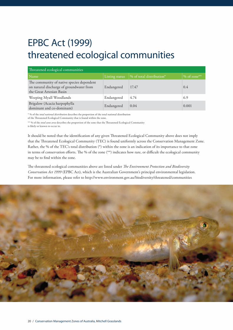
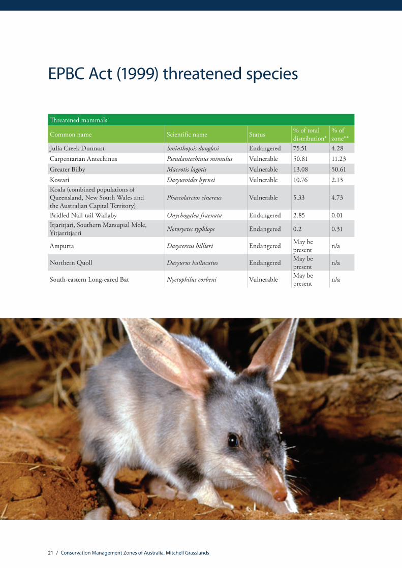
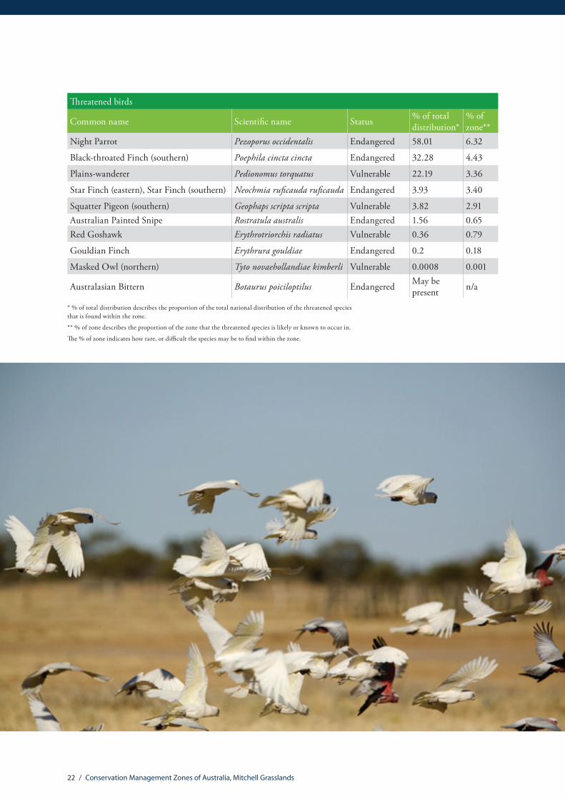
Image CreditsFront Cover: Lawn Hill National Park – Peter LikPage 4: Kowaris (Dasyuroides byrnei) – Leong LimPage 10: Oriental Pratincole (Glareola maldivarum) – JJ HarrisonPage 16: Australian Fossil Mammal Sites (Riversleigh) – World Heritage Listed site – Colin TotterdellPage 18: Mitchell Grasslands – Baz – The Landy, www.thelandy.comPage 20: Elizabeth Springs Goby (Chlamydogobius micropterus) – Gunther SchmidaPage 21: Greater Bilby (Macrotis lagotis) – © The State of Queensland (Department of Environment and Heritage Protection)Page 22: Birdlife, Diamantina National Park – Nick RainsPage 24: Rainbow Bee-Eater (Merops ornatus) – Georgina Steytler, www.wildandendangered.com.auPage 25: Lawn Hill National Park, ‘Boodjamulla’– Mark Nemeth, © The State of Queensland (Department of Environment and Heritage Protection)Page 29: Plains-wanderer (Pedionomus torquatus) – Mark Sanders, EcoSmart EcologyPage 30: Mitchell grass (Astrebla) tussock grasslands – Baz – The Landy, www.thelandy.comPage 31: Eucalyptus low open woodlands with hummock grass, Welford National Park – Murray FaggPage 32: Eucalyptus open woodlands with a grassy understorey, Bladensburg National Park – Ray Jones, www.travelling-australia.infoPage 33: Acacia open woodlands and sparse shrublands – Murray FaggBack Cover: Lawn Hill National Park – Peter Lik
© Commonwealth of Australia, 2015.
The Conservation Management Zones of Australia profile is licensed by the Commonwealth of Australia for use under a Creative Commons By Attribution 3.0 Australia licence with the exception of the Coat of Arms of the Commonwealth of Australia, the logo of the agency responsible for publishing the report, content supplied by third parties, and any images depicting people.
For licence conditions see here.
Conservation Management Zones of Australia, Mitchell Grasslands
Contents
Acknowledgement of Traditional Owners and Country ����������������������������������������������2
Introduction ��������������������������������������������������������������������������������������������������������������������������������2
Zone at a glance ������������������������������������������������������������������������������������������������������������������������3
Population characteristics �������������������������������������������������������������������������������������������������������6
Employment, volunteering and incomes �������������������������������������������������������������������������9
Agriculture, Natural Resource Management practices and sources of NRM advice ��������������������������������������������������������������������������������������������������11
Land tenure, land use, Native Title and Local Government Areas ������������������������� 13
Zone vegetation characteristics����������������������������������������������������������������������������������������� 15
Nationally Important Wetlands �������������������������������������������������������������������������������������������17
World and National Heritage ���������������������������������������������������������������������������������������������� 18
Major National Reserve System properties �������������������������������������������������������������������� 19
EPBC Act (1999) threatened ecological communities ������������������������������������������������� 20
EPBC Act (1999) threatened species ��������������������������������������������������������������������������������� 21
EPBC Act (1999) migratory species ������������������������������������������������������������������������������������ 24
Threatened endemic species ���������������������������������������������������������������������������������������������� 25
Invasive species ���������������������������������������������������������������������������������������������������������������������� 27
Vegetation profiles and management recommendations ��������������������������������������� 29

2 / Conservation Management Zones of Australia, Mitchell Grasslands
The Australian Government acknowledges Australia’s Traditional Owners and pays respect to Elders past and present of our nation’s Aboriginal and Torres Strait Islander communities� We honour the deep spiritual, cultural and customary connections of Traditional Owners to the Australian landscape, including Australia’s waterways, land and sea country�
Introduction The 23 Conservation Management Zones of Australia are geographic areas, classified according to their ecological and threat characteristics. The zones are also aligned with the Interim Biogeographic Regionalisation of Australia.
The Conservation Management Zones provide a way of understanding Australia’s natural environment that will assist in long-term conservation planning and help the Australian Government to better design, deliver and report on Natural Resource Management (NRM) investments, including ensuring alignment of national NRM priorities with local action.
The Conservation Management Zones also provide a filter through which to make national environmental and socio-economic data more accessible and comprehensible, and a framework for gathering on-ground knowledge and expertise about the environment. This will improve information flow to the Australian Government about regional NRM requirements, best practice management, emerging NRM issues and knowledge gaps.
The Conservation Management Zones do not represent any change to existing administrative boundaries or governance structures, but aim to support the NRM and wider community to cooperatively manage environmental assets across boundaries, where they share common threats, ecological characteristics and stakeholders.
Each Conservation Management Zone profile contains a standard suite of nationally available ecological and socio-economic information. We hope that this information will enable Australians of all ages and backgrounds to engage with, understand and appreciate Australian landscapes, and support all Australians to manage our natural resources more effectively.
The profile information provides an indicative, high-level stock-take of the environmental and socio-economic landscape and it is not intended to be comprehensive. It should also be noted that, at present, the profiles contain only limited information on aquatic ecosystems, coastal assets and Indigenous land management practices. In future, consultation and comprehensive literature reviews will enable us to provide more complete information.
Acknowledgement of Traditional Owners and Country
3 / Conservation Management Zones of Australia, Mitchell Grasslands
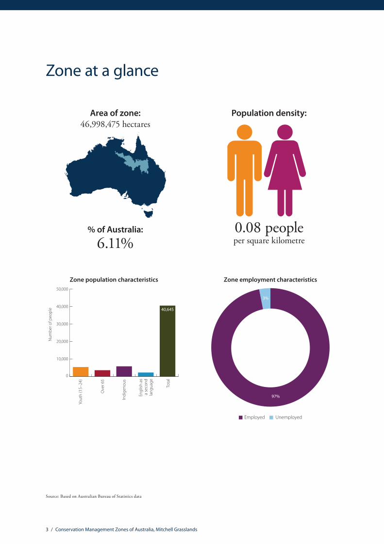
Zone at a glance
Area of zone: 46,998,475 hectares
% of Australia:
6.11%0.08 people per square kilometre
Population density:
Zone population characteristics
0
10,000
20,000
30,000
40,000
50,000
40,645
Tota
l
Engl
ish a
s a
seco
nd
lang
uage
Indi
geno
us
Ove
r 65
Yout
h (1
5–24
)
Num
ber o
f peo
ple
Zone employment characteristics
97%
3%
UnemployedEmployed
Source: Based on Australian Bureau of Statistics data

4 / Conservation Management Zones of Australia, Mitchell Grasslands
Natural Resource Management (NRM) regions
Territory Natural Resource Management NT
Desert Channels Group QLD
NQ Dry Tropics Group Inc QLD
South West NRM Group Ltd QLD
Southern Gulf Catchments Inc QLD
Regional centres Population
Barcaldine 1,317
Cloncurry 2,320
Longreach 3,139
Mount Isa 20,568
Climate characteristics*
Mean annual temperature 23.7 Celsius
Mean Maximum of the Hottest Month 37.1 Celsius
Mean Minimum of the Coldest Month 7.8 Celsius
Mean Annual Rainfall 399.4 mm
Dominant rainfall season Summer
* The figures are interpolated 75-year means (1921 to 1995) representing the period prior to the onset of rapid climatic warming. Cited in: Williams KJ, Belbin L, Austin MP, Stein J, Ferrier S (2012) Which environmental variables should I use in my biodiversity model? International Journal of Geographic Information Sciences 26(11), 2009–2047. (Data derived from Australian Climate surfaces version 2.1 for the ANUCLIM-BIOCLIM package).
For future climate projections please refer to: http://www.climatechangeinaustralia.gov.au/
Top five agricultural commodities Value (millions)
Beef $689
Wool $36
Lamb $19
Hay $9
Goats $4Total value of agricultural commodities (including other commodities not listed here)
$761
Source: Based on Australian Bureau of Statistics data

5 / Conservation Management Zones of Australia, Mitchell Grasslands
Native Title area
19%
81%
Other areaNative Title area
National Reserve System area
98%
Other areaNRS area
2%
Native vegetation clearance level
6%
94%
Uncleared (ha)Cleared (ha)
Number of threatened species by class
20
10
10
6
3
1
FishReptiles
BirdsPlants Mammals
Sharks
Status of EPBC Act listed threatened species, communities and migratory species
0 7 14 21 28 35
32
19
26
3Threatened ecologicalcommunities
Migratory species
Endangered species
Vulnerable species
Source: Based on data from the National Native Title Register; Collaborative Australian Protected Area Database (CAPAD); National Vegetation Information System (NVIS); Species’ Profile and Threats Database (SPRAT).

6 / Conservation Management Zones of Australia, Mitchell Grasslands
Population
Population by age group
23%
14%
31%
23%
65 years and over40–64 years
15–24 years0–14 years 25–39 years
9%
Indigenous population by age group
32%
16%
6%
26%
20%
65 years and over40–64 years
15–24 years0–14 years 25–39 years
Farmer and farm managers by age group
23%
4%16%
57%
65 years and over40–64 years
25–39 years15–24 years
Gender of farmers and farm managers
949
586
FemaleMale
Source: Based on Australian Bureau of Statistics data
Population characteristics
7 / Conservation Management Zones of Australia, Mitchell Grasslands
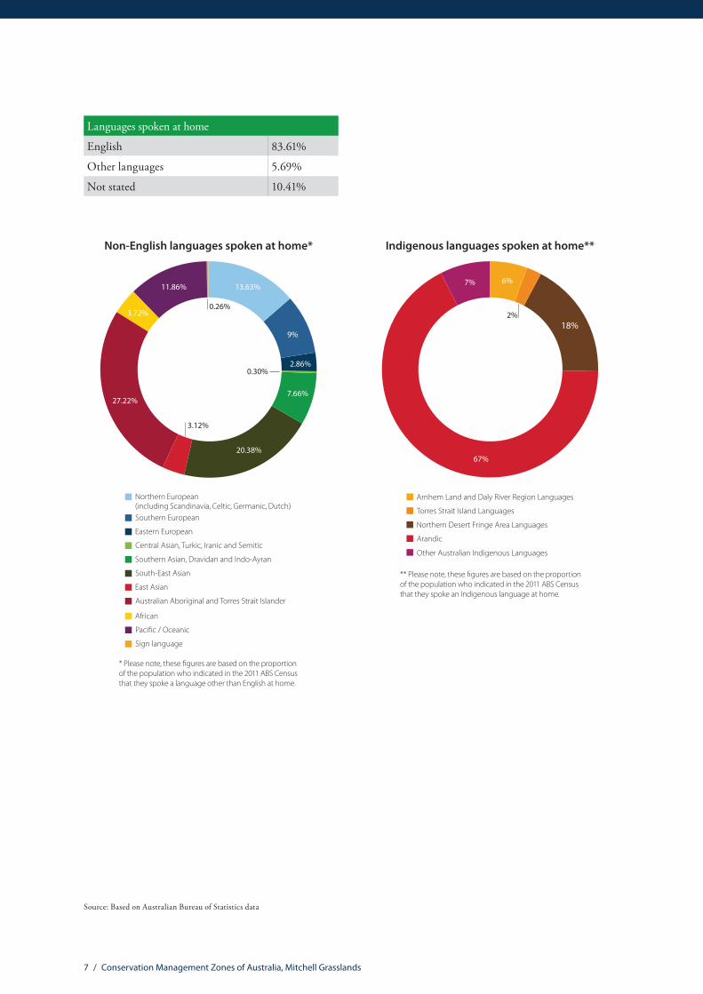
Languages spoken at home
English 83.61%
Other languages 5.69%
Not stated 10.41%
Non-English languages spoken at home*
Northern European (including Scandinavia, Celtic, Germanic, Dutch)Southern European
Eastern European
Central Asian, Turkic, Iranic and Semitic
Southern Asian, Dravidan and Indo-Ayran
South-East Asian
East Asian
Australian Aboriginal and Torres Strait Islander
African
Paci�c / Oceanic
Sign language
13.63%
3.12%
20.38%
3.72%
11.86%
0.26%
0.30%
* Please note, these �gures are based on the proportion of the population who indicated in the 2011 ABS Census that they spoke a language other than English at home.
7.66%
9%
27.22%
2.86%
Indigenous languages spoken at home**
7%
18%
67%
Arnhem Land and Daly River Region Languages
Torres Strait Island Languages
Northern Desert Fringe Area Languages
Arandic
Other Australian Indigenous Languages
** Please note, these �gures are based on the proportion of the population who indicated in the 2011 ABS Census that they spoke an Indigenous language at home.
6%
2%
Source: Based on Australian Bureau of Statistics data

8 / Conservation Management Zones of Australia, Mitchell Grasslands
Education
0%
5%
10%
15%
20%
25%
30%
35%
40%
65 years and over40–64 years
25–39 years15–24 years
Highest level of educational attainment – total population
Inad
equa
tely
des
crib
ed/N
ot st
ated
No
Educ
atio
nal A
ttai
nmen
t
Scho
ol Y
ears
10
or b
elow
Scho
ol Y
ears
11
and
12
Cert
i�ca
te L
evel
Bach
elor
Deg
ree/
Adva
nced
Dip
lom
a an
d D
iplo
ma
Post
grad
uate
Deg
ree/
Gra
duat
eD
iplo
ma
& G
radu
ate
Cert
i�ca
te
Highest level of educational attainment – Indigenous community
0%
10%
20%
30%
40%
50%
60%
Inad
equa
tely
des
crib
ed/N
ot st
ated
No
Educ
atio
nal A
ttai
nmen
t
Scho
ol Y
ears
10
or b
elow
Scho
ol Y
ears
11
and
12
Cert
i�ca
te L
evel
Bach
elor
Deg
ree/
Adva
nced
Dip
lom
a an
d D
iplo
ma
Post
grad
uate
Deg
ree/
Gra
duat
eD
iplo
ma
& G
radu
ate
Cert
i�ca
te
65 years and over40–64 years
25–39 years15–24 years
0%
10%
20%
30%
40%
50%
60%
65 years and over40–64 years
25–39 years15–24 years
Highest level of educational attainment – farmers and farm managers
Inad
equa
tely
des
crib
ed/N
ot st
ated
No
Educ
atio
nal A
ttai
nmen
t
Scho
ol Y
ears
10
or b
elow
Scho
ol Y
ears
11
and
12
Cert
i�ca
te L
evel
Bach
elor
Deg
ree/
Adva
nced
Dip
lom
a an
d D
iplo
ma
Post
grad
uate
Deg
ree/
Gra
duat
eD
iplo
ma
& G
radu
ate
Cert
i�ca
te
0
200
400
600
800
1,000
1,200
Post-school quali�cation types*
15–2
4 ye
ars o
ld
25–3
9 ye
ars o
ld
40–6
4 ye
ars o
ld
65 y
ears
an
d ab
ove
Natural and Physical Sciences
Agriculture, Environmental and Related Studies
Health and education
Architecture, building, society and culture and creative arts
Information Technology, Management and Commerce and service industries
* Please note, this table omits quali�cations of mixed �eld, quali�cations that are not adequately described, and information relating to census respondents who have not stated their quali�cation or are not applicable (i.e. Not of age to have post-school quali�cation).
Source: Based on Australian Bureau of Statistics data
9 / Conservation Management Zones of Australia, Mitchell Grasslands
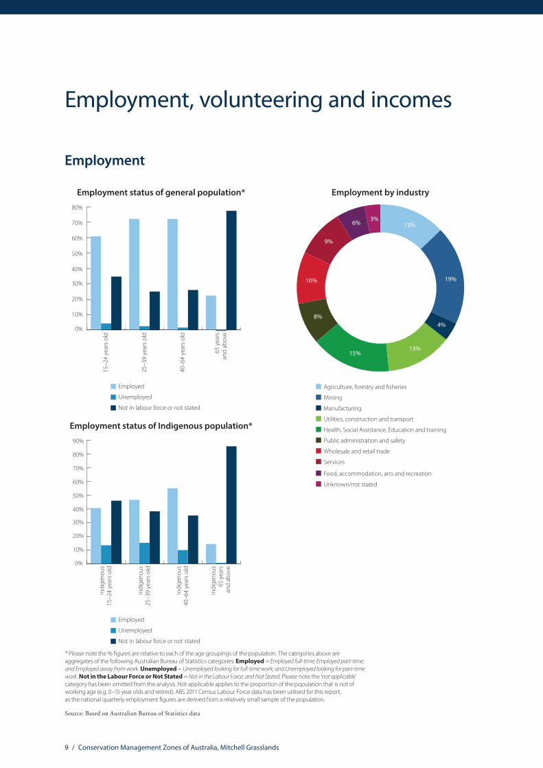
Employment
0%
10%
20%
30%
40%
50%
60%
70%
80%
Employment status of general population*
65 y
ears
and
abov
e
15–2
4 ye
ars o
ld
40–6
4 ye
ars o
ld
25–3
9 ye
ars o
ld
Employed
Unemployed
Not in labour force or not stated
* Please note the % �gures are relative to each of the age groupings of the population. The categories above are aggregates of the following Australian Bureau of Statistics categories: Employed = Employed full-time; Employed part-time; and Employed away from work. Unemployed = Unemployed looking for full-time work; and Unemployed looking for part-time work. Not in the Labour Force or Not Stated = Not in the Labour Force; and Not Stated. Please note the ‘not applicable’ category has been omitted from the analysis. Not applicable applies to the proportion of the population that is not of working age (e.g. 0–15 year olds and retired). ABS 2011 Census Labour Force data has been utilised for this report, as the national quarterly employment �gures are derived from a relatively small sample of the population.
Employment by industry
Agriculture, forestry and sheries
Mining
Manufacturing
Utilities, construction and transport
Health, Social Assistance, Education and training
Public administration and safety
Wholesale and retail trade
Services
Food, accommodation, arts and recreation
Unknown/not stated
13%
4%
19%
13%15%
8%
10%
9%
6%3%
0%
10%
20%
30%
40%
50%
60%
70%
80%
Employment status of general population*
65 y
ears
and
abov
e
15–2
4 ye
ars o
ld
40–6
4 ye
ars o
ld
25–3
9 ye
ars o
ld
Employed
Unemployed
Not in labour force or not stated
* Please note the % �gures are relative to each of the age groupings of the population. The categories above are aggregates of the following Australian Bureau of Statistics categories: Employed = Employed full-time; Employed part-time; and Employed away from work. Unemployed = Unemployed looking for full-time work; and Unemployed looking for part-time work. Not in the Labour Force or Not Stated = Not in the Labour Force; and Not Stated. Please note the ‘not applicable’ category has been omitted from the analysis. Not applicable applies to the proportion of the population that is not of working age (e.g. 0–15 year olds and retired). ABS 2011 Census Labour Force data has been utilised for this report, as the national quarterly employment �gures are derived from a relatively small sample of the population.
0%
10%
20%
30%
40%
50%
60%
70%
80%
90%
Employment status of Indigenous population*
Indi
geno
us65
yea
rsan
d ab
ove
Indi
geno
us15
–24
year
s old
Indi
geno
us40
–64
year
s old
Indi
geno
us25
–39
year
s old
Employed
Unemployed
Not in labour force or not stated
Source: Based on Australian Bureau of Statistics data
Employment, volunteering and incomes
10 / Conservation Management Zones of Australia, Mitchell Grasslands
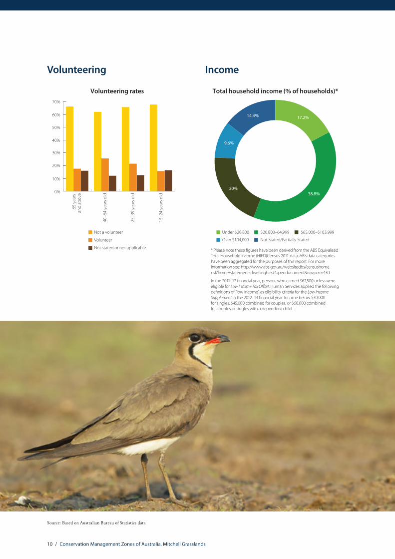
Volunteering
0%
10%
20%
30%
40%
50%
60%
70%
Volunteering rates
15–2
4 ye
ars o
ld
25–3
9 ye
ars o
ld
40–6
4 ye
ars o
ld
65 y
ears
an
d ab
ove
Not a volunteer
Volunteer
Not stated or not applicable
Income
Total household income (% of households)*
17.2%
38.8%
14.4%
9.6%
20%
Over $104,000
Under $20,800
Not Stated/Partially Stated
$20,800–64,999 $65,000–$103,999
* Please note these �gures have been derived from the ABS Equivalised Total Household Income (HIED)Census 2011 data. ABS data categories have been aggregated for the purposes of this report. For more information see: http://www.abs.gov.au/websitedbs/censushome.nsf/home/statementsdwellinghied?opendocument&navpos=430
In the 2011–12 �nancial year, persons who earned $67,500 or less were eligible for Low Income Tax O�set. Human Services applied the following de�nitions of “low income” as eligibility criteria for the Low Income Supplement in the 2012–13 �nancial year: Income below $30,000 for singles, $45,000 combined for couples, or $60,000 combined for couples or singles with a dependent child.
Source: Based on Australian Bureau of Statistics data
11 / Conservation Management Zones of Australia, Mitchell Grasslands
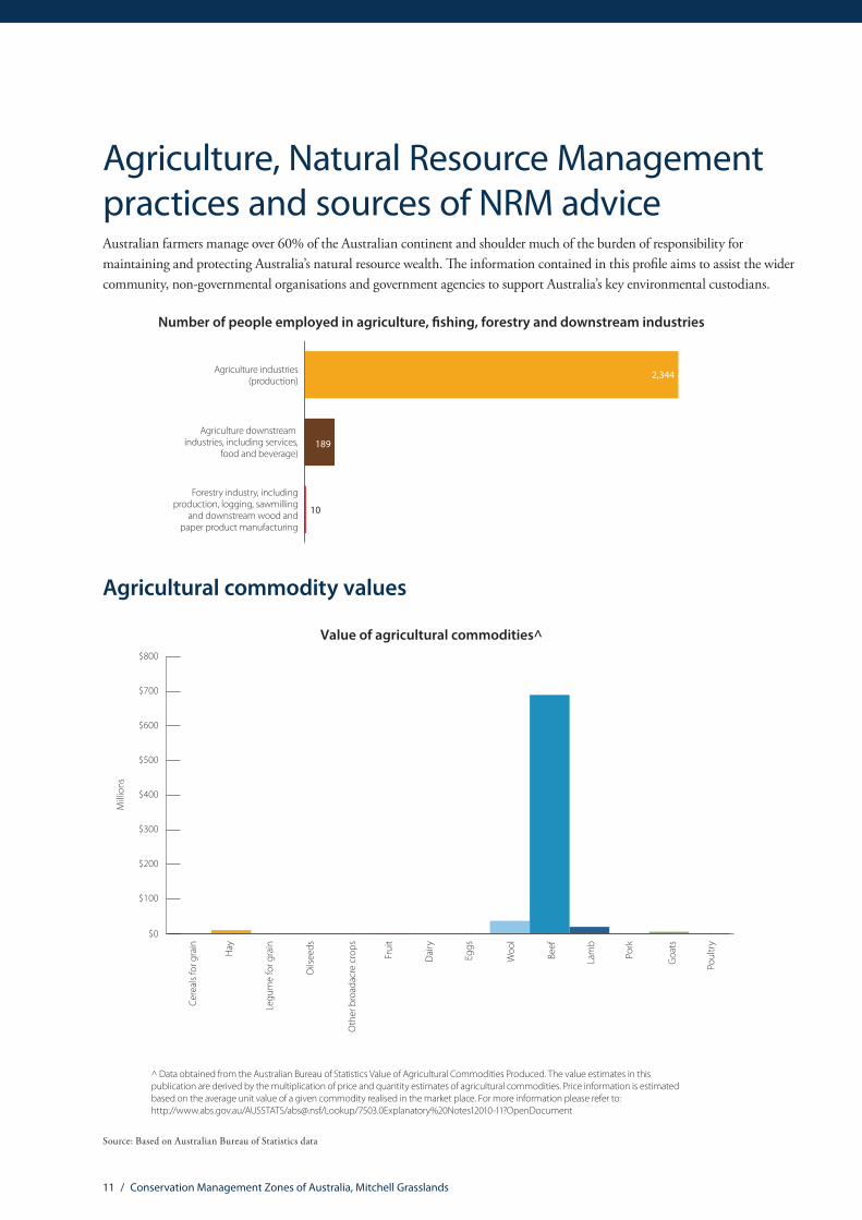
Agricultural commodity values
Value of agricultural commodities^
$0
$100
$200
$300
$400
$500
$600
$700
$800
Oth
er b
road
acre
cro
ps
Frui
t
Oils
eeds
Legu
me
for g
rain
Hay
Cere
als f
or g
rain
Eggs
Woo
l
Beef
Lam
b
Pork
Goa
ts
Poul
try
Dai
ry
Mill
ions
^ Data obtained from the Australian Bureau of Statistics Value of Agricultural Commodities Produced. The value estimates in this publication are derived by the multiplication of price and quantity estimates of agricultural commodities. Price information is estimated based on the average unit value of a given commodity realised in the market place. For more information please refer to: http://www.abs.gov.au/AUSSTATS/[email protected]/Lookup/7503.0Explanatory%20Notes12010-11?OpenDocument
Source: Based on Australian Bureau of Statistics data
Agriculture, Natural Resource Management practices and sources of NRM adviceAustralian farmers manage over 60% of the Australian continent and shoulder much of the burden of responsibility for maintaining and protecting Australia’s natural resource wealth. The information contained in this profile aims to assist the wider community, non-governmental organisations and government agencies to support Australia’s key environmental custodians.
Number of people employed in agriculture, �shing, forestry and downstream industries
2,344
7,272
189
83Forestry industry, includingproduction, logging, sawmilling
and downstream wood andpaper product manufacturing
Agriculture downstream industries, including services,
food and beverage)
Agriculture industries(production)
10
Income
Total household income (% of households)*
17.2%
38.8%
14.4%
9.6%
20%
Over $104,000
Under $20,800
Not Stated/Partially Stated
$20,800–64,999 $65,000–$103,999
* Please note these �gures have been derived from the ABS Equivalised Total Household Income (HIED)Census 2011 data. ABS data categories have been aggregated for the purposes of this report. For more information see: http://www.abs.gov.au/websitedbs/censushome.nsf/home/statementsdwellinghied?opendocument&navpos=430
In the 2011–12 �nancial year, persons who earned $67,500 or less were eligible for Low Income Tax O�set. Human Services applied the following de�nitions of “low income” as eligibility criteria for the Low Income Supplement in the 2012–13 �nancial year: Income below $30,000 for singles, $45,000 combined for couples, or $60,000 combined for couples or singles with a dependent child.
12 / Conservation Management Zones of Australia, Mitchell Grasslands
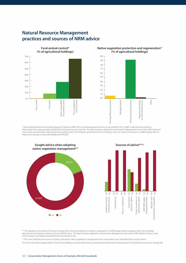
Natural Resource Management practices and sources of NRM advice
0%
10%
20%
30%
40%
50%
60%
70%
Feral animal control*(% of agricultural holdings)
No
man
agem
ent
of fe
ral a
nim
als
Oth
er (u
nspe
ci�e
d)fe
ral a
nim
al c
ontr
ol
Fera
l goa
ts
Fera
l cam
els
0%
1%
2%
3%
4%
5%
6%
7%
8%
9%
10%
Native vegetation protection and regeneration*(% of agricultural holdings)
Oth
er
Stop
ping
mec
hani
cal
or c
hem
ical
des
truc
tion
Redu
cing
gra
zing
pre
ssur
e
Man
agin
g w
eeds
Fenc
ing
o�/e
xclu
ding
stoc
k
Sought advice when adopting native vegetation management**
81.09%
18.91%
NoYes
Sources of advice**^
Yes
No
Yes
No
Yes
No
Yes
No
Yes
No
Yes
No
Yes
No
Priv
ate
cons
ulta
nt o
rag
ribus
ines
s age
nt
CMA/
NRM
regi
onem
ploy
ed fa
cilit
ator
Rese
arch
and
Dev
elop
men
t Cor
pora
tion
Gov
ernm
ent
exte
nsio
n o�
cer
Peer
s or n
eigh
bour
s
Farm
er g
roup
Land
care
or f
arm
erpr
oduc
tion
grou
p
** The sample for the Drivers of Practice Change 2012 survey consisted of a random subsample of 1228 broadacre farm managers from the Australian Agricultural and Grazing Industries Survey (AAGIS) frame. The data has been aligned to Conservation Management Zones from ABS Statistical Area 2 units. For this reason, the figures presented here are indicative only.
^ This chart indicates the sources of advice utilised for native vegetation management from respondents who identified they sought advice.
For more information please refer to http://www.daff.gov.au/SiteCollectionDocuments/forestry/domestic-forestry/prep-for-future/drivers-practice-change.pdf
* Data obtained from the Australian Bureau of Statistics (ABS) 2012 Land Management Practices Survey (LaMPS) 2012. LaMPS collected land practices information from approximately 50,000 farm businesses across Australia. The data has been aligned to Conservation Management Zones from ABS Statistical Area 2 units and Australian Agricultural Environment units. The % figures presented here are indicative only. For more information on LaMPS please refer to: http://www.abs.gov.au/ausstats/[email protected]/mf/4630.0

13 / Conservation Management Zones of Australia, Mitchell Grasslands
Land tenure, land use, Native Title and Local Government Areas
Land tenure
Crown Land – Private – Leased
Crown Land – Public
Crown Land – Public – Leased
Crown Land – Unknown – Leased
Freehold – Private
Freehold – Unknown
No Data/Unknown
3.71%
12.98%
0.74%
0.13%4.27%
2.37%
75.79%
Land use
Grazing Native Vegetation
Conservation and Natural Environments
Other
97%
0.13%
3%
Source: Land tenure data based on Environmental Resources Information Network (ERIN) categorisation of Public Sector Mapping Authority (PSMA) State Tenure 2012; Land use mapping based on Australian Collaborative Land Use and Management Program (ACLUMP) 2012. For more information on Australian land use and management information and classification please refer to: http://www.daff.gov.au/ABARES/aclump/Pages/Default.aspx
Indigenous Land Councils
Central Land Council: www.clc.org.au
North Queensland Aboriginal Land Council: http://www.nqlc.com.au
14 / Conservation Management Zones of Australia, Mitchell Grasslands
Native Title and Traditional Owners
Traditional Owners Registered Native Title Body Corporate Hectares % of zone
Kalkadoon People Kalkadoon Native Title Aboriginal Corporation RNTBC 2,725,478 5.80
Indjalandji-Dhidhanu People Indjalandji-Dhidhanu Aboriginal Corporation RNTBC 1,939,183 4.13
Pitta Pitta People 1,884,266 4.01Ilperrelhelam, Malarrarr, Nwerrarr, Meyt, Itnwerrengayt and Ampwertety landholding groups
Ilperrelhelam Aboriginal Corporation RNTBC 1,101,439 2.34
Waanyi People Waanyi Native Title Aboriginal Corporation RNTBC 953,456 2.03The Newcastle Waters – Murranji native title holders 154,771 0.33
Warranangku group 118,930 0.25The Kinbininggu group; the Warranangku group; the Marlinja group
65,247 0.14
The Jangga People Bulganunna Aboriginal Corporation RNTBC 21,429 0.05The Karranjini group; the Bamarrnganja group; the Warranangku group; the Pinda (OT Downs) group; the Lija/Muwartpi group
14,012 0.03
The Warranangku group; the Karranjini group; the Lija/Murwartpi group
11,962 0.03
Gurungu/Kulumintini people 143 0.00
Source: The Native Title Tribunal Register, October 2013. For more information please refer to: http://www.nntt.gov.au/Pages/Searchportal.aspx
Local Government Areas
Barkly Shire NT
Central Desert Shire NT
Roper Gulf Shire NT
Barcaldine Regional QLD
Barcoo Shire QLD
Blackall Tambo Regional QLD
Boulia Shire QLD
Burke Shire QLD
Charters Towers Regional QLD
Cloncurry Shire QLD
Local Government Areas
Diamantina Shire QLD
Flinders Shire QLD
Isaac Regional QLD
Longreach Regional QLD
Mckinlay Shire QLD
Mount Isa City QLD
Murweh Shire QLD
Quilpie Shire QLD
Richmond Shire QLD
Winton Shire QLD
15 / Conservation Management Zones of Australia, Mitchell Grasslands
Zone vegetation characteristics
Major Vegetation Subgroups (MVS) with >1% original distribution within zone
Acac
ia (+
/- lo
w) o
pen
woo
dlan
dsan
d sp
arse
shru
blan
dsw
ith h
umm
ock
gras
s
Acac
ia (+
/- lo
w) o
pen
woo
dlan
dsan
d sp
arse
shru
blan
ds+
/- tu
ssoc
k gr
ass
Euca
lypt
us lo
w o
penw
oodl
ands
with
tuss
ock
gras
s
Mitc
hell
gras
s (As
trebl
a)tu
ssoc
k gr
assla
nds
Oth
er A
caci
a fo
rest
s and
woo
dlan
ds
Oth
er sh
rubl
ands
Euca
lypt
us lo
w o
pen
woo
dlan
dsw
ith h
umm
ock
gras
s
Wet
tuss
ock
gras
sland
with
her
bs,
sedg
es o
r rus
hes,
herb
land
s or f
erns
Euca
lypt
us o
pen
woo
dlan
dsw
ith a
gra
ssy
unde
rsto
rey
Euca
lypt
us (+
/-) o
pen
woo
dlan
dsw
ith a
che
nopo
d or
sam
phire
unde
rsto
rey
Euca
lypt
us w
oodl
ands
with
atu
ssoc
k gr
ass u
nder
stor
ey
0%
10%
20%
30%
40%
50%
Present day percentage of CMZ areaPre 1750 percentage of CMZ area

16 / Conservation Management Zones of Australia, Mitchell Grasslands
The National Vegetation Information System (NVIS) framework is a nationally consistent vegetation classification system based on vegetation data collected by states and territories. It provides information on the extent and distribution of vegetation types across the Australian landscape.
Two products are used to provide the Zone Vegetation Characteristics graph. A modelled pre-European vegetation distribution (pre-1750), and extant (current extent) vegetation, which is based on contemporary vegetation mapping. The information presented here relates to Major Vegetation Subgroups (MVSs). There are 85 MVS types across Australia, describing the structure and floristic composition of dominant and secondary vegetation stratums (e.g. canopy and mid-storey species). Major Vegetation Subgroups only reflect the dominant vegetation type occurring in an area from a mix of vegetation types. Less-dominant vegetation groups which may also be present are therefore not represented.
It is important to note that the vegetation information is indicative only, as state and territory mapping in Australia is of variable resolution and scale. However, this data is the best available nationally consistent information on vegetation, and the dataset continues to evolve and increase in accuracy.
Analysing this information at Conservation Management Zone, rather than national level provides greater discrimination for decision makers, as clearance levels of vegetation types are not uniform across Australia. For example, eucalypt woodlands with a tussock grass understory is a vegetation type found across Australia. In the Brigalow Woodlands Conservation Management Zone, eucalypt open woodlands with a tussock grass understory originally covered approximately 36% of the zone, but today it only covers only 14.5 % of the zone (58.7% of this vegetation community has been cleared in the Brigalow). In the Northern Australia Tropical Savannah zone, this vegetation type originally occupied 19.6% of the zone. Today, it occupies approximately 19.4% of the zone (only 2.3% of this vegetation type has been cleared). It should be noted that this data only provides an indication of change in extent, and not vegetation condition.
For more information on the National Vegetation Information System (NVIS) please refer to: http://www.environment.gov.au/topics/science-and-research/databases-and-maps/national-vegetation-information-system

17 / Conservation Management Zones of Australia, Mitchell Grasslands
The National Vegetation Information System (NVIS) framework is a nationally consistent vegetation classification system based on vegetation data collected by states and territories. It provides information on the extent and distribution of vegetation types across the Australian landscape.
Two products are used to provide the Zone Vegetation Characteristics graph. A modelled pre-European vegetation distribution (pre-1750), and extant (current extent) vegetation, which is based on contemporary vegetation mapping. The information presented here relates to Major Vegetation Subgroups (MVSs). There are 85 MVS types across Australia, describing the structure and floristic composition of dominant and secondary vegetation stratums (e.g. canopy and mid-storey species). Major Vegetation Subgroups only reflect the dominant vegetation type occurring in an area from a mix of vegetation types. Less-dominant vegetation groups which may also be present are therefore not represented.
It is important to note that the vegetation information is indicative only, as state and territory mapping in Australia is of variable resolution and scale. However, this data is the best available nationally consistent information on vegetation, and the dataset continues to evolve and increase in accuracy.
Analysing this information at Conservation Management Zone, rather than national level provides greater discrimination for decision makers, as clearance levels of vegetation types are not uniform across Australia. For example, eucalypt woodlands with a tussock grass understory is a vegetation type found across Australia. In the Brigalow Woodlands Conservation Management Zone, eucalypt open woodlands with a tussock grass understory originally covered approximately 36% of the zone, but today it only covers only 14.5 % of the zone (58.7% of this vegetation community has been cleared in the Brigalow). In the Northern Australia Tropical Savannah zone, this vegetation type originally occupied 19.6% of the zone. Today, it occupies approximately 19.4% of the zone (only 2.3% of this vegetation type has been cleared). It should be noted that this data only provides an indication of change in extent, and not vegetation condition.
For more information on the National Vegetation Information System (NVIS) please refer to: http://www.environment.gov.au/topics/science-and-research/databases-and-maps/national-vegetation-information-system
Nationally Important Wetlands
Nationally Important Wetlands Jurisdiction Hectares Criteria
Aramac Springs QLD 399 1, 3
Austral Limestone Aggregation QLD 69,335 1
Bingeringo Aggregation QLD 429 1, 2, 3
Cauckingburra Swamp QLD 782 1, 2, 3, 5
Corella Lake NT 10,195 1, 2, 3
Diamantina Lakes Area QLD 2 1, 2, 3
Doongmabulla Springs QLD 400 1, 3
Elizabeth Springs QLD 399 1, 3
Eva Downs Swamp NT 12,672 1, 2, 3
Great Basalt Wall QLD 722 1, 2, 3, 5, 6
Gregory River QLD 14,833 1, 2, 3
Lake Buchanan QLD 23,212 1, 2, 3, 5
Lake de Burgh NT 22,216 1, 2, 3, 4
Lake Galilee QLD 25,789 1, 2, 3, 5
Lake Julius QLD 1,936 1, 2, 3
Lake Moondarra QLD 1,742 1, 2, 3
Lake Sylvester NT 76,466 1, 2, 3, 4, 6
Lake Woods NT 42,568 1, 2, 3, 4, 5
Tarrabool Lake NT 46,942 1, 2, 3, 5
Thorntonia Aggregation QLD 296,198 1, 2, 3, 6
Nationally important wetlands are defined according to the following criteria:1. It is a good example of a wetland type occurring within a biogeographic region in Australia.2. It is a wetland which plays an important ecological or hydrological role in the natural functioning of a major wetland system/complex.3. It is a wetland which is important as the habitat for animal taxa at a vulnerable stage in their life cycles, or provides a refuge when
adverse conditions such as drought prevail.4. The wetland supports 1% or more of the national populations of any native plant or animal taxa.5. The wetland supports native plant or animal taxa or communities which are considered endangered or vulnerable at the national level.6. The wetland is of outstanding historical or cultural significance.Please note, the above are a subset of all the Nationally Important Wetlands found within the Zone. For more information on Nationally Important Wetlands please see: http://www.environment.gov.au/resource/directory-important-wetlands-australia-third-edition
18 / Conservation Management Zones of Australia, Mitchell Grasslands
Please refer to the Australian Heritage Database for detailed information on listing criteria for these heritage values: http://www.environment.gov.au/topics/heritage/publications-and-resources/australian-heritage-database
For more information on Australia’s world and national heritage please refer to: http://www.environment.gov.au/topics/heritage/about-australias-heritage
World and National Heritage
Heritage values World or National Heritage type Jurisdiction Hectares % of zone
Australian Fossil Mammal Sites (Riversleigh)
World and National Natural QLD 10,021.49 0.02
Longreach Airport National Historic QLD 261.75 0.00Great Artesian Basin Springs: Elizabeth National Natural QLD 101.11 0.00
Dinosaur Stampede National Monument National Natural QLD 90.94 0.00
QANTAS Hangar Longreach National Historic QLD 0.11 0.00
Tree of Knowledge and curtilage National Historic QLD 0.02 0.00
19 / Conservation Management Zones of Australia, Mitchell Grasslands
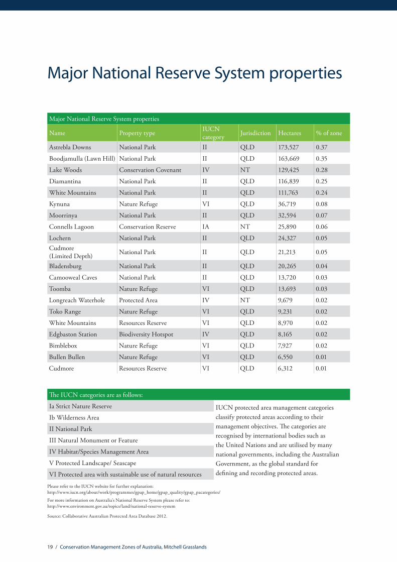
Major National Reserve System properties
Major National Reserve System properties
Name Property type IUCN category Jurisdiction Hectares % of zone
Astrebla Downs National Park II QLD 173,527 0.37
Boodjamulla (Lawn Hill) National Park II QLD 163,669 0.35
Lake Woods Conservation Covenant IV NT 129,425 0.28
Diamantina National Park II QLD 116,839 0.25
White Mountains National Park II QLD 111,763 0.24
Kynuna Nature Refuge VI QLD 36,719 0.08
Moorrinya National Park II QLD 32,594 0.07
Connells Lagoon Conservation Reserve IA NT 25,890 0.06
Lochern National Park II QLD 24,327 0.05Cudmore (Limited Depth) National Park II QLD 21,213 0.05
Bladensburg National Park II QLD 20,265 0.04
Camooweal Caves National Park II QLD 13,720 0.03
Toomba Nature Refuge VI QLD 13,693 0.03
Longreach Waterhole Protected Area IV NT 9,679 0.02
Toko Range Nature Refuge VI QLD 9,231 0.02
White Mountains Resources Reserve VI QLD 8,970 0.02
Edgbaston Station Biodiversity Hotspot IV QLD 8,165 0.02
Bimblebox Nature Refuge VI QLD 7,927 0.02
Bullen Bullen Nature Refuge VI QLD 6,550 0.01
Cudmore Resources Reserve VI QLD 6,312 0.01
The IUCN categories are as follows:
Ia Strict Nature Reserve IUCN protected area management categories classify protected areas according to their management objectives. The categories are recognised by international bodies such as the United Nations and are utilised by many national governments, including the Australian Government, as the global standard for defining and recording protected areas.
Ib Wilderness Area
II National Park
III Natural Monument or Feature
IV Habitat/Species Management Area
V Protected Landscape/ Seascape
VI Protected area with sustainable use of natural resources
Please refer to the IUCN website for further explanation: http://www.iucn.org/about/work/programmes/gpap_home/gpap_quality/gpap_pacategories/
For more information on Australia’s National Reserve System please refer to: http://www.environment.gov.au/topics/land/national-reserve-system
Source: Collaborative Australian Protected Area Database 2012.
20 / Conservation Management Zones of Australia, Mitchell Grasslands
EPBC Act (1999) threatened ecological communitiesThreatened ecological communities
Name Listing status % of total distribution* % of zone**The community of native species dependent on natural discharge of groundwater from the Great Artesian Basin
Endangered 17.47 0.4
Weeping Myall Woodlands Endangered 4.74 6.9Brigalow (Acacia harpophylla dominant and co-dominant) Endangered 0.04 0.001
* % of the total national distribution describes the proportion of the total national distribution of the Threatened Ecological Community that is found within the zone.
** % of the total zone area describes the proportion of the zone that the Threatened Ecological Community is likely or known to occur in.
It should be noted that the identification of any given Threatened Ecological Community above does not imply that the Threatened Ecological Community (TEC) is found uniformly across the Conservation Management Zone. Rather, the % of the TEC’s total distribution (*) within the zone is an indication of its importance to that zone in terms of conservation efforts. The % of the zone (**) indicates how rare, or difficult the ecological community may be to find within the zone.
The threatened ecological communities above are listed under The Environment Protection and Biodiversity Conservation Act 1999 (EPBC Act), which is the Australian Government’s principal environmental legislation. For more information, please refer to http://www.environment.gov.au/biodiversity/threatened/communities
21 / Conservation Management Zones of Australia, Mitchell Grasslands
EPBC Act (1999) threatened species
Threatened mammals
Common name Scientific name Status % of total distribution*
% of zone**
Julia Creek Dunnart Sminthopsis douglasi Endangered 75.51 4.28Carpentarian Antechinus Pseudantechinus mimulus Vulnerable 50.81 11.23Greater Bilby Macrotis lagotis Vulnerable 13.08 50.61Kowari Dasyuroides byrnei Vulnerable 10.76 2.13Koala (combined populations of Queensland, New South Wales and the Australian Capital Territory)
Phascolarctos cinereus Vulnerable 5.33 4.73
Bridled Nail-tail Wallaby Onychogalea fraenata Endangered 2.85 0.01Itjaritjari, Southern Marsupial Mole, Yitjarritjarri Notoryctes typhlops Endangered 0.2 0.31
Ampurta Dasycercus hillieri Endangered May be present n/a
Northern Quoll Dasyurus hallucatus Endangered May be present n/a
South-eastern Long-eared Bat Nyctophilus corbeni Vulnerable May be present n/a
22 / Conservation Management Zones of Australia, Mitchell Grasslands
Threatened birds
Common name Scientific name Status % of total distribution*
% of zone**
Night Parrot Pezoporus occidentalis Endangered 58.01 6.32
Black-throated Finch (southern) Poephila cincta cincta Endangered 32.28 4.43
Plains-wanderer Pedionomus torquatus Vulnerable 22.19 3.36
Star Finch (eastern), Star Finch (southern) Neochmia ruficauda ruficauda Endangered 3.93 3.40
Squatter Pigeon (southern) Geophaps scripta scripta Vulnerable 3.82 2.91Australian Painted Snipe Rostratula australis Endangered 1.56 0.65Red Goshawk Erythrotriorchis radiatus Vulnerable 0.36 0.79
Gouldian Finch Erythrura gouldiae Endangered 0.2 0.18
Masked Owl (northern) Tyto novaehollandiae kimberli Vulnerable 0.0008 0.001
Australasian Bittern Botaurus poiciloptilus Endangered May be present n/a
* % of total distribution describes the proportion of the total national distribution of the threatened species that is found within the zone.
** % of zone describes the proportion of the zone that the threatened species is likely or known to occur in.
The % of zone indicates how rare, or difficult the species may be to find within the zone.
23 / Conservation Management Zones of Australia, Mitchell Grasslands
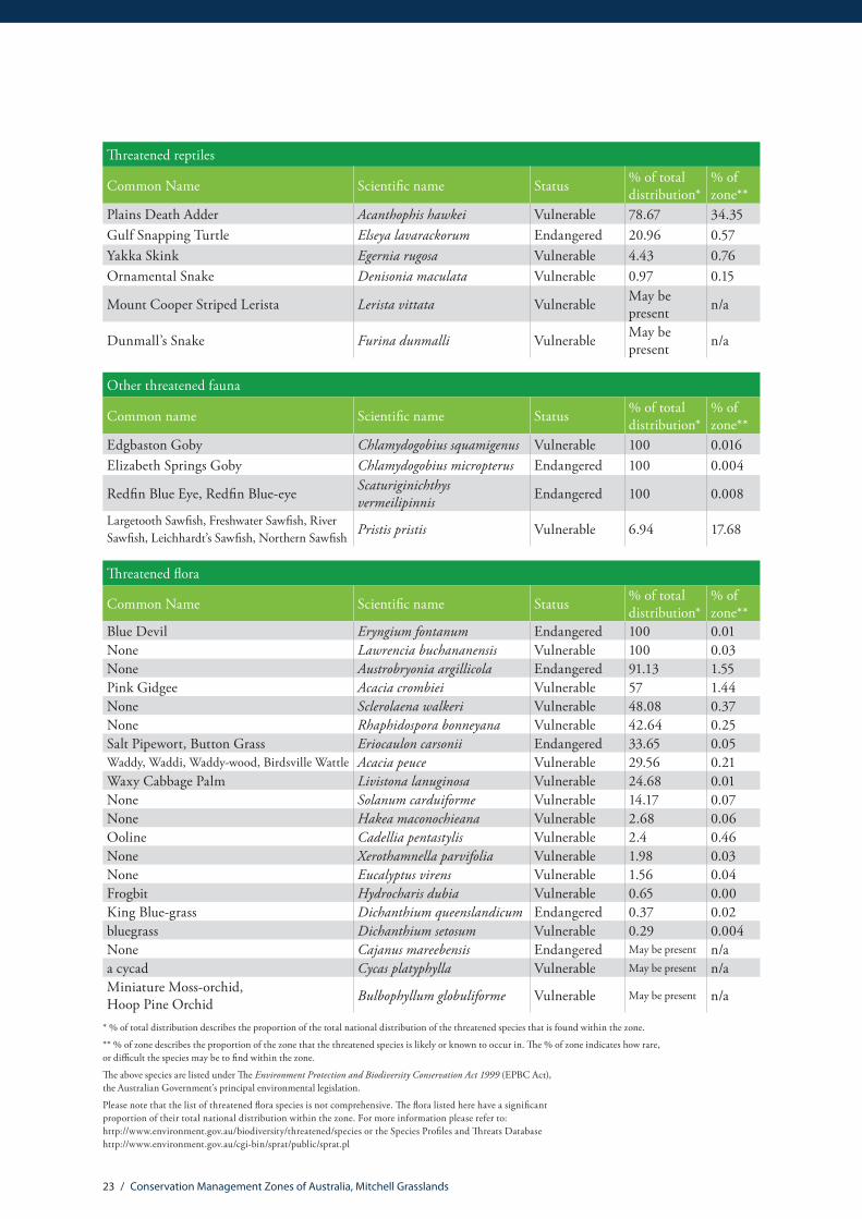
Threatened reptiles
Common Name Scientific name Status % of total distribution*
% of zone**
Plains Death Adder Acanthophis hawkei Vulnerable 78.67 34.35Gulf Snapping Turtle Elseya lavarackorum Endangered 20.96 0.57Yakka Skink Egernia rugosa Vulnerable 4.43 0.76Ornamental Snake Denisonia maculata Vulnerable 0.97 0.15
Mount Cooper Striped Lerista Lerista vittata Vulnerable May be present n/a
Dunmall’s Snake Furina dunmalli Vulnerable May be present n/a
Other threatened fauna
Common name Scientific name Status % of total distribution*
% of zone**
Edgbaston Goby Chlamydogobius squamigenus Vulnerable 100 0.016Elizabeth Springs Goby Chlamydogobius micropterus Endangered 100 0.004
Redfin Blue Eye, Redfin Blue-eye Scaturiginichthys vermeilipinnis Endangered 100 0.008
Largetooth Sawfish, Freshwater Sawfish, River Sawfish, Leichhardt’s Sawfish, Northern Sawfish Pristis pristis Vulnerable 6.94 17.68
Threatened flora
Common Name Scientific name Status % of total distribution*
% of zone**
Blue Devil Eryngium fontanum Endangered 100 0.01None Lawrencia buchananensis Vulnerable 100 0.03None Austrobryonia argillicola Endangered 91.13 1.55Pink Gidgee Acacia crombiei Vulnerable 57 1.44None Sclerolaena walkeri Vulnerable 48.08 0.37None Rhaphidospora bonneyana Vulnerable 42.64 0.25Salt Pipewort, Button Grass Eriocaulon carsonii Endangered 33.65 0.05Waddy, Waddi, Waddy-wood, Birdsville Wattle Acacia peuce Vulnerable 29.56 0.21Waxy Cabbage Palm Livistona lanuginosa Vulnerable 24.68 0.01None Solanum carduiforme Vulnerable 14.17 0.07None Hakea maconochieana Vulnerable 2.68 0.06Ooline Cadellia pentastylis Vulnerable 2.4 0.46None Xerothamnella parvifolia Vulnerable 1.98 0.03None Eucalyptus virens Vulnerable 1.56 0.04Frogbit Hydrocharis dubia Vulnerable 0.65 0.00King Blue-grass Dichanthium queenslandicum Endangered 0.37 0.02bluegrass Dichanthium setosum Vulnerable 0.29 0.004None Cajanus mareebensis Endangered May be present n/aa cycad Cycas platyphylla Vulnerable May be present n/aMiniature Moss-orchid, Hoop Pine Orchid Bulbophyllum globuliforme Vulnerable May be present n/a
* % of total distribution describes the proportion of the total national distribution of the threatened species that is found within the zone.
** % of zone describes the proportion of the zone that the threatened species is likely or known to occur in. The % of zone indicates how rare, or difficult the species may be to find within the zone.
The above species are listed under The Environment Protection and Biodiversity Conservation Act 1999 (EPBC Act), the Australian Government’s principal environmental legislation.
Please note that the list of threatened flora species is not comprehensive. The flora listed here have a significant proportion of their total national distribution within the zone. For more information please refer to: http://www.environment.gov.au/biodiversity/threatened/species or the Species Profiles and Threats Database http://www.environment.gov.au/cgi-bin/sprat/public/sprat.pl

24 / Conservation Management Zones of Australia, Mitchell Grasslands
EPBC Act (1999) migratory species
Migratory birds
Common name Scientific name
Fork-tailed Swift Apus pacificusGreat Egret, White Egret Ardea alba
Cattle Egret Ardea ibis
Painted Snipe Rostratula benghalensis (sensu lato)
Oriental Pratincole Glareola maldivarumBlack-faced Monarch Monarcha melanopsisLittle Curlew, Little Whimbrel Numenius minutus
Oriental Plover, Oriental Dotterel Charadrius veredus
White-bellied Sea-Eagle Haliaeetus leucogaster
Wood Sandpiper Tringa glareolaPacific Golden Plover Pluvialis fulvaBar-tailed Godwit Limosa lapponica
Migratory birds
Common name Scientific nameLesser Sand Plover, Mongolian Plover Charadrius mongolus
Curlew Sandpiper Calidris ferrugineaBlack-tailed Godwit Limosa limosaRed-necked Stint Calidris ruficollisSharp-tailed Sandpiper Calidris acuminataMarsh Sandpiper, Little Greenshank Tringa stagnatilis
Whimbrel Numenius phaeopusLatham’s Snipe, Japanese Snipe Gallinago hardwickii
Great Knot Calidris tenuirostrisRufous Fantail Rhipidura rufifronsSatin Flycatcher Myiagra cyanoleucaBarn Swallow Hirundo rusticaRainbow Bee-eater Merops ornatus
For more information please refer to: http://www.environment.gov.au/topics/biodiversity/migratory-species
25 / Conservation Management Zones of Australia, Mitchell Grasslands
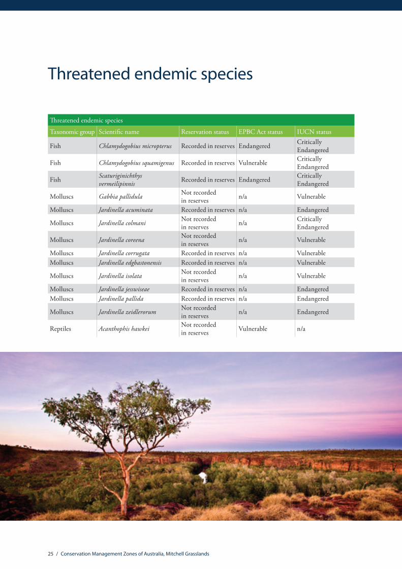
Threatened endemic species
Threatened endemic species
Taxonomic group Scientific name Reservation status EPBC Act status IUCN status
Fish Chlamydogobius micropterus Recorded in reserves Endangered Critically Endangered
Fish Chlamydogobius squamigenus Recorded in reserves Vulnerable Critically Endangered
Fish Scaturiginichthys vermeilipinnis Recorded in reserves Endangered Critically
Endangered
Molluscs Gabbia pallidula Not recorded in reserves n/a Vulnerable
Molluscs Jardinella acuminata Recorded in reserves n/a Endangered
Molluscs Jardinella colmani Not recorded in reserves n/a Critically
Endangered
Molluscs Jardinella coreena Not recorded in reserves n/a Vulnerable
Molluscs Jardinella corrugata Recorded in reserves n/a VulnerableMolluscs Jardinella edgbastonensis Recorded in reserves n/a Vulnerable
Molluscs Jardinella isolata Not recorded in reserves n/a Vulnerable
Molluscs Jardinella jesswiseae Recorded in reserves n/a EndangeredMolluscs Jardinella pallida Recorded in reserves n/a Endangered
Molluscs Jardinella zeidlerorum Not recorded in reserves n/a Endangered
Reptiles Acanthophis hawkei Not recorded in reserves Vulnerable n/a

26 / Conservation Management Zones of Australia, Mitchell Grasslands
Mitc
hell
Gra
ssla
nds
CM
Z
Con
cent
ratio
ns o
f unr
eser
ved
ende
mic
spe
cies
Aus
tralia
n N
atur
al H
erita
geA
sses
smen
t Too
l
Dat
a S
ourc
es:
- All
biod
iver
sity
dat
a ha
ve b
een
deriv
ed fr
om th
e A
ustra
lian
Nat
ural
H
erita
ge A
sses
smen
t Too
l, w
hich
incl
udes
spe
cies
loca
tion
reco
rds
from
Aus
tralia
n m
useu
ms,
Aus
tralia
n he
rbar
ia, B
irds
Aus
tralia
, CS
IRO
,st
ate
and
terr
itory
gov
ernm
ents
and
oth
er s
ourc
es.
- Wei
ghte
d en
dem
ism
/ ric
hnes
s sc
ores
are
cal
cula
ted
for a
ll sp
ecie
s w
ithin
a s
peci
fied
grou
p w
ith th
e ex
cept
ion
of v
ascu
lar p
lant
s (in
clud
es
only
75
fam
ilies
) and
ver
tebr
ates
(doe
s no
t inc
lude
fish
spe
cies
).Fo
r a fu
ll lis
t of t
axa
incl
uded
in A
NH
AT
see
ww
w.e
nviro
nmen
t.gov
.au/
herit
age/
inde
x.ht
ml
- Dra
inag
e an
d w
ater
bodi
es h
ave
been
der
ived
from
the
Geo
scie
nce
Aust
ralia
GE
OD
ATA
TO
PO 1
0M 2
002
- Loc
ality
dat
a ha
ve b
een
deriv
ed fr
om th
e G
eosc
ienc
e A
ustra
liaG
EO
DA
TA T
OP
O 1
0M 2
002
data
laye
r
Cav
eat:
Whi
le e
very
effo
rt ha
s be
en m
ade
to e
nsur
e ac
cura
cy a
ndco
mpl
eten
ess,
no
guar
ante
e is
giv
en, n
or re
spon
sibi
lity
take
n by
the
Com
mon
wea
lth fo
r err
ors
or o
mis
sion
s an
d th
e C
omm
onw
ealth
doe
sno
t acc
ept r
espo
nsib
ility
in re
spec
t of a
ny in
form
atio
n or
adv
ice
give
nin
rela
tion
to, o
r as
a co
nseq
uenc
e of
, any
thin
g co
ntai
ned
here
in.
Prod
uced
by:
The
Dep
artm
ent o
f the
Env
ironm
ent.
© C
omm
onw
ealth
of A
ustra
lia 2
008
Con
cent
ratio
n of
end
emic
s
1 2 3 4 5 Mitc
hell
Gra
ssla
nds
CM
Z B
ound
arie
s
Par
ks a
nd R
eser
ves
015
030
075
Kilo
met
res
The c
olou
r grid
s and
nu
mbe
rs a
re a
n in
dica
tion
of th
e loc
atio
n an
d nu
mbe
r of e
ndem
ic
spec
ies t
hat h
ave a
ll th
eir
know
n ra
nge o
utsid
e of
the N
atio
nal R
eser
ve
Syste
m. C
once
ntra
tions
of
unr
eser
ved
ende
mic
sp
ecie
s may
be u
sefu
l fo
cal a
reas
for p
rivat
e la
nd c
onse
rvat
ion
effor
ts.
Ende
mism
ana
lyse
s wer
e pr
ovid
ed b
y th
e Aus
tral
ian
Gov
ernm
ent D
epar
tmen
t of
Env
ironm
ent
Aust
ralia
n N
atur
al
Her
itage
Ass
essm
ent T
ool
(AN
HAT
). Th
e AN
HAT
da
taba
se h
as b
een
com
pile
d fro
m sp
ecim
ens a
nd si
te
reco
rds h
eld
in st
ate a
genc
y w
ildlif
e atla
ses,
mus
eum
co
llect
ions
, and
the w
ork
of in
divi
dual
rese
arch
ers.
For m
ore i
nfor
mat
ion
plea
se re
fer t
o: h
ttp:
//w
ww.
envi
ronm
ent.
gov.a
u/to
pics
/her
itage
/pu
blic
atio
ns-a
nd-re
sour
ces/
aust
ralia
n-na
tura
l-he
ritag
e-as
sess
men
t-too
l
Conc
entr
atio
ns o
f unr
eser
ved
ende
mic
spe
cies

27 / Conservation Management Zones of Australia, Mitchell Grasslands
Invasive species
Invasive mammals
Common name Scientific name % of total distribution* % of zone**
Cat, House Cat, Domestic Cat Felis catus 6.12 100.00
Pig Sus scrofa 12.63 94.49
Red Fox, Fox Vulpes vulpes 4.49 58.97
Horse Equus caballus 6.88 21.69
Rabbit, European Rabbit Oryctolagus cuniculus 4.50 52.40
Dromedary, Camel Camelus dromedarius 5.38 39.01
House Mouse Mus musculus 3.37 25.53
Domestic Dog Canis lupus familiaris 4.17 22.09
Goat Capra hircus 4.51 20.55
Domestic Cattle Bos taurus 2.23 8.07
Feral deer species in Australia n/a 3.69 3.01
Black Rat, Ship Rat Rattus rattus 1.11 2.62
Brown Hare Lepus capensis 0.29 0.60
* % of the total national distribution of the invasive species found within the zone.
** % of the total zone area that the invasive species is likely or known to occur in.
Other invasive fauna
Common name Scientific name % of total distribution* % of zone**
Cane Toad Rhinella marina 16.34 67.19
House Sparrow Passer domesticus 10.71 67.39
Rock Pigeon, Rock Dove, Domestic Pigeon Columba livia 3.57 19.36
Common Starling Sturnus vulgaris 2.35 10.78
Asian House Gecko Hemidactylus frenatus 3.84 1.84
Nutmeg Mannikin Lonchura punctulata 2.51 1.42
Mallard Anas platyrhynchos 0.7 1.06
Common Myna, Indian Myna Acridotheres tristis 0.79 0.87
Spotted Turtle-Dove Streptopelia chinensis 0.16 0.29

28 / Conservation Management Zones of Australia, Mitchell Grasslands
* % of the total national distribution of the invasive species found within the zone.
** % of the total zone area that the invasive species is likely or known to occur in.
It should be noted that the identification of any given invasive species above does not imply that the species is found uniformly across the Conservation Management Zone. The % of the zone area (**) indicates how common or rare the species may be within the zone.
For more information on invasive species please refer to: http://www.environment.gov.au/topics/biodiversity/invasive-species
Invasive flora
Common name Scientific name % of total distribution* % of zone**
Prickly Acacia Acacia nilotica subsp. indica 37.03 90.63Parkinsonia, Jerusalem Thorn, Jelly Bean Tree, Horse Bean Parkinsonia aculeata 26.75 90.01
Prickly Acacia, Blackthorn, Prickly Mimosa, Black Piquant, Babul Vachellia nilotica 47.39 56.28
Mesquite, Algaroba Prosopis spp. 40.55 52.23
Buffel-grass, Black Buffel-grass Cenchrus ciliaris 3.69 27.09Rubber Vine, Rubbervine, India Rubber Vine, India Rubbervine, Palay Rubbervine, Purple Allamanda
Cryptostegia grandiflora 16.02 23.19
Parthenium Weed, Bitter Weed, Carrot Grass, False Ragweed Parthenium hysterophorus 16.28 21.26
Cotton-leaved Physic-Nut, Bellyache Bush, Cotton-leaf Physic Nut, Cotton-leaf Jatropha, Black Physic Nut
Jatropha gossypifolia 19.65 16.74
Athel Pine, Athel Tree, Tamarisk, Athel Tamarisk, Athel Tamarix, Desert Tamarisk, Flowering Cypress, Salt Cedar
Tamarix aphylla 5.31 8.17
Lantana, Common Lantana, Kamara Lantana, Large-leaf Lantana, Pink Flowered Lantana, Red Flowered Lantana, Red-Flowered Sage, White Sage, Wild Sage
Lantana camara 2.72 2.82
Salvinia, Giant Salvinia, Aquarium Watermoss, Kariba Weed Salvinia molesta 2.76 1.82
Prickly Pears Opuntia spp. 1.45 1.17Hymenachne, Olive Hymenachne, Water Stargrass, West Indian Grass, West Indian Marsh Grass
Hymenachne amplexicaulis 1.23 0.59
Prickly Pears Cylindropuntia spp. 4.26 0.57
African Boxthorn, Boxthorn Lycium ferocissimum 0.35 0.40
Water Hyacinth, Water Orchid, Nile Lily Eichhornia crassipes 1.06 0.21Cat’s Claw Vine, Yellow Trumpet Vine, Cat’s Claw Creeper, Funnel Creeper Dolichandra unguis-cati 1.41 0.17
Fireweed, Madagascar Ragwort, Madagascar Groundsel Senecio madagascariensis 0.55 0.17
Prickly Pears Austrocylindropuntia spp. 3.24 0.09

29 / Conservation Management Zones of Australia, Mitchell Grasslands
Vegetation profiles and management recommendationsVegetation extent information and species lists contained in the vegetation profiles are based on analysis from the National Vegetation Information System (NVIS), including analysis of Major Vegetation Subgroups and NVIS Level V descriptions. Please see http://www.environment.gov.au/node/18930 for more information.
The management recommendations have been drawn from EPBC Act Recovery Plans, EPBC Act Ecological Communities Listing Advice and other sources. The recommendations are indicative only. Systematic reviews of management literature, consultation processes and improved Natural Resource Management program monitoring and evaluation will support development of a comprehensive set of management recommendations over time.

30 / Conservation Management Zones of Australia, Mitchell Grasslands
Mitchell grass (Astrebla) tussock grasslands vegetation profile
Protection Sustainable Agricultural Practice
Rehabilitation Fire Management
Wildlife Management
Weed Management
Feral Animal Management
Disease Management
Purchase high value remnants into reservation.
Encourage uptake of conservation agreements and covenants, particularly on private land that provides habitat for threatened species.
Moderate grazing is beneficial as it maintains Mitchell grass tussocks by stimulating plant growth and seedling recruitment.
Manage total grazing pressure, particularly during drought periods.
Consult with your local NRM organisation about grazing practices, seasonal management and rehabilitation for areas affected by Mitchell Grass dieback.
Areas badly affected by Mitchell Grass dieback may not have viable seed banks and restoration may be required.
Consult with your local NRM organisation about recovery strategies, grazing practices and seasonal management for areas affected by Mitchell Grass dieback.
Undertake mosaic burning to prevent uncontrolled, intense, unplanned wildfires, and maintain habitat for endangered species including Western hare-wallaby, Bilbies and Mulgara.
Avoid dingo control which may increase the impacts of introduced predators.
Manage weeds including Prickly Acacia, Parkinsonia, Rubberbush, Buffel Grass, Counch Grass, Roby Dock and Noogoora Burr.
Undertake coordinated and widespread programs for the control of feral animals, such as cats, pigs, foxes and rabbits.
99.43%Remaining
Change in extent
Pres
ent d
ay
Pre-
1750
45.1% 44.9%
Commonly found species within this communityAstrebla pectinata; Acacia farnesiana; Acacia victoriae; Acacia cambagei; Corymbia terminalis; Astrebla lappacea; Aristida latifolia; Dichanthium sericeum subsp. Sericeum; Astrebla squarrosa; Astrebla elymoides; Iseilema vaginiflorum; Iseilema membranaceum; Eulalia aurea; tussock grass.
Management recommendations

31 / Conservation Management Zones of Australia, Mitchell Grasslands
Eucalyptus low open woodlands with hummock grass vegetation profile
Protection Sustainable Agricultural Practice
Rehabilitation Fire Management
Wildlife Management
Weed Management
Feral Animal Management
Disease Management
Encourage uptake of conservation agreements and covenants on private land.
Protect from firewood harvesting.
Protect paddock trees.
Manage grazing practices including avoiding high-intensity set stocking.
Avoid fertiliser drift from adjacent crops and pastures.
Allow natural regeneration of tree species through fencing and stock exclusion.
Undertake revegetation activities where there is no evidence of over-storey regeneration.
99.18%Remaining
Change in extent
Pres
ent d
ay
Pre-
1750
12.4% 12.3%
Commonly found species within this communityEucalyptus leucophloia; Eucalyptus leucophylla; Eucalyptus persistens; Eucalyptus pruinosa; Corymbia terminalis; Corymbia capricornia; Corymbia aparrerinja; Acacia chisholmii; Triodia pungens; hummock grass; tussock grass.
Management recommendations

32 / Conservation Management Zones of Australia, Mitchell Grasslands
Eucalyptus open woodlands with a grassy understorey vegetation profile
86.46%Remaining
Commonly found species within this communityEucalyptus coolabah; Eucalyptus crebra; Eucalyptus whitei; Eucalyptus camaldulensis; Eucalyptus cambageana; Corymbia dallachiana; Corymbia terminalis; Acacia harpophylla; Acacia cambagei; Carissa lanceolata; Eremophila mitchellii; Bothriochloa ewartiana; Eragrostis dielsii; Triodia pungens; tussock grass; hummock grass.
Change in extent
Pres
ent d
ay
Pre-
1750
11.8%
10.2%
Protection Sustainable Agricultural Practice
Rehabilitation Fire Management
Wildlife Management
Weed Management
Feral Animal Management
Disease Management
Encourage uptake of conservation agreements on private land.
Retain hollow bearing trees and ensure that trees are left to grow to maturity.
Retain fallen timber.
Protect from changes to water flows and water table levels.
Protect during maintenance/ road works.
Manage total grazing pressure at important sites through exclusion fencing or other barriers. e.g. Fence riparian areas and stream banks.
Manage livestock grazing practices and density.
Reduce fertiliser application.
Reduce herbicide application.
Implement water efficiency measures for existing irrigation and dryland cropping infrastructure.
Revegetate gullies and stream banks where vegetation has been cleared and widen the strip of riparian vegetation.
Plant native hollow bearing tree species.
Create or restore wildlife corridors and linkages.
Develop appropriate fire management plans.
Provide maps of remnants to local and state Rural Fire Services.
Place nest boxes in remnants where there are few hollow bearing mature trees. Ensure all nest boxes are monitored for invasive bird species such as Indian Myna.
Manage weeds including Lippia (Phyla canescens) and African Boxthorn (Lycium ferocissimum).
Avoid inappropriate chemical use or mowing/slashing to eradicate weeds.
Control feral animals contributing to grazing pressure and trampling.
Management recommendations
33 / Conservation Management Zones of Australia, Mitchell Grasslands
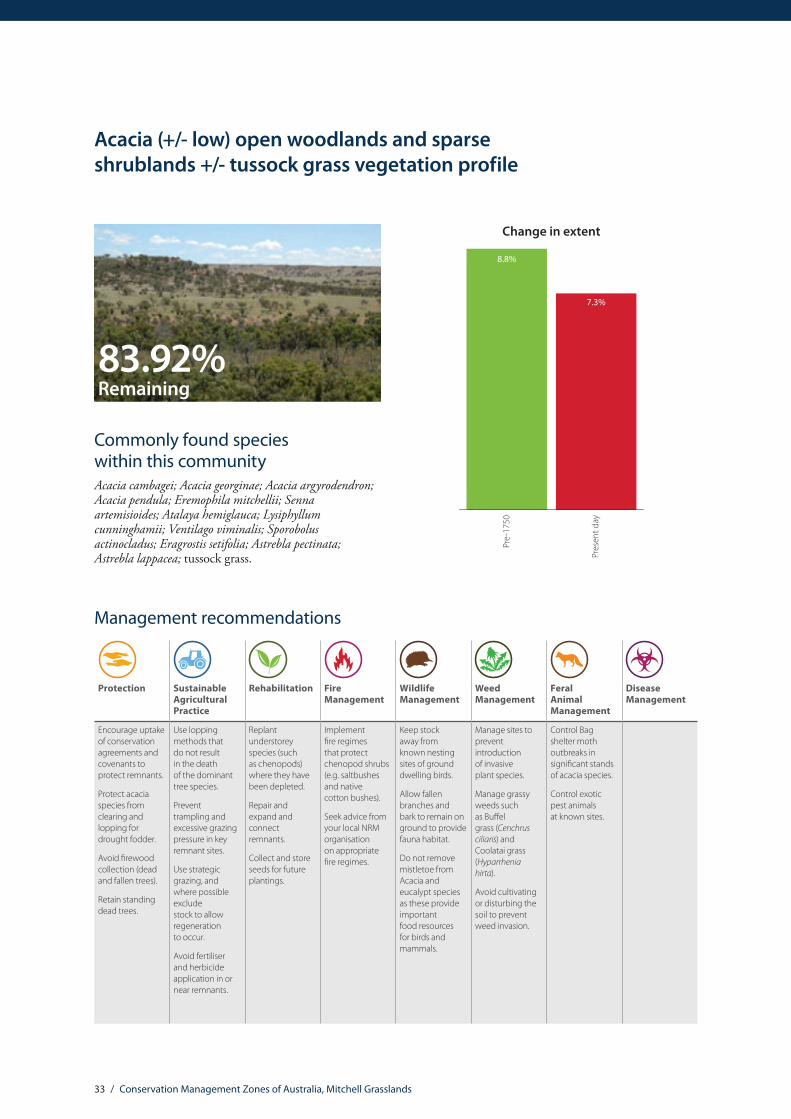
Acacia (+/- low) open woodlands and sparse shrublands +/- tussock grass vegetation profile
Protection Sustainable Agricultural Practice
Rehabilitation Fire Management
Wildlife Management
Weed Management
Feral Animal Management
Disease Management
Encourage uptake of conservation agreements and covenants to protect remnants.
Protect acacia species from clearing and lopping for drought fodder.
Avoid firewood collection (dead and fallen trees).
Retain standing dead trees.
Use lopping methods that do not result in the death of the dominant tree species.
Prevent trampling and excessive grazing pressure in key remnant sites.
Use strategic grazing, and where possible exclude stock to allow regeneration to occur.
Avoid fertiliser and herbicide application in or near remnants.
Replant understorey species (such as chenopods) where they have been depleted.
Repair and expand and connect remnants.
Collect and store seeds for future plantings.
Implement fire regimes that protect chenopod shrubs (e.g. saltbushes and native cotton bushes).
Seek advice from your local NRM organisation on appropriate fire regimes.
Keep stock away from known nesting sites of ground dwelling birds.
Allow fallen branches and bark to remain on ground to provide fauna habitat.
Do not remove mistletoe from Acacia and eucalypt species as these provide important food resources for birds and mammals.
Manage sites to prevent introduction of invasive plant species.
Manage grassy weeds such as Buffel grass (Cenchrus ciliaris) and Coolatai grass (Hyparrhenia hirta).
Avoid cultivating or disturbing the soil to prevent weed invasion.
Control Bag shelter moth outbreaks in significant stands of acacia species.
Control exotic pest animals at known sites.
83.92%Remaining
Commonly found species within this communityAcacia cambagei; Acacia georginae; Acacia argyrodendron; Acacia pendula; Eremophila mitchellii; Senna artemisioides; Atalaya hemiglauca; Lysiphyllum cunninghamii; Ventilago viminalis; Sporobolus actinocladus; Eragrostis setifolia; Astrebla pectinata; Astrebla lappacea; tussock grass.
Change in extent
Pres
ent d
ay
Pre-
1750
8.8%
7.3%
Management recommendations
ALC
100.
0915