Embed Size (px)
Citation preview

MAR 110: Lecture 15 Outline – Wave Hazards
1
1
MAR 110 LECTURE #15
Wave Hazards
Rogue Wave Hazard Rogue waves are very large open ocean waves of sometimes can range in height from 60 ft (20m) to120 feet (40m) and thus a significant hazard to large tanker ships. (???)
Constructive Wave Interference-Rogue Waves (RIGHT) The real ocean has waves of all wave heights and wavelengths, Occasionally , a long wave (wave #1) and a wave half its wavelength (wave #2) will constructively interfere with each other to form and exceptionally large wave – a rogue wave) . (LEFT) The probability of rogue wave generation is very high in the Agulhus Current region because of the environmental conditions there. (ItO)

MAR 110: Lecture 15 Outline – Wave Hazards
2
2
With satellite altimeters it is now possible to find-and measure-rogue waves. Since the satellites can cover far more of the ocean than can be observed by ships at any one time, it was discovered that rogue waves are a far more common occurrence than was previously thought. (NH)
Rogue Wave Height Estimates Until recently it was believed that rogue waves were very rare events. The only records of wave height came from estimates of people onboard ships that used line of sight to the crest of the wave to calculate the height. (??)

MAR 110: Lecture 15 Outline – Wave Hazards
3
3
Rogue Waves in the Agulhas Current The region where the Agulhas Current meets Antarctic storm waves and West Wind Drift is known for having a relatively high occurrence of rogue waves. (ItO, LEiO)
MAR 110: Lecture 15 Outline – Wave Hazards
4
4
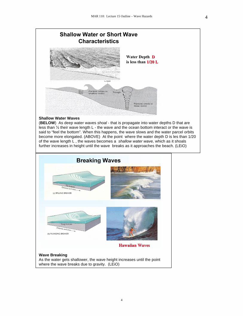
Shallow Water Waves (BELOW) As deep water waves shoal - that is propagate into water depths D that are less than their wave length L - the wave and the ocean bottom interact or the wave is said to “feel the bottom”. When this happens, the wave slows and the water parcel orbits become more elongated. (ABOVE) At the point where the water depth D is les than 1/20 of the wave length L , the waves becomes a shallow water wave, which as it shoals further increases in height until the wave breaks as it approaches the beach. (LEiO)
Wave Breaking As the water gets shallower, the wave height increases until the point where the wave breaks due to gravity. (LEiO)
MAR 110: Lecture 15 Outline – Wave Hazards
5
5
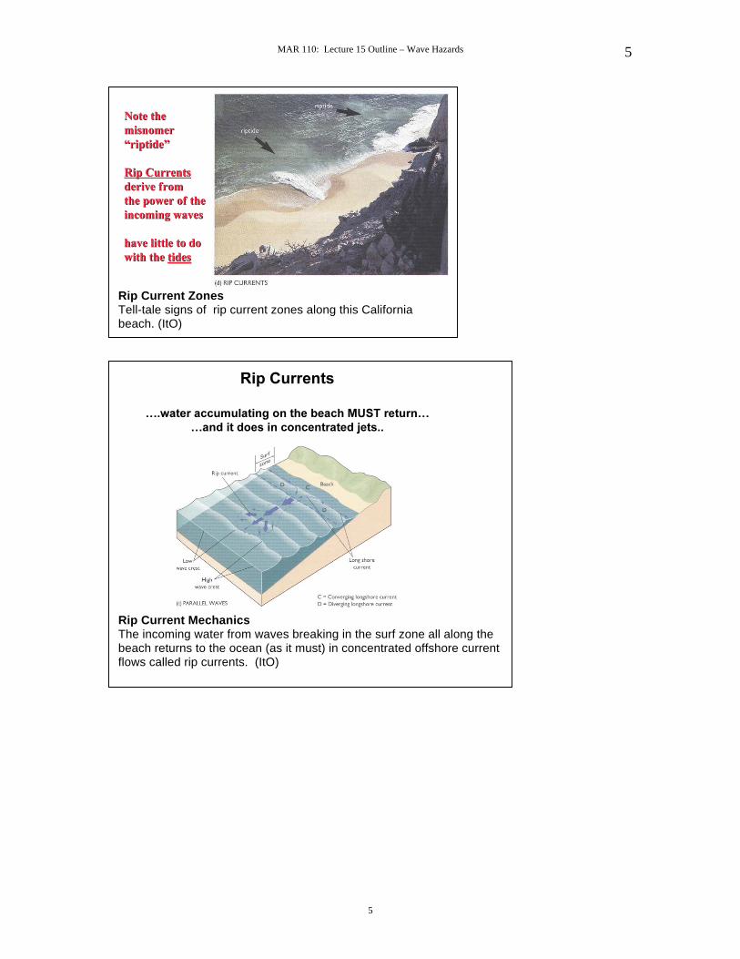
Rip Current Zones Tell-tale signs of rip current zones along this California beach. (ItO)
Rip Current Mechanics The incoming water from waves breaking in the surf zone all along the beach returns to the ocean (as it must) in concentrated offshore current flows called rip currents. (ItO)
MAR 110: Lecture 15 Outline – Wave Hazards
6
6
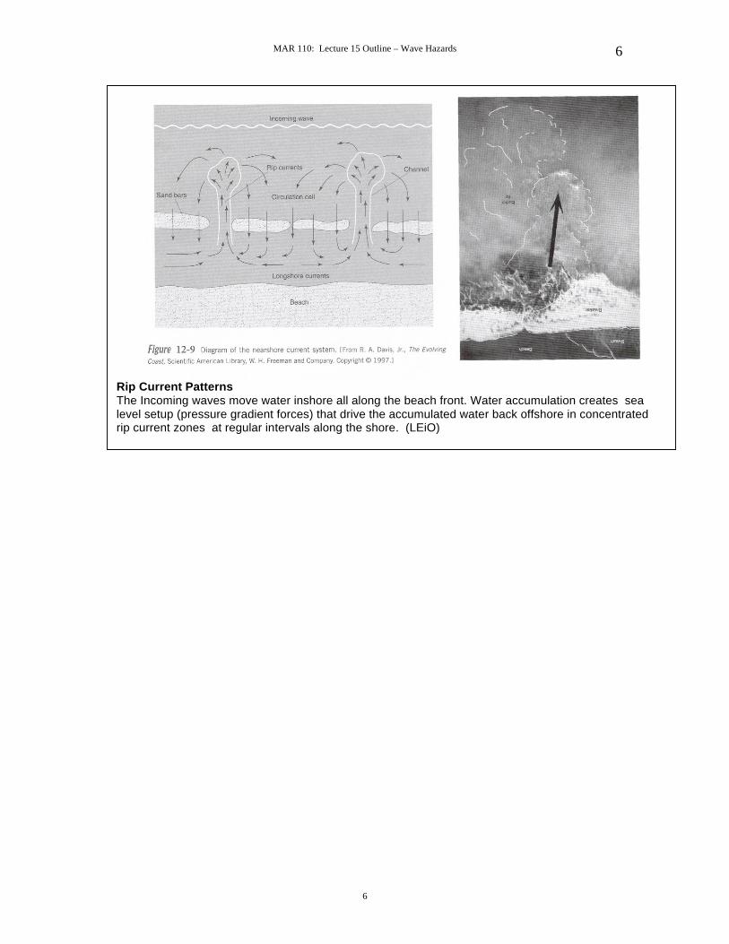
Rip Current Patterns The Incoming waves move water inshore all along the beach front. Water accumulation creates sea level setup (pressure gradient forces) that drive the accumulated water back offshore in concentrated rip current zones at regular intervals along the shore. (LEiO)
MAR 110: Lecture 15 Outline – Wave Hazards
7
7
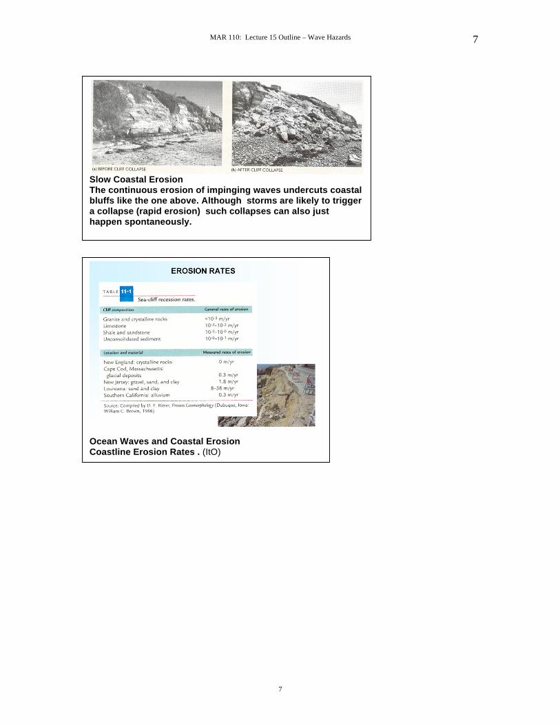
Slow Coastal Erosion The continuous erosion of impinging waves undercuts coastal bluffs like the one above. Although storms are likely to trigger a collapse (rapid erosion) such collapses can also just happen spontaneously.
Ocean Waves and Coastal Erosion Coastline Erosion Rates . (ItO)

MAR 110: Lecture 15 Outline – Wave Hazards
8
8
Shoaling Waves As wave shoal, the depth of the water depth decreases, causing the wave speeds slow , and wave heights grow. (NH)
Wave Refraction Waves that approach a beach at an angle (like the above) are refracted so that they align with the local bathymetry wave crest. The wave front is bent because the inshore end of the wave encounters shallower water depths water and hence slow earlier than the part of the wave front in deeper water. (??)
MAR 110: Lecture 15 Outline – Wave Hazards
9
9
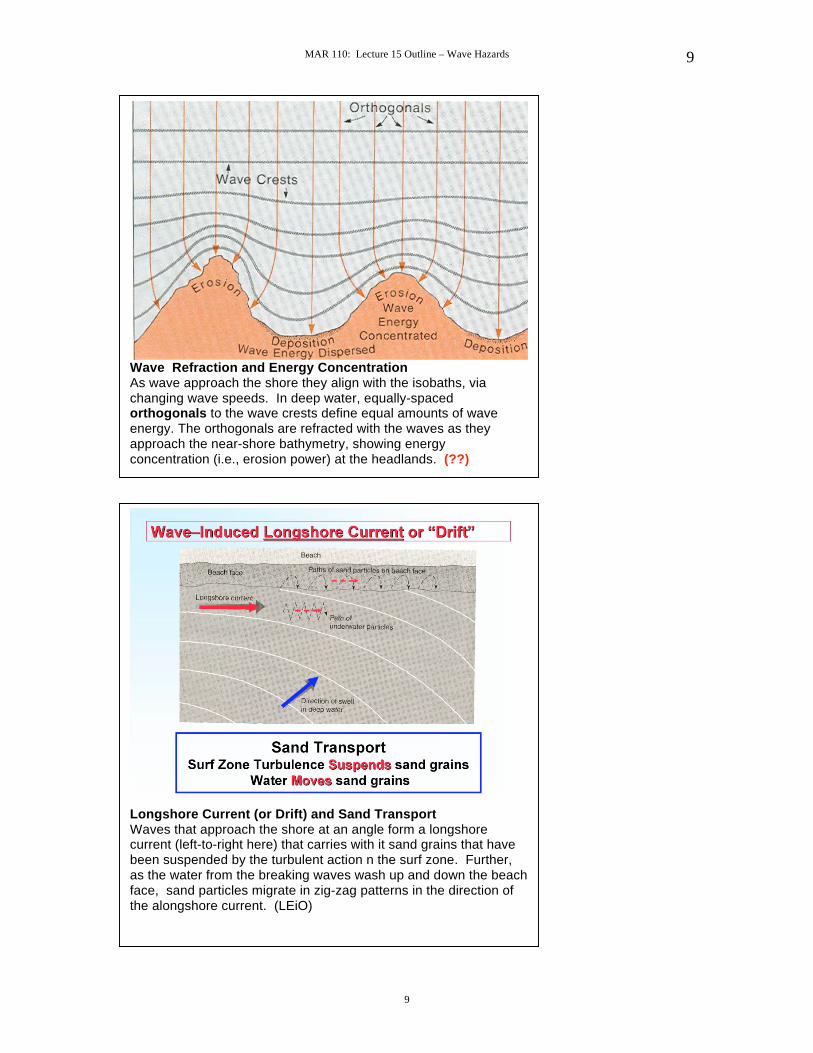
Wave Refraction and Energy Concentration As wave approach the shore they align with the isobaths, via changing wave speeds. In deep water, equally-spaced orthogonals to the wave crests define equal amounts of wave energy. The orthogonals are refracted with the waves as they approach the near-shore bathymetry, showing energy concentration (i.e., erosion power) at the headlands. (??)
Longshore Current (or Drift) and Sand Transport Waves that approach the shore at an angle form a longshore current (left-to-right here) that carries with it sand grains that have been suspended by the turbulent action n the surf zone. Further, as the water from the breaking waves wash up and down the beach face, sand particles migrate in zig-zag patterns in the direction of the alongshore current. (LEiO)

MAR 110: Lecture 15 Outline – Wave Hazards
10
10
Alongshore Sand Transport & Breakwaters I Breakwaters (like the offshore, horizontal white line above) block some of the incoming wave energy. With reduced wave energy there is reduced longshore sand transport along that section of the beach leads to accumulation (i.e., a wider beach) due to sand fed by alongshore transport from the left . However, the beach to the right that is unprotected by the breakwater longshore and thus subject to erosion (i.e., a narrower beach). (LEiO)
Alongshore Sand Transport & Breakwaters II Groins are breakwaters perpendicular to the shore that are intended to trap sand that is being transported by the longshore current in order to widen the beach in certain places. (LEiO)
MAR 110: Lecture 15 Outline – Wave Hazards
11
11
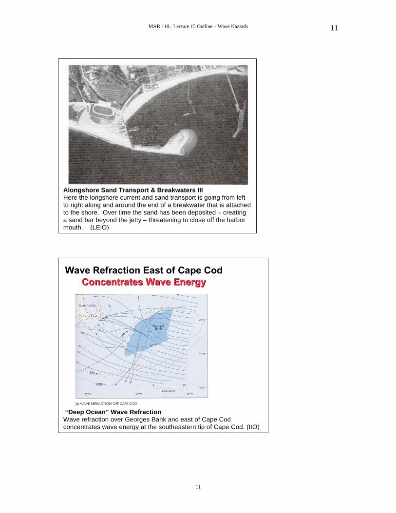
Alongshore Sand Transport & Breakwaters III Here the longshore current and sand transport is going from left to right along and around the end of a breakwater that is attached to the shore. Over time the sand has been deposited – creating a sand bar beyond the jetty – threatening to close off the harbor mouth. (LEiO)
“Deep Ocean” Wave Refraction Wave refraction over Georges Bank and east of Cape Cod concentrates wave energy at the southeastern tip of Cape Cod. (ItO)

MAR 110: Lecture 15 Outline – Wave Hazards
12
12
Cape Cod Sand Transport Waves, that hit Cape Cod north of Wellfleet-by-the-Sea are generally from the southeast, thus producing a northward longshore sand transport Waves, that hit Cape Cod south of Wellfleet-by-the-Sea are generally from the northeast, thus producing a southward longshore current. (ItO)
Beach Profile

MAR 110: Lecture 15 Outline – Wave Hazards
13
13
Beach Evolution – Summer Onshore Transport
Beach Evolution – Winter Offshore Transport

MAR 110: Lecture 15 Outline – Wave Hazards
14
14