Embed Size (px)
Citation preview

Mapping Indian Land Tenure in Minnesota
Macalester College & Indian Land Tenure FoundationGeography 364 and 365
Fall 2010
Presentation at the Federal Reserve Bank of MinneapolisDecember 2, 2010

Why use GIS for land tenure analysis?
• Facilitating education
• Visualizing patterns of land tenure
Fall 2010 partnership with ILTF• Civic engagement for GIS classes
• Land tenure data sources• Tribal land offices
• County assessors
• County plat books
• County GIS offices

Shakopee Mdewakanton Sioux Community
Lillian Gordon-Koven, Nolan Levenson, Joe Rasmussen

All lands within the reservation boundaries are SMSC owned and in trust.
SMSC owns a significant portion of the lands surrounding the reservation, about half of which are in trust.

The highest estimated land values in the area shown are in the residential, suburban areas of Shakopee and Prior Lake.
The highest estimated land values on SMSC owned lands are the commercial areas of Little Six Bingo and Mystic Lake Casino.
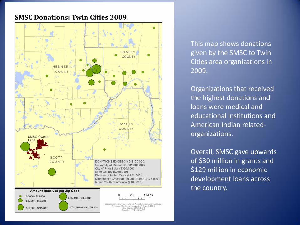
This map shows donations given by the SMSC to Twin Cities area organizations in 2009.
Organizations that received the highest donations and loans were medical and educational institutions and American Indian related-organizations.
Overall, SMSC gave upwards of $30 million in grants and $129 million in economic development loans across the country.

Prairie Island Indian Community
Lillian Gordon-Koven, Nolan Levenson, Joe Rasmussen

Key features of the landscape on and surrounding PIIC’s reservation are the buffalo project and Treasure Island Resort and Casino.

PIIC land tenure
PIIC owns most of the land within the reservation boundaries and a significant portion of the adjacent land. Northern States Power and the state own land buffering the reservation.

This map highlights the difference in income between PIIC tribal land and surrounding areas.

Cory Copeland, Peter Mathison, Olivia Posner
Upper Sioux & Lower Sioux Reservations

The Upper Sioux and Lower Sioux Reservations are located along the Minnesota River in southwest Minnesota.

The majority of land within the Upper Sioux Reservation boundaries is held in trust.
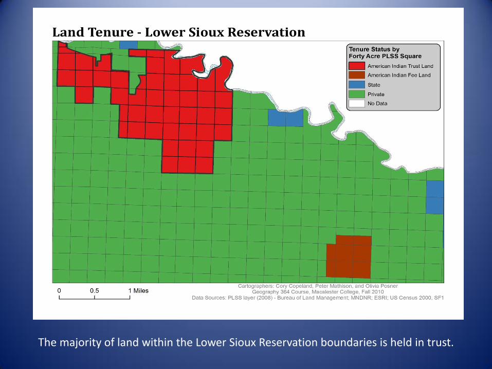
The majority of land within the Lower Sioux Reservation boundaries is held in trust.
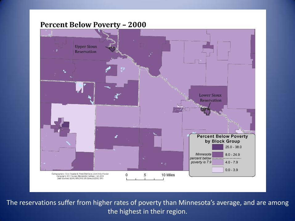
The reservations suffer from higher rates of poverty than Minnesota’s average, and are among the highest in their region.

The Upper Sioux and Lower Sioux Communities could explore amenities tourism as a method of bringing new money into the communities.

Research Observations
• After years of land loss through changes in reservation boundaries and forced migration, the limited remaining areas are in trust for the Upper Sioux and Lower Sioux Communities.
• Both reservations are experiencing high rates of poverty.
• Finding new sources of income for the reservations could help create a vibrant and diverse economic base.
• Natural amenities based tourism is a solution many rural communities have turned to and the reservations are situated well to develop a natural amenities tourism industry.
• Some specific options to explore include water based activities (e.g. fishing or canoeing), winter sports (e.g. cross-country skiing), and agro-tourism.

Mille Lacs Band of Ojibwe
Keith Bradley-Hewitt, Ross Donihue, and Kitty Ng


The majority of land within the reservation boundaries is forested, wetland, or grassland.

The majority of land within the reservation boundaries is in private or state ownership.

This map depicts potential lands for tribal reacquisition based upon the criteria listed.

Land Reacquisition Constraints
• Natural resources, water, and forest
• Economic development, tourism
• Diverse ownership of lands within the reservation boundaries

Leech Lake Reservation
Amanda Caneff, Jill Goforth, Anna Kistin

Lakes and forests are prominent in Cass, Itasca, Hubbard, and Beltrami counties.
The Chippewa National Forest covers most of the reservation.

Therefore, the majority of land on the reservation is owned by the U.S. Government.
The presence of other landowners results in an acute pattern of checkerboarding and very little land held in trust.

The only land still held in trust by the tribe is shown in red.

While block groups with both majority Indian populations and majority non-Indian populations experience high levels of poverty, the only block groups in and around the Reservation that have low levels of poverty are majority non-Indian.

The most valuable parcels in close proximity to existing trust land are shown in the deepest shades.
This map illustrates the parcels that may be strategic for the band to acquire.
This process is intended as a framework for thinking about reacquisition strategies.

White Earth Reservation
Maya Fehrs, Catherine Flint, Cori Simon

The American Indian population is concentrated on the eastern side of reservation.
This map depicts a strong east-west pattern on the reservation.

The entire area within the reservation boundary lies below the Minnesota median household income level.
The areas of highest median income are located on the western side of the reservation.

The western half of the reservation is predominantly agricultural; the eastern half is forested.
Most of the land held in trust is forested.
There is a small, concentrated area of development in Mahnomen (Shooting Star Casino).

Trust lands are concentrated in the eastern and central parts of the reservation.
Scattered parcels of trust land are located along Highway 59.
There are off-reservation parcels in trust in four townships outside of the reservation boundaries.

Bois Forte and Grand Portage
Jessica Sweet, Sidney Ainkorn, David Tomporowski

Bois Forte and Grand Portage are located in the Arrowhead region of Minnesota.


Not surprisingly, Bois Forte and Grand Portage both have a greater concentration of American Indian population than the average for the state of Minnesota.

Roughly one-third of the land on the Bois Forte reservation is in trust, and another one-third is owned by private corporations.


Cultural features were digitized from the Trygg map (1966), which was based on the original survey maps of the area.

Katie Zager, MC Muniz, Needham Hurst
Fond du Lac Reservation
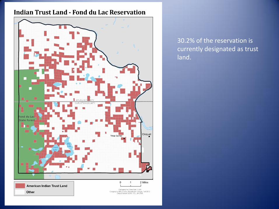
30.2% of the reservation is currently designated as trust land.

79% of allotted land was transferred into trust in May of 1896.

As a result of the Burke Act, 53% of land was transferred into fee patent between 1905 – 1924.

The area northeast of Big Lake was historically in trust, but currently is not in trust.
About 35.7% of the land in this area was historically in trust. Currently, 26.8% is in trust; 9.9% is in trust for heirs.

0
20
40
60
80
100
120
140
160
180
1896 1900-1910 1911-1919 1920-1927
Nu
mb
er
of
Par
cels
Period of Transfer
Transfer to Trust by Period
020406080
100120140160180
1884 - 1887 1896 1905 1915 - 1917 1923
Nu
mb
er
of
Par
cels
Period Placed in Allotment
Allotment by Period
0
50
100
150
200
250
300
350
1905 - 1924 1925 - 1944 1945 - 1964 1965 - 1987
Nu
mb
er
of
Par
cels
Period of Transfer
Transfer to Private by Period
These bar charts graphically depictthe complexity of land statuschange through time for the areasof the Fond du Lac reservationmapped on the previous slides.

Project Conclusions
Our Research…• Provides a framework to continue working with tribes on land tenure issues• Illustrates one small piece of the story
GIS helps to…• Visualize land tenure issues• Make connections between land tenure and socio-economic characteristics• Map the history of land tenure changes over the last century• Manage and analyze current and future land acquisitions
Future Directions• Continue to be responsive to tribes’ needs • Expand digital database• Use GIS as a resource for tribes’ land tenure goals
Acknowledgements
• Indian Land Tenure Foundation
• Tribal land offices
• County assessor offices
• County auditor offices
• County GIS offices
• Federal Reserve Bank of Minneapolis
• Terry Janis, ILTF
• Paul Schadewald, Macalester College

• Final report will be available January 2011 at: http://www.macalester.edu/geography/civic/