1
! . ! . ! . ! . ! . Map 13 Lil'wat Nation Nt'akmen and Stewardship Areas British Columbia 1:700,000 WARNING: The Integrated Land Management Bureau accepts no responsibility for the accuracy or content of the data shown on this map. All data is subject to change and can not be used for legal descriptions. The most current digital files may or may not be stored at ILMB. Projection: BC Albers Produced by: ILMB, Coast Region Lower Mainland Service Centre, Susan Mordy Map Produced: March 2008 File: Map_13_Ntakmen_Areas.mxd Print Size: 11 x 17 ´ 0 20 10 Kilometers Conservancy Upper Lillooet Provincial Park L il l ooe t Lil lo oet Ri ver L a k e Clendinning Provincial Park Tantalus Provincial Park Birkenhead Lake Provincial Park Lill o oe t R i v e r Garibaldi Provincial Park R i v e r S q u a m i s h I n d i an R iv e r Ha r r i s o n La k e J er v i s I nl e t Callaghan Lake Provincial Park E l a h o R i v e r Joffre Lakes Provincial Park Lil'wat Nation Territory within the Plan Area Lil'wat Nation Nt'akmen Areas Lil'wat Nation Stewardship Areas Georgia Strait Qwelímak Sú7a Úll’us St’uqál’ts Mkwal'ts Kzúzalt Kákla Highway 99 Sea-to-Sky LRMP Boundary Private Land Indian Reserves Municipal Boundaries Parks and Protected Areas Pemberton Whistler Squamish Lions Bay Vancouver

Map 13 Lil'wat Nation Nt'akmen and Stewardship Areas · Map 13 Lil'wat Nation Nt'akmen and Stewardship Areas British Columbia 1:700,000 WARNING: The Integrated Land Management Bureau

  • Upload
    ledung

  • View
    216

  • Download
    0

Embed Size (px)

Citation preview

!.

!.

!.

!.

!.

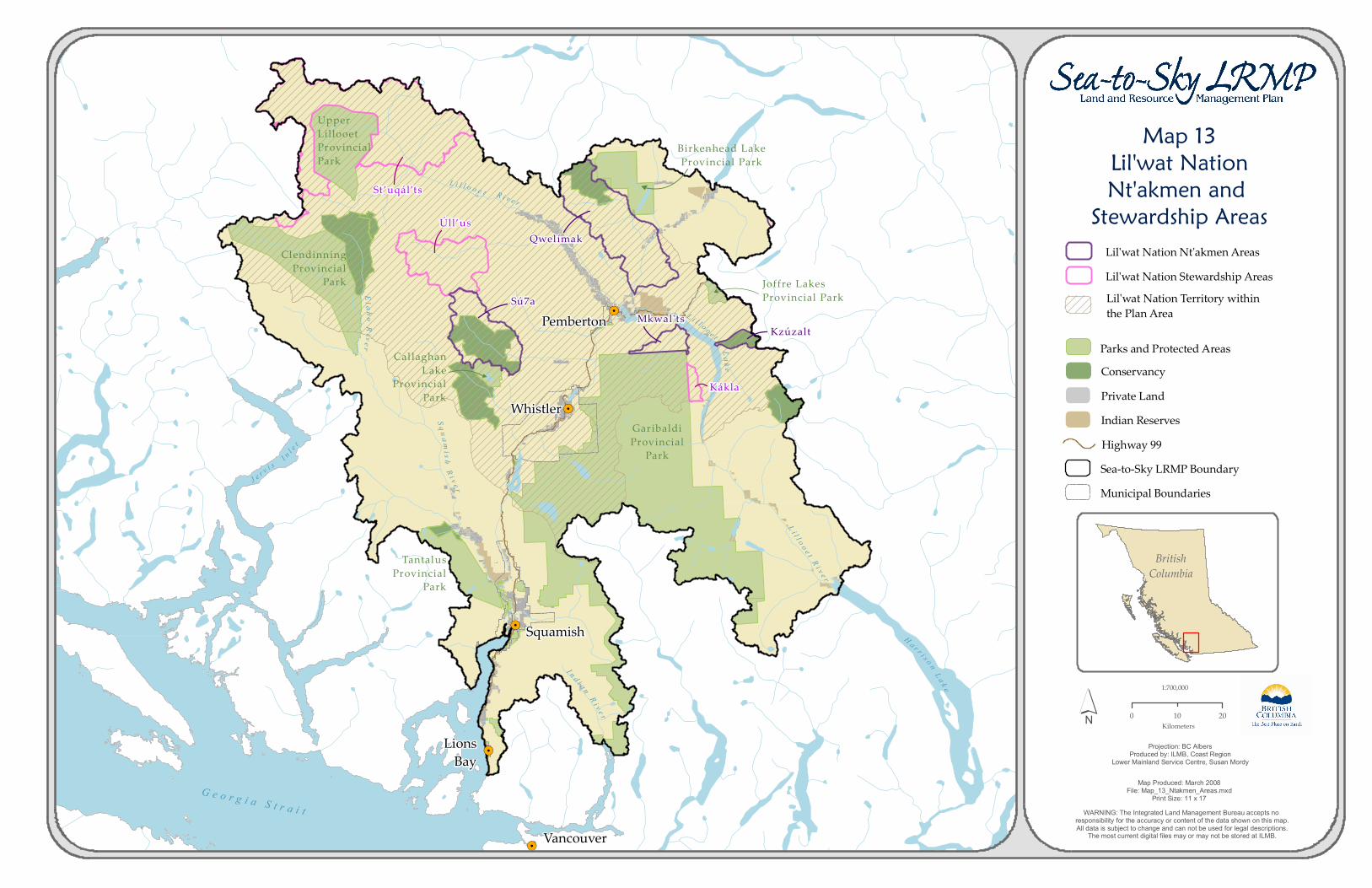
Map 13Lil'wat NationNt'akmen and Stewardship Areas

BritishColumbia

1:700,000

WARNING: The Integrated Land Management Bureau accepts no responsibility for the accuracy or content of the data shown on this map.All data is subject to change and can not be used for legal descriptions.

The most current digital files may or may not be stored at ILMB.

Projection: BC AlbersProduced by: ILMB, Coast Region

Lower Mainland Service Centre, Susan Mordy

Map Produced: March 2008File: Map_13_Ntakmen_Areas.mxd

Print Size: 11 x 17

´ 0 2010Kilometers

Conservancy

UpperLillooetProvincialPark

L i l l o o e t

L i l l o o e t R i v e r

L ak e

ClendinningProvincial

Park

TantalusProvincial

Park

Birkenhead LakeProvincial Park

L i l l o o e t

R i v e r

GaribaldiProvincial

Park

R i v e rS q u a m

i s h

I n d i a nR i v e r

H a r r i s o n L a k e

J e r v i s I n l e t

CallaghanLake

ProvincialPark

El a h o River

Joffre LakesProvincial Park Lil'wat Nation Territory within

the Plan Area

Lil'wat Nation Nt'akmen AreasLil'wat Nation Stewardship Areas

G e o r g i a S t r a i t

Qwelímak

Sú7a

Úll’us

St’uqál’ts

Mkwal'tsKzúzalt

Kákla

Highway 99Sea-to-Sky LRMP Boundary

Private LandIndian Reserves

Municipal Boundaries

Parks and Protected AreasPemberton

Whistler

Squamish

LionsBay

Vancouver