Embed Size (px)
Citation preview

https://manchester.gov.uk/consultations#GMGreenCity#GMGreenCity
Manchester to Chorlton Walking and Cycleway --- Area 3Manchester Road and Barlow Moor Road (from Seymour Grove to Sandy Lane) Have your say on proposals to improve walking and cycling links in your area.

2 3
New cycling and walking links in your areaIn 2018, we carried out a consultation with residents and businesses in Chorlton and Chorlton Park about proposed features to improve walking and cycling.
The aim of the scheme is to: – Increase walking and cycling – Make walking and cycling safer – Reduce the number of short journeys by car – Improve people’s health through walking and
cycling – Boost the local economy by making the district
centre more pleasant and reducing traffic.
More than 1,800 comments were received, and the majority of people who responded supported the scheme as a whole.
Because of the scale of the scheme, it was broken down into areas. This follow-up consultation is about Area 3, which covers Manchester Road and Barlow Moor Road (from Seymour Grove to Wilbraham Road) and down to Sandy Lane. (In the consultation around Area 4, which covers Barlow Moor Road (Sandy Lane to Hardy Lane), people were broadly happy with the proposals, and this section has already progressed to the final design. See www.manchester.gov.uk/improvements for more information.)
In the original consultation, a number of issues were raised around Area 3, including:
– Rat-running through residential streets, and the safety of schoolchildren using them
– Congestion at the ‘four banks’ junction – Making cycling safer over the Metrolink bridge – Parking being displaced onto side streets – Availability of free parking – Public realm and pavement quality – Concerns over banning right turns at the
junction with Wilbraham Road. – Traffic signals at the junction of St Werburgh’s
Road and Wilbraham Road.
What you said... Things that people asked for in Area 3 included:
– Improvements to public realm – Speed-calming around schools and on routes
that children take to school – Traffic signals on Buckingham Road – Improvements to prevent rat-running on many
roads, particularly where junction closures potentially make this more likely, including Egerton Road (North and South) Oswald Road, Corkland Road, Sandy Lane and Albany Road.
What we’’,’re doing...
We reviewed all the comments received, and following extensive discussions with local Councillors, changes have been made to the proposed measures. These included:
– Improving public realm as part of the work, eg. better pavement quality
– Putting speed tables in and narrowing crossing distances at junctions to reduce traffic speed
– Improving major junction layouts to make crossing easier and safer and improve traffic flow
– Removing ‘Copenhagen style’ bus stops, and instead providing bus stop bypasses where possible
– Reviewing concerns around rerouting of traffic due to proposed banned movements at junctions. Traffic modelling of the wider area has been carried out to inform the impact of rerouting traffic
– Reviewing proposed banned movements at signal-controlled junctions to consider the impacts on the adjacent road network. Where possible, these impacts will be eliminated or mitigated by providing traffic-management measures on the impacted roads
– The proposed banned left turn travelling towards the city centre from Wilbraham Road onto Barlow Moor Road at the ‘four banks’ junction was removed from the plans
– The proposed banned right turn travelling towards Stretford from Barlow Moor Road onto Wilbraham Road was also removed
Manley ParkPrimarySchool
St JohnVianney School
St Hilda’s CEPrimary School
St John’s RCPrimary School
Oswald RoadPrimary School
Bus Station
ChorltonHigh School
Chorlton ParkPrimary School
FirswoodMetrolink
St Werburgh’sRoad Metrolink
Barlow Moor RoadMetrolink
ChorltonMetrolink
WARW
ICK ROAD SOUTH
UPPER CHORLT
ON ROAD
BARLOW
M
OO
R
RO
AD
MAN
CH
ESTE
R
RO
AD
SEY MO
UR
GR
OV
E
BRANTINGHAM ROAD
CLARENDON ROAD
RYE BANK RD
KENSINGTON RD
CLARIDGE RD
CHELT’M RD
LONGFORD ROAD
OSW
ALD
RD
EGERTON ROAD SOUTH
EGER
TON
RO
AD
NO
RTH
NELL LAN
E
CUNDIFF RDST W
ERB
UR
GH
’S RO
AD
HIGH LANE
EDGE LANE
BEECH ROAD
SANDY LANE
CLAUDE ROAD
HARDY LANE
KINGS ROAD
WILBRAHAM ROAD
NICOLAS ROAD
Silverwood Ave.
Chestnut Ave.
Woodside Rd
Chorlton Park
CLARENDON RD WEST
BU
CKIN
GH
AM
RO
AD
N
For details of Areas 1, 2 and 4, visit www.manchester.gov.uk/improvements
Section 1
Section 2
Section 3
Section 4
Section 5
Section 6
Section 7
TCB
SEYMOUR GROVE
UPPER CHORLTON ROAD
WO
ODSIDE
ROAD
BUSSTOP
BUS STOP
CLARENDON
ROAD
WEST
MANCHESTER ROAD
BUCKI
NGHAMROAD
4 5
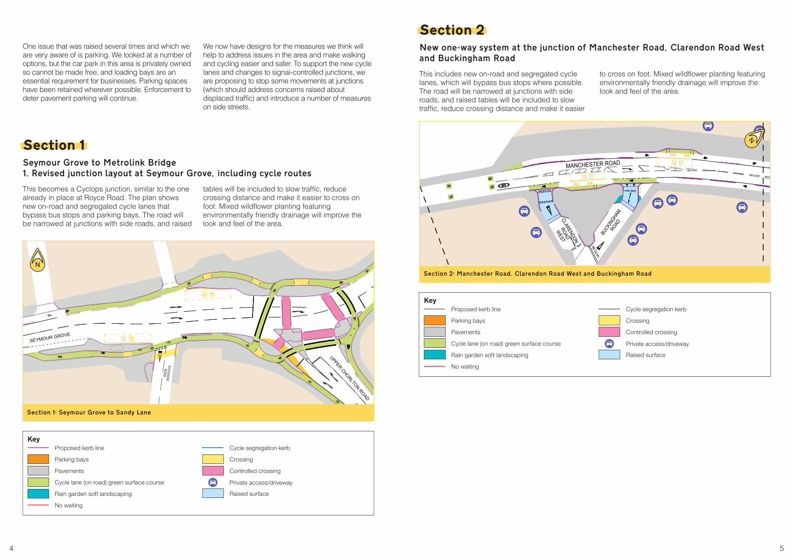
One issue that was raised several times and which we are very aware of is parking. We looked at a number of options, but the car park in this area is privately owned so cannot be made free, and loading bays are an essential requirement for businesses. Parking spaces have been retained wherever possible. Enforcement to deter pavement parking will continue.
We now have designs for the measures we think will help to address issues in the area and make walking and cycling easier and safer. To support the new cycle lanes and changes to signal-controlled junctions, we are proposing to stop some movements at junctions (which should address concerns raised about displaced traffic) and introduce a number of measures on side streets.
Section 1 Seymour Grove to Metrolink Bridge 1. Revised junction layout at Seymour Grove, including cycle routes
This becomes a Cyclops junction, similar to the one already in place at Royce Road. The plan shows new on-road and segregated cycle lanes that bypass bus stops and parking bays. The road will be narrowed at junctions with side roads, and raised
tables will be included to slow traffic, reduce crossing distance and make it easier to cross on foot. Mixed wildflower planting featuring environmentally friendly drainage will improve the look and feel of the area.
Section 1:– Seymour Grove to Sandy Lane
Section 2 New one-way system at the junction of Manchester Road, Clarendon Road West and Buckingham Road
This includes new on-road and segregated cycle lanes, which will bypass bus stops where possible. The road will be narrowed at junctions with side roads, and raised tables will be included to slow traffic, reduce crossing distance and make it easier
to cross on foot. Mixed wildflower planting featuring environmentally friendly drainage will improve the look and feel of the area.
Section 2:– Manchester Road, Clarendon Road West and Buckingham Road
N
N
Key Proposed kerb line
Parking bays
Pavements
Cycle lane (on road) green surface course
Rain garden soft landscaping
No waiting
Cycle segregation kerb
Crossing
Controlled crossing
Private access/driveway
Raised surface
Key Proposed kerb line
Parking bays
Pavements
Cycle lane (on road) green surface course
Rain garden soft landscaping
No waiting
Cycle segregation kerb
Crossing
Controlled crossing
Private access/driveway
Raised surface

BUSSTOP MANCHESTER ROAD
CHEL
TENH
AMRO
AD
KENS
ING
TON
ROAD
BUS STOP
CLA
RID
GE
RO
AD
RAN
SFIE
LDR
OAD
MANCHESTER ROAD
TOU
CAN
CR
OSSIN
G
LAN
E
50
OSW
ALD
BUSSTOP
CLA
RID
GE
MANCHESTER ROAD
LON
GFO
RD
RO
AD
BRAN
TIN
GH
AMR
OAD
ROAD
NICOLA
S
LONGFORD R
OAD
MANCHESTER ROAD
ROAD
6 7
Section 3 Manchester Road from the junction with Cheltenham Road to the junction with Claridge Road
Plans for this area include new on-road and segregated cycle lanes that bypass bus stops and parking/loading bays. The road will be narrowed at junctions with side roads, and raised tables will be included to slow traffic, reduce crossing distance and make it easier to cross on foot. The crossing
near Ransfield Road will be upgraded to a toucan crossing (allowing cyclists and pedestrians to cross at the same time). Mixed wildflower planting featuring environmentally friendly drainage will improve the look and feel of the area.
Section 3a:– Manchester Road from the junction with Cheltenham Road to the junction with Claridge Road
Section 3b:– Manchester Road from the junction with Cheltenham Road to the junction with Claridge Road
Section 4 Manchester Road from the junction with Claridge Road to the junction with Nicolas Road
Proposed improvements include new on-road and segregated cycle lanes that bypass bus stops and parking/loading bays. The road will be narrowed at the junction with side roads to slow traffic, reduce crossing distance and improve safety. A new ‘puffin’
pedestrian crossing will be installed, instead of pedestrian refuge in the vicinity of Warwick Road. Mixed wildflower planting featuring environmentally friendly drainage will improve the look and feel of the area.
Section 4a:– Manchester Road from the junction with Claridge Road to the junction with Nicolas Road
Section 4b:– Manchester Road from the junction with Claridge Road to the junction with Nicolas Road
NN
NN
Key Proposed kerb line
Parking bays
Pavements
Cycle lane (on road) green surface course
Rain garden soft landscaping
No waiting
Cycle segregation kerb
Crossing
Controlled crossing
Private access/driveway
Raised surface
BUS STOP
CLA
RID
GE
RO
AD
RAN
SFIE
LDR
OAD
MANCHESTER ROAD
TOU
CAN
CR
OSSIN
G
N
Shared space
Key Proposed kerb line
Parking bays
Pavements
Cycle lane (on road) green surface course
Rain garden soft landscaping
No waiting
Cycle segregation kerb
Crossing
Controlled crossing
Private access/driveway
Raised surface

Shelter
80 70
BUSSTOP
BUS STOP
BARLOW MOOR ROADMANCHESTER ROAD
WA
RW
ICK
R
OA
D
SE
LBO
RN
ER
OA
D
NICOLA
S
ROAD N
WIL
BRAH
AMRO
AD
WIL
BRAH
AMRO
AD
BARLOW MOOR ROAD
MANCHESTER ROAD
SILV
ER
WO
OD
AV
EN
UE
BARLOW MOOR ROAD
NAPIER
RO
AD
GR
OBY R
OAD
SILVERW
OO
DAVEN
UE
NEED
HAM
AVENU
E
CH
ES
TNU
T A
VE
NU
E
EU
NE
VA
KA
O
EU
NE
VA
ELP
AM
CR
ANBO
UR
NE R
OAD
8 9
Section 5 Barlow Moor Road from the junction with Nicolas Road to the junction with Silverwood Avenue
We have revised the junction layout at Wilbraham Road to make it safer and easier for pedestrians and cyclists to cross, and there would be revised signal timings (ie. a Cyclops junction, similar to the one already in place at Royce Road). Some traffic movements have been changed and some retained (eg. ‘no right turn’ into Wilbraham Road when travelling northbound on Barlow Moor Road (except
buses). New on-road and segregated cycle lanes are proposed, which will bypass bus stops and parking bays. The road is narrowed at the junction with side roads to slow traffic, reduce crossing distance and improve safety. Mixed wildflower planting featuring environmentally friendly drainage will improve the look and feel of the area.
Section 5a:– Barlow Moor Road from the junction with Nicolas Road to the junction with Silverwood Avenue
Section 5b:– Barlow Moor Road from the junction with Nicolas Road to the junction with Silverwood Avenue
Section 6 Barlow Moor Road, from the junction with Silverwood Avenue to the junction with Chestnut Avenue
New on-road and segregated cycle lanes will bypass bus stops and parking/loading bays. The road will be narrowed at junctions with side roads, and raised tables will be included to slow traffic,
reduce crossing distance and make it easier to cross on foot. Mixed wildflower planting featuring environmentally friendly drainage will improve the look and feel of the area.
Section 6a:– Barlow Moor Road, from the junction with Silverwood Avenue to the junction with Chestnut Avenue
Section 6b:– Barlow Moor Road, from the junction with Silverwood Avenue to the junction with Chestnut Avenue
NN
NN
Key Proposed kerb line
Parking bays
Pavements
Cycle lane (on road) green surface course
Rain garden soft landscaping
No waiting
Cycle segregation kerb
Crossing
Controlled crossing
Private access/driveway
Raised surface
Key Proposed kerb line
Parking bays
Pavements
Cycle lane (on road) green surface course
Rain garden soft landscaping
No waiting
Cycle segregation kerb
Crossing
Controlled crossing
Private access/driveway
Raised surface

10 11
Section 7 Barlow Moor Road from Chestnut Avenue to the Bus Station
The junction layout at Sandy Lane has been revised to include upgraded pedestrian crossings and cycle-crossing facilities, creating a Cyclops junction, similar to the one already in place at Royce Road. Vehicles will be prohibited from turning right into
Sandy Lane from Barlow Moor Road and also turning left out of Sandy Lane into Barlow Moor Road. Measures are being put in place to prevent rat-running in the Sandy Lane area. The proposed ‘no right turn’ into St Annes Road has been removed.
In addition to the measures above, a number of other changes are being suggested to support the scheme and prevent ‘rat-running’ around closures etc.
These include: – Placing a filter (to allow walking and cycling but
not traffic) at the junction of Longford Road with Manchester Road
– Placing a filter (to allow walking and cycling but not traffic) on a section of Sandy Lane to reduce vehicle volumes for non-residents
– A filter (to allow walking and cycling but not traffic) on sections of Hartington Road, Torbay Road, Dartmouth Road and Dawlish Road to reduce vehicle volumes for non-residents
– Placing a filter (to allow walking and cycling but not traffic) on Keppel Road, Brundretts Road and Egerton Road South.
– Additional junction speed tables either end of Fairhaven Avenue.
– Measures to slow traffic on Albany Road / Brantingham Road, Brundretts Road and Corkland Road.
– Proposed Cyclops style junction at St. Werburghs Road / Wilbraham Road (subject to modelling).
– We are considering some measures to slow traffic on Egerton Road North and Oswald Road.
– Additional junction protection markings to remove parking at the following junctions:
Sandy Lane / Fairhaven Avenue junction St. Anne’s Road / Fairhaven Avenue junction Sandy Lane / Limley Grove junction Sandy Lane / Park Brow Close junction Sandy Lane / Nell Lane / St. Werburgh’s Road.
– Measures to reduce the speed of traffic in front of Chorlton Park Primary School.
– Any mitigating measures would be installed on a trial basis, and would be adjusted in the light of feedback and monitoring of any issues.
Section 7:– Barlow Moor Road from Chestnut Avenue to the Bus Station
N Have your say Please let us know what you think of these proposals by 14 January 2021. You can do this by visiting manchester.gov.uk/consultations If you have a specific query or concern, you can email the project team at [email protected]
Key Proposed kerb line
Parking bays
Pavements
Cycle lane (on road) green surface course
Rain garden soft landscaping
No waiting
Cycle segregation kerb
Crossing
Controlled crossing
Private access/driveway
Raised surface