Embed Size (px)
Citation preview
209+ ADDRESS PHONE EMAIL PO Box 35 +61 (8) 9295 0388 [email protected] North Perth FAX WEBSITE WA 6906 Australia +61 (8) 9295 3480 www.frontierresources.com.au ABN 96 095 684 389
ASX : FNT
ASX Limited Company Announcements Office Announcement
8th July 2011
Major Polymetallic Mineralised District Demonstrated Proximal to the Dolcoath Granite
Extensive (6,000m Long ) Tungsten - Tin - Molybdenum - Copper - Bismuth + Gold - Lead - Zinc, Yttrium - Niobium Soil Anomalies Defined at the Moina Project
Frontier Resources is pleased to announce excellent soil assay results from a program that was initiated in late 2010 and recently finalised at the highly prospective Moina Project in Tasmania.
Major Project and district potential was demonstrated at Moina, with strong and widespread zones of tungsten, tin, molybdenum, copper and bismuth defined from the four sq.km soil sampling program, along with significant gold, lead, zinc, arsenic, yttrium and niobium soil anomalies.
Anomalies are in an up to 6,000m long inverted 'U' or sideways 'Y' around the northern margin of the Dolcoath Granite and their strike extents' are often open at each end. The various soil anomalies are complex shaped, often separate to partly coincident, quasi-concentric to totally overlapping and represent different mineralising phases / episodes and possible targets.
There is virtually no historic drilling in these extensive soil zones (except at the Narrawa Deposit).
The tungsten soil anomaly is more than 5,000m long, with 3 stronger zones to 1,700m long. Frontier has inadvertently drilled high grade tungsten mineralisation at Narrawa such as 1m grading 1.98% WO3 (within 14m of 0.20% WO3), where the tungsten soil geochemistry is actually very weak relative to the strong and cohesive tungsten soil zones located further south and east.
The tin soil anomaly is similar to tungsten, but displaced further from the granite contact; it is more extensive in the SE of the grid and also in a W to NW trending zone hosting the Narrawa polymetallic Deposit.
The molybdenum soil anomaly is 4,000m long and very cohesive and strong around the northern margin of the granite.
The copper soil anomaly is 5,000m long, strong and widely distributed in the SE to centre of the grid and in the NW zone hosting Narrawa.
The gold soil anomaly occurs in two main zones over a total strike length of 5,000m.
The bismuth soil anomaly is strong in the NW and NE of the granite in a 1,400m long x up to 500m wide zone and in an additional narrow 2,000m long zone that trends to the SE.
The niobium and yttrium anomalies indicate strong fractionation and a 'fertile' district to explore.
Ongoing and planned exploration includes:
Resource infill and expansion drilling will commence at the Stormont Deposit ASAP.
A very large 3D-IP program (~40 sq km) will be undertaken and ultimately completed late in Q4.
Diamond drilling will test the Moina Project's geophysical/geochemical /geological targets in early 2012, including significantly deeper drill testing for World Class deposits with a new and bigger rig.
'Capture' and evaluate data from 6 historic silver workings that are located 1km east of the grid.
An application has been lodged to acquire a 500m wide sliver of ground south of the Cethana EL boundary to consolidate the prospective area and enable Frontier to assess the soil anomalies' strike continuations to the SE.
Page 2 of 13
Chairman /Managing Director - Peter McNeil M.Sc. commented: A four sq.km soil sampling program was completed in central-northern Tasmania proximal to the I-Type Dolcoath Granite, which is host to a rich diversity of mineralisation including gold and gold - polymetallic skarns, tungsten - molybdenum - tin, fluorspar and intrusion-related gold.
Soil samples at the Moina Project have very effectively demonstrated strong and widespread zones of tungsten, tin, molybdenum, copper, gold and bismuth, along with significant zinc, lead, arsenic, yttrium and niobium anomalies.
The multi-metal anomalous soil geochemistry occurs in a 6,000m long inverted and flattened 'U' shape around the northern margin of the highly prospective and mineralising Dolcoath Granite. The strike extent of the soil anomalies is generally open at each end of the 'U', indicating that the mineralised zone is likely to be larger / longer to the SW and SE.
The soil assays show strong and distinct complex shaped, separate to partly coincident to totally overlapping zones of highly anomalous metals, with specific elemental associations that likely represent discrete mineralising episodes. Drilling at Frontier's Narrawa Deposit (within the gridded area) has documented a distinct gold - silver- lead - zinc association, while soil assays herein also show a quasi- concentrically zoned tungsten - molybdenum - tin - copper association.
Gold was demonstrated in two main zones over a total NW to WNW strike length of 5,000m. A highly prospective gold and multi-metal anomaly was discovered on the eastern side of the granite, variably up to and/or apparently extending across the southern EL boundary. This gold and base metal anomaly is a new target with a different geochemical 'signature' to Narrawa.
An application has been lodged to acquire a 500m wide sliver of open ground south of the boundary to consolidate the prospective area and enable Frontier to assess the anomalies' strike continuations.
The tungsten anomalism is widely distributed, 'U' shaped and is more than 5,000m long (at over 50ppm), with 3 stronger zones to 1,700m long (at over 100 ppm). Tin shows a similar pattern to tungsten at the same cut-offs, but is displaced slightly further concentrically from the granite contact and it is more extensive in the SE of the grid. Tin is also moderately anomalous in a NW trending zone that hosts the Narrawa Deposit.
The molybdenum anomaly is 4,000m long and very cohesive / strong around the northern margin of the granite. Copper is also strong and widely distributed in the SE to central sector of the grid and also in the NW trending structure. Bismuth occurs in the NW and NE sectors of the granite itself in a 1,400m long x up to 500m wide zone, plus an additional narrow but 2,000m long zone that trends to the SE. Niobium and yttrium soil anomalies indicate that the granite is fractionated and a highly fertile mineralising environment.
Six historic silver workings are located 1,000m northeast to east of the gridded area are now being incorporated into the grid and evaluated.
Resource infill and expansion drilling will commence at the Moina Project (Stormont and Narrawa Deposits) in a few days, to improve confidence levels relating to the deposits to potentially later allow them to be 'totally' classified as Indicated.
To further advance this multitude of large scale, base and precious metal anomalies, a very large scale 3D-IP program of approx. 40 sq km will commence in about 1 month with grid line cutting. The IP survey should be completed later in the fourth quarter and the ground geophysical and geochemical data sets will then be evaluated in conjunction with existing heli-borne electromagnetic / aeromagnetic and geological data to systematically define drilling targets for World Class intrusive related and skarn hosted precious and base metal deposits.
In early 2012 a 'regional' diamond drilling program will test the geophysical, multi-element geochemical and geological targets defined from the data compilation and evaluation.
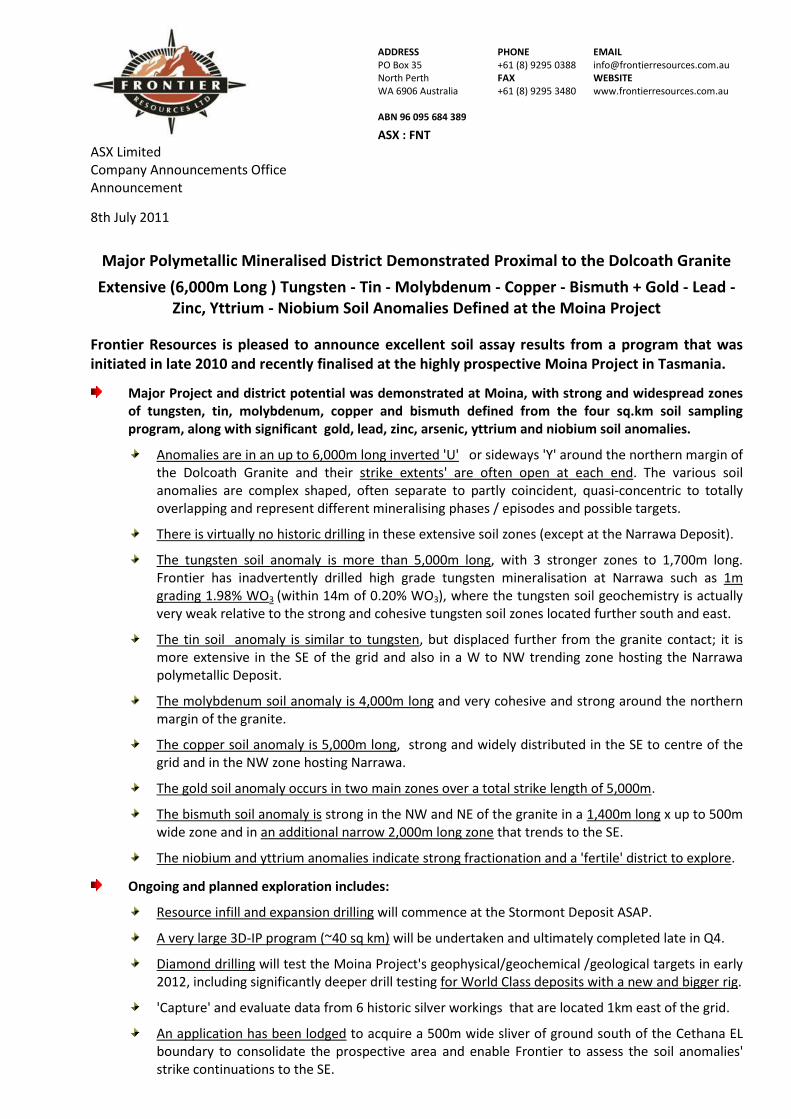
DETAILS The Moina Project consists of RL 3/2005 (Narrawa), EL 42/2010 (Stormont) and EL 29/2009 (Cethana) (Figure 1). It covers the highly mineralised Dolcoath Granite and the northern part of its WSW trending sub-surface spine plus a several skarn and vein deposits. Trending from east to west and proximal to distal (relative to the
Page 3 of 13
granite) mineralsiation includes silver, tin, tungsten, molybdenum, gold+ silver + zinc + lead, zinc+ gold, fluorspar (excised RL not FNT's) and gold + bismuth.
Frontier historically targeted gold - bismuth and gold - silver - lead -zinc skarn deposits, however tungsten - tin - molybdenum and World Class intrusive related gold deposits are also now being targeted in this highly mineralised district.
There are at least 70 historic workings (shafts, adits and small open pits) within the immediate area and the primary commodities mined were dominantly tungsten with some tin and gold (many workings are unspecified).
Frontier's Narrawa Deposit is a stratabound/ stratiform skarn within 4 steeply dipping on/near surface lodes, which could be mined by open pit mining methods. It is located in the middle of the 'old 'soil grid. The deposit contains an Indicated and Inferred resource with 14,125 ounces of gold, plus 131,300 ounces of silver plus 2,765 tonnes of lead plus 2,335 tonnes of zinc (at 0.5g/t gold cut-off grade), that is up to 220m long, 20m wide and 60m deep, within 209,330 tonnes of rock grading 2.10 g/t gold, 19.5 g/t silver, 1.32% lead and 1.12% zinc. The Indicated Resource consists of 162,755 tonnes grading 2.11 g/t gold, 20.5 g/t silver, 1.42% lead and 1.2% zinc and the Inferred Resource consists of 46,574 tonnes grading 2.07 g/t gold, 16 g/t silver, 0.98% lead and 0.81% zinc.
Located about 6km to the west of Narrawa, Stormont is an on-surface skarn hosted deposit which could be easily mined by open pit mining methods. The Inferred Resource is 14,250 ounces of gold plus 304 tonnes bismuth, within 112,500 tonnes of mineralised rock grading 3.94 g/t gold plus 0.27% bismuth (1.0g/t gold cut-off grade). Drilling will commence here in under a week, to better define and enhance the mineralised zones.
A Conceptual Mining Study evaluating mining the on-surface Stormont and Narrawa Deposits showed a satisfactory theoretical cash flow that improves significantly with increased metal prices, grades and/or tonnages of mineralisation (refer ASX release dated 12/8/2009). Metal prices utilised in the CMS were US$940/oz gold, US$0.7144/lb zinc, US$0.7738/lb lead, US$13.70/oz silver (3/7/2009) and since then, the gold price has appreciated more than 50% , silver more than 300% and zinc and lead prices are also stronger.
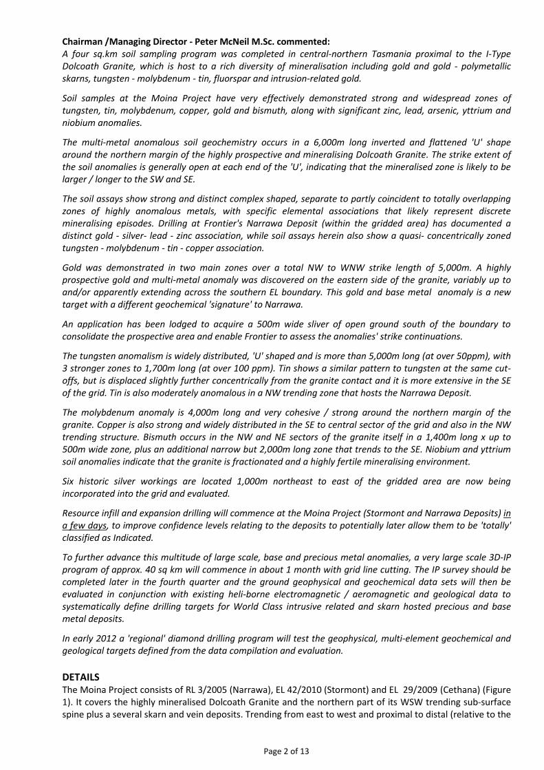
Figure 2 shows the historic aeromagnetic data as a first vertical derivative image over the Moina Project area. The Stormont EL is located off the plan to the west. The excluded Moina Fluorite / Hugo Skarn Deposits Retention Licence is partly visible and the Narrawa RL (3km2) is shown within the large Cethana EL (109km2). The 'block' size is 1km x 1km. The Dolcoath Granite is the green to blue rimmed circular aeromagnetic low to the SE of the Narrawa RL.
The three contiguous tenements have excellent potential for a range of metals as demonstrated by the soil anomalies presented herein for part of this area. The highly mineralised Dolcoath Granite has a tabular like shape extending west-southwest and is responsible for a number of skarn and vein /skarn styles of gold, tungsten, tin, lead, zinc, silver and fluorine mineralisation.
An extensive and detailed soil geochemical program was recently completed at the Cethana and Narrawa tenements over a 4km2 area (at 100m x 50m centres), encompassing and including the Narrawa Deposit and its soil grid. Multi-element analyses were undertaken using in-house (not a commercial laboratory) x-ray
Figure 1
Page 4 of 13
fluorescence (XRF) assaying equipment. Frontier believe this data to be accurate and it has been extensively checked and evaluated. There are minor 'levelling' discrepancies between the new and old data sets (as always). Gold was analysed commercially by 40 gram fire assay.
Figure 2
Figure 3
Figure 4
Figure 3
Page 5 of 13
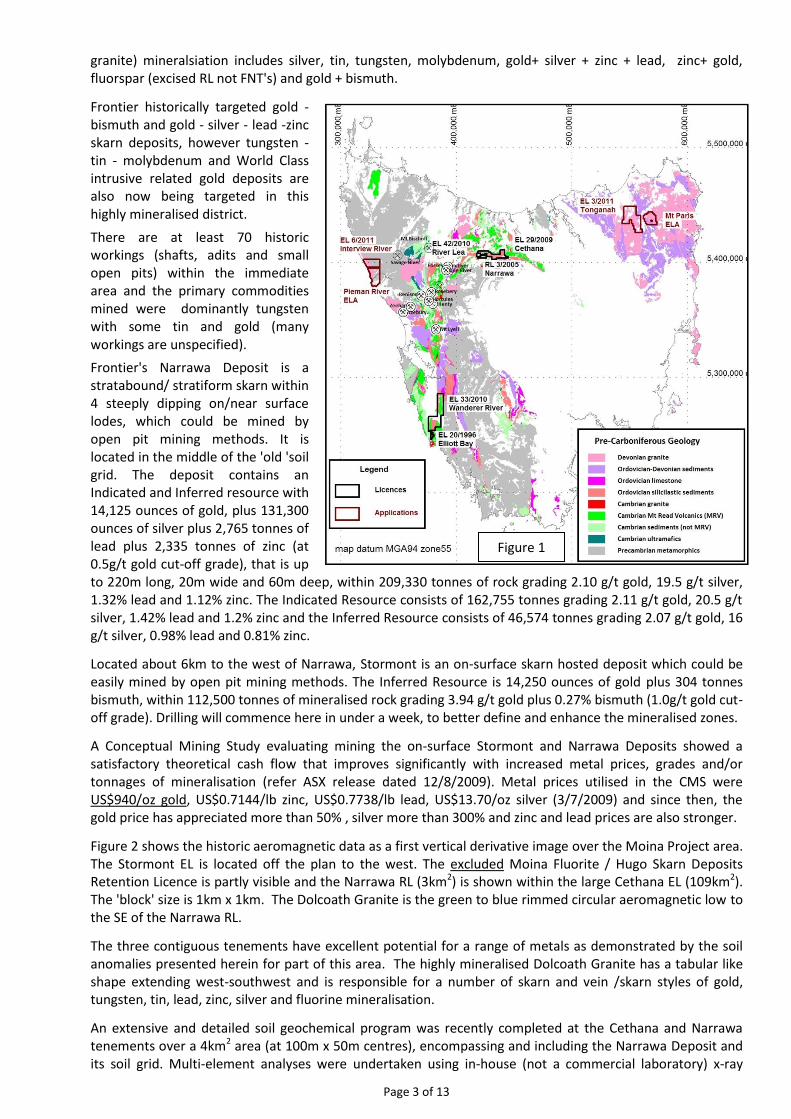
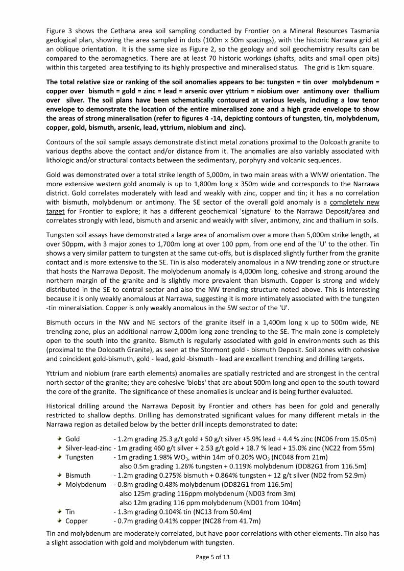
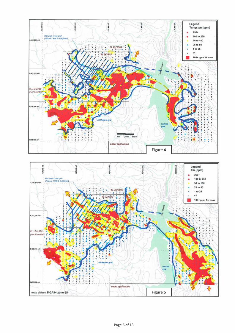
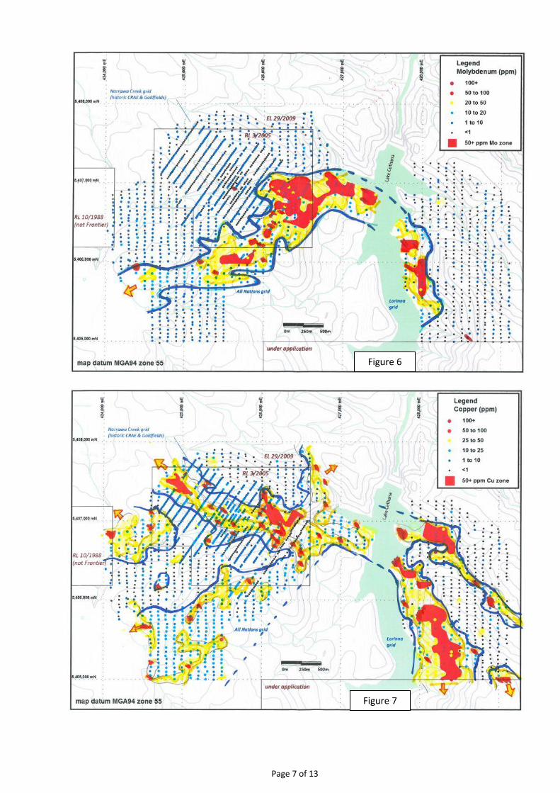
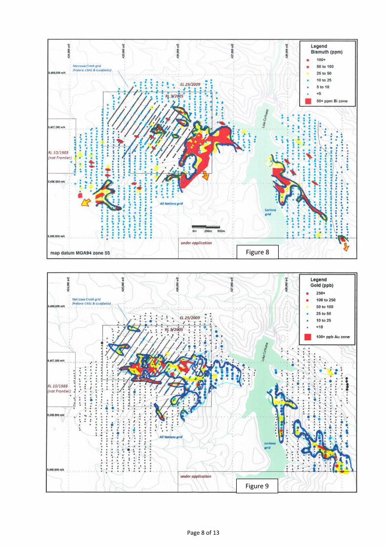
Figure 3 shows the Cethana area soil sampling conducted by Frontier on a Mineral Resources Tasmania geological plan, showing the area sampled in dots (100m x 50m spacings), with the historic Narrawa grid at an oblique orientation. It is the same size as Figure 2, so the geology and soil geochemistry results can be compared to the aeromagnetics. There are at least 70 historic workings (shafts, adits and small open pits) within this targeted area testifying to its highly prospective and mineralised status. The grid is 1km square.
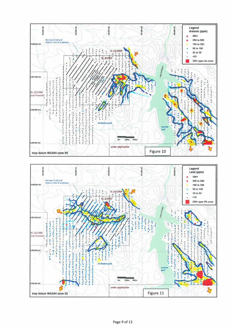
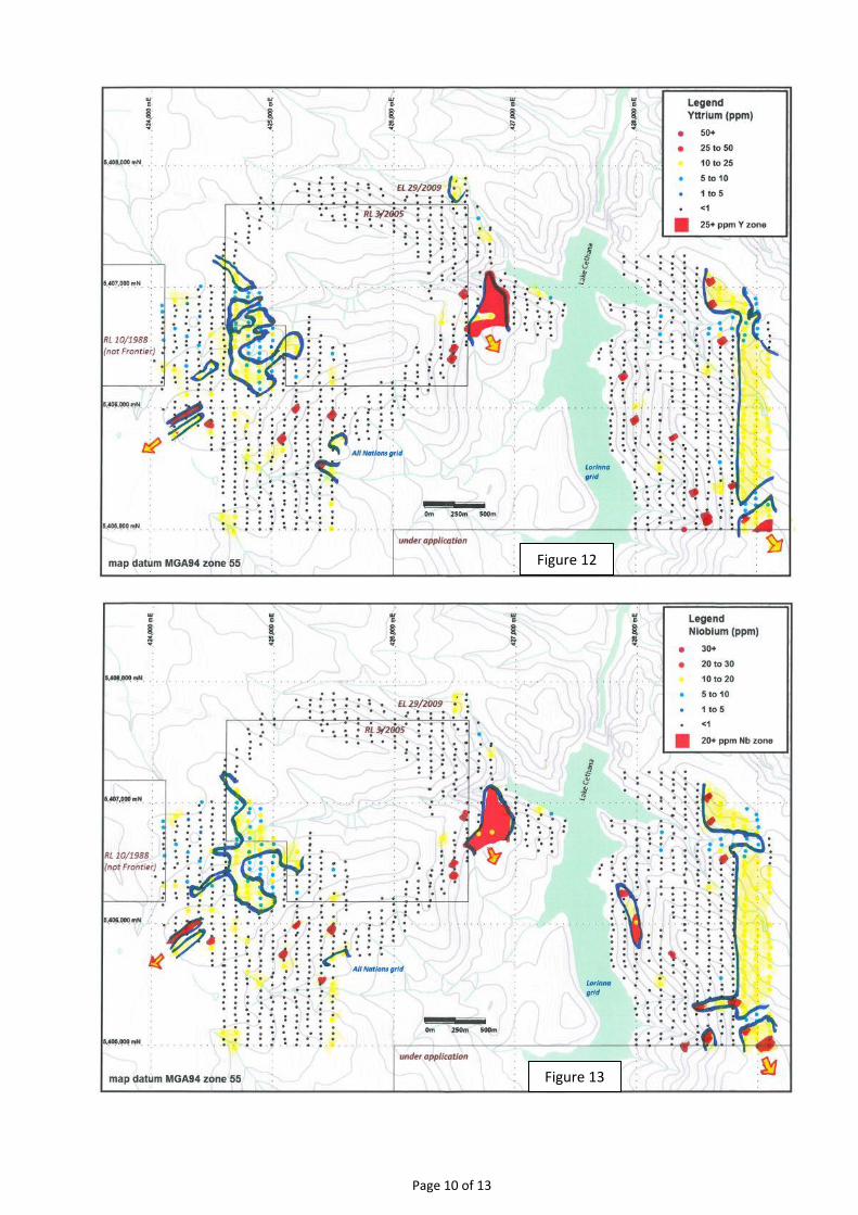
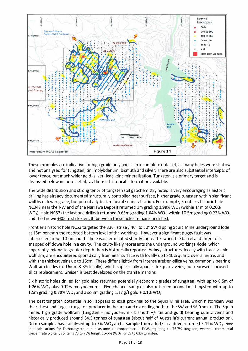
The total relative size or ranking of the soil anomalies appears to be: tungsten = tin over molybdenum = copper over bismuth = gold = zinc = lead = arsenic over yttrium = niobium over antimony over thallium over silver. The soil plans have been schematically contoured at various levels, including a low tenor envelope to demonstrate the location of the entire mineralised zone and a high grade envelope to show the areas of strong mineralisation (refer to figures 4 -14, depicting contours of tungsten, tin, molybdenum, copper, gold, bismuth, arsenic, lead, yttrium, niobium and zinc).
Contours of the soil sample assays demonstrate distinct metal zonations proximal to the Dolcoath granite to various depths above the contact and/or distance from it. The anomalies are also variably associated with lithologic and/or structural contacts between the sedimentary, porphyry and volcanic sequences.
Gold was demonstrated over a total strike length of 5,000m, in two main areas with a WNW orientation. The more extensive western gold anomaly is up to 1,800m long x 350m wide and corresponds to the Narrawa district. Gold correlates moderately with lead and weakly with zinc, copper and tin; it has a no correlation with bismuth, molybdenum or antimony. The SE sector of the overall gold anomaly is a completely new target for Frontier to explore; it has a different geochemical 'signature' to the Narrawa Deposit/area and correlates strongly with lead, bismuth and arsenic and weakly with silver, antimony, zinc and thallium in soils.
Tungsten soil assays have demonstrated a large area of anomalism over a more than 5,000m strike length, at over 50ppm, with 3 major zones to 1,700m long at over 100 ppm, from one end of the 'U' to the other. Tin shows a very similar pattern to tungsten at the same cut-offs, but is displaced slightly further from the granite contact and is more extensive to the SE. Tin is also moderately anomalous in a NW trending zone or structure that hosts the Narrawa Deposit. The molybdenum anomaly is 4,000m long, cohesive and strong around the northern margin of the granite and is slightly more prevalent than bismuth. Copper is strong and widely distributed in the SE to central sector and also the NW trending structure noted above. This is interesting because it is only weakly anomalous at Narrawa, suggesting it is more intimately associated with the tungsten -tin mineralsiation. Copper is only weakly anomalous in the SW sector of the 'U'.
Bismuth occurs in the NW and NE sectors of the granite itself in a 1,400m long x up to 500m wide, NE trending zone, plus an additional narrow 2,000m long zone trending to the SE. The main zone is completely open to the south into the granite. Bismuth is regularly associated with gold in environments such as this (proximal to the Dolcoath Granite), as seen at the Stormont gold - bismuth Deposit. Soil zones with cohesive and coincident gold-bismuth, gold - lead, gold -bismuth - lead are excellent trenching and drilling targets.
Yttrium and niobium (rare earth elements) anomalies are spatially restricted and are strongest in the central north sector of the granite; they are cohesive 'blobs' that are about 500m long and open to the south toward the core of the granite. The significance of these anomalies is unclear and is being further evaluated.
Historical drilling around the Narrawa Deposit by Frontier and others has been for gold and generally restricted to shallow depths. Drilling has demonstrated significant values for many different metals in the Narrawa region as detailed below by the better drill incepts demonstrated to date:
Gold - 1.2m grading 25.3 g/t gold + 50 g/t silver +5.9% lead + 4.4 % zinc (NC06 from 15.05m) Silver-lead-zinc - 1m grading 460 g/t silver + 2.53 g/t gold + 18.7 % lead + 15.0% zinc (NC22 from 55m) Tungsten - 1m grading 1.98% WO3, within 14m of 0.20% WO3 (NC048 from 21m)
also 0.5m grading 1.26% tungsten + 0.119% molybdenum (DD82G1 from 116.5m) Bismuth - 1.2m grading 0.275% bismuth + 0.864% tungsten + 12 g/t silver (ND2 from 52.9m) Molybdenum - 0.8m grading 0.48% molybdenum (DD82G1 from 116.5m)
also 125m grading 116ppm molybdenum (ND03 from 3m) also 12m grading 116 ppm molybdenum (ND01 from 104m)
Tin - 1.3m grading 0.104% tin (NC13 from 50.4m) Copper - 0.7m grading 0.41% copper (NC28 from 41.7m)
Tin and molybdenum are moderately correlated, but have poor correlations with other elements. Tin also has a slight association with gold and molybdenum with tungsten.
Figure 4
Figure 3
Page 6 of 13
Figure 5
Figure 4
Page 7 of 13
Figure 6
Figure 7
Page 8 of 13
Figure 9
Figure 8
Page 9 of 13
Figure 10
Figure 11
Page 10 of 13
Figure 12
Figure 13
Figure 12
Page 11 of 13
These examples are indicative for high grade only and is an incomplete data set, as many holes were shallow and not analysed for tungsten, tin, molybdenum, bismuth and silver. There are also substantial intercepts of lower tenor, but much wider gold -silver- lead -zinc mineralisation. Tungsten is a primary target and is discussed below in more detail, as there is historical information available.
The wide distribution and strong tenor of tungsten soil geochemistry noted is very encouraging as historic drilling has already documented structurally controlled near surface, higher grade tungsten within significant widths of lower grade, but potentially bulk mineable mineralisation. For example, Frontier's historic hole NC048 near the NW end of the Narrawa Deposit returned 1m grading 1.98% WO3 (within 14m of 0.20% WO3). Hole NC53 (the last one drilled) returned 0.65m grading 1.04% WO3, within 10.5m grading 0.23% WO3
and the known +800m strike length between these holes remains undrilled.
Frontier's historic hole NC53 targeted the 330º strike / 40º to 50º SW dipping Squib Mine underground lode at 15m beneath the reported bottom level of the workings. However a significant puggy fault was intersected around 32m and the hole was terminated shortly thereafter when the barrel and three rods snapped off down hole in a cavity. The cavity likely represents the underground workings /lode, which apparently extend to greater depth than is historically reported. Veins / structures, locally with trace visible wolfram, are encountered sporadically from near surface with locally up to 10% quartz over a metre, and with the thickest veins up to 15cm. These differ slightly from intense greisen-silica veins, commonly bearing Wolfram blades (to 16mm & 3% locally), which superficially appear like quartz veins, but represent focused silica replacement. Greisen is best developed on the granite margins.
Six historic holes drilled for gold also returned potentially economic grades of tungsten, with up to 0.5m of 1.26% WO3 plus 0.12% molybdenum. Five channel samples also returned anomalous tungsten with up to 1.5m grading 0.70% WO3 and also 3m grading 1.17 g/t gold + 0.1% WO3.
The best tungsten potential in soil appears to exist proximal to the Squib Mine area, which historically was the richest and largest tungsten producer in the area and extending both to the SW and SE from it. The Squib mined high grade wolfram (tungsten - molybdenum - bismuth +/- tin and gold) bearing quartz veins and historically produced around 34.5 tonnes of tungsten (about half of Australia’s current annual production). Dump samples have analysed up to 5% WO3 and a sample from a lode in a drive returned 3.19% WO3. Note
that calculations for Ferrotungsten herein assume all concentrate is FeW, equating to 76.7% tungsten, whereas commercial concentrate typically contains 70 to 75% tungstic oxide (WO3) or 55 to 63% tungsten.
Figure 14
Page 12 of 13
Historic drill hole DD82DG3 (collared approximately 200m to the east of the Squib Open Cut), drilled away from the strongest tungsten in soils, targeting Black’s Lode and Black’s Lower Workings. This apparently poorly targeted hole drilled beneath only modest tungsten in soils, but returned a 174m wide, low grade intersection with tungsten (WO3) to 0.16%, bismuth to 0.55% and molybdenum to 340ppm.
The spatial distribution of mineralisation style reflects proximity to the granite source. The Squib Open Cut mined greisen bearing pegmatitic veins and numerous narrow quartz veins within granite. The mined termination of the wolfram bearing underground East quartz Vein was noted to split into numerous thinner veins (i.e. the veins are wider /better defined distal to the granite).
The ore bodies at the Squib Open Cut contain wolframite with lesser amounts of molybdenite, cassiterite and bismuthinite. At the open cut workings, the lode consists of 15 x 2 to 10cm veins of quartz over wolframite over bismuthinite over molybdenite. The operation of the main level developed a molybdenite vein ¼ to ½ an inch (6 to 12mm) thick (McIntosh Reid, 1919). The richest ores (and with the greater proportion of molybdenite) are observed to occur in veins intruding the Moina Sandstone, however most of the workings are in the granite.
Greisen style mineralisation likely extends along the granite spine, plunging to the west and east. Higher tonnage, lower grade zones may be focused immediately within the granite and are reported from quartz porphyry margins.
It is also noted by government geologist McIntosh Reid that free gold occurs in the pegmatitic veins of the Squib workings. The veins are the typical greisen consisting of quartz - wolframite – molybdenite – cassiterite - bismuthinite veins, with minor accessory minerals such as topaz, fluorite and beryl. This occurrence of free gold provides a distinct link between the granite and gold.
The most appreciable amount of molybdenite was found in the Squib Mine East Drive (underground) where the vein was 25cm wide. Appreciable molybdenite is also found in the end of West Drive in the main level. Molybdenite and bismuthinite contents are also said to be much greater in the “Number 2 lode” or “western vein” where mineralisation is 20-30cm wide (McIntosh Reid, 1919).
McIntosh Reid (1919) also described a possible genesis that is ordered from earliest to latest: cassiterite - molybdenite - wolframite - wolframite/quartz/bismuthinite (gold?), quartz, chalcopyrite, pyrite, sphalerite, arsenopyrite. This reflects tin - molybdenum - tungsten - bismuth - gold - copper - zinc - arsenic, which is similar to the sequence demonstrated by the overall tenor of the soil anomalies/ geochemistry reported herein.
For information relating to Frontier Resources and/ or its projects, please visit the Company's website at www.frontierresources.com.au or feel free to contact me. FRONTIER RESOURCES LTD
P.A.McNeil, M.Sc. CHAIRMAN / MANAGING DIRECTOR
The information in this report that relates to Exploration Results and Mineral Resources is based on information compiled by, or compiled under the supervision of Peter A. McNeil - Member of the Aust. Inst. of Geoscientists. Peter McNeil is the Managing Director of Frontier Resources, who consults to the Company. Peter McNeil has sufficient experience which is relevant to the type of mineralisation and type of deposit under consideration to qualify as Competent Person as defined in the 2004 Edition of the Australasian Code of Reporting Exploration Results, Mineral Resources and Ore Resources. Peter McNeil consents to the inclusion in the report of the matters based on the information in the form and context in which it appears.
ABOUT FRONTIER RESOURCES LTD
FRONTIER IS FOCUSED ON EXPLORING FOR AND DEVELOPING MINERAL DEPOSITS IN THE HIGHLY MINERALISED PACIFIC ‘RIM OF FIRE’ IN PAPUA NEW GUINEA AND THE HIGHLY PROSPECTIVE DOLCOATH GRANITE AND MT READ VOLCANICS OF TASMANIA, AUSTRALIA
Frontier is an innovative and socially responsible ASX listed junior mineral explorer whose shares also trade on the Frankfurt, Berlin and Munich Stock Exchanges.
Directors have more than 150 years combined experience in PNG and Australia to serve the interests of the company, its shareholders and stakeholders.
Frontier operates with a general policy of drilling our quality projects using our purpose built and self manufactured, cost effective, environmentally friendly, man-portable diamond core rigs.
The Company has a 100% interest in six Exploration Licences (approx. 2,807 km²) and two Exploration Licence Applications (approx. 2,933km²) in PNG. Five ELs (approx. 2,690km²) are subject to two Joint Ventures with PNG copper-gold producer Ok Tedi Mining Ltd.
Frontier also has four Exploration Licences and one Retention Licence (348 km²) + 3 EL Applications in Tasmania.
Page 13 of 13
The tenement portfolio offers excellent mineral deposit potential. Primary targets are World Class copper-gold-molybdenum porphyry, high grade gold epithermal, intrusive related gold (IRG), gold–base metal & tungsten skarns + polymetallic VMS (zinc-lead-silver-gold) deposits.
The projects all have high-grade exploration results in rock, trenches and/or drill hole and are in the same or similar geological terranes as existing World Class and/or major mines.
PAPUA NEW GUINEA
THE 100% OWNED MT ANDEWA EL IN PNG HAS EXCELLENT GOLD AND COPPER MINERALISATION POTENTIAL
Frontier's exploration team is in the field conducting infill soil sampling and preparing for an extensive and deep drilling program scheduled for late June 2011 with our own drilling rig.
Frontier undertook a major Three Dimensional Induced Polarisation (3D-IP) geophysical program over a 21 sq km grid at the Andewa gold and copper Project on the island of New Britain in Papua New Guinea in 2010 and collected about 5,000 soil and rock samples.
The 3D-IP survey was a remarkable success that showed three exceptionally voluminous and intense, chargeability anomalies indicating the presence of very large sulphide systems from on-surface to more than 800m deep.
The total chargeability anomaly (over 30ms) area is approximately seven square kilometres, consisting of two very large, spatially related and intense chargeability anomalies (plus one smaller anomaly) called the Core Chargeability (CCZ), Ekhos and Ber Zones. The Ekhos chargeability anomaly is 3.3 Km2 in area, the CCZ is 3.0 km2 and Ber is approximately 0.5 km2 (at 150m below sea level).
The total anomalous chargeability area is approximately 5,400m long (E-W) and 3,000 wide (N-S). The Ekhos chargeability anomaly is approximately 3,850m long x 1,750m wide. It averages about 1,000m wide and has a higher grade chargeability core zone that is approximately 2,400m long and 1,000m wide (at over 30ms and 400m below topography). The CCZ is approximately 2,900m long (NW to SE) and a maximum of 2,100m wide, averaging 1,000m wide.
Ekhos is the largest and closest to surface 3D-IP chargeability anomaly at Andewa, with much of it very intense at over 45ms; it is open to the south and east but appears defined in general at depth. The CCZ chargeability anomaly is open to the south AND at depth, however, it’s very intense core (over 45ms) appears to be adequately resolved. The CCZ also has large anomalous areas at over 45ms chargeability that extend to depths greater than the 800m modelled maximum.
Each major chargeability anomaly is surrounded by a sub-circular high-resistivity anomaly that appears to merge near the edge and off the grid, to become 1 x~6km diameter quasi donut shaped resistivity anomaly in the centre of the Mt Andewa crater, with ‘holes’ present where the strong chargeability anomalies exist .
Frontier has previously drilled gold mineralisation at Komsen on the western margin of the CCZ from surface to a maximum depth of 320m below surface in a limited program, with drill intercepts containing significant gold and base metals such as 2m of 5.43 g/t gold + 95 g/t silver + 11.1% zinc + 2.3% lead + 0.12% copper and 7.9m of 10.01g/t gold.
OK TEDI MINING LTD JOINT VENTURE
HIGHLY PROSPECTIVE TENEMENTS AND FRONTIER’S EXPLORATION SUCCESS IN PNG CULMINATED IN AN EXCELLENT STRATEGIC ALLIANCE - JOINT VENTURE WITH WORLD CLASS COPPER PRODUCER OK TEDI MINING LTD (OTML)
13,000m of JV drilling is planned in the coming year, commencing August.
Five ELs are subject to 2 joint ventures that require a total earn-in of US$60 million over 6 years, consisting of US$12 million for each of the 5 projects.
Frontier is then deferred carried to completion of a Bankable Feasibility Study on each tenement, repayable from 50% of future cash flow.
The Company will retain a 42% interest (dilutable) in the Bulago and Leonard Schultz ELs and a 19.9% interest (non-dilutable) in the Likuruanga, Central and East New Britain ELs, to the completion of a Bankable Feasibility Study.
The JVs cover a total area of 2,690 km2.
OTML have completed large and detailed aeromagnetic and radiometric programs at Bulago, Leonard Schultz and Likuruanga to discriminate and rank targets for follow up exploration.
The Central and East New Britain licences were granted earlier in 2011 and aeromagnetic programs will be flown as soon as possible.
OTML is a major producer of copper concentrate from the Ok Tedi mine (that started operations in 1984) and has become the single largest business contributor to the economy of PNG. In 2009, OTML's export earnings were K4 billion, representing 33% of PNG's total export earnings. The contributions of the mine to PNG are wide reaching improving opportunities for employment, education and health services.
PNG exploration results from the JV projects have included: The Bulago JV has 10 zones of high-grade gold in outcrop channel samples at the Suguma and Funutu Prospects from continuous chip outcrop
channel samples. Trench intercepts included 27m of 66.8 g/t gold, 4m of 135.6 g/t gold, 9m of 64.0 g/t gold, 16m of 36.5 g/t gold, 18m of 40.3 g/t gold, 7.5m of 67.0 g/t gold and 9m of 24.0 g/t gold.
The Kru and nearby Wasi Prospects in the Leonard Schultz JV have excellent gold outcrop trench channel sample assay results including 16m of 18.60 g/t gold contained within 76m of 5.35 g/t gold. Additional significant assay results included 22m of 2.71 g/t and 36m of 1.15 g/t (within 384.3m of 0.67 g/t gold) in outcrop trench.
Likuruanga JV - Esis Prospect has 27m of supergene mineralisation grading 0.71% copper (from 33m depth), plus 66m of primary grading 0.42% copper (from 86.6m to end of hole), with the last 7.6m of the hole grading 0.49% copper. The Bukuam porphyry copper-gold-molybdenum soil anomaly is over 4.8km long and has not yet been drilled.
TASMANIA
EXPLORATION ON FRONTIER'S TASMANIAN TENEMENTS IS TARGETING KNOWN HIGH-GRADE (PLUS POTENTIALLY BULK MINEABLE) TUNGSTEN - TIN - MOLYBDENUM, GOLD - SILVER - LEAD - ZINC AND INTRUSIVE RELATED GOLD DEPOSITS
WART HILL DEPOSIT, SMRV PROJECT, SW TASMANIA Frontier is targeting a 45km total strike length of the highly prospective Mt Read Volcanics in SW Tasmania for World Class Rosebery and Eskay Creek type of Volcanic Hosted Massive Sulphide Deposits (EL 20/96 and EL 33/2010).
A high-grade ‘Rosebery’ style VHMS base metal (zinc, lead, silver, gold) horizon has been tracked for 290m down a fold keel by Frontier's drilling. A 3D-IP survey was completed and it has provided useful targeting vectors. The faulted off southern extension and the ‘sides’ are good exploration targets and there is excellent regional potential to locate additional volcanic hosted massive sulphide and also high grade gold deposits.
Trench results have included 3m of 21.9% zinc + 13.9% lead + 680g/t silver + 0.84g/t gold and 4m of 17.9% zinc + 10.2% lead + 138g/t silver + 0.60g/t gold.
Drill results have included 13.9m grading 1.11 g/t gold + 37g/t silver + 8.97% zinc + 4.47% lead + 0.31% copper, 3.9m of 0.60 g/t gold + 124 g/t silver + 12.1% zinc + 7.3% lead, 1.1m of 0.60 g/t gold +123 g/t silver + 23.6% zinc +10.4% lead & 5.7m of 0.35 g/t gold + 77 g/t silver + 7.5 % zinc + 4.0 % lead.