Embed Size (px)
Citation preview

Axiom Mining Limited
ARBN 119 698 770
Unit 6, 76 Doggett Street Newstead, Queensland 4006, Australia
T: +61 7 3319 4100 | F: +61 7 3252 7577 | www.axiom-mining.com
ASX / Media Release
28 Feb 2014
Gold mineralised zone identified at Taho exploration target, West Guadalcanal Project
HIGHLIGHTS
Axiom has received initial soil, rockchip and trench results for the field work completed at Taho epithermal exploration target
Soil geochemistry:
- 1.4 km long (open) up to 400 m wide anomalous gold-in-soil geochemistry contour defined by >0.1 g/t Au
- including 350 m long of highly anomalous gold-in-soil geochemistry contour (open) defined by >0.5 g/t Au
- up to 2.13 g/t Au and up to 100.5 g/t Ag
Rockchip geochemistry:
- up to 39.75 g/t Au and 51.8 g/t Ag
Hand trenching:
- up to 3.5 m @ 0.84 g/t Au (open) resampling of historical trenches
- up to 8.0 m @ 0.83 g/t Au from new trenches
Pathfinder soil geochemistry is consistent with the mid-upper levels of an epithermal system
Axiom Mining Limited (“Axiom” or “the Company”) is pleased to announce initial surface
geochemistry results from the Taho exploration target (Figure 1) which lies within the Hoilava
epithermal corridor at its West Guadalcanal Project (“the Project”).
For
per
sona
l use
onl
y

2
Figure 1 – West Guadalcanal project location and exploration targets
Soil Geochemistry Results
Axiom has collected a total of 1657 B-horizon soil samples on 25 m sample intervals from 100 m
spaced north-south oriented lines. Assays received for 954 samples with returns of up to 2.13 g/t Au
and up to 100.5 g/t Ag hosted in silicified limestone (Figure 2).
The >0.1 g/t Au soil contour defines a continuous gold-in-soil mineralised trend 1.4 km long and up
to 400 m wide (Figure 2). In the east of this mineralised trend there exists a highly anomalous gold-
in-soil mineralised trend (defined by the greater than 0.5 g/t Au contour) that itself is 350 m long.
Both the highly anomalous and the anomalous zone are open to the east (Figure 3).
Elevated pathfinder soil geochemistry (Ag-As-Sb) in proximity to mapped Mn wadding and
carbonate-rich veins supports the exploration model developed by Axiom; which is the mid to upper
level position of a carbonate-rich low sulphidation epithermal gold system.
For
per
sona
l use
onl
y

3
Figure 2 – Taho mineralised zone 1.4 km long defined by gold-in-soil anomaly (>0.1 g/t Au contour)
Figure 3 - Highly anomalous gold-in-soil anomaly (defined by > 0.5 g/t Au contour); 350 m long and remains open to the
east
For
per
sona
l use
onl
y
4
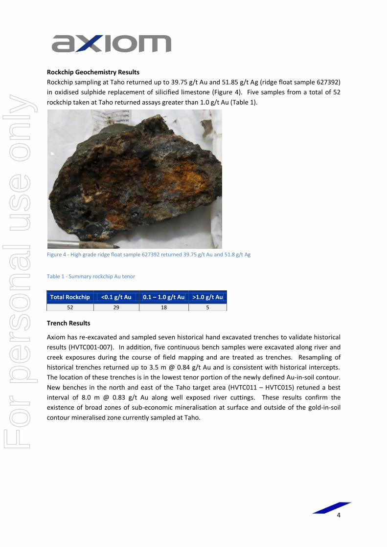
Rockchip Geochemistry Results
Rockchip sampling at Taho returned up to 39.75 g/t Au and 51.85 g/t Ag (ridge float sample 627392)
in oxidised sulphide replacement of silicified limestone (Figure 4). Five samples from a total of 52
rockchip taken at Taho returned assays greater than 1.0 g/t Au (Table 1).
Figure 4 - High grade ridge float sample 627392 returned 39.75 g/t Au and 51.8 g/t Ag
Table 1 - Summary rockchip Au tenor
Trench Results
Axiom has re-excavated and sampled seven historical hand excavated trenches to validate historical
results (HVTC001-007). In addition, five continuous bench samples were excavated along river and
creek exposures during the course of field mapping and are treated as trenches. Resampling of
historical trenches returned up to 3.5 m @ 0.84 g/t Au and is consistent with historical intercepts.
The location of these trenches is in the lowest tenor portion of the newly defined Au-in-soil contour.
New benches in the north and east of the Taho target area (HVTC011 – HVTC015) retuned a best
interval of 8.0 m @ 0.83 g/t Au along well exposed river cuttings. These results confirm the
existence of broad zones of sub-economic mineralisation at surface and outside of the gold-in-soil
contour mineralised zone currently sampled at Taho.
Total Rockchip <0.1 g/t Au 0.1 – 1.0 g/t Au >1.0 g/t Au
52 29 18 5
For
per
sona
l use
onl
y

5
Table 2 - Taho target significant trench results
Trench Name Length
(m)
Easting (WGS84_57S)
Northing (WGS84_57S) Significant Results*
HVTC001 9.0 573345 8955864 No significant results
HVTC002 8.5 573372 8955852 2.0 m @ 0.22 g/t Au (open) HVTC003 7.0 573375 8955861 2.0 m @ 0.44 g/t Au (open) HVTC004 6.0 573352 8955848 No assay > 0.1 g/t Au
HVTC005 8.7 573360 8955880 7.0 m @ 0.19 g/t Au HVTC006 11.0 573344 8955904 No assay > 0.1 g/t Au
HVTC007 13.5 573342 8955904 3.5 m @ 0.84 g/t Au (open) HVTC010 17.0 574275 8957309 4.0 m @ 0.28 g/t Au
HVTC011 19.0 574441 8957165 7.0 m @ 0.71 g/t Au
8.0 m @ 0.83 g/t Au HVTC012 46.0 573230 8957030 3.0 m @ 0.13 g/t Au
6.0 m @ 0.17 g/t Au
1.0 m @ 0.11 g/t Au
1.0 m @ 0.23 g/t Au
1.0 m @ 0.13 g/t Au
1.0 m @ 0.15 g/t Au HVTC013 14.0 573232 8957042 1.0 m @ 0.15 g/t Au
3.0 m @ 0.16 g/t Au (open)
HVTC014 11.0 573230 8957041 No assay > 0.1 g/t Au
HVTC015 24.0 573230 8957030 3.0 m @ 0.54 g/t Au
1.0 m @ 0.12 g/t Au
10.0 m @ 0.136 g/t Au (open) *Notes on calculations: Cuttoff grade 0.1 g/t Au Maximum internal dilution 1.0 m
Ryan Mount, CEO states “These initial results from the West Guadalcanal Project are very
encouraging. Not only do they support the bulk tonnage and high grade potential of the Project but
they also confirm our predictive and systematic approach to exploration.”
About the West Guadalcanal Project
The Project lies in the west of Guadalcanal Island, Solomon Islands comprising 485 km² and is wholly
owned by Axiom. The Project is considered under-explored and highly prospective for Southwest
Pacific style mineralisation, namely:
gold-silver-basemetal epithermal; and
copper-gold porphyry including skarn mineralisation.
ENDS
For
per
sona
l use
onl
y

6
About Axiom Mining Limited
Axiom Mining Limited focuses on tapping into the resource potential within the mineral-rich Pacific Rim. Through dedication to forging strong bonds and relationships with the local communities and governments where we operate, Axiom Mining has built a diversified portfolio of exploration tenements in the Asia Pacific region. This includes a majority interest in the Isabel nickel deposits in the Solomon Islands. The Company also owns all or majority holdings in Vietnam’s Quang Tri gold project and highly prospective gold silver and copper tenements in North Queensland, Australia. The Company is listed on the ASX.
For more information on Axiom Mining and details on our activities, please refer to our company website at www.axiom-mining.com.
Disclaimer Statements in this document that are forward-looking and involve numerous risks and uncertainties that could cause actual results to differ materially from expected results are based on the Company’s current beliefs and assumptions regarding a large number of factors affecting its business. There can be no assurance that (i) the Company has correctly measured or identified all of the factors affecting its business or their extent or likely impact; (ii) the publicly available information with respect to these factors on which the Company’s analysis is based is complete or accurate; (iii) the Company’s analysis is correct; or (iv) the Company’s strategy, which is based in part on this analysis, will be successful.
Competent Person's Statement The information in this announcement that relates to Exploration Results is based on information compiled by Mr Jess Oram who is a member of the Australian Institute of Geoscientists. Mr Oram has sufficient experience that is relevant to the styles of mineralisation and types of deposit under consideration and to the activity which is being undertaking to qualify as a Competent Person as defined in the 2012 Edition of the ‘Australasian Code for Reporting of Exploration Results, Mineral Resources and Ore Reserves.’ Mr Oram is a full time employee of Axiom Mining Limited and consents to the inclusion in this report of the matters based on his information in the form and context in which it appears.
For
per
sona
l use
onl
y
Axiom Mining Limited
ARBN 119 698 770
Unit 6, 76 Doggett Street Newstead, Queensland 4006, Australia
T: +61 7 3319 4100 | F: +61 7 3252 7577 | www.axiom-mining.com
ASX / Media Release
28 Feb 2014
Section 1 Sampling Techniques and Data
Criteria JORC Code explanation Commentary
Sampling
techniques
Nature and quality of sampling (eg cut
channels, random chips, or specific
specialised industry standard measurement
tools appropriate to the minerals under
investigation, such as down hole gamma
sondes, or handheld XRF instruments, etc).
These examples should not be taken as
limiting the broad meaning of sampling.
Include reference to measures taken to
ensure sample representivity and the
appropriate calibration of any measurement
tools or systems used.
Aspects of the determination of
mineralisation that are Material to the
Public Report.
In cases where ‘industry standard’ work has
been done this would be relatively simple (eg
‘reverse circulation drilling was used to
obtain 1 m samples from which 3 kg was
pulverised to produce a 30 g charge for fire
assay’). In other cases more explanation may
be required, such as where there is coarse
gold that has inherent sampling problems.
Unusual commodities or mineralisation types
(eg submarine nodules) may warrant
disclosure of detailed information.
Trenches hand excavated to 1.5 m depth or to C-
horizon subcrop. Bench exposures along river
cuttings cleaned.
Sampled at the base of trenches and benches in
continuous cut channels with samples aggregated
over measured 0.5 m, 1.0 m or 2.0 m intervals.
Rockchip sampling techniques as either float –
transported rock, grab – random sample of in-situ
rock or channel – 1m cut channel over measured 1.0
m interval to ensure appropriate representation
Soil sampling of up to 1 kg B-horizon soil profile at
0.75 m depth below surface. Sampling at 25 m
intervals along either 100 m or 50 m spaced lines.
Samples designated as either transported / unknown
/ residual to ensure appropriate representation.
Trenching samples obtained from cut channels at 0.5
m to 1.0 m intervals weighing less than 2.0 kg and
rockchip / soil samples weighing approximately 1.0
kg were transported to Intertek Laboratories in
Honiara for sample preparation prior to fire assay for
Au and aqua-regia digest for ICP finish at Intertek
Laboratories, Townsville; for the following multi-
element suite and lower detection limit in ppm (Ag
(0.05), Al (20), As (1), Ba (2), Bi (0.01), Ca (100), Cd
(0.01), Co (0.1), Cr (2), Cu (1), Fe (100), Hg (0.01), In
(0.01), K (20), Mg (100), Mn (1), Mo (0.1), Na (100),
Ni (1), P (20), Pb (1), Rb (0.02), S (50), Sb (0.02), Sn
(0.05), Sr (0.02), Te (2), Th (0.01), U (0.01), V (2), W
(2), Zn (1)).
Drilling
techniques
Drill type (eg core, reverse circulation, open-
hole hammer, rotary air blast, auger,
Bangka, sonic, etc) and details (eg core
diameter, triple or standard tube, depth of
diamond tails, face-sampling bit or other
No new drilling reported in this release.
For
per
sona
l use
onl
y

8
Criteria JORC Code explanation Commentary
type, whether core is oriented and if so, by
what method, etc).
Drill sample
recovery
Method of recording and assessing core and
chip sample recoveries and results assessed.
Measures taken to maximise sample
recovery and ensure representative nature of
the samples.
Whether a relationship exists between
sample recovery and grade and whether
sample bias may have occurred due to
preferential loss/gain of fine/coarse
material.
No new drilling reported in this release.
Logging Whether core and chip samples have been
geologically and geotechnically logged to a
level of detail to support appropriate Mineral
Resource estimation, mining studies and
metallurgical studies.
Whether logging is qualitative or
quantitative in nature. Core (or costean,
channel, etc) photography.
The total length and percentage of the
relevant intersections logged.
Logging of geology, alteration and geotechnical
aspects have been recorded in Trenches to
requirements for diamond core drilling.
Trenches / benches have been photographed.
The entire interval trenched to bedrock has been
logged.
Sub-sampling
techniques and
sample
preparation
If core, whether cut or sawn and whether
quarter, half or all core taken.
If non-core, whether riffled, tube sampled,
rotary split, etc and whether sampled wet or
dry.
For all sample types, the nature, quality and
appropriateness of the sample preparation
technique.
Quality control procedures adopted for all
sub-sampling stages to maximise
representivity of samples.
Measures taken to ensure that the sampling
is representative of the in situ material
collected, including for instance results for
field duplicate/second-half sampling.
Whether sample sizes are appropriate to the
grain size of the material being sampled.
No new drilling results reported in this release.
Field duplicates comprising 4% of total batch taken
for all sampling. Additional field duplicates taken
from zones of mineralisation in trenching that are
identified through trench mapping
Samples are dried, crushed and pulverised to 75 microns. No tests have been undertaken to determine the grain size of gold.
Quality of assay
data and
laboratory tests
The nature, quality and appropriateness of
the assaying and laboratory procedures used
and whether the technique is considered
partial or total.
For geophysical tools, spectrometers,
Fire assay is appropriate for the nature of the gold
mineralisation being assayed.
Use of certified reference material (CRM)
comprising about 8% of each sample batch is
For
per
sona
l use
onl
y
9
Criteria JORC Code explanation Commentary
handheld XRF instruments, etc, the
parameters used in determining the analysis
including instrument make and model,
reading times, calibrations factors applied
and their derivation, etc.
Nature of quality control procedures
adopted (eg standards, blanks, duplicates,
external laboratory checks) and whether
acceptable levels of accuracy (ie lack of bias)
and precision have been established.
considered acceptable to assure levels of accuracy.
Duplicate sampling comprising about 4% of each
sample batch is acceptable to assure levels of assay
precision.
Verification of
sampling and
assaying
The verification of significant intersections by
either independent or alternative company
personnel.
The use of twinned holes.
Documentation of primary data, data entry
procedures, data verification, data storage
(physical and electronic) protocols.
Discuss any adjustment to assay data.
No new drilling reported in this release.
Location of data
points
Accuracy and quality of surveys used to
locate drill holes (collar and down-hole
surveys), trenches, mine workings and other
locations used in Mineral Resource
estimation.
Specification of the grid system used.
Quality and adequacy of topographic
control.
All sample locations surveyed using hand held
garmin GPS with accuracy ±10m.
Trenches surveyed from handheld GPS start point
using tape and compass. This level of accuracy is
deemed sufficient in the early stages of the project.
Data spacing
and distribution
Data spacing for reporting of Exploration
Results.
Whether the data spacing and distribution is
sufficient to establish the degree of
geological and grade continuity appropriate
for the Mineral Resource and Ore Reserve
estimation procedure(s) and classifications
applied.
Whether sample compositing has been
applied.
Soil sampling data is at 25 m spaced samples on 100
m spaced lines. This is adequate for determining
continuity mineralised zones in soil contours.
All samples surveyed in coordinate system
UTM_WGS84_Zone 57S.
No compositing has been applied.
Orientation of
data in relation
to geological
structure
Whether the orientation of sampling
achieves unbiased sampling of possible
structures and the extent to which this is
known, considering the deposit type.
If the relationship between the drilling
orientation and the orientation of key
mineralised structures is considered to have
introduced a sampling bias, this should be
Due to the nature of tropical jungle soil weathering,
it is too early to determine bias as not enough
structural information is available. The nature of
key mineralising structures has not been established
in trenching.
For
per
sona
l use
onl
y
10
Criteria JORC Code explanation Commentary
assessed and reported if material.
Sample security The measures taken to ensure sample
security.
A chain of custody procedure has been
implemented by the company from site to Intertek
Honiara.
Audits or
reviews
The results of any audits or reviews of
sampling techniques and data.
No audits have been undertaken.
Section 2 Reporting of Exploration Results
Criteria JORC Code explanation Commentary
Mineral
tenement and
land tenure
status
Type, reference name/number, location and
ownership including agreements or material
issues with third parties such as joint
ventures, partnerships, overriding royalties,
native title interests, historical sites,
wilderness or national park and
environmental settings.
The security of the tenure held at the time
of reporting along with any known
impediments to obtaining a licence to
operate in the area.
Axiom Mining Limited wholly owns exploration licence
PL01/14 located in the west of Guadalcanal Island,
Solomon Islands.
No other agreements or material issues associated
with the licence.
No impediments to access. Axiom has full access to the
tenement under the same surface access agreements
with indigenous landowners as previous tenement
holder. A new surface access agreement is being
finalised.
Exploration
done by other
parties
Acknowledgment and appraisal of
exploration by other parties.
1954 – Solomon Islands Geological Survey notes
sulphides in Hoilava catchment
1970 - Carpentaria Exploration Company Pty Ltd (CEC).
Six month stream sediment and mapping program
discovers altered and mineralised outcrop and float in
Hoilava catchment.
1986 – 1988, BHP Utah were the first company to
target specifically epithermal mineralisation.
Identified anomalous gold values and sporadic zones
of siliceous, argillic and pyritic alteration in the
headwaters of the Hoilava catchment. Loosely
identified Polo, Taho and Mt Tanjili areas.
Austpac Gold NL (and from 1988 in JV with Nuigini
mining through to 1990). Trenching at Polo Creek
returned 130 m @ 0.58 g/t Au, including 10 m @ 3.44
g/t Au.
1994 – 1998 Gualer Resources completed 100m
spaced airborne magnetics and radiometrics which
covers about half of the current project area. Soil and
trench sampled at Hoilava, the best results reported as
being 37.6 m @ 1.03 g/t Au.
Geology Deposit type, geological setting and style of
mineralisation.
The regional tectonic and geological settings of the
project is similar to that of major porphyry copper-gold
and epithermal gold deposits elsewhere within the
For
per
sona
l use
onl
y
11
Criteria JORC Code explanation Commentary
southwest Pacific island arc system including the
Panguna porphyry copper (and Gold Ridge epithermal
gold deposits that lie within the same volcanic arc and
in Gold Ridge’s case, island and are associated with
similar aged igneous rocks. The Solomon Islands are
part of the currently active Outer Melanesian Arc
System, lying on a complex convergent boundary
between the Indo-Australian and Pacific Plates They
are composed of a diverse assemblage of rocks of Late
Mesozoic to Cainozoic age that have formed and
accreted within an intra-oceanic environment.
Drill hole
Information
A summary of all information material to
the understanding of the exploration results
including a tabulation of the following
information for all Material drill holes:
easting and northing of the drill hole
collar
elevation or RL (Reduced Level –
elevation above sea level in metres) of
the drill hole collar
dip and azimuth of the hole
down hole length and interception
depth
hole length.
If the exclusion of this information is
justified on the basis that the information is
not Material and this exclusion does not
detract from the understanding of the
report, the Competent Person should clearly
explain why this is the case.
Significant trench results are reported in Figure 1.
Trench lengths and trenches which returned no
significant mineralisation are also reported to enable
balance of reporting and exclusion of the entire
dataset does not detract from the understanding of
the report.
Data
aggregation
methods
In reporting Exploration Results, weighting
averaging techniques, maximum and/or
minimum grade truncations (eg cutting of
high grades) and cut-off grades are usually
Material and should be stated.
Where aggregate intercepts incorporate
short lengths of high grade results and
longer lengths of low grade results, the
procedure used for such aggregation should
be stated and some typical examples of
such aggregations should be shown in
detail.
The assumptions used for any reporting of
metal equivalent values should be clearly
stated.
For trench sampling, length weighing calculations with
a maximum 1 m internal dilution have been applied
For significant rockchip and trench sampling a cutoff of
0.1 g/t Au has been applied.
No metal equivalent values reported.
For
per
sona
l use
onl
y

12
Criteria JORC Code explanation Commentary
Relationship
between
mineralisation
widths and
intercept
lengths
These relationships are particularly
important in the reporting of Exploration
Results.
If the geometry of the mineralisation with
respect to the drill hole angle is known, its
nature should be reported.
If it is not known and only the down hole
lengths are reported, there should be a clear
statement to this effect (eg ‘down hole
length, true width not known’).
No drilling results reported in this release
Diagrams Appropriate maps and sections (with scales)
and tabulations of intercepts should be
included for any significant discovery being
reported These should include, but not be
limited to a plan view of drill hole collar
locations and appropriate sectional views.
No drilling results reported in this release
Balanced
reporting
Where comprehensive reporting of all
Exploration Results is not practicable,
representative reporting of both low and
high grades and/or widths should be
practiced to avoid misleading reporting of
Exploration Results.
No drilling results reported in this release
Other
substantive
exploration data
Other exploration data, if meaningful and
material, should be reported including (but
not limited to): geological observations;
geophysical survey results; geochemical
survey results; bulk samples – size and
method of treatment; metallurgical test
results; bulk density, groundwater,
geotechnical and rock characteristics;
potential deleterious or contaminating
substances.
Geological mapping by Axiom confirms significant
zones of mineralisation and alteration associated with
an epithermal system occurs in the target areas.
All soil and rockchip sample locations are shown in
Figure 1 and Figure 2. Anomalous soil results are
labelled with Au grade in g/t in Figure 2.
Further work The nature and scale of planned further
work (eg tests for lateral extensions or
depth extensions or large-scale step-out
drilling).
Diagrams clearly highlighting the areas of
possible extensions, including the main
geological interpretations and future drilling
areas, provided this information is not
commercially sensitive.
Axiom is targeting the western Hoilava area and will be
undertaking further trenching, systematic soil
sampling, geological mapping and airborne magnetics
prior to planned drill program in mid-2014.
For
per
sona
l use
onl
y