Embed Size (px)
Citation preview
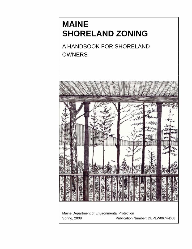
MAINE SHORELAND ZONING
A HANDBOOK FOR SHORELAND OWNERS Maine Department of Environmental Protection Spring, 2008 Publication Number: DEPLW0674-D08

TABLE OF CONTENTS ACKNOWLEDGMENTS II
THE PURPOSE OF THIS HANDBOOK 1 Introduction 1
PART ONE – THE LAW 2 Maine's Mandatory Shoreland Zoning Law 2 Why Zone Shoreland? 4 State and Local Responsibilities 5
PART TWO – SHORELAND ZONING REGULATIONS 6 The State Guidelines: An Overview 6 Establishing Districts 7 Measurements 9 The Official Shoreland Zoning Map 10 Non-conformance 11 Non-conforming Uses 16 Land Use Table 17
PART THREE – LAND USE STANDARDS 18 Minimum Lot Standards 18 Building Setback, Height, and Lot Coverage 19 Parking Areas, Roads, and Driveways 22 Stormwater Runoff and Erosion Control 24 Septic Disposal 25 Individual, Private Campsites 26 Clearing Vegetation (other than for Commercial Timber Harvesting) 26 Timber Harvesting 29 Optional Provisions 30
PART FOUR — THE ROLES OF LOCAL OFFICIALS 32 The Code Enforcement Officer 32 The Planning Board 32 The Board of Appeals 33
OTHER LAWS 34
REFERENCES 36
USEFUL PUBLICATIONS 37
i
Acknowledgments
ii
ACKNOWLEDGMENTS This handbook was originally prepared by Kent Associates, Planning & Design Associates in Gardiner, Maine in 1998. It was updated in 2007 by Jennifer Cayer of the Department of Environmental Protection, and in 2008 by Alison Truesdale of LandForms. An electronic copy of this publication can be downloaded from Maine Department of Environmental Protection’s website at: http://www.maine.gov/dep/blwq/docstand/szpage.htm. Drawings in this handbook are by Brian Kent; woodcut art is by Jon Luoma. This publication was funded, in part, with a grant from the USEPA under assistance grant number C900178193.
NOTE This handbook is for informational purposes only. It explains Maine’s Shoreland Zoning Law and Guidelines, in words and pictures, for shoreland owners. It is not a substitute for the law, the Guidelines, or municipal shoreland zoning ordinances. For specific information about your local shoreland zoning provisions, refer to your municipal ordinance.
1
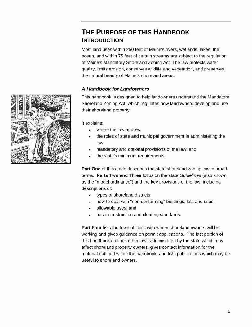
THE PURPOSE OF THIS HANDBOOK INTRODUCTION Most land uses within 250 feet of Maine's rivers, wetlands, lakes, the ocean, and within 75 feet of certain streams are subject to the regulation of Maine's Mandatory Shoreland Zoning Act. The law protects water quality, limits erosion, conserves wildlife and vegetation, and preserves the natural beauty of Maine's shoreland areas. A Handbook for Landowners This handbook is designed to help landowners understand the Mandatory Shoreland Zoning Act, which regulates how landowners develop and use their shoreland property. It explains:
• where the law applies; • the roles of state and municipal government in administering the
law; • mandatory and optional provisions of the law; and • the state's minimum requirements.
Part One of this guide describes the state shoreland zoning law in broad terms. Parts Two and Three focus on the state Guidelines (also known as the “model ordinance”) and the key provisions of the law, including descriptions of:
• types of shoreland districts; • how to deal with "non-conforming" buildings, lots and uses; • allowable uses; and • basic construction and clearing standards.
Part Four lists the town officials with whom shoreland owners will be working and gives guidance on permit applications. The last portion of this handbook outlines other laws administered by the state which may affect shoreland property owners, gives contact information for the material outlined within the handbook, and lists publications which may be useful to shoreland owners.
Part One – The Law
2
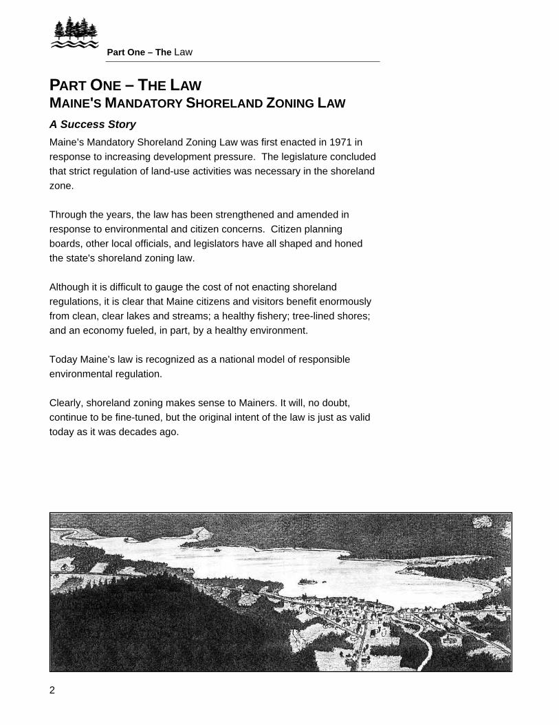
PART ONE – THE LAW MAINE'S MANDATORY SHORELAND ZONING LAW A Success Story Maine’s Mandatory Shoreland Zoning Law was first enacted in 1971 in response to increasing development pressure. The legislature concluded that strict regulation of land-use activities was necessary in the shoreland zone. Through the years, the law has been strengthened and amended in response to environmental and citizen concerns. Citizen planning boards, other local officials, and legislators have all shaped and honed the state's shoreland zoning law. Although it is difficult to gauge the cost of not enacting shoreland regulations, it is clear that Maine citizens and visitors benefit enormously from clean, clear lakes and streams; a healthy fishery; tree-lined shores; and an economy fueled, in part, by a healthy environment. Today Maine’s law is recognized as a national model of responsible environmental regulation. Clearly, shoreland zoning makes sense to Mainers. It will, no doubt, continue to be fine-tuned, but the original intent of the law is just as valid today as it was decades ago.
3
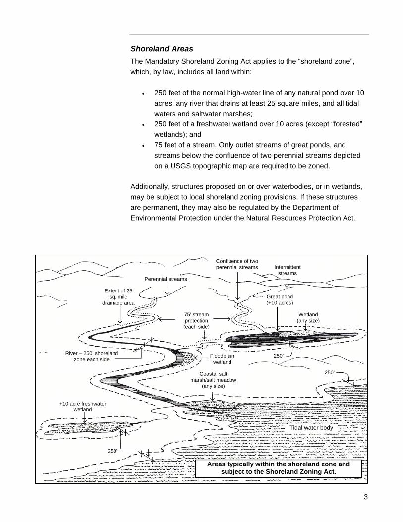
Shoreland Areas The Mandatory Shoreland Zoning Act applies to the “shoreland zone”, which, by law, includes all land within:
• 250 feet of the normal high-water line of any natural pond over 10 acres, any river that drains at least 25 square miles, and all tidal waters and saltwater marshes;
• 250 feet of a freshwater wetland over 10 acres (except “forested” wetlands); and
• 75 feet of a stream. Only outlet streams of great ponds, and streams below the confluence of two perennial streams depicted on a USGS topographic map are required to be zoned.
Additionally, structures proposed on or over waterbodies, or in wetlands, may be subject to local shoreland zoning provisions. If these structures are permanent, they may also be regulated by the Department of Environmental Protection under the Natural Resources Protection Act.
Confluence of two perennial streams Intermittent
streams Perennial streams
Extent of 25 sq. mile
drainage area
75’ stream protection
(each side)
River – 250’ shoreland zone each side
+10 acre freshwater wetland
250’
Tidal water body
250’Coastal salt marsh/salt meadow
(any size)
Great pond (+10 acres)
Wetland (any size)
250’ Floodplainwetland
Areas typically within the shoreland zone and subject to the Shoreland Zoning Act.
Part One – The Law
4
WHY ZONE SHORELAND? Responsible Development Development that is too close to the shores of lakes, rivers, wetlands, and the ocean can cause soil erosion and a decline in water quality. Poor construction practices can be unsightly, destroy valuable natural habitat, and reduce property values. Shoreland zoning protects the environment, encourages responsible development, and prevents development that does not protect the public's interest in healthy shoreland and waters. The Purposes of the Law The purposes of shoreland regulations are to:
• prevent and control water pollution; • conserve natural beauty and open space; • conserve shore cover; • protect freshwater and coastal wetlands; • protect fish spawning areas, aquatic life, bird and wildlife habitat; • protect buildings from flooding; • control the location of buildings; • conserve public access to the water; • protect commercial fishing and the maritime industry; and • protect archaeological and historic resources.
Further, the state Shoreland Zoning Act establishes minimum requirements that all towns must abide by in developing their local ordinances. This helps assure a level regulatory playing field, and attempts to maintain consistency in the law across town lines.
5
STATE AND LOCAL RESPONSIBILITIES All municipalities must enact, administer and enforce a local shoreland ordinance. This local ordinance is required to be either as restrictive as or more restrictive than the state’s model ordinance. It is recommended that every landowner of shoreland property obtain a copy of the local ordinance from their Town office. The State's Oversight Role Your local shoreland zoning ordinance sets the rules in your municipality. The state oversees the administration of the municipal ordinances and assists towns and cities in four ways. The state, through the Department of Environmental Protection (DEP):
• establishes minimum ordinance standards by publishing model Guidelines for Municipal Shoreland Zoning Ordinances (see page 6);
• provides assistance to town officials and landowners in the form of workshops, publications and staff time;
• monitors local compliance to ensure that the local ordinances are followed; and
• reviews and approves (or disapproves) local ordinances to ensure compliance with the state Guidelines and statute.
The Municipal Role The Shoreland Zoning Act requires all municipalities to enact, administer, and enforce a local ordinance. This means that local government must:
• adopt a shoreland zoning ordinance (and map) that, at a minimum, meets the state Guidelines, addresses all the statutory requirements of the Act, and has been approved by the DEP Commissioner;
• put administrative procedures in place to review applications and issue permits; and
• appoint a Code Enforcement Officer whose responsibility it is to enforce the ordinance provisions, collect permit fees, and record all transactions.
You can obtain a copy of your municipal shoreland zoning ordinance from your town office.
Part Two – Shoreland Zoning Regulations
6
PART TWO – SHORELAND ZONING REGULATIONS
THE STATE GUIDELINES: AN OVERVIEW Part Two of this publication highlights the most important provisions of the state's Guidelines for Municipal Shoreland Zoning Ordinances, also referred to as the Model Ordinance. Please note that a town’s ordinance may be more restrictive than the standards within this handbook. The focus here is only on those sections of the Guidelines that are most relevant to residential shoreland owners. Please check with your local code enforcement officer before planning your project. The Purpose of the Guidelines The Guidelines were written to provide municipalities with shoreland zoning standards, and serve as a model for town ordinances. They are also used by the state to determine if a municipality is in compliance with the Mandatory Shoreland Zoning Act. The Scope of the Guidelines The Guidelines document is written as an ordinance. It contains 17 sections that address ordinance administration, types of districts, allowable land uses, definitions, etc., and more than twenty sets of land use standards. State Imposed Ordinances When a town fails to enact a shoreland ordinance or when DEP finds that a town's ordinance is inadequate, a suitable ordinance and map, geared to the town's needs, is adopted for the town by the DEP. This ordinance is then administered and enforced by the municipality. Any changes to a state imposed ordinance or map must be done through the Board of Environmental Protection.
7
ESTABLISHING DISTRICTS Types of Districts The law requires municipalities to identify all shoreland areas and then establish specific districts or zones within those areas. Most towns establish Resource Protection, General Development, Limited Residential, and Stream Protection districts; they may also designate areas dedicated to Limited Commercial and/or Commercial Fisheries/Maritime Activity districts. The basic criteria for the establishment of districts are summarized here; refer to the Guidelines for details. 1. Resource Protection Districts Municipalities must map the following areas within the 250 foot shoreland zone as Resource Protection Districts, if they are undeveloped:
• 100-year floodplains on rivers or tidal waters; • areas adjacent to freshwater wetlands, salt marshes, and salt
meadows which are rated as moderate or high value for waterfowl habitat by the Maine Department of Inland Fisheries;
• areas with two or more acres of steep slopes (+ 20 %) • areas with two or more acres of wetland vegetation which are
not part of a water body (typically, forested wetlands); and • areas on rivers or tidal water subject to severe bank erosion.
Towns may also include within Resource Protection Districts:
• other fish and wildlife habitat such as deer yards, salmon spawning areas, and eagle nesting sites;
• specific natural or scenic areas that are important to local townspeople;
• public access areas; and • archaeological and historic sites.
2. Limited Residential Districts Limited Residential areas are those that are suitable for residential and recreational development. 3. Limited Commercial Districts Areas suitable for low intensity, mixed residential and light commercial uses (such as a typical village area), but not industrial uses, should be designed and mapped as Limited Commercial districts.
Part Two – Shoreland Zoning Regulations
8
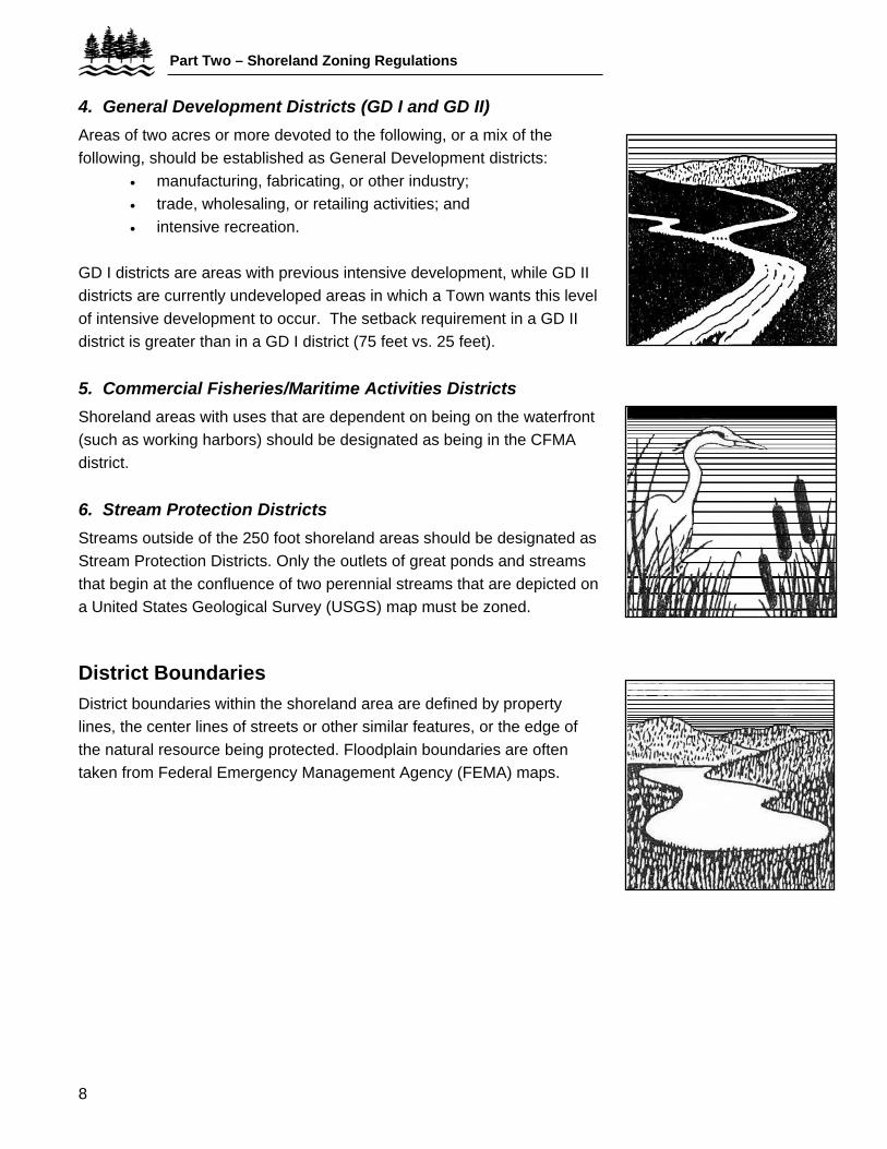
4. General Development Districts (GD I and GD II) Areas of two acres or more devoted to the following, or a mix of the following, should be established as General Development districts:
• manufacturing, fabricating, or other industry; • trade, wholesaling, or retailing activities; and • intensive recreation.
GD I districts are areas with previous intensive development, while GD II districts are currently undeveloped areas in which a Town wants this level of intensive development to occur. The setback requirement in a GD II district is greater than in a GD I district (75 feet vs. 25 feet). 5. Commercial Fisheries/Maritime Activities Districts Shoreland areas with uses that are dependent on being on the waterfront (such as working harbors) should be designated as being in the CFMA district. 6. Stream Protection Districts Streams outside of the 250 foot shoreland areas should be designated as Stream Protection Districts. Only the outlets of great ponds and streams that begin at the confluence of two perennial streams that are depicted on a United States Geological Survey (USGS) map must be zoned.
District Boundaries District boundaries within the shoreland area are defined by property lines, the center lines of streets or other similar features, or the edge of the natural resource being protected. Floodplain boundaries are often taken from Federal Emergency Management Agency (FEMA) maps.
9
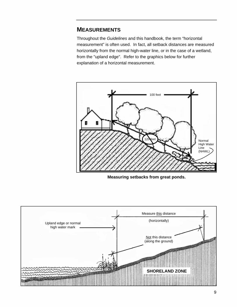
MEASUREMENTS Throughout the Guidelines and this handbook, the term “horizontal measurement” is often used. In fact, all setback distances are measured horizontally from the normal high-water line, or in the case of a wetland, from the "upland edge". Refer to the graphics below for further explanation of a horizontal measurement.
Normal High Water Line (NHWL)
100 feet
120 feet
Measuring setbacks from great ponds.
Upland edge or normal high water mark
Measure this distance
(horizontally)
Not this distance (along the ground)
SHORELAND ZONE
Part Two – Shoreland Zoning Regulations
10
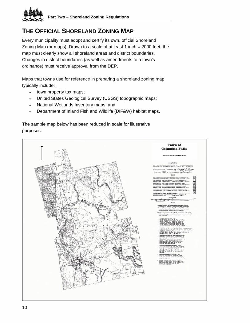
THE OFFICIAL SHORELAND ZONING MAP Every municipality must adopt and certify its own, official Shoreland Zoning Map (or maps). Drawn to a scale of at least 1 inch = 2000 feet, the map must clearly show all shoreland areas and district boundaries. Changes in district boundaries (as well as amendments to a town's ordinance) must receive approval from the DEP. Maps that towns use for reference in preparing a shoreland zoning map typically include:
• town property tax maps; • United States Geological Survey (USGS) topographic maps; • National Wetlands Inventory maps; and • Department of Inland Fish and Wildlife (DIF&W) habitat maps.
The sample map below has been reduced in scale for illustrative purposes.
Town of Columbia Falls
SHORELAND ZONING MAP
11
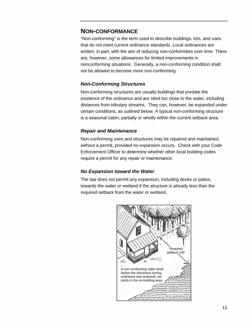
NON-CONFORMANCE "Non-conforming" is the term used to describe buildings, lots, and uses that do not meet current ordinance standards. Local ordinances are written, in part, with the aim of reducing non-conformities over time. There are, however, some allowances for limited improvements in nonconforming situations. Generally, a non-conforming condition shall not be allowed to become more non-conforming. Non-Conforming Structures Non-conforming structures are usually buildings that predate the existence of the ordinance and are sited too close to the water, including distances from tributary streams. They can, however, be expanded under certain conditions, as outlined below. A typical non-conforming structure is a seasonal cabin, partially or wholly within the current setback area. Repair and Maintenance Non-conforming uses and structures may be repaired and maintained, without a permit, provided no expansion occurs. Check with your Code Enforcement Officer to determine whether other local building codes require a permit for any repair or maintenance. No Expansion toward the Water The law does not permit any expansion, including decks or patios, towards the water or wetland if the structure is already less than the required setback from the water or wetland.
Required setback 100’
A non-conforming cabin (built before the shoreland zoning ordinance was enacted), set partly in the no-building area.
Part Two – Shoreland Zoning Regulations
12
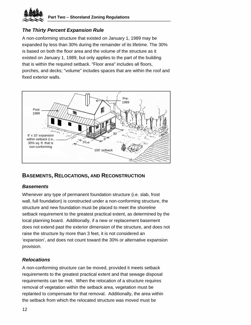
The Thirty Percent Expansion Rule A non-conforming structure that existed on January 1, 1989 may be expanded by less than 30% during the remainder of its lifetime. The 30% is based on both the floor area and the volume of the structure as it existed on January 1, 1989, but only applies to the part of the building that is within the required setback. "Floor area" includes all floors, porches, and decks; "volume" includes spaces that are within the roof and fixed exterior walls.
9’ x 10’ expansion within setback (i.e., 30% sq. ft. that is non-conforming
Post 1989
30’9’
10
Pre-1989
100’ setback
BASEMENTS, RELOCATIONS, AND RECONSTRUCTION
Basements Whenever any type of permanent foundation structure (i.e. slab, frost wall, full foundation) is constructed under a non-conforming structure, the structure and new foundation must be placed to meet the shoreline setback requirement to the greatest practical extent, as determined by the local planning board. Additionally, if a new or replacement basement does not extend past the exterior dimension of the structure, and does not raise the structure by more than 3 feet, it is not considered an ‘expansion’, and does not count toward the 30% or alternative expansion provision. Relocations A non-conforming structure can be moved, provided it meets setback requirements to the greatest practical extent and that sewage disposal requirements can be met. When the relocation of a structure requires removal of vegetation within the setback area, vegetation must be replanted to compensate for that removal. Additionally, the area within the setback from which the relocated structure was moved must be
13
replanted with vegetation. Replanting standards for relocations include:
• Removed trees must be replaced with native trees, three feet in height, a least one tree planted for each tree removed. If more than five trees are planted, no one species can make up more than half of the total number planted. Replacement trees can be placed no further from the water body or wetland than those removed.
• An area at least the same size as what was removed of woody or herbaceous vegetation and ground cover must be re-established within the setback. This new vegetation must be of a similar type to that which was removed.
• Where feasible, the original location of the structure shall be replanted with vegetation.
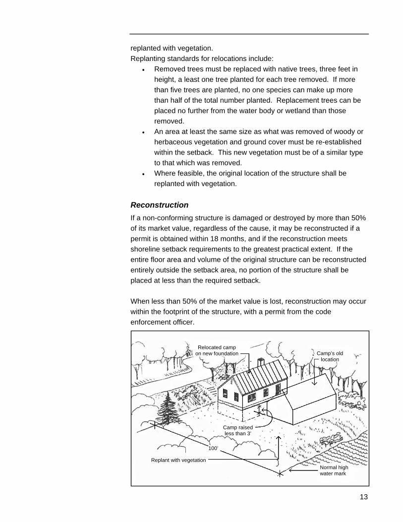
Reconstruction If a non-conforming structure is damaged or destroyed by more than 50% of its market value, regardless of the cause, it may be reconstructed if a permit is obtained within 18 months, and if the reconstruction meets shoreline setback requirements to the greatest practical extent. If the entire floor area and volume of the original structure can be reconstructed entirely outside the setback area, no portion of the structure shall be placed at less than the required setback. When less than 50% of the market value is lost, reconstruction may occur within the footprint of the structure, with a permit from the code enforcement officer.
Relocated camp on new foundation Camp’s old
location
Normal high water mark
Camp raised less than 3’
100’
Replant with vegetation
Part Two – Shoreland Zoning Regulations
14
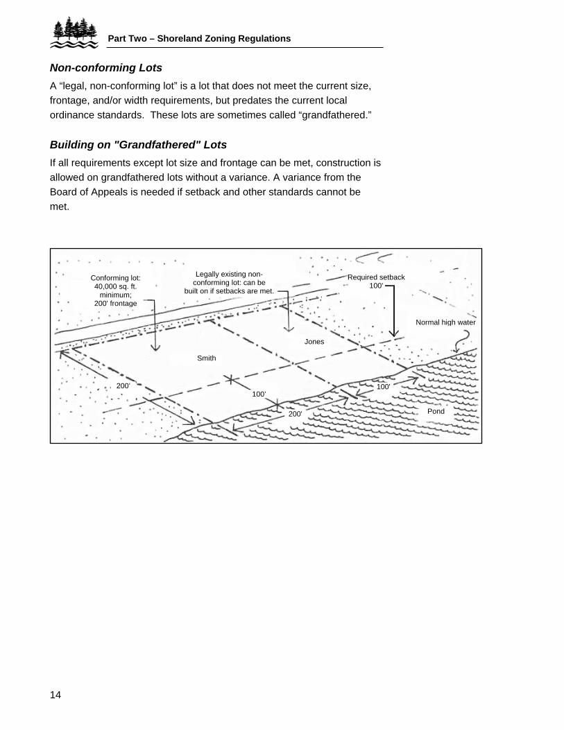
Non-conforming Lots A “legal, non-conforming lot” is a lot that does not meet the current size, frontage, and/or width requirements, but predates the current local ordinance standards. These lots are sometimes called “grandfathered.” Building on "Grandfathered" Lots If all requirements except lot size and frontage can be met, construction is allowed on grandfathered lots without a variance. A variance from the Board of Appeals is needed if setback and other standards cannot be met.
Conforming lot: 40,000 sq. ft.
minimum; 200' frontage
Legally existing non-conforming lot: can be
built on if setbacks are met.
Jones
Required setback 100'
Normal high water
Pond
Smith
200'
100'200’ 100’
15
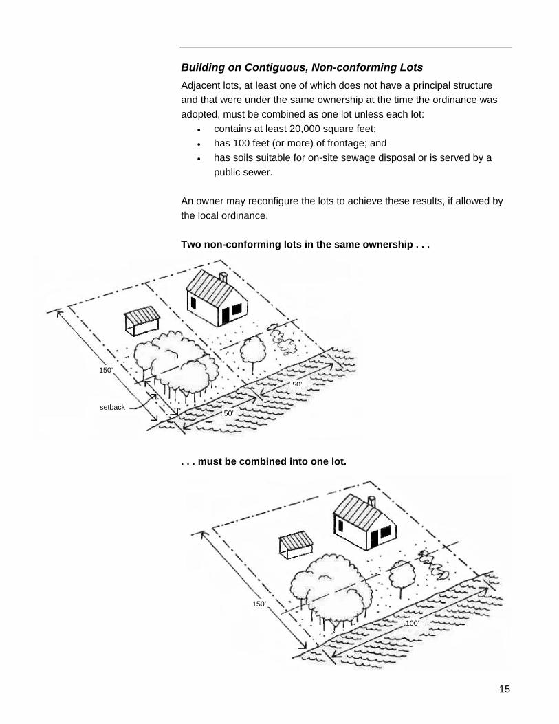
Building on Contiguous, Non-conforming Lots Adjacent lots, at least one of which does not have a principal structure and that were under the same ownership at the time the ordinance was adopted, must be combined as one lot unless each lot:
• contains at least 20,000 square feet; • has 100 feet (or more) of frontage; and • has soils suitable for on-site sewage disposal or is served by a
public sewer. An owner may reconfigure the lots to achieve these results, if allowed by the local ordinance. Two non-conforming lots in the same ownership . . .
setback
150’
50’
50’
. . . must be combined into one lot.
100’
150’
Part Two – Shoreland Zoning Regulations
16
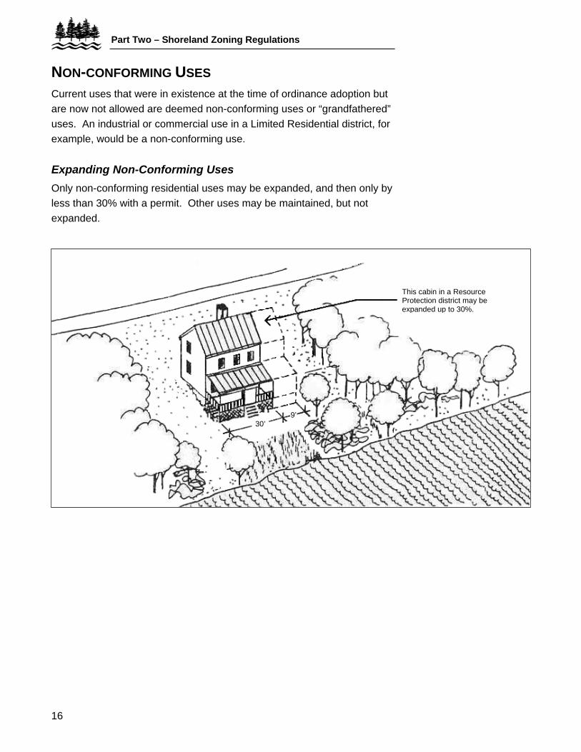
NON-CONFORMING USES
Current uses that were in existence at the time of ordinance adoption but are now not allowed are deemed non-conforming uses or “grandfathered” uses. An industrial or commercial use in a Limited Residential district, for example, would be a non-conforming use. Expanding Non-Conforming Uses Only non-conforming residential uses may be expanded, and then only by less than 30% with a permit. Other uses may be maintained, but not expanded.
This cabin in a Resource Protection district may be expanded up to 30%.
9’30’
17
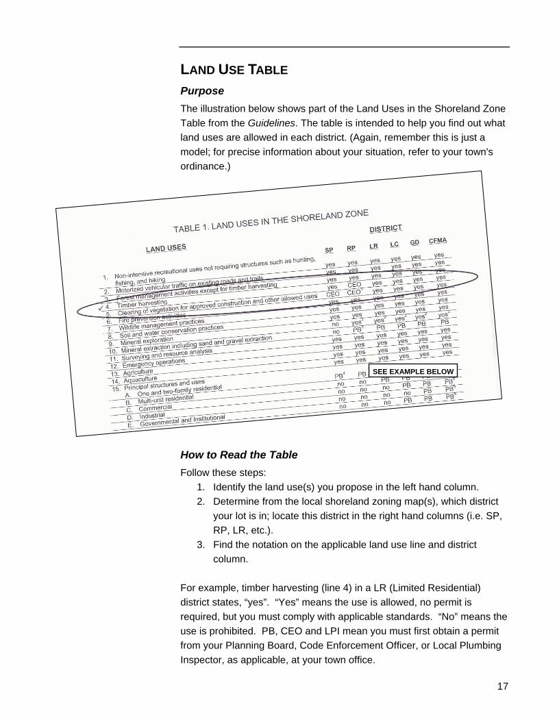
LAND USE TABLE Purpose The illustration below shows part of the Land Uses in the Shoreland Zone Table from the Guidelines. The table is intended to help you find out what land uses are allowed in each district. (Again, remember this is just a model; for precise information about your situation, refer to your town's ordinance.)
SEE EXAMPLE BELOW
How to Read the Table Follow these steps:
1. Identify the land use(s) you propose in the left hand column. 2. Determine from the local shoreland zoning map(s), which district
your lot is in; locate this district in the right hand columns (i.e. SP, RP, LR, etc.).
3. Find the notation on the applicable land use line and district column.
For example, timber harvesting (line 4) in a LR (Limited Residential) district states, “yes”. “Yes” means the use is allowed, no permit is required, but you must comply with applicable standards. “No” means the use is prohibited. PB, CEO and LPI mean you must first obtain a permit from your Planning Board, Code Enforcement Officer, or Local Plumbing Inspector, as applicable, at your town office.
Part Three – Land Use Standards
18
PART THREE – LAND USE STANDARDS All permitted land uses, whether they require a permit or not, must conform to the applicable standards, as described in your local ordinance. The most commonly used standards are explained on the following pages. For more information about the standards that apply specifically to your situation, refer to your local shoreland zoning ordinance.
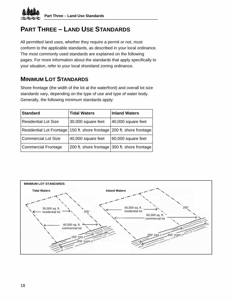
MINIMUM LOT STANDARDS Shore frontage (the width of the lot at the waterfront) and overall lot size standards vary, depending on the type of use and type of water body. Generally, the following minimum standards apply:
Standard Tidal Waters Inland Waters
Residential Lot Size 30,000 square feet 40,000 square feet
Residential Lot Frontage 150 ft. shore frontage 200 ft. shore frontage
Commercial Lot Size 40,000 square feet 60,000 square feet
Commercial Frontage 200 ft. shore frontage 300 ft. shore frontage
30,000 sq. ft. residential lot
40,000 sq. ft. commercial lot
200 ‘ 40,000 sq. ft. residential lot
60,000 sq. ft. commercial lot
150’ (res.) 200’ (com.)
200’ (res.) 300’ (com.)
200 ‘
Inland WatersTidal Waters
MINIMUM LOT STANDARDS:
19
Additionally: 1. The minimum lot width within 100 feet of the shoreline can be no
less than the shore frontage standard. 2. Land below normal high-water and roads cannot be included in
the lot area. 3. The frontage and lot size requirement applies to each principal
structure, dwelling unit, or use. 4. Lots located on opposite sides of a road shall be considered a
separate parcel of land unless the road was established by the owner after September 22, 1971.
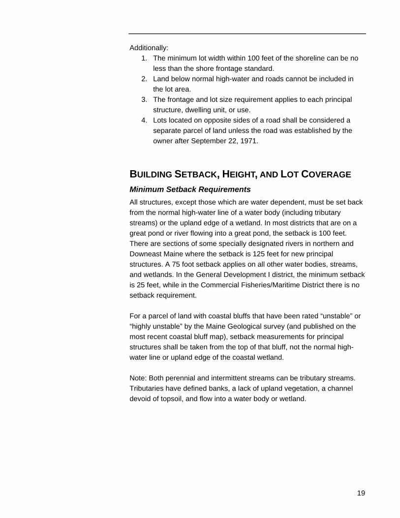
BUILDING SETBACK, HEIGHT, AND LOT COVERAGE Minimum Setback Requirements All structures, except those which are water dependent, must be set back from the normal high-water line of a water body (including tributary streams) or the upland edge of a wetland. In most districts that are on a great pond or river flowing into a great pond, the setback is 100 feet. There are sections of some specially designated rivers in northern and Downeast Maine where the setback is 125 feet for new principal structures. A 75 foot setback applies on all other water bodies, streams, and wetlands. In the General Development I district, the minimum setback is 25 feet, while in the Commercial Fisheries/Maritime District there is no setback requirement. For a parcel of land with coastal bluffs that have been rated “unstable” or “highly unstable” by the Maine Geological survey (and published on the most recent coastal bluff map), setback measurements for principal structures shall be taken from the top of that bluff, not the normal high-water line or upland edge of the coastal wetland. Note: Both perennial and intermittent streams can be tributary streams. Tributaries have defined banks, a lack of upland vegetation, a channel devoid of topsoil, and flow into a water body or wetland.
Part Three – Land Use Standards
20
Setback100’
Normal high-water mark
Great ponds and some rivers
Residential District
Residential District
Factory
Setback75’
Other rivers, streams, and wetlands
Setback 25’
All shoreland zoning
General Development District I Tributary stream in the shoreland zone
Setback75’
Residential District
Height Restrictions The maximum height of a new or expanded structure in a Resource Protection, Limited Residential, Limited Commercial, or Stream Protection district is 35 feet (measured from the downhill side of the building to the roof peak).
35’ maximum, measured on downhill side
21
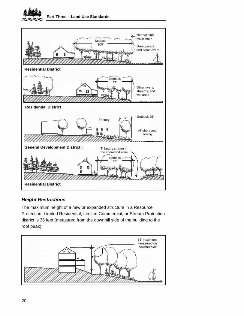
Flood Elevation The lowest floor of all principal buildings, including the basement, must be at least one foot above the 100-year flood elevation. Your town office should have the flood hazard maps on file, showing the location of the 100-year flood elevation.
Basement fill
100-year flood zone
Minimum distance 1’
100-year flood elevation
River
Lot coverage Because non-vegetated surfaces increase runoff, the total area of a lot covered by structures, driveways, parking areas, decks, patios, and other non-vegetated surfaces is limited to 20% in shoreland areas. In General Development Districts which are on tidal waters or rivers that do not flow into great ponds, and in Commercial Fisheries and Maritime Activity districts, the limit is 70%.
Setback line
200’
Total area permitted to be developed and covered by non-vegetated (i.e., house, garage, driveway, paths, etc.) surfaces: 20% of 40,000 sq. ft. or 8,000
sq. ft. 100’
200’ frontage
Part Three – Land Use Standards
22
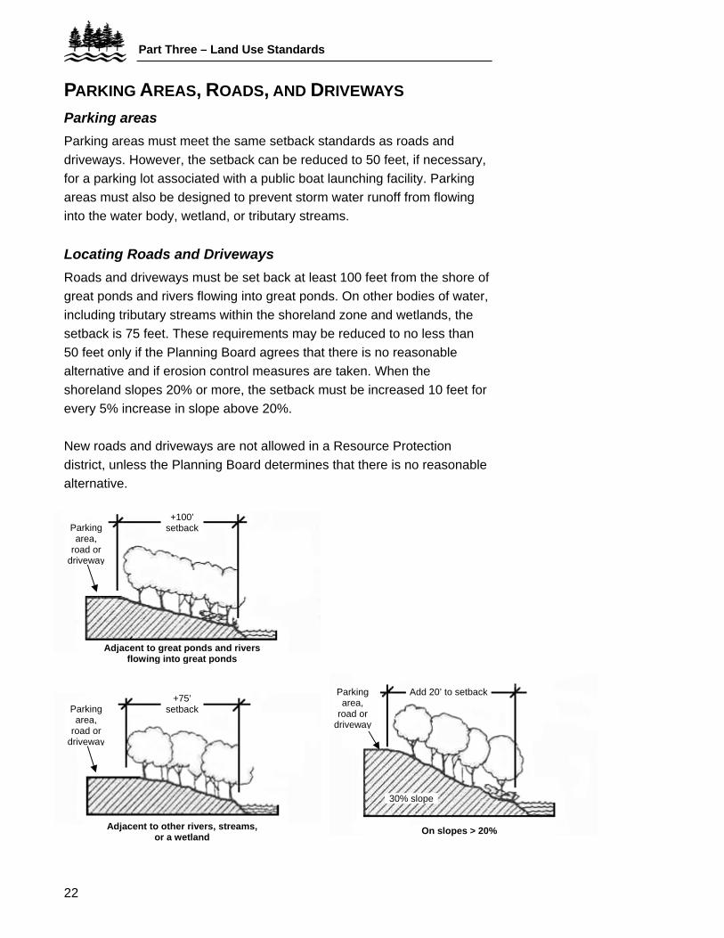
PARKING AREAS, ROADS, AND DRIVEWAYS Parking areas Parking areas must meet the same setback standards as roads and driveways. However, the setback can be reduced to 50 feet, if necessary, for a parking lot associated with a public boat launching facility. Parking areas must also be designed to prevent storm water runoff from flowing into the water body, wetland, or tributary streams. Locating Roads and Driveways Roads and driveways must be set back at least 100 feet from the shore of great ponds and rivers flowing into great ponds. On other bodies of water, including tributary streams within the shoreland zone and wetlands, the setback is 75 feet. These requirements may be reduced to no less than 50 feet only if the Planning Board agrees that there is no reasonable alternative and if erosion control measures are taken. When the shoreland slopes 20% or more, the setback must be increased 10 feet for every 5% increase in slope above 20%. New roads and driveways are not allowed in a Resource Protection district, unless the Planning Board determines that there is no reasonable alternative.
Adjacent to other rivers, or a wetland
streams,
+100’ setback
Adjacent to great ponds anflowin
d rivers
Parking area,
road or driveway
g into great ponds
On slopes > 20%
Parking area,
road or driveway
Add 20’ to setback
30% slope
+75’ setback Parking
area, road or
driveway
23
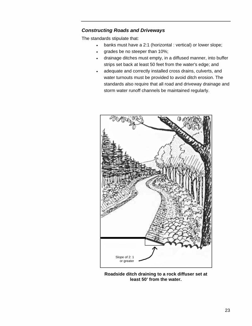
Constructing Roads and Driveways The standards stipulate that:
• banks must have a 2:1 (horizontal : vertical) or lower slope; • grades be no steeper than 10%; • drainage ditches must empty, in a diffused manner, into buffer
strips set back at least 50 feet from the water's edge; and • adequate and correctly installed cross drains, culverts, and
water turnouts must be provided to avoid ditch erosion. The standards also require that all road and driveway drainage and storm water runoff channels be maintained regularly.
Slope of 2: 1 or greater
Roadside ditch draining to a rock diffuser set at least 50’ from the water.
Part Three – Land Use Standards
24
STORMWATER RUNOFF AND EROSION CONTROL When development is undertaken in the shoreland zone, it is essential that adequate measures are taken to prevent exposed soil and pollutants from reaching the water. The standards require that:
• natural site features such as small wetlands, wooded areas, swales and berms, be retained to reduce runoff; and
• a soil erosion and sediment control plan be prepared that shows: how disturbed soils will be mulched and revegetated; where hay bales, silt fencing and/or diversion ditches will be placed; where permanent stabilizing structures may be needed; and how the site plan is designed to fit with the slopes and contours of the land.
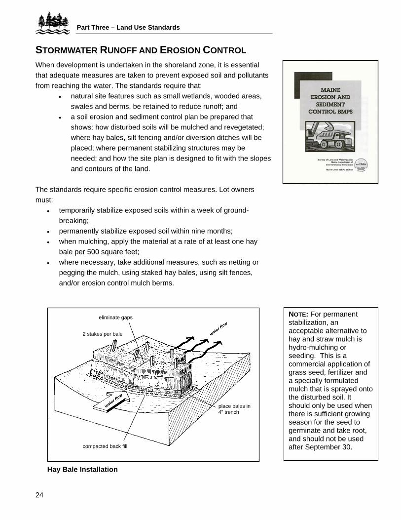
The standards require specific erosion control measures. Lot owners must:
• temporarily stabilize exposed soils within a week of ground-breaking;
• permanently stabilize exposed soil within nine months; • when mulching, apply the material at a rate of at least one hay
bale per 500 square feet; • where necessary, take additional measures, such as netting or
pegging the mulch, using staked hay bales, using silt fences, and/or erosion control mulch berms.
NOTE: For permanent stabilization, an acceptable alternative to hay and straw mulch is hydro-mulching or seeding. This is a commercial application of grass seed, fertilizer and a specially formulated mulch that is sprayed onto the disturbed soil. It should only be used when there is sufficient growing season for the seed to germinate and take root, and should not be used after September 30.
eliminate gaps
2 stakes per bale
place bales in 4” trench
compacted back fill
Hay Bale Installation
25
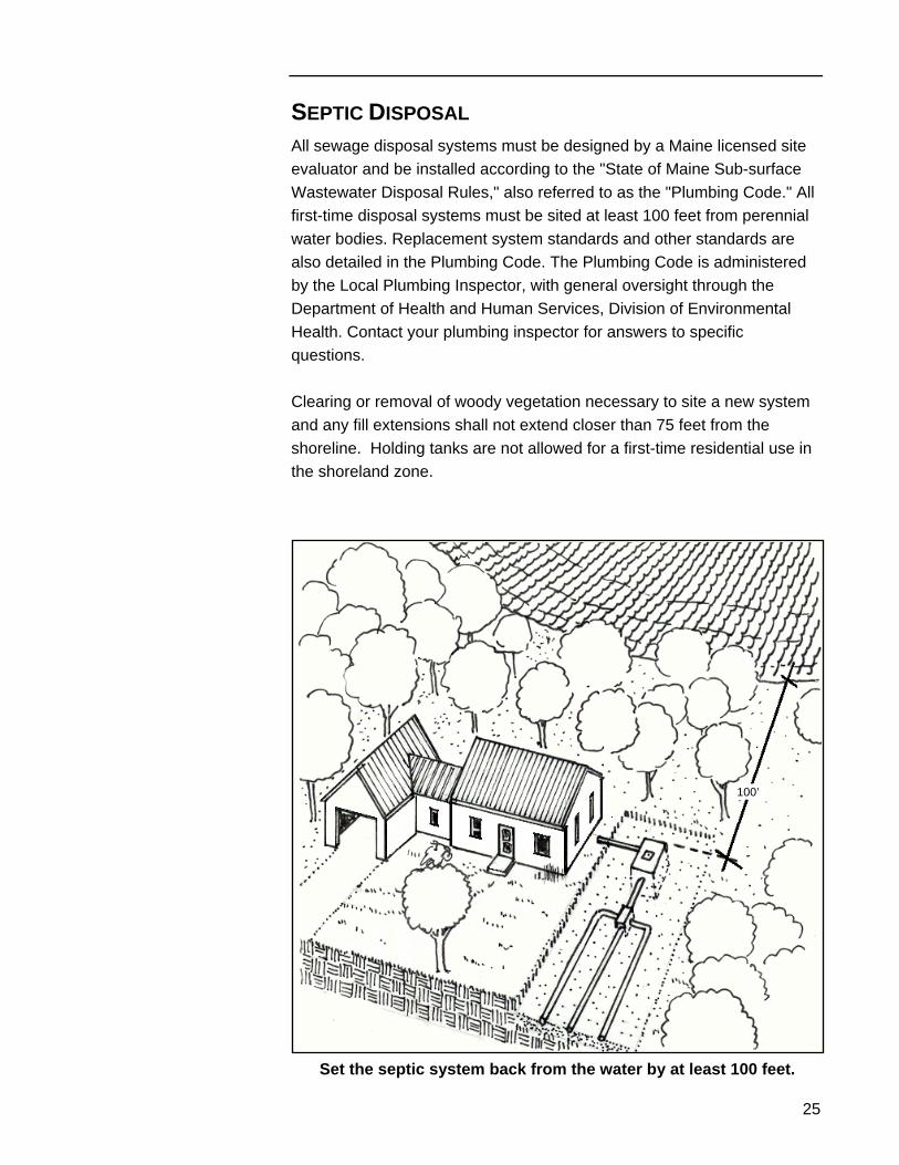
SEPTIC DISPOSAL All sewage disposal systems must be designed by a Maine licensed site evaluator and be installed according to the "State of Maine Sub-surface Wastewater Disposal Rules," also referred to as the "Plumbing Code." All first-time disposal systems must be sited at least 100 feet from perennial water bodies. Replacement system standards and other standards are also detailed in the Plumbing Code. The Plumbing Code is administered by the Local Plumbing Inspector, with general oversight through the Department of Health and Human Services, Division of Environmental Health. Contact your plumbing inspector for answers to specific questions. Clearing or removal of woody vegetation necessary to site a new system and any fill extensions shall not extend closer than 75 feet from the shoreline. Holding tanks are not allowed for a first-time residential use in the shoreland zone.
100’
Set the septic system back from the water by at least 100 feet.
Part Three – Land Use Standards
26
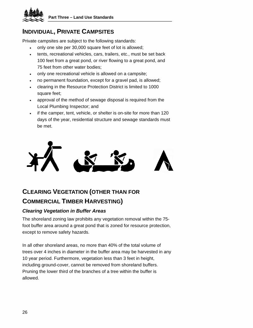
INDIVIDUAL, PRIVATE CAMPSITES Private campsites are subject to the following standards:
• only one site per 30,000 square feet of lot is allowed; • tents, recreational vehicles, cars, trailers, etc., must be set back
100 feet from a great pond, or river flowing to a great pond, and 75 feet from other water bodies;
• only one recreational vehicle is allowed on a campsite; • no permanent foundation, except for a gravel pad, is allowed; • clearing in the Resource Protection District is limited to 1000
square feet; • approval of the method of sewage disposal is required from the
Local Plumbing Inspector; and • if the camper, tent, vehicle, or shelter is on-site for more than 120
days of the year, residential structure and sewage standards must be met.
CLEARING VEGETATION (OTHER THAN FOR
COMMERCIAL TIMBER HARVESTING) Clearing Vegetation in Buffer Areas The shoreland zoning law prohibits any vegetation removal within the 75-foot buffer area around a great pond that is zoned for resource protection, except to remove safety hazards. In all other shoreland areas, no more than 40% of the total volume of trees over 4 inches in diameter in the buffer area may be harvested in any 10 year period. Furthermore, vegetation less than 3 feet in height, including ground-cover, cannot be removed from shoreland buffers. Pruning the lower third of the branches of a tree within the buffer is allowed.
27
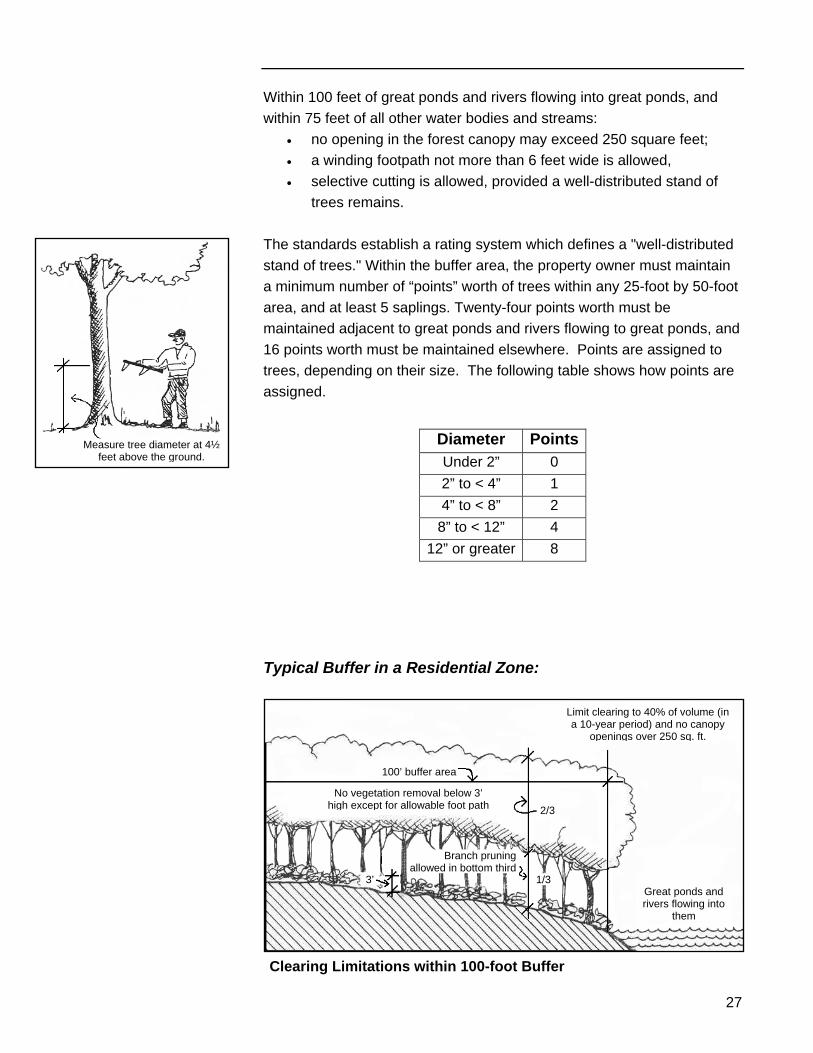
Within 100 feet of great ponds and rivers flowing into great ponds, and within 75 feet of all other water bodies and streams:
• no opening in the forest canopy may exceed 250 square feet; • a winding footpath not more than 6 feet wide is allowed, • selective cutting is allowed, provided a well-distributed stand of
trees remains. The standards establish a rating system which defines a "well-distributed stand of trees." Within the buffer area, the property owner must maintain a minimum number of “points” worth of trees within any 25-foot by 50-foot area, and at least 5 saplings. Twenty-four points worth must be maintained adjacent to great ponds and rivers flowing to great ponds, and 16 points worth must be maintained elsewhere. Points are assigned to trees, depending on their size. The following table shows how points are assigned.
Measure tree diameter at 4½ feet above the ground.
Diameter Points
Under 2” 0 2” to < 4” 1 4” to < 8” 2
8” to < 12” 4 12” or greater 8
Typical Buffer in a Residential Zone:
Limit clearing to 40% of volume (in a 10-year period) and no canopy
openings over 250 sq. ft.
100’ buffer area
No vegetation removal below 3’ high except for allowable foot path 2/3
Branch pruning allowed in bottom third
3’ 1/3Great ponds and rivers flowing into
them
Clearing Limitations within 100-foot Buffer
Part Three – Land Use Standards
28
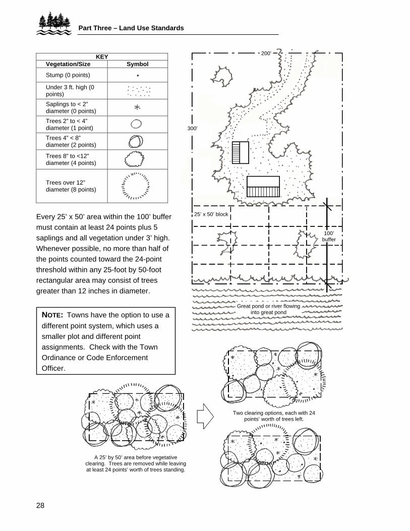
Every 25’ x 50’ area within the 100’ buffer must contain at least 24 points plus 5 saplings and all vegetation under 3’ high. Whenever possible, no more than half of the points counted toward the 24-point threshold within any 25-foot by 50-foot rectangular area may consist of trees greater than 12 inches in diameter.
KEY Vegetation/Size Symbol
Stump (0 points)
Under 3 ft. high (0 points)
Saplings to < 2” diameter (0 points)
Trees 2” to < 4” diameter (1 point)
Trees 4” < 8” diameter (2 points)
Trees 8” to <12” diameter (4 points)
Trees over 12” diameter (8 points)
300’
200’
25’ x 50’ block
100’ buffer
Great pond or river flowing into great pond
Great Pond or Lake
NOTE: Towns have the option to use a different point system, which uses a smaller plot and different point assignments. Check with the Town Ordinance or Code Enforcement Officer.
A 25’ by 50’ area before vegetative clearing. Trees are removed while leaving at least 24 points’ worth of trees standing.
Two clearing options, each with 24 points’ worth of trees left.
29
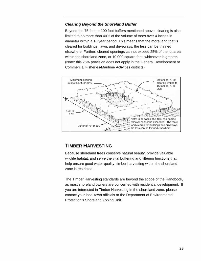
Clearing Beyond the Shoreland Buffer Beyond the 75 foot or 100 foot buffers mentioned above, clearing is also limited to no more than 40% of the volume of trees over 4 inches in diameter within a 10 year period. This means that the more land that is cleared for buildings, lawn, and driveways, the less can be thinned elsewhere. Further, cleared openings cannot exceed 25% of the lot area within the shoreland zone, or 10,000 square feet, whichever is greater. (Note: this 25% provision does not apply in the General Development or Commercial Fisheries/Maritime Activities districts)
Note: In all cases, the 40% cap on tree removal cannot be exceeded. The more land cleared for buildings and driveways, the less can be thinned elsewhere.
60,000 sq. ft. lot:clearing limited to 15,000 sq. ft. or 25%
Maximum clearing10,000 sq. ft. or 25%
150’ to 175’
Buffer of 75’ or 100’
TIMBER HARVESTING Because shoreland trees conserve natural beauty, provide valuable wildlife habitat, and serve the vital buffering and filtering functions that help ensure good water quality, timber harvesting within the shoreland zone is restricted. The Timber Harvesting standards are beyond the scope of the Handbook, as most shoreland owners are concerned with residential development. If you are interested in Timber Harvesting in the shoreland zone, please contact your local town officials or the Department of Environmental Protection’s Shoreland Zoning Unit.
Part Three – Land Use Standards
30
OPTIONAL PROVISIONS The state's Shoreland Zoning Act allows municipalities to increase the level of protection of their shoreland areas over and above the levels prescribed in the Guidelines. Towns often strengthen their ordinances by:
Forested wetland
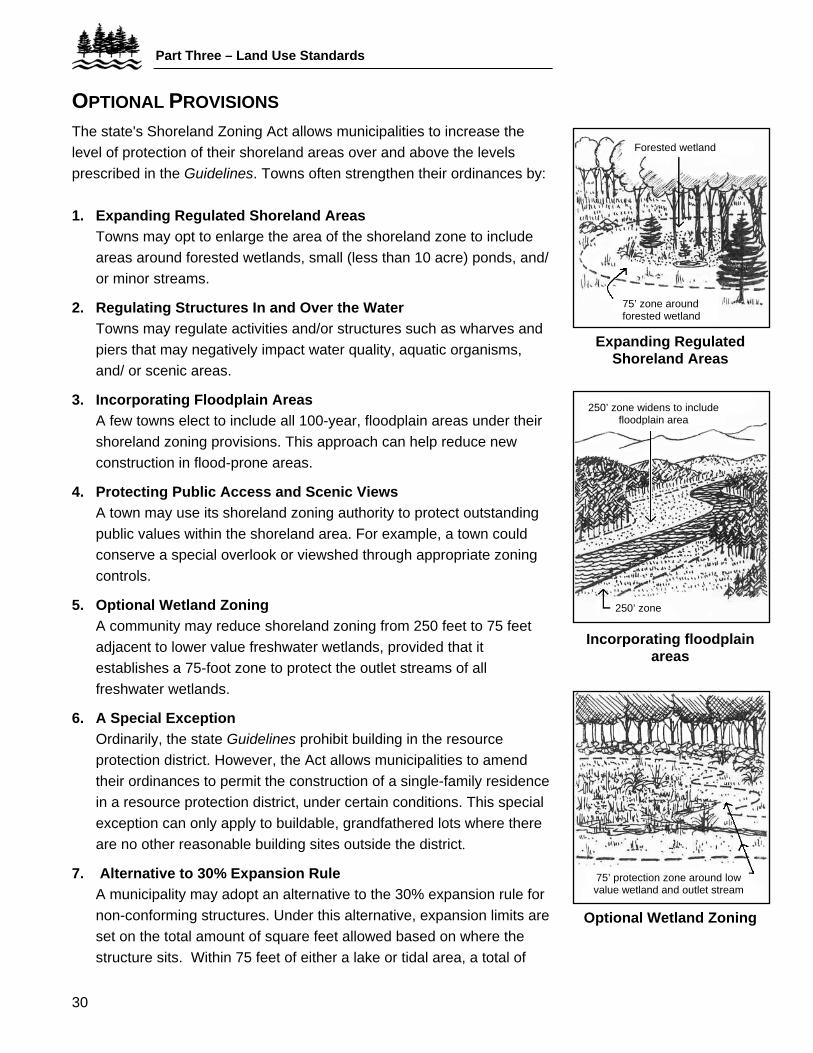
1. Expanding Regulated Shoreland Areas
Towns may opt to enlarge the area of the shoreland zone to include areas around forested wetlands, small (less than 10 acre) ponds, and/ or minor streams.
75’ zone around forested wetland2. Regulating Structures In and Over the Water
Towns may regulate activities and/or structures such as wharves and piers that may negatively impact water quality, aquatic organisms, and/ or scenic areas.
Expanding Regulated Shoreland Areas
3. Incorporating Floodplain Areas A few towns elect to include all 100-year, floodplain areas under their shoreland zoning provisions. This approach can help reduce new construction in flood-prone areas.
250’ zone widens to include floodplain area
4. Protecting Public Access and Scenic Views A town may use its shoreland zoning authority to protect outstanding public values within the shoreland area. For example, a town could conserve a special overlook or viewshed through appropriate zoning controls.
5. Optional Wetland Zoning A community may reduce shoreland zoning from 250 feet to 75 feet adjacent to lower value freshwater wetlands, provided that it establishes a 75-foot zone to protect the outlet streams of all freshwater wetlands.
250’ zone
Incorporating floodplain areas
6. A Special Exception Ordinarily, the state Guidelines prohibit building in the resource protection district. However, the Act allows municipalities to amend their ordinances to permit the construction of a single-family residence in a resource protection district, under certain conditions. This special exception can only apply to buildable, grandfathered lots where there are no other reasonable building sites outside the district.
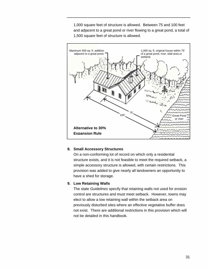
7. Alternative to 30% Expansion Rule A municipality may adopt an alternative to the 30% expansion rule for non-conforming structures. Under this alternative, expansion limits are set on the total amount of square feet allowed based on where the structure sits. Within 75 feet of either a lake or tidal area, a total of
75’ protection zone around low value wetland and outlet stream
Optional Wetland Zoning
31
1,000 square feet of structure is allowed. Between 75 and 100 feet and adjacent to a great pond or river flowing to a great pond, a total of 1,500 square feet of structure is allowed.
1,000 sq. ft. original house within 75’ of a great pond, river, tidal area or wetland.
Great Pond or river
Maximum 500 sq. ft. additionadjacent to a great pond.
75’
Alternative to 30% Expansion Rule
100’
8. Small Accessory Structures On a non-conforming lot of record on which only a residential structure exists, and it is not feasible to meet the required setback, a simple accessory structure is allowed, with certain restrictions. This provision was added to give nearly all landowners an opportunity to have a shed for storage.
9. Low Retaining Walls The state Guidelines specify that retaining walls not used for erosion control are structures and must meet setback. However, towns may elect to allow a low retaining wall within the setback area on previously disturbed sites where an effective vegetative buffer does not exist. There are additional restrictions in this provision which will not be detailed in this handbook.
Part Four — The Roles of Local Officials
32
PART FOUR — THE ROLES OF LOCAL OFFICIALS
THE CODE ENFORCEMENT OFFICER All municipalities are required to appoint a code enforcement officer (CEO). It is the duty of the CEO to:
• enforce your local shoreland zoning ordinance; • collect fees, if authorized, for every permit issued; • conduct on-site inspections to assure compliance; • keep a record of all shoreland related transactions and submit
a summary of this record to DEP biennially; • review applications for new residential construction.
The "land uses" table in your local Shoreland Ordinance notes which kinds of permits may be issued by the local Code Enforcement Officer.
THE PLANNING BOARD The municipal Planning Board is responsible for preparing and administering the local Shoreland Zoning Ordinance and Map. Working with the Code Enforcement Officer, the Board processes permit applications at regularly scheduled, public meetings. Some specific duties of the Planning Board include:
• making recommendations to town officials regarding ordinance amendments and rezoning petitions;
• reviewing applications for reconstructing and relocating non-conforming structures;
• reviewing applications for commercial and industrial uses; and • reviewing applications for new roads and parking facilities.
33
Permit Application Every applicant shall submit a written application to the appropriate official (see the Land Uses Table) on a form provided by the town. Information required in the application should include:
• a scaled site plan; • evidence of right, title or interest in the property; • valid plumbing permit, including site evaluation approved by
Plumbing Inspector, if necessary; • date and signature of the applicant or agent of the applicant.
The applicant has the burden of proving that the proposed land use activity is in conformity with the town’s Shoreland Zoning Ordinance.
THE BOARD OF APPEALS It is the duty of the municipal Board of Appeals to hear and act upon appeals of Planning Board or CEO decisions; to grant variances, if appropriate; to interpret ordinance provisions; and to settle zoning district boundary disputes. Variances can only be granted under certain narrow circumstances. "Use" variances are not allowed, but lot width, coverage, and setback requirements may be modified if the applicant can demonstrate undue hardship. "Undue hardship" means that the owners must prove that they can only obtain a reasonable return from the property if the variance is granted; that the need for a variance is caused by unique site conditions; that granting the variance will not change the character of the area; and that the hardship was not caused by the current or previous owner. All appeals must be made in writing and all Appeals Board decisions must also be in writing. Strict time limits (typically 30 to 45 days) are set to give all parties reasonable time to act. When a variance is granted by the Board of Appeals, the landowner is responsible for recording a certificate of variance approval at the local registry of deeds within 90 days of the final written approval. Otherwise, the variance is voided. Municipalities must send copies of variance approvals to the DEP within 7 days of the approval decision.
References
34
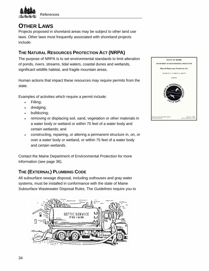
OTHER LAWS Projects proposed in shoreland areas may be subject to other land use laws. Other laws most frequently associated with shoreland projects include:
THE NATURAL RESOURCES PROTECTION ACT (NRPA) The purpose of NRPA is to set environmental standards to limit alteration of ponds, rivers, streams, tidal waters, coastal dunes and wetlands, significant wildlife habitat, and fragile mountain areas. Human actions that impact these resources may require permits from the state. Examples of activities which require a permit include:
• Filling; • dredging; • bulldozing; • removing or displacing soil, sand, vegetation or other materials in
a water body or wetland or within 75 feet of a water body and certain wetlands; and
• constructing, repairing, or altering a permanent structure in, on, or over a water body or wetland, or within 75 feet of a water body and certain wetlands.
Contact the Maine Department of Environmental Protection for more information (see page 36).
THE (EXTERNAL) PLUMBING CODE All subsurface sewage disposal, including outhouses and gray water systems, must be installed in conformance with the state of Maine Subsurface Wastewater Disposal Rules. The Guidelines require you to
35
have a valid plumbing permit, or a completed application for a permit, when your proposed construction in the shoreland zone involves sewage disposal. For more information, please contact your local plumbing inspector.
THE SEASONAL CONVERSION LAW If you wish to convert a seasonal dwelling in the shoreland zone to a permanent, year-round home, you may be required to obtain a seasonal conversion permit from the local plumbing inspector. The law ensures that adequate subsurface wastewater disposal systems are put in place to handle increased usage.
SUBDIVISION LAW If you propose to subdivide an existing lot in the shoreland area (or anywhere in Maine) to create a total of three or more lots within a five year period, you are subject to local Subdivision Ordinance requirements. Or, if you live in an unorganized township or plantation, check with the Maine Land Use Regulation Commission (see page 36). If the subdivision is a large one (15 or more lots involving 30 or more acres), check with the Department of Environmental Protection to make sure that you are not also subject to the state's Site Location of Development Law.
EROSION AND SEDIMENTATION CONTROL LAW This law applies to all filling or earth cutting that exposes the soil to erosion. It applies in all areas, whether or not they are in the shoreland zone, and requires that measures to control erosion and sedimentation are put in place before any earth work begins (see page 24 for more information). This law, too, is administered by the DEP.
THE STORMWATER MANAGEMENT LAW Stormwater is water that flows over the ground as a result of rain and snowmelt. The Stormwater Management Law seeks to control pollutants that are washed by stormwater into waterbodies and groundwater. Additionally, the Stormwater Management Law seeks to control increased flows which can cause flooding and property damage. A permit from the DEP is required for any development that includes 20,000 square feet of impervious area or 5 acres or more of disturbed area in the direct watershed of a “waterbody most at risk from new development”. Additionally, a permit is required for a project that creates 1 acre or more of impervious area or 5 acres or more of disturbed area in any other watershed.
References
36
REFERENCES STATE AGENCY CONTACTS For shoreland zoning, Natural Resources Protection Act, and erosion and sedimentation control information, contact the office of the Maine DEP nearest you: Maine Department of Environmental Protection (DEP): http://www.maine.gov.dep Bureau of Land and Water Quality 17 State House Station Augusta, ME 04333-0017 Tel. (207) 287-3901 or 1-800-452-1942 DEP Southern Maine Regional Office 312 Canco Road Portland, ME 04103 Tel. (207) 822-6300 or 1-888-769-1036
DEP Eastern Maine Regional Office 106 Hogan Road Bangor, ME 04401 Tel. (207) 941-4570 or 1-888-769-1137 DEP Northern Maine Regional Office 1235 Central Drive Presque Isle, ME 04769 Tel. (207) 764-0477 or 1-888-769-1053
For Plumbing Code and seasonal conversion information: • Maine Department of Health and Human Services
Division of Environmental Health State House Station #11 Augusta, ME 04333 Tel. (207) 287-5689 or 287-5672 http://www.maine.gov/dhhs/eng
For shoreland zoning information in the unorganized townships and plantations of Maine: • Maine Department of Conservation
Land Use Regulation Commission State House Station #22 Augusta, ME 04333 Tel. (207) 287-2631 http://www.state.me.us/doc/lurc
37
USEFUL PUBLICATIONS Available from the DEP (for addresses and telephone numbers, see page 36):
• State of Maine Guidelines for Municipal Shoreland Zoning Ordinances
• State of Maine Mandatory Shoreland Zoning Act • Issue Profiles:
○ Mandatory Shoreland Zoning Act ○ Nonconforming Structures in the Shoreland Zone ○ Clearing of Vegetation in the Shoreland Zone
• Information Sheets: ○ Establishing the Starting Point for Measurement of the
Shoreland Zone and Related Setback Determinations ○ Homeowner’s Guide to Environmental Laws ○ Timber Harvesting Guide for Organized Areas
Available from the Congress of Lake Associations (COLA) P.O. Box 426 Belgrade, ME 04917 The Lake Book or e-mail them at: [email protected] .