Embed Size (px)
Citation preview
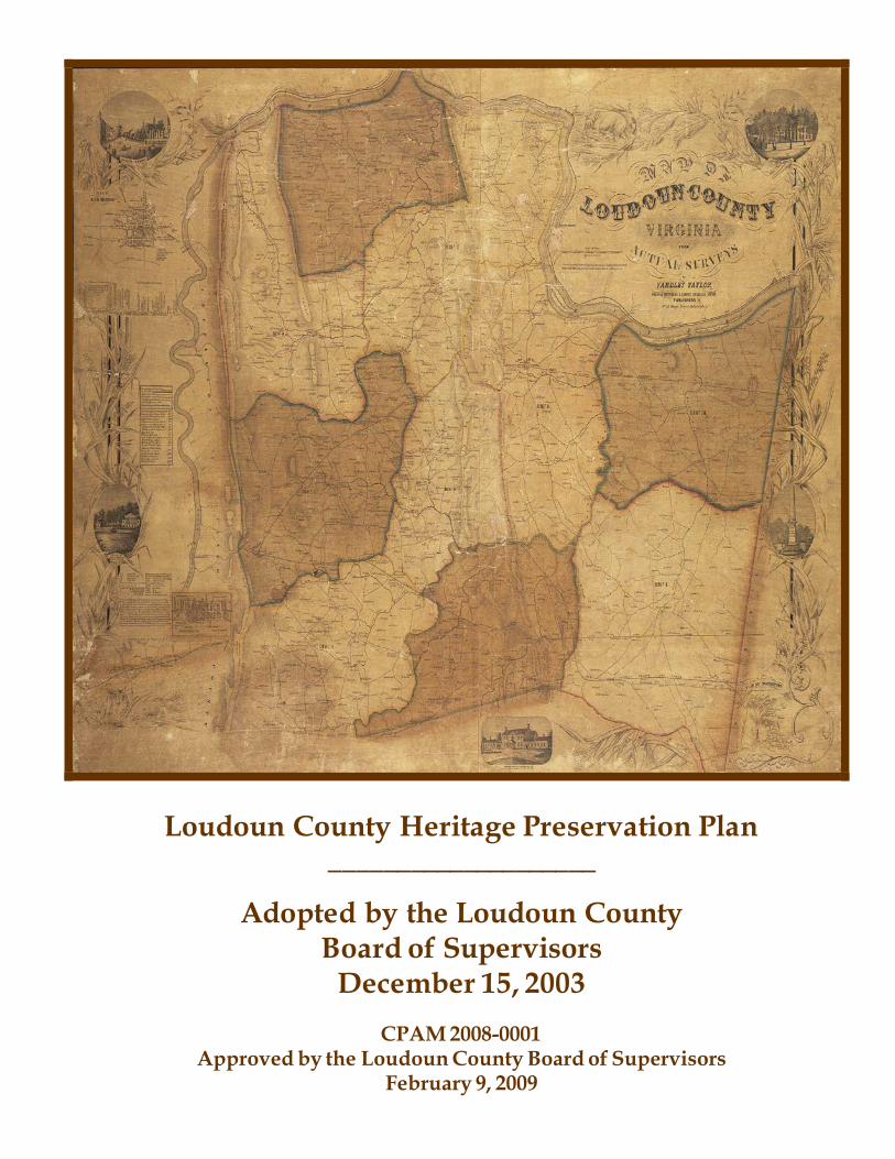
Loudoun County Heritage Preservation Plan ____________________
Adopted by the Loudoun County Board of Supervisors
December 15, 2003
CPAM 2008-0001 Approved by the Loudoun County Board of Supervisors
February 9, 2009

Addendum: 2008 Review Process and Current Plan Implementation 2008 Process In February, 2008, the Board of Supervisors resolved to re-affirm the Heritage Preservation Plan and directed the Planning Commission to review the Plan, solicit stakeholder input and recommend to the Board minor updates and edits to the Plan. As part of the Planning Commission’s review, the concept of adding a chapter on Civil War Battlefields was to be considered by the Commission. Between its adoption in 2003 and the 2008 re-affirmation of the Plan, strides were made by the County on several policy issues outlined in the Plan. These are listed briefly below: Historic Districts The County’s Historic District Interactive Website (www.loudoun.gov/historic) was launched in 2007. Funded in part by Certified Local Government grant money, the website is used to educate residents and the general public on the historic districts and associated benefits and regulations. Historic District Review Committee members and Planning Department staff have conducted realtor training programs on the County’s historic districts so that realtors can educate prospective buyers on the benefits and regulations of purchasing property in a locally administrated historic district. The County’s 2008 tax assessments highlight historic district designation to make property owners aware that their property falls within a locally administered historic district. The Historic District Guidelines adopted in 1987 were updated for the first time in 2008. This project was also partially funded through a Certified Local Government grant. Archaeological Resources A County Archaeologist was hired in 2007 in the Department of Building and Development. This position is responsible for the review of archaeological survey reports for ministerial development applications. The position also includes a public education component. The County Archaeologist has partnered with the Loudoun Museum on education and outreach activities, including “Archaeological Road Shows” where residents bring artifacts for identification. County-owned heritage sites such as Banshee Reeks Nature Preserve and Claude Moore Park, have been used to foster archaeological research, education and outreach programs. The non-profit Loudoun Archaeological Foundation, in coordination with the County, has taken the lead on the implementation of Plan policy that calls for County owned heritage properties to be a venue for public education programs.
Table of Contents ____________________
Executive Summary ............................................................................................................................................. I Preface....................................................................................................................................................................II What does the Preservation Plan mean for Property Owners?............................................................... III Heritage Preservation in Loudoun County: Past and Present ................................................................. V Phase –1 Actions ............................................................................................................................................. VIII Chapter One: Survey of Heritage Resources................................................................................................. 1 Chapter Two: Archaeological Resources ....................................................................................................... 7 Chapter Three: County Heritage Register ...................................................................................................14 Chapter Four: Historic Districts .....................................................................................................................18 Chapter Five: Cultural Landscapes ...............................................................................................................22 Chapter Six: Heritage Tourism.......................................................................................................................33 Chapter Seven: Stewardship of County-Owned Heritage Resources ...................................................38 Chapter Eight: Education ................................................................................................................................43 Chapter Nine: Development Review ............................................................................................................47 Chapter Ten: Design and Preservation Guidelines ...................................................................................55 Chapter Eleven: County Operations .............................................................................................................62 Implementation Matrix Appendix .......................................................................................................................................................... A-I Glossary............................................................................................................................................................. G-I

Executive Summary It is the primary goal of the Heritage Preservation Plan to facilitate the identification, preservation and promotion of the County’s heritage resources. The Plan explores three principal means of achieving this goal: resource protection, community education and heritage tourism. The majority of the County’s heritage resources are located on private property. Many are homes to Loudoun residents and one of the best methods of preservation is continued care through use. Recognizing this, the Heritage Preservation Plan focuses plan implementation on programmatic, incentive-based and education oriented strategies. The Plan is a tool to assist property owners in efforts to protect and preserve heritage resources. As a primary implementation recommendation, the Plan calls for the creation of a Heritage Commiss ion to bring together public and private preservation interests active in the County and spearhead community education and heritage tourism efforts. The Heritage Commission is the appropriate body to establish revolving funds and channel monies from the County’s expanding heritage tourism program into a variety of preservation efforts. The Plan addresses the need for government action to protect significant resources threatened by development pressures with the recognition that an expansion of state enabling legislation is necessary to do so effectively. The Plan contains policies and implementation strategies that aim to preserve the County’s many remaining resources and its successful implementation ultimately rests in the hands of the community. Heritage preservation should be undertaken on behalf of the citizens of the County. The stakeholders in this endeavor; property owners, land developers, local government, preservation groups and interested citizens, must have viable and creative tools to be good stewards of their heritage resources. The adoption and implementation of the Heritage Preservation Plan provides such tools and focuses efforts to ensure the future of our shared past.
Whether we are leaving it or coming to it, it is here that matters, it is place. Whether we understand where we are or don’t, that is the story. Storytelling is as old as our need to remember where the water i s, where the best food grows, where we find our courage for the hunt. It is as persistent as our desire to teach our children how to live in this place that we have known longer than they have. Our greatest and smallest explanations for ourselves grow from place, as surely as carrots grow in the dirt. …. Among the greatest of all gifts is to know our place. (Barbara Kingsolver, Small Wonders, 2002)
Lincoln, Virginia
Heritage Preservation Plan Introduction
II
Preface
“A country with no respect for its past will do little worth remembering in the future.” (Abraham Lincoln)
Loudoun County is located at the northern-most end of the State of Virginia, nestled among the foothills of the Blue Ridge Mountains and adjacent to the historic Potomac River. Loudoun has a greater variety of documented heritage resources than any other county in Virginia, as is evidenced by the Virginia Department of Historic Resources’ archives. Loudoun County’s rich geologic and environmental resources provided natural prehistoric settlement areas, particularly along the County’s watercourses and upland terraces. The ridges and valleys of the County have been traversed for thousands of years, first by Native Americans traveling between winter and summer camps, and later by settlers traveling north and south along the Old Carolina Road and east and west along the earliest turnpikes during the western frontier movement. These both facilitated the exploration and settlement that occurred in the early 18th century. Vestiges of these population movements and settlement areas remain, as do the natural resources that first attracted humans to the area. All of these elements assure the progress and development of Loudoun County making it one of the most desirable places in Virginia to live and work. The natural and historic resources that characterize Loudoun face serious threats. Rapid development, unsympathetic to existing resources, threatens the County’s heritage sites and will ultimately contribute to the diminution of the County’s heritage. Despite past losses and the prospect of unending threats , the heritage resources in Loudoun County remain significant and permit cautious optimism that the citizens of the County will secure a future distinctly richer and more diverse than the homogenized landscape of rapid-growth suburbia. In recognition of the real and potential loss of heritage resources in the face of unprecedented population growth and development, the voters of Loudoun County provided the Loudoun County Board of Supervisors with a mandate to manage growth. In response, the Board of Supervisors adopted the County’s Revised General Plan in July 2001. A goal of the Revised General Plan is to preserve “our historic and environmental heritage and the character of our towns and neighborhoods; fostering a strong sense of community, with robust economic, educational and recreational activity; (so that) the County is recognized as a superb place for families and individuals to live, learn, work, worship, invest and visit.” In 2002 the Board of Supervisors appointed a Citizens Advisory Committee (CAC) to draft a heritage preservation plan. The committee, comprised of interested citizens and preservation professionals, began its work early in 2003. Each member has brought valuable insight and broad perspectives to the task of defining, preserving and promoting the County’s rich heritage resources. Additionally, a team of s ta ff from various county departments and related agencies, such as the Loudoun Convention and Vis itors Association, has lent technical support to the CAC. Most importantly, the drafting of the plan has been a public process. The CAC has sought guidance from local and regional preservation experts, private preservation organizations, preservation community leaders and the general public. Public input sessions were held on March 10, and September 9, 2003to garner public comment on the draft plan. The Heritage Preservation Plan was adopted by the Board of Supervisors in December, 2003.
Heritage Preservation Plan Introduction
III
What does the Preservation Plan mean for Property Owners? Preservation efforts in Loudoun succeed because individual landowners, volunteer groups and companies see a benefit to preserving and using our heritage resources appropriately. The Preservation Plan reinforces preservation efforts pertaining to the protection and development of the property. Resource inventory An inventory of heritage properties aids in identifying and determining the value of the resource and its eligibility for Federal, State and local tax relief programs. The County will offer educational and technical support for property owners interested in evaluating their resources. A County Heritage Registry program will expand public awareness and support of preservation by acknowledging and rewarding participating owners through technical and financial assistance. Maintaining or improving property Several policies of the Plan speak to providing design assistance to landowners. A Design Resource Center will assist people proposing the adaptive reuse of their heritage resource. A County certification program will be defined and established to give County certification to a pool of craftsmen specia lizing in restoration and preservation of heritage sites in Loudoun County. State and federal programs offer tax relief to homeowners to rehabilitate or maintain eligible historic properties. The Preservation Plan proposes expanding a local real estate tax deferral program, currently available only to people who own older homes in Sterling and Sugarland Run, to heritage properties throughout the County. Participation in any of these programs is voluntary. Historic districts The Plan recommends that existing historic overlay zoning district boundaries be modified to align with State and National Register Historic District boundaries and that district guidelines be updated to reflect new circumstances and technology. The Plan supports State legislation that would allow regulations to protect heritage properties outside of historic districts. The mechanism to create new historic overlay zoning districts is unchanged. The Plan supports citizen efforts to identify new districts. New development Subdivisions will continue to require an archaeological survey. In addition, the Plan recommends a Context Analysis Report in some cases. Both together will provide a complete picture of any resources on or near a property that merit special consideration during the review process. Conservation design guidelines, where applicable, will be used to protect identified heritage resources . Predictive models will help identify sites with a potential for archaeological resources. The Plan proposes design guidelines to ensure that new development is compatible with identified heritage resources. These guidelines are not to be imposed by ordinance but offered as recommendations through the legislative development review process (rezonings, special exceptions…).

Heritage Preservation Plan Introduction
IV
Heritage tourism incentives The Plan offers technical support and financial incentives to heritage tourism efforts through a Heritage Commission appointed by the Board of Supervisors. Inappropriate ordinance standards that might impede new heritage business development will be identified and recommended for removal to ease the process of starting appropriate heritage businesses.

Heritage Preservation Plan Introduction
V
Historic District Local Designation
State Landmark National Register
National Landmark
County Aldie Yes Yes Yes Bluemont Yes Yes Yes Catoctin Rural No Yes No Goose Creek Yes Yes Yes Oatlands Yes Yes Yes Yes Paeonian Springs
No Yes Yes
Taylorstown Yes Yes Yes Unison No Yes Yes Waterford Yes Yes Yes Yes Towns Hillsboro No Yes Yes Leesburg Yes Yes Yes Middleburg Yes Yes Yes Purcellville Yes Yes Yes
Historic District Designations
Heritage Preservation in Loudoun County: Past and Present Where We’ve Been Loudoun County has a long history of heritage preservation. In recognition of the scenic vistas along Loudoun’s roadways, initial preservation efforts were aimed at retaining the rural, historic landscape by regulating roadway signs and billboards. The 1930’s and 40’s saw the proliferation of large roadway signs and billboards that obstructed the scenic views. A group of preservation-minded county residents, under the leadership of the Leesburg Garden Club and Loudoun’s first Planning Commission Chairman, Vinton Pickens of Janelia Farm, spearheaded the idea for the regulation of roadway signs. As a result, the County’s first sign ordinance was adopted in 1942.
In 1972, the County established the Historic and Cultural Conservation (HCC) Districts as zoning overlay districts. Subsequently, the County recognized the Aldie, Oatlands and Waterford HCC districts in 1972 , the Taylorstown district in 1976 and the Goose Creek Rural Historic District in 1977. As one of the firs t rural historic districts created in the state, the Goose Creek District was formed to preserve not only the historic architecture of the area but also the surrounding rural, agricultural landscape. In spite of Loudoun’s preservation efforts, the zoning within the district has allowed suburban style development to occur. In 1988 the Bluemont Historic District was created and in 2002, the County’s first Historic Roadways District, known as the Beaverdam Creek Historic Roadways District, was formed in the southwestern portion of the County. The Towns of Leesburg, Middleburg and Purcellville also administer local historic districts.
Heritage Preservation Plan Introduction
VI
As evidence of the vast and significant resources of the County, to date 70 sites and districts are listed in the National Register of Historic Places. These sites include each of the eight local historic districts mentioned above as well as the Town of Hillsboro and the villages of Unison and Paeonian Springs. Five of these National Register properties have also been designated National Historic Landmarks, the highest honor the federal government can bestow on a historic site. The County’s National Historic Landmarks are Balls Bluff Battlefield, Dodona Manor, Oak Hill, Oatlands and the village of Waterford. Sadly, the integrity of several of these resources, particularly Oatlands and the village of Waterford are threatened by rapid suburban development. North of Leesburg, the Catoctin Rural Historic District is listed on the Virginia Landmarks Register. Although the district is eligible for listing in the National Register, at the time of evaluation, there was a lack of community support for National Register recognition. In 2001, a portion of the village of Ashburn in eastern Loudoun was evaluated and deemed eligible for inclusion in the National Register but like the Catoctin Rural Historic District, sufficient community support was lacking. The Town of Purcellville has established a National Register District, while Hamilton, Lovettsville and Round Hill are in the process of evaluating their eligibility for inclusion in the National Register. In 1993, the Federal government completed a nation-wide study of some 10,500 armed conflicts related to the Civil War and identified 384 of the most significant or “principle battles.” Four of these “principle battles” took place in Loudoun County and are represented in the battlefield sites of Aldie, Middleburg, Upperville and Balls Bluff. Despite the rich resource base or perhaps because of it, the County still finds itself confronting daily attacks on our heritage resources, incurring tragic losses. The rural agricultural landscape and unique brick bank barn of Shenstone Farm west of Leesburg, the African American Settlement of Cooksville south of Purcellville, the Grenata (Elgin) House on Evergreen Mill Road southeast of Leesburg and the historic landscape related to Selma Plantation, along Route 15 north of Leesburg are just a few of examples of significant losses. Both Waterford and Oatlands are struggling with encroaching development. Many of the County’s successful preservation efforts have been achieved through the last minute heroics of individuals and cooperative landowners. The Settle Dean site, in the southeastern part of the County, was preserved through long negotiations with a developer who was willing to invest significant private funds to assess and move the structure. These events have underscored the need for a strategic plan specific to the issue of heritage preservation. The adoption of the Revised General Plan in July 2001 significantly expanded and strengthened the County’s regulatory standards. Heritage resources are now considered part of the County’s Green Infrastructure, the interconnecting network of natural and cultural features throughout the County. Viewing natural and cultural resources as related heritage resources is a new and innovative approach to resource protection. Within the development process, the Revised General Plan calls for the use of Conservation Design as the primary method of preserving and enhancing the County’s Green Infrastructure, including significant heritage resources. In addition, the Revised General Plan places a greater emphasis on preserving archaeological resources as part of the Green Infrastructure, calling for archaeological surveys to be conducted as part of the development process. These policies are manifest by regulation in both the County’s Zoning Ordinance and Facilities Standards Manual, governing by-right development. The Heritage Preservation Plan reinforces the vision of the Revised General Plan, recognizing that the County’s heritage is comprised of both natural and cultural assets. In 2002 the Board of Supervisors appointed a Citizens Advisory Committee (CAC) to draft a Heritage Preservation Plan. The purpose of this plan is to implement the Heritage Resource Policies of the Revised General Plan. The Heritage Preservation Plan provides an overview of the heritage resources and preservation challenges unique to the County and provides policy guidance and implementation
Heritage Preservation Plan Introduction
VII
strategies to citizens, landowners, developers and County staff to achieve rewarding and appropriate resource preservation.
LOUDOUN COUNTY BOARD OF SUPERVISORS’ VISION FOR LOUDOUN COUNTY
Adopted April 3, 2000
“At the start of this new millennium, we, the Loudoun County Board of Supervisors, env ision Loudoun County as a prominent sustainable community; as the global crossroads of the information technology industry and as a vibrant rural and broad based economy; preserving our historic and environmental heritage and the character of our towns and neighborhoods; fostering a strong sense of community , with robust economic, educational and recreational activity; recognized as a superb place for families and individuals to live, learn, work, worship, invest and visit.”
The Preservation Plan recognizes that there are a great number of groups and individuals already investing time and money in protecting the array of historic and natural resources in the County. Successful preservation efforts rely largely on the decisions and investments of individual landowners, volunteer groups and companies who recognize the value of their heritage and act to save it and use it appropriately. Many of the Plan’s recommended actions and programs are intended to support existing groups in their preservation, educational and heritage tourism efforts. In identifying the priority actions, the Preservation Plan seeks to move forward while minimizing new public costs. The costs associated with the following “Phase 1” implementation actions come from redirecting or adding to the responsibilities of existing staff and the formation of a Heritage Commiss ion to develop detailed implementation strategies. As implementation efforts progress, new resources may be needed.

Heritage Preservation Plan Introduction
VIII
Phase 1 Actions Establish a Heritage Commission, consisting of members such as staff from various County agencies, (including the Heritage Resource Center) interested citizens, stakeholders and experts in preservation, historic architecture, archaeology, battlefields, museum/historic site administration, history, environment, finance, arts and crafts, folklore, farming and husbandry, education, libraries, museums, archives, journalism, and heritage tourism to undertake specific implementation assignments and to provide the coordinating function between public and private sector groups. The Commission will play a significant role in fund raising and education and resource identification. The Plan recommends that, over time, the Heritage Commission become the principal link between public and private sectors and undertake action that may be most appropriate outside the scope of existing County operations. It is envisioned, however that the Heritage Commission will work closely with County staff, particularly when County resources, policies, regulations and procedures would be affected by Commission activities. The formation of a Heritage Commission will ensure that the 250th anniversary of the founding of Loudoun County and Leesburg and the statewide celebration of the 400th anniversary of the founding of Jamestown is a springboard for the County to realize the full potential economic benefit of heritage preservation and tourism. To this end the Heritage Commission should initially undertake three specific tasks:
1. Establish a County Heritage Register to highlight significant resources. By increasing community awareness of the resources, this program will encourage a higher level of stewardship and support preservation efforts in the County. The program will broaden the definition of heritage resources beyond historic standing structures and archaeological s ites, to include geological formations, cultural landscapes, such as battlefields, cemeteries, ruins and significant trees.
2. Initiate the County Stewardship Program to put in place management plans for all County-
owned properties and ensure appropriate protection, maintenance and interpretation of heritage resources on each property. This effort should coincide with the Heritage Commission’s development of a Countywide Strategic Acquisition and Stewardship Plan outlining broader policies for the acquisition and management of public property.
3. Initiate community outreach and education programs to educate residents of the County’s
heritage resources and preservation programs. The Preservation Plan recommends including the following actions in the Phase 1 implementation actions: • Begin countywide education and community awareness program with County departments ,
private groups and the Public Schools Administration; • Expand the glossary of terms in the Preservation Plan; • Create a web page specific to the Preservation Plan; • Conduct community outreach meetings; • Create written materials (eg. brochures) for distribution.
Phase 1 actions that specifically require County implementation efforts in coordination with the Heritage Commission include the following:

Heritage Preservation Plan Introduction
IX
1. Amend the Historic District Boundaries and Guidelines to reflect changing the character of the districts and to align federal, state and local historic district boundaries. Updated guidelines and boundary adjustments will offer better protection and more appropriate design review. The guidelines have not been reviewed since their adoption in 1987.
2. Integrate preservation efforts into the County’s Development Review Process to better protect
resources. Working within the current Conservation Design review process, this preservation focus is intended to facilitate resource protection through early identification and clear guidelines for review and preservation.
3. Train staff in the various County departments involved in the review of land development
applications and the management of heritage properties in the identification and preservation of heritage resources.
4. Review and amend the County’s Revised 1993 Zoning Ordinance to facilitate resource
protection and promote heritage tourism efforts. 5. Amend existing County programs, such as the County’s Residential Rehabilitation Program and
the Land Use Assessment Program to facilitate heritage resource protection. The Preservation Plan recommends expanding the scope of the Residential Rehabilitation Program to apply to heritage properties countywide and reducing the minimum area requirement of the Land Use Assessment Program to encourage property owners to take advantage of these programs.
6. Amend the County’s Geographic Information System (GIS) and Land Management
Information System (LMIS) to facilitate heritage resource identification and protection. This is intended to serve both the public and county staff in the review of land development applications. All parcels that are within and/or contiguous to County Historic Districts (and potentially federal, state and local historic districts and the County Heritage Register) will be identified on the County GIS and LMIS Systems. The County will develop a predictive model for determining high probability areas for archaeological sites and corridor viewshed maps for designated high priority cultural landscapes in the County. The LMIS database will identify parcels within the viewsheds of designated priority heritage corridors.
7. Strengthen the County’s Grant Writing Assistance Program to assist individuals and
organizations in heritage resource preservation. 8. Seek State enabling legislation to implement program and policy recommendations included in
the Heritage Preservation Plan. The Preservation Plan recommends seeking state enabling legislation to allow the transfer of development rights and increase the County’s authority to require the protection of historic structures and archaeological sites that are outside County designated historic districts.
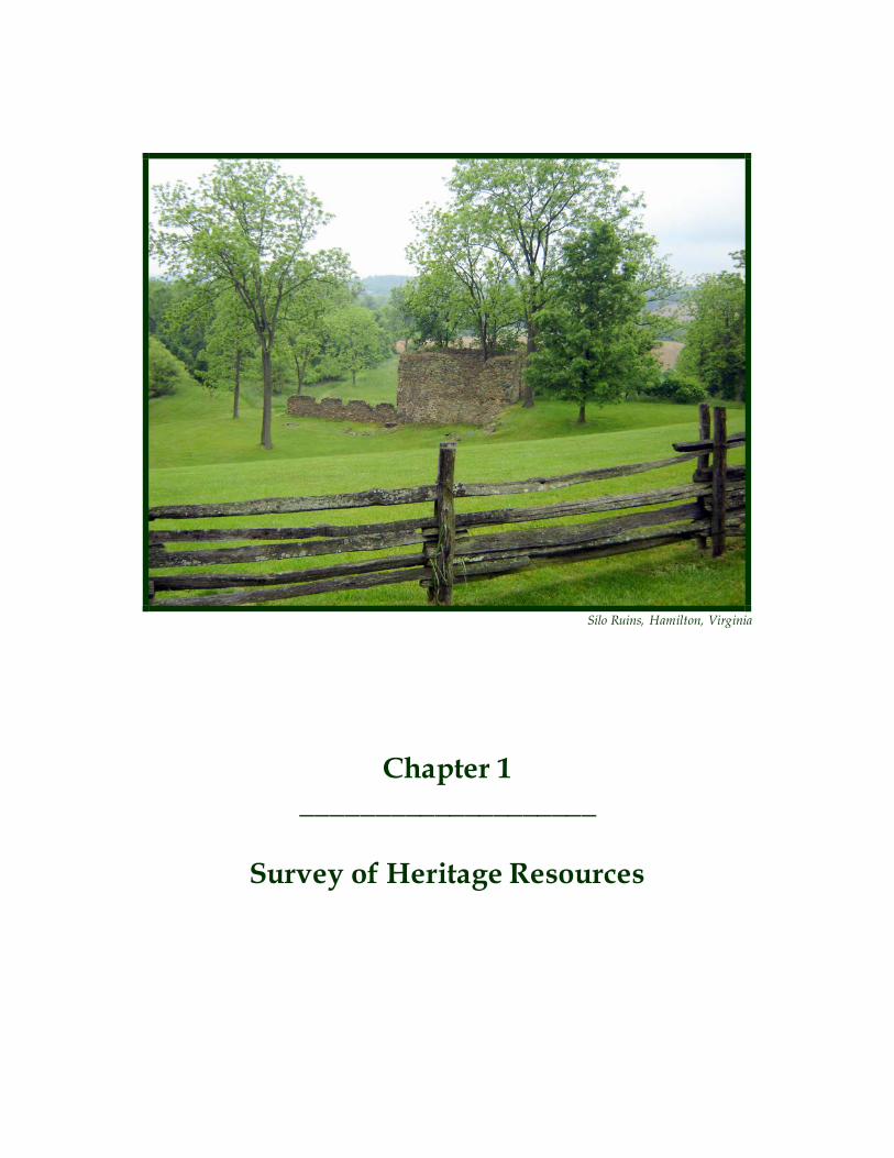
Chapter 1 ____________________
Survey of Heritage Resources
Silo Ruins, Hamilton, Virginia
Heritage Preservation Plan Chapter One – Survey of Heritage Resources
2
Loudoun County is one of the fastest growing jurisdictions in the nation. Between 1990 and 2000, the population of Loudoun County has more than tripled from approximately 86,000 in 1990 to approximately 263,000 in 2006. The population forecast for Loudoun County in 2020 is 409,000. Loudoun County is expected to lead the region in population growth from 2005 to 2030 with an 89% increase in population. (Sources: Loudoun County 2007 Annual Report and Metropolitan Washington Council of Governments MWCOG, Round 7.0 Cooperative Intermediate Forecast) Between 1997 and 2007, the County issued 55,585 residential building permits. Although the las t two years (2006, 2007) have shown a decline in permits issued, residential development will continue to pose the greatest challenge to the protection of heritage resources. The development pressures over the last decade have had a significant impact on heritage resources. Historic structures are demolished to clear land for development, archaeological s ites, and s ignificant cultural landscapes, including battlefields, are bulldozed and paved. Historic settings and viewsheds are filled in by incompatible development patterns. Recognizing the urgency of this situation, the County’s Comprehensive Plan (Revised General Plan adopted in July 2001) calls for the identification, preservation and management of heritage resources. Resource Survey Recognizing that resource identification is the first step in resource preservation, the Revised General Plan states:
“The County will conduct a comprehensive survey of its heritage resource base and will prepare and implement a plan for the preservation and promotion of these resources as an integral part of the economy.” (Revised General Plan, Policy 1, p 5-35)
A Cultural Resources Survey is the first step in documenting and preserving the heritage of the past. The survey of cultural resources and cultural landscapes, such as battlefields, is an ongoing effort. As standing structures age and archeological resources are unearthed, a systematic approach is necessary to record, document and evaluate their significance. The information generated from surveys provides private citizens, preservation organizations and government agencies with a guide to his toric places, a permanent written and photographic record of the County’s heritage and facilitates informed decision making on issues regarding preservation planning and land development. Survey reports and inventories also permit evaluation of properties for nomination to the national, state and county registers. Concurrent with the development of the Preservation Plan, the County contracted for three different cultural resource surveys, including:
• A survey of 750 historic standing structures • A survey of historically African American sites (with support from the Black History Committee
of the Friends of the Thomas Balch Library • Preliminary Information Forms (PIFs) to assess resources within four of the incorporated towns
in the County namely, Lovettsville, Hamilton, Purcellville and Round Hill • Preliminary Information Forms (PIFs) to assess resources within seven historically African
American settlements

Heritage Preservation Plan Chapter One – Survey of Heritage Resources
3
The roadbed of the uncompleted Loudoun Branch of the Manassas Gap Railroad is still visible along Foundry Road southwest of Lincoln. Authorized in 1853, the railroad was never completed due to construction delays, financial delays and the outbreak of the Civil War.
The County retains a database of all historic standing structures and archaeological sites recorded with the VDHR offices at Richmond, Virginia; facilitating the County’s heritage resource mapping efforts with other data for analysis purposes. Also, added to the County database are two National Park Service mapping studies related to four Civil War battles located in the County. This important data is available to staff working on both short and long-range planning efforts, particularly in the review of development applications. In addition to these survey efforts, the County, as recommended in the Revised General Plan, requires a Phase 1 archaeological survey, an identification level survey and report for most land development applications to identify potential archaeological sites in the County.
These identified resources however, barely scratch the surface of potential diverse heritage resources in the County. More than 20,000 structures in the County are 50 years old or older. In addition, the rich integrated network of stream corridors in this region supports a high potential for archaeological resources. Over the last 30 years, the County has identified, and documented at some level, 1,500 archaeological sites and approximately 4,500 historic buildings. The resource survey policies reaffirm the County’s commitment to resource identification and provide additional direction on priority areas and themes to target with future survey efforts.
Resource Survey Policies
1. The County will conduct periodic site surveys of historic and prehistoric resources with the objective of maintaining a comprehensive architectural and archaeological resource database for the County. Priority will be given to themes that to date are under-represented in county and state inventories.
2. The County will increase the number of historic and cultural resources surveyed that are
associated with the County’s diverse cultural groups. 3. The County will pursue various funding sources to support cultural resources surveys, historical
research and preservation-related projects on a periodic basis. 4. The County will encourage community involvement in the survey efforts to increase awareness
of the value of historic resources and the importance of their preservation. 5. The County will work with residents wishing to identify and prepare nominations for individual
properties and districts to the National Register of Historic Places.

Heritage Preservation Plan Chapter One – Survey of Heritage Resources
4
6. The County will coordinate cultural resources survey efforts with the Virginia Department of Historic Resources (VDHR) to ensure that all properties included on the County Heritage Register will also be documented in the VDHR Inventory of Historic Sites.
7. The County will develop and maintain an archival database of all survey results to be made
accessible to government agencies and the public. The information will be linked to the County’s parcel based GIS mapping system. County staff will use this database in the evaluation of land use applications and potential impacts will be identified. However, information on the locations of known archaeological sites and other sensitive resources will be limited to the genera l public to protect these resources from potential looting.
8. The County will continue to recognize Phase I archaeological surveys for land development
applications and their contribution towards completing a comprehensive architectural and archaeological survey of the County.
9. The County will promote the use of state and federal programs to protect heritage resources.
Significant Environmental Resources The Preservation Plan expands the definition of heritage resources beyond cultural landscapes , h istoric standing structures and archaeological sites and calls for the protection of select natura l resources that contribute to the heritage of Loudoun County. These resources include significant geological formations such as rock outcrops, mineral deposits and trees such as National and State Champions, National Register Trees, State Big Trees, Specimen Trees and Heritage Trees. The intent of these policies is to promote community awareness of these resources and seek their protection as a means of ensuring the unique identity of Loudoun County. Geologic Resources Loudoun County is divided into two significantly different physiographic provinces, the “Blue Ridge” and the “Piedmont” (Triassic Basin). The Blue Ridge province, west of Route 15 starting with the Catoctin and Bull Run ridges, is dominated by deep well-drained soils formed from crystalline rock. The Triass ic Basin, east of Route 15, is dominated by moderately deep, well to poorly drained soils underlain by level bedded sedimentary rocks intruded with igneous diabase rock. Several unique geological formations in the County reveal the history and evolution of the land. The County also has a very detailed geology map compared to other jurisdictions along the East Coast thanks to efforts by the County and the U.S. Geological Survey. Some of these geologic resources identified to date include the diabase quarries in Eastern Loudoun that have provided much of the stone and gravel for construction in northern Virginia. Most of these diabase areas have been built upon in recent years. Other resources include the copper mine at Potomac Station; the iron ore deposits at Catoctin and Short Hill, and Point of Rocks; the limestone kiln and marble pit on Lime Kiln Road; Buzzard’s Rock overlooking Harpers Ferry; Devil’s Racetrack and Preachers Rock. Resources such as the limestone outcrops along Route 15 have also been popularized in historical fi les such as various Civil War documents.
Heritage Preservation Plan Chapter One – Survey of Heritage Resources
5
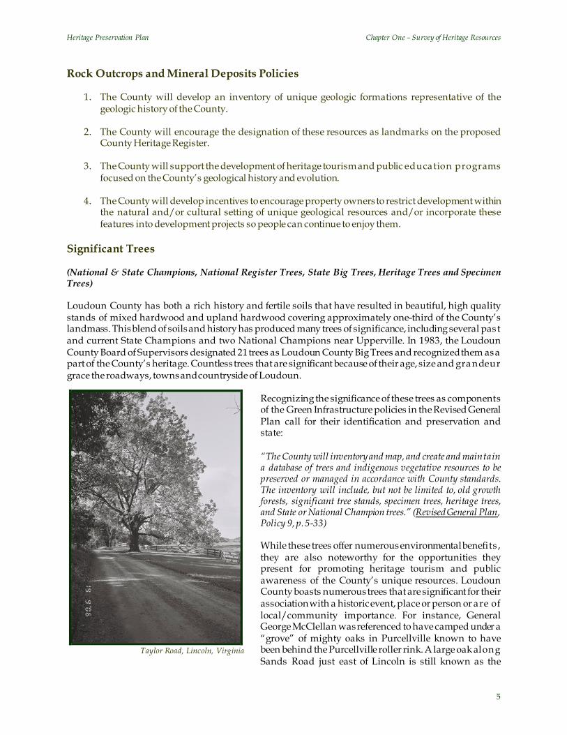
Taylor Road, Lincoln, Virginia
Rock Outcrops and Mineral Deposits Policies
1. The County will develop an inventory of unique geologic formations representative of the geologic history of the County.
2. The County will encourage the designation of these resources as landmarks on the proposed
County Heritage Register. 3. The County will support the development of heritage tourism and public education programs
focused on the County’s geological history and evolution. 4. The County will develop incentives to encourage property owners to restrict development within
the natural and/or cultural setting of unique geological resources and/or incorporate these features into development projects so people can continue to enjoy them.
Significant Trees (National & State Champions, National Register Trees, State Big Trees, Heritage Trees and Specimen Trees) Loudoun County has both a rich history and fertile soils that have resulted in beautiful, high quality stands of mixed hardwood and upland hardwood covering approximately one-third of the County’s landmass. This blend of soils and history has produced many trees of significance, including several past and current State Champions and two National Champions near Upperville. In 1983, the Loudoun County Board of Supervisors designated 21 trees as Loudoun County Big Trees and recognized them as a part of the County’s heritage. Countless trees that are significant because of their age, size and grandeur grace the roadways, towns and countryside of Loudoun.
Recognizing the significance of these trees as components of the Green Infrastructure policies in the Revised General Plan call for their identification and preservation and state: “The County will inventory and map, and create and maintain a database of trees and indigenous vegetative resources to be preserved or managed in accordance with County standards. The inventory will include, but not be limited to, old growth forests, significant tree stands, specimen trees, heritage trees, and State or National Champion trees.” (Revised General Plan, Policy 9, p. 5-33) While these trees offer numerous environmental benefits , they are also noteworthy for the opportunities they present for promoting heritage tourism and public awareness of the County’s unique resources. Loudoun County boasts numerous trees that are significant for their association with a historic event, place or person or are of local/community importance. For instance, General George McClellan was referenced to have camped under a “grove” of mighty oaks in Purcellville known to have been behind the Purcellville roller rink. A large oak along Sands Road just east of Lincoln is still known as the

Heritage Preservation Plan Chapter One – Survey of Heritage Resources
6
“Cannon Ball” tree as a result of a wound from a skirmish during the Civil War. The largest Painted Buckeye tree in Virginia can be seen from John Mosby Highway at the Aldie Mill, while Oatlands Plantation has both an English Oak and an American Hornbeam on the Virginia Big Tree Register. Significant Trees Policies
1. The County will develop an inventory of or maintain a list of significant trees that include National and State Champions, National Register Trees, State Big Trees, Heritage trees and Specimen trees.
2. The County will define the standards for the identification of heritage and specimen trees and encourage their nomination to the County Heritage Register. The County Urban Forester will offer technical assistance to property owners in determining the eligibility of trees on their properties to County Heritage Register.
3. The County will assist property owners seeking to nominate trees to the National Register, Sta te
Big Tree Program or designate examples as a Heritage or Specimen tree. 4. The County will consider the strategic acquisition of property containing significant trees
threatened by development pressures. 5. The County will assist property owners in the development of tree preservation techniques to
address the long-term management and health of threatened heritage trees. 6. The County will develop incentives to encourage property owners to restrict development within
the natural and/or cultural setting of significant trees listed on the National Register, Sta te Big Tree List or the County Heritage Register.
7. The County supports the development of heritage tourism and public education programs
focused on the County’s significant trees, specifically the Heritage trees. 8. Specimen trees include trees that serve as natural gateways to historic sites or towns, trees that
are significant on account of their great age or are especially renowned for their aesthetic or community value.
9. The County will support and encourage efforts that seek to propagate significant tree specimens.
Chapter 2 ____________________
Archaeological Resources
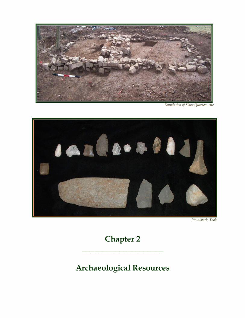
Pre-historic Tools
Foundation of Slave Quarters site
Heritage Preservation Plan Chapter Two – Archaeological Resources
8
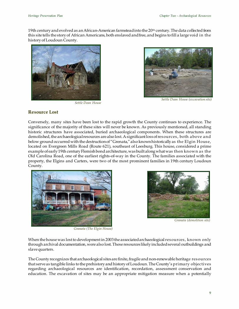
The identification and preservation of archaeological resources is linked to all other heritage resource issues in this plan. Interdependencies exist between archaeology and public education, heritage tourism, the County’s survey and heritage register program efforts and the land development process. Archaeological sites are generally defined as the physical/material remains of any area that supported human activity, 50 years old and older and for which a boundary can be established. Unlike s tanding structures, archaeological sites are typically buried and not apparent on the landscape and thus, can go unrecognized as resources vital to the understanding of the human past. While historic standing structures represent a valuable heritage resource in their own right, all such s ites have archaeological components to them, such as non-extant related structures, privies, trash deposits and fence lines. Battlefields are not only cultural landscapes, but archaeological resources as well. Similarly, historic rights-of-way such as waterways, byways and historic corridors include archaeological components. Natural heritage resources such as significant rock outcrops were important resources for prehistoric peoples for stone-tool production and, as such are also linked to archaeological resources. Thus, these become potential archaeological sites that should be conserved, or studied further as circumstances might require. These individual resources represent pieces of Loudoun’s heritage. Together, they tell the story of past human life-ways. Prehistoric archaeological sites date to the time period before the advent of the written record. In North America, the prehistoric period terminates with European contact and subsequent settlement of the continent. Archaeologists date the earliest occupation by Native Americans in the region to circa 12,000 before present (BP) based on findings of the earliest stone tools, specifically projectile points, found in the area. Prehistoric sites in Loudoun County range from small transient campsites to full-scale village s ites along significant watercourses. Historic archaeological sites relate to European settlement of the area. The first accounts of Euro-American forays into Loudoun date from the late 17th century. Settlement of parts of the County occurred by the first quarter of the 18th century. There are many distinct types of historical archaeological sites in the County including domestic sites related to plantation owners, tenant farmers and slaves, commercial and industrial sites such as mills, ferries, potteries, lime kilns and furnaces and military s ites such as battlefields and camp sites. Many archaeological sites have been identified and recorded in the County. More than 1 ,500 s ites have been registered with the Virginia Department of Historic Resources. Most of these sites were identified in the eastern portion of the County as part of land development projects and, if significant, have been excavated. Undoubtedly thousands more prehistoric and historic sites exist across the County. There have been significant sites located and conserved most notably, the Fisher Site, a Late Woodland village site located near the confluence of the Potomac River and Broad Run, which was identified in the 1930’s and investigated in 2001 through a joint effort between the County and the Department of Historic Resources. The investigation confirmed the village’s integrity and boundaries. This site is one of severa l Woodland village sites along the Potomac on both the Virginia and Maryland sides referred to as part of the “Montgomery Focus” culture. Investigations of this site have contributed to our knowledge of settlement pattern, village size and interaction between populations in the area between 1200 A.D. and the time of European settlement. Success Story: The Settle Dean House The Settle Dean Site is an example of a significant historical archaeological resource that was excavated as part of a development project in the southeastern portion of the County. This site, which was associated with a standing log structure, dates from the early 19th century. Although first inhabited by slave-owning white farmers and their slaves, this property was deeded to emancipated slaves in the la ter part of the
Heritage Preservation Plan Chapter Two – Archaeological Resources
9
19th century and evolved as an African-American farmstead into the 20th century. The data collected from this site tells the story of African Americans, both enslaved and free, and begins to fill a large void in the history of Loudoun County.
Settle Dean House Resource Lost Conversely, many sites have been lost to the rapid growth the County continues to experience. The significance of the majority of these sites will never be known. As previously mentioned, all standing historic structures have associated, buried archaeological components. When these structures are demolished, the archaeological resources are also lost. A significant loss of resources , both above and below ground occurred with the destruction of “Grenata,” also known historically as the Elgin House, located on Evergreen Mills Road (Route 621), southeast of Leesburg. This house, considered a prime example of early 19th century Flemish bond architecture, was built along what was then known as the Old Carolina Road, one of the earliest rights-of-way in the County. The families associated with the property, the Elgins and Carters, were two of the most prominent families in 19th century Loudoun County.
When the house was lost to development in 2003 the associated archaeological resources , known only through archival documentation, were also lost. These resources likely included several outbuildings and slave quarters. The County recognizes that archaeological sites are finite, fragile and non-renewable heritage resources that serve as tangible links to the prehistory and history of Loudoun. The County’s primary objectives regarding archaeological resources are identification, recordation, assessment conservation and education. The excavation of sites may be an appropriate mitigation measure when a potentially
Granata (The Elgin House)
Settle Dean House
Granata (demolition site)
Settle Dean House (excavation site)

Heritage Preservation Plan Chapter Two – Archaeological Resources
10
significant site is threatened; however, excavation ultimately results in the destruction and loss of the resource. To retain and protect significant sites for the future, the County’s objective is to avoid and preserve such sites as open or civic space. To achieve the identification, recordation and assessment of archaeological resources on a site, archaeological survey and reporting is a submission requirement for land development applications proceeding through the County’s legislative process and for administrative applications requiring preliminary plats of subdivision and preliminary/record plats. The archaeological survey data is considered by the County to be part of the “existing conditions” of a property. Through the conservation design process, the locations of significant or potentially significant sites will be used to determine areas best suited for development. Archaeological Resource Policies
1. The County will dedicate qualified staff resources to actively identify archaeological resources, develop conservation and mitigation strategies, coordinate public outreach efforts and appropriately maintain databases and site reports.
2. The County will continue to require Phase 1 archaeological surveys for all legislative applications
and for those administrative applications that require a preliminary plat of subdivision. 3. All levels of archaeological survey and related reports shall be conducted and prepared using the
Virginia Department of Historic Resources’ Guidelines to Archaeological Investigations in Virginia. In addition to the state standards, the following County standards shall be followed:
a. The use of heavy machinery to identify site locations is only appropriate in very limited
cases. Approval by the County must be obtained if the use of heavy machinery is proposed or intended as part of a Phase 1 archaeological survey.
b. All Phase 1 survey must adhere to a 50 foot minimal shovel test interval unless previously
approved by County staff. Intervals of 75 feet and judgmental shovel testing may be appropriate in some areas following prior consultation with staff on a project specific basis.
c. All survey reports must contain a summary and conclusions section with a map showing the
testing strategy and distribution of all identified sites within the project area. The report shall contain detailed site descriptions and recommendations for further investigation.
d. To fully convey information on the prehistory and history of the County to the general
public, reports must include a brief, non-technical synopsis of archaeological survey results that can be disseminated to the general public. This can be accomplished in the abstract portion of the report or can be a separate synopsis within an appendix to the report.
4. Site data garnered from Phase 1 archaeological survey reports will be used to develop and refine
predictive models. Survey data will also be used to evaluate gaps in the County’s archaeological record. Data voids or under-representation of cultural groups, time periods or themes will help define priorities for future survey, site acquisition and conservation.
5. Site identification and evaluation will be conducted on all county owned properties where a
probability for archaeological resources is determined. Site locations and assessments will be integrated into stewardship plans. Education, interpretation and conservation strategies for significant resources will be addressed programmatically for each county owned property.

Heritage Preservation Plan Chapter Two – Archaeological Resources
11
6. The County will pursue historic site designation, as outlined in Section 6-1800 of the Loudoun County Revised 1993 Zoning Ordinance, and county heritage register status for significant archaeological sites on county-owned properties. Priority properties include the Banshee Reeks Nature Preserve, the Mount Zion Church, the Slave Quarters at Arcola, and heritage areas within Claude Moore Park.
7. Countywide predictive models for archaeological site locations will be created to assist the
County and individual property owners in the identification and conservation of significant resources. The models will be used to delineate “archaeologically sensitive areas.”
8. The County will continue to explore the applicability and feasibility of new technology, such as
remote sensing, as a supplement to the predictive models. The County will seek public-private partnerships with local companies specializing in these technologies.
9. When significant archaeological resources have been identified, recorded and assessed during the
land development process, it is the County’s primary objective to protect and conserve these resources through the conservation design process.
10. During the conservation design process, the locations of identified significant archaeological
resources will be a determining factor in the delineation of the required open space element for land development projects where surveys are required.
Left: Predictive Modeling - a case study Predictive modeling shows the relationship between the location of archaeological sites of different types and the environmental conditions they are associated with. Models typical ly show areas of high, medium and low probability for archaeological resource based on a complement of environmental factors. Models predicting prehistoric and historic land use patterns are a useful planning tool, providing the best opportunity for areas with high probability to be avoided during land development activities. Variables included in this general model include: proximity to water (200’ to 500’), soi l type and slope. The County anticipates refining the modeling process to determine probability for discrete time periods and specific site types.
Heritage Preservation Plan Chapter Two – Archaeological Resources
12
11. A determination of resource significance will be based on criteria set forth for the National Register of Historic Places and as defined for the County Heritage Register.
12. When resource conservation cannot occur, the County will seek the mitigation of development
impacts on significant or potentially significant sites. Mitigation is typically defined as further archaeological investigation and data collection, but can include oral history, historical narrative and/or public presentations when significant resources are identified.
13. The County will create incentives to encourage the conservation or mitigation of impacts to
significant sites during the development process. Incentives may include, expedited application review, density bonus and voluntary density transfers.
14. The County will pursue state enabling legislation to conserve or mitigate impacts to sites deemed
at the Phase 1 level of investigation to be eligible or potentially eligible for the National Regis ter of Historic Places during the land development process.
15. Strategies for conservation and stewardship will be developed for areas defined through
modeling and/or field verification to be “archaeologically sensitive areas,” that are not protected as part of a primary conservation area. Strategies may include the purchase of development rights, conservation easements, education on resource management, historic district or his toric site designation, and specific performance standards for land development.
16. Where National Register eligible sites are identified on private properties, the County will
provide information to property owners on site protection, conservation and management. 17. County-owned properties will be used to foster research, education and outreach programs
highlighting the importance of the County’s archaeological resources. 18. The County recognizes that archaeological resources have the potential to be an important aspect
of heritage tourism. Heritage tourism related programs will be developed on County owned properties that contain archaeological sites representing significant aspects of the County’s prehistory and history. Site tours and “hand’s on” archaeology programs will be integrated into the County’s heritage tourism efforts.
19. The County will cooperate with private organizations and local museums to assist in the proper
curation, interpretation and exhibition of artifacts from significant sites excavated in the County and will explore the possibility of establishing a local repository.
20. The County will support the public outreach activities of private organizations and local
museums related to archaeological resources. 21. The County will work with citizens interested in heritage resource preservation to form a
coalition that can actively advocate heritage preservation at the state level. Implementation Cultural resource management (CRM) firms conduct nearly every archaeological investigation that occurs in the County in the context of land development projects. While it is the intent of the County to maintain and reinforce requirements for archaeological survey and reporting that result in this practice, the County recognizes that the educational and heritage tourism benefits related to the County’s vast and varied archaeological resources are rarely conveyed to the public during this process. Further, artifacts

Heritage Preservation Plan Chapter Two – Archaeological Resources
13
are typically stored in places with limited accessibility and, at times, they are not curated in a way that ensures optimal conservation of the resource. The County’s goal is to educate the community about its archaeological resources and make these resources accessible to the public. The County will seek to establish partnerships with private organizations to ensure proper artifact curation and recordation and to promote the exhibition and interpretation of significant artifacts for the benefit of County residents and visitors.
Grace Methodist Episcopal Church, Lincoln, Virginia
Photo courtesy of: History Matters
Chapter 3 ____________________
County Heritage Register

Heritage Preservation Plan Chapter Three – County Heritage Register
15
At a time of rapid growth and change, the County needs to acknowledge the efforts of individuals and groups that hold and maintain the integrity of properties that tie us to our past. The County Heritage Register is a tool to highlight significant resources and recognize those landowners who see the value of the heritage resources on their property. The program is also intended to encourage a higher level of stewardship by increasing community awareness of the resources and the benefits of preservation. The direction for this program is derived from the County’s Comprehensive Plan that states:
“[The] County will create a County Historic Landmarks Inventory, which will reflect those historic structures and archaeological sites that have local historic value and represent the prehistoric and historic trad itions of Loudoun County.” (Revised General Plan, Policy 7, p.5-35)
The County Heritage Register should not be confused with the National Register of Historic Places, which is a separate federal program, or the Virginia Historic Landmarks Register, adminis tered by the State. The County program would differ from the federal and state programs in two primary respects. First, the County Heritage Register Program will broaden the scope of the register beyond historic standing structures and archaeological sites. The County program will include geological formations, heritage corridors and significant trees in addition to buildings, sites, battlefields, cemeteries and districts. Second, though the criteria for nomination to the County Heritage Register would be based on recognized and accepted national and international standards for the evaluation of heritage resources and insignificant environmental resources, there will be variations to recognize local properties that may not qualify for the federal and/or state programs. Nomination will be based on the criteria developed for both the National Register of Historic Places, administered by the United States Department of Interior, and the World Heritage List, administered by the United Nations Educational Scientific and Cultura l Organization (UNESCO). These criteria provide a uniform standard by which to evaluate significant heritage resources in the County. Similarly, the benefits of the County Heritage Register would be specific to Loudoun County, with public acknowledgment, maintenance assistance and technical support being offered to property owners on the Register. The designation of a property or resource as a County Heritage Register site is strictly voluntary on the part of the owner and does not require the owner to provide public access to the property. County Heritage Register Policies
1. The County will implement a County Heritage Register (CHR) to highlight important heritage resources and to encourage a higher level of community awareness and stewardship. Designation as a County Heritage Register will be strictly voluntary and the County will incorporate incentives to encourage participation.
2. The Register will include sites, buildings, structures, cultural landscapes such as battlefields and
objects, including environmental resources; that are culturally important to the County. 3. To encourage appropriate restoration and preservation of Register properties, the County will
pursue changes in regulations and land use policies to offer greater flexibility in the use and adaptive reuse of the property and offer technical assistance to owners.
4. County Heritage Register properties will be considered primary resources in the Conservation
Design process for proposed developments on or adjacent to a designated property. As such the County will seek to preserve the Register property and its associated setting and mitigate any impacts resulting from the proposed development.
Heritage Preservation Plan Chapter Three – County Heritage Register
16
5. To be considered eligible for the County Heritage Register, a property must be at least 50years old (with certain exceptions); and posses integrity of location, design, setting, materials, workmanship, feeling and/or association. A designated property may also posses natural, historical, architectural, archeological, or cultural significance and meet one of these criteria:
a. be associated with events that have made a significant contribution to the broad patterns of
our history; or b. be associated with the lives of significant historic figures; or c. be an outstanding example of a type of building or architectural or technological ensemble or
landscape which illustrates distinctive characteristics of a type, period, or method of construction, or that represents the work of a master, or that possess high artistic va lues; or represent a significant and distinguishable entity whose components may lack individual distinction; or
d. have yielded or may be likely to yield, archeological information important in history or
prehistory; or e. achieved exceptional significance and/or importance within the past 50 years; or f. be an established and familiar visual feature due to its singular man-made or natural
characteristics or features; or g. be an outstanding example of a major stage of the earth’s geologic history; or h. be an outstanding example of an environmental feature (i.e. diabase glades, fens,etc.); or i. be recognized as a specimen or heritage tree, and/or be designated as a State or National
Champion tree; or j. be an outstanding example of community design and/or compatible infill development.
6. Individual properties and cultural landscapes such as battlefields and districts listed in the
National Register of Historic Places and/or Virginia Historic Landmarks Register will be automatically considered eligible for inclusion in the County Heritage Register. In addition, battlefields located in Loudoun County and identified as “principle battles” of the Civil War by the Congressionally mandated Civil War Site Advisory Commissin (CWSAC) will be automatically considered eligible for inclusion in the County Register.
7. Listing on the Heritage Register will be an ongoing effort and a property’s status may be
removed at anytime if it has undergone any major alterations that may have diminished its integrity or significance.
8. The County will extend the Tax Exemption for Revitalized Real Estate program administered by
the County to designated properties for maintenance and restoration and will assist owners seeking incentives offered by Federal and State agencies.
9. The County will consider other financial incentives for properties listed in the County Heritage
Register.

Heritage Preservation Plan Chapter Three – County Heritage Register
17
10. The County will establish a program whereby building contractors may become certified as recognized practitioners of preservation techniques and methods appropriate for the repair, rehabilitation and renovation of historic properties. The County will pursue an expedited permitting process for certified contractors and will maintain a list of certified contractors as a resource to property owners.
Implementation The County Heritage Register is a tool intended to recognize the County’s heritage resources at the loca l level and foster the preservation, stewardship and heritage education objectives of the County’s Comprehensive Plan. The Heritage Preservation Plan envisions the County Heritage Register being operated through a board appointed commission such as the Heritage Commission or the Historic District Review Committee (HDRC). The Heritage Commission would seek funds for and administer the program and offer technical expertise in the development of nomination criteria and resource selection. Funding for the program will be derived from both public and private resources.
Hunting Hill, Taylorstown, Virginia, circa 1737
One of the oldest standing structures in Loudoun County Photo courtesty of: Paul Glenshaw
Chapter 4 ____________________
Historic Districts
Aldie Mill, Aldie, Virginia
Photo courtesy of: Paul Glenshaw
Heritage Preservation Plan Chapter Four – Historic Districts
19
Section 15.2-2283 of the Code of Virginia delegates to local governments the authority to enact zoning ordinances “to protect against the destruction of or encroachment upon historic areas”. The zoning authorized by the Code of Virginia is the enabling legislation for historic district zoning and is also known as overlay zoning since the regulation of historic resources is in addition to existing land use regulations. In effect since 1972, the Historic District Ordinance of the Loudoun County Zoning Ordinance (Ordinance) allows for the designation, review and protection of heritage resources through the creation of historic overlay districts. The Ordinance includes provisions for the creation of Historic and Cultural Conservation (HCC) Districts, Historic Site (HS) Districts, Historic Roadway (HR) Districts and Historic Access Corridor (HAC) Districts, which are generally referred to as county Historic Districts. The Ordinance mimics the criteria of the National Register and Virginia Landmarks Register and expands these with basic criteria for the determination of local significance. (Refer to Appendix C: Section 6-1800 Historic Districts, Loudoun County Revised 1993 Zoning Ordinance) Loudoun County currently administers six Historic and Cultural Conservation (HCC) Dis tricts-Aldie, Bluemont, Goose Creek, Oatlands, Taylorstown and Waterford. These six historic districts are l is ted on the National Register and Virginia Landmarks Register. Historic Site (HS) Districts are used to designate individual properties. Only two properties are currently listed as HS Districts in the County namely, Welbourne and the Ruins of the Broad Run Bridge and Toll House, both of which are listed in the National Register and Virginia Landmarks Register. The County also administers one Historic Roadway (HR) District known as the Beaverdam Creek Historic Roadway District, in the southwestern portion of the County. There are currently no roadway corridors listed as Historic Access Corridor (HAC) Dis tricts in the County. (see Appendices A6 – A12) A seven-member Historic District Review Committee (HDRC) administers the County’s historic districts. The review by the HDRC is intended to ensure architectural compatibility and harmony within these districts. The HDRC review is based on the County’s Historic District Guidelines adopted as part of the Ordinance in 1987. Updating the Guidelines is on the HDRC’s 2008 work program. The Historic Dis trict Guidelines are available to the public as a guide for the renovation of existing structures and/or new construction projects. (Refer to Appendix D: Section 6-300 Historic District Review Committee, Loudoun County Revised 1993 Zoning Ordinance) While the County has the authority under State Enabling Legislation to create and administer historic overlay districts, there are issues of concern associated with the current ordinance language as it pertains to the owner consent requirements for the creation of a historic district, district boundaries and the Historic District Guidelines. While the Ordinance allows for the creation and review of new county administered historic districts, this regulatory zoning tool is underutilized. Until a text amendment in the year 2000, the Ordinance required a signed affidavit of consent from every property owner within a proposed historic dis trict boundary. This requirement seriously constrained the County’s ability to recognize and protect the historic integrity of a district, as districts are fragmented and include within their boundaries properties that are not part of the district. This can be seen in the existing Aldie Historic District, the Bluemont Historic District and the Goose Creek Historic District. The County Ordinance currently requires two-thirds of the owners within a proposed historic district to consent to the proposal to adopt a historic district. This new “super-majority” provision allows for the creation of historic districts that include all the lands within the proposed district boundary. The Ordinance also empowers the County’s Historic District Review Committee to “propose the establishment of additional historic overlay districts and revisions to the existing historic overlay districts.” The provision allows the Planning Commission and the Board of Supervisors to reconsider existing fragmented districts. The newly established Beaverdam Creek Historic Roadways District is eligible for this remedy.
Heritage Preservation Plan Chapter Four – Historic Districts
20
The boundaries of the County historic districts and those of the state and National Register historic districts do not align in the Aldie, Bluemont, Goose Creek and Waterford Historic Districts. and the County’s Revised General Plan calls for actions to rectify these boundary discrepancies.
“The boundaries of the County’s Historic Cultural Conservation Districts will be amended or extended to coincide with the boundaries of the state’s corresponding Historic Districts. This applies to Bluemont, Goose Creek, and Waterford. The County will work with the state to extend the state registered boundary of Ald ie to meet the County Aldie Historic District boundary.” (Revised General Plan, Policy 15, p. 5-36) Waterford Mil l Waterford Post Office
Policies in the Revised General Plan also called for updates to the current Historic District Guidelines that were adopted in 1987. This is especially a concern for the rural Goose Creek Historic District. This district, encompassing more than 10,000 acres of land, was formed to protect and enhance the rural agricultural landscape of the area, which has gradually been changed through the years by the influx of res idential construction.
“The Historic District Guidelines will be updated to include new districts as they are-established and to recognize and give appropriate importance to the rural-suburban character of the Goose Creek Historic District.” (Revised General Plan, Policy 14, p. 5-36)
Historic District Policies
1. The boundaries of the County’s Historic Cultural Conservation Districts will be amended or extended to coincide with the boundaries of the state’s corresponding Historic Districts. This applies to Bluemont, Goose Creek, and Waterford. The County will work with the state to extend the state registered boundary of Aldie to meet the County Aldie Historic District boundary.
2. The Historic District Review Committee will work on updating the Historic District Guidelines.
Subsequent reviews and updates should be conducted on a five-year schedule. Revisions should ensure that the guidelines continue to meet the goals of the districts, reflect changing development patterns, and avail themselves of new and emerging technologies that can enhance resource identification, preservation, restoration, rehabilitation, etc.
3. The County will provide technical assistance and guidance to those citizens groups, villages, and
towns that are interested in creating additional County Historic Districts. 4. The County will identify additional areas for the creation of County Historic Districts based on
criteria defined in the Loudoun County Revised 1993 Zoning Ordinance. 5. All sellers will be required to notify prospective purchasers of properties located in and/or
contiguous to a County administered Historic District and of the requirements of a Certificates of Appropriateness (CAPP) for any proposed construction and/or alterations to properties located within the historic district.
6. Information and disclosures about historic districts shall be made readily available through
County information systems.

Heritage Preservation Plan Chapter Four – Historic Districts
21
Implementation The Heritage Preservation Plan identifies the re-aligning of the boundaries of the county historic districts to match federal and state historic district boundaries to be a priority. The current mismatch in the boundary leaves the National and State Register historic districts exposed to incompatible development patterns that may detract from the historic authenticity of the resource and its natural and cultural setting. The update of the existing Historic District Guidelines is another key implementation step identified in this Plan. The HDRC should be responsible for updating those guidelines.
Diggs Valley, Hamilton, Virginia
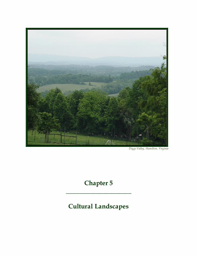
Chapter 5 ____________________
Cultural Landscapes
Heritage Preservation Plan Chapter Five – Cultural Landscapes
23
Cultural landscapes can range in size and historic usage but all are unique places that represent aspects of our collective history and cultural development. The National Park Service defines a cultural landscape as “a geographic area, including both cultural and natural resources and the wildlife or domestic animals therein, associated with a historic event, activity, or person or exhibiting other cultural or aesthetic values.” Many of the other cultural and historic areas discussed in previous chapters could easily be included under the broad term of cultural landscape; however they are not discussed here because of their specific designations as Historic Districts, archaeological sites, etc. This chapter focuses on exceptional areas that have not been defined as “districts” or “sites” but rather fall under a different classification. These include Heritage Corridors, Heritage Areas, Waterways, and Battlefields . Each of these covers a broad area that has a distinctive history, setting it apart from the surrounding countryside. Heritage Corridors Roads, trails and waterways are important heritage resources that represent the migration, settlement and travel patterns of the County’s early populations. These corridors served an essential transportation function linking different cultures and peoples in the region. Roads and trails are also the leading places from which residents and visitors experience and enjoy the cultural landscape. Loudoun County has sixteen designated Virginia Byways that include: Routes 9, 15, 662, 665, 671, 673, 681, 690, 699, 704, 719, 722, 728, 731, 734 and a segment of Route 7. The Virginia Department of Transportation (VDOT) administers the Virginia Byway program. This program is intended to recognize road corridors of aesthetic and/or cultural value near areas of historical, natural or recreational significance. Once designated, a byway becomes part of the statewide promotional strategy, which consists of special roadway signs and highlights on State road maps. These roads direct visitors to wineries, Civil War battlefields and campsites and other historic attractions, beautiful scenery and recreational resources. Simply stated, the County’s heritage corridors promote heritage tourism by inviting visitors and encouraging them to spend more time and money in the County . The Virginia Byway program, however, is honorary and carries no mandatory protections. The County is largely responsible for protecting its travel corridors. Historic travel routes are also essential components of the County’s historic landscape. Associa ted with standing structures, linking early settlements, these travel routes speak to the movement of early populations. There are several documented and undocumented examples of historic travel routes in the County. Some of the well-known resources include the Washington & Old Dominion Railroad, Snickersville Turnpike, Braddock Road, Vestal’s Gap Road and the Old Carolina Road. Numerous less significant travel routes exist on private property and these are often identified in the course of the review of land development applications. To protect these corridors, the County’s Historic District Ordinance, as defined in the Revised 1993 Zoning Ordinance (Ordinance), includes provisions for the creation, review and protection of His toric Roadway (HR) Districts and Historic Access Corridors (HAC). In 2002, Loudoun County established its first Historic Roadway (HR) District, the Beaverdam Creek Historic Roadway District (BCHRD). Located in the southwestern portion of the County, the BCHRD includes approximately 70 miles of paved and gravel roads on 27 different public road segments . The BCHRD was established largely through the efforts of citizens who saw the need to protect the character of existing roads against threats of widening and paving. District standards are intended to protect features such as trees, walls and structures within a defined protection area called the Roadway Buffer Area. The Historic District Review Committee (HDRC) is responsible for the review and issuance of Certificates of Appropriateness (CAPP) for any construction including VDOT work within the Roadway Buffer Area, excluding regular maintenance. However, there are limitations to the district. District regulations apply only to a limited Roadway Buffer Area, that extends to a distance of 35-feet measured
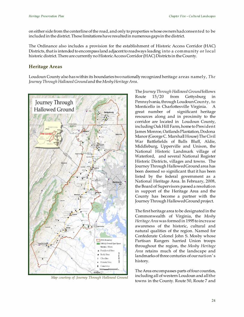
Heritage Preservation Plan Chapter Five – Cultural Landscapes
24
Map courtesy of: Journey Through Hallowed Ground
on either side from the centerline of the road, and only to properties whose owners had consented to be included in the district. These limitations have resulted in numerous gaps in the district. The Ordinance also includes a provision for the establishment of Historic Access Corridor (HAC) Districts, that is intended to encompass land adjacent to roadways leading into a community or loca l historic district. There are currently no Historic Access Corridor (HAC) Districts in the County. Heritage Areas Loudoun County also has within its boundaries two nationally recognized heritage areas namely, The Journey Through Hallowed Ground and the Mosby Heritage Area.
The Journey Through Hallowed Ground follows Route 15/20 from Gettysburg in Pennsylvania, through Loudoun County, to Monticello in Charlottesville Virginia. A great number of significant heritage resources along and in proximity to the corridor are located in Loudoun County, including Oak Hill Farm, home to Pres ident James Monroe, Oatlands Plantation, Dodona Manor (George C. Marshall House) The Civil War Battlefields of Balls Bluff, Aldie, Middleburg, Upperville and Unison, the National Historic Landmark village of Waterford, and several National Register Historic Districts, villages and towns. The Journey Through Hallowed Ground area has been deemed so significant that it has been listed by the federal government as a National Heritage Area. In February, 2008, the Board of Supervisors passed a resolution in support of the Heritage Area and the County has become a partner with the Journey Through Hallowed Ground project. The first heritage area to be designated in the Commonwealth of Virginia, the Mosby Heritage Area was formed in 1995 to increase awareness of the historic, cultural and natural qualities of the region. Named for Confederate Colonel John S. Mosby whose Partisan Rangers harried Union troops throughout the region, the Mosby Heritage Area retains much of the landscape and landmarks of three centuries of our nation’s history. The Area encompasses parts of four counties, including all of western Loudoun and all the towns in the County. Route 50, Route 7 and
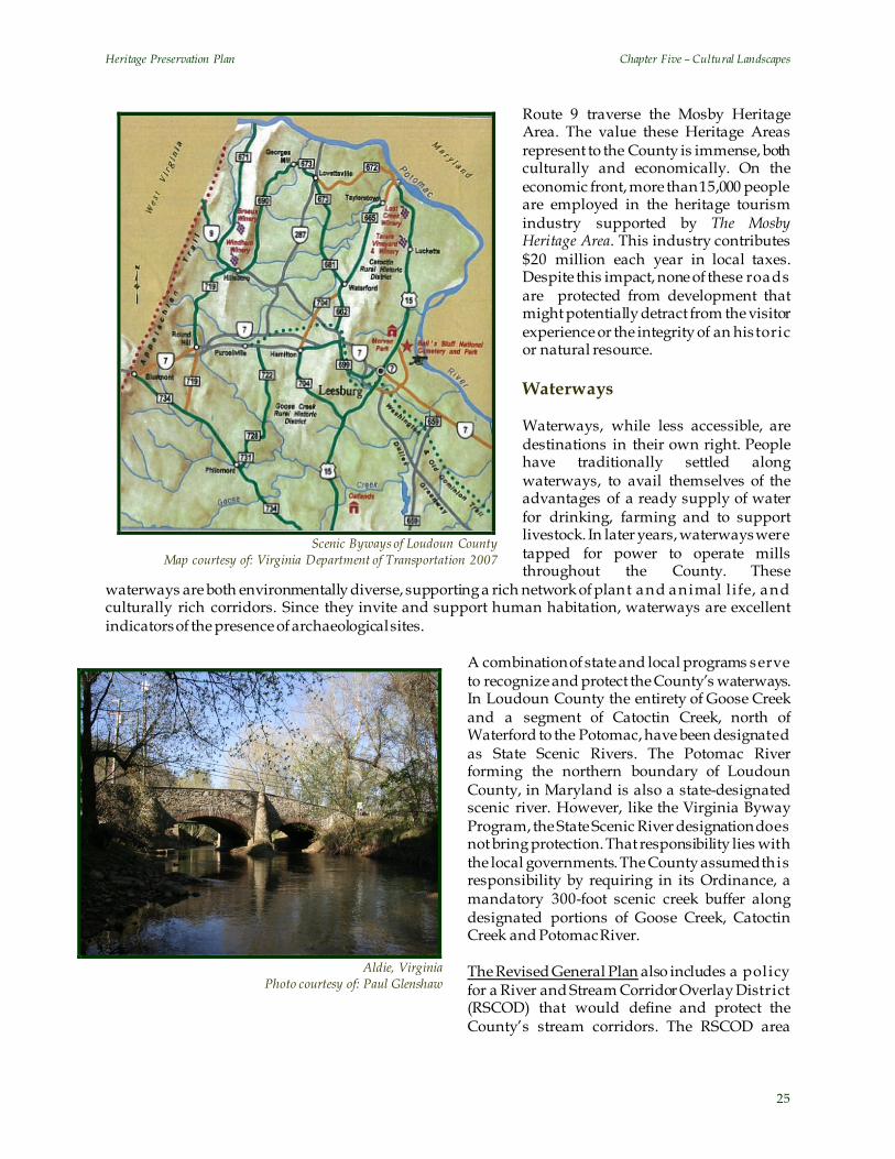
Heritage Preservation Plan Chapter Five – Cultural Landscapes
25
Route 9 traverse the Mosby Heritage Area. The value these Heritage Areas represent to the County is immense, both culturally and economically. On the economic front, more than 15,000 people are employed in the heritage tourism industry supported by The Mosby Heritage Area. This industry contributes $20 million each year in local taxes. Despite this impact, none of these roads are protected from development that might potentially detract from the visitor experience or the integrity of an his toric or natural resource. Waterways Waterways, while less accessible, are destinations in their own right. People have traditionally settled along waterways, to avail themselves of the advantages of a ready supply of water for drinking, farming and to support livestock. In later years, waterways were tapped for power to operate mills throughout the County. These
waterways are both environmentally diverse, supporting a rich network of plant and animal l ife, and culturally rich corridors. Since they invite and support human habitation, waterways are excellent indicators of the presence of archaeological sites.
A combination of state and local programs serve to recognize and protect the County’s waterways. In Loudoun County the entirety of Goose Creek and a segment of Catoctin Creek, north of Waterford to the Potomac, have been designated as State Scenic Rivers. The Potomac River forming the northern boundary of Loudoun County, in Maryland is also a state-designated scenic river. However, like the Virginia Byway Program, the State Scenic River designation does not bring protection. That responsibility lies with the local governments. The County assumed this responsibility by requiring in its Ordinance, a mandatory 300-foot scenic creek buffer along designated portions of Goose Creek, Catoctin Creek and Potomac River. The Revised General Plan also includes a policy for a River and Stream Corridor Overlay District (RSCOD) that would define and protect the County’s stream corridors. The RSCOD area
Scenic Byways of Loudoun County
Map courtesy of: Virginia Department of Transportation 2007
Aldie, Virginia
Photo courtesy of: Paul Glenshaw

Heritage Preservation Plan Chapter Five – Cultural Landscapes
26
would encompass stream channels, adjoining floodplains and areas of steep slope (with over a 25% gradient) that extends to a certain distance from the stream. Development would be largely restricted from this area. This overlay district was included in the Zoning Ordinance from 2001 to 2004 , but has since been removed. River and Stream Corridor policies remain in the Revised General Plan and are used to evaluate legislative applications. Increasing development pressures threaten both the resource and the heritage tourism appeal of the County. While state and local programs continue to identify and recognize some of the County’s key heritage corridors, protection is limited at state and federal levels. While the Revised General Plan identifies these corridors as significant components of the countywide Green Infrastructure and ca lls for their identification, preservation and management as part of the Conservation Design process, the County has not been successful for a variety of reasons. First, the County has yet to complete an inventory and assessment of these corridors, including an evaluation of the heritage resources and scenic vistas associated with them. And second, based on past experience, a purely regulatory approach will not be successful. A combination of regulatory and incentive-based voluntary tools is necessary to promote an awareness and appreciation of these resources and facilitate their preservation. Civil War Battlefields Among Loudoun County’s significant cultural landscapes are its Civil War battlefields. These battlefield landscapes are key elements to understanding Loudoun’s past and its role in the tumultuous conflict known as the Civil War. One of the primary goals of the Heritage Preservation Plan is to promote the identification and preservation of Loudoun’s heritage resources, including its historic battlefields. This portion of the Heritage Preservation Plan provides the policies and strategies for achieving these goals for Loudoun’s Civil War battlefields. Identification of a nationally or state recognized battlefield is a relatively straightforward task, us ing the well-established federal and state procedures for doing so. Battlefields are historic landscapes that vary considerably in terms of size, integrity, ownership patterns, land use and threats. A basic precept in evaluating battlefields is that to be significant, a battlefield must retain enough of its original condition, that is, its physical integrity, to convey its story to today’s students and visitors. One test of integrity is to ask, if a person who was a participant at the time of the battle would be able to recognize the battlefield landscape as it exists today. Evaluating integrity is a complex and difficult business because it involves , given the federal and state guidance, the “setting” of a battlefield and the “feeling” of what happened at that place so many years ago. And yes, the important history of the battle remains with us and in our libraries, even when its integrity is lost. However, the value of the battlefield as a tourist site or an educational experience is greatly diminished and nominations of such listings to the National or Sta te Registers will likely not be accepted. Most battles were part of a larger military campaign, such as the Gettysburg Campaign of 1863, and that campaign must be well understood in order to place the battle in its context. Also, understanding the function of the component parts of the battle will help define its boundaries and explain the importance of certain features of the battlefield. The following are a few of these components: picket and skirmish lines, artillery positions, engagement and staging areas, observation points, command posts, signal stations, roads, fords, bridges, open meadows, woods, fences, stonewalls, dwellings and farm buildings. Additionally, viewsheds are an important component of the battlefield, particularly in relation to its integrity. Modern battlefield mapping used by the National Park Service divides the battled into core and study areas, the former being where actual combat took place. Four principal battles of the Civil War were found by Civil War Sites Advisory Commission (CWSAC) to have occurred in Loudoun County. The boundaries of three of these, the battles of Aldie, Middleburg
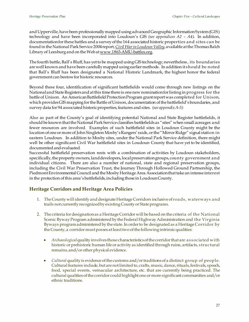
Heritage Preservation Plan Chapter Five – Cultural Landscapes
27
and Upperville, have been professionally mapped using advanced Geographic Information System (GIS) technology and have been incorporated into Loudoun’s GIS (see appendices A2 – A4). In addition, documentation for these battles and a survey of the 164 associated historic properties and s ites can be found in the National Park Service 2004 report, Civil War in Loudoun Valley, available at the Thomas Balch Library of Leesburg and on the Web at www.1863-AMU-battles.org. The fourth battle, Ball’s Bluff, has yet to be mapped using GIS technology; nevertheless , i ts boundaries are well known and have been carefully mapped using earlier methods. In addition it should be noted that Ball’s Bluff has been designated a National Historic Landmark, the highest honor the federal government can bestow for historic resources. Beyond these four, identification of significant battlefields would come through new listings on the National and State Registers and at this time there is one new nomination for listing in progress for the battle of Unison. An American Battlefield Protection Program grant report was completed for Unison, which provides GIS mapping for the Battle of Unison, documentation of the battlefield’s boundaries, and survey data for 94 associated historic properties, features and sites. (see appendix A-5) Also as part of the County’s goal of identifying potential National and State Register battlefields, it should be known that the National Park Service classifies battlefields as “sites” when small acreages and fewer resources are involved. Examples of such battlefield sites in Loudoun County might be the location of one or more of John Singleton Mosby’s Rangers’ raids, or the “Mirror Ridge” signal station in eastern Loudoun. In addition to Mosby sites, under the National Park Service definition, there might well be other significant Civil War battlefield sites in Loudoun County that have yet to be identified, documented and evaluated. Successful battlefield preservation rests with a combination of activities by Loudoun stakeholders, specifically, the property owners, land developers, local preservation groups, county government and individual citizens. There are also a number of national, state and regional preservation groups, including the Civil War Preservation Trust, the Journey Through Hollowed Ground Partnership, the Piedmont Environmental Council and the Mosby Heritage Area Association that take an intense interest in the protection of this area’s battlefields, including those in Loudoun County. Heritage Corridors and Heritage Area Policies
1. The County will identify and designate Heritage Corridors inclusive of roads , waterways and trails not currently recognized by existing County or State programs.
2. The criteria for designation as a Heritage Corridor will be based on the criteria of the National
Scenic Byway Program administered by the Federal Highway Administration and the Virginia Byways program administered by the state. In order to be designated as a Heritage Corridor by the County, a corridor must posses at least two of the following intrinsic qualities:
• Archaeological quality involves those characteristics of the corridor that are associa ted with
historic or prehistoric human life or activity as identified through ruins, artifacts, s tructural remains, and/or other physical evidence.
• Cultural quality is evidence of the customs and/or traditions of a distinct group of people.
Cultural features include, but are not limited to, crafts, music, dance, rituals, festivals, speech, food, special events, vernacular architecture, etc. that are currently being practiced. The cultural qualities of the corridor could highlight one or more significant communities and/or ethnic traditions.

Heritage Preservation Plan Chapter Five – Cultural Landscapes
28
• Historic quality reflects the activities of people from the past and may include buildings, settlement patterns, and other physical examples of human occupation. Historic features can be inventoried, mapped, and interpreted. Historic features must possess integrity of location, design, setting, material, workmanship, feeling, and association.
• Natural quality encompasses those natural features in the visual environment that may
include geological formations, fossils, landforms, water bodies, vegetation and wildlife. • Recreational quality involves passive and active recreational activities directly associated with,
and dependent upon, the natural and cultural elements of the corridor’s landscape. • Scenic quality is the heightened visual experience derived from the view of natural and
manmade elements on the landscape. All elements of the landscape including landforms, water, vegetation, and man-made elements contribute to the quality of the corridor’s visual environment.
3. The County will develop Corridor Assessment Plans for key heritage corridors in the County
with input from other associated public agencies and private groups and stakeholders. The Corridor Assessment Plans will identify, evaluate and develop protection and management strategies for the historic and scenic resources associated with the heritage corridor. Guidelines for development will be included in these plans and address issues such as the siting of buildings, setbacks and buffering.
4. The County will seek Virginia Byway designation for the following roads:
• Hamilton Station Road (Route 704) between Hamilton and Clark’s Gap Road (Route 662); • Segments of Evergreen Mill Road (Route 621) from Leesburg to Watson Road (Route 860)
associated with the Old Carolina Road; • Watson Road (Route 860) in its entirety; • Route 626 in its entirety (including Foggy Bottom, Bloomfield, and Foxcroft Road); and • John S. Mosby Highway (Route 50) from Lenah through the Mosby Heritage Area
5. The County will pursue the
designation of James Monroe Highway (Route 15), Johns S. Mosby Highway (Route 50), Snickersville Turnpike (Route 734) and other significant roadway corridors as National Scenic Byways through the Federal Scenic Byways Program.
6. Recognizing the significance of
historic travel routes in providing information about historic settlement and movement patterns, the County
Yardley Taylor Map, 1853

Heritage Preservation Plan Chapter Five – Cultural Landscapes
29
Viewshed Analysis, Route 15 Corridor, North of the Town of Leesburg
encourages the identification, preservation, management and marketing as part of coordinated heritage tourism and education programs. The abandoned road and railroad beds at Vestals Gap, Manassas Gap and the Old Carolina Road are examples of such historic travel routes.
7. Recognizing that historic travel routes provide opportunities for the development of a
countywide Greenways and Trails network and the Green Infrastructure, the County will pursue the development of an inventory of historic travel routes as part of the countywide inventory of heritage resources.
8. The County inventory will be developed using historic documentation, both text and maps, such
as the 1853 Yardley Taylor Map, Historic US Postal Routes Map, aerial photography, historic USGS maps, Sanborn maps, etc.
9. The County encourages the incorporation of these heritage corridors, specifically historic travel
routes into the design of developments. For instance, these travel routes may offer opportunities for the development of trail networks.
10. The County will provide design assistance to property owners interested in providing public
access to privately held trails, to help develop interpretive signs along the tra il , and otherwise enhance and maintain these trails.
11. The County supports the Journey Through Hallowed Ground National Heritage Area and will
work with private citizens and organizations to achieve the conservation and preservation of the cultural landscapes and individual heritage resources associated with the Heritage Area.
12. The County will support citizen groups, villages and towns in their efforts to preserve and protect identified Heritage Corridors through the creation of zoning overlay districts and in the development of associated des ign guidelines.

Heritage Preservation Plan Chapter Five – Cultural Landscapes
30
13. The County in conjunction with the Virginia Department of Transportation will develop a series of pull-offs from where motorist can enjoy points of interest and scenic vistas.
14. The County will work with the Virginia Department of Transportation and utility companies to
ensure that the planning and construction of future road improvements and utility networks do not detract from the existing character of Virginia Byways and Heritage Corridors.
15. The County will partner with public and private organizations to construct additional foot tra ils
and equestrian trails in the County consistent with the policies in the Countywide Bicycle and Pedestrian Mobility Master Plan.
16. The County will increase opportunities for public access to designated Scenic Rivers and
waterways through the establishment of primitive boat landings in conjunction with Virginia Department of Game and Inland Fisheries.
17. The County will identify priority vistas and views to be targeted for preservation and develop
corridor viewshed maps for identified heritage corridors based on standards established by the Historic American Landscape Survey (HALS) program administered by the Department of the Interior.
18. The County will develop a package of incentives and strategic programs to encourage property
owners to restrict development within critical viewsheds associated with Virginia Byways, Scenic Rivers and Heritage Corridors. These include amendments to the requirements for the current Land Use Assessment program to allow more properties to participate.
Civil War Battlefield Policies: The County will make the identification of battlefields and battle sites a priority in future resource survey efforts.
1. The County will work with owners of property within the boundaries of Loudoun battlefields identified as “principal battles” of the Civil War by CWSAC as well as those listed on the National Register of Historic Places and the Virginia Landmarks Register to list their properties on the County Heritage Register. These listings will include all parcels that are wholly or partly on the battlefield.
2. The County will encourage property owners to list all battlefield-associated historic properties
and sites on the County Heritage Register. 3. When Loudoun properties are found to be on a battlefield identified by CWSAC or on the
National, State or County Registers, the County will work with private organizations to provide information to property owners about site protection, conservation and management. This information will include a summary of the tax and the other preservation benefits of voluntary conservation easements.
4. The County will support the public outreach activities of private organizations associa ted with
Loudoun’s battlefields. The County will provide technical advice to preservation groups and individual citizens about the listing process and encourage them to nominate the County’s battlefields and battlefield sites for listing on the National, State and County Registers. Protection of such resources does not happen until potential battlefields and battlefield sites are identified to the appropriate authorities.
Heritage Preservation Plan Chapter Five – Cultural Landscapes
31
5. The County recognizes that Civil War battlefields have the potential of being an important aspect of heritage tourism and will place increased emphasis on Loudoun’s battlefields and battlefield sites as part of its tourism program. Public-private development of signage and self-driving tours of the County's battlefields and battlefield sites will be encouraged and integrated into the County’s heritage tourism efforts.
6. The County will establish partnerships with the Public School Administration, to include field
programs and supporting class work associated with Civil War battlefields and battlefield s ites located in Loudoun County. In addition, the County will establish, in partnership with local, regional and national preservation organizations, Civil War battlefield education programs for Loudoun citizens. Such programs will include on-site educational tours of Loudoun’s battlefields and battlefield sites.
7. The County will cooperate with private organizations and local museums to assist in the proper
curation, exhibition and interpretation of battlefield artifacts relevant to or taken from sites excavated in Loudoun and the County will explore the possibility of establishing a local repository. In addition, the County will take steps to discourage the removal of artifacts from Loudoun’s battlefields and battlefield sites without proper protective measures.
8. The County will designate its historic battlefields and battlefield sites as Conservation Design
Group 2--Heritage Resource Assets, to be preserved as provided for in the Revised General Plan. 9. When the County’s historic battlefields and battlefield sites become involved in the Development
Review Process, the County’s primary objective will be to protect the important components of the battlefield as defined in this chapter to include the battlefield setting and viewshed.
Implementation The Preservation Plan strategy for the protection of the County’s heritage corridors relies on a careful assessment of the resources of each corridor through the development of Corridor Assessment Plans. The Plan also calls for the development of a complementary set of regulatory and voluntary standards to protect the natural and cultural resources associated with the corridor. The identification, protection and promotion of scenic areas and views associated with heritage sites and cultural landscapes such as battlefields are other key implementation strategies. Using Geographic Information System (GIS) technology, the County will develop a viewshed analysis of identified heritage corridors and associa ted cultural landscapes, along with detailed analyses of environmental, land use and ownership patterns. People who live next to these important byways, or own land within these significant landscapes have a special responsibility and should be supported in their efforts to maintain the integrity of the resources . Regulatory flexibility, technical support, information and tax relief programs are incentives that should be investigated. While effective management of Loudoun’s cultural resources relies on the various activities of individual citizens, property owners, local, regional, state and national preservation groups and the county government, there continues to be an unusual lack of knowledge at all levels about Loudoun’s significant cultural landscapes, particularly Civil War battlefields and battlefield sites. Improving this level of knowledge is the first step toward the protection of these resources. To rectify this situation, the County’s first goal for cultural landscapes such as heritage areas, corridors , battlefields and battlefield sites, is to educate the public at all levels about the County’s rich and valuable heritage. To do so, the County will establish partnerships with private organizations and individuals to expand this level of knowledge. Additionally, Loudoun’s Convention and Visitor’s Association, the

Heritage Preservation Plan Chapter Five – Cultural Landscapes
32
County’s Department of Economic Development, the County Public School Administration and the County Office of Mapping and Geographic Information must all play an active role in achieving this goal. Funding for this activity must come from both County departmental budgets and private resources.

Chapter 6 ____________________
Heritage Tourism
Oatlands Plantation, Leesburg, Virginia
Photo courtesy of: Paul Glenshaw
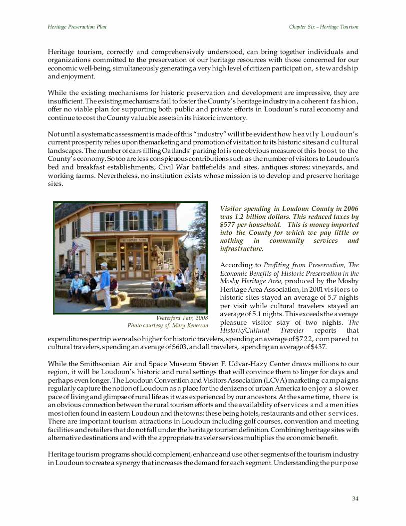
Heritage Preseravtion Plan Chapter Six – Heritage Tourism
34
Waterford Fair, 2008
Photo courtesy of: Mary Kenesson
Heritage tourism, correctly and comprehensively understood, can bring together individuals and organizations committed to the preservation of our heritage resources with those concerned for our economic well-being, simultaneously generating a very high level of citizen participation, s tewardship and enjoyment. While the existing mechanisms for historic preservation and development are impressive, they are insufficient. The existing mechanisms fail to foster the County’s heritage industry in a coherent fashion, offer no viable plan for supporting both public and private efforts in Loudoun’s rural economy and continue to cost the County valuable assets in its historic inventory. Not until a systematic assessment is made of this “industry” will it be evident how heavily Loudoun’s current prosperity relies upon themarketing and promotion of visitation to its historic sites and cultural landscapes. The number of cars filling Oatlands’ parking lot is one obvious measure of this boost to the County’s economy. So too are less conspicuous contributions such as the number of visitors to Loudoun’s bed and breakfast establishments, Civil War battlefields and sites, antiques stores; vineyards, and working farms. Nevertheless, no institution exists whose mission is to develop and preserve heritage sites.
Visitor spending in Loudoun County in 2006 was 1.2 billion dollars. This reduced taxes by $577 per household. This is money imported into the County for which we pay little or nothing in community services and infrastructure. According to Profiting from Preservation, The Economic Benefits of Historic Preservation in the Mosby Heritage Area, produced by the Mosby Heritage Area Association, in 2001 vis itors to historic sites stayed an average of 5.7 nights per visit while cultural travelers stayed an average of 5.1 nights. This exceeds the average pleasure visitor stay of two nights. The Historic/Cultural Traveler reports that
expenditures per trip were also higher for historic travelers, spending an average of $722, compared to cultural travelers, spending an average of $603, and all travelers, spending an average of $437. While the Smithsonian Air and Space Museum Steven F. Udvar-Hazy Center draws millions to our region, it will be Loudoun’s historic and rural settings that will convince them to linger for days and perhaps even longer. The Loudoun Convention and Visitors Association (LCVA) marketing campaigns regularly capture the notion of Loudoun as a place for the denizens of urban America to en joy a s lower pace of living and glimpse of rural life as it was experienced by our ancestors. At the same time, there is an obvious connection between the rural tourism efforts and the availability of services and amenities most often found in eastern Loudoun and the towns; these being hotels, restaurants and other services. There are important tourism attractions in Loudoun including golf courses, convention and meeting facilities and retailers that do not fall under the heritage tourism definition. Combining heritage sites with alternative destinations and with the appropriate traveler services multiplies the economic benefit. Heritage tourism programs should complement, enhance and use other segments of the tourism industry in Loudoun to create a synergy that increases the demand for each segment. Understanding the purpose
Heritage Preseravtion Plan Chapter Six – Heritage Tourism
35
of the trip as well as what activities visitors include in their plans will increase the economic impact from heritage preservation through increased visitation. Heritage Tourism Policies
1. As Loudoun County’s programmatic arm for tourism, the Loudoun Convention and Vis itor’s Association should lead and implement the heritage tourism program providing the marketing, product development, business development and research support necessary to help to generate visitor spending.
2. County-owned heritage sites appropriate for visitation should develop educational materials and conduct tours. Marketing efforts should be coordinated with the LCVA in order to link individual resources to expand their visitation. Non-County owned sites should be encouraged to do likewise.
3. The County will maximize the tourism opportunities springing from the State’s 2007 celebration
of the first English settlement in Virginia, the opening of the Smithsonian Air and Space Museum Steven F. Udvar-Hazy Center, the County’s own 250th anniversary of its formation and Leesburg’s 250th anniversary.
4. As part of an overall heritage awareness program there will be the continuation of heritage
tourism awareness building to promote Loudoun’s heritage tourism assets to our residents. 5. The LCVA will continue to represent the tourism industry regionally, statewide and nationally to
ensure that heritage tourism opportunities are connected to Loudoun’s visitor experience. 6. The development of new heritage sites should be encouraged and fostered, such as those
associated with Civil War battles and skirmishes and other historical events. 7. The Heritage Commission will provide support to heritage property owners interested in
properly identifying, interpreting, establishing and maintaining a heritage tourism s ite, set the standards and regularly assess the authenticity, readiness and suitability of proposed heritage tourism sites.
8. To ensure an authentic educational experience, the County will adopt a series of criteria to ass ist
in identifying sites, services, and events that authentically convey the heritage of Loudoun County. An authentic resource is defined as:
Authentic Resource: A site, service, or event which reflects the County’s heritage by retaining f eatures which existed during its period of significance, and by demonstrating an association with historic events, persons, architecture, engineering, or technology. It is not necessary for a site, service, or event to retain al l of the features that it had during its period of significance, but it must retain enough of these f eatures to present a clear picture of local heritage.· • For a Historic Site, evidence of authenticity is strengthened by listing on, or eligibility for li sting on,
the National or State Register of Historic Places or the Loudoun Heritage Register. • For a Museum, evidence of authenticity is strengthened by interpretation that meets professional
standards such as the standards established by the American Association of Museums. Collections, which are not displayed in an interpreted historic building, must have sufficiently detailed interpretation to convey a strong sense of local heritage.
Heritage Preseravtion Plan Chapter Six – Heritage Tourism
36
9. Heritage and related resources that are officially designated by the County will be encouraged to participate in targeted advertising and identification programs. Participants in the programs shall be provided with marketing devices that help visitors identify authentic heritage tourism sites as places where they can be assured of obtaining an authentic and high-quality experience. Incentives such as those listed here could be made available to officially designated heritage and related resources:
• Assistance with grant writing needs • Appropriate preference within the grant criteria and priorities for each grants program or
funding requests from Loudoun County • Special publications that feature only the officially designated heritage and related resources • Special tours and media opportunities for additional visibility • Priority consideration for use of images in promotional materials
10. To maintain a quality heritage tourism experience, the County, through the Heritage
Commission, will establish readiness criteria that shall be met by all heritage tourism businesses that wish to participate in the heritage tourism program. The readiness criteria address business activities such as hours of operation, events, history interpretation and availability of customer services.
11. The County will remove obstacles from the Zoning Ordinance and Facilities Standards Manual
(FSM) to facilitate heritage resource protection, preservation and adaptive reuse as tourism facilities. For instance, historic sites and buildings should not be placed in a nonconforming status by zoning ordinance standards. FSM and Zoning standards should not require site des ign features that detract from the authenticity of the tourist experience, endanger the integrity of the resource or prevent the adaptive reuse of the site.
12. Since appropriate, convenient tourist services are an essential complement to heritage tourism
development, the zoning ordinance should reflect the need for restaurants, overnight accommodations, support shops and other services both as part of a heritage tourism facility and in reasonable proximity to such facilities. Development of such uses is preferred as adaptive reuse or in the towns and villages where infrastructure exists so that tourist facilities do not impact the integrity and authenticity of heritage sites.
13. The County will establish incentive programs to assist prospective tourism businesses including
appropriate site preservation and maintenance, business start-up or gap financing and educational and technical support.
14. The County will identify a sustainable source of funding to enhance the current heritage tourism
program. Because heritage tourism plays an educational and preservation role for local residents as well as tourists, the County should not rely solely on Transient Occupancy Taxes but should seek funds from other government and private sources.
15. The County should help to expand the heritage educational opportunities that increasingly are
part of the tourism experience. Use of public sites for archaeological research, as museums and libraries provides an added dimension to the tourism experience.

Heritage Preseravtion Plan Chapter Six – Heritage Tourism
37
Implementation The Heritage Preservation Plan envisions that the County’s tourism program will continue to be driven by entrepreneurial efforts of private property owners supported in part by Transient Occupancy Tax funds and other sustainable funding sources. The LCVA should play a central marketing and coordination role in concert with the County’s Department of Economic Development and private organizations. However, the function of developing authentic, appropriately interpreted and preserved heritage tourism resources could most effectively be handled under the purview of a Heritage Commission.1
1 The Heritage Commission is a body which includes stakeholders and experts in a variety of fields related to historic preservation, including heritage tourism, as well as marketing and business. The Commission is to undertake several responsibilities identified in the Heritage Preservation Plan. In this case it is to be a conduit for financial and technical assistance to owners of significant heritage resources who wish to restore and interpret their resource a nd to maximize its economic potential. The Commission will also seek out new products and resources and encourage coordination between different operators to maximize the economic return to the County while meeting preservation objectives.
Waterford Fair, 2008
Photo courtesy of: Mary Kenesson

Chapter 7 ____________________
Stewardship of County-Owned
Heritage Resources
Mt. Zion Church, Aldie, Virginia

Heritage Preservation Plan Chapter Seven – Stewardship of County-Owned Heritage Resources
39
E. E. Lake Store, Bluemont, Virginia
Stewardship means planning and taking the necessary actions over the long term to successfully preserve and protect the resources for which we have the privilege of caring. Good stewardship also requires managing resources to help educate and revitalize communities, while maintaining the character that makes Loudoun a desirable place to live.
The County recognizes its responsibility for owning and managing heritage resources and is committed to being a better steward through implementation of the following policies. Because Loudoun County currently owns and operates several historic properties it is incumbent on the County to be a good steward (Refer to Appendix A). These properties fall broadly into two categories; those located within staffed county parks and those that are stand-alone sites. Sites within park settings are operated by the Department of Parks, Recreation and Community Services (PRCS) and are managed by the respective park s ta ff. Each stand-alone property has a citizen
advisory board that, in cooperation with the County, is generally responsible for stewardship of the property. Decisions about restoration objectives, how the property will be interpreted or used, modifications to buildings and landscape, are made in cooperation with the volunteer advisory groups through a written agreement with the County. The County has several successful preservation projects. For example, the Carver School in Purcellvil le has been restored as a senior center, adult daycare and community center. The Carver School was opened in early 1948 as the area’s first modern elementary school for African-American children. Following school integration, Carver School was closed in 1968 and served as a school storage facility for the next 31 years. In February 2000, the Older Americans Humanities Corp. (OAHC), a private non-profit group, proposed restoring the building to active use as a senior center. The Loudoun County Board of Supervisors approved $5.3 million dollars in funding for Carver Center on a bond referendum in November 2001. The design retains the historic fabric of the building to the extent that much of the existing woodwork, hardware, doors and even blackboards have been preserved. The finished Senior Center has retained many of the elements of the original school while providing a modern facility for adult day care, activities for seniors and community programs. Another example of stewardship is the restoration of the Mt. Zion Primitive Baptist Church located on Route 50 east of Gilberts Corner. The Mt. Zion Church Preservation Association Inc. manages this County-owned property. Working in partnership with the County, the Association has been able to secure federal transportation-related funding (ISTEA and TEA-21) to restore the church, purchase additional land, and design a visitor’s center. (Refer to Appendix E: Stewardship of County owned properties) Inspite of these successes, there are challenges facing the County’s current stewardship program. The absence of a formal process for receiving threatened sites and the lack of reliable funding have resulted in the loss of resources to development pressures. The County should take a leading role in the protection and preservation of heritage resources through the acquisition and good s tewardship of these properties and, when appropriate, the de-accessioning of properties back into private ownership under conditions that ensure the preservation of the resource. The County is committed to a continuing program of acquisition and management of heritage resources. The purpose of these stewardship policies is to set the framework for acquiring and managing these resources.

Heritage Preservation Plan Chapter Seven – Stewardship of County-Owned Heritage Resources
40
Slave Quarters, Arcola, Virginia
Stewardship Policies
1. The County will be a leader in the protection and preservation of heritage resources through exemplary stewardship of public properties.
2. The County recognizes that strategic acquisition and maintenance of heritage properties can be a
key component to the preservation of significant heritage resources.
3. The County recognizes the link between stewardship and public education and will use county-owned sites to promote community involvement, stewardship and education in heritage preservation and development.
4. The County will develop and implement a Heritage Resources Stewardship Plan for county-
owned properties. The plan will set the vision for resource management and establish a unified approach to management, funding, accessioning, de-accessioning, research and education and heritage tourism development. The components of this plan should include as follows:
a. The county’s vision and over-arching preservation goals including the rationale for acquiring
and managing additional resources b. Specific criteria and process for acquisition or de-accessioning resources c. Funding options and recommendations for annual funding levels to accomplish preservation
program objectives d. A framework for a county public education program e. Heritage tourism opportunities
5. Each county-owned property will have a stewardship plan that addresses, on a site-specific level,
resource management, funding, ongoing research and education and the heritage tourism development that is unique to each site. Where historic standing structures are present an HSR

Heritage Preservation Plan Chapter Seven – Stewardship of County-Owned Heritage Resources
41
(Historic Structure Report) shall be prepared. Site-specific stewardship plans should address, as a minimum, the following components:
a. Survey of the heritage resource (documentation and physical survey) b. Assessment of resource condition c. Historical context d. Evaluation of significance (Eligibility for national, state and local registers) e. Plan for immediate stabilization and protection f. Plan for restoration and/or adaptive reuse including funding g. Programming plan (education, heritage tourism, and revenue generating events) h. Maintenance plan
6. The County will develop and implement a Strategic Acquisition Plan that will define priorities
for county ownership using data derived from county surveys and assessments . The s tra tegic acquisition plan will include criteria to evaluate resources based on the standards of the National Register of Historic Places and criteria to ensure public acquisition is consistent with the vision of the Heritage Preservation Plan and the Stewardship Plan. The Strategic Acquisition Plan will:
a. Assess whether the resource meets overarching County preservation or thematic goals b. Assess the resource’s historic significance and site integrity c. Determine whether or not there is an opportunity to preserve the resource in context d. Determine suitability for adaptive reuse, public education, recreation or heritage tourism
uses e. Offer a funding strategy and evaluation of the availability of continued funding to fully
execute an appropriate stabilization, rehabilitation, or restoration plan f. Assess Federal, State, or local eligibility
7. The County will explore establishing a revolving fund for acquisition and maintenance of
publicly owned heritage resources. 8. For county-owned properties and resources that meet the appropriate criteria, the County will
seek National Register, County Heritage Register, and Historic Site Designation (as defined in the Loudoun County Zoning Ordinance).
9. The Heritage Commission will, in collaboration with the County shape the vision for the
stewardship and strategic acquisition plans, and will advise the County on site-specific management issues.
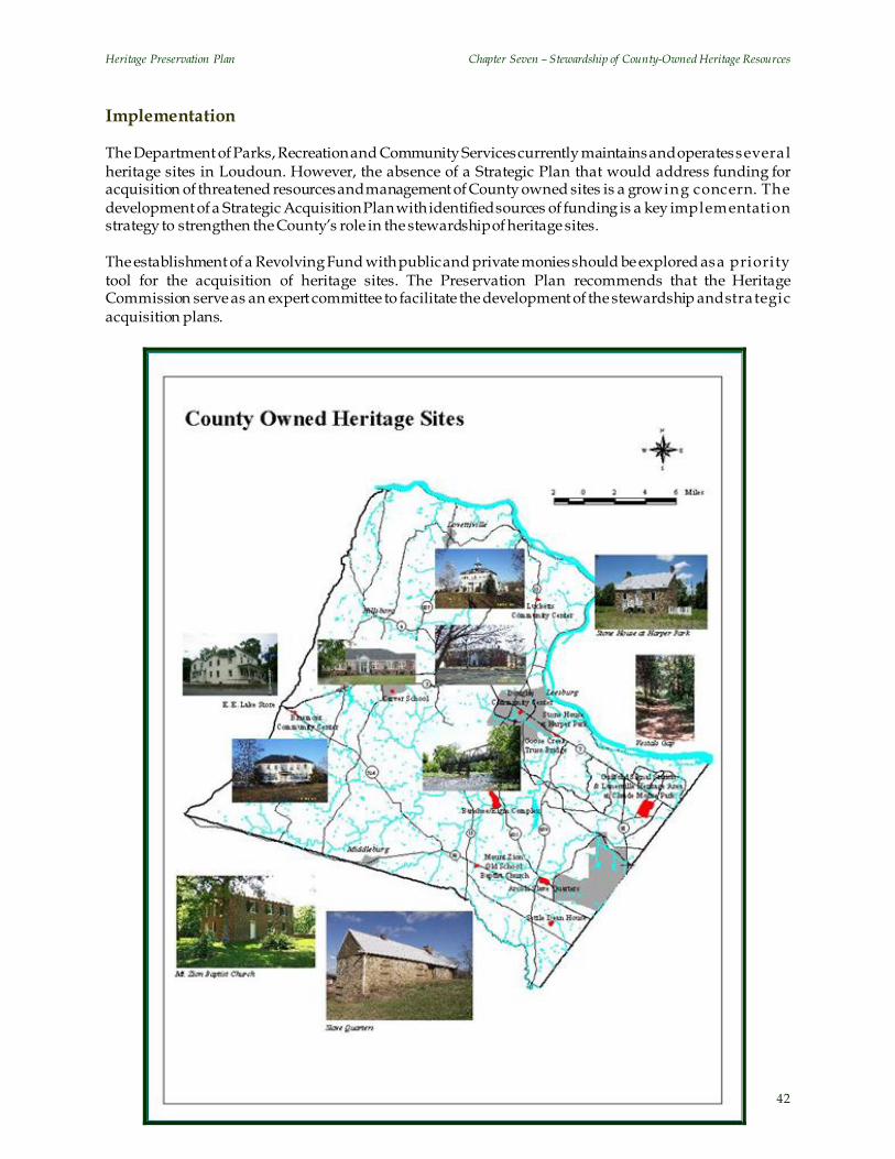
Heritage Preservation Plan Chapter Seven – Stewardship of County-Owned Heritage Resources
42
Implementation The Department of Parks, Recreation and Community Services currently maintains and operates severa l heritage sites in Loudoun. However, the absence of a Strategic Plan that would address funding for acquisition of threatened resources and management of County owned sites is a growing concern. The development of a Strategic Acquisition Plan with identified sources of funding is a key implementation strategy to strengthen the County’s role in the stewardship of heritage sites. The establishment of a Revolving Fund with public and private monies should be explored as a priority tool for the acquisition of heritage sites. The Preservation Plan recommends that the Heritage Commission serve as an expert committee to facilitate the development of the stewardship and stra tegic acquisition plans.

Chapter 8 ____________________
Education
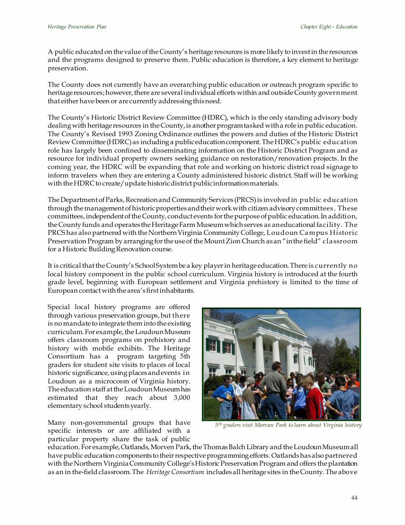
Heritage Preservation Plan Chapter Eight – Education
44
5th graders visit Morvan Park to learn about Virginia history
A public educated on the value of the County’s heritage resources is more likely to invest in the resources and the programs designed to preserve them. Public education is therefore, a key element to heritage preservation. The County does not currently have an overarching public education or outreach program specific to heritage resources; however, there are several individual efforts within and outside County government that either have been or are currently addressing this need. The County’s Historic District Review Committee (HDRC), which is the only standing advisory body dealing with heritage resources in the County, is another program tasked with a role in public education. The County’s Revised 1993 Zoning Ordinance outlines the powers and duties of the Historic District Review Committee (HDRC) as including a public education component. The HDRC’s public education role has largely been confined to disseminating information on the Historic District Program and as resource for individual property owners seeking guidance on restoration/renovation projects. In the coming year, the HDRC will be expanding that role and working on historic district road signage to inform travelers when they are entering a County administered historic district. Staff will be working with the HDRC to create/update historic district public information materials. The Department of Parks, Recreation and Community Services (PRCS) is involved in public education through the management of historic properties and their work with citizen advisory committees . These committees, independent of the County, conduct events for the purpose of public education. In addition, the County funds and operates the Heritage Farm Museum which serves as an educational facility. The PRCS has also partnered with the Northern Virginia Community College, Loudoun Campus Historic Preservation Program by arranging for the use of the Mount Zion Church as an “in the field” classroom for a Historic Building Renovation course. It is critical that the County’s School System be a key player in heritage education. There is currently no local history component in the public school curriculum. Virginia history is introduced at the fourth grade level, beginning with European settlement and Virginia prehistory is limited to the time of European contact with the area’s first inhabitants. Special local history programs are offered through various preservation groups, but there is no mandate to integrate them into the existing curriculum. For example, the Loudoun Museum offers classroom programs on prehistory and history with mobile exhibits. The Heritage Consortium has a program targeting 5th graders for student site visits to places of local historic significance, using places and events in Loudoun as a microcosm of Virginia history. The education staff at the Loudoun Museum has estimated that they reach about 3,000 elementary school students yearly. Many non-governmental groups that have specific interests or are affiliated with a particular property share the task of public education. For example, Oatlands, Morven Park, the Thomas Balch Library and the Loudoun Museum all have public education components to their respective programming efforts. Oatlands has also partnered with the Northern Virginia Community College’s Historic Preservation Program and offers the plantation as an in the-field classroom. The Heritage Consortium includes all heritage sites in the County. The above

Heritage Preservation Plan Chapter Eight – Education
45
mentioned organizations are part of this Consortium. A major focus of the Consortium is promoting the use of local heritage resources as tools for teaching local heritage in the public school system. Public education is a shared responsibility. Formalizing partnerships with other organizations that have a public education mission can strengthen all efforts to highlight the importance of heritage resource preservation. Many separate public education efforts are already established and making some inroads into the community and a successful public education program will necessitate the involvement of these local preservation and education organizations, county government and the public school system. Finally, the County’s public outreach efforts must address changing demographics. Our increas ingly diverse population will influence how the County views its past, how it uses the past in the present and future and which historic places are identified, preserved and interpreted for future generations. Education Policies
1. The County will work with the Public School Administration to coordinate the use of local historic sites, assist in curriculum development, develop new ways of using local resources, provide field trip opportunities, share expertise, and provide extra-curricular opportunities.
2. County Public Schools shall encourage the State Board of Education to make local history a part
of the public school curriculum in all grades. The County will seek to use local history as a case study for national history, math, geography, social studies and other programs.
3. The County should assist private sector heritage providers by encouraging County Public
Schools Administration to participate in development of joint education programs and by offering technical support such as grant writing assistance and other assistance.
4. Public schools will be encouraged to develop enrichment programs (similar to the Virginia Time
Travelers Program) that encourage students and their families to visit heritage sites outside of the school program.
5. The County seeks to facilitate a stronger relationship between Parent Teacher Organizations and
local heritage sites to garner support for preservation activities, fund raising, encouraging school use of local resources and other benefits.
6. The County will partner with colleges and universities to preserve heritage resources by offering
County property as “in-field” classrooms. 7. The Public Information Office should provide all current and new residents with a short/basic
history of Loudoun County, its people and places stories, links to organizations and other materials that introduce them to the County.
8. Loudoun will celebrate our heritage and the County’s role in the State and the nation before and
since 1607. The County should sponsor, encouraging the support of local businesses and organizations, an ongoing program of festivals, lectures, publications and other means of celebrating the 250th anniversary of the founding of Loudoun and other significant National, State and local anniversaries.
9. The County will actively introduce local residents to Loudoun’s history by publishing
information articles, assisting in marketing and advertising events, offering data and coordinating County publications.
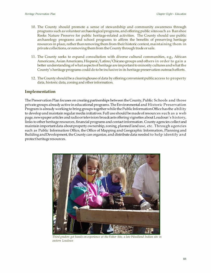
Heritage Preservation Plan Chapter Eight – Education
46
10. The County should promote a sense of stewardship and community awareness through programs such as volunteer archaeological programs, and offering public sites such as Banshee Reeks Nature Preserve for public heritage-related activities. The County should use public archaeology programs and school programs to affirm the benefits of preserving heritage resources in place, rather than removing them from their historic context, maintaining them in private collections, or removing them from the County through trade or sale.
11. The County seeks to expand consultation with diverse cultural communities, e.g., African
Americans, Asian Americans, Hispanic/Latino/Chicano groups and others in order to ga in a better understanding of what aspects of heritage are important to minority cultures and what the County’s heritage programs could do to be inclusive in its heritage preservation outreach efforts.
12. The County should be a clearinghouse of data by offering convenient public access to property
data, historic data, zoning and other information. Implementation The Preservation Plan focuses on creating partnerships between the County, Public Schools and those private groups already active in educational programs. The Environmental and Historic Preservation Program is already working to bring groups together while the Public Information Office has the ability to develop and maintain regular media initiatives. Full use should be made of resources such as a web page, newspaper articles and radio or television broadcasts offering vignettes about Loudoun’s his tory, links to other heritage resources, financial programs and contact information. County agencies collect and maintain important data about property ownership, zoning, planned land use, etc. Through agencies such as Public Information Office, the Office of Mapping and Geographic Information, Planning and Building and Development, the County can organize, and distribute data needed to help identify and protect heritage resources.
Third graders get hands-on experience at the Fisher Site, a late Woodland Indian site in eastern Loudoun
Chapter 9 ____________________
Development Review

Heritage Preservation Plan Chapter Nine – Development Review
48
To combat the loss of heritage resources to land development activity, the County’s Comprehensive Plan calls for the identification, preservation and conservation of heritage resources as part of the land development processes. The County’s preservation strategy relies largely on a Conservation Design process. However, the County currently has neither the enabling legislation to fully implement the principles of Conservation Design nor adequate design guidelines and criteria against which to review land development applications. To assist in this task, the Preservation Plan develops policies, guidelines and future action steps for the identification and preservation of heritage resources as part of the review of land development applications. Land Use Planning For the purposes of strategic land use planning, the County is defined by four distinct Policy Areas, namely the Suburban, Transition and Rural Policy Areas and the Joint Land Management Area (JLMA) surrounding four of the seven incorporated towns in the County. The County has a specific vision for each of these policy areas that differs in land use, development density and pattern, the provision of public and private facilities and services, access to transportation networks and central utilities. It is a lso important to note that these policy areas are in different stages of their development/build-out and are, therefore, subject to varying levels of development pressure.
The Suburban Policy Area includes the eastern 60,000 acres of the County. This is a designated growth area within the County with higher residential and non-residential densities either currently served or planned to be served by a full complement of public utilities and services such as schools, parks and libraries. Most of the Suburban Policy Area is either completely developed or approved for development with the largest undeveloped area existing in its southern portion. Redevelopment and revitalization will constitute significant factors in the future growth and development of most of this policy area. The Transition Policy Area extends over an area of approximately 23,000 acres and is envisioned to serve as a visual and physical transition between the Suburban Policy Area to the east and the Rural Policy Area to the west. Planned at lower densities than the Suburban Policy Area, clustered residential development is intended to constitute the primary development
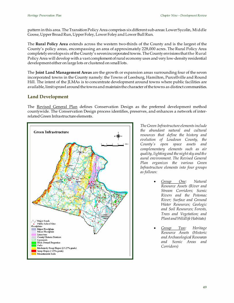
Heritage Preservation Plan Chapter Nine – Development Review
49
pattern in this area. The Transition Policy Area comprises six different sub-areas: Lower Sycolin, Middle Goose, Upper Broad Run, Upper Foley, Lower Foley and Lower Bull Run. The Rural Policy Area extends across the western two-thirds of the County and is the largest of the County’s policy areas, encompassing an area of approximately 228,000 acres. The Rural Policy Area completely envelops six of the County’s seven incorporated towns. The County envisions that the Rural Policy Area will develop with a vast complement of rural economy uses and very low-density residential development either on large lots or clustered on small lots. The Joint Land Management Areas are the growth or expansion areas surrounding four of the seven incorporated towns in the County namely: the Towns of Leesburg, Hamilton, Purcellville and Round Hill. The intent of the JLMAs is to concentrate development around towns where public facilities are available, limit sprawl around the towns and maintain the character of the towns as distinct communities. Land Development The Revised General Plan defines Conservation Design as the preferred development method countywide. The Conservation Design process identifies, preserves, and enhances a network of inter-related Green Infrastructure elements.
The Green Infrastructure elements include the abundant natural and cultural resources that define the history and evolution of Loudoun County, the County’s open space assets and complementary elements such as air quality, lighting and the night sky and the aural environment. The Revised General Plan organizes the various Green Infrastructure elements into four groups as follows:
• Group One: Natural Resource Assets (River and Stream Corridors; Scenic Rivers and the Potomac River; Surface and Ground Water Resources; Geologic and Soil Resources; Forests, Trees and Vegetation; and Plant and Wildlife Habitats)
• Group Two: Heritage
Resource Assets (Historic and Archaeological Resources and Scenic Areas and Corridors)

Heritage Preservation Plan Chapter Nine – Development Review
50
• Group Three: Open Space Assets (Greenways and Trails, Parks and Recreation, Public School Si tes, and Open Space Elements)
• Group Four: Complementary Elements (Air Quality, Lighting and the Night Sky, and Aural
Environment) (Revised General Plan, Text, p. 5-1) The conservation design process is designed to identify, preserve and manage these Green Infrastructure elements through the review of land development applications through a four-step process.
“The first step in conservation design is to identify those Green Infrastructure features of a site to be preserved. The unconstrained land then is available for development and buildings can be located in that area as part of the second step. Street, utility and trail locations are then introduced on the development plan as the third step. The final step is to locate lot lines.” (Revised General Plan, Text, p.11-5)
The Conservation Design process protects primary conservation areas namely, the River and Stream Corridor Resources, Mountainside Soils, Steep Slopes (slopes with greater than 25% gradient), Limestone Conglomerate Bedrock and other resources required to be protected by federal and state regulations. Revised General Plan Policies seek to protect these resources. All other Green Infrastructure elements, including heritage resources, fall within the scope of secondary conservation areas that are currently not defined in the Ordinance. These resources are protected only if they occur within the primary conservation areas listed above, in areas of steep slopes, or within one of the six County administered historic overlay districts. There are few tools available to the County to protect heritage resources outside adopted environmental and historic overlay districts. In such instances, resource protection is largely negotiated during the review of land development applications. The limited success that the County has achieved in this area has been the result of voluntary proffers and dedications by applicants and protection of these heritage resources within open space areas. The intent of the land development policies of the Preservation Plan is to support the review of land development applications by defining the heritage resource types, offering protection strategies, protection incentives and design guidelines. Land Development Policies
1. The County recognizes its heritage resources as a collection of natural and cultural resources that represent the history and evolution of Loudoun County. These heritage resources are an integral component of the Green Infrastructure that will provide the framework for strategic land use planning and development. All new development should first and foremost seek to minimize adverse impacts on heritage sites. New development should be sited and designed to be compatible with the heritage resources on the site.
2. The County’s heritage resources include, but are not limited to the following elements:
• Historic standing structures, ruins and/or complexes in the context of their historic settings • Archaeological sites, including gravesites and cemeteries • Cultural landscapes such as battlefields and sites • Landscape elements such as stone walls, historic roadbeds

Heritage Preservation Plan Chapter Nine – Development Review
51
• Geologic formations such as rock outcrops and mineral deposits • Significant trees that have been designated or qualify for designation as State or National
Champions, National Register Trees, State Big Trees, Heritage trees and Specimen trees.
3. The following heritage sites will be considered priority sites in the land development review process.
• Sites designated or potentially eligible for designation as County Heritage Register properties
and/or National Landmarks and sites listed in or potentially eligible for listing in the National or State Register of Historic Places
• Battlefields associated with “principle battles” of the Civil War (as identified by the Civil War
Site Advisory Commission)
• Sites designated or deemed potentially eligible for designation as Historic Sites under the provisions of the Loudoun County Revised 1993 Zoning Ordinance
4. The County will develop incentives to encourage the voluntary protection of heritage resources.
• The County will permit the voluntary transfer of density from a site with an identified heritage resource to another County approved site or sites. Receiving sites may be located anywhere in the County.
• The County will review and make changes, as necessary, to the various regulatory
documents including the Loudoun County Revised 1993 Zoning Ordinance, Facilities Standards Manual and the Land Subdivision and Development Ordinance to ensure that the regulations promote and encourage heritage preservation.
5. Recognizing the significance of contemporary architecture to the evolving heritage of Loudoun
County, the County will pursue the identification and preservation of sites that are less than 50 years of age and are known for their outstanding architecture, site design and/or heritage preservation. Examples of such sites include the Washington Dulles International Airport and the Howard Hughes Medical Research Facility.
6. The County recognizes that all historic standing structures and sites have archaeological
resources associated with them and that the demolition of these structures/sites impacts the integrity of their archaeological components. Therefore, prior to issuance of a demolition permit for any structure 50 years of age or older, qualified County staff will conduct an assessment of the structure to determine historic significance based on National Register criteria. The County’s objective is the preservation of historically significant structures and their associated archaeological resources. At a minimum, the County will record the significant s tructures and associated archaeological resources prior to demolition.
7. The County will establish a Design Awards Program, as recommended by the Loudoun Main
Street Program, to recognize annually existing and new developments that constitute outstanding examples of architecture, site design and/or historic preservation.

Heritage Preservation Plan Chapter Nine – Development Review
52
Selma Plantation, Leesburg, Virginia
8. The County will establish an incentive-based program to provide financial assistance to property owners in dismantling a historic structure. For instance, if the salvaged materials are to be dedicated to the County, the County will bear the full cost of dismantling the structure.
9. County regulatory measures will prevent the neglect and demolition by neglect of historic
resources. 10. The County will provide technical assistance in writing grant proposals to secure funding for
various preservation related activities. This service will be offered to both public and private organizations seeking to preserve resources.
11. Primary responsibility for reviewing land development applications for heritage resource
protection shall reside with County staff. Depending on the level of complexity involved, s ta ff may elevate the applications to the Heritage Commission for comments.
12. The Heritage Commission will serve in an advisory capacity in the review of land use
applications, whether legislative or by right. 13. The County’s security plan should take into account the risks and consequences of potential
terrorist threats and attacks. Critical sites are those historic and contemporary architectural and cultural resources that represent our Nation’s heritage, traditions and values and political power e.g., Dulles International Airport. The sites that fall into this key asset category draw large amounts of tourism and frequent media attention, factors that impose terrorist protection challenges. The requirement at those high profile sites is to protect the visitors as well as the structures themselves. Some historic and cultural sites, located in Loudoun County, are under the protection of the Department of Homeland Security (DHS). Plans for those sites are classified by the DHS and are not freely accessible, or discussed by them. In those instances, the County security staff’s role will be to coordinate and cooperate with DHS, where possible. For other County sites, designated as possible targets, the County security staff will accomplish their own evaluation and planning protection within the scope of the Nation’s security guidelines.
Historic Standing Structures and their Settings
Historic structures in Loudoun County constitute the most visible representations of the County’s heritage. These structures tell stories about the origins, settlement patterns, social structures and lifestyles of the County’s early settlers and serve as vital indicators of the presence of archaeological sites. These structures provide valuable information, not only through their design, architectural style, building materials and construction techniques, but also through the layout of the site and surrounding landscape and are thus, inextricably linked to their historic settings. The historic settings, comprising natural and cultural
Heritage Preservation Plan Chapter Nine – Development Review
53
elements, associated outbuildings and other contributing landscape elements such as historic travel routes and stone walls, define the larger context within which the structure was built. Recognizing the significance of preserving historic structures in the context of their settings , policies in the Revised General Plan state:
“The County will protect structures and other features of historic significance in the context of their natural settings and will work with landowners to convey the historic value of the resource to the community at large. Structures and other features of particular historic significance will be retained, restored, or utilized in adaptive reuse as part of a conservation design process.” (Rev ised General Plan, Policy 8, p.5-35)
The intent of these policies is to assist in the review of land development applications by identifying strategies to protect historic standing structures in their settings. Historic Standing Structures and their Settings Policies
1. The County will consider the following preservation mechanisms in the review of historic standing structures. These mechanisms are prioritized in the order listed below.
a. Preservation: The County’s first priority is to preserve the original use/use type of the
structure in the context of its historic setting. b. Adaptive Re-use: While it may not always be possible to preserve or promote the original
use for which a historic structure was constructed, the County recognizes the value of the building itself as a historic resource and calls for its preservation through adaptive re-use.
c. Record and Relocate: The historic structure or complex will be recorded and relocated to
another County approved site. This receiving site may be located in any suitable location, anywhere in the County.
d. Record and Dismantle: The historic structure or complex will be recorded and dismantled.
• Prior to dismantling a structure the applicant will explore opportunities for its relocation. For instance, the property owner will offer the property for sale for a minimum period of 120 days.
• The applicant will offer the County the opportunity to relocate the structure to an
alternate site within the County, prior to dismantling the structure.
e. Record and Demolish: The historic structure or complex will be recorded and demolished.
• Prior to the issuance of a demolition permit for any structure 50 years of age or older, qualified County staff will conduct an assessment of the structure to determine his toric significance based on National Register criteria.
2. Recognizing the significance of historic standing structures in their settings as valuable sources of
information about the settlement patterns, architecture and lifestyles of the early inhabitants of Loudoun County, the County’s first priority will be the preservation of these resources in the context of their historic settings.

Heritage Preservation Plan Chapter Nine – Development Review
54
3. The County will consider applications requesting the purposeful termination of or modifications to the boundaries of historic settings through mechanisms such as buffer, landscaping and the arrangement of building sites.
4. The County will develop and make available examples of Context Analysis Reports to property
owners and applicants to assist in determining the historic setting of a resource. The Context Analysis Reports will be developed based on the criteria and guidelines developed by the National Park Service for Cultural Landscape Reports.
5. The need for a Context Analysis Report will be identified at the time of the pre-application
meeting for legislative applications and the pre-submission meeting for by-right applications. 6. County staff will review the context of the resource and provide input into the scope of the
Context Analysis Report. This will be done during the Site Analysis and Site Inspection stages of an application review as defined in Section 6-2000 of the Loudoun County Revised 1993 Zoning Ordinance.
7. All recordation of historic structures will be conducted in accordance with the Secretary of the
Interior’s Standards. 8. An applicant shall conduct a Reconnaissance Level Survey to assess the historic s ignificance of
any structures 50 years of age or older prior to relocating, dismantling or demolishing the structure. The historic assessment will be conducted for any structure less than 50 years of age if the structure has been identified as an exceptional example of contemporary architecture either by the County Design Awards Program or the County Heritage Register.
9. All new land development applications will be evaluated against the Design and Preservation
Guidelines outlined in this Plan. 10. All new developments falling within the setting of a historic resource will comply with the
Architectural Compatibility Guidelines established in the Preservation Plan.

Chapter 10 ____________________
Design and Preservation Guidelines:
Guidelines for the Preservation of Historic Standing Structures
Goose Creek Meeting House, Lincoln, Virginia
Photo courtesy of: Paul Glenshaw
Heritage Preservation Plan Chapter Ten – Design and Preservation Guidelines: Guidelines for the Preservation of Historic Standing Structures
56
Principles The following guidelines outline five strategies for the preservation of historic standing structures . The guidelines are derived predominately from the standards and guidelines of the National Park Service. These strategies are prioritized in the order listed below. 1. Preservation
a. The original use/use type of the structure should be preserved. Structural stabilization,rehabilitation and/or restoration should be executed as necessary to the Secretary of the Interior’s Standards for the Treatment of Historic Properties and the Secretary of the Interior’s Standards for Rehabilitation (36 CFR 67).
b. Historic structures should be protected in the context of their natural and/or cultural settings .
The County will develop a package of incentives to encourage property owners to limit development within this area.
c. New developments that extend into the viewshed and/or setting of a historic s tructure will be
reviewed for compatibility with the architecture and associated landscape of the historic structure.
d. Architectural Compatibility Guidelines: In reviewing new land development applications for
compatibility with historic structures, the following factors should be taken into consideration:
i. Building mass and height in relation to that of surrounding development within its viewshed ii. Roof form
iii. The setback and placement of the building on the lot in relation to the average setback and placement of the nearest adjacent and opposite buildings within the viewshed of the historic resource(s)
iv. Building orientation v. Number, placement and proportion of façade fenestration, including primarily the doors and
windows vi. Size, shape and proportion of entrance features such as porches vii. Choice and color of exterior construction materials
viii. Architectural detailing ix. Landscape elements such as vegetation, fences, walkways, etc.
2. Adaptive Re-use
a. While it may not always be possible to preserve or promote the original use for which a his toric structure was constructed, the County recognizes the value of the building itself as a historic resource and calls for its preservation through adaptive re-use.
b. The proposed re-use should be consistent with and implement the land use policies for the area
as defined in the County’s Comprehensive Plan. c. The historic landscape associated with the structure should be protected to preserve the resource
in its context. d. The proposed use should generally be compatible with the surrounding landscape and
development patterns. For instance, any additional parking, lighting or s ignage requirements necessitated by the re-use of the historic structure should be appropriately sized and/or shielded

Heritage Preservation Plan Chapter Ten – Design and Preservation Guidelines: Guidelines for the Preservation of Historic Standing Structures
57
to minimize any adverse impacts on the character of the surrounding area. The County will amend its regulatory documents to ensure that the minimum parking, signage, lighting and other design requirements do not adversely impact the historic character of an area.
3. Record and Relocate
a. The proposed use of a relocated structure should be compatible with the land use policies of the receiving site and surrounding uses.
b. The site to which a historic structure is relocated/receiving site should meet the following
established criteria:
Moving Historic Standing Structures: Criteria for Receiving Sites i. Receiving sites should ensure that the historic resource is compatible with its new landscape.
(Refer to the section on Architectural Compatibility Guidelines) ii. Locate the structure where it is similar in architecture and period to the existing buildings.
iii. Locate the building within the same historic district or a historic district with a similar architectural period.
iv. Retain all the important character defining architectural features that contribute to the historic authenticity of the building.
v. Landscape the site with indigenous plantings similar to those at the original site. 4. Record and Dismantle
a. Dismantle a building if:
i. The building is structurally unstable ii. It can be shown that at least 60 percent of the structural integrity of the building has been
compromised based on current structural engineering standards iii. Incompatible additions or modifications over time have depleted the historic value or
integrity of the structure.
b. Dedicate or sell building materials salvaged from historic structures to the County, or another public or private agency/organization that is involved in the preservation field.
c. Include with these materials a written history of the structure from which the materials were
salvaged. 5. Record and Demolish
a. Demolish a building if:
i. The building is structurally unstable. ii. It can be shown that at least 60 percent of the structural integrity of the building has been
compromised based on current structural engineering standards iii. Incompatible additions or modifications over time have depleted the historic value or
integrity of the structure.
Heritage Preservation Plan Chapter Ten – Design and Preservation Guidelines: Guidelines for the Preservation of Historic Standing Structures
58
Guidelines for the Delineation of Historic Settings Historic settings comprise both natural and cultural elements. To assist in the delineation and preservation of these settings, the Preservation Plan calls for the definition of two components of settings: the ‘Viewshed’ and the ‘Resource Setting.’ Viewsheds may be defined simply as the foreground of the resource. The definition of resource settings is more complex. The resource setting of a historic structure includes the historic landscape associated with the structure, including the foreground and background or the backdrop against which the s tructure is viewed. The viewshed may be considered a component of the resource setting. 1. Viewshed
a. The viewshed of a historic structure or complex is generally defined as the foreground of the primary structure(s) to the public right-of-way that serves as the primary access to the site.
b. In the case of a historic district or a landscape such as a battlefield, the viewshed should include
the views to and from all public rights-of-way adjacent to the district or landscape. c. The viewshed should be protected from at least one point on the public right-of-way that serves
as the primary access to the site. d. Some historic properties are located in less visible areas of the County from the perspective of
heritage tourism and public access. These sites are typically located away from major travel corridors, nestled in remote corners of the county, etc. In such areas that are typically not frequented by tourists or the general public, the viewsheds may be terminated at the property boundary and not extend to the public right-of-way.
2. Resource Setting
a. Protect the historic resource in the context of their historic setting that includes both the natural and cultural landscape elements on the property.
b. The resource setting is the immediate foreground and background of the resource and includes
the following elements:
• All contributing structures • Landscape elements such as tree lines, driveways, historic roadbeds, gardens, walls and
fences associated with the structure.
c. The resource setting should be protected from at least one point on the public right-of-way that serves as the primary access to the site. The setting will include all or part of the viewshed as defined above.
d. Include all contributing structures in the definition of the setting. If this is not feasible, focus on
the primary structure. e. Applicants should identify contributing landscape elements, define the boundaries of the
resource settings and assess their historic significance within the scope of a Context Analysis Report. The Context Analysis Report should also identify the viewing point(s) and include a definition and analysis of the areas visible from these viewing points on the public right-of- way.
Heritage Preservation Plan Chapter Ten – Design and Preservation Guidelines: Guidelines for the Preservation of Historic Standing Structures
59
f. Qualified County staff and/or the Heritage Commission will review applications requesting to modify the historic settings. The modified setting and the materials should not detract from the historic authenticity of the resource. Characteristics such as the height, density and species/species composition of vegetation, design, material and layout of landscape elements such as stone walls and/or the architectural compatibility of buildings intended to redefine the natural boundaries of viewsheds should be considered in the review.
3. Buffer Guidelines In developing buffers around historic resources to protect them from incompatible development patterns or to modify the boundaries of a historic setting or viewshed, the following guidelines will be followed.
a. A historic structure or complex should be appropriately buffered from surrounding development when the structure or complex cannot be protected in its natural or cultural setting or the historic landscape cannot be preserved in its entirety.
b. Buffers may serve to define or direct views to and from the resource. They may a lso be used to
define narrower boundaries for the viewshed or resource setting of a historic structure and shield the historic resource from incompatible surrounding developments.
c. Buffers may consist of vegetation or be constructed out of traditional landscape elements such as
stone walls. d. These buffers should be protected through perpetual open space easements. e. Applications should be reviewed to ensure that the design, layout and choice of materials for the
buffer maintain or enhance the historic authenticity of the resource. Development Siting Guidelines Application Development siting guidelines are intended to mitigate the impacts of new development on the his toric and cultural resources and landscapes of Loudoun County. These guidelines will apply to all new developments proposed within the viewshed or resource setting of a historic structure, cultural landscape or historic district. The historic significance of a resource will be determined through the Phase-1 Report. The development siting guidelines will also apply to all new developments proposed within the viewsheds of designated heritage corridor, including Virginia Byways, State Scenic Rivers and mountain ridges. 1. Site Development
a. Retain natural site contours b. Avoid placing structures on ridgelines or hilltops. Structures should follow the natural
topography unless sound engineering standards suggest that it is not feasible. 2. Site Layout
a. Incorporate existing features such as trees, hedgerows, walls and fences into the des ign of new building sites in order to blend with the surrounding landscape.
Heritage Preservation Plan Chapter Ten – Design and Preservation Guidelines: Guidelines for the Preservation of Historic Standing Structures
60
b. Locate new buildings in such a way that the natural contours and vegetation screen them from the historic resource.
c. Orient buildings in a coherent relationship to each other with one or more organiz ing elements
such as a park, civic or community center, stream corridor or access road. d. Face buildings towards the public right-of-way. Exceptions to this guideline will be considered
on a case-by-case basis. This rule may be waived if for instance, buildings face each other across a pedestrian pathway, a green, square, etc.
3. Building Design
a. Building form and orientation should enhance and/or direct existing views. b. Break down the building mass into smaller units, except for uses that are characterized by large
buildings such as barns. c. The design should establish a hierarchy in the building mass, with the smaller masses located
closer to the public right-of-way. d. The design should be visually compatible with adjoining historic properties. This does not
necessarily mean that the architectural style of the historic structure should be duplicated. e. Designs associated with national franchises or chains proposed within the viewshed of his toric
resources should be subject to review by the Heritage Commission to ensure their consistency with established architectural compatibility standards.
f. Avoid large expanses of blank walls. Modify surface planes through recessions, projections,
introduction of fenestration, variations in building materials, color, texture, etc. Exceptions may be allowed in uses that are designed in accordance with traditional architectural principles, such as barns.
4. Transportation and Parking
a. Reduce the number of curb cuts by consolidating site access with shared, well-defined entrances. b. Avoid large expanses of parking lots. Break parking areas into smaller units. Landscape parking
areas to minimize the visual and environmental impacts of impervious surfaces. c. Avoid placing parking areas in front of buildings. Distribute parking spaces to the sides and rear
of buildings. 5. Services
a. Locate storage and service areas away from public view and screen them with plant materials and/or berms, as necessary.
6. Towns and Villages
a. When developing within a town, its Joint Land Management Area or a village, the development should be compatible with the predominant development pattern within the town or village.

Heritage Preservation Plan Chapter Ten – Design and Preservation Guidelines: Guidelines for the Preservation of Historic Standing Structures
61
b. The primary factors that should be considered in determining the compatibil ity of a proposed development include density, street layout, building siting, mass, form and orientation.
Late 18th Century House, Cooksville
Lost to demolition

Chapter 11 ____________________
County Operations
Lucketts School, now a Community Center
Heritage Preservation Plan Chapter Eleven – County Operations
63
The Preservation Plan sees the need to emphasize the importance of heritage preservation among County employees through a variety of programmatic changes and initiatives such as making it an integra l part of their performance plans and assessments. A critical aspect of development review pertains to the training of County staff in the identification and review of land development application for the preservation of heritage resources and their settings. To implement the recommendations pertaining to the review of land development applications, the County also recommends the creation of a management structure that will draw together public and private organizations from a variety of fields. The Heritage Commission is the primary organization to be established by the County to implement the Heritage Preservation Plan. The Heritage Commission will be composed of members from various County agencies and private organizations that work in such fields as heritage preservation, tourism and business development. The overarching function of this Commission will be to oversee the long-term implementation of the Preservation Plan and to serve in an advisory capacity on the day-to-day preservation related activities of the County, such as the review of land development applications. In addition to this Commission, the County calls for the creation of a Preservation Resource Center, composed of experts in various fields who can offer design services related to preservation to public and private entities. Both organizations will be housed within the County. County Operations Policies 1. The County will improve its system of resource identification and protection so that all branches of
the County government have as part of their responsibilities the protection of our heritage resources. No branch of county government should be ignorant of just what and where these resources are. No “permitting” should take place at any level that does not reflect staff work that has taken into account all county heritage resources.
2. The County shall require each agency to annually assess its impact on heritage preservation efforts ,
outlining protection successes and failures and recommendations for anticipated issues. 3. Performance plans for County employees shall require training and ongoing awareness of County
heritage preservation policy and ordinances. Orientation for new County employees will include materials and presentations on the County’s heritage resources.
4. The County will offer continuing education classes on heritage preservation design guidelines,
policies and regulations. Participation in these classes shall be in accordance with an es tablished schedule.
5. The County will work with the Heritage Commission to establish a Preservation Resource Center or a
centralized clearinghouse for preservation resource materials that would provide technical assistance to the citizens and organizations undertaking preservation activities in the County.
6. The establishment of a Preservation Resource Center, and/or resource materials, will help
appropriate County agencies respond to citizen’s requests for assistance and address des ign issues within the County’s seven incorporated towns and villages.

Heritage Preservation Plan Chapter Eleven – County Operations
64
7. The Preservation Resource Center will provide the following technical assistance:
a. Produce information materials such as brochures, and pamphlets on various issues pertaining to preservation
b. Make available County and other public documentation and resources to help trace the history of
the site or structure c. Provide information on available federal, state or local preservation assistance programs, both
financial and otherwise d. Provide information and assistance to property owners regarding the various preservation
mechanisms such as rehabilitation, restoration, adaptive re-use, etc. e. Assist owners of small properties in the development of Context Analysis Reports, the need for
which will be determined on a case-by-case basis
8. The Preservation Resource Center will offer appropriate maintenance, repair and restoration information to builders such as that provided by the National Park Service. Such material should at a minimum be available at the Departments of Planning and Building and Development customer counters.
9. The Preservation Resource Center will include staff representatives from County agencies, primarily
the Departments of Planning, Building and Development and Economic Development, to assist in the review of land development applications, expedite application review timelines, etc.
10. The members of the Preservation Resource Center will consist of experts in the field of preservation,
including County staff, academics, architects, contractors and developers. The County will pay for the services offered by this group.
11. The Preservation Resource Center will be represented on the Heritage Commission. 12. Preservation Resource Center will establish a County Preservation Certification Program that will
license or certify contractors to work in the preservation field. This will be combined with incentives to encourage property owners to use County licensed contractors. This is intended to ensure a high quality of preservation work in the County to maintain and/or enhance the historic authenticity of the resource.
Resource Recordation The recordation and management of data collected through the various survey efforts and archaeological reports are critical follow-up steps to resource identification and an integral component of County operations. In this regard, the County government has a unique record keeping and information management role. The Division of Purchasing and Support Services, through its Records Officer, is responsible for administering the Records Management program. Guidelines developed by the Library of Virginia (LVA) Records Management division have been used as a framework for creating county-specific records management policies and procedures. The LVA also provides services to support state and local government records management initiatives.
Heritage Preservation Plan Chapter Eleven – County Operations
65
The County Records Center was established to provide economical storage and efficient and timely retrieval of stored records. The County’s Records Center should continue to ensure that data is properly maintained and easily accessible and recognize the value of data as historic information. As office space is considerably more expensive, the County Records Center also works to remove inactive records from these spaces. Automated records systems and electronic records can greatly enhance an agency’s productivity and customer service programs. However, it should be recognized by all administrators and records officers that the value of a record may not expire once a transaction has been finalized, a project completed, or a decision reached. Land records, development permits and applications, cultural and environmental resources, property assessments and tax payment information are all databases that over time become important historical records. Continued administrative, legal, and historical value must be considered before a record is removed or lost through the deterioration of the storage medium or technological obsolescence. The County’s information system should provide the public and various County departments and agencies a convenient means of researching property and events. Steps have been taken to improve the County’s Land Management Information System, making certain pieces of information more readily available. Providing this and GIS information on the internet will also improve convenience; however, i t is critical that such databases be kept up to date. Resource Recordation Policies 1. The County will maintain a computerized database of heritage resources by parcel information. This
database will identify parcels that are in and/or contiguous to historic districts. This data will be made available through the County’s web-site for public information and to assist county staff in the review of land development applications.
2. The County Records Center shall provide economical storage and efficient and timely retrieval of
stored records. The record-storage space shall be designed to maintain County records in a good condition.
3. Records scheduled for permanent retention shall be systematically maintained so that access to the
information they contain is possible. Basic rules of archival management will be followed and records will be maintained in the order they were kept by the creating office.
4. The County will comply with the Virginia Public Records Act; and follow Library of Virginia (LVA)
records management guidelines where appropriate to ensure that all records are managed properly.
Glossary ____________________
Archaeology: The scientific study of the physical evidence of past human societies recovered through excavation. Archaeological Site: A location that contains material evidence of past human activities for which a boundary can be established. Certified Local Government (CLG): Refers to a local government, certified or approved by the State Historic Preservation Office (SHPO), which has an appointed commission to oversee the survey and inventory of historic resources, to review areas for historically significant structures, and to develop and maintain community planning and education programs. Champion Trees: A Champion Tree is defined as the largest specimen of its species. A champion tree may be a National Champion, a State Champion or both. Corridor Assessment Plan: A Corridor Assessment Plan is a planning document that provides inventory and assessment of important resources and intrinsic qualities associated with an individual heritage corridor. The Corridor Assessment plan also provides management strategies designed to address development in proximity to the corridor, the interpretation and promotion of the corridor and the preservation and protection of the corridor in both the short-term and long-term. Context Analysis Reports: A Context Analysis Report follows standard procedures for documenting, mapping, and analyzing historic landscapes and their associated view sheds based on techniques used by National Park Service. A Context Analysis report also may provide guidance for the stewardship, preservation, and mitigation of effects on significant landscapes. Contributing Structure: A building or structure in historic district that generally has historic, architectural, cultural, or archeological significance. Cultural Landscape: The United Nations Educational, Scientific and Cultural Organizations (UNESCO) defines cultural landscapes as “the combined works of nature and of man and are illustrative of the evolution of human society and settlement over time, under the influence of the physical constraints and/or opportunities presented by their natural environment and of successive socia l, economic and cultural forces, both external and internal”. (UNESCO/ICOMOS Expert Group, World Heritage Convention Operation Guidelines, February 1995). The National Park Service (NPS) defines a cultural landscape as “a geographic area, including both cultural and natural resources and the wildlife or domestic animals therein, associated with a historic event, activity, or person or exhibiting other cultural or aesthetic values.” Cultural Resource Surveys: Inventories of sites, buildings, structures, or objects deemed to have loca l, regional, national, or international cultural significance. The purpose of such surveys is to have a record of what is significant in order to protect such resources from development or encroachment or to document the current appearance or condition for the record. Often such surveys lead to the nomination of properties to historic registers.
Heritage Preservation Plan Glossary
G-II
Curb-cuts: Openings within curb and gutter sections to allow access to intersecting roads , walkways, storm water management facilities, driveways, etc. Demolition by neglect: Process of allowing a building to deteriorate to the point where demolition is necessary to protect public health and safety. Easement (preservation or conservation): Partial interest in property that can be transferred to a nonprofit organization or governmental entity by gift or sale to ensure the protection of a historic resource and/or land area in perpetuity. Economic hardship: Extreme economic impact on individual property owner resulting from the application of a historic preservation law. Eligible property: Property that meets the criteria for inclusion in the National Register of Historic Places but is not formally listed. Enabling law: A law enacted by a state setting forth the legal parameters by which local governments may operate. The source of authority for enacting local preservation ordinances. Guidelines: Interpretative standards or criteria that are generally advisory in form. Historic Districts: An area that generally includes within its boundaries a significant concentration of properties linked by architectural style, historical development, or a past event. Used only when referring to a neighborhood or region designated by national, state, or local officials as a historic district Heritage Trees: A heritage tree is defined as one that has been individually recognized by the local governing body for its association with a historic event, person, structure or landscape. The historic significance may be at the local, state, regional or national level. Historic Context (as defined for eligibility for listing on the National Register of Historic Places): Information about historic trends and properties grouped by an important theme in the prehistory or history of a community, state, or the nation during a particular period of time. Historic contexts are organized by theme, place, and time, and link properties to important historic trends. Historic Integrity (per National Register criteria): The authenticity of a property’s historic identity, evidenced by the survival of physical characteristics that existed during the property’s period of significance. These characteristics include integrity of location, design, setting, materials, workmanship, feeling, and association. Historic Landmarks: Used only when referring to a site designated by national, state, or local officials as a historic landmark. The term is primarily used to refer to National Historic Landmarks. Historic Property: Building, site, district, object, or structure evaluated as historically significant inclusive of their historic setting. Historic Preservation Feasibility Studies: Refers to studies which examine all facets of a proposed preservation effort to determine if the structure or site’s significance is worth the efforts required to save it, as well as whether artisans, materials, funds, community support are sufficient for the project. Historic Structure Reports (HSR): A comprehensive reference documents providing long term preservation guidance for a historic property. Survey work involves both documentary research and in depth on-site inspection. Reports typically include narratives on the property’s history and construction;

Heritage Preservation Plan Glossary
G-III
descriptions and photographs showing its original appearance and current conditions ; original paint colors; materials conservation analysis; masonry cleaning and mortar specifications for restoration work. The purpose of an HSR is usually to provide a record of a building’s condition before beginning restoration or renovation of the building. Impact Studies: Studies done to determine the impact that a new plan would have on an area, such as a study to determine the effect building a new by-pass would have on a historic downtown shopping district. Infill: The use of vacant land and property within a built-up area for further construction or development, especially as part of a neighborhood preservation or limited growth program. Integrity: The authenticity of a property’s historic identity, evidenced by the survival of physical characteristics that existed during the property’s historic or prehistoric period. Inventory: A list of historic properties determined to meet specified criteria of significance. Land trust: A nonprofit organization engaged in the voluntary protection of land for the purpose of providing long-term stewardship of important resources, whether historical, archeologica l, or environ-mental, through the acquisition of full or partial interests in property. Land use: General term used to describe how land is or may be utilized or developed, whether for industrial, commercial, residential or agricultural purposes, or as open space. Main Street Program: Programs to revitalize central business districts of small cities and towns. This term refers most commonly, but not exclusively, to efforts underwritten by the National Main Street Center of the National Trust for Historic Preservation. Massing: A term used to define the over all volume or size of a building. National Champions: A National Champion is the largest tree specimen of its species in the nation. Only native and naturalized trees are eligible. In most states, and nationally, trees are scored by a point system based on three measurements, which include the girth, height and crown spread of the tree. These three measurements are added together to determine the Total Points. The Champion is the tree with the highest overall score. Girth: The girth is calculated as one point per inch of trunk circumference, measured at a height of 4.5 feet above the base of the trunk. Height: The height is measured as one point per foot of height from the base of the trunk to the topmost twig. Crown Spread: The crown spread is one quarter the average crown spread in feet, measured along the widest and narrowest axes of the crown. National Register of Big Trees: The National Register of Big Trees maintains a list of America’s biggest trees. Published every year, this list is compiled from Big Tree Lists maintained by individual sta tes and from trees nominated by private citizens and professional foresters. National Champions are genera lly selected through nomination from the National Register. National Register Criteria: The established criteria for evaluating the eligibility of properties for inclusion in the National Register of Historic Places. National Register of Historic Places: The National Register is the official Federal list of dis tricts , s ites, buildings, structures, and objects significant in American history, architecture, archaeology, engineering, and culture. These contribute to an understanding of the historical and cultural foundations of the Nation.

Heritage Preservation Plan Glossary
G-IV
Outbuildings: All nonresidential structures on a site which may include barns, sheds, smokehouses, icehouses, etc. Phase I Survey: An archaeological survey conducted to locate and identify all archaeological sites within a survey area, estimate size and boundaries of identified sites, evaluate potential s ite s ignificance and recommend treatment of identified sites. Prehistory: The time period before the advent of the written record. In North America, the prehistoric period terminates with European contact and subsequent settlement of the continent. Preservation: The act or process of applying measures necessary to sustain the existing form, integrity, and materials of a historic property. Pre-application Meeting: A non-binding meeting between applicants and relevant County agencies held prior to the filing of legislative land development applications. Pre-submission Meeting: A binding meeting between applicants and relevant County agencies held prior to the filing of administrative land development applications. Public-Private Partnership: Joint ventures between community members and government or business or between corporations and government. Reconstruction: Reconstruction is a type of new construction that reproduces the exact form and detail of a vanished building, structure or object, or a part thereof, as it appeared at a specific period of time. Regulations: Rules promulgated by an administrative agency that interpret and implement statutory requirements. Rehabilitation: Rehabilitation of a building or property returns it to a state of utility by means of repair or alteration, which makes possible an efficient contemporary use while preserving those sections or features that are significant to its historical, architectural and cultural values. Restoration: Restoration of a building recovers the authentic form and details of the building and its landscape as it appeared in a particular period in time. This may involve the careful removal of later work or the replacement of missing earlier work. Revolving fund: Fund established by a public or nonprofit organization to purchase land or buildings or make grants or loans to facilitate the preservation of historic resources. Scale: A term used to define the proportions of a building in relation to its surroundings. Section 106: Provision in National Historic Preservation Act that requires federal agencies to consider effects of proposed undertakings on properties listed or eligible for listing in the National Register of Historic Places. State Champions: A State Champion is the largest tree specimen of an individual species in a particular state. All 50 states maintain their own Big Tree Lists, and much of the National Register is compiled from these individual state big tree inventories. Specimen Trees: A specimen tree is defined as one that has been individually recognized by the loca l governing body for its special status. A tree may receive this designation by virtue of its outstanding size or quality of the particular species, especially if it represents a locally significant native species. Trees associated with the character of a community, trees that are relatively rare in an area, whether native or

Heritage Preservation Plan Glossary
G-V
not, may also be awarded this status. The category also includes other locally significant trees that are significant on account of their great age or are especially renowned for their aesthetic or community value. The function of a tree in a landscape may be sufficient to justify special status such as a landmark pair of trees that frame an entrance and/or serve as natural gateways to historic sites, towns or villages. Viewshed: A viewshed is an area of land, water, and other environmental elements that is visible from a fixed vantage point. In planning viewsheds tend to be areas of particular scenic or historic value that are deemed worthy of preservation against development or other change. Virginia Big Tree Program: The Virginia Big Tree Program maintains a list of State Champions in Virginia.
Appendix ____________________
Aldie Battlefield Map (National Park Service 2004).......................................................................................................... A-2 Upperville Battlefield Map (National Park Service 2004) ................................................................................................ A-3 Middleburg Battlefield Map (National Park Service 2004).............................................................................................. A-4 Battle of Unison, 1-3 November 1862 Map (National Park Service 2008) .................................................................... A-5 Aldie Historic and Cultural Conservation District Map ................................................................................................. A-6 Beaverdam Historic Roadways District Map ..................................................................................................................... A-7 Bluemont Historic and Cultural Conservation District Map .......................................................................................... A-8 Goose Creek Historic and Cultural Conservation District Map..................................................................................... A-9 Oatlands Historic and Cultural Conservation District Map .........................................................................................A-10 Taylorstown Historic and Cultural Conservation District Map...................................................................................A-11 Waterford Historic and Cultural Conservation District Map .......................................................................................A-12
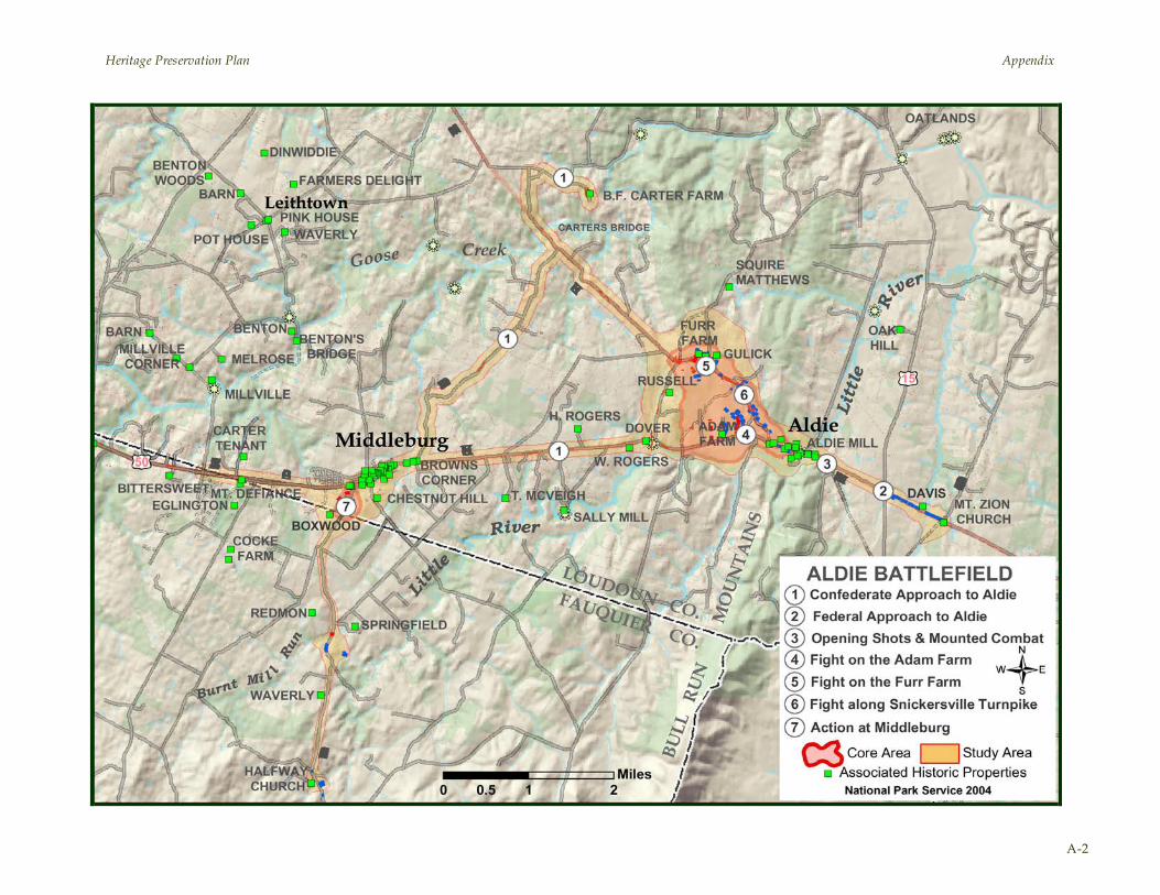
Heritage Preservation Plan Appendix
A-2

Heritage Preservation Plan Appendix
A-3
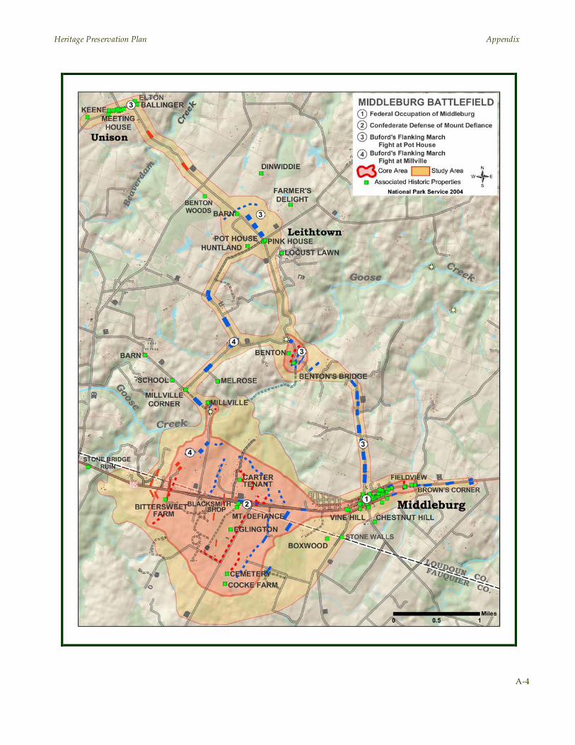
Heritage Preservation Plan Appendix
A-4
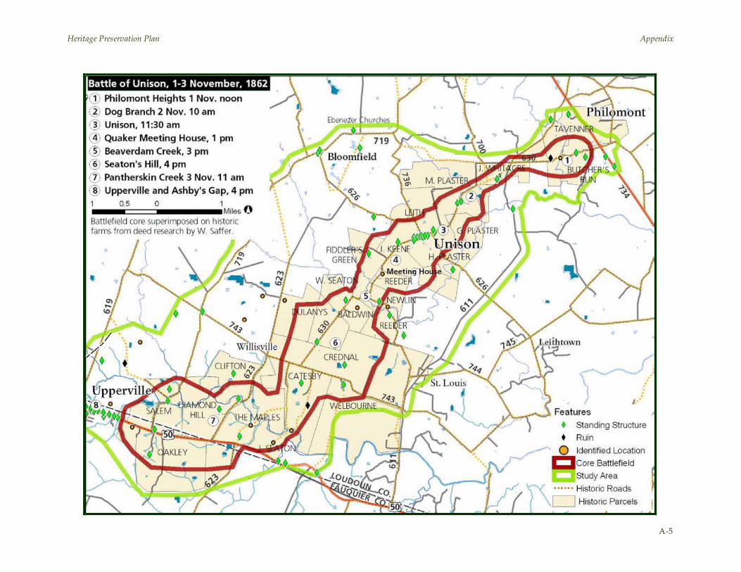
Heritage Preservation Plan Appendix
A-5
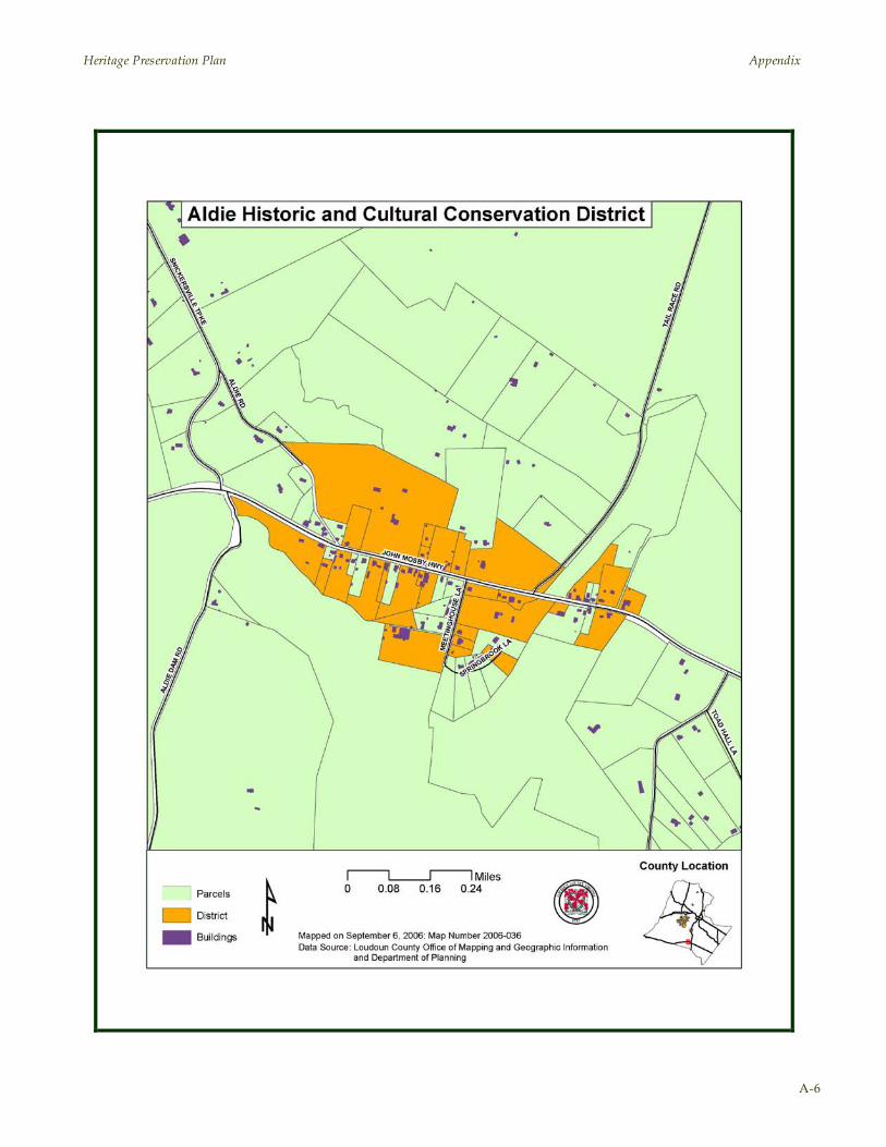
Heritage Preservation Plan Appendix
A-6
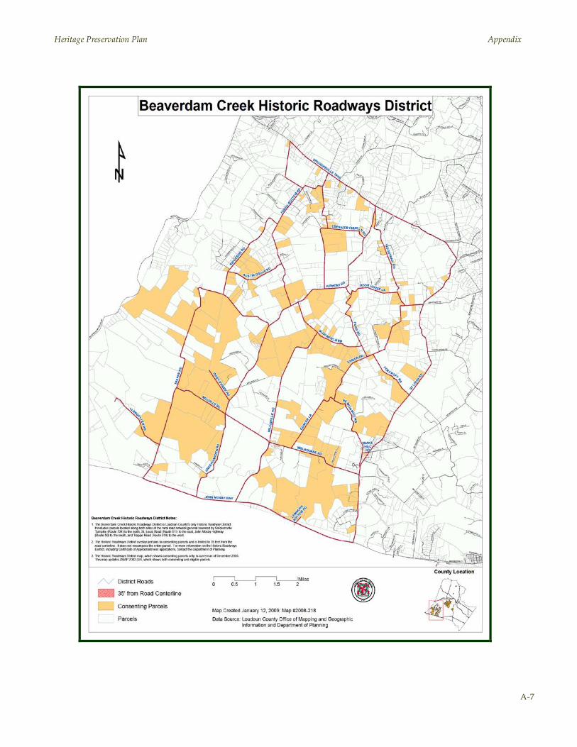
Heritage Preservation Plan Appendix
A-7
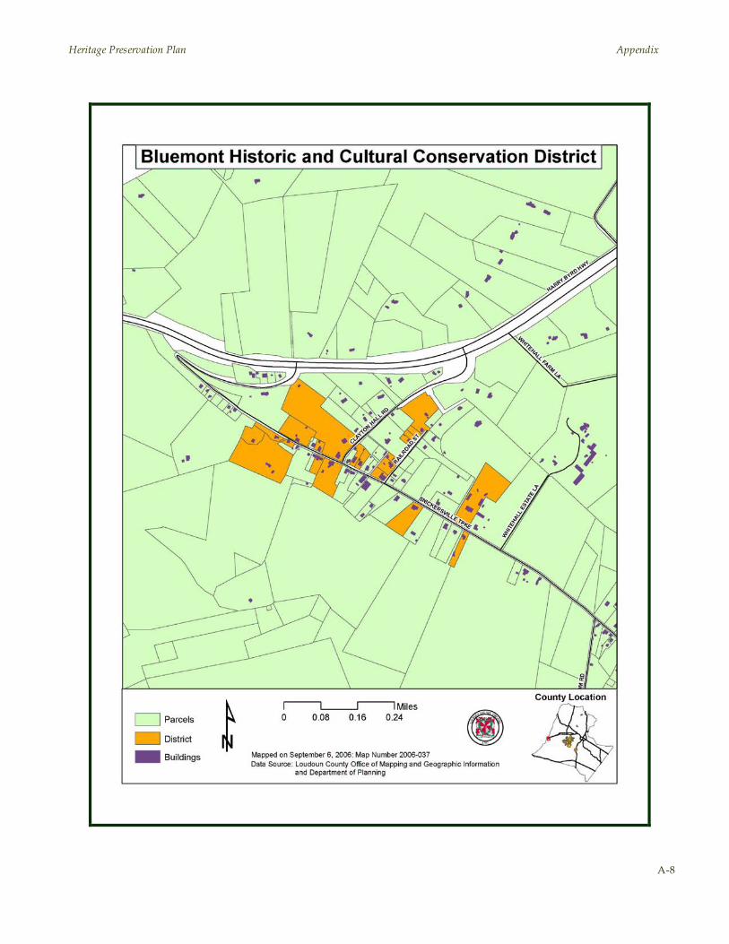
Heritage Preservation Plan Appendix
A-8

Heritage Preservation Plan Appendix
A-9
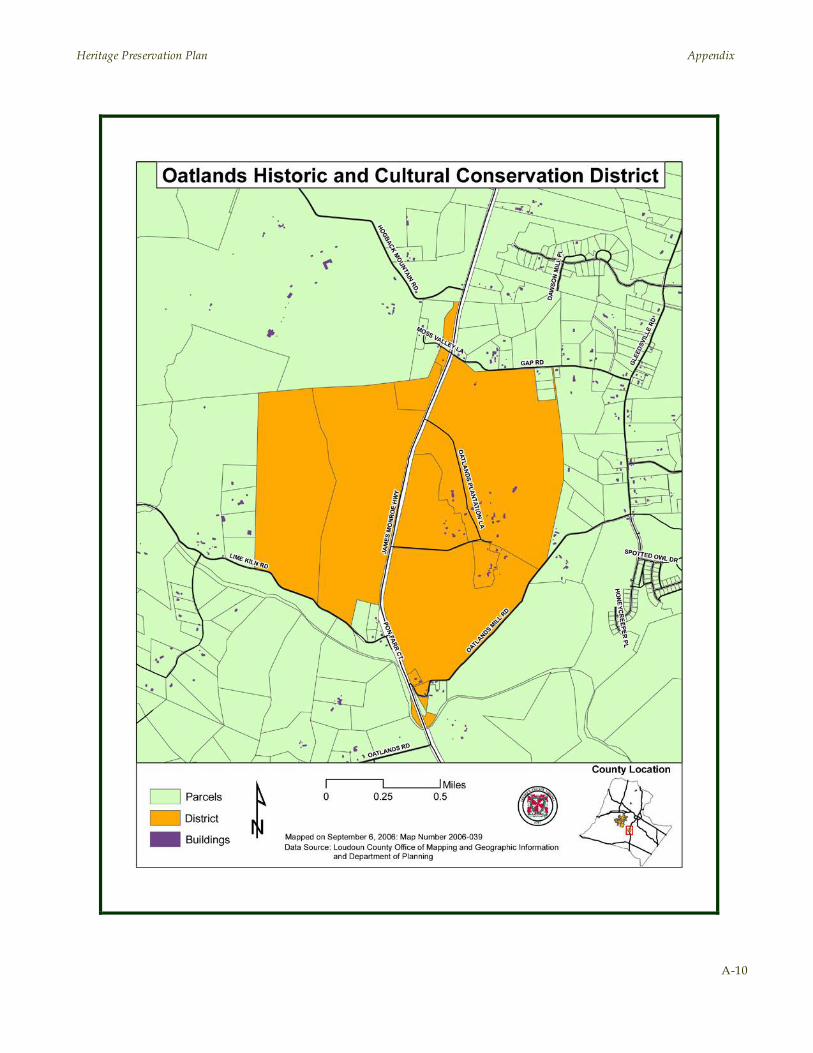
Heritage Preservation Plan Appendix
A-10

Heritage Preservation Plan Appendix
A-11

Heritage Preservation Plan Appendix
A-12