Embed Size (px)
Citation preview

HERITAGE IMPACT STATEMENT
LOT 224 DP 807299 CUSACK AVENUE
CASULA
2008
FOR CaRRY INVESTMENTS PTY l TO
CULTURAL RESOURCES MANAGEMENT

CONTENTS
1.0 EXECUTIVE SUMMARY ........................................................................................ 01 1.1 The Work ................................................................................................................ 02 1.3 The Site ................................................................................................................... 02 1.4 The Development and Its Impacts .......................................................................... 02 1.5 Mitigation and Recommendations .......................................................................... 03
2.0 THE CONTEXT ....................................................................................................... 04 2.1 Project Initiation ...................................................................................................... 05 2.2 The Development Area ........................................................ ................................... 05 2.3 Statutory Requirements ..................................... ..................................................... 06 2.4 The State Heritage Inventory Item: Glenfield House ................... ........................... 06 2.5 Objectives and Tasks ............................................................................................. 07 2.6 Authorship and Client ............ ................................................................................. 07
3.0 CULTURAL CONTEXT .......................................................................................... 08 3.1 The Throsby Family: 1810-1920 ............................................. ................................ 09 3.2 James Leacock: 1920-1951 .................................................................................... 10 3.3 The Co-Operatives ................................................................................................. 11 3.4 Subdivision and Parks ............................................................................................ 11
4.0 PROPOSED DEVELOPMENT SiTE ...................................................................... 12 4.1 Topography and Environment ................................................................................ 13 4.2 Association to Glenfield House: Access Road ....................................................... 16 4.3 Context and Views ....................................... ........................................................... 17
5.0 IMPACT ASSESSMENT ........................................................................................ 21 5.1 Description of the Development. ............................................................................. 22
5.1.1 Immediate Works ........................................................................................ 22 5.1.2 Future Works .............................................................................................. 22
5.2 Heritage Impacts ..................................................................................................... 24 5.2.1 Creek Infill ................................................................................................... 24 5.2.2 Footpath Service Connections ...... ............................................................. 24 5.2.3 Widening Mackellar Street. ................................................ ......................... 24 5.2.4 Views to and From Glenfield House ..... ..................................................... 24
5.3 Mitigation ................................................................................................................. 25 5.3.1 Potential Archaeological Evidence ............................................................. 25 5.3.2 Views .......................................................................................................... 25
5.4 Recommendation .................................................................................................... 26
6.0 REFERENCES ....................................................................................................... 27

1.0 EXECUTIVE SUMMARY

Heritage Impact Statement, Lot 224 DP 807299 Cusack Avenue Casula January 2008
1.1 THE WORK
This report provides a heritage impact statement with respect to a new development in Cusack Avenue Casu la, The site is located next to a state heritage inventory listed item, the Glenfield Farm group. This work has been carried out in response to a request from Liverpool City Council for additional information to inform the Development Application made for the site. The latter is a block bound by Cusack Avenue, Mackellar Street and Leacocks Lane in Casula.
1.2 THE HISTORICAL CONTEXT
The proposed development site was part of the Glenfield estate developed by Or Charles Throsby between 1810 and 1817. After Throsby's death in 1828 his nephew Charles Throsby inherited the property. The estate remained in the hands of the Throsby family until 1920. For most of this time the land was leased to tenants. After Charles Throsby's death the lands encompassed in his will were sold on behalf of the beneficiaries. James Leacock purchased a little over 376 acres in 1920; this parcel encompassed the house and its close environs including the proposed development area. Subdivisions made between 1920 and 1933 on the southern boundary of Leacock's land left the property as a block between the river and the road with the railway running to the east of the house. Some small subdivisions were made along the highway in 1945.
Leacock formed the Rural Homes (Glenfield) Co-Operative in 1951 and signed the land over to the Co-operative in 1952. The Co-Operative subdivided much of the land to the west of the house up to the highway into smaller parcels for the members of the collective. The study area was not included in this property division. The first co-op folded in 1960. The land was then vested in the Glenfield Goodwill Co-Operative in 1969. It failed a few years later. The Glenfield Goodwill Co-Operative was formed in 1970 and again re-organised the boundaries of the estate. Leacock purchased back fourteen acres that included the house. He lived there until his death in 1974. The proposed development site was included in the Co-operative land. The fourteen acres reacquired by Leacock forms the basis of the present SHR property. A regional park was formed to the south and north of the estate. The land to the west, including the proposed development site, has been subdivided into the present allotments since 1988.
1.3 THE SITE
The proposed development site was part of the original Throsby House curtilage; there is good archival evidence to show that the site had been cleared by the 1820s. Apart from a track or drive to the house that ran through part of this site there is no evidence to suggest that it was developed in any way or used for any purpose other than for grazing. There is no visible evidence of the track but some archaeological evidence of it may lie buried on the southern boundary of the site. The main feature of the land is a shallow depression running through it east to west that is the remnant of a small creek, now infilled. There are only a few self-seeded eucalypts and the base of what is likely to have been an early twentieth century tree. The site is surrounded on three sides by streets and houses constructed on residential subdivisions of the 1990s. The only view to or from the site that has any significance is that to the east towards the barn group behind Glenfield House. The proposed development site is the only remaining vacant land to the west of the property. The views to and from the site are obscured by screen planting on the boundary of Glenfield House.
1.4 THE DEVELOPMENT AND ITS IMPACTS
It is the intention of the proposed work that the site will gradually be redeveloped with houses similar to those surrounding the place on all three sides. To accommodate this the former shallow creek bed will be filled in to level the site. It will be sub-divided into thirteen allotments. Mackellar Street will be widened in the south-eastern corner of the site. The
CRM for Yarraman Developments Pty Ltd on behalf of Corry Investments Pty Ltd Page 2
Heritage Impact Statement, Lot 224 DP 807299 Cusack Avenue Casu la January 2008
impact of this development on this site and the Glenfield House property have been assessed as follows:
• The former creek bed has no heritage significance and has long been partly filled in; completing the process has no identifiable heritage impacts on either this site or on the Glenfield Farm property.
• There is no evidence to suggest that excavation required for service connections in the footpath will impact on any known archaeological feature associated with Glenfield House. There are no identifiable heritage impacts associated with this work.
• The proposed widening of Mackellar Street in the south-eastern corner of the site, as well as any future excavation associated with the construction of houses on these allotments (Nos 5-8) may have some impact on sub-surface evidence of the original track or drive that led to Glenfield House. The depth of the track below the present surface is unknown.
• The development of this site will remove the last open portion of ground on the western side of the house and its out-buildings. Until relatively recently the view west from the house group was one of open grazing land. This has been comprehensively removed through the construction of the Glenfield Estate residential subdivisions in the 1990s; even the small pocket of open land preserved in the proposed development site has a backdrop of residential development along Cusack Avenue. The only significant extant views from the house are to the east and to a lesser extent to the north and south. The impact of this lost vista to the west is acknowledged within the Glenfield House property by screen planting on the western boundary. Retention of the proposed development site as open space will not redress the loss of vistas from the western side of Glenfield House.
1.5 MI'TIGATION AND RECOMMENDATIONS
With respect to Council's objectives in approving new development in the vicinity of a heritage item the proposed work will not diminish the heritage significance of Glenfield House and, through some minimal archaeolOgical work may retrieve some historical evidence that will enhance our knowledge of the place. The loss of this small parcel of vacant land will not have any greater impact,:upon' the .Ioss of views to the west from the house than is now the case and its preservatioh\viII not redress this loss. The DA for this proposed subdivision should be approved subject to the following conditions:
• A small programme of archaeological testing should be undertaken on the southern boundary of the site for the purpose of identifying and recording the evidence of the original Glenfield House Drive. This should be managed as a Section 139 exception.
• The proposed subdivision should be limited to residential development consistent with local planning codes and similar in height and scale to the existing houses around it.
CRM for Yarraman Developments pty Ltd on behalf of Corry Investments Pty Ltd Page 3

2.0 THE CONTEXT

Heritage Impact Statement, Lot 224 DP 807299 Cusack Avenue Casula January 2008
2.1 PROJECT INITIATION
This report has been prepared in response to a request by Liverpool City Council for more information with respect to a proposed subdivision at Casula The site is located opposite to an item of state heritage significance and Council has requested a Statement of Heritage Impad. This report fulfils that requirement.
2.2 THE DEVELOPMENT AREA
The proposed development area is an allotment of land in Cusack Avenue, Casu la (OP 807299 Lot 224). It is bound on the north by an existing residential subdivision, on the west by Cusack Avenue, on the south by Mackellar Street and on the east by Leacocks Lane.
It is a vacant allotment of land with a few trees and the stumps of others as shown on the aerial view below. The relationship of the proposed development site to the state heritage inventory listed item is shown here; the heritage item is indicated by the yellow arrow.
1 Liverpool City Council to Corry Investments Pty Ltd, 26 November 2007 (Ref DA-543/2008).
CRM for Yarraman Developments Pty Lld on behalf of Corry Investments Ply Lld Page 5
Heritage Impact Statement, Lot 224 DP 807299 Cusack Avenue Casula January 2008
The proposed development site, or any part within it, is not recognized in any heritage schedule or inventory, state, local or national, to have cultural significance for any reason.
2.3 STATUTORY REQUIREMENTS
The requirement for a heritage impact statement arises from Part 12 of Liverpool Local Environmental Plan 1997, which states;
"Council may consent to development in land in the vicinity of a heritage item only if, in the opinion of Council,
(a) it will not diminish the heritage significance of the item and its setting and (b) it will be compatible with the existing heritage item in terms of
(i) height, scale and proportion and (ii) overall form and massing including pitch and form of roof, if any and (iii) the setting including any building alignment affected and (iv) the colour, texture, size and type of finish of the material to be used in the
extension of the building if any.
Generally, the planning instrument intends that "new development is undertaken in a manner that is sympathetic to and does not detract from the heritage significance of heritage items and their setting, as well as streetscapes and landscapes and the distinctive character they impart to the City of LiverpooI2".
2.4 THE STATE HERITAGE INVENTORY ITEM; GLENFIELD HOUSE
The proposed development site is located on the western side of Leacocks Lane, Casula. On the eastern side of the lane is the site of Glenfield House also known as Glenfield Farm Homestead. It is item 58 in the heritage schedule attached to the local planning instrument (also including the farm group, barn and dairy, associated with the house. It is listed in the State Heritage Register and State Heritage Inventory as Glenfield Farm (Item 00025). It is also listed by the National Trust of Australia (NSW) and is on the Register of the National Estate. The cultural significance of this site may be summarised as follows:
• It is one of the few surviving farm complexes in NSW dating from 1810 and still capable of being used for its original purpose.
• The building stock provides evidence of architecture, rural development and life in the early settlement period and they are substantially intact. Some of the buildings have significance in their own right for their rarity and integrity including the house and barn and stables.
• The grounds demonstrate the core activities of the farm and the garden and the tastes and needs of successive occupants.
• The place has strong associations with several significant figures and families in early settlement history.
• The place has SUbstantial landmark qualities and preserves some important views.
• The place has substantial archaeological significance for its research values3.
The SHR listing makes several recommendations for the management of this place, adopted from the Conservation Management Plan prepared in 20034
. These recommendations are
2 Liverpool Local Environmental Plan 1997 Part 12, 71 (d) 3 This summary has been adapted from the statements of significance presented in the SHR listing. 4 Mayne-Wilson and Associates (2003), Conservation Management Plan for G/enfield Farm 88 Leacocks Lane Casu/a.
CRM for Yarraman Developments Pty Ltd on behalf of Corry Investments Pty Ltd Page 6

Heritage Impact Statement, Lot 224 DP 807299 Cusack Avenue Casula January 2008
concerned with preserving views to and from the site and controlling development immediately adjacent to the property for the same purpose, to maintain a relatively nonintrusive setting on the boundary of the curtilage to Glenfield Farm.
2.5 OBJECTIVES AND TASKS
The purpose of this report is to:
• Provide information concerning the proposed development;
• Determine the likely impacts of that development on the SHR item and any cultural material within the development site;
• Describe what measures are proposed to mitigate any negative impacts or to conserve or enhance the heritage significance of the place.
2.6 AUTHORSHIP AND CLIENT
This report has been written by Wendy Thorp (Cultural Resources Management). It has been commissioned by Yarraman Developments on behalf of the owner of the property Corry Investments Pty Ltd.
CRM for Yarraman Developments Ply Lld on behalf of Corry Investments pty Lld Page 7

3.0 THE CULTURAL CONTEXT

Heritage Impact Statement, Lot 224 DP 807299 Cusack Avenue Casu la January 2008
A detailed analysis of the historical development of the SHR listed property Glenfield Farm has been presented in the Conservation Plan prepared in 2002. This summary draws on that research.
3.1 THE THROSBY FAMILY: 1810-1920
Glenfield was settled by Dr Charles Throsby a significant figure in the early settlement of New South Wales through his various roles as Assistant Colonial Surgeon, Magistrate and explorer. He acquired several properties; the one at present-day Casu la is based on a grant of 950 acres made to him in 1810. The house and its out-buildings were built between 1810 and 1817. During this period Throsby acquired other properties adjacent to his grant including that of Isaac Knight (granted to him a few months after Throsby received his land). It was on Knight's land that Throsby built his houses and farm buildings. The proposed development site is also located on Knight's land.
The extent of the property in 1817 shown in red; the position of the house and the study area is shown by an arrow. (Source: Clive Lucas, Stapleton and Partners (2007),: Statement of Heritage Impact Glenfield.41
After Throsby's death at Glenfield in 1828 his nephew Charles Throsby inherited the property. Throsby's widow continued to live at Glenfield until her death in 1838. By the time Charles Throsby acquired the estate some additional lots had been added to it (shown in blue above). The estate remained in the hands of the Throsby family until 1920. For most of this time the land was leased to tenants. Throughout the later nineteenth century several parcels were resumed for public purposes including reservations for the railway, to the Department of Education and for the construction of Glenfield Road.
CRM for Yarraman Developments Pty Lld on behalf of Carry Investments Ply Lld Page 9
Heritage Impact Statement, Lot 224 DP 807299 Cusack Avenue Casu la January 2008
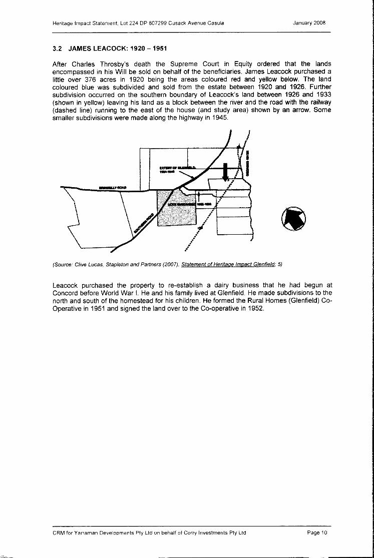
3.2 JAMES LEACOCK: 1920 - 1951
After Charles Throsby's death the Supreme Court in Equity ordered that the lands encompassed in his Will be sold on behalf of the beneficiaries. James Leacock purchased a little over 376 acres in 1920 being the areas coloured red and yellow below. The land coloured blue was subdivided and sold from the estate between 1920 and 1926. Further subdivision occurred on the southern boundary of Leacock's land between 1926 and 1933 (shown in yellow) leaving his land as a block between the river and the road with the railway (dashed line) running to the east of the house (and study area) shown by an arrow. Some smaller subdivisions were made along the highway in 1945 .
. L...---'----,,i
/If ..
. . . . .
(Source: Clive Lucas, Staple ton and Partners (2007), Statement of Heritage Impact Glenfield: 5)
Leacock purchased the property to re-establish a dairy business that he had begun at Concord before World War I. He and his family lived at Glenfield. He made subdivisions to the north and south of the homestead for his children. He formed the Rural Homes (Glenfield) CoOperative in 1951 and signed the land over to the Co-operative in 1952.
CRM for Yarraman Developments Pty Ltd on behalf of Carry Investments Pty Ltd Page 10
Heritage Impact Statement Lot 224 DP 807299 Cusack Avenue Casula January 2008
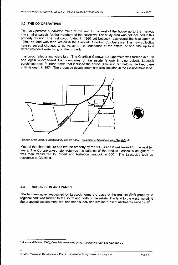
3.3 THE CO-OPERATIVES
The Co-Operative subdivided much of the land to the west of the house up to the highway into smaller parcels for the members of the collective. The study area was not included in this property division. The first co-op folded in 1960 but Leacock resurrected the idea again in 1969.The land was then vested in the Glenfield Goodwill Co-Operative. This new collective caused several changes to be made to the boundaries of the estate. At one time up to a dozen residents were living on the property.
The co-op failed a few years later. The Glenfield Goodwill Co-Operative was formed in 1970 and again re-organised the boundaries of the estate (shown in blue below). Leacock purchased back fourteen acres that included the house (shown in red below). He lived there until his death in 1974. The proposed development site was included in the Co-operative land.
/1-----\
I (Source: Clive Lucas, Stap/eton and Partners (2007), Statement of Heritage Impact Glenfield; 6)
Most of the shareholders had left the property by the 1980s and it was leased for the next ten years. The Co-operatives later returned the balance of the land to Leacock's daughters. It was then transferred to Robert and Rebecca Leacock in 2001. The Leacock's took up residence at Glenfield,
3.4 SUBDIVISION AND PARKS
The fourteen acres reacquired by Leacock forms the basis of the present SHR property. A regional park was formed to the south and north of the estate. The land to the west, including the proposed development site, has been subdivided into the present allotments since 19885
.
5 Morris and Britton (2000), Colonial Landscapes of the Cumber/and Plain and Camden; 39
CRM for Yarraman Developments Pty Ltd on behalf of Carry Investments Pty Ltd Page 11

4.0 PROPOSED DEVELOPMENT SITE
Heritage Impact Statement Lot 224 DP 807299 Cusack Avenue Casula January 2008
4.1 TOPOGRAPHY AND ENVIRONMENT
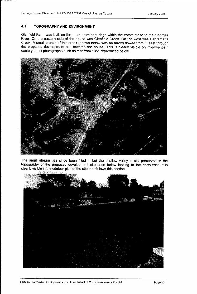
Glenfield Farm was built on the most prominent ridge within the estate close to the Georges River. On the eastern side of the house was Glenfield Creek. On the west was Cabramatta Creek. A small branch of this creek (shown below with an arrow) flowed from it, east through the proposed development site towards the house. This is clearly visible on mid-twentieth century aerial photographs such as that from 1951 reproduced below.
The small stream has since been filled in but the shallow valley is still preserved in the topography of the proposed development site seen below looking to the north-east. It is clearly visible in the contour plan of the site that follows this section.
CRM for Yarraman Developments Ply Lld on behalf of Carry Investments Ply Lld Page 13

Heritage Impact Statement, Lot 224 DP 807299 Cusack Avenue Casula January 2008
The same shallow bed was partly included in a sketch of the farm made in c. 1823 shown below (the stream indicated with an arrow); the artist was standing on the proposed development site6
.
This same sketch shows that even by that date much of the land to the west of the house had been cleared leaving only isolated stands of trees and scattered shrubs. Charles Throsby almost certainly cleared the land to the west of the house for pasturage and set about improving it by sowing clover and rye grass? When Glenfield was leased in 1859 it was described as being a "working dairy farm" including 1000 acres of grazing landS.
There is no evidence from any source that suggests the proposed development site was used for any other purpose other than as grazing land. The aerial photograph on the previous page indicates that there may have been a paddock to the north of the study area, now encompassed by the residential subdivision, but the proposed development area appears to have been completely devoid of any particular use apart from a track running through part of it (Section 4.2).
The stand of trees shown on that mid-twentieth century view have largely gone leaving only a few trunks and the base of a large tree that shows that some old specimens had survived into the later part of the twentieth century.
View south-east showing stream bed and trunks. Base of large tree in south-east corner.
6 Edward Mason, Glenfield Farm reproduced in Mayne-Wilson (2003); 10 7 Morris and Britton, Colonial Landscapes of the Cumber/and Plain (2000); 39 8 Lease advertisement quoted in Ibid.
CRM for Yarraman Developments Pty Lld on behalf of Corry Investments Pty Lld Page 14

Heritage Impact Statement, Lot 224 DP 807299 Cusack Avenue Casula January 2008
c ,
; N '11 , S)l000'll;1
)B'
I
!
CRM for Yarraman Developments Pty Ltd on behalf of Corry Investments Pty Ltd Page 15

Heritage Impact Statement. Lot 224 DP 807299 Cusack Avenue Casula January 2008
4.2 ASSOCIATION TO GLENFIELD HOUSE: ACCESS ROAD
The proposed development site was part of the 100 acres originally granted to Isaac Knight in 1810 and then purchased by Dr Throsby in the same year. It was located immediately west of the homestead and farm buildings. There is no evidence though, that it was ever developed as part of the original estate. The only know use of the land to the west was to provide an access track to the homestead from the main south road (now the Hume Highway). This track commenced at the northern junction of Throsby's land with the road and curved eastwards up to the house. This track was located within the proposed development site running east to west across it to end at a point close to the southern side of the barn/stables/coach house. It was still clearly visible in aerial views of 1961 but this access road was lost during the extensive subdivisions made by the Co-Operatives during the 1970s9
. This access road is visible on aerial photographs of the early twentieth century. The earliest of these views is from 1930; a detail is reproduced below.
An image taken from the Glenfield property in the 1970s 10 shows a small portion of this track (reproduced below). It appears to have been an earth track raised on an embankment.
There is no visible evidence of this track left within the site but there may be physical traces buried on the southern boundary of the property.
9 Mayne-Wilson and Associates (2002), Conservation Management Plan Glenfield; 28 10 Ibid. 27
CRM for Yarraman Developments Pty Ltd on behalf of Corry Investments Pty Ltd Page 16

Heritage Impact Statement, Lot 224 DP 807299 Cusack Avenue Casu la January 2008
4.3 CONTEXT AND VIEWS
The proposed development site is surrounded on three sides by houses and streets constructed as part of residential subdivisions of the 1990s. None of the views to or from the site with respect to these subdivisions has any significance.
View to the east from the proposed development site of the houses along Cusack Avenue
View to the north-east from Cusack Avenue showing the houses to the north of the proposed development site that face Leacocks Lane.
CRM for Yarraman Developments Pty Lld on behalf of Corry Investments Pty Lld Page 17

Heritage Impact Statement. Lot 224 DP 807299 Cusack Avenue Casu la January 2008
View to the south-east showing the houses to the south of the proposed development site facing Mackellar Street.
The view from the site to the east is the only one of any cultural value. It has an aspect of the Glenfield Farm barn and smaller out-buildings although a deliberate effort has been made to screen this view by plantings on the boundary of the estate. This view, though, from the Glenfield property is the only one on the western side of the estate that has some open land although the houses along Cusack Avenue are visible at a lower level.
View of the bam and out-buildings from the proposed development site
CRM for Yarraman Developments Pty Lld on behalf of Carry Investments Pty Lld Page 18

Heritage Impact Statement, Lot 224 DP 807299 Cusack Avenue Casula January 2008
View of the proposed development site from the footpath in front of the bam group on the eastern side of Leacocks Lane. The houses in the background are on Cusack Avenue.
Glenfield House is to the north of the barn group and of the proposed development site, The view from the house to the west has already been curtailed by the construction of a residential subdivision in the 1990s,
View of Glenfield House on the eastern side of Leacocks Lane to the north of the barn group and proposed development site.
CRM for Yarraman Developments Pty Ltd on behalf of Corry Investments Pty Ltd Page 19

Heritage Impact Statement Lot 224 DP 807299 Cusack Avenue Casula January 2008
View from Glenfield House across Leacocks Lane to the residential subdivision; the proposed development site adjoins the house to the left.
CRM for Yarraman Developments Pty Ltd on behalf of Corry Investments Ply Ltd Page 20

5.0 IMPACT ASSESSMENT

Heritage Impact Statement Lot 224 DP 807299 Cusack Avenue Casula January 2008
5.1 DESCRIPTION OF THE DEVELOPMENT
5.1.1 Immediate Works
Very little work is planned for the site in the first phase of development. The former shallow creek bed will be filled in to level the site. Service connections will be made in the footpath but will not proceed into the site. The site will be sub-divided into thirteen allotments as per the attached plan but, at this time, these are only a planning intention. Mackellar Street will be widened in the south-eastern corner of the site for a width of up to 1.5 metres.
5.1.2 Future Works
It is the intention of this development that the site will gradually be redeveloped with houses similar to those surrounding the place on all three sides.
South-eastern corner of the proposed development site at the intersection of Cusack Avenue in the foreground and Mackellar Street to the right. This corner will be widened in the proposed development.
CRM for Yarraman Developments Pty Ltd on behalf of Corry Investments Pty Ltd Page 22

o :;0 s:: Q -< ~ m 3 III ::J
o Cl> < Cl> "0
1:1 3 Cl> ::J c;; )} '< r er o ::J
0-Cl> ;;:y III :::;;
S, o o ~ ::J < Cl> V>
3 Cl> ::J c;; lJ -< r er
lJ III to
Cl> IV 0>
-.~
\
\\ \~
PROUST&.GARDNER COIIISUlH •• 'T" ~III.IT(O
SURVEYORS a.. PLANNERS
...... -1'1) .. 1»
.Dll(t
=::'.0 ::::::
I--'~
.0 I ~_~
-13
,12 , ,
.............. ,
,
",
""-~ , Q,----''- ~Om'
1- \
"
"
0:
""-
" " \ ~ I , \ ,l ,
" 7 ""-
"" ,
11
"" 600'" ~
" ""-
10
" 4S0'"
~ " ""-,
'0
""-""-
" " '"
~ .... .. 3
~ 30
, \
450m'
o \~=ff w ~\ • ,·~~v. t :
\ \ _I .... 2
~. 450'"
" '\..
\
&91.7'" 5
STREET
cTlililii'l_ NiiMiiJOiIlA:WIIIf fAIIIII!fIJ • ltclbm AOCID fQ IIl.M --.. 111 .-r
""" ... "iii:i: tN-.i~
o c w ....
l!lQll.li; 1 DIMENSIONS AND AREAS SUBJECT TO FINAL SURVEY, 2, CONTOUR INTERVAL 1m ON AHO.
~
(:J DENOTES EXISTING TREE AND CANOPY.
" DENOTES EXISTING CONTOURS --.... - DENOTES PROPOSED FilL CONTOURS, ---£1'- DENOTES EXISTING ELECTRiCITY ITELSTRA CONDUIT -,- DENOTES EXISTING TElSTRA LINE, ->- DENOTES EXISTING SEWER MAIN • -w- DENOTES EXISTING WATER MAIN.
"-'" _ ... LIVERPOOL CITY COUNCIL
PLAN OF PROPOSED SUBDIVISION OF LOT 224 DP 807299
CUSACK A VENUE. MACKELLAR STREET 8. LEACOCKS LANE, CASULA
SCALE, UOOGA1 DATE, 7 NOVEMBER 2007 PLAN No,22404/SUB1C
I ~ [; to
Cl>
3 1:1 !l> n. en Iii m 3 Cl>
~ r Q. IV IV ~
o lJ ex:> o ~ IV <0 <0
o C V> !l> o "'" » ~ ::J C Cl>
o !l> (J)
c iil
<!l> :::J C !l>
-< IV o o ex:>
Heritage Impact Statement, Lot 224 DP 807299 Cusack Avenue Casu la January 2008
5.2 HERITAGE IMPACTS
5.2.1 Creek Infill
The former creek bed has no heritage significance and has long been partly filled in; completing the process has no identifiable heritage impacts on either this site or on the Glenfield Farm property.
5.2.2 Footpath Service Connections
There is no evidence to suggest that excavation required for these connections will impact on any known archaeological feature associated with Glenfield House. There are no identifiable heritage impacts associated with this work.
5.2.3 Widening Mackellar Street
The proposed widening of Mackellar Street in the south-eastern corner of the site, as well as any future excavation associated with the construction of houses on these allotments (Nos 5-8) may have some impact on any sub-surface evidence of the original track or drive that led to Glenfield House. The depth of the track below the present surface is unknown.
5.2.4 Views to and From Glenfield House
The construction of houses on this vacant land will remove the last open portion of ground on the western side of the house and its out-buildings. All of the studies undertaken on Glenfield House have noted that until relatively recently the view west from the house group was one of open grazing land. This has been comprehensively removed through the construction of the Glenfield Estate residential subdivisions. It is a situation that is regretted but in the most recent analysis prepared of new development in the immediate environs of the house it was concluded that,
"with the encroachment of new houses on the western side of Leacocks Lane, views to and from the west of the house have been lost. The significant views that remain are to and from the east ... . ,,11.
This is certainly the case. The intention of retaining long vistas from the house is to preserve some sense of its historical context as a rural property and working farm. This is now only achieved by the views across the valley to the east and, to a lesser extent, to the north and south. The western vista has been completely lost by past subdivision; even the small pocket of open land preserved in the proposed development site has a backdrop of residential development along Cusack Avenue.
The impact of this lost vista is acknowledged within the Glenfield House property by screen planting on the western boundary.
11 Clive Lucas, Stapleton and Partners (2007), Glenfield Land Subdivision Heritage Impact Statement; 8
CRM for Yarraman Developments Pty Ltd on behalf of Corry Investments Pty Ltd Page 24

Heritage Impact Statement, Lot 224 DP 807299 Cusack Avenue Casu la January 2008
5.3 MITIGATION
This analysis has identified only two potential heritage impacts arising from the proposed subdivision and redevelopment of this site.
5.3.1 Potential Archaeological Evidence
There is the likelihood that both the development of the site and the widening of Mackellar Street may disturb evidence of the original track or drive leading to Glenfield House. The majority of this track has already been lost through earlier subdivision although a portion is likely to be preserved with the Glenfield property. While it is only a relatively minor element associated with the estate, it has some cultural significance through its association. In terms of the standard criteria used to assess cultural value it would have scientific and research value as an archaeological resource and contributory historical value through its association with Glenfield. It is assessed to have a medium level of cultural value.
This potential archaeological feature does not have sufficient significance to warrant its preservation or design changes to the proposed development. However, it is recommended that the information that may be contained in this site be investigated and recorded prior to redevelopment. This should take the form of an archaeological test trench placed across the route of the drive. This can be excavated by machine under the supervision of qualified archaeologists. The intention will be to locate and record the drive in its original form and any subsequent resurfacings. This small investigation is best managed by an application for works under a Section 139 exception from the NSW Heritage Office. The results of the work should be made available to the Historic Houses Trust (as managers of Glenfield House) as well as copies to the usual repositories as required by the Heritage Council of NSW.
5.3.2 Views
Retention of this ground as open space will not redress the loss of vistas from the western side of Glenfield House. These have already been comprehensively curtailed by existing subdivisions. The view from the barn/stables, which is the building that will be directly impacted by the proposed development, has already been partially screened by planting along the boundary of the Glenfield property. Development of this site will contribute to the loss of views from the western side of the estate but these have already been comprehensively lost through earlier works and retention of this as open space will make no significant redress to this issue.
Therefore these is no reason to preclude residential development from this site so long as that development is confined to residential buildings, built within the provisions of the planning instrument. These buildings should be no higher than those other houses in their immediate environs.
CRM for Yarraman Developments Pty Ltd on behalf of Carry Investments Pty Ltd Page 25

Heritage Impact Statement, Lot 224 DP 807299 Cusack Avenue Casu la January 2008
5.4 RECOMMENDATIONS
With respect to Council's objectives in approving new development in the vicinity of a heritage item the proposed work it will not diminish the heritage significance of Glenfield House and, through some minimal archaeological work may retrieve some historical evidence that will enhance our knowledge of the place. The loss of this small parcel of vacant land will not have any greater impact upon the loss of views to the west from the house than is now the case and its preservation will not redress this loss.
The DA for this proposed subdivision should be approved subject to the following conditions:
• A small programme of archaeological testing should be undertaken on the southern boundary of the site for the purpose of identifying and recording the evidence of the original Glenfield House Drive. This should be managed as a Section 139 exception.
• The proposed subdivision should be limited to residential development consistent with local planning codes and similar in height and scale to the existing houses around it.
CRM for Yarraman Developments Pty Ltd on behalf of Corry Investments Pty Ltd Page 26
6.0 REFERENCES

Heritage Impact Statement, Lot 224 DP 807299 Cusack Avenue Casula January 2008
6.1 REPORTS
Clive Lucas, Stapleton &Partners (2007) Statement of Heritage Impact Glenfield 88 Leacocks Lane Casu la Land Subdivision Historic Houses Trust.
Mayne-Wilson and Associates (2002) Conservation Management Plan for Glenfield Farm Mr and Mrs R. Leacock.
Colleen Morris, Geoffrey Britton (2000) Colonial Landscapes of the Cumberland Plain and Camden NSW National Trust NSW
6.2 PROPERTY RECORDS
NSW Heritage Office State Heritage Inventory Listing Glenfield Farm Homestead State Heritage Inventory listing Glenfield Farm State Heritage Inventory listing Glenfield Farm Group State Heritage Inventory listing Glenfield Farm Barn State Heritage Inventory listing Glenfield Farm Former Dairy
6.3 MAPS, PLANS and IMAGES
LPI Aerial photograph Liverpool 1951 466-34
LPI Aerial photograph Liverpool 1930 Survey 3429 Run 23
CRM for Yarraman Developments Pty Lld on behalf of Carry Investments Pty Lld Page 28