Embed Size (px)
Citation preview

1
vvv v-r
MMS 90-0030
Long-term Assessment of the Oil Spill at Bahia Las Minas, Panama Interim Report
Volume I : Executive Summary
Puma so" Bees
A P P q
CARIBBEAN SEA Is las Naranios
Cr'
LAS MINAS
ie a `._ Navy t Ga . Reef
Punta Galeta~ ~ is la ~
Punta Muerto
Panama Canal peef , La go Entrance M ~ R~ gahfa OR
Cat ivy Is la ~ Margarita j. . . . . : .
Payardi
Breakwater ~ E o
. o° o~ - --- o o
Co16n / /.
0 1 2 3 4 5 km
- - -- U.S . Department of the Interior VR Minerals Management Service IIIIw Gulf of Mexico OCS Region

OCS Study MMS 90-0030
Long-term Assessment of the Oil Spill at Bahia Las Minas, Panama Interim Report
Volume I : Executive Summary
Editors
Brian D. Keller Jeremy B.C. Jackson Smithsonian Tropical Research Institute
Prepared under MMS Contract 14-12-0001-30393 by Smithsonian Topical Research Institute Box 2072 Balboa, Republic of Panama
U.S . Mailing Address : Smithsonian Tropical Research Institute APO Miami, FL 34002-0011
Published by
U.S . Department of the Interior Minerals Management Service New Orleans Gulf of Mexico OCS Region October 1991

111
Disclaimer
This report was prepared under contract between the Minerals Management Service (MMS) and the Smithsonian Tropical Research Institute . This report has been technically reviewed by the MMS and approved for publication. Approval does not signify that the contents necessarily reflect the views and policies of the Service, nor does mention of trade names or commercial products constitute endorsement or recommendation for use. It is, however, exempt from review and compliance with MMS editorial standards.
Report Availability
Preparation of this report was conducted under contract between the MMS and the Smithsonian Tropical Research Institute . Extra copies of the report may be obtained from the Public Information Unit (Mail Stop 5034) at the following address :
U.S. Department of the Interior Minerals Management Service Gulf of Mexico OCS Regional Office Public Information Unit (MS 5034) 1201 Elmwood Park Boulevard New Orleans, Louisiana 70123-2394
Telephone Number : (504) 736-2519 or (FTS) 686-2519
Citation
Suggested citation :
Keller, Brian D. and J.B.C . Jackson, eds . 1991 . Long-term assessment of the oil spill at Bahia Las Minas, Panama, interim report, volume I: executive summary. OCS Study MMS 90-0030 . U.S . Department of the Interior, Minerals Management Service, Gulf of Mexico OCS Regional Office, New Orleans, La. xii, 48 pp.

V
Table of Contents
List of Figures . . . . . . . . . . . . . . . . . . . . . . . . . . . . . . . . . . . . . . . . . . . . . . . vii
Acknowledgments . . . . . . . . . . . . . . . . . . . . . . . . . . . . . . . . . . . . . . . . . . . . ix
Introduction . . . . . . . . . . . . . . . . . . . . . . . . . . . . . . . . . . . . . . . . . . . . . . . . . . 1 The 1986 Oil Spill at Bahia Las Minas, Republic of Panama . . . . . . . . 1 Historical Background of the Study Area . . . . . . . . . . . . . . . . . . . . . . . 5 Purposes of the Study and Organization of the Report . . . . . . . . . . . . . 5
Reef Flat Sessile Biota, Infauna, and Sea Urchins . . . . . . . . . . . . . . . . . . . . . . 7 Introduction . . . . . . . . . . . . . . . . . . . . . . . . . . . . . . . . . . . . . . . . . . . . . 7 Study Sites and Methods . . . . . . . . . . . . . . . . . . . . . . . . . . . . . . . . . . . 7 Results . . . . . . . . . . . . . . . . . . . . . . . . . . . . . . . . . . . . . . . . . . . . . . . . 8 Conclusions . . . . . . . . . . . . . . . . . . . . . . . . . . . . . . . . . . . . . . . . . . . . 11
Reef Flat Gastropods . . . . . . . . . . . . . . . . . . . . . . . . . . . . . . . . . . . . . . . . . . 13 Introduction . . . . . . . . . . . . . . . . . . . . . . . . . . . . . . . . . . . . . . . . . . . . 13 Study Sites and Methods . . . . . . . . . . . . . . . . . . . . . . . . . . . . . . . . . . 13 Results . . . . . . . . . . . . . . . . . . . . . . . . . . . . . . . . . . . . . . . . . . . . . . . 14 Conclusions . . . . . . . . . . . . . . . . . . . . . . . . . . . . . . . . . . . . . . . . . . . . 17
Reef Flat Stomatopods . . . . . . . . . . . . . . . . . . . . . . . . . . . . . . . . . . . . . . . . . 19 Introduction . . . . . . . . . . . . . . . . . . . . . . . . . . . . . . . . . . . . . . . . . . . . 19 Study Sites and Methods . . . . . . . . . . . . . . . . . . . . . . . . . . . . . . . . . . 19 Results . . . . . . . . . . . . . . . . . . . . . . . . . . . . . . . . . . . . . . . . . . . . . . . 20 Conclusions . . . . . . . . . . . . . . . . . . . . . . . . . . . . . . . . . . . . . . . . . . . . 21
Subtidal Reef Corals . . . . . . . . . . . . . . . . . . . . . . . . . . . . . . . . . . . . . . . . . . 23 Introduction . . . . . . . . . . . . . . . . . . . . . . . . . . . . . . . . . . . . . . . . . . . . 23 Study Sites and Methods . . . . . . . . . . . . . . . . . . . . . . . . . . . . . . . . . . 23 Results . . . . . . . . . . . . . . . . . . . . . . . . . . . . . . . . . . . . . . . . . . . . . . . 24 Conclusions . . . . . . . . . . . . . . . . . . . . . . . . . . . . . . . . . . . . . . . . . . . . 26
Mangrove Forests . . . . . . . . . . . . . . . . . . . . . . . . . . . . . . . . . . . . . . . . . . . . 29 Introduction . . . . . . . . . . . . . . . . . . . . . . . . . . . . . . . . . . . . . . . . . . . . 29 Study Sites and Methods . . . . . . . . . . . . . . . . . . . . . . . . . . . . . . . . . . 29 Results . . . . . . . . . . . . . . . . . . . . . . . . . . . . . . . . . . . . . . . . . . . . . . . 30 Conclusions . . . . . . . . . . . . . . . . . . . . . . . . . . . . . . . . . . . . . . . . . . . . 31

vi
Mangrove Roots . . . . . . . . . . . . . . . . . . . . . . . . . . . . . . . . . . . . . . . . . . . . . 33 Introduction . . . . . . . . . . . . . . . . . . . . . . . . . . . . . . . . . . . . . . . . . . . . 33 Study Sites and Methods . . . . . . . . . . . . . . . . . . . . . . . . . . . . . . . . . . 33 Results . . . . . . . . . . . . . . . . . . . . . . . . . . . . . . . . . . . . . . . . . . . . . . . 34 Conclusions . . . . . . . . . . . . . . . . . . . . . . . . . . . . . . . . . . . . . . . . . . . . 37
Subtidal Seagrass Communities . . . . . . . . . . . . . . . . . . . . . . . . . . . . . . . . . . 41 Introduction . . . . . . . . . . . . . . . . . . . . . . . . . . . . . . . . . . . . . . . . . . . . 41 Study Sites and Methods . . . . . . . . . . . . . . . . . . . . . . . . . . . . . . . . . . 41 Results . . . . . . . . . . . . . . . . . . . . . . . . . . . . . . . . . . . . . . . . . . . . . . . 41 Conclusions . . . . . . . . . . . . . . . . . . . . . . . . . . . . . . . . . . . . . . . . . . . . 42
Hydrocarbon Analyses . . . . . . . . . . . . . . . . . . . . . . . . . . . . . . . . . . . . . . . . . 43 Introduction . . . . . . . . . . . . . . . . . . . . . . . . . . . . . . . . . . . . . . . . . . . . 43 Study Sites and Methods . . . . . . . . . . . . . . . . . . . . . . . . . . . . . . . . . . 43 Results . . . . . . . . . . . . . . . . . . . . . . . . . . . . . . . . . . . . . . . . . . . . . . . 43 Conclusions . . . . . . . . . . . . . . . . . . . . . . . . . . . . . . . . . . . . . . . . . . . . 44
Physical Environmental Monitoring . . . . . . . . . . . . . . . . . . . . . . . . . . . . . . . 47 Introduction . . . . . . . . . . . . . . . . . . . . . . . . . . . . . . . . . . . . . . . . . . . . 47 Study Sites and Methods . . . . . . . . . . . . . . . . . . . . . . . . . . . . . . . . . . 47 Conclusions . . . . . . . . . . . . . . . . . . . . . . . . . . . . . . . . . . . . . . . . . . . . 48

List of Figures
Figure 1 Region of the Republic of Panama affected by the 27 April 1986 oil spill, shown as increasing enlargements, (A)-(C) . . . . . .
Figure 2 Changes in percent cover of major groups of sessile organisms and bare rock in the reef edge transects at Punta Galeta. . . . . .
Figure 3 Echinometra lucunter populations in 1986 and the average seasonal pattern from the 1978-1988 censuses . . . . . . . . . . . . . .
Figure 4 Total gastropod abundance and the number of species in the reef rock zone . . . . . . . . . . . . . . . . . . . . . . . . . . . . . . . . . . .
Figure 5 Changes in the number of coral colonies per m2, size of coral colonies, and percent cover in relation to amount of oil and depth. . . . . . . . . . . . . . . . . . . . . . . . . . . . . . . . . . . . . . . . . . . .
Figure 6 Mean annual band width from 1977 to 1986 for four coral species in relation to the amount of oiling in 1986 . . . . . . . . . . .
Figure 7 Percent cover of oil on sampled roots or dowels in oiled open coast, channel and stream habitats. . . . . . . . . . . . . . . . . . . . . .
Figure 8 Percent cover of Crassostrea rhizophorae on roots or dowels sampled from channels and lagoons. . . . . . . . . . . . . . . . . . . . .
Figure 9 Percent cover of Mytilopsis sallei on roots or dowels from drainage streams and rivers . . . . . . . . . . . . . . . . . . . . . . . . . . . .
Figure 10 Gas chromatograms of saturated hydrocarbons in VMIC oil and suspended in seawater near mangroves at Punta Galeta, September 1986 . . . . . . . . . . . . . . . . . . . . . . . . . . . . . . . . . . . .
vii
2
9
10
16
25
27
35
38
39
45
ix
Acknowledgments
The Smithsonian Tropical Research Institute wishes to thank the following scientists for their participation in this program:
Kathryn A. Burns, Bermuda Biological Station for Research, Inc. (Ph.D., Massachusetts Institute of Technology/Woods Hole Oceanographic Institution, 1975). Scientist-in-Charge and chapter co-author : Hydrocarbon Analyses .
Roy L. Caldwell, University of California, Berkeley (Ph.D., University of Iowa, 1969). Co-Scientist-in-Charge and chapter co-author : Reef Flat Stomatopods.
Gerald E. Kananen, Bermuda Biological Station for Research, Inc. (Ph.D., Duquesne University, 1968). Chapter co-author: Hydrocarbon Analyses.
Michael J. Marshall, Continental Shelf Associates, Inc . (Ph.D., University of Florida, 1985). Scientist-in-Charge and chapter author : Subtidal Seagrass Communities.
Richard Steger, Richard Gump South Pacific Biological Research Station, University of California, Berkeley (Ph.D., University of California, Berkeley, 1985). Co-Scientist-in-Charge and chapter co-author : Reef Flat Stomatopods.
We thank the following staff of the Minerals Management Service (MMS) for technical review and assistance : Dr. James J. Kendall (Contracting Officer's Technical Representative), Dr. Murray L. Brown (former COTR), Dr. Gail Irvine (Contract Inspector), and Dr. Thomas Ahlfeld (Branch of Environmental Studies). The MMS Contracting Officers were Mr. Carroll D. Day, Ms. Paula C. Bowman, and Ms. Sandra L. McLaughlin . Dr. Donald V. Aurand (Chief, BES) helped initiate the project.
We thank the members of the Scientific Review Board for their participation and advice : Dr . Robert S. Carney, (Louisiana State University, chairman), Dr. Paul D. Boehm (A.D. Little, Inc.), Dr . Richard E. Dodge (Nova University), Dr. Roger H. Green (University of Western Ontario), and Dr. Yossi Loya (Tel Aviv University) .
Scientific staff from the Smithsonian Tropical Research Institute are listed below, along with their role(s) :
Brian D. Keller (Ph.D., The Johns Hopkins University, 1976). Project Manager, chapter co-author : Physical Environmental Monitoring, and appendix section author: Project Management .
Jeremy B.C. Jackson (Ph.D., Yale University, 1971). Chief Scientist, and Co-Scientist-in-Charge and chapter co-author : Subtidal Reef Corals.
Jeffrey D. Brawn (Ph.D., Northern Arizona University, 1985). Data Analyst.

X
John D. Cubit (Ph.D., University of Oregon, 1975) . Scientist-in-Charge and chapter author: The Reef-Flat Sub-Project: Sessile Biota, Infauna, and Sea Urchins on Intertidal Flats.
Norman C. Duke (Ph.D., James Cook University, 1988). Scientist-in-Charge and chapter author : Mangrove Forests.
Stephen D. Gamty (B.A., University of Massachusetts, 1978). Scientist-in-Charge and chapter co-author: Effects of an Oil Spill on the Gastropods of a Tropical Intertidal Reef Flat and Effects of the April 1986 Oil Spill at Isla Payardi on the Epibiota of Mangrove (Rhizophora mangle L.) Roots.
Hector M. Guzmdn (M.S ., University of Costa Rica, 1986). Scientist-in-Charge and chapter co-author: Subtidal Reef Corals.
Karl W. Kaufmann (M.S., Lehigh University, 1969). Data Manager, chapter co-author: Physical Environmental Monitoring, and appendix section author: Data Management .
Sally C. Levings (Ph.D., Harvard University, 1981) . Data Analyst and chapter co-author : Effects of an Oil Spill on the Gastropods of a Tropical Intertidal Reef Flat and Effects of the April 1986 Oil Spill at Isla Payardi on the Epibiota of Mangrove (Rhizophora mangle L.) Roots .
Ricardo C. Thompson, Chief Technician, Environmental Sciences Program and chapter co-author: Physical Environmental Monitoring .
We thank the technical and support staff from the Smithsonian Tropical Research Institute (unless otherwise noted) listed below:
Victoria Batista, Biological Technician, Subtidal Seagrass Communities. Bonita Benis, Biological Technician (University of California, Berkeley), Reef
Flat Stomatopods. Consul Chamono, Facilities Worker, Galeta Marine Laboratory . Gladys Dunnell, Biological Technician, Reef Flat Communities . M. Helena Fortunato, Data Management Technician. Carlos Gonzdlez, Biological Technician, Reef Flat Gastropods and Mangrove
Roots. Xenia S. de Guerra, Data Management Technician . Carlos Guevara, Technican, Environmental Sciences Program. Irene Holst, Biological Technician, Subtidal Reef Corals. Gabriel Jacome, Data Management Technician . Esther Jan, Biological Technician, Reef Flat Communities. Carlos Jim6nez, Biological Technician, Subtidal Reef Corals . Jennifer MacPherson, Technician (Bermuda Biological Station for Research),
Hydrocarbon Analyses . Digna Matias, Biological Technician, Subtidal Seagrass Communities . Alicia Pino, Accountant. Zuleika Pinz6n, Biological Technician, Mangrove Forests.
xl
Felix Sanchez, Facilities Worker, Galeta Marine Laboratory . Osmila Sa.nchez-Galdn, Secretary. Julie Tierney, Technician (Bermuda Biological Station for Research),
Hydrocarbon Analyses. Olga Vasquez, Biological Technician, Reef Flat Communities. Roberto Yau, Group leader, Facilities Management .
We also thank Emesto Weil, University of Texas, for developing techniques and surveying coral reefs prior to and soon after the spill, and for comparing sampling techniques with Hector Guzman.
Finally, we thank the following staff from the Smithsonian Tropical Research Institute and the Smithsonian Institution (SI) for their help :
Ira Rubinoff, Director. James R. Karr, Acting Director (1987-1988) . John H. Christy, Assistant Director for Marine Research . Elena Lombardo, Assistant Director for External Affairs. Leonor G. Motta, Executive Officer. Mercedes Arroyo, Procurement. Leopoldo Lebn, Budget Analyst . Gloria Maggiori, Travel . Carmen Sucre, Personnel . Carlos Tejada, Facilities Manager. Carlos Urbina, Accounting . Rosa Zambrano, Accountant. Robert S. Hoffmann, Assistant Secretary for Research (SI) . Ross Simons, Deputy Assistant Secretary for Research (SI) . David R. Short, Contracts Specialist (SI) .
The Data Management group, Karl Kaufmann, M. Helena Fortunato, Xenia Guena, and Gabriel Jacome took charge of assembling and producing this report. We owe a special gratitude to their efforts .

Introduction
In 1986 a major oil spill in the Republic of Panama polluted Caribbean coastal environments, including a long-term monitoring site and short-term study sites investigated by staff of the Smithsonian Tropical Research Institute (STRI) . Pre-spill biological and physical environmental data for the reef flat at the Galeta Marine Laboratory span over 15 years for some parameters . There had also been short-term studies on coral reefs, seagrass communities, and mangroves. These pre-spill studies provided a relatively comprehensive background for assessing biological effects of the spill. Furthermore, observations of the effects of the spill began as oil was washing ashore. This promptness is important since many ecological changes start immediately after such pollution.
The U.S. Department of the Interior Minerals Management Service (MMS) has helped support the present study because of the unique opportunity for assessing the biological effects of a major oil spill in the Caribbean region . The purposes of the on-going study are to monitor long-term changes that may result from the spill in the distribution and abundance of marine organisms, and to understand the ecological processes causing any observed changes.
The study area extends along the Caribbean coast of Panama from Toro Point (just west of the entrance to the Panama Canal) to Isla Grande, a distance of about 55 km (Figure 1). Heavy oiling from the 1986 spill occurred in Bahia Las Minas .
The 1986 Oil Spill at Bahia Las Minas, Republic of Panama
The oil spill occurred on 27 April 1986 at Bahia Las Minas, Republic of Panama. Approximately 38.3 million 1 (240,000 bbls) of medium-weight crude oil drained from a ruptured storage tank at a coastal refinery . About 22.3 million 1 (140,000 bbls) flooded through a containment dike and overwhelmed separators and a retaining lagoon. It was reported by the refinery that 9.6 million 1 (60,000 bbls) had been recovered from the sea, but it is not known how much oil was not recovered from the sea. The volume of this spill, even estimated conservatively, is greater than for any other reported near coral reefs and mangroves in the tropical Americas.
For six days onshore winds caused the spilled oil to stay within Bahia Cativd adjacent to the refinery (Figure 1). Then shifting winds and run-off from rains caused a large quantity of oil to float out to sea past a boom across the mouth of the embayment. At this time (3 May), aircraft sprayed approximately 21,000 1 of the dispersant Corexit 9527 (Exxon Chemicals) onto oil slicks . Such applications were observed in Bahia Cativa, near Islas Naranjos, along the breakwater at the mouth of the Panama Canal, offshore of Bahia Las Minas, and near Portobelo. The application of dispersant onto oil slicks so many days after the spill and the calm sea conditions during the spraying appeared to render its use ineffective . Although some coastal areas were exposed to the dispersant, particularly Bahia Cativa and near Islas

San Bias ~ r Isla Grande
Isla Lint6n ~,. . ,. : . , . . . . Nombre Palenque
.'!7 .~ . . ., de D(os P~ . :A
: . . . ~ ~ ~ ~~ . . . . . .' . . . . . r. . . . . . .
Portobelo
Maria soto ~.
..~. Mar (a
0 5 10 15 20 kt"1'1 Chiquita
Panama Canal Punta 0'~~ . . .
Entrance Galeta
L TT
oro Point
C
gr
Col6n
oro Po
n
R (o ha es . . . ..
Figure 1 Region of the Republic of Panama affected by the 27 April 1986 oil spill, shown as increasing enlargements, (A)-(Q. (A) Location within Panama, just east of the Caribbean entrance to the Panama Canal. (B) The boxed area includes the most heavily oiled coastal habitats. Punta Galeta, inside the boxed area, is 9°24'N, 79°52'W. Lightly oiled and unoiled study sites are at Toro Point and northeast of Bahia Las Minas. (C) Detail of Bahia Las Minas, the most heavily oiled area. The encircled "L" marks the marine laboratory of the Smithsonian Tropical Research Institute. Encircled "R" marks the refinery where the oil spill occurred. Horizontal hatching denotes embayments where little oil penetrated . The "C" marks the out-of-use cement plant. The "E" marks the electrical generating station. The "W" marks the location of the stern section of the wreck of the Wtwater. The dashed line shows the 11-m depth contour.
N

C
CARIBBEAN SEA Islas.
NaranJos
f:r'
0 p, LAS MINAS . .,,
. .1~ m Goleta Navy Reef
unto " -Punta Galeta L : ~Isln' " , ~ ~.Muerto
Panama Canal Ref l,a ~ Entrance
. . . . . ~~ Isle M in*
Ffe!Tlo. . ~ Bahia .~ .OR
~~ .
. . . . . ' . . . Cativg Isla , .,'' . ., . . ., . . . . . . .
.,-' . . .Isla ~M t Payardi .
. ~. . . . ;' . . . .. . . . . . arqari :
~ Breakwa .
o
. . . . . . "" , ~~ ;I , O . .
1~ ~~. . . .
Cok~n If
1 2 3 4 5 km 0
Figure 1 Region of the Republic of Panama affected by the 27 April 1986 oil spill, shown as increasing enlargements, (A)-(C) (continued).
w

4
Naranjos, only a relatively small amount of dispersant was used and many areas, including Punta Galeta, were not directly contaminated by this compound .
By 15 May oil had spread along the coast and washed across fringing reefs into mangroves, small estuaries, and sand beaches within 10 km of the refinery. During the first two months after the spill, the distribution of oil was surveyed from low-flying aircraft between Rio Chagres 27 km west of the refinery and Punta San Blas 98 km to the east. Surveys by foot and by boat were conducted from Rio Chagres to Nombre de Dios. During these surveys, visual assessments were made of the degree of oiling (heavy, moderate, light, or absent), and of the habitats and types of organisms obviously oiled or affected by oiling . Heavy oiling was observed along much of the coast between Isla Margarita and Islas Naranjos, with the exception of two partially isolated lagoons (Figure 1, hatched areas) . The length of this heavily oiled coastline is about 82 km (straight-line distance = 11 km) and includes extensive areas of mangroves, intertidal reef flats, seagrass beds, and subtidal coral reefs. Very little oil was observed on shores east of Maria Chiquita and west of the entrance to the Panama Canal.
Degrees of oiling were highly variable within each particular coastal habitat (mangroves, reef flats, seagrass beds, and coral reefs) in the heavily polluted area . Probable causes of this variability include distance from the refinery, directions of movement of the spilled oil, and water depth. The greatest amounts of oil in coastal habitats occurred within a few kilometers of the refinery . There was obviously less oil in the same habitats at Islas Naranjos and Isla Margarita. Large differences in visible oiling also occurred on a much smaller scale of a few hundred meters, depending on orientation of the coastline. Much of the oil that escaped from Bahia Cativa spread to the west. Accordingly, coasts facing north to northeast were much more heavily oiled than coasts facing west or south. Also, seasonal low tides between 10 and 19 May caused oil to accumulate along the seaward margins of reef flats. As a result, oiling was heaviest in intertidal habitats just above mean low water, such as mangrove roots and associated sediments, reef-flat seagrass beds, coral rock, and beaches. Chemical analyses of petroleum hydrocarbons in surface sediments generally verified these scales of variability based on visual assessments. They also show considerable variability in concentrations of oil among replicates, confirming observations of small-scale patchiness as well.
Several different kinds of efforts were used to clean up the spilled oil. Some oil was removed from the sea using skimmers and shore-based pump trucks . Channels were dug through mangroves, apparently to drain oil, but these channels appeared instead to increase the movement of oil inshore, and disturbance from workers may have increased subsequent erosion. In other areas, oiled rocks, rubble, and debris were physically removed and seawater was sprayed on sandy areas. Pumping floating oil appeared to be by far the most effective method of recovery. Shallow water and mangroves impeded many of the kinds of clean-up operations deployed after major oil spills, perhaps for the better, since some of these procedures can be environmentally or biologically destructive.

5
During the four years since the spill, oil slicks have been regularly observed in Bahia Las Minas; they appear to come mainly from fringing mangroves . Dead red mangrove trees (Rhizophora mangle) have been decaying, and as the wooden physical structures disappear, erosion of the associated oiled sediments occurs . Some slicks also appear to come from the oiled landfill beneath the refinery.
Historical Background of the Study Area
Much of the study area has a long history of exposure to various types and degrees of human disturbance and pollution. Construction of the Panama Canal and the city of Col6n started over a century ago, and included decades of excavation, dredging, and landfill . There was also extensive drainage of swamps and spraying for mosquito control . There has been widespread deforestation on the mainland facilitating erosion and the subsequent deposition of terrigenous sediments in coastal environments .
Construction of the refinery started in 1956 and included excavating over 4 million cubic meters of coral reef for land-fill. The refinery started operating in 1961 . Other industrial operations in Bahia Las Minas include an electrical generating station and a cement plant that opened in 1967 and closed in 1975 (Figure 1) .
In 1968 the break-up of the tanker Witwater caused a major oil spill in the bay. Observations of the effects of that spill were largely qualitative or conjectural ; the Galeta Marine Laboratory was just being established. Since 1968 there have been many ecological and biological investigations in the area . Through the Environmental Sciences Program (ESP) of the Smithsonian Institution, there are detailed time-series data for the biota of the reef flat and the hydrographic and meteorological conditions . Such an extensive database is rarely available in studies of effects of oil spills .
Since the 1986 spill there have been additional small spills in parts of the study region. These include a diesel spill at Toro Point in May 1988 and fuel oil spills in December 1988 and June 1990 from the electrical generating station.
Purposes of the Study and Organization of the Report
The study has two main purposes : to monitor the long-term changes that may occur in the distribution and abundance of marine organisms as a result of the 1986 oil spill at Bahia Las Minas, and to understand the ecological processes causing any observed changes.
This volume of the report is organized into sections for each part of the study. These sections are : reef flat sessile biota, infauna, and sea urchins; reef flat gastropods ; reef flat stomatopods; subtidal reef corals ; mangrove forests; mangrove roots; subtidal seagrass communities; hydrocarbon analyses ; and physical environmental monitoring . Volume II of this report also includes sections on data management and project management.

Reef Flat Sessile Biota, Infauna, and Sea Urchins
Introduction
Platforms of fringing reefs form broad shallow habitats along the Caribbean coast of Panama . These structures are covered with highly productive stands of algae and seagrasses and are common features of mature reefs throughout the tropics . However, little information exists regarding the effects of oil on these habitats .
Data from the long-term environmental monitoring program at Punta Galeta Reef allowed comparisons of the abundances of algae, seagrasses, and invertebrates on this reef flat before and after the 1986 oil spill . Gross variations in the spatial pattern of oiling on the reef flat also allowed comparisons of changes in the biota between the most heavily oiled seaward part of the flat and the less heavily oiled shoreward area. After the oil spill, additional oiled and unoiled sites were monitored to measure the extent to which the longer term post-spill events at Punta Galeta Reef represented general phenomena.
The surveys of biotic cover and echinoid populations on the reef flat include more than 90% of the living biomass, sessile organisms, primary producers, structuring species, and reef builders in this habitat. These groups, however, do not comprise an equivalent percentage of the diversity on reef flats since there are many species of associated small, mobile invertebrates. To obtain a better assessment of diversity, surveys were conducted of the species-rich infauna found in turfs of the predominant alga of the reef flat. Data from these samples yield information about recruitment, population dynamics, demography, and abundances of a variety of invertebrates, including those of economic importance, such as juvenile lobsters .
Study Sites and Methods
As part of the long-term monitoring program at the seaward edge of the reef flat at Punta Galeta, the percent cover of sessile biota and the thickness of the algal mat were measured in permanent transects perpendicular to the shoreline. Similar transects were established at three additional sites (one oiled, two unoiled) .
Censuses of sea urchin populations are another part of the long-term monitoring program. Urchins were counted in permanent transects and plots . After the spill, transects were established at the three additional sites .
Core samples were taken from mats of the dominant alga, Laurencia papillosa, near the seaward edge of the four reef flats . Cores were collected by driving a 5.2 cm diameter stainless steel pipe through the algal mat into the hard substratum. Samples were positioned in clusters at intervals along transects spaced 0, 2, 4, and 6 m from the seaward edge of the L. papillosa zone. After collection, they were preserved for later separation and identification of the algae and infauna.

8
Results
Field Observations During the First Month of Oiling
On 9 May 1986, 12 days after the spill, the first large masses of oil washed ashore at Punta Galeta. Over the next week-and-a-half seasonal low tides caused oil to accumulate along the seaward edge of the reef flat. Organisms in this zone were directly immersed in oil. By 17 May mass mortality was evident from the smell of rotting invertebrates and the appearance of numerous sea urchin tests (endoskeletal shells). A week later, enough oil had washed away to reveal a wide band of white calcareous substratum with growths of translucent filamentous microalgae . By 7 June filamentous microalgae 1-5 mm thick covered an estimated 75% of the seaward edge of the reef flat .
Sessile Biota
The first post-spill measurements of percent cover at Punta Galeta were made in June 1986. An algal mat had developed on the substratum left bare by the oil spill at the seaward edge of the reef flat . The mat consisted mainly of filamentous green and red microalgae (Figure 2) . However, after a few months, microalgal cover had decreased to values measured before the spill. Corals and other cnidarians, which prior to the spill reached their greatest abundance at the seaward end of the transects, suffered the greatest mortality among other sessile organisms.
The most severe exposures above water level of the reef flat in over 15 years of records occurred in 1988, two years after the spill . These exposures reduced to unusually low values the cover of many of the species that had recovered from the oil spill . In contrast to damage from the spill, however, damage from the exposures to the atmosphere was not concentrated at the seaward edge of the reef flat, but on higher substrata .
Sea Urchins
Echinometra lucunter was the most common sea urchin on the reef flat at Punta Galeta in 1986. Prior to the spill, Echinometra populations had been increasing for several months, particularly in the reef edge transect where the greatest post-spill declines were recorded (Figure 3) . Little or no decrease was observed in the other transects. The spill occurred at the time of year when emersions of the reef flat are frequent and prolonged, and natural mortality of sea urchins is high. The decline in urchin populations at the time of the oil spill was compared with natural variability seen in previous years; Echinometra in the reef edge transect showed a larger than usual decrease from May to June 1986. Urchin recruitment continued after the oil spill . At the edge of the reef flat, populations of Echinometra increased to typical numbers soon after the heavy post-spill mortality.

9
L m 0 U
C m U m
2 - Stony corals
1
0 Laurencia
papillosa
50 V
100 Fleshy algae
60
0 100
60
2 - Pa :, lythoa
SPIO 1
U 0 4 Crustose cora I I i nes
2 -A... .
1Q0 Fleshy
50
macroalgae
v
All biota
100 0
V
- /
20-
All algae
10 Zoanthus spp,
5 Y V
10
Bare rock
0 - 100 .
60-60-
0 - 10-1
M icroa Igae
,. . .
All invertebrates
83 84 85 86 87 88 89 90 83 84 85 86 87 88 89 90 83 84 85 86 87 88 89 90 t t t
Year
Figure 2 Changes in percent cover of major groups of sessile organisms and bare rock in the reef edge transects at Punta Galeta . The three groups in the top row are invertebrates . The vertical scales differ among graphs to better show variations in cover for each group . As shown by the dashed line, no surveys were made in 1985 . The arrow marks when the first oil slicks arrived at Punta Galeta .

10
30
20
10
L
Q c U
0 L 3
6
3
0
Edge
~, l T
Tha/ass115
1 2 3 4 5 6 7 8 9 10 11 12
Month
Figure 3 Echinometra lucunter populations in 1986 and the average seasonal pattern from the 1978-1988 censuses . The 1986 populations are shown as solid lines ; the 1978-1988 average pattern is shown as the dashed line with standard error bars . Edge = reef edge transect ; Rubble = east reef transect in area of coral rubble on the reef flat ; Thalassia = mid-reef transect in Thalassia bed. The first heavy slicks of oil arrived on 9 May 1986 . Sea urchin populations at the reef edge showed a sharp reduction during the oil spill, but no such reductions were seen in the other transects .
Rubble F

11
Infauna
Analysis of the core samples of the algal turf infauna is at a preliminary stage . The first samples were collected in September 1987, about 1.5 years after the spill, and showed that the infauna had not been completely eliminated . However, there were significant differences between the oiled and unoiled sites in the abundance and size distributions of most major groups of invertebrates .
Conclusions
Changes in the biota at Galeta coincided with the pattern of heavy oiling of the reef flat. The greatest reductions in perennial biota were closest to the seaward edge of the flat, where oil accumulated during low tides and the biota were directly immersed in oil. In tidepools and slightly deeper water, where oil floated above the biota, and shoreward of the edge of the flat, much less mortality occurred. An exception to this pattern was the dominant turf-forming alga Laurencia papillosa. Because this alga dried at low tide, oil adhered to it and fronds died. The alga quickly regenerated, however, and within five months of the spill had regained abundances measured before the spill (Figure 2) . Continued expansion of algae has increased their presence in the zone previously occupied mainly by zoanthids and corals .
Despite the extensive mortality after the spill, there was little bare space on reef flats (Figure 2) . Available space was immediately colonized by a bloom of microalgae, which developed as the oil was still coming ashore. Within five months of the spill the microalgal bloom had declined and perennial species had regained or exceeded pre-spill abundances. These events suggest that ecological processes that maintained open space before the spill were less effective after the spill, possibly because of changes in herbivory, carnivory, and turnover of sessile species because of senescence or other factors related to stage of development.
Extreme above-water exposures of reef flats during 1988 also caused widespread die-offs . However, the spatial distribution of mortality differed after the spill and after the extreme exposures .

13
Reef Flat Gastropods
Introduction
There is little information about the effects of oil pollution on reef flat gastropods. Data on densities and sizes of gastropods at Galeta Navy Reef (GNRF), located approximately 0.5 km west of Punta Galeta Reef, had been collected in November 1982 and January 1983, several years before the 1986 oil spill . The goal of this component of the study was to document effects of the spill on reef flat gastropods, using pre- and post-spill comparisons at GNRF and comparisons with data from unoiled reef flats sampled after the spill. One of the unoiled sites was oiled by a small diesel spill during the study. The effects of this spill and recovery of the site through May 1989, when field work ended, are discussed.
Study Sites and Methods
Six discrete habitats (= zones) at Galeta Navy Reef were sampled in November 1982 and January 1983, more than three years prior to the spill, and after the spill from August 1986 through May 1989. Running roughly from the shore toward the seaward edge of the reef, they included high rubble, low rubble, sand, reef rock, beds of seagrasses (primarily Thalassia testudinum), and beds of algae (primarily Laurencia papillosa) . The high rubble habitat was never submerged, although waves sometimes splashed or surged onto it during extremely rough weather. The low rubble habitat occurred partly within the intertidal zone and was regularly to intermittently submerged. The sand habitat occurred just below the low rubble habitat, partly in and partly below the intertidal zone ; snails were monitored in the intertidal portion of this habitat. The reef-rock habitat was a relatively horizontal area well within the intertidal zone. It was isolated from the shoreward zones by deeper water. Thalassia beds were partly exposed during low tides. Laurencia beds occurred near the seaward wave-fringe of the reef flat and were exposed only when calm seas occurred along with very low water levels .
Tidal fluctuations in this region are small and are often overridden by winds and currents . In general, water levels and wave action are high in the dry season (December - March) . In the early rainy season (April - May), onshore winds cease and water levels drop, often leading to long exposures of the reef flat .
Gastropods were identified and counted in quadrats along a transect in each habitat. Shell lengths were measured for common species ; recruitment was defined as a pulse of small individuals .
Pre-spill monitoring of GNRF had been conducted in November 1982 and January 1983 . This site was first monitored after the spill during July and August 1986 . Less than one week after this monitoring, a clean-up crew manually removed oil and oiled debris from the high and low rubble habitats, and sprayed seawater to remove oil from the sand habitat . These three habitats were remonitored within two

14
weeks to assess changes brought about by cleaning. Reef flat habitats at GNRF were then monitored quarterly until May 1989 .
In August 1986, four months after the spill, the percent cover of oil in each habitat was measured in randomly placed quadrats or visually estimated where measurements were not possible .
Unoiled reef flats were sampled similarly for gastropod distribution, abundance, and size structure beginning in August 1986. Two unoiled sites were used because no one area had all the habitats found at Galeta Navy Reef. The unoiled reef flats were located west of Toro Point and seaward of Maria Soto (Figure 1) .
In May 1988 at least part of one of the unoiled sites (Toro Point) was contaminated by a small diesel spill from a grounded boat . Percent cover of oil in the high rubble, low rubble, and reef rock zones at both Toro Point and GNRF was estimated again in November 1988 .
Results
Extent of Oiling
Oil from the 1986 spill was not deposited uniformly across Galeta Navy Reef. The high rubble zone had very little oil in August 1986 (oil cover = 2%). In contrast, the low rubble and reef rock zones were heavily oiled (85% and 92% oil cover, respectively) . Oil was present in the other three zones, but the amount could not be quantified . The unoiled sites had no oil attributable to the spill ; no oiling was observed at Maria Soto during the study . At Toro Point tar balls have been found in the low rubble and reef rock zones since observations were initiated in 1986 . In May 1988 a boat ran aground at this site, releasing an undetermined amount of diesel fuel . An oily sheen occurred across the flat, and dead crabs and snails were found in several habitats.
Percent cover of oil was monitored again at both GNRF and Toro Point in November 1988 . The high rubble zone at GNRF still had little oil. Somewhat more oil was recorded in this zone at Toro Point (oil cover = 5%), mainly because of a large tar ball in one quadrat. In the low rubble zone at GNRF, oil cover had dropped from 85% to 4%; only traces of oil were recorded at Toro Point . Similarly, oil covered only 14% of the reef rock zone at GNRF compared to 92% soon after the spill . Again, only traces of oil were recorded at Toro Point. Because of the continuing presence of tar balls and the May 1988 diesel spill, Toro Point should be classified as lightly oiled compared to GNRF (heavily oiled) and Maria Soto (unoiled).
Gastropod Abundance
High Rubble Zone. Prior to the spill (1982-83) the high rubble zone at GNRF was characterized by the large-bodied, herbivorous snail Tectarius muricatus and the

15
smaller Littorina angustior. Although the amount of oil deposited in this zone at GNRF was small, many snails were oiled in August 1986, a few months after the spill. Oiled snails may have moved to this zone from the low rubble zone. Although the activities of a clean-up crew at this time appeared to reduce the abundance of several snail species and moved two additional species into the zone, these changes were ephemeral . Dead snails were still found in November 1986 .
Soon after the spill, in August and November 1986, total snail abundance was similar at the unoiled site and GNRF. From February 1987 through May 1989, however, density was greater at the unoiled site, mainly because Littorina lineolata increased markedly in abundance there. After the small spill of diesel fuel at Toro Point in May 1988, the abundance of some species declined. Density returned to previous levels by August 1988, then declined during the rest of the study. At GNRF decreased recruitment, particularly for L. lineolata, appeared to be the major long-term effect of the spill in this zone.
Low Rubble Zone. Nerita tessellata and N. versicolor were the most abundant snail species in low rubble habitat at GNRF four years prior to the spill. In August 1986, a few months after the spill, many snails had oiled shells and much of this zone was coated with oil. A comparison of shell sizes of live and dead individuals of two common species, N. versicolor and Planaxis nucleus, indicated that small snails died proportionately more than large ones. After the activities of a cleaning crew in August-September 1986, four of five species decreased in abundance or disappeared, one increased, and two new species were found. However, by November 1986 snail densities had generally returned to levels measured prior to the clean-up, as in the high rubble zone.
Gastropod abundance in the low rubble zone was generally greater, but more variable at the unoiled site than at GNRF during the study . In May 1988, there was some evidence of mortality due to the small diesel spill at Toro Point. At GNRF there appeared to be a persistent effect of oiling in this zone through May 1988, two years after the spill . However, by August 1988 snails were as abundant as they had been in 1982, four years prior to the spill .
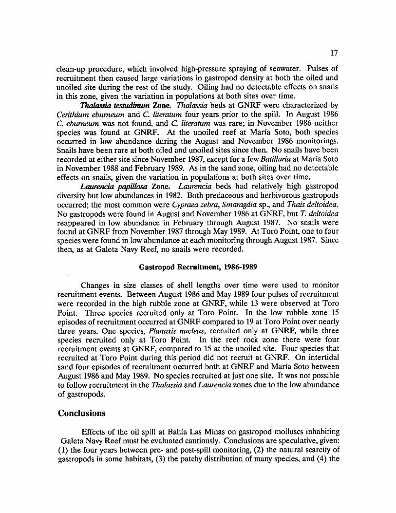
Reef Rock Zone. Nerita spp. were the most abundant snails in the reef rock zone at Galeta Navy Reef four years prior to the oil spill. The effects of the 1986 oil spill were severe, with snails generally far less abundant at GNRF than at the unoiled site during the three years of post-spill monitoring (Figure 4) . Although Nerita spp. were common at the unoiled site, Littorina spp. were the most abundant species during the study. Only in May 1988, following the localized diesel spill, was snail abundance as low at Toro Point as at GNRF, but populations quickly recovered there. There apparently was a strong, persistent effect of oiling in this zone at GNRF.
Sand Zone. Two species, Batillaria minima and Neritina virginea, occurred on intertidal sand at GNRF in 1982 ; B. minima was patchily abundant while N. virginea was rare . After the spill, N. virginea was absent and the abundance of B. minima was far lower than it had been in 1982 . Snail populations were further disturbed by the

16
Reef Rock Zone 150 - Total Snails/0.25m2 (se)
100 -
50 -
0 W
No. of species/transect
ND ND
Toro Point 50
Total Snails/025m2 (se)
0~,~ - - - - - - - -
i 0 ~ No. species/transect ND
0 No Au Se No Fe My Au No Fe My Au No Fe My
1982 1986 1987 1988 1989 Galeta Navy Reef
Figure 4 Total gastropod abundance and the number of species in the reef rock zone. The abundance data are shown as means with standard error bars . The vertical arrow indicates monitoring done just after a diesel spill at Toro Point. The number of species is the total in the 20 quadrats sampled per transect . ND = no data .
17
clean-up procedure, which involved high-pressure spraying of seawater . Pulses of recruitment then caused large variations in gastropod density at both the oiled and unoiled site during the rest of the study. Oiling had no detectable effects on snails in this zone, given the variation in populations at both sites over time .
Thalasria testudinum Zone. Thalassia beds at GNRF were characterized by Cerithium eburneum and C. literatum four years prior to the spill. In August 1986 C. eburneum was not found, and C. literatum was rare; in November 1986 neither species was found at GNRF. At the unoiled reef at Maria Soto, both species occurred in low abundance during the August and November 1986 monitorings. Snails have been rare at both oiled and unoiled sites since then. No snails have been recorded at either site since November 1987, except for a few Batillaria at Maria Soto in November 1988 and February 1989. As in the sand zone, oiling had no detectable effects on snails, given the variation in populations at both sites over time.
I.aurericia papillosa Zone. Laurencia beds had relatively high gastropod diversity but low abundances in 1982. Both predaceous and herbivorous gastropods occurred; the most common were Cypraea zebra, Smaragdia sp., and Thais deltoidea. No gastropods were found in August and November 1986 at GNRF, but T. deltoidea reappeared in low abundance in February through August 1987. No snails were found at GNRF from November 1987 through May 1989 . At Toro Point, one to four species were found in low abundance at each monitoring through August 1987. Since then, as at Galeta Navy Reef, no snails were recorded.
Gastropod Recruitment, 1986-1989
Changes in size classes of shell lengths over time were used to monitor recruitment events . Between August 1986 and May 1989 four pulses of recruitment were recorded in the high rubble zone at GNRF, while 13 were observed at Toro Point. Three species recruited only at Toro Point . In the low rubble zone 15 episodes of recruitment occurred at GNRF compared to 19 at Toro Point over nearly three years . One species, Planazis nucleus, recruited only at GNRF, while three species recruited only at Toro Point. In the reef rock zone there were four recruitment events at GNRF, compared to 15 at the unoiled site. Four species that recruited at Toro Point during this period did not recruit at GNRF. On intertidal sand four episodes of recruitment occurred both at GNRF and Maria Soto between August 1986 and May 1989. No species recruited at just one site . It was not possible to follow recruitment in the Thalassia and Laurencia zones due to the low abundance of gastropods .
Conclusions
Effects of the oil spill at Bahia Las Minas on gastropod molluscs inhabiting Galeta Navy Reef must be evaluated cautiously. Conclusions are speculative, given: (1) the four years between pre- and post-spill monitoring, (2) the natural scarcity of gastropods in some habitats, (3) the patchy distribution of many species, and (4) the

18
unknown extent of natural variation. Despite this, there were indications that the spill had adverse effects on gastropod populations in some zones of Galeta Navy Reef. Especially important were (1) observations of dead oiled snails, (2) large numbers of dead snails at Galeta Navy Reef when none were recorded at Toro Point and Maria Soto, and (3) failure of recruitment in the most heavily oiled zones .

19
Reef Flat Stomatopods
Introduction
Gonodactylid stomatopods (mantis shrimp) occupy and defend cavities in hard substrata, such as coral rubble . They are principal components of many intertidal and subtidal communities as both predators and prey . Prior to the 1986 oil spill (1979-1983), studies of the population biology, ecology, and behavior of gonodactylids were conducted near Punta Galeta .
In September 1986, five months after the spill, gonodactylid stomatopods were surveyed in the intertidal seagrass beds on reef flats at four sites, two heavily oiled and two lightly oiled to unoiled reference sites. All these sites had been sampled prior to the oil spill .
There were four major findings from this initial post-spill survey : (1) there were significantly fewer large gonodactylids, particularly females, at the heavily oiled sites; (2) individuals occupied significantly larger cavities at one of the heavily oiled sites than previously measured for Gonodactylus; (3) individuals had fewer wounds and injuries at the heavily oiled sites; and (4) individuals grew more per molt at the heavily oiled sites. The last three findings appear to have been caused by a release from competition for cavities and a possible increase in prey at the heavily oiled sites. When the numbers of large gonodactylids were reduced at heavily oiled sites, their cavities became available and allowed smaller individuals to move up into larger, more preferred cavities . Reduced competition for refuges was further reflected in reduced levels of wounds and injuries . Increased growth rates apparently were related both to reduced competition and an explosion in the numbers of hermit crab prey at the oiled sites.
The purpose of this component of the study is to document longer term changes in gonodactylid stomatopod populations . These changes will be related to the initial effects of the spill and to possible additional effects of continued oiling .
Study Sites and Methods
The two heavily oiled sites were on the northern shore of Isla Largo Remo and at Isla Mina, less than 1 km southeast of the Galeta Marine Laboratory (Figure 1) . One lightly oiled to unoiled reference site was located less than 1 km west of the oiled site at Isla Largo Remo; the other was on the northern shore of Isla Margarita. Sites were monitored in September 1986, February and September 1987, and February 1988 ; more recent collections and pre-spill data have not yet been fully analyzed .
Monitoring included three types of sampling . First, stomatopods were collected from all the pieces of hard substrata found in quadrats . The substrata were measured and then broken apart to remove all stomatopods from cavities . Second, to increase sample sizes, additional pieces of coral rubble were collected from adjacent areas . These samples were used to calculate densities of Gonodactylus per

20
unit volume of rubble and to provide sufficient numbers of individuals for estimating growth, reproduction, recruitment, and the frequency of injuries . Finally, cavity utilization was monitored at three of the four sites by bringing intact pieces of coral rubble into the laboratory. Each resident stomatopod was forced to leave its cavity and the volume of the cavity was measured using lead shot .
All animals collected in the field were brought to the laboratory and examined under a dissecting microscope to determine species, sex, size, injuries, and the reproductive state of females . Each animal was kept for three days to record whether it molted or laid eggs . If animals molted or were collected in the field with their molt skins, growth was calculated by measuring the change in carapace length .
Results
Stomatopod Densities
Pre- and post-spill data have not yet been compiled for statistical analyses . However, pre-spill densities at one of the reference sites (Isla Margarita) were in the range of post-spill measurements (pre-spill : 1979 = 9.6/m2, 1982 = 7.8 ; post-spill : September 1986 = 10.0, February 1987 = 7.2, September 1987 = 6.0, and February 1988 = 5.6).
Gonodactylid densities declined at all of the four study sites, regardless of oiling, between September 1986 and February 1988 . This trend can be seen in the post-spill values for Isla Margarita, above. These decreases were caused by a steady decline in the abundance of small- to medium-sized individuals due to low postlarval recruitment. Previously, large numbers of larvae settled on reef flats from January through June, while recruitment during the rest of the year was lower and highly variable. The abundance of large individuals at the reference sites has not yet been affected by the lack of recruitment. Eventually, however, densities of large individuals must also decrease at the current levels of recruitment.
Since recruitment was low at both heavily oiled and lightly to unoiled reference sites, the spill may not have caused the reduction in recruitment . However, the initial post-spill survey showed the abundance of large females was greatly reduced at the heavily oiled sites . Also, recruitment increased with distance from Bahia Las Minas. Considering the scale of the 1986 spill, it is possible that the larval pool was greatly reduced by the mortality of large females, thus affecting recruitment on a large scale. It is also possible that chronic oiling is inhibiting the return of larvae . Alternatively, the reduction in recruitment may be a natural phenomenon triggered by events unrelated to the oil spill . Further monitoring should clarify which of these alternatives explains the observed patterns of recruitment.
In September 1986 very few large individuals, especially females, were found at the heavily oiled sites . Large females move into very shallow water to brood at the time of year of the spill, apparently causing their disproportionately high post-spill mortality at the heavily oiled sites . A similar selective mortality of large females did not occur at the lightly oiled reference sites . At one of the heavily oiled sites,

21
migration caused the density of large individuals to increase and the proportion of females returned to a pre-spill level by February 1987, less than a year after the spill . At the other heavily oiled site, densities of large individuals were still very low nearly two years after the spill .
Competition for Cavities
The intensity of competition for cavities should be a function of the relative abundance of individuals and cavities. A good indicator of the intensity of competition is the relationship between the size of a gonodactylid and its cavity . When cavities are limiting, the intensity of competition for cavities is high and individuals tend to occupy cavities smaller than those preferred .
Analysis of cavity-occupation data appeared to support that prediction for one of the heavily oiled sites (no data were collected at the other heavily oiled site) and one of the reference sites. However, the changes in gonodactylid densities have occurred in a complex size-dependent fashion since 1986 . It will be necessary to analyze these patterns by size class to examine how shifts in the relative densities of different sizes of individuals affect overall patterns of competition. At the other lightly oiled site, there was no significant change in density and in the cavity volume relationship. The intensity of competition for cavities apparently has remained at the same level for all sizes of individuals at this site . Although it appeared that competition influenced the size of cavities stomatopods occupied, a firmer conclusion awaits further analyses of the data .
Injuries to large Gonodactylus from intraspecific aggression were correlated with density at three of the four sites . The number of large individuals increased at one of the heavily oiled sites between September 1986 and February 1987, and a significant increase in injuries was measured. At the other heavily oiled site, both the density of large animals and the frequency of injuries remained very low. No changes in density and injuries occurred at one of the reference sites ; at the other reference site density and injuries fluctuated in a complex fashion.
Habitat Deterioration
Deterioration of the habitat occurred at one of the heavily oiled sites . Seagrasses died after the spill, and the bed has broken down. Soft sediments and coral rubble stabilized by the root and rhizome system are eroding away. If this continues, the habitat will disappear .
Conclusions
Three patterns have been documented. First, stomatopod densities have been declining due to low levels of postlarval recruitment at both heavily oiled and reference sites . Local populations cannot be maintained unless recruitment increases, but it is not yet clear whether this is an effect of the spill . Second,

22
although it is premature to draw firm conclusions, competition for cavities and injuries from aggression generally remained associated with stomatopod densities . Third, the habitat at the most heavily oiled site has deteriorated considerably, apparently because the spill killed the seagrass bed that stabilized sediments and coral rubble .

23
Subtidal Reef Corals
Introduction
The effects of oil on reef-building corals are not well understood . Some field studies have reported harmful effects and lasting damage, whereas some laboratory and field experiments showed little or no mortality or lasting sublethal effects of oil on corals . The purpose of this component of the study is to examine the biological effects of the 1986 oil spill on reef corals .
Subtidal reefs along the Caribbean coast of Panama are mostly fringing reefs extending to plains of sediments at a depth of 10 to 25 m. Despite heavy sedimentation and runoff in this region, cover of living organisms measured in 1985, the year prior to the oil spill, was high (83%). The most abundant organisms were macroalgae (45% cover) and corals (27% cover) . Since corals physically structure the habitat, the focus was on the primary reef-building species: Siderastrea siderea, Pontes astreoides, Diploria clivosa, Agaricia agaricites, and D. strigosa .
Cover of sessile organisms and recent injuries to four coral species (S. siderea, P. astreoides, D. strigosa, and D. clivosa) were monitored. Colonial animals frequently suffer injuries to patches of tissue from natural processes (e.g ., fish bites, abrasion). After a few weeks the exposed skeleton becomes overgrown by algae and other organisms. Eventually, the coral may regenerate tissue into the injured patch by overgrowing these invaders, or the lesion may persist .
Assays of physiological state (regeneration into experimentally induced injuries and rates of growth) of common coral species (S. siderea and P. astreoides for both injury regeneration and growth, D. clivosa and Montastrea annularis only for growth) were conducted. Also, temperature, salinity, suspended sediments, and resuspended sediments were measured at all sites, and the occurrence of oil slicks was recorded .
Study Sites and Methods
Using post-spill visual assessments, reef sites were classified as heavily oiled (six reefs), moderately to lightly oiled (two reefs), or unoiled (four reefs) . Six of these reefs (one heavily oiled, one moderately to lightly oiled, and four unoiled) had been surveyed the year before the spill . Petroleum hydrocarbons measured in coral tissues and reef sediments corresponded well with the visual classification.
To measure cover of sessile organisms, transects perpendicular to the shore were established across each reef. Cover was measured in quadrats placed along the transects . The six reefs surveyed before and after the spill were analyzed for effects of oiling and changes through time in coral cover, colony abundance, colony size, and diversity (based on both percent cover of corals and on number of coral colonies) .
Quarterly surveys of recent injuries to four common corals were made along transects parallel to the reef crest at two shallow depths (0.5-1 and > 1-2.5 m). Sizes

24
of coral colonies were measured and proportions of recent injuries (bare or gouged white skeleton) were estimated .
Organisms may be weakened by exposure to oil in the natural environment in a complex, time-dependent fashion. Responses of S. siderea and P. astreoides to stress were compared at oiled and unoiled reefs. Two different types of injuries, each about 6 cm2, were inflicted on a single colony . One type was made by rasping the skeleton with a rotating tool, the other by blasting off the coral tissue with air. Photographs were taken before and after the injuries, and then bi-monthly .
Growth rates (i.e ., skeletal extensions) were determined from the width of annual growth bands. These data were obtained from photographic prints of X-radiographs of sections cut parallel to the growth axis of coral skeletons.
Results
Cover of Sessile Organisms
Between 1985, the year before the spill, and 1986, three months after the spill, total coral cover decreased by 76% at depths of 0.5-3 m and by 56% at >3-6 m at the heavily oiled reef (Figure 5). Coral cover declined somewhat at the shallower depth at the moderately oiled reef. In contrast, cover increased somewhat or remained the same at the unoiled reefs. Between 1986 and 1988, two years after the spill, coral cover declined at the unoiled reefs (Figure 5). Depending on future patterns, this unexplained decrease in cover may complicate assessment of effects of the spill and possible recovery . In 1988, coral cover at the heavily oiled reef was substantially less than at the unoiled reefs despite the natural decline.
Recent Injuries to Corals
Both the frequency and size of injuries increased with the amount of oiling, particularly at the shallower depth and during the first year after the spill. Also, coral species differed in levels of injuries, with S. siderea affected more than D. clivosa and P. astreoides.
Resistance of Corals to Stress
P. astreoides generally regenerated tissues into experimentally inflicted injuries more rapidly than S. siderea . For both species, regeneration into rasped patches was far more rapid than into air-blasted patches . The tissue lesions created by air-blasting more closely mimic the injuries observed at heavily oiled reefs after the spill . Surprisingly, regeneration was faster at heavily oiled than at unoiled reefs for both species.

25
20
15 O U
10
L
5
Z 0 400
N
U 200 0 a) N
0
30 -
0 U 20
10 . i N
04-85
Total scleractinians 0 .5-3 m >3-6 m
~ ___----------0
. ."
O~O~~O ". . . . . . . . . ..~ ~I . . .,
1 ono
o ̀ '; o
. .... . .
1 OI
\ O
0
i
. . . ........ . . . . . . . . ....... .
1 T
. . . . .
D
O-O No Oil ,L-,L Moderate Oil
C~-- "°°°°" Heavy Oil
C3 ,. 0~, " T
80 87 88 89 85 80 87 88 89 oil spill Year oil spill
Figure 5 Changes in the number of coral colonies per m2, size of coral colonies, and percent cover in relation to amount of oil and depth . Standard errors are shown for the four unoiled reefs ; there was one heavily oiled reef and one moderately oiled reef.

26
Sclerochronology
Coral skeletons contain a wealth of information about rates of growth, past and present incidents of stress, and, to some extent, the history of the environment . Growth rates in the year of the oil spill (1986) were compared with mean growth over the nine previous years and showed a reduction at moderately and heavily oiled reefs relative to unoiled reefs for M. annularis and D. strigosa ; growth of P. astreoides was reduced at heavily oiled reefs relative to moderately oiled and unoiled reefs (Figure 6). One species, S. siderea, showed no pattern of variation in growth related to the degree of oiling by the spill. For all species, growth rates were highly variable .
Physical Monitoring
Water temperature averaged 29°C (range = 27-31) and varied little seasonally. In general, there was less suspended particulate matter at unoiled reefs than at oiled reefs and there was a greater load of resuspended sediments at the oiled reefs.
Oil slicks have been chronic at the oiled reefs more than three years after the spill. The oil emanates from mangroves and the landfill under the refinery, most frequently after heavy rains and very high tides . In 1988, two years after the spill, heavily oiled reefs still had oil slicks present for 82% of 122 observations . Moderately oiled reefs had slicks during 15% of 30 observations, while no slicks were observed at unoiled reefs during 61 observations .
Conclusions
The spill had deleterious effects on shallow subtidal reef corals, as measured by percent cover, injuries, and growth. There were differences among species in these effects . Percent cover of a branching coral (Acropora palmata) dropped much more than massive corals (e.g., S. siderea) at the heavily oiled reef. S. siderea was more susceptible to injuries at oiled reefs than the other massive species monitored, but its growth at oiled reefs was not relatively low during the year of the spill, in contrast to the three other species measured .
Oil slicks emerging from mangroves and the landfill under the refinery have been chronic. Since the composition and toxicity of the oil change through time, chronic effects of the spill may be less pronounced than those measured soon after the spill .
Many coral populations vary through time due to a variety of natural factors (e.g ., predation, disease, competition, physical disturbance) . The decline in corals at the unoiled reefs between 1986 and 1988 is one of many examples of this kind of variation . It may have been related to the Caribbean-wide die-off of the sea urchin Diadema antillarum in 1983-84 and the subsequent increases in macroalgae that overgrow corals, the epidemic diseases of certain corals, the widespread coral

27
6 5
6
5
4
3 0 7
a 6
5 C a
4 C 0
3 12 7
121 Montastrea annularis
>>
1o
Porites astreoides
I '~" 0 Ti/ '11~ T 7
T T
/I hT
Siderastrea siderea o-o No Oil O-O Moderate Oil
T T/°\ 0 -- . . . . .t Heavy Oil
To~o.~ 1 r T T r~ O~ p T \r . . . . . E7~ . . . ., , T .,.~~~-....1 . . . ...~ D .-0~ " 1 1 a 1 l~d,
" .
3 76 77 78 79 80 81 82 83 84 85 86 87
'Yea Year Oil spill
Figure 6 Mean annual band width from 1977 to 1986 for four coral species in relation to the amount of oiling in 1986 . Specimens were collected from four unoiled reefs, two moderately oiled reefs, and five heavily oiled reefs .
Diploria strigosa

28
bleaching events that have been occurring in the Caribbean, or some combination of these and other factors . Given both the effects of the spill and the natural decline, it may require more than a decade for equivalent populations to become established provided that future events do not further depress coral populations .

29
Mangrove Forests
Introduction
Effects of the 1986 spill on mangroves were readily apparent after a few months when mature trees died over large areas. It was reported by H.J . Teas and co-workers that approximately 75 hectares of mangroves were killed, the most extensive impact of oiling yet recorded . Over three years after the spill, dense growths of young seedlings, including planted ones and natural recruits of various ages, occur in much of the deforested areas . Hydrocarbon analyses have shown that substantial amounts of oil are still present in the muddy substratum . The distribution and growth patterns of mangroves and associated fauna may be altered by this residual oil and, thus, the ability of mangrove forests to recover.
Where deforestation occurred after the spill, recovery chiefly involves natural recruitment, seedling growth, and possibly growth of mature survivors. While effects of oil may disappear after about five years for mature survivors, this period marks only the beginning (or early stages) for seedlings in deforested areas. According to published estimates, full recovery may require many decades. In areas where effects of the spill on mangroves were not lethal, patterns of growth and development of mature trees may not be normal.
Although some observations were made soon after the spill, the studies described here were not initiated until January 1989 . The findings therefore are preliminary.
Study Sites and Methods
Most study sites were chosen near those established for the study of mangrove roots. There are two treatments (oiled and unoiled) and three habitats (open coast, lagoon, and river), with four or five replicates of each combination (total of 26 sites) .
Mapping. Aerial photography will be used to prepare vegetation maps before and after the spill . These will show the extent of deforestation and other changes in mangrove forests .
Profile . Standard surveying techniques will be used to define topographic profiles along transects across the study areas . These data will provide further physical description of mangrove deforestation caused by oiling .
Tree and Forest Study. Tree species are being identified and structural characteristics of forests described . Data on forest structure chiefly include species, height, girth, and inter-tree distance . One species, the red mangrove, Rhizophora mangle, was most affected by oiling . Therefore, most attention is focused on it .
Primary Consumers. The major consumers of canopy vegetation, litter, and wood will be identified, and their distributional ranges will be described.
Primary Production. The main purpose of this study is to quantify major components of primary production by mangrove trees and show their phenology. Litter traps were installed and shoots were tagged for monthly monitoring . The two

30
techniques are closely related, and together provide measures of canopy density . Trunk growth is being monitored by marking outer wood layers with dye.
Primary Consumption. This study will quantify consumption of canopy leaves, litter fall, and wood. The relationship between crab predation on mangrove propagules and species composition of forests will be investigated . Herbivory in the canopy is being assessed by quantifying leaf loss ; exclusion devices were installed in the field to help determine proportions removed by arboreal crabs or insects. Consumption of litter fall on the forest floor will be examined by tethering leaves and propagules . Wood consumption will be measured from losses in volume and weight of wooden blocks .
Recruitment and Seedling Demography. Replicate quadrats were established at oiled and cleared unoiled sites, seedlings were marked, and the plots are monitored biannually for new recruits .
Seedling Growth. Seedlings were tagged and their growth will be monitored. In addition, propagules planted in a range of habitats and treatments will be assessed for age-related parameters and growth characteristics.
Forest Gap Primary Consumers. Distribution and relative abundances of primary consumers in forest gaps will be monitored for comparisons between oiled and unoiled gaps, and between unoiled mature forests and oiled gaps .
Results
Primary Productivity
Initial field and literature surveys of earlier and on-going studies of mangroves at Bahia Las Minas were completed in May 1989 . There are four mangrove tree species in the study areas, including a species not previously reported for the region, Pelliciera rhizophorae.
Leafy shoots of Rhizophora mangle were tagged in June 1989 to be monitored monthly. At the same time, litter-fall traps were installed under mature trees and litter has been gathered each month. Data collected so far indicate that canopy growth of surviving adult trees adjacent to oiled areas is not different from growth at unoiled areas. Estimates of litter fall productivity from the first three months were comparable to values measured elsewhere, and for other Rhizophora species . Also, there do not appear to be any consistent trends across treatments and habitats. However, these data are preliminary and considerable seasonal variation is likely .
Data on shoots showed some seasonal change in the number of leaves per shoot, and rates of leaf production and fall . There were important differences among habitats, but unoiled and oiled sites are not distinguishable . This pattern also applied to net canopy production (difference between production and fall rates) .

31
Seedling Growth
Seedlings of Rhizophora mangle planted in 1986 and 1987 were tagged and measured in August and September 1989 . There were two types of sites : unoiled closed canopy and oiled open canopy. These seedlings provided evidence that the number of nodes (leaf scars) on the vertical stem could be used to measure age-specific growth, and that available light was an important rate-determining factor . Using this new technique, it was clear that some seedlings survived the spill while surrounding adults died . This finding suggests that tree death resulted from suffocation rather than toxicity of oil . Apparently, the structure of seedlings enabled them to tolerate periods of immersion in oil.
Additional seedlings were tagged in September 1989 . This monitoring should further quantify age-related parameters in seedlings, and thus enable detailed demographic study of recruitment at deforested sites .
Primary Consumption
In a pilot study, crawling-herbivore excluders were installed on branches of Rhizophora mangle. Data on leaf herbivory will be collected after complete canopy turnover has taken place, probably by May 1990 .
Conclusions
The finding that canopy growth of surviving adult mangrove trees at oiled sites is similar to growth at unoiled sites suggests that the oil in the substratum around these trees no longer directly threatens them. However, the absence of neighboring trees killed by the spill leaves the survivors more prone to fall over and die during periods of strong winds. Although litter fall showed no consistent trends between oiled and unoiled sites and among habitats, shoot productivity differed among habitats . However, it will be necessary to collect a full year of data to evaluate this further because of the considerable seasonal variation expected.
It appears that some aspect of the structure of young seedlings, perhaps their lack of prop roots, enabled them to survive periods of partial immersion in crude oil. The numbers of surviving seedlings and post-spill recruits appear to be sufficient for reforestation, although it will require decades for trees to mature fully. By measuring the nodes on vertical stems of seedlings and shoots, it is possible to quantify and compare growth of seedlings and trees at oiled and unoiled sites .

33
Mangrove Roots
Introduction
Mangrove-dominated shores are characteristic of tropical and subtropical coastlines worldwide. The red mangrove, Rhizophora mangle, is widely distributed in the Caribbean region and occurs extensively on both coasts of Panama . It grows along much of the south coast of Florida and is found patchily elsewhere along the southeastern coast of the United States .
The prop roots of Rhizophora are breeding and nursery areas for many marine species, and substrata or shelter for a diverse group of epibiotic marine plants and animals . Epibiota on Rhizophora prop roots were sampled near the Galeta Marine Laboratory in 1981 and 1982, providing information about these assemblages several years prior to the 1986 spill . Epibiota were monitored quarterly beginning in August 1986 at oiled and unoiled sites.
Study Sites and Methods
Three intertidal habitats of Rhizophora mangle were examined: (1) trees fronting the open ocean, generally along the inner margins of fringing reef flats (= open coast) ; (2) those along the banks of channels and lagoons (= channel); and (3) those in brackish water streams and man-made ditches (= drainage stream). In 1981-1982 percent cover of fouling and encrusting organisms was estimated visually on roots in these habitats. Since July-August 1986, three months after the oil spill, monitoring of epibiotic cover has been quarterly (designated "long-term census"). To measure percent cover, strings with 100 randomly chosen marked points were held against roots, and what occurred under each point was recorded. Starting in February 1987 root condition was also monitored.
Beginning in August 1987, about 16 months after the spill, two additional types of data were collected quarterly. First, the development of assemblages of organisms from the point roots enter the water was investigated ("community development") . Tagged roots were measured and sampled for percent cover and root condition. Second, patterns of recruitment were followed using hardwood dowels hung vertically in the water at each site and collected three months later. Percent cover of organisms that settled over the previous three months was measured .
The following physical factors were monitored : salinity, water temperature, depth, light intensity, and water movement. In May 1989, sediment cores were collected as part of a collection of samples for hydrocarbon analyses . Other data collected from the cores and that are pertinent to this study include presence of oil in each core (visible, by smell, or none) and substratum type (e.g ., peat, mud, sand, rubble, coral fragments) .

34
Results
Physical Characteristics of the Habitats
Salinity was oceanic at all open coast sites . Water temperatures were similar at open coast sites and showed little evidence of depth stratification. Depths averaged 55-65 cm. Substrata at all open coast sites were dominated by sand and shell fragments.
Channels and lagoons also had oceanic salinities, except in May 1989 when surface salinity was generally lower than salinity at 1 m depth, probably as a result of heavy rains. There has been little evidence to date of thermal stratification. Depths were highly variable and shallower than at open coast sites . The substratum was characterized by finer-grained sediments : peat, coral rubble, and organic and inorganic muds.
Physical characteristics of drainage streams were far more variable than the other two habitats . Both surface and 1 m salinity readings in oiled streams were oceanic. In contrast, unoiled streams had variable surface salinity and relatively high salinity at 1 m depth. This difference can be attributed to the fact that streams with more freshwater drainage were less likely to be oiled than those with less current flow. There was also considerable variation in depth among unoiled streams; streams were deeper than either channels or the open coast. Sediments were fine-grained muds and peat .
Extent of Oiling
Mangrove roots were first examined about three months after the spill began. All open coast mangrove areas between Isla Margarita and Islas Naranjos (Figure 1) were oiled to some degree. Mangrove channels and lagoons at Isla Margarita had been protected by booms and remained unoiled, and most of the back lagoons and channels between Isla Payardi and Punta Galeta were either unoiled or lightly oiled. Streams and rivers draining into this lagoon were unoiled, except for a stream draining Isla Largo Remo. The lagoon between Isla Payardi and Punta Muerto was heavily oiled, as was Bahia Cativa. In these bays, most small streams draining interior mangroves were heavily oiled, but larger streams escaped oiling .
Oil has continued to appear on roots during the three years since the spill (Figure 7) . The highest levels of continued oiling occurred in streams, followed by channels and the open coast. The percent cover of oil on recruitment dowels showed the amount of reoiling occurring over three-month periods. At this scale, oiling was heaviest in streams and has persisted three years after the spill.
In May 1989 no evidence of oil was found in sediment cores from any unoiled site. In contrast, oil was still present in sediments at all but one of the oiled sites three years after the spill .

35
100 a
Q
O
50
Recruitment o A A, O
100
0
Q U Q
50
0
100
50
0
>us
Figure 7 Percent cover of oil on sampled roots or dowels in oiled open coast, channel and stream habitats . Each symbol is an among-site mean with standard error bars. Recruitment dowels show the quarterly extent of oiling . Community development roots show the presence of oil on roots that entered the water in August 1987 and long-term census data show the cover of oil on randomly selected roots .
open coast channel stream
Community Development
I
m
Au No Fe My Au No Fe My Au No Fe My 1986 1987 1988 1989
Monitoring Date

36
Effects of Oiling on Roots and Trees
Long-term census roots at unoiled stream and open coast sites were longer by May 1989 than those at oiled sites ; differences in the channel habitat were not significant. Community development roots were longer in unoiled open coast and stream habitats, but were longer in oiled channels than in unoiled channels. Differences in length may reflect differences in physical conditions other than oiling.
In May 1989, three years after the spill, the fractions of sampled roots that were live were 69%, 71%, and 58% at oiled open coast, channel, and stream sites, respectively. In comparison, values at unoiled sites were 98%, 98%, and 96%. Clearly, it will be a considerable period before oiled mangrove root habitats recover .
Damage to mangrove trees from oiling changed physical characteristics of the habitat. Defoliation removed the weight of leaves from branches and, in some cases, branches flexed upward and lifted roots out of the water. Organisms that had survived oiling were then killed by desiccation or heat stress or both. Defoliation also increased light available for algal growth. On average, available light was greater at oiled than at unoiled sites for all three habitats ; available light decreased from open coast to channel to stream sites. An ephemeral increase in algal cover occurred in channels, correlated with defoliation.
Pre- and Post-spill Epibiota on Mangrove Roots
Prior to the spill, there were more species or groups of epibiota on the open coast than at channel and stream sites . There also was limited overlap in species occurrence among habitats ; exceptions were mixed-species groups (e.g ., diatoms, mixed algal turfs) . Roots in each habitat supported a distinct community . Open coast sites were dominated by a diverse group of foliose and crustose algae . The edible oyster Crassostrea rhizophorae was the most common species in channels, and the false mussel Mytilopsis sallei covered the most space in streams .
Open Coast. Although some plants and animals are returning to abundances similar to those before the spill, the open coast habitat showed persistent effects of the spill after three years. The cover of foliose algae at oiled sites was similar to that at unoiled areas soon after the spill. Since then, it has generally been lower at oiled sites with no indication of an increasing trend. Sessile invertebrates were negatively affected by oiling, except for the high intertidal barnacle Chthamalus sp., which became more common at oiled sites. Sponges, tunicates, corals, hydroids, and bryozoans were all less common at oiled than at unoiled sites three years after the spill. Differences in foliose algae and sessile invertebrates on roots that entered the water in August 1987 ("community development"), but not on recruitment dowels, also still occur. This suggests that oiling only affects postlarval events in this habitat. Despite the observed rapid turnover, recovery of the biotic assemblage in this habitat appears to be several years in the future .
Channels and Lagoons. Channels and lagoons still showed effects of oiling in May 1989 . Two major space-occupiers, the edible oyster Crassostrea rhizophorae

37
(Figure 8) and the barnacle Balanus improvisus, occurred at population levels lower than those measured in 1981 and 1982 throughout the study. Little recruitment of either species has occurred over the last two years, but Crassostrea cover has increased gradually on oiled community development roots. Also, oyster cover has declined steadily on long-term census roots at unoiled sites. Recovery of epibiota in channels thus seems complicated by a high degree of natural variability, and more data are needed for conclusions to be drawn.
Drainage Streams. The oil spill had devastating effects in drainage streams. The dominant space-occupier, Mytilopsis sallei, was virtually eliminated by the spill and has not recovered after three years (Figure 9) . Other epibiota were also almost completely eliminated after the spill and showed little or no recovery through May 1989. Oil cover remained the highest of all three habitats (Figure 7), and root condition was the worst of the three habitats . It appears that recovery will be a prolonged process, dependent on relative rates of root provisioning and mortality, and leaching of oil trapped in sediments.
Conclusions
Distinct communities occur on Rhizophora roots in the three habitats examined. Foliose and crustose algae occupy the most space on open coast roots ; species richness is the highest and no single species dominates space. In channels and lagoons, bivalve molluscs, especially Crassostrea rhizophorae, dominate and barnacles are abundant. Mytilopsis sallei is the most common species in drainage streams ; barnacles and algae are also abundant .
The oil spill had immediate effects on many organisms in all three habitats . Within three to nine months, the most common taxa were less abundant at oiled than at unoiled areas. Many less common species also decreased in abundance at oiled sites compared with unoiled sites soon after the spill . In contrast, diatoms bloomed ephemerally at oiled open coast sites from three to six months after the spill .
Oil has persisted in mangroves during the three years since the spill, leading to considerable reoiling of roots . This has been especially pronounced in oiled drainage streams .
Differences in the epibiota at oiled and unoiled sites remained three years after the spill . Long-term effects of oiling and recovery from those effects varied both among habitats and among taxa. On the open coast, it appears that algae were affected by post-settlement mortality or reduced growth or both . In channels and lagoons, more physical and biological data are needed to evaluate recovery of the oyster Crassostrea from the spill. Three years after the spill, the barnacle Balanus was less abundant at oiled sites than at unoiled sites, but some rare groups or species differed little . Oiled drainage streams remained severely affected ; the normally dominant mussel Mytilopsis did not occur on oiled long-term census roots three years after the spill .

38
Channel and lagoons Crassos~rea rl~rzopl~orae
40 e Recruitment
0 ~ as
40 Community Development -- ~ ~ ~--
100 Longterm census o pre-Spill
CD o unoiled oiled
-- cl~
o -- - ------ --
No Ja Ju Au No Fe My Au No Fe My Au No Fe My 1981 1982 1986 1987 1988 1989
MoNtorhg Date
Figure 8 Percent cover of Crassostrea rhizophorae on roots or dowels sampled from channels and lagoons . Each symbol is an among-site mean with standard error bars .

39
Drainage Streams and Rivers M y/ %psrs salle~
40
a '~ 20
Recruitment a 0
a pre-spill Q
0 20- Community o unoiled oiled Development ~ - _ -
-+- 100
Longterm census U
80
60
40 __
20 -
0 No Ja Ju Au No Fe My Au No Fe My Au No Fe My
1981 1982 1986 1987 1988 1989
Monitori ng Date Figure 9 Percent cover of Mytilopsis sallei on roots or dowels from drainage
streams and rivers . Each symbol is an among-site mean with standard error bars .
41
Subtidal Seagrass Communities
Introduction
Seagrass beds along the central Caribbean coast of Panama are usually located between fringing coral reefs and mangrove forests. There are numerous beds in Bahia Las Minas and along the coast toward Isla Grande. The response of seagrass communities to oiling, although not well described, probably depends on the depth of subtidal beds and their position in intertidal zones, and the climate and sea conditions during exposure to oil. The 1986 spill in Panama presented an opportunity to observe the amount of damage to seagrass communities by various degrees of oiling and the resilience of these communities to this type of damage under a range of environmental conditions . This report describes preliminary results of a three-year post-spill study.
Study Sites and Methods
The seagrass beds from Isla Margarita to Isla Lint6n (near Isla Grande ; see Figure 1) chosen as study sites were (1) adjacent to a mangrove shoreline, (2) behind small patch or fringing reefs, and (3) subtidal . Depth profiles were produced for each site along transects from the shore to the seaward edge of the bed.
Beginning in September 1986, several months after the spill, until April 1989 samples of seagrasses, algae, and benthic fauna were collected quarterly at four oiled and four unoiled seagrass beds using a coring tube (10.2 cm diameter) . Surface scrapes for sediment analyses were also collected . In the laboratory, seagrass blades and roots and macroalgae were separated, dried, and weighed. Animals were separated and sorted to higher taxa, except polychaetes and caridean shrimp, which the principal investigator could often identify to genus or species . Samples from September 1986 - January 1987 and for January 1988 have been processed . Sediment samples were sieved wet through a standard series, and organic content was determined by combustion. Oiled and unoiled sites did not differ greatly in these sediment parameters .
From November 1986 until April 1989 mobile epifauna were collected quarterly at the same sites by pushnet sampling along transects. The animals collected were preserved and sorted ; samples from November 1986 - July 1987 have been processed.
Results
Although seagrass biomass in September 1986, several months after the spill, was somewhat lower at oiled sites than at unoiled sites, this difference disappeared by November 1986 . Damage to plants may have been more severe near shoreward

42
margins of oiled beds; three years after the spill, shoreward margins of oiled beds were receding.
Caridean shrimp, by far the most abundant group in epifaunal collections, showed a varied response between oiled and unoiled sites for over a year after the spill. Some species were generally more common at unoiled sites than at oiled sites . Others, such as Penaeus duorarum, were generally somewhat more abundant at oiled sites . Small ash were more abundant at unoiled sites than at oiled sites, but many epifaunal taxa, including majid crabs, amphipods, mysid shrimp, hermit crabs, and echinoderms, had variable, but often similar, abundances at oiled and unoiled sites .
Infaunal taxa also showed variable responses after the spill. Groups generally more abundant at unoiled sites than at oiled sites included tanaid shrimp and ophiuroids. Bivalves generally were similar in abundance at oiled and unoiled sites. Polychaete biomass was lower at oiled sites in September 1986 than at unoiled sites, but biomasses at oiled and unoiled sites had converged by January 1987.
The distribution of males, females, and juveniles of the caridean shrimp Hippolyte zostericola at oiled and unoiled sites in November 1986 indicated that juvenile shrimp were affected more by the spill than adults . Juveniles of Latreutes fucorum were similarly affected, but more variably. Further analyses of these data and completion of measurements of more species should indicate whether certain life stages were most susceptible to the spill.
Conclusions
The oil spill may have caused an initial reduction in seagrass biomass at oiled sites, evident several months later (in September 1986). However, there was no difference by November 1986 and in subsequent samples .
In the post-spill collections of epifauna and infauna at oiled and unoiled sites, there were no universal patterns in the abundance of taxa. Some taxa were less abundant at oiled sites, some were more abundant, and others were very similar in abundance at oiled and unoiled sites . It has not yet been determined why such variation occurred after the spill .

43
Hydrocarbon Analyses
Introduction
In September 1986, five months after the spill, and in 1988-89, two-and-a-half to three years after the spill, environmental and biological samples were collected for chemical analyses . These analyses show the distribution and degradation of the spilled oil and are necessary to correlate oiling and biological effects of the spill and to identify sources of contamination .
Study Sites and Methods
In 1986 and 1988-89, samples of surface sediments were collected from reef flat, mangrove, seagrass, and coral reef sites used for biological studies . Sediment cores were also collected at mangrove sites.
Oysters were collected in September 1986 from three mangrove sites (one unoiled, one lightly oiled, and one moderately oiled) . No living oysters or other obvious bivalves could be found in heavily oiled mangroves. Since December 1988, there have been quarterly collections of oysters, mussels, and barnacles from oiled and unoiled channel, drainage stream, and open coast mangrove roots, respectively .
Corals were collected from four reef sites (one unoiled, one moderately oiled, and two heavily oiled) in September 1986 and from all 12 reef sites in 1988-89 . Coral tissues were removed from the skeleton by air-blasting or scraping .
Sediment and tissue samples were extracted and analyzed for hydrocarbons using ultraviolet fluorescence (UVF) and gas chromatography (GC). Results of the 1986 collection are presented here ; analysis of the 1988-89 collection is not complete .
Results
Data for mangrove surface sediments collected five months after the spill showed both the patchiness and high levels of oiling at heavily oiled sites, and suggested that oiled mangrove sediments will be a lasting source of contamination as sediments erode and oil is flushed out . Sediment cores showed that Venezuelan/Mexican Isthmian Crude (VMIC) had not penetrated deeply into mangrove sediments except at seaward fronts . Most of the spilled oil in this intertidal habitat was in a discrete layer near the surface . Data on seagrass and coral reef sediments showed that oil spread subtidally, as well as intertidally. The chemical data generally agreed with visual assessments of oiling .
Analysis of coral tissues indicated that corals take up petroleum hydrocarbons in proportion to their level of exposure from contaminated seawater . High levels of oil in coral tissues at heavily oiled reefs correlated with the observed reduction in percent cover of live corals and with the high levels of coral tissue lesions . There was also preliminary evidence for effects of oil on the lipid biochemistry of corals.

44
This observation is consistent with other studies of the effects of oil on coral reproduction and energetics. The preliminary data on bivalves indicate they will be useful in establishing dose/response relationships for sublethal biological effects.
Gas chromatograms of sediment samples showed that significant alteration of the oil had occurred within five months of the spill, even in heavily oiled mangroves . Figure 10 shows the change in saturated hydrocarbons of spilled VMIC extracted from seawater . This pattern is similar to that seen in oiled seagrass and coral reef sediments . Some samples of mangrove sediments showed high levels of less degraded oil .
The source of contamination was unquestionable in areas heavily contaminated by VMIC. Only one area was significantly contaminated by another type of oil, which appeared to be an old spill of fuel oil. During the 1988-89 collection one site had recently been exposed to a spill of fuel oil; this event should be evident in sediment samples. Additional information on sources is obtained by means of selected ion searching for stable marker compounds by a gas chromatography/mass spectrometry system (GC/MS). It should be possible to follow stages of degradation by tabulating changes in the ratios of specific marker peaks caused by selective degradation of some compounds and possible bacterial synthesis of others . Ratios of specific aromatics may also yield useful information. Data will be synthesized to construct a model for rates of degradation and dispersion processes in this tropical environment compared to similar models derived for temperate regions.
Conclusions
Analysis of sediment samples confirmed the presence of the spilled oil, sometimes in very high concentrations, at intertidal mangrove and at subtidal reef and seagrass sites in Bahia Las Minas . These measurements generally confirmed the site classifications based on observations during and soon after the spill (unoiled, lightly or moderately oiled, and oiled or heavily oiled) . They also supported observations of considerable patchiness in the distribution of the spilled oil, and that mangrove sediments contain substantial quantities of oil and will be a source of chronic contamination.
The spilled oil also occurred in coral and oyster tissues at oiled sites . This corresponded with the adverse effects on corals at oiled sites, such as reduced percent cover, increased levels of tissue lesions, and reduced growth.
The composition of the oil changed rapidly after the spill, but it was possible to identify the degraded spilled oil and distinguish it from other sources of contamination.

45
: . .,
'. i
ETA SPILL
)ROCARBONS
- _,----~ ,---- i ~ --- ~------ - ; - 0 0 o b ~ o 0 0
O N c ~O m
p N ri N N N N H
B . SEAWATER t i .1
GALETA SAND l
: . ~ 2 ug I-I
!1 ~ I p~i4( (i. hN t
i =7
-----i
o c o 0 0 0 o C O O O O O O
a °o o °o 0
OD O N ID pp p N Q N N N N N ("1 Pf M N C v^ Q
1 ~°
. ;
I~~ f .~~;Y ~ i ( I i
iNi p ~ji~~~fii~S,
ALI(ANE RMUMON INDEX
Figure 10 Gas chromatograms of saturated hydrocarbons in VMIC oil and suspended in seawater near mangroves at Punta Galeta, September 1986. The tracings show the composition of different sized hydrocarbon molecules, with size increasing to the right. Numerous compounds are apparent in the fresh crude oil (A), but after five months of weathering most smaller compounds were missing (B) ; the peak near 1800 in (B) is an internal standard .
47
Physical Environmental Monitoring
Introduction
The basic purpose of the Smithsonian Institution's Environmental Sciences Program (ESP) is to monitor long-term physical environmental and biological variation, i.e., to collect "baseline" data. A monitoring program was initiated at the Galeta Marine Laboratory during 1972 . Physical environmental data have been collected continuously since then, with some gaps and changes in parameters and instruments .
Study Sites and Methods
The factors monitored on the reef flat at Punta Galeta include water level, air temperature, rainfall, solar radiation, wind speed and direction, salinity, and upstream (seaward) and downstream (landward) water temperatures. Most of the monitoring devices are affixed to the reef flat adjacent to the laboratory, often taking advantage of existing concrete structures from earlier military use of the reef flat .
Subsurface (3 m depth) water temperature has been monitored since 1988 at reef sites at Punta Galeta, Isla Payardi, and Isla Grande (Figure 1).
Water Level. Water level is measured with a mechanical chart recorder . Rates of chart movement and accuracy of measurement are manually checked using independent measurements of water level . The same apparatus has been kept in use because its accuracy, precision, resolution, and reliability are better than the available electronic methods .
Air Temperature. Hourly mean temperatures are monitored with a portable digital recorder connected to a sensor mounted about 1.5 m above mean low water level. The sensor is shielded from rainfall, salt spray, static charges, and direct sunlight . Temperatures are checked with a precision mercury thermometer.
Rainfall. Rainfall is also measured with a mechanical chart recorder . Its float is in a cistern connected to a collector on the roof of the laboratory. These data are checked against data from simple collector gauges . Also, a known volume of water is added periodically to the cistern to ensure proper functioning of the recorder .
Solar Radiation . Wide-spectrum solar radiation is monitored by a portable digital recorder connected to a sensor . Solar radiation is checked against expected values for full sun at mid-day and darkness at night . The sensor is sent to the manufacturer every two years for recalibration.
Wind Speed and Direction. An anemometer at the seaward edge of the reef flat measures wind speed and wind direction 3 m above low water level. Hourly mean wind speed, hourly mean wind direction, hourly peak wind speed, and the direction of peak speed are registered by a portable digital recorder.
Salinity. Salinity is measured with a temperature-compensated, hand-held refractometer for water samples taken from the upper 15 cm of water flowing across

48
the reef flat . The refractometer is zeroed with distilled water before each daily measurement and is periodically checked against standard seawater.
Upstream and Downstream Water Temperatures. Water temperatures are measured hourly by a sensor and portable digital recorder. Temperature readings are checked at least once a week with a precision mercury thermometer.
Subtidal Temperature. Daily minimum, maximum, and mean temperatures are monitored at a depth of 3 m by a portable digital recorder at three different sites with two sensors for each recorder. One sensor is inside the housing and the other is attached to the sea floor. Data from both sensors are compared to check for proper functioning.
Conclusions
Environmental data for May 1986 showed the rainfall and shifting winds that flushed oil out of Bahia Cativa toward the open sea. Also apparent were the subsequent low tides that caused the spilled oil to accumulate on the seaward margin of reef flats.
ESP data for populations and communities on the reef flat at Punta Galeta provided extensive sets of pre-spill data for comparisons with data after the spill . This long-term information shows the extreme variation through time in abundances of organisms on the reef flat . Daytime tidal exposures of reef flats were unusually extreme during June - September 1988. Such continuing natural variability, which in this case caused considerable reductions in abundances of organisms for this time of year, is the sort of "noise" that complicates interpretations of ecological recovery in this habitat following the spill. Careful monitoring of natural variability is essential for detecting the "signal" of a particular event, such as an oil spill.

As the Nation's principal conservation agency, the Department of the Interior has responsibility for most of our nationally owned public lands and natural resources . The includes fostering the wisest use of our land and water resources, protecting our fish and wildlife, preserving the environmental and cultural values of our national pants and historical places, and providing for the enjoyment of life through outdoor recreation . The Department assesses our energy and mineral resources and works to assure that their development is in the best interest of all our people . The Department also has a major responsibility for American Indian reservation communities and for people who live in Island Territories under U .S . Administration .
..,.,w
1 - ~. .
~...~