Embed Size (px)
Citation preview

LOCAL PLANNING SCHEME NO. 42
Gazetted: 26 May 2020
Last Document Update: 26 May 2020
Disclaimer
Whilst this document is generally believed to be complete at the time of compilation and all reasonable efforts are made to ensure its currency, no warranty is given that it is free from error or omission.
The definitive City of Canning Local Planning Scheme No. 42Text (and Scheme Maps) is that which is held by the City of Canning at any point in time.

CITY OF CANNING LPS 42 – TEXT AMENDMENTS
AmendmentNo. Gazettal Date Details
City of Canning Local Planning Scheme No. 42
ii

Table of ContentsPART 1 – PRELIMINARY.........................................................................................................................1
1.1 CITATION...............................................................................................................................................1
1.2 COMMENCEMENT................................................................................................................................1
1.3 SCHEME REVOKED................................................................................................................................1
1.4 NOTES DO NOT FORM PART OF THE SCHEME.......................................................................................1
1.5 RESPONSIBILITY FOR SCHEME...............................................................................................................1
1.6 SCHEME AREA.......................................................................................................................................1
1.7 CONTENTS OF SCHEME.........................................................................................................................2
1.8 PURPOSES OF SCHEME.........................................................................................................................2
1.9 AIMS OF SCHEME..................................................................................................................................2
1.10 RELATIONSHIP WITH LOCAL LAWS......................................................................................................3
1.11 RELATIONSHIP WITH OTHER LOCAL PLANNING SCHEMES..................................................................3
1.12 RELATIONSHIP WITH REGION PLANNING SCHEME.............................................................................3
PART 2 – RESERVES...............................................................................................................................5
2.1 REGIONAL RESERVES.............................................................................................................................5
2.2 LOCAL RESERVES...................................................................................................................................5
2.3 ADDITIONAL USES FOR LOCAL RESERVES..............................................................................................7
PART 3 – ZONES AND USE OF LAND......................................................................................................9
3.1 ZONES...................................................................................................................................................9
3.2 ZONING TABLE....................................................................................................................................12
3.3 INTERPRETING ZONING TABLE............................................................................................................16
3.4 ADDITIONAL USES...............................................................................................................................18
3.5 RESTRICTED USES................................................................................................................................18
3.6 SPECIAL USE ZONES.............................................................................................................................18
3.7 NON-CONFORMING USES...................................................................................................................18
3.8 CHANGES TO NON-CONFORMING USE...............................................................................................19
3.9 REGISTER OF NON-CONFORMING USES..............................................................................................19
PART 4 – GENERAL DEVELOPMENT REQUIREMENTS.........................................................................22
4.1 R-CODES..............................................................................................................................................22
4.2 MODIFICATION OF R-CODES...............................................................................................................22
4.3 STATE PLANNING POLICY 3.6 TO BE READ AS PART OF SCHEME........................................................22
4.4 MODIFICATION OF STATE PLANNING POLICY 3.6................................................................................22
City of Canning Local Planning Scheme No. 42
iii
4.5 OTHER STATE PLANNING POLICIES TO BE READ AS PART OF SCHEME................................................22
4.6 MODIFICATION OF STATE PLANNING POLICIES...................................................................................22
4.7 ENVIRONMENTAL CONDITIONS..........................................................................................................23
4.8 SETBACKS TO ROADS TO BE WIDENED................................................................................................23
4.9 ACCESS TO PRIMARY AND OTHER REGIONAL ROADS.........................................................................23
4.10 CAR PARKING....................................................................................................................................23
4.10.1 General Requirements...............................................................................................................23
4.10.2 Cash in Lieu................................................................................................................................23
4.10.3 Reciprocal Parking......................................................................................................................24
4.11 SERVICE ACCESS................................................................................................................................24
4.12 BICYCLE PARKING AND END OF TRIP FACILITIES...............................................................................25
4.12.1 Bicycle Parking...........................................................................................................................25
4.12.2 End of Trip Facilities...................................................................................................................25
4.12.3 Unit of Measurement.................................................................................................................25
4.13 PARKING AND ACCESS DESIGN REQUIREMENTS...............................................................................25
4.14 ADAPTABLE BUILDINGS.....................................................................................................................39
4.14.1 Application.................................................................................................................................39
4.14.2 Minimum Floor to Ceiling Height...............................................................................................39
4.15 HOME BASED BUSINESSES................................................................................................................39
4.16 RESIDENTIAL ZONE DEVELOPMENT REQUIREMENTS........................................................................39
4.16.1 Application.................................................................................................................................39
4.16.2 General Requirements...............................................................................................................39
4.16.3 Commercial Vehicle Parking in the Residential Zone.................................................................40
4.17 INDUSTRIAL ZONES DEVELOPMENT REQUIREMENTS.......................................................................41
4.17.1 Application.................................................................................................................................41
4.17.2 Setbacks and Frontage...............................................................................................................41
4.17.3 Use of Setbacks..........................................................................................................................41
4.17.4 Landscaping................................................................................................................................42
4.17.5 Facades......................................................................................................................................42
4.17.6 Storage of Goods and Materials.................................................................................................42
4.18 COMMERCIAL AND SERVICE COMMERCIAL ZONES DEVELOPMENT REQUIREMENTS......................43
4.18.1 Application.................................................................................................................................43
4.18.2 Setbacks.....................................................................................................................................43
4.18.3 Use of Setbacks..........................................................................................................................44
City of Canning Local Planning Scheme No. 42
iv

4.18.4 Landscaping................................................................................................................................44
4.18.5 Facades......................................................................................................................................44
4.19 MIXED USE ZONE DEVELOPMENT REQUIREMENTS..........................................................................45
4.19.1 Application.................................................................................................................................45
4.19.2 Density.......................................................................................................................................45
4.19.3 Setbacks.....................................................................................................................................45
4.19.4 Building Height...........................................................................................................................45
4.19.5 Land Use Mix..............................................................................................................................45
4.19.6 Deep Soil Zones..........................................................................................................................45
4.19.7 Parking Location and Signage.....................................................................................................46
4.19.8 Streetscape and Facades............................................................................................................46
4.19.9 Blank Walls.................................................................................................................................46
4.20 RURAL AND RURAL RESIDENTIAL ZONES DEVELOPMENT REQUIREMENTS.......................................47
4.20.1 Application.................................................................................................................................47
4.20.2 Setbacks and Density.................................................................................................................47
4.20.3 Character....................................................................................................................................47
4.20.4 Environment and Vegetation.....................................................................................................47
4.20.5 Commercial Vehicle Parking.......................................................................................................48
4.21 PRIVATE COMMUNITY PURPOSES ZONE DEVELOPMENT REQUIREMENTS.......................................49
4.21.1 Application.................................................................................................................................49
4.21.2 Setbacks.....................................................................................................................................49
4.21.3 Bulk and Scale............................................................................................................................49
4.21.4 Landscaping................................................................................................................................49
4.21.5 Facades......................................................................................................................................49
4.22 DISTRICT CENTRE AND LOCAL CENTRE ZONES DEVELOPMENT REQUIREMENTS..............................50
4.22.1 Application.................................................................................................................................50
4.22.2 Density.......................................................................................................................................50
4.22.3 Setbacks.....................................................................................................................................50
4.22.4 Landscaping................................................................................................................................50
4.22.5 Facades......................................................................................................................................51
4.23 SCHEME TO PREVAIL.........................................................................................................................51
4.24 VARIATIONS TO SITE AND DEVELOPMENT REQUIREMENTS.............................................................51
4.25 RESTRICTIVE COVENANTS.................................................................................................................52
PART 5 – SPECIAL CONTROL AREAS....................................................................................................53
City of Canning Local Planning Scheme No. 42
v

5.1 SPECIAL CONTROL AREAS....................................................................................................................53
PART 6 – TERMS REFERRED TO IN THE SCHEME................................................................................57
6.1 TERMS USED.......................................................................................................................................57
6.2 LAND USE TERMS USED......................................................................................................................60
Schedules
Schedule A – Supplementary Provisions to the Deemed Provisions..................................................72
Schedule B – Additional Uses.............................................................................................................74
Schedule C – Restricted Uses..............................................................................................................78
Schedule D – Former Town Planning Scheme No. 29 Contribution Requirements...........................80
Tables
Table 1 – Reserve Objectives................................................................................................................5
Table 2 – Zone objectives.....................................................................................................................9
Table 3 – Zoning Table........................................................................................................................13
Table 4 – Land Use Parking Requirements.........................................................................................26
Table 5 – General and Light Industry Zones Setback Requirements..................................................41
Table 6 – Commercial and Service Commercial Zones Setback Requirements..................................43
Table 7 – Mixed Use Zone Setback Requirements..............................................................................45
Table 8 – Rural and Rural Residential Zones Setback and Density Requirements..............................47
Table 9 – District and Local Centre Zones Setback Requirements......................................................50
Table 10 – Special Control Areas in Scheme Area..............................................................................54
City of Canning Local Planning Scheme No. 42
vi

Page left blank intentionally.
City of Canning Local Planning Scheme No. 42
vii

PART 1 – PRELIMINARY 1
1.1 CITATION
This local planning scheme is the City of Canning Scheme No. 42.
1.2 COMMENCEMENT
Under section 87(4) of the Act, this local planning scheme comes into operation on the day onwhich it is published in the Gazette.
1.3 SCHEME REVOKED
The following local planning schemes are revoked –
Name Gazettal date
City of Canning Town Planning Scheme No. 40 14 February 1994
City of Canning Town Planning Scheme No. 29 15 April 1977
City of Canning Town Planning Scheme No. 38 30 March 1990
1.4 NOTES DO NOT FORM PART OF THE SCHEME
Notes, and instructions printed in italics, do not form part of this Scheme.
Note: The Interpretation Act 1984 section 32 makes provision in relation to whether headings form partof the written law.
1.5 RESPONSIBILITY FOR SCHEME
The City of Canning (herein referred to as “the local government”) is the local governmentresponsible for the enforcement and implementation of this Scheme and the execution of anyworks required to be executed under this Scheme.
1.6 SCHEME AREA
This Scheme applies to the whole of the district of the City of Canning, comprising the areaidentified and contained within the inner edge of a broken black line on the Scheme map.
Note: The Scheme area (or part) is also subject to the Metropolitan Region planning scheme (see clause1.12) and other local planning schemes (see clause 1.11).
City of Canning Local Planning Scheme No. 42
1

1.7 CONTENTS OF SCHEME
1.7.1 In addition to the provisions set out in this document (the scheme text), this Schemeincludes the following –
(a) the deemed provisions (set out in the Planning and Development (LocalPlanning Schemes) Regulations 2015 Schedule 2); and
(b) the Scheme Map.
1.7.2 This Scheme is to be read in conjunction with any local planning strategy for the Schemearea.
1.8 PURPOSES OF SCHEME
The purposes of this Scheme are to –
(a) set out the local government’s planning aims and intentions for the Scheme area; and
(b) set aside land as local reserves for public purposes; and
(c) zone land within the Scheme area for the purposes defined in this Scheme; and
(d) control and guide development including processes for the preparation of structureplans, activity centre plans and local development plans; and
(e) set out procedures for the assessment and determination of development applications;and
(f) set out procedures for contributions to be made for the costs of providing infrastructurein connection with development through development contribution plans; and
(g) make provision for the administration and enforcement of this Scheme; and
(h) address other matters referred to in Schedule 7 of the Act.
1.9 AIMS OF SCHEME
The aims of this Scheme are –
(a) to zone and classify the land within the local government for the purposes described in theScheme so as to promote the orderly and proper development of land, and make suitableprovisions for the use of land within the local government; and
(b) to secure the amenity, health and convenience of the local government and theinhabitants thereof; and
(c) to set aside land used or to be secured for use as reserves for public purposes; and
(d) to make provision for the conservation and enhancement of places of cultural heritagesignificance; and
(e) to make provision for other matters incidental to town planning and land use.
City of Canning Local Planning Scheme No. 42
2

1.10 RELATIONSHIP WITH LOCAL LAWS
Where a provision of this Scheme is inconsistent with a local law, the provision of this Schemeprevails to the extent of the inconsistency.
1.11 RELATIONSHIP WITH OTHER LOCAL PLANNING SCHEMES
The following local planning schemes of the City of Canning also apply in the Scheme area –
Scheme No. 17A Gazettal date 20 March 1998
Scheme No. 21 Gazettal date 13 August 1982
Scheme No. 39 Gazettal date 18 November 1994
1.12 RELATIONSHIP WITH REGION PLANNING SCHEME
The Metropolitan Region Scheme continued under Part 4 of the Act applies in respect of all of theScheme area.
Note: The authority responsible for implementing the Metropolitan Region Scheme is the WesternAustralian Planning Commission.
City of Canning Local Planning Scheme No. 42
3

Page left blank intentionally.
City of Canning Local Planning Scheme No. 42
4

PART 2 – RESERVES 2
2.1 REGIONAL RESERVES
2.1.1 Regional reserves are marked on the Scheme Map according to the legend on theScheme Map.
2.1.2 The lands marked as regional reserves are lands reserved for a public purpose under theMetropolitan Region Scheme.
Note: The process of reserving land under a regional planning scheme is separate from the process ofreserving land under the Land Administration Act 1997 section 41.
2.2 LOCAL RESERVES
2.2.1 In this clause –
Department of Main Roads means the department principally assisting in theadministration of the Main Roads Act 1930;
Western Australian Road Hierarchy means the document of that name available on thewebsite maintained by the Department of Main Roads.
2.2.2 Local reserves are shown on the Scheme Map according to the legend on the SchemeMap.
2.2.3 The objectives of each local reserve are as follows –
Table 1 – Reserve Objectives
Reserve name Objectives
Public Open Space
• To set aside areas for public open space, particularly those established under the Planning and Development Act 2005 s. 152.
• To provide for a range of active and passive recreation uses such as recreation buildings and courts and associated car parking and drainage.
Environmental Conservation
• To identify areas with biodiversity and conservation value, and to protect those areas from development and subdivision.
• To identify and protect areas of biodiversity conservation significance within National Parks and State and other conservation reserves.
City of Canning Local Planning Scheme No. 42
5

Reserve name Objectives
Civic and Community
• To provide for a range of community facilities which are compatible with surrounding development.
• To provide for public facilities such as halls, theatres, art galleries, educational, health and social care facilities, accommodation for the aged, and other services by organisations involved in activities for community benefit.
Social Care Facilities• Civic and Community which specifically provide for a range
of essential social care facilities.
Cultural Facilities• Civic and Community which specifically provide for a range
of essential cultural facilities.
Public Purposes • To provide for a range of essential physical and communityinfrastructure.
Medical Services • Public Purposes which specifically provide for a range of essential medical services.
Infrastructure Services • Public Purposes which specifically provide for a range of essential infrastructure services.
Education • Public Purposes which specifically provide for a range of essential education services.
Emergency Services • Public Purposes which specifically provide for a range of essential emergency services.
Heritage • Public Purposes which specifically provide for a range of heritage purposes.
Government Services • Public Purposes which specifically provide for a range of government services.
Recreational • Public Purposes which specifically provide for a range of public recreational facilities.
Cemetery • To set aside land required for a cemetery.
Car Park • To set aside land required for a car park.
Drainage / Waterway • To set aside land required for significant waterways and drainage.
Railways • To set aside land required for passenger rail and rail freightservices.
Primary Distributor Road• To set aside land required for a primary distributor road
being a road classified as a Regional Distributor or Primary Distributor under the Western Australian Road Hierarchy.
District Distributor Road• To set aside land required for a District Distributor road
being a road classified as a Distributor A or Distributor B under the Western Australian Road Hierarchy.
Local Distributor Road• To set aside land required for a local distributor road being
a road classified as a Local Distributor under the Western Australian Road Hierarchy.
City of Canning Local Planning Scheme No. 42
6

Reserve name Objectives
Local Road• To set aside land required for a local road being a road
classified as an Access Road under the Western Australian Road Hierarchy.
Foreshore Reserve
• To set aside areas for foreshore reserved abutting a body of water or water course, particularly those required pursuant to State Planning Policy 2.6 State Coastal Planning Policy and any other Commission policy.
• To provide for the protection of natural values, a range of active and passive recreational uses, cultural and community activities, activities promoting community education of the environment and/or uses that are compatible with and/ or support the amenity of the reservation.
2.3 ADDITIONAL USES FOR LOCAL RESERVES
There are no additional uses for land in local reserves that apply to this Scheme.
City of Canning Local Planning Scheme No. 42
7

Page left blank intentionally.
City of Canning Local Planning Scheme No. 42
8

PART 3 – ZONES AND USE OF LAND 3
3.1 ZONES
3.1.1 Zones are shown on the Scheme Map according to the legend on the Scheme Map.
3.1.2 The objectives of each zone are as follows –
Table 2 – Zone objectives
Zone name Objectives
Centre
• To designate land for future development as a town centre or activity centre.
• To provide a basis for future detailed planning in accordance with the structure planning provisions of this Scheme or the Activity Centres State Planning Policy.
Commercial
• To provide for a range of shops, offices, restaurants and other commercial outlets in defined townsites or activity centres.
• To maintain the compatibility with the general streetscape, for all new buildings in terms of scale, height, style, materials, street alignment and design of facades.
• To ensure that development is not detrimental to the amenity of adjoining owners or residential properties in the locality.
District Centre
• Provide a community focal point for people, services, employment and leisure that are highly accessible and do not adversely impact on adjoining residential areas.
• Provide for district centres, to focus on weekly needs and services for a wider district catchment.
• Provide a broad range of employment opportunities to encourage diversity within the Centre.
• Ensure a mix of commercial and residential development, which provides for activity and accessibility at the street level and supports the provision of public transport and pedestrian links.
• Provide for a wide range of different types of residential accommodation, including high density residential, to meet thediverse needs of the community.
General Industry
• To provide for a broad range of industrial, service and storage activities which, by the nature of their operations, should be isolated from residential and other sensitive land uses.
• To accommodate industry that would not otherwise comply with the performance standards of light industry.
• Seek to manage impacts such as noise, dust and odour within the zone.
City of Canning Local Planning Scheme No. 42
9

Zone name Objectives
Light Industry
• To provide for a range of industrial uses and service industries generally compatible with urban areas, that cannot be located in commercial zones.
• To ensure that where any development adjoins zoned or developed residential properties, the development is suitably set back, screened or otherwise treated so as not to detract from the residential amenity.
Local Centre
• Provide services for the immediate neighbourhoods, that are easily accessible, which do not adversely impact on adjoining areas.
• Provide for neighbourhood and local centres to focus on the main daily household shopping and community needs.
• Encourage high quality, pedestrian-friendly, street-orientated development.
• Provide a focus for medium density housing.
• Ensure the design and landscaping of development provides a high standard of safety, convenience and amenity and contributes towards a sense of place and community.
Mixed Use
• To provide for a wide variety of active uses on street level which are compatible with residential and other non-active uses on upper levels.
• To allow for the development of a mix of varied but compatible land uses such as housing, offices, showrooms, amusement centres, eating establishments and appropriate industrial activities which do not generate nuisances detrimental to the amenity of the district or to the health, welfare and safety of itsresidents.
Private Community Purposes
• To provide sites for privately owned and operated recreation, institutions and places of worship.
• To integrate private recreation areas with public recreation areas wherever possible.
• To separate potentially noisy engine sports from incompatible uses.
• To provide for a range of privately owned community facilities, and uses that are incidental and ancillary to the provision of those facilities, which are compatible with surrounding development.
• To ensure that the standard of development is in keeping with surrounding development and protects the amenity of the area.
City of Canning Local Planning Scheme No. 42
10

Zone name Objectives
Residential
• To provide for a range of housing and a choice of residential densities to meet the needs of the community.
• To facilitate and encourage high quality design, built form and streetscapes throughout residential areas.
• To provide for a range of non-residential uses, which are compatible with and complimentary to residential development.
Rural
• To provide for the maintenance and enhancement of specific local rural character.
• To protect broad acre agricultural activities such as cropping and grazing and intensive uses such as horticulture as primary uses, with other rural pursuits and rural industries as secondaryuses in circumstances where they demonstrate compatibility with the primary use.
• To maintain and enhance the environmental qualities of the landscape, vegetation, soils and water bodies, to protect sensitive areas especially the natural valley and watercourse systems from damage.
• To provide for the operation and development of existing, future and potential rural land uses by limiting the introductionof sensitive land uses in the Rural zone.
• To provide for a range of non-rural land uses where they have demonstrated benefit and are compatible with surrounding rural uses.
Rural Residential
• To provide for lot sizes in the range of 1 ha to 4 ha.
• To provide opportunities for a range of limited rural and relatedancillary pursuits on rural-residential lots where those activitieswill be consistent with the amenity of the locality and the conservation and landscape attributes of the land.
• To set aside areas for the retention of vegetation and landform or other features which distinguish the land.
Service Commercial
• To accommodate commercial activities which, because of the nature of the business, require good vehicular access and/or large sites.
• To provide for a range of wholesale sales, showrooms, trade and services which, by reason of their scale, character, operational or land requirements, are not generally appropriate in, or cannot conveniently or economically be accommodated in, the central area, shops and offices or industrial zones.
City of Canning Local Planning Scheme No. 42
11

Zone name Objectives
Urban Development
• To provide an intention of future land use and a basis for more detailed structure planning in accordance with the provisions of this Scheme.
• To provide for a range of residential densities to encourage a variety of residential accommodation.
• To provide for the progressive and planned development of future urban areas for residential purposes and for commercial and other uses normally associated with residential development.
• To provide an intermediate transitional zone following the lifting of an urban deferred zoning within a region planning scheme.
3.2 ZONING TABLE
3.2.1 The zoning table for this Scheme is as follows –
City of Canning Local Planning Scheme No. 42
12

Table 3 – Zoning Table
Use Classes
1. Centre
2. Comm
ercial
3. District Centre
4. General Industry
5. Light Industry
6. Local Centre
7. Mixed U
se
8. Private Comm
unity Purposes
9. Residential
10. Rural
11. Rural Residential
12. Service Comm
ercial
13. Urban D
evelopment
Abattoir X X X A X X X X X X X X X
Aged Care Facility D X D X X X D D D X X X D
Amusement Parlour D D D X A D D D X X X A D
Animal Establishment
X X X X X X X X X D D X X
Art Gallery D D D X D D D D X X X D D
Bed and Breakfast A X X X X X X X D D D X A
Betting Agency D D D X X D D X X X X X X
Brewery A X X D D X X X X X X X X
Bulky Goods Showroom A I X A P X X X X X X P X
Caravan Park X X X X X X X X X D X X X
Caretaker's Dwelling I I I I I I X I X X X I I
Car Park D D D D D D D X X X X D D
Child Care Premises D D D X X D D A A X X X D
Cinema/Theatre D P P X X A D D X X X A D
Civic Use D D D X X D D D X X X D D
Club Premises D D D X A D D P A X X X D
Commercial Vehicle Parking
A A A P D X X X A A A A X
Community Purpose D D D D D D D P A A A D D
Consulting Rooms D P P X X P P A A A A X D
Convenience Store D P P I I P D X X X X X D
Corrective Institution X X X X X X X A X X X X X
Educational Establishment
D D D X A D D P A X X D D
Exhibition Centre D D D X D D D D X X X D D
City of Canning Local Planning Scheme No. 42
13

Use Classes
1. Centre
2. Comm
ercial
3. District Centre
4. General Industry
5. Light Industry
6. Local Centre
7. Mixed U
se
8. Private Comm
unity Purposes
9. Residential
10. Rural
11. Rural Residential
12. Service Comm
ercial
13. Urban D
evelopment
Family Day Care D X D X X X D X D D D X D
Fast Food Outlet D P D X X D D X X X X A D
Fuel Depot X X X D A X X X X X X X X
Funeral Parlour X A X X A X X X X X X D X
Garden Centre X D X X D X X X X X X D X
Grouped Dwelling D X X X X X X X D X X X D
Holiday Accommodation D X A X X X D X D X X X D
Holiday House D X X X X X X X D D D X D
Home Business A X A X X X A X A X X X A
Home Business – Rural
X X X X X X X X X D D X X
Home Occupation D X D X X X D X D D D X D
Home Office P X P X X X P X P P P X P
Home Store A X X X X X X X A A A X A
Hospital A X A X X X X A X X X X A
Hotel D A D X X X X D X X X X D
Industry X X X P X X X X X X X X X
Industry – Cottage D X D X X X D X D D D X D
Industry – Extractive X X X A X X X X X A X X X
Industry – Light X X X P P X X X X X X X X
Industry – Primary Production X X X D X X X X X A X X X
Liquor Store – Large A A A X X X X X X X X D A
Liquor Store – Small D D D X X D D X X X X D D
Lunch Bar D P D D D D D X X X X A D
Market D D D X A D D X X X X A D
Medical Centre D P P X X P P D X X X D D
Motel X X X X X X X A X X X D X
City of Canning Local Planning Scheme No. 42
14

Use Classes
1. Centre
2. Comm
ercial
3. District Centre
4. General Industry
5. Light Industry
6. Local Centre
7. Mixed U
se
8. Private Comm
unity Purposes
9. Residential
10. Rural
11. Rural Residential
12. Service Comm
ercial
13. Urban D
evelopment
Motor Vehicle, Boat or Caravan Sales A X D X X X X X X X X D X
Motor Vehicle Repair
A X D D D D X X X X X D A
Motor Vehicle Wash A X D D D D X X X X X D A
Multiple Dwelling D X D X X X D X D X X X D
Nightclub D A D X X X A X X X X X D
Office D P P I I P P I X X X I D
Park Home Park X X X X X X X X X A X X X
Place of Worship A X X D D X A D A D X X A
Reception Centre D D D X X A A D X D X X D
Recreation – Private D D D A A D A D X X X D D
Renewable Energy Facility X X X X X X X X X A X X X
Repurposed Dwelling
D X D X X X D X D D D X D
Residential Building D X D X X X D X A A A X D
Resource Recovery Centre X X X D X X X X X X X X X
Restaurant / Cafe D D P X X P D I X X X A D
Restricted Premises A A A A A A A X X X X A A
Rural Pursuit / Hobby Farm
X X X X X X X X X D D X X
Second Hand Dwelling X X X X X X X X A A A X X
Serviced Apartment D X D X X X D D X X X X D
Service Station A D D D D D X X X X X D A
Shop D P P I I P P I X X X I D
Single House D X X X X X X X P P P X D
Small Bar D D D X X D D X X X X A D
City of Canning Local Planning Scheme No. 42
15

Use Classes
1. Centre
2. Comm
ercial
3. District Centre
4. General Industry
5. Light Industry
6. Local Centre
7. Mixed U
se
8. Private Comm
unity Purposes
9. Residential
10. Rural
11. Rural Residential
12. Service Comm
ercial
13. Urban D
evelopment
Tavern D D D X X X A X X X X A D
TelecommunicationsInfrastructure A A A A A A A A A A A A A
Tourist Development D D D X X X D A X X X D D
Trade Display D D D D D X D X X X X D D
Trade Supplies D D A D D X X X X X X D D
Transport Depot X X X P D X X X X X X X X
Veterinary Centre D P D X D D D D A D A D D
Warehouse / Storage
I I I P P I I I X I X I I
Waste Disposal Facility X X X A X X X X X X X X X
Waste Storage Facility
X X X A X X X X X X X X X
Winery X X X X X X X X X D X X X
3.3 INTERPRETING ZONING TABLE
3.3.1 The permissibility of uses of land in the various zones in the Scheme area is determinedby cross-reference between the list of use classes on the left hand side of the zoningtable and the list of zones at the top of the zoning table.
3.3.2 The symbols used in the zoning table have the following meanings –
P means that the use is permitted if it complies with any relevant developmentstandards and requirements of this Scheme;
I means that the use is permitted if it is consequent on, or naturally attaching,appertaining or relating to the predominant use of land and it complies withany relevant development standards and requirements of this Scheme;
D means that the use is not permitted unless the local government has exercisedits discretion by granting development approval;
City of Canning Local Planning Scheme No. 42
16

A means that the use is not permitted unless the local government has exercisedits discretion by granting development approval after giving notice inaccordance with clause 64 of the deemed provisions;
X means that the use is not permitted by this Scheme.
Note:
1. The development approval of the local government may be required to carry out workson land in addition to any approval granted for the use of land. In normalcircumstances one application is made for both the carrying out of works on, and theuse of, land. For development on land that does not require development approval seeclause 61 of the deemed provisions.
2. In considering an application for development approval, the local government will haveregard to clause 67 of the deemed provisions.
3.3.3 A specific use class referred to in the zoning table is excluded from any other use classdescribed in more general terms.
3.3.4 The local government may, in respect of a use that is not specifically referred to in thezoning table and that cannot reasonably be determined as falling within a use classreferred to in the zoning table –
(a) determine that the use is consistent with the objectives of a particular zoneand is therefore a use that may be permitted in the zone subject to conditionsimposed by the local government; or
(b) determine that the use may be consistent with the objectives of a particularzone and give notice under clause 64 of the deemed provisions beforeconsidering an application for development approval for the use of the land; or
(c) determine that the use is not consistent with the objectives of a particular zoneand is therefore not permitted in the zone.
3.3.5 If a use of land is identified in a zone as being a class P or class I use, the localgovernment may not refuse an application for development approval for that use in thatzone but may require works that are to be undertaken in connection with that use tohave development approval.
3.3.6 If a use of land is identified in a zone as being a class X use, the local government mustrefuse an application for development approval for that use in that zone unless –
(a) the development approval application relates to land that is being used for anon-conforming use; and
(b) the local government considers that the proposed use of the land would beless detrimental than the non-conforming use.
City of Canning Local Planning Scheme No. 42
17

3.3.7 If the zoning table does not identify any permissible uses for land in a zone the localgovernment may, in considering an application for development approval for land withinthe zone, have due regard to any of the following plans that apply to the land –
(a) a structure plan;
(b) an activity centre plan;
(c) a local development plan.
3.4 ADDITIONAL USES
3.4.1 The Additional Uses table at Schedule B of this Scheme sets out –
(a) classes of use for specified land that are additional to the classes of use thatare permissible in the zone in which the land is located; and
(b) the conditions that apply to those additional uses.
3.4.2 Despite anything contained in the zoning table, land that is specified in Schedule B maybe used for the additional class of use set out in respect of that land subject to theconditions that apply to that use.
3.5 RESTRICTED USES
3.5.1 The Restricted Uses table at Schedule C of this Scheme sets out –
(a) restricted classes of use for specified land that apply instead of the classes ofuse that are permissible in the zone in which the land is located; and
(b) the conditions that apply to that restricted use.
3.5.2 Despite anything contained in the zoning table, land that is specified in Schedule C ofthis Scheme may be used only for the restricted class of use set out in respect of thatland subject to the conditions that apply to that use.
3.6 SPECIAL USE ZONES
There are no special use zones which apply to this Scheme.
3.7 NON-CONFORMING USES
3.7.1 Unless specifically provided, this Scheme does not prevent –
(a) the continued use of any land, or any structure or building on land, for thepurpose for which it was being lawfully used immediately before thecommencement of this Scheme; or
(b) the carrying out of development on land if –
(i) before the commencement of this Scheme, the development waslawfully approved; and
City of Canning Local Planning Scheme No. 42
18

(ii) the approval has not expired or been cancelled.
3.7.2 Subclause 3.7.1 does not apply if –
(a) the non-conforming use of the land is discontinued; and
(b) a period of 6 months, or a longer period approved by the local government,has elapsed since the discontinuance of the non-conforming use.
3.7.3 Subclause 3.7.1 does not apply in respect of a non-conforming use of land if, under Part11 of the Act, the local government –
(a) purchases the land; or
(b) pays compensation to the owner of the land in relation to the non-conforminguse.
3.8 CHANGES TO NON-CONFORMING USE
3.8.1 A person must not, without development approval –
(a) alter or extend a non-conforming use of land; or
(b) erect, alter or extend a building used for, or in conjunction with, a non-conforming use; or
(c) repair, rebuild, alter or extend a building used for a non-conforming use that isdestroyed to the extent of 75% or more of its value; or
(d) change the use of land from a non-conforming use to another use that is notpermitted by the Scheme.
3.8.2 An application for development approval for the purposes of this clause must beadvertised in accordance with clause 64 of the deemed provisions.
3.8.3 A local government may only grant development approval for a change of use of landreferred to in subclause 3.8.1(d) if, in the opinion of the local government, the proposeduse –
(a) is less detrimental to the amenity of the locality than the existing non-conforming use; and
(b) is closer to the intended purpose of the zone in which the land is situated.
3.9 REGISTER OF NON-CONFORMING USES
3.9.1 The local government may prepare a register of land within the Scheme area that isbeing used for a non-conforming use.
3.9.2 A register prepared by the local government must set out the following –
(a) a description of each area of land that is being used for a non-conforming use;
City of Canning Local Planning Scheme No. 42
19

(b) a description of any building on the land;
(c) a description of the non-conforming use;
(d) the date on which any discontinuance of the non-conforming use is noted.
3.9.3 If the local government prepares a register under subclause 3.9.1 the local government –
(a) must ensure that the register is kept up to date; and
(b) must make a copy of the register available for public inspection during businesshours at the offices of the local government; and
(c) may publish a copy of the register on the website of the local government.
3.9.4 An entry in the register in relation to land that is being used for a non-conforming use isevidence of the matters set out in the entry, unless the contrary is proved.
City of Canning Local Planning Scheme No. 42
20

Page left blank intentionally.
City of Canning Local Planning Scheme No. 42
21

PART 4 – GENERAL DEVELOPMENT REQUIREMENTS 4
4.1 R-CODES
4.1.1 The R-Codes, modified as set out in clause 4.2, are to be read as part of this Scheme.
4.1.2 The local government –
(a) must make a copy of the R-Codes available for public inspection duringbusiness hours at the offices of the local government; and
(b) may publish a copy of the R Codes on the website of the local government.
4.1.3 The coding of land for the purposes of the R-Codes is shown by the coding numbersuperimposed on a particular area contained within the boundaries of the area shownon the Scheme Map.
4.1.4 The R-Codes apply to an area if the area has a coding number superimposed on it inaccordance with subclause 4.1.3.
4.2 MODIFICATION OF R-CODES
There are no modifications to the R-Codes.
4.3 STATE PLANNING POLICY 3.6 TO BE READ AS PART OF SCHEME
4.3.1 State Planning Policy 3.6 – Development Contributions for Infrastructure, modified as setout in clause 4.4, is to be read as part of this Scheme.
4.3.2 The local government –
(a) must make a copy of State Planning Policy 3.6 available for public inspectionduring business hours at the offices of the local government; and
(b) may publish a copy of State Planning Policy 3.6 on the website of the localgovernment.
4.4 MODIFICATION OF STATE PLANNING POLICY 3.6
There are no modifications to State Planning Policy 3.6.
4.5 OTHER STATE PLANNING POLICIES TO BE READ AS PART OF SCHEME
There are no other State planning policies that are to be read as part of the Scheme.
4.6 MODIFICATION OF STATE PLANNING POLICIES
There are no modifications to a State planning policy that, under clause 4.5 is to be read as part ofthe Scheme.
City of Canning Local Planning Scheme No. 42
22

4.7 ENVIRONMENTAL CONDITIONS
There are no environmental conditions imposed under the Environmental Protection Act 1986 thatapply to this Scheme.
4.8 SETBACKS TO ROADS TO BE WIDENED
Where a proposed development has frontage to a road reserved under the Metropolitan RegionScheme that is proposed to be widened, any proposed building shall be setback from the road as ifthe road had been already widened, unless otherwise approved by the local government orWestern Australian Planning Commission.
4.9 ACCESS TO PRIMARY AND OTHER REGIONAL ROADS
Where a site abuts a Primary or Other Regional Road under the Metropolitan Region Scheme, thenumber of crossovers for any development is to be minimised, having regard to the relevant policyof the Western Australian Planning Commission and/or local government.
4.10 CAR PARKING
4.10.1 General Requirements
(a) All developments are to provide car parking at a rate in accordance with therequirements detailed in Table 4.
(b) Notwithstanding subclause 4.10.1(a) if a change of use application in the Centre zoneresults in a car parking requirement that is less than the number of parking spaces onthe site, the excess car parking spaces may be retained for use on the site.
(c) The number of car parking spaces required in Table 4 shall be rounded to the nearestwhole number.
(d) If the number of parking spaces for a land use is not specified in Table 4, the localgovernment shall determine the appropriate number of car parking spaces.
(e) All car parking is to be provided on the same site as the development unlessotherwise approved by the local government.
(f) Land set aside for car parking is to be used only for the parking of cars used byemployees or visitors to the site, unless otherwise approved by the local government.
4.10.2 Cash in Lieu
(a) In the event that a development does not provide the number of car parking spacesrequired in Table 4, the local government may consider cash in lieu for the car parkingshortfall.
(b) The moneys received by the local government under the provisions of this subclauseshall be paid into a trust fund and used for –
City of Canning Local Planning Scheme No. 42
23

(i) the acquisition and/or development of a public car park in the locality; or
(ii) the construction of car parking bay embayments directly adjoining the site;or
(iii) investment in infrastructure that will improve access to, or reduce demandfor, car parking in the vicinity of the development.
(c) Prior to accepting cash in lieu of car parking, the local government shall prepare andadopt a policy that details how the costs will be calculated and how the moneys willbe used.
4.10.3 Reciprocal Parking
(a) If there is a deficiency in the number of parking spaces provided to serve a building orland use, the local government may permit the sharing of parking spaces of anadjoining building or site subject to there being different peak hours of the land uses.
(b) The local government may require reciprocal access for any buildings or land usessubject to subclause 4.10.3(a), when in the opinion of the local government thereciprocal access will improve design or amenity.
(c) The applicant of any development subject to subclause 4.10.3(a) shall provideevidence –
(i) that no substantial conflict will exist in the peak hours of operation of thebuildings or land uses for which the reciprocal parking is proposed; and
(ii) that the parking spaces credited from one building or land use to another isnot in excess of that required by the first building or land use to operate atpeak hours.
(d) The local government may require a legal agreement to be prepared by a solicitordetailing the relevant reciprocal parking arrangement and access. The terms withinthe legal agreement are to be to the satisfaction of the local government.
(e) Any costs associated with a legal agreement subject to subclause 4.10.3(d) are to beborne by the person seeking to take advantage of the reciprocal parkingarrangement.
4.11 SERVICE ACCESS
4.11.1 Provision shall be made for service access for the purposes of loading and unloading tothe rear or side of any non-residential development, where available.
4.11.2 The local government may waive the requirements of subclause 4.11.1 where it can bedemonstrated that the development will not require loading and unloading facilities.
4.11.3 Any service access provided pursuant to subclause 4.11.1 is to comply with the followingrequirements –
City of Canning Local Planning Scheme No. 42
24

(a) the access way and loading areas shall be designed to allow service vehicles tomanoeuvre and return to street or right of way in forward gear;
(b) vehicles loading or unloading are to do so within the lot/s boundary and arenot to do so from a public street or right of way; and
(c) access ways shall be designed to segregate service vehicles from parking areasand access ways provided for customer parking to the satisfaction of the localgovernment.
4.12 BICYCLE PARKING AND END OF TRIP FACILITIES
4.12.1 Bicycle Parking
(a) Bicycle parking shall be provided for all developments in accordance with the ratesset out in Table 4.
(b) The number of bicycle parking spaces required in Table 4 shall be rounded up to thenearest whole number.
(c) Bicycle parking spaces required under the provisions of paragraph 4.12.1(a) shall besheltered by a water impermeable roof structure.
(d) If the number of bicycle parking spaces for a land use is not specified in Table 4, thelocal government shall determine the appropriate number of bicycle parking spaces.
4.12.2 End of Trip Facilities
(a) Provision shall be made for 1 male and 1 female shower (or 1 unisex) per 8 bicycleparking spaces or part thereof, excluding bicycle parking spaces required for visitors,up to a maximum of 6 male and 6 female showers (or 6 unisex).
(b) Lockers shall be provided and maintained for all developments at a rate of 1 lockerper bicycle parking space required for employees.
(c) Where bicycle parking rates in Table 4 do not provide a split between employees andvisitors, the bicycle parking rate shall be allocated to employees for the purposes ofcalculating the number of showers and lockers.
4.12.3 Unit of Measurement
When the unit of measurement is based on the number of employees, the shift or employmentperiod during which the greatest number of employees are present on the lot shall be used inthe calculation.
4.13 PARKING AND ACCESS DESIGN REQUIREMENTS
All car parking, bicycle parking, accessways and unloading and loading areas are to be designed inaccordance with the relevant part of AS 2890.
City of Canning Local Planning Scheme No. 42
25

Table 4 – Land Use Parking Requirements
Land UseCar Parking
Bicycle Parking(Minimum)Centre Zone Other Zones
(Minimum)
Abattoir N/A. 1 space per 100m2 NLA. 0.2 spaces per 100m2 NLA.
Aged Care Facility 1 space per unit. 1 space per unit. 0.5 spaces per 100m2 NLA (0.4 spaces for visitors + 0.1 spaces for employees).
Aged or Dependent Persons’ Dwellings As per R-Codes. As per R-Codes. As per R-Codes.
Amusement Parlour
Minimum: 1 space per 16 persons the building is designed to accommodate.
Maximum: 1 space per 8 persons the building is designed to accommodate.
1 space per 4 persons the buildingis designed to accommodate.
0.5 spaces per 100m2 NLA (0.4 spaces for visitors + 0.1 spaces for employees).
Ancillary Dwelling As per R-Codes. As per R-Codes. As per R-Codes.
Animal Establishment N/A. 1 space per employee on the premises at any one time. N/A.
Art GalleryMinimum: 1 space per 100m2 NLA.
Maximum: 1 space per 50m2 NLA.1 space per 25m2 NLA.
0.5 spaces per 100m2 NLA (0.4 spaces for visitors + 0.1 spaces for employees).
Bed and Breakfast
Minimum: 0.5 spaces per bedroom in addition to the residential requirement.
Maximum: 1 space per bedroom in addition to the residential requirement.
1 space per bedroom in addition to theresidential requirement. N/A.
City of Canning Local Planning Scheme No. 42
26

Land UseCar Parking
Bicycle Parking(Minimum)Centre Zone Other Zones
(Minimum)
Betting AgencyMinimum: 1 space per 20m2 NLA.
Maximum: 1 space per 40m2 NLA. 1 space per 20m2 NLA. 0.5 spaces per 100m2 NLA (0.4 spaces for visitors + 0.1 spaces for employees).
Brewery N/A. 1 space per 100m2 NLA. 0.2 spaces per 100m2 NLA.
Bulky Goods ShowroomMinimum: 1 space per 100m2 NLA.
Maximum: 1 space per 50m2 NLA.
1 space per 40m2 of areas open to the public. Storage areas to be calculated at the warehouse/storage rate.
0.2 spaces per 100m2 NLA.
Caravan Park N/A. N/A. N/A.
Caretaker's Dwelling N/A. N/A. N/A.
Car Park N/A. N/A. N/A.
Child Care Premises
Minimum: 0.5 space per employee + 1 space per 40 children.
Maximum: 1 space per employee + 1 space per 20 children.
1 space per employee + 1 space per 10 children.
0.5 spaces per 100m2 NLA (0.4 spaces for visitors + 0.1 spaces for employees).
Cinema/Theatre
Minimum: 1 space per 16 persons the building is designed to accommodate.
Maximum: 1 space per 8 persons the building is designed to accommodate.
1 space per 5 seats.0.5 spaces per 100m2 NLA (0.4 spaces for visitors + 0.1 spaces for employees).
Civic UseMinimum: 1 space per 50m2 NLA.
Maximum: 1 space per 25m2 NLA.1 space per 25m2 NLA. 0.5 spaces per 100m2 NLA (0.4 spaces
for visitors + 0.1 spaces for employees).
City of Canning Local Planning Scheme No. 42
27

Land UseCar Parking
Bicycle Parking(Minimum)Centre Zone Other Zones
(Minimum)
Club Premises
Minimum: 1 space per 8m2 of eating, drinking or lounge area.
Maximum: 1 space per 4m2 of eating, drinking or lounge area.
1 space per 4 persons the building is designed to accommodate.
0.5 spaces per 100m2 NLA (0.4 spaces for visitors + 0.1 spaces for employees).
Commercial Vehicle Parking N/A. N/A. N/A.
Community PurposeMinimum: 1 space per 100m2 NLA.
Maximum: 1 space per 50m2 NLA.1 space per 25m2 NLA. 0.5 spaces per 100m2 NLA (0.4 spaces
for visitors + 0.1 spaces for employees).
Consulting RoomsMinimum: 1 space per 40m2 NLA.
Maximum: 1 space per 20m2 NLA.5 spaces for the first practitioner + 4 spaces for the second practitioner.
Centre Zone
0.6 spaces per 100m2 NLA (0.5 spaces for employees + 0.1 spaces for visitors).
Other Zones
0.4 spaces per 100m2 NLA (0.3 spaces for employees + 0.1 spaces for visitors).
Convenience StoreMinimum: 2.1 spaces per 100m2 NLA.
Maximum: 4.2 spaces per 100m2 NLA.1 space per 20m2 NLA. 0.5 spaces per 100m2 NLA (0.4 spaces
for visitors + 0.1 spaces for employees).
Corrective Institution N/A.1 space per employee on site at any one time and parking for visitors to be negotiated with the local government.
0.5 spaces per 100m2 (0.4 spaces for visitors + 0.1 spaces for employees).
City of Canning Local Planning Scheme No. 42
28

Land UseCar Parking
Bicycle Parking(Minimum)Centre Zone Other Zones
(Minimum)
Educational Establishment
Minimum: 0.3 spaces per employee + parking for students to be negotiated with the local government.
Maximum: 0.6 spaces per employee + parking for students to be negotiated with the local government.
Primary and Secondary
1 space per employee on site at any one time + 1 space per 10 students.
Tertiary
1 space per 5 employees and students.
Primary and secondary
0.5 spaces per student + 0.1 spaces peremployee on premises.
Tertiary
0.15 spaces per student and employee on premises.
Exhibition CentreMinimum: 1 space per 100m2 NLA.
Maximum: 1 space per 50m2 NLA.1 space per 4 persons the building is designed to accommodate.
0.5 spaces per 100m2 (0.4 spaces for visitors + 0.1 spaces for employees).
Family Day CareA paved pick-up area to the satisfactionof the local government in addition to residential requirements.
A paved pick-up area to the satisfactionof the local government in addition to residential requirements.
N/A.
Fast Food Outlet
Minimum: 1 space per 100m2 NLA (car queuing areas can be calculated as parking spaces).
Maximum: 1 space per 50m2 NLA (car queuing areas can be calculated as parking spaces).
1 space per 15m2 NLA (car queuing areas can be calculated as parking spaces), unless part of a shopping centre in excess of 1,500m2 NLA with a shared car parking area, in which case the parking standards for a ‘Shop’ shall apply.
0.5 spaces per 100m2 NLA (0.4 spaces for visitors + 0.1 spaces for employees).
Fuel Depot N/A. N/A. N/A.
Funeral Parlour N/A.1 space per employee on site at any one time + parking for visitors to be negotiated with the local government.
N/A.
City of Canning Local Planning Scheme No. 42
29

Land UseCar Parking
Bicycle Parking(Minimum)Centre Zone Other Zones
(Minimum)
Garden CentreMinimum: 1 space per 200m2 NLA.
Maximum: 1 space per 100m2 NLA.1 space per 50m2 NLA. 0.2 spaces per 100m2 NLA.
Grouped Dwelling As per R-Codes. As per R-Codes. As per R-Codes.
Holiday Accommodation
Minimum: 1 space for the first bedroom + 0.5 spaces for every additional bedroom.
Maximum: 1 space for the first 2 bedrooms + 1 space for every additional bedroom.
1 space for the first 2 bedrooms + 1 space for every additional bedroom. N/A.
Holiday House
Minimum: 1 space for the first bedroom + 0.5 spaces for every additional bedroom.
Maximum: 1 space for the first 2 bedrooms + 1 space for every additional bedroom.
1 space for the first 2 bedrooms + 1 space for every additional bedroom. N/A.
Home Business
Minimum: 0.5 spaces per employee in addition to the residential requirement. Visitor parking to be negotiated with the local government.
Maximum: 1 space per employee in addition to the residential requirement. Visitor parking to be negotiated with the local government.
1 space per employee in addition to the residential requirement. Visitor parking to be negotiated with the local government.
N/A.
City of Canning Local Planning Scheme No. 42
30

Land UseCar Parking
Bicycle Parking(Minimum)Centre Zone Other Zones
(Minimum)
Home Business – Rural N/A. N/A. N/A.
Home Occupation As per definition in Part 6. As per definition in Part 6. N/A.
Home Office As per definition in Part 6. As per definition in Part 6. N/A.
Home StoreExtra parking in addition to the residential requirement to be negotiated with the local government.
5 spaces in addition to the residential requirement.
1 space in addition to the residential requirement for visitors.
HospitalMinimum: 1 space per 100m2 NLA.
Maximum: 1 space per 50m2 NLA.
1 space per 4 patient beds + 1 space foreach employee on duty at any one time.
Centre Zone
0.6 spaces per 100m2 NLA (0.5 spaces for employees + 0.1 spaces for visitors).
Other Zones
0.4 spaces per 100m2 NLA (0.3 spaces for employees + 0.1 spaces for visitors).
HotelMinimum: 1 space per 8 rooms.
Maximum: 1 space per 4 rooms.1 space per 4 rooms.
Centre Zone
0.6 spaces per 100m2 NLA (0.5 spaces for employees + 0.1 spaces for guests).
Other Zones
0.4 spaces per 100m2 NLA (0.3 spaces for employees + 0.1 spaces for guests).
Industry N/A. 1 space per 100m2 NLA. 0.2 spaces per 100m2 NLA.
City of Canning Local Planning Scheme No. 42
31

Land UseCar Parking
Bicycle Parking(Minimum)Centre Zone Other Zones
(Minimum)
Industry – Cottage
Minimum: 0.5 spaces per employee in addition to residential requirement.
Maximum: 1 space per employee in addition to residential requirement.
1 space per employee in addition to the residential requirement. N/A.
Industry – Extractive N/A. 1 space per 100m2 NLA. 0.2 spaces per 100m2 NLA.
Industry – Light N/A. 1 space per 100m2 NLA. 0.2 spaces per 100m2 NLA.
Industry – Primary Production N/A. N/A. N/A.
Liquor Store – LargeMinimum: 2.1 spaces per 100m2 NLA.
Maximum: 4.2 spaces per 100m2 NLA.1 space per 20m2 NLA.
0.5 spaces per 100m2 NLA (0.4 spaces for visitors + 0.1 spaces for employees).
Liquor Store – SmallMinimum: 2.1 spaces per 100m2 NLA.
Maximum: 4.2 spaces per 100m2 NLA.1 space per 20m2 NLA.
0.5 spaces per 100m2 NLA (0.4 spaces for visitors + 0.1 spaces for employees).
Lunch BarMinimum: 1 space per 100m2 NLA.
Maximum: 1 space per 50m2 NLA.
1 space per 15m2 NLA unless part of a shopping centre in excess of 1,500m2 NLA with a shared car parking area, in which case the parking standards for a Shop shall apply.
0.5 spaces per 100m2 NLA (0.4 spaces for visitors + 0.1 spaces for employees).
MarketMinimum: 2.1 spaces per 100m2 NLA.
Maximum: 4.2 spaces per 100m2 NLA.3 spaces per stall or 1 space per 10m2 whichever is the greater.
0.5 spaces per 100m2 NLA (0.4 spaces for visitors + 0.1 spaces for employees).
City of Canning Local Planning Scheme No. 42
32

Land UseCar Parking
Bicycle Parking(Minimum)Centre Zone Other Zones
(Minimum)
Medical CentreMinimum: 1 space per 40m2 NLA.
Maximum: 1 space per 20m2 NLA.
6 spaces for the first practitioner + 4 spaces for each subsequent practitioner on site at any one time.
Centre Zone
0.6 spaces per 100m2 NLA (0.5 spaces for employees + 0.1 spaces for visitors).
Other Zones
0.4 spaces per 100m2 NLA (0.3 spaces for employees + 0.1 spaces for visitors).
Motel N/A. 1 space per unit + 1 space per 5m2 eating, drinking or lounge area.
N/A.
Motor Vehicle, Boat or Caravan SalesMinimum: 1 space per 200m2 NLA.
Maximum: 1 space per 100m2 NLA.1 space per 100m2 NLA. 0.2 spaces per 100m2 NLA.
Motor Vehicle RepairMinimum: 1 space per 200m2 NLA.
Maximum: 1 space per 100m2 NLA.1 space per 100m2 NLA. N/A.
Motor Vehicle Wash Parking to be negotiated with the local government.
Parking to be negotiated with the local government. N/A.
Multiple Dwelling As per R-Codes. As per R-Codes. As per R-Codes.
Night Club
Minimum: 1 space per 8m2 of eating, drinking or lounge area.
Maximum: 1 space per 4m2 of eating, drinking or lounge area.
1 space per 4m2 of eating, drinking or lounge area. N/A.
City of Canning Local Planning Scheme No. 42
33

Land UseCar Parking
Bicycle Parking(Minimum)Centre Zone Other Zones
(Minimum)
OfficeMinimum: 0.75 spaces per 100m2 NLA.
Maximum: 1.5 spaces per 100m2 NLA.1 space per 30m2 NLA.
Centre Zone
0.6 spaces per 100m2 NLA (0.5 spaces for employees + 0.1 spaces for visitors).
Other Zones
0.4 spaces per 100m2 NLA (0.3 spaces for employees + 0.1 spaces for visitors).
Park Home Park N/A. N/A. N/A.
Place of WorshipMinimum: 1 space per 100m2 NLA.
Maximum: 1 space per 50m2 NLA.1 space per 4 persons the building is designed to accommodate.
0.5 spaces per 100m2 NLA (0.4 spaces for visitors + 0.1 spaces for employees).
Reception Centre
Minimum: 1 space per 8m2 seating area or 1 space per 100m2 NLA, whichever is the lesser.
Maximum: 1 space per 4m2 seating area, or 1 space per 50m2 NLA, whichever is the lesser.
1 space per 4m2 seating area. N/A.
Recreation – Private
Minimum: 1 space per 16 persons the building is designed to accommodate.
Maximum: 1 space per 8 persons the building is designed to accommodate.
1 space per 4 persons the building is designed to accommodate.
0.5 spaces per 100m2 NLA (0.4 spaces for visitors + 0.1 spaces for employees).
Renewable Energy Facility N/A. N/A. N/A.
Repurposed Dwelling As per R-Codes. As per R-Codes. As per R-Codes.
City of Canning Local Planning Scheme No. 42
34

Land UseCar Parking
Bicycle Parking(Minimum)Centre Zone Other Zones
(Minimum)
Residential BuildingMinimum: 0.25 spaces per bedroom.
Maximum: 0.5 spaces per bedroom.0.5 spaces per bedroom. N/A.
Resource Recovery Centre N/A. 1 space per 100m2 NLA. 0.2 spaces per 100m2 NLA.
Restaurant/CafeMinimum: 1 space per 100m2 NLA.
Maximum: 1 space per 50m2 NLA.
1 space per 5 seats or 1 space per 5m2 of seating area, whichever is the greater, unless part of a shopping centre in excess of 1,500m2 NLA with a shared car parking area, in which case the parking standards for a Shop shall apply.
0.5 spaces per 100m2 NLA (0.4 spaces for visitors + 0.1 spaces for employees).
Restricted PremisesMinimum: 2.1 spaces per 100m2 NLA.
Maximum: 4.2 spaces per 100m2 NLA.1 space per 20m2 NLA. 0.5 spaces per 100m2 NLA (0.4 spaces
for visitors + 0.1 spaces for employees).
Rural Pursuit/Hobby Farm N/A. N/A. N/A.
Second Hand Dwelling N/A. As per R-Codes. As per R-Codes.
Serviced ApartmentMinimum: 1 space per 2 units.
Maximum: 1 space per unit. 1 space per unit.
Centre Zone
0.6 spaces per 100m2 NLA (0.5 spaces for employees + 0.1 spaces for guests).
Other Zones
0.4 spaces per 100m2 NLA (0.3 spaces for employees + 0.1 spaces for guests).
City of Canning Local Planning Scheme No. 42
35

Land UseCar Parking
Bicycle Parking(Minimum)Centre Zone Other Zones
(Minimum)
Service Station
Minimum: 0.5 spaces per working bay + 0.5 spaces per employee.
Maximum: 1 space per working bay + 1space per employee.
1 space per working bay + 1 space per employee on site at any one time. N/A.
ShopMinimum: 2.1 spaces per 100m2 NLA.
Maximum: 4.2 spaces per 100m2 NLA.1 space per 20m2 NLA.
0.5 spaces per 100m2 NLA (0.4 spaces for visitors + 0.1 spaces for employees).
Single House As per R-Codes. As per the R-Codes. As per R-Codes.
Small Bar
Minimum: 1 space per 8m2 of eating, drinking or lounge area.
Maximum: 1 space per 4m2 of eating, drinking or lounge area.
1 space per 4m2 of eating, drinking or lounge area.
0.5 spaces per 100m2 NLA (0.4 spaces for visitors + 0.1 spaces for employees).
TavernMinimum: 1 space per 100m2 NLA.
Maximum: 1 space per 50m2 NLA.1 space per 4m2 of eating, drinking or lounge area.
0.5 spaces per 100m2 NLA (0.4 spaces for visitors + 0.1 spaces for employees).
Telecommunications Infrastructure N/A. N/A. N/A.
Tourist DevelopmentMinimum: 1 space per 8 rooms.
Maximum: 1 space per 4 rooms.1 space per 4 rooms.
Centre Zone
0.6 spaces per 100m2 NLA (0.5 spaces for employees + 0.1 spaces for guests).
Other Zones
0.4 spaces per 100m2 NLA (0.3 spaces for employees + 0.1 spaces for guests).
City of Canning Local Planning Scheme No. 42
36

Land UseCar Parking
Bicycle Parking(Minimum)Centre Zone Other Zones
(Minimum)
Trade Display N/A. N/A. N/A.
Trade SuppliesMinimum: 1 space per 100m2 NLA.
Maximum: 1 space per 50m2 NLA.1 space per 25m2 of NLA.
0.5 spaces per 100m2 NLA (0.4 spaces for visitors + 0.1 spaces for employees).
Transport Depot N/A. 1 space per 100m2 NLA. N/A.
Veterinary CentreMinimum: 1 space per 40m2 NLA.
Maximum: 1 space per 20m2 NLA.
6 spaces for 1 practitioner + 4 spaces for each subsequent practitioner on site at any one time.
Centre Zone
0.6 spaces per 100m2 NLA (0.5 spaces for employees + 0.1 spaces for visitors).
Other Zones
0.4 spaces per 100m2 NLA (0.3 spaces for employees + 0.1 spaces for visitors).
Warehouse/Storage
Warehouse/Storage up to 5,000m2 NLA.
Minimum: 1 space per 200m2 NLA.Maximum: 1 space per 100m2 NLA.
Warehouse/Storage above 5,000m2 NLA.
Minimum: 1 space per 400m2 NLA.Maximum: 1 space per 200m2 NLA.
1 space per 100m2 NLA for developments with Warehouse/Storage area up to 5,000m2 NLA.
1 space per 200m2 NLA for developments with Warehouse/Storage area above 5,000m2 NLA.
0.2 spaces per 100m2 NLA.
Waste Disposal Facility N/A. 1 space per 100m2 NLA. N/A.
City of Canning Local Planning Scheme No. 42
37

Land UseCar Parking
Bicycle Parking(Minimum)Centre Zone Other Zones
(Minimum)
Waste Storage Facility N/A. 1 space per 100m2 NLA. N/A.
Winery N/A. N/A. N/A.
City of Canning Local Planning Scheme No. 42
38
4.14 ADAPTABLE BUILDINGS
4.14.1 Application
The provisions of this clause apply to the Centre, District Centre and Mixed Use zones.
4.14.2 Minimum Floor to Ceiling Height
Where Holiday Accommodation, Multiple Dwelling or Serviced Apartment land uses areproposed on the ground floor of any development, a minimum 4 metres floor to ceiling heightis to be provided.
4.15 HOME BASED BUSINESSES
4.15.1 For the purposes of this clause, a home based business includes –
(a) Home Occupation;
(b) Home Business;
(c) Family Day Care; and
(d) Industry – Cottage.
4.15.2 The approval of a home based business shall be personal to the applicant and shall notbe transferred or assigned to another person.
4.15.3 The approval shall not run with the land in respect of which it was granted.
4.15.4 The person to whom approval is granted by the local government to carry on a homebased business shall not carry on that home based business on any other land.
4.16 RESIDENTIAL ZONE DEVELOPMENT REQUIREMENTS
4.16.1 Application
The provisions of this clause apply to the Residential zone.
4.16.2 General Requirements
(a) All development within the Residential zone is to comply with the requirements ofthe R-Codes.
(b) Non-residential development within the Residential zone shall be of a scale andintensity of uses and buildings that are compatible with the proposed uses andbuildings permitted under the maximum residential density in that locality, and becompatible with surrounding development in terms of streetscape.
City of Canning Local Planning Scheme No. 42
39

4.16.3 Commercial Vehicle Parking in the Residential Zone
(a) A person may park a commercial vehicle in the Residential zone subject to thefollowing provisions –
(i) the lot on which the vehicle is parked contains only a single house, ancillarydwelling and/or associated outbuildings;
(ii) notwithstanding paragraph 4.16.3(a)(i), the local government may permitthe parking of a commercial vehicle on a grouped dwelling lot, if in theopinion of the local government, the parking of the commercial vehicle isunlikely to adversely affect the amenity of the surrounding area;
(iii) the commercial vehicle is to be parked entirely within the lot and located ona hardstand behind the front building line;
(iv) the commercial vehicle does not exceed 3 metres in height, 2.5 metres inwidth and 8 metres in length;
(v) any noise created by the commercial vehicle does not exceed the standardsset out in the Environmental Protection (Noise) Regulations 1997;
(vi) only minor servicing or cleaning of the commercial vehicle is carried outbehind the front building line;
(vii) storage of liquid fuels on the lot complies with the Dangerous Goods SafetyAct 2004; and
(viii) the commercial vehicle is not carrying a refrigeration unit which operates ona continuous or intermittent basis.
(b) The local government may consider variations to the requirements of paragraph4.16.3(a) through a development approval provided the local government consultssurrounding landowners and is satisfied that the variations will not adversely affectthe amenity of the surrounding area.
(c) A development approval granted under paragraph 4.16.3(b) does not run with theland in respect of which it is granted but is personal to the person to whom it wasgranted. The development approval shall not be transferred or assigned to anotherperson.
(d) A commercial vehicle is considered to be parked on a lot for the purposes of thissubclause if it remains parked in aggregate for more than one hour in a twenty fourhour period unless the commercial vehicle is associated with construction work onthe lot.
City of Canning Local Planning Scheme No. 42
40
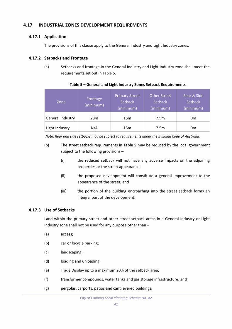
4.17 INDUSTRIAL ZONES DEVELOPMENT REQUIREMENTS
4.17.1 Application
The provisions of this clause apply to the General Industry and Light Industry zones.
4.17.2 Setbacks and Frontage
(a) Setbacks and frontage in the General Industry and Light Industry zone shall meet therequirements set out in Table 5.
Table 5 – General and Light Industry Zones Setback Requirements
ZoneFrontage
(minimum)
Primary StreetSetback
(minimum)
Other StreetSetback
(minimum)
Rear & SideSetback
(minimum)
General Industry 28m 15m 7.5m 0m
Light Industry N/A 15m 7.5m 0m
Note: Rear and side setbacks may be subject to requirements under the Building Code of Australia.
(b) The street setback requirements in Table 5 may be reduced by the local governmentsubject to the following provisions –
(i) the reduced setback will not have any adverse impacts on the adjoiningproperties or the street appearance;
(ii) the proposed development will constitute a general improvement to theappearance of the street; and
(iii) the portion of the building encroaching into the street setback forms anintegral part of the development.
4.17.3 Use of Setbacks
Land within the primary street and other street setback areas in a General Industry or LightIndustry zone shall not be used for any purpose other than –
(a) access;
(b) car or bicycle parking;
(c) landscaping;
(d) loading and unloading;
(e) Trade Display up to a maximum 20% of the setback area;
(f) transformer compounds, water tanks and gas storage infrastructure; and
(g) pergolas, carports, patios and cantilevered buildings.
City of Canning Local Planning Scheme No. 42
41

4.17.4 Landscaping
Any development in the industrial zones shall provide landscaping in accordance with thefollowing provisions –
(a) a minimum 2 metre width landscaping strip shall be provided along any boundary toa public street, except where a driveway and crossover is required;
(b) trees are to be provided in accordance with any local planning policy relating to treeretention and/or planting;
(c) landscaped areas shall be separated from car parking areas with kerbing at least150mm higher than the car parking area, or other manner to protect the landscapingfrom damage, to the satisfaction of the local government; and
(d) landscaped areas shall be planted in accordance with an approved plan prior to theoccupation of the site, or such other time as agreed by the local government.
4.17.5 Facades
(a) Each façade of a building shall be constructed of brick, stone, concrete or glass or acombination of those materials or similar materials as approved by the localgovernment, and shall incorporate the following features –
(i) varied heights, materials, colours or textures; or
(ii) public artwork.
(b) Any artwork on walls subject to paragraph 4.17.5(a) is to meet the requirements ofany local planning policy relating to public art.
(c) Panel filling of other materials to a design approved by the local government may bepermitted on facades above a height of 2 metres from the ground level.
4.17.6 Storage of Goods and Materials
(a) In any Industrial zone where the open storage of goods or materials is permitted andthe goods and materials stored are, in the opinion of the local government, of anuntidy nature and likely to have an adverse effect upon the general appearance of thearea, the local government may require –
(i) the owner or occupier to restrict the height to which goods and materialsmay be stored; and
(ii) the screening of the open storage area by a visually impermeable fence andthe planting of trees and/or shrubs as may be considered desirable.
City of Canning Local Planning Scheme No. 42
42

(b) The height to which storage is to be restricted, the height, design and specificationsof the fence, distance from side or rear boundaries of the site, and the nature andextent of the planting shall be determined by the local government in respect of eachcase taking into consideration any matters it considers relevant including the physicalcharacteristics and the zoning classification of surrounding land.
(c) A front fence erected pursuant to this subclause shall not be erected in front of thesetback line unless approved otherwise by the local government.
4.18 COMMERCIAL AND SERVICE COMMERCIAL ZONES DEVELOPMENT REQUIREMENTS
4.18.1 Application
The provisions of this clause apply to the Commercial and Service Commercial zones.
4.18.2 Setbacks
(a) Setbacks in the Commercial and Service Commercial zones shall meet therequirements set out in Table 6.
Table 6 – Commercial and Service Commercial Zones Setback Requirements
ZonePrimary Street
Setback (minimum)Other Street Setback
(minimum)Rear & Side Setback
(minimum)
Commercial 15m 3m 0m
Service Commercial 15m 3m 0m
Note: Rear and side setbacks may be subject to requirements under the Building Code of Australia.
(b) The street setback requirements in Table 6 may be reduced by the local governmentsubject to the following provisions –
(i) the reduced setback will not have any adverse impacts on the adjoiningproperties or the street appearance;
(ii) the proposed development will constitute a general improvement to theappearance of the street; and
(iii) the portion of the building encroaching into the street setback forms anintegral part of the development.
City of Canning Local Planning Scheme No. 42
43

4.18.3 Use of Setbacks
Land within the primary street and other street setback areas in a Commercial or ServiceCommercial zone shall not be used for any purpose other than –
(a) access;
(b) car or bicycle parking;
(c) landscaping;
(d) loading and unloading;
(e) pergolas, carports, patios and cantilevered buildings.
4.18.4 Landscaping
Any development in the commercial zones shall provide landscaping in accordance with thefollowing provisions –
(a) a minimum 2 metre width landscaping strip shall be provided along any boundary toa public street, except where a driveway and crossover is required;
(b) trees are to be provided in accordance with any local planning policy relating to treeretention and/or planting;
(c) landscaped areas shall be separated from car parking areas with kerbing at least150mm higher than the car parking area, or other manner to protect the landscapingfrom damage, to the satisfaction of the local government; and
(d) landscaped areas shall be planted in accordance with an approved plan prior to theoccupation of the site, or such other time as agreed by the local government.
4.18.5 Facades
(a) Each façade of a building shall be constructed of brick, stone, concrete or glass or acombination of those materials or similar materials as approved by the localgovernment, and shall incorporate the following features –
(i) varied heights, materials, colours or textures; or
(ii) public artwork.
(b) Any artwork on walls subject to paragraph 4.18.5(a) is to meet the requirements ofany local planning policy relating to public art.
(c) Facades facing regional or local reserves as detailed in Table 1 are to incorporate clearopenings to a minimum of 50% of the façade.
(d) Panel filling of other materials to a design approved by the local government may bepermitted on facades above a height of 2 metres from the ground level.
City of Canning Local Planning Scheme No. 42
44

4.19 MIXED USE ZONE DEVELOPMENT REQUIREMENTS
4.19.1 Application
The provisions of this clause apply to the Mixed Use zone.
4.19.2 Density
The maximum residential density for developments in the Mixed Use zone shall be inaccordance with the R-Code value shown on the Scheme map for the lot.
4.19.3 Setbacks
Setbacks for developments in the Mixed Use zone shall be in accordance with Table 7.
Table 7 – Mixed Use Zone Setback Requirements
Boundary Setback Requirement
Primary Street (Minimum) Nil.
Primary Street (Maximum) 2m.
Other Street (Minimum) Nil.
Other Street (Maximum) 2m.
Side As per R-Codes.
Rear / Other As per R-Codes
4.19.4 Building Height
The height of the ground floor of buildings within the Mixed Use zone shall be a minimum of 4metres measured floor to ceiling, and the remaining wall and building height shall be inaccordance with the R-Code requirements for the density assigned on the Scheme map inaddition to the ground floor height.
4.19.5 Land Use Mix
Non-residential floor space in a mixed use development is to occupy a minimum of 20% and amaximum of 60% of the development floor space.
4.19.6 Deep Soil Zones
(a) A minimum of 12% of the land area is to be made available for a deep soil zone wherelarger trees can be planted.
(b) Trees are to be provided in accordance with any local planning policy relating to treeretention and/or planting.
City of Canning Local Planning Scheme No. 42
45

4.19.7 Parking Location and Signage
(a) Parking areas shall be located behind the building line (except disabled parking) andscreened from view from the street.
(b) Car parking spaces shall be clearly signposted differentiating between the residentialcar parking and non-residential car parking spaces.
4.19.8 Streetscape and Facades
(a) Awnings shall be provided above all entrances and exits of a building and publicfootpaths that abut a building.
(b) Entrances to buildings shall be from the primary street to which the building faces,unless otherwise approved by the local government.
(c) Non-residential facades abutting public streets and public open spaces of anydevelopment in the mixed use zones are to incorporate a minimum 75% visuallypermeable glazing.
(d) On all levels above the ground floor, facades shall be articulated to break-up straightplain walls through the use of at least four of the following –
(i) openings;
(ii) protruding balconies;
(iii) awnings over windows;
(iv) use of different colours and textures; and
(v) indentations and extrusions with details to break the building into individualelements.
4.19.9 Blank Walls
(a) Exposed blank walls visible from regional or local reserves as detailed in Table 1 areto incorporate one of the following features –
(i) varied heights, materials, colours or textures; or
(ii) public artwork.
(b) Any artwork on walls subject to paragraph 4.19.9(a) is to meet the requirements ofany local planning policy relating to public art.
City of Canning Local Planning Scheme No. 42
46

4.20 RURAL AND RURAL RESIDENTIAL ZONES DEVELOPMENT REQUIREMENTS
4.20.1 Application
The provisions of this clause apply to the Rural and Rural Residential zones.
4.20.2 Setbacks and Density
(a) All development within the Rural and Rural Residential zones shall comply with therequirements of Table 8.
(b) The local government may require greater setback distances than those required inTable 8, to preserve indigenous vegetation on a lot.
Table 8 – Rural and Rural Residential Zones Setback and Density Requirements
ZoneLot Size
(minimum)Front Setback
(minimum)Side Setback(minimum)
Rear Setback(minimum)
Rural Residential 10,000m2 15m 5m 7.5m
Rural 20,000m2 15m 5m 7.5m
(c) The front setback requirement may be averaged as provided for under the R-Codes.
4.20.3 Character
Except with the approval of the local government, no boundary fence within a Rural Residentialzone shall be constructed of the following materials –
(a) fibre cement sheeting;
(b) metal sheeting; or
(c) wooden pickets.
4.20.4 Environment and Vegetation
(a) No animals are to be kept or grazed on a lot unless the local government is satisfiedthat the grazing or keeping of any animal will not result in the removal or damage ofthe vegetation and trees or result in soil erosion and dust pollution. As a condition ofapproval the local government may require the animals to be stabled or corralled.
(b) No indigenous vegetation or trees shall be destroyed or cleared unless –
(i) approved by the local government; and
(ii) such vegetation or trees are dead or diseased; or
(iii) the clearing is required for the purpose of a fire break, dwelling,outbuilding, fence and/or house driveways.
City of Canning Local Planning Scheme No. 42
47

(c) The local government may direct the landowner(s) to plant on a lot indigenous andnative trees and shrubs of a species and at a density, distribution and at a time to bedetermined by the local government to control soil erosion.
(d) The landowner(s) of a lot shall be responsible for the maintenance and thereplacement, if and where necessary, of trees and vegetation on the lot to thesatisfaction of the local government.
4.20.5 Commercial Vehicle Parking
(a) A person may park a commercial vehicle in the Rural zones subject to the followingprovisions –
(i) the commercial vehicle is to be parked entirely within the lot and located ona hardstand behind the front building line;
(ii) the commercial vehicle does not exceed 3 metres in height, 2.5 metres inwidth and 8 metres in length;
(iii) any noise created by the commercial vehicle does not exceed the standardsset out in the Environmental Protection (Noise) Regulations 1997;
(iv) only minor servicing or cleaning of the commercial vehicle is carried outbehind the front building line;
(v) storage of liquid fuels on the lot complies with the Dangerous Goods SafetyAct 2004; and
(vi) the commercial vehicle is not carrying a refrigeration unit which operates ona continuous or intermittent basis.
(b) The local government may consider variations to the requirements of paragraph4.20.5(a) through a development approval provided the local government consultssurrounding landowners and is satisfied that the variations will not adversely affectthe amenity of the surrounding area.
(c) A development approval granted under paragraph 4.20.5(b) does not run with theland in respect of which it is granted but is personal to the person to whom it wasgranted. The development approval shall not be transferred or assigned to anotherperson.
(d) A commercial vehicle is considered to be parked on a lot for the purposes of thissubclause if it remains parked in aggregate for more than one hour in a twenty fourhour period unless the commercial vehicle is associated with construction work onthe lot.
City of Canning Local Planning Scheme No. 42
48

4.21 PRIVATE COMMUNITY PURPOSES ZONE DEVELOPMENT REQUIREMENTS
4.21.1 Application
The provisions of this clause apply to the Private Community Purposes zone.
4.21.2 Setbacks
Setbacks for development in the Private Community Purposes zone shall be compatible withthe setbacks of the surrounding properties.
4.21.3 Bulk and Scale
The bulk, scale and height of development in the Private Community Purposes zone shall becompatible with the bulk, scale and character of the surrounding properties.
4.21.4 Landscaping
(a) Soft landscaping shall cover a minimum of 25% of any street setback area with aminimum width of 2 metres along any street boundary except where a crossover ispresent or required.
(b) Trees are to be provided in accordance with any local planning policy relating to treeretention and/or planting.
(c) Landscaped areas shall be separated from car parking areas with kerbing at least150mm higher than the car parking area, or other manner to protect the landscapingfrom damage, to the satisfaction of the local government.
(d) Landscaped areas shall be planted in accordance with an approved plan prior to theoccupation of the site, or such other time as agreed by the local government.
4.21.5 Facades
(a) Each façade of a building shall be constructed of brick, stone, concrete or glass or acombination of those materials or similar materials as approved by the localgovernment.
(b) Facades facing regional or local reserves as detailed in Table 1 are to incorporate clearopenings to a minimum of 25% of the façade.
(c) Panel filling of other materials to a design approved by the local government may bepermitted on facades above a height of 2 metres from the ground level.
City of Canning Local Planning Scheme No. 42
49

4.22 DISTRICT CENTRE AND LOCAL CENTRE ZONES DEVELOPMENT REQUIREMENTS
4.22.1 Application
The provisions of this clause apply to the District and Local Centre zones.
4.22.2 Density
The maximum residential density for developments in the District Centre zone shall be inaccordance with the R-Code value shown on the Scheme map for the lot.
4.22.3 Setbacks
(a) Setbacks in the District and Local Centre zones shall meet the requirements set out inTable 9.
Table 9 – District and Local Centre Zones Setback Requirements
ZonePrimary Street
Setback (minimum)Secondary Street
Setback (minimum)Rear & Side Setback
(minimum)
District Centre 12m 3m 0m
Local Centre 12m 3m 0m
Note: Rear and side setbacks may be subject to requirements under the Building Code of Australia.
(b) The setback requirements in Table 9 may be reduced by the local government subjectto the following provisions –
(i) the reduced setback will not have any adverse impacts on the adjoiningproperties or the street appearance;
(ii) the proposed development will constitute a general improvement to theappearance of the street; and
(iii) the portion of the building encroaching into the setback forms an integralpart of the development.
4.22.4 Landscaping
(a) Soft landscaping shall cover a minimum of 25% of any street setback area with aminimum width of 2 metres along any street boundary except where a crossover ispresent or required.
(b) Trees are to be provided in accordance with any local planning policy relating to treeretention and/or planting.
(c) Landscaped areas shall be separated from car parking areas with kerbing at least150mm higher than the car parking area, or other manner to protect the landscapingfrom damage, to the satisfaction of the local government.
City of Canning Local Planning Scheme No. 42
50

(d) Landscaped areas shall be planted in accordance with an approved plan prior to theoccupation of the site, or such other time as agreed by the local government.
4.22.5 Facades
(a) Each façade of a building shall be constructed of brick, stone, concrete or glass or acombination of those materials or similar materials as approved by the localgovernment, and shall incorporate the following features –
(i) varied heights, materials, colours or textures; or
(ii) public artwork.
(b) Any artwork on walls subject to paragraph 4.22.5(a) is to meet the requirements ofany local planning policy relating to public art.
(c) Facades facing regional or local reserves as detailed in Table 1 are to incorporate clearopenings to a minimum of 50% of the façade.
(d) Panel filling of other materials to a design approved by the local government may bepermitted on facades above a height of 2 metres from the ground level.
4.23 SCHEME TO PREVAIL
To the extent that a requirement referred to in clauses 4.8 to 4.22 are inconsistent with arequirement in the R-Codes, an activity centre plan, structure plan, a local development plan or aState or local planning policy the requirements referred to in clauses 4.8 to 4.22 prevail.
4.24 VARIATIONS TO SITE AND DEVELOPMENT REQUIREMENTS
4.24.1 In this clause –
Additional site and development requirement means a requirement set out in clauses4.8 to 4.22.
4.24.2 The local government may approve an application for development approval that doesnot comply with an additional site and development requirement.
4.24.3 An approval under subclause 4.24.2 may be unconditional or subject to any conditionsthe local government considers appropriate.
4.24.4 If the local government is of the opinion that the non-compliance with an additional siteand development requirement will mean that the development is likely to adverselyaffect any owners or occupiers in the general locality or in an area adjoining the site ofthe development the local government must –
(a) consult the affected owners or occupiers by following one or more of theprovisions for advertising applications for development approval under clause64 of the deemed provisions; and
City of Canning Local Planning Scheme No. 42
51

(b) have regard to any expressed views prior to making its determination to grantdevelopment approval under this clause.
4.24.5 The local government may only approve an application for development approval underthis clause if the local government is satisfied that –
(a) approval of the proposed development would be appropriate having regard tothe matters that the local government is to have regard to in considering anapplication for development approval as set out in clause 67 of the deemedprovisions; and
(b) the non-compliance with the additional site and development requirement willnot have a significant adverse effect on the occupiers or users of thedevelopment, the inhabitants of the locality or the likely future development ofthe locality.
4.25 RESTRICTIVE COVENANTS
4.25.1 A restrictive covenant affecting land in the Scheme area that would have the effect oflimiting the number of residential dwellings which may be constructed on the land isextinguished or varied to the extent that the number of residential dwellings that may beconstructed is less than the number that could be constructed on the land under thisScheme.
4.25.2 If subclause 4.25.1 operates to extinguish or vary a restrictive covenant –
(a) development approval is required to construct a residential dwelling thatwould result in the number of residential dwellings on the land exceeding thenumber that would have been allowed under the restrictive covenant; and
(b) the local government must not grant development approval for theconstruction of the residential dwelling unless it gives notice of the applicationfor development approval in accordance with clause 64 of the deemedprovisions.
City of Canning Local Planning Scheme No. 42
52

PART 5 – SPECIAL CONTROL AREAS 5
5.1 SPECIAL CONTROL AREAS
5.1.1 Special control areas are marked on the Scheme Map according to the legend on theScheme Map.
5.1.2 The purpose, objectives and additional provisions that apply to each special control areais set out in Table 10.
City of Canning Local Planning Scheme No. 42
53

Table 10 – Special Control Areas in Scheme Area
Name of area Purpose Objectives Additional provisions
SCA 1 – Perth Airport Buffer Special Control Area
To support the implementation of State Planning Policy No. 5.1 – Land Use Planning in the Vicinity of Perth Airport.
To promote the long term viability of the Perth Airport so as to enable its on-going development and operation.
To prevent unreasonable encroachmentof incompatible (noise sensitive) land uses and those activities affected or potentially impacted upon by aircraft noise.
To provide for appropriately designed and constructed development of low tomedium density residential uses within suitable locations within the Special Control Area.
To minimise the impact of aircraft noiseon existing and future communities within the Special Control Area.
The development of a single house between the 20 and 25 ANEF Contours of the Perth Airport Buffer Special Control Arearequires development approval if no notification relating to aircraft noise is on the land title.
The development of a single house above the 25 ANEF Contour of the Perth Airport Buffer Special Control Area requires development approval.
Development applications for residential development above the 25 ANEF contour must be accompanied by a statement or report which demonstrates that the development achieves all of the relevant policy measures under the State Planning PolicyNo. 5.1 – Land Use Planning in the Vicinity of Perth Airport.
Applications for development approval in the Perth Airport Buffer Special Control Area may be referred to the Perth Airport Pty. Ltd. for comment and advice in accordance with State Planning Policy No. 5.1 – Land Use Planning in the Vicinity of Perth Airport.
City of Canning Local Planning Scheme No. 42
54
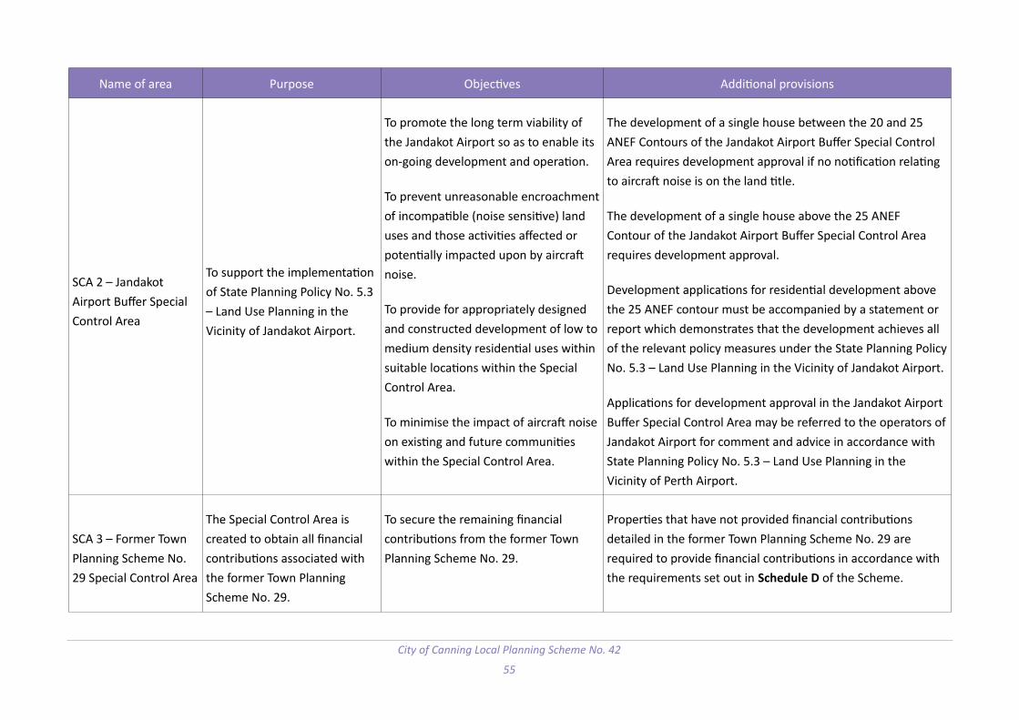
Name of area Purpose Objectives Additional provisions
SCA 2 – Jandakot Airport Buffer Special Control Area
To support the implementation of State Planning Policy No. 5.3 – Land Use Planning in the Vicinity of Jandakot Airport.
To promote the long term viability of the Jandakot Airport so as to enable its on-going development and operation.
To prevent unreasonable encroachmentof incompatible (noise sensitive) land uses and those activities affected or potentially impacted upon by aircraft noise.
To provide for appropriately designed and constructed development of low tomedium density residential uses within suitable locations within the Special Control Area.
To minimise the impact of aircraft noiseon existing and future communities within the Special Control Area.
The development of a single house between the 20 and 25 ANEF Contours of the Jandakot Airport Buffer Special Control Area requires development approval if no notification relating to aircraft noise is on the land title.
The development of a single house above the 25 ANEF Contour of the Jandakot Airport Buffer Special Control Area requires development approval.
Development applications for residential development above the 25 ANEF contour must be accompanied by a statement or report which demonstrates that the development achieves all of the relevant policy measures under the State Planning PolicyNo. 5.3 – Land Use Planning in the Vicinity of Jandakot Airport.
Applications for development approval in the Jandakot Airport Buffer Special Control Area may be referred to the operators ofJandakot Airport for comment and advice in accordance with State Planning Policy No. 5.3 – Land Use Planning in the Vicinity of Perth Airport.
SCA 3 – Former Town Planning Scheme No. 29 Special Control Area
The Special Control Area is created to obtain all financial contributions associated with the former Town Planning Scheme No. 29.
To secure the remaining financial contributions from the former Town Planning Scheme No. 29.
Properties that have not provided financial contributions detailed in the former Town Planning Scheme No. 29 are required to provide financial contributions in accordance with the requirements set out in Schedule D of the Scheme.
City of Canning Local Planning Scheme No. 42
55

Page left blank intentionally.
City of Canning Local Planning Scheme No. 42
56

PART 6 – TERMS REFERRED TO IN THE SCHEME 6
Division 1 – General definitions used in Scheme
6.1 TERMS USED
6.1.1 If a word or expression used in this Scheme is listed in this clause, its meaning is asfollows –
building envelope means the area of land within which all buildings and effluent disposal facilities on a lotmust be contained;
building height, in relation to a building –
(a) if the building is used for residential purposes, has the meaning given in the R Codes; or
(b) if the building is used for purposes other than residential purposes, means the maximum verticaldistance between the natural ground level and the finished roof height directly above, excludingminor projections as that term is defined in the R Codes;
cabin means a dwelling forming part of a tourist development or caravan park that is –
(a) an individual unit other than a chalet; and
(b) designed to provide short term accommodation for guests;
chalet means a dwelling forming part of a tourist development or caravan park that is –
(a) a self-contained unit that includes cooking facilities, bathroom facilities and separate living andsleeping areas; and
(b) designed to provide short term accommodation for guests;
commencement day means the day this Scheme comes into effect under section 87(4) of the Act;
commercial vehicle means a vehicle, whether licenced or not, that has a gross vehicle mass of greater than4.5 tonnes including –
(a) a utility, van, truck, tractor, bus or earthmoving equipment; and
(b) a vehicle that is, or is designed to be an attachment to a vehicle referred to in paragraph (a);
floor area has meaning given in the Building Code;
frontage, in relation to a building –
(a) if the building is used for residential purposes, has the meaning given in the R Codes; or
City of Canning Local Planning Scheme No. 42
57

(b) if the building is used for purposes other than residential purposes, means the line where a roadreserve and the front of a lot meet and, if a lot abuts 2 or more road reserves, the one to whichthe building or proposed building faces;
incidental use means a use of premises which is consequent on, or naturally attaching, appertaining orrelating to, the predominant use;
minerals has the meaning given in the Mining Act 1978 section 8(1);
net lettable area or nla means the area of all floors within the internal finished surfaces of permanent wallsbut does not include the following areas –
(a) stairs, toilets, cleaner’s cupboards, lift shafts and motor rooms, escalators, tea rooms and plantrooms, and other service areas;
(b) lobbies between lifts facing other lifts serving the same floor;
(c) areas set aside as public space or thoroughfares and not for the exclusive use of occupiers of thefloor or building;
(d) areas set aside for the provision of facilities or services to the floor or building where thosefacilities are not for the exclusive use of occupiers of the floor or building;
non-conforming use has the meaning given in the Planning and Development Act 2005 section 172;
plot ratio means the ratio of the floor area of a building to an area of land within the boundaries of the lotor lots on which the building is located;
precinct means a definable area where particular planning policies, guidelines or standards apply;
predominant use means the primary use of premises to which all other uses carried out on the premisesare incidental;
retail means the sale or hire of goods or services to the public;
short-term accommodation means temporary accommodation provided either continuously or from timeto time with no guest accommodated for periods totalling more than 3 months in any 12 month period;
wall height, in relation to a wall of a building —
(a) if the building is used for residential purposes, has the meaning given in the R-Codes; or
(b) if the building is used for purposes other than residential purposes, means the vertical distancefrom the natural ground level of the boundary of the property that is closest to the wall to thepoint where the wall meets the roof or parapet;
City of Canning Local Planning Scheme No. 42
58

wholesale means the sale of goods or materials to be sold by others;
6.1.2 A word or expression that is not defined in this Scheme –
(a) has the meaning it has in the Planning and Development Act 2005; or
(b) if it is not defined in that Act – has the same meaning as it has in the R-Codes.
City of Canning Local Planning Scheme No. 42
59

Division 2 – Land use terms used in Scheme
6.2 LAND USE TERMS USED
If this Scheme refers to a category of land use that is listed in this provision, the meaning of thatland use is as follows –
abattoir means premises used commercially for the slaughtering of animals for the purposes ofconsumption as food products;
aged care facility means a premises used to provide accommodation and personal or nursing care for theaged and may include recreational, health or laundry facilities and services for residents of the facility;
amusement parlour means premises –
(a) that are open to the public; and
(b) that are used predominantly for amusement by means of amusement machines includingcomputers; and
(c) where there are 2 or more amusement machines;
animal establishment means premises used for the breeding, boarding, training or caring of animals forcommercial purposes but does not include animal husbandry – intensive or veterinary centre;
art gallery means premises –
(a) that are open to the public; and
(b) where artworks are displayed for viewing or sale;
bed and breakfast means a dwelling –
(a) used by a resident of the dwelling to provide short term accommodation, including breakfast, on acommercial basis for not more than 4 adult persons or one family; and
(b) containing not more than 2 guest bedrooms;
betting agency means an office or totalisator agency established under the Racing and Wagering WesternAustralia Act 2003;
brewery means premises the subject of a producer’s licence authorising the production of beer, cider orspirits granted under the Liquor Control Act 1988;
bulky goods showroom means premises –
(a) used to sell by retail any of the goods and accessories of the following types that are principallyused for domestic purposes –
City of Canning Local Planning Scheme No. 42
60

(i) automotive parts and accessories;
(ii) camping, outdoor and recreation goods;
(iii) electric light fittings;
(iv) animal supplies including equestrian and pet goods;
(v) floor and window coverings;
(vi) furniture, bedding, furnishings, fabrics, manchester and homewares;
(vii) household appliances, electrical goods and home entertainment goods;
(viii) party supplies;
(ix) office equipment and supplies;
(x) babies’ and childrens’ goods, including play equipment and accessories;
(xi) sporting, cycling, leisure, fitness goods and accessories;
(xii) swimming pools;
or
(b) used to sell by retail goods and accessories by retail if –
(i) a large area is required for the handling, display or storage of the goods; or
(ii) vehicular access is required to the premises for the purpose of collection of purchasedgoods;
caravan park means premises that are a caravan park as defined in the Caravan Parks and CampingGrounds Act 1995 section 5(1);
caretaker’s dwelling means a dwelling on the same site as a building, operation or plant used for industry,and occupied by a supervisor of that building, operation or plant;
car park means premises used primarily for parking vehicles whether open to the public or not but does notinclude –
(a) any part of a public road used for parking or for a taxi rank; or
(b) any premises in which cars are displayed for sale;
child care premises means premises where –
City of Canning Local Planning Scheme No. 42
61

(a) an education and care service as defined in the Education and Care Services National Law(Western Australia) section 5(1), other than a family day care service as defined in that section, isprovided; or
(b) a child care service as defined in the Child Care Services Act 2007 section 4 is provided;
cinema/theatre means premises where the public may view a motion picture or theatrical production;
civic use means premises used by a government department, an instrumentality of the State or the localgovernment for administrative, recreational or other purposes;
club premises means premises used by a legally constituted club or association or other body of personsunited by a common interest;
commercial vehicle parking means premises used for parking of one or 2 commercial vehicles but does notinclude –
(a) any part of a public road used for parking or for a taxi rank; or
(b) parking of commercial vehicles incidental to the predominant use of the land;
community purpose means premises designed or adapted primarily for the provision of educational, socialor recreational facilities or services by organisations involved in activities for community benefit;
consulting rooms means premises used by no more than 2 health practitioners at the same time for theinvestigation or treatment of human injuries or ailments and for general outpatient care;
convenience store means premises –
(a) used for the retail sale of convenience goods commonly sold in supermarkets, delicatessens ornewsagents; and
(b) operated during hours which include, but may extend beyond, normal trading hours; and
(c) the floor area of which does not exceed 300m2 net lettable area;
corrective institution means premises used to hold and reform persons committed to it by a court, such as aprison or other type of detention facility;
educational establishment means premises used for the purposes of providing education includingpremises used for a school, higher education institution, business college, academy or other educationalinstitution;
exhibition centre means premises used for the display, or display and sale, of materials of an artistic,cultural or historical nature including a museum;
family day care means premises where a family day care service as defined in the Education and CareServices National Law (Western Australia) is provided;
City of Canning Local Planning Scheme No. 42
62

fast food outlet means premises, including premises with a facility for drive through service, used for thepreparation, sale and serving of food to customers in a form ready to be eaten –
(a) without further preparation; and
(b) primarily off the premises;
freeway service centre means premises that has direct access to a freeway and which provides all thefollowing services or facilities and may provide other associated facilities or services but does not providebulk fuel services –
(a) service station facilities;
(b) emergency breakdown repair for vehicles;
(c) charging points for electric vehicles;
(d) facilities for cyclists;
(e) restaurant, cafe or fast food services, excluding the sale or consumption of alcohol under theLiquor Licensing Act 1988;
(f) take away food retailing, without a drive-through facility;
(g) public ablution facilities, including provision for disabled access and infant changing rooms;
(h) parking for passenger and freight vehicles;
(i) outdoor rest stop facilities such as picnic tables and shade areas; and
(j) dump points for the disposal of black and/or grey water from recreational vehicles;
fuel depot means premises used for the storage and sale in bulk of solid or liquid or gaseous fuel but doesnot include premises used –
(a) as a service station; or
(b) for the sale of fuel by retail into a vehicle for use by the vehicle;
funeral parlour means premises used –
(a) to prepare and store bodies for burial or cremation;
(b) to conduct funeral services;
garden centre means premises used for the propagation, rearing and sale of plants, and the storage andsale of products associated with horticulture and gardens;
City of Canning Local Planning Scheme No. 42
63

holiday accommodation means 2 or more dwellings on one lot used to provide short term accommodationfor persons other than the owner of the lot;
holiday house means a single house on one lot used to provide short term accommodation but does notinclude a bed and breakfast;
home business means a dwelling or land around a dwelling used by an occupier of the dwelling to carry outa business, service or profession if the carrying out of the business, service or profession –
(a) does not involve employing more than 2 people who are not members of the occupier’shousehold; and
(b) will not cause injury to or adversely affect the amenity of the neighbourhood; and
(c) does not occupy an area greater than 50m2; and
(d) does not involve the retail sale, display or hire of any goods unless the sale, display or hire is doneonly by means of the Internet; and
(e) does not result in traffic difficulties as a result of the inadequacy of parking or an increase in trafficvolumes in the neighbourhood; and
(f) does not involve the presence, use or calling of a vehicle of more than 4.5 tonnes tare weight; and
(g) does not involve the use of an essential service that is greater than the use normally required inthe zone in which the dwelling is located;
home business – rural means a dwelling or land around a dwelling used by an occupier of the dwelling tocarry out a business, service or occupation if the carrying out of the business, service or occupation –
(a) does not involve employing more than 2 people who are not members of the occupier’shousehold; and
(b) will not cause injury to or adversely affect the amenity of the neighbourhood; and
(c) does not occupy an area greater than 200m2; and
(d) does not involve the retail sale, display or hire of any goods unless the sale, display or hire is doneonly be means of the Internet; and
(e) does not result in traffic difficulties as a result of the inadequacy of parking or an increase in trafficvolumes in the neighbourhood; and
(f) does not involve the presence, use or calling of more than 3 vehicles at any one time or of avehicle of more than 30 tonnes gross weight;
City of Canning Local Planning Scheme No. 42
64

home occupation means a dwelling or land around a dwelling used by an occupier of the dwelling to carryout an occupation if the carrying out of the occupation that –
(a) does not involve employing a person who is not a member of the occupier’s household; and
(b) will not cause injury to or adversely affect the amenity of the neighbourhood; and
(c) does not occupy an area greater than 20m2; and
(d) does not involve the display on the premises of a sign with an area exceeding 0.2m2; and
(e) does not involve the retail sale, display or hire of any goods unless the sale, display or hire is doneonly by means of the Internet; and
(f) does not –
(i) require a greater number of parking spaces than normally required for a single dwelling;or
(ii) result in an increase in traffic volume in the neighbourhood;
and
(g) does not involve the presence, use or calling of a vehicle of more than 4.5 tonnes tare weight; and
(h) does not include provision for the fuelling, repair or maintenance of motor vehicles; and
(i) does not involve the use of an essential service that is greater than the use normally required inthe zone in which the dwelling is located;
home office means a dwelling used by an occupier of the dwelling to carry out a home occupation if thecarrying out of the occupation –
(a) is solely within the dwelling; and
(b) does not entail clients or customers travelling to and from the dwelling; and
(c) does not involve the display of a sign on the premises; and
(d) does not require any change to the external appearance of the dwelling;
home store means a shop attached to a dwelling that –
(a) has a net lettable area not exceeding 100m2; and
(b) is operated by a person residing in the dwelling;
hospital means premises that are a hospital within the meaning given in the Health Services Act 2016section 8(4);
City of Canning Local Planning Scheme No. 42
65

hotel means premises the subject of a hotel licence other than a small bar or tavern licence granted underthe Liquor Control Act 1988 including any betting agency on the premises;
industry means premises used for the manufacture, dismantling, processing, assembly, treating, testing,servicing, maintenance or repairing of goods, products, articles, materials or substances and includesfacilities on the premises for any of the following purposes –
(a) the storage of goods;
(b) the work of administration or accounting;
(c) the selling of goods by wholesale or retail;
(d) the provision of amenities for employees;
(e) incidental purposes;
industry – cottage means a trade or light industry producing arts and crafts goods which does not fall withinthe definition of a home occupation and which –
(a) does not cause injury to or adversely affect the amenity of the neighbourhood;
(b) where operated in a residential zone, does not employ any person other than a member of theoccupier’s household;
(c) is conducted in an out-building which is compatible with the principal uses to which land in thezone in which it is located may be put;
(d) does not occupy an area in excess of 50 square metres; and
(e) does not display a sign exceeding 0.2 square metres in area;
industry – extractive means premises, other than premises used for mining operations, that are used forthe extraction of basic raw materials including by means of ripping, blasting or dredging and may includefacilities for any of the following purposes –
(a) the processing of raw materials including crushing, screening, washing, blending or grading;
(b) activities associated with the extraction of basic raw materials including wastewater treatment,storage, rehabilitation, loading, transportation, maintenance and administration;
industry – light means premises used for an industry where impacts on the amenity of the area in whichthe premises is located can be mitigated, avoided or managed;
industry – primary production means premises used –
(a) to carry out a primary production business as that term is defined in the Income Tax AssessmentAct 1997 (Commonwealth) section 995-1; or
City of Canning Local Planning Scheme No. 42
66

(b) for a workshop servicing plant or equipment used in primary production businesses;
liquor store – large means premises the subject of a liquor store licence granted under the Liquor ControlAct 1988 with a net lettable area of more than 300m2;
liquor store – small means premises the subject of a liquor store licence granted under the Liquor ControlAct 1988 with a net lettable area of not more than 300m2;
lunch bar means premises or part of premises used for the sale of takeaway food (in a form ready to beconsumed without further preparation) within industrial or commercial areas;
market means premises used for the display and sale of goods from stalls by independent vendors;
medical centre means premises other than a hospital used by 3 or more health practitioners at the sametime for the investigation or treatment of human injuries or ailments and for general outpatient care;
motel means premises, which may be licensed under the Liquor Control Act 1988 –
(a) used to accommodate guests in a manner similar to a hotel; and
(b) with specific provision for the accommodation of guests with motor vehicles;
motor vehicle, boat or caravan sales means premises used to sell or hire motor vehicles, boats or caravans;
motor vehicle repair means premises used for or in connection with –
(a) electrical and mechanical repairs, or overhauls, to vehicles other than panel beating, spraypainting or chassis reshaping of vehicles; or
(b) repairs to tyres other than recapping or re-treading of tyres;
motor vehicle wash means premises primarily used to wash motor vehicles;
nightclub means premises the subject of a nightclub licence granted under the Liquor Control Act 1988;
office means premises used for administration, clerical, technical, professional or similar business activities;
park home park means premises used as a park home park as defined in the Caravan Parks and CampingGrounds Regulations 1997 Schedule 8;
place of worship means premises used for religious activities such as a chapel, church, mosque, synagogueor temple;
reception centre means premises used for hosted functions on formal or ceremonial occasions;
recreation – private means premises that are –
(a) used for indoor or outdoor leisure, recreation or sport; and
City of Canning Local Planning Scheme No. 42
67
(b) not usually open to the public without charge;
renewable energy facility means premises used to generate energy from a renewable energy source andincludes any building or other structure used in, or in connection with, the generation of energy by arenewable resource. It does not include solar panels or a wind turbine located on a lot with a single housewhere the energy produced only supplies that house or private rural use or anemometers.
repurposed dwelling means a building or structure not previously used as a single house which has beenrepurposed for use as a dwelling;
resource recovery centre means premises other than a waste disposal facility used for the recovery ofresources from waste;
restaurant/café means premises primarily used for the preparation, sale and serving of food and drinks forconsumption on the premises by customers for whom seating is provided, including premises that arelicenced under the Liquor Control Act 1988;
restricted premises means premises used for the sale by retail or wholesale, or the offer for hire, loan orexchange, or the exhibition, display or delivery of –
(a) publications that are classified as restricted under the Classification (Publications, Films andComputer Games) Act 1995 (Commonwealth); or
(b) materials, compounds, preparations or articles which are used or intended to be used primarily inor in connection with any form of sexual behaviour or activity; or
(c) smoking-related implements;
rural pursuit/hobby farm means any premises, other than premises used for agriculture – extensive oragriculture – intensive, that are used by an occupier of the premises to carry out any of the followingactivities if carrying out of the activity does not involve permanently employing a person who is not amember of the occupier’s household –
(a) the rearing, agistment, stabling or training of animals;
(b) the keeping of bees;
(c) the sale of produce grown solely on the premises;
second hand dwelling means a dwelling that has been in a different location, and has been dismantled andtransported to another location, but does not include a modular home or transportable dwelling;
serviced apartment means a group of units or apartments providing –
(a) self-contained short stay accommodation for guests; and
(b) any associated reception or recreational facilities;
City of Canning Local Planning Scheme No. 42
68

service station means premises other than premises used for a transport depot, panel beating, spraypainting, major repairs or wrecking, that are used for –
(a) the retail sale of petroleum products, motor vehicle accessories and goods of an incidental orconvenience nature; and/or
(b) the carrying out of greasing, tyre repairs and minor mechanical repairs to motor vehicles;
shop means premises other than a bulky goods showroom, a liquor store – large or a liquor store – smallused to sell goods by retail, to hire goods, or to provide services of a personal nature, including hairdressingor beauty therapy services;
small bar means premises the subject of a small bar licence granted under the Liquor Control Act 1988;
tavern means premises the subject of a tavern licence granted under the Liquor Control Act 1988;
telecommunications infrastructure means premises used to accommodate the infrastructure used by or inconnection with a telecommunications network including any line, equipment, apparatus, tower, antenna,tunnel, duct, hole, pit or other structure related to the network;
tourist development means a building, or a group of buildings forming a complex, other than a bed andbreakfast, a caravan park or holiday accommodation, used to provide –
(a) short term accommodation for guests; and
(b) onsite facilities for the use of guests; and
(c) facilities for the management of the development;
trade display means premises used for the display of trade goods and equipment for the purpose ofadvertisement;
trade supplies means premises used to sell by wholesale or retail, or to hire, assemble or manufacture anymaterials, tools, equipment, machinery or other goods used for the following purposes including goodswhich may be assembled or manufactured off the premises –
(a) automotive repairs and servicing;
(b) building including repair and maintenance;
(c) industry;
(d) landscape gardening;
(e) provision of medical services;
(f) primary production;
City of Canning Local Planning Scheme No. 42
69

(g) use by government departments or agencies, including local government;
transport depot means premises used primarily for the parking or garaging of 3 or more commercialvehicles including –
(a) any ancillary maintenance or refuelling of those vehicles; and
(b) any ancillary storage of goods brought to the premises by those vehicles; and
(c) the transfer of goods or persons from one vehicle to another;
veterinary centre means premises used to diagnose animal diseases or disorders, to surgically or medicallytreat animals, or for the prevention of animal diseases or disorders;
warehouse/storage means premises including indoor or outdoor facilities used for –
(a) the storage of goods, equipment, plant or materials; or
(b) the display or sale by wholesale of goods;
waste disposal facility means premises used –
(a) for the disposal of waste by landfill; or
(b) the incineration of hazardous, clinical or biomedical waste;
waste storage facility means premises used to collect, consolidate, temporarily store or sort waste beforetransfer to a waste disposal facility or a resource recovery facility on a commercial scale;
winery means premises used for the production of viticultural produce and associated sale of the produce;
City of Canning Local Planning Scheme No. 42
70

Page left blank intentionally.
City of Canning Local Planning Scheme No. 42
71

Schedule A – Supplementary Provisions to the Deemed Provisions
These provisions are to be read in conjunction with the deemed provisions (Schedule 2) contained in thePlanning and Development (Local Planning Schemes) Regulations 2015;
Clause 13A Significant Tree Register –
(1) The local government must establish and maintain a significant tree register toidentify trees within the scheme area that are worthy of preservation.
(2) The significant tree register –
(a) must set out a description of each tree, its location and the reason for itsentry in the significant tree register; and
(b) must be available, with the scheme documents, for public inspection duringbusiness hours at the offices of the local government; and
(c) may be published on the website of the local government.
(3) The local government must not enter a tree in, or remove a tree from, thesignificant tree register or modify the entry of a tree in the significant tree registerunless the local government –
(a) notifies in writing each owner and occupier of the land which contains thetree and provides each of them with a description of the tree and thereason for its proposed entry; and
(b) invites each owner and occupier to make submissions on the proposalwithin 21 days of the day on which the notice is served or within a longerperiod specified in the notice; and
(c) carries out any other consultation the local government considersappropriate; and
(d) following any consultation and consideration of the submissions made onthe proposal, resolves that the tree be entered into the significant treeregister with or without modifications, or that the tree be removed fromthe significant tree register.
(4) If the local government enters a tree in the significant tree register or modifies anentry of a tree in the significant tree register, the local government must give noticeof the entry or modification to each owner and occupier of the land which containsthe tree.
(5) The local government may require assessment or certification by an aboriculturist tobe carried out prior to the determination of an application for developmentapproval for land which contains a tree identified on the significant tree register.
Clause 61(1)(k) The removal of a tree unless it is identified on the significant tree register, or is required tobe retained as a condition of development approval.
City of Canning Local Planning Scheme No. 42
72

Page left blank intentionally.
City of Canning Local Planning Scheme No. 42
73

Schedule B – Additional Uses
No. Description of land Additional use Conditions
1 4 Castlereagh Close (Lot 37), Willetton. Medical Centre.
2339 Wharf Street (Lot 20), Queens Park. Medical Centre.
Maximum of 6 practitioners on site at any one time.
3Portion of 280 Bannister Road (Lot 1002), Canning Vale.
Bulky Goods Showroom, Club Premises, Fast Food Outlet, Garden Centre, Lunch Bar, Market, Medical Centre, Motor Vehicle, Boat or Caravan Sales, Office, Restaurant/Café, Shop & Tavern.
Tavern floorspace limitedto a maximum of 900m2 GFA.
Total floorspace limited to a maximum of 7,000m2 GFA.
4
87-91 Catalano Circuit (Lot 3), 257 Bannister Road (Lot 1) & 259-261 Bannister Road (Lot 2), Canning Vale.
Office & Industry – Light
5 23-29 Kewdale Road (Lot 57), Welshpool.
Restaurant/Café, Fast Food Outlet & Convenience Store.
6 230 Treasure Road (Lot 16), Queens Park. Caravan Park.
72/627 Metcalfe Road (Lot91), Lynwood. Medical Centre.
Maximum of 4 practitioners on site at any one time.
81120-1124 Albany Highway (Lot 77), Bentley.
Hotel.
91098-1100 Albany Highway (Lot 70 & 51), St James.
Medical Centre & Shop.Shop floorspace limited to a maximum of 130m2 GFA.
1058 Burrendah Boulevard (Lot 108), Willetton. Medical Centre.
Maximum of 3 practitioners on site at any one time.
City of Canning Local Planning Scheme No. 42
74

No. Description of land Additional use Conditions
1136 & 38 Granville Way (Lot 501 & 101), Willetton.
Medical Centre & Shop.
Maximum of 14 practitioners on site at any one time.
Shop floorspace limited to a maximum of 80m2 GFA.
121128-1132 Albany Highway (Lot 503), Bentley.
Convenience Store.
13 25 Mills Street (Lot 500), Cannington.
Medical Centre.
14 138-144 Pilbara Street (Lot 8), Welshpool. Office.
Office floorspace limited to a maximum of 2,450m2 GFA.
15Portion of 271 Treasure Road (Lot 151), Welshpool
Office, Exhibition Centre Reception Centre & Club Premises.
Total floorspace limited to a maximum of 1,330m2 GFA.
16 Catalano Circuit, Canning Vale
Motor Vehicle, Boat or Caravan Sales, Market & Fast Food Outlet.
Total floorspace limited to a maximum of 3,000m2 GFA.
17 6-8 Aveley Street (Lot 500), Willetton. Office.
Office floorspace limited to a maximum of 500m2 NLA.
18
38 Vahland Ave (Lot 57) & 211 & 213 Corinthian Road East (Lot 55 & 56), Riverton.
Medical Centre.Maximum of 7 practitioners on site at any one time.
197 Herald Avenue (Lot 194), Willetton. Medical Centre.
Maximum of 4 practitioners on site at any one time.
2081-85 Catalano Circuit (Lot 31), Canning Vale. Place of Worship.
Place of Worship floorspace limited to a maximum of 500m2 NLA.
21Portion of 59-87 Pilbara Street (Lot 3), Welshpool. Office.
Office floorspace limited to a maximum of 3,145m2 GFA.
22 2 Granite Place (Lot 20), Welshpool.
Fast Food Outlet.
City of Canning Local Planning Scheme No. 42
75

No. Description of land Additional use Conditions
23 206 & 208 High Road (Lot4 & 5), Riverton. Medical Centre & Office.
Maximum of 6 practitioners on site at any one time.
24 29 Augusta Street, (Lot 62), Willetton. Office.
Office floorspace limited to a maximum of 100m2 GFA.
25 202 High Road (Lot 218), Riverton.
Consulting Rooms & Office.
261 Wilfred Road (Lot 11), Canning Vale.
Child Care Premises & Office.
Office floorspace limited to a maximum of 100m2 GFA.
271-31 & 33-37 Murray Road (Lot 3359 & 1), Welshpool
Convenience Store, Fast Food Outlet & Office.
28
All lots zoned Residential with an R-Code of R2.5 inthe vicinity of Candeloro Road, Battersea Road andCrufts Way, Canning Vale.
Animal Establishment as a ‘D’ use as defined in clause 3.3.2 of the Scheme.
Development of an animal establishment shall not be permitted ona lot unless there is an existing dwelling or a dwelling is developed concurrently on the same lot, such dwelling being for the use of the animal establishment operator.
29 64-66 Bannister Road (Lot 303), Canning Vale.
Lunch Bar, Office & Shop as ‘D’ uses as defined in clause 3.3.2 of the Scheme.
City of Canning Local Planning Scheme No. 42
76

Page left blank intentionally.
City of Canning Local Planning Scheme No. 42
77

Schedule C – Restricted Uses
No. Description of Land Restricted Use Conditions
1Manning Road Corridor as depicted on the Scheme Map.
Land use permissibility within the R80 coded areas is as follows:
Multiple dwelling - ‘D’ pursuant to clause 3.3.2.
Single house - ‘X’ pursuant to clause 3.3.2.
Grouped dwelling - ‘X’ pursuant to clause 3.3.2.
All other land uses – in accordance with Table 3, unless otherwise specified in Schedule B orSchedule C.
Development adjacent toManning Road and Leach Highway is to comply with the requirements of State Planning Policy No. 5.4 – Road and Rail Transport Noise and Freight Considerations in Land Use Planning.
2Albany Highway Corridor as depicted on the Scheme Map.
Land use permissibility within the R80 and R100 coded areas is as follows:
Multiple dwelling - ‘D’ pursuant to clause 3.3.2.
Single house - ‘X’ pursuant to clause 3.3.2.
Grouped dwelling - ‘X’ pursuant to clause 3.3.2.
All other land uses – in accordance with Table 3, unless otherwise specified in Schedule B orSchedule C.
Access requirements should generally be in accordance with the City approved local planning policy for Albany Highway.
Development fronting Albany Highway, Leach Highway and Welshpool Road is to comply with the requirements of StatePlanning Policy No. 5.4 – Road and Rail Transport Noise and Freight Considerations in Land Use Planning.
City of Canning Local Planning Scheme No. 42
78

Page left blank intentionally.
City of Canning Local Planning Scheme No. 42
79

Schedule D – Former Town Planning Scheme No. 29 Contribution Requirements
Note: Town Planning Scheme No. 29 – Burton Street Guided Development Scheme (TPS29) was Gazetted on 15April 1977. TPS29 was applicable to an area bounded by Leach Highway, Manning Road and AlbanyHighway. All works for the scheme have been completed and there are only two lots that have not yetcontributed to scheme costs, identified in SCA 3 – Former Town Planning Scheme No. 29 Special ControlArea.
D.1 General
D1.1 The remaining objective of former Town Planning Scheme No. 29 is to facilitate andencourage the development of land within the Scheme Area.
D1.2 The properties with outstanding contributions are identified in SCA 3 – Former TownPlanning Scheme No. 29 Special Control Area.
D1.3 Contributions are required from these properties at subdivision or development stage(whichever comes first), consistent with the manner of dealing with outstandingcontributions for the original Town Planning Scheme No. 29.
D1.4 Unspent contributions remaining in trust funds will be used to fund infrastructureimprovements within the former Town Planning Scheme No. 29 scheme area.
D.2 Sewerage Costs
D2.1 In this clause, unless the context requires otherwise, “sewerage costs” means the sumof:
(a) the total costs of all sewerage works carried out and of acquisition of landrequired for sewerage services paid or incurred by the local government lessany portion thereof recouped from or paid or payable by the WaterCorporation or government grant or subsidy;
(b) any payments made or agreed to be made by the local government to owners;and
(c) all interest on moneys borrowed by the local government for the purpose ofcarrying out the sewerage works or any of them or making payments to ownersunder subclause D2.5.
D2.2 Subject to the provisions of this clause, the owners of the land within the original TownPlanning Scheme No. 29 area shall pay the sewerage costs in the proportion that thearea of each owner's land bears to the total area of land within the original TownPlanning Scheme No. 29 area other than roads.
D2.3 Each owner shall pay to the local government their proportion of the sewerage costsupon -
(a) being granted approval to commence development of their land; or
(b) the final approval of a subdivision of their land or of amalgamation of theirland with another piece of land;
whichever first occurs.
City of Canning Local Planning Scheme No. 42
80

D2.4 Where local government is of the opinion that any one or more items of the seweragecosts relate exclusively to any part of the original Town Planning Scheme No. 29 area itmay apportion that item or items among the owners of the land within that part in theproportion that the area of each owner's land bears to the total area of land within thatpart other than roads in addition to or in substitution for the method of apportionmentprovided for in subclause D2.2 hereof, as the case requires.
D2.5 Where:
(a) an owner has, carried out or caused to be carried out any sewerage workswithin the original Town Planning Scheme No. 29 area at their own expense;and
(b) the local government is of the opinion that it is fair and reasonable that thecost of those works be apportioned under Clause D2 Sewerage Costs;
it may pay or enter into an agreement to pay that owner the proportion of the cost ofthose works (other than interest on moneys borrowed by the owner) which the localgovernment considers should be paid by other owners of land within the original TownPlanning Scheme No. 29 area.
City of Canning Local Planning Scheme No. 42
81

Page left blank intentionally.
City of Canning Local Planning Scheme No. 42
82

COUNCIL RESOLUTION TO ADVERTISE LOCAL PLANNING SCHEME
Adopted by resolution of the Council of the City of Canning at the Ordinary Meeting of Council held on the 18th of July 2017.
CHIEF EXECUTIVE OFFICER
MAYOR
City of Canning Local Planning Scheme No. 42
83

COUNCIL RESOLUTION TO SUPPORT SCHEME FOR APPROVAL
Council resolved to support approval of the Scheme of the City of Canning at the Ordinary Meeting ofCouncil held on the 16th of April 2019.
The Common Seal of the City of Canning was hereunto affixed by authority of a resolution of the Council inthe presence of:
CHIEF EXECUTIVE OFFICER
MAYOR
WAPC Recommended for Approval
Delegated under S.16 of the Planning andDevelopment Act, 2005
Date:
Approval Granted
MINISTER FOR PLANNING
Date:
City of Canning Local Planning Scheme No. 42
84
COMMON SEAL