Embed Size (px)
Citation preview

A Proud Capital
CARDIFF LOCAL DEVELOPMENT PLAN
2006-2026Candidate Site RegisterRevised March 2011
Cardiff Local Development Plan 2006 - 2026
Introduction 1. This document lists all of the sites that have been submitted by landowners, or
others, through the candidate site process which forms an early part in helping to prepare a Local Development Plan (LDP) for Cardiff. It is important to note that the submission of candidate sites should not be interpreted as a commitment that such sites will be taken forward into the LDP.
2. Part 6 of the Planning and Compulsory Purchase Act 2004 places a duty on
each local authority in Wales to prepare an LDP. The LDP will set out the Council’s land use strategy for Cardiff for the period 2006 - 2026. The purpose of the LDP is to identify the anticipated level of future development that may occur and allocate land for such development that may take place during the lifetime of the Plan.
3. The LDP Manual (Welsh Assembly Government, 2006) recommends that local
planning authorities engage with developers and landowners at the evidence gathering stage of the LDP process to obtain information about potential development sites that may be included in the plan. The aim of this is to help with the council’s consideration of suitable sites for inclusion in the LDPs and avoid a substantial number of unidentified sites coming forward at the latter examination stage and also to ensure that the LDP can be delivered in land use terms.
4. Accordingly, in October 2010, the Council formally invited developers,
landowners, agents, council departments and others with an interest in land to submit sites (known as ‘Candidate Sites’) they wished to be considered for development or reuse through the LDP, for a range of uses, including but not limited to housing, employment, retail, transportation, leisure, waste, community facilities, open space and mixed use schemes. No minimum threshold on site size was specified as it was considered important to use the process to identify the potential contribution of smaller sites.
5. Following advice contained in the LDP Manual this site register of submitted
candidate sites has been produced. The register includes the following information: site reference number; site name; site area in hectares, the existing use and proposed use (including proposed numbers of
dwellings where stated); and a site plan.
6. The sites are arranged by Electoral Division (ED) and by site reference number
within the Electoral Division. It should be noted that: All information is as stated in submissions; The site reference number is the number given to each site when the
submission was originally made;
Candidate Sites Register Revised March 2011 i

Cardiff Local Development Plan 2006 - 2026
the site index summarises sites submitted by each ED and identifies situations where sites cross the boundary of those EDs;
the scales of the maps vary with the aim of showing each site clearly within its local context.
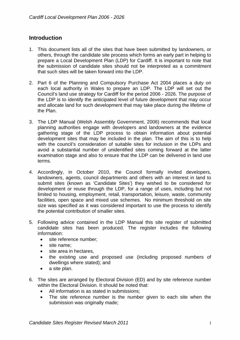
7. As a result of this exercise 112 sites have been submitted for consideration
through the LDP process. The Council will now determine which could form part of the LDP as allocations for development. The views of stakeholders and the public will be considered as part of this process.
8. Please note that the formal opportunity for stakeholders and the public to
comment on these Candidate Sites will be during the consultation and engagement process on the Strategic Options and Strategic Sites which is currently planned to run between 9th May and 10th June 2011, but this may be subject to change - check the LDP Website for updates. Comments provided from stakeholders and the public at that time will help inform the LDP Preferred Strategy which is proposed to be taken to Council in October 2011.
Candidate Sites Register Revised March 2011 ii

Cardiff Local Development Plan 2006 - 2026
INDEX
Page Site Ref Site Name
Adamsdown
1 95 Howard Gardens Bowling Green and Nursery Play area
Butetown
2 18 Queen Alexandra Head
3 20 Former Queens Gate Car Park
4 57 Land at Hannah Street, Butetown
5 60 Roath Basin South, Porth Teigr
6 61 Land south of Central Station
7 71 Wales Millennium Centre, Bute Place, Cardiff Bay
8 73 Graving Docks, Butetown
9 101 Dumballs Road
Caerau
10 17 Ely Bridge Farm, Dyfrig Road, Ely
Canton
11 16 Land at Ely Bridge
12 36 Former Landsdowne Hospital site
13 52 Land at Paper Mill Road, Canton
Cathays
14 70 Central Square
Creigiau/St Fagans 15 7 Land at Tregymog House, Capel Llanillterne
16 8 Land west of Clos y Cwarra, Michaelston-super-Ely
17 32 Land at Michaelston Road
18 46 Land to the North of Junction 33, M4
19 47 Goitre Fach Farm, Llantrisant Road
20 75 Land east of Great House Farm, Michaelston Road
21 82 Land to the west of Cardiff (also partly in Radyr and
Fairwater)
Candidate Sites Register Revised March 2011 iii
Cardiff Local Development Plan 2006 - 2026
Page Site Ref Site Name
22 102 Land south of Creigiau
23 111 Land north west of Great House Farm, Michaelston Rd
Cyncoed
Note Site 33, Llanishen Reservoir, (Llanishen) extends into Cyncoed
Fairwater
Note Site 82, West Cardiff (Creigiau/St Fagans) also extends into Radyr
Grangetown
24 31 Land at Brindley Road, Leckwith
25 62 Land rear of Clive Street, Grangetown
26 77 Gas works, Ferry Road
27 78 Fruit Market, B&Q Hadfield Road
28 83 Former J R Freeman Factory, Penarth Road
Heath
29 45 Government offices, St. Agnes Road, Heath
30 108 Electrocoin Automatics Ltd. Phoenix Estate, Caerphilly RoadLisvane
31 6 Land at Cefn Mably Road, Lisvane
32 11 Land to the east of Graig Road, Lisvane
33 66 Land at Church House Farm, Lisvane
34 67 Land at Maerdy Farm, Lisvane
35 68 Land at Llwynypia Farm, Lisvane
36 85 Land off Llwyn Y Pia Road, North East Cardiff
37 89 North East Cardiff (part)
38 90 North East Cardiff (part)
39 103 Mill Farm, St. Mellons Road, Lisvane (Note Sites 50 [Rhiwbina] 86 (Pontprennau/OSM) and 112 [Pontprennau/OSM] are partly within Lisvane)
Llandaff
40 35 Rookwood Hospital
41 96 Land adjacent to Llandaff Campus
Candidate Sites Register Revised March 2011 iv

Cardiff Local Development Plan 2006 - 2026
Page Site Ref Site Name
42 97 Plas Gwyn Residential Campus/BBC, Llantrisant Road, Llanishen 43 12 Parc Ty Glas/Malvern Drive, Llanishen
44 33 Llanishen Reservoir (extends into Cyncoed)
45 34 Llanishen Reservoir
Pentyrch
46 5 Land to the east of Fairmeadow, Pentyrch
47 54 Taffs Well Quarry
48 69 Land at Tynewydd, Gwaelod Y Garth
49 99 Dan y Garth (a)
50 100 Dan y Garth (b)
Penylan
51 94 UWIC, Colchester Avenue
Pontprennau/ Old St. Mellons
52 4 Energlyn, Ty Draw Road, Lisvane
53 9 Land at Sunnybank Farm, St. Mellons Road
54 10 The Dutch Garden Centre, M4 Junction 30
55 14 Land to the north west of Druidstone Road, Old St.Mellons 56 15 Land at Druidstone Road, Old St. Mellons
57 27 Pwll Coch Uchaf, Old St. Mellons
58 29 Land north west of Druidstone Road, Old St. Mellons
59 30 Land at Pwll Coch, Druidstone Road, Old St. Mellons
60 38 Land off Ty Winch Road St. Mellons
61 43 Land to the east of Brook House, Old St. Mellons
62 44 Land at Bridge Road, Old St. Mellons
63 48 Church Farm, Church Road
64 53 Cardiff Gate
65 59 Goitre Farm, St. Mellons
66 72 Land east and west of Church Road and north and south of Bridge Road, St. Mellons
Candidate Sites Register Revised March 2011 v

Cardiff Local Development Plan 2006 - 2026
Page Site Ref Site Name 67 79 Land at Ty Draw Road, Pentwyn
68 80 Land at Bridge Road, Old St. Mellons
69 81 Land at Began Road/Bridge Road, Old St. Mellons
70 84 Malthouse Farm, North East Cardiff
71 86 North East Cardiff (part) [also extends into Lisvane]
72 87 North East Cardiff (Part)
73 88 North East Cardiff (Part)
74 91 Land at Pwll Coch, Druidstone Road, Old St. Mellons
75 98 Land at Church Road, Llanederyn Village
76 104 Land off Druidstone Road, Old St. Mellons
77 105 Land off Druidstone Road, Old St. Mellons (Site 2)
78 109 Land at Bridge Road, Old St. Mellons
79 110 Land north east of Cefn Eurwg, Druidstone Road, OSM
80 112 N. E. Cardiff - Comprehensive Scheme (also extends into Lisvane)
Radyr 81 63 Former compound, former Cwm Farm, Morganstown
82 64 Former compound, former Cwm Farm, Morganstown
83 65 Land at former Cwm Farm, Morganstown
84 107 Land at Gelynis Farm, Morganstown
Note Site 82 West Cardiff (Creigiau/St Fagans) also extends into Radyr.
Rhiwbina
85 13 Land to the rear of Brynteg, Rhiwbina
86 37 Greenhill School, Rhiwbina
87 50 Land at Briwnant (partly in Lisvane)
88 92 Greenhill School, Heol Brynglas, Rhiwbina
89 93 Greenhill School, Heol Brynglas, Rhiwbina
Rumney
90 56 Land at former St. Johns College, Rumney
Splott
91 19 Pengam Green
Candidate Sites Register Revised March 2011 vi

Cardiff Local Development Plan 2006 - 2026
Candidate Sites Register Revised March 2011 vii
Page Site Ref Site Name 92 58 Rear of 353-379 Moorland Road, Splott
Trowbridge
93 1 Land at Wentloog Levels
94 2 Land at St. Mellons Business Park
95 3 Land at Pill Du Farm, Hendre Lane, Trowbridge
96 21 Land at areas 9-12, St. Mellons
97 22 Trowbridge Mawr - land west of Trowbridge Road, south of Greenway Park and north of Wentlood Road
98 23 Land between Crickhowell Road and Willowbrook Drive, St. Mellons 99 24 Land east of Cypress Drive, St. Mellons
100 49 Blooms Garden Centre, St. Mellons
101 55 Land at Trowbridge Road
102 74 Land east of Wentloog Corporate Industrial Park
103 76 Land south of Wentloog Avenue, Wentloog
104 106 Cardiff Parkway, east of Cypress Drive, St. Mellons
Whitchurch/ Tongwynlais
105 25 Land at Cefn Garw Quarry, Tongwynlais
106 26 Land previously part of Ty Isaf Farm House
107 28 Land North of Ty Isaf, Tongwynlais
108 39 Whitchurch Hospital Site 1
109 40 Whitchurch Hospital Site 2
110 41 Whitchurch Hospital Site 3
111 42 Whitchurch Hospital Site 4
112 51 Land at Mill Road, Tongwynlais

Cardiff Local Development Plan
Adamsdown
Site Reference: 95 Site Name: Howard Gardens Bowling Green and Nursery Play area
Site Size (Ha): 0.49
Current Use: Leisure
Proposed Use: Education
Reproduced from the Ordnance Survey mapping with the permission of the Controller of Her Majesty’s Stationary Office. © Crown Copyright. Unauthorised reproduction infringes Crown Copyright and may lead to prosecution or civil proceedings. Cardiff County Council, 100023376 (2011)
Page 1 of 112Candidate Sites Register Revised March 2011

Cardiff Local Development Plan
Butetown
Site Reference: 18 Site Name: Queen Alexandra Head
Site Size (Ha): 4.69
Current Use: Vacant
Proposed Use: Mixed use including leisure - no firm proposals
Reproduced from the Ordnance Survey mapping with the permission of the Controller of Her Majesty’s Stationary Office. © Crown Copyright. Unauthorised reproduction infringes Crown Copyright and may lead to prosecution or civil proceedings. Cardiff County Council, 100023376 (2011)
Page 2 of 112Candidate Sites Register Revised March 2011

Cardiff Local Development Plan
Butetown
Site Reference: 20 Site Name: Former Queens Gate Car Park
Site Size (Ha): 1.58
Current Use: Vacant
Proposed Use: Development appropriate to the Cardiff Bay Development Area
Reproduced from the Ordnance Survey mapping with the permission of the Controller of Her Majesty’s Stationary Office. © Crown Copyright. Unauthorised reproduction infringes Crown Copyright and may lead to prosecution or civil proceedings. Cardiff County Council, 100023376 (2011)
Page 3 of 112Candidate Sites Register Revised March 2011

Cardiff Local Development Plan
Butetown
Site Reference: 57 Site Name: Land at Hannah Street, Butetown
Site Size (Ha): 0.05
Current Use: Vacant
Proposed Use: Residential (10 dwellings)
Reproduced from the Ordnance Survey mapping with the permission of the Controller of Her Majesty’s Stationary Office. © Crown Copyright. Unauthorised reproduction infringes Crown Copyright and may lead to prosecution or civil proceedings. Cardiff County Council, 100023376 (2011)
Page 4 of 112Candidate Sites Register Revised March 2011

Cardiff Local Development Plan
Butetown
Site Reference: 60 Site Name: Roath Basin South, Porth Teigr
Site Size (Ha): 16.60
Current Use: Former operational docks
Proposed Use: Office, residential, leisure & retail, car park (1010 dwellings)
Reproduced from the Ordnance Survey mapping with the permission of the Controller of Her Majesty’s Stationary Office. © Crown Copyright. Unauthorised reproduction infringes Crown Copyright and may lead to prosecution or civil proceedings. Cardiff County Council, 100023376 (2011)
Page 5 of 112Candidate Sites Register Revised March 2011

Cardiff Local Development Plan
Butetown
Site Reference: 61 Site Name: Land south of Central Station
Site Size (Ha): 2.95
Current Use: Car Park
Proposed Use: Mixed use
Reproduced from the Ordnance Survey mapping with the permission of the Controller of Her Majesty’s Stationary Office. © Crown Copyright. Unauthorised reproduction infringes Crown Copyright and may lead to prosecution or civil proceedings. Cardiff County Council, 100023376 (2011)
Page 6 of 112Candidate Sites Register Revised March 2011

Cardiff Local Development Plan
Butetown
Site Reference: 71 Site Name: Wales Millennium Centre, Bute Place, Cardiff Bay
Site Size (Ha): 0.08
Current Use: Use for occasional outdoor events
Proposed Use: Arts related activities
Reproduced from the Ordnance Survey mapping with the permission of the Controller of Her Majesty’s Stationary Office. © Crown Copyright. Unauthorised reproduction infringes Crown Copyright and may lead to prosecution or civil proceedings. Cardiff County Council, 100023376 (2011)
Page 7 of 112Candidate Sites Register Revised March 2011

Cardiff Local Development Plan
Butetown
Site Reference: 73 Site Name: Graving Docks, Butetown
Site Size (Ha): 2.05
Current Use: Car park, mooring, public space, restaurant
Proposed Use: Mixed use, commercial, tourism/leisure, residential, marina (35-140 dwellings)
Reproduced from the Ordnance Survey mapping with the permission of the Controller of Her Majesty’s Stationary Office. © Crown Copyright. Unauthorised reproduction infringes Crown Copyright and may lead to prosecution or civil proceedings. Cardiff County Council, 100023376 (2011)
Page 8 of 112Candidate Sites Register Revised March 2011
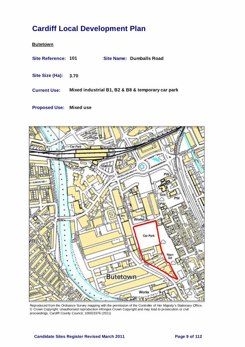
Cardiff Local Development Plan
Butetown
Site Reference: 101 Site Name: Dumballs Road
Site Size (Ha): 3.70
Current Use: Mixed industrial B1, B2 & B8 & temporary car park
Proposed Use: Mixed use
Reproduced from the Ordnance Survey mapping with the permission of the Controller of Her Majesty’s Stationary Office. © Crown Copyright. Unauthorised reproduction infringes Crown Copyright and may lead to prosecution or civil proceedings. Cardiff County Council, 100023376 (2011)
Page 9 of 112Candidate Sites Register Revised March 2011

Cardiff Local Development Plan
Caerau
Site Reference: 17 Site Name: Ely Bridge Farm, Dyfrig Road, Ely
Site Size (Ha): 0.72
Current Use: Unused/previously agriculture
Proposed Use: Residential (35 dwellings)
Reproduced from the Ordnance Survey mapping with the permission of the Controller of Her Majesty’s Stationary Office. © Crown Copyright. Unauthorised reproduction infringes Crown Copyright and may lead to prosecution or civil proceedings. Cardiff County Council, 100023376 (2011)
Page 10 of 112Candidate Sites Register Revised March 2011

Cardiff Local Development Plan
Canton
Site Reference: 16 Site Name: Land at Ely Bridge
Site Size (Ha): 22.34
Current Use: Unused
Proposed Use: Residential/commercial, retail and community uses (900 dwellings)
Reproduced from the Ordnance Survey mapping with the permission of the Controller of Her Majesty’s Stationary Office. © Crown Copyright. Unauthorised reproduction infringes Crown Copyright and may lead to prosecution or civil proceedings. Cardiff County Council, 100023376 (2011)
Page 11 of 112Candidate Sites Register Revised March 2011

Cardiff Local Development Plan
Canton
Site Reference: 36 Site Name: Former Landsdowne Hospital site
Site Size (Ha): 1.51
Current Use: Redundant hospital buildings
Proposed Use: Residential (50-75 dwellings)
Reproduced from the Ordnance Survey mapping with the permission of the Controller of Her Majesty’s Stationary Office. © Crown Copyright. Unauthorised reproduction infringes Crown Copyright and may lead to prosecution or civil proceedings. Cardiff County Council, 100023376 (2011)
Page 12 of 112Candidate Sites Register Revised March 2011

Cardiff Local Development Plan
Canton
Site Reference: 52 Site Name: Land at Paper Mill Road, Canton
Site Size (Ha): 0.77
Current Use: Vacant
Proposed Use: Residential (30 dwellings)
Reproduced from the Ordnance Survey mapping with the permission of the Controller of Her Majesty’s Stationary Office. © Crown Copyright. Unauthorised reproduction infringes Crown Copyright and may lead to prosecution or civil proceedings. Cardiff County Council, 100023376 (2011)
Page 13 of 112Candidate Sites Register Revised March 2011
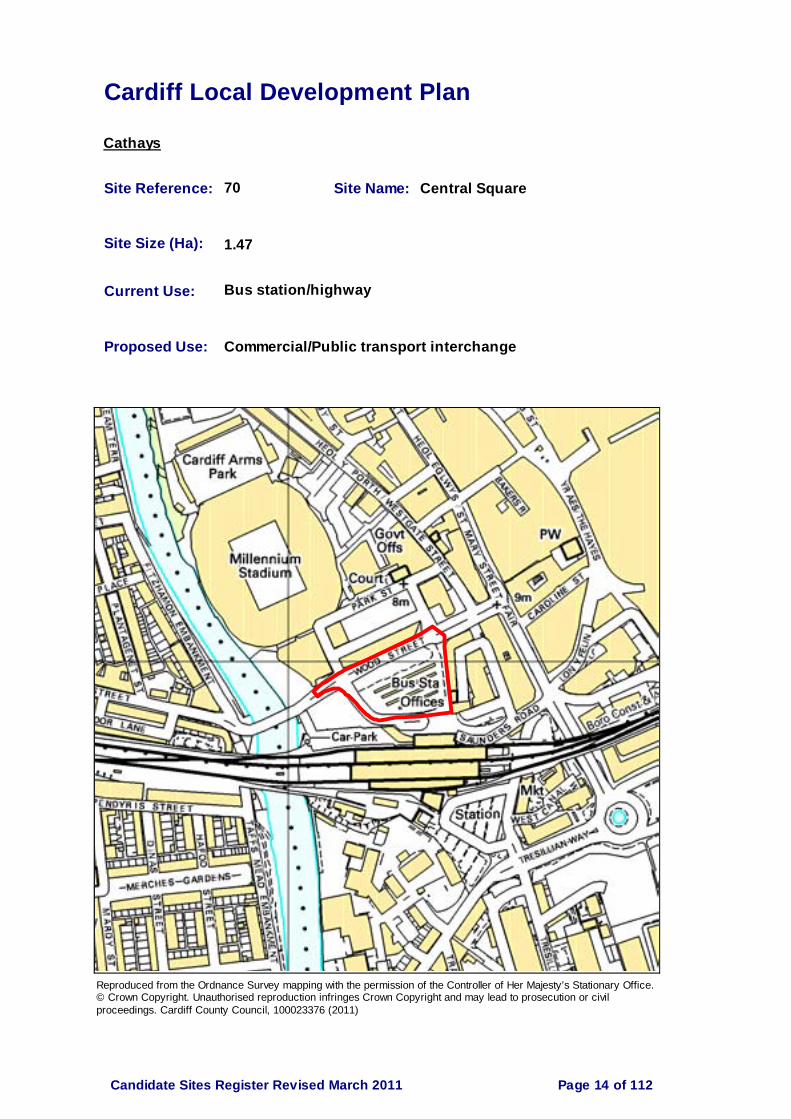
Cardiff Local Development Plan
Cathays
Site Reference: 70 Site Name: Central Square
Site Size (Ha): 1.47
Current Use: Bus station/highway
Proposed Use: Commercial/Public transport interchange
Reproduced from the Ordnance Survey mapping with the permission of the Controller of Her Majesty’s Stationary Office. © Crown Copyright. Unauthorised reproduction infringes Crown Copyright and may lead to prosecution or civil proceedings. Cardiff County Council, 100023376 (2011)
Page 14 of 112Candidate Sites Register Revised March 2011

Cardiff Local Development Plan
Creigiau/St. Fagans
Site Reference: 7 Site Name: Land at Tregyrnog House, Capel Llanillterne
Site Size (Ha): 4.70
Current Use: Residential/grazing
Proposed Use: Residential (125-150 dwellings)
Reproduced from the Ordnance Survey mapping with the permission of the Controller of Her Majesty’s Stationary Office. © Crown Copyright. Unauthorised reproduction infringes Crown Copyright and may lead to prosecution or civil proceedings. Cardiff County Council, 100023376 (2011)
Page 15 of 112Candidate Sites Register Revised March 2011

Cardiff Local Development Plan
Creigiau/St. Fagans
Site Reference: 8 Site Name: Land west of Clos y Cwarra, Michaelston-super-Ely
Site Size (Ha): 1.64
Current Use: Grazing
Proposed Use: Residential (50 dwellings)
Reproduced from the Ordnance Survey mapping with the permission of the Controller of Her Majesty’s Stationary Office. © Crown Copyright. Unauthorised reproduction infringes Crown Copyright and may lead to prosecution or civil proceedings. Cardiff County Council, 100023376 (2011)
Page 16 of 112Candidate Sites Register Revised March 2011

Cardiff Local Development Plan
Creigiau/St. Fagans
Site Reference: 32 Site Name: Land at Michaelston Road
Site Size (Ha): 9.77
Current Use: Predominantly agriculture (wooded hillside to south)
Proposed Use: Residential (80 dwellings)
Reproduced from the Ordnance Survey mapping with the permission of the Controller of Her Majesty’s Stationary Office. © Crown Copyright. Unauthorised reproduction infringes Crown Copyright and may lead to prosecution or civil proceedings. Cardiff County Council, 100023376 (2011)
Page 17 of 112Candidate Sites Register Revised March 2011

Cardiff Local Development Plan
Creigiau/St. Fagans
Site Reference: 46 Site Name: Land to the North of Junction 33, M4
Site Size (Ha): 80.00
Current Use: Agriculture/pasture
Proposed Use: Mixed use to include a premier business park & science park, residential and retailing (1680-2016 dwellings)
Reproduced from the Ordnance Survey mapping with the permission of the Controller of Her Majesty’s Stationary Office. © Crown Copyright. Unauthorised reproduction infringes Crown Copyright and may lead to prosecution or civil proceedings. Cardiff County Council, 100023376 (2011)
Page 18 of 112Candidate Sites Register Revised March 2011

Cardiff Local Development Plan
Creigiau/St. Fagans
Site Reference: 47 Site Name: Goitre Fach Farm, Llantrisant Road
Site Size (Ha): 9.64
Current Use: Agricultural grazing land (with derelict farm buildings)
Proposed Use: Residential (241 dwellings)
Reproduced from the Ordnance Survey mapping with the permission of the Controller of Her Majesty’s Stationary Office. © Crown Copyright. Unauthorised reproduction infringes Crown Copyright and may lead to prosecution or civil proceedings. Cardiff County Council, 100023376 (2011)
Page 19 of 112Candidate Sites Register Revised March 2011
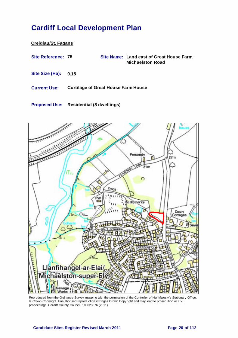
Cardiff Local Development Plan
Creigiau/St. Fagans
Site Reference: 75 Site Name: Land east of Great House Farm, Michaelston Road
Site Size (Ha): 0.15
Current Use: Curtilage of Great House Farm House
Proposed Use: Residential (8 dwellings)
Reproduced from the Ordnance Survey mapping with the permission of the Controller of Her Majesty’s Stationary Office. © Crown Copyright. Unauthorised reproduction infringes Crown Copyright and may lead to prosecution or civil proceedings. Cardiff County Council, 100023376 (2011)
Page 20 of 112Candidate Sites Register Revised March 2011
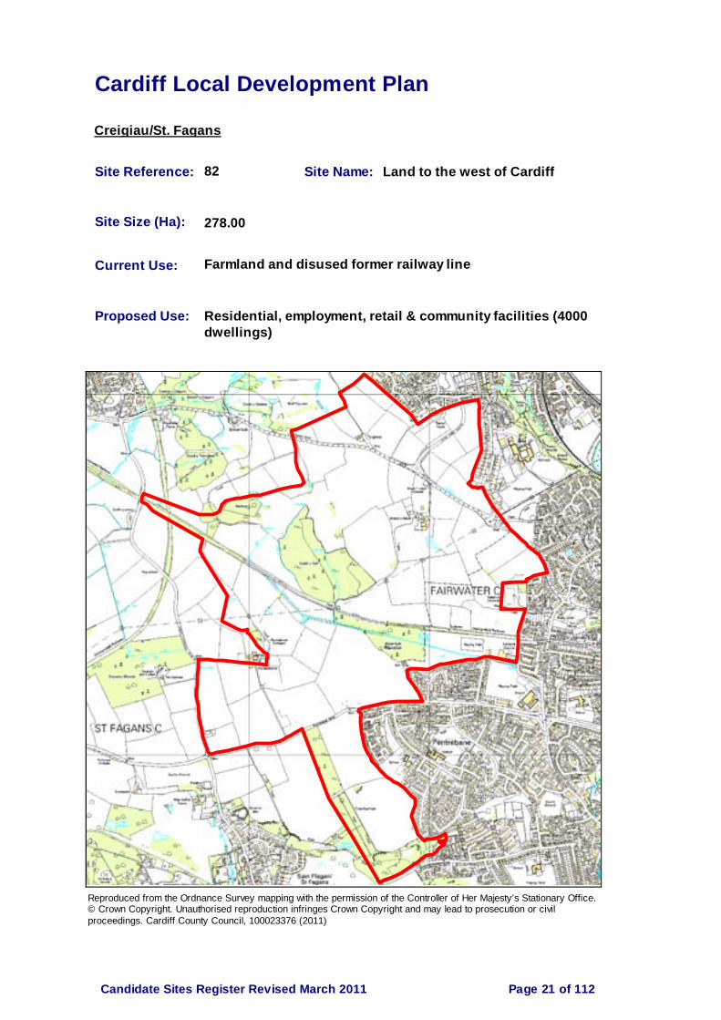
Cardiff Local Development Plan
Creigiau/St. Fagans
Site Reference: 82 Site Name: Land to the west of Cardiff
Site Size (Ha): 278.00
Current Use: Farmland and disused former railway line
Proposed Use: Residential, employment, retail & community facilities (4000 dwellings)
Reproduced from the Ordnance Survey mapping with the permission of the Controller of Her Majesty’s Stationary Office. © Crown Copyright. Unauthorised reproduction infringes Crown Copyright and may lead to prosecution or civil proceedings. Cardiff County Council, 100023376 (2011)
Page 21 of 112Candidate Sites Register Revised March 2011

Cardiff Local Development Plan
Creigiau/St. Fagans
Site Reference: 102 Site Name: Land south of Creigiau
Site Size (Ha): 37.70
Current Use: Agricultural
Proposed Use: Residential with potential for new community facilities (400-460 dwellings)
Reproduced from the Ordnance Survey mapping with the permission of the Controller of Her Majesty’s Stationary Office. © Crown Copyright. Unauthorised reproduction infringes Crown Copyright and may lead to prosecution or civil proceedings. Cardiff County Council, 100023376 (2011)
Page 22 of 112Candidate Sites Register Revised March 2011

Cardiff Local Development Plan
Creigiau/St. Fagans
Site Reference: 111 Site Name: Land north west of Great House Farm, Michaelston Road
Site Size (Ha): 0.54
Current Use: Vacant
Proposed Use: Residential (14 dwellings)
Reproduced from the Ordnance Survey mapping with the permission of the Controller of Her Majesty’s Stationary Office. © Crown Copyright. Unauthorised reproduction infringes Crown Copyright and may lead to prosecution or civil proceedings. Cardiff County Council, 100023376 (2011)
Page 23 of 112Candidate Sites Register Revised March 2011

Cardiff Local Development Plan
Grangetown
Site Reference: 31 Site Name: Land at Brindley Road, Leckwith
Site Size (Ha): 8.00
Current Use: Nil use
Proposed Use: Commercial/industrial B1, B2 & B8 uses or transport use; or strategic park & ride facilities or combination of all 3
Reproduced from the Ordnance Survey mapping with the permission of the Controller of Her Majesty’s Stationary Office. © Crown Copyright. Unauthorised reproduction infringes Crown Copyright and may lead to prosecution or civil proceedings. Cardiff County Council, 100023376 (2011)
Page 24 of 112Candidate Sites Register Revised March 2011

Cardiff Local Development Plan
Grangetown
Site Reference: 62 Site Name: Land rear of Clive Street, Grangetown
Site Size (Ha): 2.87
Current Use: Ex railway land
Proposed Use: Residential (80 dwellings)
Reproduced from the Ordnance Survey mapping with the permission of the Controller of Her Majesty’s Stationary Office. © Crown Copyright. Unauthorised reproduction infringes Crown Copyright and may lead to prosecution or civil proceedings. Cardiff County Council, 100023376 (2011)
Page 25 of 112Candidate Sites Register Revised March 2011

Cardiff Local Development Plan
Grangetown
Site Reference: 77 Site Name: Gas works, Ferry Road
Site Size (Ha): 11.73
Current Use: Gas works
Proposed Use: Residential (500 dwellings)
Reproduced from the Ordnance Survey mapping with the permission of the Controller of Her Majesty’s Stationary Office. © Crown Copyright. Unauthorised reproduction infringes Crown Copyright and may lead to prosecution or civil proceedings. Cardiff County Council, 100023376 (2011)
Page 26 of 112Candidate Sites Register Revised March 2011

Cardiff Local Development Plan
Grangetown
Site Reference: 78 Site Name: Fruit Market, B&Q Hadfield Road
Site Size (Ha): 7.00
Current Use: Fruit market, B&Q
Proposed Use: Residential, commercial, employment (230-250 dwellings)
Reproduced from the Ordnance Survey mapping with the permission of the Controller of Her Majesty’s Stationary Office. © Crown Copyright. Unauthorised reproduction infringes Crown Copyright and may lead to prosecution or civil proceedings. Cardiff County Council, 100023376 (2011)
Page 27 of 112Candidate Sites Register Revised March 2011
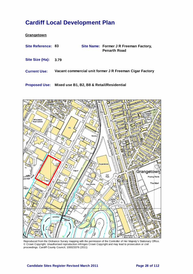
Cardiff Local Development Plan
Grangetown
Site Reference: 83 Site Name: Former J R Freeman Factory, Penarth Road
Site Size (Ha): 3.79
Current Use: Vacant commercial unit former J R Freeman Cigar Factory
Proposed Use: Mixed use B1, B2, B8 & Retail/Residential
Reproduced from the Ordnance Survey mapping with the permission of the Controller of Her Majesty’s Stationary Office. © Crown Copyright. Unauthorised reproduction infringes Crown Copyright and may lead to prosecution or civil proceedings. Cardiff County Council, 100023376 (2011)
Page 28 of 112Candidate Sites Register Revised March 2011
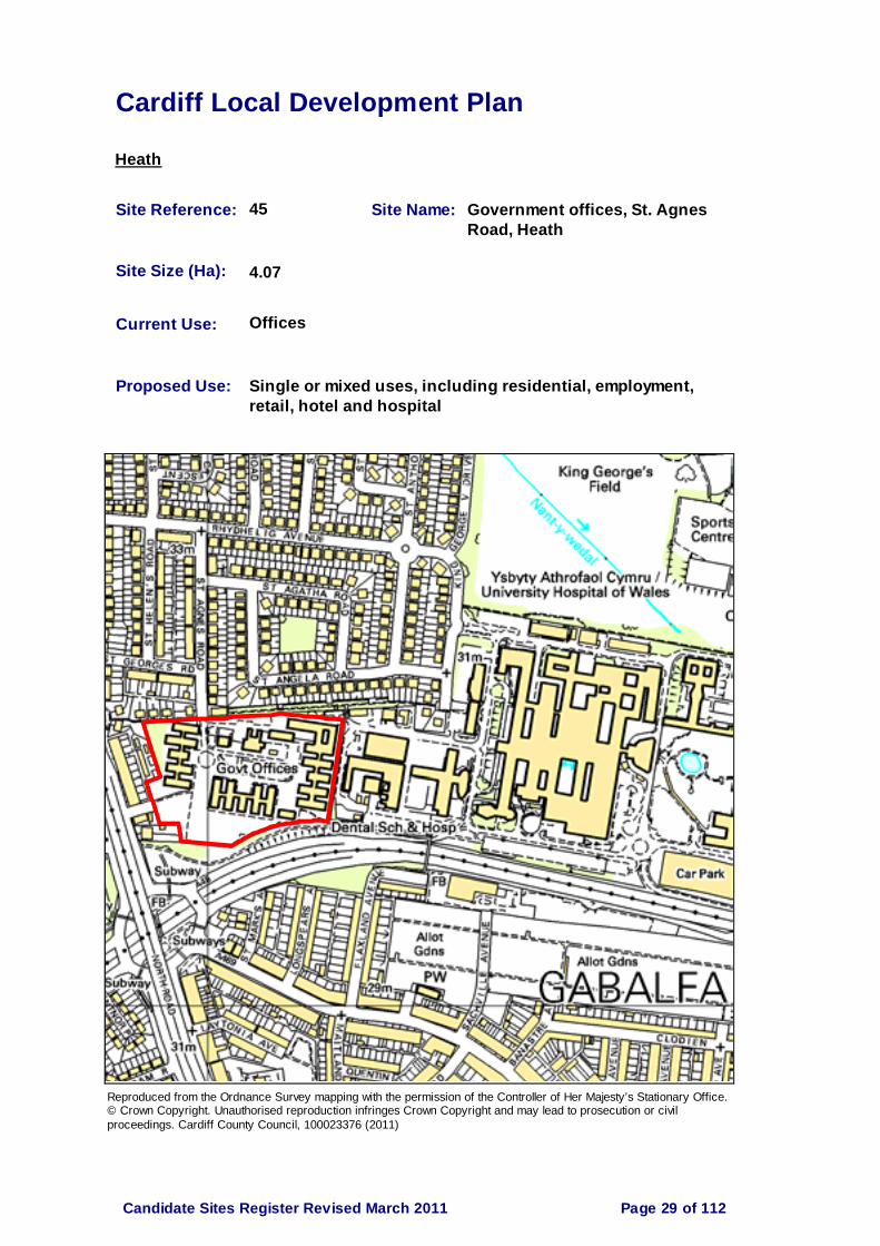
Cardiff Local Development Plan
Heath
Site Reference: 45 Site Name: Government offices, St. Agnes Road, Heath
Site Size (Ha): 4.07
Current Use: Offices
Proposed Use: Single or mixed uses, including residential, employment, retail, hotel and hospital
Reproduced from the Ordnance Survey mapping with the permission of the Controller of Her Majesty’s Stationary Office. © Crown Copyright. Unauthorised reproduction infringes Crown Copyright and may lead to prosecution or civil proceedings. Cardiff County Council, 100023376 (2011)
Page 29 of 112Candidate Sites Register Revised March 2011

Cardiff Local Development Plan
Heath
Site Reference: 108 Site Name: Electrocoin Automatics Ltd. Phoenix Estate, Caerphilly Road
Site Size (Ha): 0.61
Current Use: Industrial
Proposed Use: Residential
Reproduced from the Ordnance Survey mapping with the permission of the Controller of Her Majesty’s Stationary Office. © Crown Copyright. Unauthorised reproduction infringes Crown Copyright and may lead to prosecution or civil proceedings. Cardiff County Council, 100023376 (2011)
Page 30 of 112Candidate Sites Register Revised March 2011

Cardiff Local Development Plan
Lisvane
Site Reference: 6 Site Name: Land at Cefn Mably Road, Lisvane
Site Size (Ha): 2.84
Current Use: Grazing
Proposed Use: Residential (90 dwellings)
Reproduced from the Ordnance Survey mapping with the permission of the Controller of Her Majesty’s Stationary Office. © Crown Copyright. Unauthorised reproduction infringes Crown Copyright and may lead to prosecution or civil proceedings. Cardiff County Council, 100023376 (2011)
Page 31 of 112Candidate Sites Register Revised March 2011
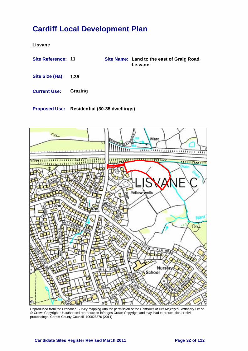
Cardiff Local Development Plan
Lisvane
Site Reference: 11 Site Name: Land to the east of Graig Road, Lisvane
Site Size (Ha): 1.35
Current Use: Grazing
Proposed Use: Residential (30-35 dwellings)
Reproduced from the Ordnance Survey mapping with the permission of the Controller of Her Majesty’s Stationary Office. © Crown Copyright. Unauthorised reproduction infringes Crown Copyright and may lead to prosecution or civil proceedings. Cardiff County Council, 100023376 (2011)
Page 32 of 112Candidate Sites Register Revised March 2011

Cardiff Local Development Plan
Lisvane
Site Reference: 66 Site Name: Land at Church House Farm, Lisvane
Site Size (Ha): 9.70
Current Use: Agriculture/woodland
Proposed Use: Mixed use - residential, local centre, education, public open space (4500 dwellings total for wider proposal)
Reproduced from the Ordnance Survey mapping with the permission of the Controller of Her Majesty’s Stationary Office. © Crown Copyright. Unauthorised reproduction infringes Crown Copyright and may lead to prosecution or civil proceedings. Cardiff County Council, 100023376 (2011)
Page 33 of 112Candidate Sites Register Revised March 2011

Cardiff Local Development Plan
Lisvane
Site Reference: 67 Site Name: Land at Maerdy Farm, Lisvane
Site Size (Ha): 32.03
Current Use: Agriculture/woodland
Proposed Use: Mixed use - residential, local centre, education, public open space (4500 dwellings total for wider proposal)
Reproduced from the Ordnance Survey mapping with the permission of the Controller of Her Majesty’s Stationary Office. © Crown Copyright. Unauthorised reproduction infringes Crown Copyright and may lead to prosecution or civil proceedings. Cardiff County Council, 100023376 (2011)
Page 34 of 112Candidate Sites Register Revised March 2011

Cardiff Local Development Plan
Lisvane
Site Reference: 68 Site Name: Land at Llwynypia Farm, Lisvane
Site Size (Ha): 7.34
Current Use: Agriculture/woodland
Proposed Use: Mixed use - residential, local centre, education, public open space (4500 dwellings total for wider proposal)
Reproduced from the Ordnance Survey mapping with the permission of the Controller of Her Majesty’s Stationary Office. © Crown Copyright. Unauthorised reproduction infringes Crown Copyright and may lead to prosecution or civil proceedings. Cardiff County Council, 100023376 (2011)
Page 35 of 112Candidate Sites Register Revised March 2011

Cardiff Local Development Plan
Lisvane
Site Reference: 85 Site Name: Land off Llwyn Y Pia Road, North East Cardiff
Site Size (Ha): 4.20
Current Use: Paddocks & unoccupied fields
Proposed Use: Residential (100 dwellings)
Reproduced from the Ordnance Survey mapping with the permission of the Controller of Her Majesty’s Stationary Office. © Crown Copyright. Unauthorised reproduction infringes Crown Copyright and may lead to prosecution or civil proceedings. Cardiff County Council, 100023376 (2011)
Page 36 of 112Candidate Sites Register Revised March 2011

Cardiff Local Development Plan
Lisvane
Site Reference: 89 Site Name: North East Cardiff (part)
Site Size (Ha): 19.60
Current Use: Agriculture
Proposed Use: Predominantly residential (400 dwellings)
Reproduced from the Ordnance Survey mapping with the permission of the Controller of Her Majesty’s Stationary Office. © Crown Copyright. Unauthorised reproduction infringes Crown Copyright and may lead to prosecution or civil proceedings. Cardiff County Council, 100023376 (2011)
Page 37 of 112Candidate Sites Register Revised March 2011

Cardiff Local Development Plan
Lisvane
Site Reference: 90 Site Name: North East Cardiff (part)
Site Size (Ha): 47.25
Current Use: Agriculture
Proposed Use: Predominantly residential (840 dwellings)
Reproduced from the Ordnance Survey mapping with the permission of the Controller of Her Majesty’s Stationary Office. © Crown Copyright. Unauthorised reproduction infringes Crown Copyright and may lead to prosecution or civil proceedings. Cardiff County Council, 100023376 (2011)
Page 38 of 112Candidate Sites Register Revised March 2011

Cardiff Local Development Plan
Lisvane
Site Reference: 103 Site Name: Mill Farm, St. Mellons Road, Lisvane
Site Size (Ha): 1.10
Current Use: Mixed employment
Proposed Use: Mixed use - housing (30 units), employment, sheltered accommodation (50-100 units), care home & leisure
Reproduced from the Ordnance Survey mapping with the permission of the Controller of Her Majesty’s Stationary Office. © Crown Copyright. Unauthorised reproduction infringes Crown Copyright and may lead to prosecution or civil proceedings. Cardiff County Council, 100023376 (2011)
Page 39 of 112Candidate Sites Register Revised March 2011

Cardiff Local Development Plan
Llandaff
Site Reference: 35 Site Name: Rookwood Hospital
Site Size (Ha): 2.90
Current Use: Healthcare
Proposed Use: Residential (80 dwellings)
Reproduced from the Ordnance Survey mapping with the permission of the Controller of Her Majesty’s Stationary Office. © Crown Copyright. Unauthorised reproduction infringes Crown Copyright and may lead to prosecution or civil proceedings. Cardiff County Council, 100023376 (2011)
Page 40 of 112Candidate Sites Register Revised March 2011

Cardiff Local Development Plan
Llandaff
Site Reference: 96 Site Name: Land adjacent to Llandaff Campus
Site Size (Ha): 0.70
Current Use: Leisure
Proposed Use: Education
Reproduced from the Ordnance Survey mapping with the permission of the Controller of Her Majesty’s Stationary Office. © Crown Copyright. Unauthorised reproduction infringes Crown Copyright and may lead to prosecution or civil proceedings. Cardiff County Council, 100023376 (2011)
Page 41 of 112Candidate Sites Register Revised March 2011

Cardiff Local Development Plan
Llandaff
Site Reference: 97 Site Name: Plas Gwyn Residential Campus / BBC, Llantrisant Road, Llandaff
Site Size (Ha): 8.02
Current Use: Student residential / BBC
Proposed Use: Education & Employment
Reproduced from the Ordnance Survey mapping with the permission of the Controller of Her Majesty’s Stationary Office. © Crown Copyright. Unauthorised reproduction infringes Crown Copyright and may lead to prosecution or civil proceedings. Cardiff County Council, 100023376 (2011)
Page 42 of 112Candidate Sites Register Revised March 2011

Cardiff Local Development Plan
Llanishen
Site Reference: 12 Site Name: Parc Ty Glas/Malvern Drive, Llanishen
Site Size (Ha): 1.86
Current Use: Vacant
Proposed Use: Residential (100 dwellings)
Reproduced from the Ordnance Survey mapping with the permission of the Controller of Her Majesty’s Stationary Office. © Crown Copyright. Unauthorised reproduction infringes Crown Copyright and may lead to prosecution or civil proceedings. Cardiff County Council, 100023376 (2011)
Page 43 of 112Candidate Sites Register Revised March 2011

Cardiff Local Development Plan
Llanishen
Site Reference: 33 Site Name: Llanishen Reservoir
Site Size (Ha): 36.50
Current Use: Former reservoir
Proposed Use: Residential (300 dwellings), watersports, wetland habitat, educational/community centre, open space
Reproduced from the Ordnance Survey mapping with the permission of the Controller of Her Majesty’s Stationary Office. © Crown Copyright. Unauthorised reproduction infringes Crown Copyright and may lead to prosecution or civil proceedings. Cardiff County Council, 100023376 (2011)
Page 44 of 112Candidate Sites Register Revised March 2011
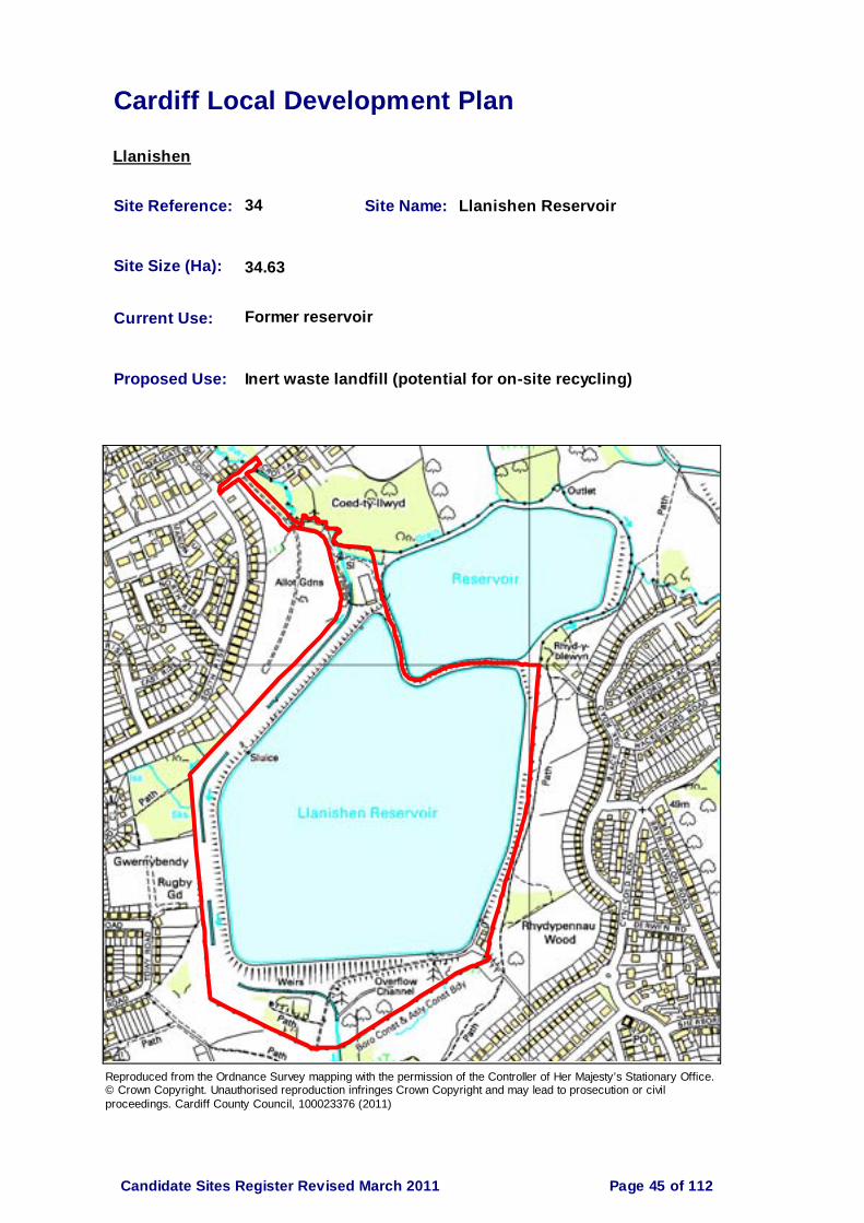
Cardiff Local Development Plan
Llanishen
Site Reference: 34 Site Name: Llanishen Reservoir
Site Size (Ha): 34.63
Current Use: Former reservoir
Proposed Use: Inert waste landfill (potential for on-site recycling)
Reproduced from the Ordnance Survey mapping with the permission of the Controller of Her Majesty’s Stationary Office. © Crown Copyright. Unauthorised reproduction infringes Crown Copyright and may lead to prosecution or civil proceedings. Cardiff County Council, 100023376 (2011)
Page 45 of 112Candidate Sites Register Revised March 2011

Cardiff Local Development Plan
Pentyrch
Site Reference: 5 Site Name: Land to the east of Fairmeadow, Pentyrch
Site Size (Ha): 0.90
Current Use: Scrub land
Proposed Use: Allotments
Reproduced from the Ordnance Survey mapping with the permission of the Controller of Her Majesty’s Stationary Office. © Crown Copyright. Unauthorised reproduction infringes Crown Copyright and may lead to prosecution or civil proceedings. Cardiff County Council, 100023376 (2011)
Page 46 of 112Candidate Sites Register Revised March 2011

Cardiff Local Development Plan
Pentyrch
Site Reference: 54 Site Name: Taffs Well Quarry
Site Size (Ha): 64.80
Current Use: Limestone Quarry
Proposed Use: Continued use as Limestone Quarry
Reproduced from the Ordnance Survey mapping with the permission of the Controller of Her Majesty’s Stationary Office. © Crown Copyright. Unauthorised reproduction infringes Crown Copyright and may lead to prosecution or civil proceedings. Cardiff County Council, 100023376 (2011)
Page 47 of 112Candidate Sites Register Revised March 2011

Cardiff Local Development Plan
Pentyrch
Site Reference: 69 Site Name: Land at Tynewydd, Gwaelod Y Garth
Site Size (Ha): 0.50
Current Use: Vacant
Proposed Use: Residential (10 dwellings)
Reproduced from the Ordnance Survey mapping with the permission of the Controller of Her Majesty’s Stationary Office. © Crown Copyright. Unauthorised reproduction infringes Crown Copyright and may lead to prosecution or civil proceedings. Cardiff County Council, 100023376 (2011)
Page 48 of 112Candidate Sites Register Revised March 2011

Cardiff Local Development Plan
Pentyrch
Site Reference: 99 Site Name: Dan y Garth (a)
Site Size (Ha): 2.49
Current Use: Agriculture
Proposed Use: Residential 87 dwellings)
Reproduced from the Ordnance Survey mapping with the permission of the Controller of Her Majesty’s Stationary Office. © Crown Copyright. Unauthorised reproduction infringes Crown Copyright and may lead to prosecution or civil proceedings. Cardiff County Council, 100023376 (2011)
Page 49 of 112Candidate Sites Register Revised March 2011

Cardiff Local Development Plan
Pentyrch
Site Reference: 100 Site Name: Dan y Garth (b)
Site Size (Ha): 1.19
Current Use: Agriculture
Proposed Use: Residential (42 dwellings)
Reproduced from the Ordnance Survey mapping with the permission of the Controller of Her Majesty’s Stationary Office. © Crown Copyright. Unauthorised reproduction infringes Crown Copyright and may lead to prosecution or civil proceedings. Cardiff County Council, 100023376 (2011)
Page 50 of 112Candidate Sites Register Revised March 2011

Cardiff Local Development Plan
Penylan
Site Reference: 94 Site Name: UWIC, Colchester Avenue
Site Size (Ha): 2.00
Current Use: Education
Proposed Use: Residential (106 dwellings)
Reproduced from the Ordnance Survey mapping with the permission of the Controller of Her Majesty’s Stationary Office. © Crown Copyright. Unauthorised reproduction infringes Crown Copyright and may lead to prosecution or civil proceedings. Cardiff County Council, 100023376 (2011)
Page 51 of 112Candidate Sites Register Revised March 2011

Cardiff Local Development Plan
Pontprennau/OSM
Site Reference: 4 Site Name: Energlyn, Ty Draw Road, Lisvane
Site Size (Ha): 0.45
Current Use: Garden
Proposed Use: Residential (5 dwellings)
Reproduced from the Ordnance Survey mapping with the permission of the Controller of Her Majesty’s Stationary Office. © Crown Copyright. Unauthorised reproduction infringes Crown Copyright and may lead to prosecution or civil proceedings. Cardiff County Council, 100023376 (2011)
Page 52 of 112Candidate Sites Register Revised March 2011

Cardiff Local Development Plan
Pontprennau/OSM
Site Reference: 9 Site Name: Land at Sunnybank Farm, St. Mellons Road
Site Size (Ha): 3.47
Current Use: Agriculture/pasture
Proposed Use: Residential (80 dwellings)
Reproduced from the Ordnance Survey mapping with the permission of the Controller of Her Majesty’s Stationary Office. © Crown Copyright. Unauthorised reproduction infringes Crown Copyright and may lead to prosecution or civil proceedings. Cardiff County Council, 100023376 (2011)
Page 53 of 112Candidate Sites Register Revised March 2011

Cardiff Local Development Plan
Pontprennau/OSM
Site Reference: 10 Site Name: The Dutch Garden Centre, M4 Junction 30
Site Size (Ha): 3.12
Current Use: Nursery use/garden centre, existing dwellings & extensive hardstanding
Proposed Use: Motorway related employment (B1,B8) service and/or tourism uses, garden related retail uses, agricultural related commercial development
Reproduced from the Ordnance Survey mapping with the permission of the Controller of Her Majesty’s Stationary Office. © Crown Copyright. Unauthorised reproduction infringes Crown Copyright and may lead to prosecution or civil proceedings. Cardiff County Council, 100023376 (2011)
Page 54 of 112Candidate Sites Register Revised March 2011

Cardiff Local Development Plan
Pontprennau/OSM
Site Reference: 14 Site Name: Land to the north west of Druidstone Road, Old St.Mellons
Site Size (Ha): 1.09
Current Use: Grazing
Proposed Use: Residential (35 dwellings)
Reproduced from the Ordnance Survey mapping with the permission of the Controller of Her Majesty’s Stationary Office. © Crown Copyright. Unauthorised reproduction infringes Crown Copyright and may lead to prosecution or civil proceedings. Cardiff County Council, 100023376 (2011)
Page 55 of 112Candidate Sites Register Revised March 2011
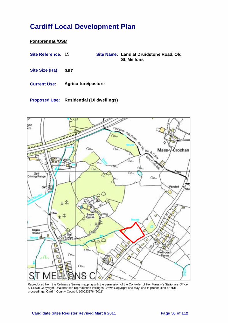
Cardiff Local Development Plan
Pontprennau/OSM
Site Reference: 15 Site Name: Land at Druidstone Road, Old St. Mellons
Site Size (Ha): 0.97
Current Use: Agriculture/pasture
Proposed Use: Residential (10 dwellings)
Reproduced from the Ordnance Survey mapping with the permission of the Controller of Her Majesty’s Stationary Office. © Crown Copyright. Unauthorised reproduction infringes Crown Copyright and may lead to prosecution or civil proceedings. Cardiff County Council, 100023376 (2011)
Page 56 of 112Candidate Sites Register Revised March 2011

Cardiff Local Development Plan
Pontprennau/OSM
Site Reference: 27 Site Name: Pwll Coch Uchaf, Old St. Mellons
Site Size (Ha): 0.36
Current Use: Garden
Proposed Use: Residential (4 dwellings)
Reproduced from the Ordnance Survey mapping with the permission of the Controller of Her Majesty’s Stationary Office. © Crown Copyright. Unauthorised reproduction infringes Crown Copyright and may lead to prosecution or civil proceedings. Cardiff County Council, 100023376 (2011)
Page 57 of 112Candidate Sites Register Revised March 2011

Cardiff Local Development Plan
Pontprennau/OSM
Site Reference: 29 Site Name: Land north west of Druidstone Road, Old St. Mellons
Site Size (Ha): 5.00
Current Use: Rough pasture
Proposed Use: Residential (64 dwellings)
Reproduced from the Ordnance Survey mapping with the permission of the Controller of Her Majesty’s Stationary Office. © Crown Copyright. Unauthorised reproduction infringes Crown Copyright and may lead to prosecution or civil proceedings. Cardiff County Council, 100023376 (2011)
Page 58 of 112Candidate Sites Register Revised March 2011

Cardiff Local Development Plan
Pontprennau/OSM
Site Reference: 30 Site Name: Land at Pwll Coch, Druidstone Road, Old St. Mellons
Site Size (Ha): 7.89
Current Use: Vacant grazing land
Proposed Use: Residential (40-50 dwellings)
Reproduced from the Ordnance Survey mapping with the permission of the Controller of Her Majesty’s Stationary Office. © Crown Copyright. Unauthorised reproduction infringes Crown Copyright and may lead to prosecution or civil proceedings. Cardiff County Council, 100023376 (2011)
Page 59 of 112Candidate Sites Register Revised March 2011

Cardiff Local Development Plan
Pontprennau/OSM
Site Reference: 38 Site Name: Land off Ty Winch Road St. Mellons
Site Size (Ha): 4.00
Current Use: Training Facility
Proposed Use: Residential (100-150 dwellings)
Reproduced from the Ordnance Survey mapping with the permission of the Controller of Her Majesty’s Stationary Office. © Crown Copyright. Unauthorised reproduction infringes Crown Copyright and may lead to prosecution or civil proceedings. Cardiff County Council, 100023376 (2011)
Page 60 of 112Candidate Sites Register Revised March 2011

Cardiff Local Development Plan
Pontprennau/OSM
Site Reference: 43 Site Name: Land to the east of Brook House, Old St. Mellons
Site Size (Ha): 9.72
Current Use: Scrub land
Proposed Use: Residential
Reproduced from the Ordnance Survey mapping with the permission of the Controller of Her Majesty’s Stationary Office. © Crown Copyright. Unauthorised reproduction infringes Crown Copyright and may lead to prosecution or civil proceedings. Cardiff County Council, 100023376 (2011)
Page 61 of 112Candidate Sites Register Revised March 2011

Cardiff Local Development Plan
Pontprennau/OSM
Site Reference: 44 Site Name: Land at Bridge Road, Old St. Mellons
Site Size (Ha): 1.10
Current Use: Scrub land
Proposed Use: Residential (9-13 dwellings)
Reproduced from the Ordnance Survey mapping with the permission of the Controller of Her Majesty’s Stationary Office. © Crown Copyright. Unauthorised reproduction infringes Crown Copyright and may lead to prosecution or civil proceedings. Cardiff County Council, 100023376 (2011)
Page 62 of 112Candidate Sites Register Revised March 2011

Cardiff Local Development Plan
Pontprennau/OSM
Site Reference: 48 Site Name: Church Farm, Church Road
Site Size (Ha): 4.50
Current Use: Open grassland, storage of skips and bins
Proposed Use: Residential (70 dwellings)
Reproduced from the Ordnance Survey mapping with the permission of the Controller of Her Majesty’s Stationary Office. © Crown Copyright. Unauthorised reproduction infringes Crown Copyright and may lead to prosecution or civil proceedings. Cardiff County Council, 100023376 (2011)
Page 63 of 112Candidate Sites Register Revised March 2011

Cardiff Local Development Plan
Pontprennau/OSM
Site Reference: 53 Site Name: Cardiff Gate, Pontprennau
Site Size (Ha): 10.40
Current Use: Retail
Proposed Use: District Centre Shopping Centre
Reproduced from the Ordnance Survey mapping with the permission of the Controller of Her Majesty’s Stationary Office. © Crown Copyright. Unauthorised reproduction infringes Crown Copyright and may lead to prosecution or civil proceedings. Cardiff County Council, 100023376 (2011)
Page 64 of 112Candidate Sites Register Revised March 2011

Cardiff Local Development Plan
Pontprennau/OSM
Site Reference: 59 Site Name: Goitre Farm, St. Mellons
Site Size (Ha): 13
Current Use: Temporary grazing
Proposed Use: Commercial/residential
Reproduced from the Ordnance Survey mapping with the permission of the Controller of Her Majesty’s Stationary Office. © Crown Copyright. Unauthorised reproduction infringes Crown Copyright and may lead to prosecution or civil proceedings. Cardiff County Council, 100023376 (2011)
Page 65 of 112Candidate Sites Register Revised March 2011
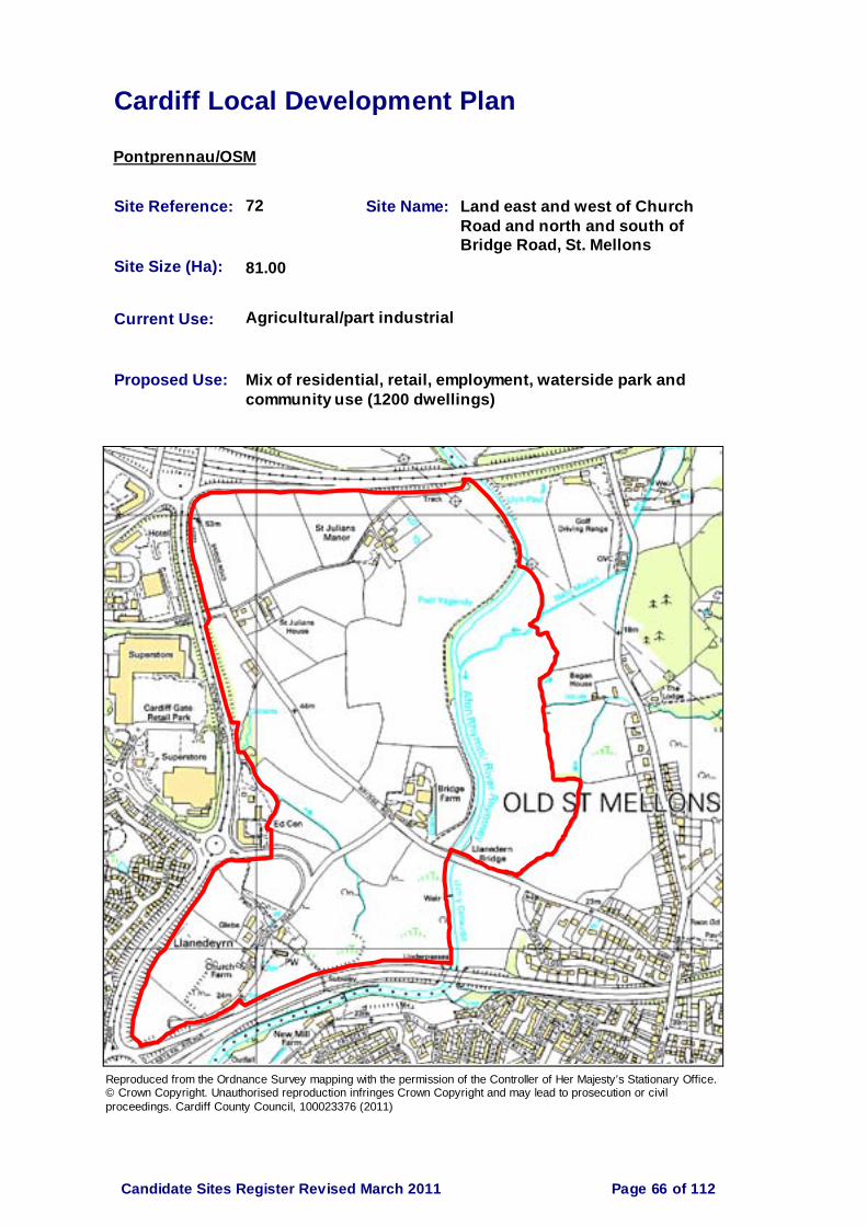
Cardiff Local Development Plan
Pontprennau/OSM
Site Reference: 72 Site Name: Land east and west of Church Road and north and south of Bridge Road, St. Mellons
Site Size (Ha): 81.00
Current Use: Agricultural/part industrial
Proposed Use: Mix of residential, retail, employment, waterside park and community use (1200 dwellings)
Reproduced from the Ordnance Survey mapping with the permission of the Controller of Her Majesty’s Stationary Office. © Crown Copyright. Unauthorised reproduction infringes Crown Copyright and may lead to prosecution or civil proceedings. Cardiff County Council, 100023376 (2011)
Page 66 of 112Candidate Sites Register Revised March 2011

Cardiff Local Development Plan
Pontprennau/OSM
Site Reference: 79 Site Name: Land at Ty Draw Road, Pentwyn
Site Size (Ha): 15.06
Current Use: Agriculture/arable land
Proposed Use: Residential (300 dwellings)
Reproduced from the Ordnance Survey mapping with the permission of the Controller of Her Majesty’s Stationary Office. © Crown Copyright. Unauthorised reproduction infringes Crown Copyright and may lead to prosecution or civil proceedings. Cardiff County Council, 100023376 (2011)
Page 67 of 112Candidate Sites Register Revised March 2011

Cardiff Local Development Plan
Pontprennau/OSM
Site Reference: 80 Site Name: Land at Bridge Road, Old St. Mellons
Site Size (Ha): 5.05
Current Use: Agriculture
Proposed Use: Residential (130 dwellings)
Reproduced from the Ordnance Survey mapping with the permission of the Controller of Her Majesty’s Stationary Office. © Crown Copyright. Unauthorised reproduction infringes Crown Copyright and may lead to prosecution or civil proceedings. Cardiff County Council, 100023376 (2011)
Page 68 of 112Candidate Sites Register Revised March 2011

Cardiff Local Development Plan
Pontprennau/OSM
Site Reference: 81 Site Name: Land at Began Road/Bridge Road, Old St. Mellons
Site Size (Ha): 3.27
Current Use: Grazing
Proposed Use: Residential (90 dwellings)
Reproduced from the Ordnance Survey mapping with the permission of the Controller of Her Majesty’s Stationary Office. © Crown Copyright. Unauthorised reproduction infringes Crown Copyright and may lead to prosecution or civil proceedings. Cardiff County Council, 100023376 (2011)
Page 69 of 112Candidate Sites Register Revised March 2011

Cardiff Local Development Plan
Pontprennau/OSM
Site Reference: 84 Site Name: Malthouse Farm, North East Cardiff
Site Size (Ha): 21.40
Current Use: Farm
Proposed Use: Residential/employment (350 dwellings)
Reproduced from the Ordnance Survey mapping with the permission of the Controller of Her Majesty’s Stationary Office. © Crown Copyright. Unauthorised reproduction infringes Crown Copyright and may lead to prosecution or civil proceedings. Cardiff County Council, 100023376 (2011)
Page 70 of 112Candidate Sites Register Revised March 2011

Cardiff Local Development Plan
Pontprennau/OSM
Site Reference: 86 Site Name: North East Cardiff (part)
Site Size (Ha): 131.90
Current Use: Agriculture
Proposed Use: Predominantly residential plus mixed uses (2500 dwellings)
Reproduced from the Ordnance Survey mapping with the permission of the Controller of Her Majesty’s Stationary Office. © Crown Copyright. Unauthorised reproduction infringes Crown Copyright and may lead to prosecution or civil proceedings. Cardiff County Council, 100023376 (2011)
Page 71 of 112Candidate Sites Register Revised March 2011

Cardiff Local Development Plan
Pontprennau/OSM
Site Reference: 87 Site Name: North East Cardiff (part)
Site Size (Ha): 102.80
Current Use: Agriculture
Proposed Use: Predominantly residential plus mixed uses (2000 dwellings)
Reproduced from the Ordnance Survey mapping with the permission of the Controller of Her Majesty’s Stationary Office. © Crown Copyright. Unauthorised reproduction infringes Crown Copyright and may lead to prosecution or civil proceedings. Cardiff County Council, 100023376 (2011)
Page 72 of 112Candidate Sites Register Revised March 2011

Cardiff Local Development Plan
Pontprennau/OSM
Site Reference: 88 Site Name: North East Cardiff (part)
Site Size (Ha): 65.20
Current Use: Agriculture
Proposed Use: Predominantly residential (1000 dwellings)
Reproduced from the Ordnance Survey mapping with the permission of the Controller of Her Majesty’s Stationary Office. © Crown Copyright. Unauthorised reproduction infringes Crown Copyright and may lead to prosecution or civil proceedings. Cardiff County Council, 100023376 (2011)
Page 73 of 112Candidate Sites Register Revised March 2011

Cardiff Local Development Plan
Pontprennau/OSM
Site Reference: 91 Site Name: Land at Pwll Coch, Druidstone Road, Old St. Mellons
Site Size (Ha): 9.65
Current Use: Agriculture
Proposed Use: Mix of residential & employment (337 dwellings)
Reproduced from the Ordnance Survey mapping with the permission of the Controller of Her Majesty’s Stationary Office. © Crown Copyright. Unauthorised reproduction infringes Crown Copyright and may lead to prosecution or civil proceedings. Cardiff County Council, 100023376 (2011)
Page 74 of 112Candidate Sites Register Revised March 2011

Cardiff Local Development Plan
Pontprennau/OSM
Site Reference: 98 Site Name: Land at Church Road, Llanederyn Village
Site Size (Ha): 6.61
Current Use: Agriculture, part of site use for skip storage
Proposed Use: Residential (150 dwellings)
Reproduced from the Ordnance Survey mapping with the permission of the Controller of Her Majesty’s Stationary Office. © Crown Copyright. Unauthorised reproduction infringes Crown Copyright and may lead to prosecution or civil proceedings. Cardiff County Council, 100023376 (2011)
Page 75 of 112Candidate Sites Register Revised March 2011
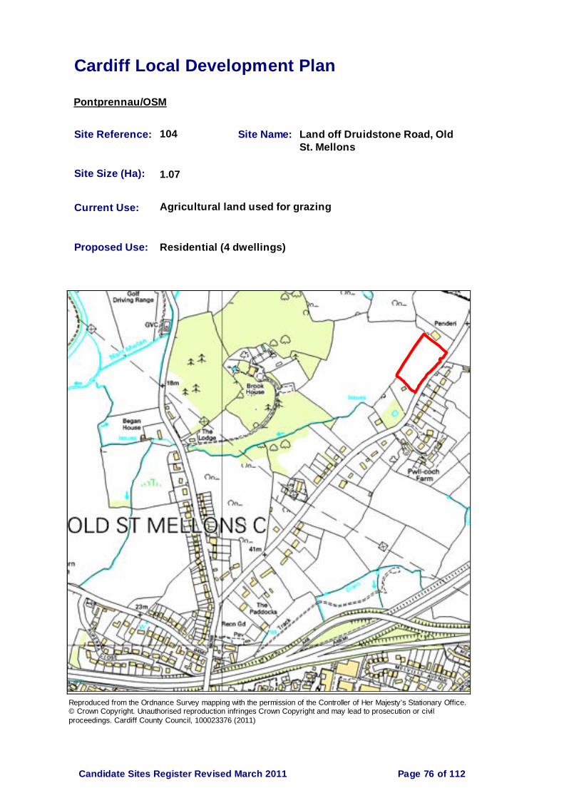
Cardiff Local Development Plan
Pontprennau/OSM
Site Reference: 104 Site Name: Land off Druidstone Road, Old St. Mellons
Site Size (Ha): 1.07
Current Use: Agricultural land used for grazing
Proposed Use: Residential (4 dwellings)
Reproduced from the Ordnance Survey mapping with the permission of the Controller of Her Majesty’s Stationary Office. © Crown Copyright. Unauthorised reproduction infringes Crown Copyright and may lead to prosecution or civil proceedings. Cardiff County Council, 100023376 (2011)
Page 76 of 112Candidate Sites Register Revised March 2011

Cardiff Local Development Plan
Pontprennau/OSM
Site Reference: 105 Site Name: Land off Druidstone Road, Old St. Mellons (Site 2)
Site Size (Ha): 6.96
Current Use: Agricultural land used for grazing
Proposed Use: Residential (20 dwellings)
Reproduced from the Ordnance Survey mapping with the permission of the Controller of Her Majesty’s Stationary Office. © Crown Copyright. Unauthorised reproduction infringes Crown Copyright and may lead to prosecution or civil proceedings. Cardiff County Council, 100023376 (2011)
Page 77 of 112Candidate Sites Register Revised March 2011

Cardiff Local Development Plan
Pontprennau/OSM
Site Reference: 109 Site Name: Land at Bridge Road, Old St. Mellons
Site Size (Ha): 0.87
Current Use: Paddocks
Proposed Use: Residential (12 dwellings)
Reproduced from the Ordnance Survey mapping with the permission of the Controller of Her Majesty’s Stationary Office. © Crown Copyright. Unauthorised reproduction infringes Crown Copyright and may lead to prosecution or civil proceedings. Cardiff County Council, 100023376 (2011)
Page 78 of 112Candidate Sites Register Revised March 2011

Cardiff Local Development Plan
Pontprennau/OSM
Site Reference: 110 Site Name: Land north east of Cefn Eurwg, Druidstone Road, Old St. Mellons
Site Size (Ha): 0.40
Current Use: Vacant
Proposed Use: Residential (3-4 dwellings)
Reproduced from the Ordnance Survey mapping with the permission of the Controller of Her Majesty’s Stationary Office. © Crown Copyright. Unauthorised reproduction infringes Crown Copyright and may lead to prosecution or civil proceedings. Cardiff County Council, 100023376 (2011)
Page 79 of 112Candidate Sites Register Revised March 2011

Cardiff Local Development Plan
Pontprennau/OSM
Site Reference: 112 Site Name: North East Cardiff
Site Size (Ha): 238.00
Current Use: Agriculture/woodland
Proposed Use: Residential, local centre, mixed use, employment, education, POS, landscaping & infrastructure (4500 dwellings)
Reproduced from the Ordnance Survey mapping with the permission of the Controller of Her Majesty’s Stationary Office. © Crown Copyright. Unauthorised reproduction infringes Crown Copyright and may lead to prosecution or civil proceedings. Cardiff County Council, 100023376 (2011)
Page 80 of 112Candidate Sites Register Revised March 2011

Cardiff Local Development Plan
Radyr
Site Reference: 63 Site Name: Former compound, former Cwm Farm, Morganstown
Site Size (Ha): 0.52
Current Use: Vacant, former compound
Proposed Use: Retail
Reproduced from the Ordnance Survey mapping with the permission of the Controller of Her Majesty’s Stationary Office. © Crown Copyright. Unauthorised reproduction infringes Crown Copyright and may lead to prosecution or civil proceedings. Cardiff County Council, 100023376 (2011)
Page 81 of 112Candidate Sites Register Revised March 2011

Cardiff Local Development Plan
Radyr
Site Reference: 64 Site Name: Former compound, former Cwm Farm, Morganstown
Site Size (Ha): 0.52
Current Use: Vacant, former compound
Proposed Use: Residential (7 dwellings)
Reproduced from the Ordnance Survey mapping with the permission of the Controller of Her Majesty’s Stationary Office. © Crown Copyright. Unauthorised reproduction infringes Crown Copyright and may lead to prosecution or civil proceedings. Cardiff County Council, 100023376 (2011)
Page 82 of 112Candidate Sites Register Revised March 2011

Cardiff Local Development Plan
Radyr
Site Reference: 65 Site Name: Land at former Cwm Farm, Morganstown
Site Size (Ha): 0.62
Current Use: Vacant greenfield
Proposed Use: Residential (7 dwellings)
Reproduced from the Ordnance Survey mapping with the permission of the Controller of Her Majesty’s Stationary Office. © Crown Copyright. Unauthorised reproduction infringes Crown Copyright and may lead to prosecution or civil proceedings. Cardiff County Council, 100023376 (2011)
Page 83 of 112Candidate Sites Register Revised March 2011

Cardiff Local Development Plan
Radyr
Site Reference: 107 Site Name: Land at Gelynis Farm, Morganstown
Site Size (Ha): 10.50
Current Use: Grazing, access land, nursery & railway land
Proposed Use: Residential (300 dwellings)
Reproduced from the Ordnance Survey mapping with the permission of the Controller of Her Majesty’s Stationary Office. © Crown Copyright. Unauthorised reproduction infringes Crown Copyright and may lead to prosecution or civil proceedings. Cardiff County Council, 100023376 (2011)
Page 84 of 112Candidate Sites Register Revised March 2011
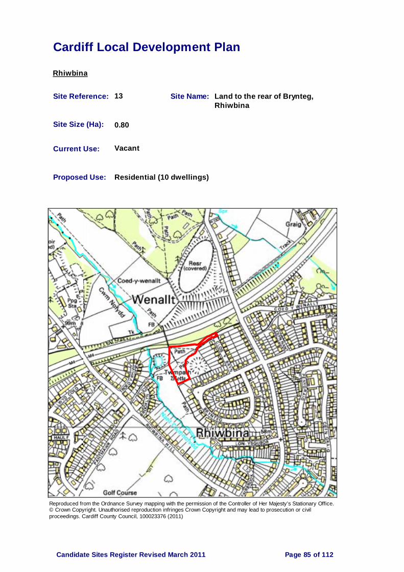
Cardiff Local Development Plan
Rhiwbina
Site Reference: 13 Site Name: Land to the rear of Brynteg, Rhiwbina
Site Size (Ha): 0.80
Current Use: Vacant
Proposed Use: Residential (10 dwellings)
Reproduced from the Ordnance Survey mapping with the permission of the Controller of Her Majesty’s Stationary Office. © Crown Copyright. Unauthorised reproduction infringes Crown Copyright and may lead to prosecution or civil proceedings. Cardiff County Council, 100023376 (2011)
Page 85 of 112Candidate Sites Register Revised March 2011

Cardiff Local Development Plan
Rhiwbina
Site Reference: 37 Site Name: Greenhill School, Rhiwbina
Site Size (Ha): 3.50
Current Use: Education
Proposed Use: Residential (78 dwellings) & assisted living accommodation (60 bed)
Reproduced from the Ordnance Survey mapping with the permission of the Controller of Her Majesty’s Stationary Office. © Crown Copyright. Unauthorised reproduction infringes Crown Copyright and may lead to prosecution or civil proceedings. Cardiff County Council, 100023376 (2011)
Page 86 of 112Candidate Sites Register Revised March 2011

Cardiff Local Development Plan
Rhiwbina
Site Reference: 50 Site Name: Land at Briwnant
Site Size (Ha): 157.00
Current Use: Grazing land
Proposed Use: Residential, village centre, primary school, local shopping & community facilities, business park, park & ride facility. Country park. (1200 dwellings)
Reproduced from the Ordnance Survey mapping with the permission of the Controller of Her Majesty’s Stationary Office. © Crown Copyright. Unauthorised reproduction infringes Crown Copyright and may lead to prosecution or civil proceedings. Cardiff County Council, 100023376 (2011)
Page 87 of 112Candidate Sites Register Revised March 2011

Cardiff Local Development Plan
Rhiwbina
Site Reference: 92 Site Name: Greenhill School, Heol Brynglas, Rhiwbina
Site Size (Ha): 4.00
Current Use: School
Proposed Use: Residential (110 dwellings)
Reproduced from the Ordnance Survey mapping with the permission of the Controller of Her Majesty’s Stationary Office. © Crown Copyright. Unauthorised reproduction infringes Crown Copyright and may lead to prosecution or civil proceedings. Cardiff County Council, 100023376 (2011)
Page 88 of 112Candidate Sites Register Revised March 2011

Cardiff Local Development Plan
Rhiwbina
Site Reference: 93 Site Name: Greenhill School, Heol Brynglas, Rhiwbina
Site Size (Ha): 4.00
Current Use: School
Proposed Use: Mixed use- new school & residential (80 dwellings)
Reproduced from the Ordnance Survey mapping with the permission of the Controller of Her Majesty’s Stationary Office. © Crown Copyright. Unauthorised reproduction infringes Crown Copyright and may lead to prosecution or civil proceedings. Cardiff County Council, 100023376 (2011)
Page 89 of 112Candidate Sites Register Revised March 2011
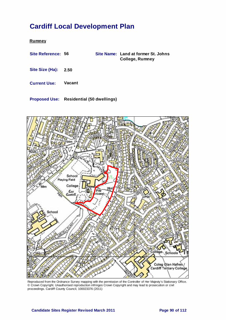
Cardiff Local Development Plan
Rumney
Site Reference: 56 Site Name: Land at former St. Johns College, Rumney
Site Size (Ha): 2.50
Current Use: Vacant
Proposed Use: Residential (50 dwellings)
Reproduced from the Ordnance Survey mapping with the permission of the Controller of Her Majesty’s Stationary Office. © Crown Copyright. Unauthorised reproduction infringes Crown Copyright and may lead to prosecution or civil proceedings. Cardiff County Council, 100023376 (2011)
Page 90 of 112Candidate Sites Register Revised March 2011

Cardiff Local Development Plan
Splott
Site Reference: 19 Site Name: Pengam Green
Site Size (Ha): 23.86
Current Use: Vacant
Proposed Use: Employment B1, B2 & B8
Reproduced from the Ordnance Survey mapping with the permission of the Controller of Her Majesty’s Stationary Office. © Crown Copyright. Unauthorised reproduction infringes Crown Copyright and may lead to prosecution or civil proceedings. Cardiff County Council, 100023376 (2011)
Page 91 of 112Candidate Sites Register Revised March 2011

Cardiff Local Development Plan
Splott
Site Reference: 58 Site Name: Rear of 353-379 Moorland Road, Splott
Site Size (Ha): 0.03
Current Use: Gardens
Proposed Use: Residential (10 dwellings)
Reproduced from the Ordnance Survey mapping with the permission of the Controller of Her Majesty’s Stationary Office. © Crown Copyright. Unauthorised reproduction infringes Crown Copyright and may lead to prosecution or civil proceedings. Cardiff County Council, 100023376 (2011)
Page 92 of 112Candidate Sites Register Revised March 2011

Cardiff Local Development Plan
Trowbridge
Site Reference: 1 Site Name: Land at Wentloog Levels
Site Size (Ha): 28.00
Current Use: Grazing
Proposed Use: Residential, Business/Industry
Reproduced from the Ordnance Survey mapping with the permission of the Controller of Her Majesty’s Stationary Office. © Crown Copyright. Unauthorised reproduction infringes Crown Copyright and may lead to prosecution or civil proceedings. Cardiff County Council, 100023376 (2011)
Page 93 of 112Candidate Sites Register Revised March 2011

Cardiff Local Development Plan
Trowbridge
Site Reference: 2 Site Name: Land at St. Mellons Business Park
Site Size (Ha): 3.90
Current Use: Grazing
Proposed Use: Residential or Business/Industry
Reproduced from the Ordnance Survey mapping with the permission of the Controller of Her Majesty’s Stationary Office. © Crown Copyright. Unauthorised reproduction infringes Crown Copyright and may lead to prosecution or civil proceedings. Cardiff County Council, 100023376 (2011)
Page 94 of 112Candidate Sites Register Revised March 2011

Cardiff Local Development Plan
Trowbridge
Site Reference: 3 Site Name: Land at Pill Du Farm, Hendre Lane, Trowbridge
Site Size (Ha): 0.47
Current Use: Yard & Scrub land
Proposed Use: Residential (4 dwellings)
Reproduced from the Ordnance Survey mapping with the permission of the Controller of Her Majesty’s Stationary Office. © Crown Copyright. Unauthorised reproduction infringes Crown Copyright and may lead to prosecution or civil proceedings. Cardiff County Council, 100023376 (2011)
Page 95 of 112Candidate Sites Register Revised March 2011

Cardiff Local Development Plan
Trowbridge
Site Reference: 21 Site Name: Land at areas 9-12, St. Mellons
Site Size (Ha): 18.80
Current Use: Nil use/informal grazing
Proposed Use: Residential (450-500 dwellings)
Reproduced from the Ordnance Survey mapping with the permission of the Controller of Her Majesty’s Stationary Office. © Crown Copyright. Unauthorised reproduction infringes Crown Copyright and may lead to prosecution or civil proceedings. Cardiff County Council, 100023376 (2011)
Page 96 of 112Candidate Sites Register Revised March 2011

Cardiff Local Development Plan
Trowbridge
Site Reference: 22 Site Name: Trowbridge Mawr - land west of Trowbridge Road, south of Greenway Park and north of Wentloog RoadSite Size (Ha): 35.00
Current Use: Nil use/informal grazing
Proposed Use: Mixed residential/industrial/public open space (300-350 dwellings)
Reproduced from the Ordnance Survey mapping with the permission of the Controller of Her Majesty’s Stationary Office. © Crown Copyright. Unauthorised reproduction infringes Crown Copyright and may lead to prosecution or civil proceedings. Cardiff County Council, 100023376 (2011)
Page 97 of 112Candidate Sites Register Revised March 2011

Cardiff Local Development Plan
Trowbridge
Site Reference: 23 Site Name: Land between Crickhowell Road and Willowbrook Drive, St. Mellons
Site Size (Ha): 5.60
Current Use: Nil use
Proposed Use: Residential and public open space (150 dwellings)
Reproduced from the Ordnance Survey mapping with the permission of the Controller of Her Majesty’s Stationary Office. © Crown Copyright. Unauthorised reproduction infringes Crown Copyright and may lead to prosecution or civil proceedings. Cardiff County Council, 100023376 (2011)
Page 98 of 112Candidate Sites Register Revised March 2011

Cardiff Local Development Plan
Trowbridge
Site Reference: 24 Site Name: Land east of Cypress Drive, St. Mellons
Site Size (Ha): 9.50
Current Use: Nil use
Proposed Use: Commercial/light industrial B1, B2 & B8 uses; alternatively residential (350 dwellings)
Reproduced from the Ordnance Survey mapping with the permission of the Controller of Her Majesty’s Stationary Office. © Crown Copyright. Unauthorised reproduction infringes Crown Copyright and may lead to prosecution or civil proceedings. Cardiff County Council, 100023376 (2011)
Page 99 of 112Candidate Sites Register Revised March 2011

Cardiff Local Development Plan
Trowbridge
Site Reference: 49 Site Name: Blooms Garden Centre, St. Mellons
Site Size (Ha): 3.32
Current Use: Garden centre
Proposed Use: Housing/general retail/employment or mixed use (132 dwellings)
Reproduced from the Ordnance Survey mapping with the permission of the Controller of Her Majesty’s Stationary Office. © Crown Copyright. Unauthorised reproduction infringes Crown Copyright and may lead to prosecution or civil proceedings. Cardiff County Council, 100023376 (2011)
Page 100 of 112Candidate Sites Register Revised March 2011

Cardiff Local Development Plan
Trowbridge
Site Reference: 55 Site Name: Land at Trowbridge Road
Site Size (Ha): 1.56
Current Use: Field
Proposed Use: Residential (53 dwellings)
Reproduced from the Ordnance Survey mapping with the permission of the Controller of Her Majesty’s Stationary Office. © Crown Copyright. Unauthorised reproduction infringes Crown Copyright and may lead to prosecution or civil proceedings. Cardiff County Council, 100023376 (2011)
Page 101 of 112Candidate Sites Register Revised March 2011

Cardiff Local Development Plan
Trowbridge
Site Reference: 74 Site Name: Land east of Wentloog Corporate Industrial Park
Site Size (Ha): 8.30
Current Use: Agriculture/pasture
Proposed Use: Employment and waste
Reproduced from the Ordnance Survey mapping with the permission of the Controller of Her Majesty’s Stationary Office. © Crown Copyright. Unauthorised reproduction infringes Crown Copyright and may lead to prosecution or civil proceedings. Cardiff County Council, 100023376 (2011)
Page 102 of 112Candidate Sites Register Revised March 2011

Cardiff Local Development Plan
Trowbridge
Site Reference: 76 Site Name: Land south of Wentloog Avenue, Wentloog
Site Size (Ha): 60.00
Current Use: Waste management operations including waste transfer station and soil blending facility
Proposed Use: Waste management facility and include within defined settlement boundary and remove from SSSI
Reproduced from the Ordnance Survey mapping with the permission of the Controller of Her Majesty’s Stationary Office. © Crown Copyright. Unauthorised reproduction infringes Crown Copyright and may lead to prosecution or civil proceedings. Cardiff County Council, 100023376 (2011)
Page 103 of 112Candidate Sites Register Revised March 2011

Cardiff Local Development Plan
Trowbridge
Site Reference: 106 Site Name: Cardiff Parkway, east of Cypress Drive, St. Mellons
Site Size (Ha): 71.00
Current Use: Agriculture
Proposed Use: Rail station, park & ride, hotel, retail, business, landscaping
Reproduced from the Ordnance Survey mapping with the permission of the Controller of Her Majesty’s Stationary Office. © Crown Copyright. Unauthorised reproduction infringes Crown Copyright and may lead to prosecution or civil proceedings. Cardiff County Council, 100023376 (2011)
Page 104 of 112Candidate Sites Register Revised March 2011

Cardiff Local Development Plan
Whitchurch & Tongwynlais
Site Reference: 25 Site Name: Land at Cefn Garw Quarry, Tongwynlais
Site Size (Ha): 11.20
Current Use: Concrete batching plant and quarry with extant consent for extended working
Proposed Use: Residential and leisure recreation uses (100 dwellings)
Reproduced from the Ordnance Survey mapping with the permission of the Controller of Her Majesty’s Stationary Office. © Crown Copyright. Unauthorised reproduction infringes Crown Copyright and may lead to prosecution or civil proceedings. Cardiff County Council, 100023376 (2011)
Page 105 of 112Candidate Sites Register Revised March 2011

Cardiff Local Development Plan
Whitchurch & Tongwynlais
Site Reference: 26 Site Name: Land previously part of Ty Isaf Farm House
Site Size (Ha): 0.09
Current Use: None
Proposed Use: Residential (1 dwelling)
Reproduced from the Ordnance Survey mapping with the permission of the Controller of Her Majesty’s Stationary Office. © Crown Copyright. Unauthorised reproduction infringes Crown Copyright and may lead to prosecution or civil proceedings. Cardiff County Council, 100023376 (2011)
Page 106 of 112Candidate Sites Register Revised March 2011

Cardiff Local Development Plan
Whitchurch & Tongwynlais
Site Reference: 28 Site Name: Land North of Ty Isaf, Tongwynlais
Site Size (Ha): 0.87
Current Use: Pasture
Proposed Use: Residential (30 dwellings)
Reproduced from the Ordnance Survey mapping with the permission of the Controller of Her Majesty’s Stationary Office. © Crown Copyright. Unauthorised reproduction infringes Crown Copyright and may lead to prosecution or civil proceedings. Cardiff County Council, 100023376 (2011)
Page 107 of 112Candidate Sites Register Revised March 2011

Cardiff Local Development Plan
Whitchurch & Tongwynlais
Site Reference: 39 Site Name: Whitchurch Hospital Site 1
Site Size (Ha): 6.45
Current Use: Rough pasture
Proposed Use: Residential (137 dwellings)
Reproduced from the Ordnance Survey mapping with the permission of the Controller of Her Majesty’s Stationary Office. © Crown Copyright. Unauthorised reproduction infringes Crown Copyright and may lead to prosecution or civil proceedings. Cardiff County Council, 100023376 (2011)
Page 108 of 112Candidate Sites Register Revised March 2011
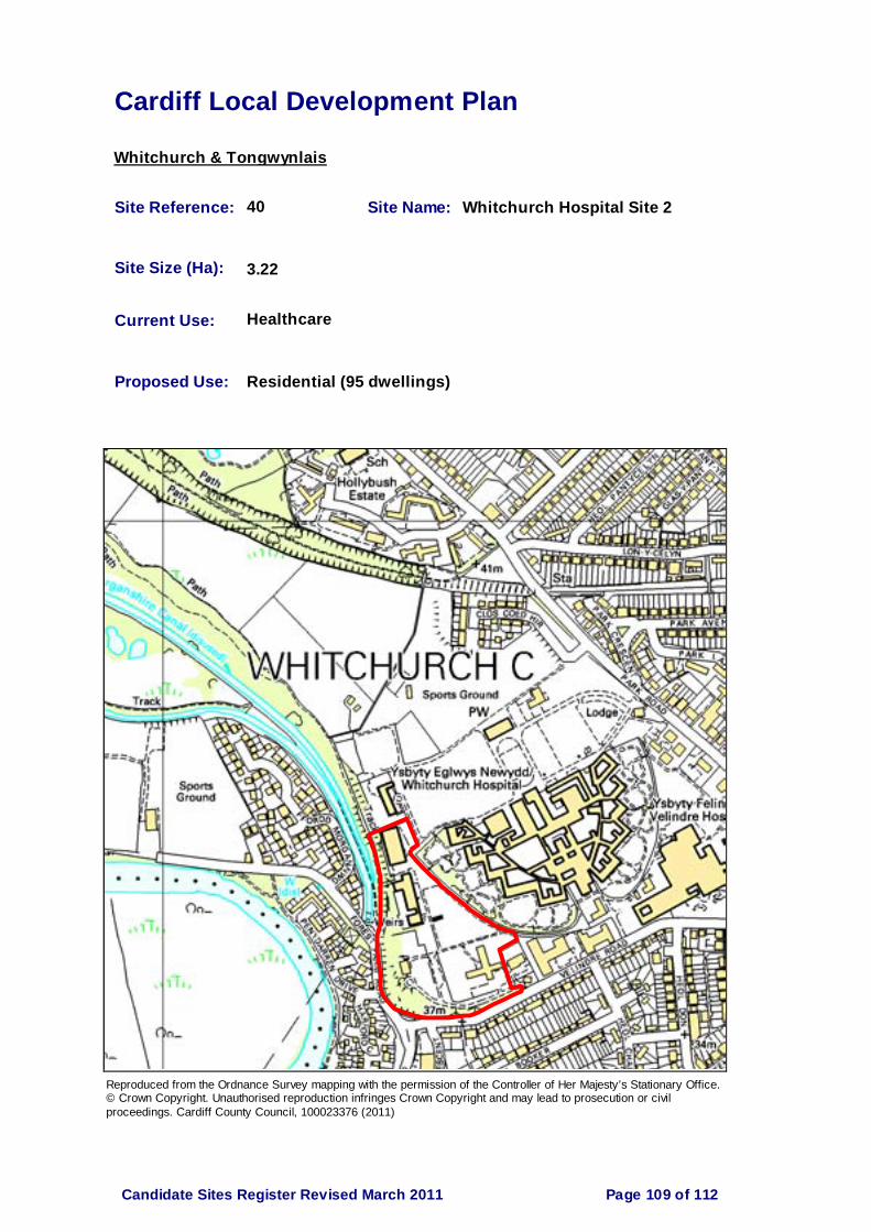
Cardiff Local Development Plan
Whitchurch & Tongwynlais
Site Reference: 40 Site Name: Whitchurch Hospital Site 2
Site Size (Ha): 3.22
Current Use: Healthcare
Proposed Use: Residential (95 dwellings)
Reproduced from the Ordnance Survey mapping with the permission of the Controller of Her Majesty’s Stationary Office. © Crown Copyright. Unauthorised reproduction infringes Crown Copyright and may lead to prosecution or civil proceedings. Cardiff County Council, 100023376 (2011)
Page 109 of 112Candidate Sites Register Revised March 2011

Cardiff Local Development Plan
Whitchurch & Tongwynlais
Site Reference: 41 Site Name: Whitchurch Hospital Site 3
Site Size (Ha): 14.20
Current Use: Healthcare & sports facilities
Proposed Use: Residential, community & possibly employment (100-120 dwellings)
Reproduced from the Ordnance Survey mapping with the permission of the Controller of Her Majesty’s Stationary Office. © Crown Copyright. Unauthorised reproduction infringes Crown Copyright and may lead to prosecution or civil proceedings. Cardiff County Council, 100023376 (2011)
Page 110 of 112Candidate Sites Register Revised March 2011

Cardiff Local Development Plan
Whitchurch & Tongwynlais
Site Reference: 42 Site Name: Whitchurch Hospital Site 4
Site Size (Ha): 1.41
Current Use: Building and incidental open space
Proposed Use: Community Health facility
Reproduced from the Ordnance Survey mapping with the permission of the Controller of Her Majesty’s Stationary Office. © Crown Copyright. Unauthorised reproduction infringes Crown Copyright and may lead to prosecution or civil proceedings. Cardiff County Council, 100023376 (2011)
Page 111 of 112Candidate Sites Register Revised March 2011

Cardiff Local Development Plan
Whitchurch & Tongwynlais
Site Reference: 51 Site Name: Land at Mill Road, Tongwynlais
Site Size (Ha): 0.40
Current Use: Unused, previously part of Castle Farm
Proposed Use: Residential (5 dwellings)
Reproduced from the Ordnance Survey mapping with the permission of the Controller of Her Majesty’s Stationary Office. © Crown Copyright. Unauthorised reproduction infringes Crown Copyright and may lead to prosecution or civil proceedings. Cardiff County Council, 100023376 (2011)
Page 112 of 112Candidate Sites Register Revised March 2011

Cardiff CouncilStrategic Planning & Environment
Room CY1 County Hall
Atlantic WharfCardiff
CF10 4UW