Embed Size (px)
Citation preview
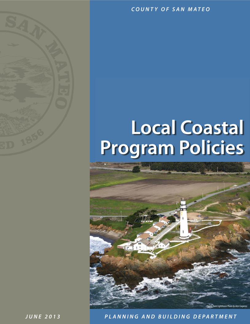
J U N E 2 0 1 3 P L A N N I N G A N D B U I L D I N G D E P A R T M E N T
C O U N T Y O F S A N M A T E O
Pigeon Point Lighthouse Photo by Jitze Couperus
Local Coastal Program Policies

June 18, 2013 Dear Interested Citizens: In late 1980, the County Board of Supervisors and the California Coastal Commission approved the San Mateo County’s Local Coastal Program. In April 1981, the County assumed responsibility for implementing the State Coastal Act in the unincorporated area of San Mateo County, including issuance of Coastal Development Permits. All development in the Coastal Zone requires either a Coastal Development Permit or an exemption from Coastal Development Permit requirements. For a permit to be issued, the development must comply with the policies of the Local Coastal Program (LCP) and those ordinances adopted to implement the LCP. The project must also comply with other provisions of the County Ordinance Code, such as zoning, building and health regulations. This edition contains all Local Coastal Program policies, with amendments approved through August 8, 2012. We hope it will help you understand the requirements of the County’s LCP. Those planning projects located within the Coastal Zone should be designed to comply with these as well as other County requirements. These policies are adopted by reference in the County’s Zoning Regulations under Chapter 20B, Section 6328.19 through 6328.30. The staff at the Planning and Building Department (Second Floor, 455 County Center, Redwood City, CA 94063; Telephone 650/363-4161) is prepared to answer your questions about specific properties in the Coastal Zone, permit application procedures, provisions of the LCP and other pertinent County ordinances. Sincerely, Jim Eggemeyer Community Development Director
County of San Mateo
Planning & Building DepartmentMail Drop PLN122
www.co.sanmateo.ca.us/planning
455 County Center, 2nd FloorRedwood City, California 94063650/363-4161 Fax: 650/363-4849
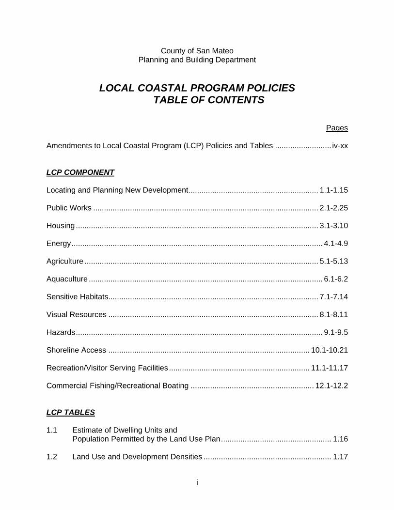
i
County of San Mateo Planning and Building Department
LOCAL COASTAL PROGRAM POLICIES TABLE OF CONTENTS
Pages Amendments to Local Coastal Program (LCP) Policies and Tables .......................... iv-xx LCP COMPONENT Locating and Planning New Development ............................................................ 1.1-1.15 Public Works ........................................................................................................ 2.1-2.25 Housing ................................................................................................................ 3.1-3.10 Energy .................................................................................................................... 4.1-4.9 Agriculture ............................................................................................................ 5.1-5.13 Aquaculture ............................................................................................................ 6.1-6.2 Sensitive Habitats................................................................................................. 7.1-7.14 Visual Resources ................................................................................................. 8.1-8.11 Hazards .................................................................................................................. 9.1-9.5 Shoreline Access ............................................................................................. 10.1-10.21 Recreation/Visitor Serving Facilities ................................................................. 11.1-11.17 Commercial Fishing/Recreational Boating ......................................................... 12.1-12.2 LCP TABLES 1.1 Estimate of Dwelling Units and Population Permitted by the Land Use Plan ................................................... 1.16 1.2 Land Use and Development Densities ........................................................... 1.17
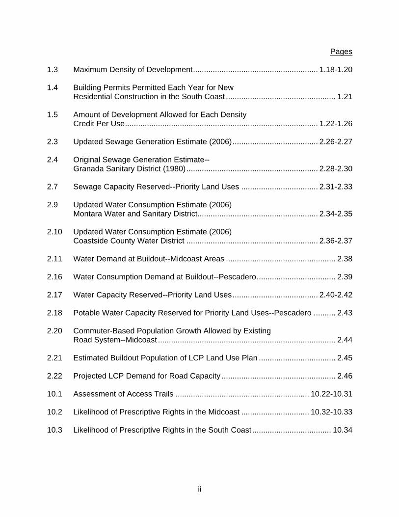
Pages
ii
1.3 Maximum Density of Development ......................................................... 1.18-1.20 1.4 Building Permits Permitted Each Year for New Residential Construction in the South Coast .................................................. 1.21 1.5 Amount of Development Allowed for Each Density Credit Per Use ........................................................................................ 1.22-1.26 2.3 Updated Sewage Generation Estimate (2006) ....................................... 2.26-2.27 2.4 Original Sewage Generation Estimate-- Granada Sanitary District (1980) ............................................................ 2.28-2.30 2.7 Sewage Capacity Reserved--Priority Land Uses ................................... 2.31-2.33 2.9 Updated Water Consumption Estimate (2006) Montara Water and Sanitary District....................................................... 2.34-2.35 2.10 Updated Water Consumption Estimate (2006) Coastside County Water District ............................................................ 2.36-2.37 2.11 Water Demand at Buildout--Midcoast Areas .................................................. 2.38 2.16 Water Consumption Demand at Buildout--Pescadero .................................... 2.39 2.17 Water Capacity Reserved--Priority Land Uses ....................................... 2.40-2.42 2.18 Potable Water Capacity Reserved for Priority Land Uses--Pescadero .......... 2.43 2.20 Commuter-Based Population Growth Allowed by Existing Road System--Midcoast ................................................................................. 2.44 2.21 Estimated Buildout Population of LCP Land Use Plan ................................... 2.45 2.22 Projected LCP Demand for Road Capacity .................................................... 2.46 10.1 Assessment of Access Trails ............................................................. 10.22-10.31 10.2 Likelihood of Prescriptive Rights in the Midcoast ............................... 10.32-10.33 10.3 Likelihood of Prescriptive Rights in the South Coast .................................... 10.34
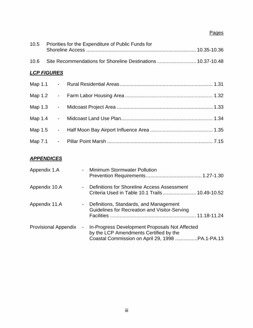
Pages
iii
10.5 Priorities for the Expenditure of Public Funds for Shoreline Access ............................................................................... 10.35-10.36 10.6 Site Recommendations for Shoreline Destinations ............................ 10.37-10.48 LCP FIGURES Map 1.1 - Rural Residential Areas ................................................................... 1.31 Map 1.2 - Farm Labor Housing Area ............................................................... 1.32 Map 1.3 - Midcoast Project Area ..................................................................... 1.33 Map 1.4 - Midcoast Land Use Plan .................................................................. 1.34 Map 1.5 - Half Moon Bay Airport Influence Area ............................................. 1.35 Map 7.1 - Pillar Point Marsh ............................................................................ 7.15 APPENDICES Appendix 1.A - Minimum Stormwater Pollution Prevention Requirements ........................................ 1.27-1.30 Appendix 10.A - Definitions for Shoreline Access Assessment Criteria Used in Table 10.1 Trails ........................ 10.49-10.52 Appendix 11.A - Definitions, Standards, and Management Guidelines for Recreation and Visitor-Serving Facilities .............................................................. 11.18-11.24 Provisional Appendix - In-Progress Development Proposals Not Affected by the LCP Amendments Certified by the Coastal Commission on April 29, 1998 ................ PA.1-PA.13

iv
1982 AMENDMENTS TO LCP POLICIES By Resolution No. 43219 - April 6, 1982
Component 1. Locating and Planning New Development Delete Renumber Amend Add 1.5(c) 1.15(d) 1.8(b)(c) Component 2. Public Works Delete Renumber Amend Add 2.53 2.13 to 2.14 2.16 2.13 2.14 to 2.15 2.19(a) 2.19(b)(c)(d)(e)(f)(g) 2.15 to 2.16 2.20 2.16 to 2.17 2.21(a) 2.17 to 2.18 2.28 2.18 to 2.19 2.29 2.19 to 2.20 2.32(a) 2.20 to 2.21 2.33 2.21 to 2.22 2.35(b) 2.22 to 2.23 2.41 2.23 to 2.24 2.44(d) 2.24 to 2.25 2.59(c) 2.25 to 2.26 2.26 to 2.27 2.27 to 2.28 2.28 to 2.29 2.29 to 2.30 2.30 to 2.31 2.31 to 2.32 2.31A to 2.33 2.32 to 2.34 2.33 to 2.35 2.34 to 2.36 2.35 to 2.37 2.36 to 2.38 2.37 to 2.39 2.38 to 2.40 2.39 to 2.41 2.40 to 2.42 2.41 to 2.43 2.42 to 2.44 2.43 to 2.45 2.44 to 2.46 2.45 to 2.47
v
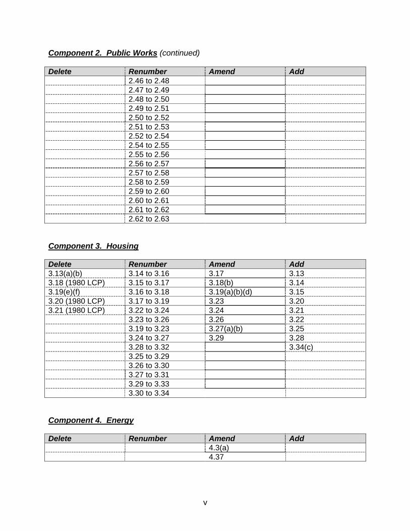
Component 2. Public Works (continued) Delete Renumber Amend Add 2.46 to 2.48 2.47 to 2.49 2.48 to 2.50 2.49 to 2.51 2.50 to 2.52 2.51 to 2.53 2.52 to 2.54 2.54 to 2.55 2.55 to 2.56 2.56 to 2.57 2.57 to 2.58 2.58 to 2.59 2.59 to 2.60 2.60 to 2.61 2.61 to 2.62 2.62 to 2.63 Component 3. Housing Delete Renumber Amend Add 3.13(a)(b) 3.14 to 3.16 3.17 3.13 3.18 (1980 LCP) 3.15 to 3.17 3.18(b) 3.14 3.19(e)(f) 3.16 to 3.18 3.19(a)(b)(d) 3.15 3.20 (1980 LCP) 3.17 to 3.19 3.23 3.20 3.21 (1980 LCP) 3.22 to 3.24 3.24 3.21 3.23 to 3.26 3.26 3.22 3.19 to 3.23 3.27(a)(b) 3.25 3.24 to 3.27 3.29 3.28 3.28 to 3.32 3.34(c) 3.25 to 3.29 3.26 to 3.30 3.27 to 3.31 3.29 to 3.33 3.30 to 3.34 Component 4. Energy Delete Renumber Amend Add 4.3(a) 4.37

vi
Component 5. Agriculture Delete Renumber Amend Add 5.2 5.1(4)(5) 5.3 5.4 5.5 5.6 5.7 5.8 5.9 5.10 5.16 Component 7. Sensitive Habitats Delete Renumber Amend Add 7.9(b) 7.5(a) 7.18 7.15(b) Component 9. Hazards Delete Renumber Amend Add 9.3(c) to 9.3(b) 9.3(c) 9.3(d) to 9.3(c) 9.10 9.3(e) to 9.e(d) Component 10. Shoreline Access Delete Renumber Amend Add 10.39A to 10.40 10.11(a) 10.40 to 10.41 10.30(c)(2) 10.41 to 10.42 10.42 to 10.43 10.43 to 10.44 10.44 to 10.45 10.45 to 10.46 10.46 to 10.47
vii
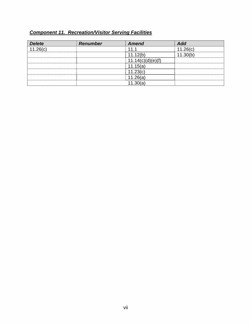
Component 11. Recreation/Visitor Serving Facilities Delete Renumber Amend Add 11.26(c) 11.1 11.26(c) 11.12(b) 11.30(b) 11.14(c)(d)(e)(f) 11.15(a) 11.23(c) 11.26(a) 11.30(a)
viii
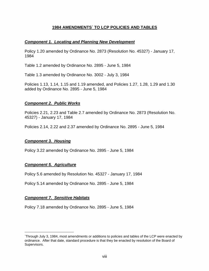
1984 AMENDMENTS∗
TO LCP POLICIES AND TABLES
Component 1. Locating and Planning New Development Policy 1.20 amended by Ordinance No. 2873 (Resolution No. 45327) - January 17, 1984 Table 1.2 amended by Ordinance No. 2895 - June 5, 1984 Table 1.3 amended by Ordinance No. 3002 - July 3, 1984 Policies 1.13, 1.14, 1.15 and 1.19 amended, and Policies 1.27, 1.28, 1.29 and 1.30 added by Ordinance No. 2895 - June 5, 1984 Component 2. Public Works Policies 2.21, 2.23 and Table 2.7 amended by Ordinance No. 2873 (Resolution No. 45327) - January 17, 1984 Policies 2.14, 2.22 and 2.37 amended by Ordinance No. 2895 - June 5, 1984 Component 3. Housing Policy 3.22 amended by Ordinance No. 2895 - June 5, 1984 Component 5. Agriculture Policy 5.6 amended by Resolution No. 45327 - January 17, 1984 Policy 5.14 amended by Ordinance No. 2895 - June 5, 1984 Component 7. Sensitive Habitats Policy 7.18 amended by Ordinance No. 2895 - June 5, 1984
∗Through July 3, 1984, most amendments or additions to policies and tables of the LCP were enacted by ordinance. After that date, standard procedure is that they be enacted by resolution of the Board of Supervisors.
ix
Component 8. Visual Resources Policy 8.22 amended, and Policies 8.23, 8.33 and 8.34 added by Ordinance No. 2895 - June 5, 1984 Component 9. Hazards Policies 9.2 and 9.9 amended by Ordinance No. 3002 - July 3, 1984
1986 AMENDMENTS TO LCP POLICIES AND TABLES Component 1. Locating and Planning New Development Policy 1.20 amended by Resolution No. 47809 - March 4, 1986 Table 1.4 amended by Resolution No. 47809 - March 4, 1986 Component 2. Public Works Tables 2.3, 2.4, 2.9, 2.10, 2.11, 2.21 and 2.22 amended by Resolution No. 47809 - March 4, 1986. Component 3. Housing Policies 3.20, 3.21, 3.28 and 3.29 amended by Resolution No. 47809 - March 4, 1986 Policy 3.24 amended by Resolution No. 47809 - March 4, 1986
x
1987 AMENDMENTS TO LCP POLICIES AND TABLES Component 1. Locating and Planning New Development Policies 1.32 and 1.33 added by Resolution No. 49044 - April 14, 1987 (see note below) Map 1.2 added by Resolution No. 49044 - April 14, 1987 Table 1.2 amended by Resolution No. 49044 - April 14, 1987 Component 2. Public Works Policy 2.8 amended by Resolution No. 49673 - October 6, 1987 Tables 2.7 and 2.17 amended by Resolution No. 48673 - October 6, 1987 Component 3. Housing Policy 3.35 amended by Resolution No. 49044 - April 14, 1987 Policies 3.16 and 3.19 amended by Resolution No. 49673 - October 6, 1987 Component 5. Agriculture Policy 5.19 amended by Resolution No. 49044 - April 14, 1987 Component 7. Sensitive Habitats Policy 7.9 amended by Resolution No. 49044 - April 14, 1987 Component 10. Shoreline Access Policies 10.1, 10.2, 10.11 and 10.30 amended by Resolution No. 49044 - April 14, 1987 Note: Policies 1.32 and 1.33 are identified as Policies 1.31 and 1.32, respectively, in
Resolution No. 49044 (April 14, 1987). The change in numbering was required to eliminate duplication of numbering and confusion with Policy *1.31, a “Measure A” policy added by Resolution No. 50289 (April 26, 1988).
xi
1988 AMENDMENTS TO LCP POLICIES AND TABLES Component 1. Locating and Planning New Development Policies 1.7, 1.8, 1.9, 1.18, 1.28 and 1.29 amended by Resolution No. 50289 - April 26, 1988 Policy 1.31 added by Resolution No. 50289 - April 26, 1988 Table 1.3 amended by Resolution No. 50289 - April 26, 1988 Component 2. Public Works Policies 2.4, 2.6, 2.14 and 2.15 amended by Resolution No. 50289 - April 26, 1988 Component 4. Energy Policies 4.23 through 4.41 amended/renumbered by Resolution No. 50289 - April 26, 1988 Policy 4.42 added/renumbered by Resolution No. 50289 - April 26, 1988 Component 5. Agriculture Policy 5.1 through 5.16 and Policy 5.22 amended by Resolution No. 50289 - April 26, 1988 Component 7. Sensitive Habitats Policies 7.1, 7.3 and 7.4 amended by Resolution No. 50289 - April 26, 1988 Component 8. Visual Resources Policies 8.5, 8.7, 8.15 and 8.18 amended by Resolution No. 50289 - April 26, 1988

xii
Component 9. Hazards Policies 9.2 and 9.9 amended by Ordinance No. 3150 - August 30, 1988.∗
Note: Resolution No. 50289 put into effect the voter initiative approved on November 4, 1986,
and commonly referred to as Measure A. In 1988, Resolution No. 50289 adopted amendments specifically voted upon on
November 4, 1986, by initiative of the citizens of San Mateo County (commonly known as Measure A). In doing so, Policy 1.31 was added in order to provide a specific procedure for future amendments to certain policies marked with an asterisk (*). These policies are found in the following components of the LCP: Locating and Planning New Development, Public Works, Energy, Agriculture, Sensitive Habitats, and Visual Resources.
It should be noted that Policy 7.4 (marked with an asterisk) refers to Policies 7.9, 7.16,
7.23, 7.26, 7.30, 7.33 and 7.44 (without asterisks) as they existed on March 25, 1986; any amendment to these policies will therefore require an amendment to Policy 7.4.
∗This amendment is an exception to the rule that revisions be accomplished by resolution of the Board of Supervisors.
xiii
1990 AMENDMENTS TO LCP POLICIES AND TABLES Component 2. Public Works Tables 2.4, 2.7, 2.10 and 2.17 amended by Resolution No. 54517 - November 20, 1990
1991 AMENDMENTS TO LCP POLICIES AND TABLES Component 11. Recreation/Visitor Serving Facilities Policy 11.7 amended by Resolution No. 54823 - March 12, 1991
1992 AMENDMENTS TO LCP POLICIES AND TABLES Component 2. Public Works Policy 2.37(c)(6) amended by Resolution No. 56015 - April 7, 1992. Table 2.17 amended by Resolution No. 56015 - April 7, 1992
1993 AMENDMENTS TO LCP POLICIES AND TABLES Component 2. Public Works Policy 2.45 amended by Resolution No. 57533 - September 14, 1993 Tables 2.16 and 2.18 amended by Resolution No. 57533 - September 14, 1993
xiv
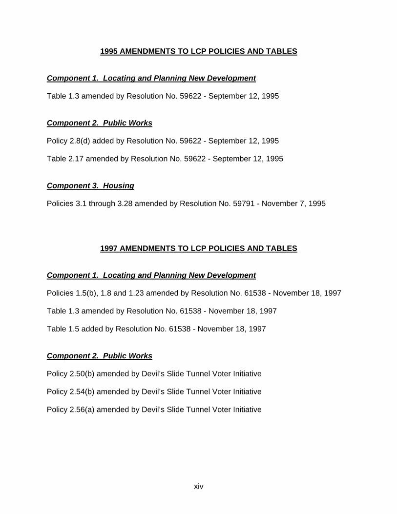
1995 AMENDMENTS TO LCP POLICIES AND TABLES Component 1. Locating and Planning New Development Table 1.3 amended by Resolution No. 59622 - September 12, 1995 Component 2. Public Works Policy 2.8(d) added by Resolution No. 59622 - September 12, 1995 Table 2.17 amended by Resolution No. 59622 - September 12, 1995 Component 3. Housing Policies 3.1 through 3.28 amended by Resolution No. 59791 - November 7, 1995
1997 AMENDMENTS TO LCP POLICIES AND TABLES Component 1. Locating and Planning New Development Policies 1.5(b), 1.8 and 1.23 amended by Resolution No. 61538 - November 18, 1997 Table 1.3 amended by Resolution No. 61538 - November 18, 1997 Table 1.5 added by Resolution No. 61538 - November 18, 1997 Component 2. Public Works Policy 2.50(b) amended by Devil’s Slide Tunnel Voter Initiative Policy 2.54(b) amended by Devil’s Slide Tunnel Voter Initiative Policy 2.56(a) amended by Devil’s Slide Tunnel Voter Initiative
xv
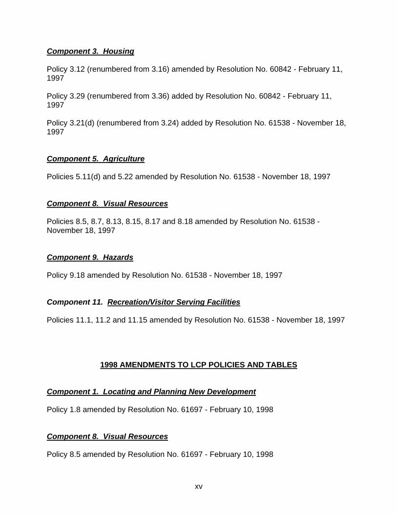
Component 3. Housing Policy 3.12 (renumbered from 3.16) amended by Resolution No. 60842 - February 11, 1997 Policy 3.29 (renumbered from 3.36) added by Resolution No. 60842 - February 11, 1997 Policy 3.21(d) (renumbered from 3.24) added by Resolution No. 61538 - November 18, 1997 Component 5. Agriculture Policies 5.11(d) and 5.22 amended by Resolution No. 61538 - November 18, 1997 Component 8. Visual Resources Policies 8.5, 8.7, 8.13, 8.15, 8.17 and 8.18 amended by Resolution No. 61538 - November 18, 1997 Component 9. Hazards Policy 9.18 amended by Resolution No. 61538 - November 18, 1997 Component 11. Recreation/Visitor Serving Facilities Policies 11.1, 11.2 and 11.15 amended by Resolution No. 61538 - November 18, 1997
1998 AMENDMENTS TO LCP POLICIES AND TABLES Component 1. Locating and Planning New Development Policy 1.8 amended by Resolution No. 61697 - February 10, 1998 Component 8. Visual Resources Policy 8.5 amended by Resolution No. 61697 - February 10, 1998

xvi
Component 11. Recreation/Visitor Serving Facilities Policy 11.15 amended by Resolution No. 61697 - February 10, 1998
2010 AMENDMENTS TO LCP POLICIES AND TABLES Component 8. Visual Resources Policies 8.12 and 8.13 amended by Resolution No. 66612 - April 20, 2004 and by Resolution No. 70738 - May 11, 2010
xvii
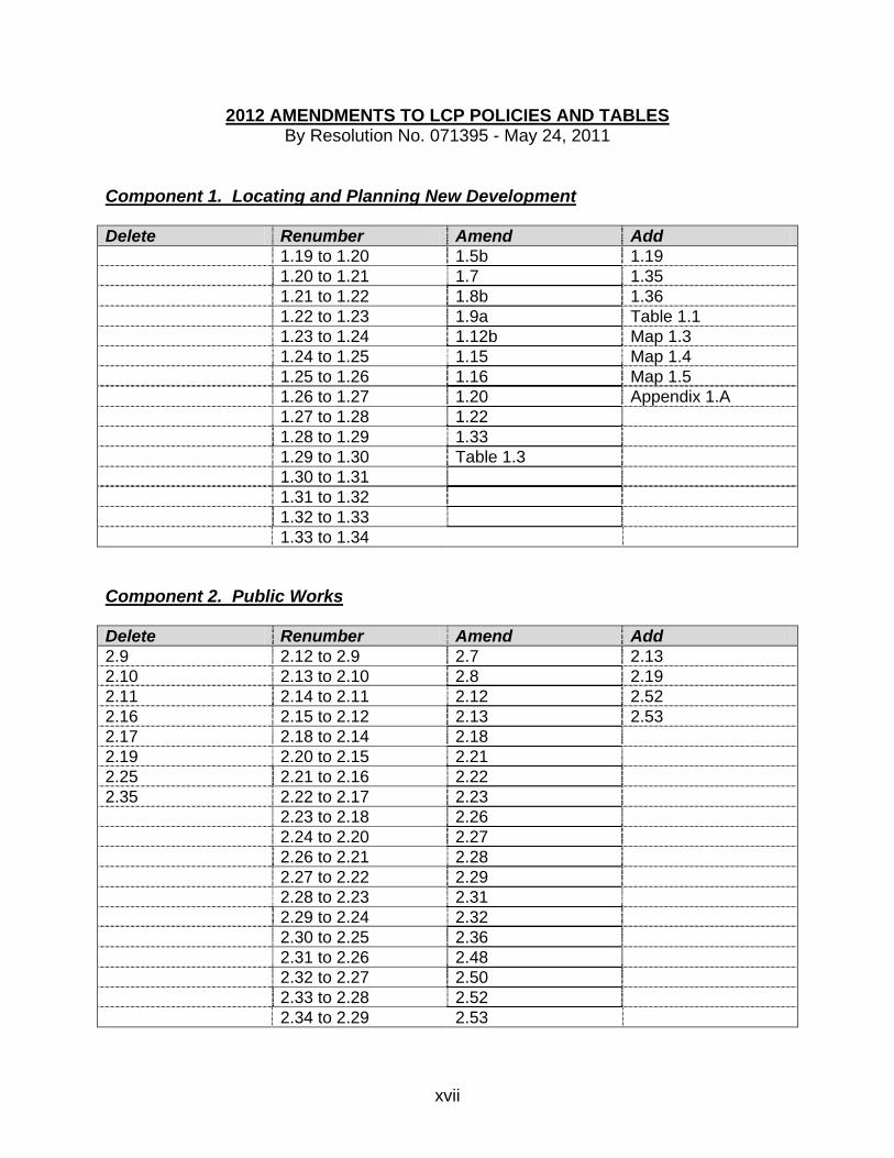
2012 AMENDMENTS TO LCP POLICIES AND TABLES By Resolution No. 071395 - May 24, 2011
Component 1. Locating and Planning New Development Delete Renumber Amend Add 1.19 to 1.20 1.5b 1.19 1.20 to 1.21 1.7 1.35 1.21 to 1.22 1.8b 1.36 1.22 to 1.23 1.9a Table 1.1 1.23 to 1.24 1.12b Map 1.3 1.24 to 1.25 1.15 Map 1.4 1.25 to 1.26 1.16 Map 1.5 1.26 to 1.27 1.20 Appendix 1.A 1.27 to 1.28 1.22 1.28 to 1.29 1.33 1.29 to 1.30 Table 1.3 1.30 to 1.31 1.31 to 1.32 1.32 to 1.33 1.33 to 1.34 Component 2. Public Works Delete Renumber Amend Add 2.9 2.12 to 2.9 2.7 2.13 2.10 2.13 to 2.10 2.8 2.19 2.11 2.14 to 2.11 2.12 2.52 2.16 2.15 to 2.12 2.13 2.53 2.17 2.18 to 2.14 2.18 2.19 2.20 to 2.15 2.21 2.25 2.21 to 2.16 2.22 2.35 2.22 to 2.17 2.23 2.23 to 2.18 2.26 2.24 to 2.20 2.27 2.26 to 2.21 2.28 2.27 to 2.22 2.29 2.28 to 2.23 2.31 2.29 to 2.24 2.32 2.30 to 2.25 2.36 2.31 to 2.26 2.48 2.32 to 2.27 2.50 2.33 to 2.28 2.52 2.34 to 2.29 2.53

xviii
Component 2. Public Works (continued) Delete Renumber Amend Add 2.36 to 2.30 2.54 2.37 to 2.31 2.55 2.38 to 2.32 2.56 2.39 to 2.33 2.57 2.40 to 2.34 Table 2.3 2.41 to 2.35 Table 2.4 2.42 to 2.36 Table 2.9 2.43 to 2.37 Table 2.10 2.44 to 2.38 Table 2.17 2.45 to 2.39 2.46 to 2.40 2.47 to 2.41 2.48 to 2.42 2.49 to 2.43 2.50 to 2.44 2.51 to 2.45 2.52 to 2.46 2.53 to 2.47 2.54 to 2.48 2.55 to 2.49 2.56 to 2.50 2.57 to 2.51 2.58 to 2.54 2.59 to 2.55 2.60 to 2.56 2.61 to 2.57 2.62 to 2.58 2.63 to 2.59 Component 3. Housing Delete Renumber Amend Add 3.17 to 3.18 3.11 3.17 3.18 to 3.19 3.14a 3.19 to 3.20 3.20 to 3.21 3.21 to 3.22 3.22 to 3.23 3.23 to 3.24 3.24 to 3.25 3.25 to 3.26 3.26 to 3.27
xix
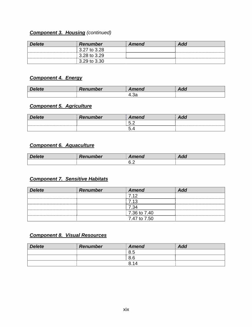
Component 3. Housing (continued) Delete Renumber Amend Add 3.27 to 3.28 3.28 to 3.29 3.29 to 3.30 Component 4. Energy Delete Renumber Amend Add 4.3a Component 5. Agriculture Delete Renumber Amend Add 5.2 5.4 Component 6. Aquaculture Delete Renumber Amend Add 6.2 Component 7. Sensitive Habitats Delete Renumber Amend Add 7.12 7.13 7.34 7.36 to 7.40 7.47 to 7.50 Component 8. Visual Resources Delete Renumber Amend Add 8.5 8.6 8.14

xx
Component 10. Shoreline Access Delete Renumber Amend Add 10.38 to 10.39 10.41 10.38 10.39 to 10.40 10.44 10.49 10.40 to 10.41 10.50 10.41 to 10.42 10.42 to 10.43 10.43 to 10.44 10.44 to 10.45 10.45 to 10.46 10.46 to 10.47 10.47 to 10.48 Component 11. Recreation/Visitor Serving Facilities Delete Renumber Amend Add 11.13 11.31 11.24 11.32 11.25 11.33 11.26 11.27 11.28 11.29 11.30
1.1
LOCATING AND PLANNING NEW DEVELOPMENT COMPONENT
DEVELOPMENT REVIEW 1.1 Coastal Development Permits After certification of the Local Coastal Program (LCP), require a Coastal
Development Permit for all development in the Coastal Zone subject to certain exemptions.
1.2 Definition of Development As stated in Section 30106 of the Coastal Act, define development to mean: On land, in or under water, the placement or erection of any solid material or
structure; discharge or disposal of any dredged material or any gaseous, liquid, solid, or thermal waste; grading, removing, dredging, mining, or extraction of any materials; change in the density or intensity of use of land, including, but not limited to, subdivision pursuant to the Subdivision Map Act (commencing with Section 66410 of the Government Code), and any other division of land, including lot splits, except where the land division is brought about in connection with the purchase of such land by a public agency for public recreational use; change in the intensity of use of water, or of access thereto; construction, reconstruction, demolition, or alteration of the size of any structure, including any facility of any private, public, or municipal utility; and the removal or harvesting of major vegetation other than for agricultural purposes, kelp harvesting, and timber operations which are in accordance with a timber harvesting plan submitted pursuant to the provisions of the Z’berg-Nejedly Forest Practice Act of 1973 (commencing with Section 4511).
As used in this section, “structure” includes, but is not limited to, any buildings,
road, pipe, flume, conduit, siphon, aqueduct, telephone line, and electrical power transmission and distribution line.
URBAN AREAS 1.3 Definition of Urban Areas a. Define urban areas as those lands suitable for urban development because
the area is either: (1) developed, (2) subdivided and zoned for develop-ment at densities greater than one dwelling unit/5 acres, (3) served by sewer and water utilities, and/or (4) designated as an affordable housing site in the Housing Component.
1.2
b. Recognize, however, that in order to make a logical urban/rural boundary, some land has been included within the urban boundary which should be restricted to open space uses and not developed at relatively high densities (e.g., prime agricultural soils, and sensitive habitats).
1.4 Designation of Urban Areas Designate as urban those lands shown inside the urban/rural boundary on the
Land Use Plan Maps. Such areas include Montara, Moss Beach, El Granada, Princeton and Miramar.
1.5 Land Uses and Development Densities in Urban Areas a. Incorporate the adopted Montara-Moss Beach-El Granada Community
Plan into the land use plan for the Midcoast, but amend it where necessary to meet Local Coastal Program objectives.
b. Permit in urban areas land uses designated on the LCP Land Use Plan
Map and conditional uses up to the densities specified in Tables 1.2 and 1.3. The use and amount of development allowed on a parcel, including parcels in areas designated “General Open Space,” “Agriculture,” or “Public Recreation-Community Park” on the General Plan Land Use Map within the urban boundary in the Coastal Zone, shall be limited to the uses and to the amount, density and size of development permitted by the Local Coastal Program, including the density credit requirements of Policy 1.8c and Table 1.3.
RURAL AREAS 1.6 Definition of Rural Areas Define rural areas as those lands suitable for a variety of residential,
commercial, agricultural and recreational land uses which are consistent with maintaining open space (as defined in Section 65560 of the Government Code (as of January 1, 1970)) in order to: (1) preserve natural resources, (2) manage the production of resources, (3) provide outdoor recreation, and (4) protect public health and safety.
*1.7 Designation of Rural Areas Designate as rural those lands shown outside the urban/rural boundary on the
LCP Land Use Plan Map, in effect on March 25, 1986, that were designated Agriculture, General Open Space, Timber Preserve, or Public Recreation on that date.
1.3
*1.8 Land Uses and Development Densities in Rural Areas a. Allow new development (as defined in Section 30106 of the California
Coastal Act of 1976) in rural areas only if it is demonstrated that it will not: (1) have significant adverse impacts, either individually or cumulatively, on coastal resources and (2) diminish the ability to keep all prime agricultural land and other land suitable for agriculture (as defined in the Agriculture Component) in agricultural production.
b. Permit in rural areas land uses designated on the LCP Land Use Plan Map,
and conditional uses up to the densities specified in Tables 1.2 and 1.3. c. (1) Require Density Credits for Non-Agricultural Uses Require density credits for all new or expanded non-agricultural land
uses in rural areas, including all residential uses, except affordable housing (to the extent provided in Local Coastal Program Policy 3.24) and farm labor housing, as defined in Local Coastal Program Policy 3.29, mining in accordance with General Plan Policies 3.11 and 3.12, and solid waste facilities under the policies in General Plan Chapter 13. The existence and number of density credits on a parcel shall be determined by applying Table 1.3.
Expanded or additional non-agricultural uses shall only be permitted
on a parcel when there are enough density credits available to that parcel to meet the density credit requirements of this policy for both (a) existing uses, and (b) any expanded or additional uses, and only where such development meets all other applicable policies of the Local Coastal Program.
(2) Amount of Development Allowed for Non-Agricultural Uses, Except
Visitor-Serving, Commercial Recreation, and Public Recreation Uses For new or expanded non-agricultural uses, except visitor-serving,
commercial recreation, and public recreation uses, one density credit shall be required for each 315 gallons, or fraction thereof, of average daily water use during the two months of highest water use in a year. This requirement applies to water use by or resulting from the non-agricultural use, including landscaping, swimming pools and all other appurtenant uses.
1.4
(a) Residential Uses For new or expanded residential uses, a single-family dwelling
unit shall be deemed to use 315 gallons of water per day during the two months of highest water use in a year (including landscaping, swimming pools and all other appurtenant uses).
(b) Non-Agricultural Uses Except Visitor-Serving, Commercial
Recreation, and Public Recreation Uses For non-agricultural uses, except visitor-serving, commercial
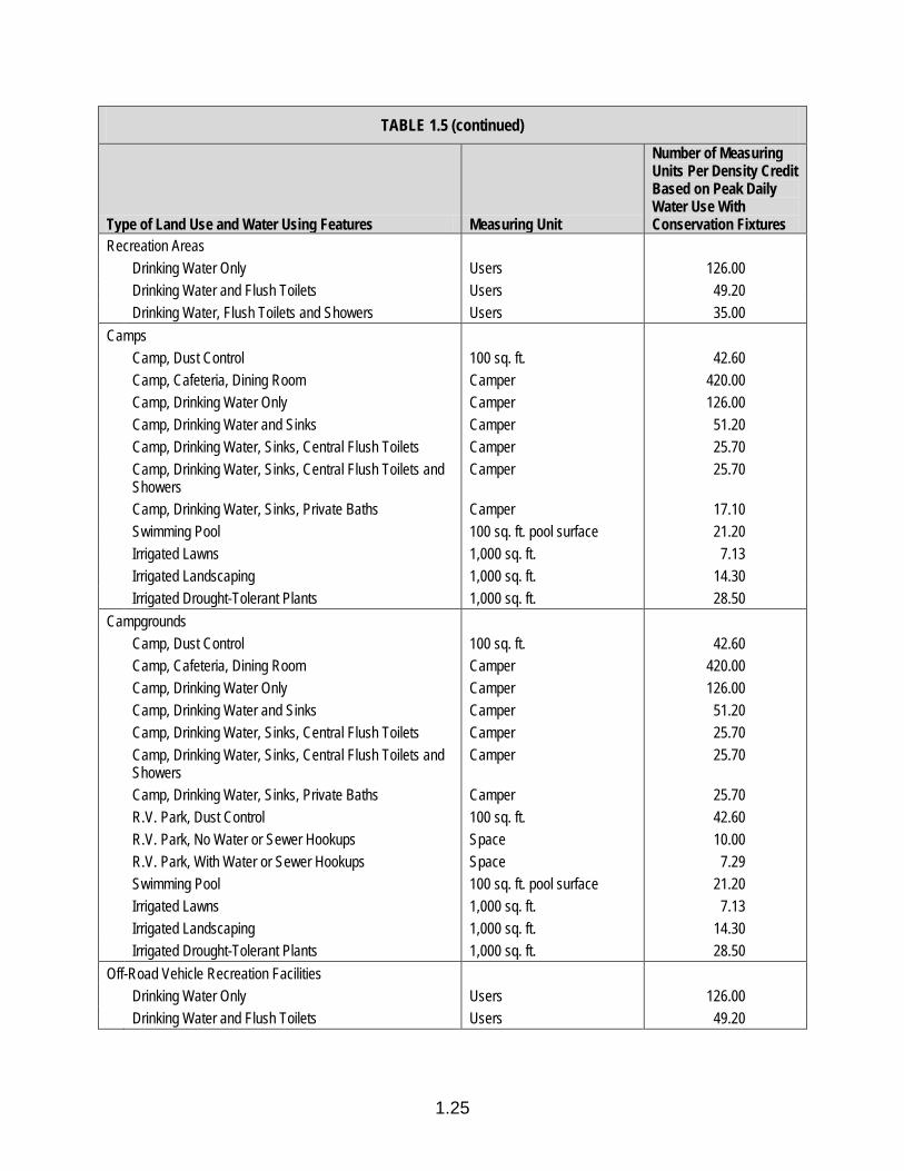
recreation, and public recreation uses, the amount of develop-ment allowed for each density credit in accordance with the requirements of this policy shall be the amount stated in Table 1.5 in the column headed “Number of Measuring Units Per Density Credit Based on Peak Daily Water Use With Conservation Fixtures.”
(3) Amount of Development Allowed for Visitor-Serving, Commercial
Recreation, and Public Recreation Uses For new or expanded visitor-serving, commercial recreation, and
public recreation uses, one density credit shall be required for the first 945 gallons, or fraction thereof, of average daily water use during the two months of highest water use in a year. One additional density credit shall be required for each 630 gallons, or fraction thereof, of average daily water use during the two months of highest water use in a year.
This requirement applies to water use by or resulting from the visitor-
serving, commercial recreation, and public recreation use, including landscaping, swimming pools and all other appurtenant uses. The 945-gallon water use allowance for one density credit may be applied one time only on a parcel.
For visitor-serving, commercial recreation, and public recreation
uses, the amount of development allowed for each density credit in accordance with the requirements of this policy shall be:
(a) For one density credit or the first density credit when multiple
density credits are available, either 1 1/2 times the amount stated in Table 1.5 in the column headed “Number of Measur-ing Units Per Density Credit Based on Peak Daily Water Use With Conservation Fixtures,” or the amount stated in that column and a residential dwelling unit associated with a visitor-serving facility that is occupied by the facility owner or operator.

1.5
(b) For each additional density credit, the amount stated in Table 1.5 in the column headed “Number of Measuring Units Per Density Credit Based on Peak Daily Water Use With Conservation Fixtures.”
d. For the purpose of this policy, “visitor-serving, commercial recreation, and
public recreation uses” shall be only those lands and facilities listed in LCP Policies 11.1, 11.2 and 11.3, and only if those lands and facilities specifi-cally enhance public opportunities for coastal recreation.
e. As an interim limit, no more than 600 visitor-serving lodging units may be
approved in the rural Coastal Zone, as specified by LCP Policy 1.24.
*1.9 Conservation/Open Space Easements a. In rural areas, designated as General Open Space on the LCP Land Use
Plan Map, require the applicant for a land division, as a condition of approval, to grant to the County (and the County to accept) a conserva-tion/open space easement containing a covenant, running with the land in perpetuity, which limits the use of the land covered by the easement to uses consistent with open space (as defined in the California Open Space Lands Act of 1972 on January 1, 1980).
b. Exempt land divisions which solely provide affordable housing, as defined
in Policy 3.7 of the Local Coastal Program on March 25, 1986, from the requirements in subsection a.
RURAL SERVICE CENTERS 1.10 Definition of Rural Service Center Define rural service centers as small rural communities having a combination of
land uses which provide services to rural areas. 1.11 Designation of Rural Service Centers Designate San Gregorio and Pescadero as Rural Service Centers. 1.12 Land Uses and Development Densities in Rural Service Centers a. Require the infilling and use of existing rural service centers to: (1) provide
commercial facilities which support agriculture and recreation and (2) meet housing needs which are generated by local employment.
b. Permit in rural service centers the land uses designated on the LCP Land
Use Plan Map and at densities specified in Tables 1.2 and 1.3.
1.6
RURAL RESIDENTIAL AREAS 1.13 Definition of Rural Residential Area Define rural residential areas as rural lands outside the urban/rural boundary
which are: (1) subdivided and developed with residential uses at densities less than one dwelling unit/5 acres, (2) adjacent to urban areas, and (3) partially or entirely served with utility lines.
1.14 Designation of Rural Residential Areas Designate the following recorded subdivisions as rural residential areas:
(1) Montara, First Addition; (2) Montara, Second Addition; (3) Montara, Hotel Addition; and (4) Montara, Wienke Addition.
1.15 Land Uses and Development Densities in Rural Residential Areas Permit in rural residential areas the land use designated on the LCP Land Use
Plan Map and at densities specified in Tables 1.2 and 1.3. GROWTH MANAGEMENT 1.16 Definition and Establishment of Urban/Rural Boundary Define urban/rural boundary as a stable line separating urban areas and rural
service centers from rural areas in the Coastal Zone and establish this line on the LCP Land Use Plan Map.
1.17 Existing Developed Areas Conserve, improve, and revitalize existing residential, commercial and industrial
areas. 1.18 Location of New Development *a. Direct new development to existing urban areas and rural service centers
in order to: (1) discourage urban sprawl, (2) maximize the efficiency of public facilities, services, and utilities, (3) minimize energy consumption, (4) encourage the orderly formation and development of local govern-mental agencies, (5) protect and enhance the natural environment, and (6) revitalize existing developed areas.
b. Concentrate new development in urban areas and rural service centers by
requiring the “infilling” of existing residential subdivisions and commercial areas.
1.7
c. Allow some future growth to develop at relatively high densities for affordable housing in areas where public facilities and services are or will be adequate and where coastal resources will not be endangered.
d. Require the development of urban areas on lands designated as agriculture and sensitive habitats in conformance with Agriculture and Sensitive Habitats Component policies.
1.19 Ensure Adequate Public Services and Infrastructure for New Development in Urban Areas
No permit for development in the urban area shall be approved unless it can be demonstrated that it will be served with adequate water supplies and wastewater treatment facilities, consistent with the subsections below:
a. Development that relies upon municipal water and wastewater treatment systems shall not be approved, except as provided in the subsections below, if there is: (a) insufficient water and wastewater public works capacity within the system to serve the development given the already outstanding commitments by the service provider or (b) evidence that the entity providing the service cannot provide such service for the development.
b. Development that relies upon municipal water and is located within the Coastside County Water District (CCWD) service area shall not be approved unless the allocation of CCWD water to the projects is consistent with the Coastal Development Permit for the El Granada Pipeline Project (Coastal Commission CDP A-2-SMC-99-063; A-1-HMB-99-020) as amended.
c. New public water connections in the Montara Water and Sanitary District (MWSD) water service area will be allowed only if consistent with the MWSD Public Works Plan (Coastal Commission PWP No. 2-06-006), Chapter 2 of the LCP, and all other applicable policies of the LCP as amended.
d. Approval of any new private wells within the urban/rural boundary and the Montara Water and Sanitary District (MWSD) water service area shall be limited to five per year for three years of the effective date of this policy (i.e., on August 8, 2012), or until MWSD obtains the necessary approvals from the California Coastal Commission to provide water service to vacant properties, whichever comes first.
e. Approval of any new private well or development that relies on a new private well may only be considered if a connection to the public water supply is not available. In such instances, the applicant for the
1.8
development must obtain a coastal development permit (CDP) for a test well, and document compliance with all Environmental Health standards and requirements for the proposed use of the well, prior to submitting a CDP application for the development. The CDP application for the development shall include a report prepared by a California Registered Geologist or Registered Civil Engineer which demonstrates, to the satisfaction of the Environmental Health Director and the Community Development Director, that:
i. The yield of the well meets the Standards for Adequate Water as
described in the County Well Ordinance and will be adequate to meet the needs of the development for the design life of the development;
ii. The water quality meets safe drinking water standards, or will meet
such standards with treatment; iii. The well will be sited, designed, and operated in a manner that
avoids contamination from any potential pollutant sources; and iv. Operation of the well will, at the level contemplated for the
development, avoid individual or cumulative adverse impacts to other wells, or to biological resources including streams, riparian habitats, and wetlands.
The approval of any development that relies on a private well shall be
conditioned to require recordation of a Deed Restriction, to the satisfaction of County Counsel and the Planning and Building Department, prior to the issuance of building permits, that requires the applicant and any successor in interest to abandon the well consistent with Environmental Health requirements and connect to the public water system within 90 days of the date on which a connection becomes available, availability being deter-mined in the reasonable judgment of the Community Development Director. Except as limited above, private wells shall not be prohibited or required to be abandoned if the applicable water district has the authority to issue new connections but refuses or is unable to provide water service.
f. If a public water supply is available, major remodels or expansions of
existing development, or new development on vacant lots, served by private wells constructed after September 12, 1989, are not permitted unless the project will connect to the public water system and abandon the well. For purposes of this policy, major remodels or expansions include all projects where new construction has a value equal or greater to 50% of the value of the existing structure.
g. New private septic systems shall be prohibited within the urban/rural
boundary of the Midcoast unless: (1) there is no public sewer hookup
1.9
available; (2) system complies with all the requirements for individual septic disposal systems; and (3) the system is approved by San Mateo County Environmental Health and other applicable authorities.
h. Lack of adequate water supplies and wastewater facilities, as defined
above, shall be grounds for denial of the development applications. 1.20 Definition of Infill Define infill as the development of vacant land in urban areas and rural service
centers which is: (1) subdivided and zoned for development at densities greater than one dwelling unit per 5 acres, and/or (2) served by sewer and water utilities.
1.21 Lot Consolidation According to the densities shown on the LCP Land Use Plan Map, consolidate
contiguous lots, held in the same ownership, in residential subdivisions in Seal Cove to minimize risks to life and property and in Miramar to protect coastal views and scenic coastal areas.
1.22 LAFCo Spheres of Influence After State certification of the County’s and Half Moon Bay Local Coastal
Programs, request LAFCo to designate sphere of influence lines for Half Moon Bay and special districts which are coterminous with the urban/rural boundary.
1.23 Timing of New Housing Development in the Midcoast a. In order to ensure that roads, utilities, schools and other public works
facilities and community infrastructure are not overburdened by rapid residential growth, limit the maximum number of new dwelling units built in the urban Midcoast to 40 units each calendar year until:
i. A comprehensive transportation management plan, as described in
Policy 2.53, is incorporated into the LCP; ii. Facilities to adequately contain stormwater infiltration and inflow that
exceed the existing Intertie Pipeline System (IPS) capacity during storm events and peak flows have been constructed and sufficient evidence has been presented that IPS capacity is adequate to avoid sewage overflows and water quality violations; and
iii. The growth rate is changed by an LCP amendment.
1.10
b. New dwelling units include each new single-family residential unit, each new unit in a two-family dwelling, each new unit in a multiple-family residential development, each new unit in mixed-use development, each new caretaker quarter, each new affordable housing unit, and each new second dwelling unit as further defined in ‘d’.
c. The number of each dwelling units built each year means that the number
of units for which building permits have been issued authorizing construc-tion to commence. The date of building permit issuance does not relate to the date of building permit application.
d. If the number of issued building permits for any given year has reached the
40-unit maximum, building permits for affordable housing, including second dwelling units, may still be issued under the following circumstances: (1) the units are “affordable” as defined by Section 6102.48.6 of the certified zoning regulations and subject to income and cost/rent restrictions for the life of the development; and (2) the growth rate average over the three-year period, that includes the year of building permit issuance and the following two years, does not exceed 40 units/year.
e. This annual limit on residential units is not an entitlement, i.e., it does not
guarantee that any proposed development will be approved. A coastal development permit for residential units may only be approved if the proposed development can be found consistent with all applicable policies of the certified LCP.
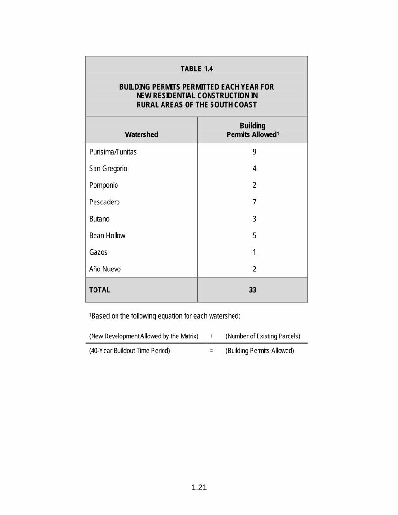
1.24 Timing of Development in the South Coast a. To ensure that rural area residential buildout proceeds at an even rate and
does not overburden coastal resources or public services, and provides for priority coastal uses (agriculturally related development, public/private recreation, affordable housing and visitor-serving commercial uses con-sistent with Land Use Plan policies), limit the building permits granted in any year for the construction of residences in rural areas, other than affordable and/or farm labor housing, in each watershed as specified in Table 1.4. Exceptions may be made by the appropriate County officials for large scale, master planned developments, on a case-by-case basis, when a qualified hydrologist determines that the cumulative impact of all new development on the relevant watershed(s) will not adversely affect coastal resources including wetlands, streams, riparian habitats, wildlife and agriculture. The hydrological study should include an analysis of the geological formation within the watershed(s) and stream flow data for both summer and winter flows, and should project expected drought-year flows, and should provide data pertaining to riparian and appropriative water rights of the property being planned and a correlation of those water rights with the agricultural activity proposed on the property. Hydrologic data

1.11
collected by project and/or collectively within watersheds for different projects shall be utilized to consider changes in the size of any annual increment of development or total amount.
b. Limit Coastal Development Permits granted for hotel, motel and country inn
visitor-serving uses in the rural area to an interim total of 600 lodging units. After that limit is reached, visitor-serving development would only be permitted through an LCP amendment. The amount of additional visitor-serving development allowed shall be based on the County demonstrating that additional visitor-serving development in the rural area would not adversely affect coastal resources and public services.
1.25 Protection of Archaeological/Paleontological Resources Based on County Archaeology/Paleontology Sensitivity Maps, determine
whether or not sites proposed for new development are located within areas containing potential archaeological/paleontological resources. Prior to approval of development proposed in sensitive areas, require that a mitigation plan, adequate to protect the resource and prepared by a qualified archaeologist/ paleontologist be submitted for review and approval and implemented as part of the project.
1.26 Rural Watershed Monitoring Program Commencing within one year of certification of the LCP, the County shall,
providing funding can be secured, undertake a water-monitoring program to determine, on a watershed-by-watershed basis, water availability for new development consistent with LCP resource protection policies. The monitoring program should be completed within five years of LCP certification and sub-sequent development shall be consistent with the findings of the approved final report.
1.27 Monitor Buildout in Rural Areas The County shall maintain accurate records of development undertaken in the
rural areas and release annual reports indicating the types, location and intensity of new development. Cumulative number of permitted units (or density credit equivalents) shall not exceed that projected on Table 1.1 absent an LCP amendment specifically providing for the increase.
1.12
PARCEL LEGALIZATION 1.28 Confirming Legality of Parcels Require a Coastal Development Permit when issuing a Certificate of
Compliance to confirm the legal existence of parcels as addressed in Section 66499.35(a) of the California Government Code (e.g., lots which predated or met Subdivision Map Act and local government requirements at the time they were created), only if: (1) the land division occurred after the effective date of coastal permit requirements for such division of land (i.e., either under Proposition 20 or the Coastal Act of 1976), and (2) a coastal permit has not previously been issued for such division of land.
*1.29 Legalizing Parcels Require a Coastal Development Permit when issuing a Certificate of
Compliance to legalize parcels under Section 66499.35(b) of the California Government Code (i.e., parcels that were illegally created without benefit of government review and approval).
*1.30 Coastal Development Permit Standards of Review for Legalizing Parcels Require Coastal Development Permits to legalize parcels. Where applicable,
condition permits to meet the following standards. (Permit applications shall be considered as “conditional uses” for the purposes of review.)
a. On developed illegal parcels created before Proposition 20 (effective date
January 1, 1973) on lands located within 1,000 yards of the mean high tide line, or the Coastal Act of 1976 (effective date January 1, 1977), on lands shown on the official maps adopted by the Legislature, which received all required building permits or government approvals for development, a Coastal Development Permit to legalize the parcel shall be issued without conditions.
b. On developed illegal parcels created before Proposition 20, on lands within
1,000 years of the mean high tide line, or the Coastal Act of 1976, on lands shown on the official maps adopted by the Legislature, which received a coastal permit for the development, a coastal permit to legalize the parcel shall be issued without conditions.
c. On illegal parcels created and developed after Proposition 20, on lands
located within 1,000 yards of the mean high tide line, or the Coastal Act of 1976, on lands shown on the official maps adopted by the Legislature, a Coastal Development Permit shall be issued if the development and parcel configuration do not have any substantial adverse impact on coastal resources, in conformance with the standards of the Coastal Development
1.13
District regulations. Permits to legalize this type of development and parcel shall be conditioned to maximize consistency with Local Coastal Program resource protection policies.
d. On undeveloped parcels created before Proposition 20, on lands located
within 1,000 yards of the mean high tide line, or the Coastal Act of 1976, on lands shown on the official maps adopted by the Legislature, a coastal permit shall be issued to legalize the parcel if the parcel configuration will not have any substantial adverse impacts on coastal resources, in conformance with the standards of review of the Coastal Development District regulations. Permits to legalize this type of parcel shall be condi-tioned to maximize consistency with Local Coastal Program resource protection policies. A separate Coastal Development Permit, subject to all applicable Local Coastal Program requirements, shall be required for any development of the parcel.
e. On undeveloped illegal parcels created after Proposition 20, on lands
located within 1,000 yards of the mean high tide line, or the Coastal Act of 1976, on lands shown on the official maps adopted by the Legislature, a Coastal Development Permit is necessary to legalize the parcel. A permit may be issued only if the land division is in conformance with the standards of the Coastal Development District regulations.
1.31 Notices of Violation The County shall discourage the creation of illegal parcels by developing and
implementing a system for the timely review of all newly recorded parcels in the Coastal Zone. Notices of violation, as provided for in Government Code Section 66499.36 shall be promptly filed on the deeds of those parcels which have not received required government approvals.
*1.32 Local Coastal Program Amendments a. Local Coastal Program policies, or subsections of such policies, identified
by an asterisk (*), may be amended or repealed only after approval by a majority of the voters of San Mateo County, voting in a valid election. The Board of Supervisors may, by a four-fifths vote after consideration by the Planning Commission, submit proposed amendment(s) to the voters.
b. Subsection a. does not apply to amendments to Local Coastal Program
policies or subsections of such policies, identified by an asterisk (*), which would further restrict non-agricultural development, density or use, providing that such amendments conform with the California Coastal Act of 1976 or other State law.
1.14
c. Local Coastal Program policies or subsections of such policies, not identified by an asterisk (*), may be amended by the Board of Supervisors in conformance with the California Coastal Act.
1.33 Designation of Farm Labor Housing Areas Designate the area shown on Map 1.2 as Farm Labor Housing. 1.34 Land Use and Development Density for Farm Labor Housing Areas Permit, in Farm Labor Housing areas, the land uses designated on the LCP
Land Use Plan Map and at densities specified in Table 1.2. 1.35 All New Land Use Development and Activities Shall Protect Coastal Water
Quality Among Other Ways By: a. Implementing appropriate site design and source control best management
practices (BMPs). Site design BMPs are land use or site planning prac-tices that aim to prevent runoff pollution by reducing the potential soil erosion or contact of runoff with pollutants. Source control BMPs are structural or non-structural practices that minimize the contact between pollutants and runoff.
b. Implementing treatment BMPs along with site design and source control
BMPs when the combination of site design and source control BMPs is not sufficient to protect water quality as required by the LCP, or when required by the Regional Board per municipal permit provisions. Treatment BMPs are practices designed to remove pollutants and/or solids from polluted stormwater runoff. Projects that drain directly to a sensitive habitat shall implement post-construction structural treatment BMPs.
c. Where treatment BMPs are required, the BMPs (or suites of BMPs) shall
be designed and implemented to remove pollutants from the amount of stormwater runoff produced by all storms up to and including the 85th percentile, 24-hour storm event for volume-based BMPs and/or the 85th percentile, 1-hour storm event (with an appropriate safety factor, i.e., 2 or greater) for flow-based BMPs or the flow of runoff from a rain event equal to at least 0.2 inches per hour intensity to the maximum extent feasible.
d. Using multi-benefit, natural feature, stormwater treatment systems, such as
landscape-based bioretention systems, bioswales and green roofs, where feasible, in place of single purpose treatment BMPs.
e. Minimizing the introduction of pollutants into coastal waters (including the
ocean, estuaries, wetlands, rivers, streams, and lakes).
1.15
f. Minimizing the amount of impervious surfaces and directly connected impervious surfaces in areas of new development and redevelopment and, where feasible, maximizing on-site infiltration of runoff.
g. Preserving and, where possible, creating or restoring areas that provide
important water quality benefits, such as riparian corridors, wetlands, and buffer zones.
h. Limiting disturbances of natural water bodies and natural drainage systems
caused by development including roads, highways, and bridges. i. Avoiding development of areas that are particularly susceptible to erosion
and sediment loss, where feasible and, where not feasible, incorporate appropriate BMPs to minimize erosion and sediment loss.
j. In projects where the combined amounts of impervious surface created
and replaced total one acre or more (or smaller areas where required by the Regional Board), implementing hydromodification requirements as further detailed in Appendix 1.A. Developments that are exempt from this requirement are stipulated in NPDES Permit No. CAS612008, Order No. R2-2009-0074, issued October 14, 2009, except for single-family residences that drain directly to sensitive habitats.
k. Implementing the minimum stormwater pollution prevention requirements
contained in Appendix 1.A. 1.36 Half Moon Bay Airport Influence Area Requirements Within the Half Moon Bay Airport Influence Area, as shown on Map 1.5, the
following shall apply: a. New development and land uses must comply with all relevant Federal
Aviation Administration (FAA) standards and criteria regarding (1) safety, (2) flashing lights, (3) reflective material, (4) land uses which may attract large concentrations of birds, (5) HVAC exhaust fans, and (6) land uses which may generate electrical or electronic interference with aircraft communications and/or instrumentation.
b. All transfers of real property must comply with the real estate disclosure
requirements specified in Chapter 496, California Statutes of 2002.

1.16
TABLE 1.1
Original Buildout Estimate (1980)
ESTIMATE OF DWELLING UNITS AND POPULATION PERMITTED BY THE LAND USE PLAN
EXISTING PHASE I BUILDOUT
Dwelling Units Population Dwelling
Units Population Dwelling Units Population
MIDCOAST 2,775 7,675 4,100–4,700 11,500–12,700 6,728 16,485
Urban (2,550) (7,000) (4,100–4,700) (11,500–12,700) (6,200) (14,900)
Rural (225) (675) — — (528) (1,585)
HALF MOON BAY 2,240 6,900 5,000 12,000–13,000 5,500–6,500 13,500–15,000
SOUTH COAST 620 2,000 — — 1,424 5,000
Pescadero (143) — — — (200) —
San Gregorio — — — — (40) —
Rural (447) — — — (1,184) —
TOTAL 5,635 16,575 — — 13,650–14,650 35,000–36,500
Updated Buildout Estimate (2006) R-1 Zoning District 4,804 units R-3 Zoning District 443 units R-3-A Zoning District 513 units RM-CZ and PAD Zoning Districts 160 units C-1 and CCR Zoning Districts 99–495 units Second Units 466 units Caretaker’s Quarters 45 units Pillar Ridge Manufactured Home Community 227 units TOTAL 6,757–7,153 units
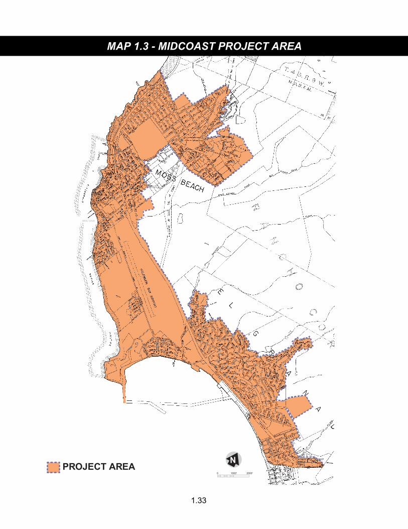
The above table represents an updated estimate of residential buildout for the Midcoast LCP Update Project Area, as shown on Map 1.3. Buildout is the planned endpoint in a community’s growth that would occur if all land that has been designated for development has been developed to its maximum density, i.e., the sum of all units potentially allowed under existing certified LCP density limitations. The buildout estimate assumes that public service constraints can be resolved, and that there are no resource constraints or other LCP requirements that would limit buildout density on individual sites. The buildout estimate and the LCP policies on which it is based are not entitlements and do not guarantee that any proposed development will be approved.

1.17
TABLE 1.2
LAND USES AND DEVELOPMENT DENSITIES
LAND USE DENSITY URBAN AREA
RURAL SERVICE CENTER
RURAL RESIDENTIAL
AREA
FARM LABOR
HOUSING AREA
RURAL AREA
RESIDENTIAL (1) Very Low (0.0–0.2 d.u./ac.) X X X X (2) Low (0.3–2.0 d.u./ac.) X X X (3) Medium Low (2.1–6.0 d.u./ac.) X X X (4) Medium (6.1–8.0 d.u./ac.) X X X (5) Medium High (8.1–16.0 d.u./ac.) X (6) High (16.1–32.0 d.u./ac.) X
COMMERCIAL (7) General Commercial —— X X (8) Neighborhood Commercial —— X X (9) Coastside Commercial
Recreation —— X X
(10) Offices —— X
INDUSTRIAL (11) General —— X (12) Heavy —— X
OTHER (13) Institutional —— X X (14) Transportation —— X
OPEN SPACE (15) Public Recreation (1 d.c./40 ac.–
1 d.c./160 ac.)1 X X X
(16) Private Recreation (1 d.c./40 ac.– 1 d.c./160 ac.)1
X X X
(17) General Open Space (1 d.c./40 ac.– 1 d.c./160 ac.)1
X X X2 X
(18) Agriculture (1 d.c./40 ac.– 1 d.c./160 ac.)1
X X X2 X
1See Table 1.3 for explanation of computation of maximum density of development for compatible conditional uses. 2Maximum density permitted is eight dwelling units per acre.
1.18
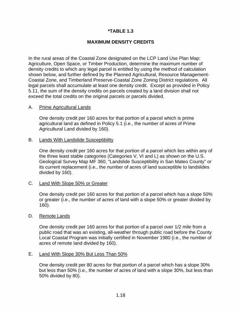
*TABLE 1.3
MAXIMUM DENSITY CREDITS In the rural areas of the Coastal Zone designated on the LCP Land Use Plan Map: Agriculture, Open Space, or Timber Production, determine the maximum number of density credits to which any legal parcel is entitled by using the method of calculation shown below, and further defined by the Planned Agricultural, Resource Management-Coastal Zone, and Timberland Preserve-Coastal Zone Zoning District regulations. All legal parcels shall accumulate at least one density credit. Except as provided in Policy 5.11, the sum of the density credits on parcels created by a land division shall not exceed the total credits on the original parcels or parcels divided. A. Prime Agricultural Lands One density credit per 160 acres for that portion of a parcel which is prime
agricultural land as defined in Policy 5.1 (i.e., the number of acres of Prime Agricultural Land divided by 160).
B. Lands With Landslide Susceptibility One density credit per 160 acres for that portion of a parcel which lies within any of
the three least stable categories (Categories V, VI and L) as shown on the U.S. Geological Survey Map MF 360, “Landslide Susceptibility in San Mateo County” or its current replacement (i.e., the number of acres of land susceptible to landslides divided by 160).
C. Land With Slope 50% or Greater One density credit per 160 acres for that portion of a parcel which has a slope 50%
or greater (i.e., the number of acres of land with a slope 50% or greater divided by 160).
D. Remote Lands One density credit per 160 acres for that portion of a parcel over 1/2 mile from a
public road that was an existing, all-weather through public road before the County Local Coastal Program was initially certified in November 1980 (i.e., the number of acres of remote land divided by 160).
E. Land With Slope 30% But Less Than 50% One density credit per 80 acres for that portion of a parcel which has a slope 30%
but less than 50% (i.e., the number of acres of land with a slope 30%, but less than 50% divided by 80).
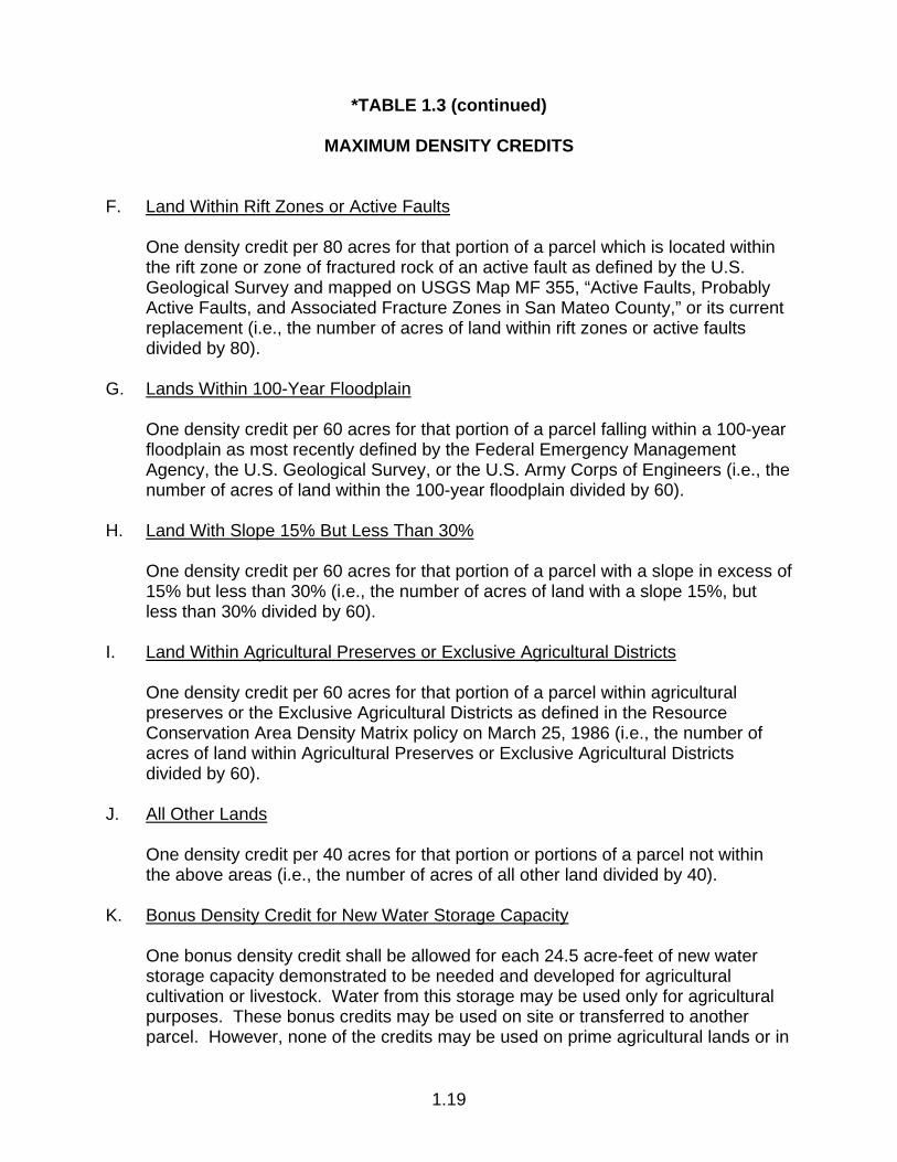
*TABLE 1.3 (continued)
MAXIMUM DENSITY CREDITS
1.19
F. Land Within Rift Zones or Active Faults One density credit per 80 acres for that portion of a parcel which is located within
the rift zone or zone of fractured rock of an active fault as defined by the U.S. Geological Survey and mapped on USGS Map MF 355, “Active Faults, Probably Active Faults, and Associated Fracture Zones in San Mateo County,” or its current replacement (i.e., the number of acres of land within rift zones or active faults divided by 80).
G. Lands Within 100-Year Floodplain One density credit per 60 acres for that portion of a parcel falling within a 100-year
floodplain as most recently defined by the Federal Emergency Management Agency, the U.S. Geological Survey, or the U.S. Army Corps of Engineers (i.e., the number of acres of land within the 100-year floodplain divided by 60).
H. Land With Slope 15% But Less Than 30% One density credit per 60 acres for that portion of a parcel with a slope in excess of
15% but less than 30% (i.e., the number of acres of land with a slope 15%, but less than 30% divided by 60).
I. Land Within Agricultural Preserves or Exclusive Agricultural Districts One density credit per 60 acres for that portion of a parcel within agricultural
preserves or the Exclusive Agricultural Districts as defined in the Resource Conservation Area Density Matrix policy on March 25, 1986 (i.e., the number of acres of land within Agricultural Preserves or Exclusive Agricultural Districts divided by 60).
J. All Other Lands One density credit per 40 acres for that portion or portions of a parcel not within
the above areas (i.e., the number of acres of all other land divided by 40). K. Bonus Density Credit for New Water Storage Capacity One bonus density credit shall be allowed for each 24.5 acre-feet of new water
storage capacity demonstrated to be needed and developed for agricultural cultivation or livestock. Water from this storage may be used only for agricultural purposes. These bonus credits may be used on site or transferred to another parcel. However, none of the credits may be used on prime agricultural lands or in
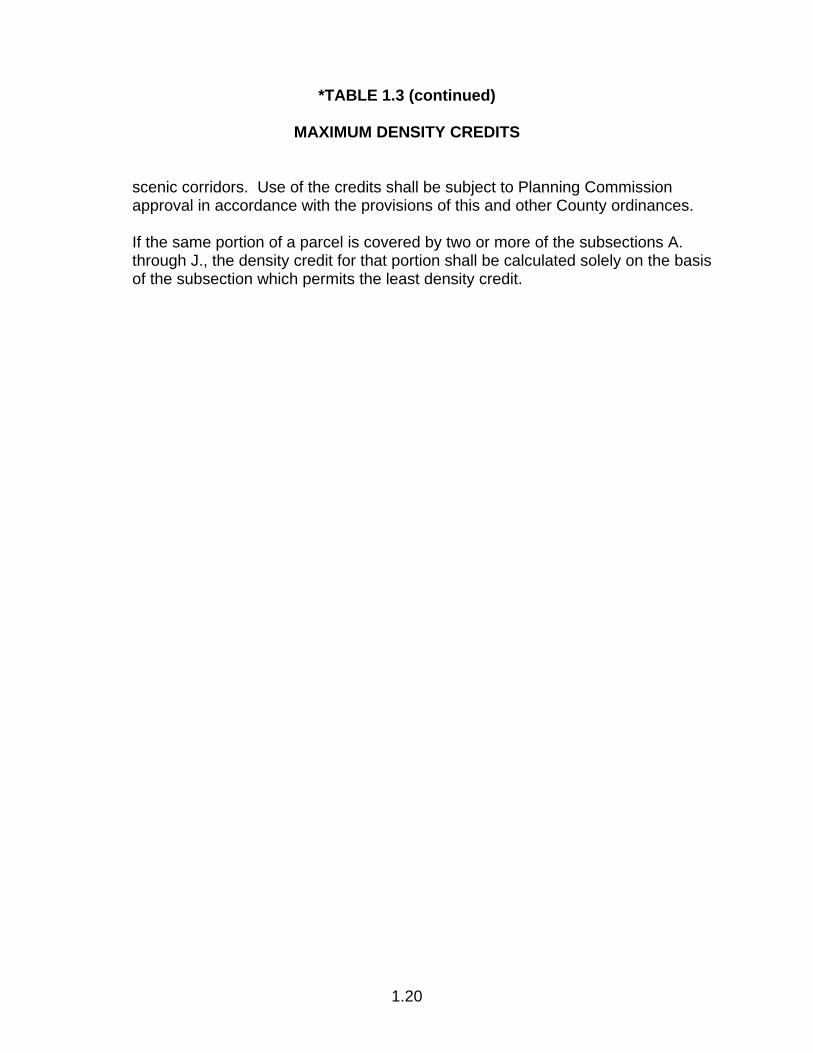
*TABLE 1.3 (continued)
MAXIMUM DENSITY CREDITS
1.20
scenic corridors. Use of the credits shall be subject to Planning Commission approval in accordance with the provisions of this and other County ordinances.
If the same portion of a parcel is covered by two or more of the subsections A.
through J., the density credit for that portion shall be calculated solely on the basis of the subsection which permits the least density credit.
1.21
TABLE 1.4
BUILDING PERMITS PERMITTED EACH YEAR FOR NEW RESIDENTIAL CONSTRUCTION IN RURAL AREAS OF THE SOUTH COAST
Watershed Building
Permits Allowed1
Purisima/Tunitas 9
San Gregorio 4
Pomponio 2
Pescadero 7
Butano 3
Bean Hollow 5
Gazos 1
Año Nuevo 2
TOTAL 33
1Based on the following equation for each watershed: (New Development Allowed by the Matrix) + (Number of Existing Parcels)
(40-Year Buildout Time Period) = (Building Permits Allowed)

1.22
TABLE 1.5
Type of Land Use and Water Using Features Measuring Unit
Number of Measuring Units Per Density Credit Based on Peak Daily Water Use With Conservation Fixtures
Irrigated Lawns 1,000 sq. ft. 3.56 1,000 sq. ft. 7.13 Irrigated Landscaping 1,000 sq. ft. 7.13 1,000 sq. ft. 14.30 Irrigated Drought-Tolerant Plantings 1,000 sq. ft. 14.30 1,000 sq. ft. 28.50 Swimming Pools 100 sq. ft. of pool surface 10.60 100 sq. ft. of pool surface 21.20 Small Hostelries Hotel/Motel Rooms Rentable Room 6.33 Restaurant Seat 26.80 Irrigated Lawn 1,000 sq. ft. 7.13 Swimming Pool 100 sq. ft. of pool surface 21.20 Large Hostelries Hotel/Motel Rooms Rentable Room 6.33 Restaurant Seat 26.80 Irrigated Lawn 1,000 sq. ft. 7.13 Swimming Pool 100 sq. ft. of pool surface 21.20 Resort Facilities Hotel/Motel Rooms Rentable Room 6.33 Restaurant/Banquet Rooms Seat 26.80 Spa/Gym (with showers) 1,000 sq. ft. 1.46 Spa/Gym (without showers) 1,000 sq. ft. 2.16 Laundry Rentable Unit 10.30 Convention Facilities/Meeting Rooms 1,000 sq. ft. 21.20 Live-In Staff Person 12.20 Irrigated Lawn 1,000 sq. ft. 7.13 Irrigated Landscaping 1,000 sq. ft. 14.30 Irrigated Drought-Tolerant Plantings 1,000 sq. ft. 28.50 Swimming Pool 100 sq. ft. of pool surface 21.20 Residential Day Care Facilities for Children Residents Bed 2.22 Day Users Person 14.60 Residential Full-Time Care Facilities for Children Residents Bed 2.33
1.23
TABLE 1.5 (continued)
Type of Land Use and Water Using Features Measuring Unit
Number of Measuring Units Per Density Credit Based on Peak Daily Water Use With Conservation Fixtures
Foster Family Homes Residents Bed 2.33 Residential Day Care Facilities for Adults Residents Bed 2.22 Day Users Person 14.60 Residential Full-Time Care Facilities for Adults Residents Bed 2.33 Residential Day Care Facilities for the Elderly Residents Bed 2.22 Day Users Person 14.60 Shared Housing Facilities for the Elderly Residents Bed 2.33 Restaurants Eating Area Seat 28.60 Bar or Cocktail Lounge (additional) Patron 315.00 Food Establishments Specializing in Carry-Out or Delivery Service
Building Area 1,000 sq. ft. 1.62 Bars Seat 25.80 Motor Vehicle Sales Service Area Fuel Pump 1.78 Car Wash (tunnel type) 1,000 sq. ft. 0.048 Motor Vehicle Service Stations Service Area Fuel Pump 1.78 Car Wash (tunnel type) 1,000 sq. ft. 0.048 Religious Facilities Meeting Facilities 1,000 sq. ft. 1.24 Rectory Unit 1.00 Club and Organization Meeting Facilities Building Area 1,000 sq. ft. 8.77 Interpretive Centers Visitors 63.00 Botanical and Zoological Gardens Domestic Use Visitors 63.00 Animal Use 1,000 sq. ft. 4.32 Irrigated Lawns 1,000 sq. ft. 7.13 Irrigated Landscaping 1,000 sq. ft. 14.30 Irrigated Drought-Tolerant Plantings 1,000 sq. ft. 28.50
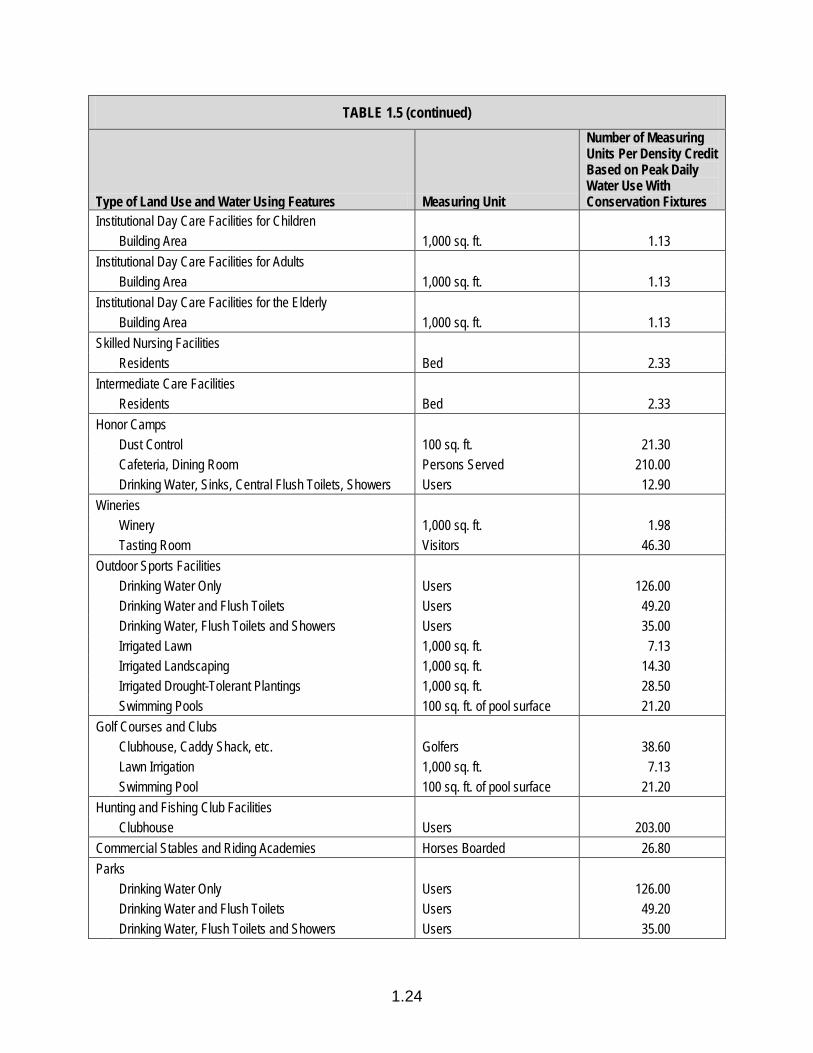
1.24
TABLE 1.5 (continued)
Type of Land Use and Water Using Features Measuring Unit
Number of Measuring Units Per Density Credit Based on Peak Daily Water Use With Conservation Fixtures
Institutional Day Care Facilities for Children Building Area 1,000 sq. ft. 1.13 Institutional Day Care Facilities for Adults Building Area 1,000 sq. ft. 1.13 Institutional Day Care Facilities for the Elderly Building Area 1,000 sq. ft. 1.13 Skilled Nursing Facilities Residents Bed 2.33 Intermediate Care Facilities Residents Bed 2.33 Honor Camps Dust Control 100 sq. ft. 21.30 Cafeteria, Dining Room Persons Served 210.00 Drinking Water, Sinks, Central Flush Toilets, Showers Users 12.90 Wineries Winery 1,000 sq. ft. 1.98 Tasting Room Visitors 46.30 Outdoor Sports Facilities Drinking Water Only Users 126.00 Drinking Water and Flush Toilets Users 49.20 Drinking Water, Flush Toilets and Showers Users 35.00 Irrigated Lawn 1,000 sq. ft. 7.13 Irrigated Landscaping 1,000 sq. ft. 14.30 Irrigated Drought-Tolerant Plantings 1,000 sq. ft. 28.50 Swimming Pools 100 sq. ft. of pool surface 21.20 Golf Courses and Clubs Clubhouse, Caddy Shack, etc. Golfers 38.60 Lawn Irrigation 1,000 sq. ft. 7.13 Swimming Pool 100 sq. ft. of pool surface 21.20 Hunting and Fishing Club Facilities Clubhouse Users 203.00 Commercial Stables and Riding Academies Horses Boarded 26.80 Parks Drinking Water Only Users 126.00 Drinking Water and Flush Toilets Users 49.20 Drinking Water, Flush Toilets and Showers Users 35.00
1.25
TABLE 1.5 (continued)
Type of Land Use and Water Using Features Measuring Unit
Number of Measuring Units Per Density Credit Based on Peak Daily Water Use With Conservation Fixtures
Recreation Areas Drinking Water Only Users 126.00 Drinking Water and Flush Toilets Users 49.20 Drinking Water, Flush Toilets and Showers Users 35.00 Camps Camp, Dust Control 100 sq. ft. 42.60 Camp, Cafeteria, Dining Room Camper 420.00 Camp, Drinking Water Only Camper 126.00 Camp, Drinking Water and Sinks Camper 51.20 Camp, Drinking Water, Sinks, Central Flush Toilets Camper 25.70 Camp, Drinking Water, Sinks, Central Flush Toilets and
Showers Camper 25.70
Camp, Drinking Water, Sinks, Private Baths Camper 17.10 Swimming Pool 100 sq. ft. pool surface 21.20 Irrigated Lawns 1,000 sq. ft. 7.13 Irrigated Landscaping 1,000 sq. ft. 14.30 Irrigated Drought-Tolerant Plants 1,000 sq. ft. 28.50 Campgrounds Camp, Dust Control 100 sq. ft. 42.60 Camp, Cafeteria, Dining Room Camper 420.00 Camp, Drinking Water Only Camper 126.00 Camp, Drinking Water and Sinks Camper 51.20 Camp, Drinking Water, Sinks, Central Flush Toilets Camper 25.70 Camp, Drinking Water, Sinks, Central Flush Toilets and
Showers Camper 25.70
Camp, Drinking Water, Sinks, Private Baths Camper 25.70 R.V. Park, Dust Control 100 sq. ft. 42.60 R.V. Park, No Water or Sewer Hookups Space 10.00 R.V. Park, With Water or Sewer Hookups Space 7.29 Swimming Pool 100 sq. ft. pool surface 21.20 Irrigated Lawns 1,000 sq. ft. 7.13 Irrigated Landscaping 1,000 sq. ft. 14.30 Irrigated Drought-Tolerant Plants 1,000 sq. ft. 28.50 Off-Road Vehicle Recreation Facilities Drinking Water Only Users 126.00 Drinking Water and Flush Toilets Users 49.20
1.26
TABLE 1.5 (continued)
Type of Land Use and Water Using Features Measuring Unit
Number of Measuring Units Per Density Credit Based on Peak Daily Water Use With Conservation Fixtures
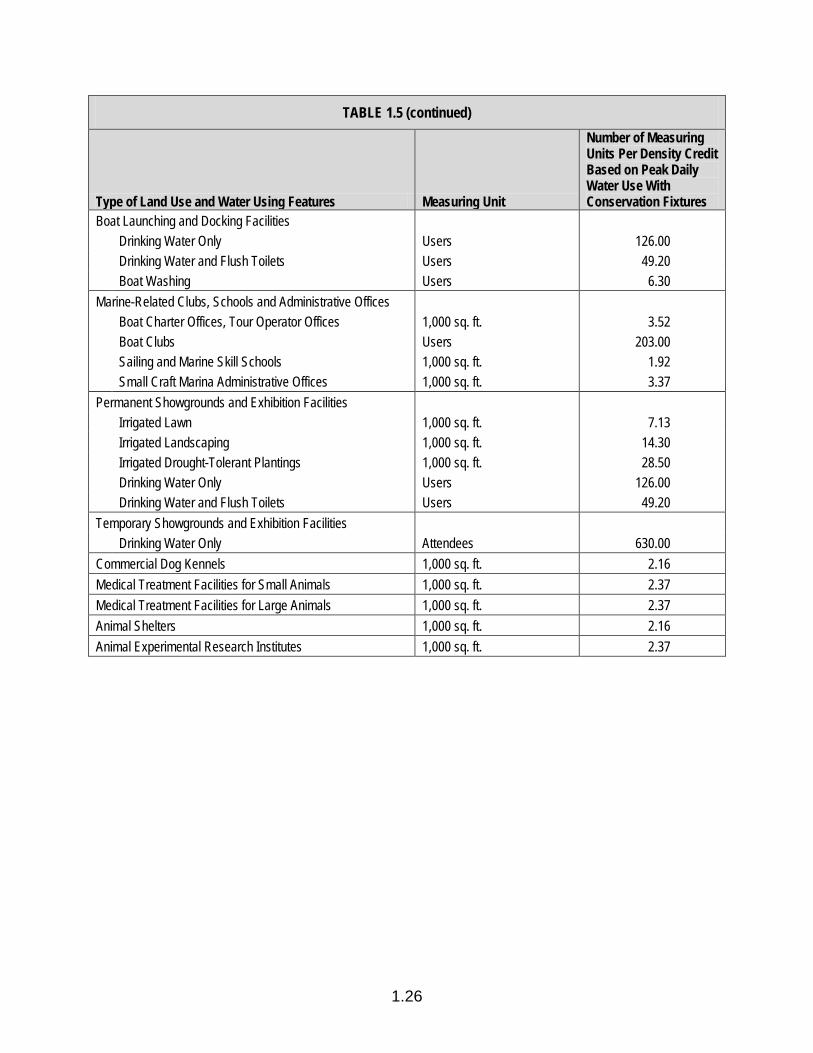
Boat Launching and Docking Facilities Drinking Water Only Users 126.00 Drinking Water and Flush Toilets Users 49.20 Boat Washing Users 6.30 Marine-Related Clubs, Schools and Administrative Offices Boat Charter Offices, Tour Operator Offices 1,000 sq. ft. 3.52 Boat Clubs Users 203.00 Sailing and Marine Skill Schools 1,000 sq. ft. 1.92 Small Craft Marina Administrative Offices 1,000 sq. ft. 3.37 Permanent Showgrounds and Exhibition Facilities Irrigated Lawn 1,000 sq. ft. 7.13 Irrigated Landscaping 1,000 sq. ft. 14.30 Irrigated Drought-Tolerant Plantings 1,000 sq. ft. 28.50 Drinking Water Only Users 126.00 Drinking Water and Flush Toilets Users 49.20 Temporary Showgrounds and Exhibition Facilities Drinking Water Only Attendees 630.00 Commercial Dog Kennels 1,000 sq. ft. 2.16 Medical Treatment Facilities for Small Animals 1,000 sq. ft. 2.37 Medical Treatment Facilities for Large Animals 1,000 sq. ft. 2.37 Animal Shelters 1,000 sq. ft. 2.16 Animal Experimental Research Institutes 1,000 sq. ft. 2.37

1.27
APPENDIX 1.A
MINIMUM STORMWATER POLLUTION PREVENTION REQUIREMENTS
1. All New Development All new development, including remodeling of existing buildings, shall comply with
the following minimum requirements: a. Avoid or minimize and mitigate the potential adverse impacts to water quality
from new development by using pre-construction, during construction, and post-construction best management practices.
b. Prevent the flow of liquid building materials and wastes onto impervious
surfaces and into storm drains and waterways. c. Prevent construction equipment, building materials and piles of soil from
contact with rain using plastic sheeting or other temporary cover, and contact with stormwater using berms, ditches, and other methods.
d. Contain vehicle and equipment cleaning, storage, maintenance, and refuse
and recycling areas to prevent runoff from discharging into the storm drain system.
e. Clean up leaks and spills immediately to prevent soil and groundwater
contamination, contact with paved surfaces, and discharge into the storm drain system.
f. Use silt ponds, berms and other techniques to trap sediment, spilled liquids
and other pollutants. g. Employ site planning and construction methods to reduce the need for
pesticides and contaminants, and prevent contact with stormwater. 2. New Development that Alters the Land In addition to the requirements listed in 1. above, new development, construction
or other activities that disturb or otherwise alter the land shall comply with the following minimum requirements:
a. Where the potential for significant erosion from construction activities exists,
prepare and implement an erosion and sediment control plan that includes effective erosion and sediment control measures.
1.28
b. Protect sensitive areas, minimize changes to the natural topography, and avoid removing existing vegetation unless absolutely necessary. If existing vegetation consists of invasive plant species, this vegetation shall be removed and replaced with drought-tolerant native or non-invasive species by the conclusion of construction.
c. Protect undisturbed areas from construction impacts using vegetative buffer
strips, sediment barriers, filters, dikes, mulching and other measures as appropriate.
d. Reduce the amount of impervious surface areas, and use permeable
pavement where feasible. e. Reduce the amount of runoff crossing construction sites by constructing
berms, swales and dikes and diverting drainage ditches. Use berms or temporary check dams to reduce the velocity of stormwater runoff.
f. Use landscaping to collect, detain and filter surface runoff, and design
landscaping to minimize the use of irrigation, fertilizers and pesticides. All landscaping plants shall be drought tolerant, and consist of either native or non-invasive species.
g. Prevent erosion and trap sedimentation on-site using sediment basins or
traps, earthen dikes or berms, silt fences, check dams, soil blankets or mats, and storm drain inlet protection.
h. Control erosion on slopes by seeding and planting vegetation, and using hay
bales, temporary drainage swales, silt fences and berms. i. Restrict land clearing, earth moving, and excavation and grading activities to
during dry weather, i.e., between April 15 and October 15 of each year. j. Separate construction sites from storm drains with berms and filters, stabilize
denuded areas, and maintain erosion and sedimentation controls during wet weather, i.e., between October 15 and April 15 of each year.
k. Provide for ongoing operation and maintenance of installed stormwater
treatment measures. l. As applicable based on project size, secure a Construction Activity
Stormwater General Permit from the San Francisco Bay Area Regional Water Quality Control Board.
m. Require post-development peak flow (runoff) and velocity to be less than or
equal to pre-development peak flow and velocity. No additional runoff, caused by development, shall cross property lines. If the development will
1.29
connect to an existing storm drain system, then the development shall make improvements to the existing system as required to accept the increased runoff, or mitigation procedures shall be taken. Mitigation procedures may include on-site storm drain detention or off-site storm drain detention.
3. Developments of Special Concern In addition to the requirements listed in 1. and 2. above, developments with land
use activities that have a high potential for generating pollutants shall incorporate best management practices (BMPs) to address the particular pollutants of concern, including but not limited to the following requirements:
a. Development of parking lots shall incorporate BMPs to minimize runoff of oil,
grease, car battery acid, coolant, gasoline, sediments, trash, and other pollutants to receiving waters.
b. Development of commercial facilities shall incorporate BMPs to minimize
polluted runoff from structures, landscaping consisting of drought-tolerant and either native or non-invasive plant species, parking areas, repair and main-tenance areas, loading/unloading areas, and vehicle/equipment wash areas.
c. Development of automotive service stations, gasoline outlets, car washes,
and vehicle repair facilities shall incorporate BMPs to minimize runoff of oil, grease, solvents, car battery acid, coolant, gasoline, and other pollutants to the stormwater conveyance system from areas including fueling areas, repair and maintenance areas, loading/unloading areas, and vehicle/equipment wash areas.
d. Development of restaurants shall incorporate BMPs to minimize runoff of oil,
grease, solvents, phosphates, suspended solids, and other pollutants. e. Outdoor material storage areas shall be designed (e.g., with a roof or awning
cover) to minimize runoff of toxic compounds, oil and grease, heavy metals, nutrients, suspended solids, and other pollutants.
f. Roof or awning covers over trash storage areas shall be required in order to
minimize off-site transport of trash and other pollutants. g. Development of beachfront and waterfront structures and uses shall
incorporate BMPs to minimize polluted runoff to beach and coastal waters. h. Confined animal facilities, stables and similar animal keeping operations shall
be sited and designed to manage, contain, and dispose of animal waste using BMPs to ensure that waste is not introduced to surface runoff or groundwater. In no case shall an animal keeping operation be managed or maintained so
1.30
as to produce sedimentation or polluted runoff on any public road, adjoining property, or in any creek or drainage channel.
i. On-site sewage treatment systems (septic systems) shall be sited, designed,
installed, operated, and maintained to avoid contributing nutrients and pathogens to groundwater and/or surface waters.
j. On-site sewage treatment systems (septic systems) shall be sited away from
areas that have poorly or excessively drained soils, shallow water tables or high seasonal water tables that are within floodplains or where effluent cannot be adequately treated before it reaches streams or the ocean. New develop-ment with conventional or alternative on-site sewage treatment systems shall include protective setbacks from surface waters, wetlands and floodplains, as well as appropriate separation distances between on-site sewage treatment system components, building components, property lines, and groundwater as required by the Regional Board. Under no conditions shall the bottom of the effluent dispersal system be within five (5) feet of groundwater.
4. Hydromodification Requirements Development shall implement the hydromodification requirements stipulated in
LCP Policy 1.35.j by use of on-site control measures, regional control measures, or in-stream measures, as required by the Regional Board NPDES Permit No. CAS612008, Order No. R2-2009-0074, issued October 14, 2009. Stormwater discharges from new development and redevelopment projects shall not cause an increase in the erosion potential of the receiving stream over the pre-project (existing) condition. Increase in runoff flow and volume shall be managed so that post-project runoff shall not exceed estimated pre-project rates and durations, where such increased flow and/or volume is likely to cause increased potential for erosion of creek beds and banks, silt pollutant generated, or other adverse impacts to beneficial uses due to increased erosive force.

MAP 1.1 - RURAL RESIDENTIAL AREAS
1.31
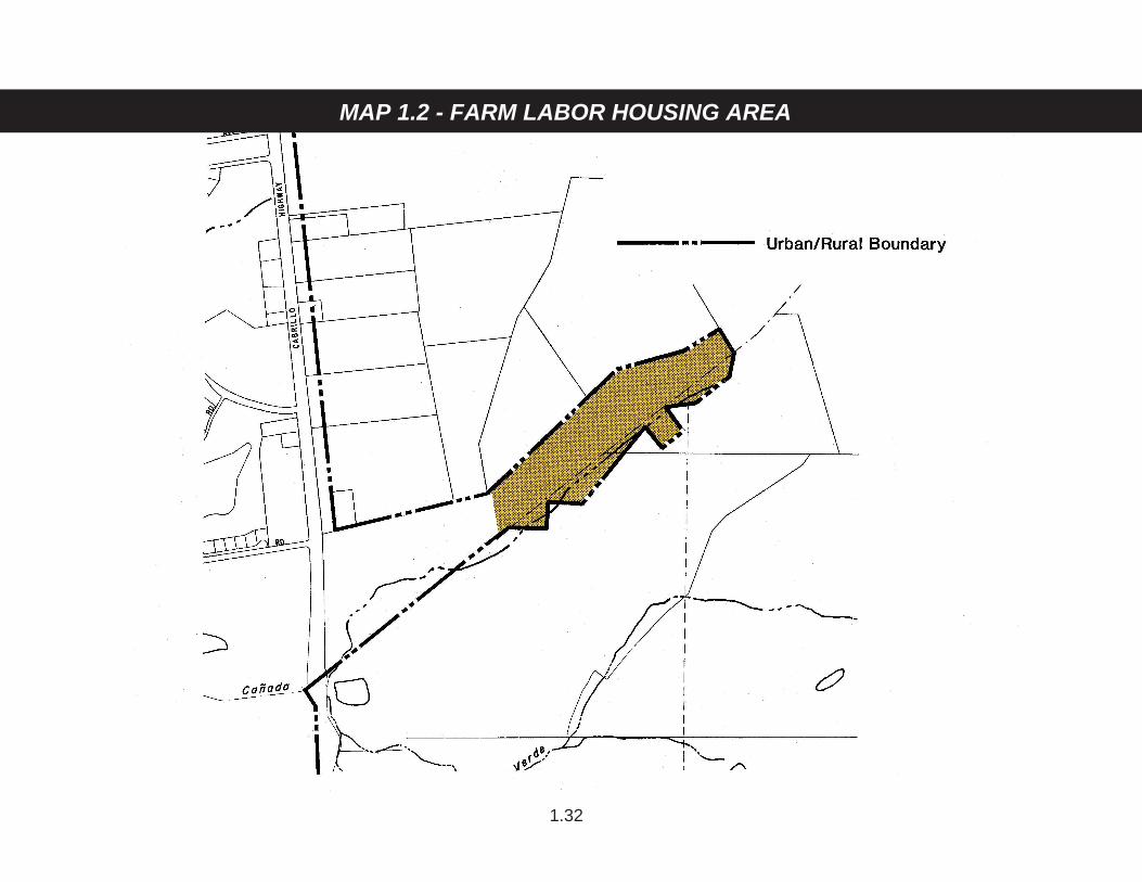
MAP 1.2 - FARM LABOR HOUSING AREA
1.32
SEAL COVE
N0 1000′ 2000′
PROJECT AREA
1.33
MAP 1.3 - MIDCOAST PROJECT AREA
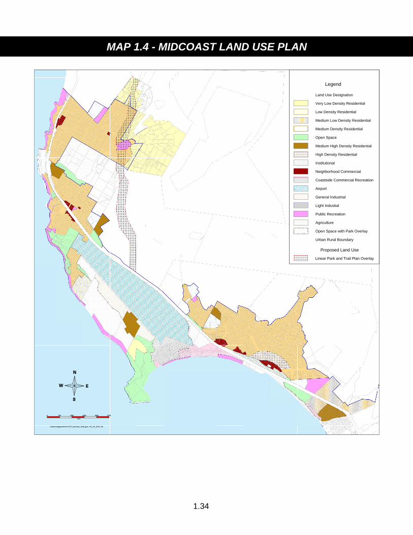
0 750 1500 2250 3000 3750
Feet
l:\planning\gis\steve\LCP_landuse_final.gws 04_25_2011 ah
Legend
Land Use Designation
Very Low Density Residential
Low Density Residential
Medium Low Density Residential
Medium Density Residential
Open Space
Medium High Density Residential
High Density Residential
Institutional
Neighborhood Commercial
Coastside Commercial Recreation
Airport
General Industrial
Light Industial
Public Recreation
Agriculture
Open Space with Park Overlay
Urban Rural Boundary
Proposed Land Use
Linear Park and Trail Plan Overlay
1.34
MAP 1.4 - MIDCOAST LAND USE PLAN
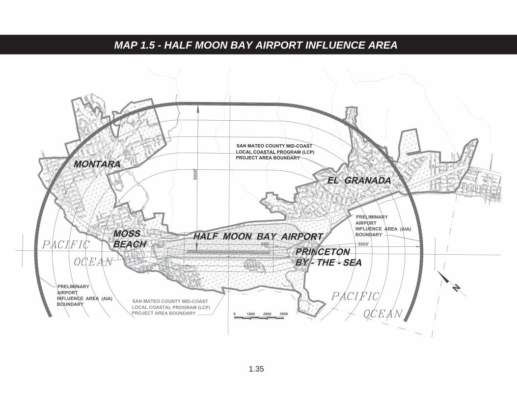
MAP 1.5 - HALF MOON BAY AIRPORT INFLUENCE AREA
1.35

2.1
PUBLIC WORKS COMPONENT GENERAL POLICIES 2.1 Development Review of Public Works After certification of the LCP, require a Coastal Development Permit from any
public utility, government agency or special district wishing to undertake any development in the Coastal Zone, with the exceptions of State Universities and colleges and development on public trust lands or tidelands as described in Section 30519(b) of the California Coastal Act.
2.2 Definition of Public Works Define public works as: a. All production, storage, transmission and recovery facilities for water,
sewerage, telephone, and other similar utilities owned or operated by any public agency or by any utility subject to the jurisdiction of the Public Utilities Commission except for energy facilities.
b. All public transportation facilities, including streets, roads, highways, public
parking lots and structures, ports, harbors, airports, railroads and mass transit facilities and stations, bridges, trolley wires and other related facilities.
c. All publicly financed recreational facilities and any development by a
special district. d. All community college facilities. 2.3 Definition of Special District Define a special district as any public agency, other than a local government,
formed pursuant to general law or special act for the local performance of governmental or proprietary functions within limited boundaries. “Special Districts” include, but are not limited to, a County service area, a maintenance district or area, an improvement district or improvement zone, or any other zone or area, formed for the purpose of designating an area within which a property tax or fee will be levied to pay for a service or improvement benefiting the area.

2.2
*2.4 Ordinance Conformity As a condition of permit approval, special districts, public utilities and other
government agencies shall conform to the County’s zoning ordinance and the policies of the Local Coastal Program.
2.5 Review of Public Works Projects a. Require implementation in the Coastal Zone of Sections 65401, 65402 and
65403 of the Government Code which require all governmental bodies, including special districts, to submit to the Planning agency a list of the proposed public works recommended for planning or construction during the ensuing fiscal year. Require in the Coastal Zone that State agencies also fulfill this requirement. Require that the Planning Commission review these lists for conformance with the Local Coastal Program.
b. Require that each governmental body in the Coastal Zone, including
special districts and State agencies, prepare five (5) year Capital Improve-ment Programs as allowed by Section 65403 of the Government Code. Require that the Planning Commission review these Capital Improvement Programs for conformance with the Local Coastal Program.
*2.6 Capacity Limits Limit development or expansion of public works facilities to a capacity which
does not exceed that needed to serve buildout of the Local Coastal Program. 2.7 Phased Development of Public Works Facilities Require the phased development of public works facilities in order to ensure that
permitted public works capacities are limited to serving needs generated by development which is consistent with the Local Coastal Program policies. In accordance with Policies 2.9, 2.14, 2.22, 2.27, and 2.42, allow expansion of public works facilities, including but not limited to water supply and transmission, sewage treatment and transmission, and the San Mateo County Midcoast and City of Half Moon Bay regional transportation system only after considering the availability of other public works facilities, and establishing whether capacity increases would overburden the existing and probable future capacity of other public works facilities.
2.8 Reservation of Capacity for Priority Land Uses a. Reserve public works capacity for land uses given priority by the Local
Coastal Program as shown on Table 2.7 and Table 2.17. All priority land uses shall exclusively rely on public sewer and water services.
2.3
b. For each public works development to serve vacant lands with new connections, reserve capacity adequate to allow priority land uses to develop in conjunction with the non-priority development that would be facilitated by the public works development.
c. Where development of new public works facilities can accommodate only a
limited amount of new connections on vacant land, the service provider shall ensure that adequate capacity is reserved for Coastal Act priority uses before reserving capacity for Local Coastal Program priority uses shown on Tables 2.7 and 2.17.
d. Allow public agencies and utilities to reallocate capacity to non-priority land
uses only through an amendment to the coastal development permit, Public Works Plan, and/or LCP Amendment if applicable. Applications for a coastal development permit, Public Works Plan, or LCP Amendment to reallocate priority capacity must be accompanied by substantial evidence and studies documenting excess capacity. Before approving the realloca-tion and before submitting the reallocation to the Coastal Commission for an LCP Amendment, the Planning Commission shall substantiate, in writing, that the remaining reserved capacity will be adequate to serve the remaining priority land uses.
e. Allow Coastside County Water District and Montara Water and Sanitary
District to allocate priority capacity in accordance with Table 2.17 to provide municipal water service to residential dwellings which are connected to the public sanitary sewer system, when such a connection is necessary to avert a substantial hardship caused by the failure of a private well serving the dwelling in production quantity or quality as certified by the Director of the Environmental Health Division. For purposes of this policy, “substantial hardship” shall not include any failure which can be remedied by repair or replacement of well equipment or facilities, or relocation of a well on a parcel. Whether substantial hardship exists shall be determined by the Community Development Director, following consultation with the Director of Environmental Health and the General Manager of the serving water district.
In order to minimize the reduction in water reserved for Coastal Act priority
land uses, applications for reallocated water shall include a Water Fixture Retrofit Plan to replace existing water fixtures of the residence applying for the connection with water conserving fixtures. This plan must be reviewed and approved by the General Manager of the serving water district prior to the establishment of the connection, and contain the following:
(1) A list of all existing fixtures to be retrofitted and their present
associated water flow (e.g., gallons/second);
2.4
(2) A list of all proposed fixtures to be installed and their associated water flow;
(3) The estimated annual water savings resulting from the proposed
retrofit, showing all calculations and assumptions; and (4) A leak detection test; all leaks shall be repaired, but such repairs
shall not be calculated in the estimates of savings. The inspection personnel of the serving water district shall inspect the
water fixtures prior to and following the retrofit to confirm compliance with the approved plan and proper installation.
The serving water district shall provide notices to the County Planning
Department and the Coastal Commission of all failed well applications. 2.9 Timing for New or Expanded Public Works Facilities a. The amount of new or expanded capacity shall be determined by: (1) Estimating the capacity needed to serve the land use plan at
buildout; (2) Considering the availability of related public works to establish
whether capacity increases would overburden the existing and probable future capacity of other public works;
(3) Considering the availability of funds; and (4) Considering available information from the Transportation
Management Plan required by Policy 2.53. b. Require every new public works facility or expansion of capacity to go
through the coastal development review process. 2.10 Coordination with the City of Half Moon Bay Coordinate with the City of Half Moon Bay’s certified Local Coastal Program to
take into consideration the policies of the City’s LCP when determining when and how much to increase the capacity of all public works facilities.
2.5
2.11 Establishing Service Area Boundaries *a. Confine urban level services provided by governmental agencies, special
districts and public utilities to urban areas, rural service centers and rural residential areas as designated by the Local Coastal Program on March 25, 1986.
*b. Redraft the boundaries of special districts or public utilities providing urban
level services to correspond to the boundaries of urban areas, rural service centers and rural residential areas established by the Local Coastal Program.
*c. Allow exceptions to a. and b. when all alternatives have been fully explored
and a special district or public utility is required to maintain some rural land within its boundaries in order to continue a service to its customers which is (1) otherwise consistent with the policies of the Local Coastal Program, (2) maintains the rural nature of undeveloped areas, particularly the use and productivity of agricultural land, (3) maintains the present level of service to existing users in undeveloped areas, and (4) where an illegal situation or great hardship would be created by detachment from a special district or public utility.
d. Require, when a special district or public agency maintains rural lands
within their boundaries that the special district or public agency divide the districts into rural and urban zones. Make boundaries of the urban zone, where urban level services are provided, correspond to the boundaries of urban areas and rural service centers established by the Local Coastal Program. Include the rest of the district in the rural zone. Restrict the activities in rural zones to those which are consistent with the maintenance of the rural nature of the area and all other policies of the Local Coastal Program. Lower the user costs in the rural zone to reflect the lower level of service and minimize growth inducement.
*2.12 New or Expanded Special Districts Allow the formation or expansion of special districts only when the new or
expanded district would not cause or allow development or uses inconsistent with the Local Coastal Program.
2.13 Expansion of Special Districts Allow the formation or expansion of special districts only where assessment for,
and provision of, the service would not induce new development inconsistent with the Coastal Act or with the certified LCP.
2.6
SEWERS 2.14 New and Expanded Sewage Treatment and Distribution Capacity a. Allow new or expanded sewage treatment and distribution capacity to
serve new development only when existing capacity has been consumed or will be consumed within the time period required to construct additional sewage treatment capacity, and only when capacity increases would not overburden the existing and probable future capacity of other public works facilities.
b. Projects to increase sewage collection, transmission, and storage capacity,
in order to prevent wet weather overflows only, are permitted notwith-standing traffic conditions on Highways 1 and 92 provided that the projects do not: (1) induce growth; or (2) increase the treatment capacity of the Sewer Authority Mid-Coastside (SAM) plant or the total number of sewer connections made available by the SAM treatment plant expansion permitted by Coastal Commission CDP No. 1-94-111.
c. Projects to upgrade the SAM treatment plant from secondary to tertiary
treatment to produce recycled water are permitted notwithstanding traffic conditions on Highways 1 and 92 provided that the recycled water project does not: (1) induce growth inconsistent with the LCP; (2) provide potable water connections to new non-priority development; or (3) increase the total number of non-priority connections made available by either the El Granada Pipeline Project (Coastal Commission CDP A-2-SMC-99-063; A-1-HMB-99-020) or the Montara Water and Sanitary District (MWSD) Public Works Plan (Coastal Commission PWP No. 2-06-006). Recycled water projects that would provide new potable water connections to new commercial, residential, or industrial development are subject to subsection (a), Policy 2.22, and all other applicable policies of the LCP.
d. Sewage treatment, collection, storage, and transmission projects shall be
consistent with the following standards: (1) Maximum Capacity. The maximum service capacity of the project
shall not induce growth inconsistent with the protection of coastal resources and public access and recreation opportunities, and will assure that untreated wastewater will not be discharged into any coastal waters including streams, wetlands and the marine environment.
(2) Priority Uses. The project shall demonstrate that sewage treatment,
collection, and transmission capacity is available and allocations are reserved for Coastal Act priority uses.
2.7
(3) Siting. The project shall be sited and designed to minimize impacts to visual resources, prevent degradation of sensitive habitats, and shall be consistent with all applicable policies of the LCP.
(4) The project shall minimize the use of energy. 2.15 Annexation Recommend that the City of Half Moon Bay detach incorporated areas from the
Granada Sanitary District and include these areas in their allocation. 2.16 Reservation of Capacity for Priority Land Uses a. Reserve sewage treatment capacity for each land use given priority by the
Coastal Act or the Local Coastal Program. These priority uses are shown on Table 2.7. Amend this table to reflect all changes in the Land Use Plan which affect these priority land uses.
b. Where existing or planned sewage treatment facilities can accommodate
only a limited amount of new development, services to Coastal Act priority uses listed on Table 2.7 shall have priority over Local Coastal Program priority uses listed on Table 2.7.
c. Allow capacity to be reallocated to non-priority land uses in accordance
with Policy 2.8. 2.17 Establishing Service Area Boundaries a. Require, as a condition of granting a permit for expansion of sewage
treatment facilities, that sanitary sewer connections be limited to the urban areas and rural residential areas as shown on the Land Use Plan Map 1.3 and the zoning map. Exclude property located outside the urban boundary and rural residential areas from assessment for sewage treatment facilities by SAM or its member agencies.
b. Allow SAM to supply reclaimed wastewater to areas consistent with
LCP Policy 2.14(c). c. Redraw the boundaries of the sewer districts to correspond to all lands
inside the urban/rural boundary and the boundary of rural residential areas. 2.18 Montara Treatment Plant a. Allow Montara Water and Sanitary District to use the old Montara
Treatment Plant for wet weather storage, a pump station, and to provide tertiary wastewater treatment to produce recycled water.
2.8
b. Reserve public pedestrian access on the seaward side of this Montara site and connect it to proposed trails at both ends consistent with the policies of the Shoreline Access Component.
2.19 Private Septic Systems New private septic systems shall be prohibited within the urban/rural boundary
of the Midcoast unless: a. There is no public sewer hookup available; b. The system complies with all the requirements for individual septic disposal
systems; and c. The system is approved by San Mateo County Environmental Health and
other applicable authorities. 2.20 Environmental Compatibility of Treatment Plants a. Require that utilities, prior to approval of construction or addition to
treatment plants, submit a plan for successful mitigation of any potential impacts on the surrounding residential and recreational area and on resources, including habitats and air quality.
b. Require that plants be designed and landscaped to be visually compatible
with surrounding areas, particularly nearby residences or recreational areas.
MIDCOAST WATER SUPPLY 2.21 Water Use Monitoring Require that the water service providers, presently Coastside County Water
District (CCWD) and the Montara Water and Sanitary District (MWSD), monitor: (1) the actual amount of water consumption by land use, and (2) the rate of growth of new development. Require them to submit an annual data report to the County summarizing the results of this monitoring.
2.22 New and Expanded Water Supply and Distribution Capacity a. Allow new or expanded water supply, service connections, treatment,
storage and distribution capacity to serve new development only under the following circumstances: (1) when existing capacity has been consumed or will be consumed within the time required to construct additional water supply capacity; (2) after considering the availability of other public works facilities, and establishing whether capacity increases would overburden
2.9
the existing and probable future capacity of other public works facilities; and (3) after considering information from, or being used to create, the Transportation Management Plan required by Policy 2.53, if available.
b. Supplemental water supply projects to serve urban development served
by private wells that exist as of [effective date of amendment] may be permitted notwithstanding traffic conditions on Highways 1 and 92 if existing non-priority capacity has been consumed. “Consumption of existing capacity” shall be defined as either water-serving district having no water connections available, or water district having no available water to serve existing connections.
c. Supplemental water supply projects to serve customers who purchased
water connections before December 10, 2009 may be permitted notwith-standing traffic conditions on Highways 1 and 92, if existing capacity has been consumed and the project is a component of a comprehensive water management plan consistent with f.(5) below.
d. The capacity of water facilities may be sized for probable future service
needs of new development notwithstanding the traffic conditions on Highways 1 and 92, if the project is conditioned to restrict the provision of connections to new development in a manner that does not overburden local roadways or other infrastructure systems.
e. Projects to upgrade the SAM treatment plant from secondary to tertiary
treatment to produce recycled water are permitted notwithstanding traffic conditions on Highways 1 and 92 provided that the recycled water project does not: (1) induce growth; (2) provide potable water connections to new non-priority development; or (3) increase the total number of non-priority connections made available by either the El Granada Pipeline Project (Coastal Commission CDP A-2-SMC-99-063; A-1-HMB-99-020) or the Montara Water and Sanitary District (MWSD) Public Works Plan (Coastal Commission PWP No. 2-06-006). Recycled water projects that would provide new water potable connections to new commercial, residential, or industrial development are subject to subsection (a), Policy 2.14, and all other applicable policies of the LCP.
f. Supplemental water supply projects shall be consistent with the following
standards: (1) The maximum service capacity of the project will not induce growth
inconsistent with the protection of coastal resources and public access and recreation opportunities.
(2) The project shall assure that water withdrawals from surface streams
and groundwater will be sufficiently limited to protect: (i) adequate

2.10
in-stream flows necessary to support sensitive species and other riparian/wetland habitats; (ii) underlying groundwater aquifers; and (iii) agricultural resources.
(3) The project shall demonstrate that water capacity is available and
allocations are reserved for Coastal Act priority uses. (4) The project shall demonstrate that water storage and delivery
systems will be adequate to meet the fire safety and other public health and safety needs of new development supported by the project, consistent with the protection of other coastal resources.
(5) The project shall demonstrate that it is an element (where
economically and environmentally appropriate) of a balanced water supply portfolio that also includes other supply alternatives, including conservation and water recycling to the maximum extent practicable.
(6) The project shall minimize the use of energy. (7) The project shall be sited and designed to minimize impacts to visual
resources and shall be consistent with all applicable policies of the LCP.
2.23 Desalination Definition: A desalination facility removes salts and minerals from seawater or
groundwater to create potable water. A desalination facility does not include devices attached to existing wells or public water connections to remove minerals from an existing water source.
Desalination facilities must: a. Provide public services within the urban area. b. Avoid or fully mitigate any adverse environmental impacts to coastal
resources. c. Be consistent with all LCP and Coastal Act policies, including those for
concentrating development, supporting priority coastal uses, and protecting significant scenic and habitat resources.
d. Be designed and sized based upon adopted community planning docu-
ments, which may include General Plans, Urban Water Management Plans, Regional Water Supply Plans, Local Coastal Programs, and other approved plans that integrate local or regional planning, growth, and water supply/demand projections.

2.11
e. Use technologies that are energy-efficient. Estimates of the projected annual energy use and the environmental impacts that will result from this energy production, and evidence of compliance with air pollution control and greenhouse gas emission laws for emissions from the electricity generation, shall be submitted with permit applications.
f. Use, where feasible, sub-surface feedwater intakes (e.g., beach wells)
instead of open pipelines from the ocean, where they will not cause significant adverse impacts to either beach topography or potable groundwater supplies.
g. Use technologies and processes that eliminate or minimize the discharges
of hazardous constituents into the ocean and ensure that the least environ-mentally damaging options for feedwater treatment and cleaning of plant components are selected. Opportunities for combining brine discharges with other discharges (e.g., from a sewage treatment facility or power plant) should be considered and the least environmentally damaging alternative pursued. Applicants should provide information necessary to determine the potential impacts to marine resources from the proposed intake and discharge. Obtaining this information may require new or updated engineering, modeling and biological studies, or in some cases may be obtained from pre-operational monitoring, monitoring results from other desalination facilities, and pilot studies conducted before building a full-scale facility.
h. Be designed and limited to assure that any water supplies made available
as a direct or indirect result of the project will accommodate needs generated by development or uses consistent with the kinds, location and densities specified in the LCP and Coastal Act, including priority uses as required by Coastal Act Section 30254.
i. Be an element (where economically and environmentally appropriate) of a
balanced water supply portfolio that also includes conservation and water recycling to the maximum extent practicable.
2.24 Reservation of Capacity for Priority Land Uses a. Reserve water supplies for each land use given priority by the Coastal Act
or the Local Coastal Program. These priority uses are shown on Table 2.17. Amend this table to reflect all changes in the Land Use Plan which affect these land uses.
b. For each water supply public works development to serve vacant lands
with new connections, reserve capacity adequate to allow priority land uses to develop in conjunction with the non-priority development that would be facilitated by the water supply public works development.

2.12
c. Where development of new public works facilities can accommodate only a limited amount of new connections on vacant land, adequate capacity for Coastal Act priority uses shall be reserved before reserving capacity for Local Coastal Program priority uses shown on Tables 2.7 and 2.17.
2.25 Quality of Water Supply Require that the water quality of new supplies for domestic use meet potable
water standards and provide the highest practicable quality for floriculturists. 2.26 Conservation Require water service providers to establish water conservation programs to
reduce existing and future water consumption. 2.27 Groundwater Proposal Require, if new or increased well production is proposed to increase public water
supply consistent with LCP Policy 2.22, that: a. Water quality be adequate, using blending if required, to meet the water
standards of Policy 2.25. b. Wells are installed under inspection according to the requirements of the
State and County Department of Public Health. c. The amount pumped be limited such that it does not impact sensitive
species and habitats including streams, riparian habitats and wetlands. d. Base pumping restriction on studies conducted by a person agreed upon
by the County and the applicant which shall: (1) prior to the granting of the permit, examine the geologic and hydrologic conditions of the site to determine the amount that may be pumped without adversely affecting a water-dependent sensitive habitat or result in depletion of the aquifer; and (2) during the first [three] years, monitor the impact of the well on ground-water and surface water levels and water quality and plant species and animals of water-dependent sensitive habitats to determine if the preliminary pumping restriction adequately protects the sensitive habitats and what measures should be taken if and when adverse effects occur.
e. If monitoring shows impacts to water-dependent sensitive habitats, the
pumping rate shall be reduced until it is clear that such impacts will not occur.
2.13
2.28 Management of Pillar Point Marsh Require, as a condition of development permit for any facilities to increase water
supply, that any water system that presently draws or proposes to draw water from wells in the aquifer serving Pillar Point Marsh agree to participate in and assist in the funding of the hydrologic study of Pillar Point Marsh required by Policy 7.20 and to accept the restrictions resulting from that study.
2.29 Denniston Dam Project Proposal Require, if building Denniston or any other dam is proposed to increase water
supplies: (1) a study evaluating the effects of the dam on groundwater and maintaining the optimum productivity of Pillar Point Marsh and other affected habitats which shall include monitoring procedures to measure the effects of the project and measures to be taken if and when adverse effects occur, (2) a seismic safety evaluation, consistent with State standards, to determine that the dam is safe, (3) a list of mitigation measures to be taken ensuring a viable habitat for the San Francisco garter snake and (4) phased development of the dam.
2.30 Findings Require, as a condition of permit approval for any facilities to increase water
supply, that the following findings are made: (1) the addition of this water supply facility is consistent LCP Policies 2.22, 2.23, and 2.24; (2) storage is adequate to ensure that sufficient emergency supply is available and any additional development allowed because of this increase in water supply will be served during dry summer months; (3) the development of this facility minimizes energy consumption; and (4) the siting of this facility is consistent with LCP policies.
2.31 Service Area Boundaries As a condition of expansion of water facilities, require water service providers to: a. Revise district boundaries to include within those boundaries only those
areas proposed for urban development by the LCP and rural areas within the existing Coastside County Water District Service Area which have existing water connections for floriculturists.
b. Permit new connections to the water system only within district boundaries. c. Divide the district into rural and urban zones.

2.14
(1) Make the boundaries of the urban zone correspond to the urban boundary and the boundary of rural residential areas established by the LCP.
(2) Allow water connections for all types of users within urban zone. (3) Designate the parts of the district outside the urban zone as the rural
zone. (4) Permit new water connections to only floriculturist and agriculture
within the rural zone. (5) Establish user fees to cover the costs of water service in the rural
zone. Relieve, where legally feasible, property owners within the rural zone who are not connected to the water system of indebtedness and transfer the debt to the urban zone and property owners provided with water service in the rural zone.
(6) Permit new water connections to serve designated historical
structures within the rural area of the Coastal Zone when the following conditions are met:
(a) The water system connection services only the designated
historical structure, no hookups to service other properties are allowed;
(b) The historical structure is listed on the National Register of
Historical Places as of January 7, 1992; (c) It is demonstrated that there is no adequate on-site well water
source or other feasible on-site water supply; (d) The site and structure are owned by a governmental agency
and operated by a governmental agency or non-profit organization;
(e) The site includes an agricultural demonstration use; (f) Water use is limited to that necessary to serve agriculture,
visitor serving, and fire protection needs; provided that the amount of water allowed for such uses is limited to that which is necessary for museum purposes including the demonstration of Nineteenth Century garden and agrarian practices directly associated with the historical structure;

2.15
(g) No residential use will be made of the structure or site; (h) The structure is open on a regular basis to visitors; and (i) Any commercial use of the site directly relates to the historical
significance of the structure. For the purposes of this policy, any service provided to a structure
which meets the above criteria shall not be deemed an urban level service.
2.32 Consolidation Encourage the consolidation of Midcoast water service providers into one
authority or agency. TOWN OF PESCADERO WATER SUPPLY 2.33 Provision of Safe Water System Pursue actively the development and funding of a water system to eliminate the
potential health hazard in the Town of Pescadero. 2.34 Capacity Limits Limit capacity of the system to the water required to serve buildout of the LCP
Pescadero Land Use Plan. 2.35 Reservation of Capacity Reserve capacity for uses in the following order: a. Existing housing units and commercial facilities. b. Coastal Act and LCP priority land uses as shown on Table 2.18. Amend
this table to reflect changes in the Land Use Plan which affect these land uses.
c. Other land uses. 2.36 Release of Permits a. Require the managing entity of the water system to: (1) Base release of water connection permits on proven capability of the
system as it is determined initially and reevaluated annually.
2.16
(2) Use the priorities for reservation of capacity to determine the order in which permits shall be granted. Prohibit the granting of permits to other land uses until the system is proven capable of supplying existing housing and commercial facilities and Coastal Act and LCP priority land uses.
2.37 Monitoring Require the managing entity of the water system to monitor water consumption
by use and revise the estimated buildout capacity limits and the reservations for the priority uses annually on the basis of this monitoring.
2.38 Groundwater Proposal a. Require, if wells are proposed for increased water supply, two or more
wells to reduce the potential for drawing down polluted water from the surface alluvium layer.
b. Require a storage tank with capacity to provide a two to four week
emergency water supply in case of full failure of the wells and/or rapid deterioration of water quality.
c. Require that a qualified person agreed upon by the County and the
applicant shall conduct studies which: (1) prior to the granting of a well permit, examine the geologic and hydrologic conditions of the site to determine a safe water yield which will not adversely affect water dependent sensitive habitats; and (2) during the first five years, monitor the impact of the well on groundwater and surface water levels and quality, plant species and animals of affected water dependent sensitive habitats to determine if the sensitive habitats are adversely impacted and what measures should be taken if and when adverse effects occur. Require mitigation of adverse impacts.
d. If the preliminary safe yield has been found to be other than previously
established, after public hearings, revise the yearly allowable water withdrawals to reflect this new figure, seek other water sources and follow the requirements for the release of permits in Policy 2.36.
2.39 Service Area Boundary Limit water connections to uses within the boundary of the rural service center
and to the fire protection facility serving the rural service center on July 28, 1993.

2.17
2.40 Sewage Disposal a. Examine the need for a change in sewage disposal practices when a new
water source for Pescadero has been found. Determine whether the existing septic tank system is adequate or if an alternative sewage disposal system is required to serve the increased sewage generation created by the new water system. Pursue actively the development and funding of an appropriate sewage disposal system.
b. Limit the capacity of any sewage disposal system to what is required to
serve buildout of the LCP Pescadero Land Use Plan. SOLID WASTE 2.41 Regulating Truck Traffic at Ox Mountain Landfill a. Continue to monitor the commuter period traffic on Route 92 and the effect
of trucks using the Ox Mountain Landfill to determine whether the period when trucks are prohibited from entering or leaving the landfill should be extended to allow smoother commuter traffic flow.
b. Require the San Mateo County Scavenger Company, as a condition for a
development permit to expand its operation, to expand the period when trucks are prohibited from entering or leaving the landfill if and when CalTrans determines this is required to serve commuter traffic.
c. Encourage the San Mateo County Scavenger Company to use techniques,
such as front-end materials separation, at Bayside transfer stations in order to reduce the amount of solid waste requiring transportation and disposal at Ox Mountain.
ROADS 2.42 Capacity Limits a. Limit expansion of roadways to capacity which does not exceed that
needed to accommodate commuter peak period traffic when buildout of the Land Use Plan occurs and which does not exceed existing and probable future capacity of water and sewage treatment and transmission capacity or otherwise conflict with other policies of the LCP.
b. Use the requirements of commuter peak period traffic as the basis for
determining appropriate increases in capacity.
2.18
c. Ensure that any additional development that would be served or facilitated by the road expansion project does not exceed the development levels that the existing and probable future water supply and sewage treatment capability can serve.
d. Maintain Highway 1 as scenic two-lane road outside the Urban Midcoast
area depicted on Land Use Plan Map 1.3. 2.43 Desired Level of Service In assessing the need for road expansion, consider Service Level D acceptable
during commuter peak periods and Service Level E acceptable during recreation peak periods.
2.44 Route 1 and Route 92 Phase I Capacity Limits a. On Route 92, limit Phase I improvements to: (1) slow vehicle lanes on
uphill grades, and (2) the following operational and safety improvements within the existing alignment or lands immediately adjacent: elimination of sharp curves, lane widening, wider shoulders to allow passage for bicycles and emergency vehicles and signals at major intersections.
b. On Route 1, limit improvements to: (1) slow vehicle lanes on uphill grades
and the following operational and safety improvements within the existing alignment or lands immediately adjacent: elimination of sharp curves, lane widening, lane reconfiguration, acceleration/deceleration lanes, wider shoulders to allow passage for bicycles, emergency vehicles and signals at major intersections; (2) additional traffic lanes in the Midcoast project area as depicted on Map 1.3, provided the additional lanes are found to be in compliance with all other applicable policies of the LCP, including, but not limited to, sensitive habitat and wetland protection policies; and (3) con-struction of a tunnel for motorized vehicles only behind Devil’s Slide through San Pedro Mountain.
The tunnel design shall be consistent with (a) Coastal Act limits restricting
Route 1 to a two-lane scenic highway, and (b) minimum State and federal tunnel standards. A separate trail for pedestrians and bicycles shall be provided outside the tunnel as specified in Policy 2.50a and 2.50b.
2.45 Route 84 Phase I Capacity Limits Designate Route 84 as a recreational road. Limit Phase I improvements to the
following operational and safety improvements within the existing alignment or lands immediately adjacent: elimination of sharp curves, lane widening and wider shoulders to allow passage for emergency vehicles.
2.19
2.46 Monitoring a. Ensure that any data collected by transportation organizations, including
CalTrans’, of peak commuter periods and recreation peak periods is applied in decisions related to the adequacy of roadway capacity.
b. Monitor the number and rate of new residential construction particularly in
the rural and urban Midcoast. 2.47 Road Expansion Capacity Establish the capacity of future road expansion projects by: (1) estimating the
road capacity needed to serve the land use plan at buildout; (2) considering the availability of related public works and whether expansion of the road capability would overburden the existing and probable future capacity of other public works. The additional development that would be served/facilitated by the road expansion project may not exceed the development levels that the existing and probable future water supply and sewage treatment capability can serve; (3) considering the availability of funds; (4) demonstrating that basic levels of public transit service have been met and the proposed improvement will not result in reduced public transit patronage; and (5) ensuring that State Highway 1 in rural areas north of the Midcoast project boundary and south of the City of Half Moon Bay shall remain a scenic two-lane road.
2.48 Roadway Alignments a. For Routes 92 and 84, use the existing alignment when increasing roadway
capacity, unless it can be proven physically and economically infeasible, or if use of the existing alignment would be environmentally more damaging than an alternative route.
b. Require that the roadway improvements be consistent with all applicable
policies of the Local Coastal Program, including, but not limited to, the Sensitive Habitats and Agriculture Components.
2.49 Preferential Treatment for Buses Require that CalTrans provide preferential treatment for buses and shuttles at
congested locations, such as the intersection of Routes 1 and 92, in accordance with the Transit Policies of this Component.
2.50 Improvements for Bicycle and Pedestrian Trails a. Require, if funds are available, that CalTrans provide adjacent or separate
facilities for bicycle and pedestrian trails in accordance with the policies of the Recreation and Visitor-Serving Facilities and Shoreline Access

2.20
Components and the San Mateo County Bikeways Plan (CCAG). When the tunnel is completed behind Devil’s Slide, assure that CalTrans provides for a multi-use bicycle and pedestrian trail and connections consistent with Policy 10.38 and in accordance with the coastal development permit for the tunnel project.
b. Consistent with San Mateo County Coastal Development Permit No. PLN
2003-00428, upon the completion of all access improvements associated with the tunnel behind Devil’s Slide, if there is no plan for an alternative transition of responsibility for managing the relinquished portion of Highway 1 that is slated to become part of the California Coastal Trail (CCT), the County will accept CalTrans’ relinquishment of the abandoned portion as a non-motorized trail and shall open and operate the trail and facilities 365 days a year and in accordance with the operations plan developed by the County and CalTrans in consultation with the Devil’s Slide Access Task Force. This CCT facility shall be incorporated into the San Mateo County Parks System and remain within that system until such time as respon-sibility for operation and maintenance of the access is transferred to an alternative permanent custodian. In the event of a catastrophic failure of this public trail which renders all or part of it, in the judgment of the agency or organization which then has operational responsibility for it, unusable, un-repairable or un-maintainable, and such agency or organization further determines that repairs to restore the access to the pre-failure condition would not be feasible, that agency or organization shall not be required to return the access to its pre-failure condition. The agencies or organizations that own the land and have operational responsibility for the trail shall immediately apply for a separate coastal development permit to modify the nature, extent, and operational parameters of the coastal access in a manner consistent with the requirements of the Coastal Act, and the San Mateo County Local Coastal Program.
c. The County will work with CalTrans, the State Coastal Conservancy, the
Coastal Commission, State Parks, Golden Gate National Recreation Area, and other public agencies to ensure that a CCT trail alignment is developed and will continue from the southern terminus of the Devil’s Slide Highway 1 relinquishment and link to other trail systems.
d. Require, at a minimum, and consistent with AB 1396, that CalTrans protect
and make available adequate right-of-way to allow the future development of bicycle and pedestrian trails in accordance with the policies of the Recreation and Visitor-Servicing Facilities and Shoreline Access Com-ponents and the San Mateo County Comprehensive Bike Route Plan (CCAG) and the California Coastal Trail (CCT) Plan.
2.21
e. Through coordination with CalTrans, promote the development of a continuous Midcoast pedestrian/bicycle/multi-purpose path (or a system of single mode paths) parallel to Highway 1 as part of the overall CCT system.
f. Through coordination with CalTrans, promote the most appropriate, safe,
feasible crossings, either at-grade, above- or below-ground pedestrian crossings at Midcoast locations along Highway 1, including those shown as “Proposed Safe Crossing” in the Midcoast Recreational Needs Assessment – Map 3.
g. Unless a suitable off-highway alternative already exists or is being
provided, as part of any new or improved roadway project other than repair and maintenance of existing facilities and consistent with AB 1396, require that CalTrans incorporate the following provisions (the size and scope of which will be commensurate with the size and scope of the proposed roadway project):
(1) A link within the vicinity of the project area necessary to facilitate a
continuous Midcoast pedestrian/bicycle/multi-purpose path (or a system of single mode paths) parallel to Highway 1; or
(2) The most appropriate, safe, feasible crossings, either at-grade,
above- or below-ground pedestrian crossings at Midcoast locations along Highway 1, including those shown as “Proposed Safe Crossing” in the Midcoast Recreational Needs Assessment – Map 3; or
(3) Completion of any CCT segment gap that is in the vicinity of the new
or improved roadway project; or (4) Provide funding necessary to complete any of the above actions; or (5) Any combination of the above. h. Ensure that no roadway repair or maintenance project blocks or damages
any existing or formally planned public trail segment or, if such an impact is not avoidable, that an equal or better trail connection is provided in conjunction with that repair and maintenance project either directly by CalTrans or through CalTrans’ funding to a third party.
2.51 Protecting Road Capacity for Visitors through Transportation System Manage-
ment Techniques a. Use the following transportation system management techniques to
maximize the efficiency and effectiveness of existing roadways during

2.22
recreation peak periods and protect road capacity for visitors: (1) recom-mend that the State Highway Patrol enforce illegal parking regulations along Route 1 and in emergency pullouts on peak weekends and holidays; (2) recommend that CalTrans install left turn storage lanes at all parking lots (25 spaces or greater) along the shoreline; (3) prohibit new road or driveway connections to Routes 1 and 92 in the Midcoast area as shown on Map 1.3 which do not serve recreation facilities unless there is no feasible alternative; (4) minimize the number of new road or driveway connections to Routes 1, 92, and 84 in rural areas which do not serve recreation facilities; and (5) orient local commercial and community facilities away from Highways 1 and 92.
b. Recommend to the City of Half Moon Bay that it prohibit the location of
local commercial or community facilities on Route 92 and on Route 1, within a half-mile of Route 92.
c. Monitor the peak recreation period traffic to determine whether the above
techniques are successful and whether new residential development is consuming road capacity needed for visitors.
2.52 Traffic Mitigation for all Development in the Urban Midcoast In the urban Midcoast, require applicants for new development, as defined in
Section 30106 of the Coastal Act, that generates any net increase in vehicle trips on Highways 1 and/or 92, except for a single-family dwelling, a second dwelling unit, or a two-family dwelling, to develop and implement a traffic impact analysis and mitigation plan (TIMP). Prior to the approval of any coastal devel-opment permit (CDP) application involving the above, information necessary for the analysis and implementation of all components of the TIMP shall be submitted in support of any CDP application. Calculation of new vehicle trips generated shall assume maximum occupancy/use of any approved development. The TIMP shall include:
a. Traffic mitigation measures, including but not limited to transportation
demand management (TDM) measures set forth by the City/County Association of Governments (CCAG), establishing a shuttle service for employees of the subject development, subsidizing transit for employees of the specific development, charging for non-public access parking, establishing a carpool or vanpooling program for employees of the subject development, having a compressed work week for employees of the subject development, providing bicycle storage facilities and showers for employees of the subject development, and establishing a day care program for employees of the subject development. Prior to approval of the coastal development permit, the County must be able to make the finding that the proposed mitigation measures are adequate to offset new vehicle trips generated by the project to the extent feasible.
2.23
b. Specific provisions to assess, and mitigate for, the project’s significant adverse cumulative impacts on public access to, and recreational use of, the beaches of the Midcoast region of San Mateo County. This shall include an assessment of project impacts combined with other projects causing related impacts, including all reasonably foreseeable future projects as defined in 14 CCR Section 15130(b). Public access and recreation mitigation measures to consider include: providing public access parking that is not time restricted, public access signage indicating that public access parking is available, providing a public recreation shuttle bus to all the beaches during key recreational use times that commences at the junction of Highways 92 and 280, dedication of construction of various public access improvements such as bikeways, and vertical and lateral public paths to and along the beaches and/or bluffs.
2.53 Transportation Management Plan Develop a comprehensive transportation management plan to address the
cumulative traffic impacts of residential development, including single-family, two-family, multi-family, and second dwelling units, on roads and highways in the entire Midcoast, including the City of Half Moon Bay. The plan shall be based on the results of an analysis that identifies the total cumulative traffic impact of projected new development at LCP buildout and shall propose specific LCP policies designed to offset the demand for all new vehicle trips generated by new residential development on Highway 1, Highway 92, and relevant local streets, during commuter peak periods and peak recreation periods; and policies for new residential development to mitigate for residential development’s significant adverse cumulative impacts on public access to the beaches of the Midcoast region of San Mateo County.
The plan shall thoroughly evaluate the feasibility of developing an in-lieu fee
traffic mitigation program, the expansion of public transit, including buses and shuttles, and development of a mandatory lot merger program.
TRANSIT 2.54 Increased Commuter Transit Use Encourage use of transit by commuters through the following actions: a. Encourage and cooperate with SamTrans in gaining use of or developing a
park and ride facility near the intersection of Highways 1 and 92 which could be used as a central bus loading zone for commuters to the Bayside.
b. Encourage SamTrans to run express buses between the Bayside and the
park and ride facility during peak weekday commuter periods. Route buses
2.24
to a few central locations on the Bayside which connect with other SamTrans bus lines and other transit systems such as the South Pacific.
c. On weekends, use the park and ride facility for visitors parking. Visitors
could then walk, bike or take the bus to shoreline recreations points. d. Encourage SamTrans to sign and otherwise publicize the park and ride
facility for commuter and weekend recreation use. 2.55 Increased Recreational Transit Use Encourage use of transit by visitors through the following actions: a. Encourage SamTrans to continue special recreation transit service to Año
Nuevo State Reserve and Half Moon Bay during the Pumpkin Festival. b. Encourage SamTrans to expand and publicize their existing weekend and
holiday bus service. c. Encourage SamTrans, as a first phase, to make the following modifications
in their existing routes on weekends and holidays from March through October in order to better inform and serve recreationists:
(1) In cooperation with the County and the State Department of Parks
and Recreation, place transit information signs at recreation facilities and established shoreline access points.
(2) Locate and designate bus stops near each of the following recreation
facilities: (a) Grey Whale Cove State Beach (Route 1A/1H only), (b) Montara State Beach, (c) Fitzgerald Marine Reserve, (d) Pillar Point Harbor, (e) Park and Ride Facility near the intersection of Routes 1 and 92 described in Policy 2.54, and (f) Half Moon Bay State Beach.
(3) Use more direct routes, with very limited side trips into residential
neighborhoods, during the peak recreation periods. d. As a second phase, after the above improvements in service have been
made, encourage SamTrans to do the following on holidays and weekends between March and October:
(1) Expand regular transit service to the South Coast and provide
frequent express recreational transit service to the Coastside from school and shopping center locations on the Bayside and in San Francisco.

2.25
(2) Provide shuttle service between inland parking lots on the Coastside, such as the commuter park and ride lots, and beaches.
2.56 Increased Service for Coastside Residents Encourage SamTrans to expand bus service to and along the Coastside to
improve transit service to Coastside residents. 2.57 Investigate and Maximize New Transit Funding Resources Encourage SamTrans to investigate and maximize new funds to expand transit
service to the Coastside particularly during recreation periods. 2.58 Cooperation with Santa Cruz Transit Encourage SamTrans to cooperate with Santa Cruz transit in providing transit
service on the Coastside. 2.59 Monitoring Require that the County Planning staff and SamTrans staff jointly evaluate, on a
continuing basis, the implementation of the Transit Policies of this Component.
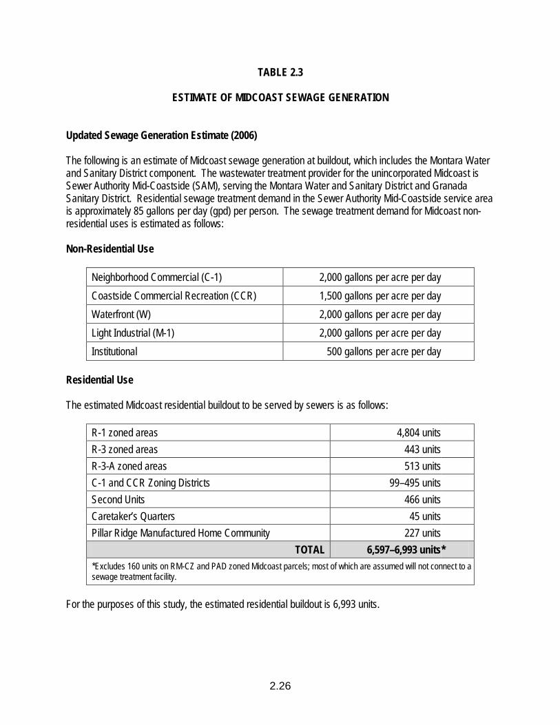
2.26
TABLE 2.3
ESTIMATE OF MIDCOAST SEWAGE GENERATION Updated Sewage Generation Estimate (2006) The following is an estimate of Midcoast sewage generation at buildout, which includes the Montara Water and Sanitary District component. The wastewater treatment provider for the unincorporated Midcoast is Sewer Authority Mid-Coastside (SAM), serving the Montara Water and Sanitary District and Granada Sanitary District. Residential sewage treatment demand in the Sewer Authority Mid-Coastside service area is approximately 85 gallons per day (gpd) per person. The sewage treatment demand for Midcoast non-residential uses is estimated as follows: Non-Residential Use
Neighborhood Commercial (C-1) 2,000 gallons per acre per day Coastside Commercial Recreation (CCR) 1,500 gallons per acre per day Waterfront (W) 2,000 gallons per acre per day Light Industrial (M-1) 2,000 gallons per acre per day Institutional 500 gallons per acre per day
Residential Use The estimated Midcoast residential buildout to be served by sewers is as follows:
R-1 zoned areas 4,804 units R-3 zoned areas 443 units R-3-A zoned areas 513 units C-1 and CCR Zoning Districts 99–495 units Second Units 466 units Caretaker’s Quarters 45 units Pillar Ridge Manufactured Home Community 227 units
TOTAL 6,597–6,993 units * *Excludes 160 units on RM-CZ and PAD zoned Midcoast parcels; most of which are assumed will not connect to a sewage treatment facility.
For the purposes of this study, the estimated residential buildout is 6,993 units.

TABLE 2.3 (continued)
ESTIMATE OF MIDCOAST SEWAGE GENERATION
2.27
Census 2000 showed average Midcoast household size as 2.78 persons per household. Based on the residential sewage treatment demand figure above (85 gpd), the estimated sewer treatment capacity needed to serve Midcoast residential buildout is 1.65 million gallons per day. Non-Residential Uses The area designated for non-residential sewage treatment demanding uses in the Midcoast is as follows:
Land Use/Zoning Acres Neighborhood Commercial (C-1) 24 Coastside Commercial Recreation (CCR) 45 Waterfront (W) 39 Light Industrial (M-1) 47 Institutional 49
Based on the non-residential sewage treatment demand figures above, the sewage treatment capacity needed to serve non-residential uses at buildout is as follows:
Land Use/Zoning Gallons Per Day Neighborhood Commercial (C-1) 48,000 Coastside Commercial Recreation (CCR) 67,500 Waterfront (W) 78,000 Light Industrial (M-1) 94,000 Institutional 24,500 TOTAL 311,000
The sewage treatment capacity needed to serve non-residential buildout is 0.31 million gallons per day. Combined Residential and Non-Residential Uses at Buildout The total sewage treatment capacity needed to serve combined residential and non-residential Midcoast buildout is 1.96 million gallons per day.
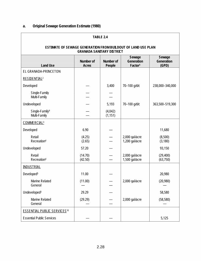
2.28
a. Original Sewage Generation Estimate (1980)
TABLE 2.4
ESTIMATE OF SEWAGE GENERATION FROM BUILDOUT OF LAND USE PLAN GRANADA SANITARY DISTRICT
Land Use Number of
Acres Number of
People
Sewage Generation
Factor1
Sewage Generation
(GPD) EL GRANADA-PRINCETON
RESIDENTIAL2
Developed — 3,400 70–100 g/d/c 238,000–340,000
Single-Family — — Multi-Family — —
Undeveloped — 5,193 70–100 g/d/c 363,500–519,300
Single-Family9 — (4,042) Multi-Family — (1,151)
COMMERCIAL3
Developed 6.90 — 11,680
Retail (4.25) — 2,000 gal/acre (8,500) Recreation4 (2.65) — 1,200 gal/acre (3,180)
Undeveloped 57.20 — 93,150
Retail (14.70) — 2,000 gal/acre (29,400) Recreation4 (42.50) — 1,500 gal/acre (63,750)
INDUSTRIAL
Developed5 11.00 — 20,980
Marine Related (11.00) — 2,000 gal/acre (20,980) General — — —
Undeveloped3 29.29 — 58,580
Marine Related (29.29) — 2,000 gal/acre (58,580) General — — —
ESSENTIAL PUBLIC SERVICES10
Essential Public Services — — 5,125
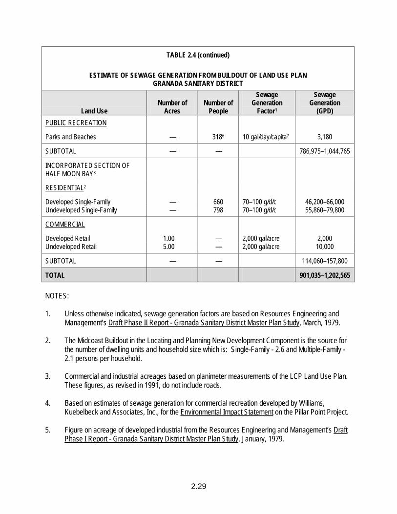
2.29
TABLE 2.4 (continued)
ESTIMATE OF SEWAGE GENERATION FROM BUILDOUT OF LAND USE PLAN GRANADA SANITARY DISTRICT
Land Use Number of
Acres Number of
People
Sewage Generation
Factor1
Sewage Generation
(GPD) PUBLIC RECREATION
Parks and Beaches — 3186 10 gal/day/capita7 3,180
SUBTOTAL — — 786,975–1,044,765
INCORPORATED SECTION OF HALF MOON BAY8
RESIDENTIAL2
Developed Single-Family — 660 70–100 g/d/c 46,200–66,000 Undeveloped Single-Family — 798 70–100 g/d/c 55,860–79,800
COMMERCIAL
Developed Retail 1.00 — 2,000 gal/acre 2,000 Undeveloped Retail 5.00 — 2,000 gal/acre 10,000
SUBTOTAL — — 114,060–157,800
TOTAL 901,035–1,202,565 NOTES: 1. Unless otherwise indicated, sewage generation factors are based on Resources Engineering and
Management’s Draft Phase II Report - Granada Sanitary District Master Plan Study, March, 1979. 2. The Midcoast Buildout in the Locating and Planning New Development Component is the source for
the number of dwelling units and household size which is: Single-Family - 2.6 and Multiple-Family - 2.1 persons per household.
3. Commercial and industrial acreages based on planimeter measurements of the LCP Land Use Plan.
These figures, as revised in 1991, do not include roads. 4. Based on estimates of sewage generation for commercial recreation developed by Williams,
Kuebelbeck and Associates, Inc., for the Environmental Impact Statement on the Pillar Point Project. 5. Figure on acreage of developed industrial from the Resources Engineering and Management’s Draft
Phase I Report - Granada Sanitary District Master Plan Study, January, 1979.
TABLE 2.4 (continued)
ESTIMATE OF SEWAGE GENERATION FROM BUILDOUT OF LAND USE PLAN GRANADA SANITARY DISTRICT
2.30
6. Based on the number of projected annual visitors to the Fitzgerald Marine Reserve divided by 365 to estimate an average day.
7. Based on the estimates of sewage generation for beach and tourist restrooms developed by
Williams, Kuebelbeck and Associates, Inc., for the Environmental Impact Statement on the Pillar Point Project.
8. Based on estimates of buildout for the part of Half Moon Bay included in the Granada Sanitary
District which were contained in Resources Engineering and Management’s Draft Phase I Report - Granada Sanitary District Master Plan Study.
9. This table reflects the second units that are permitted in R-1 Coastal Zoning Districts. It is estimated
that 350 persons would be housed in second units located in this area based on a household size estimate of 1.410 persons per second unit as derived using standards for a one-bedroom duplex from the U.S. Department of Commerce and Housing and Urban Development, Annual Housing Survey, 1977.
10. Essential public services include the following uses: Emergency Facilities, Correctional Facilities,
Transportation Facilities (public), Utility Facilities, Hospitals, Skilled Nursing Facilities, Intermediate Care Facilities, Libraries, Community Centers, Elementary and Secondary Schools, Institutional Day Care Facilities for Children (Day Care Centers as defined by State law), Adults and the Elderly, Institutional Full-Time Care Facilities for Children and Adults, and Institutional Shared Housing Facilities for the Elderly. These services must be provided by a public agency or private non-profit or government-funded (partially or fully) purveyor to be considered an essential public service. The reserve capacity allocated to these priority uses may not be shared by any associated, non-priority use and must be forfeited when the priority use is discontinued.
b. Updated Sewage Generation Estimate (2006) See Table 2.3 for estimated Midcoast sewage generation at buildout, which includes the Granada
Sanitary District component.
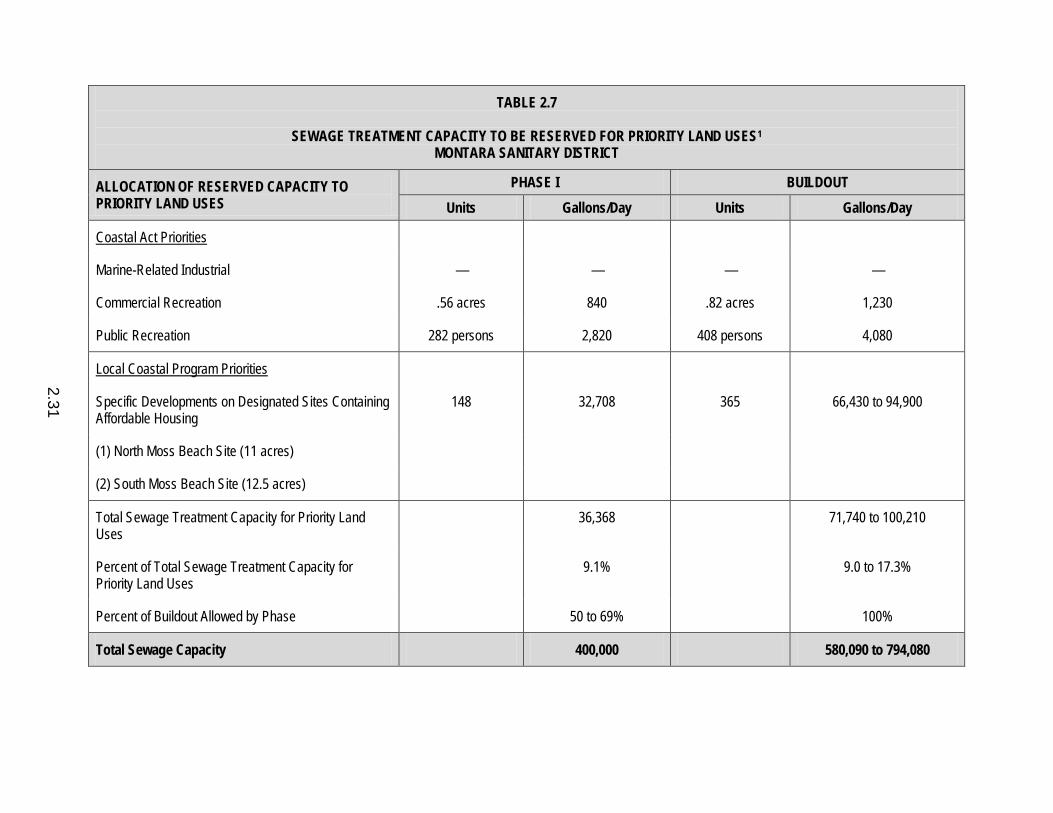
TABLE 2.7
SEWAGE TREATMENT CAPACITY TO BE RESERVED FOR PRIORITY LAND USES1 MONTARA SANITARY DISTRICT
ALLOCATION OF RESERVED CAPACITY TO PRIORITY LAND USES
PHASE I BUILDOUT Units Gallons/Day Units Gallons/Day
Coastal Act Priorities
Marine-Related Industrial — — — —
Commercial Recreation .56 acres 840 .82 acres 1,230
Public Recreation 282 persons 2,820 408 persons 4,080
Local Coastal Program Priorities
Specific Developments on Designated Sites Containing Affordable Housing
148 32,708 365 66,430 to 94,900
(1) North Moss Beach Site (11 acres)
(2) South Moss Beach Site (12.5 acres)
Total Sewage Treatment Capacity for Priority Land Uses
36,368 71,740 to 100,210
Percent of Total Sewage Treatment Capacity for Priority Land Uses
9.1% 9.0 to 17.3%
Percent of Buildout Allowed by Phase 50 to 69% 100%
Total Sewage Capacity 400,000 580,090 to 794,080
2.31
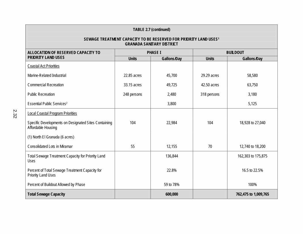
TABLE 2.7 (continued)
SEWAGE TREATMENT CAPACITY TO BE RESERVED FOR PRIORITY LAND USES1 GRANADA SANITARY DISTRICT
ALLOCATION OF RESERVED CAPACITY TO PRIORITY LAND USES
PHASE I BUILDOUT Units Gallons/Day Units Gallons/Day
Coastal Act Priorities
Marine-Related Industrial 22.85 acres 45,700 29.29 acres 58,580
Commercial Recreation 33.15 acres 49,725 42.50 acres 63,750
Public Recreation 248 persons 2,480 318 persons 3,180
Essential Public Services2 3,800 5,125
Local Coastal Program Priorities
Specific Developments on Designated Sites Containing Affordable Housing
104 22,984 104 18,928 to 27,040
(1) North El Granada (6 acres)
Consolidated Lots in Miramar 55 12,155 70 12,740 to 18,200
Total Sewage Treatment Capacity for Priority Land Uses
136,844 162,303 to 175,875
Percent of Total Sewage Treatment Capacity for Priority Land Uses
22.8% 16.5 to 22.5%
Percent of Buildout Allowed by Phase 59 to 78% 100%
Total Sewage Capacity 600,000 762,475 to 1,009,765
2.32
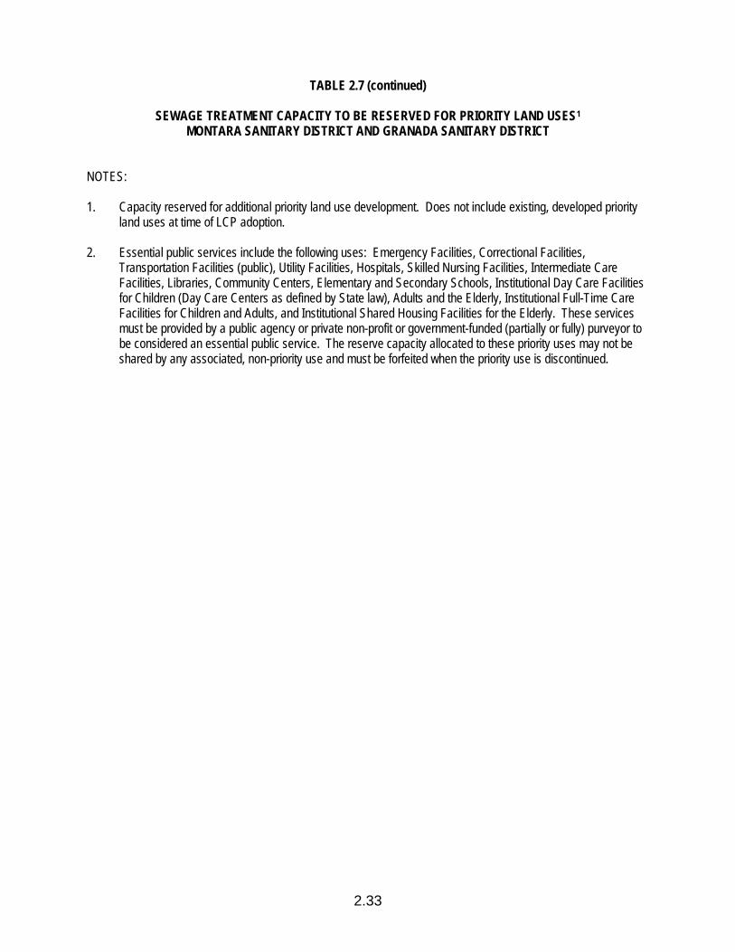
2.33
TABLE 2.7 (continued)
SEWAGE TREATMENT CAPACITY TO BE RESERVED FOR PRIORITY LAND USES1 MONTARA SANITARY DISTRICT AND GRANADA SANITARY DISTRICT
NOTES: 1. Capacity reserved for additional priority land use development. Does not include existing, developed priority
land uses at time of LCP adoption. 2. Essential public services include the following uses: Emergency Facilities, Correctional Facilities,
Transportation Facilities (public), Utility Facilities, Hospitals, Skilled Nursing Facilities, Intermediate Care Facilities, Libraries, Community Centers, Elementary and Secondary Schools, Institutional Day Care Facilities for Children (Day Care Centers as defined by State law), Adults and the Elderly, Institutional Full-Time Care Facilities for Children and Adults, and Institutional Shared Housing Facilities for the Elderly. These services must be provided by a public agency or private non-profit or government-funded (partially or fully) purveyor to be considered an essential public service. The reserve capacity allocated to these priority uses may not be shared by any associated, non-priority use and must be forfeited when the priority use is discontinued.
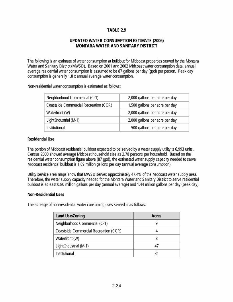
2.34
TABLE 2.9
UPDATED WATER CONSUMPTION ESTIMATE (2006) MONTARA WATER AND SANITARY DISTRICT The following is an estimate of water consumption at buildout for Midcoast properties served by the Montara Water and Sanitary District (MWSD). Based on 2001 and 2002 Midcoast water consumption data, annual average residential water consumption is assumed to be 87 gallons per day (gpd) per person. Peak day consumption is generally 1.8 x annual average water consumption. Non-residential water consumption is estimated as follows:
Neighborhood Commercial (C-1) 2,000 gallons per acre per day Coastside Commercial Recreation (CCR) 1,500 gallons per acre per day Waterfront (W) 2,000 gallons per acre per day Light Industrial (M-1) 2,000 gallons per acre per day Institutional 500 gallons per acre per day
Residential Use The portion of Midcoast residential buildout expected to be served by a water supply utility is 6,993 units. Census 2000 showed average Midcoast household size as 2.78 persons per household. Based on the residential water consumption figure above (87 gpd), the estimated water supply capacity needed to serve Midcoast residential buildout is 1.69 million gallons per day (annual average consumption). Utility service area maps show that MWSD serves approximately 47.4% of the Midcoast water supply area. Therefore, the water supply capacity needed for the Montara Water and Sanitary District to serve residential buildout is at least 0.80 million gallons per day (annual average) and 1.44 million gallons per day (peak day). Non-Residential Uses The acreage of non-residential water consuming uses served is as follows:
Land Use/Zoning Acres Neighborhood Commercial (C-1) 9 Coastside Commercial Recreation (CCR) 4 Waterfront (W) 8 Light Industrial (M-1) 47 Institutional 31
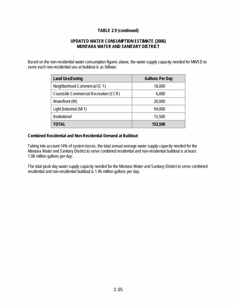
TABLE 2.9 (continued)
UPDATED WATER CONSUMPTION ESTIMATE (2006) MONTARA WATER AND SANITARY DISTRICT
2.35
Based on the non-residential water consumption figures above, the water supply capacity needed for MWSD to serve each non-residential use at buildout is as follows:
Land Use/Zoning Gallons Per Day Neighborhood Commercial (C-1) 18,000 Coastside Commercial Recreation (CCR) 6,000 Waterfront (W) 20,000 Light Industrial (M-1) 94,000 Institutional 15,500 TOTAL 153,500
Combined Residential and Non-Residential Demand at Buildout Taking into account 14% of system losses, the total annual average water supply capacity needed for the Montara Water and Sanitary District to serve combined residential and non-residential buildout is at least 1.08 million gallons per day. The total peak day water supply capacity needed for the Montara Water and Sanitary District to serve combined residential and non-residential buildout is 1.96 million gallons per day.

2.36
TABLE 2.10
UPDATED WATER CONSUMPTION ESTIMATE (2006) COASTSIDE COUNTY WATER DISTRICT
The following is an estimate of water consumption at buildout for Midcoast properties served by the Coastside County Water District (CCWD). Based on 2001 and 2002 Midcoast water consumption data, annual average residential water consumption is assumed to be 87 gallons per day (gpd) per person. Peak day consumption is generally 1.8 x annual average water consumption. Non-residential water consumption is estimated as follows:
Neighborhood Commercial (C-1) 2,000 gallons per acre per day Coastside Commercial Recreation (CCR) 1,500 gallons per acre per day Waterfront (W) 2,000 gallons per acre per day Light Industrial (M-1) 2,000 gallons per acre per day Institutional 500 gallons per acre per day
Residential Use The portion of Midcoast residential buildout expected to be served by a water supply utility is 6,993 units. Census 2000 showed average Midcoast household size as 2.78 persons/household. Based on the residential water consumption figure above (87 gpd), the estimated water supply capacity needed to serve Midcoast residential buildout is 1.69 million gallons per day (annual average consumption). Utility service area maps show that CCWD serves approximately 52.6% of the Midcoast water supply area. Therefore, the water supply capacity needed for the Coastside County Water District to serve residential buildout is 0.89 million gallons per day (annual average) and 1.60 million gallons per day (peak day). Non-Residential Uses The acreage of non-residential water consuming uses is as follows:
Land Use/Zoning Acres Neighborhood Commercial (C-1) 15 Coastside Commercial Recreation (CCR) 41 Waterfront (W) 31 Institutional 18 Agriculture (Floriculture) (PAD) (see below)

TABLE 2.10 (continued)
UPDATED WATER CONSUMPTION ESTIMATE (2006) COASTSIDE COUNTY WATER DISTRICT
2.37
Based on the non-residential water consumption figures above, the water supply capacity needed for CCWD to serve each non-residential use at buildout is as follows:
Land Use/Zoning Acres Neighborhood Commercial (C-1) 30,000 Coastside Commercial Recreation (CCR) 61,500 Waterfront (W) 77,500 Institutional 9,000 Agriculture (Floriculture) (PAD) 170,000 TOTAL 348,000
Combined Residential and Non-Residential Demand at Buildout Taking into account 9.5% of system losses, the total annual average water supply capacity needed for the Coastside County Water District to serve combined residential and non-residential buildout is at least 1.36 million gallons per day. The total peak day water supply capacity needed for the Coastside County Water District to serve combined residential and non-residential buildout is 2.44 million gallons per day.
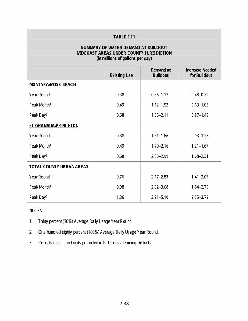
2.38
TABLE 2.11
SUMMARY OF WATER DEMAND AT BUILDOUT MIDCOAST AREAS UNDER COUNTY JURISDICTION
(in millions of gallons per day)
Existing Use
Demand at Buildout
Increase Needed for Buildout
MONTARA/MOSS BEACH
Year Round 0.38 0.86–1.17 0.48–0.79
Peak Month1 0.49 1.12–1.52 0.63–1.03
Peak Day2 0.68 1.55–2.11 0.87–1.43
EL GRANADA/PRINCETON
Year Round 0.38 1.31–1.66 0.93–1.28
Peak Month1 0.49 1.70–2.16 1.21–1.67
Peak Day2 0.68 2.36–2.99 1.68–2.31
TOTAL COUNTY URBAN AREAS
Year Round 0.76 2.17–2.83 1.41–2.07
Peak Month1 0.98 2.82–3.68 1.84–2.70
Peak Day2 1.36 3.91–5.10 2.55–3.79 NOTES: 1. Thirty percent (30%) Average Daily Usage Year Round. 2. One hundred eighty percent (180%) Average Daily Usage Year Round. 3. Reflects the second units permitted in R-1 Coastal Zoning Districts.
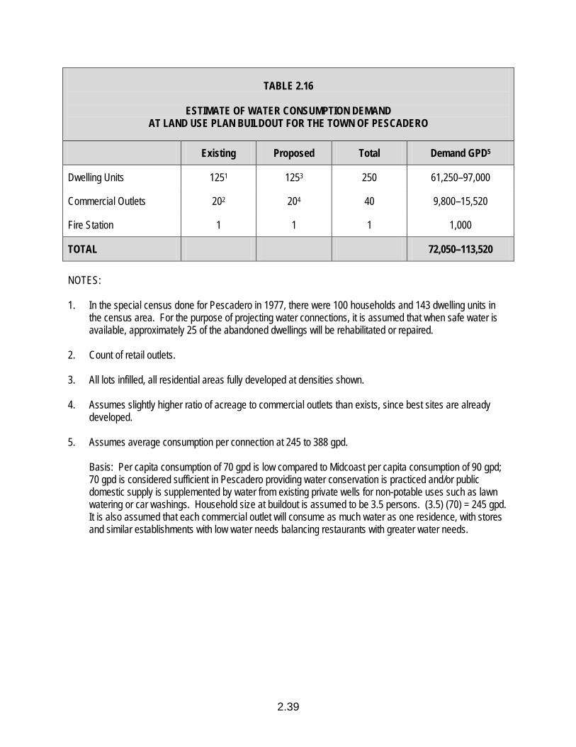
2.39
TABLE 2.16
ESTIMATE OF WATER CONSUMPTION DEMAND AT LAND USE PLAN BUILDOUT FOR THE TOWN OF PESCADERO
Existing Proposed Total Demand GPD5
Dwelling Units 1251 1253 250 61,250–97,000
Commercial Outlets 202 204 40 9,800–15,520
Fire Station 1 1 1 1,000
TOTAL 72,050–113,520 NOTES: 1. In the special census done for Pescadero in 1977, there were 100 households and 143 dwelling units in
the census area. For the purpose of projecting water connections, it is assumed that when safe water is available, approximately 25 of the abandoned dwellings will be rehabilitated or repaired.
2. Count of retail outlets. 3. All lots infilled, all residential areas fully developed at densities shown. 4. Assumes slightly higher ratio of acreage to commercial outlets than exists, since best sites are already
developed. 5. Assumes average consumption per connection at 245 to 388 gpd. Basis: Per capita consumption of 70 gpd is low compared to Midcoast per capita consumption of 90 gpd;
70 gpd is considered sufficient in Pescadero providing water conservation is practiced and/or public domestic supply is supplemented by water from existing private wells for non-potable uses such as lawn watering or car washings. Household size at buildout is assumed to be 3.5 persons. (3.5) (70) = 245 gpd. It is also assumed that each commercial outlet will consume as much water as one residence, with stores and similar establishments with low water needs balancing restaurants with greater water needs.

TABLE 2.17
AMOUNT OF WATER CAPACITY TO BE RESERVED FOR PRIORITY LAND USES1 MONTARA WATER AND SEWER DISTRICT (MONTARA/MOSS BEACH)
ALLOCATION OF RESERVED CAPACITY TO PRIORITY LAND USES
PHASE I BUILDOUT Units Gallons/Day Units Gallons/Day
Coastal Act Priorities
Marine-Related Industrial — — — —
Commercial Recreation .57 acres 1,100 .82 acres 1,230
Public Recreation 282 persons 3,200 408 persons 4,080
Floriculture 13,800 10,000
Essential Public Services2 5,000
Local Coastal Program Priorities
Specific Developments on Designated Sites Containing Affordable Housing
148 64,380 148 35,816 to 51,504
(1) North Moss Beach Site (11 acres)
Other Affordable Housing 20 5,000
Total Water Capacity for Priority Land Uses 82,480 61,126 to 76,814
Percent of Total Water Capacity for Priority Land Uses 10.6% 5.4 to 9.2%
Percent of Buildout Allowed by Phase 50 to 69% 100%
Total Water Capacity 778,800 836,300 to 1,128,700
2.40

TABLE 2.17 (continued)
AMOUNT OF WATER CAPACITY TO BE RESERVED FOR PRIORITY LAND USES1 COASTSIDE COUNTY WATER DISTRICT (COUNTY JURISDICTION)
ALLOCATION OF RESERVED CAPACITY TO PRIORITY LAND USES
PHASE I BUILDOUT Units Gallons/Day Units Gallons/Day
Coastal Act Priorities
Marine-Related Industrial 22.85 acres 55,770 29.29 acres 71,870
Commercial Recreation 33.15 acres 61,630 42.50 acres 79,395
Public Recreation 248 persons 2,900 318 persons 3,700
Floriculture 179,400 220,000
Essential Public Services2 7,700 14,135
Local Coastal Program Priorities4
Specific Developments on Designated Sites Containing Affordable Housing
104 39,936 322 77,924 to 112,056
(1) North El Granada Site (6 acres) (2) South Moss Beach Site (12.5 acres)
Other Affordable Housing5 20 5,000
Consolidated Lots in Miramar 55 20,900 70 16,900 to 24,400
Historic Structures3 1 1,480 1 1,480 (1) Johnston House
Total Water Capacity for Priority Land Uses 369,716 490,404 to 532,036
2.41
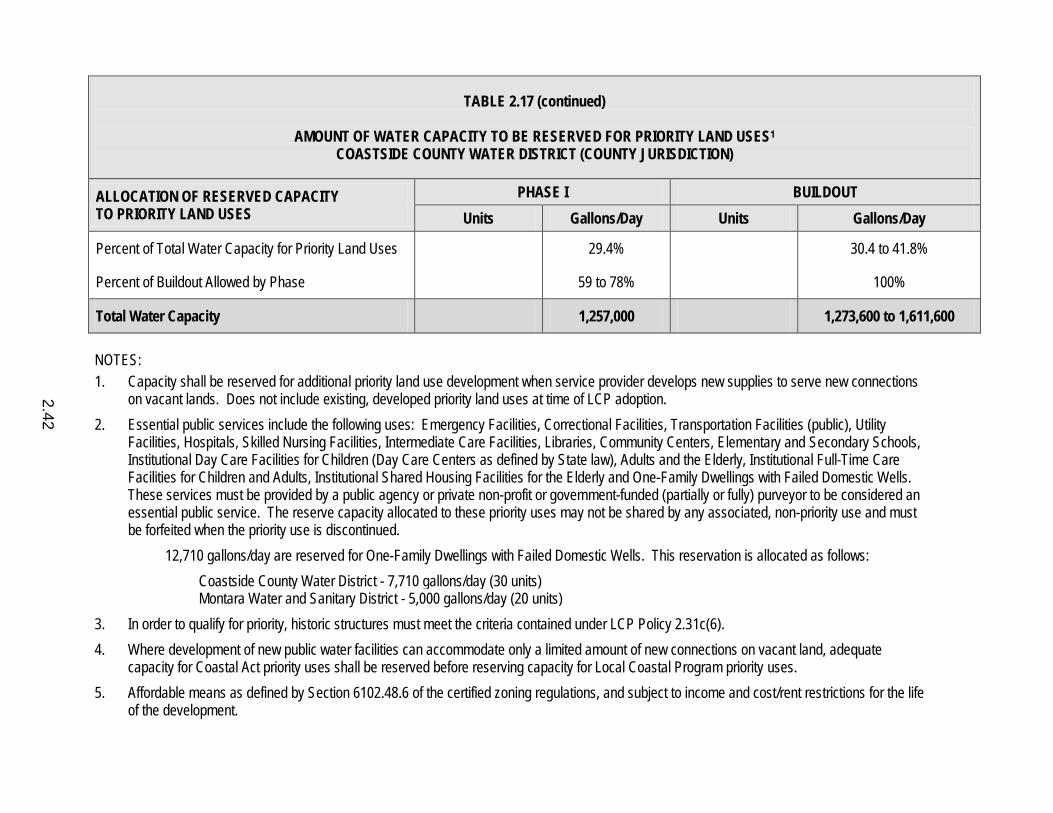
TABLE 2.17 (continued)
AMOUNT OF WATER CAPACITY TO BE RESERVED FOR PRIORITY LAND USES1 COASTSIDE COUNTY WATER DISTRICT (COUNTY JURISDICTION)
ALLOCATION OF RESERVED CAPACITY TO PRIORITY LAND USES
PHASE I BUILDOUT Units Gallons/Day Units Gallons/Day
Percent of Total Water Capacity for Priority Land Uses 29.4% 30.4 to 41.8%
Percent of Buildout Allowed by Phase 59 to 78% 100%
Total Water Capacity 1,257,000 1,273,600 to 1,611,600 NOTES: 1. Capacity shall be reserved for additional priority land use development when service provider develops new supplies to serve new connections
on vacant lands. Does not include existing, developed priority land uses at time of LCP adoption. 2. Essential public services include the following uses: Emergency Facilities, Correctional Facilities, Transportation Facilities (public), Utility
Facilities, Hospitals, Skilled Nursing Facilities, Intermediate Care Facilities, Libraries, Community Centers, Elementary and Secondary Schools, Institutional Day Care Facilities for Children (Day Care Centers as defined by State law), Adults and the Elderly, Institutional Full-Time Care Facilities for Children and Adults, Institutional Shared Housing Facilities for the Elderly and One-Family Dwellings with Failed Domestic Wells. These services must be provided by a public agency or private non-profit or government-funded (partially or fully) purveyor to be considered an essential public service. The reserve capacity allocated to these priority uses may not be shared by any associated, non-priority use and must be forfeited when the priority use is discontinued.
12,710 gallons/day are reserved for One-Family Dwellings with Failed Domestic Wells. This reservation is allocated as follows: Coastside County Water District - 7,710 gallons/day (30 units) Montara Water and Sanitary District - 5,000 gallons/day (20 units) 3. In order to qualify for priority, historic structures must meet the criteria contained under LCP Policy 2.31c(6). 4. Where development of new public water facilities can accommodate only a limited amount of new connections on vacant land, adequate
capacity for Coastal Act priority uses shall be reserved before reserving capacity for Local Coastal Program priority uses. 5. Affordable means as defined by Section 6102.48.6 of the certified zoning regulations, and subject to income and cost/rent restrictions for the life
of the development.
2.42
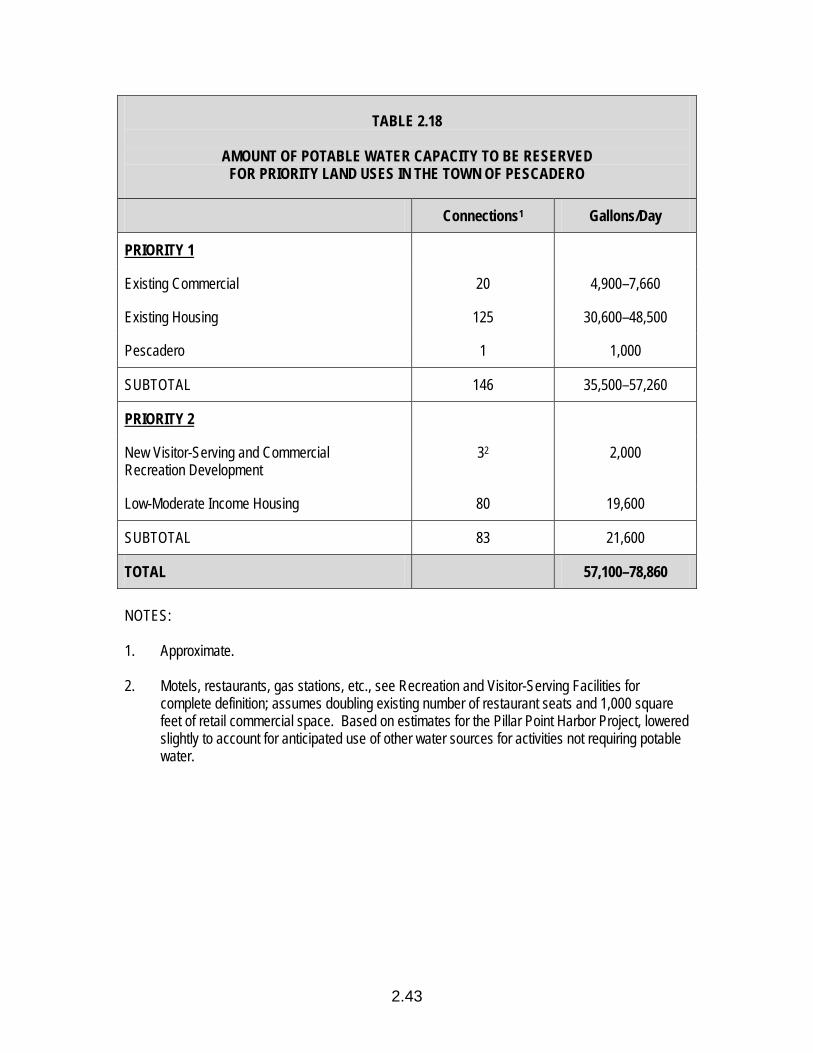
2.43
TABLE 2.18
AMOUNT OF POTABLE WATER CAPACITY TO BE RESERVED FOR PRIORITY LAND USES IN THE TOWN OF PESCADERO
Connections1 Gallons/Day
PRIORITY 1
Existing Commercial 20 4,900–7,660
Existing Housing 125 30,600–48,500
Pescadero 1 1,000
SUBTOTAL 146 35,500–57,260
PRIORITY 2
New Visitor-Serving and Commercial Recreation Development
32 2,000
Low-Moderate Income Housing 80 19,600
SUBTOTAL 83 21,600
TOTAL 57,100–78,860 NOTES: 1. Approximate. 2. Motels, restaurants, gas stations, etc., see Recreation and Visitor-Serving Facilities for
complete definition; assumes doubling existing number of restaurant seats and 1,000 square feet of retail commercial space. Based on estimates for the Pillar Point Harbor Project, lowered slightly to account for anticipated use of other water sources for activities not requiring potable water.
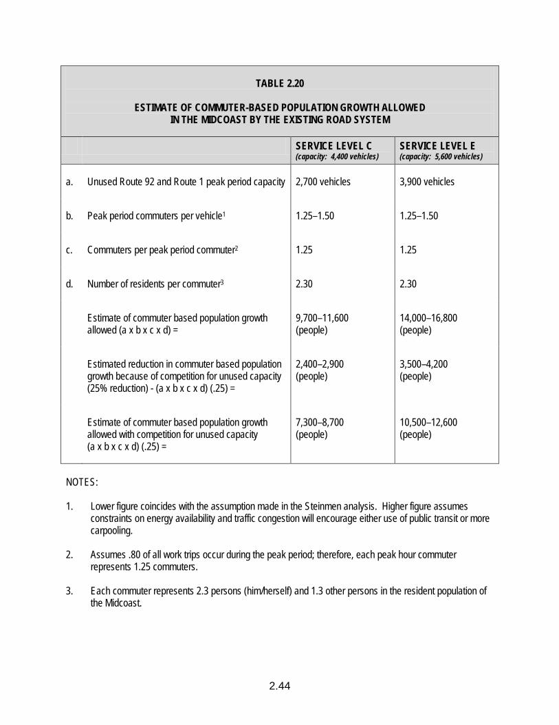
2.44
TABLE 2.20
ESTIMATE OF COMMUTER-BASED POPULATION GROWTH ALLOWED IN THE MIDCOAST BY THE EXISTING ROAD SYSTEM
SERVICE LEVEL C (capacity: 4,400 vehicles)
SERVICE LEVEL E (capacity: 5,600 vehicles)
a. Unused Route 92 and Route 1 peak period capacity 2,700 vehicles 3,900 vehicles
b. Peak period commuters per vehicle1 1.25–1.50 1.25–1.50
c. Commuters per peak period commuter2 1.25 1.25
d. Number of residents per commuter3 2.30 2.30
Estimate of commuter based population growth allowed (a x b x c x d) =
9,700–11,600 (people)
14,000–16,800 (people)
Estimated reduction in commuter based population growth because of competition for unused capacity (25% reduction) - (a x b x c x d) (.25) =
2,400–2,900 (people)
3,500–4,200 (people)
Estimate of commuter based population growth allowed with competition for unused capacity (a x b x c x d) (.25) =
7,300–8,700 (people)
10,500–12,600 (people)
NOTES: 1. Lower figure coincides with the assumption made in the Steinmen analysis. Higher figure assumes
constraints on energy availability and traffic congestion will encourage either use of public transit or more carpooling.
2. Assumes .80 of all work trips occur during the peak period; therefore, each peak hour commuter
represents 1.25 commuters. 3. Each commuter represents 2.3 persons (him/herself) and 1.3 other persons in the resident population of
the Midcoast.
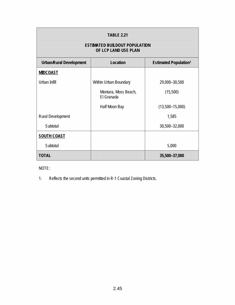
2.45
TABLE 2.21
ESTIMATED BUILDOUT POPULATION OF LCP LAND USE PLAN
Urban/Rural Development Location Estimated Population1
MIDCOAST
Urban Infill Within Urban Boundary 29,000–30,500
Montara, Moss Beach, El Granada
(15,500)
Half Moon Bay (13,500–15,000)
Rural Development 1,585
Subtotal 30,500–32,000
SOUTH COAST
Subtotal 5,000
TOTAL 35,500–37,000 NOTE: 1. Reflects the second units permitted in R-1 Coastal Zoning Districts.
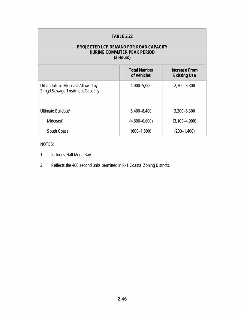
2.46
TABLE 2.22
PROJECTED LCP DEMAND FOR ROAD CAPACITY DURING COMMUTER PEAK PERIOD
(2 Hours)
Total Number of Vehicles
Increase From Existing Use
Urban Infill in Midcoast Allowed by 2 mgd Sewage Treatment Capacity
4,000–5,000 2,300–3,300
Ultimate Buildout2 5,400–8,400 3,300–6,300
Midcoast1 (4,800–6,600) (3,100–4,900)
South Coast (600–1,800) (200–1,400) NOTES: 1. Includes Half Moon Bay. 2. Reflects the 466 second units permitted in R-1 Coastal Zoning Districts.

3.1
HOUSING COMPONENT GENERAL POLICIES 3.1 Sufficient Housing Opportunities Through both public and private efforts, protect, encourage and, where feasible,
provide housing opportunities for persons of low and moderate income who reside, work or can be expected to work in the Coastal Zone.
3.2 Non-Discrimination Strive to ensure that decent housing is available for low and moderate income
persons regardless of age, race, sex, marital status or other arbitrary factors. 3.3 Balanced Developments Strive to provide such housing in balanced residential environments that
combine access to employment, community facilities and adequate services. 3.4 Diverse Housing Opportunities Strive to improve the range of housing choices, by location, type, price and
tenure, available to persons of low and moderate income. DISTRIBUTION OF AFFORDABLE HOUSING 3.5 Regional Fair Share Define the regional fair share assisted housing allocation for the San Mateo
County Coastal Zone as that which provides housing opportunities for low and moderate income households who reside, work or can be expected to work in the Coastal Zone.
3.6 Allocation of Affordable Units a. In order to reduce home-to-work travel distance within the Coastal Zone,
and to encourage shared responsibility for housing by subarea roughly proportional to employment opportunities available in the subarea, allocate the “fair share” as follows:
(1) In the Midcoast, allocate 50% to the unincorporated area, with no
more affordable units to be built in the rural unincorporated area than allowed by Policy 3.24, and 50% to Half Moon Bay.
3.2
(2) In the South Coast, allocate 100% to the extent water and sewer capacities are available.
b. Through the County Planning Department and the Housing and Community
Development Division (HCD), cooperate with the City of Half Moon Bay toward achieving its fair share housing allocation.
PROTECTION OF EXISTING HOUSING OPPORTUNITIES FOR LOW AND MODERATE INCOME HOUSEHOLDS 3.7 Rehabilitation Loans a. To the extent of available resources, provide rehabilitation loans to low and
moderate income owners of deteriorating housing through the County Housing and Community Development Program. Continue the designation of Pescadero as the first priority rehabilitation area on the Coastside.
b. Through the County HCD Program, provide monetary relocation assistance
and, if necessary, relocation housing when housing programs require temporary or permanent displacement of households. Where feasible, relocate households within the community.
3.8 Rental Assistance Through the County Housing Authority, provide rental assistance to needy
tenant families by utilizing available rental assistance funds. 3.9 Demolition of Existing Structures Prohibit the demolition of structures providing affordable housing, unless:
(1) the structure poses a serious health and safety hazard, cannot feasibly be rehabilitated, and the County requires demolition; (2) the structure was built in violation of the zoning and building codes, cannot be brought into conformance with the building code through rehabilitation and the zoning ordinance through Policies 3.25 and 3.28, and the County requires demolition; (3) the landowner undertakes the demolition to build a house for his/her own habitation and executes a recordable agreement with the County that this is his/her intent; and (4) the person undertaking the demolition provides replacement affordable housing which is similar in size and location to the demolished structure.
3.10 Condominium Conversion Prohibit the conversion of rental housing units to condominiums, stock
cooperatives and/or community apartments.
3.3
3.11 Protection of the Pillar Ridge Manufactured Home Community Designate the existing Pillar Ridge Manufactured Home Community as an
affordable housing site. Prohibit the demolition or displacement of this manufactured home community.
ENCOURAGEMENT AND PROVISION OF NEW HOUSING OPPORTUNITIES FOR LOW AND MODERATE INCOME HOUSEHOLDS 3.12 Reservation of Water and Sewer Capacity a. Designate affordable housing and designated family farm labor housing
sites as a priority land use for which water and sewer capacity will be reserved in accordance with the policies of the Public Works Component. Where a portion of a site (i.e., North Moss Beach site) is required to provide affordable housing, consider the entire development proposed on the site as a priority land use for which water and sewer capacity will be reserved.
b. Allow Sewer Authority Mid-Coastside (SAM) to reallocate sewer capacity
among the three sewer agencies to facilitate development of designated family farm labor housing site.
3.13 Maintenance of Community Character Require that new development providing significant housing opportunities for low
and moderate income persons contribute to maintaining a sense of community character by being of compatible scale, size and design. Limit the height to two stories to mitigate the impact of this development on the surrounding neighborhoods. Assess negative traffic impacts and mitigate as much as possible.
3.14 Location of Affordable Housing a. Midcoast: Locate affordable housing in the following locations: (1) All designated affordable housing sites in the urban area (within the
urban boundary) defined in the Locating and Planning New Development Component.
(2) Elsewhere in the urban area, where affordable housing units
specified in LCP Policies 3.19, 3.20, 3.21 and 3.22 are permitted, including mobile homes, second units, and affordable units derived from density bonus provisions.
3.4
(3) In the rural area (outside the urban boundary), affordable housing units as specified in LCP Policies 3.23 and 3.24.
b. South Coast: Locate affordable housing in the following locations: (1) To the maximum extent feasible, in rural service centers as defined
in the Locating and Planning New Development Component. (2) In rural residential land divisions, as specified in Policies 3.23 and
3.24. (3) Farm labor housing on private farms or ranches. 3.15 Designated Affordable Housing Sites a. Designate the following as potential sites where affordable housing would
be feasibly provided when residential development occurs: (1) The 11-acre site in North Moss Beach. (2) The 12.5-acre site northeast of Etheldore Street in South Moss
Beach. (3) The 6-acre North El Granada site. b. Designate these sites Medium High Density to incorporate a density bonus
within the land use designation. c. Rezone the designated sites or other appropriate sites within the urban
boundary to the Planned Unit Development (PUD) zone to allow flexible residential development standards, when appropriate in conjunction with development plan approval.
d. Evaluate proposals to develop the designated or other appropriate sites
according to the following criteria: (1) For the total 11-acre North Moss Beach site, development must help
meet LCP housing objectives by meeting the following criteria: (a) Twenty-one percent (21%) of the total units constructed on the
site are reserved for low income households. (b) In addition to the required low income units, fourteen percent
(14%) of the total units constructed are reserved for moderate income households.

3.5
(2) For the other designated sites, development must help meet LCP housing objectives by meeting the following criteria:
(a) Thirty percent (30%) of the total units constructed on a site are
reserved for low income households. (b) In addition to the required low income units, twenty percent
(20%) of the total units constructed are reserved for moderate income households.
(3) Development must comply with all of the regulations established for
Structural and Community Features (Urban), as established in the Visual Resources Component.
(4) Require the provision of amenities including, but not limited to,
landscaping and recreation facilities. (5) Encourage the provision of community services, such as day care
centers. 3.16 Phasing the Development of Designated Housing Sites a. Limit the number of affordable housing units given building permits for
construction on the designated sites to 60 during any 12-month period in order to allow the affordable housing units constructed on the designated housing sites to be assimilated into the community a few at a time.
b. Allow the County Board of Supervisors to increase the number of
affordable housing units permitted if they make the finding that the above phasing requirement threatens the implementation of affordable housing on a designated site by prohibiting the developer(s) from building when circumstances are uniquely favorable for a limited period of time (i.e., low interest rate financing or public subsidies are available).
c. Prohibit the designation of additional housing sites for affordable housing
for five years in order to permit the housing techniques stated in Policies 3.18, 3.19, 3.20 and 3.21 an opportunity to demonstrate that they can successfully serve as alternatives to additional designated housing sites.
3.17 Incentives for Midcoast Affordable Housing Provide the following incentives for voluntary development of affordable housing
units on Midcoast parcels other than the designated housing sites: a. Any property that is: (1) developed with an affordable (very low, low or
moderate income) housing unit, as defined by Section 6102.48.5 of the
3.6
Zoning Regulations and subject to income and cost/rent restriction con-tracts with San Mateo County; and (2) located in an urban Midcoast zoning district where residential units are permitted, may receive reserved water supply capacity to the extent authorized by LCP Table 2.17, and to the extent the water service provider has reserved the water supply capacity pursuant to an approved coastal development permit or a public works plan.
b. Any substandard lot smaller than 4,500 sq. ft. in area and not in common
ownership with contiguous lots that is: (1) developed with an affordable (very low, low or moderate income) housing unit, i.e., subject to income and cost/rent restriction contracts with San Mateo County; and (2) located in a Midcoast residential zoning district, shall be entitled to:
(1) Up to 200 sq. ft. of covered parking floor area that is not counted
toward the applicable building floor area limit; and (2) One required parking space may be provided uncovered. 3.18 Evaluating the Use of Alternative Housing Techniques a. Begin immediately to record the number of affordable housing units
developed by any of the three more dispersed, lower density methods listed below and provide an annual report to the Planning Commission of the results.
(1) Units on R-1 lots, developed through Policies 3.20 and 3.21. (2) Units on C-1 lots, including those developed through Policy 3.21. (3) Units on sites less than 2 acres. b. At the end of a five-year period, evaluate how well the dispersed housing
techniques described in (a) are meeting the housing need in the following way:
(1) If a minimum of 12 affordable housing units per year, or 60 total, are
provided by these methods, assume they are meeting their fair share of the need and no additional designated housing sites for affordable housing are required.
(2) If less than 60 units of affordable housing have been provided by
these methods over the five-year period, assume additional designated housing sites are required to meet the housing need and designate sites for this purpose.
3.7
(3) If expanded sewer and water capacity have not been available, delay designating sites until one year after expanded sewer and water capacity are both available. If during that one year extension, less than 12 units of affordable housing are provided by these methods, assume additional designated housing sites are required to meet the housing need and designate sites for this purpose.
3.19 Mobile Homes in R-1 Zoning Districts Permit mobile homes on permanent foundations in zoning districts where single-
family residences are permitted, except in scenic corridors. 3.20 Grant Density Bonuses for the Development of Affordable Housing In accordance with State Government Code Section 65915, or any successor
statute, grant a density bonus of 25% and other incentive(s) for the development of new housing in the urban area if a developer agrees to construct: (a) 10% of the housing units for very low income households, or (b) 20% of the housing units for lower income households, or (c) 50% of the housing units for senior households. Also, grant a supplemental density bonus if a development exceeds the minimum requirements stated above, or provides a percentage of the total units for large families or disabled households.
3.21 Establish an Inclusionary Requirement for Affordable Housing Establish an inclusionary requirement for affordable housing whereby residential
developments, including land divisions in urban areas will be required to either (a) reserve a percentage of the units constructed as affordable housing, OR (b) pay a fee in lieu of constructing the required affordable housing units. Assure continued affordability of reserved affordable housing units through appropriate deed restrictions.
3.22 Second Dwelling Units in R-1 Zoning Districts Permit second dwelling units on building sites containing a one-family residence
in R-1 Zoning Districts subject to the following restrictions: a. Limit the total number of approved second units to 466 in the Coastal Zone. b. Limit the size of the units to 700 sq. ft. or 35% of the floor area of the
existing principal residence, whichever is greater. c. Comply with all applicable policies and procedures as required by the LCP. d. Second dwelling units shall not be permitted on non-conforming parcels
less than 5,000 sq. ft.

3.8
3.23 Requirements from Land Divisions in Rural Areas a. In any residential land division in rural areas, require that the applicant give
the County an option to buy a minimum of 20% of the lots for affordable housing. If the option is exercised by the County’s Housing and Community Development Division, assign it to a qualified non-profit organization (if available), who would seek funds from FmHA rural housing development programs or other sources to build low and moderate income housing.
b. To the maximum extent possible, assist qualified non-profit organizations in
securing funds to build rural affordable housing. 3.24 Density Bonus for Affordable Housing in Rural Areas a. In addition to the number of density credits permitted by zoning regulations,
allow 30 dwelling units of affordable housing to be built and land divided for this purpose in rural areas of the South Coast and 10 dwelling units of affordable housing to be built and land divided for this purpose in rural areas of the Midcoast under the following circumstances:
(1) Units may be built individually, but no more than 15 units may be built
in one cluster. No more than four units may be built by one developer, with the exception of non-profit organizations.
(2) On-site well water and sewage disposal requirements for each
dwelling unit are met. (3) The units meet all of the requirements of other LCP policies. b. Allow two additional increments of 30 units of affordable housing in the
rural areas of the South Coast and 10 units of affordable housing in the rural areas of the Midcoast under the following circumstances:
(1) Permits for the original 40 (or 80) units of affordable housing have
been granted. (2) A water system adequate to serve buildout of the Pescadero Land
Use Plan is not yet available, or if water is available, the County’s Housing and Community Development Division determines there are no sites available within the town for the construction of affordable housing.
(3) The additional units will not result in any greater conversion of prime
agricultural land than would be permitted without the bonus.
3.9
c. Assist the financing of these units by: (1) Helping qualified non-profit organizations to secure funds to build
rural affordable housing. (2) Giving priority to purchasers of these units for below market rate
mortgage loans and/or other housing assistance funds available from the County.
ALLOCATION OF PUBLIC RESOURCES 3.25 Funding Sources Make maximum utilization of housing assistance funds available primarily for
rural areas such as the Coastal Zone, including Farmers Home Administration (FmHA) programs, and special programs of the California Housing Finance Agency (CHFA) and the Department of Housing and Urban Development, in order to minimize the competition between the Bayside and Coastside areas of San Mateo County for limited housing assistance resources.
3.26 Farm Labor Households For farm labor housing, use resources to: a. Expand housing choices b. Promote a stable, non-itinerant labor force by emphasizing provision of
family housing. 3.27 Implementation Techniques Through the County HCD Program, reduce development and financing costs for
profit or non-profit developers of affordable housing as needed by one or more of the following methods: (1) land cost write downs (discounts), (2) below market interest rate loans for construction financing, long-term financing or home mortgages, (3) Farmers Home Administration or CHFA Section 8 rent subsidies, and/or (4) other local, State, and federal programs which may be available.
3.28 Responsibility for Implementation a. Designate the County Housing and Community Development Division as
the primary implementation agency for: (1) facilitating affordable housing, (2) facilitating housing rehabilitation, (3) providing for relocation assistance, and if necessary relocation housing, (4) designing and implementing programs to achieve housing objectives, (5) locating and promoting funding
3.10
for Coastal Zone housing programs, and (6) directing limited public resources toward the high-need groups.
b. Designate the County Planning Department as the primary implementing
agency for: (1) priority processing, (2) reviewing permit applications for consistency with LCP housing policies, (3) zoning ordinance revisions, (4) revising and refining housing objectives for the Coastal Zone housing programs, and (5) directing limited public resources toward the high-need groups.
c. In unsewered areas without public water supplies, Environmental Health
shall be provided evidence of the feasibility of water supply and sewage disposal prior to routine processing of the application.
3.29 Definition of Farm Labor Housing Define “farm labor housing” as mobile homes or other housing structures
intended to house persons or families, at least one of whom derives a substantial portion of his/her income from employment in an agricultural or floricultural operation.
3.30 Designated Family Farm Labor Housing Sites a. Designate the following as priority land uses where family farm labor
housing may occur: (1) Coastside Family Farm Labor housing project located on a 42-acre
site east of Miramontes Road in South Half Moon Bay.
4.1
ENERGY COMPONENT OIL AND GAS WELLS (ONSHORE) General Regulations 4.1 Permit Requirement Require the issuance of Coastal Development Permit for the drilling, sinking,
or boring of any well, hole, or bore for oil or gas or any other hydrocarbon substance, in the Coastal Zone. Permitted oil and gas well development shall be in accordance with all relevant Local Coastal Program policies.
4.2 Regulation of Oil and Gas Wells a. Revise the oil and gas well chapter of the County’s Zoning Ordinance to
reflect Coastal Act policies. Use the ordinance as the principle imple-mentation device for regulating oil and gas well development.
b. Recognize the State Division of Oil and Gas as the primary regulatory
authority for oil and gas well development. c. Require all permits to conform to Division of Oil and Gas regulations and
regulations of other responsible State agencies. d. In revising the County ordinance, do not supersede, duplicate, or exceed
controls of these State agencies. Locational Criteria 4.3 Appropriate Locations a. Prospect drilling and production of oil and gas wells may be permitted by
an oil and gas well permit on parcels designated on the LCP Land Use Plan Map: Open Space, Timber Production, Agriculture, or General Industrial. Unless acceptable mitigation measures to the maximum feasible extent can be undertaken, prohibit wells and appurtenant facilities from locating in scenic corridors, hazardous areas, and recreation areas. Prohibit wells on prime agricultural soils and in sensitive habitats.
b. Where drilling sites are located adjacent to sensitive habitat areas, prime
agricultural soils, recreation areas, residential or hazardous areas, require mitigation to the maximum extent feasible to protect the adjacent resources.
4.2
c. Require as far as practicable, consolidation of oil and gas well facilities. Performance Standards for Protecting Land and Water Resources 4.4 Road and Drilling Pad Construction a. Require road and pad construction in conformance with applicable
ordinances. b. Restrict width of roads to allow only for the safe passage of drill rigs and
equipment. c. Minimize grading to prevent erosion and sedimentation, and to preserve
appearance, vegetation and contours of the landscape. 4.5 Erosion Control Minimize erosion from oil and gas well development by: (1) requiring a buffer
strip between streams and roads, (2) constructing waterbreaks at appropriate intervals, (3) constructing roadside berms to guide surface waterflow, and (4) planting protective ground cover on slopes exceeding 5%.
4.6 Restoration Require the revegetation of all cleared and exposed lands, abandoned roads,
earthen sumps, well sites, work sites, and other areas not needed for normal operation of all wells.
4.7 Removal of Materials Require that all waste material removed from the land is deposited in an
approved disposal site. 4.8 Water Quality a. Prohibit the disposal of wastewater from drilling operations on land or in
wells and water bodies which may damage soil, plant life and surface or subsurface water supplies.
b. Prohibit oil field wastes from polluting surface or subsurface waters. 4.9 Sensitive Resources a. Require tank ponds, sumps and brine mixing ponds to be lined with
impermeable material to prevent the release of harmful substances.

4.3
b. Prohibit direct flow of any water from well pads into a marsh or other sensitive habitat areas.
Performance Standards for Protecting Adjacent Land Uses 4.10 Suspension of Activities Require the suspension of drilling and production operations at the site of any
disaster, accident, or pollution of surface or subsurface waters. 4.11 Limiting Hours of Operation Limit to daylight hours oil transfer activities that would disturb nearby residents. 4.12 Termination of Operations Require the removal or fencing of wells and other facilities which go out of
production temporarily or permanently. Performance Standards for Protecting Scenic Quality 4.13 Screening a. Avoid construction of facilities in scenic road corridors and recreation
areas. Where necessary, maximum effort shall be made to screen views of facilities from scenic roadways and recreation areas.
b. Require landscaping or other screening at production facility sites. 4.14 Painting Require painting of production facilities in a manner which assures maximum
blending with the natural surroundings. 4.15 Height Limits Require all production facilities to be placed at least their height below the ridge
top or otherwise hidden from view. Performance Standards for Protecting Air Quality 4.16 Air Pollution Emissions Require construction and operation of oil and gas well facilities to employ
methods which minimize air pollution emissions.
4.4
4.17 Vapor Recovery Systems Require the utilization of vapor recovery systems. 4.18 Atmospheric Exposure a. Prohibit crude oil or oil waste to stand open to the atmosphere during
production. b. Limit sump operation during exploratory drilling and testing. 4.19 Standards Require all drilling activity to meet the standards of the Air Resources Board. Performance Standards for Limiting Noise 4.20 Engine Mufflers Require that engines use muffler systems. 4.21 Adjacent Land Uses Minimize noise impacts on surrounding land uses, especially residential. 4.22 Drilling Time Limit the time of exploratory drilling activities. ONSHORE FACILITIES FOR OFFSHORE OIL
*4.23 Definition Define onshore facilities for offshore oil as temporary or permanent service
bases, including but not limited to warehouses, open storage areas or stockpiling areas, offices, communication centers, harbor or wharf development or improvement, parking and helipad areas, processing plants and oil storage tanks.
*4.24 Prohibition of Onshore Facilities Prohibit onshore facilities for offshore oil or gas from locating in the Coastal
Zone.
4.5
*In the event that Federal or State law requires onshore facilities for offshore oil and gas extraction activities, Policies 4.25-4.27 shall apply:
*4.25 Permit Requirement Require the issuance of a Coastal Development Permit for all onshore facilities
in sites designated appropriate (if any) based on conclusions of the Coastal Energy Impact Program (CEIP) in the Coastal Zone.
*4.26 Preliminary Concept Plan a. For all new or expanded facilities, require the submittal of a Preliminary
Concept Plan to the County Planning Commission. b. Require the Preliminary Concept Plan to provide an Environmental Setting
Statement to ensure that the proposed location of facilities is consistent with the policies of the Local Coastal Program. Specifically, require Environmental Setting Statements to describe and analyze the sites’ environmental resources, including topography, geology, vegetation, wildlife habitats and visual and cultural resources.
c. Require the Preliminary Concept Plan to include an Overall Development
Scheme which states the general intentions of the applicant for the development of the facility of which the proposed development is a part. Require the plan to be consistent with the findings and conclusions of the Environmental Setting Survey and to include: (1) a site plan showing the ultimate development plan for the facility indicating the location and intensity of proposed uses, including types of structure, landscape and circulation, (2) proposed site management techniques, (3) a general sequence of anticipated development and (4) a statement detailing the consistency of the proposed development project with the policies of the Local Coastal Program.
After the Preliminary Concept Plan has been approved and found to be
consistent with the LCP by the Planning Commission, use it as the basis for subsequent Coastal Development Permit approvals. Require that subsequent development proposals be consistent with the Preliminary Concept Plan, unless amendments are applied for and approved by the Planning Commission.
*4.27 Development Standards Develop performance standards and specific criteria, based on CEIP, to protect
coastal resources and to mitigate to the maximum extent feasible adverse impacts of energy-related development, while considering national energy

4.6
needs. Land use recommendations developed from the CEIP for onshore facilities for offshore oil may require amendments to the LCP.
4.28 Designation of Facility Sites Continue to study areas proposed for the siting of onshore facilities for offshore
oil development through the CEIP. PIPELINES AND TRANSMISSION LINES
*4.29 Permit Requirement Require the issuance of a Coastal Development Permit for all pipelines and
transmission lines in the Coastal Zone which are not under the jurisdiction of the California Energy Commission. Prohibit pipelines for the transmission of offshore oil and gas.
*In the event that Federal or State law requires onshore facilities for offshore oil and gas extraction activities, Policies 4.30-4.38 shall apply:
*4.30 Preliminary Concept Plan For all new or expanded pipelines or transmission lines, require the submittal of
a Preliminary Concept Plan (as outlined in Policy 4.24) to the County Planning Commission.
*4.31 Locational Criteria a. When feasible, pipelines shall be routed to avoid important coastal
resources, including recreation, sensitive habitats and archaeological areas and seismically active or geologically unstable areas. Unavoidable routing through recreation, habitat, or archaeological areas, or other areas of significant coastal resources value, shall be done in a manner that minimizes the extent of disturbance, erosion potential and the impacts of a spill, should it occur (by considering spill volumes, durations, and projected path).
b. Existing utility rights-of-way should be utilized for other related utilities to
provide consolidated corridors wherever such uses are compatible or feasible.
c. Electrical transmission facilities should be consolidated with existing
transmission facilities unless there are social, aesthetic or significant economic concerns.
4.7
d. New pipeline corridors should be consolidated within existing pipeline or electrical transmission corridors where feasible unless there are overriding technical constraints or significant social, aesthetic, environmental, or economic concerns.
Performance Standards for Protecting Adjacent Land Uses
*4.32 Construction Activities Access and construction roads should be located to minimize landform
alterations. Road grades and alignments should follow the contour of the land with smooth, gradual curves where possible.
*4.33 Restoration Upon completion of construction, the site shall be restored to the approximate
previous grade and condition. All excavated materials shall be replaced in reverse order with topsoil replaced at grade level and compacted if necessary. All sites previously covered with native vegetation shall be reseeded with the same or recovered with the previously removed vegetative materials, and shall include other measures as deemed necessary to prevent erosion until the vegetation can become established.
Performance Standards for Protecting Scenic Quality
*4.34 Vegetation Removal Scarring, grading, or other vegetative removal shall be minimized and
revegetated with plants similar to those in the area.
*4.35 Siting a. Siting of transmission lines should avoid the crests of roadways to minimize
their visibility on distant views. Lines should cross the roadway perpendicular and at a downhill low elevation site or a curve in the road.
b. Transmission line rights-of-way shall be routed to minimize impacts on the
viewshed in the Coastal Zone, especially in scenic rural areas, and to avoid locations which are on or near habitat, recreational, or archaeological resources, whenever feasible.
c. Where above-ground transmission line placement would unavoidably affect
views, undergrounding shall be required where it is technically and economically feasible, unless it can be shown that other alternatives are less environmentally damaging.
4.8
d. Above-ground pipeline or transmission facilities should be sited outside the view corridor of scenic areas where alternative corridors are feasible.
e. Where above-ground pipeline or transmission facilities must be sited within
a scenic corridor, the pipelines and/or utility lines should not extend along the road right-of-way for continuous extended distances.
*4.36 Color and Design When above-ground facilities are necessary, design and color of the support
towers shall be compatible with the surroundings to the extent safety and economic considerations allow.
Performance Standards for Protecting Sensitive Resources
*4.37 Sensitive Resource Protection a. Where new petroleum pipeline segments pass through sensitive resource
areas, recreation areas, or archaeological areas or seismically active areas, the segment shall be isolated, in the case of a break, by automatic shutoff valves. The County may determine whether spacing of automatic shutoff valves at intervals less than the maximum set by the Department of Transportation is required to protect sensitive coastal resources.
b. In sensitive resource areas, the extent of construction and ground surface
disturbance shall be reduced to a minimum by restricting construction activities and equipment within narrow, limited and staked work corridors and storage areas.
c. A field survey funded by the applicant shall be conducted along the
proposed pipeline route in all sensitive resource areas. This survey shall identify and determine the type and extent of impacts resulting from the construction and operation of the proposed pipeline on important coastal resources, including sensitive habitat and sensitive or endangered flora species, visual resources and archaeological resources. Measures to mitigate these impacts shall also be suggested including pipeline route relocation, strategies to minimize the extent of topographic alteration and disturbance (i.e., minimize grading and the width of work corridors, etc.), measures to enhance the revegetation of temporarily disturbed areas (i.e., separation of topsoil and vegetative materials from excavation spoils for subsequent spreading over excavation programs).
*4.38 Geologic Investigations Geologic investigations shall be performed by a certified engineering geologist
where a proposed petroleum pipeline route crosses high risk landslide areas.
4.9
This report should investigate the potential risk and recommend such mitigation measures to help assure the integrity of the pipeline and minimize erosion, geologic instability, and substantial alterations of the natural topography.
POWER PLANTS 4.39 Notice of Intention For all power plant development in the Coastal Zone, the County shall
participate in Energy Commission Notice of Intention proceedings. 4.40 Preliminary Concept Plan For all new or expanded power plants, require the submittal of a Preliminary
Concept Plan (as outlined in Policy 4.26) to the San Mateo County Planning Commission.
4.41 Locational Criteria a. Prohibit power plants from locating in areas designed in the Coastal
Commission’s report, “Designation of Areas Where Power Plants Would be Inconsistent With Coastal Act Objectives.”
b. Outside of these designated areas, prohibit power plants from locating in
sensitive habitats, geologic hazards areas, and timber preserve zones. ALTERNATIVE ENERGY 4.42 Alternative Energy Sources Encourage the development of non-polluting alternative energy resources
including but not limited to co-generation, biomass, wind and solar.

5.1
AGRICULTURE COMPONENT OPEN FIELD AGRICULTURE
*5.1 Definition of Prime Agricultural Lands Define prime agricultural lands as: a. All land which qualifies for rating as Class I or Class II in the U.S.
Department of Agriculture Soil Conservation Service Land Use Capability Classification, as well as all Class III lands capable of growing artichokes or Brussels sprouts.
b. All land which qualifies for rating 80-100 in the Storie Index Rating. c. Land which supports livestock for the production of food and fiber and
which has an annual carrying capacity equivalent to at least one animal unit per acre as defined by the U.S. Department of Agriculture.
d. Land planted with fruit or nut bearing trees, vines, bushes, or crops which
have a non-bearing period of less than five years and which normally return during the commercial bearing period, on an annual basis, from the produc-tion of unprocessed agricultural plant production not less than $200 per acre.
e. Land which has returned from the production of an unprocessed
agricultural plant product an annual value that is not less than $200 per acre within three of the five previous years.
The $200 per acre amount in subsections d. and e. shall be adjusted
regularly for inflation, using 1965 as the base year, according to a recognized consumer price index.
*5.2 Designation of Prime Agricultural Lands Designate any parcel which contains prime agricultural lands as Agriculture on
the Local Coastal Program Land Use Plan Map, subject to the following exceptions: State Park lands existing as of the date of Local Coastal Program certification, rural service centers, and solid waste disposal sites necessary for the health, safety, and welfare of the County.
5.2
*5.3 Definition of Lands Suitable for Agriculture Define other lands suitable for agriculture as lands on which existing or potential
agricultural use is feasible, including dry farming, animal grazing, and timber harvesting.
*5.4 Designation of Lands Suitable for Agriculture Designate any parcel, which contains other lands suitable for agriculture, as
Agriculture on the Local Coastal Program Land Use Plan Map, subject to the following exceptions: rural service centers, State Park lands existing as of the date of Land Use Plan certification, and solid waste disposal sites necessary for the health, safety and welfare of the County.
*5.5 Permitted Uses on Prime Agricultural Lands Designated as Agriculture a. Permit agricultural and agriculturally related development on prime agricul-
tural lands. Specifically, allow only the following uses: (1) agriculture including, but not limited to, the cultivation of food, fiber or flowers, and the grazing, growing, or pasturing of livestock; (2) non-residential development customarily considered accessory to agricultural uses including barns, storage/equipment sheds, stables for farm animals, fences, water wells, well covers, pump houses, and water storage tanks, water impoundments, water pollution control facilities for agricultural purposes, and temporary roadstands for seasonal sale of produce grown in San Mateo County; (3) soil-dependent greenhouses and nurseries; and (4) repairs, alterations, and additions to existing single-family residences.
b. Conditionally permit the following uses: (1) single-family residences,
(2) farm labor housing, (3) public recreation and shoreline access trails, (4) non-soil-dependent greenhouses and nurseries, (5) onshore oil and gas exploration, production, and minimum necessary related storage, (6) uses ancillary to agriculture, (7) permanent roadstands for the sale of produce, provided the amount of prime agricultural land converted does not exceed one-quarter (1/4) acre, (8) facilities for the processing, storing, packaging and shipping of agricultural products, and (9) commercial wood lots and temporary storage of logs.
*5.6 Permitted Uses on Lands Suitable for Agriculture Designated as Agriculture a. Permit agricultural and agriculturally related development on land suitable
for agriculture. Specifically, allow only the following uses: (1) agriculture including, but not limited to, the cultivation of food, fiber or flowers, and the grazing, growing, or pasturing of livestock; (2) non-residential development customarily considered accessory to agricultural uses including barns, storage/equipment sheds, fences, water wells, well covers, pump houses,
5.3
water storage tanks, water impoundments, water pollution control facilities for agricultural purpose, and temporary roadstands for seasonal sale of produce grown in San Mateo County; (3) dairies; (4) greenhouses and nurseries; and (5) repairs, alterations, and additions to existing single-family residences.
b. Conditionally permit the following uses: (1) single-family residences,
(2) farm labor housing, (3) multi-family residences if affordable housing, (4) public recreation and shoreline access trails, (5) schools, (6) fire stations, (7) commercial recreation including country inns, stables, riding academies, campgrounds, rod and gun clubs, and private beaches, (8) aquacultural activities, (9) wineries, (10) timber harvesting, commercial wood lots, and storage of logs, (11) onshore oil and gas exploration, production, and storage, (12) facilities for the processing, storing, pack-aging and shipping of agricultural products, (13) uses ancillary to agriculture, (14) dog kennels and breeding facilities, (15) limited, low intensity scientific/technical research and test facilities, and (16) permanent roadstands for the sale of produce.
*5.7 Division of Prime Agricultural Land Designated as Agriculture a. Prohibit the division of parcels consisting entirely of prime agricultural land. b. Prohibit the division of prime agricultural land within a parcel, unless it can
be demonstrated that existing or potential agricultural productivity would not be reduced.
c. Prohibit the creation of new parcels whose only building site would be on
prime agricultural land.
*5.8 Conversion of Prime Agricultural Land Designated as Agriculture a. Prohibit conversion of prime agricultural land within a parcel to a
conditionally permitted use unless it can be demonstrated: (1) That no alternative site exists for the use, (2) Clearly defined buffer areas are provided between agricultural and
non-agricultural uses, (3) The productivity of any adjacent agricultural land will not be
diminished, and (4) Public service and facility expansions and permitted uses will not
impair agricultural viability, including by increased assessment costs or degraded air and water quality.
5.4
b. In the case of a recreational facility on prime agricultural land owned by a public agency, require the agency:
(1) To execute a recordable agreement with the County that all prime
agricultural land and other land suitable for agriculture which is not needed for recreational development or for the protection and vital functioning of a sensitive habitat will be permanently protected for agriculture, and
(2) Whenever legally feasible, to agree to lease the maximum amount of
agricultural land to active farm operators on terms compatible with the primary recreational and habitat use.
*5.9 Division of Land Suitable for Agriculture Designated as Agriculture Prohibit the division of lands suitable for agriculture unless it can be
demonstrated that existing or potential agricultural productivity of any resulting parcel determined to be feasible for agriculture would not be reduced.
*5.10 Conversion of Land Suitable for Agriculture Designated as Agriculture a. Prohibit the conversion of lands suitable for agriculture within a parcel to
conditionally permitted uses unless all of the following can be demonstrated:
(1) All agriculturally unsuitable lands on the parcel have been developed
or determined to be undevelopable; (2) Continued or renewed agricultural use of the soils is not feasible as
defined by Section 30108 of the Coastal Act; (3) Clearly defined buffer areas are developed between agricultural and
non-agricultural uses; (4) The productivity of any adjacent agricultural lands is not diminished; (5) Public service and facility expansions and permitted uses do not
impair agricultural viability, including by increased assessment costs or degraded air and water quality.
b. For parcels adjacent to urban areas, permit conversion if the viability of
agricultural uses is severely limited by conflicts with urban uses, the conversion of land would complete a logical and viable neighborhood and contribute to the establishment of a stable limit to urban development, and conditions (3), (4) and (5) in subsection a. are satisfied.

5.5
*5.11 Maximum Density of Development Per Parcel a. Limit non-agricultural development densities to those permitted in rural
areas of the Coastal Zone under the Locating and Planning New Development Component.
b. Further, limit non-agricultural development densities to that amount which
can be accommodated without adversely affecting the viability of agriculture.
c. In any event, allow the use of one density credit on each legal parcel. d. A density credit bonus may only be allowed for the merger of contiguous
parcels provided that (1) the density bonus is granted as part of a Coastal Development Permit, (2) a deed restriction is required as a condition of approval of that Coastal Development Permit, (3) the deed restriction requires that any subsequent land division of the merged property shall be consistent with all other applicable LCP policies, including Agriculture Component Policies, and shall result in at least one agricultural parcel whose area is greater than the largest parcel before consolidation, and (4) the Coastal Development Permit is not in effect until the deed restriction is recorded by the owner of the land. The maximum bonus shall be calculated by:
(1) Determining the total number of density credits on all parcels
included in a master development plan; and (2) Multiplying that total by 25% if the merger is entirely of parcels of 40
acres or less, or by 10% if some or all of the parcels combined are larger than 40 acres.
The merged parcel shall be entitled to the number of density credits on the
separate parcels prior to merger plus the bonus calculated under this subsection. The total number of density credits may be used on the merged parcel. Once a parcel or portion of a parcel has been part of a merger for which bonus density credit has been given under this subsection, no bonus credit may be allowed for any subsequent merger involving that parcel or portion of a parcel.
e. Density credits on parcels consisting entirely of prime agricultural land, or
of prime agricultural land and land which is not developable under the Local Coastal Program, may be transferred to other parcels in the Coastal Zone, provided that the entire parcel from which credits are transferred is restricted permanently to agricultural use by an easement granted to the County or other governmental agency. Credits transferred may not be used in scenic corridors or on prime agricultural lands; they may be used

5.6
only in accordance with the policies and standards of the Local Coastal Program.
*5.12 Minimum Parcel Size for Agricultural Parcels Determine minimum parcel sizes on a case-by-case basis to ensure maximum
existing or potential agricultural productivity.
*5.13 Minimum Parcel Size for Non-Agricultural Parcels a. Determine minimum parcel size on a case-by-case basis to ensure that
domestic well water and on-site sewage disposal requirements are met. b. Make all non-agricultural parcels as small as practicable (residential
parcels may not exceed 5 acres) and cluster them in one or as few clusters as possible.
*5.14 Master Land Division Plan a. In rural areas designated as Agriculture on the Local Coastal Program
Land Use Plan Maps on March 25, 1986, require the filing of a Master Land Division Plan before the division of any parcel. The plan must demon-strate: (1) how the parcel will be ultimately divided, in accordance with permitted maximum density of development, and (2) which parcels will be used for agricultural and non-agricultural uses, if conversions to those uses are permitted. Division may occur in phases. All phased divisions must conform to the Master Land Division Plan.
b. Exempt land divisions which solely provide affordable housing, as defined
in Policy 3.7 on March 25, 1986, from the requirements in a. c. Limit the number of parcels created by a division to the number of density
credits to which the parcel divided is entitled, prior to division, under Table 1.3 and Policy 5.11d. and e., except as authorized by Policy 3.28 on March 25, 1986.
*5.15 Mitigation of Land Use Conflicts a. When a parcel on or adjacent to prime agricultural land or other land
suitable for agriculture is subdivided for non-agricultural uses, require that the following statement be included, as a condition of approval, on all parcel and final maps and in each parcel deed:
“This subdivision is adjacent to property utilized for agricultural purposes.
Residents of the subdivision may be subject to inconvenience or discomfort arising from the use of agricultural chemicals, including herbicides,
5.7
pesticides, and fertilizers, and from the pursuit of agricultural operations, including plowing, spraying, pruning and harvesting, which occasionally generate dust, smoke, noise, and odor. San Mateo County has established agriculture as a priority use on productive agricultural lands, and residents of adjacent property should be prepared to accept such inconvenience or discomfort from normal, necessary farm operations.”
b. Require the clustering of all non-agricultural development in locations most
protective of existing or potential agricultural uses. c. Require that clearly defined buffer areas be provided between agricultural
and non-agricultural uses. d. Require public agencies owning land next to agricultural operations to
mitigate rodent, weed, insect, and disease infestation, if these problems have been identified by the County’s Agricultural Commissioner.
*5.16 Easements on Agricultural Parcels As a condition of approval of a Master Land Division Plan, require the applicant
to grant to the County (and the County to accept) an easement containing a covenant, running with the land in perpetuity, which limits the use of the land covered by the easement to agricultural uses, non-residential development customarily considered accessory to agriculture, and farm labor housing. The easement shall specify that, any time after three (3) years from the date of recordation of the easement, land within the boundaries of the easement may be converted to other uses consistent with open space (as defined in the California Open Space Lands Act of 1972 on January 1, 1980) upon finding that changed circumstances beyond the control of the landowner or operator have rendered the land unusable for agriculture and upon approval by the State Coastal Commission of a Local Coastal Program amendment changing the land use designation to Open Space.
Uses consistent with the definition of open space shall mean those uses
specified in the Resource Management Zone (as in effect on November 18, 1980). Any land use allowed on a parcel through modification of an agricultural use easement shall recognize the site’s natural resources and limitations. Such uses shall not include the removal of significant vegetation (except for renewed timber harvesting activities consistent with the policies of the Local Coastal Program), or significant alterations to natural landforms.
5.8
FLORICULTURE 5.17 Definition of Floricultural Uses a. Define “soil-dependent” floricultural uses as those which require relocation
on prime soil areas in order to obtain a growing medium. b. Define “non-soil-dependent” floricultural uses as floricultural uses, including
greenhouses, which can be established on flat or gently sloping land and do not require locations on prime soils.
5.18 Location of Floricultural Uses a. Allow soil-dependent floriculture to locate on prime soils provided that a soil
management plan is prepared showing how prime soils will be preserved and how they will be returned to their original condition when operations cease.
b. Restrict non-soil-dependent floriculture greenhouses to non-prime soil
areas on parcels with level to gentle sloping ground (less than 20% slope). 5.19 Development Standards of Floricultural Uses a. Allow existing floricultural operations and greenhouses, whether soil-
dependent or independent, to expand on their existing sites or on adjacent sites in order to minimize capital expenditures, according to basic setback requirements of 30 feet from the right-of-way of any street and 20 feet from the lot lines of the parcel on which the greenhouse is located.
Parcel Size Basic Setback Requirements Less than 5 acres 30 feet from the right-of-way of any street and
20 feet from the lot lines of the parcel on which the greenhouse is located.
5 acres or more 30 feet from the right-of-way of any street and
from the lot lines of the parcel on which the greenhouse is located.
b. Prohibit greenhouse, hothouse, or accessory structures from locating
closer than 50 feet from the boundary line of a lot in a residential zoning district.
c. Require runoff impoundments so that total runoff shall not be greater than if
the site were uncovered, unless the applicant can demonstrate that
5.9
increased runoff will not damage or be detrimental to downstream property owners.
d. Require runoff containing fertilizers or pesticides be stored on site and not
released to any perennial or intermittent stream, but disposed of according to standards established by the United States Environmental Protection Agency, and the State Regional Water Quality Control Board.
e. Prohibit the use of herbicides or soil sterilants under any asphalt or
concrete paving installed as part of a greenhouse development. f. Encourage new or expanded greenhouse operations to practice water
conservation by one or more of the following methods: (1) recycling of irrigation water, (2) use of drip irrigation systems, (3) construction of small off-stream water reservoirs for water use during summer months, except where a sensitive habitat would be affected by reduced stream flow, and (4) other methods acceptable to the County.
g. Apply the Design Review Ordinance regulations to greenhouse floriculture
uses. h. Prohibit greenhouses from locating on ridges or hillcrests in order to
prevent excessive grading and damage to hill silhouettes. i. Encourage new floricultural operations to use alternative energy systems
and minimize reliance on oil and natural gas. Acceptable sources include, but are not limited to, solar energy and wind energy.
j. Require on-site mitigation of adverse impacts for greenhouses located in or
adjacent to urban areas. 5.20 Agricultural Management Practices a. Encourage proper soil conservation techniques and proper grazing
methods. b. Encourage the development of conservation plans on a watershed-by-
watershed basis with the Soil Conservation Service. c. Require that compost, processing wastewater, and other by-products of
agricultural activities be properly disposed of on land or through suitable sewage disposal systems, if available. Prohibit disposal in perennial or intermittent streams or sensitive habitats.
5.10
AGRICULTURAL WATER SUPPLIES 5.21 Water Supply Establish strategies for increasing agricultural water supplies without
endangering sensitive habitats.
*5.22 Protection of Agricultural Water Supplies Before approving any division or conversion of prime agricultural land or other
land suitable for agriculture, require that: a. The existing availability of an adequate and potable well water source be
demonstrated for all non-agricultural uses according to the following criteria: (1) each existing parcel developed with non-agricultural uses, or parcel legalized in accordance with LCP Policy 1.30, shall demonstrate a safe and adequate well water source located on that parcel, and (2) each new parcel created by a land division shall demonstrate a safe and adequate well water source located either (a) on that parcel, or (b) on the larger property that was subdivided to create the new parcel, providing that a single well source may not serve more than four (4) new parcels.
b. Adequate and sufficient water supplies needed for agricultural production
and sensitive habitat protection in the watershed are not diminished. c. All new non-agricultural parcels are severed from land bordering a stream
and their deeds prohibit the transfer of riparian rights. 5.23 Priorities for Use of Agricultural Water Supplies Recommend to the California State Water Resources Control Board that when
issuing permits for appropriate water rights they establish the following priorities: a. The protection of minimum stream flows as determined by the State
Department of Fish and Game; b. New and existing agricultural operations; c. New and existing farm family and farm labor housing; d. Coastal-dependent uses; e. Public recreation and visitor-serving facilities; f. Other.
5.11
5.24 Monitoring of Agricultural Water Supplies a. Request the California State Water Resources Control Board to provide the
County with special notice of: (1) any water rights application involving a San Mateo County stream, (2) any petition for change in an existing water rights entitlement, and/or (3) any petition for extension of time to apply water to a beneficial use under an existing entitlement involving a San Mateo County stream.
b. Review all such notices and protest any application or petition which is not
in conformance with the LCP. 5.25 Dam Construction Permit on-stream dams in the South Coast when all the following criteria are
met: a. In-stream flows adequate to support the maintenance of fish and wildlife
habitats would be retained consistent with LUP Sensitive Habitat Policies and the concurrence of the California Department of Fish and Game.
b. The capacity of the proposed dam would be consistent with demonstrated
demand for agricultural purposes. c. All water developed by on-stream dam construction would be exclusively
used for agricultural purposes and, if feasible, for domestic purposes within the rural service center of Pescadero as identified and defined in the LUP.
d. For any dam proposed on Pescadero or Butano Creeks, a comprehensive
hydrologic study and a marsh management plan have been prepared with the participation of the California Departments of Parks and Recreation, and Fish and Game, and in whose results those departments concur, demonstrating that the proposed dam would be compatible with maximum wildlife potential (Policy 7.21).
5.26 Small Water Impoundments a. Encourage farmers, acting individually or as a group, to develop: (1) their
own water supplies by utilizing small off-stream reservoirs which draw from winter stream flows or (2) dams on intermittent streams.
b. Assist farmers to obtain subsidies for water development and assign
priority for funding to the water-short watersheds which were evaluated in the Agricultural Water Supplies Background Report.

5.12
5.27 Floriculture Water Supplies Require the allocation of future additional Midcoast water supplies to floriculture
in accordance with the policies of the Public Works Component. 5.28 Monitoring of Wells Request funding from the State to monitor selected wells throughout the Coastal
Zone to provide data on long-term well yield and water quality for the purpose of utilizing such information in development review.
5.29 Permits for Water Impoundments Require a grading permit for water impoundments according to the standards of
review of the County’s Excavating, Grading, Filling, and Clearing Ordinance. TAXATION 5.30 Review and Cancellation of Williamson Act Lands Review all Williamson Act contracts and agreements which were signed before
1976 to ensure that the lands contracted are consistent with the intent of the Williamson Act, the General Plan, the LCP, and present zoning; and file non-renewal notices on those not in conformity with the State Code and County policies.
ROLE OF OTHER PUBLIC AGENCIES 5.31 LAFCo Spheres of Influence Request the Local Agency Formation Commission to exclude prime agricultural
lands outside the urban boundary from designated spheres of influence. 5.32 Role of State Coastal Conservancy a. Encourage the Coastal Conservancy to acquire as a first priority prime
agricultural lands within the urban boundary. b. Allow the Coastal Conservancy to exercise eminent domain powers to
acquire parcels of prime agricultural lands one acre and larger in size located on the urban rural fringe, and otherwise threatened by conversion to non-agricultural uses.
5.13
5.33 Lease-Back of State Parks and Recreation Lands a. As a condition of permit approval, require the State, where legally feasible,
to lease prime agricultural lands, and other land suitable to agriculture, determined to be feasible for agricultural use, which would not endanger an existing sensitive habitat, to active farm operators on terms compatible with recreational and any adjacent habitat use.
b. Encourage the State to continue leasing prime agricultural land and other
land suitable for agriculture prior to the issuance of any required permits.
6.1
AQUACULTURE COMPONENT 6.1 Definition of Aquaculture Define aquaculture as the culture and husbandry of aquatic organisms,
including, but not limited to, fish, shellfish, mollusks, crustaceans, kelp and algae.
6.2 Appropriate Location for Aquaculture Permit aquaculture on parcels designated on the LCP Land Use Plan Map:
General Industrial, Open Space, or Agriculture. The Department of Fish and Game may also identify appropriate sites for aquaculture facilities consistent with Section 30411(c) of the Public Resources Code.
6.3 Permit Conditions for Shoreline Facilities Require that aquaculture facilities sited on or near the shoreline are coastal
dependent. 6.4 Definition of Coastal-Dependent Development or Use As stated in Section 30101 of the Coastal Act, define coastal-dependent
development or use to mean: Any development or use which requires a site on, or adjacent to, the sea to be able to function.
6.5 Sensitive Habitats a. Require that development be sited and designed to prevent adverse
impacts on designated sensitive habitats areas. b. Require that natural vegetation buffer areas be maintained to protect
riparian habitats. DEVELOPMENT STANDARDS 6.6 Coastal Visual Resources Require that facilities be compatible with natural surroundings. Screen shoreline
facility structures. 6.7 Intake and Outfall Lines Require the placement of intake and outfall lines underground, except where not
feasible for certain activities such as salmon culture.
6.2
6.8 Coastal Access Require provision of shoreline access consistent with the Shoreline Access
Component, including adequate provision for lateral beach access if channels and pipes must be placed above ground.
6.9 Public Safety Require that aquaculture facilities incompatible with adjacent high use
recreational areas erect barriers designed to discourage encroachment. ROLE OF THE COUNTY 6.10 Permit Policy Work with the State and the aquacultural industry to identify coastal sites
appropriate for aquaculture facilities.
7.1
SENSITIVE HABITATS COMPONENT GENERAL POLICIES
*7.1 Definition of Sensitive Habitats Define sensitive habitats as any area in which plant or animal life or their
habitats are either rare or especially valuable and any area which meets one of the following criteria: (1) habitats containing or supporting “rare and endan-gered” species as defined by the State Fish and Game Commission, (2) all perennial and intermittent streams and their tributaries, (3) coastal tide lands and marshes, (4) coastal and offshore areas containing breeding or nesting sites and coastal areas used by migratory and resident water-associated birds for resting areas and feeding, (5) areas used for scientific study and research concerning fish and wildlife, (6) lakes and ponds and adjacent shore habitat, (7) existing game and wildlife refuges and reserves, and (8) sand dunes.
Sensitive habitat areas include, but are not limited to, riparian corridors,
wetlands, marine habitats, sand dunes, sea cliffs, and habitats supporting rare, endangered, and unique species.
7.2 Designation of Sensitive Habitats Designate sensitive habitats as including, but not limited to, those shown on the
Sensitive Habitats Map for the Coastal Zone.
*7.3 Protection of Sensitive Habitats a. Prohibit any land use or development which would have significant adverse
impact on sensitive habitat areas. b. Development in areas adjacent to sensitive habitats shall be sited and
designed to prevent impacts that could significantly degrade the sensitive habitats. All uses shall be compatible with the maintenance of biologic productivity of the habitats.
*7.4 Permitted Uses in Sensitive Habitats a. Permit only resource dependent uses in sensitive habitats. Resource
dependent uses for riparian corridors, wetlands, marine habitats, sand dunes, sea cliffs and habitats supporting rare, endangered, and unique species shall be the uses permitted in Policies 7.9, 7.16, 7.23, 7.26, 7.30, 7.33, and 7.44, respectively, of the County Local Coastal Program on March 25, 1986.
7.2
b. In sensitive habitats, require that all permitted uses comply with U.S. Fish and Wildlife and State Department of Fish and Game regulations.
7.5 Permit Conditions a. As part of the development review process, require the applicant to
demonstrate that there will be no significant impact on sensitive habitats. When it is determined that significant impacts may occur, require the applicant to provide a report prepared by a qualified professional which provides: (1) mitigation measures which protect resources and comply with the policies of the Shoreline Access, Recreation/Visitor-Serving Facilities and Sensitive Habitats Components, and (2) a program for monitoring and evaluating the effectiveness of mitigation measures. Develop an appro-priate program to inspect the adequacy of the applicant’s mitigation measures.
b. When applicable, require as a condition of permit approval the restoration
of damaged habitat(s) when in the judgment of the Planning Director restoration is partially or wholly feasible.
7.6 Allocation of Public Funds In setting priorities for allocating limited local, State, or federal public funds for
preservation or restoration, use the following criteria: (1) biological and scientific significance of the habitat, (2) degree of endangerment from development or other activities, and (3) accessibility for educational and scientific uses and vulnerability to overuse.
RIPARIAN CORRIDORS 7.7 Definition of Riparian Corridors Define riparian corridors by the “limit of riparian vegetation” (i.e., a line
determined by the association of plant and animal species normally found near streams, lakes and other bodies of freshwater: red alder, jaumea, pickleweed, big leaf maple, narrow-leaf cattail, arroyo willow, broadleaf cattail, horsetail, creek dogwood, black cottonwood, and box elder). Such a corridor must contain at least a 50% cover of some combination of the plants listed.
7.8 Designation of Riparian Corridors Establish riparian corridors for all perennial and intermittent streams and lakes
and other bodies of freshwater in the Coastal Zone. Designate those corridors shown on the Sensitive Habitats Map and any other riparian area meeting the definition of Policy 7.7 as sensitive habitats requiring protection, except for man-made irrigation ponds over 2,500 sq. ft. surface area.
7.3
7.9 Permitted Uses in Riparian Corridors a. Within corridors, permit only the following uses: (1) education and
research, (2) consumptive uses as provided for in the Fish and Game Code and Title 14 of the California Administrative Code, (3) fish and wildlife management activities, (4) trails and scenic overlooks on public land(s), and (5) necessary water supply projects.
b. When no feasible or practicable alternative exists, permit the following
uses: (1) stream dependent aquaculture, provided that non-stream dependent facilities locate outside of corridor, (2) flood control projects, including selective removal of riparian vegetation, where no other method for protecting existing structures in the floodplain is feasible and where such protection is necessary for public safety or to protect existing development, (3) bridges when supports are not in significant conflict with corridor resources, (4) pipelines, (5) repair or maintenance of roadways or road crossings, (6) logging operations which are limited to temporary skid trails, stream crossings, roads and landings in accordance with State and County timber harvesting regulations, and (7) agricultural uses, provided no existing riparian vegetation is removed, and no soil is allowed to enter stream channels.
7.10 Performance Standards in Riparian Corridors Require development permitted in corridors to: (1) minimize removal of
vegetation, (2) minimize land exposure during construction and use temporary vegetation or mulching to protect critical areas, (3) minimize erosion, sedimentation, and runoff by appropriately grading and replanting modified areas, (4) use only adapted native or non-invasive exotic plant species when replanting, (5) provide sufficient passage for native and anadromous fish as specified by the State Department of Fish and Game, (6) minimize adverse effects of waste water discharges and entrainment, (7) prevent depletion of groundwater supplies and substantial interference with surface and subsurface waterflows, (8) encourage waste water reclamation, (9) maintain natural vegetation buffer areas that protect riparian habitats, and (10) minimize alteration of natural streams.
7.11 Establishment of Buffer Zones a. On both sides of riparian corridors, from the “limit of riparian vegetation”
extend buffer zones 50 feet outward for perennial streams and 30 feet outward for intermittent streams.
b. Where no riparian vegetation exists along both sides of riparian corridors,
extend buffer zones 50 feet from the predictable high water point for perennial streams and 30 feet from the midpoint of intermittent streams.

7.4
c. Along lakes, ponds, and other wet areas, extend buffer zones 100 feet from the high water point except for man-made ponds and reservoirs used for agricultural purposes for which no buffer zone is designated.
7.12 Permitted Uses in Buffer Zones Within buffer zones, permit only the following uses: (1) uses permitted in
riparian corridors; (2) residential uses on existing legal building sites, set back 20 feet from the limit of riparian vegetation, only if no feasible alternative exists, and only if no other building site on the parcel exists; (3) on parcels designated on the LCP Land Use Plan Map: Agriculture, Open Space, or Timber Produc-tion, residential structures or impervious surfaces only if no feasible alternative exists; (4) crop growing and grazing consistent with Policy 7.9; (5) timbering in “streamside corridors” as defined and controlled by State and County regulations for timber harvesting; and (6) no new residential parcels shall be created whose only building site is in the buffer area.
7.13 Performance Standards in Buffer Zones Require uses permitted in buffer zones to: (1) minimize removal of vegetation;
(2) conform to natural topography to minimize erosion potential; (3) make provisions (i.e., catch basins) to keep runoff and sedimentation from exceeding pre-development levels; (4) replant where appropriate with native and non-invasive exotics; (5) prevent discharge of toxic substances, such as fertilizers and pesticides; into the riparian corridor; (6) remove vegetation in or adjacent to man-made agricultural ponds if the life of the pond is endangered; (7) allow dredging in or adjacent to man-made ponds if the San Mateo County Resource Conservation District certified that siltation imperils continued use of the pond for agricultural water storage and supply; and (8) limit the sound emitted from motorized machinery to be kept to less than 45-dBA at any riparian buffer zone boundary except for farm machinery and motorboats.
WETLANDS 7.14 Definition of Wetland Define wetland as an area where the water table is at, near, or above the land
surface long enough to bring about the formation of hydric soils or to support the growth of plants which normally are found to grow in water or wet ground. Such wetlands can include mudflats (barren of vegetation), marshes, and swamps. Such wetlands can be either fresh or saltwater, along streams (riparian), in tidally influenced areas (near the ocean and usually below extreme high water of spring tides), marginal to lakes, ponds, and man-made impoundments. Wetlands do not include areas which in normal rainfall years are permanently submerged (streams, lakes, ponds and impoundments), nor marine or estuarine
7.5
areas below extreme low water of spring tides, nor vernally wet areas where the soils are not hydric.
In San Mateo County, wetlands typically contain the following plants: cordgrass,
pickleweed, jaumea, frankenia, marsh mint, tule, bullrush, narrow-leaf cattail, broadleaf cattail, pacific silverweed, salt rush, and bog rush. To qualify, a wetland must contain at least a 50% cover of some combination of these plants, unless it is a mudflat.
7.15 Designation of Wetlands a. Designate the following as wetlands requiring protection: Pescadero
Marsh, Pillar Point Marsh (as delineated on Map 7.1), marshy areas at Tunitas Creek, San Gregorio Creek, Pomponio Creek and Gazos Creek, and any other wetland meeting the definition in Policy 7.14.
b. At the time a development application is submitted, consider modifying the
boundary of Pillar Point Marsh (as delineated on Map 7.1) if a report by a qualified professional, selected jointly by the County and the applicant, can demonstrate that land within the boundary does not meet the definition of a wetland.
7.16 Permitted Uses in Wetlands Within wetlands, permit only the following uses: (1) nature education and
research, (2) hunting, (3) fishing, (4) fish and wildlife management, (5) mosquito abatement through water management and biological controls; however, when determined to be ineffective, allow chemical controls which will not have a significant impact, (6) diking, dredging, and filling only as it serves to maintain existing dikes and an open channel at Pescadero Marsh, where such activity is necessary for the protection of pre-existing dwellings from flooding, or where such activity will enhance or restore the biological productivity of the marsh, (7) diking, dredging, and filling in any other wetland only if such activity serves to restore or enhance the biological productivity of the wetland, (8) dredging man-made reservoirs for agricultural water supply where wetlands may have formed, providing spoil disposal is planned and carried out to avoid significant disruption to marine and wildlife habitats and water circulation, and (9) incidental public service purposes, including, but not limited to, burying cables and pipes or inspection of piers and maintenance of existing intake and outfall lines.
7.17 Performance Standards in Wetlands Require that development permitted in wetlands minimize adverse impacts
during and after construction. Specifically, require that: (1) all paths be elevated (catwalks) so as not to impede movement of water, (2) all construction takes place during daylight hours, (3) all outdoor lighting be kept at a distance away

7.6
from the wetland sufficient not to affect the wildlife, (4) motorized machinery be kept to less than 45-dBA at the wetland boundary, except for farm machinery, (5) all construction which alters wetland vegetation be required to replace the vegetation to the satisfaction of the Planning Director including “no action” in order to allow for natural reestablishment, (6) no herbicides be used in wetlands unless specifically approved by the County Agricultural Commissioner and State Department of Fish and Game, and (7) all projects be reviewed by the State Department of Fish and Game and State Water Quality Board to determine appropriate mitigation measures.
7.18 Establishment of Buffer Zones Buffer zones shall extend a minimum of 100 feet landward from the outermost
line of wetland vegetation. This setback may be reduced to no less than 50 feet only where: (1) no alternative development site or design is possible; and (2) adequacy of the alternative setback to protect wetland resources is conclusively demonstrated by a professional biologist to the satisfaction of the County and the State Department of Fish and Game. A larger setback shall be required as necessary to maintain the functional capacity of the wetland ecosystem.
7.19 Permitted Uses in Buffer Zones Within buffer zones, permit the following uses only: (1) uses allowed within
wetlands (Policy 7.16) and (2) public trails, scenic overlooks, and agricultural uses that produce no impact on the adjacent wetlands.
7.20 Management of Pillar Point Marsh a. Define safe yield from the aquifer feeding the marsh as the amount of
water that can be removed without adverse impacts on marsh health. b. Restrict groundwater extraction in the aquifer to a safe yield as determined
by a hydrologic study participated in by the two public water systems (CUC and CCWD). Water system capacity permitted and the number of building permits allowed in any calendar year shall be limited if necessary by the findings of the study.
c. Encourage purchase by an appropriate public agency such as the Coastal
Conservancy. d. Encourage management of the marsh to enhance the biological
productivity and to maximize wildlife potential. e. All adjacent development shall, where feasible, contribute to the restoration
of biologic productivity and habitat.
7.7
7.21 Management of Pescadero Marsh a. Designate the marsh as a high priority resource management project,
requiring additional governmental involvement. b. Encourage the State to conduct a thorough hydrological study of the
watershed with emphasis on efficient utilization of existing yields through detailed knowledge of diversions, pumping activities and flooding potential as well as existing water control structures in the marsh. Groundwater extraction should be limited to aquifer safe yield.
c. Require, as a condition of permit, that the Department of Parks and
Recreation develop and implement a management plan with the State Department of Fish and Game which maximizes the wildlife potential of Pescadero Marsh and permits only compatible uses.
d. Assist the San Mateo County Resource Conservation District in developing
and implementing a soil management program to control sedimentation throughout the Pescadero/Butano watersheds with special emphasis on anadromous fish spawning and nursery areas in the upper tributaries as well as in agricultural areas adjacent to the marsh. Base the program on the findings of the 208 Best Management Practices Program.
e. Permit dredging of Pescadero Creek mouth when necessary to protect the
viability of the marsh and to protect Pescadero from floods. Dredging at the creek mouth is appropriate only when there is no feasible less environ-mentally damaging alternative, mitigation measures have been provided to minimize adverse environmental effects, and the functional capacity of the wetland is being maintained or enhanced.
f. Development shall be limited to: very minor incidental public facilities
which only temporarily impact the resources of the area, wetland restoration, and nature study.
MARINE HABITATS 7.22 Designation of Marine and Estuarine Habitats Designate all areas containing marine and estuarine habitats as requiring
protection, specifically including but not limited to: Fitzgerald Marine Reserve, San Gregorio Estuary, Pescadero Marsh, Pigeon Point, Franklin Point, Año Nuevo Point, and Año Nuevo Island Reserve.
7.8
7.23 Permitted Uses in Marine and Estuarine Habitats In marine and estuarine habitats, permit only the following uses: (1) nature
education and research, (2) consumptive uses as provided for in the Fish and Game Code and Title 14 of the California Administrative Code, (3) fishing and (4) fish and wildlife management.
7.24 Energy Development Request that offshore energy developments and require that onshore facilities
for offshore oil be designed, constructed and maintained in a manner which minimizes impacts on marine habitats.
SAND DUNES 7.25 Designation of Sand Dune Habitats Designate the following dune areas as protected sensitive habitats: Pescadero
Point, Franklin Point, and Año Nuevo Point. “Dune areas” are defined as those areas indicated above and delineated by both active and stabilized dunes.
7.26 Permitted Uses In dune areas, permit only the following uses: (1) education and research, and
(2) trails. 7.27 Development Standards a. Prohibit any activity which alters the profile of an active dune or which
results in the disturbance or removal of dune vegetation on active dunes. b. Control pedestrian traffic in dune areas. c. Prohibit all non-authorized motor vehicles from dune areas. d. Post signs informing recreational users not to disturb dunes or their natural
vegetation. e. Where development is permitted, require revegetation with appropriate
stabilizing species (preferably native) as a condition of permit approval. f. Prohibit any direct removal or excavation of sand from active dunes. g. Require development to locate only landward of the most seaward
stabilized dune.
7.9
h. When no feasible or practical alternative exists, permit underground utilities.
7.28 Restoration of Dunes Encourage projects by agencies and community groups to assist in the
stabilization and restoration of dunes, particularly at Año Nuevo Point and Franklin Point.
7.29 Public Acquisition Encourage public acquisition of the dune habitat at Franklin Point. SEA CLIFFS 7.30 Permitted Uses a. Where nesting or roosting exists, permit only education and research
activities. b. Where nesting or roosting does not exist, permit only the following uses:
(1) education and research, (2) limited foot paths, (3) limited recreational rock climbing, (4) road and underground utility construction where no feasible alternative exists, and (5) intake or outfall lines provided that the habitat is not threatened.
7.31 Development Standards a. Restrict pedestrian traffic in bluff and cliff areas and on faces to a limited
number of well-defined trails which avoid seabird nesting and roosting sites.
b. Post signs informing recreational users not to disturb natural vegetation or
nesting and roosting sites. RARE AND ENDANGERED SPECIES 7.32 Designation of Habitats of Rare and Endangered Species Designate habitats of rare and endangered species to include, but not be limited
to, those areas defined on the Sensitive Habitats Map for the Coastal Zone. 7.33 Permitted Uses a. Permit only the following uses: (1) education and research, (2) hunting,
fishing, pedestrian and equestrian trails that have no adverse impact on the

7.10
species or its habitat, and (3) fish and wildlife management to restore damaged habitats and to protect and encourage the survival of rare and endangered species.
b. If the critical habitat has been identified by the Federal Office of
Endangered Species, permit only those uses deemed compatible by the U.S. Fish and Wildlife Service in accordance with the provisions of the Endangered Species Act of 1973, as amended.
7.34 Permit Conditions In addition to the conditions set forth in Policy 7.5, require, prior to permit
issuance, that a qualified biologist prepare a report which defines the requirements of rare and endangered organisms. At minimum, require the report to:
a. Discuss: (1) Animal food, water, nesting or denning sites and reproduction,
predation and migration requirements, and (2) Plants life histories and soils, climate and geographic requirements. b. Include a map depicting the locations of plants or animals and/or their
habitats. c. Demonstrate that any development will not impact the functional capacity
of the habitat. d. Recommend mitigation if development is permitted within or adjacent to
identified habitats. 7.35 Preservation of Critical Habitats Require preservation of all habitats of rare and endangered species using
criteria including, but not limited to, Section 6325.2 (Primary Fish and Wildlife Habitat Area Criteria) and Section 6325.7 (Primary Natural Vegetative Areas Criteria) of the Resource Management Zoning District.
7.36 San Francisco Garter Snake (Thanmophis sirtalis tetrataenia) a. Prevent any development where there is known to be a riparian or wetland
location for the San Francisco garter snake with the following exceptions: (1) existing man-made impoundments smaller than one-half acre in surface, and (2) existing man-made impoundments greater than one-half acre in surface providing mitigation measures are taken to prevent
7.11
disruption of no more than one half of the snake’s known habitat in that location in accordance with recommendations from the State Department of Fish and Game.
b. Require developers to make sufficiently detailed analyses of any con-
struction which could impair the potential or existing migration routes of the San Francisco garter snake. Such analyses will determine appropriate mitigation measures to be taken to provide for appropriate migration corridors.
7.37 San Francisco Tree Lupine Moth (Graptholitha edwardsiana) Prevent the loss of any large populations (more than 100 plants in a 1/10-acre
area) of tree lupine within 1 mile of the coastline. 7.38 Brackish Water Snail (Tryonia imitator) a. Prevent any development which can have a deleterious effect on the
California brackish water snail, including any dredging of its known or potential habitat.
b. Encourage the State Department of Parks and Recreation to manage
Pescadero Marsh in such a manner as to enhance the habitat for the California brackish water snail.
7.39 Sea Otter (Enhydra lutris nereis) Encourage the appropriate agency to protect, monitor, and enhance sea otter
habitats. In the development of mariculture facilities, encourage appropriate State and federal agencies to seek measures to protect them from predation by the sea otter.
7.40 Globose Dune Beetle (Coelus globosus) a. Assess, monitor, and contain the spread of dune grass. b. Provide roped-off trails for public access to the beach with the explanation
of the dune beetle and its surrounding habitat. 7.41 Rare Plant Search Encourage a continued search for any rare plants known to have occurred in
San Mateo County Coastal Zone but not recently seen. Such search can be done by various persons or groups concerned with such matters.
7.12
7.42 Development Standards Prevent any development on or within 50 feet of any rare plant population.
When no feasible alternative exists, permit development if: (1) the site or a significant portion thereof is returned to a natural state to allow for the reestablishment of the plant, or (2) a new site is made available for the plant to inhabit.
UNIQUE SPECIES 7.43 Designation of Habitats of Unique Species Designate habitats of unique species to include, but not be limited to, those
areas designated on the Sensitive Habitats Map for the Coastal Zone. 7.44 Permitted Uses Permit only the following uses: (1) education and research, (2) hunting, fishing,
pedestrian and equestrian trails that have no adverse impact on the species or its habitat, and (3) fish and wildlife management to the degree specified by existing governmental regulations.
7.45 Permit Conditions In addition to the conditions set forth in Policy 7.5, require, as a condition of
permit approval, that a qualified biologist prepare a report which defines the requirements of a unique organism. At minimum, require the report to discuss: (1) animal food, water, nesting or denning sites and reproduction, predation and migration requirements, and (2) plants life histories and soils, climate and geographic requirements.
7.46 Preservation of Habitats Require preservation of critical habitats using criteria including, but not limited to,
Section 6325.2 (Primary Fish and Wildlife Habitat Area Criteria) and Section 6325.7 (Primary Natural Vegetative Areas Criteria) of the Resource Management Zoning District.
7.47 Elephant Seal (Mirounga angustirostris) a. Encourage affected public agencies to control access to areas where
elephant seals congregate. b. Enforce trespass laws to restrict access to areas where elephant seals
congregate especially during mating, breeding, and molting season.
7.13
7.48 Monterey Pine (Pinus radiata) a. Require any development to keep to a minimum the number of native
Monterey pine cut in the natural pine habitat near the San Mateo-Santa Cruz County line.
b. Allow the commercial cutting of Monterey pine if it: (1) perpetuates the
long-term viability of stands, (2) prevents environmental degradation, and (3) protects the viewshed within the Cabrillo Highway Scenic Corridor.
c. To preserve the productivity of prime agricultural soils, encourage the
control of invasive Monterey pine onto the soils. 7.49 California Wild Strawberry (Fragaria californica) Require any development, within one-half mile of the coast, to mitigate against
the destruction of any California wild strawberry in one of the following ways: a. Prevent any development, trampling, or other destructive activity which
would destroy the plant; or b. After determining specifically if the plants involved are of particular value,
successfully transplant them or have them successfully transplanted to some other suitable site. Determination of the importance of the plants can only be made by a professional doing work in strawberry breeding.
7.50 Champion Monterey Cypress (Cupressus macrocarpa) Declare the Champion Monterey Cypress Tree a Class I Heritage Tree. WEEDY, UNDESIRABLE PLANTS 7.51 Voluntary Cooperation Encourage the voluntary cooperation of private landowners to remove from their
lands the undesirable pampas grass, French, Scotch and other invasive brooms. Similarly, encourage landowners to remove blue gum seedlings to prevent their spread.
7.52 Public Agency Requirements Require public agencies, to the point feasible, to remove the undesirable
pampas grass and French, Scotch, and other invasive brooms from their lands.
7.14
7.53 Sale Prevention Encourage the voluntary cooperation of the County’s retail nursery trade to
prevent the sale of undesirable pampas grass and French, Scotch, and other invasive brooms in the County.
7.54 Weedy Thistle Eradication Encourage farmers to eradicate weedy thistle, particularly from land adjacent to
artichoke fields. Encourage the Agricultural Commissioner to support eradica-tive procedures in cooperation with the Farm Advisor, local farmers, the State Department of Beaches and Parks, CalTrans, and the State Department of Food and Agriculture.
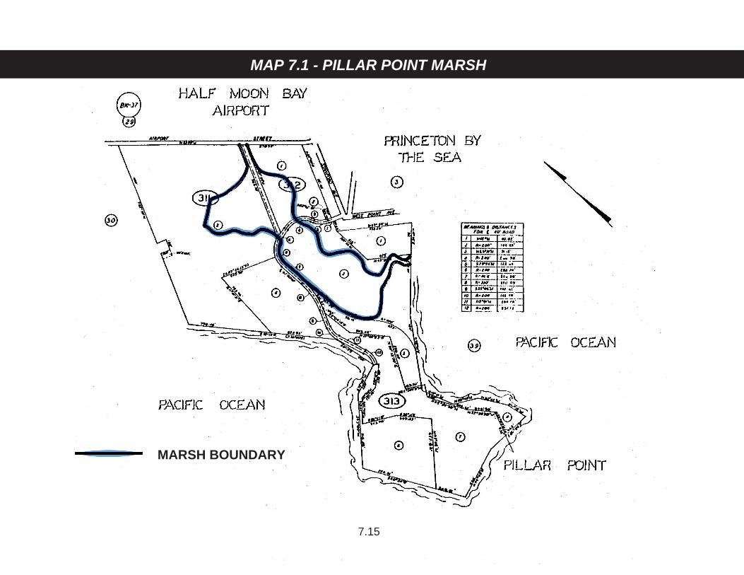
MAP 7.1 - PILLAR POINT MARSH
7.15
MARSH BOUNDARY
8.1
VISUAL RESOURCES COMPONENT NATURAL FEATURES--LANDFORMS 8.1 Definition of Landforms Define landforms as natural topographic and landscape features which include,
but are not restricted to, ridgelines, hillsides, canyons, coastal terraces, head-lands, mountains, rock outcroppings, hills, cliffs and bluffs, sand dunes, beaches, wetlands, estuaries, streams, and arroyos.
8.2 Beaches Prohibit permanent structures on open sandy beaches except facilities required
for public health and safety (i.e., beach erosion control structures). 8.3 Sand Dunes Prohibit development or uses that would alter the natural appearance of dunes,
significantly hamper natural dune movement, conflict with the visual form of the dune ridgelines, destroy dune-stability vegetation, or require sand removal.
8.4 Cliffs and Bluffs a. Prohibit development on bluff faces except public access stairways where
deemed necessary and erosion control structures which are in conformity with coastal policies on access and erosion.
b. Set back bluff top development and landscaping from the bluff edge (i.e.,
decks, patios, structures, trees, shrubs, etc.) sufficiently far to ensure it is not visually obtrusive when viewed from the shoreline except in highly developed areas where adjoining development is nearer the bluff edge, or in special cases where a public facility is required to serve the public safety, health, and welfare.
8.5 Location of Development On rural lands and urban parcels larger than 20,000 sq. ft.: a. Require that new development be located on a portion of a parcel where
the development: (1) is least visible from State and County Scenic Roads; (2) is least likely to significantly impact views from public viewpoints; and (3) is consistent with all other LCP requirements, best preserves the visual and open space qualities of the parcel overall. Where conflicts in complying with this requirement occur, resolve them in a manner which, on

8.2
balance, most protects significant coastal resources on the parcel, consistent with Coastal Act Section 30007.5.
Public viewpoints include, but are not limited to, coastal roads, roadside
rests and vista points, recreation areas, trails, coastal accessways, and beaches.
This provision does not apply to enlargement of existing structures,
provided that the size of the structure after enlargement does not exceed 150% of the pre-existing floor area, or 2,000 sq. ft., whichever is greater.
This provision does not apply to agricultural development to the extent that
application of the provision would impair any agricultural use or operation on the parcel. In such cases, agricultural development shall use appro-priate building materials, colors, landscaping and screening to eliminate or minimize the visual impact of the development.
b. Require, including by clustering if necessary, that new parcels have
building sites that are not visible from State and County Scenic Roads and will not significantly impact views from other public viewpoints. If the entire property being subdivided is visible from State and County Scenic Roads or other public viewpoints, then require that new parcels have building sites that minimize visibility from those roads and other public viewpoints.
8.6 Streams, Wetlands, and Estuaries a. Set back development from the edge of streams and other natural
waterways a sufficient distance to preserve the visual character of the waterway.
b. Prohibit structural development which will adversely affect the visual quality
of perennial streams and associated riparian habitat, except for those permitted by Sensitive Habitats Component Policies.
c. Retain the open natural visual appearance of estuaries and their
surrounding beaches. d. Retain wetlands intact except for public accessways designed to respect
the visual and ecological fragility of the area and adjacent land, in accordance with the Sensitive Habitats Component policies.
*8.7 Development on Skylines and Ridgelines a. Prohibit the location of development, in whole or in part, on a skyline or
ridgeline, or where it will project above a skyline or ridgeline, unless there is no other developable building site on the parcel.

8.3
Consistent with Policy 9.18, a site of greater than 30% slope may be deemed developable if it is the only other building site on the parcel and can be developed consistent with all other applicable LCP policies.
Prohibit the location of development, in whole or in part, on a skyline, or
where it will project above a skyline, when a developable building site exists on a ridgeline.
A skyline is the line where sky and land masses meet, and ridgelines are
the tops of hills or hillocks normally viewed against a background of other hills (General Plan Policy 4.7).
b. Where no other developable building site exists on a parcel, limit
development on a skyline or ridgeline to 18 feet in height from the natural or finished grade, whichever is lower.
c. Prohibit the creation of new parcels which have no developable building
site other than on a skyline or ridgeline. NATURAL FEATURES--VEGETATIVE FORMS 8.8 Definition of Vegetative Forms Define vegetative forms as naturally occurring or introduced vegetation that
grows in the Coastal Zone. 8.9 Trees a. Locate and design new development to minimize tree removal. b. Employ the regulations of the Significant Tree Ordinance to protect
significant trees (38 inches or more in circumference) which are located in urban areas zoned Design Review (DR).
c. Employ the regulations of the Heritage Tree Ordinance to protect unique
trees which meet specific size and locational requirements. d. Protect trees specifically selected for their visual prominence and their
important scenic or scientific qualities. e. Prohibit the removal of trees in scenic corridors except by selective
harvesting which protects the existing visual resource from harmful impacts or by other cutting methods necessary for development approved in compliance with LCP policies and for opening up the display of important views from public places, i.e., vista points, roadways, trails, etc.
8.4
f. Prohibit the removal of living trees in the Coastal Zone with a trunk circumference of more than 55 inches measured 4 1/2 feet above the average surface of the ground, except as may be permitted for development under the regulations of the LCP, or permitted under the Timber Harvesting Ordinance, or for reason of danger to life or property.
g. Allow the removal of trees which are a threat to public health, safety, and
welfare. 8.10 Vegetative Cover (with the exception of crops grown for commercial purposes) Replace vegetation removed during construction with plant materials (trees,
shrubs, ground cover) which are compatible with surrounding vegetation and is suitable to the climate, soil, and ecological characteristics of the area.
STRUCTURAL AND COMMUNITY FEATURES--URBAN AREAS AND RURAL SERVICE CENTERS 8.11 Definition of Urban Define urban areas and rural service centers in accordance with the Locating
and Planning New Development Component Policies 1.3 and 1.10. 8.12 General Regulations a. Apply the Design Review (DR) Zoning District to urban areas of the Coastal
Zone (1) For one- and two-family developments in the Midcoast, apply the
design standards contained in Section 6565.20. (2) For all other development, apply the design standards contained in
Section 6565.17 and the design criteria set forth in the Community Design Manual.
b. Locate and design new development and landscaping so that ocean views
are not blocked from public viewing points such as public roads and publicly-owned lands.
8.13 Special Design Guidelines for Coastal Communities a. Montara-Moss Beach-El Granada-Miramar (1) Design structures that fit the topography of the site and do not
require extensive cutting, grading, or filling for construction.
8.5
(2) Employ the use of natural materials and colors that blend with the vegetative cover of the site.
(3) Use pitched roofs that are surfaced with non-reflective materials
except for the employment of solar energy devices. The limited use of flat roofs may be allowed if necessary to reduce view impacts or to accommodate varying architectural styles that are compatible with the character of the surrounding area.
(4) Design structures that are in scale with the character of their setting
and blend rather than dominate or distract from the overall view of the urbanscape.
(5) To the extent feasible, design development to minimize the blocking
of views to or along the ocean shoreline from Highway 1 and other public viewpoints between Highway 1 and the sea. Public viewpoints include coastal roads, roadside rests and vista points, recreation areas, trails, coastal accessways, and beaches. This provision shall not apply in areas west of Denniston Creek zoned either Coastside Commercial Recreation or Waterfront.
(6) In areas east of Denniston Creek zoned Coastside Commercial
Recreation, the height of development may not exceed 28 feet from the natural or finished grade, whichever is lower.
b. Princeton-by-the-Sea (1) Commercial Development Design buildings which reflect the nautical character of the harbor
setting, are of wood or shingle siding, employ natural or sea colors, and use pitched roofs.
(2) Industrial Development Employ architectural detailing, subdued colors, textured building
materials, and landscaping to add visual interest and soften the harsh lines of standard or stock building forms normally used in industrial districts.
c. San Gregorio Encourage new buildings to incorporate traditional design features found in
the San Gregorio House and other houses in the community, i.e., clean and simple lines, steep roof slopes, placement of windows and doors at regular intervals, doors and windows of equal proportions, and wood
8.6
construction. Require remodeling of existing buildings to retain and respect their traditional architectural features, if any.
d. Pescadero Encourage new buildings to incorporate architectural design features found
in the historic buildings of the community (see inventory listing), i.e., clean and simple lines, precise detailing, steep roof slopes, symmetrical relation-ship of windows and doors, wood construction, white paint, etc. Require remodeling of existing buildings to retain and respect their traditional architectural features, if any.
STRUCTURAL AND COMMUNITY FEATURES--RURAL 8.14 Definition of Rural Define rural as lands indicated on the LCP Land Use Plan Map for rural use.
*8.15 Coastal Views Prevent development (including buildings, structures, fences, unnatural
obstructions, signs, and landscaping) from substantially blocking views to or along the shoreline from coastal roads, roadside rests and vista points, recreation areas, trails, coastal accessways, and beaches.
8.16 Landscaping a. Use plant materials to integrate the man-made and natural environments
and to soften the visual impact of new development. b. Protect existing desirable vegetation. Encourage, where feasible, that new
planting be common to the area.
*8.17 Alteration of Landforms; Roads and Grading a. Require that development be located and designed to conform with, rather
than change, landforms. Minimize the alteration of landforms as a consequence of grading, cutting, excavating, filling or other development.
b. To the degree possible, ensure restoration of pre-existing topographic
contours after any alteration by development, except to the extent necessary to comply with the requirements of Policy 8.18.
c. Control development to avoid the need to construct access roads visible
from State and County Scenic Roads. Existing private roads shall be shared wherever possible. New access roads may be permitted only
8.7
where it is demonstrated that use of existing roads is physically or legally impossible or unsafe. New roads shall be (1) located and designed to minimize visibility from State and County Scenic Roads and (2) built to fit the natural topography and to minimize alteration of existing landforms and natural characteristics.
This provision does not apply to agricultural development to the extent that
application of the provision would impair any agricultural use or operation, or convert agricultural soils. In such cases, build new access roads to minimize alteration of existing landforms and natural characteristics.
8.18 Development Design a. Require that development (1) blend with and be subordinate to the
environment and the character of the area where located, and (2) be as unobtrusive as possible and not detract from the natural, open space or visual qualities of the area including, but not limited to, siting, design, layout, size, height, shape, materials, colors, access and landscaping.
The colors of exterior materials shall harmonize with the predominant earth
and vegetative colors of the site. Materials and colors shall absorb light and minimize reflection. Exterior lighting shall be limited to the minimum necessary for safety. All lighting, exterior and interior, must be placed, designed and shielded so as to confine direct rays to the parcel where the lighting is located.
Except for the requirement to minimize reflection, agricultural development
shall be exempt from this provision. Greenhouse development shall be designed to minimize visual obtrusiveness and avoid detracting from the natural characteristics of the site.
b. Require screening to minimize the visibility of development from scenic
roads and other public viewpoints. Screening shall be by vegetation or other materials which are native to the area or blend with the natural environment and character of the site.
c. Require that all non-agricultural development minimize noise, light, dust,
odors and other interference with persons and property off the development site.
8.19 Colors and Materials a. Employ colors and materials in new development which blend, rather than
contrast, with the surrounding physical conditions of the site.
8.8
b. Prohibit highly reflective surfaces and colors except those of solar energy devices.
8.20 Scale Relate structures in size and scale to adjacent buildings and landforms.
*8.21 Commercial Signs a. Prohibit off-premises commercial signs except for seasonal temporary
agricultural signs. b. Design on-premises commercial signs as an integral part of structure they
identify and which do not extend above the roofline. c. Prohibit brightly illuminated colored, rotating, reflective, blinking, flashing or
moving signs, pennants, or streamers. d. Design and minimize information and direction signs to be simple, easy-to-
read, and harmonize with surrounding elements. 8.22 Utilities in State Scenic Corridors a. Install new distribution lines underground. b. Install existing overhead distribution lines underground where they are
required to be relocated in conjunction with street improvements, new utility construction, etc.
c. Exceptions to a. and b. may be approved by the Planning Commission
where it is not physically practicable due to topographic features; however, utilities shall not be substantially visible from any public road or developed public trails.
8.23 Utilities in County Scenic Corridors a. Install new distribution lines underground, except as provided in b. b. For all development, exceptions may be approved by the Planning
Commission when: (1) it is not physically practicable due to topographic features, (2) there are agricultural land use conflicts, or (3) development is for farm-labor housing. In addition, for building permits, exceptions may be approved by the Planning Commission for financial hardships. In each case, however, utilities shall not be substantially visible from any public road or developed public trail.
8.9
8.24 Large Agricultural Structures Require large agricultural structures (i.e., greenhouses or buildings for the
storage of farm or ranch equipment, products, or related uses) to employ a combination of the following criteria depending on the design problems of the site:
a. Require agricultural equipment storage buildings to be constructed of
materials or painted colors which blend with the natural vegetative cover of the site.
b. Employ landscaping to screen structures from public view. SPECIAL FEATURES 8.25 Definition Define special features as unique structural, land, or vegetative forms that
possess or exhibit distinctive qualities that set them apart from all others, contribute significantly to the scenic resources of the Coastal Zone, and are listed in the Inventory of Special Features in the LCP.
8.26 Structural Features Employ the regulations of the Historical and Cultural Preservation Ordinance to
protect any structure or site listed as an Official County or State Historic Landmark or is listed in the National Register of Historic Sites.
8.27 Natural Features Prohibit the destruction or significant alteration of special natural features
through implementation of Landform Policies and Vegetative Form Policies of the LCP.
SCENIC ROADS AND SCENIC CORRIDORS 8.28 Definition of Scenic Corridors Define scenic corridors as the visual boundaries of the landscape abutting a
scenic highway and which contain outstanding views, flora, and geology, and other unique natural or man-made attributes and historical and cultural resources affording pleasure and instruction to the highway traveler.

8.10
8.29 Designation of Officially Adopted State Scenic Roads and Corridors Recognize officially adopted State Scenic Roads and Corridors as shown on
the Scenic Roads and Corridors Map for the Coastal Zone. These are Coast Highway south of Half Moon Bay city limits (State Route 1) and Skyline Boulevard (State Route 35).
8.30 Designation of County Scenic Roads and Corridors a. Expand existing County Scenic Corridors to include the visual limits of the
landscape abutting the scenic road. b. Designate County Scenic Roads and Corridors as shown on the Scenic
Roads and Corridors Map for the Coastal Zone. These are Coast Highway north of Half Moon Bay city limits (State Route 1), Half Moon Bay Road (State Route 92), La Honda Road (State Route 84), Higgins-Purisima Road, Tunitas Creek Road, Pescadero Road, Stage Road, Cloverdale Road, and Gazos Creek Road (Coast Highway to Cloverdale Road).
8.31 Regulation of Scenic Corridors in Rural Areas a. Apply the policies of the Scenic Road Element of the County General Plan. b. Apply Section 6325.1 (Primary Scenic Resources Areas Criteria) of the
Resource Management (RM) Zoning District as specific regulations protecting scenic corridors in the Coastal Zone.
c. Apply the Rural Design Policies of the LCP. d. Apply the Policies for Landforms and Vegetative Forms of the LCP. e. Require a minimum setback of 100 feet from the right-of-way line, and
greater where possible; however, permit a 50-foot setback when sufficient screening is provided to shield the structure from public view.
f. Continue applying special regulations for the Skyline Boulevard and
Cabrillo Highway State Scenic Corridors. g. Enforce specific regulations of the Timber Harvest Ordinance which
prohibits the removal of more than 50% of timber volume in scenic corridors.
8.32 Regulation of Scenic Corridors in Urban Areas a. Apply the regulations of the Design Review (DR) Zoning Ordinance.
8.11
b. Apply the design criteria of the Community Design Manual. c. Apply specific design guidelines for Montara, Moss Beach, El Granada,
Princeton-by-the-Sea, Miramar, San Gregorio, and Pescadero as set forth in Urban Design Policies of the LCP.
8.33 Exemptions Exempt from Planning Commission architectural and site review agricultural
related development (as defined in the Categorical Exclusion for Agriculturally Related Development (E-81-1)), and all buildings and structures which would not be visible from the roadway due to localized terrain and vegetative cover.
8.34 Uses Allowed in Designated Historic Structures and Historic Districts a. In urban and rural areas, allow the following uses subject to a use permit:
(1) single-family residential, (2) multiple-family residential, (3) schools, public and private, (4) libraries, (5) community centers, (6) conference centers, (7) clubs, public and private, (8) professional offices, (9) art galleries, (10) art studios, (11) museums, (12) shops and boutiques, (13) book stores, (14) country inns and hotels, (15) restaurants and cafes, and (16) bars.
b. Use must be consistent with the resource protection policies of the San
Mateo County Local Coastal Program. c. In rural areas, water use for the permitted use shall not exceed that
provided for under “priority uses” in Policy 1.8(c) of the San Mateo County Local Coastal Program. Priority uses are allocated a maximum daily water use of 615 gallons per density credit.
d. In rural areas, density of use shall not exceed that permitted under Policy
1.8(b) of the San Mateo County Local Coastal Program.
9.1
HAZARDS COMPONENT 9.1 Definition of Hazard Areas Define hazardous areas as fault zones and land subject to dangers from
liquefaction and other severe seismic impacts, unstable slopes, landslides, coastal cliff instability, flooding, tsunamis, fire, and steep slopes (over 30%).
9.2 Designation of Hazard Areas Designate hazardous areas in the Coastal Zone as those delineated on the
Geotechnical Hazards Synthesis Map, the Floodway Boundary and Floodway Maps and Flood Insurance Rate Maps adopted under Chapter 35.5 of the San Mateo County Zoning Regulations, and the Natural Hazards Map in the Natural Hazards Chapter of the General Plan.
9.3 Regulation of Geologic Hazard Areas Apply the following regulations of the Resource Management (RM) Zoning
Ordinance to designated geologic hazard areas: a. Section 6324.6 - Hazards to Public Safety Criteria. b. Section 6326.2 - Tsunami Inundation Area Criteria. c. Section 6326.3 - Seismic Fault/Fracture Area Criteria. Require geologic
reports prepared by a certified engineering geologist consistent with “Guidelines for Geologic/Seismic Reports” (CDMG Notes #37) for all proposed development.
d. Section 6326.4 - Slope Instability Area Criteria. 9.4 Definition of High Risk Fire Areas Define fire hazard areas as those having a high potential for catastrophic fire. 9.5 Designation of High Risk Fire Areas Designate high risk fire areas in the Coastal Zone as those delineated by the
State Division of Forestry and shown on the Hazards Map for the Coastal Zone. 9.6 Regulation of Development in High Risk Fire Areas Require residential development in high risk areas to be reviewed and
conditioned by the County Fire Warden to ensure that building materials,
9.2
access, brush clearings and water storage capacity are adequate for fire flow and fire protection purposes.
9.7 Definition of Coastal Bluff or Cliff Define coastal bluff or cliff as a scarp or steep face of rock, decomposed rock,
sediment or soil resulting from erosion, faulting, folding or excavation of the land mass and exceeding 10 feet in height.
9.8 Regulation of Development on Coastal Bluff Tops a. Permit bluff and cliff top development only if design and setback provisions
are adequate to assure stability and structural integrity for the expected economic life span of the development (at least 50 years) and if the development (including storm runoff, foot traffic, grading, irrigation, and septic tanks) will neither create nor contribute significantly to erosion problems or geologic instability of the site or surrounding area.
b. Require the submittal of a site stability evaluation report for an area of
stability demonstration prepared by a soils engineer or a certified engineering geologist, as appropriate, acting within their areas of expertise, based on an on-site evaluation. The report shall consider:
(1) Historic, current and foreseeable cliff erosion, including investigation
of recorded land surveys and tax assessment records in addition to the use of historic maps and photographs where available, and possible changes in shore configuration and transport.
(2) Cliff geometry and site topography, extending the surveying work
beyond the site as needed to depict unusual geomorphic conditions that might affect the site and the proposed development.
(3) Geologic conditions, including soil, sediment and rock types and
characteristics in addition to structural features such as bedding, joints, and faults.
(4) Evidence of past or potential landslide conditions, the implications of
such conditions for the proposed development, and the potential effects of the development on landslide activity.
(5) Wave and tidal action, including effects of marine erosion on sea
cliffs. (6) Ground and surface water conditions and variations, including
hydrologic changes caused by the development (e.g., introduction of
9.3
sewage effluent and irrigation water to the groundwater system; alterations in surface drainage).
(7) Potential effects of seismic forces resulting from a maximum credible
earthquake. (8) Effects of the proposed development including siting and design of
structures, septic system, landscaping, drainage, and grading, and impacts of construction activity on the stability of the site and adjacent area.
(9) Any other factors that may affect slope stability. (10) Potential erodibility of site and mitigating measures to be used to
ensure minimized erosion problems during and after construction (i.e., landscaping and drainage design).
c. The area of demonstration of stability includes the base, face, and top of all
bluffs and cliffs. The extent of the bluff top considered should include the area between the face of the bluff and a line described on the bluff top by the intersection of a plane inclined at a 20º angle from the horizontal passing through the toe of the bluff or cliff, or 50 feet inland from the edge of the cliff or bluff, whichever is greater.
d. Prohibit land divisions or new structures that would require the need for
bluff protection work. 9.9 Regulation of Development in Floodplains a. Channelization, dams, or other stream alterations shall incorporate the best
mitigation measures feasible and be limited to: (1) necessary water supply projects, (2) flood control projects where no other methods for protecting existing development or providing public safety exists, or (3) developments to enhance fish and wildlife habitat.
b. Development located within flood hazard areas shall employ the standards,
limitations and controls contained in Chapter 35.5 of the San Mateo County Ordinance Code, Sections 8131, 8132 and 8133 of Chapter 2 and Section 8309 of Chapter 4, Division VII (Building Regulations), and applicable Subdivision Regulations.
9.10 Geological Investigation of Building Sites Require the County Geologist or an independent consulting certified engineering
geologist to review all building and grading permits in designated hazardous areas for evaluation of potential geotechnical problems and to review and
9.4
approve all required investigations for adequacy. As appropriate and where not already specifically required, require site specific geotechnical investigations to determine mitigation measures for the remedy of such hazards as may exist for structures of human occupancy and/or employment other than those considered accessory to agriculture as defined in Policy 5.6.
“Hazards areas” and “hazards” are defined as those geotechnical hazards
shown on the current Geotechnical Hazards Synthesis Maps of the General Plan and the LCP Hazards Maps. A copy of the report of all geologic investigations required by the California Division of Mines and Geology shall be forwarded to that agency.
9.11 Shoreline Development Locate new development (with the exception of coastal-dependent uses or
public recreation facilities) in areas where beach erosion hazards are minimal and where no additional shoreline protection is needed.
9.12 Limiting Protective Shoreline Structures a. Permit construction of shoreline structures such as retaining walls, groins,
revetments, and breakwaters only in accordance with the following conditions when: (1) necessary to serve coastal-dependent uses, to protect existing development, or to protect public beaches in danger of erosion, (2) designed to eliminate or mitigate adverse impacts on local shoreline sand supply, and (3) non-structural methods (e.g., artificial nourishment) have been proved to be infeasible or impracticable.
b. Protect existing roadway facilities which provide public access to beaches
and recreational facilities when alternative routes are not feasible and when protective devices are designed in accordance with the requirements of this component and other LCP policies.
9.13 Limiting Shoreline Structures on Sandy Beaches To avoid the need for future protective devices that could impact sand
movement and supply, prohibit permanent structures on the dry sandy beach except facilities necessary for public health and safety, such as lifeguard towers.
9.14 Shoreline Structure Design a. Require that all protective structures are designed to: (1) minimize visual
impact by using appropriate colors and materials, (2) utilize materials which require minimum maintenance, and (3) provide public overlooks where feasible and safe.

9.5
b. Require that shoreline protective structures not impede lateral access along beach areas and provide vertical access where feasible.
c. Require that any shoreline alteration or structure project shall mitigate
project impacts by adequate fish and wildlife preservation measures. 9.15 Emergency Provisions Waive the requirement for obtaining a Coastal Development Permit to: (1) allow
immediate action by a person or public agency performing a public service to protect life and public property from imminent danger or (2) restore, repair, or maintain public works, utilities, or services which have been destroyed, damaged, or interrupted by natural disaster, serious accident, or other emergencies if such action does not involve the permanent erection of structures valued at $25,000 or more.
9.16 Geologic Reports for Shoreline Structures Require that all applications involving shoreline structures shall be accompanied
by a report prepared by a certified engineering geologist or a soils engineer, as appropriate, which analyzes the effect that the project will have on physical shoreline processes.
9.17 Maintenance of Structures Require that project plans for shoreline structures specify agencies or persons
responsible for the maintenance of proposed structure(s). 9.18 Regulation of Development on 30% or Steeper Slopes a. Prohibit development on slopes of 30% or more, unless (1) no alternative
exists or (2) the only practicable alternative site is on a skyline or ridgeline. Parcels shall not be created where the only building site, in whole or in part, including roads and driveways, is on a slope of 30% or more. An engineering geologic report shall be required for any development on a slope of 30% or more.
Development less than 10 feet in height that does not constitute a building,
road or driveway, or require grading shall be exempt from the application of this provision.
b. Employ the siting and grading criteria of the Design Review Zoning
Ordinance and the Community Design Manual for Development on Slopes 30% or Greater.

10.1
SHORELINE ACCESS COMPONENT REQUIREMENT FOR THE PROVISION OF SHORELINE ACCESS 10.1 Permit Conditions for Shoreline Access Require some provision for shoreline access as a condition of granting
development permits for any public or private development permits (except as exempted by Policy 10.2) between the sea and the nearest road. The type of provision, the location of the access and the amount and type of improvements required shall be consistent with the policies of this component.
10.2 Definition of Development As stated in Section 30106 of the Coastal Act, define development in areas
between the sea and the nearest public road to mean: a. On land, in or under water, the placement or erection of any solid material
or structure; discharge or disposal of any dredged material or of any gaseous, liquid, solid or thermal waste; grading, removing, dredging, mining, or extraction of any materials; change in the density or intensity of use of land, including, but not limited to, subdivision pursuant to the Subdivision Map Act (commencing with Section 66410 of the Government Code), and any other division of land, including lot splits, except where the land division is brought about in connection with the purchase of such land by a public agency for public recreational use; change in intensity of use of water, or of access thereto; construction, reconstruction, demolition, or alteration of the size of any structure, including any facility of any private, public, or municipal utility; and the removal or harvesting of major vegetation other than for agricultural purposes, kelp harvesting and timber operations which are in accordance with a timber harvesting plan submitted pursuant to the provisions of the Z’berg-Nejedly Forest Practice Act of 1973 (commencing with Section 4511).
b. Any structure which would close off, restrict, or impede access to an
existing access trail. c. Exempt from the requirement for provision of shoreline access the
following: (1) Replacement of any structure pursuant to the provisions of
subdivision (g) of Section 30610 of the Coastal Act. (2) The demolition and reconstruction of a single-family residence;
provided, that the reconstructed residence shall not exceed either the
10.2
floor area, height or bulk of the former structure by more than 10%, and that the reconstructed residence shall be sited in the same location on the affected property as the former structure.
(3) Improvements to any structure which do not change the intensity of
its use, which do not increase either the floor area, height, or bulk of the structure by more than 10%, which do not block or impede public access, and which do not result in a seaward encroachment by the structure.
(4) Any repair or maintenance activity for which the Commission has
determined, pursuant to Section 30610, that a Coastal Development Permit will be required unless the County or the Commission determines that such activity will have an adverse impact on lateral public access along the beach.
As used in this subdivision, “bulk” means total interior cubic volume
as measured from the exterior surface of the structure. (5) The following small to medium developments necessary to an
agricultural operation: (a) Wells for agricultural purposes, (b) Storage/equipment sheds (maximum 500 sq. ft.), (c) Fencing that does not interfere with existing access as defined
in Policies 10.5 and 10.6, (d) Utility poles to serve agricultural uses, (e) Barns not to exceed 5,000 sq. ft., (f) Water storage tanks, maximum 10,000 gallons. Providing that existing public access as defined in Policies 10.5 and
10.6 is retained, potential public access which would not adversely affect agriculture is protected, and hazardous and environmentally sensitive areas are posted.
If development approved without access requirement under this
policy converts to a non-agricultural use, a Coastal Development Permit shall be required for the conversion and appropriate access requirements applied.

10.3
10.3 Definition of Shoreline Access Define shoreline access as the provision of access for the general public from a
public road to and along the shoreline. Classify shoreline access into two types: vertical and lateral.
a. Define vertical access as a reasonably direct connection between the
nearest public roadway and the shoreline. Define shoreline as a beach, where contact with the water’s edge is possible, or a bluff, where only visual access is afforded. Call passageways which provide vertical access trails.
b. Define lateral access as a strip of land running along the shoreline,
parallel to the water and immediately inland from the mean high tide line. Lateral access may include a beach, where contact with the water’s edge is possible, or a bluff, where only visual access is afforded. Refer to lateral access areas as shoreline destinations.
10.4 Designation of Shoreline Access Designate vertical (trails) and lateral (shoreline destinations) access as areas to
which the policies of this component apply. Such areas include, but are not limited to, those listed in the Assessment of Access Trails and Shoreline Destinations (Table 10.6).
10.5 Definition of Established Shoreline Access Define established vertical (trails) and lateral (shoreline destinations) access as
areas where the public’s right to use has been legally established through permit conditioning, acquisition, and/or prescriptive rights.
10.6 Definition of Undeveloped Shoreline Access Define undeveloped vertical (trails) and lateral (shoreline destinations) access
as access created and maintained by actual use, whether on privately or publicly owned lands. Consider undeveloped shoreline access to be generally unsigned and unimproved.
10.7 Definition of Private Shoreline Access Define private vertical (trails) and lateral (shoreline destinations) access as
access on privately owned land where the public’s right to use has not been legally established through permit conditioning and/or prescriptive rights.
10.4
LOCATIONAL CRITERIA 10.8 Appropriate Locations for Shoreline Access Use the following criteria to determine appropriate locations for shoreline
access. 10.9 Public Safety a. Provide safe access to the following shoreline destinations which are large
enough to accommodate public safety improvements and public use: (1) beaches which are large enough to provide space for easy retreat from normal tidal action, (2) bluffs which are large enough and of a physical character to accommodate safety improvements and which provide room for public use as a vista point, and (3) beaches and bluffs designated appropriate for public use in the Site Specific Recommendations for Shoreline Destinations (Table 10.6).
b. Discourage public use of access trails which are hazardous because
safety improvements have not been provided or cannot be built due to physical limitations. Specifically,
(1) Close undeveloped trails which are hazardous when an alternative
safe existing or potential access is available for the same beach or bluff.
(2) When no safe access alternative is available, close undeveloped
hazardous trails identified in Tables 10.1 and 10.2 as having a “high” rating in the public safety hazards category and which pose a risk of serious bodily harm because of the height or unstable nature of bluffs or the limited beach area between the mean high tide line and the base of the bluff. Give priority to the acquisition and improvement of nearby access or for the improvement and re-opening of accesses closed for safety reasons to those trails which lead to long sandy beaches as indicated on Table 10.1.
(3) Where a trail to the beach is closed, provide a bluff top access point
or trail for public viewing, of the shoreline when consistent with Policy 10.9(a).
(4) Prohibit development that would prevent the future improvement of
unsafe access.

10.5
10.10 Fragile Resources (Sensitive Habitats) a. Require the establishment of public access to sensitive habitats or their
buffer zones, through grants or dedications of easements or other means, at the time a Coastal Development Permit is processed. Open the access in sensitive habitats or their buffer zones for public use only when development standards and management practices are adequate to protect the resources (see Sensitive Habitats Component) and Policies 10.23 and 10.25.
b. Discourage public use of existing established access trails if the present
level of use is causing the deterioration of a sensitive habitat. Specifically, (1) Close such trails when an existing or potential alternative trail is
available for the same beach or bluff area. (2) When no alternative is available, mitigate the access impacts through
improved management and design consistent with Policies 10.25 and 10.26, wherever possible. Close trails only if permanent, irreversible damage to a habitat is causing its destruction.
(3) Where a trail to the beach is closed, provide a bluff top access point
or trail for public viewing of the shoreline consistent with Policy 10.9(a).
(4) Prohibit development that would prevent the future provision of
improved access. (5) Allow closely monitored access for scientific and educational
research by organized study groups. 10.11 Agricultural Areas a. For development of land whose primary use will be agriculture, require the
establishment of vertical and/or lateral access to beaches only when: (1) Policy 10.30 requires it, and (2) no established vertical or lateral access exists.
b. Open the access in agricultural areas only when development standards
are adequate to protect agricultural land consistent with Policy 10.28. c. Based on current (1980) patterns of agricultural operations, establish a
maximum requirement of one vertical trail from the road to the mean high tide for any individually owned agricultural operation.
10.6
(Ref. LUP Agricultural Maps.) Vertical accesses established under this policy shall not be abandoned due to consolidation of operations, nor shall future consolidation result in the denial of accesses to the long sandy beaches identified on Table 10.1.
d. Limit the lateral access requirement to the provisions of access between
the mean high tide line and the bluff or first line of terrestrial vegetation. Do not require lateral access along bluff tops in agricultural areas.
10.12 Residential Areas Locate shoreline access within existing or new residential areas in the least
disruptive manner. Specifically, a. Provide vertical access (trails) at the ends of streets perpendicular to the
shoreline. b. If there are few or no such right angle streets, provide vertical access
(trails) between houses at 1/4-mile intervals, where consistent with the public safety policies in this component and the policies of the Sensitive Habitats Component. Require more frequent trails if there are several non-continuous shoreline destinations.
c. Give priority to improving existing access trails. 10.13 Commercial and Industrial Areas Require the establishment and improvement of vertical (trails) and lateral
(shoreline destinations) public access and parking consistent with Policy 10.22(e) as a condition for obtaining a permit for commercial and industrial development along the shoreline, except where the establishment of access would disrupt activities which are essential to public safety.
10.14 Military Sites Encourage the establishment and improvement of vertical (trails) and lateral
(shoreline destinations) public access in military facilities when not used for high security activities.
MINIMUM DEVELOPMENT STANDARDS 10.15 Application of Minimum Development Standards Apply minimum development standards to all shoreline access development.
10.7
10.16 Vertical Access (Trails) When building trails, provide a right-of-way at least 10 feet in width, which
allows feasible, unobstructed access for the general public from the nearest public roadway to the mean high tide line. Require a 5-foot minimum separation between the edges of the right-of-way and adjacent uses.
10.17 Lateral Access (Shoreline Destinations) With Coastal Bluffs a. Provide access for the general public between the mean high tide line and
the base of the bluff where there is adequate room for public use. b. Because of scenic or recreational value, provide a pathway with a
right-of-way at least 25 feet in width, which allows feasible unobstructed public access along the top of the bluff when no public access will be provided to the area between the mean high tide line and the base of the bluff because of safety and/or other considerations, and/or when the Site Specific Recommendations for Shoreline Destinations (Table 10.6) requires one.
c. Require bluff top setbacks, based upon site specific geologic and erosion
conditions, to ensure safe and continued use. 10.18 Lateral Access (Shoreline Destinations) Without Coastal Bluffs Provide access to and along the beach during normal tides, with a right-of-way
at least 25 feet in width, between the mean high tide line and the first line of terrestrial vegetation. Measure the width of the access either from a fixed inland point seaward or from the mean high tide line landward.
10.19 Maintenance Eliminate debris, provide trash cans and keep trails safe for public use in new
or improved public areas. 10.20 Posting Clearly post new or improved public access areas. 10.21 Access for the Disabled In all areas where topography permits, provide shoreline access for the
disabled by building paths and ramps for wheelchairs without altering major landforms. Refer to the Site Specific Recommendations for Shoreline Destina-tions (Table 10.6) for a listing of existing access trails which should be made wheelchair accessible.
10.8
10.22 Parking a. Continue the use of existing official off-street parking facilities for shoreline
access areas in order to maintain existing parking levels and to confine negative impacts to areas already disturbed.
b. Minimize the negative impacts of existing official off-street parking
facilities. Specifically, (1) Require the landscaping of existing facilities which are visible from
public roads, vista points or recreation areas without blocking ocean views from these areas.
(2) Remove or relocate parking spaces in existing facilities which are
located in or near sensitive habitats to provide adequate buffering. In no cases, however, eliminate an entire existing parking facility without relocation.
c. Use the following criteria when developing or relocating new off-street
parking facilities for shoreline access areas: (1) Base the amount of parking on the level of public use appropriate for
a site’s size, environmental sensitivity, and amount of land suitable for parking.
(2) Give preference to sites which are now used informally for shoreline
access parking. However, do not establish the following as perma-nent sites for parking: (a) emergency pullouts needed for highway safety, (b) visually prominent sites where landscaping would not significantly screen the parking from view, (c) visually prominent sites where landscape screening would block ocean views, and (d) sites in or adjacent to sensitive habitats.
(3) Locate new parking facilities on sites where it is possible to blend
them into the landscape or screen them by topography or vegetation. (4) Prohibit the development of sandy beaches. (5) Prohibit the conversion of prime agricultural lands, except where
such conversion is consistent with Policies 5.8 to 5.11 of the Agriculture Component. In such cases, locate facilities at the edges of fields, separated by fences or other facilities to protect agricultural operations.
d. New commercial or industrial parking facilities of ten or more spaces
within 1/4-mile radius of an established shoreline access area shall
10.9
designate and post 20% of the total spaces for beach user parking between 10:00 a.m. and 4:00 p.m.
e. Provide trails linking parking facilities to nearby shoreline destinations that
do not have existing parking facilities because such facilities would be inconsistent with other parking policies.
f. Reserve parking spaces for the disabled at the trailheads of wheelchair
accessible paths and ramps and at other level sites with safe access. g. Provide bus and secure bicycle parking in parking facilities. DEVELOPMENT STANDARDS FOR PROTECTING PUBLIC SAFETY 10.23 Access Trails a. Give preference to providing access trails in level, safe areas. b. Where no such safe areas exist, provide the following trail improvements,
including but not limited to: (1) staircases down steep bluffs, (2) fences along the edges of narrow bluffs, and (3) handrails and steps on steep terrain.
c. Design and site trail improvements to blend with the natural environment.
Prohibit the disturbance or alteration of landforms which would cause or contribute to erosion or geologic hazards.
d. Refer to the Site Specific Recommendations for Shoreline Destinations
(Table 10.6) for a listing of required improvements to protect public safety at existing sites.
e. Post caution signs on all difficult access trails. DEVELOPMENT STANDARDS FOR PROTECTING FRAGILE RESOURCES 10.24 Definition of Fragile Resources Define fragile resources as: (1) exposed rocky cliff faces, steep slopes as
defined in the Hazards Component, and hilly coastal terraces (e.g., San Pedro Bluff and Devil’s Slide), (2) all sensitive habitats defined in the Sensitive Habitats Component, and archaeological/paleontological resources.
10.25 Access Trails in Fragile Resource Areas a. During the planning and design phase for access projects, conduct studies
by a qualified person agreed upon by the County and the applicant to
10.10
determine the least disruptive method of constructing access trails and associated improvements. Consider in the study and implement appro-priate levels of development and management practices to protect resources.
b. Require that the design of trails encourages the public to stay on them or
in designated rest areas. c. Prohibit the use of off-road vehicles on access trails. 10.26 Access Trails in Sensitive Habitats a. Provide improvements and management practices in sensitive habitats
and their buffer zones adequate to protect the resources. Include, but do not limit, improvements and management practices to the following: (1) in areas not subject to tidal action, interpretive trails posted with educational signs which minimize public intrusions and impacts, (2) brochures and educational displays at trailheads leading to areas subject to tidal action, (3) organized tours, (4) limited number of persons per visitor tour, (5) restricted number of access points which are improved and managed, and (6) limit the seasons of the year when public access is permitted.
b. Refer to the Site Specific Recommendations for Shoreline Destinations
(Table 10.6) for a listing of required improvements to protect fragile resources in existing shoreline destinations.
c. Post signs on all access trails leading to unimproved or underprotected
sensitive habitats to restrict public intrusion. DEVELOPMENT STANDARDS FOR PROTECTING ADJACENT LAND USES 10.27 Residential a. Provide separation between shoreline access and adjacent residential
uses to protect the privacy and security of houses and the public nature and use of the shoreline. Specifically, keep the edge of lateral shoreline access trails 25 feet and vertical shoreline access trails 10 feet from any occupied residential structure.
b. Maximize the use of landscaping, fences, and grade separation. 10.28 Agricultural a. Locate access trails on agriculturally unsuitable land to the greatest extent
possible. Where it is not possible to locate access on agriculturally unsuitable land, locate trails at the edge of fields, and/or along parcel lines

10.11
consistent with the Conversion and Division Policies of the Agriculture Component.
b. Provide improvements and management in agricultural areas adequate to
protect the productivity of adjacent agricultural lands. Include, but do not limit, improvements and management practices to the following: (1) limit the seasons of the year when public access is permitted by using sea-sonal barriers and signs and (2) develop access trails with fences or other buffers to protect agricultural lands.
10.29 Protection of Trails from Closing and/or Encroachment a. Prohibit adjacent property owners from closing and/or encroachment on
established trails except to protect public safety and sensitive habitats as specified in Policy 10.10.
b. Require setbacks for development adjacent to existing or proposed shore-
line access to prevent encroachment. Do not permit new structures to encroach farther than the most extended adjacent structure.
ROLE OF SAN MATEO COUNTY IN ACQUIRING, DEVELOPING, MAINTAINING, AND REGULATING PUBLIC ACCESS 10.30 Requirement of Minimum Access as a Condition of Granting Development
Permits a. Require the provision of shoreline access for any private or public
development between the sea and the nearest public road. b. Base the level of improvement and development of access support
facilities at a site on the Locational Criteria and Development Standards Policies and the Site Specific Recommendations contained in Table 10.6.
c. Base the responsibility and requirements of the property owner for the
provision of this access on: (1) the size and type of development, (2) the benefit to the developer, (3) the priority given to the type of development under the Coastal Act, and (4) the impact of the development, particularly the burden the proposed development would place on the public right of access to and use of the shoreline. Determine the minimum requirements according to the following:
(1) For small non-agricultural developments (i.e., construction of
non-residential structures 500 sq. ft. and smaller, fences, wells, placement of utility poles), require the retention of existing public access as defined in Policies 10.5 and 10.6, the posting of hazardous and environmentally sensitive areas, and pay an in-lieu fee of a
10.12
minimal sum not to exceed 5% of the project cost to contribute to the provision of public access elsewhere along the County shoreline.
(2) For small to medium developments (i.e., single-family residences, all
minor land divisions, barns over 5,000 sq. ft., small greenhouses), not specifically exempted from shoreline access requirements by Policy 10.2, require the offering or granting of a vertical and/or lateral access consistent with the policies of this component, to either a public agency or private group acceptable to the County for improve-ment and maintenance.
(3) For large agricultural and non-agricultural developments (i.e., devel-
opments of more than one single-family house, major subdivisions, commercial and industrial developments, and large greenhouses and agricultural processing plants), require the property owner to provide, improve, and maintain shoreline access consistent with the policies of this component.
10.31 Requirement of Additional Access as a Condition of Granting Development
Permits Require additional access areas, improvements or operation and maintenance
beyond the minimum when a project decreases the existing or potential public access to the shoreline by: (1) removing or infringing upon an area which historically has been subject to public use without permission or effective interference by the owner, and/or (2) decreasing the amount of sandy beach by building seawalls, etc., and/or (3) removing future recreation opportunities by committing lands suitable for recreational development to uses which are not assigned priority for use of oceanfront land by Section 30222 of the Coastal Act.
10.32 Techniques for Securing Access Use one of the following techniques for securing access from a private property
owner. Determine the most appropriate technique by assessing the use and maintenance of the access and the type and size of the development.
a. Offer of Dedication Require offers of dedication of a fee interest or an easement over vertical
and/or lateral access when no agency or association acceptable to the County is currently ready to accept the dedication. Require offer to be recorded and be irrevocable for a period of 21 years. Until the offer is accepted by a public agency or private association acceptable to the County, or the landowner consents, do not open the dedicated accessway to public use.

10.13
b. Grant of an Easement Require grants of an access easement, which allow the public to travel
over a designated portion of a parcel, when an agency or association acceptable to the County is ready to accept the dedication and when an easement will be adequate to provide public access consistent with this component. Generally, when access is used only to travel to and along the shoreline, an easement shall be adequate.
c. Grant of a Fee Interest Require the offer or grant of a fee interest in a portion of a parcel for public
access, which results in a complete transfer of ownership, when an agency or association is ready to accept the grant and when the land is important in and of itself for recreation (i.e., used as more than the means to reach the shoreline).
d. Deed Restrictions Require deed restrictions which bind the owner and successors to allow
public access and recreation on a particular portion of a parcel when an access will be improved, maintained and operated by the property owner.
e. In-Lieu Fees Require the payment of an in-lieu fee for new developments where public
access at a site is not consistent with the policies of this component. Base the amount of the fee on the costs of access provision to other owners undertaking developments of a similar size and impact.
10.33 Publicizing Offers of Dedication Inform and encourage other public agencies, and private associations, such as
the State Department of Parks and Recreation, to accept offers to dedicate access which the County is unable to accept.
10.34 User Fees Allow public and private property owners to charge user fees for the operation
and maintenance of shoreline access under the following circumstances: (1) the property owner provides access improvements, operation and maintenance which exceed the development permit requirements for the size and impact of the development they are undertaking, and (2) fees are restricted to use of improvements, particularly parking, and not charged for pedestrian access or restrooms.
10.14
10.35 Priorities for Public Acquisition and Development Establish priorities for expenditure of public funds, including Coastal
Conservancy funds, based on maximizing public recreational opportunities, while protecting public safety and natural resources.
a. Follow the priorities as shown in Table 10.5 when unrestricted public funds
are available. b. Regularly assess these priorities as new access is established along the
coast. c. Before public expenditures are made, assess the potential for adjacent
private development to provide access improvements. Spend public money in areas where required improvements exceed what could be expected from private development.
d. Ensure that high priority access trails and shoreline destinations identified
in this component are given preference in public expenditures by informing other public agencies of local priorities and by reviewing the acquisition and development plans of other public agencies for consistency with them.
10.36 Coastal Access Acquisition and Development Fund a. Establish a County Coastal Access Acquisition and Improvement Fund
which will be used to improve and acquire important access trails and shoreline destinations in accordance with Table 10.5 priorities. Place in-lieu fees, user fees, and other minor revenues into the fund.
b. Explore adding to this fund a share of parking ticket revenues gained from
enforcing illegal parking along the coast. 10.37 Fitzgerald Marine Reserve Continue to provide for the improvement, expansion, and maintenance of
access to the Fitzgerald Marine Reserve according to Table 10.6, Site Specific Recommendations. Accept dedications of access easements or fee interests which provide access to or expand the size of the reserve.
10.38 California Coastal Trail (CCT) a. Definition: The California Coastal Trail (CCT) is a continuous inter-
connected public trail system along the California coastline. It is designed to foster appreciation and stewardship of the scenic and natural resources of the coast and serves to implement aspects of Coastal Act policies promoting non-motorized transportation. The Trail system is to be located
10.15
on a variety of terrains, including the beach, bluff edge, hillsides providing scenic vantage points, and within the highway right-of-way. It may take many forms including informal footpaths, paved sidewalks, and separated bicycle paths. When no other alternative exists, it sometimes connects along the shoulder of the road. While primarily for pedestrians, the Trail also accommodates a variety of additional user groups, such as bicyclists, wheelchair users, equestrians, and others as opportunities allow. The CCT consists of one or more parallel alignments.
b. Segments of the California Coastal Trail shall be developed consistent
with the parameters of this policy. (1) The County shall take the lead responsibility and will consult with
the National Park Service, the State Department of Parks and Recreation, the State Coastal Conservancy, the California Coastal Commission, the Counties of San Francisco and Santa Cruz, the Cities of Daly City, Pacifica and Half Moon Bay, CalTrans and other appropriate public and private entities and interested parties in designing, locating, funding, acquiring and implementing the CCT.
(2) The CCT shall be identified and defined as a continuous trail system
along the State’s coastline and designed and sited as a continuous lateral trail network traversing the length of the County’s Coastal Zone and connecting with contiguous trail links in adjacent Coastal jurisdictions, the Counties of San Francisco and Santa Cruz as well as with the Cities of Pacifica and Half Moon Bay.
(3) Existing segments of the CCT within County jurisdiction include at
least the following: (a) Former Highway 1 at Devil’s Slide, once formally relinquished
by CalTrans and opened as a public trail, (b) Old San Pedro Road, (c) Surfer’s Beach Trail, (d) Mirada Surf West, (e) Various segments within State Park properties that have been
signed with the CCT official State logo. (4) It is intended that the CCT system shall be designed and
implemented to achieve the following goals and objectives:
10.16
(a) Provide a continuous walking and hiking trail as close to the ocean as possible;
(b) Provide maximum access for a variety of non-motorized uses
by utilizing alternative trail segments where feasible; (c) Maximize connections to existing and proposed local trail
systems; (d) Ensure that the trail has connections to trailheads, parking
areas, interpretive kiosks, inland trail segments, etc., at reasonable intervals;
(e) Maximize ocean views and scenic coastal vistas; (f) Provide an educational experience where feasible through
interpretive facilities. (5) CCT Siting and Design Standards: (a) The trail should be sited and designed to be located along or as
close to the shoreline where physically and aesthetically feasible. Where it is not feasible to locate the trail along the shoreline due to natural landforms or legally authorized development that prevents passage at all times, inland bypass trail segments located as close to the shore-line as possible should be utilized. Shoreline trail segments that may not be passable at all times should provide inland alternative routes. Special attention should be given to identifying any segments that may need to be incorporated into water-crossing structures and that may need to be placed within CalTrans right-of way.
(b) Where gaps are identified in the trail, interim segments should
be identified to ensure a continuous coastal trail. Interim segments should be noted as such, with provisions that as opportunities arise, the trail shall be realigned for ideal siting. Interim trail segments should meet as many of the CCT objectives and standards as possible.
(c) The CCT should be designed and located to minimize impacts
to environmentally sensitive habitat areas and prime agriculture lands to the maximum extent feasible. Where appropriate, trail access should be limited to pass and repass. Where neces-sary to prevent disturbance to sensitive species, sections of the trail may be closed on a seasonal basis. Alternative trail segments shall be provided where feasible. For situations
10.17
where impact avoidance is not feasible, appropriate mitigation measures should be identified, including but not limited to use of boardwalks, reducing width of trails, converting edges of agricultural land to public trail use when the minimal amount of conversion is used, etc.
(d) The CCT should be located to incorporate existing oceanfront
trails and paths and support facilities of public shoreline parks and beaches to the maximum extent feasible.
(e) The CCT should be designed to avoid being located on roads
with motorized vehicle traffic where feasible, except for those specific strands of the trail system that are specifically designed to service commuter needs and safely provide for the shortest distance between destination points. Providing such a commuter-purpose strand of the CCT does not replace the remaining need to provide a recreational strand of the CCT as close to the shoreline as possible. In locations where it is not possible to avoid siting the trail along a roadway, the trail should be located off of the pavement and within the public right-of-way, and separated from traffic by a safe distance or by physical barriers that do not obstruct, or detract from the visual scenic character of their surroundings. In locations where the trail must cross a roadway, safe under- or over-crossings or other alternative at-grade crossings should be considered in connection with appropriate directional and traffic warning signage.
(6) CCT Acquisition and Management: (a) Trail easements should be obtained by encouraging private
donation of land, by public purchase, or by dedication of trail easements required pursuant to a development permit.
(b) The CCT Alignment Study should identify the appropriate
management agency(s) to take responsibility for trail operation and maintenance.
(7) CCT Signage Standards (a) The trail should provide adequate signage at all access points,
trailheads, parking lots, road crossings, and linkages or inter-sections with other trails or roads and shall incorporate the State adopted CCT logo.

10.18
(b) The trail should provide adequate safety signage, including but not limited to, road crossing signs and yield/warning signs on multi-use trail segments. Where appropriate, signs should be developed in coordination with CalTrans; Cities of Daly City, Pacifica and of Half Moon Bay; County Public Works Depart-ment and/or any other applicable public agencies or nonprofit organizations.
(8) CCT Support Facilities: To maximize access to the CCT, adequate parking and trailhead
facilities should be provided. (9) CCT Mapping: (a) The final CCT map shall identify all finally planned or secured
segments, including existing segments, all access linkages and planned staging areas, public and private lands, existing ease-ments, deed restricted sections and sections subject to an Offer-to-Dedicate (OTD). Where property ownerships or other constrictions make final alignment selection unfeasible, a preferred corridor for the alignment shall be identified. The map shall be updated on a regular basis, including updated Shoreline Destination/Access Maps.
(b) The CCT preferred alignment corridor shall be identified on all
applicable County Trail Maps contained in the LCP. (10) Inclusion of the CCT in LCP: Within one year of the completion of the CCT Alignment Study, the
LCP shall be amended to incorporate all plans and designs for locating and implementing the CCT within the County, including the final maps of the trails and corridor alignments.
10.39 Maintenance and Operation Explore developing a contractual agreement with the State Department of
Parks and Recreation which would allow the County to maintain and operate State owned shoreline access areas with reimbursement for these expenses by the State.
10.40 Signing and Publicizing Access a. Sign and publicize established shoreline access areas. Specifically:

10.19
(1) Place signs in prominent locations along Route 1 and at the trailhead of each established access point indicating its location and the degree of difficulty in using trails. Make signs visible but not detract from the scenic quality of the Coastal Zone.
(2) Place warning signs at the trailheads of difficult access trails. (3) Before and possibly after educational displays and interpretive trails
are built, post signs next to sensitive habitats to protect them. (4) Post two types of signs: (1) those that describe the resource and
forbid public entry to sensitive habitats, and (2) those that prohibit the collection of specimens.
(5) Require that all signs be distinctive in their design, easy to
understand, and uniform. b. Develop maps and a brochure showing all established trails, shoreline
destinations, parking, and pedestrian and bicycle routes to: (1) encourage the public to assist in monitoring maintenance, (2) prevent the closing of established shoreline access by encouraging public use, and (3) en-courage the public to inform the County of any failures to meet permit conditions. Encourage the Chambers of Commerce and other civic groups to assist in the printing and distribution of this brochure.
10.41 Review and Enforcement Based on available funding, County Planning staff shall undertake an annual
field review of beach accesses and support facilities to determine whether permit conditions requiring access and/or access related improvements have been fulfilled, existing, pre-LCP accesses remain open and to update access needs.
ROLE OF THE STATE DEPARTMENT OF PARKS AND RECREATION 10.42 Major Shoreline Access Provider Encourage the State Department of Parks and Recreation to continue
assuming a major role in the acquisition, development, and maintenance of public shoreline access along the coast.
10.43 Priorities Encourage the Department to contribute the major portion of funds for the
acquisition and development of access trails and shoreline destinations in
10.20
accordance with the priorities and policies of this component and reimburse the County for their maintenance and operation.
10.44 Implied Dedication Suits Allow the Department to bring forth implied dedication suits for high priority
access trails and shoreline destinations on private land when: (1) gaining access through permit conditioning is unlikely because of no probability of future development, and (2) attempts at acquisition through purchase have failed.
ROLE OF THE STATE COASTAL CONSERVANCY 10.45 Major Shoreline Access Facilitator Encourage the State Coastal Conservancy to continue assuming a major role
in funding and facilitating the acquisition, development, and maintenance of public shoreline access to and along the coast.
10.46 Accept Offers of Dedication Encourage the State Coastal Conservancy to accept offers to dedicate access
which the County and the State Department of Parks and Recreation are unable to accept and to actively seek other agencies or groups authorized to improve and operate the access to whom the offers may be transferred.
10.47 Eminent Domain Allow the Coastal Conservancy to request the State Public Works Board to
exercise the power of eminent domain to acquire high priority access trails and shoreline destinations where there is little likelihood of prescriptive rights, no probability of significant future private development, and where attempts at acquisition through purchase have failed.
10.48 Site Specific Recommendations for Shoreline Designations a. Use Site Specific Recommendations for Shoreline Destinations
(Table 10.6), which reflect presently known needs and circumstances, as the basis for determining required improvements whether access is publicly or privately developed.
b. Investigate and evaluate inaccessible areas not in Table 10.6 in the same
manner used for existing shoreline access when development permits are requested for these areas. Apply the policies of this component to deter-mine appropriate access locations and improvements.
10.21
10.49 San Mateo County Harbor District Encourage the San Mateo County Harbor District to continue its efforts
developing and maintaining public shoreline access on the District’s coastal properties.
10.50 National Park Service Encourage the National Park Service to acquire, develop, and maintain public
shoreline access on coastal land in the Golden Gate National Recreation Area.

TABLE 10.1 – ASSESSMENT OF ACCESS TRAILS AND SHORELINE DESTINATIONS (See Appendix A for Complete Definition of Terms)
a Trails are listed separately if there are several trailheads or the trail has
different ownership from the shoreline destination. Trails are numbered north to south.
c L refers to linear yards of shoreline, W to average width. f Pr indicates private ownership. P indicates public ownership. C indicates combined public/private ownership.
b Categories of beach background types. B indicates bluffs. C indicates cliffs. M indicates marsh. D indicates dunes. X indicates other.
d H - High, M - Medium, blank square - Low. g Existing and potential activities. E indicates equestrian. H indicates
hang-gliding. S indicates surfing. F indicates fishing. D indicates diving. B indicates sunbathing. SW indicates swimming.
e Sh - Short and level, M - Medium Length and steepness, Lg - Long and/or very steep.
10.22
SHORELINE DESTINATION TYPE OF ACCESS
TYPE OF BEACH b RESOURCE CHARACTERISTICS LOCATION MANAGEMENT CONSIDERATIONS
NUMBER ON MAP
DESTINATION NAME
TRAILS a
TO TOP OF BLUFF
TO WATER’S EDGE
SHORT ROCKY BEACH
SHORT SANDY BEACH
LONG ROCKY BEACH
LONG SANDY BEACH
SIZE OF DESTINATION c
PROTECTION FROM EXPOSURE d
PUBLIC SAFETY HAZARDS d
ENVIRONMENTAL SENSITIVITY d
UNIQUENESS/SPECIAL INTEREST d
COMPATIBILITY WITH
EXISTING LAND USE d
LENGTH OF SHORELINE TRAIL e
ACCESSIBILITY FROM HIGHW
AY 1 d
CONTINUITY WITH EXISTING
SHORELINE ACCESS d
INTRODUCES NEW PUBLIC
ACCESS d
OWNERSHIP f
THREAT OF DAMAGE d
THREAT OF LOSS d
LEVEL OF EXISTING USE d
ACTIVITIES g
PARKING AVAILABILITY d
IMPROVEMENTS REQUIRED FOR PUBLIC ACCESS d
POTENTIAL FOR INCREASED PUBLIC USE d
L. W. 100-1,000 YDS.
>1,000 YDS.
10-25 YDS.
>25 YDS.
1 OLYMPIC COUNTRY CLUB 1 B H M H Lg M H Pr M M E, H, B H H H
2 SHELTER COVE 1 B M M Lg H Pr D, H, S, F, B M H
3 SAN PEDRO BLUFF H M H Lg M H Pr H M H M H H
1 H M M Lg H Pr M M M H
2 H M Lg H Pr M M M H
3 M M H Lg H H Pr H M M H H
4 DEVIL’S SLIDE AREA
DEVIL’S SLIDE BUNKER 1 H H Lg H H Pr H M
5 DEVIL’S SLIDE BLUFF 1 C H H Lg H H P F H
6 FREDERICK WAGNER PROPERTY
1 M H Sh H M Pr M M
7 EDEN COVE/GRAY WHALE COVE STATE BEACH
C M M M H Lg H H C M H B H
1 M M M H Lg H H P M H H
2 H M H Lg H H P H M M H
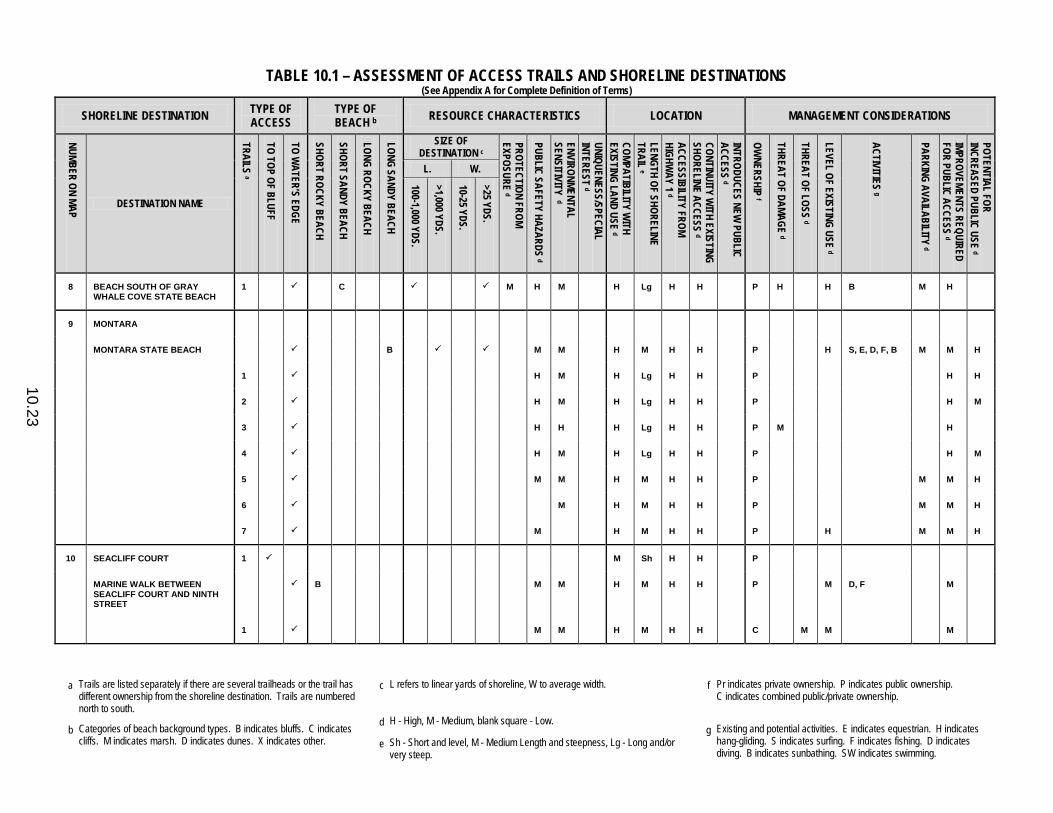
TABLE 10.1 – ASSESSMENT OF ACCESS TRAILS AND SHORELINE DESTINATIONS (See Appendix A for Complete Definition of Terms)
a Trails are listed separately if there are several trailheads or the trail has
different ownership from the shoreline destination. Trails are numbered north to south.
c L refers to linear yards of shoreline, W to average width. f Pr indicates private ownership. P indicates public ownership. C indicates combined public/private ownership.
b Categories of beach background types. B indicates bluffs. C indicates cliffs. M indicates marsh. D indicates dunes. X indicates other.
d H - High, M - Medium, blank square - Low. g Existing and potential activities. E indicates equestrian. H indicates
hang-gliding. S indicates surfing. F indicates fishing. D indicates diving. B indicates sunbathing. SW indicates swimming.
e Sh - Short and level, M - Medium Length and steepness, Lg - Long and/or very steep.
10.23
SHORELINE DESTINATION TYPE OF ACCESS
TYPE OF BEACH b RESOURCE CHARACTERISTICS LOCATION MANAGEMENT CONSIDERATIONS
NUMBER ON MAP
DESTINATION NAME
TRAILS a
TO TOP OF BLUFF
TO WATER’S EDGE
SHORT ROCKY BEACH
SHORT SANDY BEACH
LONG ROCKY BEACH
LONG SANDY BEACH
SIZE OF DESTINATION c
PROTECTION FROM EXPOSURE d
PUBLIC SAFETY HAZARDS d
ENVIRONMENTAL SENSITIVITY d
UNIQUENESS/SPECIAL INTEREST d
COMPATIBILITY WITH
EXISTING LAND USE d
LENGTH OF SHORELINE TRAIL e
ACCESSIBILITY FROM HIGHW
AY 1 d
CONTINUITY WITH EXISTING
SHORELINE ACCESS d
INTRODUCES NEW PUBLIC
ACCESS d
OWNERSHIP f
THREAT OF DAMAGE d
THREAT OF LOSS d
LEVEL OF EXISTING USE d
ACTIVITIES g
PARKING AVAILABILITY d
IMPROVEMENTS REQUIRED FOR PUBLIC ACCESS d
POTENTIAL FOR INCREASED PUBLIC USE d
L. W. 100-1,000 YDS.
>1,000 YDS.
10-25 YDS.
>25 YDS.
8 BEACH SOUTH OF GRAY WHALE COVE STATE BEACH
1 C M H M H Lg H H P H H B M H
9 MONTARA
MONTARA STATE BEACH B M M H M H H P H S, E, D, F, B M M H
1 H M H Lg H H P H H
2 H M H Lg H H P H M
3 H H H Lg H H P M H
4 H M H Lg H H P H M
5 M M H M H H P M M H
6 M H M H H P M M H
7 M H M H H P H M M H
10 SEACLIFF COURT 1 M Sh H H P
MARINE WALK BETWEEN SEACLIFF COURT AND NINTH STREET
B M M H M H H P M D, F M
1 M M H M H H C M M M
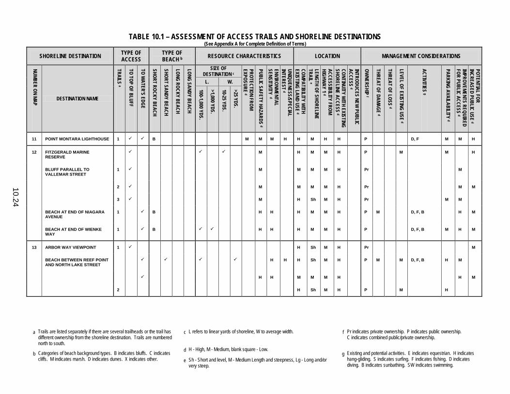
TABLE 10.1 – ASSESSMENT OF ACCESS TRAILS AND SHORELINE DESTINATIONS (See Appendix A for Complete Definition of Terms)
a Trails are listed separately if there are several trailheads or the trail has
different ownership from the shoreline destination. Trails are numbered north to south.
c L refers to linear yards of shoreline, W to average width. f Pr indicates private ownership. P indicates public ownership. C indicates combined public/private ownership.
b Categories of beach background types. B indicates bluffs. C indicates cliffs. M indicates marsh. D indicates dunes. X indicates other.
d H - High, M - Medium, blank square - Low. g Existing and potential activities. E indicates equestrian. H indicates
hang-gliding. S indicates surfing. F indicates fishing. D indicates diving. B indicates sunbathing. SW indicates swimming.
e Sh - Short and level, M - Medium Length and steepness, Lg - Long and/or very steep.
10.24
SHORELINE DESTINATION TYPE OF ACCESS
TYPE OF BEACH b RESOURCE CHARACTERISTICS LOCATION MANAGEMENT CONSIDERATIONS
NUMBER ON MAP
DESTINATION NAME
TRAILS a
TO TOP OF BLUFF
TO WATER’S EDGE
SHORT ROCKY BEACH
SHORT SANDY BEACH
LONG ROCKY BEACH
LONG SANDY BEACH
SIZE OF DESTINATION c
PROTECTION FROM EXPOSURE d
PUBLIC SAFETY HAZARDS d
ENVIRONMENTAL SENSITIVITY d
UNIQUENESS/SPECIAL INTEREST d
COMPATIBILITY WITH
EXISTING LAND USE d
LENGTH OF SHORELINE TRAIL e
ACCESSIBILITY FROM HIGHW
AY 1 d
CONTINUITY WITH EXISTING
SHORELINE ACCESS d
INTRODUCES NEW PUBLIC
ACCESS d
OWNERSHIP f
THREAT OF DAMAGE d
THREAT OF LOSS d
LEVEL OF EXISTING USE d
ACTIVITIES g
PARKING AVAILABILITY d
IMPROVEMENTS REQUIRED FOR PUBLIC ACCESS d
POTENTIAL FOR INCREASED PUBLIC USE d
L. W. 100-1,000 YDS.
>1,000 YDS.
10-25 YDS.
>25 YDS.
11 POINT MONTARA LIGHTHOUSE 1 B M M M H H M H H P D, F M M H
12 FITZGERALD MARINE RESERVE
M H M M H P M M H
BLUFF PARALLEL TO VALLEMAR STREET
1 M M M M H Pr M
2 M M M M H Pr M M
3 M H Sh M H Pr M M
BEACH AT END OF NIAGARA AVENUE
1 B H H H M M H P M D, F, B H M
BEACH AT END OF WIENKE WAY
1 B H H H M M H P D, F, B M H M
13 ARBOR WAY VIEWPOINT 1 H Sh M H Pr M
BEACH BETWEEN REEF POINT AND NORTH LAKE STREET
H H H Sh M H P M M D, F, B H M
H H M M M H H M
2 H Sh M H P M H
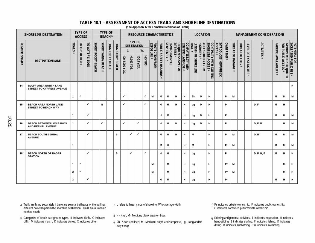
TABLE 10.1 – ASSESSMENT OF ACCESS TRAILS AND SHORELINE DESTINATIONS (See Appendix A for Complete Definition of Terms)
a Trails are listed separately if there are several trailheads or the trail has
different ownership from the shoreline destination. Trails are numbered north to south.
c L refers to linear yards of shoreline, W to average width. f Pr indicates private ownership. P indicates public ownership. C indicates combined public/private ownership.
b Categories of beach background types. B indicates bluffs. C indicates cliffs. M indicates marsh. D indicates dunes. X indicates other.
d H - High, M - Medium, blank square - Low. g Existing and potential activities. E indicates equestrian. H indicates
hang-gliding. S indicates surfing. F indicates fishing. D indicates diving. B indicates sunbathing. SW indicates swimming.
e Sh - Short and level, M - Medium Length and steepness, Lg - Long and/or very steep.
10.25
SHORELINE DESTINATION TYPE OF ACCESS
TYPE OF BEACH b RESOURCE CHARACTERISTICS LOCATION MANAGEMENT CONSIDERATIONS
NUMBER ON MAP
DESTINATION NAME
TRAILS a
TO TOP OF BLUFF
TO WATER’S EDGE
SHORT ROCKY BEACH
SHORT SANDY BEACH
LONG ROCKY BEACH
LONG SANDY BEACH
SIZE OF DESTINATION c
PROTECTION FROM EXPOSURE d
PUBLIC SAFETY HAZARDS d
ENVIRONMENTAL SENSITIVITY d
UNIQUENESS/SPECIAL INTEREST d
COMPATIBILITY WITH
EXISTING LAND USE d
LENGTH OF SHORELINE TRAIL e
ACCESSIBILITY FROM HIGHW
AY 1 d
CONTINUITY WITH EXISTING
SHORELINE ACCESS d
INTRODUCES NEW PUBLIC
ACCESS d
OWNERSHIP f
THREAT OF DAMAGE d
THREAT OF LOSS d
LEVEL OF EXISTING USE d
ACTIVITIES g
PARKING AVAILABILITY d
IMPROVEMENTS REQUIRED FOR PUBLIC ACCESS d
POTENTIAL FOR INCREASED PUBLIC USE d
L. W. 100-1,000 YDS.
>1,000 YDS.
10-25 YDS.
>25 YDS.
14 BLUFF AREA NORTH LAKE STREET TO CYPRESS AVENUE
H
1 M M M H H Sh M H Pr M M M M
15 BEACH AREA NORTH LAKE STREET TO BEACH WAY
B H H H H Lg M H P D, F M H
1 H M H Lg M H Pr M H M
16 BEACH BETWEEN LOS BANOS AND BERNAL AVENUE
1 C H H H H Lg M H P D, F, B H M
17 BEACH SOUTH BERNAL AVENUE
B M H H H M H P M D, B M M M
1 M H H M H Pr M M M M
18 BEACH NORTH OF RADAR STATION
B H H H Lg H P D, F, H, B M H H
1 M M H Lg H Pr M M H
2 M M H Lg H Pr M M H
3 H M H Lg H Pr M H H

TABLE 10.1 – ASSESSMENT OF ACCESS TRAILS AND SHORELINE DESTINATIONS (See Appendix A for Complete Definition of Terms)
a Trails are listed separately if there are several trailheads or the trail has
different ownership from the shoreline destination. Trails are numbered north to south.
c L refers to linear yards of shoreline, W to average width. f Pr indicates private ownership. P indicates public ownership. C indicates combined public/private ownership.
b Categories of beach background types. B indicates bluffs. C indicates cliffs. M indicates marsh. D indicates dunes. X indicates other.
d H - High, M - Medium, blank square - Low. g Existing and potential activities. E indicates equestrian. H indicates
hang-gliding. S indicates surfing. F indicates fishing. D indicates diving. B indicates sunbathing. SW indicates swimming.
e Sh - Short and level, M - Medium Length and steepness, Lg - Long and/or very steep.
10.26
SHORELINE DESTINATION TYPE OF ACCESS
TYPE OF BEACH b RESOURCE CHARACTERISTICS LOCATION MANAGEMENT CONSIDERATIONS
NUMBER ON MAP
DESTINATION NAME
TRAILS a
TO TOP OF BLUFF
TO WATER’S EDGE
SHORT ROCKY BEACH
SHORT SANDY BEACH
LONG ROCKY BEACH
LONG SANDY BEACH
SIZE OF DESTINATION c
PROTECTION FROM EXPOSURE d
PUBLIC SAFETY HAZARDS d
ENVIRONMENTAL SENSITIVITY d
UNIQUENESS/SPECIAL INTEREST d
COMPATIBILITY WITH
EXISTING LAND USE d
LENGTH OF SHORELINE TRAIL e
ACCESSIBILITY FROM HIGHW
AY 1 d
CONTINUITY WITH EXISTING
SHORELINE ACCESS d
INTRODUCES NEW PUBLIC
ACCESS d
OWNERSHIP f
THREAT OF DAMAGE d
THREAT OF LOSS d
LEVEL OF EXISTING USE d
ACTIVITIES g
PARKING AVAILABILITY d
IMPROVEMENTS REQUIRED FOR PUBLIC ACCESS d
POTENTIAL FOR INCREASED PUBLIC USE d
L. W. 100-1,000 YDS.
>1,000 YDS.
10-25 YDS.
>25 YDS.
19 PILLAR POINT HARBOR M H H H Sh H C M M D, F, B H H H
SOUTH AND EAST SIDE OF PILLAR POINT
1 H H Sh H C M H H H
20 BEACH BETWEEN WESTPOINT AND COLUMBIA AVENUES
H M H Sh M M Pr SW, B M M
1 H H Sh M M Pr M M
2 H M H Sh M M P M M M
3 H M H Sh M M P M M
4 H M H Sh M M P M M M M
21 BROADWAY ROAD BEACH B H M H Sh M M Pr M SW, B M
1 H M H Sh M M Pr M M
2 H M H Sh M M P M
22 DENNISTON CREEK BEACH B H H H H M M M Pr M M SW, B M H
23 JOHNSON PIER AND BEACH B H H Sh M H P H SW, B, F H M
24 BEACH NEAR 1740 CABRILLO HIGHWAY
C M Lg H H Pr B M H

TABLE 10.1 – ASSESSMENT OF ACCESS TRAILS AND SHORELINE DESTINATIONS (See Appendix A for Complete Definition of Terms)
a Trails are listed separately if there are several trailheads or the trail has
different ownership from the shoreline destination. Trails are numbered north to south.
c L refers to linear yards of shoreline, W to average width. f Pr indicates private ownership. P indicates public ownership. C indicates combined public/private ownership.
b Categories of beach background types. B indicates bluffs. C indicates cliffs. M indicates marsh. D indicates dunes. X indicates other.
d H - High, M - Medium, blank square - Low. g Existing and potential activities. E indicates equestrian. H indicates
hang-gliding. S indicates surfing. F indicates fishing. D indicates diving. B indicates sunbathing. SW indicates swimming.
e Sh - Short and level, M - Medium Length and steepness, Lg - Long and/or very steep.
10.27
SHORELINE DESTINATION TYPE OF ACCESS
TYPE OF BEACH b RESOURCE CHARACTERISTICS LOCATION MANAGEMENT CONSIDERATIONS
NUMBER ON MAP
DESTINATION NAME
TRAILS a
TO TOP OF BLUFF
TO WATER’S EDGE
SHORT ROCKY BEACH
SHORT SANDY BEACH
LONG ROCKY BEACH
LONG SANDY BEACH
SIZE OF DESTINATION c
PROTECTION FROM EXPOSURE d
PUBLIC SAFETY HAZARDS d
ENVIRONMENTAL SENSITIVITY d
UNIQUENESS/SPECIAL INTEREST d
COMPATIBILITY WITH
EXISTING LAND USE d
LENGTH OF SHORELINE TRAIL e
ACCESSIBILITY FROM HIGHW
AY 1 d
CONTINUITY WITH EXISTING
SHORELINE ACCESS d
INTRODUCES NEW PUBLIC
ACCESS d
OWNERSHIP f
THREAT OF DAMAGE d
THREAT OF LOSS d
LEVEL OF EXISTING USE d
ACTIVITIES g
PARKING AVAILABILITY d
IMPROVEMENTS REQUIRED FOR PUBLIC ACCESS d
POTENTIAL FOR INCREASED PUBLIC USE d
L. W. 100-1,000 YDS.
>1,000 YDS.
10-25 YDS.
>25 YDS.
25 PURISIMA CREEK BEACH B Lg H H Pr M H F, B H
26 COVE NORTH OF MARTIN’S BEACH
1 B M H M H Lg H Pr B H H
MARTIN’S BEACH 1 B M M H Sh M H Pr H B, F H M
27 TUNITAS CREEK BEACH 1 B M H M H Lg H H Pr B, F H H H
28 COVE SOUTH OF TUNITAS CREEK BEACH
1 B M H M H Lg H H Pr M B, F M H M
29 BEACH NORTH OF SAN GREGORIO STATE BEACH
B H M H M M H Pr M B, F H H H
1 H M H Lg H H Pr H
2 H H H Lg M H Pr M H H H
3 H M H M M H Pr M H H H
30 SAN GREGORIO STATE BEACH B M H H Sh H H P H H H, SW, B H H M
1 H M H M H H P M H H M M
2 M H H Sh H H P H H H H M
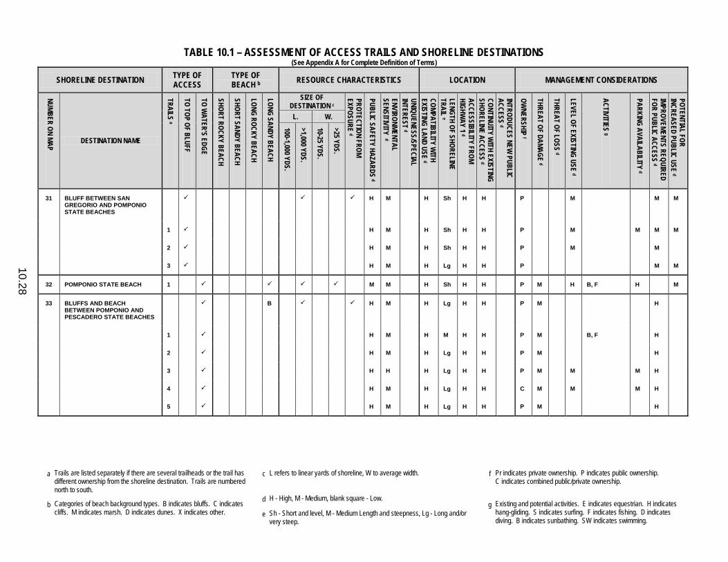
TABLE 10.1 – ASSESSMENT OF ACCESS TRAILS AND SHORELINE DESTINATIONS (See Appendix A for Complete Definition of Terms)
a Trails are listed separately if there are several trailheads or the trail has
different ownership from the shoreline destination. Trails are numbered north to south.
c L refers to linear yards of shoreline, W to average width. f Pr indicates private ownership. P indicates public ownership. C indicates combined public/private ownership.
b Categories of beach background types. B indicates bluffs. C indicates cliffs. M indicates marsh. D indicates dunes. X indicates other.
d H - High, M - Medium, blank square - Low. g Existing and potential activities. E indicates equestrian. H indicates
hang-gliding. S indicates surfing. F indicates fishing. D indicates diving. B indicates sunbathing. SW indicates swimming.
e Sh - Short and level, M - Medium Length and steepness, Lg - Long and/or very steep.
10.28
SHORELINE DESTINATION TYPE OF ACCESS
TYPE OF BEACH b RESOURCE CHARACTERISTICS LOCATION MANAGEMENT CONSIDERATIONS
NUMBER ON MAP
DESTINATION NAME
TRAILS a
TO TOP OF BLUFF
TO WATER’S EDGE
SHORT ROCKY BEACH
SHORT SANDY BEACH
LONG ROCKY BEACH
LONG SANDY BEACH
SIZE OF DESTINATION c
PROTECTION FROM EXPOSURE d
PUBLIC SAFETY HAZARDS d
ENVIRONMENTAL SENSITIVITY d
UNIQUENESS/SPECIAL INTEREST d
COMPATIBILITY WITH
EXISTING LAND USE d
LENGTH OF SHORELINE TRAIL e
ACCESSIBILITY FROM HIGHW
AY 1 d
CONTINUITY WITH EXISTING
SHORELINE ACCESS d
INTRODUCES NEW PUBLIC
ACCESS d
OWNERSHIP f
THREAT OF DAMAGE d
THREAT OF LOSS d
LEVEL OF EXISTING USE d
ACTIVITIES g
PARKING AVAILABILITY d
IMPROVEMENTS REQUIRED FOR PUBLIC ACCESS d
POTENTIAL FOR INCREASED PUBLIC USE d
L. W. 100-1,000 YDS.
>1,000 YDS.
10-25 YDS.
>25 YDS.
31 BLUFF BETWEEN SAN GREGORIO AND POMPONIO STATE BEACHES
H M H Sh H H P M M M
1 H M H Sh H H P M M M M
2 H M H Sh H H P M M
3 H M H Lg H H P M M
32 POMPONIO STATE BEACH 1 M M H Sh H H P M H B, F H M
33 BLUFFS AND BEACH BETWEEN POMPONIO AND PESCADERO STATE BEACHES
B H M H Lg H H P M H
1 H M H M H H P M B, F H
2 H M H Lg H H P M H
3 H H H Lg H H P M M M H
4 H M H Lg H H C M M M H
5 H M H Lg H H P M H

TABLE 10.1 – ASSESSMENT OF ACCESS TRAILS AND SHORELINE DESTINATIONS (See Appendix A for Complete Definition of Terms)
a Trails are listed separately if there are several trailheads or the trail has
different ownership from the shoreline destination. Trails are numbered north to south.
c L refers to linear yards of shoreline, W to average width. f Pr indicates private ownership. P indicates public ownership. C indicates combined public/private ownership.
b Categories of beach background types. B indicates bluffs. C indicates cliffs. M indicates marsh. D indicates dunes. X indicates other.
d H - High, M - Medium, blank square - Low. g Existing and potential activities. E indicates equestrian. H indicates
hang-gliding. S indicates surfing. F indicates fishing. D indicates diving. B indicates sunbathing. SW indicates swimming.
e Sh - Short and level, M - Medium Length and steepness, Lg - Long and/or very steep.
10.29
SHORELINE DESTINATION TYPE OF ACCESS
TYPE OF BEACH b RESOURCE CHARACTERISTICS LOCATION MANAGEMENT CONSIDERATIONS
NUMBER ON MAP
DESTINATION NAME
TRAILS a
TO TOP OF BLUFF
TO WATER’S EDGE
SHORT ROCKY BEACH
SHORT SANDY BEACH
LONG ROCKY BEACH
LONG SANDY BEACH
SIZE OF DESTINATION c
PROTECTION FROM EXPOSURE d
PUBLIC SAFETY HAZARDS d
ENVIRONMENTAL SENSITIVITY d
UNIQUENESS/SPECIAL INTEREST d
COMPATIBILITY WITH
EXISTING LAND USE d
LENGTH OF SHORELINE TRAIL e
ACCESSIBILITY FROM HIGHW
AY 1 d
CONTINUITY WITH EXISTING
SHORELINE ACCESS d
INTRODUCES NEW PUBLIC
ACCESS d
OWNERSHIP f
THREAT OF DAMAGE d
THREAT OF LOSS d
LEVEL OF EXISTING USE d
ACTIVITIES g
PARKING AVAILABILITY d
IMPROVEMENTS REQUIRED FOR PUBLIC ACCESS d
POTENTIAL FOR INCREASED PUBLIC USE d
L. W. 100-1,000 YDS.
>1,000 YDS.
10-25 YDS.
>25 YDS.
34 PESCADERO STATE BEACH BEACH NORTH OF PESCADERO CREEK BRIDGE
D H H Sh H H P M H B, F, SW M M H
1 H H Sh H H P M H H M H
2 H H Sh H H P M H M M H
35 COVES SOUTH OF PESCADERO CREEK BRIDGE
B M H H M H H P M H B, F M H
1 H H H M H H P M H H H
2 M H H M H H P M H H H
3 M H H M H H P M H M
36 BEACH SOUTH OF PESCADERO STATE BEACH
1 B M H H Sh H H Pr M M B, F H M
37 PEBBLE BEACH STATE PARK 1 B M H H Sh H H P M H B, F M M
38 BLUFF BETWEEN PEBBLE AND BEAN HOLLOW STATE BEACHES
1 B M H H M H H P M H B, F H M
39 BEAN HOLLOW STATE BEACH 1 B M M H H Sh H H P H B, F M
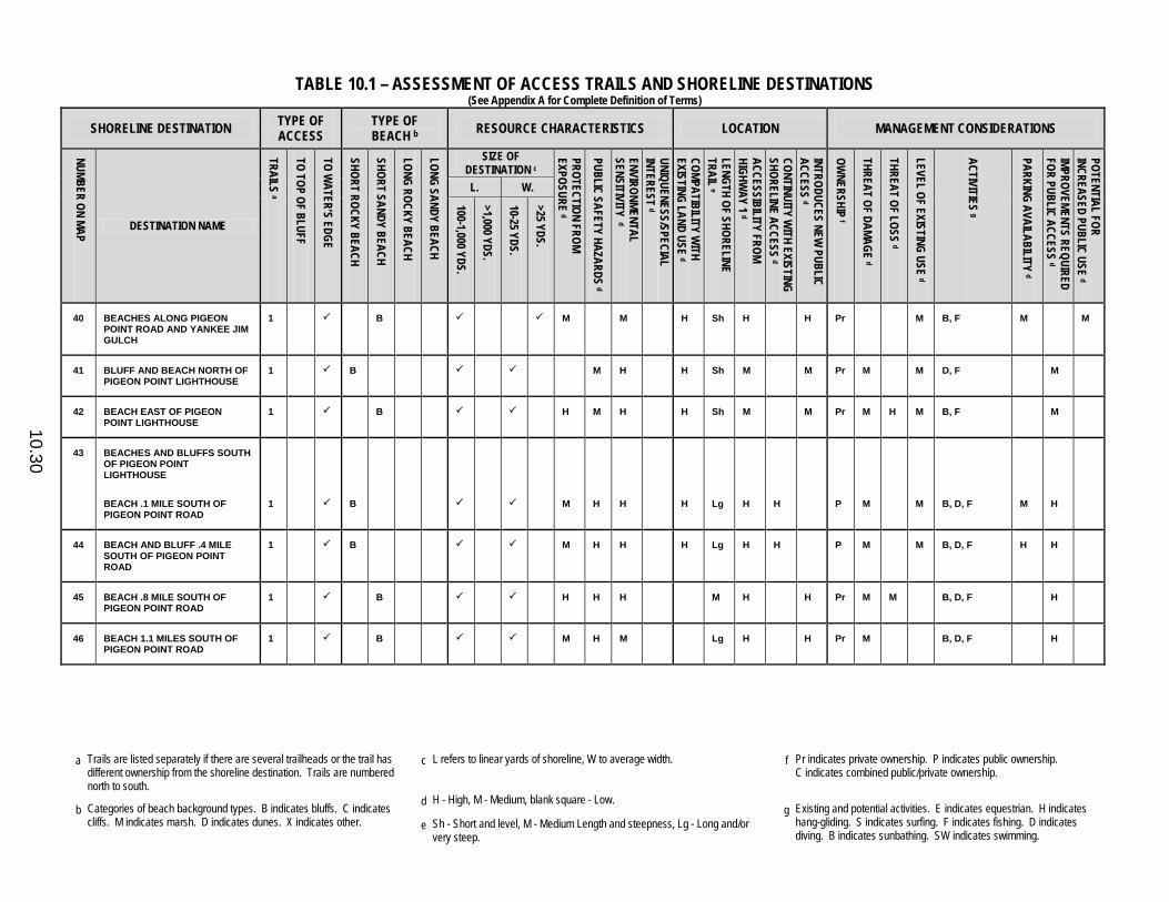
TABLE 10.1 – ASSESSMENT OF ACCESS TRAILS AND SHORELINE DESTINATIONS (See Appendix A for Complete Definition of Terms)
a Trails are listed separately if there are several trailheads or the trail has
different ownership from the shoreline destination. Trails are numbered north to south.
c L refers to linear yards of shoreline, W to average width. f Pr indicates private ownership. P indicates public ownership. C indicates combined public/private ownership.
b Categories of beach background types. B indicates bluffs. C indicates cliffs. M indicates marsh. D indicates dunes. X indicates other.
d H - High, M - Medium, blank square - Low. g Existing and potential activities. E indicates equestrian. H indicates
hang-gliding. S indicates surfing. F indicates fishing. D indicates diving. B indicates sunbathing. SW indicates swimming.
e Sh - Short and level, M - Medium Length and steepness, Lg - Long and/or very steep.
10.30
SHORELINE DESTINATION TYPE OF ACCESS
TYPE OF BEACH b RESOURCE CHARACTERISTICS LOCATION MANAGEMENT CONSIDERATIONS
NUMBER ON MAP
DESTINATION NAME
TRAILS a
TO TOP OF BLUFF
TO WATER’S EDGE
SHORT ROCKY BEACH
SHORT SANDY BEACH
LONG ROCKY BEACH
LONG SANDY BEACH
SIZE OF DESTINATION c
PROTECTION FROM EXPOSURE d
PUBLIC SAFETY HAZARDS d
ENVIRONMENTAL SENSITIVITY d
UNIQUENESS/SPECIAL INTEREST d
COMPATIBILITY WITH
EXISTING LAND USE d
LENGTH OF SHORELINE TRAIL e
ACCESSIBILITY FROM HIGHW
AY 1 d
CONTINUITY WITH EXISTING
SHORELINE ACCESS d
INTRODUCES NEW PUBLIC
ACCESS d
OWNERSHIP f
THREAT OF DAMAGE d
THREAT OF LOSS d
LEVEL OF EXISTING USE d
ACTIVITIES g
PARKING AVAILABILITY d
IMPROVEMENTS REQUIRED FOR PUBLIC ACCESS d
POTENTIAL FOR INCREASED PUBLIC USE d
L. W. 100-1,000 YDS.
>1,000 YDS.
10-25 YDS.
>25 YDS.
40 BEACHES ALONG PIGEON POINT ROAD AND YANKEE JIM GULCH
1 B M M H Sh H H Pr M B, F M M
41 BLUFF AND BEACH NORTH OF PIGEON POINT LIGHTHOUSE
1 B M H H Sh M M Pr M M D, F M
42 BEACH EAST OF PIGEON POINT LIGHTHOUSE
1 B H M H H Sh M M Pr M H M B, F M
43 BEACHES AND BLUFFS SOUTH OF PIGEON POINT LIGHTHOUSE
BEACH .1 MILE SOUTH OF PIGEON POINT ROAD
1 B M H H H Lg H H P M M B, D, F M H
44 BEACH AND BLUFF .4 MILE SOUTH OF PIGEON POINT ROAD
1 B M H H H Lg H H P M M B, D, F H H
45 BEACH .8 MILE SOUTH OF PIGEON POINT ROAD
1 B H H H M H H Pr M M B, D, F H
46 BEACH 1.1 MILES SOUTH OF PIGEON POINT ROAD
1 B M H M Lg H H Pr M B, D, F H

TABLE 10.1 – ASSESSMENT OF ACCESS TRAILS AND SHORELINE DESTINATIONS (See Appendix A for Complete Definition of Terms)
a Trails are listed separately if there are several trailheads or the trail has
different ownership from the shoreline destination. Trails are numbered north to south.
c L refers to linear yards of shoreline, W to average width. f Pr indicates private ownership. P indicates public ownership. C indicates combined public/private ownership.
b Categories of beach background types. B indicates bluffs. C indicates cliffs. M indicates marsh. D indicates dunes. X indicates other.
d H - High, M - Medium, blank square - Low. g Existing and potential activities. E indicates equestrian. H indicates
hang-gliding. S indicates surfing. F indicates fishing. D indicates diving. B indicates sunbathing. SW indicates swimming.
e Sh - Short and level, M - Medium Length and steepness, Lg - Long and/or very steep.
10.31
SHORELINE DESTINATION TYPE OF ACCESS
TYPE OF BEACH b RESOURCE CHARACTERISTICS LOCATION MANAGEMENT CONSIDERATIONS
NUMBER ON MAP
DESTINATION NAME
TRAILS a
TO TOP OF BLUFF
TO WATER’S EDGE
SHORT ROCKY BEACH
SHORT SANDY BEACH
LONG ROCKY BEACH
LONG SANDY BEACH
SIZE OF DESTINATION c
PROTECTION FROM EXPOSURE d
PUBLIC SAFETY HAZARDS d
ENVIRONMENTAL SENSITIVITY d
UNIQUENESS/SPECIAL INTEREST d
COMPATIBILITY WITH
EXISTING LAND USE d
LENGTH OF SHORELINE TRAIL e
ACCESSIBILITY FROM HIGHW
AY 1 d
CONTINUITY WITH EXISTING
SHORELINE ACCESS d
INTRODUCES NEW PUBLIC
ACCESS d
OWNERSHIP f
THREAT OF DAMAGE d
THREAT OF LOSS d
LEVEL OF EXISTING USE d
ACTIVITIES g
PARKING AVAILABILITY d
IMPROVEMENTS REQUIRED FOR PUBLIC ACCESS d
POTENTIAL FOR INCREASED PUBLIC USE d
L. W. 100-1,000 YDS.
>1,000 YDS.
10-25 YDS.
>25 YDS.
47 GAZOS CREEK COASTAL ACCESS
1 D H H Sh H H P M H B, D, F H M
BEACH BETWEEN GAZOS CREEK AND AÑO NUEVO STATE RESERVE
1 X H H H H Lg H H C H F M H H
48 AÑO NUEVO STATE RESERVE X M H H H M M H P M M B H
1 D M H H H Lg M H P M M H
2 B M H H H M M H P M M H
3 B M H H H H M M H P M M H H
4 B M H H H Sh M H P M M H
49 COASTWAYS RANCH B M H M H H Pr L B M H
1 M H M H H Pr L M H
2 M H Sh H H P M M H
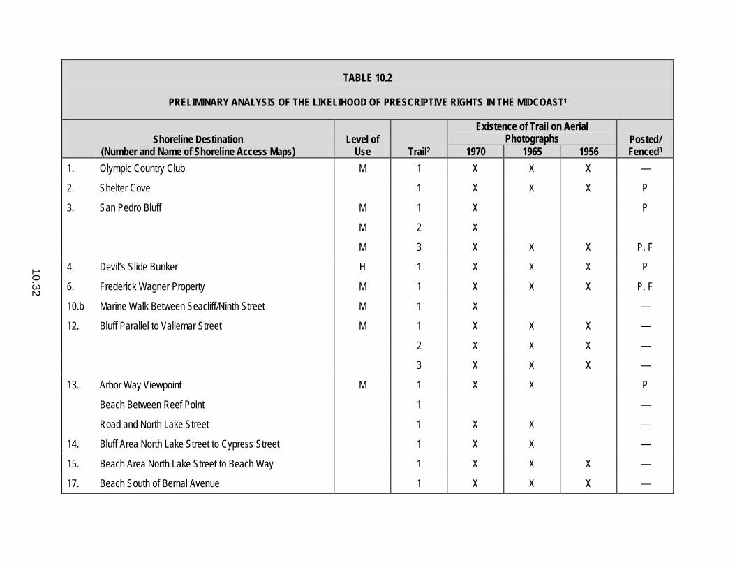
10.32
TABLE 10.2
PRELIMINARY ANALYSIS OF THE LIKELIHOOD OF PRESCRIPTIVE RIGHTS IN THE MIDCOAST1
Shoreline Destination (Number and Name of Shoreline Access Maps)
Level of Use Trail2
Existence of Trail on Aerial Photographs Posted/
Fenced3 1970 1965 1956 1. Olympic Country Club M 1 X X X —
2. Shelter Cove 1 X X X P
3. San Pedro Bluff M 1 X P
M 2 X
M 3 X X X P, F
4. Devil’s Slide Bunker H 1 X X X P
6. Frederick Wagner Property M 1 X X X P, F
10.b Marine Walk Between Seacliff/Ninth Street M 1 X —
12. Bluff Parallel to Vallemar Street M 1 X X X —
2 X X X —
3 X X X —
13. Arbor Way Viewpoint M 1 X X P
Beach Between Reef Point 1 —
Road and North Lake Street 1 X X —
14. Bluff Area North Lake Street to Cypress Street 1 X X —
15. Beach Area North Lake Street to Beach Way 1 X X X —
17. Beach South of Bernal Avenue 1 X X X —

10.33
TABLE 10.2 (continued)
PRELIMINARY ANALYSIS OF THE LIKELIHOOD OF PRESCRIPTIVE RIGHTS IN THE MIDCOAST1
Shoreline Destination (Number and Name of Shoreline Access Maps)
Level of Use Trail2
Existence of Trail on Aerial Photographs Posted/
Fenced3 1970 1965 1956 18. Beach North of Radar Station 1 X X —
2 X X —
3 X X X —
19. South and East Sides of Pillar Point M 1 X X X P
21. Broadway Road Beach 1 X P
22. Denniston Creek Beach 1 X —
24. Beach Near 1740 Cabrillo Highway 1 X X X P, F
25. Purisima Creek/Beach 1 P 1Trails already under public ownership not included. 2If there is only one trail to destination, “1” is indicated; if there are two or more trails, “1” then refers to the most northerly trail. 3Posted with No Trespassing Signs.

10.34
TABLE 10.3
PRELIMINARY LIKELIHOOD OF PRESCRIPTIVE RIGHTS IN THE SOUTH COAST1
Shoreline Destination (Number and Name of Shoreline Access Maps)
Level of Use Trail2
Existence of Trail on Aerial Photographs Posted/
Fenced3 1970 1965 1956 26. Cove North of Martin’s Beach H 1 X X X —
Martin’s Beach 1 X X X —
27. Tunitas Creek 1 X X X P
28. Cove South of Tunitas Creek 1 X P, F
29. Beach North of San Gregorio State Beach M 1 X X X P, F
2 X X —
33. Bluffs and Beach Between Pomponio and Pescadero State Beaches
M 4 X X X —
40. Yankee Jim Gulch M 1 X X X —
41. Bluff and Beach North of Pigeon Point Lighthouse M 1 X X X —
42. Beach East of Pigeon Point Lighthouse M 1 P, F
45. Beach .8 Mile South of Pigeon Point Road 1 X —
46. Beach 1.1 Miles South of Pigeon Point Road 1 X X X —
47. Beach Between Gazos Creek and Año Nuevo State Reserve
H 1 X X X —
49. Coastways Beach L 1 X X X — 1Trails already under public ownership not included. 2If there is only one trail to destination, “1” is indicated; if there are two or more trails, “1” then refers to the most northerly trail. 3Posted with No Trespassing Signs.

10.35
TABLE 10.5
PRIORITIES FOR THE EXPENDITURE OF PUBLIC FUNDS
Priority Ranking Category
First Phase Sites Within Each Category
Name
Number of Shoreline
Access Maps MIDCOAST First Improvement of Access to Shoreline
Destinations Where Both the Trail and the Destination Are on Publicly Owned Land
(1) Montara State Beach 9 (2) Gray Whale Cove State Beach 7 (3) Beach Between Reef Point Road
and North Lake Street 13
SOUTH COAST (4) San Gregorio State Beach 30 (5) Pescadero State Beach North of
Pescadero Creek Bridge 34
(6) Bluff Between Pebble and Beach Hollow State Beaches
39
MIDCOAST Second Acquisition and Improvement of
Privately Owned Trails to Publicly Owned Shoreline Destinations
(7) Trail from the Pillar Point Radar Station Road to the Fitzgerald Marine Reserve Beach North of Pillar Point
18
MIDCOAST Third Acquisition and Improvement of
Privately Owned Trails and Shoreline Destinations Which Are Adjacent to and Would Expand the Size of Existing Publicly Owned Shoreline Destinations
(8) South and East Sides of Pillar Point
19
(9) Bluff Area Between North Lake Street and Cypress Avenue
14
(10) Olympic Country Club 1
SOUTH COAST (11) Coastways Ranch 49

10.36
TABLE 10.5 (continued)
PRIORITIES FOR THE EXPENDITURE OF PUBLIC FUNDS
Priority Ranking Category
First Phase Sites Within Each Category
Name
Number of Shoreline
Access Maps MIDCOAST Fourth Acquisition and Improvement of
Privately Owned Trails and Shoreline Destinations Which Would Introduce Access Where Little or No Established Access Now Exists
(12) Beach Near 1740 Cabrillo Highway 24 (13) San Pedro Bluff 2
SOUTH COAST (14) Yankee Jim Gulch 40 (15) Tunitas Creek 27
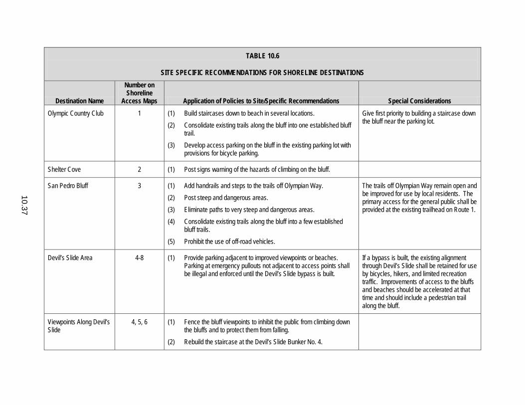
10.37
TABLE 10.6
SITE SPECIFIC RECOMMENDATIONS FOR SHORELINE DESTINATIONS
Destination Name
Number on Shoreline
Access Maps Application of Policies to Site/Specific Recommendations Special Considerations
Olympic Country Club 1 (1) Build staircases down to beach in several locations. (2) Consolidate existing trails along the bluff into one established bluff
trail. (3) Develop access parking on the bluff in the existing parking lot with
provisions for bicycle parking.
Give first priority to building a staircase down the bluff near the parking lot.
Shelter Cove 2 (1) Post signs warning of the hazards of climbing on the bluff.
San Pedro Bluff 3 (1) Add handrails and steps to the trails off Olympian Way. (2) Post steep and dangerous areas. (3) Eliminate paths to very steep and dangerous areas. (4) Consolidate existing trails along the bluff into a few established
bluff trails. (5) Prohibit the use of off-road vehicles.
The trails off Olympian Way remain open and be improved for use by local residents. The primary access for the general public shall be provided at the existing trailhead on Route 1.
Devil’s Slide Area 4-8 (1) Provide parking adjacent to improved viewpoints or beaches. Parking at emergency pullouts not adjacent to access points shall be illegal and enforced until the Devil’s Slide bypass is built.
If a bypass is built, the existing alignment through Devil’s Slide shall be retained for use by bicycles, hikers, and limited recreation traffic. Improvements of access to the bluffs and beaches should be accelerated at that time and should include a pedestrian trail along the bluff.
Viewpoints Along Devil’s Slide
4, 5, 6 (1) Fence the bluff viewpoints to inhibit the public from climbing down the bluffs and to protect them from falling.
(2) Rebuild the staircase at the Devil’s Slide Bunker No. 4.
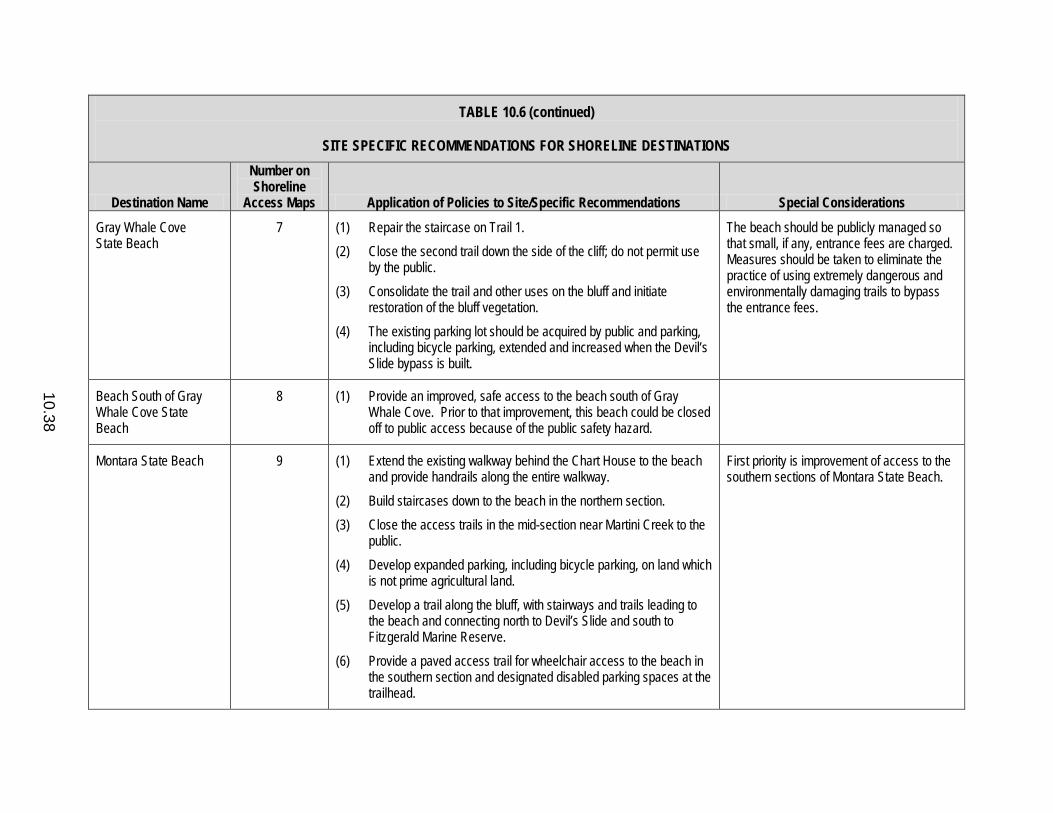
10.38
TABLE 10.6 (continued)
SITE SPECIFIC RECOMMENDATIONS FOR SHORELINE DESTINATIONS
Destination Name
Number on Shoreline
Access Maps Application of Policies to Site/Specific Recommendations Special Considerations
Gray Whale Cove State Beach
7 (1) Repair the staircase on Trail 1. (2) Close the second trail down the side of the cliff; do not permit use
by the public. (3) Consolidate the trail and other uses on the bluff and initiate
restoration of the bluff vegetation. (4) The existing parking lot should be acquired by public and parking,
including bicycle parking, extended and increased when the Devil’s Slide bypass is built.
The beach should be publicly managed so that small, if any, entrance fees are charged. Measures should be taken to eliminate the practice of using extremely dangerous and environmentally damaging trails to bypass the entrance fees.
Beach South of Gray Whale Cove State Beach
8 (1) Provide an improved, safe access to the beach south of Gray Whale Cove. Prior to that improvement, this beach could be closed off to public access because of the public safety hazard.
Montara State Beach 9 (1) Extend the existing walkway behind the Chart House to the beach and provide handrails along the entire walkway.
(2) Build staircases down to the beach in the northern section. (3) Close the access trails in the mid-section near Martini Creek to the
public. (4) Develop expanded parking, including bicycle parking, on land which
is not prime agricultural land. (5) Develop a trail along the bluff, with stairways and trails leading to
the beach and connecting north to Devil’s Slide and south to Fitzgerald Marine Reserve.
(6) Provide a paved access trail for wheelchair access to the beach in the southern section and designated disabled parking spaces at the trailhead.
First priority is improvement of access to the southern sections of Montara State Beach.
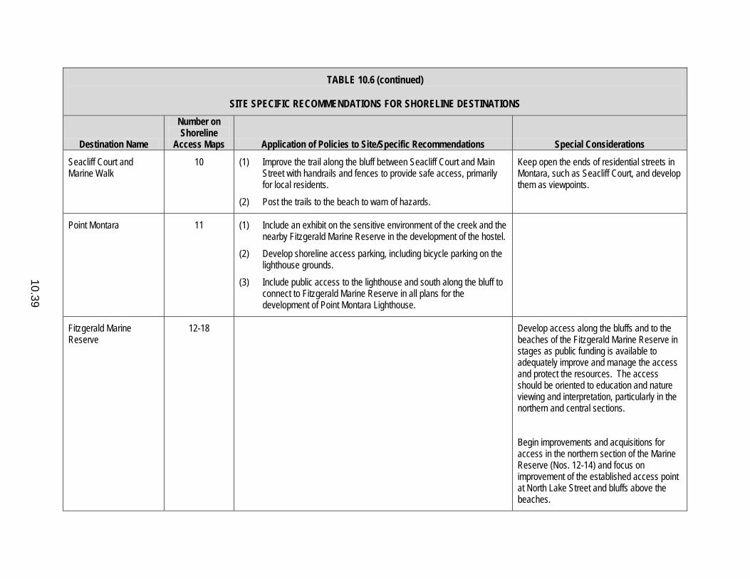
10.39
TABLE 10.6 (continued)
SITE SPECIFIC RECOMMENDATIONS FOR SHORELINE DESTINATIONS
Destination Name
Number on Shoreline
Access Maps Application of Policies to Site/Specific Recommendations Special Considerations
Seacliff Court and Marine Walk
10 (1) Improve the trail along the bluff between Seacliff Court and Main Street with handrails and fences to provide safe access, primarily for local residents.
(2) Post the trails to the beach to warn of hazards.
Keep open the ends of residential streets in Montara, such as Seacliff Court, and develop them as viewpoints.
Point Montara 11 (1) Include an exhibit on the sensitive environment of the creek and the nearby Fitzgerald Marine Reserve in the development of the hostel.
(2) Develop shoreline access parking, including bicycle parking on the lighthouse grounds.
(3) Include public access to the lighthouse and south along the bluff to connect to Fitzgerald Marine Reserve in all plans for the development of Point Montara Lighthouse.
Fitzgerald Marine Reserve
12-18 Develop access along the bluffs and to the beaches of the Fitzgerald Marine Reserve in stages as public funding is available to adequately improve and manage the access and protect the resources. The access should be oriented to education and nature viewing and interpretation, particularly in the northern and central sections. Begin improvements and acquisitions for access in the northern section of the Marine Reserve (Nos. 12-14) and focus on improvement of the established access point at North Lake Street and bluffs above the beaches.
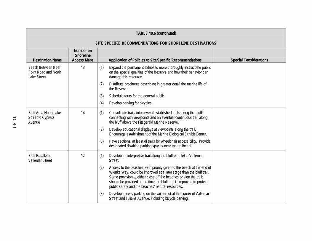
10.40
TABLE 10.6 (continued)
SITE SPECIFIC RECOMMENDATIONS FOR SHORELINE DESTINATIONS
Destination Name
Number on Shoreline
Access Maps Application of Policies to Site/Specific Recommendations Special Considerations
Beach Between Reef Point Road and North Lake Street
13 (1) Expand the permanent exhibit to more thoroughly instruct the public on the special qualities of the Reserve and how their behavior can damage this resource.
(2) Distribute brochures describing in greater detail the marine life of the Reserve.
(3) Schedule tours for the general public. (4) Develop parking for bicycles.
Bluff Area North Lake Street to Cypress Avenue
14 (1) Consolidate trails into several established trails along the bluff connecting with viewpoints and an eventual continuous trail along the bluff above the Fitzgerald Marine Reserve.
(2) Develop educational displays at viewpoints along the trail. Encourage establishment of the Marine Biological Exhibit Center.
(3) Pave sections, at least of trails for wheelchair accessibility. Provide designated disabled parking spaces near the trailhead.
Bluff Parallel to Vallemar Street
12 (1) Develop an interpretive trail along the bluff parallel to Vallemar Street.
(2) Access to the beaches, with priority given to the beach at the end of Wienke Way, could be improved at a later stage than the bluff trail. Some provision to either close off the beaches or sign the trails should be provided at the time the bluff trail is improved to protect public safety and the beaches’ natural resources.
(3) Develop access parking on the vacant lot at the corner of Vallemar Street and Juliana Avenue, including bicycle parking.
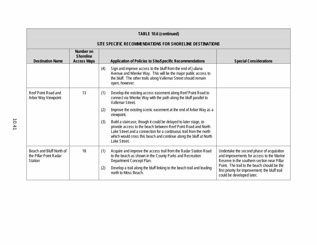
10.41
TABLE 10.6 (continued)
SITE SPECIFIC RECOMMENDATIONS FOR SHORELINE DESTINATIONS
Destination Name
Number on Shoreline
Access Maps Application of Policies to Site/Specific Recommendations Special Considerations
(4) Sign and improve access to the bluff from the end of Juliana Avenue and Wienke Way. This will be the major public access to the bluff. The other trails along Vallemar Street should remain open, however.
Reef Point Road and Arbor Way Viewpoint
13 (1) Develop the existing access easement along Reef Point Road to connect via Wienke Way with the path along the bluff parallel to Vallemar Street.
(2) Improve the existing scenic easement at the end of Arbor Way as a viewpoint.
(3) Build a staircase, though it could be delayed to later stage, to provide access to the beach between Reef Point Road and North Lake Street and a connection for a continuous trail from the north which would cross this beach and continue along the bluff at North Lake Street.
Beach and Bluff North of the Pillar Point Radar Station
18 (1) Acquire and improve the access trail from the Radar Station Road to the beach as shown in the County Parks and Recreation Department Concept Plan.
(2) Develop a trail along the bluff linking to the beach trail and leading north to Moss Beach.
Undertake the second phase of acquisition and improvements for access to the Marine Reserve in the southern section near Pillar Point. The trail to the beach should be the first priority for improvement; the bluff trail could be developed later.
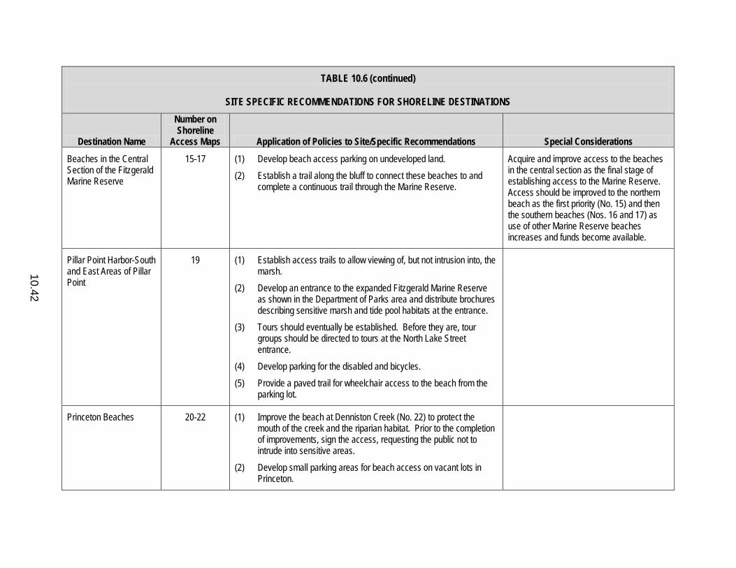
10.42
TABLE 10.6 (continued)
SITE SPECIFIC RECOMMENDATIONS FOR SHORELINE DESTINATIONS
Destination Name
Number on Shoreline
Access Maps Application of Policies to Site/Specific Recommendations Special Considerations
Beaches in the Central Section of the Fitzgerald Marine Reserve
15-17 (1) Develop beach access parking on undeveloped land. (2) Establish a trail along the bluff to connect these beaches to and
complete a continuous trail through the Marine Reserve.
Acquire and improve access to the beaches in the central section as the final stage of establishing access to the Marine Reserve. Access should be improved to the northern beach as the first priority (No. 15) and then the southern beaches (Nos. 16 and 17) as use of other Marine Reserve beaches increases and funds become available.
Pillar Point Harbor-South and East Areas of Pillar Point
19 (1) Establish access trails to allow viewing of, but not intrusion into, the marsh.
(2) Develop an entrance to the expanded Fitzgerald Marine Reserve as shown in the Department of Parks area and distribute brochures describing sensitive marsh and tide pool habitats at the entrance.
(3) Tours should eventually be established. Before they are, tour groups should be directed to tours at the North Lake Street entrance.
(4) Develop parking for the disabled and bicycles. (5) Provide a paved trail for wheelchair access to the beach from the
parking lot.
Princeton Beaches 20-22 (1) Improve the beach at Denniston Creek (No. 22) to protect the mouth of the creek and the riparian habitat. Prior to the completion of improvements, sign the access, requesting the public not to intrude into sensitive areas.
(2) Develop small parking areas for beach access on vacant lots in Princeton.
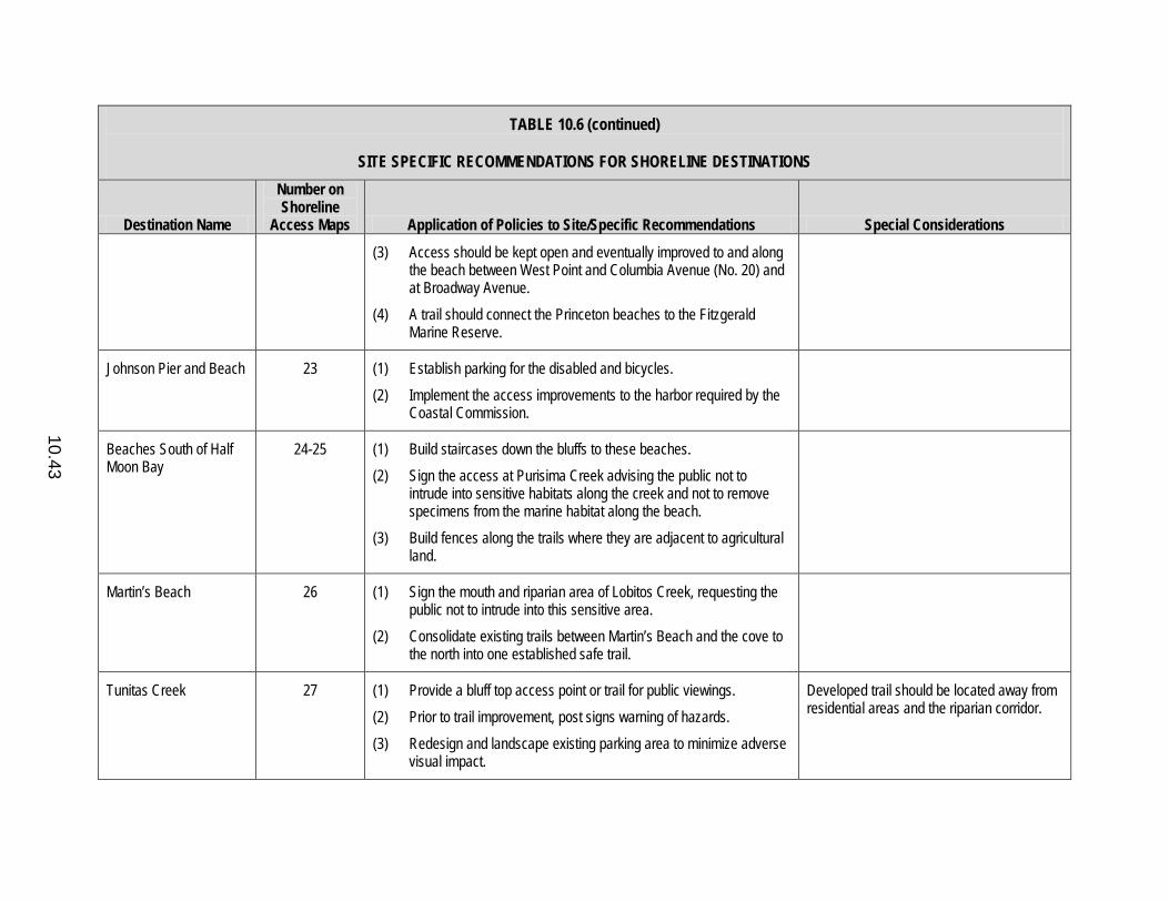
10.43
TABLE 10.6 (continued)
SITE SPECIFIC RECOMMENDATIONS FOR SHORELINE DESTINATIONS
Destination Name
Number on Shoreline
Access Maps Application of Policies to Site/Specific Recommendations Special Considerations
(3) Access should be kept open and eventually improved to and along the beach between West Point and Columbia Avenue (No. 20) and at Broadway Avenue.
(4) A trail should connect the Princeton beaches to the Fitzgerald Marine Reserve.
Johnson Pier and Beach 23 (1) Establish parking for the disabled and bicycles. (2) Implement the access improvements to the harbor required by the
Coastal Commission.
Beaches South of Half Moon Bay
24-25 (1) Build staircases down the bluffs to these beaches. (2) Sign the access at Purisima Creek advising the public not to
intrude into sensitive habitats along the creek and not to remove specimens from the marine habitat along the beach.
(3) Build fences along the trails where they are adjacent to agricultural land.
Martin’s Beach 26 (1) Sign the mouth and riparian area of Lobitos Creek, requesting the public not to intrude into this sensitive area.
(2) Consolidate existing trails between Martin’s Beach and the cove to the north into one established safe trail.
Tunitas Creek 27 (1) Provide a bluff top access point or trail for public viewings. (2) Prior to trail improvement, post signs warning of hazards. (3) Redesign and landscape existing parking area to minimize adverse
visual impact.
Developed trail should be located away from residential areas and the riparian corridor.

10.44
TABLE 10.6 (continued)
SITE SPECIFIC RECOMMENDATIONS FOR SHORELINE DESTINATIONS
Destination Name
Number on Shoreline
Access Maps Application of Policies to Site/Specific Recommendations Special Considerations
Cove South of Tunitas Creek Beach
28 (1) Build stairway to beach. Prior to that improvement, this beach could be closed off to public access because of the public safety hazard.
(2) Develop parking on the bluff in an area other than the existing emergency pullout.
Beach North of San Gregorio
29 (1) Improve trails to beach, constructing stairways where necessary. Give first priority to building a staircase down the bluff from the most southern parking lot.
San Gregorio State Beach
30 (1) Construct one or more defined beach access trails creating a ramp or stairway to minimize impact of public use on riparian area.
(2) Relandscape leveled bluff and slopes near parking lot to correct erosion problem.
(3) Regrade trail to bluff top viewpoint, using steps or switchbacks.
Bluff Between San Gregorio and Pomponio State Beaches
31 (1) Consolidate bluff paths into one well-marked trail. (2) Prohibit parking in hazardous pullout at Trails 2 and 3. (3) Establish a safe bluff trail connecting Trails 1, 2, and 3, and
Pomponio State Beach. (4) Improve parking area at Trail 1 and establish as a viewpoint.
Give priority to consolidation and improvement of bluff trails originating from the Pomponio State Beach parking area heading northward.
Pomponio State Beach 32 (1) Post signs at Pomponio Creek advising the public not to intrude into the riparian habitat.
(2) Provide a paved trail for wheelchair access to the beach from the parking lot.
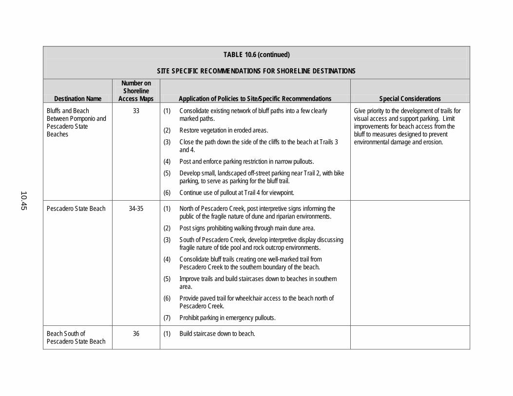
10.45
TABLE 10.6 (continued)
SITE SPECIFIC RECOMMENDATIONS FOR SHORELINE DESTINATIONS
Destination Name
Number on Shoreline
Access Maps Application of Policies to Site/Specific Recommendations Special Considerations
Bluffs and Beach Between Pomponio and Pescadero State Beaches
33 (1) Consolidate existing network of bluff paths into a few clearly marked paths.
(2) Restore vegetation in eroded areas. (3) Close the path down the side of the cliffs to the beach at Trails 3
and 4. (4) Post and enforce parking restriction in narrow pullouts. (5) Develop small, landscaped off-street parking near Trail 2, with bike
parking, to serve as parking for the bluff trail. (6) Continue use of pullout at Trail 4 for viewpoint.
Give priority to the development of trails for visual access and support parking. Limit improvements for beach access from the bluff to measures designed to prevent environmental damage and erosion.
Pescadero State Beach 34-35 (1) North of Pescadero Creek, post interpretive signs informing the public of the fragile nature of dune and riparian environments.
(2) Post signs prohibiting walking through main dune area. (3) South of Pescadero Creek, develop interpretive display discussing
fragile nature of tide pool and rock outcrop environments. (4) Consolidate bluff trails creating one well-marked trail from
Pescadero Creek to the southern boundary of the beach. (5) Improve trails and build staircases down to beaches in southern
area. (6) Provide paved trail for wheelchair access to the beach north of
Pescadero Creek. (7) Prohibit parking in emergency pullouts.
Beach South of Pescadero State Beach
36 (1) Build staircase down to beach.
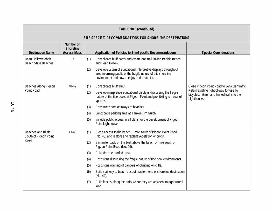
10.46
TABLE 10.6 (continued)
SITE SPECIFIC RECOMMENDATIONS FOR SHORELINE DESTINATIONS
Destination Name
Number on Shoreline
Access Maps Application of Policies to Site/Specific Recommendations Special Considerations
Bean Hollow/Pebble Beach State Beaches
37 (1) Consolidate bluff paths and create one trail linking Pebble Beach and Bean Hollow.
(2) Develop system of educational interpretive displays throughout area informing public of the fragile nature of this shoreline environment and how to enjoy and protect it.
Beaches Along Pigeon Point Road
40-42 (1) Consolidate bluff trails. (2) Develop interpretive educational displays discussing the fragile
nature of the tide pools at Pigeon Point and prohibiting removal of species.
(3) Construct short stairways to beaches. (4) Landscape parking area at Yankee Jim Gulch. (5) Include public access in all plans for the development of Pigeon
Point Lighthouse.
Close Pigeon Point Road to vehicular traffic. Retain existing right-of-way for use by bicycles, hikers, and limited traffic to the Lighthouse.
Beaches and Bluffs South of Pigeon Point Road
43-46 (1) Close access to the beach .1 mile south of Pigeon Point Road (No. 43) and restore and replant vegetation or crops.
(2) Eliminate roads on the bluff above the beach .4 mile south of Pigeon Point Road (No. 44).
(3) Relandscape eroded areas. (4) Post signs discussing the fragile nature of tide pool environments. (5) Post signs warning of dangers of climbing on cliffs. (6) Build stairway to beach at southeastern end of shoreline destination
(No. 44). (7) Build fences along the trails where they are adjacent to agricultural
land.
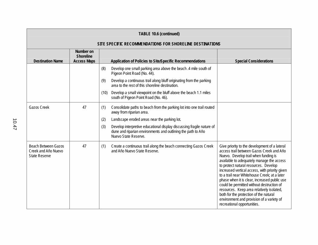
10.47
TABLE 10.6 (continued)
SITE SPECIFIC RECOMMENDATIONS FOR SHORELINE DESTINATIONS
Destination Name
Number on Shoreline
Access Maps Application of Policies to Site/Specific Recommendations Special Considerations
(8) Develop one small parking area above the beach .4 mile south of Pigeon Point Road (No. 44).
(9) Develop a continuous trail along bluff originating from the parking area to the rest of this shoreline destination.
(10) Develop a small viewpoint on the bluff above the beach 1.1 miles south of Pigeon Point Road (No. 46).
Gazos Creek 47 (1) Consolidate paths to beach from the parking lot into one trail routed away from riparian area.
(2) Landscape eroded areas near the parking lot. (3) Develop interpretive educational display discussing fragile nature of
dune and riparian environments and outlining the path to Año Nuevo State Reserve.
Beach Between Gazos Creek and Año Nuevo State Reserve
47 (1) Create a continuous trail along the beach connecting Gazos Creek and Año Nuevo State Reserve.
Give priority to the development of a lateral access trail between Gazos Creek and Año Nuevo. Develop trail when funding is available to adequately manage the access to protect natural resources. Develop increased vertical access, with priority given to a trail near Whitehouse Creek; at a later phase when it is clear, increased public use could be permitted without destruction of resources. Keep area relatively isolated, both for the protection of the natural environment and provision of a variety of recreational opportunities.

10.48
TABLE 10.6 (continued)
SITE SPECIFIC RECOMMENDATIONS FOR SHORELINE DESTINATIONS
Destination Name
Number on Shoreline
Access Maps Application of Policies to Site/Specific Recommendations Special Considerations
Año Nuevo State Reserve
48 (1) Consolidate trails to bluff. (2) Continue policy of limiting access during Elephant Seal breeding
periods. (3) Either close beach Trail 3 or improve it to prevent erosion and
protect public safety.
Coastways Beach 49 (1) If publicly acquired, reopen foot access to beach via the existing jeep trail (Trail 1).
CalTrans Overlook Above Coastways Beach
50 (1) Maintain pullout as a viewpoint.

10.49
APPENDIX 10.A
DEFINITIONS FOR SHORELINE ACCESS ASSESSMENT CRITERIA USED IN TABLE 10.1 TRAILS
Each trailhead from which a trail leads to a shoreline destination is included in this assessment. Shoreline destinations with only one trailhead are evaluated as a unit. However, trails are assessed separately if there are several trailheads for a shoreline destination or any trail has different ownership from the shoreline destination. Then, all trails are evaluated as a group to develop a composite assessment of trail charac-teristics for a shoreline destination and to ensure comparability with other shoreline destinations. TYPE OF ACCESS To Top of Bluff: Trails go to bluff top; there are no existing access trails leading to
water’s edge. To Water’s Edge: Existing trails lead to water’s edge. TYPE OF BEACH Short Rocky Beach - Beach is less than 1,000 yards long and predominately rocky. Short Sandy Beach - Beach is less than 1,000 yards long and predominately sandy. Long Rocky Beach - Beach is longer than 1,000 yards long and predominately
rocky. Long Sandy Beach - Beach is longer than 1,000 yards long and predominately
sandy. RESOURCE CHARACTERISTICS Size of Destination Length: Linear yards of oceanfront of beach or bluff. Width: Above the ordinary high-water line for beach, level area for bluff. Protection from Exposure - Level of protection from the open sea, and winter northwest wind and water action.
10.50
Public Safety Hazards High: Hazardous, with some risk of bodily harm. Medium: Accessible with difficulty, but without risk of bodily harm. Low: Level and unobstructed, easily accessible to elderly and others for whom
walking may be difficult. Environmental Sensitivity - Level of environmental sensitivity of the area to which access is permitted. High: Area indicated on the maps of environmentally sensitive habitat areas. Medium: Bluffs, steep slopes. Low: Beach and other habitats not sensitive to human intrusion. Uniqueness/Special Interest - Historic, paleontological, natural, geological - must be outstanding and unusual along the San Mateo Coast to be rated High. LOCATION Compatibility with Existing Land Use - Does not conflict with existing land use. a. Residential High: Substantial separation by distance, grade separation or landscaping. Low: Allows less than 5 feet separation between existing houses and vertical
access, and 10 yards separation between houses and lateral access. b. Agriculture High: Fences separate access from agricultural land. Low: Passes through unfenced agricultural land. Length of Shoreline Trail Short: Less than 250 feet across and 10 feet down to shoreline destination. Medium: Between 250 feet and 1/4 mile across and 10 and 15 feet down to shoreline
destination. Long: More than 1/4 mile across and 50 feet down to shoreline destination.
10.51
Accessibility from Highway 1 High: Shoreline trail is immediately accessible from Highway 1. Medium: Shoreline trail is less than 1/2 mile from Highway 1. Low: Shoreline trail is greater than 1/2 mile from Highway 1. Continuity with Existing Shoreline Access High: Shoreline access trail and/or shoreline destination provides for the following: a. Linkage between existing public shoreline destinations. b. Expansion of the size of existing public shoreline destinations. c. Expansion of access to an existing public shoreline destination. Low: Does not fulfill one of the above functions. Introduces New Public Access High: No existing established public shoreline access trail or destination nearby,
within 1/4 mile in both directions. Medium: Little existing established public shoreline access trail or destination nearby,
within 1/4 mile but not adjacent, in one direction only. Low: Adjacent to or included within an established public shoreline access. Ownership - Public indicates an area is owned in fee by a public agency. Threat of Damage - Evaluates threat of deterioration of the natural environment, continuation of existing public or private use. Threat of Loss - Evaluates the possibility of property owner closing off the access and the likelihood of establishing prescriptive rights based on Table 2. High: Indicates no evidence on historic aerials. Medium: Indicates no evidence on aerials prior to 1970. Parking Availability High: Areas where existing official off-street parking for more than 75 cars exists,
or adequate space to provide such parking exists within 1/4 mile.
10.52
Medium: Areas where official off-street parking for between 15 and 75 cars exists or could be provided.
Low: Parking for 15 cars or less. Level of Use High: Many people using trail and shoreline destination on weekdays and
evidence of heavy use (more than 200 people at shoreline destination). Medium: Some people using trail or shoreline destination on weekdays and evidence
of moderate public use (50-200 people at shoreline destination). Low: No people on trail or shoreline destination on weekdays and little evidence
of public use (less than 50 at shoreline destination). Activities - Letter indicates activities which are already ongoing at the site or for which the site has potential established by practitioners of the sport. Improvements Required for Public Access - Level of improvement required to provide safe public access and protect natural resources and adjacent uses. High: Establishing trails in hazardous or environmentally sensitive areas and
staircases in very steep or fragile areas. Medium: Moderate improvements - improved surfacing, establishing trails in level
areas and simple staircases. Low: Repair of existing improvements, signing. Potential for Increased Public Use - Areas are rated high if they could support a substantial increase in public use after improvements.
11.1
RECREATION/VISITOR-SERVING FACILITIES COMPONENT DEFINITIONS 11.1 Definition of Visitor-Serving Facilities Define visitor-serving facilities as public and private developments that are
exclusively available to the general public and provide necessary, basic visitor support services such as lodging, food, water, restroom and automobile services. Visitor-serving facilities include, but are not limited to, hotels, motels, hostels, campgrounds, group camps, grocery stores, food concessionaires, auto serving stations, public drinking water, restrooms, public parking for coastal recreation or access, restaurants, and country inns no more than two stories in height.
11.2 Definition of Commercial Recreation Facilities Define commercial recreation facilities as developments serving primarily a
recreation function which are operated by private business for profit and are exclusively available to the general public. Commercial recreation facilities include, but are not limited to, beaches, stables, golf courses, specialty stores and sporting equipment sales and rentals.
11.3 Definition of Public Recreation Facilities Define public recreation facilities as lands and facilities serving primarily a
recreation function which are operated by public agencies or other non-profit organizations. Public recreation facilities include, but are not limited to, public beaches, parks, recreation areas, natural preserves, wild areas and trails.
PERMITTED USES AND LOCATIONS 11.4 Recreation and Visitor-Serving Facilities Permitted in the Coastal Zone Permit the following facilities in the Coastal Zone: (1) necessary visitor-serving
facilities as defined in Policy 11.1, and (2) commercial recreation and public recreation facilities which (a) are designed to enhance public opportunities for coastal recreation, (b) do not substantially alter the natural environment, and (c) do not subvert the unique small town, rural character of the individual communities on the Coastside.
11.5 Priority to Visitor-Serving and Commercial Recreation Facilities Give priority to visitor-serving and commercial recreation facilities on desig-
nated Midcoast lands and throughout the South Coast over private residential,
11.2
general industrial or general commercial development but not over agriculture or coastal-dependent industry.
11.6 Concentrated Development in the Midcoast Concentrate new public recreation, visitor-serving and commercial recreation in
the Midcoast, rather than the South Coast, through the following means: a. Give priority to the Midcoast for the expenditure of County funds for the
development of public recreation facilities. b. Encourage the State Department of Parks and Recreation to give priority
to the Midcoast (Gray Whale Cove, Montara, and Half Moon Bay State Beaches) for the expenditure of State funds for the development of public recreation facilities. Require new development of recreation facilities in the South Coast to be phased in accordance with a long-range develop-ment program that gives priority to development of Midcoast facilities.
c. Designate areas in the Midcoast as Coastside Commercial Recreation for
the development of commercial recreation and commercial visitor-serving facilities.
11.7 Urban Areas a. Permit visitor-serving and commercial recreation facilities to locate within
enclosed buildings in areas designated as Coastside Commercial Recreation and Neighborhood Commercial.
b. Designate areas as Coastside Commercial Recreation on the Land Use
Map which are: (1) near or along the shoreline, (2) already developed with visitor-oriented commercial facilities, and (3) separated from neigh-borhood-oriented commercial areas, or (4) subdivided land in Princeton west of Denniston Creek if (a) additional land area is needed to support coastal-dependent, commercial fishing and recreational boating activities, (b) permitted development is directly supportive of these activities (those projects which provide lower cost restaurants, overnight accommodations and other required services are preferred), and (c) a deed restriction which provides notice that adjacent marine-related industrial uses have priority in this area and that new CCR uses may be subject to inconvenience arising from the reasonable execution of such activities is obtained as part of the permit process.
c. Permit uses in Coastside Commercial Recreation areas which (1) serve
primarily visitors or boating and fishing, (2) contribute to the creation of a coastally related commercial area or would uniquely enhance coastal recreation at that location, and (3) are pedestrian- or boat-oriented. Such
11.3
facilities include: restaurants, public restrooms, hotels, motels, sporting goods sales and rentals, specialty shops, ship chandleries, fish processing and buying, harbor administration, and marine supply stores.
d. Apply Coastside Commercial District Zoning Regulations in such
designated areas. e. Permit public recreation facilities in urban areas. 11.8 Rural Areas a. Permit visitor-serving and commercial recreation facilities to locate within
enclosed buildings in areas designated as Neighborhood Commercial in rural service centers, provided that this development fits the character and scale of the surrounding community.
b. Permit visitor-serving, commercial recreation and public recreation
facilities to locate outside of rural service centers which: (1) require or benefit from a location surrounded by open land or provide needed visitor services in an isolated area of attraction and (2) do not require new structures which obstruct or detract from existing views. Such facilities include, but are not limited to, country inns, stables, campgrounds, riding academies, private beaches, picnic grounds, food/emergency gasoline/ telephone services, hotels and hunting and fishing facilities or clubs.
11.9 Oceanfront Land in Urban and Rural Areas a. Protect suitable oceanfront land for public recreation, visitor-serving and
commercial recreation facilities. Consider sites suitable when they are: (1) not on prime agricultural land or other lands suitable for agriculture unless they are in compliance with the conversion policies of the Agricul-ture Component, (2) not required for coastal-dependent industry, and (3) large enough to accommodate safety improvements and public use as defined in the Shoreline Access Component.
b. Permit facilities which require or are enhanced by an oceanfront site to
locate adjacent to the shoreline. Require that facilities: (1) comply with Sensitive Habitats Component Policies, (2) not substantially alter the natural environment through the removal of vegetation or alteration of the natural topography, (3) not require structures which obstruct or detract from existing ocean views in rural areas, and (4) minimize impacts on ocean views in urban areas.
c. Prohibit the following from locating adjacent to the shoreline: (1) view
obstructing recreation and visitor-serving structures which are not significantly enhanced by an oceanfront site, such as tennis courts, auto
11.4
service stations, specialty shops, and (2) recreation and visitor-serving facilities which require substantial removal of vegetation or alteration of the natural topography, such as golf courses.
11.10 Upland Locations in Urban and Rural Areas Permit uses which are consistent with Policy 11.4, but do not meet the criteria
for location on oceanfront land to locate in upland areas. Encourage them to connect to the shoreline by bicycle path or trail.
11.11 Agricultural Areas a. Permit the location of public recreation, visitor-serving, and commercial
recreation facilities on prime agricultural land and other lands suitable for agriculture when in compliance with the conversion policies of the Agriculture Component.
b. When conversion policies have been met, encourage visitor-serving and
commercial recreation facilities which would permanently subsidize agriculture.
c. Permit low-intensity facilities to locate adjacent to agricultural operations
or undeveloped agricultural land which are: (1) separated from agricul-tural operations by distance or barriers, such as fences, consistent with Policies 5.8, 5.10, 5.15, and 5.22 and (2) only require structures, like stables, which are visually compatible within agricultural areas.
11.12 Sensitive Habitats a. Permit recreation and visitor-serving facilities to locate on lands adjacent
to sensitive habitats only when (1) there is adequate distance or separa-tion by barriers such as fences, (2) the habitat is not threatened, and (3) there would not be substantial impacts on habitat, topography, and water resources.
b. Permit recreation or visitor-serving facilities to locate adjacent to sensitive
habitats only when development standards and management practices are adequate to protect the resources, consistent with Policy 11.18 and the Sensitive Habitats Component.
c. Discourage the expansion of public recreation into locations within or
adjacent to sensitive habitats until the level of improvement and management of existing public recreation areas within or adjacent to sensitive habitats are consistent with the Sensitive Habitats Component.
11.5
11.13 Trails a. The 2001 County Trails Plan establishes a trails program for the Coastal
Zone with the objective of: (1) connecting major shoreline areas and trails to inland park and recreation facilities and trails, and (2) linking existing and proposed recreation facilities along the coast. Policies 3.0-3.2 (County Trail Policies) and Policies 4.0-4.3 (County Trails Design and Management Guidelines) of the 2001 County Trails Plan are hereby incorporated into the LCP.
b. Designate the following as Local Coastal Program (LCP) trails: (1) Countywide: California Coastal Trail, connecting Thorton Beach to Año Nuevo
State Reserve. (2) Regional trails (portions located within the Coastal Zone): (a) Montara Mountain Trail connecting Montara State Beach and
San Pedro Park near the McNee Ranch, with connections to Gray Whale Cove State Beach.
(b) Pilarcitos, Scarper View, Midcoast Foothill, and Old San Pedro
Road Trails, as shown in the County Trails Plan. When the County Trails Plan is amended, the Scarper View
Trail could be more precisely described as located on Mirada Surf West, Mirada Surf East, Quarry Park, and other publicly-owned properties.
(c) Half Moon Bay to Huddart Park Trail connecting Half Moon Bay
State Beach near Higgins Road to Huddart County Park. (d) Purisima Creek to Huddart County Park Trail connecting from
Route 1 near Purisima Creek to Huddart County Park. (e) Martin’s Beach to Huddart County Park Trail connecting from
Martin’s Beach via the Lobitos Creek cut-off and Tunitas Creek Road to Huddart County Park.
(f) San Gregorio State Beach to Town of Pescadero Trail
connecting San Gregorio State Beach to the communities of San Gregorio and Pescadero via La Honda Road and Stage Road.
11.6
(g) Gazos Creek Coastal Access to Butano State Park Trail connecting Gazos Creek Coastal Access to Butano State Park via Gazos Creek Access Road.
(h) Midcoast Foothills Trail connecting the south boundary of
McNee Ranch State Park with Highway 92 in Half Moon Bay. (3) Trails, located within the coastal zone, offered by property owners for
public use. (4) All future trails located in the coastal zone shall be considered a
Local Coastal Program trail. DEVELOPMENT STANDARDS FOR RECREATION AND VISITOR-SERVING FACILITIES 11.14 Public Recreation Facilities a. Use the locational and development standards included throughout this
component, the Agriculture Component and the applicable standards and planning and management guidelines of the County’s Parks and Recreation Element (contained in Appendix 11.A) as the development and management standards for public recreation facilities, including trails. LCP policies must predominate if there are conflicts. Seek any modifica-tions in the classification of State Park Units which will conform their purposes and uses more closely to the policies of the LCP.
b. Use development standards of this component, the County’s Parks and
Recreation Element standards and the criteria for trail development management contained in Appendix 11.A when constructing trails. When the route of a bike path in the County’s Bikeways Plan corresponds to the route of a trail included in the LCP trail program, construct the trail to accommodate both bicycle and pedestrian use, wherever possible.
c. Permit the following recreation facilities on lands designated low-intensity
public recreation: trails, interpretive facilities, family picnicking, parking not exceeding one auto space per 100 linear feet of beach or 50 acres of upland recreation, primitive camping, and one contact station per park unit.
d. Permit the following recreational facilities on lands designated
medium-intensity public recreation: all low-intensity facilities, plus permanent restrooms, other forms of camping, group picnicking and parking not exceeding one auto space per 25 linear feet of beach or 10 acres of upland recreation.

11.7
e. Permit the following recreational facilities on lands designated high-intensity public recreation: all low- and medium-intensity facilities, plus permanent concessions, lodging in enclosed buildings, and additional parking to accommodate permitted uses.
f. Permit the following additional recreational facilities on lands designated
community park: meeting rooms, sports facilities. 11.15 Private Recreation and Visitor-Serving Facilities a. Require that private recreation and visitor-serving facilities conform to:
(1) the development and locational standards included throughout this component and as referred in other components, and (2) the design standards of the Visual Resources Component.
b. Require that private recreation and visitor-serving facilities conform to the
intensities of use appropriate to the rural or urban setting and to the requirements of the individual site. In rural areas, visitor-serving uses shall require density credits based on daily water use in accordance with the requirements set forth in Local Coastal Program Policy *1.8.
c. Any Coastal Development Permit for a visitor-serving or commercial
recreation use shall include a condition of approval that requires the owner of the land to execute and record a deed restriction over the entire parcel or parcels. The Coastal Development Permit shall not be in effect until the deed restriction is recorded by the owner of the land, and shall specify that:
(1) The development is a visitor-serving use exclusively available to the
general public and that visitor length of stays are limited to no more than 29 consecutive days, and no more than 90 days per year. The deed restriction shall be recorded with the County Recorder to run with the land free and clear of all prior liens and encumbrances.
(2) Conversion of any portion of the visitor-serving or commercial
recreation facilities from development allowed under subparagraph (1) above, to a non-public, private, or member-only use, or the implementation of any program to allow extended or exclusive use or occupancy of such facilities by an individual or limited group or segment of the public, shall require an amendment to the applicable permit, and shall require a reduction in project density to the amount prescribed by LCP Policy *1.8 for uses which are not visitor serving.
11.8
11.16 Posting a. Require, as a condition of recreational or highway development in the
vicinity, the placement of signs on major roads near major public and commercial recreation areas to inform visitors of available services, recreation facilities and distances to the next service or facility.
b. Design these signs to be similar in style and materials to the signs for
shoreline access. 11.17 Parking Use the parking standards contained in the Shoreline Access Component
(Policy 10.22) and Chapter 3 of the Zoning Ordinance. 11.18 Sensitive Habitats a. Conduct studies by a qualified person agreed by the County and the
applicant during the planning and design phases of facilities located within or near sensitive habitats and archaeological/paleontological resources to determine the least disruptive locations for improvements and the methods of construction.
These studies should consider the appropriate intensity of use, improve-
ments and management to protect the resources and reduce or mitigate impacts.
b. Provide improvements and management adequate to protect sensitive
habitats. These may include, but are not limited to, the following: (1) informative displays, brochures, and signs to minimize public intrusion and impact, (2) organized tours of sensitive areas, (3) landscaped buffers or fences, and (4) staff to maintain improvements and manage the use of sensitive habitats.
c. Provide setbacks from bluff edges adequate to protect the public, based
on local geology and erosion rates and consistent with the Hazards Component.
11.19 Agriculture Separate visitor-serving and recreation facilities from agricultural lands with
improvements such as landscaping and/or fences to keep vehicles, horses and visitors off agricultural land. These improvements shall be installed and maintained at the expense of the applicant.

11.9
11.20 Utilities a. Require that sites for permitted recreation or visitor-serving facilities have
or develop access to a public road in conformance with the policies of the Sensitive Habitats, Scenic Resources, and Hazards Components.
b. Encourage sites for recreation or visitor-serving facilities to develop public
restrooms, drinking water and telephones. c. Require recreation and visitor-serving facilities to connect to public or
community water and sewer systems wherever those exist. 11.21 Shoreline Access Require that any development along the shoreline provide access in
accordance with the policies of the Shoreline Access Component. ROLE OF THE PUBLIC AND PRIVATE SECTORS IN ACQUIRING, DEVELOPING AND MAINTAINING RECREATION AND VISITOR-SERVING FACILITIES 11.22 Encourage Facility Development by the Private Sector a. Encourage development by the private sector of visitor-serving and
commercial recreation facilities on private land which support and supplement public recreational use of public lands.
b. Consider commercial recreation facilities such as hotels, motels,
restaurants, stables, specialty stores, sporting goods sales and rentals and RV campgrounds to be suitable for private development in the Coastal Zone.
c. Prohibit overnight RV parking along roads or in the parking lots of County
recreation facilities in order to lessen the negative impacts of existing, informal RV camping.
d. Encourage the State Department of Parks and Recreation to prohibit
overnight RV parking in the parking lots of State recreation facilities. 11.23 Low Cost Facilities a. Provide low cost or no cost visitor-serving and public recreation facilities in
public facilities. b. Encourage low cost facilities in privately developed visitor-serving
facilities, particularly hotels and motels.

11.10
c. Define low cost facilities as those which are open to the general public and are provided at rates attractive to and affordable to low-income people.
11.24 Priorities for the Expenditure of Public Funds a. Establish the following priorities for the expenditure of public funds on
public recreation and visitor-serving facilities, based on the level of existing development and need:
(1) Improve and maintain existing public recreation areas in the
Midcoast. (2) Develop and maintain necessary visitor-serving facilities such as rest
areas, public restrooms, drinking water, campgrounds, within existing public recreation areas.
(3) Expand recreational opportunities through the provision of trails and
youth hostels. (4) Acquire and develop for recreational use lands which are adjacent to
and would expand the size of existing publicly-owned recreation areas.
(5) Acquire and develop for recreational use lands which would
introduce a public recreation area into a section of the Coastal Zone where no public recreation areas now exist.
(6) Acquire and develop lands designated as community parks. b. Use the following priorities when expending County funds for trails: (1) Implement the California Coastal Trail Plan identified in LCP Policy
10.38 and as included in Regional Transportation Plans as identified in Policy 11.32.
(2) Implement the Regional Local Coastal Program trails identified in
LCP Policy 11.13. c. Regularly reassess these priorities as new public recreation and visitor-
serving facilities development takes place in the Coastal Zone. d. Encourage low cost facilities in privately developed visitor-serving
facilities, particularly hotels and motels.
11.11
ROLE OF SAN MATEO COUNTY 11.25 Requirement that State Parks Development Conform to the Local Coastal
Program a. Require that the State Department of Parks and Recreation, as part of any
application for a Coastal Development Permit, and in addition to any other submittals required, submit a long-range plan for any park unit proposed for improvement which includes: (1) the development plan, including the location of all proposed structures, parking areas, trails, recreation facilities and any proposed alterations of the natural environment; (2) a map of sensitive habitats and lands which are needed for the protection and vital functioning of sensitive habitats; (3) evidence of how agriculture has been considered in the planning of each park unit by (a) demon-strating how the Department will continue or renew the maximum amount of prime agricultural land and other lands suitable for agriculture in agricultural production within each park unit and (b) providing site specific justifications, which are consistent with the criteria for conversion in the Agriculture Component, for converting prime agricultural land or other lands suitable for agriculture to non-agricultural use; and (4) any capital outlay projects proposed for the subsequent one-year period.
b. Require that, prior to granting a development permit to the State Depart-
ment of Parks and Recreation, the development and the long-range park unit plan be found consistent with the certified Local Coastal Program, or with a public works plan approved by the California Coastal Commission.
11.26 Requirements for Trails and Recreational Development a. Require the dedication by public agencies of trail easements along the
routes of the LCP Trails (as defined in Policy 11.13b). b. Require some provision for public recreation for each development permit
for a land division within the Coastal Zone. Require either: (1) the dedica-tion of trail easements when the division affects land along the routes of LCP Trails Program trails, including the California Coastal Trail (CCT), after submission by the State Department of Parks and Recreation of an acceptable alignment, or (2) the payment of in-lieu fees in areas outside a trail corridor. Base the amount of the land to be dedicated or the fees to be paid on a graduated scale related to the size, type, and adverse impact on the development of open space recreational opportunities or coastal access.
c. Require each agency, board, department, or commission of the State with
property interests or regulatory authority in coastal areas, to the extent feasible and consistent with their mandates, to cooperate in the planning
11.12
and making of lands available for the CCT Plan (Policy 10.38) and within the right-of-way when no other preferable CCT alignment is available.
d. Through coordination with CalTrans, promote the development of a
continuous Midcoast pedestrian/bicycle/multi-purpose path parallel to Highway 1.
e. Through coordination with CalTrans, promote the development of the most
appropriate, safe, feasible crossings, either at grade, above or below ground pedestrian crossings at Midcoast locations along Highway 1, including those shown as “Proposed Safe Crossing” in the Midcoast Recreational Needs Assessment – Map 3.
f. As part of any new or improved roadway project other than repair and
maintenance of existing facilities and consistent with AB 1396, require that CalTrans incorporate the following provisions (the size and scope of which will be commensurate with the size and scope of the proposed roadway project):
(1) A continuous Midcoast pedestrian/bicycle/multi-purpose path (or a
system of single mode paths) parallel to Highway 1, and/or (2) The most appropriate, safe, feasible crossings, either at grade,
above or below ground pedestrian crossings at Midcoast locations along Highway 1, including those shown as “Proposed Safe Crossing” in the Midcoast Recreation Needs Assessment – Map 3.
g. Ensure that transportation agencies, including CalTrans, San Mateo
County Transportation Authority, San Mateo County Public Works, etc., coordinate their actions to provide for the CCT along the San Mateo County coastline. In particular, no highway, County road or street right-of-way will be transferred out of public ownership unless it has first been evaluated for its utility as part of the CCT or other public access, and is found to have no reasonable potential for such use. Transfer of public roads or rights-of-way out of public ownership that may provide such public access shall require a coastal development permit appealable to the Coastal Commission. The sale or transfer of State lands between the first public road and the sea with an existing or potential public accessway to or from the sea, or that the Commission or County has formally desig-nated as part of the California Coastal Trail, shall comply with Coastal Act Section 30609.5.
h. The County shall work with the San Mateo County Transportation
Authority and the Metropolitan Transportation Commission to ensure that provisions for the CCT are included within the Regional Transportation Plan each time that it is updated, consistent with AB 1396.

11.13
11.27 Improvement, Expansion and Maintenance of Public Recreation a. Continue to provide for the improvement, expansion and maintenance of
the Fitzgerald Marine Reserve, San Pedro Valley Park, and the CCT. b. Support efforts to add the Devil’s Slide bypass roadway alignment to
adjoining park units, including, but not limited to, the Golden Gate National Recreation Area.
c. Explore developing a contractual agreement with the State Department of
Parks and Recreation which would allow the County to maintain and operate State-owned recreation areas with reimbursement for these expenses by the State Department of Parks and Recreation.
d. Undertake the development and maintenance of Gregorio/Murphy and
LCP proposed trails, including the Coastal Trail, with reimbursement for these activities by the State of California to the greatest extent possible.
e. Collect in-lieu fees and contribute these and other minor funds to the
appropriate County fund including, but not limited to, the Midcoast Parks Development Fund administered by the Parks and Recreation Depart-ment. Use these funds to: (1) develop County public recreation facilities, including trails, and (2) provide matching funds for State and federal recreation programs in accordance with the priorities in Policy 11.23.
f. Sign major public recreation areas and commercial recreation areas
consistent with Policy 11.16. 11.28 Role of the State Department of Parks and Recreation a. Designate the State Department of Parks and Recreation as the primary
agency for the acquisition, development and maintenance of public recreation and visitor-serving facilities in the Coastal Zone.
b. Encourage the Department to contribute the major portion of funds for the
development, expansion and maintenance of public recreation and visitor-serving facilities in accordance with the priorities and policies of this component.
c. Encourage the State Department of Parks and Recreation to develop and
maintain segments of the California Coastal Trail on State-owned property, in conjunction with the shoreline access trails.
d. Consider the possibility of having the County undertake the maintenance
of the facilities with reimbursed funds.

11.14
11.29 Role of the State Coastal Conservancy a. Request the State Coastal Conservancy to contribute funds to acquire
land or interests in land in the areas surrounding public beaches, parks and nature preserves when private development would clearly damage the resource values of the public land.
b. Support and facilitate the efforts of the State Coastal Conservancy to
develop the California Coastal Trail. 11.30 Encourage San Mateo County Harbor District Encourage the San Mateo County Harbor District to continue its efforts pro-
viding public recreation and visitor-serving facilities on the District’s coastal properties, including provision of shoreline access and trails.
11.31 Encourage National Park Service Encourage the National Park Service to provide public recreation and visitor-
serving facilities on coastal land in the Golden Gate National Recreation Area, including provision of shoreline access and trails.
11.32 Encourage Transportation Authority and Metropolitan Transportation
Commission Encourage the San Mateo County Transportation Authority and the
Metropolitan Transportation Commission to ensure that provisions for the CCT are included within the Regional Transportation Plan each time that it is updated, consistent with AB 1396.
11.33 Use of CalTrans’ Devil’s Slide Bypass Alignment within Montara a. A Linear Park and Trail Plan (LPTP) Overlay is applied over the original
Devil’s Slide Bypass Alignment, also known as the “Adopted Alignment,” between the National Park Service – Golden Gate National Recreation Area property known as Rancho Del Tierra and Highway 1, including the Peninsula Open Space Trust (POST) ownership south and east of Sunshine Valley Road. (The “Adopted Alignment” right-of-way area is also called out as the Midcoast Foothills Trail in the 2001 County Parks Plan.) The LPTP Overlay requires the preparation of a Specific Plan for all properties currently within the “Adopted Alignment.”
b. Except for park, open space, trail or habitat protection and restoration
purposes, the County shall not permit any requests for subdivisions, lot line adjustments, conditional or unconditional certificates of compliance, or coastal development permits within the “Adopted Alignment” area until the
11.15
LPTP Overlay Specific Plan is adopted by the County and effectively certified by the Coastal Commission through an LCP Amendment. The underlying zoning remains RM-CZ, R-1/S-17 and PAD within the LPTP Overlay area until such a Specific Plan is effectively certified by the Commission. Notwithstanding the provisions of any R-1 categorical exclusions, all overlay provisions will apply to the “Adopted Alignment” area. Further, until such time that a Specific Plan is effectively certified by the Coastal Commission, all uses within the LPTP Overlay area will be treated as conditional uses, except that linear park uses shall be con-sidered the principally permitted use for purposes under the Coastal Act. Any proposed transfer of title to the State Department of Transportation (“Department”) property within the adopted alignment will proceed after the Department, County and Commission jointly determine that there is no conflict with the proposed LPTP Overlay Specific Plan as specified below.
c. The County will work with CalTrans and other affected agencies in a
manner consistent with applicable State and Federal laws and regulations to complete a LPTP Overlay Specific Plan for the Devil’s Slide Bypass “Adopted Alignment.” The County, CalTrans and other affected agencies shall collectively provide whatever information they have readily available to complete the requirements of the Specific Plan described below and shall collectively seek whatever additional effort or resources may be necessary to complete the plan as soon as feasible. The LPTP Overlay Specific Plan shall include a text and a diagram or diagrams which specify all of the following:
(1) The distribution, location, and extent of the uses of land, including
open space, within the area covered by the plan. (2) The proposed distribution, location, and extent and intensity of major
components of public and private transportation, sewage, water, drainage, solid waste disposal, energy, and other essential facilities proposed to be located within the area covered by the plan and needed to support the land uses described in the plan.
(3) Standards and criteria by which development will proceed, and
standards for the conservation, development, and/or utilization of natural resources, consistent with provisions 11.33(d) and (e) below.
(4) A program of implementation measures including regulations, zoning
changes, potential reversion of categorical exclusions, and other programs to carry out the Specific Plan.
(5) The Specific Plan shall include a statement describing the
relationship of the Specific Plan to the LCP and General Plan.
11.16
d. In order to meet the requirements set forth in this section, the Specific Plan shall provide for:
(1) Low-intensity, non-motorized park and trail recreation uses
(pedestrian, bicycle, and equestrian (as appropriate)), open space, sensitive resource protection and restoration, agriculture, and repair and maintenance of existing structures through the potential designation of a Linear Park and Trail;
(2) Appropriate, continuous trail alignments for hiking trail and bicycle
routes, and equestrian trails as appropriate, along with projected road and stream crossing locations, consistent with the Linear Park and Trail guidelines of Land Use Plan (LUP) Appendix 11.A;
(3) Suitable trailhead parking and scenic viewing areas; (4) Connections to other trail systems, public transit, and community
facilities; (5) Existing and/or designated but underdeveloped roads and access
easements that will be retained, realigned, consolidated or retired (generally, all plated but unnecessary, roads will be retired), particularly for resource protection and hazard avoidance purposes, and actions that the County will undertake to implement the desired road configurations and crossings, ensuring, if required by State law, that there is no loss of ingress and/or egress from private property to a public street that existed or which was designated but under-developed prior to or after CalTrans’ acquisition of the parcels for the Bypass project;
(6) Sensitive resource features and appropriate impact avoidance
measures for each. Appropriate mitigation measures should be identified for situations where impact avoidance is not feasible for the useable location of hiking and biking trails in the LPTP Overlay Specific Plan. Such sensitive resource features include, but are not limited to, the following:
(i) Wetlands, streams, designated critical habitats, and other
environmentally sensitive-habitat areas; (ii) Archaeological, paleontological and historical features; (iii) Productive agricultural lands; (iv) Highly scenic landscapes; and
11.17
(v) Watersheds identified as critical for potable water or anadromous fish habitat/passage.
(7) Sites with potential prescriptive access rights and sites with value for
development as scenic vista points, interpretive centers, or other public uses consistent with the Linear Park and Trail uses allowed within this land-use designation;
(8) Sites suitable for future CalTrans’ potential mitigation needs,
particularly for public access and public access banking, agriculture, wetlands, and other environmentally sensitive habitats as well as reservation of necessary access to those selected sites;
(9) Lots that were bisected by the highway right-of-way acquisition
process and are suitable for recombination and lot line adjustment, as necessary, to accommodate the most reasonable land-use pattern within the community, provided for any particular site, the optimum alignment of the linear trails and supporting facilities will not be compromised;
(10) Adequate right-of-way space along and across the existing County
roads traversing the Adopted Alignment right-of-way is reserved for safe crossing and visual resource protection of the future hiking and biking trails within the Linear Park; and
(11) An implementation plan for the Linear Park and Trail, including
identification of potential funding sources for trail construction; management mechanisms; and any identified parking areas, scenic vistas, or other implementing measures and public support facilities.
e. As necessary, the Specific Plan shall authorize mixtures of lot merger,
permissible land uses and site layout and structural design to provide maximum resource and open space protection and provision of maximum public access. Once effectively certified through an LCP Amendment, the Specific Plan becomes part of the Implementing Ordinances and governs development in the area. Where there is a conflict between the policies set forth in the Specific Plan and any other policies of the LUP, the Specific Plan shall take precedence.
11.18
APPENDIX 11.A
DEFINITIONS, STANDARDS, AND MANAGEMENT GUIDELINES FOR RECREATION AND
VISITOR-SERVING FACILITIES
PARK DEFINITION A spacious area of outstanding scenic and natural character where outdoor recreation opportunities and facilities may be provided for public convenience and enjoyment, and within which special natural areas, geologic exhibits or historic places can be set aside. STANDARDS 1. The major portion of a Park should include (or potentially include) an area of
outstanding scenic and natural character. This area should be designed as a Natural Area for planning and management purposes.
2. A small portion(s) of a Park should be suitable for accommodating a variety of
recreation activities. This area(s) should be designed as a Facilities Cluster(s) for planning and management purposes.
PLANNING AND MANAGEMENT GUIDELINES 1. Emphasis should be placed on locating County parks within 15 minutes of urban
areas. Natural Areas 2. The purpose of Natural Areas is to assure the protection of the natural
environment within a significant portion of a County park. 3. The most important management objective is to determine the prime resource of
the park and to protect and enhance it. 4. Only those recreation activities compatible with this primary management objective
should be allowed. 5. Development of recreation facilities should be limited to those which make the unit
available for public enjoyment and convenience in a manner which is consistent with the protection and enhancement of the prime resource. Development may
11.19
include facilities for nature interpretation, hiking and horseback riding trails. Access should be controlled.
6. Resource management techniques such as tree cutting, controlled burning,
reforestation and planting may be used to preserve, maintain or recreate the desired environmental setting. Preference should be given to planting native species.
Facilities Cluster(s) 7. Facilities cluster(s) should contain substantially all of the recreation development
that is provided within a County park. 8. Development in a facilities cluster(s) should be limited to those facilities which are
consistent with the protection and enhancement of the primary resource. Develop-ment may include campgrounds, youth group camps, picnic areas, commercial concessions, nature interpretive facilities, nature, hiking and horseback riding trails, and equestrian facilities. Access should be controlled.
9. All developed facilities should be designed, landscaped and managed to
harmonize visually with the surrounding natural environment. APPROPRIATE LOCATIONS The Environmental Suitability for Parks Map represents the areas within the Coastal Zone which are suited for park development. There are more areas with moderately high to high suitability (the top three categories) for park development than for the other recreation classifications, particularly on the South Coast. Most suitable sites are east of Highway 1, with many located in the mountains.

11.20
RECREATION AREA DEFINITION An area developed for a variety of outdoor recreation uses, including areas that will provide for public use of natural and man-made water features, as well as for special recreation activities compatible with specific land uses. It may be designed to accommodate one or a variety of recreation activities. STANDARDS 1. A County Recreation Area should be capable (or potentially capable) of
withstanding the impacts of high public use. 2. Development should be compatible with surrounding environmental setting. 3. Public facilities can be such that intensive public use is accommodated and special
man-made features can dominate. PLANNING AND MANAGEMENT GUIDELINES 1. The prime objective should be the accommodation of a variety of compatible forms
of recreation. Alteration of the environment and extensive maintenance may be necessary to handle intensive public use.
2. Emphasis should be placed on locating recreation areas within 15 minutes of
urban areas. 3. Nature interpretive facilities could be provided where opportunities exist. Marshes,
habitat areas, ponds and other similar facilities could be artificially created for this purpose.
4. Development of park user facilities should receive prime consideration and may
include swimming pools and beaches, marinas, picnic areas, lakes, playfields, playgrounds, golf courses and aquatic facility complexes. Access should be controlled.
APPROPRIATE LOCATIONS There is little land within the Coastal Zone which is suitable for development as recreation areas, the most intensely used and developed classification (see Environmental Suitability for Recreation Area Map). The Bayside is the area determined to be suited environmentally for Recreation Areas by the Parks and Recreation Element.
11.21
NATURAL PRESERVE DEFINITION A scenic and natural area where outstanding features as well as significant wildlife habitats are preserved in their present state for the enjoyment, education and well-being of the public. STANDARDS 1. A County Natural Preserve should be of outstanding scenic and natural character. 2. Primary resources typically should consist of woodlands, meadows, hillsides,
canyons, creeks, lakes, ridgelines, shorelines, visually sensitive or prominent landscape features and rare, endangered or unusual natural resources.
3. Public facilities should be limited to those necessary for public health, safety and
education. PLANNING AND MANAGEMENT GUIDELINES 1. The prime resource of the area should be determined. Preservation and
enhancement of the prime resource should be the most important management objective. Interpretation and enjoyment should be secondary management objectives.
2. Development should be limited to foot trails, protective barriers, regeneration of
indigenous vegetation, overlooks, signs, sanitary facilities, parking areas, interpretive center and other minimal service facilities as may be required.
3. Emphasis should be placed on the protection of rare, endangered, unusual or
educationally important natural resources. 4. Emphasis should be placed on locating natural preserves within 15 minutes of
urban areas. 5. Access should be controlled to provide adequate resource protection and sufficient
buffers from adjacent environment should be provided within its boundaries. 6. A Natural Preserve may be a separate unit of the County park system or be
contained within a County park.

11.22
APPROPRIATE LOCATIONS Sections of the coastline which are not prime agricultural land are highly suitable for development as a nature preserve (see Environmental Suitability for Natural Preserve Map), primarily because of the moderate and highly sensitive habitats; tidepools, marshes, rocky cliff faces and hilly coastal terraces located along the coastline. San Pedro Point through Devil’s Slide, Montara Point, the Coast north of San Gregorio State Beach and Franklin Point are all coastal areas with high environmental suitability for development as Natural Preserves. Other scattered inland areas are also shown as highly suitable for Natural Preserves.
11.23
WILD AREA DEFINITION A spacious area isolated from the urban scene in a setting where natural qualities and forces are dominant, and the intrusion of man has been minimized. Through appro-priate management practices, there may be a high potential for complete restoration to a pristine state. STANDARDS 1. A County Wild Area should be large and remote enough to provide isolation from
man-made development. 2. A County Wild Area should generally be undisturbed, natural and roadless. PLANNING AND MANAGEMENT GUIDELINES 1. The prime resource should be determined. The management objective should be
the preservation and enhancement of the prime resource to the greatest extent possible, allowing natural environmental processes to return the area to a natural state.
2. Minimal necessary public facilities should be located at the perimeter of these
areas. These “staging facilities” may include primitive restrooms, a water source and trailhead parking.
3. Emphasis should be placed on locating wild areas within one hour of urban areas. 4. Access should be controlled and consist of riding and hiking trails and minor
service roads for emergency and maintenance equipment. 5. Management practices should not include logging, grazing, controlled burning or
reforestation, except where it is specifically determined that such practices would enhance the resource.
6. A Wild Area may be used to enhance interpretive programs, but not specific
interpretive facilities should be maintained. APPROPRIATE LOCATIONS There are sections of the Coastal Zone with moderately high to high suitability for devel-opment as wild areas (see Environmental Suitability for Wild Area Map). They are clustered inland mountainous areas away from existing roads.
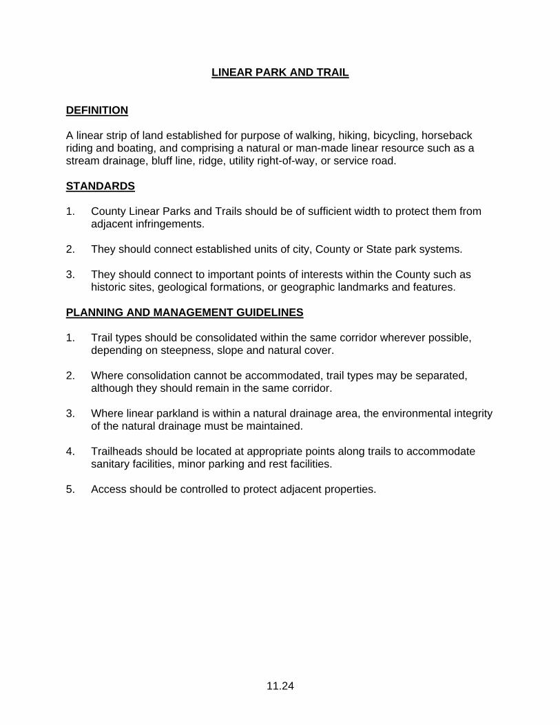
11.24
LINEAR PARK AND TRAIL DEFINITION A linear strip of land established for purpose of walking, hiking, bicycling, horseback riding and boating, and comprising a natural or man-made linear resource such as a stream drainage, bluff line, ridge, utility right-of-way, or service road. STANDARDS 1. County Linear Parks and Trails should be of sufficient width to protect them from
adjacent infringements. 2. They should connect established units of city, County or State park systems. 3. They should connect to important points of interests within the County such as
historic sites, geological formations, or geographic landmarks and features. PLANNING AND MANAGEMENT GUIDELINES 1. Trail types should be consolidated within the same corridor wherever possible,
depending on steepness, slope and natural cover. 2. Where consolidation cannot be accommodated, trail types may be separated,
although they should remain in the same corridor. 3. Where linear parkland is within a natural drainage area, the environmental integrity
of the natural drainage must be maintained. 4. Trailheads should be located at appropriate points along trails to accommodate
sanitary facilities, minor parking and rest facilities. 5. Access should be controlled to protect adjacent properties.
12.1
COMMERCIAL FISHING/RECREATIONAL BOATING COMPONENT
12.1 Reservation of Public Works Capacity Reserve sewer and water capacity on a 50/50 proportional basis for commercial
fishing and recreational boating land uses and in accordance with the policies of the Public Works Component.
12.2 Locating Facilities Limit the location of small craft harbors on the San Mateo County Coast to the
eastern portion of Pillar Point Harbor. 12.3 Related Uses Encourage developments or uses which directly support recreational boating or
commercial fishing before all others within one-half mile of the Pillar Point Harbor area on lands designated on the Land Use Plan maps in Commercial Recreation or General Industrial.
12.4 Protection of Sensitive Habitats a. Discourage marina development which requires the construction of major
breakwaters or dredging and filling. b. Prohibit the discharge or disposal of any solid or liquid waste including
sanitary waste from boats into sensitive habitat areas. c. Any marina development shall be consistent with Policy 7.5 (permit
conditions) of the Sensitive Habitat Component for the protection of Pillar Point Marsh, Denniston Creek and harbor tidelands.
12.5 Role of the San Mateo County Harbor District a. Encourage the Harbor District to investigate the needs of commercial
fishing and recreational boating on an equal basis, and to accommodate those needs accordingly.
b. Require the District to submit to the County annually a list of proposed
development plans recommended for planning or construction during the ensuing fiscal year in accordance with Section 65401 of the Government Code and Policy 2.5 of the Public Works Component. Evaluate projects within County jurisdiction for consistency with the development plan approved as Coastal Permit 133-76.

12.2
c. Encourage the Harbor Master to set minimum use requirements for buying stations leased from the Harbor District.

PA.1
PROVISIONAL APPENDIX
IN-PROGRESS DEVELOPMENT PROPOSALS NOT AFFECTED BY THE LCP AMENDMENTS CERTIFIED BY THE COASTAL COMMISSION
ON APRIL 29, 1998 Board of Supervisors’ Resolutions 61538 and 61697 provide that the LCP policy amendments contained within such resolutions do not apply to development that has fulfilled at least one of the following requirements prior to the date that the amendments become effective, i.e., thirty days after certification by the Coastal Commission: 1. A permit application for each development permit required by the County Zoning
Regulations applicable to the proposed development, including a Coastal Development Permit application, has been submitted to the County and determined to be complete, or
2. A building permit application has been submitted to the County and determined to
be complete, if no development permit is required by the County Zoning Regulations, or
3. A development agreement has been recorded between the County and the owner
of the property where the development will occur, and the proposed development conforms with the terms of the development agreement.
Resolutions 61538 and 61697 also provide that the LCP be amended to establish an Appendix which (1) identifies all development proposals that are not affected by the LCP amendments contained in the resolutions, and (2) identifies the LCP policies which apply to such development proposals, in lieu of the amended policies. The LCP amendments contained in Resolutions 61538 and 61697 became effective on May 29, 1998. Those in-progress development proposals not affected by these amendments are listed below.
Permit Number Name Type of Development
CDP 81-0074 BFI Landfill Expansion
CDP 90-0053 Cozzolino Nursery Signage
CDP 93-0003 Mazzanti Greenhouses
CDP 93-0024 Vanos Greenhouses
CDP 95-0006 Navarro Farm Labor Housing

PA.2
Permit Number Name Type of Development
CDP 95-0050 Fishing Village Associates Visitor-Serving Complex
LLA 96-0004 Naify/Magliocco Lot Line Adjustment
CDP 96-0004 Jacobs Water Impoundment
CDP 96-0035 Paulson/Kinsella Retail Development
CDP 96-0039 Coastside County Water District Reservoir Dredging
CDP 96-0049 Bay City Flowers Water Impoundment
CDP 97-0007 Our Lady of Vladimir Convent
CDP 97-0044 Westly Tree Removal
CDP 97-0046 Falvey Single-Family Residence
CDP 97-0051 Buddhist Society Monastery
CDP 97-0059 Perri Affordable Housing Unit
CDP 97-0061 Kaufman and Broad Major Subdivision
CDP 97-0063 San Mateo County Parks Relocate Footbridge
CDP 97-0069 Kennedy Domestic Well
CDP 97-0071 Oku Domestic Well
CDP 97-0074 Kroll Warehouse
CDP 98-0002 Goldman/Erdie Single-Family Residence
GRD 98-0002 Van Es Sea Wall Repair
LLA 98-0005 Blue Sky Designs Lot Line Adjustment
CDP 98-0006 Green Outdoor Storage
PAD 98-0008 Pastorino Barn
CDP 98-0010 Banks Single-Family Residence
CDP 98-0011 Van Linge Hotel Expansion
CDP 98-0013 Moore Retail/Lodging
CDP 98-0014 Gardiner Single-Family Residence
CDP 98-0017 Voisin Single-Family Residence
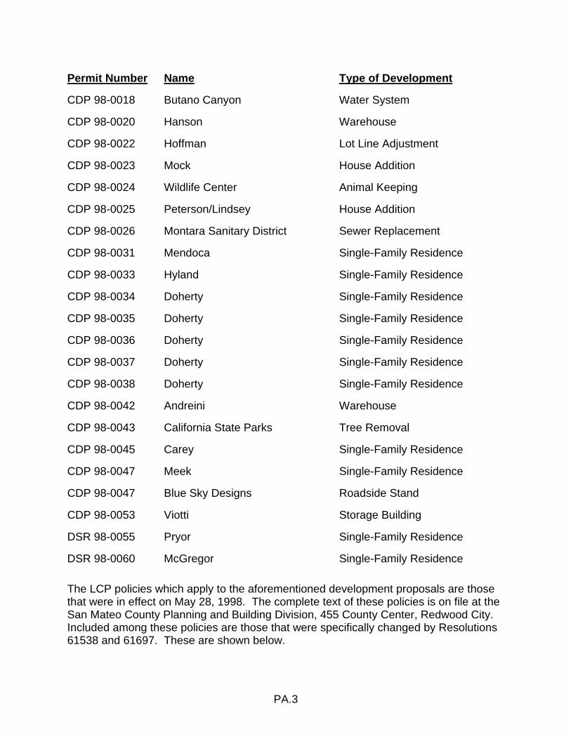
PA.3
Permit Number Name Type of Development
CDP 98-0018 Butano Canyon Water System
CDP 98-0020 Hanson Warehouse
CDP 98-0022 Hoffman Lot Line Adjustment
CDP 98-0023 Mock House Addition
CDP 98-0024 Wildlife Center Animal Keeping
CDP 98-0025 Peterson/Lindsey House Addition
CDP 98-0026 Montara Sanitary District Sewer Replacement
CDP 98-0031 Mendoca Single-Family Residence
CDP 98-0033 Hyland Single-Family Residence
CDP 98-0034 Doherty Single-Family Residence
CDP 98-0035 Doherty Single-Family Residence
CDP 98-0036 Doherty Single-Family Residence
CDP 98-0037 Doherty Single-Family Residence
CDP 98-0038 Doherty Single-Family Residence
CDP 98-0042 Andreini Warehouse
CDP 98-0043 California State Parks Tree Removal
CDP 98-0045 Carey Single-Family Residence
CDP 98-0047 Meek Single-Family Residence
CDP 98-0047 Blue Sky Designs Roadside Stand
CDP 98-0053 Viotti Storage Building
DSR 98-0055 Pryor Single-Family Residence
DSR 98-0060 McGregor Single-Family Residence
The LCP policies which apply to the aforementioned development proposals are those that were in effect on May 28, 1998. The complete text of these policies is on file at the San Mateo County Planning and Building Division, 455 County Center, Redwood City. Included among these policies are those that were specifically changed by Resolutions 61538 and 61697. These are shown below.

PA.4
In addition, the PAD, RM/CZ, and TPZ/CZ Zoning District Regulations were amended to conform with the changes to Policy 1.8 in Resolutions 61538 and 61697. The prior PAD, RM/CZ, and TPZ/CZ Zoning District Regulations conformed with the text of Policy 1.8 in effect on May 28, 1998, and this policy is shown below. Finally, the CD District Regulations were amended to require proof of well water availability at time of Coastal Development Permit application for non-residential development on parcels larger than 40 acres, and the CCR District Regulations were amended to reduce the building height limit from 36 to 28 feet. The applicable sections of these zoning district regulations, in effect on May 28, 1998, are also shown below. LCP POLICIES IN EFFECT ON MAY 28, 1998 1.5 Land Uses and Development Densities in Urban Areas a. Incorporate the adopted Montara-Moss Beach-El Granada Community
Plan into the land use plan for the Midcoast, but amend it where necessary to meet Local Coastal Program objectives.
b. Permit in urban areas land uses designated on the Land Use Plan Maps
and conditional uses at densities specified in Tables 1.2 and 1.3.
*1.8 Land Uses and Development Densities in Rural Areas a. Allow new development (as defined in Section 30106 of the California
Coastal Act of 1976) in rural areas only if it is demonstrated that it will not: (1) have significant adverse impacts, either individually or cumulatively, on coastal resources and (2) diminish the ability to keep all prime agricultural land and other land suitable for agriculture (as defined in the Agriculture Component) in agricultural production.
b. Permit in rural areas land uses designated on the Local Coastal Program
Land Use Plan Maps, and conditional uses at densities specified in Tables 1.2 and 1.3.
c. Require density credits for non-agricultural land uses in rural areas,
including any residential use, except affordable housing (to the extent authorized in Policy 3.27 of the Local Coastal Program on March 25, 1986, the date notice of circulation of this ordinance was published) and farm labor housing. One density credit shall be required for each 315 gallons maximum daily water use as a result of a land use. For purposes of this ordinance, a single-family dwelling unit shall be deemed to use 315 gallons per day. In order to give priority to public and commercial recreation land uses, one density credit shall be required for those uses for each 630 gallons of maximum daily water use. Water use shall be calculated on the
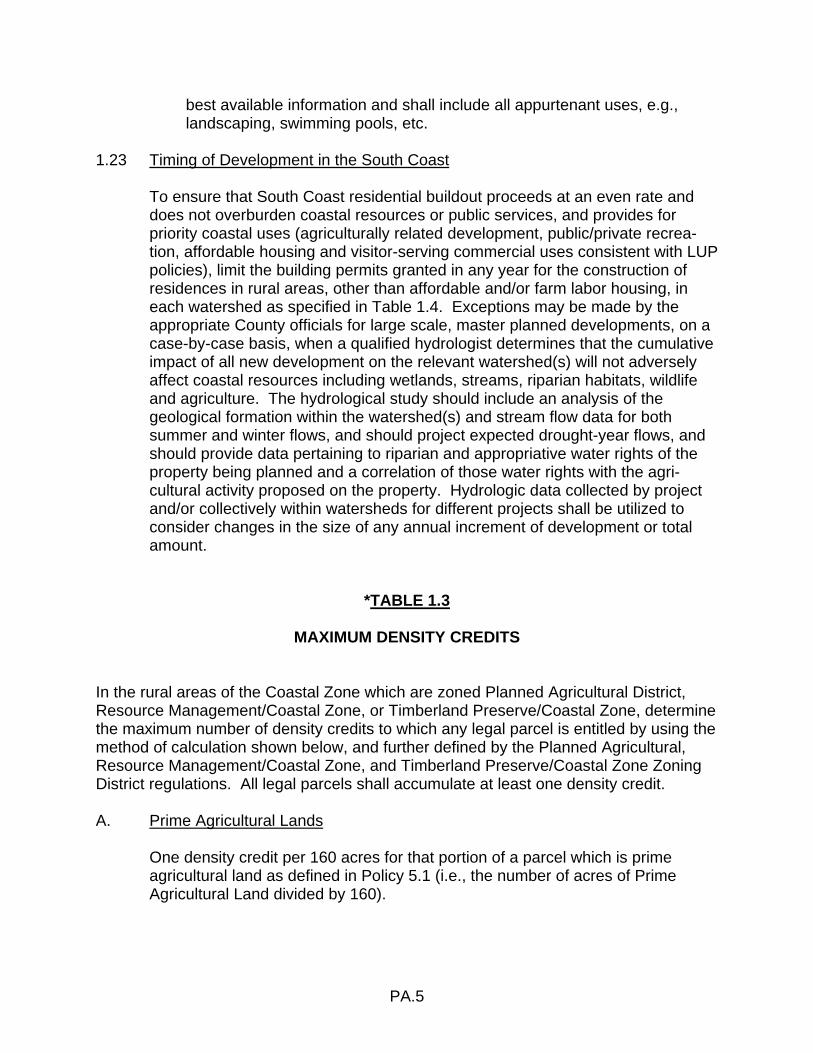
PA.5
best available information and shall include all appurtenant uses, e.g., landscaping, swimming pools, etc.
1.23 Timing of Development in the South Coast To ensure that South Coast residential buildout proceeds at an even rate and
does not overburden coastal resources or public services, and provides for priority coastal uses (agriculturally related development, public/private recrea-tion, affordable housing and visitor-serving commercial uses consistent with LUP policies), limit the building permits granted in any year for the construction of residences in rural areas, other than affordable and/or farm labor housing, in each watershed as specified in Table 1.4. Exceptions may be made by the appropriate County officials for large scale, master planned developments, on a case-by-case basis, when a qualified hydrologist determines that the cumulative impact of all new development on the relevant watershed(s) will not adversely affect coastal resources including wetlands, streams, riparian habitats, wildlife and agriculture. The hydrological study should include an analysis of the geological formation within the watershed(s) and stream flow data for both summer and winter flows, and should project expected drought-year flows, and should provide data pertaining to riparian and appropriative water rights of the property being planned and a correlation of those water rights with the agri-cultural activity proposed on the property. Hydrologic data collected by project and/or collectively within watersheds for different projects shall be utilized to consider changes in the size of any annual increment of development or total amount.
*TABLE 1.3
MAXIMUM DENSITY CREDITS In the rural areas of the Coastal Zone which are zoned Planned Agricultural District, Resource Management/Coastal Zone, or Timberland Preserve/Coastal Zone, determine the maximum number of density credits to which any legal parcel is entitled by using the method of calculation shown below, and further defined by the Planned Agricultural, Resource Management/Coastal Zone, and Timberland Preserve/Coastal Zone Zoning District regulations. All legal parcels shall accumulate at least one density credit. A. Prime Agricultural Lands One density credit per 160 acres for that portion of a parcel which is prime
agricultural land as defined in Policy 5.1 (i.e., the number of acres of Prime Agricultural Land divided by 160).
PA.6
B. Lands With Landslide Susceptibility One density credit per 160 acres for that portion of a parcel which lies within any
of the three least stable categories (Categories V, VI and L) as shown on the U.S. Geological Survey Map MF 360, “Landslide Susceptibility in San Mateo County” or its current replacement (i.e., the number of acres of land susceptible to landslides divided by 160).
C. Land With Slope 50% or Greater One density credit per 160 acres for that portion of a parcel which has a slope
50% or greater (i.e., the number of acres of land with a slope 50% or greater divided by 160).
D. Remote Lands One density credit per 160 acres for that portion of a parcel over 1/2 mile from a
public road that was an existing, all-weather through public road before the County Local Coastal Program was initially certified in November 1980 (i.e., the number of acres of remote land divided by 160).
E. Land With Slope 30% But Less Than 50% One density credit per 80 acres for that portion of a parcel which has a slope
30% but less than 50% (i.e., the number of acres of land with a slope 30%, but less than 50% divided by 80).
F. Land Within Rift Zones or Active Faults One density credit per 80 acres for that portion of a parcel which is located
within the rift zone or zone of fractured rock of an active fault as defined by the U.S. Geological Survey and mapped on USGS Map MF 355, “Active Faults, Probably Active Faults, and Associated Fracture Zones in San Mateo County,” or its current replacement (i.e., the number of acres of land within rift zones or active faults divided by 80).
G. Lands Within 100-Year Floodplain One density credit per 60 acres for that portion of a parcel falling within a
100-year floodplain as most recently defined by the Federal Emergency Management Agency, the U.S. Geological Survey, or the U.S. Army Corps of Engineers (i.e., the number of acres of land within the 100-year floodplain divided by 60).
PA.7
H. Land With Slope 15% But Less Than 30% One density credit per 60 acres for that portion of a parcel with a slope in excess
of 15% but less than 30% (i.e., the number of acres of land with a slope 15%, but less than 30% divided by 60).
I. Land Within Agricultural Preserves or Exclusive Agricultural Districts One density credit per 60 acres for that portion of a parcel within agricultural
preserves or the exclusive Agricultural Districts as defined in the Resource Conservation Area Density Matrix policy on March 25, 1986 (i.e., the number of acres of land within Agricultural Preserves or Exclusive Agricultural Districts divided by 60).
J. All Other Lands One density credit per 40 acres for that portion or portions of a parcel not within
the above areas (i.e., the number of acres of all other land divided by 40). K. Bonus Density Credit for New Water Storage Capacity One bonus density credit shall be allowed for each 24.5 acre-feet of new water
storage capacity demonstrated to be needed and developed for agricultural cultivation or livestock. Water from this storage may be used only for agricul-tural purposes. These bonus credits may be used on site or transferred to another parcel. However, none of the credits may be used on prime agricultural lands or in scenic corridors. Use of the credits shall be subject to Planning Commission approval in accordance with the provisions of this and other County ordinances.
If the same portion of a parcel is covered by two or more of the subsections A.
through J., the density credit for that portion shall be calculated solely on the basis of the subsection which permits the least density credit.
3.21 Second Dwelling Units in R-1 Zoning Districts Permit second dwelling units on building sites containing a one-family residence
in R-1 zoning districts subject to the following restrictions: a. Limit the total number of approved second units to 466 in the Coastal Zone. b. Limit the size of the units to 700 sq. ft. or 35% of the floor area of the
existing principal residence, whichever is greater. c. Comply with all applicable policies and procedures as required by the LCP.

PA.8
*5.11 Maximum Density of Development Per Parcel a. Limit non-agricultural development densities to those permitted in rural
areas of the Coastal Zone under the Locating and Planning New Development Component.
b. Further, limit non-agricultural development densities to that amount which
can be accommodated without adversely affecting the viability of agriculture.
c. In any event, allow the use of one density credit on each legal parcel. d. A density credit bonus may be allowed for the merger of contiguous
parcels. The maximum bonus shall be calculated by: (1) Determining the total number of density credits on all parcels
included in a master development plan; and (2) Multiplying that total by 25% if the merger is entirely of parcels of
40 acres or less, or by 10% if some or all of the parcels combined are larger than 40 acres.
The merged parcel shall be entitled to the number of density credits on
the separate parcels prior to merger plus the bonus calculated under this subsection. The total number of density credits may be used on the merged parcel. Once a parcel or portion of a parcel has been part of a merger for which bonus density credit has been given under this subsection, no bonus credit may be allowed for any subsequent merger involving that parcel or portion of a parcel.
e. Density credits on parcels consisting entirely of prime agricultural land, or
of prime agricultural land and land which is not developable under the Local Coastal Program, may be transferred to other parcels in the Coastal Zone, provided that the entire parcel from which credits are transferred is restricted permanently to agricultural use by an easement granted to the County or other governmental agency. Credits transferred may not be used in scenic corridors or on prime agricultural lands; they may be used only in accordance with the policies and standards of the Local Coastal Program.
*5.22 Protection of Agricultural Water Supplies Before approving any division or conversion of prime agricultural land or other
land suitable for agriculture, require that:
PA.9
a. All non-agricultural uses permitted on a parcel demonstrate the existing availability of a potable and adequate on-site well water source.
b. Adequate water supplies needed for agricultural production and sensitive
habitat protection in the watershed are not diminished. c. All new non-agricultural parcels are severed from land bordering a stream
and their deeds prohibit the transfer of riparian rights.
*8.5 Structures Minimize the number of structures located in open fields and grassland areas;
require that structures be designed in scale with the rural character of the region, and that they be clustered near existing natural or man-made vertical features.
*8.7 Ridgelines and Hilltops a. Prohibit the location of new development on ridgelines and hilltops unless
there is no other buildable area on the parcel. b. Prohibit the removal of tree masses which would destroy the silhouette of
the ridgeline or hilltop forms. c. Restrict the height of structures to prevent their projection above ridgeline
or hilltop silhouettes. d. Prohibit land divisions which would create parcels whose only building site
would be on ridgelines or hilltops. 8.13 Special Design Guidelines for Coastal Communities The following special design guidelines supplement the design criteria in the
Community Design Manual: a. Montara-Moss Beach-El Granada (1) Design structures which fit the topography of the site and do not
require extensive cutting, grading, or filling for construction. (2) Employ the use of natural materials and colors which blend with the
vegetative cover of the site. (3) Use pitched, rather than flat, roofs which are surfaced with non-
reflective materials except for the employment of solar energy devices.
PA.10
(4) Design structures which are in scale with the character of their setting and blend rather than dominate or distract from the overall view of the urbanscape.
b. Princeton-by-the-Sea (1) Commercial Development Design buildings which reflect the nautical character of the harbor
setting, are of wood or shingle siding, employ natural or sea colors, and use pitched roofs.
(2) Industrial Development Employ architectural detailing, subdued colors, textured building
materials, and landscaping to add visual interest and soften the harsh lines of standard or stock building forms normally used in industrial districts.
c. San Gregorio Encourage new buildings to incorporate traditional design features found in
the San Gregorio House and other houses in the community, i.e., clean and simple lines, steep roof slopes, placement of windows and doors at regular intervals, doors and windows of equal proportions, and wood construction. Require remodeling of existing buildings to retain and respect their traditional architectural features, if any.
d. Pescadero Encourage new buildings to incorporate architectural design features found
in the historic buildings of the community (see inventory listing), i.e., clean and simple lines, precise detailing, steep roof slopes, symmetrical relationship of windows and doors, wood construction, white paint, etc. Require remodeling of existing buildings to retain and respect their traditional architectural features, if any.
*8.15 Coastal Views Prevent development (including buildings, structures, fences, un-natural
obstructions, signs, and landscaping) from substantially blocking views to or along the shoreline from coastal roads, roadside rests and vista points, recreation areas, and beaches.
PA.11
*8.17 Alteration of Landforms Minimize the visual degradation of natural landforms caused by cutting, filling, or
grading for building sites, access roads, or public utilities by: a. Concentrating development so that steep hillsides may be left undisturbed. b. Requiring structures to be designed to fit hillsides rather than altering the
landform to accommodate buildings designed for level sites. c. Prohibiting new development which requires grading, cutting, or filling that
would substantially alter or destroy the appearance of natural landforms. d. Restoring as much as possible the natural topographic contours after any
permitted temporary alteration of landforms during construction, timber harvesting, or mineral extraction.
*8.18 Location of New Development Require: a. That new development be located, sited, and designed to fit the physical
setting, so that its presence is subordinate to the pre-existing character of the site, enhances the scenic and visual qualities of the area, or maintains the natural characteristics of existing major water courses, established and mature trees, or dominant vegetative communities.
b. That roads, buildings, and other structural improvements be constructed to
fit the natural topography and to minimize grading and modification of existing landforms.
c. That private roads and driveways be shared, where feasible, to reduce the
amount of grading, cutting and filling required to provide access. d. That all development minimize the impacts of noise, light, glare and odors
on adjacent properties and the community at large. 9.18 Regulation of Development on 30% or Steeper Slopes a. Prohibit, unless no alternatives exist, development (including land divisions
which would create parcels exclusively) on slopes of 30% or greater. If no alternatives exist, require engineering geologic reports to enable minimizing of hazards.
PA.12
b. Employ the siting and grading criteria of the Design Review Zoning Ordinance and the Community Design Manual for Development on Slopes 30% or Greater.
11.15 Private Recreation and Visitor Serving Facilities a. Require that private recreation and visitor-serving facilities conform to:
(1) the development and locational standards included throughout this component and as referred in other components, and (2) the design standards of the Visual Resources Component.
b. Require that private recreation and visitor-serving facilities conform to the
intensities of use appropriate to the rural or urban setting and to the requirements of the individual site. In rural areas, limit visitor-serving development to water supply requirements of 630 gallons per density credit.
ZONING DISTRICT REGULATIONS IN EFFECT ON MAY 28, 1998 CCR DISTRICT SECTION 6269. DEVELOPMENT STANDARDS 3. Building Height Limit. The maximum building height is thirty-six (36) feet, except
when a lower limit is imposed in accordance with this chapter. Height is measured from finished grade to the highest point of the roof.
CD DISTRICT SECTION 6328.7. APPLICATION REQUIREMENTS. Application for a Coastal Development Permit shall be made to the Planning and Building Division on forms provided by the Planning Director. Where required by this Chapter, application for a Coastal Development Permit shall be made prior to or concurrently with application for any other permit or approvals required for the project by the San Mateo County Ordinance Code. The application for a Coastal Development Permit shall be accompanied by: (a) A nominal fee set by resolution of the Board of Supervisors. (b) A location map showing the lot to be developed in relation to nearby lots,
streets, highways and major natural features such as the ocean, beaches, wetlands and major landforms.
(c) A site plan, to scale, showing:
PA.13
(1) Existing and proposed property lines of the lot to be developed, including all easements over or adjacent to the lot.
(2) Existing and proposed topography, at a contour interval appropriate to the
size of the site to be developed. (3) All existing and proposed structures, roads, utility lines, signs, fences and
other improvements. (4) Major natural and man-made landscape features, including location, type
and size of any trees or other vegetation to be removed or planted. (5) For projects proposed between the first through public road and the sea,
indicate on the site plan existing and/or proposed public access to and along the shoreline.
(d) Building elevations showing: (1) All exterior walls. (2) Type and color of roof and other exterior materials. (3) Location and design of roof equipment, trash enclosures, fences, exterior
lights, signs and other exterior structures and equipment. (e) Any additional information determined by the Planning Director to be necessary
for evaluation of the proposed development.
P L A N N I N G A N D B U I L D I N G D E P A R T M E N T
C O U N T Y O F S A N M A T E O