Embed Size (px)
Citation preview


Livelihood, Land Use and Customary Tenure in
KWAINGANReport of a Participatory
Action Research
Karuna Mission Social
Solidarity (KMSS) - Loikaw
2017

Livelihood, Land Use and Customary Tenure in KwainganReport of a Participatory Action Research
Karuna Mission Social Solidarity (KMSS)-Loikaw
Copyright © KMSS-Loikaw 2017The contents of this book may be reproduced and distributed for non-commercial purposes ifprior notice is given to the copyright holders and the source and authors are duly acknowledged.Published by Karuna Mission Social Solidarity (KMSS)-LoikawKMSS: www.kmss-caritasmyanmar.orgWritten by: KMSS-Loikaw Livelihood Programme teamEditing: Christian ErniLayout and Cover Design: Saw BenhurPhotos: Alesio Ngairi (Fig. 09, 11, 13, 14, 16, 23, 28, 32, 34) Ignatio (Fig. 01, 05, 06, 08, 18, 19, 33) Christina T Myar (Fig. 12) Christian Erni (Fig. 20, 22, 26, 27, 29, 31)Cover photos: Alesio Ngairi, Christian Erni, IgnatioMaps: Nabwong Chuaychuwong (Fig. 02); all other maps and satellite images were created by Elena
Printed in Yangon by MYINT color offset
This publication has been produced with financial support from MISEREOR, the International WorkGroup for Indigenous Affairs (IWGIA) and the Danish Ministry of Foreign Affairs.

Contents
Introduction 2
I The Community and its History 41. Kwaingan community 4
Demography of Kwaingan 5
2. History of Kwaingan 8Difficulties in the face of war 16Education 16
II Livelihood and Land Use 181. Livelihood 18
Farming 18Other sources of income 20
Wage labour 20Burning lime 21Raising farm animals 23
Hunting, fishing and gathering forest products 23Food security 24
2. Land use 28Land types and tenure 28
Settlement area 31Irrigated land 31Permanently used taungya land 32Shifting cultivation taungya land 33Forest land 35Community protected forest 36Spring forest 37Bamboo forest 37Lake 38Cemetery 38
III Customary Tenure and Management of Land and Resources 391. Customary tenure 39
Individually owned land 40Collectively owned land 40
2. Customary law and resource management 40Rules on sale and lease of land 40Rules on use of resources and damage compensation 40Regulations regarding fishing and the protection of streams 41Laws on use of community forests 41Other customary rules and regulations 42
Regulations related to social life in the village 42Regulations for Catholic community members 42Customary rules regarding farming 43Customary rules regarding food 43Customs regarding social matters 43
IV Community Governance 441. Village administration 442. The Elders 453. Groups, committees and associations 45
Youth Group 45Community Forest Committee (CFC) 46Ngwe Taung spring management committee 46School committee 46Day care centre committee 46Religious associations 46

V Challenges and the Way Forward 47
Appendix 48Geographical information of village boundary 48
Perimeter survey map 48Perimeter survey waypoints data 49

“ Land of our ancestorsLand of ours.
The green mountains bring welfare
The springs give life.
Generations must stand and care
For our land to exist forever. ”
Motto of Kwaingan village

Introduction This report is the result of a participatory action research (PAR) conducted by members of Kwaingan community and the livelihood program team of Karuna Mission Social Solidarity-Loikaw (KMSS-Loikaw) between January and June 2016. In its first field work, the research team was joined by members of the Indigenous Peoples/Ethnic Nationalities (IP/EN) network who had attended the preparatory training.
The PAR is one of the four components of a project through which KMSS-Loikaw supports indigenous communities in Kayah state to document and seek official recognition of their customary land and natural resource rights and management practices.
The Myanmar government’s National Land Use Policy (NLUP) of 2016, in part 8 on “Land Use Rights of Ethnic Nationalities”, recognizes the traditional land use system of ethnic nationalities, traditional land use rights and land tenure rights, and it provides for establishing of a process for recognition of the rights of communities, and not just individuals.
Furthermore, part 8 of the NLUP provides, among others, for
• The preparation and revision of customary land use maps and records of ethnic nationalities in a participatory manner with involvement of representatives and elders;
• Formal recognition and protection of the customary land tenure, land use and rights of ethnic groups, whether or not existing land use is registered, recorded or mapped
• Reclassification of customary lands of ethnic groups in accordance with the expected new National Land Law, and for the temporary suspension of any allocation of land until existing ethnic land users register these customary lands, and therefore
• Protection against grants or leasing of land by the government allowed under any existing law
• Restitution of land lost “due to civil war, land confiscation or natural disasters or other causes”
• Recognition of land use rights relating to rotating and shifting cultivation in farmland or forestland.
This report contains the findings of the PAR that documents the community’s natural resource management and customary tenure and governance system. The report is part of the evidence compiled by Kwaingan community that is proof of the community’s long and close relationship to and dependence on its land and resources. The PAR report is complemented by a detailed map showing key features of Kwaingan’s territory such as its boundary, settlement sites the current land use system and important cultural and sacred sites. A copy of this map as well as the perimeter survey map and the related geographical information data are included in this report. The maps comprise the other part of the evidence of the community’s close relationship and customary rights over its land and resources. The maps were also made in a participatory manner by community members and KMSS-Loikaw staff.
The members of the research team from the community are Andrew, Antony, Caspare, Marcello, Natalina, Patritio, Petru (Saw Ko), Poupeo and Racinta. The members of the KMSS-Loikaw livelihood sector team involved in the research are Christina T Myar, Elena, Anne Mary Ne Nel, Alesio Ngairi and Ignatio.
2Livelihood, Land Use and Customary Tenure in KWAINGAN

The PAR was supported by Christian Erni, Prawit Nikornuaychai and Gam Angkang Shimray as trainers, during field testing of the research methodology, and through technical support during data consolidation and analysis, and report writing.
Fig. 01. The community research team (left to right): Front: Natalina , Racinta, back: Patritio, Petru (Saw Ko), Poopeo, Caspare, Marcello, Antony, Andrew.
The research team would like to express its gratitude to the other community member who shared their time and willingly cooperated with the team. Community members not only shared their knowledge and stories, which was immensely rich and enlightening, but received the research team with warm hospitality and open arms whenever they were approached. The research team would like to extend heartfelt appreciation to Gemma Nanmu for her assistance in report translation.
The research team would also like to thank the KMSS-Loikaw Management Team and other staff for the warm hospitality and having done everything within their means to help successfully carry out the PAR. The research team also expresses its deep appreciation to MISEREOR and the International Work Group for Indigenous Affairs (IWGIA) for their goodwill and financing the research.
3Report of a Participatory Action Research

4Livelihood, Land Use and Customary Tenure in KWAINGAN
IThe Community
and its History1. Kwaingan community Kwaingan village is located in Demoso Township, Kayah State.Itis situated at 3216 feet (980 metres) above sea level. Its highest mountain, Sa Plong Sou, rises as high as 4291 feet (1308 metres) above sea level. Th e community’s territory measures 2714 acres (4.24 sq. miles or 10.98 sq. km). Th e land is featured with high hills, mountains, streams and few plains. Th e average rainfall in the low-lying area is 40 inches (1016 mm) and the annual average temperature is 30 degrees Celsius.
Kwaingan is bordered by Ngwe Taung stream, and Sodekhu and Dokukhu villages in the east, Solyarku village in the south east, Moso and Hteediku villages in the north, Doroukhu village in the west, Doweku and Laymaankhu villages in the north west, Soupahtan and Yusomoso villages in the north and Nganroe village in the north east.
Kwaingan’s community members all belong to the Kayan Kangan ethnic group and most of them are Catholics. Th e community comprises twelve clans.
Fig. 02. Location of Kwaingan village

5Report of a Participatory Action Research
Fig. 03: Satellite image of Kwaingan village territory
Demography of Kwaingan Kwaingan village has 86 households with an official population, according to the government’s census of 2014, of 535 people (260 female, 275 male). However, since some of the children and other community members study or work temporarily or permanently outside the village, the actual permanent resident population is less and fluctuating throughout the year. At the time of field work 472 people lived permanently in the village (225 male, 247 female). Most of the 86 households in Kwainga village consist of married couples and their unmarried children. In 24 households, there are other people living with them, most of them relatives like grandparents, parents, brothers, daughter-in-law, son-in-law, or an adopted child. Three households are headed by widowers and twelve by widows. The average actual household size is 5.5.
Table 01: Official census population and actual resident population
Male Female Total
Official population 275 260 535
51.4% 48.6%
Counted resident population 225 247 472
47.7% 52.3%

6Livelihood, Land Use and Customary Tenure in KWAINGAN
Fig.04: Satellite image of the Kwaingan village with its three settlement areas Doudu,Prannaw and Nouthkhu
Fig. 05: Doudu, the Western part of Kwaingan Village

7Report of a Participatory Action Research
Fig. 06: Prannaw and Nouthkhu, the Eastern part of Kwaingan village
On average, married couples have five children. Most children at the level of kindergarten, primary and middle school go to school in the village. Those attending high school and university have to move to the cities. In 2016, 29 children above the age of 15 years were studying at high schools in Demoso and Loikaw, or at the University of Loikaw.
Some of the younger generation have left the village to work in cities or abroad. 14 of them of age above 14 are currently working in Thailand, Malaysia, Singapore and China, two in nearby towns.
Of the 89 children that are already married, 61(27 men, 34 women) married and now live within the village, 28(8 men, 20 women) married to and live in other villages. Ten Kwaingan villager now live permanently in cities in Myanmar and one woman lives permanently abroad. Two have become Catholic priests and one is now a Catholic nun.

8Livelihood, Land Use and Customary Tenure in KWAINGAN
Fig.07: Migration pattern: Residence of offspring over 14 years of age
2. History of Kwaingan The village name Kwaingan is a composition of the two words Kwai and Ngan. Kwai is the name of a sound producing instrument made from buffalo horn, and Ngan means ‘plain land’. According to the legend, men from Krui Khu village came to the Gan Ngan plain for hunting and they played the buffalo horn to give a signal to the villagers whether they had got any animal or not. Later on, when a village was founded on GanNgan plain it was named Kwaingan village.
The foundation of the village goes back a hundred and three years. At that time there were about one thousand people in a hundred households living in Douroukhu village. The large population made it difficult for many villagers to earn their living from growing crops. Therefore, many turned to a business of making handicrafts such as earthenware pots, bamboo baskets, bamboo bags and bamboo backpacks which were then exchanged for rice or millet from Kayah villages. However, as Douroukhu people found it difficult to bring back to their village the rice and millet they got from Kayah villages, they requested the Kayah people to allow them to build a barn for their crops to be stored. So a barn was built at a place called Socrockhu (or Sokhu by the Kayah), which was also known as Kwaingan.

9Report of a Participatory Action Research
In 1910, Phu Kouphawan Soyu, a man of the Takhasu clan of Dourawkhu village came to settle there with the intention of founding a village. Soon others joined him. The first settlers and their clans were as follow:
1. Kouphawan (Takhasu clan)2. Phu Shosu (Soupasa clan)3. Phu Nanri (Suphai clan)4. Phu Palaouri (Suphai clan)5. Phu Thansu (Suphai clan)6. Phu Leiphao (Rouphao clan)7. Phu Thasu (Praansu clan)8. Phu Kosu (Yarayepra clan)
In 1912, Phu Kosu of the Yarayepra clan and four other families joined these first settlers. The first thing they did was to plant a banana tree. They believed that if the plant thrives, they will be able to stay there. Phu That Su strongly wanted to stay in that place and so he watered the banana plant every evening. The banana plant grew well and so the people continued to stay in Kwaingan village. They planted a Kamongmon tree (Eugenia Sp.) at Socroukhu, a location in today’s Kwaingan village. Phu Ko Su, the Smou (traditional spiritual leader) was responsible for taking care of and worshipping the tree. Phu Nan Ri was his successor. The tree is still there, but after having converted to Christianity the people of Kwaingan do not worship it any more.
Fig. 08: The Kamongmon tree at Socroukhu

10Livelihood, Land Use and Customary Tenure in KWAINGAN
Original clans from Dauroukhu Clans from other areas
1. Takhasu clan 1. Si Ngae clan
2. Suphai clan 2. Sounglar clan
3. Rouphao clan 3. Ou Ri clan
4. Praansu clan 4. Sesu Masou clan
5. Yarayepra clan 5. Choe Su clan
6. Ai clan
7. Tarsu clan
Table 02: The clans of Kwaingan village
The sons of the village founder Khouphawan did not stay in Kwaingan but moved back to Douroukhu. But other member s of the Takhasu clan stayed on in Kwaingan.
Fig. 09: Genealogy of the heads of the five original clans and their present-day descendants
U Shosu
Daw Maria
U Parsakwarle
U Nyaedu
Takhasu clan
Takhasu clan

11Report of a Participatory Action Research
Suphal clan
U Nanri
U Kansu
U Zarkamo
U Nartarle
U Palaungri
U Moses
Daw Mange
U Tansu
U Ngaesu
U ngaisu
Suphai clan

12Livelihood, Land Use and Customary Tenure in KWAINGAN
U Lainphay
U Joseph
U Lainphou
U Gabraele
Rouphao clan
Rouphao clan
U Thatsu
U Tomarso
U Thatsu
U Ponpayo
Praansu clan
Praansu clan

13Report of a Participatory Action Research
U Joverni
U Romarno
U Peter
Yarayepra clan
Yarayepra clan
Fig. 10: present-day descendants of the seven clans from other areas
Sesu Masou clan I clan
Ou Ri clan Tarsu clan

14Livelihood, Land Use and Customary Tenure in KWAINGAN
Si Ngae clan Choe Su clan
Sounglar clan
Year Event
1910 Phu Kouphawanfounded the Kwaingan village, seven other householdsjoined him
1912 Four other families settled in Kwaingan
1913 A bamboo Church was built
1941 The church and village was burnt down by the Japanese
1942 The village was rebuilt
1943 The Bamboo church was rebuilt
1947-1948 Wooden church was built.
1949 Kwaingan community built its own school
1959 The foundation for a new church in stone and brick was laid
1965 Blessing of the new church
1966 The residence for the parish priest was built of wood
1967 Renovation of the school
Table 03: Main historical events

15Report of a Participatory Action Research
Year Event
1974 Jubilee Cross built on top of Kra Sou mountain
1983 The primary school was built of wood
1984 70-years jubilee of the village foundation was celebrated on top of Par Aunn mountain
1986 A large cross was erected at the spring that is the source of Suenguthakhu river
1995 The two story priest house was built in brick and wood
1996 St. Ann’s 25th anniversary jubilee memorial was built on Karasoude mountain between the east and west part of the village
2003 A pre-school was built
2004 The Mother Mary Shrine was built in the Church compound
2004 Foundation of a new settlement for new members village at the east of village, including a church and play ground
2010 A Mother Mary shrine was built at Suenguthakhu stream
2014 The new school was built
2014 A Clinic was built by the government
Fig. 11: The old church, built in 1959

Fig. 12: St. Antony church, built in 2014
Difficulties in the face of war When the Second World War broke out in 1943, Kwaingan village also came under the attack of Japanese military troops. Eighteen houses and seven barns including the chapel were burned down. The bell from the chapel was taken down and hidden by Joseph, Angelo and Zakamo Kori. The Catechist Plouri was shot dead by Japanese soldiers at a place called Klouno in the east of the village. A Japanese second lieutenant was killed by the defiant villagers. Struck by war, the Kwaingan villagers took refuge in Doroukhu village. They were living there in temporary houses between six and twelve months. When the Second World War was over in 1946 they were able to return to Kwaingan. On 27 Nov 1973, Generals Suha and Kyawnysoe from the Karenni National Progressive Party (KNPP), and armed group fighting against the military government came to Kwaingan and held a public meeting with the villagers at the elementary school building. While having the meeting, the KNPP were attacked by government troops. This incident imposed trail of difficulties upon the peaceful life of the villagers in the later years. In 1991 and 1992, thirty five households out of eighty moved to the new settlement New Kwaingan because of the conflict. Some moved back to Kwaingan after the political situation became more stable, the others remained in New Kwaingan.
Education There was no school in Kwaingan village until 1953 when the villagers built a small school made of bamboo and thatch. In 1976, the school was renovated with wood for the walls and zinc sheets for the roof. In 2015, a new school was built by the government with bricks. So far there have been 12 graduates and 13 people who have completed their high school.
16Livelihood, Land Use and Customary Tenure in KWAINGAN

Fig 13: The old wooden primary school built 1947-48
17Report of a Participatory Action Research
Fig 14: The new primary school built in 2014

18Livelihood, Land Use and Customary Tenure in KWAINGAN
II Livelihood and
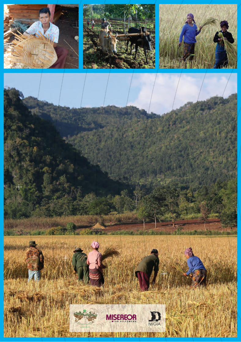
Land Use1. Livelihood Farming is the main source of livelihood for Kwaingan villagers. All families are engaged in farming, most of them in combination with various other livelihood activities for income generation. However, only 22 of the 86 families make a living entirely from farming. 64 families depend on additional sources of income to make ends meet. In addition to that, Kwaingan villagers raise domestic animals and they get food and other important resources from the forest. The most important sources of cash income are cash crops and wage labour, followed by forest products. In their own assessment, Kwaingan villagers found that the highest expenses are for food, and health, followed by education.
Farming The main crop grown is rice, and out of the 86 households 83 grow their own rice. Of the three household that do not grow rice, one is a landless family, the other two grow other cops only. 56 families grow crops other than rice. Among the commonly grown crops are corn, sorghum, millet, green pea, peanuts, pigeon peas and sesame, both for consumption and for sale. 64 of 86 families in the village grow cash crops both on paddy and taungya fields.The main cash crops grown are corn, sorghum and groundnut.
Fig. 15: Sowing rice on permanent taungya land

19Report of a Participatory Action Research
Fig. 16: Groundnut field and harvested groundnuts that are hung up for drying.
20Livelihood, Land Use and Customary Tenure in KWAINGAN
Rice is grown both on wet paddy fields and upland fields, in their own language called Săkhusăka, in Burmese called taungya. Taungya is a type of upland cultivation system that is widely practiced among indigenous communities in Myanmar. Taungya is generally known as a form of shifting cultivation, which is characterized by a short period of cultivation alternating with a longer period of fallow, but the system varies from place to place, even within Kayah state. In Kwaingan the land is now used almost permanently, i.e. without a long fallow period. Most families (67 of 86) own some paddy land, and almost all (81 of 86) own taungya land. Only three families do not own any land at all. Two of them rent land from others.
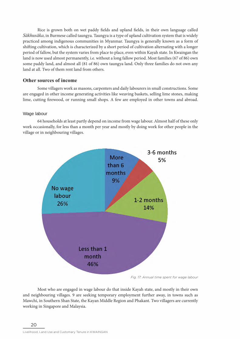
Other sources of income Some villagers work as masons, carpenters and daily labourers in small constructions. Some are engaged in other income generating activities like weaving baskets, selling lime stones, making lime, cutting firewood, or running small shops. A few are employed in other towns and abroad.
Wage labour 64 households at least partly depend on income from wage labour. Almost half of these only work occasionally, for less than a month per year and mostly by doing work for other people in the village or in neighbouring villages.
Fig. 17: Annual time spent for wage labour
Most who are engaged in wage labour do that inside Kayah state, and mostly in their own and neighbouring villages. 9 are seeking temporary employment further away, in towns such as Mawchi, in Southern Shan State, the Kayan Middle Region and Phakant. Two villagers are currently working in Singapore and Malaysia.

21Report of a Participatory Action Research
Local labour
In own village 18
In neighbouring villages 2
In own and neighbouring villages 35
Total local labour 55
Migrant labour
In own village and outside Kayah State 2
In own village, neighbouring villages and outside Kayah State 5
In neighbouring village and outside Kayah State 2
Total migrant labour 9
Overall total 64
Table 04: Engagement in wage labour
Eight village members are government employees, 4 of them men and 4 women. Four of them are teachers. One male teacher works at the primary school in the village and one male teacher works at 4 Mile Myaenighon middle, in Demoso Township. The two female teacher work at Phruso town high school and in Kachin State. Two work as policemen at Demoso police station. Two health care workers work at Demoso hospital.
Burning lime Lime powder is used for various purposes in house construction but also as an ingredient for chewing betel nut, which is very popular all over Myanmar. Lime powder making involves the following steps: First, lime stones and fire wood need to be collected and the lime burning stove has to be made. For that two round holes are dug in the ground – a horizontal hole for putting firewood and a vertical, bigger one which is filled with lime stones to be burned and also serves as the smoke outlet (chimney). The smoke outlet should be cover by straw or thatch. The horizontal hole is around 18 inches wide and the vertical hole high is six feet long. The fire is fed for four to five consecutive days and nights until the stones are totally burned. A bunch of dry straw or thatch is put into the mouth of the vertical hole and if it is burned one knows that the lime stones are totally burned. The burned lime stones are left to cool for two to three days and nights. Then they are collected and stored under the house, and occasionally turned to air them well for two months, after which the lime stones disintegrate into lime powder. In case of urgency a person can sprinkle water on the lime stones and turn them daily, and after one week the lime powder is ready to be used. However, the quality will be inferior.

22Livelihood, Land Use and Customary Tenure in KWAINGAN
Fig. 18: Lime stove in operation: The vertical hole for the fire and the horizontal hole filled with lime stones

23Report of a Participatory Action Research
Fig. 19: Transporting peanuts with a bullock cart
Raising farm animals Chicken, pigs, cattle and buffaloes are raised for consumption and sale. Cattle and buffaloes are also used for ploughing, pulling carts and other farm work. There are 62 families who own cattle and buffaloes. There is no particular grazing land for the animals. People graze their animals near their houses, in the nearby forests, and after the harvest on farm land.
Hunting, fishing and gathering forest products Hunting is not as important anymore as it used to be in the past. Only in around one third of all households there is someone who still hunts. In the dry season slightly more people go hunting than in the rainy season, and they do that a little more often. Likewise, catching fish, crabs, shrimps and other aquatic an in the local streams and rivers is not as widely practiced any longer as in the past. Only in about half of all households there is someone doing that. However, all except one household said that they regularly gather forest products for their own consumption or use, like firewood, wood for construction, bamboo for various uses, broom grass, herbal medicine and wild edible plants. For 15 households forest products are a source of income. Among the most important is bamboo for basketry.

24Livelihood, Land Use and Customary Tenure in KWAINGAN
Food security The people of Kwaingan produce a considerable amount of food for their own consumption, but they also buy food on the market with the money earned from selling cash crops or from other sources. In fact, the largest share of people’s cash expenses is for food.
Only 8 families have enough rice for more than a year and 27 families harvest enough rice for one year. 21 families grow enough rice for eight months, 13 families for six months, and for 17 families their own rice lasts for less than six months.
Fig. 20: Successful hunt: A Cukein (Masked Palm Civet, Paguma larvata) was shot the previous night
Fig. 21: Level of rice self-sufficiency in Kwaingan

25Report of a Participatory Action Research
Fig. 22: Rice is harvested by sharing labour among villagers
Fields and forests are an important source of food, especially in the rainy season. All households also buy vegetables and other food on the market, but in the rainy season almost everybody grows vegetables in the kitchen garden, and most grow some or collect wild vegetables in their taungya and paddy fields. In the dry season people depend more on vegetables bought on the market.
Throughout the year, the forest is an important source of wild vegetables and other food. 72 of the 86 families reported that they gather wild vegetables in the forest during the dry season. In the rainy season this is a little less (60 households) since vegetables in their gardens and fields are more abundant.
Table 05: Sources of fruits, vegetables, herbs and spices throughout the year
Type of land Dry season Rainy season
Kitchen garden
Bean, yam, jackfruit, banana, papaya, acacia leaf, horseradish leaf, ridge gourd, drum stick gourd, turmeric, tamarind, lemon,
Pumpkin, chili, cucumber, bean, nacritela (local name of a leafy vegetable), passion-fruit, lemongrass, mustard, ginger, mango, guava, papaya, corn, lemon, banana, basils, eggplant
Permanent farm land
Centella (Centella asiatica),Swekha (a leafy vegetable), Talai la (a leafy vegetable)
Metkha (a small, green spicy hollow fruit that is used fresh or as in cooking), banana, Sawlawki (an edible insect living in water)), centella, mushroom

26Livelihood, Land Use and Customary Tenure in KWAINGAN
Type of land Dry season Rainy season
Taungya land
Chilli, acacia leaves Corn, chili, yam, pumpkin, cucumber, bean, mustard
Forest land Swedaw ywet leaves (Burmese name of edible leaves), banyan buds, soap acacia leaf
Birds, mushroom, Swedaw ywet (Burmese name of edible leaves), bamboo shoots, trumpet flower and fruit (Oroxylum Indicum (L.) Vent), centella
Fruit tree land
Banana, papaya Mango, banana, jackfruit, lemon, jengkol, guava
Paddy field Centella, dayinkout and kwaytotywat (Burmese names of two kinds of leafy vegetables
Corn, pumpkin leaf, mustard
Fig. 23: Examples of fruits, vegetables and spices grown in Kwaingan
1
4
7
2
5
8
3
6
1.Lemon, 2.lychee, 3.methkha,
4.pumpkin, 5.turmeric, 6.ginger,
7.chili, 8.ridge gourd

27Report of a Participatory Action Research
Table 06: Varieties of plants grown and gathered
Type of land Plant species Varieties Total number of varieties
Paddy Field Rice 1. Nga Kywe (Myanmar name)
2. Bôeji (local name)
3. Yar Koe (Myanmar name)
4. Htee Poe Kloe (Myanmar name)
5. Pa Le Thwel (Myanmar name)
5
Taungya Rice 1. Bon Khõn (local name) 1
Taungya Sorghum 1. Kalu Li (red sorghum)2. Kalu Bu (white sorghum)
2
Paddy field Sticky rice 1. Bon Ei 1
Cucumber 1. Long cucumber2. Round cucumber
2
Taungya Mustard 1. White mustard 2. Green mustard
2
Pumpkin 1. Round pumpkin 2. Long pumpkin
2
Taungya White pumpkin 1. Long white pumpkin2. Round white pumpkin
2
Taungya, Permanent land, Kitchen garden
Beans 1. Bı Du lain ( local)2. Bı Du Thyun (local)3. Bı Du (local)4. Pae Paq Zun (Myanmar name)5. Bı swi (local name)6. Bı tapyi (local name)7. Bı hton (local name)8. Bı ba (local name)
8
Taungya, Kitchen garden
Yam 1. Nawe ebuu (local name)2. Nawe li (local name)3. Nawe thuphan (local name)4. Su lane (local name)5. Su buu (local name)6. Su bashwe (local name)7. Su tari (local name)
7
Taungya, Kitchen garden
Ginger 1
Taungya, Kitchen garden
Chilly 1. Thahaī yuueaĭ (local name) 2. Thahaī twa (local name) 3. Thahaī htoĕ (local name)
3
x
x x
x
x
x
x
x

28Livelihood, Land Use and Customary Tenure in KWAINGAN
Type of land Plant species Varieties Total number of varieties
Taungya Potato Nwè (local name) 1
Taungya, Kitchen garden
Sweet potato Red (Nwe ma ohn lee)White (Nwe ma ohn buu)
2
Taungya, Forest, Permanent
Mushroom 1. Kyawn Plote, 2. Kywan Kya
2
Forest Mala Phu (phuklo) A kind of flower growing naturally 1
Taungya, Kitchen garden
Rosella 1
Paddy field and Taungya
Pi saywet (tong lar)
A plant with strong smelling leaves and yellow flower used in cooking
1
Forest, Kitchen garden
Tadahtha(local name)
Trumpet flower fruit (OroxylumIndicum (L.) Vent)
1
Total number of plant varieties 45
2. Land use Kwaingan community distinguishes between ten different types of land, each of which is used in different ways and is a source of different types of food and other resources.
Land types and tenure The main types of land distinguished in Kwaingan are:
1. Settlement area (Doukalăntha)2. Irrigated land (Prakalankasaw)3. Permanently used taungya land (Săkhusăka)4. Shifting cultivation taungya land (rotation farming land) (Hlaisaswi)5. Clan forest (Tamô thoupha, literally “plant forest”)6. Village forest (Tadou thoupha)7. Protected forest (Tamadidaw thoupha)8. Spring forest (Sûnou thoupha guthakhu)9. Bamboo forest (Whar phar, literally “bamboo land”)
10. Cemetery (Lukhu)11. Lake (Sûou)

29Report of a Participatory Action Research
Participatory Land Use Map of Kwaingan
Fig. 24: Land use map of Kwaingan community

30Livelihood, Land Use and Customary Tenure in KWAINGAN
Table 07: Area of land types and other geographical features
Type of land Local name Area in acres Area in hectares
Settlement area Doukalăntha 186 75.3
Irrigated land Năraosuou 95 38.4
Permanent taungya land Săkhusăka 876 354.5
Shifting cultivation taungya land Hlaisaswi 55 22.3
Forest Thoupha
Clan forest Tamô thoupha 34 13.8
Village forest Tadou thoupha 855 346.0
Protected forest Tamadidaw thoupha 576 233.1
Spring forest Sûnou thoupha guthakhu
26 10.5
Bamboo forest Whar phar 2.5 1.0
Cemetery land Lukhu 1.5 0.6
Lake Sûou 7 2.8
Total land area 2714 1098.4
Only one household does not own any land at all. 64 of the 86 households own enough land to meet their needs, but 22 households do not have enough and borrow land to grow crops from others. 14 of these do not have to pay any rent. Among those who are asked to pay rent, two families pay the rent in cash and six families pay one third of their crop.
Fig. 25: Area coverage of different land types

31Report of a Participatory Action Research
Settlement area 186 acres (75.3 ha) of the village are settlement area (Doukalăntha), where the houses, school, barns, clinic, soccer field, church, Maria grotto, clergy house, nursery school, cattle stalls, pigsties and streets are found. Near their houses, people grow vegetables in kitchen gardens, fruit producing trees and shade trees. They also keep farm animals in the compounds. Among the vegetables they grow are cucumber, pumpkin, gourd, bean, eggplant, tomato, bitter gourd, and passion-fruit.
Irrigated land Irrigated land (năraosuou) is located along Ngwe Taung stream and used for growing rice and vegetables. It measures 96 acres (38.4 ha). 67 families out of 86 own irrigated land. They own between 0.25 and 2.06 acres. The land is mostly owned by individual men, some by women and some by families.
In paddy fields they grow several kinds of hybrid paddy (among them Shweyinaye, Pelealtwel, and Tayotemwae, in Myanmar language). The local paddy varieties grown are Lonepu, Loneshae, Phinmel and Ngakwel. They also grow sticky rice and after the rice harvest they grow groundnuts, corn, onion, garlic, tomato, mustard and salad (see Fig.30: Seasonal work calendar in agriculture).
The cultivation of rice is done in the rainy season depending on the rain and water from Ngwe Taung River. Families whose field area close to river, grow mustard, onion and vegetables in January and after that they plant corn and groundnut in February. The rice farms are well fenced. For less fertile fields, animal dung, compost and chemical fertilizer are used.
For ploughing domestic animals and small tractors are used. Human labour is needed for most of the work in the paddy field, from transplantation to weeding and harvesting. Labour exchange is practiced among community members, but in some cases, labour is also hired. During harvesting, some ask for paddy (one basket of paddy per day) instead of cash for their labour. The paddy is then transported to the village with bullock carts, cars, motorbikes or by humans.
People also catch and gather different kinds of wild food in their paddy fields and in and along the nearby river, such as fish, snail, frog, crab, cricket, or vegetables like centella, Kayankatot (local name of a plant with edible fruit), Shidaila, Phoeshila, Bonkhala and Kalantonla (local names of plants with edible leaves) that grow along the river or near paddy fields.
Fig 26: Kwaingan village street with the limestone cliffs of Sapalongsoung

32Livelihood, Land Use and Customary Tenure in KWAINGAN
Fig. 27: Harvesting rice grown on irrigated paddy land.
Permanently used taungya land The largest part of the farming area is taungya land (săkhusăka), upland farm land that can be used permanently. This type of land measures 876 acres (354.5 ha). This is fairly fertile flat and gently rolling land which is good for growing a broad range of crops. 80 households own permanent taungya land. These holdings are between 0.4 to 14 acres large and are mostly owned individually by male heads of the families, a few plots are owned by women and some jointly by families.
In Kwaingan the practice of taungya on this land is different from other taungya, which are usually a form of shifting cultivation with a short cultivation period and long fallow periods. In some parts of Kwaingan’s village territory, shifting cultivation taungya is still practiced, but most of the taungya fields in Kwaingan are permanently used. Kwaingan villagers have been cultivating those plots since they settled there. The fertile soils and their rich knowledge of soil management, multi-cropping and relay-cropping, has allowed them to cultivate the land as permanent fields. In addition, they prepare the soil well with manure using animal droppings and compost from plants, and turning the soil after harvest. Even though it has become a permanent form of cultivation, they continue to call it taungya because their knowledge comes from their traditional practice of taungya.
Numerous different crops are grown on permanent taungya land, like the local paddy varieties Yarkoe, Shwewarhtun and Shweyinaye, sticky rice are plant among 2 years. On the other hand, that year yields good harvest, and it is easier to do weeding. After that planting .sorghum, pigeon peas, corn and vegetables like chili, pumpkin, winter melon, cucumber, various beans, mustard, eggplant and tomato. There are also some fruit trees planted on permanent taungya land like mango, jengkol fruit and metkhar (local name of a tree with spicy fruits).
In Kwaingan, domestic animals and small tractors are used to till the fields, and human labour is used in weeding and harvesting. Like in paddy cultivation, exchange of labour is also practiced in taungya cultivation and sometimes labour is hired.

33Report of a Participatory Action Research
Fig. 28: Ploughing permanent taungya land
Shifting cultivation taungya land Land on steeper slopes is not suitable for permanent cultivation and it is therefore used through the traditional system of shifting cultivation (saû). There are 55 acres (22.3 ha) of shifting cultivation taungya land (hlaisaswi). 75 households own plots of shifting cultivation taungya land. They are mostly owned individually by male heads of the families, some by families. 20 families own both permanent and shifting cultivation taungya land.
The shifting cultivation taungya land is used for a period of up to three years, after which it is left fallow for a period of time depending on the fertility of the soil. Normally, the land is used again after a fallow period of 4 or 5 years. The different stages of the shifting cultivation cycle have different names, which are compiled in the table below.
Year of rest Local name
General term for shifting cultivation Saû
Newly cut field (before planting) Saûhtekhu
New field Saûsaô
Fallow 2-4 years SoûSâ
Fallow 5-10 years Soû ri
Ready to use fallow Soûpra
Table 08: Local names of shifting cultivation stages

34Livelihood, Land Use and Customary Tenure in KWAINGAN
The crops grown on shifting cultivation taungya land are the same as those grown on permanent taungya land. The villagers also benefit from the fallow land, where they collect firewood and different kinds of natural food (leaves, bamboo shoots, fruits, etc.).
Fig. 29: Fallow on shifting cultivation taungya land
Fig.30: Seasonal work calendar in agriculture

35Report of a Participatory Action Research
Forest land Forest is called thoupha and covers 1493.5 acres (604.4 ha), which is 55.03% of the village territory of 2714 acres (1098.4 ha). Kwaingan community distinguishes between different forests according to ownership and the rules regarding their use.
Village forest and clan forest The village forest (tadou thoupha) covers an areas of 855 acres. It is collectively owned by the community. 34 acres are clan forest (tamô thoupha) owned by clans.
Trees and bamboo in forests owned by clans are used by their owners for construction, making furniture and for firewood. The community owned forest is managed by customary law. The people of the community are allowed to cut firewood and bamboo for family use, but wood from the village owned forests is used only for the construction of common buildings and sometimes sold to generate income for the village fund.
Many kinds of trees grow in the forest of Kwaingan community, like teak, jackfruit and other useful trees like Pjingadou, Thiya, Ingjin ,Badau, Yonpin, Yae Ma Ni, TaPya, Taw Ta Yoke, Kyok, Pauk, Let Pan, Thit Say, Phan Kha, Zee Phyu, Kaw, Thit Eh, Thit Ngon, Nyaung Pin, Pin Sein Pin.
There are many kinds of herbal trees in the forest, like Pankar, Tapintainmyanan, Tapinshewhtee, Sintonemanwe, Waoo, Taloneoo, Seikphu, Myinkwar and Pisat. Different flowers grow in the forest that can be sold in the market. Among them are orchids, Tiger lady, Tatkel, Tajarpan. Moreover, the forest is also a source of food like mushrooms, bamboo shoot and vegetables like Inu, Taphan, Kinponchin, Swedaw, Nyaunchinphu) and fruits like Trumpet flower fruit (Oroxylum Indicum (L.) Vent), wild banana, Kyoethee, Ziphyuthee. The forest is also home to many kinds of birds and animals, many of which are hunted, like wild boar, different kinds of rodents, civets and birds. However, it is not allowed to hunt peacocks.

36Livelihood, Land Use and Customary Tenure in KWAINGAN
Community protected forest There are 576 acres (233.1 ha) of forest owned by the community that have been declared as protected forest (tamadidaw thoupha). The forest has been well protected by the villagers for the purposes of conserving the forest resources, caring for the environment, the future development of the local people and for maintaining the springs. Kwaingan village applied for registration as community forest to the government but has not yet received the certificate.
Fig. 31: The protected forest of Parannsoung mountain to the East of Kwaingan village.
The village owned protected forest is taken care of in accordance with the rules provided by the government forestry department. Acts of prevention for wild fire such as making fire breaking paths, keeping fire watchers and removing dry bushes and trees are annually done from February 15 to May 15.
Other activities such as cutting the unhealthy trees, cutting off the branches in order to keep trees straight, keeping apart the lean-to trees and clearing off the dry branches are annually done from January 1 to April 30. Removing the strangling figs and climbing plants is also done every January. Warning sign boards are posted around the forest area. Any open space is planted with new trees. Any infected or injured tree or trees standing too dense and shading out others cut down to encourage good quality trees to be kept as mother trees for better regeneration.
People are not allowed to cut wood for construction or collect firewood, bamboo and bamboo shoot in the forest. They are also not allowed to hunt. They can only gather mushroom and wild vegetables.

37Report of a Participatory Action Research
Fig. 32: Sign board at the edge of the community protected forest, informing that it is not allowed to make fire in the forest.
Spring forest The forest at sŭnguthakhu spring is a 52 acre (21 ha) large virgin forest where Ngwe Taung stream originates. The stream gives water to thousands of people. All trees and plants in this spring forest (sûnou thoupha guthakhu) are protected for the maintenance of the spring. It is not allowed to cut trees or bamboo, to hunt any animals or birds or to catch or gather fish, frogs, snails or anything else from this forest.
Bamboo forest There are 2.5 acres (1 ha) of bamboo forest (whar phar) owned by the village community. Different kinds of bamboos are used for making baskets, bags, sieves, trays, strips and mats. They are also used for making temporary shelters and fences around houses, the school, church and fields. Bamboo belong to individual households. Around 45 households own bamboo clumps. Some families own two to three, others own six to ten clumps. If someone who doesn’t own any bamboo wants to use bamboo he or she needs to get the permission from the bamboo owner. Generally, when someone needs bamboo to build a house they do not need to pay anything. But for making basket, mats, trays or other products they have to pay the owner a fee. A big stem costs 1500 kyats, a small bamboo stem 1000 kyats. If someone wants to make a basket and cannot pay for the bamboo he can give a basket instead, the rate being one basket for two bamboo stems.

38Livelihood, Land Use and Customary Tenure in KWAINGAN
Lakes During the rainy season two temporary lakes (sûou) form, one, about 3 acres large, at a place called Sutuethou, the other, about 4 acres large, at Sungujor. In these two places water from the surrounding mountains gathers during rainy season. Anybody can catch fish and frogs from the lakes. In years of little rain, corn and millet are grown in the lake area. During the dry season the lakes dry up completely and the area is thus used for grazing livestock.
Cemetery The currently used cemetery (lukhu) measures 1.5 acres (0.6 ha). There are three old cemeteries named Lusoungda, Doukalettaw and Roekular in the previous settlement areas.
It is not permitted to cultivate, cut trees or bamboo in the old cemetery areas as it is believed that this will anger the spirits. However, people are permitted to hunt, collect honey and bees or orchids in the cemetery forests,
Fig. 33: Kwaingan’s cemetery

39Report of a Participatory Action Research
IIICustomary tenure
and management of land and resources The state does not yet recognize the individual or communal ownership of land and resources, it recognizes only individual use rights. The government office of Land Management Department has issued land user right certificates, called Form7 and Form 105. In Kwaingan, 47 households have such a certificate, the other 39 still do not have any document recognizing their land use rights.
Customary law has regulated access to, use, ownership and management of land and resources in Kwaingan since generations, and it continues to do so today.
1. Customary tenure Like in other indigenous communities, customary tenure of Kwaingan community regulates the ownership and use rights over different types of land and resource found within its territory. There are two types of customary ownership of land - individual and collective - and several rules regulating access to and use of other resources.
Fig. 34: Land use right certificate form 7 (left and middle) and land use right certificate form 105 (right)

40Livelihood, Land Use and Customary Tenure in KWAINGAN
Individually owned land Most irrigated paddy land, most taungya land, the house compounds and backyard gardens belong to individuals.
In handing over land to the children, priority given to the youngest son. The youngest son gets the largest share of land because he is customarily obliged to stay with his parents and look after them to their last days. When the eldest son gets married, he gets a portion of farm land and a barn. When any middle son gets married he gets a portion of farm land and a bull or a buffalo. When any daughter is married, she gets some crops to be grown, and a cow and a buffalo if there are any. When the youngest son is married, he gets the house and the rest of the land and animals. If a son marries a girl without the consent of his parents he does not inherit anything.
When there are no sons a daughter takes the place of the youngest son if she decides to stay with the parents and look after them when they are old. When parents without children die, their land goes to their brothers. In doing so the priority is given to the brothers of the deceased husband. When a woman without husband and children dies, her land goes to her paternal uncles, i.e. her father’s brothers. The decision for applying the above mentioned regulations is to be made by the parents, the respective clans and revered elders of the village.
Collectively owned land While most of the paddy and taungya land is owned by individuals, some of this land is owned jointly by members of a family until the parents decide to split up the property among their sons.
Small areas of forest land are owned by clans, but most of the forest land, including the protected forest, spring forest and bamboo forest, is owned collectively by Kwaingan community. The community has set up rules regarding the access to and use of communally owned land and resources, which are overseen by the village administration and the Community Forest Committee.
2. Customary law and resource management Kwaingan community has set up regulations related to land and resource use on both communal and individually owned land.
Rules on sale and lease of land Every owner has the right to sell their land. However, this has to be made known first to the head of the clan, the family and relatives. Only when the brothers and sisters cannot afford to buy the land it can be sold to others.
When land is rented, one third of the harvest has to be paid to the owner or a corresponding, agreed-on amount in cash.
Rules on use of resources and damage compensation Generally, only members of the community are allowed to extract natural resources such as
water, wood or lime stones from the communally owned land, and this has to be done in accordance
with the specific rules for the respective land or resource.

41Report of a Participatory Action Research
The water from common irrigation channels must be equally and properly shared among all
farms. The water must be taken only with the consent of the majority of the people. Any infringement
of the rule is liable to a fine of 50,000 Kyats (ca. 37 US$).
If crops are destroyed by farm animals a compensation for the damage has to be paid in cash
corresponding to the value of the destroyed crop.
Using resources on individually owned land requires the permission of the owner. When
fish from the irrigated farms are caught without the knowledge of the owners, a fine has to be paid.
The fine is to be decided jointly by the owner and the perpetrator. If an agreement cannot be reached,
the final decision has to be obtained from the official head or revered elders of the village.
Regulations regarding fishing and the protection of streams No waste of any kind is allowed to be dumped in the streams. No fishing is to be done in any
stream within 150 metres from the spring. Mining, cutting trees, dropping any poison and fishing
with the use of electricity are not allowed all along the streams.
Laws on use of community forests All community members have the right to collect fire wood from the community forest. If
any wood is needed for house construction, the permission has to be obtained from the Community
Forest Committee. For the construction of common buildings of the village, trees have to be selected
and cut down under the direction of the committee. Whenever there is a need of wood for repairs
because of natural disasters or for funerals, permission is required from the committee. Anyone
cutting trees without permission will be fined 50,000 Kyats (ca. 37 US$). The fund generated from the
forest will be used for the welfare of the village such as for the construction of schools, maintenance
of the roads and financial support for the hired teachers working at the village school.
Lime stones and lime powder are important building materials and a source of cash income
in Kwaingan and other villages in the area. Most of the lime stone hills and cliffs are found in
community forest areas. Only members of Kwaingan community are allowed to extract lime stones
and produce lime powder.

42Livelihood, Land Use and Customary Tenure in KWAINGAN
Other customary rules and regulations Regulations related to social life in the village Kwaingan community has formal printed regulations for community members. All community members of Kwaingan are to respect and abide by these regulations, which comprise:
1. All community members must live in the spirit of unity by observing peace and respecting diversity
2. It is the duty of everybody to promote peace and preserve traditions and customs3. All villagers are to work together to protect the community from any harm and danger4. All must strive for a modern (developed) community through mutual respect, love
and recognition5. Any household that has children getting married is exempted from all village tax
within one year6. Everyone who owns domestic animals is responsible for them and must pay
compensation for any damage caused by them 7. For the security of the community, all households must ensure it has solid gates and
fencing, and they must have necessary precautions for any natural disasters8. A clan is to help solve any problem arising from its clan members. If the problem
cannot be resolved by the clan, it is referred to the village administrator, and if no solution can be found, then the matter is referred to the village tract administrator
9. All community members must assist in the rehabilitation of any families affected by natural disaster
10. Anyone who deals or uses drugs will be severely punished according to the community laws
11. Nobody is allowed to obstruct public roads and lanes, or to use them as his/her own land
12. A member from each and every family must take part in community works, and failing to do that, a fine equivalent to a day wage must be given to the village administration team. But it is not allowed to hire someone from other community to work on behalf of a community member.
13. Anyone who gets married to a man/woman from other faiths cannot live in the community unless that man/woman becomes a catholic
14. Whenever there is a funeral, every villager must accompany the diseased to the cemetery. No playing cards (considered as gambling and therefore inappropriate) is allowed in the funeral home under pain of a fine.
Regulations for Catholic community members
Members of the Catholic community members must abide by the following regulations:
1. There must be no living together or act as husband and wife for any unmarried man and woman
2. Religious leaders and the village administration team will not solve problems arising from a unmarried couple living together
3. The persons engaged in fornication must make a public confession, and if it is not done, he/she cannot receive the sacraments of confession, holy Eucharist and matrimony (religious or sacramental benefits), and they will not receive any other assistance from the community
4. All shops must be closed on Sundays5. If any emergency works needs to be done on Sundays, a notice must be given to the
catechist and other religious leaders

43Report of a Participatory Action Research
6. When any non-practising catholic dies, he/she will be not be buried in the community cemetery
Customary rules regarding farming 1. No unclean food is to be eaten in the days of sowing the seeds. The unclean foods are
fish paste, food from weddings and food from the funerals. 2. No woman having her period is to sow seeds and the one making yeast is not to sow or plant either. 3. No sowing or planting is to be done on full moon days and new moon days. 4. If there is a funeral at home, seven days have to pass before farming or harvesting can be done.
Customary rules regarding food While making yeast, food that is sour or spicy or pickled is to be avoided. If there is a funeral at home, the host family is not allowed to eat any vegetable which is in a state of sprouting. It is believed that harms may fall upon the family or the village if these customs are not followed.
The meal made with the first grains from newly harvested rice has to be eaten with meat of quail, sparrow, buffalo, snail, bat or chicken. This custom is believed to make the harvested rice be sufficient for the whole year.
Customs regarding social matters For the proposal of engagement, the fiancé has to offer the fiancée a silver coin or 10,000 Kyats (ca. 7.5 US$) in cash. In addition, he has to give a mat or a blanket to the future bride’s aunt or uncle which is believed to ensure that the couple will have children after marriage.
Whenever there is a funeral, the villagers gather at the funeral house praying and singing dirges for the purpose of offering condolences to the deceased’s family members. People also bring to the funeral house little amounts of cash, rice and local wine as their donations. Any publicly known act of fornication is to be charged with a 5000 Kyat (ca. 3.7 US$) fine to be given to the Church, and 5000 Kyats and a pig weighing not less than ten kilos has to be given to the village. Then a public confession has to be made in front of all the villagers. If it is not done, a 10,000 Kyat (ca. 7.5 US$) fine has to be faced. Only after everything is settled between the parents from both sides of the couple involved in fornication, they can continue to live as husband and wife. If the parents of both sides cannot reach an agreement, the couple have to let go of each other for life. If the couple insist on living together as husband and wife, the parents and relatives will not come to eat any of the food.

44Livelihood, Land Use and Customary Tenure in KWAINGAN
IVCommunity governance
Kwaingan community is governed by a combination of the state’s local administration and customary village institutions. The local government institutions are the Village Tract Administrator and the Village Administrator (Oatsu Oat Kyote Yae Mu and Kyae Ywar Oat Kyote Yae Mu in Myanmar language), the customary institutions are the Elders and the various committees established to take care of specific matters.
Kwaingan has the written community regulations summarized above, based on which the community is governed.
The following committees have been formed which have responsibility over certain aspects of village governance:
1. Youth Group2. Community Forest Committee3. Ngwe Taung spring management committee4. School committee5. Day care centre committee6. Religious associations
1. Village Administration Team The village tract administrator and village administrator are the main link between communities and the state and they play a key role in local development. They have duties concerned with security, law and order, and local development. They also play a role in all matters concerning land and resources, together with the elders and the committees.
The current village administration team is composed of seven members, and is headed by the village administrator U Pompeo who is also acting as the accountant of the team. Its members are:
1. Pompeo (Village Administrator) – Accountant2. Anthony Htun (Village Secretary) – Accountant3. Regino (Ten Household Administrator) - Treasurer4. Anthony Pel (Ten Household Administrator)5. Elgeo (Ten Household Administrator)6. Aaron (Ten Household Administrator)7. Morris (Ten Household Administrator)

45Report of a Participatory Action Research
The village administration team mediates and resolves any problems that have arisen and notifies the community of the activities of the village administrator, ten household administrators and the Elders. It is responsible for mobilizing the community members for meetings on village development and other issues. The team helps ensure and safeguard security, tranquillity and rule of law in the community. Through the village administrator, it also reports to the village tract administrator regularly. The team maintains community owned infrastructure and furniture.
According to the official Regulations of Kwaingan community, the members of the village administration term must meet the following criteria:
• He/she must be elected by the majority of the villagers• His/her family members must be upright and of good reputation• He/she must be respected by the community• He/she must have considerable educational qualification, and must be a healthy person• He/she must be dutiful and committed
2. The Elders The Elders are the senior people who are well respected by the community. They act as informal advisers to the community and the village administration team. There are 12 elders representing the 12 clans of Kwaingan. They are:
1. Celestino (Yarayepra clan)2. Cypriano (Rouphao clan)3. Dolafo (Praansu clan)4. Caspare (Suphai clan)5. Arr Shwe (Si Ngae clan)6. Martino (Sesu Masou clan)7. Henry (Choe Su clan)8. Marcello (Tarsu clan)9. Tura (Sounglar)
10. Francis (Ai clan))11. Nga Reh (Ou Ri clan)12. Pasquale (Takhasu clan)
The Elders cooperate with the village administration team and other committees for village development work. They participate in decision making on all matters concerning the community. They help preserve the tradition and customs of the clans, and take a leading role in organizing meetings and feasts of their respective clans. The group also has a network of connections with groups and clans from other communities. The Elders play an important role in the management of the use of community land and clan land.
3. Groups, committees and associationsYouth Group The Youth Group is composed of young men and women who have reached 15 years of age. Youth group members must participate in community works and all young people must abide by the following rules:
• Young people must hold their faith in high esteem and safeguard it • Any member who is away from the village more than five months must make a
contribution to the Youth Fund

46Livelihood, Land Use and Customary Tenure in KWAINGAN
• Any member who fails to take part in Youth Group related works must pay a fine of 4,000 Kyat per day
• Any member who hires any property of the group must pay the stipulated fee, and must pay the full value for any item lost or damaged
• Any member who is in the village but is not involved in youth activities for three consecutive times will be expelled from the group and he/she will not receive the group’s assistance in any matters
• Any member who actively takes part in the group for more than ten years is entitled to benefits as determined by the group
• If any member whose membership is less than three years commits fornication will be fined 10,000 Kyat, and the other members will not take part in his/her wedding
Community Forest Committee (CFC) The committee is composed of 12 persons comprising members of village administration team and the Elders. The committee is headed by U Saw Ko. The committee sets up guidelines for long term use and management of the forest resources. The CFC leads activities related to setting up signboards, cleaning for fire protection, clesaring of branches, and plantating of new trees and other plants. It administersthe community forest fund, and shares forest related information to people who visit the community forest.
Ngwe Taung spring management committee The committee comprises 16 community leaders from 14 neighbouring communities including two from Kwaingan. It manages the protection of the watershed area, sets up information signboards and erects boundary posts around the spring, and takes action against any breaches of the regulations. The committee meets once a year for financial reporting and to plan future activities. It is responsible for organizing a prayer event at the spring on April 5 every year.
School committee The school committee is composed of six members including the village administrator, teachers and parents of the students, and its chair person is U Caspare. The school committee is responsible for supervising the security of the school compound, raises school funds, and ensures that the school has enough desks, chairs and other furniture. It also chairs parents-teachers-students meetings.
Day care centre committee The committee comprises the day care centre teacher, village administrator and parents of the children. U Gabriele is the chairperson of the four-member committee. The day care centre committee oversees the day care centre, the house for teacher, and ensure that teaching aids for children are in place. It also supervises the day care centre fund and monthly allowance for the teacher.
Religious associations Besides the above-mentioned committee’s and groups, Kwaingan community has some religious associations that play key roles both in religious activities as well as other community activities. They are
1. Catholic Action composed of married men2. St. Anne Association that is made up of married women3. Daughters of Mary comprising young, unmarried girls4. Catechist/who leads prayer service and other religious activities, and 5. Church minders who look after the church and oversee the Sunday collection.

47Report of a Participatory Action Research
VChallenges and
the Way Forward Land is inherited from generation to generation but due to the increasing population land availability for Kwaingan’s households is decreasing and land use practices are changing. Therefore, the people of Kwaingan believe that it is really important to get the recognition of indigenous peoples land rights, and the indigenous communities have to be united and work together for asserting their rights over land tenure.
The people of Kwaingan community expressed their interest and willingness to actively take part in the work which they hope will lead to the recognition of customary rights over their territory. And the staff of KMSS-Loikaw is committed to continue supporting and facilitating the process.
There is a need to be aware of the crucial needs of indigenous communities, and to give other communities the opportunity to join in and represent themselves in meetings, workshops and trainings on the rights of indigenous peoples.
The Research Committee of Kwaingan is ready to share their experiences with neighboring villages and support them in participatory research and mapping. To assert the rights of indigenous peoples, KMSS should collaborate with the communities during advocacy and lobbying with the government. The older people will pass the history, culture and inheritance of Kwaingan to the new generations. Meanwhile, the people of Kwaingan are committed to join in advocacy efforts with other people regarding the customary rights. There is also a need to raise awareness among neighboring villagers about the importance of protecting the water source area of Kwaingan because it is important for the sustainable livelihood for all indigenous communities who depend on this water source. There should be written rules recognized and respected by all the communities in the area.
48Livelihood, Land Use and Customary Tenure in KWAINGAN
APPENDIX
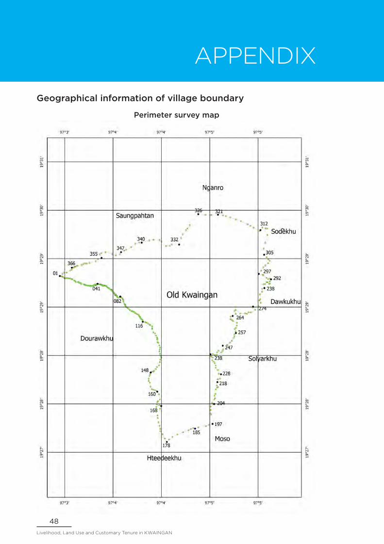
Geographical information of village boundary
Perimeter survey map

49Report of a Participatory Action Research
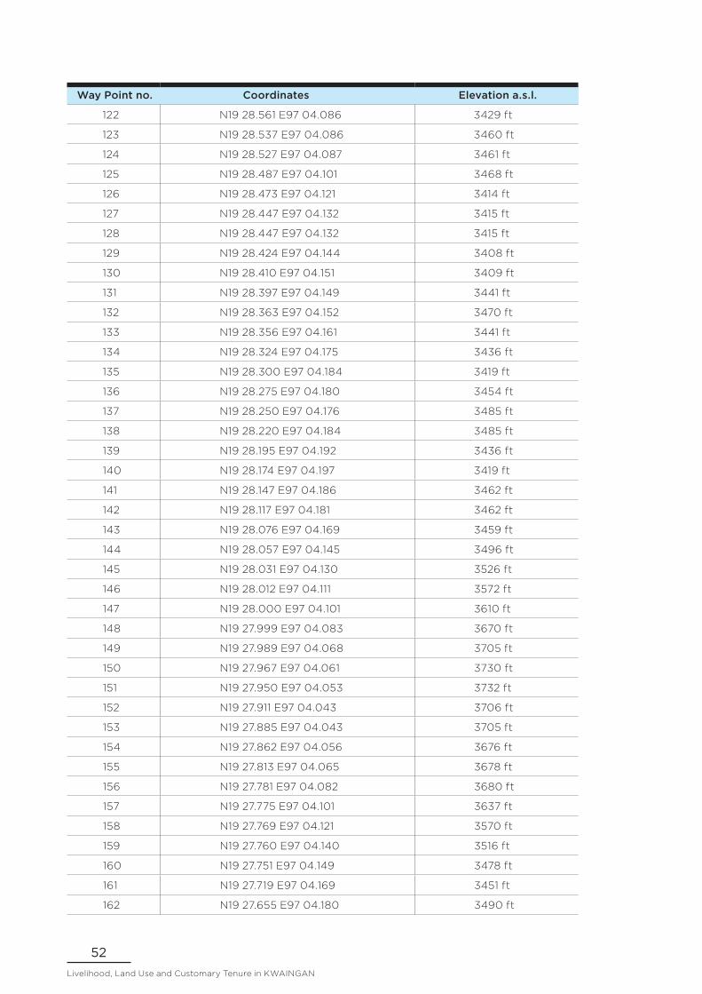
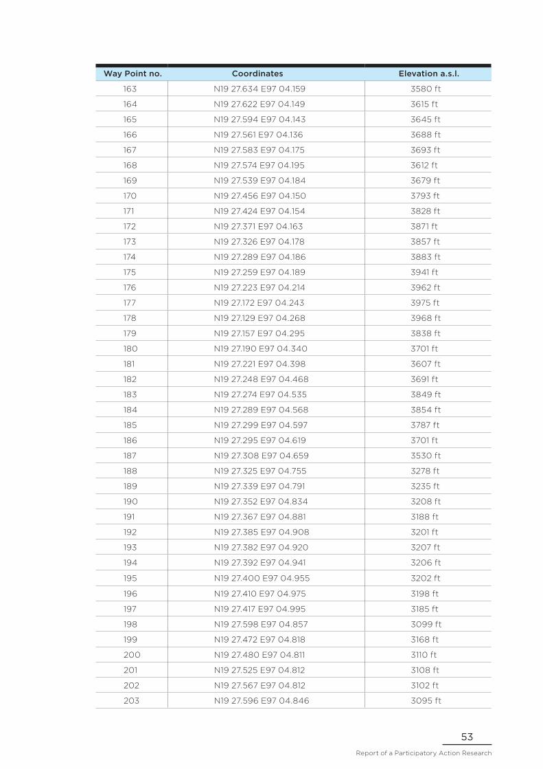
Perimeter survey waypoints data
Way Point no. Coordinates Elevation a.s.l.
1 N19 29.182 E97 02.959 3965 ft
2 N19 29.175 E97 02.972 3982 ft
3 N19 29.177 E97 02.975 3972 ft
4 N19 29.165 E97 02.988 3963 ft
5 N19 29.154 E97 03.002 3948 ft
6 N19 29.155 E97 03.009 3925 ft
7 N19 29.160 E97 03.022 3905 ft
8 N19 29.157 E97 03.036 3889 ft
9 N19 29.155 E97 03.050 3890 ft
10 N19 29.155 E97 03.068 3873 ft
11 N19 29.151 E97 03.078 3858 ft
12 N19 29.145 E97 03.090 3851 ft
13 N19 29.142 E97 03.096 3846 ft
14 N19 29.129 E97 03.119 3858 ft
15 N19 29.120 E97 03.131 3881 ft
16 N19 29.109 E97 03.142 3904 ft
17 N19 29.110 E97 03.167 3912 ft
18 N19 29.108 E97 03.170 3915 ft
19 N19 29.104 E97 03.178 3929 ft
20 N19 29.099 E97 03.189 3948 ft
21 N19 29.093 E97 03.198 3971 ft
22 N19 29.089 E97 03.207 3986 ft
23 N19 29.081 E97 03.238 3984 ft
24 N19 29.074 E97 03.250 3991 ft
25 N19 29.077 E97 03.254 3979 ft
26 N19 29.071 E97 03.264 3981 ft
27 N19 29.067 E97 03.279 3985 ft
28 N19 29.064 E97 03.295 3965 ft
29 N19 29.066 E97 03.303 3947 ft
30 N19 29.063 E97 03.315 3932 ft
31 N19 29.064 E97 03.321 3921 ft
32 N19 29.060 E97 03.326 3918 ft
33 N19 29.061 E97 03.336 3897 ft
34 N19 29.063 E97 03.352 3857 ft
35 N19 29.069 E97 03.356 3836 ft
36 N19 29.073 E97 03.366 3793 ft
37 N19 29.078 E97 03.375 3770 ft
38 N19 29.068 E97 03.382 3786 ft
39 N19 29.072 E97 03.389 3766 ft

50Livelihood, Land Use and Customary Tenure in KWAINGAN
Way Point no. Coordinates Elevation a.s.l.
40 N19 29.080 E97 03.393 3730 ft
41 N19 29.087 E97 03.402 3692 ft
42 N19 29.089 E97 03.407 3657 ft
43 N19 29.085 E97 03.414 3651 ft
44 N19 29.085 E97 03.428 3625 ft
45 N19 29.080 E97 03.444 3606 ft
46 N19 29.079 E97 03.447 3603 ft
47 N19 29.076 E97 03.449 3608 ft
48 N19 29.078 E97 03.456 3597 ft
49 N19 29.072 E97 03.461 3606 ft
50 N19 29.067 E97 03.467 3604 ft
51 N19 29.062 E97 03.470 3618 ft
52 N19 29.067 E97 03.478 3618 ft
53 N19 29.068 E97 03.487 3561 ft
54 N19 29.064 E97 03.488 3558 ft
55 N19 29.065 E97 03.503 3543 ft
56 N19 29.064 E97 03.511 3533 ft
57 N19 29.057 E97 03.520 3527 ft
58 N19 29.048 E97 03.525 3528 ft
59 N19 29.038 E97 03.538 3524 ft
60 N19 29.034 E97 03.547 3517 ft
61 N19 29.030 E97 03.555 3522 ft
62 N19 29.018 E97 03.569 3497 ft
63 N19 29.013 E97 03.578 3493 ft
64 N19 29.015 E97 03.582 3476 ft
65 N19 29.010 E97 03.585 3468 ft
66 N19 29.006 E97 03.583 3471 ft
67 N19 28.994 E97 03.593 3481 ft
68 N19 28.983 E97 03.604 3476 ft
69 N19 28.972 E97 03.615 3479 ft
70 N19 28.963 E97 03.619 3480 ft
71 N19 28.954 E97 03.621 3518 ft
72 N19 28.946 E97 03.628 3512 ft
73 N19 28.946 E97 03.630 3512 ft
74 N19 28.952 E97 03.635 3498 ft
75 N19 28.946 E97 03.639 3482 ft
76 N19 28.938 E97 03.647 3508 ft
77 N19 28.932 E97 03.646 3524 ft
78 N19 28.924 E97 03.652 3544 ft
79 N19 28.915 E97 03.666 3514 ft
80 N19 28.924 E97 03.682 3474 ft

51Report of a Participatory Action Research
Way Point no. Coordinates Elevation a.s.l.
81 N19 28.929 E97 03.688 3437 ft
82 N19 28.925 E97 03.693 3426 ft
83 N19 28.925 E97 03.698 3421 ft
84 N19 28.918 E97 03.703 3424 ft
85 N19 28.904 E97 03.717 3432 ft
86 N19 28.896 E97 03.722 3437 ft
87 N19 28.887 E97 03.727 3448 ft
88 N19 28.886 E97 03.727 3473 ft
89 N19 28.865 E97 03.729 3503 ft
90 N19 28.842 E97 03.739 3513 ft
91 N19 28.831 E97 03.752 3521 ft
92 N19 28.827 E97 03.752 3537 ft
93 N19 28.820 E97 03.750 3565 ft
94 N19 28.804 E97 03.759 3558 ft
95 N19 28.799 E97 03.767 3542 ft
96 N19 28.788 E97 03.781 3540 ft
97 N19 28.778 E97 03.794 3549 ft
98 N19 28.761 E97 03.810 3553 ft
99 N19 28.749 E97 03.830 3543 ft
100 N19 28.750 E97 03.839 3518 ft
101 N19 28.746 E97 03.845 3503 ft
102 N19 28.741 E97 03.856 3493 ft
103 N19 28.736 E97 03.867 3464 ft
104 N19 28.728 E97 03.874 3469 ft
105 N19 28.718 E97 03.888 3443 ft
106 N19 28.713 E97 03.904 3435 ft
107 N19 28.702 E97 03.917 3416 ft
108 N19 28.688 E97 03.926 3432 ft
109 N19 28.684 E97 03.930 3452 ft
110 N19 28.677 E97 03.933 3465 ft
111 N19 28.669 E97 03.940 3460 ft
112 N19 28.657 E97 03.945 3486 ft
113 N19 28.649 E97 03.954 3473 ft
114 N19 28.638 E97 03.965 3487 ft
115 N19 28.632 E97 03.967 3511 ft
116 N19 28.620 E97 03.971 3527 ft
117 N19 28.612 E97 03.998 3485 ft
118 N19 28.608 E97 04.014 3444 ft
119 N19 28.597 E97 04.034 3447 ft
120 N19 28.583 E97 04.052 3447 ft
121 N19 28.577 E97 04.064 3434 ft
52Livelihood, Land Use and Customary Tenure in KWAINGAN
Way Point no. Coordinates Elevation a.s.l.
122 N19 28.561 E97 04.086 3429 ft
123 N19 28.537 E97 04.086 3460 ft
124 N19 28.527 E97 04.087 3461 ft
125 N19 28.487 E97 04.101 3468 ft
126 N19 28.473 E97 04.121 3414 ft
127 N19 28.447 E97 04.132 3415 ft
128 N19 28.447 E97 04.132 3415 ft
129 N19 28.424 E97 04.144 3408 ft
130 N19 28.410 E97 04.151 3409 ft
131 N19 28.397 E97 04.149 3441 ft
132 N19 28.363 E97 04.152 3470 ft
133 N19 28.356 E97 04.161 3441 ft
134 N19 28.324 E97 04.175 3436 ft
135 N19 28.300 E97 04.184 3419 ft
136 N19 28.275 E97 04.180 3454 ft
137 N19 28.250 E97 04.176 3485 ft
138 N19 28.220 E97 04.184 3485 ft
139 N19 28.195 E97 04.192 3436 ft
140 N19 28.174 E97 04.197 3419 ft
141 N19 28.147 E97 04.186 3462 ft
142 N19 28.117 E97 04.181 3462 ft
143 N19 28.076 E97 04.169 3459 ft
144 N19 28.057 E97 04.145 3496 ft
145 N19 28.031 E97 04.130 3526 ft
146 N19 28.012 E97 04.111 3572 ft
147 N19 28.000 E97 04.101 3610 ft
148 N19 27.999 E97 04.083 3670 ft
149 N19 27.989 E97 04.068 3705 ft
150 N19 27.967 E97 04.061 3730 ft
151 N19 27.950 E97 04.053 3732 ft
152 N19 27.911 E97 04.043 3706 ft
153 N19 27.885 E97 04.043 3705 ft
154 N19 27.862 E97 04.056 3676 ft
155 N19 27.813 E97 04.065 3678 ft
156 N19 27.781 E97 04.082 3680 ft
157 N19 27.775 E97 04.101 3637 ft
158 N19 27.769 E97 04.121 3570 ft
159 N19 27.760 E97 04.140 3516 ft
160 N19 27.751 E97 04.149 3478 ft
161 N19 27.719 E97 04.169 3451 ft
162 N19 27.655 E97 04.180 3490 ft
53Report of a Participatory Action Research
Way Point no. Coordinates Elevation a.s.l.
163 N19 27.634 E97 04.159 3580 ft
164 N19 27.622 E97 04.149 3615 ft
165 N19 27.594 E97 04.143 3645 ft
166 N19 27.561 E97 04.136 3688 ft
167 N19 27.583 E97 04.175 3693 ft
168 N19 27.574 E97 04.195 3612 ft
169 N19 27.539 E97 04.184 3679 ft
170 N19 27.456 E97 04.150 3793 ft
171 N19 27.424 E97 04.154 3828 ft
172 N19 27.371 E97 04.163 3871 ft
173 N19 27.326 E97 04.178 3857 ft
174 N19 27.289 E97 04.186 3883 ft
175 N19 27.259 E97 04.189 3941 ft
176 N19 27.223 E97 04.214 3962 ft
177 N19 27.172 E97 04.243 3975 ft
178 N19 27.129 E97 04.268 3968 ft
179 N19 27.157 E97 04.295 3838 ft
180 N19 27.190 E97 04.340 3701 ft
181 N19 27.221 E97 04.398 3607 ft
182 N19 27.248 E97 04.468 3691 ft
183 N19 27.274 E97 04.535 3849 ft
184 N19 27.289 E97 04.568 3854 ft
185 N19 27.299 E97 04.597 3787 ft
186 N19 27.295 E97 04.619 3701 ft
187 N19 27.308 E97 04.659 3530 ft
188 N19 27.325 E97 04.755 3278 ft
189 N19 27.339 E97 04.791 3235 ft
190 N19 27.352 E97 04.834 3208 ft
191 N19 27.367 E97 04.881 3188 ft
192 N19 27.385 E97 04.908 3201 ft
193 N19 27.382 E97 04.920 3207 ft
194 N19 27.392 E97 04.941 3206 ft
195 N19 27.400 E97 04.955 3202 ft
196 N19 27.410 E97 04.975 3198 ft
197 N19 27.417 E97 04.995 3185 ft
198 N19 27.598 E97 04.857 3099 ft
199 N19 27.472 E97 04.818 3168 ft
200 N19 27.480 E97 04.811 3110 ft
201 N19 27.525 E97 04.812 3108 ft
202 N19 27.567 E97 04.812 3102 ft
203 N19 27.596 E97 04.846 3095 ft

54Livelihood, Land Use and Customary Tenure in KWAINGAN
Way Point no. Coordinates Elevation a.s.l.
204 N19 27.610 E97 04.831 3094 ft
205 N19 27.628 E97 04.822 3097 ft
206 N19 27.653 E97 04.854 3098 ft
207 N19 27.669 E97 04.866 3092 ft
208 N19 27.681 E97 04.821 3094 ft
209 N19 27.701 E97 04.858 3088 ft
210 N19 27.722 E97 04.871 3086 ft
211 N19 27.735 E97 04.826 3090 ft
212 N19 27.778 E97 04.840 3087 ft
213 N19 27.780 E97 04.876 3086 ft
214 N19 27.799 E97 04.853 3081 ft
215 N19 27.816 E97 04.872 3083 ft
216 N19 27.801 E97 04.894 3081 ft
217 N19 27.807 E97 04.901 3083 ft
218 N19 27.827 E97 04.888 3081 ft
219 N19 27.871 E97 04.895 3080 ft
220 N19 27.904 E97 04.900 3077 ft
221 N19 27.912 E97 04.926 3081 ft
222 N19 27.967 E97 04.939 3080 ft
223 N19 27.972 E97 04.913 3080 ft
224 N19 28.020 E97 04.900 3080 ft
225 N19 28.048 E97 04.874 3078 ft
226 N19 28.076 E97 04.872 3080 ft
227 N19 28.104 E97 04.862 3079 ft
228 N19 28.123 E97 04.850 3076 ft
229 N19 28.141 E97 04.832 3079 ft
230 N19 28.175 E97 04.836 3076 ft
231 N19 28.188 E97 04.816 3079 ft
232 N19 28.212 E97 04.810 3079 ft
233 N19 28.217 E97 04.839 3075 ft
234 N19 28.204 E97 04.862 3075 ft
235 N19 28.208 E97 04.885 3077 ft
236 N19 28.240 E97 04.893 3078 ft
237 N19 28.260 E97 04.909 3077 ft
238 N19 28.234 E97 04.944 3076 ft
239 N19 28.257 E97 04.960 3077 ft
240 N19 28.275 E97 04.968 3076 ft
241 N19 28.322 E97 04.961 3073 ft
242 N19 28.331 E97 05.019 3077 ft
243 N19 28.357 E97 05.052 3075 ft
244 N19 28.381 E97 05.074 3076 ft

55Report of a Participatory Action Research
Way Point no. Coordinates Elevation a.s.l.
245 N19 28.417 E97 05.096 3075 ft
246 N19 28.439 E97 05.108 3074 ft
247 N19 28.462 E97 05.107 3075 ft
248 N19 28.480 E97 05.125 3072 ft
249 N19 28.498 E97 05.120 3069 ft
250 N19 28.526 E97 05.110 3069 ft
251 N19 28.542 E97 05.126 3069 ft
252 N19 28.570 E97 05.138 3066 ft
253 N19 28.605 E97 05.137 3063 ft
254 N19 28.627 E97 05.090 3064 ft
255 N19 28.641 E97 05.076 3066 ft
256 N19 28.648 E97 05.057 3067 ft
257 N19 28.682 E97 05.059 3068 ft
258 N19 28.689 E97 05.084 3065 ft
259 N19 28.715 E97 05.122 3068 ft
260 N19 28.752 E97 05.110 3069 ft
261 N19 28.765 E97 05.122 3068 ft
262 N19 28.720 E97 05.178 3067 ft
263 N19 28.722 E97 05.237 3069 ft
264 N19 28.717 E97 05.260 3066 ft
265 N19 28.734 E97 05.282 3070 ft
266 N19 28.734 E97 05.310 3069 ft
267 N19 28.767 E97 05.362 3067 ft
268 N19 28.793 E97 05.333 3071 ft
269 N19 28.804 E97 05.338 3067 ft
270 N19 28.813 E97 05.405 3063 ft
271 N19 28.854 E97 05.431 3068 ft
272 N19 28.883 E97 05.416 3066 ft
273 N19 28.897 E97 05.426 3062 ft
274 N19 28.956 E97 05.423 3062 ft
275 N19 28.990 E97 05.450 3060 ft
276 N19 29.028 E97 05.450 3058 ft
277 N19 29.036 E97 05.478 3060 ft
278 N19 29.082 E97 05.467 3060 ft
279 N19 29.085 E97 05.485 3057 ft
280 N19 29.109 E97 05.505 3058 ft
281 N19 29.108 E97 05.518 3059 ft
282 N19 29.089 E97 05.535 3059 ft
283 N19 29.089 E97 05.547 3058 ft
284 N19 29.119 E97 05.547 3056 ft
285 N19 29.145 E97 05.562 3056 ft

56Livelihood, Land Use and Customary Tenure in KWAINGAN
Way Point no. Coordinates Elevation a.s.l.
286 N19 29.151 E97 05.549 3057 ft
287 N19 29.147 E97 05.525 3060 ft
288 N19 29.162 E97 05.504 3057 ft
289 N19 29.196 E97 05.464 3069 ft
290 N19 29.200 E97 05.457 3071 ft
291 N19 29.210 E97 05.409 3072 ft
292 N19 29.252 E97 05.438 3077 ft
293 N19 29.290 E97 05.466 3072 ft
294 N19 29.317 E97 05.490 3078 ft
295 N19 29.345 E97 05.525 3074 ft
296 N19 29.375 E97 05.543 3068 ft
297 N19 29.393 E97 05.528 3073 ft
298 N19 29.419 E97 05.506 3073 ft
299 N19 29.449 E97 05.475 3074 ft
300 N19 29.523 E97 05.469 3091 ft
301 N19 29.596 E97 05.489 3083 ft
302 N19 29.693 E97 05.516 3064 ft
303 N19 29.772 E97 05.514 3063 ft
304 N19 29.776 E97 05.493 3057 ft
305 N19 29.784 E97 05.453 3061 ft
306 N19 29.754 E97 05.429 3060 ft
307 N19 29.742 E97 05.420 3066 ft
308 N19 29.783 E97 05.345 3071 ft
309 N19 29.807 E97 05.303 3063 ft
310 N19 29.827 E97 05.270 3068 ft
311 N19 29.865 E97 05.187 3076 ft
312 N19 29.885 E97 05.127 3072 ft
313 N19 29.910 E97 05.052 3082 ft
314 N19 29.928 E97 05.000 3091 ft
315 N19 29.938 E97 04.962 3096 ft
316 N19 29.945 E97 04.901 3098 ft
317 N19 29.941 E97 04.816 3096 ft
318 N19 29.941 E97 04.816 3097 ft
319 N19 29.945 E97 04.746 3106 ft
320 N19 29.952 E97 04.657 3142 ft
321 N19 29.816 E97 04.552 3202 ft
322 N19 29.771 E97 04.522 3265 ft
323 N19 29.752 E97 04.506 3270 ft
324 N19 29.704 E97 04.464 3225 ft
325 N19 29.657 E97 04.447 3192 ft
326 N19 29.578 E97 04.421 3163 ft

57Report of a Participatory Action Research
Way Point no. Coordinates Elevation a.s.l.
327 N19 29.579 E97 04.328 3216 ft
328 N19 29.563 E97 04.303 3221 ft
329 N19 29.557 E97 04.258 3247 ft
330 N19 29.612 E97 04.201 3285 ft
331 N19 29.629 E97 04.177 3335 ft
332 N19 29.635 E97 04.103 3353 ft
333 N19 29.625 E97 04.049 3377 ft
334 N19 29.601 E97 03.955 3460 ft
335 N19 29.600 E97 03.925 3495 ft
336 N19 29.584 E97 03.877 3512 ft
337 N19 29.544 E97 03.824 3532 ft
338 N19 29.509 E97 03.763 3620 ft
339 N19 29.501 E97 03.739 3660 ft
340 N19 29.480 E97 03.699 3719 ft
341 N19 29.456 E97 03.684 3808 ft
342 N19 29.441 E97 03.634 3932 ft
343 N19 29.458 E97 03.590 3940 ft
344 N19 29.480 E97 03.507 4055 ft
345 N19 29.471 E97 03.455 4194 ft
346 N19 29.455 E97 03.436 4332 ft
347 N19 29.406 E97 03.458 4326 ft
348 N19 29.396 E97 03.411 4355 ft
349 N19 29.368 E97 03.386 4335 ft
350 N19 29.348 E97 03.306 4373 ft
351 N19 29.337 E97 03.276 4409 ft
352 N19 29.340 E97 03.253 4403 ft
353 N19 29.334 E97 03.231 4352 ft
354 N19 29.321 E97 03.209 4328 ft
355 N19 29.311 E97 03.158 4295 ft
356 N19 29.305 E97 03.144 4287 ft
357 N19 29.298 E97 03.127 4253 ft
358 N19 29.301 E97 03.126 4224 ft
359 N19 29.289 E97 03.109 4128 ft
360 N19 29.289 E97 03.089 4053 ft
361 N19 29.265 E97 03.086 3915 ft
362 N19 29.255 E97 03.069 3912 ft
363 N19 29.227 E97 03.023 3875 ft
364 N19 29.228 E97 02.992 3900 ft
365 N19 29.212 E97 02.975 3926 ft
366 N19 29.185 E97 02.942 3908 ft