Embed Size (px)
Citation preview
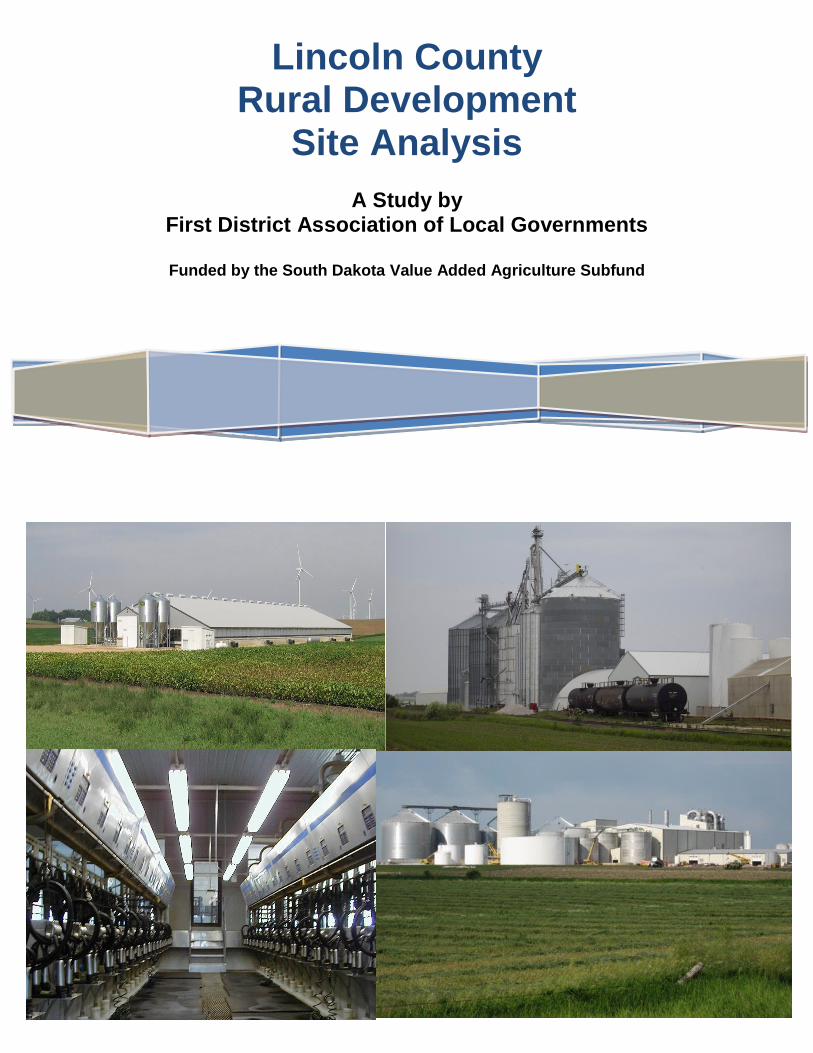
Lincoln County Rural Development
Site Analysis
A Study by First District Association of Local Governments
Funded by the South Dakota Value Added Agriculture Subfund

Lincoln County Rural Development Site Analysis – First District Association of Local Governments – 11/25/13 Page 1
TABLE OF CONTENTS SUMMARY ................................................................................................................................. 2 SECTION 1 – SITE ASSESSMENT CRITERIA .......................................................................... 6
Land Use Regulations ..................................................................................................... 7
Environmental ............................................................................................................... 10
Infrastructure ................................................................................................................. 10 SECTION 2 – RESEARCH AND METHODOLGY .................................................................... 13 SECTION 3 – CONTACT INFORMATION ................................................................................ 16 LIST OF TABLES
Table 1 Site Characteristics Criteria .................................................................................... 13 LIST OF MAPS
Potential CAFO Development Sites Map ............................................................................... 4
Potential AID Development Sites Map ................................................................................... 5
Lincoln County Rural Development Site Analysis – First District Association of Local Governments – 11/25/13 Page 2
SUMMARY
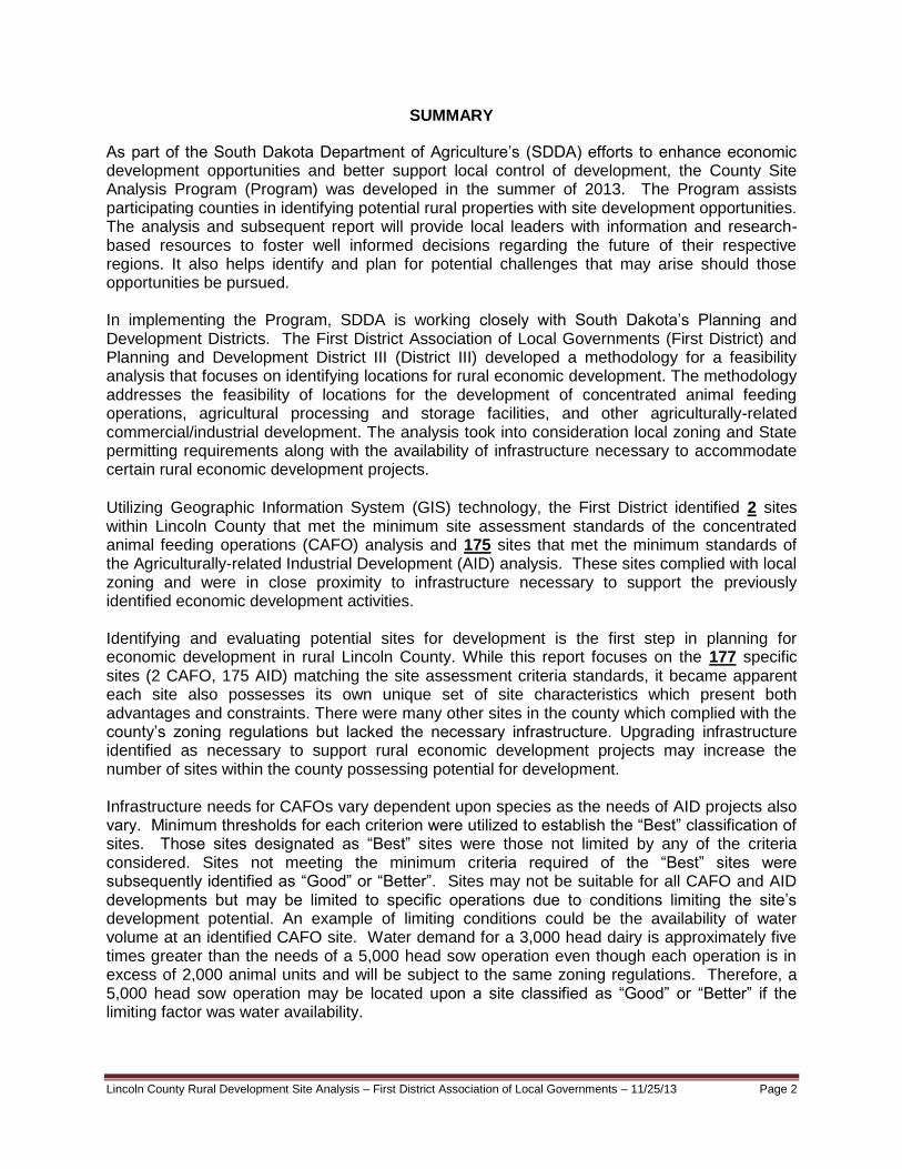
As part of the South Dakota Department of Agriculture’s (SDDA) efforts to enhance economic development opportunities and better support local control of development, the County Site Analysis Program (Program) was developed in the summer of 2013. The Program assists participating counties in identifying potential rural properties with site development opportunities. The analysis and subsequent report will provide local leaders with information and research-based resources to foster well informed decisions regarding the future of their respective regions. It also helps identify and plan for potential challenges that may arise should those opportunities be pursued. In implementing the Program, SDDA is working closely with South Dakota’s Planning and Development Districts. The First District Association of Local Governments (First District) and Planning and Development District III (District III) developed a methodology for a feasibility analysis that focuses on identifying locations for rural economic development. The methodology addresses the feasibility of locations for the development of concentrated animal feeding operations, agricultural processing and storage facilities, and other agriculturally-related commercial/industrial development. The analysis took into consideration local zoning and State permitting requirements along with the availability of infrastructure necessary to accommodate certain rural economic development projects.
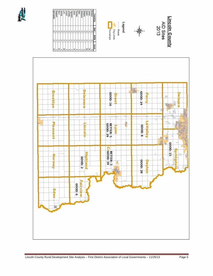
Utilizing Geographic Information System (GIS) technology, the First District identified 2 sites within Lincoln County that met the minimum site assessment standards of the concentrated animal feeding operations (CAFO) analysis and 175 sites that met the minimum standards of the Agriculturally-related Industrial Development (AID) analysis. These sites complied with local zoning and were in close proximity to infrastructure necessary to support the previously identified economic development activities. Identifying and evaluating potential sites for development is the first step in planning for economic development in rural Lincoln County. While this report focuses on the 177 specific sites (2 CAFO, 175 AID) matching the site assessment criteria standards, it became apparent each site also possesses its own unique set of site characteristics which present both advantages and constraints. There were many other sites in the county which complied with the county’s zoning regulations but lacked the necessary infrastructure. Upgrading infrastructure identified as necessary to support rural economic development projects may increase the number of sites within the county possessing potential for development. Infrastructure needs for CAFOs vary dependent upon species as the needs of AID projects also vary. Minimum thresholds for each criterion were utilized to establish the “Best” classification of sites. Those sites designated as “Best” sites were those not limited by any of the criteria considered. Sites not meeting the minimum criteria required of the “Best” sites were subsequently identified as “Good” or “Better”. Sites may not be suitable for all CAFO and AID developments but may be limited to specific operations due to conditions limiting the site’s development potential. An example of limiting conditions could be the availability of water volume at an identified CAFO site. Water demand for a 3,000 head dairy is approximately five times greater than the needs of a 5,000 head sow operation even though each operation is in excess of 2,000 animal units and will be subject to the same zoning regulations. Therefore, a 5,000 head sow operation may be located upon a site classified as “Good” or “Better” if the limiting factor was water availability.

Lincoln County Rural Development Site Analysis – First District Association of Local Governments – 11/25/13 Page 3
The primary limiting factor in reviewing a property’s development potential is the availability of quality potable water. The same is true with agricultural-related industrial developments which also require a reliable source of high quality water. Access to a centralized water source such as rural water was identified as a key component in the site analysis process. For example, none of the AID sites were identified as being “Better” or “Best”. This was due primarily to Lincoln County’s zoning requirements and also the lack of adequate infrastructure (rail, water). However, the rural water systems in Lincoln County noted that if a significant water user (CAFO or AID) would locate in the county; all three rural water systems would explore ways to improve their supply and distribution systems in order to provide water to the proposed development. Therefore the analysis does not make the claim that the only sites for CAFO and AID development in Lincoln County be relegated to the 177 specific sites identified herein. The site assessment process was limited in scope to include undeveloped parcels and did not consider expansion of existing CAFOs or commercial/industrial uses. In addition to this limited scope, minimum values were utilized in ranking each site with regards to zoning requirements and infrastructure demands. No attempt was made to rank each site within the three identified classifications. The uniqueness of each criterion identified in Table 1 warrants a comprehensive review of the potential impact each may have upon a subject property. This study is intended as the first step of a multi-faceted development process potentially leading to more specific site evaluations such as Phase 1 Environmental Assessments, engineering plans, development cost analysis, etc. Identification of each site’s relative advantages and constraints provides decision-makers with useful information for assessing the development potential of each site. The information contained herein has the potential to streamline the marketing process thereby reducing timelines, financial expenditures and labor costs. Local governments, landowners, economic development groups and state agencies such as the Department of Agriculture or Governor’s Office of Economic Development all benefit from the rural site development analysis. These entities now have access to a marketing tool based on proactive planning efforts. In addition, the report may assist local governments in updating their comprehensive plans, zoning ordinances and permitting procedures while also increasing local awareness of potential development opportunities. The findings of this report will assist in determining the potential role each site may play in supporting economic development and should be considered when planning for future projects within Lincoln County. The remainder of the report has been divided into two sections. Section 1 provides an overview of the criteria utilized as part of the Rural Site Development Analysis while Section 2 explains the methodology incorporated into the review phase and identifies the “Good”, “Better”, and “Best” hierarchy. As previously mentioned, there were 2 sites within Lincoln County which met the minimum standards for inclusion as potential Concentrated Animal Feeding Operation (CAFO) sites and 175 sites met the minimum standards for agriculturally-related industrial development (AID) sites. The following maps provide information at a township level regarding the number of “Good”, “Better” and “Best” CAFO and AID development sites.

Lincoln County Rural Development Site Analysis – First District Association of Local Governments – 11/25/13 Page 4
Lincoln County Rural Development Site Analysis – First District Association of Local Governments – 11/25/13 Page 5

Lincoln County Rural Development Site Analysis – First District Association of Local Governments – 11/25/13 Page 6
SECTION 1: SITE ASSESSMENT CRITERIA
Lincoln County Location Map The analysis methodology developed for this study utilized an established set of criteria deemed critical to further development of the subject properties while specifically addressing the suitability of a site for either a CAFO or an AID. Sites possessing all of the criteria identified as critical within the analysis will be those most sought by potential developers. The occurrence of these sites may be somewhat rare therefore sites under consideration for either a CAFO or AID may meet the majority of criteria, but will be lacking in several specific areas. Any sites not meeting all the criteria may be burdened with a limitation thus requiring more specific analysis. In these cases, the feasibility of developing the site is highly dependent upon the identified limitation(s). Earlier, an example of a potential site limitation was discussed regarding the demand for water. In that situation, the lack of water in the volume necessary for a dairy lent the site to be more likely developed as a swine facility. This example did not explore potential alternatives to the water shortage. The absence of adequate rural water volume at the site may require upsizing of the water infrastructure or securing an alternative water source. All of which hold the potential to mitigate this constraint thereby facilitating the proposed development. In other cases, however, failure to meet certain criteria, such as access to a quality road network, may result in a situation where development of the site becomes economically unfeasible. The site assessment criteria, depending upon whether or not the site is for a CAFO or AID project, have been divided into three major categories to include:

Lincoln County Rural Development Site Analysis – First District Association of Local Governments – 11/25/13 Page 7
I. LAND USE REGULATIONS a. Alignment with Local and Regional Plans b. Compliance with Local Zoning Regulations c. Minimum Lot Area
II. ENVIRONMENTAL
a. Potential Environmental Constraints - Aquifer
III. INFRASTRUCTURE
a. Water Supply b. Electrical Supply c. Transportation Networks – Access to State and/or County Roads and Rail
LAND USE REGULATIONS Economic development planning in Lincoln County must be conducted in concert with the county’s overall economic development goals. All development activities, including those specifically related to agriculture need to be accomplished within the parameters set forth in local and regional planning documents Land use or development guidance is traditionally provided via local documents such as Comprehensive Plans, Zoning Ordinances, Policies, Mission Statements and other local economic development plans and initiatives. Comprehensive Land Use Plan The 2005-2025 Lincoln County Comprehensive Land Use Plan provides guidance for large scale animal agricultural development and agriculturally-related commercial and industrial development in order to ensure an adequate supply of sites are available for future development in the county. The need to plan for CAFO and AID development is supported by the 2005-2025 Plan, which states: Planning Policy Framework
Lincoln County has the role not only to promote orderly, compatible and efficient growth within the agricultural areas but also to ensure that land use decisions are in the best interests of other governmental entities, who will eventually be expected to provide services to development areas.
Projections to the year 2025 indicate that numerous housing units will be constructed in the agricultural areas and additional agricultural land will be converted to commercial and industrial uses, causing significant changes in the county’s physical environment. This anticipated growth will present challenges to the Planning Commission and the Board of County Commissioners as well as to citizens of the county in dealing with substantially more population and economic development than exists today

Lincoln County Rural Development Site Analysis – First District Association of Local Governments – 11/25/13 Page 8
Agriculture - General Goals
To maintain a viable agricultural economy and preserve the rural quality of life. Urban Area Expansion Policy
Consider limited development in those areas where parcel size and competing land uses have substantially reduced the economic viability and future success of agricultural operations.
Agricultural Areas Policy
Agricultural areas are generally those areas which have experienced little or no competing non-farm development. These areas are intended to be preserved for farm related use where such activities can freely operate without the need to impose restrictions due to competing uses. A density standard not exceeding one dwelling per quarter-quarter section of land should be maintained for the planning area.
Regulate concentrated animal feeding and processing operations to protect the environment and minimize conflicts with human activities while giving due regard to existing operations.
Preserve and protect the agricultural productivity of land by restricting the development to a residential density of not more than one building site per quarter-quarter section.
The premature development of agricultural areas should be discouraged.
Protect the agricultural areas from uses which interfere and are not compatible with general farming practices.
Avoid regulations which have a negative impact on farming operations Development Plan Summary
Unrestricted residential development in the agricultural areas strains public services and conflicts with agricultural operations. This plan recognizes the importance of agricultural land and the adverse impacts resulting from over development of the agricultural areas.
.
Commercial/Industrial Land Use – Agricultural Area
Discourage the random and haphazard siting of commercial and industrial uses within the Agricultural areas.
Rural Commercial/Industrial Areas
The future land use plan encourages the majority of commercial and industrial development to locate within the cities. However, it is recognized that convenience goods and services as well as some industrial uses could be appropriately sited within the rural commercial/industrial areas. These locations include existing commercial/industrial areas where some reasonable expansion is appropriate and at major highway intersections.
Lincoln County Rural Development Site Analysis – First District Association of Local Governments – 11/25/13 Page 9
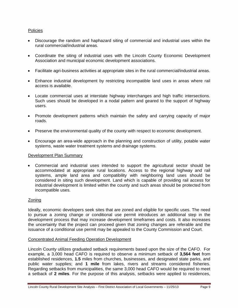
Policies
Discourage the random and haphazard siting of commercial and industrial uses within the rural commercial/industrial areas.
Coordinate the siting of industrial uses with the Lincoln County Economic Development Association and municipal economic development associations.
Facilitate agri-business activities at appropriate sites in the rural commercial/industrial areas.
Enhance industrial development by restricting incompatible land uses in areas where rail access is available.
Locate commercial uses at interstate highway interchanges and high traffic intersections. Such uses should be developed in a nodal pattern and geared to the support of highway users.
Promote development patterns which maintain the safety and carrying capacity of major roads.
Preserve the environmental quality of the county with respect to economic development.
Encourage an area-wide approach in the planning and construction of utility, potable water systems, waste water treatment systems and drainage systems.
Development Plan Summary
Commercial and industrial uses intended to support the agricultural sector should be accommodated at appropriate rural locations. Access to the regional highway and rail systems, ample land area and compatibility with neighboring land uses should be considered in siting such development. Land which is capable of providing rail access for industrial development is limited within the county and such areas should be protected from incompatible uses.
Zoning Ideally, economic developers seek sites that are zoned and eligible for specific uses. The need to pursue a zoning change or conditional use permit introduces an additional step in the development process that may increase development timeframes and costs. It also increases the uncertainty that the project can proceed given that zoning changes are referable and the issuance of a conditional use permit may be appealed to the County Commission and Court. Concentrated Animal Feeding Operation Development Lincoln County utilizes graduated setback requirements based upon the size of the CAFO. For example, a 3,000 head CAFO is required to observe a minimum setback of 3,564 feet from established residences, 1.5 miles from churches, businesses, and designated state parks, and public water supplies; and 1 mile from lakes, rivers and streams considered fisheries. Regarding setbacks from municipalities, the same 3,000 head CAFO would be required to meet a setback of 2 miles. For the purpose of this analysis, setbacks were applied to residences,
Lincoln County Rural Development Site Analysis – First District Association of Local Governments – 11/25/13 Page 10
municipalities and lakes, rivers, and streams considered fisheries. While it is possible that some of the sites identified in the analysis as good, better, or best may be impacted due to the possibility that a church, school or business is located within 1.5 miles of a proposed CAFO site, it is believed that the incidence is minimal. Both CAFO sites in the analysis are currently zoned in Lincoln County as agricultural and all or a portion of the legally described parcels, according to the best available data, further meet the required setback and lot area requirements. Commercial/Industrial Development There are approximately 20 locations currently zoned for industrial activity within the county. It is the intention of Lincoln County high amenity industrial development along the major roads and adjacent to residential areas, while allowing for slightly heavier development in the interior of the industrial areas. Further heavier industrial uses shall comply with any state regulations regarding noise, emissions, dust, odor, glare, vibration or heat when applicable. Light and heavy manufacturing uses are required to obtain a conditional use permit. Buildable Parcel One criterion deemed necessary to facilitate development of either a CAFO or an AID was land area. A parcel of 40 buildable acres was set as the minimum for consideration within the analysis. In order to be considered, the property must have consisted of 40 contiguous acres and able to support development upon all 40 acres. Parcels without 40 buildable acres were not considered in the final analysis. ENVIRONMENTAL The location of shallow aquifers in relation to potential development sites was included in the analysis. In reviewing shallow aquifers it is critical to note that they are included in the analysis for two distinct and very different reasons. Shallow aquifers may be utilized as a potential water source to support development. These same aquifers are vulnerable to pollution due to their proximity to the surface and must be protected via setbacks and development limitations. Prior to or contingent upon acquiring a parcel it is assumed other environmental factors potentially affecting the property would be addressed via a Phase I Environmental Assessment or similar process. It is recommended that developers consider undertaking such an inquiry prior to executing a major commitment to a particular location. The analysis did include a review of those parcels located over the shallow aquifer. Lincoln County’s Zoning regulations do not allow new or the expansion of existing CAFOs and certain industrial uses to be located over the shallow aquifer or in wellhead protection zones. Neither of the 2 CAFO sites identified by the analysis is located over the shallow aquifer or within a wellhead protection zone. INFRASTRUCTURE The term infrastructure is broad though in the context of property development the term includes essential services such as water, sewer, electrical, telecommunications, and roads. With regards to the rural site analysis process; access to quality roads, electrical capacity and water supply were deemed essential and indentified as site selection criteria.

Lincoln County Rural Development Site Analysis – First District Association of Local Governments – 11/25/13 Page 11
Transportation Access to quality roads was identified as critical to determining the development potential of a parcel. The proximity of a potential development site to either a state or county road was established as one of the parameters in conducting the rural site analysis. In addition to utilizing the South Dakota Department of Transportation’s road layer to identify roads and surface types, local experts were consulted to assist in identifying the road network. First District requested the Lincoln County Highway Superintendent to identify segments of the county road system inadequate to support a CAFO or AID. Sites accessed only by township roads were eliminated from the CAFO analysis and all potential AID sites abutting non hard surfaced roads and located greater than one-half mile from a hard surface road were also eliminated from the analysis. A potential development site’s proximity to certain road types impacted its designation. Those parcels abutting hard surface roads were consistently ranked higher than those served by gravel roads. In reviewing CAFO sites, parcels adjacent to a county or state hard surface road were designated “Better” or “Best” for transportation resources. Parcels adjacent to county gravel roads were designated “Good”. Regarding AID sites, parcels adjacent to a county or state hard surface road were designated “Best” and those parcels within one-half mile of a county or state hard surface road were designated “Good” or “Better”. Electric Supply Access to 3-phase power was designated as a site characteristics criterion for both CAFO and AID development. First District contacted the Southeastern Electric Cooperative, the primary provider of electricity in the county and Excel Energy, which supplies many of the communities and areas adjacent to those communities in Lincoln County to obtain the location and capacity of the 3-Phase infrastructure within the county. All parcels whether for CAFO or AID development adjacent to a 3-phase power line were designated “Best” for electricity resources. Whereas, parcels within one-half mile of a 3-phase power line were designated “Better” and those within 1 mile of a 3-phase power line were designated “Good Water Supply The ability to secure information regarding rural water distribution networks and capacity proved to be the most complex and difficult component of the infrastructure analysis. Due to this complexity, water resources were evaluated differently than transportation and electric infrastructure. While transportation and electric infrastructure were classified based solely upon proximity to roads and 3-phase power, the analysis of rural water systems first required the evaluation of the water systems based upon each system’s supply and distribution capacities. Development sites were then were selected based upon the proximity to water service. The classifications with regards to water supply and their respective criteria are as follows:
1. “Best”
a. CAFO - If the rural water system had sufficient supply and distribution (104 gallons per
minute for a CAFO see below) in a specific geographic area, that area was designated as “Best” for water resources.
Lincoln County Rural Development Site Analysis – First District Association of Local Governments – 11/25/13 Page 12
b. AID - If the rural water system had sufficient supply and distribution (285 gallons per minute for an AID site see below) in a specific geographic area, that area was designated as “Best” for water resources.
2. “Better” - In those geographic areas of the county where the rural water system had a
sufficient supply of water but inadequate distribution lines, or vice versa.
3. “Good” - In the event, the rural water system had neither supply or distribution within a geographic area a “Good” designation was applied to those areas that were within 2 miles but not closer than ½ mile from a shallow aquifer.
Upon defining the ranking criteria these parameters were utilized to evaluate potential CAFO and AID sites within Lincoln County. Potential CAFO development sites adjacent to a rural water system with the supply and distribution capacity of 104 gallons per minute were classified as “Best” for water resources. Parcels adjacent to a rural water system with the supply but not distribution capacity of 104 gallons per minute, or vice versa were classified as “Better”. Any sites identified as “Good” for water resources required those parcels to lack a central water source and be within 2 miles but not closer than ½ mile from a shallow aquifer. Due to the varying demands of potential uses a separate set of criteria was utilized to rank potential AID sites. Parcels adjacent to a rural water system with the supply and distribution capacity of 285 gallons per minute were classified as “Best” for water resources. Any parcels adjacent to a rural water system with the supply but not distribution capacity of 285 gallons per minute, or vice versa were classified as “Better”. Those sites ranked as “Good” included parcels which lacked a central water source and were within 2 miles but not closer than ½ mile from a shallow aquifer. The site analysis sought to address whether or not the rural water system serving the region had excess water treatment capacity (supply) and their ability to serve potential properties (distribution). In order to address the issue of supply each rural water system was requested to identify their surplus treatment capacity. In addition, each system was requested to notate on a map those geographic areas to which 104 gallons per minute could be accommodated as well as those areas where 20.8 gallons per minute could be supplied. These capacities are necessary to accommodate a 3,000 head dairy or 5,000 head sow operation, respectively. Food and animal processing facilities require an average of 285 gallons per minute therefore rural water providers were asked to note those areas where this volume is available. As noted earlier in an effort to conduct the most accurate analysis, the First District requested location and capacity information from the two rural water providers within Lincoln County. Lincoln County Rural Water System provides water to northern quarter of Lincoln County. South Lincoln Rural Water System provides water to rest of the county. Both rural water providers stated that they had areas within their system with sufficient distribution infrastructure to deliver the minimum required amounts of water for AID and CAFO development requiring lower water needs. However, only South Lincoln Rural Water System noted that they have excess supply capacity to meet minimum water delivery requirements (450,000 gallons). Neither system could commit to meeting the minimum CAFO “Best” requirement of 100 gallons per minute without the system being evaluated by their engineer; thereby also eliminating the potential for an AID site meeting the “Best” requirement of 285 gallons per minute. For these reasons, the analysis was unable to designate any CAFO or AID development site as “Best” in Lincoln County.

Lincoln County Rural Development Site Analysis – First District Association of Local Governments – 11/25/13 Page 13
SECTION 2: RESEARCH AND METHODOLOGY This section describes the methodology utilized to evaluate the suitability of potential sites for either CAFO or AID development. Step 1: Research on Site Characteristics Based on the general site assessment criteria established in Section 1 of this report, specific site characteristics necessary for determining the suitability of a potential site were developed. Table 1 lists the criteria identified as being necessary in order to conduct analysis of the potential sites. Utilizing these criteria as a guide, a variety of research methods were employed to compile the GIS data sets used in the analysis. This included the examination of local, regional, and state planning documents and existing GIS data layers.
Table 1: Site Characteristics Criteria
Step 2: Evaluation of Site Characteristics Criteria After developing the data sets in Table 1, the analysis identified those site locations that: 1. Complied with zoning and aquifer protection guidelines; and 2. Are in close proximity to infrastructure necessary to support either CAFO or AID
development. Concentrated Animal Feeding Operation (CAFO) The GIS analysis removed all parcels within the county from consideration that:
1. Did not have direct access to either a county or state road network; 2. Were not within one mile of three phase electric power; 3. Were completely located over a shallow aquifer/well-protection area; 4. Did not meet the one-half mile setback from existing residences, churches, businesses
and commercially zoned areas; 5. Did not meet the one-mile setback from municipalities; and 6. Did not contain a buildable footprint of at least forty (40) acres.
CAFO Criteria Ag-related Commercial/Industrial Criteria
County Zoning Setback Requirements Location of Communities
Location of Rural Residences & Communities Existing Zoning Districts
Existing Zoning Districts Location of Shallow Aquifer
Location of Shallow Aquifer Access to County and State Road Network
Access to County and State Road Network Proximity to three-phase Electrical Supply
Proximity to three-phase Electrical Supply Proximity to Water Supply
Proximity to Water Supply Capacity of Water Supply
Capacity of Water Supply Proximity to Rail
Proximity to Municipality

Lincoln County Rural Development Site Analysis – First District Association of Local Governments – 11/25/13 Page 14
After applying the local zoning and buildable footprint requirements to each site, the availability of necessary infrastructure was incorporated into the analysis. The general location of available water, electric and road infrastructure was applied to the remaining sites to establish a good, better, and best hierarchy of potential development sites. The result was the identification of 2 CAFO sites that fell into the design standards of one of the following three development standards: Good Sites (1 site) – Sites that were determined to be “Good” sites met the following criteria:
Site is adjacent to any state or county hard surfaced road or county gravel road
Site is within one mile of three phase power
Site meets Lincoln County concentrated animal feeding operation setback requirements and aquifer protection guidelines
Site is adjacent to rural water area designated BEST or BETTER, or within 2 miles but not closer than ½ mile from shallow aquifer (GOOD)
Site contains 40 acres of developable ground Better Sites (1 site) – Sites that were determined to be “Better” sites met the following criteria:
Site is adjacent to any state or county hard surfaced road
Site is within one-half mile of three phase power
Site meets Lincoln County concentrated animal feeding operation setback requirements and aquifer protection guidelines
Site is adjacent to rural water area designated BEST or BETTER
Site contains 40 acres of developable ground Best Sites (0 sites) – Sites that were determined to be “Best” sites met the following criteria:
Site is adjacent to any state or county hard surfaced road
Site is adjacent to three phase power
Site meets Lincoln County concentrated animal feeding operation setback requirements and aquifer protection guidelines
Site is adjacent to rural water area designated as BEST
Site contains 40 acres of developable ground Agriculturally-related Commercial/Industrial Development (AID) The GIS analysis removed all parcels within the county from consideration that: 1. Were not within one half mile of a state or county hard surfaced road; 2. Were not within one mile of three phase electric power; 3. Were not within one mile of rail; 4. Were completely located over a shallow aquifer/well-protection area; 5. Were within ¼ mile of a community of less than 1,000 people; 6. Were within ½ mile of community with more than 1,000 people; 7. Did not contain a buildable footprint of at least forty (40) acres. After applying the locational criteria and buildable footprint requirements to each site, the availability of necessary infrastructure was incorporated into the analysis. The general location of available water, electricity, road, and rail infrastructure and the proximity to a municipality was applied to the remaining sites to establish a good, better, and best hierarchy of potential
Lincoln County Rural Development Site Analysis – First District Association of Local Governments – 11/25/13 Page 15
development sites. The result was the identification of 175 AID sites that fell into the design standards of one of the following three development standards: Good Sites (167 sites) – Sites that were determined to be “Good” sites met the following criteria:
Site is within one-half mile of a state or county hard surfaced road
Site is within one mile of three phase power
Adjacent to rural water area designated BEST or BETTER, or within 2 miles but not closer than ½ mile from shallow aquifer (GOOD)
Site contains 40 acres of developable ground
Within one mile of rail Better Sites (8 sites) – Sites that were determined to be “Better” sites met the following criteria:
Site is within one-half mile of a state or county hard surfaced road
Site is within one-half mile of three phase power
Site is adjacent to rural water area designated BEST or BETTER
Site contains 40 acres of developable ground
Site is within one-half mile of rail
Site is in the comprehensive land use plan identified for future commercial/industrial development but not yet appropriately zoned
Best Sites (0 sites) – Sites that were determined to be “Best” sites met the following criteria:
Site is adjacent to a state or county hard surfaced road
Site is adjacent to three phase power
Site is adjacent to rural water area designated BEST
Site contains 40 acres of developable ground
Site is adjacent to rail
Site is zoned for commercial/industrial development Step 3: Site Development Recommendations Based on the analysis, 2 sites were classified as “Good” or “Better” for CAFO development and 175 sites were classified as “Good” or “Better” for AID development (see Lincoln County Potential CAFO Development Sites Map and Lincoln County Potential AID Development Sites Map).
While this study only identifies those sites that met the required locational criteria for the analysis, it should be noted that other sites within the county may be satisfactory for CAFO and AID development even if they are located on a township road or do not have necessary infrastructure (rail, water, power) within close proximity.
Lincoln County Rural Development Site Analysis – First District Association of Local Governments – 11/25/13 Page 16
SECTION 3: CONTACT INFORMATION
First District Association of Local Governments Executive Director: Todd Kays GIS Coordinator: Ryan Hartley Phone: 605-882-5115 Lincoln County Highway Superintendent: Steve Williams Phone: 605-764-5841 Zoning Officer: Paul H. Aslesen Phone: 605-764-2938 Rural Water Systems South Lincoln Rural Water System Thomas Rausch Phone: 605 372-4211 Robin Dykstra Lincoln County Rural Water System Phone: 605767-2966 Electric Providers Southeastern Electric Cooperative Brad Schardin Phone: 605-648-3619