Embed Size (px)
Citation preview

GIS Data Analysis
Lecture 3:
Deus DSGST, Ardhi university

Objectives
•Appreciate different GIS operational capabilities
•Differentiate GIS from other information systems
•Able to make use of different GIS analytical tools to solve real world problems

GIS Spatial Analysis definition
• Spatial analysis is transforming and combining “data from diverse sources / disciplines into useful information, to improve one’s understanding or to satisfy the requirements or objectives of decision-makers.” [de By (ed) ITC 2000]
• Spatial analysis are all “methods that can be applied to geographic data to add value to them, to support decisions, and to reveal patterns and anomalies that are not immediately obvious – in other words, spatial analysis is the process by which we turn raw data into useful information.” [Longley et al. 2001]

what analysis tool to use?
• “Effective spatial analysis requires an intelligent user, not just a powerful computer” [Longley et al. 2001].
• …You know Why????? (next slide….)

what analysis tool to use?
• „..., our journey will be a conceptual one, and you will be spending more time learning to think spatially than on the commands you will need to perform analysis.
• Remember, the only way to decide which commands to use is to know what you are trying to do. It is a much shorter path from concepts to commands than from commands to concepts, …“ [DeMers 2000]

Introduction
•Distinguishing functions of GIS
•For spatial decision making
•Transform raw spatial data into useful information

Data analysis operations• Measurement
•Basic spatial measurements: x,y, distance, area etc.
• Spatial query •Data retrieval on both geometric and attribute
data• (Re)Classification
•Assign new classification codes• Overlay
•Topological and Raster overlay• Neighbourhood
•Evaluate the characteristics of surrounding area.• Network analysis
•The connectivity of linear features.

Spatial query
Select all clinics in district “A”.

Spatial query - Select features adjacent to other
features
– also called MEET relationship.
– Share common boundaries.
– Apply only to line and polygon features.
Original selection polygon
Features adjacent to the original selection polygon

Spatial query
•Example: •Select all clinics within 200 meters from the first class roads.
Roads and clinics
Create buffer along 1st roads
Select clinics within the buffer polygons
Select 1st class road

(Re)Classification
• Assign codes based on specific attributes.• Reduce the number of classes and eliminate
details.• useful for revealing spatial patterns.• reclassify data in different systems or for
different purposes.• Example: soil types reclassified into soil
suitability for agricultural purpose.

(Re)Classification - procedure
• Specify input data source.• Apply one of the classification
methods.• Specify the output data - new
classification (both spatial and attributes).
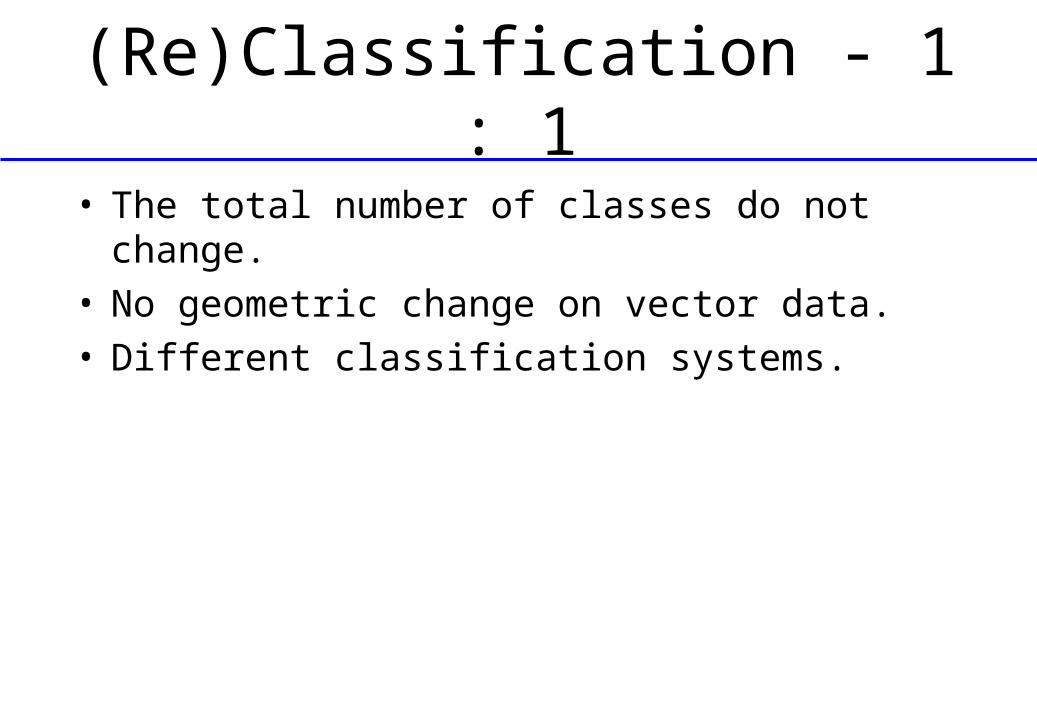
(Re)Classification - 1 : 1
• The total number of classes do not change.• No geometric change on vector data.• Different classification systems.

(Re)Classification - M : 1
• The number of classes is reduced.• May have geometric editing after the
classification.• Also called generalization, aggregation,
merge and dissolve operations.

(Re)Classification - M : 1
M : 1 classification
CODE OLD TYPE NEW TYPE
10 Planned Residential Residential 20 Industry Commercial 30 Commercial Commercial 40 Institutional Public 50 Transport Public 60 Recreational Public 70 Non Built-up Non Built-up 80 Unplanned Residential Residential

(Re)Classification - 1: M
• The number of classes increases.• Additional information are needed for 1:M
classification.• A geometric feature may be divided into two
or more features.

Overlay operations
• Combines several map layers into one.• New spatial elements are usually
created.• All map layers must be in the same
coordinate systems. • Both on vector and raster data.

Overlay operations - Vector data
• Topological overlay.• Involves complicated geometric calculations
to create new topology.• Spatial features are combined.• New attributes are assigned to each new
feature, such as area, parameters. • The attributes from the input map layers
are kept in the output.

Overlay operations

Overlay operations - Union • All the features in the two input
data source are kept in the output.• Applies only to polygon features.
Input 1
Input 2
Output
UNION

Overlay operations - Intersect
• Only the features inside the common area of the two input data are kept in the output.
• One input data can be point, line or polygon feature type, the other must be a polygon data set.
Input 1
Intersect data set
Output
INTERSECT

Overlay operations - CLIP• Extracts those features from an input coverage
that overlap with a clip coverage. • No combination of attributes.
Input 1
Clip data set
Output
CLIP

Overlay operations - ERASE
• Erases the input coverage features that overlap with the erase coverage polygons.
• No combination of attributes.
Input 1
Erase data set
Output
ERASE