Embed Size (px)
Citation preview

0 © 2021 GTAV This material is owned by the GTAV. Do not copy or distribute.
Paul Cross: Monash University
These notes are protected by Copyright.
Do not copy or distribute. S
tud
en
t Le
ctu
re 3
: U
nit
s 3
& 4
Re
visi
on
Unit 3: Area of Study 1
Land Use Change
1 © 2021 GTAV This material is owned by the GTAV. Do not copy or distribute.
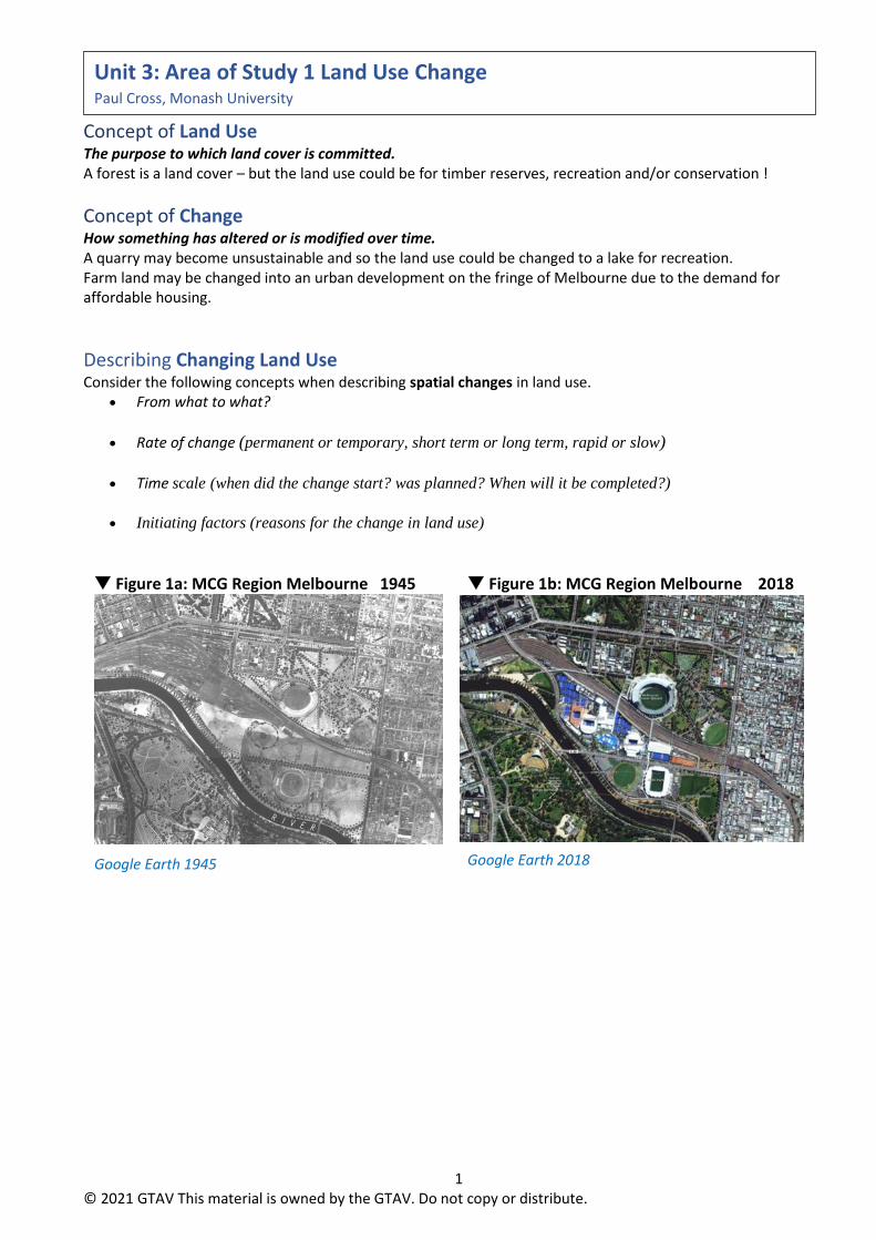
Concept of Land Use The purpose to which land cover is committed. A forest is a land cover – but the land use could be for timber reserves, recreation and/or conservation !
Concept of Change How something has altered or is modified over time. A quarry may become unsustainable and so the land use could be changed to a lake for recreation. Farm land may be changed into an urban development on the fringe of Melbourne due to the demand for affordable housing.
Describing Changing Land Use Consider the following concepts when describing spatial changes in land use.
• From what to what?
• Rate of change (permanent or temporary, short term or long term, rapid or slow)
• Time scale (when did the change start? was planned? When will it be completed?)
• Initiating factors (reasons for the change in land use)
Figure 1a: MCG Region Melbourne 1945 Figure 1b: MCG Region Melbourne 2018
Google Earth 1945
Google Earth 2018
Unit 3: Area of Study 1 Land Use Change Paul Cross, Monash University

2 © 2021 GTAV This material is owned by the GTAV. Do not copy or distribute.
Figure 2a: Ubud (Bali, Indonesia) 2015 Figure 2b: Ubud (Bali, Indonesia) 2019
Google Earth 2015
\ Google Earth 2019
Figure 3a: Disused Water Supply Reservoir Figure 3b: Booran Reserve 2018
Google Earth 2014
Google Earth 2018

3 © 2021 GTAV This material is owned by the GTAV. Do not copy or distribute.
Key knowledge
• the location of the selected area, current land use and other natural and
human geographic characteristics
• the interconnection of the selected area with its surrounding region
• for the selected land use:
o the processes of change, including the nature, scale and time sequence
of change
o reason/s for change considering the influence of geographical
characteristics of the selected area and
o surrounding region and the influence of individuals, organisations and
planning strategies
o positive and negative impacts of the change on the environment, and
economic and social conditions in the selected area and surrounding
region.
• the use of spatial technologies to assess and manage changes in land use
Key skills
• analyse maps, data and other geographic information to develop
descriptions and explanations
• collect, sort, process and represent data and other information
• interpret and analyse maps and other geographical data and information
• identify and describe the geographic characteristics of the selected area
• identify and describe the change in land use in the selected area at spatial
and temporal scales
• explain the processes of change, the reasons for change and the resulting
land use change in the selected area
• explain and assess positive and negative impacts on the selected area and
the surrounding region resulting from land use changes.

4 © 2021 GTAV This material is owned by the GTAV. Do not copy or distribute.
Describing your fieldwork location Remember that the examiner may not know your fieldwork site. Therefore, your location needs to be clear and relevant to your discussion on the examination!
• Absolute Location
• Relative Location
Describing the Land Use(s) and Changes Make sure that you are able to describe clearly the previous, current, potential future land uses.
• Describing the change of land use FROM TO • Describe the nature of the land use change – scale, rate, permanency etc.
Natural and Human geographic characteristics of your fieldwork site. Natural features – location, distribution
• Waterways, fauna (animals) and flora (plants), land forms / terrain Human features – location, distribution
• Housing, transport (footpaths, roads and railways), economic zones, other recreational areas, residential areas, schools…
Natural and Human geographic characteristics of the region. You should decide on the scale of your region. This may include features that are adjacent to your fieldwork site, or within a short distance. Sometimes the region affected by the land use change could be larger.
• Natural features – location, distribution – impact or influence on land use change.
• Human features – location, distribution – impact or influence on land use change.
Interconnection with region The region will interconnect with your site. People may move into our out of the site. The changes in land use at your site my impact on the land value, amenity or use of other regional land uses. Employment opportunities, conflict, competition or greater pressure on resources within the region may all result from the land use change.
Impact / influence of region on the changes in study area
• Movement - eg traffic • Economic Influence – eg house prices • Social Influence – eg crowds / security
5 © 2021 GTAV This material is owned by the GTAV. Do not copy or distribute.
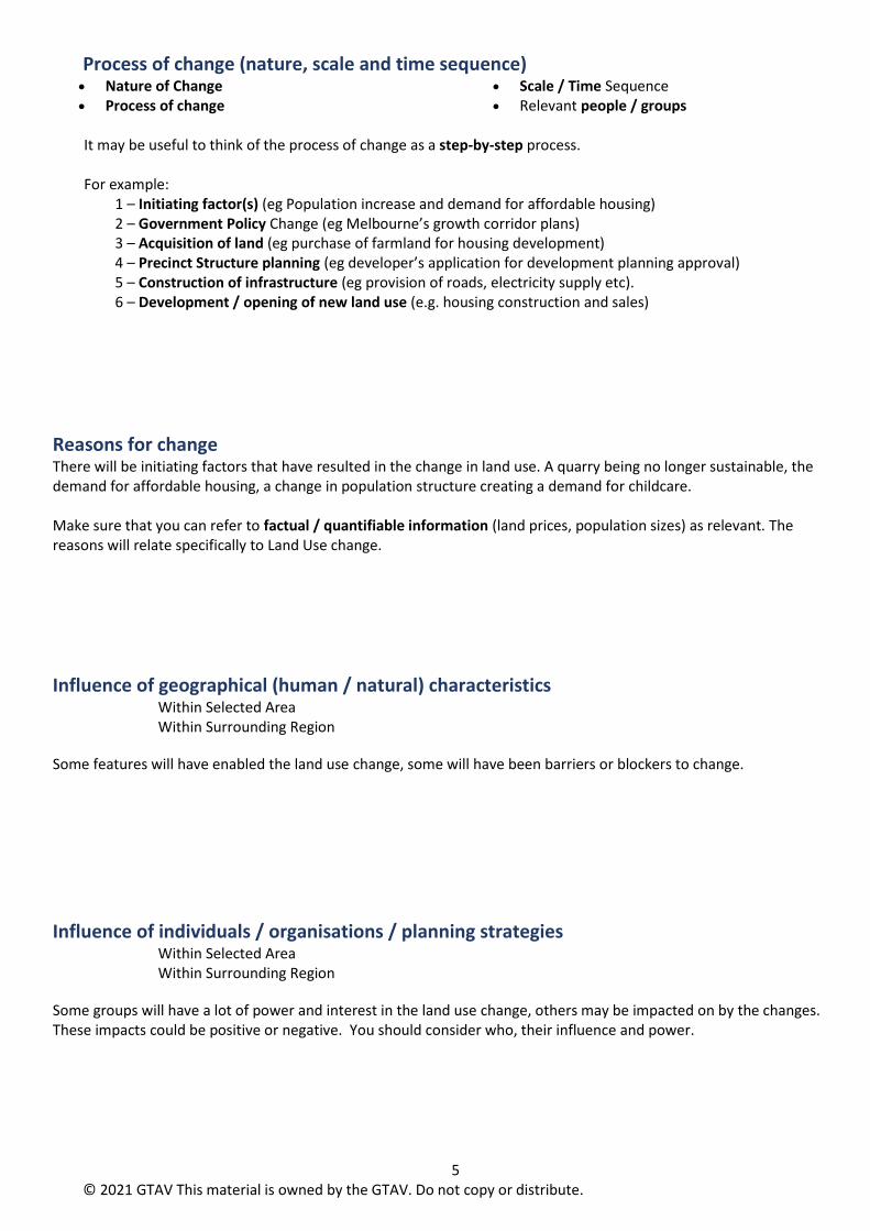
Process of change (nature, scale and time sequence) • Nature of Change • Process of change
• Scale / Time Sequence • Relevant people / groups
It may be useful to think of the process of change as a step-by-step process. For example:
1 – Initiating factor(s) (eg Population increase and demand for affordable housing) 2 – Government Policy Change (eg Melbourne’s growth corridor plans) 3 – Acquisition of land (eg purchase of farmland for housing development) 4 – Precinct Structure planning (eg developer’s application for development planning approval) 5 – Construction of infrastructure (eg provision of roads, electricity supply etc). 6 – Development / opening of new land use (e.g. housing construction and sales)
Reasons for change There will be initiating factors that have resulted in the change in land use. A quarry being no longer sustainable, the demand for affordable housing, a change in population structure creating a demand for childcare. Make sure that you can refer to factual / quantifiable information (land prices, population sizes) as relevant. The reasons will relate specifically to Land Use change.
Influence of geographical (human / natural) characteristics
Within Selected Area Within Surrounding Region
Some features will have enabled the land use change, some will have been barriers or blockers to change.
Influence of individuals / organisations / planning strategies
Within Selected Area Within Surrounding Region
Some groups will have a lot of power and interest in the land use change, others may be impacted on by the changes. These impacts could be positive or negative. You should consider who, their influence and power.

6 © 2021 GTAV This material is owned by the GTAV. Do not copy or distribute.
Positive and negative impacts of the change on the environment, and economic and social conditions in the selected area and surrounding region
• Positive / Negative • Long Term / Short Term
• Permanent / Temporary • Socio-economic / Environmental
Your land use change may result in greater movement of people into or around the site. This may increase traffic noise, pollution or safety concerns. Land prices may be affected, quality of life may be altered. Using a table to summarise your impacts will see that you have a range. Quantify: use statistical / factual information where possible!
Selected Area Surrounding Region
Environment
Positive Positive
Negative Negative
Economic Conditions
Positive Positive
Negative Negative
Social Conditions
Positive Positive
Negative Negative
The use of spatial technologies to assess and manage changes in land use. There are a range of Spatial Technologies that you will have used when preparing your fieldwork report. Aerial Photography is commonly used, but you may have also used remote sensing, GPS (Global Positioning Systems), or had access to a GIS (Geographic Information Systems). Ensure that you can name, describe and relate a spatial technology to your research of Land Use Change. How has the technology been used (or could be used) to manage or assess the impacts of the Land Use changes?

7 © 2021 GTAV This material is owned by the GTAV. Do not copy or distribute.
VCAA Cross-study Specifications
❑ Change
❑ Distance
❑ Distribution
❑ Movement
❑ Place
❑ Process
❑ Region
❑ Scale
❑ Spatial Association
❑ Sustainability
VCAA, VCE Geography Study Design (2016-2020)

8 © 2021 GTAV This material is owned by the GTAV. Do not copy or distribute.
Having an appreciation of your fieldwork report investigation Primary and Secondary sources (data) Evaluate appropriateness. You should be able to name and describe a range of primary and secondary sources / data and relate these to your investigation of Land Use Change. What were the strengths / weaknesses?
Do not forget the Research Question and your Hypothesis tested. Can you state these, evaluate their success and relate them to your data and findings?
You may need to complete a quick sketch map of your fieldwork site. Ensure that you can follow conventions (use of pencils, colour, BOLTSS).
Can you map or describe the following clearly? • Land use change • Impacts of change (environmental, socio-economic) • Regional features that have impacted on the land use change. • Interactions between the site and its region.

9 © 2021 GTAV This material is owned by the GTAV. Do not copy or distribute.
Checklist The following checklist may be useful when generating your study notes. Make sure that you are making use of clear data and examples where possible. Use statistics, figures, describe locations. Making use of you the cross-study specifications – Change, Distance, Distribution, Movement, Place, Process, Region, Scale, Spatial Association, and Sustainability is also important.
Location (Relative and Absolute)
Description of Land Use Change (from… to…)
Location / Distribution of Geographic Characteristics (Fieldwork Site)
Location / Distribution of Geographic Characteristics (Surrounding Region)
Current Land Use – Natural and Human Geographic Characteristics
Previous Land Use – Natural and Human Geographic Characteristics
Future Land Use (if relevant) – Natural and Human Characteristics
Interconnections with surrounding region
Process of change (nature, scale and time sequence)
Reason(s) for change
Influence of geographical characteristics
Influence of individuals, organisations
Influence of planning strategies
Positive and Negative impacts of the change on the environment
Positive and Negative impacts of the change on economic structures
Positive and Negative impacts of the change on social conditions
Positive and Negative impacts on the interconnections with surrounding region
Spatial Technologies used to assess land use change and management
Effectiveness of Spatial Technologies
Field Techniques used to gather data (Primary and Secondary sources, Research
Question, Hypothesis)
Effectiveness of Field Techniques
Fieldwork Research Question
Fieldwork Hypothesis

10 © 2021 GTAV This material is owned by the GTAV. Do not copy or distribute.
Sample Fieldwork Based Land Use Change Questions
VCAA, VCE Geography Examination 2016
d. State the location and describe the land use change for the selected area of fieldwork that you have undertaken this year. 2 marks
e. Assess the impacts or likely impacts of the land use change in the surrounding region of your selected area of fieldwork. 7 marks
VCAA, VCE Geography Examination 2019 Question 3 (8 marks) Identify the location of your selected area of fieldwork
a. State the land use change investigated at your selected area of fieldwork. 1 mark
b. For your selected area of fieldwork, outline a natural characteristic that has influenced, or is likely to influence, land use change. 3 marks
c. Identify and assess one impact of land use change at your selected area of fieldwork on its surrounding region. 4 marks

11 © 2021 GTAV This material is owned by the GTAV. Do not copy or distribute.
Sample Data Based Land Use Change Questions
GTAV, VCE Geography Trial Examination 2018
Figure 1. The location of Blakeview, a northern suburb of Adelaide, South Australia Figure 2a. A Satellite image of Blackview taken on May 27, 2006
Figure 2b. A Satellite image of Blackview taken on June 4 2017
Question 1 (4 marks) a. Describe the type of land use change that has occurred in Blakeview between
2006 and 2017 as shown in the satellite images. IN your response, refer to at least three specific types of land use. 3 marks.
b. Suggest one factor that could have contributed to land use change in Blakeview. 1 mark.

12 © 2021 GTAV This material is owned by the GTAV. Do not copy or distribute.
VCAA, VCE Geography Examination 2020
Use Figure 1 on page 2 of the data book when responding to Question 1.
Question 1 (5 marks) Figure 1 shows a housing estate under development. An environmental impact study of the area was undertaken before development started. From the findings of the study, a hypothesis was formed that the land use change could result in the following major impacts on the site and the surrounding region:
• Increased water runn-off
• Habitat loss
• Increased road traffic
• Increased demand for services Identify and justify an appropriate primary fieldwork technique that could be used to investigate one of the major impacts listed above. Question 2 (11 marks) b. Describe one spatial technology that was used to assess land use change for the
selected area of fieldwork that you have undertaken this year. 3 marks c. Explain how two geographical characteristics of your selected area of fieldwork
and its surrounding region have influenced the process of alnd use change. 8 marks

13 © 2021 GTAV This material is owned by the GTAV. Do not copy or distribute.
VCAA, VCE Geography Examination 2018 Question 1 a. Identify two geographical characteristics of the site at 33 Rue du
Cardinal Lemoine. 2 marks
b. Identify two geographical characteristics of the surrounding region
at 33 Rue du Cardinal Lemoine. 2 marks
c. Outline one way in which the changed land use shown in Figure 1d is likely to be more suited to the surrounding region than the previous land use was. 3 marks
14 © 2021 GTAV This material is owned by the GTAV. Do not copy or distribute.
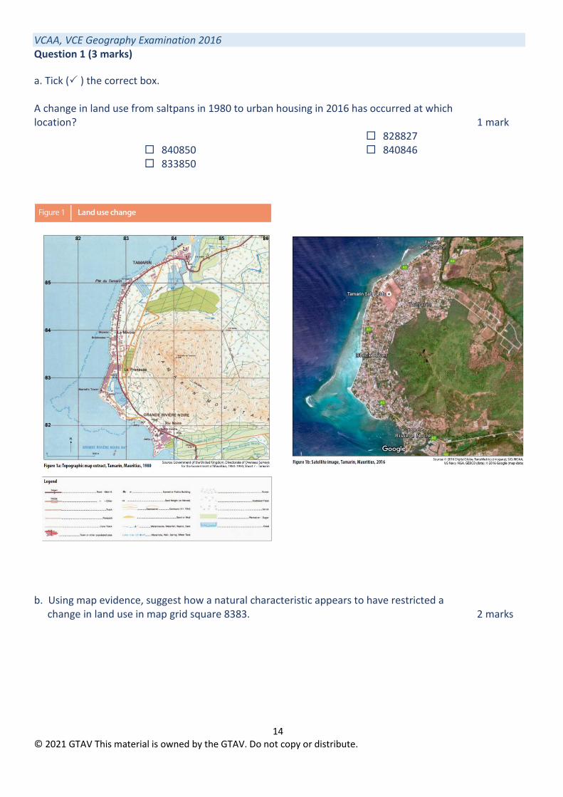
VCAA, VCE Geography Examination 2016 Question 1 (3 marks)
a. Tick ( ) the correct box. A change in land use from saltpans in 1980 to urban housing in 2016 has occurred at which location? 1 mark
840850 833850
828827 840846
b. Using map evidence, suggest how a natural characteristic appears to have restricted a
change in land use in map grid square 8383. 2 marks

15 © 2021 GTAV This material is owned by the GTAV. Do not copy or distribute.
VCAA, VCE Geography Examination 2017
Question 2 (5 marks)
Use Figures 1 and 2 on pages 2 and 3 of the data book when responding to Question 2.
a. Which category of land cover in map square A3 appears to have replaced large areas of dense forest? 1 mark
b. Shrub land in map square C1 has been extensively replaced by which two categories
of land cover? 2 marks
c. Which category of land cover had the largest percentage increase between 1973 and 2000? 1 mark
d. Which category of land cover had the largest percentage decrease between 1973
and 2000? 1 mark