Embed Size (px)
Citation preview

Lawrence Township, Mercer County, New Jersey 2009
Great places in Lawrence Township for the public to hike
Spend a few minutes or a few hours nearby on meandering off-road paths in our preserved open space parks. They are open all year from dawn to dusk for walking, hiking or biking.
Trail Guide
Shipetaukin Woods
Turtleback Park
Maidenhead Meadows

Lawrence Township Trail Guide
1 Laurie Chauncey Trail at Educational Testing Service
2 Carson Road Woods
3 Shipetaukin Woods and Terhune Orchards Farm Trail
4 Mercer County Park Northwest
5 Village Park
6 Johnson Trolley Line North
7 The Lawrenceville School
8 Maidenhead Meadows Park
9 Delaware & Raritan Canal State Park
10 Turtleback Park
11 Loveless Nature Preserve 12 12 Johnson Trolley Line South
13 Drexel Woods
14 Colonial Lake Trail
15 Lawrence Hopewell Trail
Links and Acknowledgments
This booklet features places in Lawrence for the public to hike. Most of the trails are off-road paths in our open space parks. They are open year-round from dawn to dusk and follow the carry in-carry out policy. The trails in this guide are for walking or bicycling. Be aware that some natural footpaths will be muddy in wet weather, and summer growth may obscure secondary trails. Remember to always protect yourself against poison ivy and ticks in woods and meadows. Throughout the trail system wildflowers, birds, mammals and amphibians abound. All trails are rated as easy walking.
Key to detail maps 1-15
Roads
Hiking Trails
Wooded
Agriculture
Wetlands
Lawrence Township Open Space

1
Carson Road Woods was purchased and preserved in 2001 and is named for the road that borders it. There are miles of walking trails on the mowed grass margins of farm fields and hedgerows. More than four paths take you through a rare beech forest and meander along streams and meadows. The park has over 200 varieties of plants and trees and is a habitat for many species of birds, mammals and reptiles.
The woods, fields and hedgerows are home to downy and hairy woodpeckers, eastern bluebirds, wood thrushes, black-capped chickadees, yellow-rumped warblers, wood-cock and towhees. Walkers should also look for hawks hunting over the fields. Coyote scat has been found, and cottontail rabbits and whitetail deer are likely to cross your path. Forested areas include not only beech trees but ironwood, red oak, Norway maple and spruce, tulip, ash, cedar and shagbark hickory, just to name a few.
Trails are well marked with two-foot posts topped by small molded ceramic leaf imprints in different colors: deep red (sweet gum trail), green (oak trail), yellow (beech trail), orange (sassafras trail) and reddish-orange (maple trail). Several small brook crossings require caution as the banks and stepping stones tend to be slippery.
The Carson Road Woods lie just west of Province Line Road, which corresponds to the 1687 line separating historic East and West Jersey. Settlers came from the north along the Indian trail from the Raritan River to the Delaware River and populated the area in the early 18th century.
2
The Laurie Chauncey trail is on ETS grounds on property dedicated for public access. Named in honor of Laurie Chauncey, the late wife of former ETS president Henry Chauncey, the loop trail cuts through young and mature woods as it winds along the Stony Brook. The young woodlands are made up of swamp red maple, red cedar and white pine. Basswood, red maple, white ash and tulip poplar are abundant in the flat area nearer the stream. As the terrain gets steeper, more hickory oak and beech ap-pear. Look for signs of deer, fox and raccoon in the woods. The open meadow, young woodlands and older woodland area are wonderful habitat for a variety of resident and migrating birds. Open meadows provide beautiful views as the trail continues along the circular ETS access drive. The path periodically crosses intermittent streams on bridges or stepping stones.
Entrances to the trail are marked by plantings donated by Henry Chauncey and friends. Avid naturalists will also spot a variety of wild plant life including wild leeks, dwarf ginseng, mayapples, fiddleheads, cohosh and jack-in-the-pulpits. The Laurie Chauncey Trail is noted for its diversity of trees, which are labeled.
Laurie Chauncey Trail at Educational Testing Service
Carson Road Woods
LocationRosedale Road
Distance2 miles
ParkingUse the parking lots by Wood Hall and Lord Hall
AmenitiesETS public picnic area
LocationCarson Road
Distance4.4 miles of trails
ParkingThere is room for 10 cars in a crushed-stone parking area off Carson Road, about a quarter mile from Carter Road. The lot is marked with a wooden sign.

43
Mercer County Park NorthwestThe Pole Farm
Shipetaukin Woods is a young forest of swamp red maple, sweet gum, tulip poplar, shagbark hickory, ash, oak and beech trees. The understory contains many vines (grape and poison ivy), arrow wood, and saplings of maple and hickory trees. Skunk cabbage can be found in the low-lying areas of the stream. Near the middle of the woods look for large clumps of ferns and beech-drops under the beech trees. Throughout the woods there are signs of deer, moles, squirrel and an abundance of birds. The trail is often very muddy (boots are recommended).
The main 0.6-mile red trail starts at a mowed path at the end of the entrance driveway and enters a young, wet oak-hickory forest. It continues through the woods, crossing the Shipetaukin Creek and many small channels. The shorter yellow trail is an offshoot loop near the beginning of the red trail and cuts through the woods and rejoins the red trail before you cross the larger Shipetaukin Creek (no bridge). An orange flag marks the end of the red trail and the beginning of the path to Terhune Orchards Farm Trail. At this point you may return on the same red trail back to the parking area or continue walking on the farm trail, which becomes a wider path of crushed stone.
The 64-acre Shipetaukin Woods, formerly a farm, was purchased by the Lawrence Township Conservation Foundation in 1994 and deeded to the township as permanently preserved open space in 2003.
Terhune Orchards Farm Trail, where interpretive signs highlight special plants and trees, connects directly with the end of the Shipetaukin Woods trail. Beyond the gate the trail will continue past Terhune’s pond, meadows, orchards and gardens. Please close the metal gate when entering and exiting the Terhune Orchards farm property. (No dogs are allowed on Terhune Orchards Farm Trail or at the farm.)
The one square-mile Pole Farm component of Mercer County Park Northwest has easy trails through woods, fields and meadows, with broad vistas and wonderful tranquility. It offers delightful butterflies and wildflowers. In the fall, brilliant blue asters and goldenrod shine in the sun, and milkweed scatters in the air. A total of 230 plant species have been documented in this park.
The Washington Crossing Audubon Society has documented 108 bird species at the Pole Farm property. Two of these are rare grassland birds, the bobolink and the eastern meadowlark. The American kestrel, another species of special concern, has nested successfully on the property. Winter sightings of long-eared owls have brought birding groups from all over the state to the park.
The 812-acre Pole Farm is the largest component of Mercer County’s 1600-acre Northwest Park, which includes Rosedale Park and other parcels to the north.
LocationCarter Road
Distance1.2 miles of trails
ParkingThe entrance to Shipe-taukin Woods is off Carter Road, just north of Carson Road, with parking for 2 or 3 cars. Drive down the gravel driveway for several more parking spots. Parking is also avail-able in the lot at Terhune Orchards on Cold Soil Road.
AmenitiesAt Terhune Orchards: picnic tables, farm store, port-a-johns.
Shipetaukin Woods and Terhune Orchards Farm Trail
LocationIntersection of Cold Soil Road and Keefe Road
Distance5.3 miles of trails
ParkingNear the entrance on Cold Soil and Keefe Roads
AmenitiesPicnic tables
Farmed for hundreds of years, American Telephone and Telegraph purchased the land in the 1920s and constructed an overseas radio telephone station. In 1965 it was the largest transmission station in the world, and the rows of towers came to be called the Pole Farm.
Eventually, cable and satellites made the station obsolete. It was dismantled in 1976 and the land was leased to local farmers. It was purchased by Mercer County in 1995 and has been dedicated to passive recreation.

LocationBergen Street and Yeger Drive
Distance1.4 miles
ParkingEnter from Bergen, Yeger or Gordon Ave.
AmenitiesDog run, picnic pavilion, playing fields, bathrooms
Village Park, Johnson Trolley Line North,and The Lawrenceville School
75 6
Village Park
Lawrence Township purchased the 62 acres for Village Park in 1970 and developed it in 1992. There are three lighted soccer fields and facilities for tennis, basketball, softball, volleyball, quoits, bocce and horseshoes as well as playgrounds for young children. A path for walking and biking runs through the park and is a section of the Lawrence Hopewell Trail, connecting Bergen Street and Keefe Road.
Johnson Trolley Line North
The trail from Gordon Avenue to Denow Road follows the route of the former Johnson “Fast Line” trolley, of the Trenton-Princeton Traction Company which ran from Trenton to Princeton through the Main Street area of Lawrenceville. The former power substation for the line, now an office, is on Lawrenceville- Pennington Road.
This portion of the former trolley line is about 1 mile in length. Part nature trail and part urban path, it cuts through residential neighborhoods. Along this well-shaded trail you will find a stand of bamboo plants and, opposite the former power substation, a row of red cedar trees.
The Johnson Trolley Line carried passengers from 1901 until 1940, when competition from bus service closed the trolley. The tracks were then used for freight until the construction of Interstate 295 in the early seventies.
The Lawrenceville School
Follow the green and black triangular LHT signs on white posts along the tennis and golf facilities.
Feel free to explore the historic campus and trees. The school welcomes guests to explore the grounds but reserves the facilities for student use. The Lawrenceville School was founded in 1810 The central portion of the campus, called The Circle, was planned in 1883 and planted in 1886 by Frederick Law Olmsted, America’s foremost Landscape Architect and creator of New York’s Central Park. His vision for the trees was a “complete collection of trees that could be grown in Central New Jersey…to serve as a com-bined Library and Museum of Botany and Dendrology.”
LocationGordon Avenue to Denow Road
Distance1 mile
ParkingIn the village of Lawrenceville
LocationThe Lawrenceville School section of the Lawrence Hopewell Trail can be accessed from the Route 206 gate next to the Law-renceville Presbyterian Church at Gordon Av-enue, and on Lewisville Road.
DistanceLHT trail .8 mile
ParkingEnter from Rt. 206 or Lewisville Road.
Maidenhead Meadows park, Lawrence’s largest, includes Maidenhead Meadows, the Brearley House, Princessville Cemetery, the former tree nursery and open fields. These parcels, acquired over a period of 27 years, constitute 345 contiguous acres directly abutting 82 acres of The D&R Canal State Park.
The trail system for this park is a work in progress. Currently there is a trailhead at the end of Meadow Road with access to the Brearley Trail, which leads to the D&R Canal towpath via an embankment crossing the Shipetaukin Creek flood plain. The township’s other parking area, at the site of a former nursery parking lot, provides access to the nursery’s tree plantings.
Much of this park is wetlands, some wooded, some with deciduous shrubs, with a large section of cattail meadow. Early settlers purchased or leased sections of the meadows for grazing. Portions of their ditching and road making can still be found. Other farm roads run through the park marked by rows of trees planted as a nursery in the late 1960s, including river birch, pin oaks, sycamores, sugar and red maples, beeches, white pines and other species. In addition to native wildlife, this preserve hosts migrating waterfowl in Spring and Fall.
98
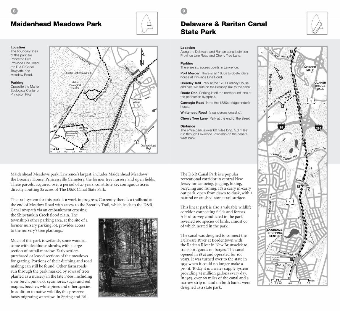
Delaware & Raritan Canal State Park
Maidenhead Meadows Park
LocationThe boundary lines of this park are Princeton Pike, Province Line Road, the D & R Canal Towpath, and Meadow Road.
ParkingOpposite the Maher Ecological Center on Princeton Pike
LocationAlong the Delaware and Raritan canal between Province Line Road and Cherry Tree Lane.
ParkingThere are six access points in Lawrence:
Port Mercer There is an 1830s bridgetender’s house at Province Line Road.
Brearley Trail Park at the 1761 Brearley House and hike 1/3 mile on the Brearley Trail to the canal. Route One Parking is off the northbound lane at the pedestrian overpass.
Carnegie Road Note the 1830s bridgetender’s house.
Whitehead Road (a dangerous crossing).
Cherry Tree Lane Park at the end of the street.
DistanceThe entire park is over 60 miles long; 5.3 miles run through Lawrence Township on the canal’s west bank.
The D&R Canal Park is a popular recreational corridor in central New Jersey for canoeing, jogging, hiking, bicycling and fishing. It’s a carry in-carry out park, open from dawn to dusk, with a natural or crushed-stone trail surface.
This linear park is also a valuable wildlife corridor connecting fields and forests. A bird survey conducted in the park revealed 160 species of birds, almost 90 of which nested in the park.
The canal was designed to connect the Delaware River at Bordentown with the Raritan River in New Brunswick to transport goods on barges. The canal opened in 1834 and operated for 100 years. It was turned over to the state in 1937 when it could no longer make a profit. Today it is a water supply system providing 75 million gallons every day. In 1974, over 60 miles of the canal and a narrow strip of land on both banks were designed as a state park.
1110
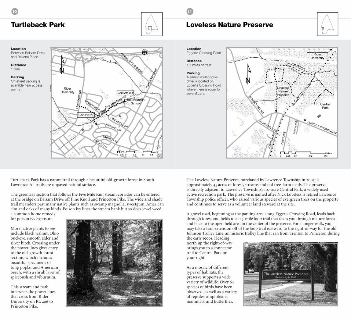
Turtleback Park
Turtleback Park has a nature trail through a beautiful old-growth forest in South Lawrence. All trails are unpaved natural surface.
The greenway section that follows the Five Mile Run stream corridor can be entered at the bridge on Balsam Drive off Pine Knoll and Princeton Pike. The wide and shady trail meanders past many native plants such as swamp magnolia, sweetgum, American elm and oaks of many kinds. Poison ivy lines the stream bank but so does jewel weed, a common home remedy for poison ivy exposure.
More native plants to see include black walnut, Ohio buckeye, smooth alder and silver birch. Crossing under the power lines gives entry to the old-growth forest section, which includes beautiful specimens of tulip poplar and American beech, with a shrub layer of spicebush and viburnum.
This stream and path intersects the power lines that cross from Rider University on Rt. 206 to Princeton Pike.
LocationBetween Balsam Drive and Ravona Place.
Distance1 mile
ParkingOn-street parking is available near access points
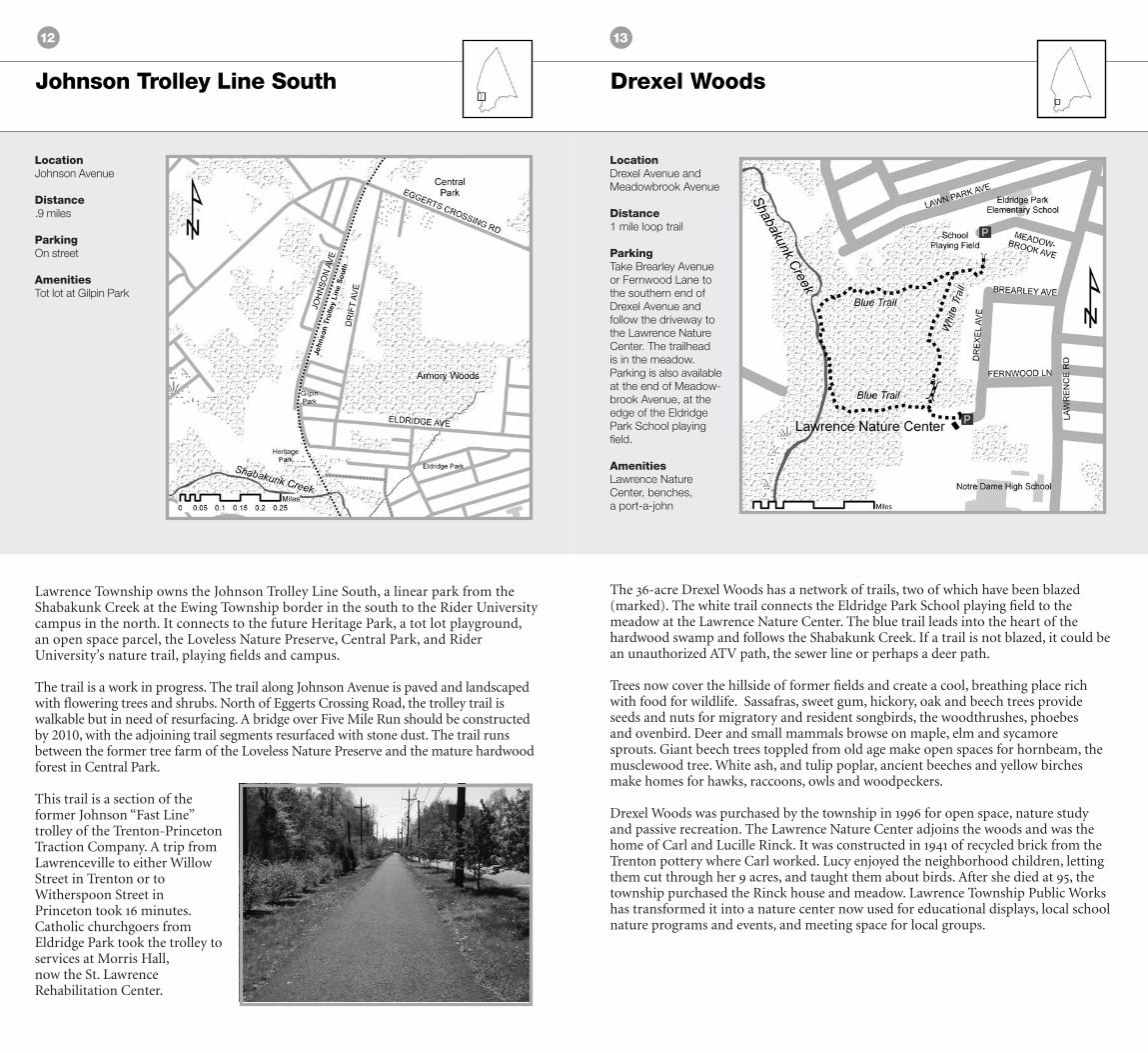
Loveless Nature Preserve
The Loveless Nature Preserve, purchased by Lawrence Township in 2007, is approximately 45 acres of forest, streams and old tree-farm fields. The preserve is directly adjacent to Lawrence Township’s 107-acre Central Park, a widely used active recreation park. The preserve is named after Nick Loveless, a retired Lawrence Township police officer, who raised various species of evergreen trees on the property and continues to serve as a volunteer land steward at the site.
A gravel road, beginning at the parking area along Eggerts Crossing Road, leads back through forest and fields to a 0.5-mile loop trail that takes you through mature forest and back to the open field area in the center of the preserve. For a longer walk, you may take a trail extension off of the loop trail eastward to the right-of-way for the old Johnson Trolley Line, an historic trolley line that ran from Trenton to Princeton during the early 1900s. Heading north up the right-of-way brings you to a connector trail to Central Park on your right.
As a mosaic of different types of habitats, the preserve supports a wide variety of wildlife. Over 64 species of birds have been observed, as well as a variety of reptiles, amphibians, mammals, and butterflies.
LocationEggerts Crossing Road
Distance1.7 miles of trails
ParkingA semi-circular gravel drive is located on Eggerts Crossing Road where there is room for several cars.
1312
Drexel Woods
The 36-acre Drexel Woods has a network of trails, two of which have been blazed (marked). The white trail connects the Eldridge Park School playing field to the meadow at the Lawrence Nature Center. The blue trail leads into the heart of the hardwood swamp and follows the Shabakunk Creek. If a trail is not blazed, it could be an unauthorized ATV path, the sewer line or perhaps a deer path.
Trees now cover the hillside of former fields and create a cool, breathing place rich with food for wildlife. Sassafras, sweet gum, hickory, oak and beech trees provide seeds and nuts for migratory and resident songbirds, the woodthrushes, phoebes and ovenbird. Deer and small mammals browse on maple, elm and sycamore sprouts. Giant beech trees toppled from old age make open spaces for hornbeam, the musclewood tree. White ash, and tulip poplar, ancient beeches and yellow birches make homes for hawks, raccoons, owls and woodpeckers.
Drexel Woods was purchased by the township in 1996 for open space, nature study and passive recreation. The Lawrence Nature Center adjoins the woods and was the home of Carl and Lucille Rinck. It was constructed in 1941 of recycled brick from the Trenton pottery where Carl worked. Lucy enjoyed the neighborhood children, letting them cut through her 9 acres, and taught them about birds. After she died at 95, the township purchased the Rinck house and meadow. Lawrence Township Public Works has transformed it into a nature center now used for educational displays, local school nature programs and events, and meeting space for local groups.
LocationDrexel Avenue and Meadowbrook Avenue
Distance1 mile loop trail
ParkingTake Brearley Avenue or Fernwood Lane to the southern end of Drexel Avenue and follow the driveway to the Lawrence Nature Center. The trailhead is in the meadow. Parking is also available at the end of Meadow-brook Avenue, at the edge of the Eldridge Park School playing field.
AmenitiesLawrence Nature Center, benches, a port-a-john
Johnson Trolley Line South
Lawrence Township owns the Johnson Trolley Line South, a linear park from the Shabakunk Creek at the Ewing Township border in the south to the Rider University campus in the north. It connects to the future Heritage Park, a tot lot playground, an open space parcel, the Loveless Nature Preserve, Central Park, and Rider University’s nature trail, playing fields and campus.
The trail is a work in progress. The trail along Johnson Avenue is paved and landscaped with flowering trees and shrubs. North of Eggerts Crossing Road, the trolley trail is walkable but in need of resurfacing. A bridge over Five Mile Run should be constructed by 2010, with the adjoining trail segments resurfaced with stone dust. The trail runs between the former tree farm of the Loveless Nature Preserve and the mature hardwood forest in Central Park.
This trail is a section of the former Johnson “Fast Line” trolley of the Trenton-Princeton Traction Company. A trip from Lawrenceville to either Willow Street in Trenton or to Witherspoon Street in Princeton took 16 minutes. Catholic churchgoers from Eldridge Park took the trolley to services at Morris Hall, now the St. Lawrence Rehabilitation Center.
LocationJohnson Avenue
Distance.9 miles
ParkingOn street
AmenitiesTot lot at Gilpin Park

1514
Lawrence Hopewell TrailColonial Lake Trail
An 8-foot-wide paved path hugs the shoreline of Colonial Lake. There is an elegant pocket park at the east end of the lake, near the footbridge, with pine trees and rocky outcroppings on a grassy little hill. The rock is 600 million years old, and marks the edge of New Jersey’s coastal plain, the flat and sandy region to the east and south. Colonial Lake was created in 1924 when the Colonial Land Company built a dam on the Shabakunk Creek, flooding the lowland Steven’s Meadow, part of the 1750 Thomas Stevens Farm. Originally intended as a swimming area for the surrounding Colonial Lakelands development, it was eventually deeded to Lawrence Township. The lake is the only township park with a water feature. Recently, native plantings were contributed by the the Lawrence Township Environmental Resources committee.
The Lawrence Hopewell Trail is a 20-mile multipurpose bicycle and pedestrian path that runs through public and private lands in Lawrence and Hopewell Townships. The trail is designed to be safe, family-friendly, and, whenever possible, handicapped accessible. Some sections are completed now; others will be completed by 2012.
LocationLake Drive, off Business Route 1
Distance.9 miles
ParkingParking lot off Lake Drive
AmenitiesTennis court, fishing, picnic tables, tot lot

Web Links
AcknowledgmentsLawrence Township Trail Guide 2009 is a publication of the Lawrence Township Greenway Committee and the Open Space and Stewardship Advisory Committee. Thanks to Educational Testing Service (ETS) for printing the guide and thanks to the Lawrence Township Community Foundation and the Lawrence Township Conservation Foundation for funding its distribution. We also thank the Lawrence Gazette for their generous help.
CreditsSome of the text for the Laurie Chauncey Trail is excerpted from “Jogging Trails and Laurie Chauncey Nature Path” published by ETS, and used with permission. Additional text is from the New Jersey Trails Association, also used with permission.
Map data is from the Friends of the Lawrence Greenway, the Mercer County Planning Division, the New Jersey Department of Transportation, and the New Jersey Department of Environmental Protection.
Carson Road Woods / www.parallaxweb.com/carsonwoods
D&R Canal State Park / www.dandrcanal.com
D&R Greenway Land Trust / www.drgreenway.org
Educational Testing Service / www.ets.org
Friends of the Lawrence Greenway / www.lawrencegreenway.org
Lawrence Hopewell Trail / www.lhtrail.org
Lawrence Township / www.lawrencetwp.com Lawrence Nature Center / www.lawrencenaturecenter.net
Lawrenceville Main Street / www.lawrencevillemainstreet.com
The Lawrenceville School / www.lawrenceville.org Mercer County / www.mercercounty.org
New Jersey Trails Association / www.njtrails.org
Sustainable Lawrence / www.sustainablelawrence.org
Terhune Orchards / www.terhuneorchards.com
Washington Crossing Audubon Society / www.washingtoncrossingaudubon.org
Please visit www.lawrencegreenway.org for updates to this trail guide.
Loveless Nature Preserve Laurie Chauncey Trail
Johnson Trolley Line North
Delaware & Raritan Canal
Carson Road Woods

Mercer County Park Northwest
Drexel Woods Meadow
Photo by James Goodman
Township of Lawrence
2207 Lawrence Road
Lawrence Township, NJ 08648