Embed Size (px)
Citation preview

Late-Quaternary Landscape Responseto Environmental Change in
South-Central KansasAlan F. Arbogast* and William C. Johnson**
*Department of Geography, Michigan State University
**Department of Geography, University of Kansas
The central Great Plains is an excellent place to study late-Quaternary geomorphic responses toclimatic fluctuations because the landscape is easily disturbed and deposits contain abundantpaleoenvironmental information. Although much research has already been conducted, studies areneeded that correlate a variety of geomorphic responses to environmental change at specific sites.This paper presents a paleoenvironmental and geomorphic reconstruction for the Great Bend SandPrairie, a mosaic of sand sheets and dune fields in south-central Kansas. Results indicate that twostratigraphic units dominate the upland geology. Late-Wisconsin deposits consist of poorly sortedsand, silt, and clay that probably accumulated in a low-energy fluvial environment. Eolian depositionof loess also occurred, but most silt was integrated with the alluvium. Intact deposits of loess arewidely scattered. All sediments contain well developed soils, indicating extended surface stability.Macrofossil and isotopic (δ13C) evidence suggest a mesic environment. Where eolian sedimentationdid occur, northwest winds were responsible for mobilization. Although late-Wisconsin strata cropout intermittently, eolian sand is the common surficial deposit. Radiocarbon dating indicates thatmost dunes are Holocene landforms. In comparison to late-Wisconsin deposits, dune sands are wellsorted, δ13C values infer a relatively warm climate, and the orientation of parabolic dunes indicatemobilizing southwesterly winds. Dunes usually contain one or two weakly developed buried soils,indicating episodic mobilization of eolian sand in the latest Holocene. Surface soils are generallypoorly developed, suggesting that dunes can easily be mobilized if vegetation is reduced, perhapsdue to C02 warming. Key Words: alluvium, central Great Plains, eolian sand, Holocene, late-Wisconsin.
A region of North America receiving in-creased attention from geomorphologistsis the central Great Plains (Figure 1).
Given the semiarid to subhumid climate, thelandscape is sensitive to disturbance, which canbe rapid and dramatic (e.g., Dust Bowl, 1993Flood). Thus the central Great Plains is an excel-lent laboratory for the observation and measure-ment of geomorphic responses to climaticfluctuations. In alluvial settings, for example, cy-cles of cutting and filling have been linked toclimate change, with a variety of terraces beingpreserved in most stream valleys (e.g., Hall 1990;Johnson and Martin 1987; May 1992; Arbogastand Johnson 1994). When more arid conditionstranspire, eolian processes dominate, with wide-spread mobilization of loess (e.g., Frye andLeonard 1951; Johnson et al. 1990, 1993; Feng etal. 1994) and eolian sand (e.g., Ahlbrandt et al.1983; Muhs 1985; Holliday 1995a, 1995b;
Madole 1995; Arbogast 1996a) being well docu-mented. Landscapes consisting of unconsolidatedsand are especially sensitive, with local reworkingof dunes frequently occurring (e.g., Ahlbrandt etal. 1983; Madole 1995; Arbogast 1996a).
Given that relief over most of the central GreatPlains is relatively low, and equilibrium can re-turn quickly, much of the mobilized sediment isredistributed within the region. This is highlysignificant because thick deposits of loess (e.g.,Frye and Leonard 1951; Johnson et al. 1990,1993; Feng et al. 1994), alluvium (e.g., Schultzand Stout 1948; Hall 1990; Johnson and Logan1990; May 1992; Arbogast and Johnson 1994)and other valley fill (Holliday 1995c), and eoliansand (e.g., Ahlbrandt et al. 1983; Muhs 1985;Muhs et al., 1996; Holliday 1995a, 1995b;Madole 1995) mantle much of the area. Mostimportant, these deposits chronologically spansignificant portions of the Quaternary period
Annals of the Association of American Geographers, 88(1), 1998, pp. 126–145©1998 by Association of American GeographersPublished by Blackwell Publishers, 350 Main Street, Malden, MA 02148, and 108 Cowley Road, Oxford, OX4 1JF, UK.

(<1.65 million years), with late-Wisconsin andHolocene sediments being especially well pre-served. Many of these sediments contain abun-dant information (e.g., sedimentological,pollen, snails, isotopic data, buried soils) thatcan be used to reconstruct regional paleoenvi-ronmental and geomorphic histories. By syn-the s i z ing and integ ra t ing th i s data ,paleoclimatologists and geomorphologists areillustrating the range of past changes, which, inturn, can be used to predict future change. Thisability is critical if increased warming, such asmodeled in many greenhouse scenarios (Han-sen et al. 1988; Wetherald and Manabe 1988;Schlesinger 1989), occurs.
Although much is known about late-Quater-nary paleoenvironmental conditions in the cen-tral Great Plains, significant gaps remain. Of thesites that have yielded data, for example, nonehave integrated environmental change and asuite of geomorphic processes from the late Wis-consin through the Holocene. In fact, geomor-
phic studies have focused largely on sites whereeither eolian (e.g., Ahlbrandt et al. 1983; Muhs1985; Johnson et al. 1993; Feng et al. 1994) oralluvial systems (e.g., Hall 1990; May 1992; Ar-bogast and Johnson 1994) dominated. An impor-tant area that has received little attention,located within the core of the central GreatPlains, is the Great Bend Sand Prairie in south-central Kansas (Figures 1, 2). In this region, late-Quaternary deposits are a complicatedassemblage of unconsolidated alluvium, loess,and eolian sand. Theoretically, the paleoenviron-mental and geomorphic history is related to manyvariables associated with climate change, includ-ing insolation variability, atmospheric circula-tion, alluviation, and eolian sedimentation. Thusthis region represents a rare opportunity to recon-struct and integrate a wide range of environ-mental fluctuations and geomorphic processesthrough much of the past 20,000 years. This issignificant within the context of global changebecause detailed chronologies are necessary to
Study Area
Figure 1. The central Great Plains in North America with location of study sites (CB = Cheyenne Bottoms; NC= North Cove; MM = Muscotah Marsh; SW = Sanders’s Well; W = Wichita. Source: modified from Fredlund andJaumann (1987) and Swinehart (1990).
Late-Quaternary Landscape Response 127
test and refine hypotheses derived from pre-viously constructed models (e.g., Fredlund andJaumann 1987; Kutzbach 1987; Wells and Ste-wart 1987; COHMAP 1988; Kutzbach et al.1993) and to fully show the range of potentialresponses should future climate change occur. Inthat context, the goal of this study is to fullyreconstruct the late-Quaternary paleoenviron-mental and geomorphic history of the region. Theprimary focus is the chronologic, stratigraphic,and sedimentary differences that exist betweenlate-Quaternary deposits on upland sites.
Late-Quaternary EnvironmentalHistory in the Central Great Plains
Late Wisconsin (ca. 21–10 ka)
Proxy climate data derived from late-Wiscon-sin deposits generally infer a more mesic environ-ment, with cooler temperatures, more effectivemoisture, and less seasonality than present. Cli-
matic modeling, for example, suggests that the jetstream was split into northern and southernbranches by the Laurentide ice sheet during thepeak of the last glacial period around 18,000 yrsB.P. (e.g., COHMAP 1988; Kutzbach 1987;Kutzbach et al., 1993). Delcourt (1979) and Del-court and Delcourt (1983) argued that the meanposition of the polar front, which today is locatedin southern Canada, was at about 34° N at thattime. As a result, mean annual surface tempera-tures in the central Great Plains were probably 2°to 4°C cooler than today (Kutzbach 1987). Mo-bilizing winds were northwesterly as indicated bythe orientation of late-glacial eolian features(Wells 1983) and were perhaps 20–50 percentstronger than at present (Crowley and North1991). As a result, immense quantities of loesswere blown out of the Platte River valley inNebraska and now mantle much of southernNebraska (Frye and Leonard 1951; Johnson et al.1990, 1993) and Kansas (Johnson 1993; Feng1991; Feng et al. 1994). Faunal investigations inthe Pleistocene biota of the central Great Plainsindicate more complex and diverse biological
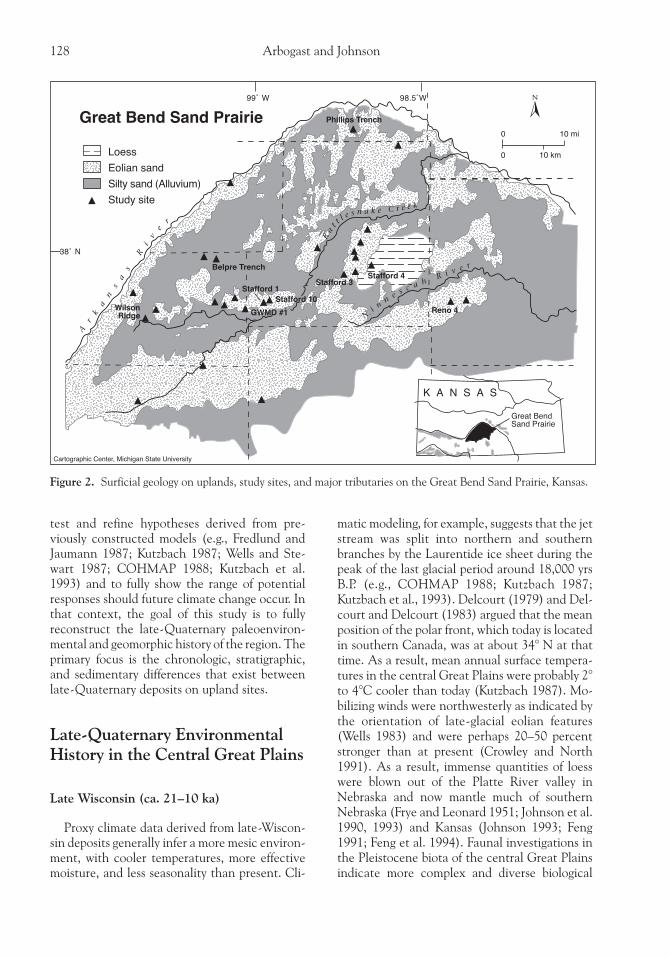
Figure 2. Surficial geology on uplands, study sites, and major tributaries on the Great Bend Sand Prairie, Kansas.
128 Arbogast and Johnson
communities, reflecting cooler summers andwarmer winters than those of the Holocene (Mar-tin 1984; Martin and Martin 1987).
In addition to decreased seasonality, the datagenerally indicate that higher levels of effectivemoisture were present in the central Great Plainsduring the late Wisconsin than present. The floralrecord, in particular, suggests a more mesic envi-ronment, reflecting a vegetational assemblagethat is radically different from that found today inthe region. According to Fredlund (1995), thepollen record at Cheyenne Bottoms, located incentral Kansas (Figure 1), suggests a spruceparkland around 20,000 yrs B.P. In the Arkansasriver floodplain, near Wichita, coniferous macro-and microfossils (e.g., spruce wood and needles,cone fragments) were recovered in peat thatdated to about 19,000 yrs B.P. (Fredlund andJaumann 1987). Wells and Stewart (1987) re-ported needle leaves of limber pine (Pinus flexilis)and white spruce (Picea cf. glauca) in charcoalthat dated to about 14,500 yrs B.P. in south-cen-tral Nebraska. Data from Sanders’s Well in east-ern Kansas and from North Cove in south-centralNebraska imply that an aspen (Populus) parklandexisted on uplands between 24,000 and 12,800yrs B.P. (Fredlund and Jaumann 1987; Fredlund1989). Isotopic data (δ13C values derived fromradiocarbon dates) from the Peoria loess also im-ply a cool and mesic environment (Johnson et al.1993). In addition, grass phytoliths extractedfrom Peoria loess indicate deposition on a wellvegetated surface, one consistent with high effec-tive moisture (Fredlund et al. 1985).
Holocene (10,000 yrs B.P. - present)
The data derived from Holocene deposits gen-erally suggests a warmer and more xeric environ-ment in the past 10,000 years than during the lateWisconsin. During the very late Wisconsin andearly Holocene, regional environmental changeis modeled to have been associated with increasedinsolation and disintegration of the Laurentideice sheet (COHMAP 1988). As the glacierwasted during the late Wisconsin and early Holo-cene, the steep north-south temperature gradientthat had been present weakened, promoting zo-nal atmospheric flow (Knox 1983). Hence cli-mate models (e.g., COHMAP 1988) suggest thatseasonal temperature extremes began to increase.At Cheyenne Bottoms (Figure 1), Fredlund(1995) reported a dramatic increase in Che-
nopodeaceae-Amarathanceae (Cheno-Am)soon after 11,000 yrs B.P., reflecting sharp fluctua-tions in water levels within the basin as the cli-mate became more variable. In northeasternKansas, an abrupt decline in spruce began about12,000 yrs B.P. at Muscotah Marsh and was con-current with an increase in oak and elm. About10,500 yrs B.P., spruce had been completely re-placed by deciduous forest, and by 9000 yrs B.P.,the region was dominated by grassland (Grüger1973).
As the Holocene progressed, strengthened zo-nal flow triggered the generally warm dry condi-tions of the middle Holocene that prevailed incentral North America from about 8 to 5 ka(Knox 1983; Kutzbach 1987; COHMAP 1988;Crowley and North 1991; Kutzbach et al. 1993).By approximately 6 ka, mean summer tempera-tures could have been 2° to 4°C higher thanpresent (COHMAP 1988; Crowley and North1991; Kutzbach et al. 1993). In addition, pollendata suggest that annual precipitation was poten-tially as much as 25 percent less than today (Bart-lein et al. 1984; Kutzbach 1987). At CheyenneBottoms (Figure 1), this interval promoted stablebut lower water levels, depressing Cheno-Ams(Fredlund 1995). In the neighboring SouthernHigh Plains, increased aridity promoted wide-spread eolian sedimentation between 9000 andabout 4500 yrs B.P., with the most intense intervaloccurring between around 5500 and 4500 yrs B.P.(Holliday 1995a, 1995b).
Following the middle-Holocene dry period, aperiod of increased moisture apparently occurredin the early part of the late Holocene. Evidencefor this shift exists in northeastern Kansas wherepollen data indicate that deciduous forest re-populated portions of the landscape briefly after5000 yrs B.P. (Grüger 1973). Since that time, theclimate has apparently fluctuated between rela-tively moist and dry. According to Fredlund(1995), Cheno-Ams were more common atCheyenne Bottoms throughout the late Holo-cene, indicating variable water levels and peri-odic drying of the basin. As a result of thesefluctuating climatic conditions, episodic mobili-zation of sand dunes occurred over much of theregion, including Nebraska (Ahlbrandt et al.1983; Swinehart 1990; Stokes and Swinehartforthcoming), Colorado (Muhs 1985; Madole1995), northwestern Oklahoma (Olson et al.1995), the neighboring Southern High Plains(Holliday 1995a, 1995b) and south-central Kan-sas (Arbogast 1996a).
Late-Quaternary Landscape Response 129

Great Bend Sand Prairie
The Great Bend Sand Prairie is a mosaic ofsand sheets and dune fields, about 4500 km2,located within the “great bend” of the ArkansasRiver. At this point, the Arkansas river is abraided stream, owing to its sandy load, withdischarge that fluctuates seasonally. In 1995,for example, discharge was low (< 10 cms)for most of the year, but peaked at 2750 cms inJune (http://www-ks.cr.usgs.gov/Kansas/rt/html/07141300.desc.html). This dramatic increase wasassociated with spring snowmelt in the RockyMountain headwaters. Major tributaries to theArkansas River are the North Fork NinnescahRiver, which flows generally to the southeast, andRattlesnake Creek, a northeasterly trendingstream that bisects the study area (Figure 2).Although mean discharge fluctuates seasonally ineach of these streams, it is generally low (< 30cms) throughout the year (http://www-ks.cr.usgs.gov/Kansas/rt/.html).
The present climate of the region is semiaridto subhumid and strongly continental, charac-terized by extreme diurnal and annual variationsin temperature. Average annual precipitation re-flects the position of the Great Bend Sand Prairieon the boundary between the dry portion of west-ern Kansas that is in the rain shadow of the RockyMountains and eastern Kansas, influenced bymore humid air from the Gulf of Mexico. Al-though yearly precipitation may vary widely giventhe characteristics of the dominating air mass,annual precipitation on the western border (57cm) is significantly less than average yearly rain-fall on the eastern margin of the study area (80cm) (Fader and Stullken 1978). At present, pre-cipitation is sufficient to support a stabilizingcover of bunch grass on sand dunes, with thepotential natural vegetation including sandbluestem (Andropogon hallii), little bluestem (An-dropogon scoparius), sand lovegrass (Eragrostistrichodes), and switchgrass (Panicum virgatum;Kuchler 1974).
The upland geology consists of unconsolidatedQuaternary deposits derived mostly from theRocky Mountains. In general, they have a maxi-mum thickness of about 100 m and contain fivelithostratigraphic units. The upper pair of strataare central to this study, and were qualitativelycharacterized by Rosner (1988) as being verydistinct from each other. The older deposit is awidespread, near-surface to outcropping unit ofsand and silt, with locally high percentages of
clay. The youngest sediments, in contrast, consistof scattered deposits of surficial eolian sand (Fig-ure 2).
Although Arbogast (1996a) proved that mostof the surficial sands are in the form of late-Holo-cene dunes, the origin, age, and actual extent ofthe near-surface deposit was unknown prior tothis study. Thus the regional environmental andgeomorphic change implied by these contrastingunits could not be confidently reconstructed. Be-cause the silty sands are massive and poorlysorted, most previous investigaters (e.g., Horschet al. 1968; Roth 1973; Dodge et al. 1978) re-ferred to them as “old alluvium.” This interpreta-tion suggests a relatively moist environment,compared to that in which the dunes formed, atthe time of deposition. The first radiocarbon ageswere derived from these sediments in a prelimi-nary study by Johnson (1991), who subsequentlyindicated that the deposits were likely late Wis-consin in age. Although no textural data wasobtained, Johnson (1991) suggested that thestrata consisted mostly of wind-blown silt (i.e,Peoria loess). In this scenario, the regional depo-sitional environment would have been distinctlydifferent than if alluviation had dominated.Given the limited data, we tested the hypothesisthat the deposits are late-Wisconsin alluvial sedi-ments.
Methods
In order to establish the spatial relations of theprincipal stratigraphic units, we mapped surficialgeology on 1:24,000 topographic maps throughfield reconnaissance and by consulting publishedgeologic maps and soil surveys. Dunes were clas-sified by the genetic term “eolian sand,” whichaccurately reflects their wind-blown origin (Ar-bogast 1996a). In contrast, the nongenetic term“silty sand” was initially assigned to Rosner’s(1988) near-surface deposit because its origin wasunknown. During the reconnaissance, the quali-tative stratigraphic associations were explored at126 widely-scattered localities by bucket auger-ing. Based upon these results, twenty-six sites(Figure 2) were selected for intensive and system-atic study so that stratigraphic variability amongand within localities could be fully characterized.At each of these localities, stratigraphic unitswere differentiated through field and laboratoryevidence, and pedologic horizons containedwithin the strata were described according to Soil
130 Arbogast and Johnson

Conservation Service standards (USDASCS1987).
A variety of laboratory procedures were em-ployed to distinguish the physical and chemicalcharacteristics of the stratigraphic units and soils.We quantified sediment texture by the pipettemethod (Day 1965), and used Krumbein’s (1934)logarithmic transformation (φ scale) of the Ud-den-Wentworth (Wentworth 1922) grade scale tographically plot the results. Subsequently, graphi-cal statistics of the textural data, including themean, median, sorting, skewness, and kurtosis (asdefined by Folk and Ward 1957) were calculatedwith software by Prante (1990). In an effort tocharacterize the depositional history of the units,we conducted scatterplot analyses of texturalvariables (e.g., Folk and Ward 1957; Friedman1967) on a total of 140 samples collected from thetwelve sites where both silty sands and eoliansand were well expressed (see Arbogast 1995 fordetails).
After assessing the physical character of thesediments, we reconstructed the geomorphic andpaleoenvironmental chronology from radiocar-bon ages obtained from the prehistoric humus(total humate fraction) contained in the bulksamples ($ 4 kg) collected from the upper and/orlower 5 cm of buried soils. Although questionspersist regarding the use of soil humates for de-tailed reconstructions of this kind (e.g., Martinand Johnson 1995; Wang et al. 1996), research inthe Great Plains (e.g., Arbogast and Johnson1994; Holliday 1995a, 1995b, 1995c, 1997;Madole 1995) indicates the method is reliable inthe nonleaching environment of the region be-cause the turnover of organic-material is veryslow. Radiocarbon ages from the lower part of thesoils provide the minimum-limiting ages for thehost deposit, whereas those from the upper partof the soils estimate the maximum-limiting agesfor overlying units. In order to reduce the chancethat the samples contained material that couldhave contaminated the ages (e.g., by providingartificially young estimates), modern rootlets andother detrital plant material were extracted byflotation, and treatment with hydrochloric acidwas performed to eliminate carbonates (Johnsonand Valastro 1994). After the sand fraction wasremoved through decantation, the samples wereoven-dried, pulverized, and sent to the Radiocar-bon Laboratory at the University of Texas(Austin) so the ages could be determined. Toensure that the estimates were conservative, allages were calculated at 2 standard deviations,
corrected for isotopic (δ13C) fractionation be-cause some plants preferentially incorporate 14Cover 12C (thereby producing artificially youngestimates; Stuiver and Polach 1977), and cali-brated to the tree-ring and marine (coral) curvesto approximate linear rather than radiocarbontime (Stuiver and Reimer 1993).
In an effort to characterize the paleoenviron-mental conditions of the region, we collected andidentified prehistoric faunal and floral remains.Additional paleofloral evidence was providedfrom isotopic (δ13C values) data obtained fromburied soils in the sediments. Data of this kind,calculated from the samples from which the ra-diocarbon ages were derived, may be used to inferpaleoenvironmental conditions at the time of soilformation (e.g., Krishnamurthy et al. 1982; De-laune 1986). Warm-season (C4) prairie grassessuch as big bluestem (Andropogon gerardii) andswitch grass (Panicum virgatum), for example,typically have mean δ13C values of -12‰. Incontrast, cool-season (C3) prairie grasses such asCanada wildrye (Elymus canadensis) and westernwheatgrass (Agropyron smithii) have average δ13Cvalues of -27‰ (Deines 1980; Krishnamurthy etal. 1982; Cerling and Quade 1993; Nordt et al.1994). Given the regional climate record and ahypothetical late-Wisconsin age for the siltysands, we expected buried soils contained withinthose sediments to have more negative δ13C val-ues than those obtained from buried soils in late-Holocene dunes.
Results
Stratigraphy, Surficial Geology, andSedimentology
During mapping and reconnaissance, a pri-mary objective was to determine the spatial ex-tent of silty sands on uplands. This was importantbecause previous studies (Rosner 1988; Johnson1991) indicated that the deposit was widespreadand quite distinct from the surficial eolian sands.Thus the unit was clearly significant from a re-gional geomorphic and paleoenvironmental per-spective. We identified the strata at one hundredeleven (77 percent) of all sites tested (by augeringand backhoe), indicating that it is pervasive. Thedepth to the top of the unit varies considerably,however, depending on the presence and/orthickness of the surficial sands (e.g., Figures 3, 4).
Late-Quaternary Landscape Response 131

Where silty sands are mapped, the deposit eithercrops out or is covered by a very thin layer ofeolian sand, and very little relief (< 2 m) exists.The silty-sand unit is buried much deeper whereeolian sand is mapped (Figure 2). In these areas,local relief is relatively high, with dunes rangingfrom 3 to 10 m in height. In addition to theprimary map units, deposits of massive silt werealso recognized as a surficial deposit. Clearly loess,these deposits were identified at several sites.Loess is a minor component of the overall surficialgeology, however, with the only extensive andmappable outcrop located in the east-central partof the region (Figure 2). In this area, the topog-raphy is very similar to the places where silty sandsare the surficial unit, with very little local relief(< 2 m).
Detailed and systematic study of the twenty-six specific sites focused largely on the strati-graphic differences that exist between thedeposits of silty sand and eolian sand. Theseinvestigations further revealed that each unit hasdistinct and dramatically different charac-teristics. The site that best demonstrates thiscontrast is Reno 4, located in a well-developeddune field in the southeastern corner of the region(Figure 2). At this site, 2.3 m of eolian sand (UnitIII) overlies 1.8 m of silty sand (Units I and II;Figure 5). The silty sand is moderately gleyed,very cohesive, and contains a strongly developed,but truncated (Bt horizonation) buried soil thatextends through the full thickness of the exposedunit. In contrast, the overlying dune sand consistsof loosely compacted, single-grained sedimentswith horizontal lamination that contain a weaklydeveloped buried soil with A/AC/C horizonation.Particle-size data from Reno 4 illustrate the tex-tural character of the two deposits. In the upperand lower part of the silty sand, the texture is
coarse, containing more than 60 percent sand.The unit fines in the middle, however, with about60 percent silt and 25 percent clay present. Asharp stratigraphic contact exists in the middle ofthe exposure, with a shift to more than 90 percentsand in the overlying dune (Figure 5b).
When viewed in thin section, the contrastbetween the two deposits is clear (Figure 6). Thesilty-sand matrix generally consists of a fine-tex-tured plasma (silt and clay; light gray in Figure 6a)that separates sand grains (dark gray and white inFigure 6a). Sand mineralogy is dominated byquartz, with lesser amounts of feldspar and mis-cellaneous rock fragments. In contrast, the dunesand (Figure 6b) consists of individual grains ofsand. Mineralogy is again dominated by quartz,with some feldspar and miscellaneous rock frag-ments. Several of the grains are pitted and frosted.These features indicate that grains collided withone another during eolian transport.
Scatterplot distributions of summary statistics,derived from the twelve sites where both depositsoccur, clearly illustrate the sedimentological dif-ferences that exist between the two units (Figure7). The variables that best distinguish the depos-its are mean particle size and sorting, with twonearly distinct groups resulting when the vari-ables are plotted together. Mean grain size in thesilty sand is coarse to fine silt, whereas averagetexture in eolian sands ranges from coarse silt tovery fine sand. Sorting in the silty sand is poor tovery poor (~ 3.0), while it is typically moderate(~ 1.0) in the dunes.
In contrast to the clear eolian origin of thesurficial sands, the sedimentary character of thesilty sands suggest that it is a fluvial deposit. Ingeneral, alluvial sediments are poorly sorted rela-tive to eolian sands because fines, suspended inthe denser fluid, are trapped between sand grains
Figure 3. Schematic cross section of uplands on the Great Bend Sand Prairie, showing the pedostratigraphic,lithostratigraphic, and geomorphic relationships of late-Quaternary deposits.
132 Arbogast and Johnson

or are deposited with them when discharge di-minishes (Blatt et al. 1980). Although poorlysorted eolian deposits (e.g., “loamy coversand,”“sandloess”) have been recognized in Alaska (Leaand Waythomas 1990) and Europe (Koster 1988;Schwan 1988), they are well stratified. Unfortu-nately, no primary sedimentary structures are pre-served in the silty sands that could reflect thegenesis of the unit on the Great Bend Sand Prai-rie. In all probability, such evidence was de-stroyed, in part, by intensive bioturbation. Suchinternal reorganization of the sediments couldeasily have occurred in periodically flooded wet-lands where biologic activity is high. Moreover,the upper part of the soil was sharply and irregu-larly truncated at several sites, far from modernstreams, where it was overlain by eolian sand.This is provocative because it demonstrates thatflowing water was present on modern upland sitessometime before burial by eolian sand.
In addition to its poorly sorted nature, lack ofstratification, and nature of truncation in places,additional evidence suggests that the silty sandsare alluvial deposits. Specifically, the unit variesconsiderably in texture within and between sites.At some localities, the silty sand is 60 percentsand, whereas it contains as much as 80 percentsilt or 40 percent clay at others. Moreover, thedeposit contains at least one, and as many asthree, fining upward sequences at each site stud-ied (e.g., Reno 4; Figures 2, 5b). This patterncontrasts with the Blackwater Draw Formation,also a poorly sorted upland deposit in the nearbySouthern High Plains (Holliday 1989). Accord-ing to Holliday (1989), the Blackwater Draw
Formation fines from southwest to northeast, butis texturally similar at a given locality. Thus it isbelieved to be an eolian deposit that was mobi-lized by southwesterly winds. On the Great BendSand Prairie, textural variability in the silty sandsdoes not follow a consistent regional trend; infact, it is random. Moreover, the fining-upwardsequences are suggestive of alluvial deposition
Figure 4. Site in the NW, NW, sec. 24, T26S., R15W,6PM where silty sand (dark area in the center of thephotograph) crops out within a dune field. In all prob-ability, the deposit has been buried and uncoveredseveral times whenever eolian sand in the area mobi-lized.
Figure 5. (a) Reno 4 (4.0-m high) with stratigraphicunits (Units I and II are eolian sand; Unit III is siltysand) and radiocarbon ages. At this site, approximately2.27 m of dune sand overlies silty sand. An extremelywell-developed buried soil is formed throughout thesilty sand, whereas, the dune sand contains a weaklydeveloped soil. (b) Soil stratigraphy, texture, and radio-carbon ages at Reno 4. Note the fining-upward se-quence within the alluvium and the well-definedstratigraphic contact with the overlying dune sand, i.e.,the sharp increase in sand.
Late-Quaternary Landscape Response 133

rather than eolian sedimentation. In this sce-nario, coarse- and fine-textured sediments wouldhave accumulated when discharge was relativelyhigh and low, respectively.
Overall, the combined textural, sedimentary,stratigraphic, and geomorphic evidence leads tothe conclusion that the silty sands are fluvialdeposits. Given the tremendous textural variabil-ity observed in the silty sands between and withinsites, alluviation on the Great Bend Sand Prairiecould have occurred in a variety of depositionalenvironments, including main channel, secon-
dary channel, and lacustrine. Although it is im-possible to determine with present data, the en-tire region may have contained a series ofwetlands that were interconnected by streamchannels. Alternatively, the silty sands may berelated directly to flooding in the Arkansas Rivervalley. At present, there is conflicting evidence asto the morphology of the ancestral ArkansasRiver. According to Johnson and Dort (1988), thegeometry of prehistoric meanders in western Kan-sas (west of the Great Bend Sand Prairie) suggeststhat the stream was narrow, sinuous, and deepsometime during the late Wisconsin. This is con-sistent with a stream that carried abundant fine-textured material, which could account for muchof the silt and clay in the alluvium downstream.The system was probably a braided meltwaterstream at other times (Schumm and Brackenridge1987), however, with highly variable discharge asalpine glaciers in the Rocky Mountain headwa-ters fluctuated. The gradient of the river declinessharply in the vicinity of the Great Bend SandPrairie (Fent 1950). As a result, the ArkansasRiver probably flooded the study area regularlyand could have deposited its alluvium over abroad area given the low relief of the region.
Although silty-sand alluvium and eolian sandare the dominant near-surface to surficial depos-its, and were the focus of detailed investigations,we identified thick deposits of loess that we ex-amined at three widely scattered sites: Belpretrench, Phillips trench, and Stafford 4 (Figures 2,8). The stratigraphy at the Belpre and Phillips
Figure 6. (a) Thin section (FOV - 1.85 × 2.69 mm)of silty sand. Note the light gray filaments (silt and clay)that separate sand grains. Black areas are voids. (b)Thin section (FOV = 1.85 × 2.69 mm) of eolian sand.In contrast to Figure 6a, note the lack of silt and clay.The sand grain in the center of the image (X) isextensively pitted, indicating eolian transport.
Figure 7. Scatterplot of mean phi and sorting from allsites studied on the Great Bend Sand Prairie. Note theclear separation that exists between alluvium and eo-lian sand, suggesting that alluvium accumulated in apoorly sorted alluvial environment in contrast to thedunes.
134 Arbogast and Johnson

trenches is generally similar, with about 3 m offossiliferous (gastropods), pale-brown (10YR6/3)silt overlying a well-developed buried soil (Bthorizonation). At Stafford 4, the deposit is ap-proximately 1.7 m thick and overlies another welldeveloped but truncated soil (Btb horizonation).In contrast to the pale-brown silt at the Belpreand Phillips trenches, the silt at Stafford 4 is darkgrayish brown (10YR3/2) to dark brown(10YR3/3; Figure 8).
Radiocarbon Dating
Forty-eight δ13C-corrected radiocarbon ages,obtained from backhoe trenches, roadcut expo-sures, and quarries, establish a generalized chro-nology of deposition and landscape stability forlate-Quaternary deposits on the Great BendSand Prairie. The majority (46) of the ages werederived from three stratigraphic positions: (1) thelower part of alluvial deposits (i.e., 2–4 m belowthe top of the unit), (2) the upper part of alluvialdeposits (i.e., upper 5 cm of the deposit) where
the unit was buried by dunes, and (3) buried soilscontained within the dunes. Ages from the lowerpart of the exposed deposits theoretically providea maximum estimate for initiation of pedogenesis.In contrast, ages obtained from the upper portionof the alluvial units generally evaluate the meanresidence time of humates at the top of the de-posit and provide a maximum-limiting age foroverlying dunes. Lastly, ages secured from buriedsoils in dunes (reported by Arbogast 1996a) pro-vide maximum and minimum ages for overlyingand underlying sand, respectively (see http://www.ssc.msu.edu/~geo/fac/arbogast/GB14C.html fordetails).
The distribution of radiocarbon ages from al-luvium and dunes illustrate a clear age-strati-graphic relationship, with the lower part of theexposed alluvium yielding late-Wisconsin toearly-Holocene ages, ranging from approximately20,000–8000 yrs B.P. Of the thirteen ages derivedfrom sediments in this stratigraphic position, ninedate to the late Wisconsin (Figure 9). At Reno 4,for example, the lower part of the exposed allu-vium provided an age of 16,670 ± 360 yrs B.P.
Figure 8. Stratigraphy at the Belpre and Phillips trenches, and at Stafford 4.
Late-Quaternary Landscape Response 135

(Figure 5). Overall, the distribution of ages de-rived from lower alluvium indicates that the stra-tum accumulated in the late Wisconsin.
Following deposition of the alluvium at anyparticular site, a significant period of stabilityoccurred, resulting in the formation of a stronglydeveloped soil. At this time, the duration of pe-dogenesis in the alluvium at specific localities isunknown, but radiocarbon ages from the upperpart of the deposit suggest that the unit and itssoils were buried episodically in time and space byeolian sand. Given the mobility of dunes, it isconceivable that the alluvium was locally buried,uncovered (e.g., Figure 4), and reburied manytimes. As a result, the upper part of the depositconceivably contains humates that date to sev-eral periods. At three sites (GWMD5 #1, Staf-ford 1, Stafford 10; Figure 2), the top of thealluvium dated to the late Wisconsin, with agesof approximately 14,000, 17,000 and 20,000 yrsB.P., respectively. These ages indicate that theoverlying eolian deposits are no older than lateWisconsin and may, in fact, be late Wisconsin inage.
At the majority of sites, however, the upper 5cm of alluvium dates to the middle and lateHolocene, with fourteen of the seventeen agesspanning the interval between approximately7000 and 800 yrs B.P. (Figure 9). At Reno 4 theupper part of the alluvium gave an apparent ageof 5370 ± 120 yrs B.P., indicating a late-Holoceneage for the overlying dune sand (Figure 5). Be-cause the vast majority of ages from the upperalluvium are middle-to-late Holocene, Arbogast(1996a) concluded that the overlying dune sedi-ments are Holocene landforms. Radiocarbon dat-ing of buried soils within the dunes indicated thatevidence of late-Holocene activity is preserved.Of the fifteen ages derived from these positions,fourteen are less than 2500 yrs B.P., and ten fallwithin the past 1000 years (Figure 9). At Reno 4,for example, the weakly developed 2Ab horizonprovided an age of 710 ± 80 yrs B.P. (Figure 5;Arbogast 1996a).
In addition to the radiocarbon ages derivedfrom alluvium and dunes, buried soils were datedat two of the three sites, the Belpre trench andStafford 4, where loess was identified. At theBelpre trench, the upper part of the buried soilprovided an age of 20,670 ± 500 yrs B.P. Giventhe similarity in stratigraphy and the develop-ment of buried soils between the Belpre andPhillips trenches, it is assumed that the soil at thePhillips trench essentially dates to the same pe-
riod. An additional age was obtained from the soilburied by dark brown loess at Stafford 4. At thissite, the humates at the top of the soil yielded anage of 12,820 ± 340 yrs B.P. (Figure 8).
Evidence For Late-QuaternaryPaleoenvironmental Change
Floral and Faunal Remains
Prehistoric floral and faunal remains provideevidence for climate change in the region duringthe past 20,000 years. In general, evidence fromlate-Wisconsin deposits indicates a cooler andmore mesic environment than during the Holo-cene. For example, a fragment of white spruce(Picea cf. glauca) charcoal, recovered from allu-vium (ca. 2.0 m deep) at a site near the Belpretrench, dated to about 17,000 yrs B.P. (Johnson1991). In addition, gastropods were collectedfrom the loess at the Belpre and Phillips trenches(Figures 2, 8), where the underlying soils date toabout 20,000 yrs B.P. The fauna includes thespecies Discus cronkhitei, Helocodiscus singleyanus,Lymnea parva, Succinea avara, and Vertigo triden-tata, and an unidentified aquatic bivalve (seeArbogast 1995 for details). All of the identifiedspecies are presently extinct in the central GreatPlains and are generally found in forested areas ofNorth America where there are cooler tempera-tures and more effective moisture (Leonard1952).
Figure 9. Radiocarbon age and stratigraphic positionon the Great Bend Sand Prairie. In general, ages fromthe lower alluvium range from 20,000 to 10,000 yrs B.P.,whereas the upper part of the deposit dates to themiddle Holocene. Buried soils in dune sand are typi-cally less than 2500 yrs B.P. in age, indicating that dunesare largely late-Holocene landforms.
136 Arbogast and Johnson

Stable Isotopes
This study analyzed detrital organic matter forstable-carbon isotopes for each sample that wasdated by radiocarbon. Because the upper part ofthe alluvium potentially contains a mixture ofrelatively young and old humates, only the δ13Cvalues from the lower alluvium and dunes wereused for the paleoenvironmental reconstruction.More negative δ13C values correlate with late-Wisconsin radiocarbon ages in the lower allu-vium, whereas less negative δ13C valuescorrespond with Holocene ages derived fromdunes. Consequently, δ13C values derived fromthe lower alluvium indicate the dominance of C3plants, at least within lowlands of the Great BendSand Prairie, during the late Wisconsin. Coupledwith the snail and spruce macrofossils, this sug-gests a mesic environment in the region that wasforested. Isotopic values obtained from late-Holocene dunes, in contrast, demonstrate thepresence of a warm-season (C4) grassland in thepast 5000 years (Figure 10) because the regionwas more arid.
Sedimentology
Sedimentological data, coupled with radiocar-bon ages obtained from alluvium and dunes, alsoprovide evidence for late-Quaternary climatechange. Given the disparity in sorting betweenthe two deposits (Figure 7) and the regional ex-tent of alluvium on uplands, we concluded thatfluvial processes dominated in the late Wisconsin,whereas eolian sedimentation has prevailed dur-ing the Holocene. In conjunction with the bio-log ica l and isotop ic evidence, thesedimentological evidence indicates that the en-vironmental conditions were more mesic be-tween about 20,000 and 10,000 yrs B.P. than inthe past 10,000 years.
Dune Orientations
The orientation of parabolic dunes reflects thedirection of prevailing winds during deposition,with limbs pointed upwind. Dominant orienta-tions on the Great Bend Sand Prairie are north-westerly and southwesterly, with the direction afunction of age. The most prominent eolian fea-ture containing significant late-Wisconsin depos-its is Wilson Ridge, a lunette in the southwestern
part of the study area (Figure 2). At this site,northwest winds episodically deflated the adja-cent playa bed during the late Wisconsin, result-ing in deposition on the southeastern margin ofthe basin and the development of a parabolicdune with northwesterly-oriented limbs (Ar-bogast 1996b). In contrast to Wilson Ridge, theorientation of Holocene dunes with a clear para-bolic form is to the southwest, indicating south-westerly winds at the time of deposition(Arbogast 1996a; Figure 11).
Discussion
Integration of data collected from field recon-naissance, mapping, backhoe-trench investiga-tions, roadcut exposures, quarries, and previousresearch has provided a chronology and under-standing of late-Quaternary paleoenvironmentalchange and landscape evolution on the GreatBend Sand Prairie in south-central Kansas. Thisdata is significant because it tests hypothesesregarding regional environmental change duringthe past 20,000 years. In addition, the data showsthat a wide range of climatic variables and geo-morphic responses are correlated.
Proxy climate data derived from late-Wiscon-sin deposits generally infer a more mesic environ-ment than during the Holocene. Macrofloralevidence, in the form of dated white-spruce char-coal, indicates the presence of conifers aroundthe peak of the last glacial period (Johnson 1991).In addition, faunal macrofossils (e.g., Discuscronkhitei, Succinea avara, an aquatic bivalve),and δ13C data (Figure 10) also imply a forestedlandscape. This reconstructed environment com-
Figure 10. Distribution of δ13C values, derived fromlower alluvium and eolian sand, and radiocarbon ageon the Great Bend Sand Prairie.
Late-Quaternary Landscape Response 137

pares favorably with that described downstreamin the Arkansas River valley (Fredlund and Jau-mann 1987), immediately (<20 km) to the northat Cheyenne Bottoms (Fredlund 1995), and else-where within the central Great Plains (e.g.,Grüger 1973; Fredlund and Jaumann 1987;Fredlund 1989; Johnson et al. 1993; Wells andStewart 1995). In addition, this correlation sup-ports the hypothesis proposed by Fredlund andJaumann (1987) that coniferous and hardwoodspecies favored mesic river valleys during the lateWisconsin. Undoubtedly, this ultimately oc-curred because the Laurentide ice sheet coveredmuch of North America at that time, and themean position of the polar front was probably tothe south of Kansas (about 34° N) (Delcourt1979; Delcourt and Delcourt 1983).
Within this environmental context, alluvia-tion dominated the geomorphic regime all overthe Great Bend Sand Prairie throughout the lateWisconsin. Given that evaporation rates wouldhave been relatively low in the cooler environ-ment, and sediment texture would have pro-moted slow drainage, the landscape probablycontained a series of interconnected shallowlakes and wetlands. A portion of this system’smorphology may be preserved at the playa adja-cent to Wilson Ridge, where late-Wisconsin sedi-ments were documented by Arbogast (1996b).
This long-term pattern of saturation contrastsdistinctly with the record at Cheyenne Bottoms,where Fredlund (1995) reported a major sedi-mentary gap that spans the latter part of the lateWisconsin. Fredlund (1995) hypothesized thatthis erosional interval occurred because climaticconditions became more arid and surface windsstrengthened following the glacial maximum. Itis possible that Fredlund’s (1995) data is biasedbecause it was obtained from only one core. If amajor period of erosion transpired at CheyenneBottoms, however, it should have also happenedon the Great Bend Sand Prairie, based on theproximity of the sites and their similar character(i.e., poorly drained lowlands). The primary dif-ference between the two regions is their drainage.Cheyenne Bottoms is located within a closedbasin (Latta 1950; Bayne 1977), whereas theGreat Bend Sand Prairie is part of the ArkansasRiver system. This supports the conclusion thatlate-Wisconsin sedimentation on the Great BendSand Prairie was related in large part to floodingof the river. Given the Arkansas River’s origin inthe Rocky Mountains, massive alluviation withinthe Great Bend Sand Prairie may have occurredconcurrently with intensive eolian deflation ofCheyenne Bottoms.
In addition to the extensive alluviation thatoccurred on the Great Bend Sand Prairie, someeolian sedimentation also transpired. Eolian mo-bilization of sand and silt occurred within theregion during the late Wisconsin, probably on alocal scale and due to northwest winds, withwind-blown sand and silt being preserved at Wil-son Ridge (Arbogast 1996b) and perhaps in a fewother dunes. This correlates with localized re-sponses on the nearby Southern High Plains,where Holliday (1997) documented lunette for-mation adjacent to playas in the late Wisconsin.Pulses of eolian mobilization within the regionlikely correlate with more arid intervals and maybe climatologically related to the erosional perioddescribed at Cheyenne Bottoms by Fredlund(1995).
Although eolian mobilization within the GreatBend Sand Prairie was likely of limited scale,evidence indicates that a large volume of loessmay have blown into the region from distantsources. Specifically, late-Wisconsin depositscontain high percentages of silt at many sites.Some of this silt is likely Peoria loess, whichaccumulated over much of the central GreatPlains after blowing out of the Platte River valleyin Nebraska (Frye and Leonard 1952; Wells and
Figure 11. Aerial photograph of a parabolic dune fieldin sections 9 and 10, T.27S., R.20W. The sharp bound-ary near the top of the photo is the section line, onethat separates grassland to the south from cultivatedfields to the north. Note the well-defined, crescentic-shaped dunes with arms that point south to southwest-erly, indicating prevailing winds from that direction, inthe southwestern third of the photograph. Bright spotsin the southern part of the photograph are blowouts,where sand is locally active. The large, bright circles atthe top of the photograph are soils stripped of stabilizingvegetation through intensive circle-pivot irrigation(expanded from Arbogast 1996a).
138 Arbogast and Johnson

Stewart 1987; Johnson 1993; Johnson et al.1993). Thick deposits of Peoria loess exist imme-diately north and south of the study area (Feng1991; Feng et al. 1994), and deposition of eoliansilt definitely occurred on the Great Bend SandPrairie as well. Although the Peoria loess wasprobably integrated with the alluvial deposits atmost sites through simultaneous deposition, itretained its distinctive character at the Belpreand Phillips trenches. At these sites (Figures 2, 8),the silt overlies a soil that dated to about 20,000yrs B.P. This age correlates nicely to terminal agesfrom the Gilman Canyon Formation, which is astratigraphic complex that immediately predatesthe Peoria loess in the central Great Plains (e.g.,Johnson et al. 1990, 1993; Johnson 1993).
Regardless of the alluvial or eolian origin of thelate-Wisconsin sediments on the Great BendSand Prairie, all have been altered by postdepo-sitional processes. In particular, pedogenesis inthe alluvium and loess resulted in strongly devel-oped soils that spanned the entire thickness of thedeposit at every site studied (e.g., Figure 5). Well-defined clay films, traceable in the soils overseveral meters, were commonly observed. More-over, slickensides were also noted in places, sug-gesting that the soils have frequently expandedand contracted through time. Overall, this evi-dence indicates that periods of extended land-scape stability and soil formation occurred in thealluvium throughout the region following itsdeposition. Unfortunately, pedogenesis probablycontributed to destruction of diagnostic sedimen-tary structures in the alluvium, in conjunctionwith intensive bioturbation.
In contrast to the mesic conditions that tran-spired during the late Wisconsin, data derivedfrom Holocene deposits suggests a warmer andprobably more xeric environment in the past10,000 years. Although most of the preservedstrata date to the late Holocene, indirect evi-dence exists for early-to-middle Holocene envi-ronments. The youngest radiocarbon age fromthe lower part of the alluvium, for example, isabout 8000 yrs B.P. (Figure 9), suggesting that themassive and widespread alluviation that occurredduring the late Wisconsin ceased sometime dur-ing the late Wisconsin or very early Holocene. Inaddition, gastropods with a boreal affinity disap-peared from the region, and δ13C values (Figure10) imply a higher proportion of C4 grasses. Thisperiod of environmental change correlates nicelywith the record at Cheyenne Bottoms (Fredlund1995) and northeastern Kansas (Grüger 1973),
and transpired in conjunction with increased in-solation, disintegration of the Laurentide icesheet (COHMAP 1988), and stronger zonal at-mospheric flow (Knox 1983).
As the early-Holocene environments on theGreat Bend Sand Prairie became warmer andwidespread alluvial deposition ceased, the mod-ern (largely ephemeral) drainage network prob-ably originated, and eolian processes started todominate. In all probability, deposits of eoliansand began to accumulate throughout the area.Hypothetically, the origin of these sands was thereach of the Arkansas River valley that boundsthe northwestern part of the region (Figure 2). Itis conceivable that the floodplain was deflatedand eolian sand was transported to the south andeast, across the lowland, as climate warmed dur-ing the early Holocene. Arbogast (1996b) dem-onstrated that the prevailing northwest winds ofthe late Wisconsin persisted into the early Holo-cene at Wilson Ridge, where an eolian unit accu-mulated on the north slope of the dune around9000 yrs B.P. This supports model data(COHMAP 1988; Kutzbach et al. 1993) thatstrong northwest winds were present in the earlyHolocene, at least during the winter months.Middle-Holocene sedimentation by wind wasdocumented at Stafford 3 (Figure 2), where aburied soil in dune sand dated to about 6000 yrsB.P.
Overall, early and middle-Holocene transportof eolian sand on the Great Bend Sand Prairie islogical within the context of other research. Asatmospheric flow became increasingly zonal,warmer and drier conditions generally prevailedin the region during the middle Holocene (Knox1983; Kutzbach 1987; COHMAP 1988; Crowleyand North 1991; Kutzbach et al. 1993). Thisinterval had a demonstrable effect near the GreatBend Sand Prairie. At Cheyenne Bottoms,Fredlund (1995) argued that stable but lowerwater levels were present. In northwestern Okla-homa, Brady (1989) reported that eolian sandwas mobilized during the early and middle Holo-cene. Holliday (1995a, 1995b) demonstrated thateolian sedimentation occurred in the neighboringSouthern High Plains between 9000 and 5500 yrsB.P. To the northwest, early- and middle-Holo-cene dune formation apparently occurred innortheastern Colorado (Forman and Maat 1990;Madole 1995).
In addition to the theorized mobilization ofeolian sand during the early and middle Holo-cene, large-scale loess deposition definitely oc-
Late-Quaternary Landscape Response 139

curred over about a 100 km2 area in the vicinityof Stafford 4 (Figure 2). At this site, dark brown,unweathered loess overlies a moderately devel-oped soil dated to about 12,000 yrs B.P. (Figure8). Given the age from the soil, the loess could belate-Pleistocene loess or early-Holocene loess(Frye et al. 1968). Empirically, the deposit closelyresembles Bignell loess, an early-Holocene loess(Frye et al. 1968; Johnson and May 1992; Johnson1993) which has been recognized immediately tothe north and south of the study area (Feng1991). If the deposit at Stafford 4 is Bignell loess,that indicates that eolian sedimentation occurredon the Great Bend Sand Prairie over a broad areaduring the early Holocene. Moreover, this arearepresents the largest expanse of the loess in thecentral Great Plains.
Although some early- and middle-Holoceneeolian sediments are preserved on the Great BendSand Prairie, the vast majority of Holocene strataon uplands are contained within late-Holocenedunes. The best developed landforms are para-bolic dunes (Figure 11) with southwesterly-ori-ented limbs. A variety of potential sources existfor the dunes. Some of the sand may have beenderived from the floodplains of streams within thearea. For example, Rattlesnake Creek flowsthrough the core of a dune field in the southwest-ern part of the region (Figure 2). Thus it is con-ceivable that eolian sand is supplied from thechannel to dunes in the immediate area duringthe dry season. Secondarily, outcrops of silty-sandalluvium were a probable source for some of thesand. This may account for the lack of A horizonsin alluvial soils at many sites. On the other hand,the thick, massive, and cohesive nature of thesediments suggests that the deposit was not animportant origin. In all probability, the primarysource for the dunes is older dunes that werereworked. Assuming that eolian-sand depositswere present during the early and middle Holo-cene (e.g., Brady 1989; Forman and Maat 1990;Madole 1995; Holliday 1995a, 1995b), and arepoorly preserved in the region today, this is themost logical conclusion.
From a paleoenvironmental perspective, val-ues of δ13C from buried soils within the dunesimply that a semiarid environment existed in thelate Holocene (Figure 10). As a result, the duneshave evolved in cycles, with soils likely formingduring moist intervals and mobilization occurringwhen conditions were relatively dry. The distri-bution of radiocarbon ages indicates significantactivation of the dunes in the past 1000 years, and
the orientation of the dunes indicates prevailingwinds were southwesterly (Arbogast 1996a). AtReno 4 (Figure 2), two periods of sand mobiliza-tion occurred in the late Holocene, with an inter-vening period of stability around 700 yrs B.P.(Figure 5). Given that some surface soils in dunesare better developed (A/Bt/C horizonation) thanothers (A/AC/C horizonation), the mobilizationof dunes must have varied spatially in the past.This is certainly the case today, as blowouts arecommon in otherwise stable dune fields. Blow-outs are more numerous in the more arid part(west half) of the region (e.g., Figure 11), whichsuggests that dune fields in this area may easilydestabilize if the climate becomes increasinglyarid.
The late-Holocene record preserved in dunescorrelates well with that reported elsewhere inthe region. Episodic aridity within the semiaridenvironment has caused periodic mobilization ofdunes throughout the central Great Plains in thelate Holocene, with mobilization reported in Ne-braska (Ahlbrandt et al. 1983; Swinehart 1990;Stokes and Swinehart forthcoming), Colorado(Muhs 1985; Forman and Maat 1990; Forman etal. 1992; Madole 1995), northwestern Oklahoma(Olson et al. 1995) and the neighboring SouthernHigh Plains (Holliday 1995a, 1995b). In particu-lar, Arbogast (1996a) demonstrated that periodsof late-Holocene stability on the Great BendSand Prairie correlate well with the record de-rived from northeastern Colorado (Madole1995). More buried soils of differing apparent agewere documented on the Great Bend Sand Prairie(Arbogast 1996a), however, than were reportedby Madole (1995). Arbogast (1996a) attributedthis difference to the more humid location ofsouth-central Kansas, which resulted in moresoils forming in the dunes and/or better preserva-tion because less erosion occurred. If more soilsformed, that would imply more frequent climaticfluctuations (i.e., from wet to dry) in south-cen-tral Kansas than in northeastern Colorado. Thesensitive nature of contemporary dunes is consis-tent with the accounts of early nineteenth-cen-tury explorers, who noted both active andinactive dunes along the Arkansas River valley(Muhs and Holliday 1995). Other research(Muhs and Maat 1993) has demonstrated thatdunes in the central Great Plains are currentlynear their threshold for instabilty. In fact, theycould increase one activity class (e.g., inactive toactive crests) if the increase (4°C) in temperaturethat is modeled in many greenhouse scenarios
140 Arbogast and Johnson

(e.g., Hansen et al. 1988; Wetherald and Manabe1988; Schlesinger 1989) occurs.
Conclusion
Within the context of global climate change,the central Great Plains is an excellent place tostudy geomorphic responses because landscapesare easily disturbed in the semiarid and subhumidclimate. In addition, thick deposits of loess, allu-vium, and eolian sand that contain abundantinformation about past environments are com-mon. Thus geomorphologists are systematicallyanalyzing these sediments in efforts to recon-struct the region’s late-Quaternary paleoenvi-ronmental and geomorphic history. Throughthese studies, relationships between sites are be-ing established throughout the area. Although aregional picture has begun to emerge, however,significant temporal and spatial gaps remain.Moreover, little work has been conducted in areaswhere a variety of geomorphic processes can becorrelated with climatic fluctuations.
In an effort to fill an important void in thelate-Quaternary record of the central GreatPlains, a systematic reconstruction of the pa-leoenvironmental and geomorphic history of theGreat Bend Sand Prairie was presented here. TheGreat Bend Sand Prairie is a mosaic of sand sheetsand dune fields that extends over a broad area insouth-central Kansas, within the core of the cen-tral Great Plains. In contrast to previous studiesin the central Great Plains, which focused largelyon sites where eolian or alluvial processes domi-nated, the record from the Great Bend SandPrairie indicates that a variety of late-Quaternarypaleoenvironmental conditions and geomorphicprocesses occurred. Results from this study showthat a number of variables are interrelated, in-cluding insolation, atmospheric circulation, allu-viation, eolian sedimentation, and glaciation.This data can be used in future studies to test andrefine hypotheses focusing on regional environ-mental change.
Proxy climatic data (i.e., floral, faunal, iso-topic, dune orientations) demonstrates that late-Wisconsin and Holocene climates differeddramatically. Evidence derived from late-Wis-consin strata indicate relatively mesic conditionsand prevailing northwest winds at the time ofdeposition. This occurred because the Laurentideice sheet covered much of North America, andthe mean position of the polar front was south of
Kansas. The lowland was apparently forested,with coniferous species such as white spruce pre-sent. This reconstruction correlates with previousdata and supports the hypothesis that boreal spe-cies forested riparian zones in the central GreatPlains during the late Wisconsin. In contrast tolate-Wisconsin conditions, Holocene environ-ments were warmer and probably drier, and werecaused by elevated insolation, disintegration ofthe Laurentide ice sheet, and increased zonalatmospheric flow. The data demonstrate thatnorthwest winds caused eolian mobilization ofsediment during the early Holocene, which veri-fies previously modeled wind directions. In thelate Holocene, mobilizing winds have generallybeen southwesterly. In general, this correlateswith the pattern observed elsewhere in the cen-tral Great Plains.
As a result of these contrasting climatic re-gimes, late-Wisconsin and Holocene landscapesevolved by different geomorphic processes. Late-Wisconsin deposits are a complicated assemblageof sand, silt, and clay. Although sedimentarystructures are not preserved in these deposits,their poorly-sorted nature, numerous fining-up-ward sequences, random textural variability, andirregular truncation suggest deposition largely byalluviation. Eolian deposition of Peoria loess un-doubtably occurred, but most loess was probablyincorporated within the alluvial sedimentsthrough simultaneous deposition or reworking.Intact deposits of Peoria loess and perhaps somewind-blown sand are preserved, however, at scat-tered localities. Radiocarbon ages from the lowerpart of late-Wisconsin deposits range from about20,000–8000, indicating that widespread sedi-mentation persisted through the late Wisconsinand perhaps into the Holocene. Given the majorunconformity at Cheyenne Bottoms, this sup-ports the conclusion that alluviation on the GreatBend Sand Prairie is related to intensive floodingin the Arkansas River valley. Conceivably, highdischarge occurred whenever alpine glaciersmelted significantly. This likely resulted in a seriesof interconnected wetlands. Following deposi-tion, individual sites were stable for significantperiods of time, causing strongly developed soilsto form.
As the climate became more xeric in the earlyHolocene, widespread alluviation ceased and eo-lian processes probably began to dominate. Anextensive deposit of loess accumulated in theeast-central part of the region, and eolian sandswere likely mobilized as well. Hypothetically,
Late-Quaternary Landscape Response 141

early-Holocene eolian sand was derived from theArkansas River valley to the northwest. Mostcontemporary dunes are late-Holocene land-forms and probably consist mostly of reworkedearly- and middle-Holocene dunes. Dunes usu-ally contain one or two weakly developed buriedsoils, representing brief periods of landscape sta-bility, that presumably developed during intervalsof more effective moisture. Surface soils vary indevelopment, indicating that mobilization hasvaried spatially. Today, dunes in the more aridpart (western) of the region are the most active,suggesting that they may easily remobilize if futurewarming occurs.
Acknowledgments
This study was made possible with funding fromnational and state agencies. At the national level, theresearch was supported by the National Aeronauticsand Space Administration (NASA) Global ClimateChange Program (1780-GC92-0137) and the Sigma XiGrants-in-Aid of Research Program. At the state level,funding was provided by the Kansas Geological Survey,Geohydrological Division. Special thanks go to SharonFalk of Groundwater Management District No.5, whocoordinated access to property throughout the region.Rick Cox of the U.S. NRCS in Hutchinson, Kansas,provided valuable assistance in the classification ofregional soils. We also extend our gratitude to the manypeople in the region who graciously allowed access totheir land. Last, thoughtful comments by Stephen A.Hall, Vance T. Holliday, Daniel R. Muhs, and threeanonymous reviewers greatly improved this manu-script.
References
Ahlbrandt, T. S.; Swinehart, J. B.; and Maroney, D. G.1983. The Dynamic Holocene Dune Fields of theGreat Plains and Rocky Mountain Basins, U.S.A.In Eolian Sediments and Processes, eds. M. E.Brookfield and T. S. Ahlbrandt, pp. 379–406.New York: Elsevier.
Arbogast, A. F. 1995. Paleoenvironments and Deserti-fication on the Great Bend Sand Prairie in Kansas.Ph.D. dissertation, University of Kansas.
———. 1996a. Stratigraphic Evidence for Late-Holo-cene Eolian Sand Mobilization and Soil Forma-tion on the Great Bend Sand Prairie in Kansas.Journal of Arid Environments 34:403–14.
———. 1996b. Late-Quaternary Evolution of a Lu-nette in the Central Great Plains: Wilson Ridge,Kansas. Physical Geography 17:354–70.
——— and Johnson, W. C. 1994. Climatic Implica-tions of the Late-Quaternary Alluvial Record of
a Small Drainage Basin in the Central GreatPlains. Quaternary Research 41:298–305.
Bartlein, P. J.; Webb, T. III; and Fleri, E. 1984. HoloceneClimatic Change in the Northern Midwest: Pol-len-Derived Estimates. Quaternary Research22:361–74.
Bayne, C. K. 1977. Geology and Structure of CheynneBottoms, Barton County, Kansas. Kansas Geologi-cal Survey Bulletin 206, pt. 3.
Blatt, H.; Middleton, G.; and Murray, R. 1980. Originof Sedimentary Rocks. Englewood Cliffs, NJ: Pren-tice Hall.
Brady, R. G. 1989. Geology of the Quaternary DuneSands in Eastern Major and Southern AlfalfaCounties, Oklahoma. Ph.D. dissertation, Okla-homa State University.
Cerling, T. E., and Quade, J. 1993. Stable Carbon andOxygen Isotopes in Soil Carbonates. In ClimateChange in Continental Isotopic Records, ed. P. K.Swart, K. C. Lohmann, J. McKenzie, and S. Savin.Geophysical Monograph 78, pp. 217–32. Wash-ington.
Cooperative Holocene Mapping Project (COHMAP).1988. Climatic Changes of the Last 18,000 Years:Observations and Model Simulations. Science24:1043–52.
Crowley, T. J., and North, G. R. 1991. Paleoclimatology.New York: Oxford University Press.
Day, P. R. 1965. Particle Fractionation and Particle-Size Analyses. In Methods of Soil Analysis, Part 1:Physical and Mineralogical Properties, Including Sta-tistics of Measurement and Sampling, ed. C. A.Black, pp. 545–67. Madison, WI: American Soci-ety of Agronomy.
Deines, P. 1980. The Isotopic Composition of ReducedOrganic Carbon. In Handbook of EnvironmentalIsotope Geochemistry: The Terrestrial Environment,ed. P. Fritz and J. Fontes. New York: Elsevier.
Delaune, R. D. 1986. The Use of δ13C Signature of C3and C4 Plants in Determining Past DepositionalEnvironments in Rapidly Accreting Marshes ofthe Mississippi River Deltaic Plain, Louisiana,USA. Chemical Geology (Isotope geoscience Sec-tion) 59:315–20.
Delcourt, H. R. 1979. Late-Quaternary VegetationHistory of the Eastern Highland Rim and Adja-cent Cumberland Plateau of Tennessee. EcologicalMonograph 49:255–80.
Delcourt, P. A., and Delcourt, H. R. 1983. Late-Qua-ternary Vegetational Dynamics and CommunityStability Reconsidered. Quaternary Research19:265–71.
Dodge, D. A.; Hoffman, B. R.; and Horsch, M. L. 1978.Soil Survey of Stafford County, Kansas. U.S. Depart-ment of Agriculture, Soil Conservation Service.Washington: Government Printing Office.
Fader, S. W., and Stullken, L. E. 1978. Geohydrology ofthe Great Bend Prairie, South-Central Kansas. Kan-sas Geological Survey Irrigation Series 4.Lawrence, KS.
142 Arbogast and Johnson
Feng, Zhao-dong 1991. Temporal and Spatial Vari-ations in the Loess Depositional Environment ofCentral Kansas during the Past 400,000 years.Ph.D. dissertation, University of Kansas.
———; Johnson, W. C.; Sprowl, D. R.; and Lu, Yan-chou. 1994. Loess Accumulation and Soil Forma-tion in Central Kansas, United States, during thePast 400,000 years. Earth Surface Processes andLandforms 19:55–67.
Fent, O. S. 1950. Pleistocene Drainage History of Cen-tral Kansas. Kansas Academy of Science 53: 81–90.
Folk, R. L., and Ward, W. C. 1957. Brazos River Bar: AStudy in the Significance of Grain Size Parame-ters. Journal of Sedimentary Petrology 27:3–26.
Forman, S. L., and Maat, P. 1990. Stratigraphic Evi-dence for Late-Quaternary Dune Activity NearHudson on the Piedmont of Northern Colorado.Geology 75:745–48.
Forman, S. L.; Goetz, A. F. H.; and Yuhas, R. H. 1992.Large-Scale Stabilized Dunes on the High Plainsof Colorado: Understanding the Landscape Re-sponse to Holocene Climates with the Aid ofImages from Space. Geology 20:145–48.
Fredlund, G. G. 1989. Paleovegetational Reconstruc-tion at the North Cove Site. In ArchaeologicalInvestigations at the North Cove Site, Harlan CountyLake, Harlan County, Nebraska, ed. J. J. Adair.Report submitted to the U.S. Army Corps of En-gineers, Kansas City, MO.
———. 1995. Late-Quaternary Pollen Record fromCheyenne Bottoms, Kansas. Quaternary Research43:67–79.
——— and Jaumann, P. J. 1987. Late-Quaternary Pa-lynological and Paleobotanical Records from theCentral Great Plains. In Quaternary Environmentsof Kansas, ed. W. C. Johnson, pp. 167–78, KansasGeological Survey, Guidebook Series 5.Lawrence, KS.
Fredlund, G. G.; Johnson, W. C.; and Dort, W., Jr. 1985.A Preliminary Analysis of Opal Phytoliths fromthe Eustis Ash Pit, Frontier County, Nebraska.Nebraska Academy of Sciences, Institute for Ter-tiary-Quaternary Studies, TER-QUA SymposiumSeries, vol. 1, pp. 147–62. Lincoln, NE.
Friedman, G. M. 1967. Dynamic Processes and Statis-tical Parameters Compared for Size FrequencyDistribution of Beach and River Sands. Journal ofSedimentary Petrology 37:327–54.
Frye, J. C., and Leonard, A. B. 1951. Stratigraphy ofLate Pleistocene Loess of Kansas. Journal of Geol-ogy 59:287–305.
——— and ———. 1952. Pleistocene Geology ofKansas . Kansas Geological Survey Bulletin109:29–48.
Frye, J. C.; Willman, H. B.; and Glass, H. D. 1968.Correlation of Midwestern Loesses with the Gla-cial Succession. In Loess and Related Deposits of theWorld, ed. C. B. Schultz and J. C. Frye, pp. 3–21.Proceedings, 7th Congress, International Asso-
ciation of Quaternary Research. Lincoln: Univer-sity of Nebraska Press.
Grüger, J. 1973. Studies on the Late-Quaternary Vege-tation History of Northeastern Kansas. GeologicalSociety of America Bulletin 84:237–50.
Hall, S. A. 1990. Channel Trenching and ClimaticChange in the Southern Great Plains. Geology18:342–45.
Hansen, J.; Fung, I.; Lacis, A.; Rind, D. S.; Ruedy, R.;and Russell, G. 1988. Global Climate Changes asForecast by the Goddard Institute for Space Stud-ies Three-Dimensional Model. Journal of Geo-physical Research 93:9341–64.
Holliday, V. T. 1989. The Blackwater Draw Formation(Quaternary): A 1.4-Plus-M.Y. Record of EolianSedimentation and Soil Formation on the South-ern High Plains. Geological Society of America Bul-letin 101:1598–1607.
———. 1995a. Stratigraphy and Geochronology of theDune Fields on the Southern High Plains. Geo-logical Society of America Annual Meeting,North-Central Section. Abstracts with Programs,p. 59. Lincoln, NE.
———. 1995b. Late-Quaternary Stratigraphy of theSouthern High Plains. In Ancient Peoples andLandscapes, pp. 289–313, ed. E. Johnson, Lub-bock: Museum of Texas Tech University.
———. 1995c. Stratigraphy and Paleoenvironmentsof Late-Quaternary Valley Fills on the SouthernHigh Plains: Geological Society of America Memoir186. Boulder, CO: Geological Society of America,Inc.
———. 1997. Origin and Evolution of Lunettes on theHigh Plains of Texas and New Mexico. QuaternaryResearch 47:54–69.
Horsch, M. L.; Hoffman, B. R.; and Gier, D. A. 1968.Soil Survey of Pratt County, Kansas. U.S. Depart-ment of Agriculture, Soil Conservation Service.Washington: Government Printing Office.
Johnson, W. C. 1991. Buried Soil Surfaces beneath theGreat Bend Prairie of Central Kansas and Archae-ological Implications. Current Research in the Pleis-tocene 8:108–10.
———. 1993. Surficial Geology and Stratigraphy ofPhillips County, Kansas, with Emphasis on theQuaternary Period. Kansas Geological Survey Tech-nical Series 1. Lawrence: Kansas Geological Sur-vey.
Johnson, W. C., and Dort, W. 1988. Paleochannels ofthe Arkansas River, Western Kansas, and Hydro-logic Implications. Annual meeting of the Asso-ciation of American Geographers, Program andAbstracts, p. 90.
Johnson, W. C., and Logan, B. 1990. Geoarchaeologyof the Kansas River Basin, Central Great Plains.Geological Society of America Centennial SpecialVolume 4:267–99.
Johnson, W. C., and Martin, C. W. 1987. HoloceneAlluvial-Stratigraphic Studies from Kansas andAdjoining States of the East-Central Plains. In
Late-Quaternary Landscape Response 143

Quaternary Environments of Kansas, ed. W. C.Johnson, pp. 109–21. Kansas Geological SurveyGuidebook Series 5, Lawrence, KS.
Johnson, W. C., and May, D. W. 1992. The BradyGeosol as an Indicator of the Pleistocene/Holo-cene Boundary in the Central Great Plains.American Quaternary Association, Program andAbstracts, p. 69. Davis, CA.
Johnson, W. C.; May, D. W.; and Souders, V. L. 1990.Age and Distribution of the Gilman Canyon For-mation of Nebraska and Kansas. Geological Soci-ety of America, Abstracts with Programs 22:A87.
Johnson, W. C.; May, D. W.; and Valastro, S. 1993. A36,000-year Chrono-, Bio-, and Magneto-Strati-graphic Record from Loess of South-Central Ne-braska. Annual meeting of the Association ofAmerican Geographers, Program and Abstracts, p.115.
Johnson, W. C., and Valastro, S. 1994. LaboratoryPreparation of Soil and Sediment Samples forRadiocarbon Dating of Humates (Total, HumicAcid, and Humin Fractions). Kansas GeologicalSurvey Open-File Report 94-50, Lawrence, KS.
Knox, J. C. 1983. Responses of River Systems to Holo-cene Climates. In Late-Quaternary Environmentsof the United States, the Holocene, ed. H. E. Wright,pp. 26–41. Minneapolis: University of MinnesotaPress.
Koster, E. A. 1988. Ancient and Modern Cold-ClimateAeolian Sand Deposition: A Review. Journal ofQuaternary Science 3:69–83.
Krishnamurthy, R. V.; Deniro, M. J.; and Pand, R. K.1982. Isotope Evidence for Pleistocene ClimaticChanges in Kashmir, India. Nature 298:640–41.
Krumbein, W. C. 1934. Size Frequency Distributions ofSediments. Journal of Sedimentary Petrology4:65–77.
Kuchler, A. W. 1974. A New Vegetation Map of Kansas.Ecology 55:586–604.
Kutzbach, J. E. 1987. Model Simulations of the Cli-matic Patterns during the Deglaciation of NorthAmerica. In North America and Adjacent Oceansduring the Last Deglaciation, ed. W. F. Ruddimanand H. E. Wright Jr., pp. 425–46. The Geology ofNorth America, vol. K-3. Boulder, CO: Geologi-cal Society of America.
———; Guetter, P. J.; Behling, P. J.; and Selin, R. 1993.Simulated Climatic Changes: Results of theCOHMAP Climate-Model Experiments. InGlobal Climates since the Last Glacial Maximum,ed. J. E. Kutzbach, T. Webb III, W. F. Ruddiman, F.A. Street-Perrott, and P. J. Bartlein, pp. 24–93.Minneapolis: University of Minnesota Press.
Latta, B. F. 1950. Geology and Groundwater Resourcesof Barton and Stafford Counties. Kansas Geologi-cal Survey Bulletin 88. Lawrence, KS.
Lea, P. D., and Waythomas, C. F. 1990. Late-Pleisto-cene Eolian Sand Sheets in Alaska. QuaternaryResearch 34:269–81.
Leonard, A. B. 1952. Illinoisan and Wisconsinan Mol-luscan Faunas in Kansas. Kansas University, Pa-leontological Contributions, Mollusca, part 4 .Lawrence, KS.
Madole, R. F. 1995. Spatial and Temporal Patterns ofLate-Quaternary Eolian Deposition, EasternColorado, U.S.A. Quaternary Science Reviews14:155–77.
Martin, C. W., and Johnson, W. C. 1995. Variation inRadiocarbon Ages of Soil Organic Matter Frac-tions from Late-Quaternary Buried Soils. Quater-nary Research 43:232–37.
Martin, L. D. 1984. The Effect of Pleistocene andRecent Environments on Man in North America:Center for Study of Early Man. Current Researchin the Pleistocene 1:73–75.
——— and Martin, J. B. 1987. Equability in the LatePleistocene. In Quaternary Environments of Kan-sas, ed. W. C. Johnson, pp. 123–27, Kansas Geo-logical Survey Guidebook Series 5, Lawrence, KS.
May, D. W. 1992. Late-Holocene Valley-Bottom Ag-gradation and Erosion in the South Loup RiverValley, Nebraska. Physical Geography 13:115–32.
Muhs, D. R. 1985. Age and Paleoclimatic Significanceof Holocene Sand Dunes in Northeastern Colo-rado. Annals of the Association of American Geog-raphers 75:566–82.
——— and Holliday, V. T. 1995. Active Dune Sand onthe Great Plains in the 19th Century: Evidencefrom Accounts of Early Explorers. Quaternary Re-search 43:198–208.
——— and Maat, P. B. 1993. The Potential Responseof Eolian Sands to Greenhouse Warming andPrecipitation Reduction on the Great Plains of theU.S.A. Journal of Arid Environments, 25:351–61.
Nordt, L. C.; Bouton, T. W.; Hallmark, C. T.; andWaters, M. R. 1994. Late-Quaternary Vegetationand Climatic Changes in Central Texas Based onthe Isotopic Composition of Organic Carbon.Quaternary Research 41:109–20.
Olson, C. G.; Porter, D. A.; Ransom, M. D.; Nettleton,W. D. 1995. Source and Distribution of EolianSurficial Material, Central and Southern HighPlains. Geological Society of America AnnualMeeting, North-Central Section. Abstracts withPrograms 27:78.
Prante, M. C. 1990. Grain Size: A Program to AidPedologic Particle-Size Analysis. Manuscript,University of Kansas, Department of Geography.
Rosner, M. L. 1988. The Stratigraphy of the Quater-nary Alluvium in the Great Bend Prairie. M.S.thesis, University of Kansas, Lawrence, KS.
Roth, W. E. 1973. Soil Survey of Edwards County, Kan-sas. U. S. Department of Agriculture, Soil Conser-vation Service. Washington: GovernmentPrinting Office.
Schlesinger, M. E. 1989. Model Projections of the Cli-matic Changes Induced by Increased Atmos-pheric CO2. In Climate and Geo-Sciences, ed. A.Berger, A. Schneider, and J. C. Duplessy, pp.
144 Arbogast and Johnson

375–415. Dordrecht, The Netherlands: D.Reidel.
Schultz, C. B., and Stout, T. M. 1948. PleistoceneMammals and Terraces in the Great Plains. Ameri-can Journal of Science 243:231–44.
Schumm, S. A., and Brackenridge, G. R. 1987. RiverResponses. In North America and Adjacent Oceansduring the Last Deglaciation, ed. W. F. Ruddimanand H. E. Wright Jr., pp. 463–78. The Geology ofNorth America, vol. K-3. Boulder, CO: Geologi-cal Society of America.
Schwan, J. 1988. The Structure and Genesis of Weish-selian to Early-Holocene Aeolian Sand Sheets inWestern Europe. Sedimentary Geology55:197–232.
Stokes, S., and Swinehart, J. B. Forthcoming. Middleand Late Holocene Dune Reaction in the Ne-braska Sand Hills. The Holocene.
Stuiver, M., and Polach, H. A. 1977. Reporting of 14CData. Radiocarbon 19:355–63.
——— and Reimer, P. J. 1993. Radiocarbon Calibra-t ion Program Revis ion 3.0. Radiocarbon35:215–30.
Swinehart, J. B. 1990. Wind-Blown Deposits. In AnAtlas of the Sandhills, ed. A. Bleed and C. Flower-day, pp. 43–56. Conservation and Survey Divi-
sion, Institute of Agriculture and Natural Re-sources, Resource Atlas No. 5a. Lincoln: Univer-sity of Nebraska.
U.S. Department of Agriculture Soil ConservationService (USDASCS). 1987. Soil Survey Labora-tory Methods and Procedures for Collecting SoilSamples. Soil Survey Investigation Report 1. Wash-ington: Government Printing Office.
Wang, Y.; Amundson, R.; and Trumbore, S. 1996.Radiocarbon Dating of Soil Organic Matter. Qua-ternary Research 45:282–88.
Wells, G. L. 1983. Late-Glacial Circulation over Cen-tral North America Revealed by Aeolian Fea-tures. In Variations in the Global Water Budget, ed.A. Street-Perrott, pp. 317–30. Dorchrecht, TheNetherlands: D. Reidel.
Wells, P. V., and Stewart, J. D. 1987. Cordilleran-BorealTaiga and Fauna on the Central Great Plains ofNorth America, 14,000–18,000 Years Ago.American Midland Naturalist 118:94–106.
Wentworth, C. K. 1922. A Scale of Grade and ClassTerms for Clastic Sediments. Journal of Geology30:377–92.
Wetherald, R. T., and Manabe, S. 1988. Cloud Feed-back Processes in a General Circulation Model.Journal of the Atmospheric Sciences 45:1397–1415.
Correspondence: Department of Geography, Michigan State University, East Lansing, MI 48824-1115, [email protected] (Arbogast); Department of Geography, University of Kansas, Lawrence, KS 66045-2121(Johnson).
Late-Quaternary Landscape Response 145