Embed Size (px)
Citation preview

Landslide Risk and climate change in the European alps

Key Contacts Trevor Maynard Exposure Management Telephone: 020 7327 6141 [email protected] Neil Smith Exposure Management Telephone: 020 7327 5605 [email protected] Alexandra Vincenti Exposure Management Telephone: 020 7327 6926 [email protected]
Acknowledgements We would like to thank Joanne Wood from the University of Exeter and her supervisors Stephan Harrison and Liam Reinhardt. Disclaimer No responsibility of liability is accepted by the Society of Lloyd’s, the Council, or any Committee of Board constituted by the Society of Lloyd’s or the Council or any of their respective members, officers, or advisors for any loss occasioned to any person acting or refraining from action as a result of any statement, fact, figure or expression of belief contained in this document or communication. The views expressed in the paper are those of the report author, Joanne Wood. Lloyd’s provides the material contained in this document for general information purposes only. Lloyd’s accepts no responsibility, and shall not be liable for any loss which may arise from reliance upon the information provided.

Landslide risk and climate change in the European alps
2
Contents
1 INTRODUCTION 3
2 EXECUTIVE SUMMARY 4
3 LANDSLIDE HAZARDS 6
4 LANDSLIDE CLASSIFICATION AND DEFINITIONS 7
5 CLIMATE CHANGE AND LANDSLIDES 9
6 THE RESEARCH PROBLEM 16
7 OBJECTIVES AND HYPOTHESES 17
8 METHODS 18
9 RESULTS AND DATABASE TO-DATE 30
10 CONCLUDING REMARKS 34
11 REFERENCES 35

Landslide risk and climate change in the European alps
3
1 Introduction The risk of landslides in the European Alps is considerable and has important implications for the insurance industry given the high levels of tourism and leisure based development in the region. Understanding how this risk may change in the future and in particular the influence of a changing climate on the magnitude and frequency of damaging landslides will be of value to insurers. This is why Lloyd’s chose to fund this research into landslide probability and climate change in the European Alps. This research is being undertaken by Joanne Wood at the University of Exeter. Joanne has a degree in Geography from the University of Sheffield. As part of this degree, she took a module on geophysical hazards which looked at landslides and mass movements. Her undergraduate dissertation focused on glacier fluctuations and reconstruction of past glacial movements in the Bernese Alps, Switzerland. Joanne obtained a masters degree in Climate Change and Risk Management at the University of Exeter in 2008 before undertaking her current PhD research looking at the influence of climate change on mass movements in the European Alps. The following paper outlines the scope of this research and the main objectives and potential outcomes. The findings of this research will be presented in a later paper.

Landslide risk and climate change in the European alps
4
2 Executive Summary
Understanding how landslide risk may change in the future in the European Alps will be of value to the insurance industry. This research project aims to better understand how the probability of occurrence of large, damaging landslides is going to change and learn how this translates into risk. In particular, it should enable us to consider how the magnitude and frequency of landsliding changes with the climate and determine how these patterns are likely to change in the future.
Increased climatic variability, including the increased frequency of extreme climate/weather events, will have a significant impact on the landscape. In order to examine the effect that the climate has on the incidence of landsliding and how this may change in the future, we must look to the past to understand how the climate changes over time and how this has impacted on landslide size and frequency distributions. When considering the frequency and magnitude of landslide events in the European Alps, it can be shown that there is a correlation between landsliding and climate. A warming climate will lead to a higher frequency of extreme weather events and marginal environments, such as the European Alps, will be affected to a greater degree.
It is important to be able to understand the relative importance of climatic variables in order to assess their impact upon landsliding. Fluctuations in weather and climate can produce large (non-linear) landscape responses where thresholds are exceeded, and changes in the variability of key climate elements influence the frequency of landscape responses. The following important climatic factors need to be considered:
• Temperature1: increases in mean annual air temperature (MAAT) will lead to increases in both frequency and magnitude of landsliding (MAAT is increasing in the European Alps)
• Precipitation: during periods where there is high variability of monthly to seasonal precipitation or periods with high storm intensity, there will be an increase in frequency and magnitude of landsliding
Other climatic factors will impact on landsliding including rainfall intensity, glacial/periglacial activity and processes, and seasonality.
Changes in landslide frequency come about as a direct result of changes in the hydrological conditions of slopes, which are directly controlled by climate. A dataset of 24 landslides from the Italian Dolomites has shown that clusters of landslides occur at the same time as climatic changes. However, the relationship between landsliding and climate change is not simple and obtaining accurate dates for older landslides is difficult, particularly as landslides may show a delayed response to changes in climate.
Research on landslides will help insurers understand the risk better The research will examine the influence of climate and climate change on the incidence of landslides in the European Alps over past 200 years. This study focuses on the relationship between climate change and the frequency and occurrence of large landslides and the risks these pose on communities and infrastructure in the European Alps. Landslide research can help the insurance industry in understanding how climate impacts on landscape evolution and ultimately the risk posed by landslides to vulnerable communities.
1 The role of temperature also varies over time and extreme weather events, such as the hot summer of 2003, highlight more recent increased variability. The summer of 2003 was around 3°C warmer than the 1961-1990 average and was characterised by exceptional rockfall and extreme permafrost thaw in the European Alps.

Landslide risk and climate change in the European alps
5
Other landslide triggers, including seismic activity, are important The European Alps is seismically active and climate fluctuations will not be the sole factor in the initiation of a landslide and may not even be the main factor. Other variables including earthquake frequency and magnitude are going to be important and being able to identify these non-climatic triggers is important as they will potentially disrupt the climate signal.
Landslide risk is increasing in the European alps The European Alps represent a marginal environment which has seen significant growth in infrastructure, population and tourism in recent decades. As rising temperatures continue, landsliding in such marginal areas will continue and intensify with the changing climate. When this is combined with increasing populations and development in these areas, the risk of damage and loss of life continues to increase making the prediction of these events an important factor in trying to reduce the risks and mitigate the potential impact. The research is important as it will determine how the climate influences the magnitude and frequency of large landslides in the European Alps: and more specifically look at what climate metrics have the greatest influence. The research aims to show that different climates do play an important role and that variability in climate has a significant influence on landsliding.

Landslide risk and climate change in the European alps
6
3 Landslide hazards One of the main reasons for carrying out this research is due to interest from the insurance industry to understand how landslide risk may change in the future in the European Alps. There are two components to this: 1) in understanding how the probability of occurrence of large, damaging landslides is going to change, and 2) understanding how this translates into risk. The first component of this is being investigated by looking at the how the distribution of large-landslides changes with the climate to see the effect that climate elements have on landsliding in the past. This is a major component of this research project which can be broken down into a number of smaller tasks, with the most fundamental being the creation of a landslide database. The second element is difficult to quantify as this project is not attempting to carry out a risk assessment for a small area whereby financial assets and antecedent conditions can be taken into consideration, but is looking at a wide area (i.e. the European Alps) to assess the overall risk posed by landslides.
A landslide inventory is fundamental to the determination of the risk of landsliding to an area. The translation from inventory to risk is difficult as risk is based on several components: a) the type of landslide, b) trigger, c) the spatial distribution, and d) temporal distribution (Sorriso-Valvo, 2002). This project considers climatic variability as the trigger (b), and looking to partition the European Alps based on changes in these. The second element considered is the spatial distribution (c) of landsliding through the amalgamation of an inventory map. Finally the temporal distribution (d) is being considered through using the Little Ice Age (LIA) and present landslides to identify periods of increased activity. These three elements combined will allow us to consider how the magnitude and frequency of landsliding changes with the climate. This will be useful for the insurance industry as we aim to determine how these patterns are likely to change in the future.
This document provides an introduction to landsliding in the European Alps, and will discuss the climatological factors which influence landsliding. Following this there will be a discussion of climate change and how past changes can be used to look at the relationships between landsliding and the climate. The document will then discuss the current position within the academic community of the relationships between these, and also highlight areas where further research is needed, before making specific reference to this research project, the proposed methods and the issues surrounding these.

Landslide risk and climate change in the European alps
7
4 Landslide Classification and Definitions To determine how changes in climatic elements (precipitation, temperature, etc; see Section 5.5) affect the frequency and magnitude of landsliding it is important to be able to classify typical types of mass movement and how these are initiated. There are a number of methods used to classify landslides within the literature. The most widely used is after Varnes (1978; Figure 4.1) and is based on process, morphology, geometry, movement and rate of displacement, type of material and activity (Jakob, 2005). Each type of movement has been widely studied within academic literature and characteristic processes and initial conditions are present for each. Whilst it is important to understand process and initial conditions conducive to landsliding to help understand potential locations of failure, more recently and perhaps more appropriately when considering landslides as hazards, size and rate have been used for classification (Fell, 1994; Cruden and Varnes, 1996; Jakob, 2005). This classification by Cruden and Varnes (1996; Table 4.1) is much more relevant to the insurance industry as it considers the speed of movement and the potential damage caused by landsliding.
Figure 4.1 USGS (2004). Illustration of the main types of mass movement after Varnes (1978).

Landslide risk and climate change in the European alps
8
Velocity Class
Typical Velocity Impact
7 5m s-1 Exposed buildings destroyed,
population killed
6 3m min-1
Some lives lost, major destruction
5 1.8m hr-1
Structures, possessions and equipment destroyed, evacuation attainable
4 13m month-1
Structures can be maintained if lie in front of toe, structures within runout are extensively damaged
3 1.6m year-1
If movement short lived, roads and structures can be maintained
2 16mm year-1
Structures remain largely undamaged, or can be repaired easily
1 <16mm year-1
No damage to structures built with precautions
Table 4.1 After Cruden and Varnes, 1996. Landslide classification by velocity and impact.

Landslide risk and climate change in the European alps
9
5 Climate change and landslides
5.1 Little Ice Age (LIA) climate in the European Alps
In order to examine the effect that the climate has on the incidence of landsliding and how this may change in the future, we must look to the past to understand how the climate changes over time and how this has impacted on landslide size and frequency distributions (after Malamud et al., 2004; see Section 8.2). Climate fluctuations vary at a number of different timescales from long-term solar driven changes (Shindell et al., 2001) and tectonic activity (Kump, 2002; Kitoh, 2004) to shorter term perturbations caused by events such as volcanic eruptions (Shindell et al., 2003). In turn, these fluctuations have, and continue, to alter the evolution of our landscape. Climate forcings can be natural as experienced throughout the Quaternary period, but more recently we have moved from a period of natural climate variability to a period of human induced-change known as the Anthropocene (Steffen et al., 2007). From the 1970’s onwards there has been a rise in global temperatures attributed to an increase in anthropogenic CO2 emissions as a result of industrialisation (Hegerl et al., 2007). This pattern is set to continue (Meehl et al., 2007; Hansen et al., 2008). It has been suggested that increased climatic variability, including the increased frequency of extreme climate/weather events, will have a significant impact on the landscape (Keiler et al., 2010). To understand the current warming and how this affects the landscape we must look to analogues in order for comparisons to be made and for models to be tested.
The LIA is important in terms of assessments of climate change attribution and estimates of climate sensitivity; we have good understanding of the forcings at this time and also accurate information on the climate response. The LIA is also important in terms of human evolution and the ways in which we have modified the Earth (Roberts, 1998). The transition from the LIA to our present climate represents two distinct, different climatologies. Firstly, there have been significant changes in temperature and precipitation, both in terms of distribution and quantity, and it is the variability of these which is important for the evolution of the landscape as investigated within the context of this study. Secondly, within the LIA, climate reconstructions have revealed periods of rapid climate change superimposed on longer-term climatic trends. Studying these and the effects that the climatic variability of these periods had on the evolution of Alpine landscapes can help us to understand how both the climate and landscape may change in the future.
5.2 Climate of the European Alps and palaeoclimatic significance
Climate reconstructions in the European Alps usually focus on the LIA which is thought to have occurred between the fifteenth and nineteenth centuries (Vincent et al., 2005). However, there still remains some uncertainty and confusion surrounding the timing of the LIA due to a divergence between the glacial signal, which is often used to reconstruct the climatic history of the Alps, and the temperature reconstruction from instrumental data. The European Alps are a marginal environment and influenced by a number of different climatic systems: Atlantic, Mediterranean and continental (Beniston, 2005). Instrumental data such as the Central England Temperature (CET) record highlight periods with severely low temperatures (Manley, 1974; Jones and Briffa, 2006). However, the range of temperature values in the CET is relatively small at ~3.8°C due to the European maritime climate (Jones and Briffa, 2006). Given this small change in temperature, glacial fluctuations have been highly variable and it has been argued that this is a result of a change in the distribution of winter precipitation in turn reducing the dominance of increasing summer temperatures leading to an overall glacial advance (Vincent et al., 2005). An example of this divergence is evident when considering the Grosser Aletsch Glacier in Switzerland which is the largest glacier in the European Alps. Reconstructions show that it reached its maximum extent between 1370 and 1780, coinciding with a number of other glacial advances in both the Swiss and Austrian Alps (Grove, 2001). However, this glacial advance is not consistent with the small drop in temperature, and the large advance has been attributed to an increase in winter precipitation of 25% over the 20th century mean in the latter phases of advance (Vincent et al., 2005). This period of extension was followed by a series of retreats and re-advances. Other studies have shown the LIA glacial advance in the European Alps occurred between 1760 and 1850 (Vincent et al., 2005), with the post-1850 decrease in glacial mass balance attributable to a decrease in winter precipitation over an increase in summer temperature (Vincent et al., 2005). Following this, the 20th century summer warming takes over the signal resulting in a continuing negative glacier mass balance which would account for the synchronous decrease in mass balance across the Alps (Vincent et al., 2005). Glacial advance and retreat in Europe from the 19th century onwards is well documented in photographic, written and remotely

Landslide risk and climate change in the European alps
10
sensed data (Bradley and Jones, 1993; Grove, 2001). Swiss glaciers in particular have a well documented history stretching back to 1880, and the onset of the LIA glacial retreat can be pinpointed to the exact year in some cases (Grove, 2001).
5.3 The North Atlantic Oscillation
The climatic response to anthropogenic forcing is spatially heterogeneous and likely to find expression through changes in natural modes of climatic variability such as the North Atlantic Oscillation (NAO; Corti et al., 1999). The NAO is a variable 2-8 year climate cycle defined by the pressure difference between the Icelandic Low and Azores High (Hurrell 1995, 2009; Visbeck et al 2001, Scaife et al., 2005) and is described by the North Atlantic Oscillation Index (NAOI; Nesje and Dahl, 2003). Temperature and pressure differences determine the trajectory of storm tracks and regions of storm intensity and thus have implications for the European Alps; particularly influencing precipitation, temperature and pressure (Beniston, 2005; Casty, 2005; Folland et al., 2009; Keiler et al., 2010). The positive phase of the NAOI causes lower than average precipitation over central and southern Europe and as such will tend to reduce the mass balance of glaciers regardless of summer temperatures (Reichert et al., 2001). In the winter the positive NAO phase reflects higher temperatures and decreased snowfall.
It has been suggested that there is a strong link between the precipitation variability and the incidence of landsliding and it is therefore possible to use NAO predictions to better understand this relationship. Trauth et al. (2000) looked at the effects of the Southern Oscillation on the landscape and found that there was a direct link. They identified clusters of large landslides during the Quaternary which were temporally correlated to active El Niño Southern Oscillation (ENSO) and Tropical Atlantic Sea Surface Temperature Dipole (TAD) (Trauth et al., 2000). They also found that the presence of ENSO and TAD increased interannual climatic variability in these regions, in turn causing the increases in landslide events (Trauth et al., 2000). This paper hypothesises that the NAO would have a similar impact on the European Alps. As well as the changing climate predicted up to 2100 (IPCC, 2007), changing NAOI values will affect the incidence of landsliding through changes in the distribution of precipitation over the Alps. It is therefore important to account for the phases of the NAO when considering past climate variability, particularly in this study as its influence on precipitation, temperature and the positioning of storm tracks has implications for slope stability.
5.4 Contemporary climate in the European Alps The European Alps have been partitioned climatically (Auer et al., 2007; Figure 5.1). These partitions are a result of larger scale atmospheric circulations, and at a smaller scale due to more localised topographic effects and elevation. Four areas have been defined from analysis of long term instrumental records stretching back to around 1760 (HISTALP, 2010). The regions have been defined by the climate recorded in the instrumental record. As the climate changes over time from periods of warm to cool, the climatic regimes of each sub-region will also have changed. It therefore follows that these changes in climate since 1760 can be used to look at the changing frequency of landsliding in relation to the climate. Over the past ~1,500 years Europe has experienced long-periods of relative warmth during the Medieval Warm Period, and cold during the LIA. More recently there has been a warming trend towards the latter part of the 20th Century. In order for this study to show the influence of climate on the frequency and occurrence of landsliding, climatic variables must be constrained individually, by region and within the context of rapid climatic changes through the LIA and present.
Since the publication of the IPCC (2007) report, it has been well understood that a warming climate will lead to a higher frequency of extreme weather events. If this is combined with a high NAOI and SOI (Southern Oscillation Index) then the implications of this could result in an increase in extreme events higher than previously anticipated. Whilst this will have implications globally for a variety of environments, marginal environments such as the European Alps will be affected to a greater degree. If we consider past climate changes, we can discern severe impacts on alpine environments which in turn lead to an increase in erosion rates (Willett et al., 2006). When considering the frequency and magnitude of landslide events in the European Alps, it has been shown that there is a correlation between landsliding and climate. Further, the transition from the relatively humid LIA to the present dryer conditions produces the highest slope instabilities (Schmidt and Dikau, 2004). While there is a definite relationship between slope stability and the climate, there are also other factors which play a role in the incidence of landsliding and these too are be considered within this study (Schmidt and Dikau, 2004).

Landslide risk and climate change in the European alps
11
The European Alps is a diverse marginal environment in which small fluctuations in climate affect processes controlling glacial and permafrost extent, landscape evolution, the water cycle, geomorphic processes and natural hazards (Haeberli et al., 2007; Keiler et al., 2010). In order to begin to understand these smaller scale processes high spatial resolution climate data is required, and it is for this reason that much work has been carried out in collecting and homogenising instrumental temperature, precipitation, air pressure sunshine and cloudiness datasets across the European Alps (Böhm et al., 2001). Continued work in this area has resulted in improvements in eliminating issues of spatial coverage and resolution (Auer et al., 2006; Böhm et al., 2010). It is not only the spatial scale which is of interest, but also the temporal scale. More recently the European Alps instrumental datasets have been improved to monthly resolution; with the hope of extending this to daily (Auer et al., 2007). Having a good temporal resolution of climatic data in alpine environments facilitates our understanding of how short term climatic changes fit in with the wider global and hemispheric scale climate variability. It will also allow for investigations into seasonal variations in climate and how variations in seasonal precipitation and temperature affect the morphology of mountainous environments
Figure 5.1 HISTALP Station Map from http://www.zamg.ac.at/histalp/content/view/21/1/index.html. The project covers [the] Greater Alpine Area (GAR) from about 4-19 E and 43-49 N. The density of the station network and length of a single station depends very strongly on the climate element - in case of precipitation measurements [have been] collected and homogenised [for] more than 200 stations and the longest series (temperature, air pressure) goes back into the year 1760. All stations have been separated into regions with common climate variation - the Coarse Resolution Subregions (CRS).
.

Landslide risk and climate change in the European alps
12
5.5 Climatic influence on landsliding Fluctuations in weather and climate can produce large (non-linear) landscape responses where thresholds are exceeded, and changes in the variability of key climate elements influence the frequency of landscape responses (Katz and Brown, 1992). In terms of landsliding, rainfall has been shown to be an important factor in initiation, and modelling has shown that responses to rainfall vary on a number of different timescales. On shorter timescales (ranging from minutes to hours and days) heavy rainfall events can result in overtopping the antecedent groundwater conditions resulting in severe erosion, landslide triggering and flash flooding (Beguería and Vicente-Serrano, 2006). Both freeze-thaw action and the transition between wet and dry phases vary on seasonal timescales, and can greatly exaggerate mechanical weathering acting as an important precursor to landsliding (Abele, 1997; Chigira, 2002). The role of temperature also varies over time and extreme events, such as the hot summer of 2003, highlight more recent increased variability. The summer of 2003 was ~3°C warmer than the 1961-1990 average (Schär et al., 2004) and was characterised by “exceptional rockfall“(Gruber et al., 2004a, p. 1) and extreme permafrost thaw in the European Alps; illustrating how a short-term increase in temperature can cause widespread destabilisation of rock walls. Modelling the effect of temperature on rock strength has also shown a reduction in both cohesive and tensile strength (Chemanda et al., 2005) and, as well as extreme events, gradual increases in mean annual air temperature (MAAT) will also affect the incidence of landsliding and rock stability in sensitive alpine environments. t is important to be able to understand the relative importance of climatic variables in order to assess their impact upon landsliding. The following list details a number of important climatic factors that need to be considered in this study: Precipitation
Temperature
1. Variability 1. Variability
2. Extremes 2. Extremes
3. Seasonality 3. Seasonality
4. Storminess 4. Summer highs
5. Intensity of events 5. Winter lows
5.5.1 Temperature
The initiation of a landslide occurs when there is a) a load or stress applied; or b) elastic deformation (Petley and Allinson, 1997). As a result it is possible for a landslide to occur in a stable stress system when a decrease in strength is met by an increase in strain. A decrease in strength can be caused by an increase in temperature (Figure 5.2, reducing rock strength (Chemenda et al., 2005) and permafrost stability (Davies et al., 2001). MAAT and rock wall temperatures in mountain permafrost environments show a high degree of coupling (Gruber et al., 2004b), thus increases in MAAT will lead to increases in both the frequency and magnitude of landsliding. This becomes an issue in the European Alps where the MAAT is increasing (Haeberli et al., 2007). When temperature oscillates between periods of cool to warm from seasonal variations to longer climatic trends, one would expect the impact of the reduction in strength to increase accordingly.

Landslide risk and climate change in the European alps
13
Figure 5.2 Chemenda et al., 2005, p. 3/8. Compressive σc and tensile σt strength against temperature.
5.5.2 Precipitation
Precipitation also has a destabilising effect on slopes (Iverson, 2000), although this relationship is much more complex than temperature. Pore water pressure (PWP) is affected by the amount of precipitation that an area receives (Iverson, 2000). During periods where there is a high variability of monthly to seasonal precipitation or periods with high storm intensity, there will be an increase in the frequency and magnitude of landsliding. Different distributions of the power-law relationship (which will be discussed in greater detail in Section 8.2) would be expected for different spatial and temporal differences in climatology.
5.5.3 Rainfall intensity
Iverson (2000) has shown that the timescale, frequency and intensity of rainfall are important for the magnitude and frequency of event. The influence of these factors varies depending on the climatological setting; whether the environment is typically dry or wet. Background water content and water-table height reflect steady-state PWP within the material which are built up over periods from days to years. These do not trigger landslides but influence propensity (Iverson, 2000). On shorter timescales, large dangerous landslides can occur in response to transient rainfall, with individual rainfall events or groups of storms prevailing (Iverson, 2000). These events occur on timescales from minutes to months (Iverson, 2000). In order for this relationship to be established, this project will assess rainfall variability on timescales ranging from months (where available), to seasons, to years.
5.5.4 Glacial and periglacial processes
Glacial and periglacial activity and processes have been shown to directly affect landslide and rockfall activity (Bisci et al., 1996; Schrott et al., 1996; Lang et al., 1999; Borgatti and Soldati, 2004; Holm et al., 2004). Both may provide a causal link to understanding mass wasting and are an important consideration for assessing locations which may become susceptible to increased frequency of landsliding in the Alps. Understanding the past will also assist with this causal link between the climate, glacial and periglacial processes and landsliding. During the LIA in the European Alps a well established pattern of several periods of glacial advance and retreat are evident (Grove, 2004; Stoffel and Beniston, 2006), and we can use this period to look at changes in landslide frequency and magnitude. Since the LIA there has been a marked decrease in glacial length and mass balance attributed to climate change (Haeberli et al., 2007). The ability to predict future patterns of glacial retreat in line with the changing climate will enable us to identify areas which may destabilise as a result of these processes in the future. This project is concerned with the specific triggering of large landslides and establishing how dependant landslide initiation is on climate variability, and so an understanding of glacial and periglacial processes is important in deducing patterns of potential areas for future landslide susceptibility.
5.5.5 Seasonality
Seasonality potentially has a large effect on the frequency and size of landslides. Hilker et al. (2009) showed that between 1972 and 2007 in Switzerland the most damaging landslides and floods were in the summer months: June, July and August. This may be difficult to quantify for the LIA as the resolution and dating of landslides will not have this monthly degree of accuracy. Nonetheless, this would be an interesting

Landslide risk and climate change in the European alps
14
consideration for those landslides from the more recent past, and would also be appropriate within the space-for-time substitution (as will be discussed in Section 8.1).
5.6 Landslides and long-term climate change
There is a well established link between short-lived heavy precipitation events and the triggering of a landslide. However, a number of studies have looked at longer term trends of landslide frequency and climate change since the Late Quaternary and Holocene (Trauth et al., 2003; Soldati et al., 2004, Figure 5.3; Borgatti and Soldati, 2010). Such studies have found that changes in landslide frequency come about as a direct result of changes in the “hydrological conditions of slopes, which are directly controlled by climate” (Borgatti and Soldati, 2010; p. 56). A dataset of 24 landslides from the Italian Dolomites has shown that clusters of landslides occur at the same time as climatic changes: at 10,700 to 8400 cal B.P.; from 8200 to 6900 cal B.P.; from 5800 to 4500 cal B.P.; and from 4000 to 2100 cal B.P. (Figure 5.3). These clusters have been found to occur with increases in temperature, precipitation and storminess (Figure 5.3). Other landslide studies referred to by Borgatti and Soldati (2004) show a divergence in the timings of landslide clusters between the UK, Poland, Spain, Switzerland and Italy; each correlated with changes in the climate. This research project hopes to draw on this and extend these findings to the European Alps as a whole, showing that the different climatic regions of the Alps (Auer et al., 2007; Figure 5.1) also show a divergence in the timings of landslides relating to the differing climatologies of these regions. Other landslide clusters have also been found in the Argentine Andes. A number of studies have attempted to reconstruct Quaternary climatic changes in this region, however, the interpretation of the palaeoclimatic records within the literature has shown a divergence in the timings of wet and dry periods (see Hermanns et al., 2000 and Trauth et al., 2003 for full discussion). In an attempt to reconcile this debate, Trauth et al. (2003) found that changes in the frequency of larger landslides (>106 m3 after Hermann et al., 2000) could be used to better understand the divergences seen between these palaeoclimatic proxies. In short they used landslides as palaeoclimate proxies themselves. Periods of increased landslide occurrence were well correlated to more humid periods, with reductions in landslide frequency reflecting dryer periods. These results would suggest that there is a correlation between climate and landsliding.
Yet, the relationship between landsliding and climate changes is not simple and obtaining accurate dates for older landslides is difficult to obtain. In the Argentine Andes example, the dating of the landslide clusters was made possible through the presence of volcanic tephra layers in landslide deposits, leading to the development of a chronostratigraphy for these events (Hermanns et al. 2000). However, this is not possible in the study area of the European Alps due to the differing geologies. Furthermore, within the academic literature the number of dated LIA timed landslides are incomplete and unrepresentative. Another issue arises when relating changes in the climate to landsliding, namely landslides may show a delayed response to changes in the climate (Abele, 1997) therefore making it difficult to establish a link between the two. The majority of modern landslide databases, which sometimes contain thousands of landslides, have known weather events as triggers and often absolute dates of initiation. Most of the papers which look at palaeo landslides do so with tens of landslides as evidence, not thousands as this study hopes to obtain. As such, this research is novel in that it will use the power-law relationship (after Malamud et al., 2004; see Section 8.2) to investigate longer term landslide and climate trends in the European Alps through the collection of a substantive landslide database incomplete.

Landslide risk and climate change in the European alps
15
Figure 5.3 After Soldati et al. (2004; p. 157). Figure shows the relationship between landsliding and late-glacial climate changes for the UK, Spain, Poland and Switzerland. The red boxes show periods of increased landslide activity which coincide with climatic changes as outlined in the paper. The red area represents an increase in temperature and glacial recession, blue areas increases in precipitation and the grey area an increase in storminess.

Landslide risk and climate change in the European alps
16
6 The research problem This research will examine the influence of climate and climate change on the incidence of landslides in the European Alps over the past 200 years. Climate influences landscape evolution through physical processes such as changes in hydrology (Korup, 2005a), glaciation and periglaciation (Benn and Evans, 1998; Holm et al., 2004), and plant community dynamics (Viles et al., 2008). These processes in turn affect the physical form of a landscape through myriad small- to large-scale mechanisms such as flooding, freeze-thaw action and landsliding (Schlunegger and Hinderer, 2001; Stoffel and Beniston, 2006; Sanchez et al., 2010). The latter is the focus of this research project; specifically this study focuses on the relationship between climate change and the frequency and occurrence of large-landslides and the risks these pose on communities and infrastructure in the European Alps. Landslide research can help the insurance industry in understanding how climate impacts on landscape evolution and ultimately the risk posed by landslides to vulnerable communities. In order to understand the potential landslide risk, areas at risk must be identified, the timescales on which landsliding may occur, and both must be understood in terms of landslide magnitude. By identifying areas at risk the potential for destruction can be evaluated. This evaluation can be problematic in that elements at risk are often transient; for example the population of an Alpine resort varies seasonally (Guzetti, 2005). For policy in particular, the timescale at which a certain magnitude event occurs is very important. Policy makers want to know ‘what is a 1:100 year event going to look like’, ‘what is the potential damage going to be’, and ‘where is it likely to occur’? Depending on the type of landslide, different triggers and combinations of these have been attributed to the increased frequency of landsliding in certain areas (Dapples et al., 2002; Soldati et al., 2004; Dai and Lee, 2001).

Landslide risk and climate change in the European alps
17
7 Objectives and hypotheses This project has the following objectives:
• to determine whether changes in the climate affect the frequency and magnitude of large landslides • to examine how the frequency of large landslides have varied with past climates • to consider the feasibility of making predictions in terms of future climate change
In order to achieve this, the following will be examined: a) the power-law relationship which describes the frequency/magnitude relationship of large landslides (Stark and Hovius, 2001; Malamud et al., 2004a; Torgoev et al., 2010; see Section 8.2), and b) past climate fluctuations in order to understand whether landslide area and frequency have co varied with climate in the past.

Landslide risk and climate change in the European alps
18
8 Methods
8.1 Landslide database
In order to quantify the relationship between the climate and landsliding, a landslide database will be compiled. The power-law relationship will be used to assess the influence that climate and individual climate metrics (as discussed in Section 8.2) have on the size and frequency of landslides in the European Alps. Two aspects in particular will be used to investigate this relationship:
a) the climate of the Alps varies spatially and has been defined by Coarse Resolution Subregion (CRS; Auer et al., 2007; Figure 5.1). These regions will be used to determine whether the spatial distribution of climate has any effect on landsliding; and
b) temporally by portioning landslides by age into the Little Ice Age and the present.
The CRSs have been defined by Auer et al. (2007) through principle component analysis (PCA) of annual temperature, precipitation, air pressure, cloudiness and sunshine (Figure 5.1). These regions will be used to segment a landslide database by location within these regions. This division is appropriate for landslides occurring post-1750 as the CRS regions are based on this period of instrumental data analysis. In order that the landslides are temporally partitioned age (goal b), instrumental temperature and precipitation reconstructions for the European Alps will be used.
The landslide data will be partitioned in several different ways:
a) by changes in climatic metrics and by separating temperature from precipitation, etc (as discussed in Section 5.5);
b) by LIA and present; c) by CRS which is a more holistic view taking into consideration climate as whole (space-for-time
scenario).
In order to determine the relative effect that changes in specified climatic variables have on the frequency of landsliding, the data will be clustered according to changes in seasonal, monthly and annual precipitation and MAAT (mean annual air temperature). This will not merely consider absolutes of temperature and precipitation, but of the magnitude of change; for example from a period of low MAAT to high, including both the timings of change and magnitude, and seasonal and annual precipitation. This will hopefully present us with differences in the shape of the distribution, specifically the tail.
Following this, the LIA and present will be considered, and used to cluster the data temporally to determine whether there is a shift in the straight tail of the log-log distribution (after Stark and Hovius, 2001). The LIA and the present represent two distinct climatologies and would be expected to present different large-landslide distributions. The justification given for this is that permafrost and rock stability is greater in colder climates.
The landslide database will also then be clustered by CRS to determine whether the climatic region will have any influence on the shape of the distribution. This will introduce a spatial element (goal a) to the investigation to determine whether the different climatic regimes of each of these regions have any impact on landsliding. This segmentation of the data is based purely on differences in climatology between regions as defined by Auer et al. (2007), but can also be used as a space-for-time substitution. The premise behind this is that climates associated with different regions will be different from each other and in some ways comparable to the climate of another time, thus allowing for the temporal element to be substituted for space.
Time-series analysis looks at the evolution of a phenomenon over time. This paper hypothesises that a spatial pattern will be evident in landsliding due to the different climatologies of each of the coarse resolution sub regions (CRS; Auer et al., 2007). This second investigation will use time-series analysis to look at how elements of the climate change over time and how well this correlates with changes in landslide magnitude and frequency. This will involve looking at how the climate elements (as discussed in Section 3.5) evolve over time and looking for patterns in each series. This will then be compared with landslide data (both frequency and size) to evaluate these distributions. Periods of greater climatic variability would be expected
Landslide risk and climate change in the European alps
19
to correlate with higher frequencies of landslide activity translating to a change in the distribution of the power-law with greater climate variability resulting in an upward shift in the tail.
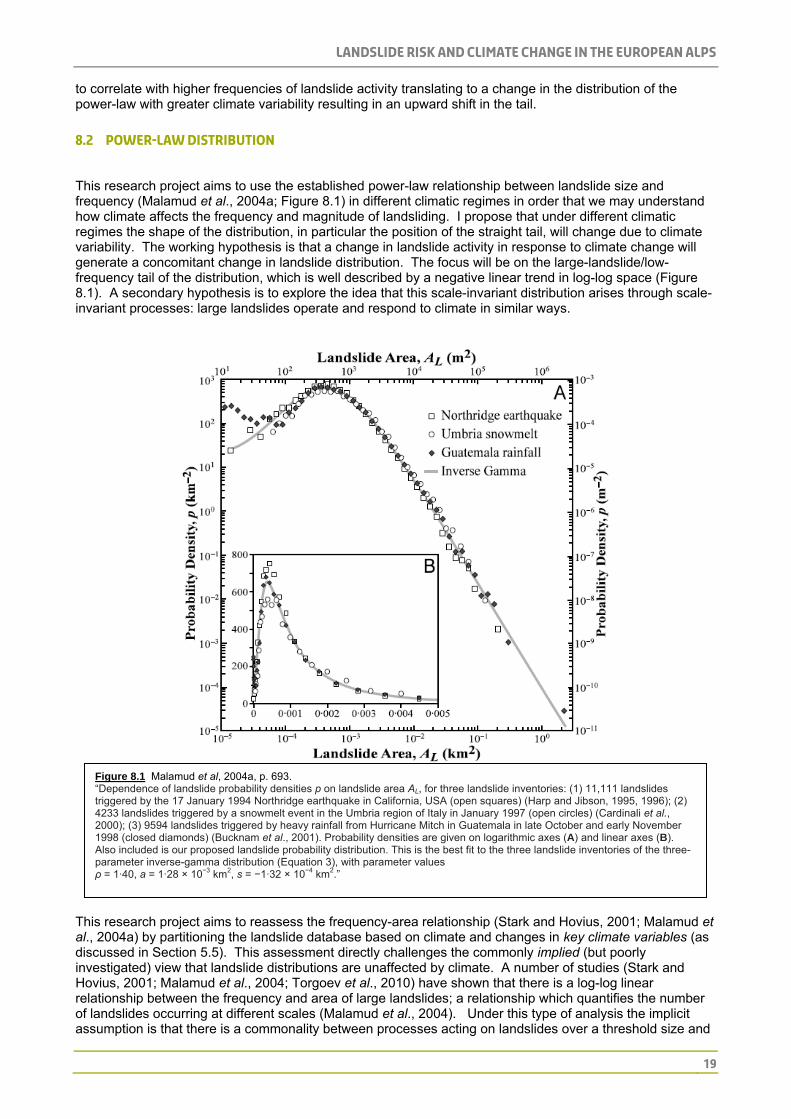
8.2 Power-law distribution This research project aims to use the established power-law relationship between landslide size and frequency (Malamud et al., 2004a; Figure 8.1) in different climatic regimes in order that we may understand how climate affects the frequency and magnitude of landsliding. I propose that under different climatic regimes the shape of the distribution, in particular the position of the straight tail, will change due to climate variability. The working hypothesis is that a change in landslide activity in response to climate change will generate a concomitant change in landslide distribution. The focus will be on the large-landslide/low-frequency tail of the distribution, which is well described by a negative linear trend in log-log space (Figure 8.1). A secondary hypothesis is to explore the idea that this scale-invariant distribution arises through scale-invariant processes: large landslides operate and respond to climate in similar ways.
Figure 8.1 Malamud et al, 2004a, p. 693. “Dependence of landslide probability densities p on landslide area AL, for three landslide inventories: (1) 11,111 landslides triggered by the 17 January 1994 Northridge earthquake in California, USA (open squares) (Harp and Jibson, 1995, 1996); (2) 4233 landslides triggered by a snowmelt event in the Umbria region of Italy in January 1997 (open circles) (Cardinali et al., 2000); (3) 9594 landslides triggered by heavy rainfall from Hurricane Mitch in Guatemala in late October and early November 1998 (closed diamonds) (Bucknam et al., 2001). Probability densities are given on logarithmic axes (A) and linear axes (B). Also included is our proposed landslide probability distribution. This is the best fit to the three landslide inventories of the three-parameter inverse-gamma distribution (Equation 3), with parameter values ρ = 1·40, a = 1·28 × 10−3 km2, s = −1·32 × 10−4 km2.”
This research project aims to reassess the frequency-area relationship (Stark and Hovius, 2001; Malamud et al., 2004a) by partitioning the landslide database based on climate and changes in key climate variables (as discussed in Section 5.5). This assessment directly challenges the commonly implied (but poorly investigated) view that landslide distributions are unaffected by climate. A number of studies (Stark and Hovius, 2001; Malamud et al., 2004; Torgoev et al., 2010) have shown that there is a log-log linear relationship between the frequency and area of large landslides; a relationship which quantifies the number of landslides occurring at different scales (Malamud et al., 2004). Under this type of analysis the implicit assumption is that there is a commonality between processes acting on landslides over a threshold size and

Landslide risk and climate change in the European alps
20
frequency; implying different triggers do not affect the shape of the distribution (Figure 8.1). This suggests that landslide size and frequency are not affected by climate as the distribution does not change. This paper intends to both look at landslide datasets as a whole (thereby validating the log-linear distribution) and by partitioning the datasets on the basis of time-varying climate regime to explicitly investigate the importance of climate change in triggering landslides.
A recent study considering the frequency/area relationship of landsliding over time has focussed on four landslide databases for the Maily-Say Valley in the Tien Shan (Figure 8.2). Unlike other landslide studies, these events were examined separately and grouped temporally. The frequency and magnitude are found to be increasing over time in this study; a relationship which had been attributed to the “increasing density of slope instabilities” (Torgoev et al., 2010, p. 34). This shows that when landslides are separated temporally there can be a difference in the position of the straight tail (Figure 8.2). Whilst Torgoev et al. (2010) do not make specific reference to the physical mechanisms behind this divergence, this paper hopes to test the hypothesis that changes in the frequency and magnitude of landslides over time will be correlated with changes in the climate.
Figure 8.2 Torgoev et al., 2010. Size/Frequency evolution of landslide areas in the Maily-Say Valley (115.4 km2). Data availability cover 1962 (162 events), 1984 (206), 1996 (222), 2002 (189) and 2007 (208).
8.3 Analysis and justification for landslide database As this paper looks at how the frequency and magnitude of landsliding changes with the climate, a landslide database or inventory is required as these are the easiest way of documenting landsliding for assessing these types of relationship (Guzzetti et al., 2000). An inventory map records the site and type of landslide in the region and also the date of initiation (Malamud et al., 2004a). Landslide inventories generally fall into one of two classes: those associated with a trigger; and historical inventories which document the landslide evolution of a region over time (Malamud et al., 2004a). In the case of this research project the temporal range would ideally include landslides from the LIA up to modern-day datasets. In order to determine whether the power-law relationship exists in the European Alps a landslide database must be collected which includes a minimum of the following:

Landslide risk and climate change in the European alps
21
Landslide ID (unique entity description)
Latitude/Longitude
Date Trigger Area of scarp (m2) Area of deposit (m2) Volume of scarp (m3) Volume of deposit (m3) Height Runout Supplementary details will include (where possible): Geology Aspect (°) Type of movement Journal reference
(Korup, 2010; personal
comm
unication)
For the analysis, the area and frequency of all landslides will initially be used and will be plotted on a log-log graph of frequency against area (m2) (Malamud et al., 2004a) and the data collected for this research would be expected to show a similar distribution. Following this the CRS will be used (Auer et al., 2007) to partition the data by climate; again a similar distribution would be expected but with a change in the positioning of the straight tail (as found by Torgoev et al., 2010). The final test will be a time-series investigation. The paper will look at the relationship between time and frequency, time and area, and finally the three together with x axis being time, the y axis landslide area (m2), and the z axis showing frequency. This will give a surface plot showing how the area (m2) and frequency of landsliding has changed over time. The temporal range of the landslide database will ideally be well distributed across the 20th century (as this is the temporal range of weather and climate data that is available). In a review of the statistical properties of landslide inventories, the authors found that the number of landslides per km2 varied from study to study. The range of landslide densities was from around 0.96 landslides per km2 (Bucknam et al., 2001) up to 2.11 landslides per km2 (Cardinali et al., 2000), yet the majority of landslides were not well distributed over this area and clusters of landslides appeared in the data (Malamud et al., 2004a). It seems evident that if the data are well clustered temporally and spatially, then a statistical relationship between landsliding and the climatic partitions will be attained. Another option would be to have landslide database covering a specific region with a good climatic record. The Barcelonnette region in France has a high resolution dataset of both climate and landslides with around 400 landslides mapped and documented in this region (Malet, 2010, personal communication). The temporal range is of around 100 years for landsliding and longer for climate. Within this dataset it may be possible to identify clusters of landslides which correlate with temperature and precipitation fluctuations as previously discussed. Other such datasets are available and may become available for this project; however the data is not yet forthcoming.
8.4 Database availability In terms of accessibility of data, an initial literature review has been conducted for the French Alps over a period of approximately 2 months. A database for Austria has also been collated over a period of 2 weeks with a total to date of 61 landslides. Along side this two datasets have been obtained from academic sources culminating in a total of around 500 landslides. There are also a number of datasets available online, with information about these being obtained from the Joint Research Centre (JRC, 2010). While these datasets provide direct and quick access to vast swathes of data, there will be an extensive amalgamation process. Many of the landslide databases miss out crucial elements such as magnitude, velocity and timings of failures as is common in such databases (Sorriso-Valvo, 2002). Available databases are also country specific and there is often little continuity between the various types of information offered by each. The format of each of the available databases is also vastly different across the European Alps, with the French database having all details available for download as one document region by region (Table 8.1) and the Austrians having the names of each landslide available for download, but details pertaining to each as a separate file, or as a list of available literature(Table 8.21, 8.22 and Figures 8.31 and 8.32). This results in a potentially time consuming exercise of extracting the necessary data required to look at the temporal and spatial distribution of landslides since the LIA.

Landslide risk and climate change in the European alps
22
BASE DE DONNEES NATIONALE DES MOUVEMENTS DE TERRAINS
(National Database of Land Movements)
Export des fiches du département (Exported records from the department) 06 (Alpes-Maritimes)
-IDENTIFICATION-
Identifiant (ID) 22300003
Type mouvement (Type of movement) Glissement (Slip)
Degré de fiabilité (Reliability) 1
Date début (Initiation date) 01/12/1987
Degré de précision (Degree of accuracy) Mois (Month)
Département (Department) Alpes-maritimes - (06)
Commune principale (Main town by proximity) AIGLUN
Numéro Insee (Number) 6001
Lieu dit (Name of place) --
Coordonnées X (m) (Coordinates X (m)) 969716
Coordonnées Y (m) (Coordinates X (m)) 1883746
Type coordonnées (Coordinate system) NTF Lambert 2 Centre
Coordonnée X en Lambert 2 étendu (m) (Coordinates X in Lambert (m)) 969716
Coordonnée Y en Lambert 2 étendu (m) (Coordinates Y in Lambert (m)) 1883746
-QUALITE FIABILITE PRECISION- (Quality and Precision, Reliability)
Degré de fiabilité de la fiche (Reliability of the data) Moyenne (Average)
Origine inconnue (Unknown origin) Saisie non validée (Entry not
valid)
-SOURCE- (Original source of the information)
LCPC (Laboratoire Central des Ponts et Chaussées)
- GEOMETRIE – (Geometry)
Pas de description géométrique (No geometric description) --
Largeur du glissement (Width of landslide) --
Amplitude du glissement (Magnitude) --
Volume du glissement (Volume transported) --
- DOMMAGES - (Damage)
Sur les biens (To property) Non (No)
Victimes (Victims) Non (No)
Table 8.1 Extract from the French Landslide Database showing the types of information available. The landslide selected is number 22300003 from the Alpes-Maritimes region of south-east France. Available online from http://www.bdmvt.net/.

Landslide risk and climate change in the European alps
23
Mass Movements
Number NameFederal Country Type Image Link
MB001 Schachtkopf Tyrol Rockfall/Rock Topple
Show Location
MB002 Am Saum Tyrol Rockfall/Rock Topple Available
Show Location
MB003 Fernpaß Nachsturz Tyrol Rockfall/Rock Topple Available
Show Location
MB004 Sonnspitze Tyrol Rockfall/Rock Topple
Show Location
MB005 Zunterköpfe Tyrol Rockfall/Rock Topple
Show Location
MB006 Ehrwald Tyrol Rockfall/Rock Topple
Show Location
MB007 Tschirgant Tyrol Rockfall/Rock Topple Available
Show Location
MB008 Haiming Tyrol Rockfall/Rock Topple Available
Show Location
MB009 Eibsee Tyrol Rockfall/Rock Topple
Show Location
MB010 Pletzachkogel Tyrol Rockfall/Rock Topple Available
Show Location
MB011 Mariathal Tyrol Rockfall/Rock Topple
Show Location
MB012 N Unken Salzburg Rockfall/Rock Topple
Show Location
MB013 Pass Luftenstein Salzburg Rockfall/Rock Topple
Show Location
MB014 Lofer 1 Salzburg Rockfall/Rock Topple
Show Location
MB015 Almtal Upper Austria
Rockfall/Rock Topple
Show Location
MB016 Grimming Styria Rockfall/Rock Topple
Show Location
MB017 Grimming E Styria Rockfall/Rock Topple
Show Location
MB018 Tragöß W Styria Rockfall/Rock Topple
Show Location
MB019 Tragöß E Styria Rockfall/Rock Topple
Show Location
MB020 Wildalpen Styria Rockfall/Rock Topple Available
Show Location
Table 8.21 An extract from the Austrian Mass Movement database. Information regarding the location is available from the Show Location hyperlink on the website. Available online from http://geomap.geolba.ac.at/MASS/MASS_main.cfm?Init=false.
Number/OBJECT ID
MB002 (OID: 176)
Source of literature
Abele, G. (1964); Steinbichler, C. U. Tippelt, O. (2006)
Internet links http://www.nat-hazards-earth-syst-sci.net/8/377/2008/nhess-8-377-2008.pdf http://info.tuwien.ac.at/geophysik/bibliography/reports/Geophysikexkursion2006_Berichte.pdf
Region of Austria Tyrol Mass Movement: Sagging of mountain slopes Contact: Department of Engineering Geology
Table 8.22 Am Saum landslide (see also Table 3.21). As shown, the information pertaining to the landslide itself is available from a number of sources including online information, through academic literature and from information available from the Department of Engineering Geology.

Landslide risk and climate change in the European alps
24
Figure 8.31 An image from the Austrian Mass Movement database of the Am Saum landslide.
Figure 8.32 Corresponding map of image 3.11 available from http://geomap.geolba.ac.at/MASS/MASS_main.cfm?Init=false with the star in the centre of the map representing the site of the landslide.

Landslide risk and climate change in the European alps
25
A number of smaller databases are available in the literature covering different areas of the European Alps. These are not suitable to use the power-law distribution analysis on due to the small number of recorded events, however can be used to look at landslide clusters across datasets. This is in line with the landslide clustering hypothesis as outlined in Section 8.1. The following Table 8.3 details the literature which could be used in such a way.
Authors Number of Landslides Temporal Range Area Other
Soldati et al., 2004 24 13,000 to 2,300 B.C. Italian Dolomites
Dapples et al., 2002 5 4,300 to 450 B.P.
Western Swiss Alps
Highly influenced by anthropogenic activity
Martin, 1994 33 1816 to 1993 A.D.
Vars, Hautes-Alpes, Fr. Dates of re-activations also
Gasparetto et al., 1994 30
10,850 to 4,220 B.P. Italian Dolomites
Dramis et al., 1994 1 1561 to 1992 A.D.
Marche, Apennines, It. 39 re-activations and climate data
Panizza et al., 1996 28 12,150 to 153 B.P. Italian Dolomites
Table 8.3 Showing the availability of smaller inventories in the literature which could be used to identify landslide clusters.
8.5 Landslide database (ArcGIS and Google Earth)
The mapping of the distribution of landslides will be carried out in Google Earth and input to ArcGIS. Google Earth has been highlighted as an appropriate and useful way by which to collate a landslide map (Korup, 2010, personal communication). Following this the data will be transferred into ArcGIS which is an appropriate and accessible way to look at spatial patterns within the datasets. ArcGIS also allows for various types of data to be collated in one place, with easy access to different layers and ways in which to link other data sources to the database.
8.6 SRTM data
A shuttle radar topography mission (SRTM) digital elevation model (DEM) at 90 m resolution is available for the whole of the European Alps (Figure 8.4). The data will be used as a layer in the final hazard map to both visually represent the spatial context of the landslide database in ArcGIS and to assess susceptible areas. The data can easily be analysed in both ArcGIS and MatLab and variation in slope angle can be determined in order to ascertain areas more susceptible to landsliding. The DEM will also be used to look at potential runout distances and there are various analysis tools in ArcGIS such as flow accumulation and direction which will also be of use in this. Other tools available in ArcGIS include spatial statistics tools which will be used to identify clusters in the dataset.

Landslide risk and climate change in the European alps
26
Figure 8.4 SRTM data, available for download from http://srtm.csi.cgiar.org/.
8.7 Google Earth
Google Earth has proven to be a useful tool for the amalgamation of landslide datasets due to its accessibility and ease of use. The software allows the user to zoom into high resolution images of the landscape, and also gives a 3D topographic view which greatly facilitates the mapping process. This has proved extremely useful in mapping landslides from the literature. There is an easy-to-use latitude/longitude indicator and matches well with the coordinates given in the literature, however others (Nourbakhsh et al., 2006) have found that the place names offered by Google Earth are sometimes up to 100 km out. The actual mapping of the landslides has been done by eye using the polygon tool in Google Earth (Figure 8.5). The data can then be saved as a kml. file and used with MatLab. The benefits of using Google Earth are numerous; as well as being freely accessible, the images are of a high resolution at between 6 inches and 15 meters (Nourbakhsh et al., 2006). The images are not always up-to-date and can be as old as three years in some cases (Nourbakhsh et al., 2006), however as this study is aiming to look at a wider temporal range than three years and so this has not been identified as an issue. Identifying older landslides is an issue as the deposits have often been eroded and have become vegetated, but the main priority of the mapping is pinpointing the location which has still proven possible. The area of the deposit is often referred to in journal articles as well as the size and date and so Google Earth stands up as an appropriate tool. In addition to this, Google Earth records areas of interest, populated areas, hotels and some infrastructure such as roads. As risk is central to this study, these elements will be of use when a pattern of landsliding determined, although location of specific sites may present an issue here. These may also be extracted as a layer and used in conjunction with the SRTM data and landslide database in ArcGIS.

Landslide risk and climate change in the European alps
27
Figure 8.5 Google Earth image including a number of landslides recorded at the Italian/French/Swiss border.
8.8 Climate data The spatial and temporal distribution of climate must also be characterised; specifically MAAT and precipitation variability at monthly, seasonal and annual timescales (as previously discussed). I am hoping to link changes in the variability of climate with changes in the frequency and magnitude of landsliding so it is important to understand the spatial distribution of these variables if landslide distribution is to be spatially correlated with the climate partitions (cf. Auer et al., 2007). In order to achieve this, the data will be divided both spatially by these regions and temporally by the LIA and present or by modern partitions to investigate the impact of specific climatologies on landsliding.
8.9 Instrumental data
Instrumental data are widely available for the European Alps and are at a good spatial resolution (Figure 3.1). The HISTALP dataset comprises 242 weather stations recording temperature, precipitation, air pressure, cloudiness and sunshine at a temporal resolution of a month since ~1850 for a number of sites (Auer et al., 2007). The density of recording stations is typically ~100-150 km for precipitation pre-1930, and ~60 km for the rest of the 20th century (Auer et al., 2007). Figure 8.6 shows the growth of monitoring stations in the region since records initially began in 1760. The benefits of using such a dataset are that the effects of heterogeneities such as changes in location, site surroundings, instruments, time of observation, observers and other factors (Auer et al., 2007) have been reduced, and the datasets have been rigorously checked.

Landslide risk and climate change in the European alps
28
Figure 8.6 Development of the HISTALP monitoring network for the European Alps. Bold lines indicate the homogenised gap-filled dataset while the thin lines show the original data.
8.10 Limitations
8.10.1 Landslide database comprehensiveness
One of the main issues which will have to be overcome and quantified is the comprehensiveness of the landslide database. It is not going to be possible within the limits of this PhD to successfully map and account for all landslides in the study area as not all will be recorded in available landslide databases or in the literature. The theory behind using the power-law distribution of Malamud et al. (2004) is that it will allow for the reconstruction of missing data where large landslides are concerned and so will allow for us to assess the comprehensiveness of the database (Korup, 2005b).
8.10.2 Literature review issues
The literature review of available data from journals was extremely time-consuming, and provided a limited number of results. It is a relatively inefficient method for obtaining the vast volumes of data required for this research. Many journals do not give specific coordinates of the landslide location, however Google Earth has proved useful in identifying landslides in this respect as often images of the landslide location are given. Where coordinates are given, these have been found to correlate well with the images obtained in Google Earth; however this too extends the time taken to document each landslide. The literature trawl method will be the primary method of data collection should appropriate databases not become available.
8.10.3 Language and accessibility
Due to the project focus on the European Alps, with the preliminary literature review centring on the French portion of the Alps, there are issues with language and accessibility of journals. Many journals containing information about particular landslides in these areas are either in French, Italian, or German, and while the author is able to understand French, reading French journals is a slow process due to differences in phrasing and idioms. Another issue with foreign journals is that many of the older journals (as with English journals) are not available online and must be requested though the library; again a process which can be time consuming.
8.10.4 Online database issues
As discussed in Section 8.4, many of the readily available online databases do not include magnitude or area, both of which are crucial to this study. The spatial distribution of landslides is easily obtainable as most databases interface revolves around a map of the region concerned. While these databases do contain date information, this would have to be mapped and extracted separately from the online databases. Other issues revolve around the varying formats each of the databases present; changing the way data is extracted from each database extends the time taken to extract the data.

Landslide risk and climate change in the European alps
29
8.10.5 Climate data limitations
As with all climatological datasets, there are limitations to their ability to represent the climatic situation of an area as diverse as the European Alps. The HISTALP dataset, however, goes a long way to overcoming issues relating to topography and spatial resolution as it has been rigorously tested and verified with a good temporal resolution.

Landslide risk and climate change in the European alps
30
9 Results and database to-date
9.1 Initial literature review database
An initial literature review was carried out between September and November 2010 to assess the feasibility of such a methodology. As the author is able to speak French, it was decided that her efforts would initially fall to the French Alps. The literature review involved compiling a database in Excel and a map of landslide locations in Google Earth (Figure 9.1). Google Earth is being used in this way for data collection as the tool allows for detailed mapping of the visible landslide as well as a coordinate system by which to pinpoint the exact location of the landslide. It is more appropriate than ArcGIS at this stage as SRTM data and Landsat data do not provide as detailed a view of the land surface. A total of 36 landslides have been recorded to date and mapped in this way. This method of data collection will be used in conjunction with obtaining datasets from academic and other sources in order to build up a substantive dataset.
Figure 9.1 Google Earth image of Charmonétier landslide from the literature trawl database.
9.2 Landslide database for the Grenoble region
A database of 113 landslide/rockfalls from the Grenoble region in South-West France with a temporal range from 1248 A.D. to 1997 A.D. has been obtained (Helmstetter, 2010, personal communication). The temporal range of the dataset is not representative of the data contained, and pre-1935 there is a very limited number of recorded events, with 89 events in the dataset occurring after this time. However, when the data are plotted on a log-log graph of frequency and volume they exhibit a power-law distribution (see Figure 9.2) in line with the more substantive datasets of Malamud et al. (2004a) and Stark and Hovius (2001).

Landslide risk and climate change in the European alps
31
Figure 9.2 Dussauge-Peisser et al.(2002; p.18). Frequency/volume distribution of the Grenoble rockfall database. The distribution has been plotted using 87 of the 113 events and would appear to exhibit similar properties to that of the Malamud et al. (2004a) and the Stark and Hovius (2001) power-law distributions.
9.3 SRTM data A section of the data focussing on the Schesatobel landslide area has been selected for initial investigation in MatLab (data obtained from the Geologische Bundesanstalt online database). This area was selected from the SRTM data using an ArcGIS mask, and the smaller area was then extracted into MatLab to look at the distribution of hillslope angles (Figures 9.31 and 9.32). This area has a wide range of hillslope angles, although the distribution shows that the majority of these lie within the range of 20-30°, with the average being 20.31°. These kinds of analyses can be performed on multiple areas in the European Alps and analysis can be carried out looking at spatial patterns in the datasets, whilst also relating these to topography.

Landslide risk and climate change in the European alps
32
Figure 9.31 Left: MatLab image of the area around the Schesatobel landslide, Austria. The area was selected in ArcGIS, and input to MatLab to calculate the hillslope angles. The average slope is 20.31°. Figure 9.32 Right: Graph showing the distribution of slope angles for the area.
Figure 9.33 Left: Hazard map showing the areas with slope angle greater than 40°. 40° has been selected as an arbitrary figure to show how the method may work when susceptible slope angles have been investigated further. Figure 9.34 Right: Image of the hazard map overlain on the DEM.

Landslide risk and climate change in the European alps
33
9.4 Seismic triggers The European Alps is seismically active, and climate fluctuations will not be the sole factor in the initiation of a landslide, and may not even be the main factor. As such, other variables including earthquake frequency and magnitude are going to be important and must be considered within this study. Google Earth compatible kml. files are available from the USGS, and initial investigations into the spatial and temporal frequency of earthquakes for the European Alps have been considered from 1973 to 2010 (USGS, 2010; Figure 9.4). Malamud et al. (2004b) suggest that the minimum magnitude required for the initiation of a landslide is M=4.3±0.4. Figure 9.4A shows all earthquakes M≥4, but when compared to Figures 9.4B and 9.4C it is evident that the majority of earthquakes are ~M4. For this project, being able to identify these non-climatic triggers is important as they will potentially disrupt the climate signal. It is likely that some of the landslides in the landslide inventories will have been triggered by earthquakes and so both temporal and spatial extent must be determined and eliminated from the dataset. There is an element of this which will be considered after initial tests are carried out on the landslide database; I propose to iteratively develop our understanding of linkages between climate change and landsliding as we take these factors into account at different stages of the analysis.
A B
C
Figure 9.4 USGS earthquake map for the European Alps and surrounding areas for the period 1973-2010. A: Magnitude included is ≥M4. B: Magnitude shown is M4 only. C: Magnitude shown is ≥M5. The colours used refer to the depth of the earthquake epicentre in kilometres (see key to the right).

Landslide risk and climate change in the European alps
34
10 Concluding remarks The European Alps represent a marginal environment which has seen significant growth in infrastructure, population and tourism (Hilker et al., 2007). The climate of the European Alps is changing and “exerting a more significant role in the generation of geomorphological hazards by influencing the operation of all landscape elements” (Keiler et al., 2010, p. 2462). The European Alps remains in a period of adjustment following the last glacial, and as such is affected by climatic changes to a greater degree than low-lying areas (Keiler et al., 2010). As this warming trend continues, landsliding in such marginal areas will continue and intensify with the changing climate. When this is combined with increasing populations and development in these areas, the risk of damage and loss of life continues to increase making the prediction of these events an important factor in trying to reduce the risk and mitigate the potential consequences. The links between climate and landsliding are clear in the literature, and as such the risks posed on infrastructure, property and populations by large landslides are increasing.
This research is important as it will determine how the climate influences the magnitude and frequency of large landslides in the European Alps; and more specifically look at which climate metrics have the greatest influence. Landslide frequency-area distribution curves are commonly used within the literature to represent the number of landslides occurring at different scales, however this relationship has been assumed to not change over time or due to different landslide triggers. This research directly challenges this, and by partitioning the landslide database based on important climatic parameters (as discussed in Section 5.5) It is hoped that this research shows that different climates do play an important role, and that variability in climate has a significant influence on landsliding.

Landslide risk and climate change in the European alps
35
11 References Abele, G (1997). Influence of glacier and climatic variation on rockslide activity in the Alps. In: Matthews, J.A., Brunsden, D., Frenzel, B., Gläser, B., Weiß, M.M. (Eds.), Rapid Mass Movement as a Source of Climatic Evidence for the Holocene. Paläoklimaforschung-Palaeoclimate Research, 19. Gustav Fischer Verlag, Stuttgart, 1-6. Anders, A.M., Roe, G.H., Hallet, B., Montgomery, D.R., Finnegan, N.J. and Putkonen, J. (2006). Spatial patterns od precipitation and topography in the Himalaya. Geological Society of America, Special Paper 398, 39-53. Archer, D (2005). Fate of fossil fuel CO2 in geologic time. Journal of Geophysical Research 110, doi:10.1029/2004JC002625, 2005. Auer et al. (2007). HISTALP – Historical Instrumental Climatological Surface Time Series of the Greater Alpine Region. International Journal of Climatology 27, 17-46. Barlow, L.K., Sadler, J.P., Ogilvie, A.E.J., Buckland, P.C., Amorosi, T., Ingimundarson, J.H., Skidmore, P., Dugmore, A.J. and McGovern, T.H. (1997). Interdisciplinary investigations of the end of the Norse Western Settlement in Greenland. The Holocene 7(4), 489-499. Barry, R.G. (2006). The status of research on glaciers and global glacier recession: a review. Progress in Physical Geography 30(3), 285-306. Bartolini, E., Claps, P. and D’Odorico, P. (2009). Interannual variability of winter precipitation in the European Alps: relations with the North Atlantic Oscillation. Hydrological Earth System Sciences 13, 7–25. BBC News (2010; 2011). Available online at http://bbc.co.uk/news/. Last accessed 18/01/2010. Beguería, S. and Vicente-Serrano, S.M. (2006). Mapping the hazard of extreme rainfall by peaks-over-threshold extreme value analysis and spatial regression techniques. Journal of Applied Meteorology and Climatology 45, 108-124. Beltrami, H. and Bourlon, E. (2004). Ground warming patterns in the Northern Hemisphere during the last five centuries. Earth and Planetary Science Letters 227, 169-177. Beniston, M. (2005). Mountain climates and climate change: an overview of processes focusing on the European Alps. Pure and Applied Geophysics 162, 1587-1606. Benn, D.I. and Evans, D.J.A. (1998). Glaciers and Glaciation. Arnold, London (Pubs.). Bisci, C., Dramis, F. and Sorriso, M. (1996). Rock Flow. Landslide Recognition: Identification, movement and causes. Dikau, R., Brunsden, D., Schrott, L. and Ibsen, M-L. [Eds.]. John Wiley & Sons [Pubs.], 1996, 150-160. Böhm, R., Auer, I., Brunetti, M., Maugeri, M., Nanni, T. and Schöner, W. (2001). Regional temperature variability in the European Alps: 1760–1998 from homogenized instrumental time series. International Journal of Climatology 21, 1779–1801. Bond, G.C, Showers, W., Cheseby, M., Lotti, R., Almasi, P., deMenocal, P., Priore, P., Cullen, H., Hajdas, I. and Bonani, G. (1997). A pervasive millennial-scale cycle in North Atlantic Holocene and Glacial Climates. Science 278, 1257-1266. Bond, G.C, Showers, W., Elliot, M., Evans, M., Lotti, R., Hajdas, I., Bonani, G. and Johnson, S. (1999). North Atlantic’s 1-2 kyr climate rhythm: relation to Heinrich Events, Dansgaard/Oeschger Cycles and the Little Ice Age. Mechanisms of Global Climate Change at Millennial time scales, Clark, Webb and Keigwin [eds]. Geophysical Monograph Series 112, 35-58. Borga, M., Fontana, G.D., Gregoretti, C. and Marchi, L. (2002). Assessment of shallow landslides by using a physically based model of hillslope stability. Hydrological Processes 16, 2833-2851. Borgatti, L.. & Soldati, M. (2010). Landslides as a geomorphological proxy for climate change: A record from the Dolomites (northern Italy). Geomorphology 120, 56-64. Bradley, R.S. and Jones, P.D. (1993). ‘Little Ice Age’ summer temperature variations: their nature and relevance to recent global warming trends. The Holocene 3(4), 367-376. Briffa, K.R. (2000). Annual climate variability in the Holocene: interpreting the message of ancient trees. Quaternary Science Reviews 19, 87-105. Broëcker, W.S. (2001). Was the Medieval Warm Period Global? Science, New Series 291(5508), 1497-1499. Brunsden, D. and Ibsen, M-L. (1996). Mudslide. Landslide Recognition: Identification, movement and causes. Dikau, R., Brunsden, D., Schrott, L. and Ibsen, M-L. [Eds.]. John Wiley & Sons [Pubs.], 1996, 103-119. Bucknam, R.C., Coe, J.A., Chavarria, M.M., Godt, J.W., Tarr, A.C., Bradley, L.-A., Rafferty, S., Hancock, D., Dart, R.L. and Johnson, M.L. (2001). Landslides Triggered by Hurricane Mitch in Guatemala – Inventory and Discussion. US Geological Survey Open File Report 01–443. Büntgen, U., Frank, D.C., Nievergelt, D. and Esper, J. (2006). Summer temperature variability in the Alps, A.D. 755-2004. Journal of Climate 19, 5606-5623. Cardinali, M., Ardizzone, F., Galli, M., Guzzetti, F. and Reichenbach, P. (2000). Landslides triggered by rapid snow melting: the December 1996– January 1997 event in Central Italy. Proceedings 1st Plinius Conference on Mediterranean Storms. Claps P, Siccardi F (eds). Bios: Cosenza; 439–448. Casty, C., Wanner, H., Luterbacher, J., Esper, J. and Böhm, R. (2005). Temperature and precipitation variability in the European Alps since 1500. International Journal of Climatology 25, 1855-1880. Chemenda, A., Bouissou, S. and Bachmann, D. (2005). Three-dimensional modelling of deep-seated landslides: new technique and first results. Journal of Geophysical Research 110, doi:10.1029/2004JF000264. Chigira, M. (2002). The effects of environmental changes on weathering, gravitational rock deformation, and landslides. In: Environmental Change and Geomorphic Hazards in Forests. Sidle, R.C. [Ed.]. CABI Publishing, Oxon, UK.

Landslide risk and climate change in the European alps
36
Chuine, I., Yiou, P., Viovy, N., Seguin, B., Daux, V. and Ladurie, E. (2004). Historical phenology: Grape ripening as a past climate indicator. Nature 432, 289-290. Christensen, J.H., Hewitson, B., Busuioc, A., Chen, A., Gao, X., Held, I., Jones, R., Kolli, R.K., Kwon, W.-T., Laprise, R., Magaña Rueda, V., Mearns, L., Menéndez, C.G., Räisänen, J., Rinke, A., Sarr, A. and Whetton (2007). Regional Climate Projections. Climate Change 2007: The Physical Scientific Basis. Contribution of Working Group 1 to the Fourth Assessment Report of the Intergovernmental Panel on Climate Change [Solomon, S., Qin, D., Manning, M., Chen, Z., Marquis, M., Averyt, K.B., Tignor, M. and Miller, H.L. (eds.)]. Cambridge University Press, Cambridge, UK and New York, NY, USA. Corominas, J. and Moya, J. (1999). Reconstructing recent landslide activity in relation to rainfall in the Llobregat River basin, Eastern Pyrenees, Spain. Geomorphology 30, 79-93. Corti, S., Molteni, F. and Palmer, T.N. (1999). Signature of recent climate changes in frequencies of natural atmospheric circulation regimes. Nature 398, 799-802. Crowley, T.J. (2000). Causes of climate change over the past 1000 years. Science 289, 270-276. Crowley, T.J. and Lowery, T.S. (2000). How warm was the Medieval Warm Period? Ambio 29(1), 51-54. Cruden, D. and Varnes, D. (1996). Landslide types and process. In A. Turner and R. Schuster (Eds.), Landslides: Investigation and mitigation (pp. 36– 75). Washington, DC’ Transportation Research Board, National Research Council, National Academy Press. CRUTEM3 (2010). Met Office Hadley Centre observations datasets available online from http://hadobs.metoffice.com/crutem3/data/download.html. Last accessed 21/08/2010. Dai, F.C. and Lee, C.F. (2001). Frequency-volume relation and prediction of rainfall-induced landslides. Engineering Geology 59, 253-266. Dapples, F., Lotter, A.F., van Leeuwen, J.F.N., van der Knaap, W.O., Dimitridis, S. and Oswald, D. (2002). Paleolimnological evidence for increased landslide activity due to forest clearing and land-use since 3600 cal BP in the western Swiss Alps. Journal of Paleolimnology 27, 239-248. Davies, M.C.R., Hamza, O. and Harris, C. (2001). The effect of rise in mean annual temperature on the stability of rock slopes containing ice-filled discontinuities. Permafrost and Periglacial Processes 12, 137-144. Davis, B.A.S., Brewer, S., Stevenson, A.C., Guiot, J. and CEREGE data contributions (2003). The temperature og Europe during the Holocene reconstructed from pollen data. Quaternary Science Reviews 22(15-17), 1701-1716. Deline, P. (2009). Interactions between rock avalanches and glaciers in the Mont Blanc Massif during the late Holocene. Quaternary Science Reviews 28, 1070-1093. deMenocal, P., Ortiz, J., Guilderson, T. and Sarnthein, M. (2000). Coherent high-and low-latitude climate variability during the Holocene warm period. Science 288, 2198-2202. Dramis, F., Gentile, B., Rodolfi, G., Bisci, C. And Di Eusebio, F. (1994). Ancient and Historic Landsliding in villages of Marche region and of Tosco-Romagnolo Apennine. In: Temporal Occurrence and Forecasting of Landslides in the European Community, Casale, Fantechi and Flageollet (Eds.). Final Report, 2, 871-890. Dussauge-Peisser, C., Helmstetter, A., Grasso, J.-R., Hantz, D., Desvarreux, P., Jeannin, M. And Giraud, A. (2002). Probabilistic approach to rock fall hazard assessment: Potential of historical data analysis. Natural Hazards and Earth System Science 2, 15-26. Esper, J., Cook, E.R. and Schweingruber, F.H. (2002). Low-frequency signals in long tree-ring chronologies for reconstructing past temperature variability. Science 295, 2250-2253. Esper, J. and Frank, D. (2009). The IPCC on heterogeneous Medieval Warm Period. Climatic Change 94, 267-273. Fell, R. (1994). Landslide risk assessment and aacceptable risk. Canadian Geotechnical Journal 31, 261-272. Fisher, D.A., Körner, R.M., Kuiviner, K., Clausen, H.B., Johnson, S.J., Steffensen, J.P., Gunderstrup, N and Hammer C.U. (1996). Intercomparison of ice core and precipitation records from sites in Canada and Greenland over the past 3500 years and over the last few centuries in detail using EOF techniques. In Jones, P.D., Bradley, R.S. and Jouzel, J. [eds.]. Springer, Berlin, p 297-328. Folland C.K., Knight, J., Linderholm, H.W., Fereday, D., Ineson, S. and Hurrell, J. (2009). The Summer North Atlantic Oscillation: past, present and future. Journal of Climate 22, 1082–1103. Frank, D. and Esper, J. (2005). Temperature reconstruction and comparisons with instrumental data from a tree-ring network for the European Alps. International Journal of Climatology 25(11), 1437-1454. Gad, F. (1970). A History of Greenland, Vol. 1, London, Hurst and Co.. Gasparetto, P., Panizza, M., Pasuto, A., Silvano, S. And Soldati, M. (1994). Research in the Cortina d’Ampezzo Area. In: Temporal Occurrence and Forecasting of Landslides in the European Community, Casale, Fantechi and Flageollet (Eds.). Final Report, 2, 741-794. Ge, Q., Zheng, J., Fang, X., Man, Z., Zhang, Z., Zhang, P. and Wang, W.-C. (2003). Winter half-year temperature reconstruction for the middle and lower reaches of the Yellow River and Yangtze River, China, during the past 2000 years. The Holocene 13(6), 933-940. Glaser, R. and Riemann, D. (2009). A thousand-year record of temperature variations for Germany and Central Europe based on documentary data. Journal of Quaternary Science 24, 437-449. Goosse, H., Arzel, O., Luterbacher, J., Mann, M.E., Renssen, H., Riedwyl, N., Timmermann, A., Xoplaki, E. and Wanner, H. (2006). The origin of the European “Medieval Warm Period”. Climate of the Past 2, 99-113. Grove, J.M. (2001). The initiation of the “Little Ice Age” in regions around the North Atlantic. Climatic Change 48, 53-82. Grove, J.M. (2004). Little Ice Ages: Ancient and Modern. Routledge, London. Gruber, S., Hoelzle, M. and Haeberli, W. (2004a). Permafrost thaw and destabilisation of Alpine rock walls in the hot summer of 2003. Geophysical Research Letters 31, doi:10.1029/2004GL020051. Gruber, S., Hoelzle, M. and Haeberli, W. (2004b). Rock-wall temperatures in the Alps: modelling their topographic distribution and regional differences. Permafrost and Periglacial Processes 15(3), 299-307. Gruber, S. and Haeberli, W. (2007). Permafrost in steep bedrock slopes and its temperature-related destabilisation following climate change. Journal of Geophysical Research 112, doi:10.1029/2006JF000547.
Landslide risk and climate change in the European alps
37
Guzzetti, F., Cardinali, M., Reichenbach, P. and Carrara, A. (2000). Comparing Landslide Maps: A case study in the Upper Tiber River Basin, Central Italy. Environmental Management 25(3), 247-263. Guzetti, F. (2005). Landslide Hazard and Risk Assessment: Concepts, methods and tools for the detection and mapping of landslides, for landslide susceptibility zonation and hazard assessment, and for landslide risk evaluation. PhD Thesis, Bonn University. Haeberli, W., Hoelzle, M., Paul, F. and Zemp, M. (2007). Integrated monitoring of mountain glaciers as key indicators of global climate change: the European Alps. Annals of Glaciology 46(1), 150-160. Hansen, J., Sato, M., Kharecha, P., Beerling, D., Berner, R., Masson-Delmotte, V., Pagani, M., Raymo, M., Royer, D.L. and Zachos, J.C. (2008). Target atmospheric CO2: Where should humanity aim? The Open Atmospheric Science Journal 2, 217-231. Haug, G.H., Ganopolski, A., Sigman, D.M., Rosell-Mele, A., Swann, G.E.A., Tiedemann, R., Jaccard, S.L., Bollmann, J., Maslin, M.A., Leng, M.J. and Eglinton, G. (2005). North Pacific seasonality and the glaciation of North America 2.7 million years ago. Nature 433, 821-825. HadUKP (2010). Met Office Hadley Centre observations datasets HadUKP. Available online at http://hadobs.metoffice.com/hadukp/. Last accessed 21/12/2010. Hegerl, G.C., Zwiers, F.W., Braconnot, P., Gillett, N.P., Luo, Y., Marengo Orsini, J.A., Nicholls, N., Penner J.E. and Stott, P.A. (2007). Understanding and Attributing Climate Change. In: Climate Change 2007: The Physical Science Basis. Contribution of Working Group I to the Fourth Assessment Report of the Intergovernmental Panel on Climate Change [Solomon, S., Qin, D., Manning, M., Chen, Z., Marquis, M., Averyt, K.B., Tignor M. and Miller, H.L. (eds.)]. Cambridge University Press, Cambridge, United Kingdom and New York, NY, USA. Helmstetter, A. (2010). RTM Landslide database for the Grenoble region, SW France. Personal communication via email. Hendy, E.J., Gagan, M.K., Alibert, C.A., McCulloch, M.T., Lough, J.M. and Isdale, P.J. (2002). Abrupt decrease in tropical Pacific Sea Surface Salinity at the end of the Little Ice Age. Science 295, 1511-1514. Hermanns, R.L., Trauth, M.H., Niedermann, S., McWilliams, M. and Strecker, M.R. (2000). Tephrochronologic constraints on temporal distribution of large landslides in northwest Argentina. The Journal of Geology 108, 35-52. Hétu, B. and Gray,J.T. (2000). Effects of environmental change on scree slope development throughout the postglacial period in the Chic-Choc Mountains in the northern Gaspé Peninsula, Québec. Geomorphology 32, 335-355. Hilker et al. (2009). The Swiss Flood and Landslide Damage Database 1972-2007. Natural Hazards and Earth System Science 9, 913-925. HISTALP (2010). HISTALP – Historical Instrumental Climatological Surface Time Series of the Greater Alpine Region. Available online at: http://www.zamg.ac.at/histalp/component/option,com_frontpage/Itemid,1/index.html. Holm, K., Bovis, M. and Jakob, M (2004). The landslide response of alpine basins to post-Little Ice Age glacial thinning and retreat in southwestern British Columbia. Geomorphology 57, 201-216. Hovius, N., Stark, C.P. and Allen, P.A. (1997). Sediment flux from a mountain bed derived by landslide mapping. Geology 25, 231-234. Huang, S., Pollack, H.N. and Shen, P.-Y. (2000). Temperature trends over the past five centuries reconstructed from borehole temperatures. Nature 403, 756-758. Huang, S., Pollack, H.N. and Shen, P.-Y. (2008). A late Quaternary climate reconstruction based on borehole heat flux data, borehole temperature data, and the instrumental record. Geophysical Research Letters 35, dio:10.1029/2008GL034187, 2008. Huntingford, C., Stott, P.A., Allen, M.A. and Lambert, F.H. (2006). Incorporating model uncertainty into attribution of observed temperature change. Geophysical Research Letters 33, doi: 10.1029/2005GL024831. Hurrell, J.W. (1995). Decadal trends in the North Atlantic Oscillation: regional temperatures and precipitation. Science 269, 676-679. Hurrell, J.W., Kushnir, Y., Otterson, G. and Visbeck, M. (2003). The North Atlantic Oscillation: Climatic Significance and Environmental Impact. Geophysical Monograph Series. Washington DC: American Geophysical Union. IPCC (2007). The Physical Science Basis. Contribution of Working Group I to the Fourth Assessment Report of the Intergovernmental Panel on Climate Change, 2007. Solomon, S., D. Qin, M. Manning, Z. Chen, M. Marquis, K.B. Averyt, M. Tignor and H.L. Miller (eds.). Cambridge University Press, Cambridge, United Kingdom and New York, NY, USA. Iverson, R.M. (2000). Landslide triggering by rain infiltration. Water Resources Research 36, 1897-1910. Ivy-Ochs, S., Kerschner, H., Reuther, A., Maisch, M., Sailer, R., Schaefer, J., Kubik, P.W., Synal, H.-A. and Schlüchter, C. (2006). The timing of glacier advances in the Northern European Alps based on surface exposure dating with cosmogenic 10Be, 26Al, 36Cl and 21Ne. In situ-produces cosmogenic nuclides and quantification of geological processes: Special Paper 415, 43-60. Jakob, M (2005). A size classification of debris flows. Engineering Geology 79, 151-161. Jones, P.D. and Bradley, R.S. (1992). Climatic variations over the last 500 years. In Climate Since AD 1500. Bradley and Jones [Eds.], Routledge, New York and London, p. 649-665. Jones, P.D. and Mann, M.E. (2004). Climate over past millennia. Reviews of Geophysics 42, AGU Paper number: 2003RG000143. Jones and Briffa (2006). Unusual Climate in Northwest Europe During the Period 1730 to 1745 Based on Instrumental and Documentary Data. Climatic Change 79, 361-379. Jones, P.D., Parker, D.E., Osborn, T.J. and Briffa, K.R. (2010). Global and hemispheric temperature anomalies—land and marine instrumental records. In Trends: A Compendium of Data on Global Change. Carbon Dioxide Information Analysis Center, Oak Ridge National Laboratory, U.S. Department of Energy, Oak Ridge, Tenn., U.S.A. doi: 10.3334/CDIAC/cli.002 JRC (2010). Landslides. Land Management and Natural Hazards Unit. Available online at http://eusoils.jrc.ec.europa.eu/library/themes/Landslides/#Europe. Last accessed 20/11/2010.

Landslide risk and climate change in the European alps
38
Katz, R.W. and Brown, B.G. (1992). Extreme events in a changing climate: Variability is more important than averages. Climatic Change 21(3), 289-302. Keiler, M., Knight, J. and Harrison, S. (2010). Climate change and geomorphological hazards in the eastern European Alps. Philosophical Transactions of the Royal Society A 368, 2461-2479. Kitoh, A. (2004). Effects of mountain uplift on East Asian summer climate investigated by a coupled Atmosphere-Ocean GCM. Journal of Climate 17, 783-802. Korup, O. (2005a). Geomorphic imprint of landslides on alpine river systems, southwest New Zealand. Earth Surface Processes and Landforms 30, 783-800. Korup, O. (2005b). Distribution of landslides in southwest New Zealand. Landslides 2, 43-51. Korup, O. (2010). Personal communication via email. Kump, L.R. (2002). Reducing uncertainty about carbon dioxide as a climate driver. Nature 419, 188-190. LaMarche, V.C. (1974). Palaeoclimatic inferences from long tree-ring records. Science 183, 1043-1048. Lamb, H.H. (1977). Climate: Present, past and future: Climatic history and the future. Meuthen, London. Lambeck, K. and Nakada, M. (1990). Late Pleistocene and Holocene sea-level change along the Australian coast. Palaeogeography, Palaeoclimatology, Palaeoecology 8,143-176. Lang, A., Moya, J., Corominas, J., Schrott, L. and Dikau, R. (1999). Classic and new dating methods for assessing the temporal occurrence of mass movements. Geomorphology 30, 33-52. Larocque-Tobler, I., Grosjean, M., Heiri, O., Trachsel, M. and Kamenik, C. (2010). Thousand years of climate change reconstructed from chironomid subfossils preserved in varved lake Silvaplana, Engadine, Switzerland. Quaternary Science Reviews, doi:10.1016/j.quascirev.2010.04.018. Lee, E.M. and Jones, D.K.C. (2004). Landslide risk assessment. Thomas Telford Books (Pubs.), London. Leemann, A. and Niessen, F. (1994). Holocene glacial activity and climatic variations in the Swiss Alps: reconstructing a continuous record from proglacial lake sediments. The Holocene 4, 259-268. Ljungqvist, F.C. (2010). A new reconstruction of temperature variability in the extra-tropical Northern Hemisphere during the last two millennia. Geografiska Annaler: Series A 92, 339-351. Lowe, J.J. and Walker, M.J.C. (1997). Reconstructing Quaternary Environments, 2nd Edition. Longman Publishing, London. Luckman, B.H. (2000). The Little Ice Age in the Canadian Rockies. Geomorphology 32, 357-384. Luckman, B.H. and Wilson, R.J.S. (2005). Summer temperatures in the Canadian Rockies during the last millennium: A revised record. Climate Dynamics 24, 131-144. Luterbacher, J., Xoplaki, E., Dietrich, D., Jones, P.D., Davies, T.D., Portis, D., Gonzalez-Rouco, J.F., von Storch, H., Gyalistras, D., Casty, C. and Wanner, H. (2001). Extending North Atlantic oscillation reconstructions back to 1500. Atmospheric Science Letters 2, 114-124. Malamud et al. (2004a). Landslide inventories and their statistical properties. Earth Surface Processes and Landforms 29(6), 687-711. Malamud, B.D., Turcotte, D.L., Guzzetti, F. and Reichenbach, P (2004b). Landslides, earthquakes and erosion. Earth and Planetary Science Letters 229, 45-59. Malet, J.-P. (2010). Personal communication at the Firenze Mountain Risks Conference, Italy. 24-26 November, 2010. Mangini, A., Spötl, C. and Verdes, P. (2005). Reconstruction of temperature in the Central Alps during the past 2000 years from a δ18O stalagmite record. Earth and Planetary Science Letters 235, 741-751. Manley, G. (1974). ‘Central England temperatures: monthly means 1659 to 1973. Quarterly Journal of the Royal Meteorological Society 100, 389–405. Mann, M.E., Bradley, R.S. and Hughes, M.K. (1999). Northern Hemisphere temperatures during the Past Millennium: Inferences, uncertainties and limitations. Geophysical research letters 26(6), 759-762. Mann, M.E., Zhang, Z., Hughes, M.K., Bradley, R.S., Miller, S.K., Rutherford, S. and Ni, F. (2008). Proxy-based reconstructions of hemispheric and global surface temperature variations over the past two millennia. PNAS 105, 13252-13257. Mann, M.E., Zhang, Z., Rutherford, S., Bradley, R.S., Hughes, M.K., Shindell, D., Ammann, C., Faluvegi, G. and Ni, F. (2009). Global Signatures and Dynamical Origins of the Little Ice Age and Medieval Climate Anomaly. Science 326, 1256-1260. Martin, B. (1994). The role of landuse and rainfall in the triggering of landslides in Vars (Hautes-Alpes, France). In: Temporal Occurrence and Forecasting of Landslides in the European Community, Casale, Fantechi and Flageollet (Eds.). Final Report, 1, 235-320. Meehl, G.A., Stocker, T.F., Collins, W.D., Friedlingstein, P., Gaye, A.T., Gregory, J.M., Kitoh, A., Knutti, R., Murphy, J.M., Noda, A., Raper, S.C.B., Watterson, I.G., Weaver A.J. and Zhao, Z.-C. (2007). Global Climate Projections. In Climate Change 2007: The Physical Science Basis. Contribution of Working Group I to the Fourth Assessment Report of the Intergovernmental Panel on Climate Change [Solomon, S., Qin, D., Manning, M., Chen, Z., Marquis, M., Averyt, K.B., Tignor M. and Miller, H.L. (eds.)]. Cambridge University Press, Cambridge, United Kingdom and New York, NY, USA. Meese, D.A., Gow, A.J., Grootes, P., Stuiver, M., Mayewski, P.A., Zielinski, G.A., Ram, M., Taylor, K.C. and Waddington, E.D. (1994). The accumulation record from the GISP2 Core as an indicator of climate change throughout the Holocene. Science 266, 1680-1682. Meier, N., Rutishauser, T., Pfister, C., Wanner, H. and Luterbacher, J. (2007). Grape harvest dates as a proxy for Swiss April to August temperature reconstructions back to AD 1480. Geophysical Research Letters 34, doi:10.1029/2007GL031381. Mitchell, T.D., Carter, T.R., Jones, P.D., Hulme, M. and New, M. (2004). A comprehensive set of high-resolution grids of monthly climate for Europe and the globe: the observed record (1901–2000) and 16 scenarios (2001–2100). Tyndall Working Paper 55, Tyndall Centre,

Landslide risk and climate change in the European alps
39
UEA, Norwich, UK. Available online from http://www.tyndall.ac.uk/. Last accessed 04/01/2011. Mitchell, T.D. (2010). Climate Data. Available online at http://www.cru.uea.ac.uk/~timm/data/index-table.html. MODIS (2010). MODIS Products Table. Available online at https://lpdaac.usgs.gov/ipdaac/products/modis_products_table. Murphy, J.M., Sexton, D.M.H., Barnett, D.N., Jones, G.S., Webb, M.J., Collins, M. and Stainforth, D.A. (2004). Quantification of modelling uncertainties in a large ensemble of climate change simulations. Nature 430, 768-772. Nesje, A. and Dahl, S.O. (2003). The ‘Little Ice Age’ – only temperature? The Holocene 13(1), 139-145. Nourbakhsh, I., Sargent, R., Wright, A., Cramer, K., McClendon, B. and Jones, M. (2006). Mapping disaster zones. Nature 439, 787-788. Orlove, B. (2005). Human adaptation to climate change: A review of three historical cases and some ground perspectives. Environmental Science and Policy 8, 589-600. Panizza, M., Pasuto, A., Silvano, S. And Soldati, M. (1996). Temporal occurrence and activity of landslides in the area of Cortina d’Ampezzo (Dolomites, Italy). Geomorphology 15, 311-326. Perry, A.H. (1981). Environmental hazards in the British Isles. George Allen and Unwin, London (Pubs.). Petley, D.N. and Allinson, R.J. (1997). The mechanics of deep-seated landslides. Earth Surface Processes and Landforms 22, 747-758. Proctor, C.J., Baker, A., Barnes, W.L. and Gilmour, M.A. (2000). A thousand year speleothem proxy record of North Atlantic climate from Scotland. Climate Dynamics 16, 815-820. Rahmstorf, S. (2002). Ocean circulation and climate during the past 120,000 years. Nature 419, 207-214. Reichert, B.K., Bengtsson, L. and Orelemans, J. (2001). Mid latitude forcing mechanisms for glacier mass balance investigated using general circulation models. Journal of Climate 14, 3767-3784. Roberts, N. (1998). The Holocene: an environmental history 2nd Edition. Blackwell, Oxford, UK. Rutherford, S., Mann, M.E., Delworth, T.L. and Stouffer, R.J. (2003). Climate Field Reconstruction under stationary and nonstationary forcing. Journal of Climate 16, 462-479. Sanchez, G., Rolland, Y., Corsini, M., Braucher, R., Bourlès, D., Arnold, M. and Aumaître, G. (2010). Relationships between tectonics, slope instability and climate change: Cosmic ray exposure dating of active faults, landslides and glacial surfaces in the SW Alps. Geomorphology 117, 1-13. Scaife, A.A., Knight, J.R., Vallis, G.K and Folland, C.K. (2005). A stratospheric influence of the winter NAO and North Atlantic surface climate. Geophysical Research Letters 32, doi:10.1029/2005GL023226. Schär, C., Vidale, P.L., Lüthi, D., Frie, C., Häberli, C., Liniger, M. and Appenzeller, C. (2004). The role of increasing temperature variability in European summer heatwaves. Nature 427, 332-336. Schlunegger, F. and Hinderer, M. (2001). Pleistocene/Holocene climate change, re-establishment of fluvial drainage network and increase in relief in the Swiss Alps. Terra Nova 15(2), 88–95. Schmidt, J. and Dikau, R. (2004). Modelling historical climate variability and slope stability. Geomorphology 60, 433-447. Schrott, L., Dikau, R. and Brunsden, D. (1996). Soil Flow (Mudflow). Landslide Recognition: Identification, movement and causes. Dikau, R., Brunsden, D., Schrott, L. and Ibsen, M-L. [Eds.]. John Wiley & Sons [Pubs.], 1996, 181-187. SGMN (2010). Swiss Glacier Monitoring Network. Available online from http://glaciology.ethz.ch/swiss-glaciers/. Last accessed 12/12/2010. Shindell, D.T., Schmidt, G.A., Mann, M.E., Rind, D. and Waple, A. (2001). Solar forcing of Regional Climate during the Maunder Minimum. xScience 294, 2149-2152. Shindell, D.T., Schmidt, G.A., Miller, R.L. and Mann, M.E. (2003). Volcanic and Solar forcing of climate change during the Preindustrial Era. Journal of Climate 16, 4094-4107. Sissons, J.B. and Sutherland, D.G. (1976). Climatic inferences from former glaciers in the South-East Grampian Highlands, Scotland. Journal of Glaciology 17(76), 325-346. Soldati, M., Corsini, A. and Pasuto, A. (2004). Landslides and climate change in the Italian Dolomites since the Lateglacial. Catena 55(2), 141-161. Solomon, S., Plattner, G.-K., Knutti, R. and Friedlingstein, P. (2009). Irreversible climate change due to carbon dioxide emissions. Proceedings of the National Academy of Sciences 106(6), 1704-1709. Sorriso-Valvo, M. (2002). Landslides: from inventory to risk. In: Landslides. Rybář, Stemberk and Wagner (Eds.). Swets & Zeitlinger (Pubs.), Lisse, 2002. Stainforth, D.A., Downing, T.E., Washington, R., Lopez, A. and New, M. (2007a). Issues in the interpretation of climate model ensembles to inform decisions. Philosophical Transactions of the Royal Society A 365, 2163-2177. Stainforth, D.A., Allen, M.R., Tredger, E.R. and Smith, L.A. (2007b). Confidence, uncertainty and decision-support relevance in climate predictions. Philisophical Transactions of the Royal Society A 365, 2145-2161. Stark, C.P. and Hovius, N. (2001). The characterisation of landslide size distribution. Geophysical Research Letters 28, 1091-1094. Steffen, W, Crutzen, P.J., McNeill, J.R. (2007). The Anthropocene: Are Humans Now Overwhelming the Great Forces of Nature? Ambio 36, 614-621. Stenseth, N.C., Otterson, G., Hurrell, J.W., Mysterud, A., Lima, M., Chan, K.-S., Yoccoz, N.G. and Adlandsvik, B. (2003). Studying climate effects on ecology through the use of climate indices: the North Atlantic oscillation, El Niño Southern Oscillation and beyond. Proceedings of the Royal Society B, doi:10.1098/rspb.2003.2415. Stine, S. (1994). Extreme and persistent drought in California and Patagonia during medieval time. Nature369, 546-549. Stoffel, M. and Beniston, M. (2006). On the incidence of debris flows from the early Little Ice Age to a future greenhouse climate: A case study from the Swiss Alps. Geophysical Research Letters 33, doi:10.1029/2006GL026805. Strom, A.L. and Korup, O (2006). Extremely large rockslides and rock avalanches in the Tien Shan Mountains, Kyrgyzstan. Landslides 3, 125-136.

Landslide risk and climate change in the European alps
40
Stuiver, M., Grootes, P. and Brazinuas, T. (1995). The GISP2 δ18O record climate record of the past 16,500 years and role of the sun, ocean and volcanoes. Quaternary Research 44, 341-354. Torgoev, A.D., Torgoev, I.A., Aleshin, Y.G., Havenith, H.-B. And Schlögel, R. (2010). Assessment of landslide activity in the Maily-Say Valley, Kyrgyz Tien Shan. Proceedings of the ‘Mountain Risks’ International Conference, Firenze, Italy, 24/26 November, 2010, 31-35. Trauth, M.H., Alonso, R.A., Haselton, K.R., Hermanns, R.L. and Strecker, M.R. (2000). Climate change and mass movements in the NW Argentine Andes. Earth and Planetary Science Letters 179, 243-256. Trauth, M.H., Bookhagen, B., Marwan, N. and Strecker, M.R. (2003). Multiple landslide clusters record Quaternary climate changes in the northwestern Argentine Andes. Palaeogeography, Palaeoclimatology, Palaeoecology 194, 109-121. Trouet, V., Esper, J., Graham, N.E., Baker, A., Scourse, J.D. and Frank, D.C. (2009). Persistent and positive North Atlantic Oscillation Mode dominated the Medieval Climate Anomaly. Science 324, 78-80. USGS (2004). Landslide types and Processes. Available online at http://pubs.usgs.gov/fs/2004/3072/fs-2004-3072.html. Last accessed (12/10/2010) USGS (2010). Earthquake Lists and Maps. Available online at http://earthquake.usgs.gov/earthquakes/eqarchives/. Last accessed (15/10/2010) Varnes, D.J. (1978). Slope movement types and processes. In: Schuster, R.L., Krizek, R.J. (Eds.), Special Report 176 Landslides: Analysis and Control. Transportation Research Board, National Research Council, Washington D.C., pp. 11 – 33. Viles, H.A., Naylor, L.A., Carter, N.E.A. and Chaput, D. (2008). Biogeomorphological disturbance regimes: progress in linking ecological and geomorphological systems. Earth Surface Processes and Landforms 33(9), 1419-1435. Vincent, C., Le Meur, E. and Six, D. (2005). Solving the paradox at the end of the Little Ice Age in the Alps. Geophysical Research Letters 32, doi:10.1029/2005GL022552, 2005. Visbeck, M.H., Hurrell, J.W., Polvani, L. and Cullen, H.M. (2001). The North Atlantic Oscillation: Past, present and future. Proceedings of the National Academy of Sciences of the United States of America 98(23), 12876-12877. WGMS (2010). Mass Balance data available online at http://www.geo.uzh.ch/wgms/mbb/sum08.html. Last accessed (21/08/2010). Willett, S.D., Schlunegger, F. and Picotti, V. (2006). Messinian climate change and erosional destruction of the central European Alps. Geology 34, 613-616. Zêzere, J.L., Trigo, R.M. and Trigo, I.F. (2005). Shallow and deep landslides induced by rainfall in the Lisbon region (Portugal): assessment of relationships with the North Atlantic Oscillation. Natural Hazards and Earth System Sciences 5, 331–344. Zhang, P., Cheng, H., Edwards, R.L., Chen, F., Wang, Y., Yang, X., Lui, J., Tan, M., Wang, X., Liu, J., An, C., Dai, Z., Zhou, J., Zhang, D., Jia, J., Jin, L. and Johnson, K.R. (2008). A test of climate, sun, and culture relationships from an 1810-year Chinese cave record. Science 322, 940-942.