Embed Size (px)
Citation preview

389
BACKGROUND AND PURPOSEProperly executed landscaping provides a variety of ecological,community, and visual benefits including an aesthetically appeal-ing environment, creating a balance between hard streetscapesand soft landscapes, establishing or enhancing vegetative buffers,creating rain gardens to abate stormwater impacts, promoting native and water effi-cient plantings, and protecting and enhancing wildlife habitat. While communitiesmay be particularly interested in promoting landscaping to achieve one of thesefunctions, good landscape designs typically address a combination of these benefits.
ECOLOGICAL SERVICES PROVIDEDWhen properly designed and installed landscaping provides substantial ecologicalbenefits. For example, deciduous trees can reduce energy demands on heating andcooling systems for buildings by providing shade during summer months andallowing sunlight to pass through to heat building exte-riors during winter months. Trees can also shade pavedparking areas and roads thereby reducing the heatingeffects created as a result of these paved areas.Landscaping can also contribute to a reduction in noisethrough use of vegetated buffers, water pollution fromimproved erosion control, and air pollution through fil-tering of air borne particulates.
WILDLIFE HABITATThe types of wildlife species attracted to a site willdepend on the food and cover provided by layers ofvegetation. Canopies formed by the tallest treebranches; under-story vegetation created by smallertrees, shrubs and vines; low lying ground covers; andthe underlying soil each attract different species ofwildlife. When combinations of plant types are providedthe resulting vegetation will likely attract a wide varietyof wildlife to a single lot, big or small.
RELATED TOOLS:
• Stormwater Management
• Habitat Protection
• Steep Slope and Ridgeline Protection
Landscaping3.6
FIGURE 3.6.1
Landscapes with multiple layers of plants provide several ecolog-ical services that include: filtering of pollutants; providing habi-tat for a wide array of wildlife; and slowing the force of rainfallas droplets break into smaller and smaller units until they soakinto the ground resulting in reduced soil erosion and runoff.
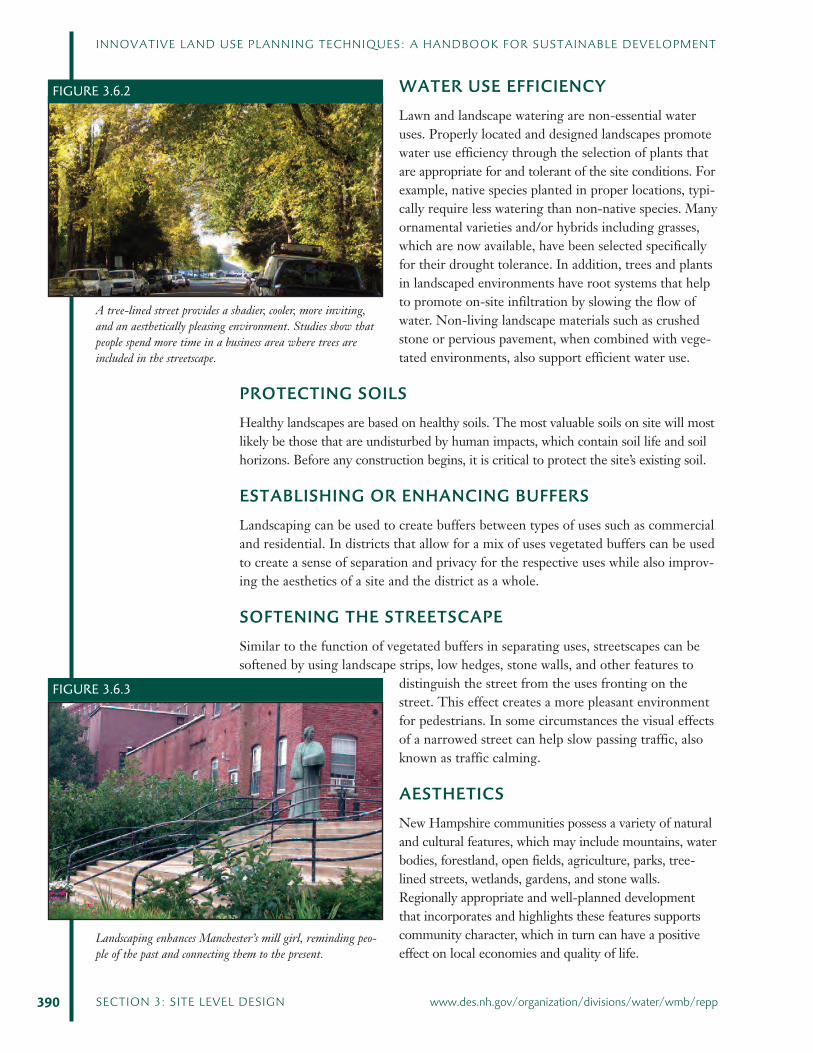
WATER USE EFFICIENCYLawn and landscape watering are non-essential wateruses. Properly located and designed landscapes promotewater use efficiency through the selection of plants thatare appropriate for and tolerant of the site conditions. Forexample, native species planted in proper locations, typi-cally require less watering than non-native species. Manyornamental varieties and/or hybrids including grasses,which are now available, have been selected specificallyfor their drought tolerance. In addition, trees and plantsin landscaped environments have root systems that helpto promote on-site infiltration by slowing the flow ofwater. Non-living landscape materials such as crushedstone or pervious pavement, when combined with vege-tated environments, also support efficient water use.
PROTECTING SOILSHealthy landscapes are based on healthy soils. The most valuable soils on site will mostlikely be those that are undisturbed by human impacts, which contain soil life and soilhorizons. Before any construction begins, it is critical to protect the site’s existing soil.
ESTABLISHING OR ENHANCING BUFFERSLandscaping can be used to create buffers between types of uses such as commercialand residential. In districts that allow for a mix of uses vegetated buffers can be usedto create a sense of separation and privacy for the respective uses while also improv-ing the aesthetics of a site and the district as a whole.
SOFTENING THE STREETSCAPESimilar to the function of vegetated buffers in separating uses, streetscapes can besoftened by using landscape strips, low hedges, stone walls, and other features to
distinguish the street from the uses fronting on thestreet. This effect creates a more pleasant environmentfor pedestrians. In some circumstances the visual effectsof a narrowed street can help slow passing traffic, alsoknown as traffic calming.
AESTHETICSNew Hampshire communities possess a variety of naturaland cultural features, which may include mountains, waterbodies, forestland, open fields, agriculture, parks, tree-lined streets, wetlands, gardens, and stone walls.Regionally appropriate and well-planned developmentthat incorporates and highlights these features supportscommunity character, which in turn can have a positiveeffect on local economies and quality of life.
390 SECTION 3: SITE LEVEL DESIGN www.des.nh.gov/organization/divisions/water/wmb/repp
INNOVATIVE LAND USE PLANNING TECHNIQUES: A HANDBOOK FOR SUSTAINABLE DEVELOPMENT
FIGURE 3.6.2
A tree-lined street provides a shadier, cooler, more inviting,and an aesthetically pleasing environment. Studies show thatpeople spend more time in a business area where trees areincluded in the streetscape.
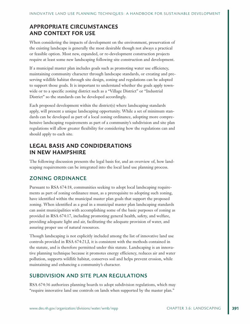
FIGURE 3.6.3
Landscaping enhances Manchester’s mill girl, reminding peo-ple of the past and connecting them to the present.
APPROPRIATE CIRCUMSTANCESAND CONTEXT FOR USEWhen considering the impacts of development on the environment, preservation ofthe existing landscape is generally the most desirable though not always a practicalor feasible option. Most new, expanded, or re-development construction projectsrequire at least some new landscaping following site construction and development.
If a municipal master plan includes goals such as promoting water use efficiency,maintaining community character through landscape standards, or creating and pre-serving wildlife habitat through site design, zoning and regulations can be adoptedto support those goals. It is important to understand whether the goals apply town-wide or to a specific zoning district such as a “Village District” or “IndustrialDistrict” so the standards can be developed accordingly.
Each proposed development within the district(s) where landscaping standardsapply, will present a unique landscaping opportunity. While a set of minimum stan-dards can be developed as part of a local zoning ordinance, adopting more compre-hensive landscaping requirements as part of a community’s subdivision and site planregulations will allow greater flexibility for considering how the regulations can andshould apply to each site.
LEGAL BASIS AND CONDIDERATIONSIN NEW HAMPSHIREThe following discussion presents the legal basis for, and an overview of, how land-scaping requirements can be integrated into the local land use planning process.
ZONING ORDINANCEPursuant to RSA 674:18, communities seeking to adopt local landscaping require-ments as part of zoning ordinance must, as a prerequisite to adopting such zoning,have identified within the municipal master plan goals that support the proposedzoning. When identified as a goal in a municipal master plan landscaping standardscan assist municipalities with accomplishing some of the basic purposes of zoning asprovided in RSA 674:17, including promoting general health, safety, and welfare,providing adequate light and air, facilitating the adequate provision of water, andassuring proper use of natural resources.
Though landscaping is not explicitly included among the list of innovative land usecontrols provided in RSA 674:21,I, it is consistent with the methods contained inthe statute, and is therefore permitted under this statute. Landscaping is an innova-tive planning technique because it promotes energy efficiency, reduces air and waterpollution, supports wildlife habitat, conserves soil and helps prevent erosion, whilemaintaining and enhancing a community’s character.
SUBDIVISION AND SITE PLAN REGULATIONSRSA 674:36 authorizes planning boards to adopt subdivision regulations, which may“require innovative land use controls on lands when supported by the master plan.”
391
INNOVATIVE LAND USE PLANNING TECHNIQUES: A HANDBOOK FOR SUSTAINABLE DEVELOPMENT
www.des.nh.gov/organization/divisions/water/wmb/repp CHAPTER 3.6: LANDSCAPING
In addition, the statute permits subdivision regulations to provide harmoniousdevelopment of the municipality and its environs; including provisions that will cre-ate conditions favorable to health and safety; and, efficient development that pro-motes retention of wildlife habitat.
Similarly, RSA 674:44 grants planning boards the power to adopt site plan reviewregulations that may “require innovative land use controls on lands when supportedby the master plan.” More specifically, the statute permits site plan regulations toguard against inadequate protection of groundwater and undesirable pollution, pro-vide for safe and attractive development, and provide for development harmoniousand aesthetically pleasing with the municipality and its environs.
EXAMPLES AND OUTCOMESThe following example highlights various approaches to promoting green spaces,minimizing air and water pollution, conserving energy, soil and water resources, andcreating harmonious and visually appealing development, through landscaping.
BEDFORD, NEW HAMPSHIRERoute 3 Corridor Performance Zoning DistrictIn 1993, the town of Bedford adopted a U.S. Route 3 Corridor Performance ZoningDistrict. While conventional zoning tends to separate incompatible uses, the per-formance zoning approach was designed to provide greater flexibility in the planningprocess in order to promote a mix of compatible uses. A wide range of types of usesare permitted in the district, and compatibility is determined based on considerationof the appropriateness (i.e. type, intensity, scale) and quantifiable impact of a pro-posed use.
Included among the performance standards for the district are minimum and gen-eral landscape standards as well as landscape standards for signage. Intended to pre-serve and enhance the aesthetic qualities of the Route 3 corridor, the landscapestandards are a matrix of planning options that provide design flexibility and creativ-ity for the owner/developer, while ensuring a measure of uniformity and compatibil-ity of landscape choices throughout the corridor. For example, while the landscapestandards include a minimum side and rear planting requirement for visual screen-ing, the standards identify a range of appropriate landscape options for that purpose,which can be used either individually or in combination.
According to Karen White, Bedford’s former planning director, “the community hasbeen generally pleased with the results.” Professional landscape architects haveenjoyed working with the ordinance, and it has been well received by builders andowners. White acknowledges two challenges they have had with the landscapingstandards. First, the housing and retail boom in recent years has limited the avail-ability of trees and shrubs that meet the minimum, at-planting, height requirements.Thus, the planning board has had to be flexible with reducing the minimum heightrequirements, in some cases. The second challenge has been keeping up the land-scaping once it is installed. Some sites require enforcement by the town for removaland replanting of dead material. (See margin note in model language section belowregarding temporary irrigation systems.)
392 SECTION 3: SITE LEVEL DESIGN www.des.nh.gov/organization/divisions/water/wmb/repp
INNOVATIVE LAND USE PLANNING TECHNIQUES: A HANDBOOK FOR SUSTAINABLE DEVELOPMENT
Model Language and Guidancefor Implementation
When considering the impacts of development on the environment, preservation ofthe existing landscape may be generally desirable, but is not always a practical or anavailable option. Most new, expanded or re-development construction projectsrequire buildings, pavement, and, if required, at least some new landscaping. Themodel language below is designed to assist communities with striking a balancebetween preserving existing resources (i.e. vegetation, topography, and soil) andestablishing requirements for selection, design, installation, and maintenance of newlandscaping features. The model language addresses a combination of landscapingfunctions that provide a variety of environmental, economic, and social benefits tocommunities.
Due to the unique characteristics presented with each site, the applicability of land-scaping standards should be considered on a site-specific basis. Including compre-hensive landscaping requirements within a community’s subdivision and site planregulations, rather than the zoning ordinance, provides greater flexibility for consid-ering the unique characteristics of each site.
A model zoning ordinance and model subdivision and site plan review regulationsare presented below.
MODEL ORDINANCE FOR ZONING
ARTICLE __: LANDSCAPING
I. PURPOSE
The purpose of this article is to protect, enhance and promote the economic, eco-logical and aesthetic environment and protect and conserve the water resources ofthe Town/City of _____ through the use of certain landscape elements.
II. AUTHORITY
The provisions of this Article are adopted pursuant to RSA 674:16, Grant of Powerand RSA 674:21, Innovative Land Use Controls.
III. APPLICABILITY
The requirements of this Article shall apply to ________ zoning district(s), and areconsistent with the goals of the Town/City of ____ Master Plan (adopted on _____)including ________________________.
IV. DEFINITIONS
Arboriculture: The planting and care of woody plants (trees, shrubs, vines, andgroundcovers).
393
INNOVATIVE LAND USE PLANNING TECHNIQUES: A HANDBOOK FOR SUSTAINABLE DEVELOPMENT
www.des.nh.gov/organization/divisions/water/wmb/repp CHAPTER 3.6: LANDSCAPING
Caliper: Diameter of a tree at 6 inches from the ground for trees 4 inches andunder in caliper, and measured at 12 inches from the ground for trees measuringover 4 inches in caliper.
Damage: In reference to landscaping, includes any intentional, negligent, or acci-dental act that will cause vegetation to decline or die within a period of two years,including but not limited to, injury by heavy equipment; soil compaction by vehicu-lar or pedestrian overuse; natural grade changes (cuts or fills); snow plow or snowload injury; fire injury or secondary infections through disease or pest infestation.
Dripline: An imaginary vertical plumb line that extends downward from the tips ofthe outermost tree branches and intersects the ground.
Drought Tolerant or Drought Resistant: A tree, shrub, or other plant that onceestablished, will require limited or no regular irrigation for adequate appearance,growth and disease resistance.
Ground Cover: Low plants which generally form a continuous cover over time thatare typically 3 feet or less in height.
Impervious Surface: Land surface with a low capacity for soil infiltration, includingbut not limited to pavement, roofs, roadways, human structures, paved parking lots,sidewalks, driveways (gravel and paved), and patios. Total impervious cover shall be cal-culated by determining the total of all impervious surfaces on a site as described above,regardless of whether the impervious surfaces are contiguous or non-contiguous.
Invasive (Plant) Species: Any plant species included on the most current list ofprohibited invasive species prepared by the New Hampshire Invasive SpeciesCommittee.
Landscaped Area or Landscaping: That area within the boundaries of a given lotthat is devoted to, and consists of, landscaping material, including but not limitedto, trees, shrubs, perennials, vines, grasses, or other groundcovers, and annual flowerbeds. Hardscape materials may be included such as planters, brick, stone, placedrocks or boulders, water forms, and aggregates.
Landscape Plan: Graphic and written specifications for design, planting, and main-tenance as well as detailed plans to create, arrange, and modify natural and man-made features.
Maintain, Maintenance: In reference to landscaping includes mulching, mowing,spraying, irrigating, fertilizing, propping, bracing, treating for disease or injury,snow removal, proper pruning techniques based on current arboriculture standards,and any other similar acts which promote the life, growth, health, safety, or beautyof the landscape vegetation.
Mulch: An organic material such as tree bark, wood chips, pine needles, leaf litter,grass clippings, or seed hulls used to control weed growth, reduce soil erosion andreduce water loss.
Native (Plant) Species – Plants that currently (or historically) grow as part of natu-ral ecosystems that have co-evolved within the same planting zone.
New Development: Any construction or land disturbance of a parcel of land thatremoves or alters the vegetation or soil.
394 SECTION 3: SITE LEVEL DESIGN www.des.nh.gov/organization/divisions/water/wmb/repp
INNOVATIVE LAND USE PLANNING TECHNIQUES: A HANDBOOK FOR SUSTAINABLE DEVELOPMENT
Parking Lot: Any off-street, unenclosed ground level facility used for the purposeof temporary storage of motor vehicles. Enclosed parking facilities, such as single ormulti-story garages or parking facilities constructed within the confines of a largerbuilding or structure, or parking facilities associated with single-family and duplexresidential development are not included within this definition.
Parking Lot Island: A planting island contained completely within the confines ofa parking lot.
Redevelopment: The reuse of a site or structure with existing man-made landalterations. A site is considered a redevelopment if it has 35 percent or more ofexisting impervious surface, calculated by dividing the total existing impervious sur-face by the size of the parcel and converting to a percentage.
Sediment: Solid material, mineral or organic, that is in suspension, is being trans-ported, or has been moved from its site of origin by air, water or gravity as a prod-uct of erosion.
Shrub: A bushy, woody-stemmed plant, usually with several permanent stems usu-ally less than 15-20 feet at maturity.
Site: The area, lot, or lots upon which development is to occur or has occurred.
Stormwater: Water resulting from precipitation (including rain and snow) that runsoff the land’s surface, is transmitted to the subsurface, or is captured by separatestorm sewers or other sewage or drainage facilities, or conveyed by snow removalequipment.
Tree: Any self-supporting woody perennial plant which normally attains an overallheight of at least ten 10 feet at maturity, either with one main stem or trunk or mul-tiple stems or trunks as commonly grown in the nursery industry.
Vegetated Buffer: Land area used to visibly separate one use from another or toshield or block, noise, light or other nuisances. Vegetated buffers may include suchthings as fences or berms as well as all forms of plant growth, whether planted ornaturally occurring.
Vegetation: Includes trees, plants, shrubs, vines, groundcovers, grasses, herbaceousperennials, or other forms of plant growth whether naturally occurring or planted.
V. SPECIAL PROVISIONS
A. Site disturbance shall be minimized and existing vegetation and undisturbedsoil shall be retained whenever possible. When site disturbance is necessary,top soil shall be stock-piled and stabilized for on-site redistribution within newlandscaped areas. Stock-piled soil shall remain covered to prevent soil loss andsedimentation of nearby surface waters.
B. Existing non-invasive vegetation shall be preserved wherever possible.Maximum effort should be made to preserve small stands of trees, rather thanindividual trees, to minimize the potential for serious damage due to wind,grade changes and soil compaction. No construction materials, equipment,vehicles, or temporary soil deposits shall be located within the dripline of
395
INNOVATIVE LAND USE PLANNING TECHNIQUES: A HANDBOOK FOR SUSTAINABLE DEVELOPMENT
www.des.nh.gov/organization/divisions/water/wmb/repp CHAPTER 3.6: LANDSCAPING

existing trees. Protective barriers shall be installed around each plant or groupof plants that are to remain on site. Snow fence installed around the dripline ofthe tree canopy is an example of an acceptable barrier.
C. Development shall follow the natural contours of the landscape to the maxi-mum extent possible to minimize grading.
D. Cut and fill shall be minimized, with the maximum height of any fill or depthof any cut area, as measured from the natural grade, not greater than 10 feetand preferably limited to four to six feet.
E. Any contiguous area of disturbance, not associated with the installation of aroadway, shall be limited to 20,000 square feet for residential development andto 100,000 square feet for other types of development. Contiguous areas ofdisturbance shall be separated by at least 20 feet of area maintained at naturalgrade and retaining existing, mature vegetated cover.
F. Lawn or grass covered areas may comprise no more than ___ percent or ____square feet of the total vegetated area. A minimum of 2 different grass specieswith three or more preferred shall make up the seed or sod.
G. Plants shall be selected based on consideration of site conditions and plantfunction. Use of native species is encouraged; hybrid varieties of native plants,and plants that are non-native and non-invasive are also permitted. Use ofinvasive species included on the N.H. Invasive Species Committee’s most cur-rent list of prohibited invasive species, is not permitted in accordance withNew Hampshire Agricultural Rule NH AGR 3800.
H. Layered plantings of trees, shrubs, vines, perennials, groundcovers and leaf lit-ter are encouraged to promote biological diversity in the landscape.
I. Low maintenance landscapes are encouraged.
J. The type and location of vegetation shall not interfere with utilities and thesafe and efficient flow of street traffic or pedestrians.
K. Nothing herein shall affect in any way the present or future acquired rights ofany public utility or the Town/City of ___ to clear trees and/or other growthfrom lands used by the public utility or town/city. Using current arboriculturestandards when pruning within public rights-of-way is strongly encouraged, aswell as leaving a vegetated understory to prevent erosion.
396 SECTION 3: SITE LEVEL DESIGN www.des.nh.gov/organization/divisions/water/wmb/repp
INNOVATIVE LAND USE PLANNING TECHNIQUES: A HANDBOOK FOR SUSTAINABLE DEVELOPMENT
NH AGR 3800 states that“no person shall knowinglycollect, transport, sell, dis-tribute, propagate, or trans-plant any living or viableportion of any listed prohib-ited invasive species includ-ing all of their cultivars,varieties and specifiedhybrids.”
As an alternative to exclusively requiring native species plantings, communities should consider requiring non-invasive speciesthat provide ecological and wildlife values consistent with the site conditions and plant functions. For example, if the sitedesign includes frontage along a state highway and retaining natural vegetation is not an option, drought and salt-tolerant plantspecies should be selected. The New Hampshire Invasive Species Committee maintains a list of invasive plants prohibited fromsale, transport, distribution, propagation or transplantation in New Hampshire, which can be found on the NH Department ofAgriculture, Markets and Food website www.agriculture.nh.gov. Information about the Invasive Species Committee is alsoavailable on that website. The UNH Cooperative Extension’s “Alternatives to Invasive Landscape Plants” identifies plants withsimilar aesthetic and functional attributes for suggested use in place of invasive species, and is available atwww.extension.unh.edu.
L. No ground disturbed as a result of site construc-tion and development shall be left exposed to baresoil at the conclusion of construction. All areas,including landscape islands and strips, exposed byconstruction, with the exception of finished build-ing, structure, and pavement footprints, shall bedecompacted (aerated) and covered with a mini-mum thickness of 6 inches of non-compacted top-soil, and shall be subsequently planted with acombination of living vegetation such as grass,groundcovers, trees, and shrubs, and other land-scaping materials. After planting, areas betweenplants where exposed soil remains shall bemulched at a depth no greater than 3 inches.
M. Tree Coverage
1. To promote the replacement of trees removed during site construction anddevelopment:
a. Developments serving single-family homes and duplexes must plantand maintain at least one tree for every 35 feet of frontage, with aminimum of one tree per lot. Trees shall have a minimum caliperof 2 inches when planted.
b. Developments serving uses other thansingle-family homes and duplexes mustplant and maintain at least one tree forevery 35 feet of frontage, with a mini-mum of one tree per lot, or at a densityof one tree for every 400 square feet ofpaved area for non-street surfaces.Trees shall have a minimum caliper of2-21/2 inches when planted. To fosterbiological diversity when more than 10trees are planted at the same time the“10-20-30 Rule” shall be used. (Nomore than 10% of the trees shall be ofthe same species, no more than 20% inthe same genus, and no more than30% in the same family.)
c. Trees shall be planted in locations thatprovide site value such as aesthetics,shading, and cooling of buildings orparking areas for energy efficiency,wildlife habitat, and stabilization ofsoils in disturbed areas. Trees shall notbe planted in locations that block safesight lines for vehicles and pedestriansentering and exiting the site.
397
INNOVATIVE LAND USE PLANNING TECHNIQUES: A HANDBOOK FOR SUSTAINABLE DEVELOPMENT
www.des.nh.gov/organization/divisions/water/wmb/repp CHAPTER 3.6: LANDSCAPING
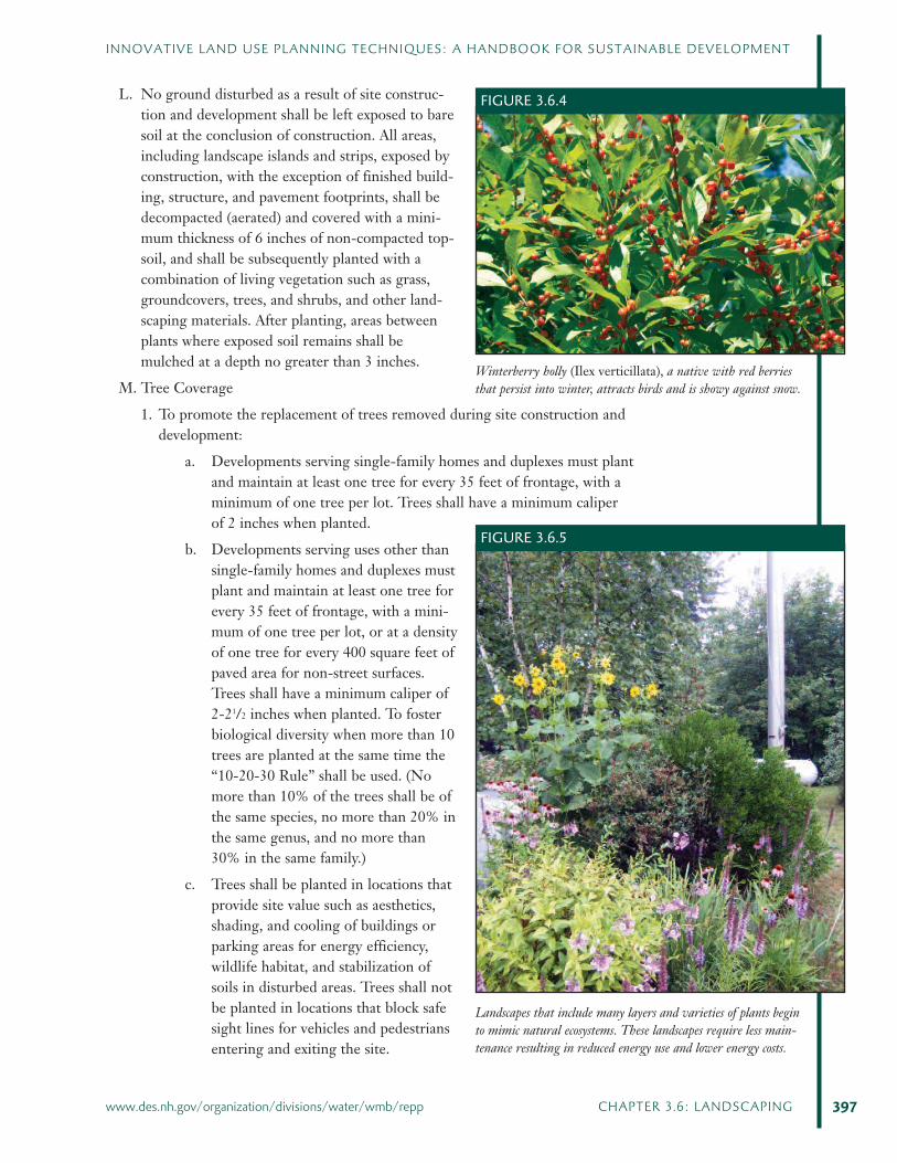
FIGURE 3.6.4
Winterberry holly (Ilex verticillata), a native with red berriesthat persist into winter, attracts birds and is showy against snow.
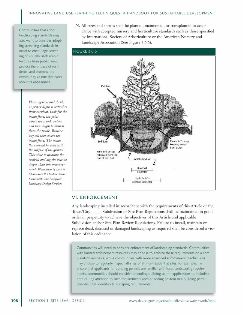
FIGURE 3.6.5
Landscapes that include many layers and varieties of plants beginto mimic natural ecosystems. These landscapes require less main-tenance resulting in reduced energy use and lower energy costs.
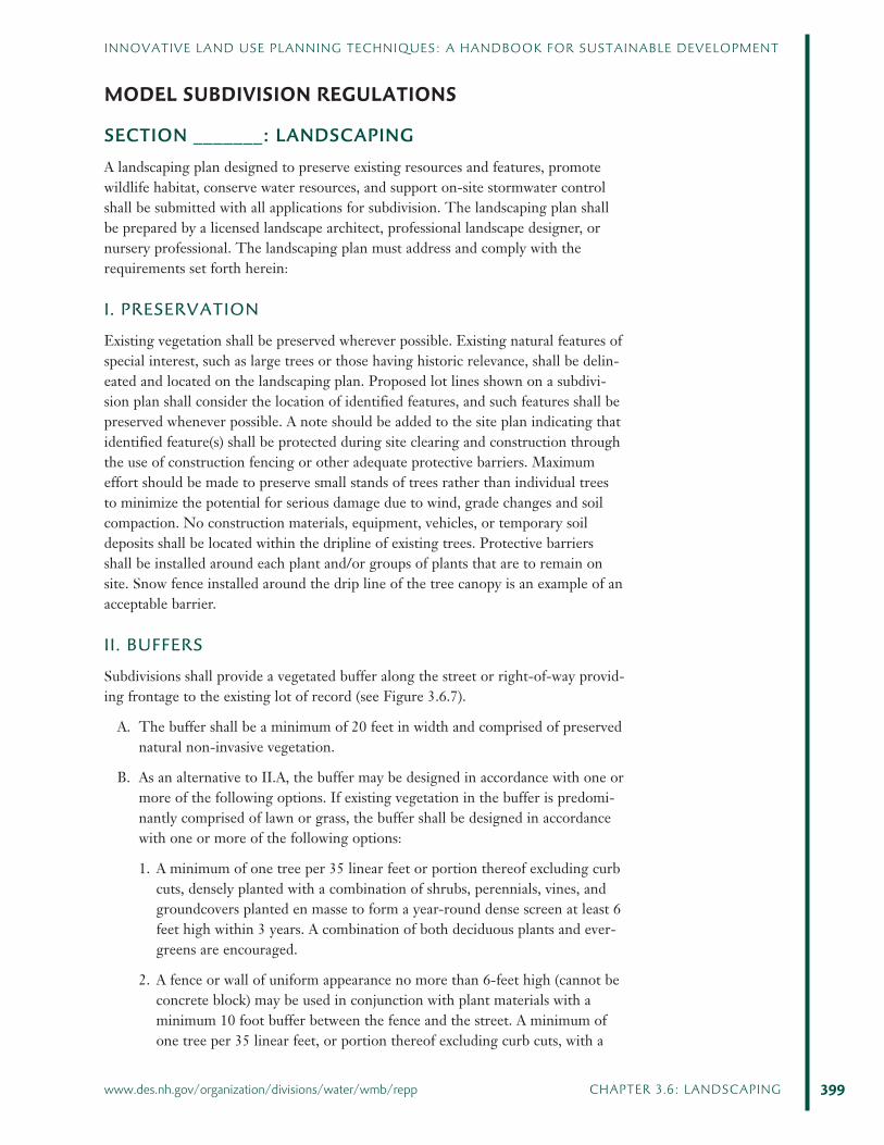
N. All trees and shrubs shall be planted, maintained, or transplanted in accor-dance with accepted nursery and horticulture standards such as those specifiedby International Society of Arboriculture or the American Nursery andLandscape Association (See Figure 3.6.6).
VI. ENFORCEMENT
Any landscaping installed in accordance with the requirements of this Article or theTown/City _____ Subdivision or Site Plan Regulations shall be maintained in goodorder in perpetuity to achieve the objectives of this Article and applicableSubdivision and/or Site Plan Review Regulations. Failure to install, maintain orreplace dead, diseased or damaged landscaping as required shall be considered a vio-lation of this ordinance.
398 SECTION 3: SITE LEVEL DESIGN www.des.nh.gov/organization/divisions/water/wmb/repp
INNOVATIVE LAND USE PLANNING TECHNIQUES: A HANDBOOK FOR SUSTAINABLE DEVELOPMENT
Planting trees and shrubsat proper depth is critical totheir survival. Look for thetrunk flare, the pointwhere the trunk widensand roots begin to branchfrom the trunk. Removeany soil that covers thetrunk flare. The trunkflare should be even withthe surface of the ground.Take time to measure therootball and dig the hole nodeeper than this measure-ment. Illustration by LaurenChase-Rowell, Outdoor RoomsSustainable and EcologicalLandscape Design Services.
Communities that adoptlandscaping standards mayalso want to consider adopt-ing screening standards inorder to encourage screen-ing of visually undesirablefeatures from public view,protect the privacy of resi-dents, and promote thecommunity as one that caresabout its appearance.
Communities will need to consider enforcement of landscaping standards. Communitieswith limited enforcement resources may choose to enforce these requirements on a com-plaint-driven basis, while communities with more advanced enforcement mechanismsmay choose to regularly inspect all sites or all non-residential sites, for example. Toensure that applicants for building permits are familiar with local landscaping require-ments, communities should consider amending building permit applications to include anote calling attention to such requirements and/or adding an item to a building permitchecklist that identifies landscaping requirements.
FIGURE 3.6.6
MODEL SUBDIVISION REGULATIONS
SECTION _______: LANDSCAPINGA landscaping plan designed to preserve existing resources and features, promotewildlife habitat, conserve water resources, and support on-site stormwater controlshall be submitted with all applications for subdivision. The landscaping plan shallbe prepared by a licensed landscape architect, professional landscape designer, ornursery professional. The landscaping plan must address and comply with therequirements set forth herein:
I. PRESERVATION
Existing vegetation shall be preserved wherever possible. Existing natural features ofspecial interest, such as large trees or those having historic relevance, shall be delin-eated and located on the landscaping plan. Proposed lot lines shown on a subdivi-sion plan shall consider the location of identified features, and such features shall bepreserved whenever possible. A note should be added to the site plan indicating thatidentified feature(s) shall be protected during site clearing and construction throughthe use of construction fencing or other adequate protective barriers. Maximumeffort should be made to preserve small stands of trees rather than individual treesto minimize the potential for serious damage due to wind, grade changes and soilcompaction. No construction materials, equipment, vehicles, or temporary soildeposits shall be located within the dripline of existing trees. Protective barriersshall be installed around each plant and/or groups of plants that are to remain onsite. Snow fence installed around the drip line of the tree canopy is an example of anacceptable barrier.
II. BUFFERS
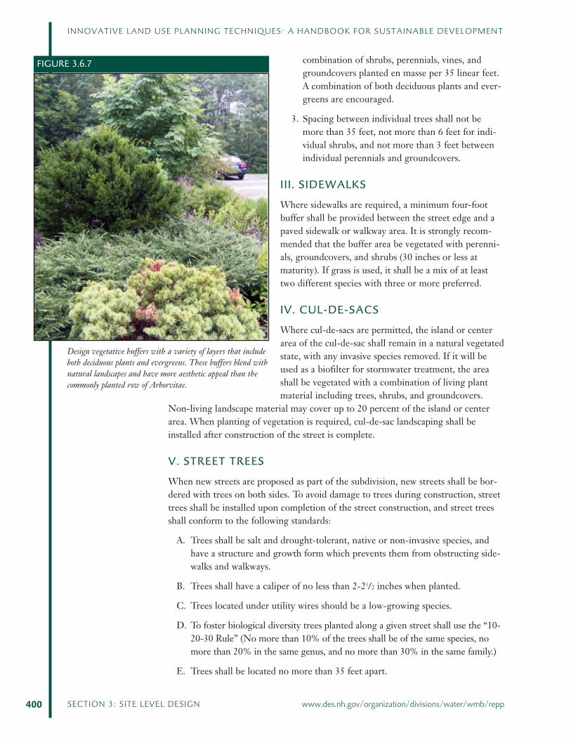
Subdivisions shall provide a vegetated buffer along the street or right-of-way provid-ing frontage to the existing lot of record (see Figure 3.6.7).
A. The buffer shall be a minimum of 20 feet in width and comprised of preservednatural non-invasive vegetation.
B. As an alternative to II.A, the buffer may be designed in accordance with one ormore of the following options. If existing vegetation in the buffer is predomi-nantly comprised of lawn or grass, the buffer shall be designed in accordancewith one or more of the following options:
1. A minimum of one tree per 35 linear feet or portion thereof excluding curbcuts, densely planted with a combination of shrubs, perennials, vines, andgroundcovers planted en masse to form a year-round dense screen at least 6feet high within 3 years. A combination of both deciduous plants and ever-greens are encouraged.
2. A fence or wall of uniform appearance no more than 6-feet high (cannot beconcrete block) may be used in conjunction with plant materials with aminimum 10 foot buffer between the fence and the street. A minimum ofone tree per 35 linear feet, or portion thereof excluding curb cuts, with a
399
INNOVATIVE LAND USE PLANNING TECHNIQUES: A HANDBOOK FOR SUSTAINABLE DEVELOPMENT
www.des.nh.gov/organization/divisions/water/wmb/repp CHAPTER 3.6: LANDSCAPING
combination of shrubs, perennials, vines, andgroundcovers planted en masse per 35 linear feet.A combination of both deciduous plants and ever-greens are encouraged.
3. Spacing between individual trees shall not bemore than 35 feet, not more than 6 feet for indi-vidual shrubs, and not more than 3 feet betweenindividual perennials and groundcovers.
III. SIDEWALKS
Where sidewalks are required, a minimum four-footbuffer shall be provided between the street edge and apaved sidewalk or walkway area. It is strongly recom-mended that the buffer area be vegetated with perenni-als, groundcovers, and shrubs (30 inches or less atmaturity). If grass is used, it shall be a mix of at leasttwo different species with three or more preferred.
IV. CUL-DE-SACS
Where cul-de-sacs are permitted, the island or centerarea of the cul-de-sac shall remain in a natural vegetatedstate, with any invasive species removed. If it will beused as a biofilter for stormwater treatment, the areashall be vegetated with a combination of living plantmaterial including trees, shrubs, and groundcovers.
Non-living landscape material may cover up to 20 percent of the island or centerarea. When planting of vegetation is required, cul-de-sac landscaping shall beinstalled after construction of the street is complete.
V. STREET TREES
When new streets are proposed as part of the subdivision, new streets shall be bor-dered with trees on both sides. To avoid damage to trees during construction, streettrees shall be installed upon completion of the street construction, and street treesshall conform to the following standards:
A. Trees shall be salt and drought-tolerant, native or non-invasive species, andhave a structure and growth form which prevents them from obstructing side-walks and walkways.
B. Trees shall have a caliper of no less than 2-21/2 inches when planted.
C. Trees located under utility wires should be a low-growing species.
D. To foster biological diversity trees planted along a given street shall use the “10-20-30 Rule” (No more than 10% of the trees shall be of the same species, nomore than 20% in the same genus, and no more than 30% in the same family.)
E. Trees shall be located no more than 35 feet apart.
400 SECTION 3: SITE LEVEL DESIGN www.des.nh.gov/organization/divisions/water/wmb/repp
INNOVATIVE LAND USE PLANNING TECHNIQUES: A HANDBOOK FOR SUSTAINABLE DEVELOPMENT
FIGURE 3.6.7
Design vegetative buffers with a variety of layers that includeboth deciduous plants and evergreens. These buffers blend withnatural landscapes and have more aesthetic appeal than thecommonly planted row of Arborvitae.
F. Trees should be located to avoid obstruction for driver visibility, and to avoidinterference between root systems and utilities. Trees may be planted individu-ally or clustered.
G. All newly planted trees, shrubs and other vegetation shall have a watering planduring the establishment period (for trees, one-year-per-inch in caliper atplanting, shrubs and other vegetation generally establish within one growingseason). Mulching trees, shrubs, and plants helps retain soil moisture, moder-ates temperature fluctuations, provides protection from mechanical damage bymowers and trimmers, and serves as temporary covering of exposed soil untilunderstory plants and ground covers fill in. However, thick applications ofmulch (such as “volcano mulching”) will kill trees and other vegetation. Mulchshall be no greater than 3 inches in depth and shall not be in contact with thebark or stems of plants.
H. Incentive Bonuses:
1. Two existing healthy and non-invasive trees, with a caliper of 3 inches orgreater, preserved using proper protection methods within the requiredplanting area, may be substituted for one required tree, to be determined bythe planning board.
2. Where an applicant proposes leaving a significant portion of healthy treeswithin the construction area, alternative landscaping designs will be considered.
VII. VEGETATION
Vegetation planted in accordance with the requirements of this section shall benative or non-invasive species selected for their adaptability to the climatic, geologicand topographical conditions of the site.
A. Shrubs and hedges shall be a minimum of 24 inches in height when measuredimmediately after planting. Groundcovers and perennials may be less.
VIII. DOCUMENTATION
A note should be added to the plan indicating that “Development of lots shown onan approved subdivision plan shall comply with the landscaping requirements setforth in the Town/City of ____ Zoning Ordinance and Subdivision Regulations.”
IX. PERFORMANCE GUARANTEE
A. To ensure that landscaping is installed in accordance with the final approvedlandscaping plan, a performance guarantee shall be provided as a condition ofapproval in an amount determined by the planning board. The performanceguarantee shall be released following an inspection by the Town of [Name]Code Enforcement Officer.
B. To ensure that landscaping functions as designed and all plants remain healthy,a performance guarantee shall be required, as a condition of approval, whichwill be held a minimum of 24 months after an approved inspection as requiredin Section __.IX.1.
401
INNOVATIVE LAND USE PLANNING TECHNIQUES: A HANDBOOK FOR SUSTAINABLE DEVELOPMENT
www.des.nh.gov/organization/divisions/water/wmb/repp CHAPTER 3.6: LANDSCAPING
X. MAINTENANCE
A. If the street is to be a private street, cul-de-sac landscaping, street trees andother landscaping as required shall be maintained by a property owners associ-ation that is responsible, in perpetuity, for maintaining all landscaping in goodcondition and replacing as necessary to the standards herein, and to keep land-scaped areas free of refuse and debris. The legal instrument establishing thisrequirement as part of the homeowners association shall be submitted to theplanning board for review and comment by town counsel prior to the planningboard taking final action on the application.
B. If the street is to be dedicated to and accepted by the Town/City of ____, thetown/city shall be responsible for maintaining street trees and cul-de-sac land-scaping.
402 SECTION 3: SITE LEVEL DESIGN www.des.nh.gov/organization/divisions/water/wmb/repp
INNOVATIVE LAND USE PLANNING TECHNIQUES: A HANDBOOK FOR SUSTAINABLE DEVELOPMENT
MODEL SITE PLAN REVIEW REGULATIONS
SECTION ______: LANDSCAPINGA landscaping plan designed to preserve existing resources and features, promotewildlife habitat, and support on-site stormwater control shall be submitted with anapplication for site plan review. Due to the variation of each site, creativity anddiversity in landscaping is encouraged. The landscaping plan shall be prepared by alicensed landscape architect, professional landscape designer, or nursery profes-sional.
The landscaping plan must address and comply with the requirements set forthherein:
I. GENERAL REQUIREMENTS
A. Existing vegetation shall be preserved wherever possible. Existing natural fea-tures of special interest, such as those having historic relevance, shall be delin-eated and located on the landscaping plan. A note should be added to the siteplan indicating that identified feature(s) shall be protected during site clearingand construction through the use of construction fencing or other adequateprotective barriers. Maximum effort should be made to preserve small standsof trees, rather than individual trees, to minimize the potential for seriousdamage due to wind, grade changes and soil compaction. No constructionmaterials, equipment, vehicles, or temporary soil deposits shall be locatedwithin the dripline of existing trees. Before commencement of work, protec-tive barriers shall be installed and maintained around each plant and/or groupsof plants that are to remain on site until completion. Snow fence installedaround the dripline of the tree canopy is an example of an acceptable barrier.
B. Vegetation planted in accordance with the requirements of this section shall benon-invasive species selected for their adaptability to the climatic, geologic andtopographical conditions of the site.
C. Shrubs and hedges shall be a minimum of 24inches in height when measured immediately afterplanting. Groundcovers and perennials may beless.
D. Effective use and preservation of natural berms,existing topography and existing vegetation isencouraged.
E. Landscaped beds shall be used to separate parkingareas from the portion of a building providingaccess to the building.
F. Vegetated Buffer: Plants or a combination ofplants and other landscaping material shall be usedto form a buffer between non-residential and resi-dential uses. The buffer shall be at least 20 feet
403
INNOVATIVE LAND USE PLANNING TECHNIQUES: A HANDBOOK FOR SUSTAINABLE DEVELOPMENT
www.des.nh.gov/organization/divisions/water/wmb/repp CHAPTER 3.6: LANDSCAPING
FIGURE 3.6.8
Adding landscape plantings to separate uses provides a visualtransition, and can increase property value.
wide, densely planted (or equivalent natural growth), and form a year-rounddense screen at least 6 feet high within 3 years. A minimum of one tree per 35feet or portion thereof, with a combinations of shrubs, perennials, vines, andgroundcovers shall be planted enmasse among the trees. Spacing between indi-vidual trees shall not be more than 35 feet, not more than 6 feet apart for indi-vidual shrubs, and not more than 3 feet between individual perennials andgroundcovers. A combination of evergreens and deciduous plants are encour-aged. As an alternative, a fence or wall of uniform appearance not more than6-feet high (concrete block cannot be used) and extending to within six inchesof ground level may be used in conjunction with the above plant materialswith a minimum 15 foot vegetative buffer.
G. Plants, or a combination of plants and a solid visual barrier such as woodenfencing, or berms, shall be used to screen loading, waste disposal, materialstorage and other areas that are likely to generate noise, dust, or other poten-tially disruptive conditions.
H. Landscaping shall be used to establish and/or maintain an attractivestreetscape adjacent to roadways. A minimum of one tree per 35 linear feet orportion thereof.
I. To promote on-site water retention and filtration, landscaped areas shall bedesigned in a manner that guides stormwater from on-site impervious streets,parking areas, sidewalks and walkways to vegetated areas or approved retentionareas.
J. Curbing or equivalent barriers shall be required toprotect vegetation from vehicular damage. Barriersshall be designed with openings that allow stormwa-ter to flow into vegetated areas.
K. The type and location of vegetation shall not inter-fere with utilities or the safe and efficient flow ofstreet traffic.
L. No trees or shrubs shall obstruct the view betweenthe street and the access drives and parking aislesnear entries and exits. Plantings within 25 feet of anintersection shall not exceed a maximum matureheight of 30 inches.
M. When irrigation systems are proposed, a temporarywatering plan/ schedule, or low volume (drip) irriga-tion system shall be required. Permanent irrigation
systems are prohibited, except as noted below. Temporary irrigation systems shall bedesigned and installed for efficient and effective water use to the landscaped area fora limited period of time determined by the plant material and site conditions. (Seemargin note.) For those exceptions when permanent irrigation is considered neces-sary, such as an athletic field, permanent irrigation shall utilize water saving tech-nologies, including rain sensors, flow meters, and management systems that monitorcurrent weather conditions.
404 SECTION 3: SITE LEVEL DESIGN www.des.nh.gov/organization/divisions/water/wmb/repp
INNOVATIVE LAND USE PLANNING TECHNIQUES: A HANDBOOK FOR SUSTAINABLE DEVELOPMENT
See the stormwater manage-ment chapter for moredetailed requirementsaddressing water quality.
FIGURE 3.6.9
Openings in curbed-areas allow vegetation to filter, slow, andretain stormwater.

N.A maintenance plan shall be provided with the site plan application. Alllandscaped areas shall receive regular maintenance and upkeep. Severelyinjured, diseased, or dead plant material shall be replaced in kind in perpe-tuity (avoid replacing landscape materials in the period from November toMarch.) Best practices to minimize environmental impacts such as the useof low phosphorous fertilizer and slow release nitrogen, shall be included inthe management plan. If ownership of a site is conveyed to a new propertyowner the new owner shall be responsible for maintaining all landscaping inaccordance with the approved final landscaping plan.
II. PARKING LOTS
A. Interior landscaped beds shall be required for all parking lots with multipleadjacent parallel parking rows. Required interior landscaping shall be a mini-mum of 10 percent of the total area of driveways and parking. The maximumnumber of continuous parking spaces permitted shall be twenty. Interior land-scaping shall be in addition to any required perimeter landscaping as specifiedbelow, and shall include trees, along with shrubs, perennials, and/or ground-covers planted enmasse among the trees. Plant materials shall be suitable forsite conditions including location, soil conditions, and exposure to environ-mental factors.
B. Bare soil is not acceptable. The introduction ofgroundcovers and/or perennials planted enmasseand the use of mulch as a soil covering is accept-able. However, no more than 20 percent of theminimum landscaped area may be covered withnon-living landscaping material such as barkmulch, woodchips, or leaf litter.
C. In order to break up the visual expansiveness ofparking lots, interior landscaped beds shall beinstalled in the form of landscape strips and/orlandscape islands. Depressed vegetated landscapedbeds are encouraged to infiltrate stormwater.
D. Landscape strips shall be a minimum of 15 feet inwidth.
E. Landscape islands shall be a minimum of 20 feet inwidth.
405
INNOVATIVE LAND USE PLANNING TECHNIQUES: A HANDBOOK FOR SUSTAINABLE DEVELOPMENT
www.des.nh.gov/organization/divisions/water/wmb/repp CHAPTER 3.6: LANDSCAPING
When developing local landscaping regulations, communities should consider adding criteria that specify circumstances toinclude a temporary low volume watering system (i.e. drip irrigation) as part of a landscaping plan until plants become estab-lished. Providing adequate water during the establishment period is critical to the long-term success of the landscape. Theestablishment period for trees is one-year-per-inch in caliper at planting. Shrubs and other vegetation will generally establishwithin one growing season. Permanent irrigation systems are generally not essential and may create inefficient water use if notproperly maintained.
FIGURE 3.6.10
Shrubs, perennials, and groundcovers planted among trees inlandscape strips or islands minimize soil compaction from pedes-trian foot traffic, and can capture and filter stormwater.
F. Parking lots with more than 50 parking spaces shall have landscape islands serv-ing as end-caps to each row.
G. The interior of parking lots shall have no less than one tree for every 10 park-ing spaces. The trees may be clustered together in landscape islands withshrubs, perennials, and ground covers planted enmasse among the trees. Thisrequirement is in addition to any trees required in Article __.V.J.b of the Townof _____ Zoning Ordinance.
H. Snow storage shall not be permitted on any landscape area.
I. Incentive Bonuses:
1. Each existing healthy and native or non-invasive tree, with a caliper of threeinches or greater, preserved using proper protection methods within theinterior parking lot area may be substituted for one tree required for every10 parking spaces.
2. Where an applicant proposes leaving a significant portion of healthy non-invasive trees and other vegetation within the proposed construction area,the planning board will consider alternative landscaping designs.
J. Perimeter Landscaping for Parking Areas: Along the perimeter of parkinglots with ten or more spaces a buffer of perimeter landscaping is requiredalong at least 75% of the length of right-of-way. The buffer width shall be aminimum of 20 feet, though the planning board may require a wider bufferwhen the use, building or site conditions dictate that a larger buffer would bet-ter serve the intent of these regulations. The vegetated buffer shall includeexisting non-invasive plant material, where appropriate, in combination withnew trees, shrubs, perennials and groundcovers of suitable type, characteristicsto meet site-specific requirements in order to provide longevity of the land-scape. The buffer shall include one or more of the following options:
1. A minimum of one tree per 35 linear feet or portionthereof excluding curb cuts, with a combination ofshrubs, perennials, vines, and groundcovers planteden masse. The trees may be clustered together withshrubs, perennials, and groundcovers plantedenmasse among the trees. A combination of bothdeciduous plants and evergreens are encouraged.
2. A wall, or fence of uniform appearance 6 feet high ofbrick, stone or finished concrete (cannot be concreteblock) may be used in conjunction with plant materialswith a minimum 10 foot-buffer between the fence andthe street. A minimum of one tree per 35 linear feet orportion thereof with a combination of shrubs, peren-nials, vines, and groundcovers planted en masse per 35linear feet excluding curb cuts. A combination of bothdeciduous plants and evergreens are encouraged.
3. Spacing between individual trees shall not be
406 SECTION 3: SITE LEVEL DESIGN www.des.nh.gov/organization/divisions/water/wmb/repp
INNOVATIVE LAND USE PLANNING TECHNIQUES: A HANDBOOK FOR SUSTAINABLE DEVELOPMENT
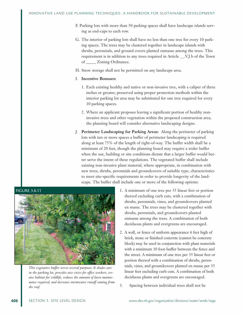
FIGURE 3.6.11
This vegetative buffer serves several purposes: It shades carsin the parking lot, provides nice views for office workers, cre-ates habitat for wildlife, reduces the amount of lawn mainte-nance required, and decreases stormwater runoff coming fromthe roof.

more than 35 feet, not more than 6 feet apart for individual shrubs, and notmore than 3 feet between individual perennials and groundcovers.
4. If the area abutting the street is existing woodland, a 25-foot woodlandbuffer may be left in lieu of landscaping if approved by the planning board.
III. TREES
A. Trees shall be salt and drought-tolerant, native or non-invasive species, andhave a structure and growth form which prevents them from obstructing side-walks and walkways.
B. Trees shall have a caliper of no less than 2-21/2 inches when planted.
C. Trees located under utility wires should be a low-growing species.
D. To foster biological diversity trees planted along a given street shall use the“10-20-30 Rule” (No more than 10% of the trees shall be of the same species,no more than 20% in the same genus, and no more than 30% in the samefamily.)
E. Trees shall be located no more than 35 feet apart.
F. Trees should be located to avoid obstruction for driver visibility, and to avoidinterference between root systems and utilities. Trees may be planted individu-ally or clustered.
G. All newly planted trees, shrubs and other vegetation shall have a watering planduring the establishment period (for trees, one-year-per-inch in caliper atplanting, shrubs and other vegetation generally establish within one growingseason). Mulching trees, shrubs, and plants helps retain soil moisture, moder-ates temperature fluctuations, provides protection from mechanical damage bymowers and trimmers, and serves as temporary covering of exposed soil untilunderstory plants and ground covers fill in. However, thick applications ofmulch (such as “volcano mulching”) will kill trees and other vegetation. Mulchshall be no greater than 3 inches in depth and shall not be in contact with thebark or stems of plants.
H. Incentive Bonuses:
1. Each existing healthy and non-invasive tree, with a caliper of 3 inches orgreater, preserved using proper protection methods within the requiredplanting area may be substituted for one required tree.
2. Where an applicant proposes leaving a significant portion of healthy treeswithin the construction area, alternative landscaping designs will be consid-ered.
IV. PLAN REQUIREMENTS
A. Landscaping plans shall include dimensions and distances and clearly delineatethe existing and proposed parking spaces, or other vehicular uses, access, aisles,driveways, and the location, and description of all landscape materials, includ-ing the quantity and common and botanical names of all plants.
407
INNOVATIVE LAND USE PLANNING TECHNIQUES: A HANDBOOK FOR SUSTAINABLE DEVELOPMENT
www.des.nh.gov/organization/divisions/water/wmb/repp CHAPTER 3.6: LANDSCAPING
The planning board maywant to consider establish-ing provisions for existingparking lots, for examplerequiring existing lots tocomply with this Section(re: parking) only if newspaces are added.
B. Landscape plans shall be provided at the same scale as the engineering draw-ings unless otherwise required by the planning board for review purposes.
C. Snow storage areas shall be clearly shown on the plan and are not permitted onany landscaped areas. In accordance with NH DES Best Management Practicessnow storage areas and snow dumps shall be located so that snow melt runoff isdirected to vegetated swales or filter strips created for that purpose.
D. A planting plan shall provide specifications regarding the plant placement,type, size and spacing, and other features as required by this section. Trees andshrubs shall be specified according to the American Standard for NurseryStock by the American Nursery and Landscape Association.
E. Depending on the nature and scale of the proposed use, a temporary wateringplan, or low volume (drip) irrigation system shall be required. When required,irrigation systems shall be designed and installed for efficient and effective useof water to the landscaped area. Permanent irrigation systems are generallyprohibited.
F. A maintenance plan shall be provided with the site plan application. All land-scaped areas shall receive regular maintenance and upkeep. Severely injured, dis-eased, or dead plant material shall be replaced in kind in perpetuity (avoidreplacing landscape materials in the period from November to March.) Bestpractices to minimize environmental impacts such as the use of low phosphorousfertilizer and slow release nitrogen, shall be included in the management plan.
G. The Planning Board may seek an advisory opinion regarding the submittedlandscape plan at the expense of the applicant.
H. The Planning Board will seek an advisory opinion of the conservation commis-sion or other municipal board or committee regarding the landscape plan, ifdeemed necessary.
V. SECURITY/PERFORMANCE BOND
A. To ensure that landscaping is installed in accordance with the final approvedlandscaping plan, a performance guarantee shall be provided as a condition ofapproval in an amount determined by the planning board. The performanceguarantee shall be released following and inspection by the Town of ____Code Enforcement Officer.
B. To ensure that landscaping functions as designed and all plants remain healthy,a performance guarantee shall be required, as a condition of approval, whichwill be held a minimum of 24 months after an approved inspection as requiredin Section __.IX.1.
VI. MAINTENANCE
A. The property owner, or owners association if applicable, is responsible, in per-petuity, for maintaining all landscaping in good condition. Landscaping shallbe kept free of refuse and debris, and shall be replaced as necessary to thestandards herein.
408 SECTION 3: SITE LEVEL DESIGN www.des.nh.gov/organization/divisions/water/wmb/repp
INNOVATIVE LAND USE PLANNING TECHNIQUES: A HANDBOOK FOR SUSTAINABLE DEVELOPMENT
B. If the ownership of a site is conveyed to a new property owner, the new ownershall be responsible for maintaining all landscaping in accordance with theapproved final landscaping plan.
C. Proposed modifications of an approved landscaping plan shall be submitted tothe planning board for review and approval. The planning board shall notifythe owner of acceptance of the modified plan or request additional informa-tion within 60 days of receipt of proposed modifications. The currentlyapproved plan shall remain in effect until notification of approval has beenissued, or the 60 day period has lapsed.
VII. ENFORCEMENT
A. An inspection of all plantings to ensure compliance with the submitted land-scape plan shall be conducted prior to the issuance of a certificate of occupancy.
B. Ongoing inspections of landscapes shall be conducted to ensure compliance oflandscape maintenance in perpetuity.
REFERENCESLandscape Standards and GuidelinesAmerican Standard for Nursery Stock, (2004 or more recent edition) www.anla.org/publications/index.cfm?
Best Management Practices Series, International Society of Arboriculture secure.isa-arbor. com/store/BMPs-C59.aspx
Lawn and Water ConservationGuide to Lawn and Landscape Water Conservation (2002) and Lawn and LandscapeWater Conservation – An Addendum to the Water Conservation Standards for theCommonwealth of Massachusetts, added to the Conservation Standards by the WaterResources Commission as of October 10, 2002, were referenced in the preparation of thischapter. The guide is available at www.mass.gov/envir/mwrc/pdf/LawnGuide.pdf,and the Addendum is available at www.mass.gov/dcr/waterSupply/intbasin/docs/lawnstandard.doc.
University of New Hampshire Cooperative Extension has an extensive list oflandscaping topics including the following publications:
Integrated Landscaping Following Nature’s Lead (2008)
Landscaping at the Water’s Edge (2007)
Best Plants for New Hampshire Gardens and Landscapes (2003)
409
INNOVATIVE LAND USE PLANNING TECHNIQUES: A HANDBOOK FOR SUSTAINABLE DEVELOPMENT
www.des.nh.gov/organization/divisions/water/wmb/repp CHAPTER 3.6: LANDSCAPING
Communities may want to consider requiring that a legal maintenance agreement be established to address all aspects of main-tenance including vegetation replacement; pruning, fertilizing and insect and disease protection; litter or debris clean-up; and,drainage and tree protection if the proposed landscaping will create a change in the existing grade.
Information Fact SheetsAlternatives to Invasive Landscape Plants
http://extension.unh.edu/Pubs/HGPubs/altinvs2.pdfDrought Tolerant Plants for NH Landscapes
http://extension.unh.edu/Pubs/HGPubs/drtolhom.pdfEfficient Water Use in Landscapes & Nurseries,
http://extension.unh.edu/Pubs/HGPubs/effwtrcom.pdfFertilizing Trees and Shrubs
http://extension.unh.edu/Pubs/HGPubs/ferttshr.pdfLandscaping with Flowers
http://extension.unh.edu/Pubs/HGPubs/landflwr.pdfLandscaping Woodland Areas
http://extension.unh.edu/Pubs/HGPubs/landwood.pdfPlanting and Mulching Trees and Shrubs
http://extension.unh.edu/Pubs/HGPubs/CNMULCH.pdfPruning Deciduous Shrubs in the Landscape
http://extension.unh.edu/Pubs/HGPubs/PrunDec.pdfPruning Evergreens in the Landscape
http://extension.unh.edu/Pubs/HGPubs/PrunEverg.pdfPruning Shade Trees in the Landscape
http://extension.unh.edu/Pubs/HGPubs/prunshad.pdfRelative Tolerance of Selected Tree Species to Air Pollution Injury
http://extension.unh.edu/Pubs/HGPubs/treetol.pdfSour Mulch
http ://extension.unh.edu/news/2007/06/watch_out_for_sour_mulch.htmlSteps to Follow When Planting Trees and Shrubs
http://extension.unh.edu/Pubs/HGPubs/stepspts.pdfUsing Plants in the Landscape
http://extension.unh.edu/Pubs/HGPubs/uplandsc.pdfMore publications and information on soil testing and plant diagnostic services canbe found on the website at http://extension.unh.edu.
Invasive PlantsAlternatives to Invasive Landscape Plants (2005) by Catherine Neal, UNH ExtensionSpecialist, University of New Hampshire Cooperative Extension, Provides a list ofplants with similar ecological and aesthetic function and value as identified invasiveplant species http://extension.unh.edu/Agric/AGNLT/NLTLand.htm
Guide to Invasive Upland Plant Species in New Hampshire (2005) prepared by the N.H.Department of Agriculture, Markets and Food (DAMF), Plant Industry Divisionand New Hampshire Invasive Species Committee includes a list and descriptions ofinvasive upland species that may be found in New Hampshire.http://extension.unh.edu/ forestry/Docs/invasive.pdf or contact the DAMF.
TreesPlanting Trees in Designed and Built Community Landscapes: Checklists for Success”(1998) by Mary K. Reynolds and H. Sharon Ossenbruggen (2nd Ed.). For moreinformation on these resources contact the Division of Forests and Lands or visitthe Division’s website, www.nhdfl.org.
410 SECTION 3: SITE LEVEL DESIGN www.des.nh.gov/organization/divisions/water/wmb/repp
INNOVATIVE LAND USE PLANNING TECHNIQUES: A HANDBOOK FOR SUSTAINABLE DEVELOPMENT

Recommended Urban Trees: Site Assessment and Tree Selection for Stress Tolerance (2003)Urban Horticulture Institute, Department of Horticulture, Cornell UniversityIthaca, New Yorkhttp://www.hort.cornell.edu/uhi/outreach/recurbtree/pdfs/01cover.pdf
Urban Ecosystem Research and Analysis for Cities and TownsAmerican Forests, an organization whose mission is to grow a healthier world, hasconducted numerous studies, called Urban Ecosystem Analysis, to assess the advan-tages of tree canopies in communities. The analysis uses a GIS-based process toassess the community’s stormwater runoff, air quality, summer energy savings, car-bon storage and avoidance, and tree growth. To read an analysis report or view suc-cess stories, refer to the American Forests website at www.americanforests.org.
State and Municipal RegulationsTown of Bedford, N.H.The Town of Bedford’s Zoning Ordinance and Subdivision and Site PlanRegulations include landscaping requirements referenced in the preparation of thischapter. Contact the town for a copy of the most current regulations.
Town of Durham, N.H.The Town of Durham’s Zoning Ordinance and Subdivision and Site PlanRegulations include landscaping requirements referenced in the preparation of thischapter. Contact the town for a copy of the most current regulations.
City of Keene, N.H.The City of Keene’s Landscaping Requirements from Zoning and Regulations werereferenced in the development of this chapter. Contact the city’s PlanningDepartment for a copy of the city’s current land use code.
City of Nashua, N.H.The City of Nashua Land Use Code landscaping requirements were referenced inthe development of this chapter. The city’s Land Use Code is available on the city’swebsite, www.ci.nashua.nh.us.
Town of Northwood, N.H.The Town of Northwood’s Site Plan Review Regulations section on landscaping wasreferenced in the development of this chapter. Contact the Town Planner for a copyof the Site Plan Review Regulations.
City of Oklahoma City, Okla.Oklahoma City’s Landscaping Requirements (Ordinance No. 22,366, EffectiveJanuary 30, 2004), were referenced in the preparation of this chapter. The ordinanceis available on the city’s website at www.okc.gov.
Town of Peterborough, N.H.The Town of Peterborough’s Zoning Ordinance and Subdivision and Site PlanRegulations include landscaping requirements referenced in the preparation of thischapter. Contact the town for a copy of the most current regulations.
411
INNOVATIVE LAND USE PLANNING TECHNIQUES: A HANDBOOK FOR SUSTAINABLE DEVELOPMENT
www.des.nh.gov/organization/divisions/water/wmb/repp CHAPTER 3.6: LANDSCAPING


![Landscaping Ideas [Read-Only]counties.agrilife.org/karnes/files/2011/08/landscaping-ideas.pdf · Landscaping Ideas. Landscaping Ideas. Landscaping Blunders. Landscaping Blunders](https://img.dokumen.tips/doc/110x75/5fdae2a2d6608009004e5f9d/landscaping-ideas-read-only-landscaping-ideas-landscaping-ideas-landscaping.jpg)