Embed Size (px)
Citation preview

Jurnal Pengelolaan Sumberdaya Alam dan Lingkungan Vol. 6. No. 2 (Desember 2016): 168-177
168 doi: 10.19081/jpsl.2016.6.2.168
LAND USE PLANNING FOR BEEKEEPING USING GEOGRAPHIC
INFORMATION SYSTEM IN SUKABUMI REGENCY, WEST JAVA
Varian Triantomoa, Widiatmakab, Asnath Maria Fuahc
aMaster of Science in Information Technology for Natural Resources Management, Graduate School, Bogor
Agricultural University, Bogor 16680 [email protected] bDepartment of Soil Science and Land Resources, Faculty of Agriculture, Bogor Agricultural University, Bogor
16680 cDepartment of Animal Production and Technology, Faculty of Animal Science, Bogor Agricultural University,
Bogor 16680
Abstract. Beekeeping is one of the alternative businesses that can be developed without converting the existing land use.
Deveoping the business of beekeeping should consider the biophysically suitable area for bees themselves and also for the bee
forage availability. The objective of this study was to provide the direction of development area for beekeeping. The methods
used consist ofa combination of remote sensing, geographic information system, and analytical hierarchy process. The
recommended area for beekeeping in Sukabumi regency consists of two areas: forest and dry land agriculture area. The
protected area has two priorities: The first priority area for beekeeping is 3,335.52 ha (6.4%), while second priority is 48,415.22
ha (93.6%) that covered 14 sub-districts. The cultivation area has three priorities: First priority area is 1,163.92 ha, second
priorityarea is 6,044.98 ha, and third priority area is 2,651.21 ha that covered 9 sub-districts. Based on result of analysis with
the existing beekeeping in Sukabumi regency, local government of Sukabumi regency or local farmer could develop program for
beekeeping in such as sub district: Cibadak, Cicurug, Cidahu, Ciemas, Cikidang, Ciracap, Cisolok, Kabandungan, Kadudampit,
Kalapanunggal, Nagrak, Pelabuhan Ratu, Sukabumi, Sukaraja, Jampang Kulon, Pabuaran, Sagaranten, Surade, and
Tegalbuleud.
Keywords: analytical hierarchy process, bee forage, beekeeping, geographic information system, landuse planning
(Diterima: 21-06-2016; Disetujui: 11-08-2016)
1. Introduction
The increase of Indonesian population is
considerably rapid. In the year 2010, the population
was 237 million people, which increased to become
254.9 million people in the year 2015 (BPS, 2016).
This high rate of population growth has impact on
social, economic and ecological aspects of the
people’s life and environment (CICRED, 1974;
Muhidin, 2002). Population increase creates many
impacts, such as the need formore space, either for
living, working and food supply. Further, such
additional needs will have effect on land conversion,
including conversion offorest to other land utilization
type (Simorangkir, 2006). Negative impacts such as
flood, erosion, drought and other natural disasters
could occur when the forest conversion could not be
limited, because forest has an important function in
ecological preservation. Minimizing such forest
conversion is important (FAO, 2011). Under this
condition, increasing the value of existing
forestbecomes imperative.
In order to minimize forest conversion, finding a
land utilization which has a high value is important.
Beekeeping is one of the alternative businesses that
can be developed in the forest, as well as in the
cultivated area in the forest margin (Hilmi et al., 2011;
Widiatmaka et al., 2015). Besides its function of
preserving the forest utilization beekeeping has
economic benefits.
The average production of honey from bee colonies
in year 2010 through 2014 was 25.37 ton/year
(Ministry of Environment and Forestry, 2014).
Besides that, Ministry of Forestry also stated that
honey production in Indonesia was 5,000 ton/year,
whereasmost of them were produced by natural honey
(Irmansyah, 2016). The actual consumption rate of
Indonesia for honey was about 10 to 15
gram/person/year, much lower than the consumption
in Japan and Australia which were around 1,200 to
1,500 gram/person/year (Novandra and Made, 2013).
With assumption that honey consumption rate is 30
gram/year/person and the actual Indonesian
populationis 254.9 million, Indonesia requires at least
7,647 ton per year. The gap between demand and
supply of honey becomes a great opportunity to
develop beekeeping business.
One of the problems faced by Indonesian
beekeeping is the low production, actually at around
1-3 kg of honey per colony per year. This production
is much lower than the optimal and potential
productions which canattain 5-10 kg per colony per
year (Saepudin, 2011; Kuntadi, 2013). In order to
increase the production, determining the suitable area
for beekeeping can become one of the solutions, to
acquire high production. Besides suitable for the bee
itself, the suitable area for beekeeping needs also be

JPSL Vol. 6 (2): 168-177, Desember 2016
169
suitable for bee forage (Widiatmakaet al., 2015). The
suitable area, eitherbiophysically and availability of
bee forage will support the metabolism and
reproduction of bees, and therefore will increase the
productivity of bees and prevent bee migration
(Bohart et al., 1956). The parameters which were
impact to productivity of bees are land use land cover,
rain fall, elevation, temperature, distance to the road,
and distance to the river (Abou-Shaara, 2014; Amiri
and Shariff, 2011; Girling et al., 2013; Karunaratne
and Edirisinghe, 2008; Kuhnholz and Seeley, 1997;
Rachmawati et al., 2015; Somerville, 1999;
Widiatmaka et al., 2015).
With such background, the main objective of this
research was to provide direction for development of
beekeeping in Sukabumi Regency. To achieve the
main objective there are specific objectives of this
research which one: to update the existing land use
and land cover, to analyze and determine the
biophysically suitable area for beekeeping, to analyze
and determine the suitable area for bee forage, to
analyze and determine direction of development
beekeeping.
2. Methodology
This research was held in Sukabumi Regency, West
Java Province from August to December 2014. For
this research, land use and land cover map was
provided by Ministry of Forestry and satellite imagery
(Landsat 8) was downloaded from USGS
(http://earthexplorer.usgs.gov/) at acquisition date of
17 February 2014 path 122 row 65. The administration
map such as road, river and sub district was provided
by Geospatial Information Agency. Elevation map
was derived from ASTER GDEM resolution 30m,
downloaded from http://earthexplorer.usgs.gov/. Map
of Land System was provided by Regional Physical
Planning Program Transmigration (RePProT),
Ministry of Transmigration (1989). The climatic data,
which consists of temperature and rainfall were
obtained from www.globalwheather.tamu.edu and
Indonesian Agency for Meteorology, Climatology and
Geophysics (BMKG). Other documents which were
use did this study such as regional spatial planning,
population, agriculture potency, etc., were collected
from local government of Sukabumi Regency.
Tools which were used in this study consist of
hardware and software. The hardwares being used
consist of GPS receiver, digital camera, and computer.
They were used for ground checking, documentation,
and processing of data.The software was used in this
study was Arc GIS 10.1 to analysis the spatial data
and processing the satelliteimagery. The spatial data
analysis was conducted at laboratory of Master of
Information Technology for Natural Resource
Management, South East Asian Regional Center for
Tropical Biology (MIT-SEAMEO BIOTROP).
Generally, the methodologies could be grouped into
four steps: (1) updating the existing land use and land
cover map, (2) providing map of the biophysically
suitable area for bee, (3) providing map for the
suitable area for bee forage (4) providing land
suitability map for beekeeping.
The land use and land cover of Sukabumi regency
consisted of thirteen land use and land cover classes,
namely settlement, dry land primary forest, dry land
secondary forest, plantation forest, shrubland,
plantation, bare land, water body, secondary mangrove
forest, dry land agriculture, dryland agriculture mixed
with shrub, paddy field, and fish pond. These classes
were simplified in this research to become nine
classes, namely settlement, forest, dry land agriculture,
plantation, bare land, shrub land, paddy field, water
body and fish pond. This class simplification does not
give significant effect to the study.
This land use and land cover was updated by using
Landsat 8. The method used was visual image
interpretation, based on human vision system to
interpret pattern and colors in the image. Spontaneous
recognition and logical inference are distinguished
(Janssen, 2000). To enhance the image used a pan
sharp, where each band was changed from 30m to
15m spatial resolution. The composite band for
Landsat 8 was used true color (Red: 4, Green: 3, Blue:
2). Validation was done by ground truth and Google
earth check. The ground truth was done by checking
thirty locations, selected by purposive sampling.
Common validations in remote sensing were using
user’s accuracy, procedures accuracy, overall accuracy,
and Kappa accuracy. This accuracy was calculated
using Microsoft Excel. The formulas used for
accuracy measurement are as follows (Janssen, 2000).
The biophysically suitable area in this analysis
consist of six criterias, namely land use, distance to
the river, distance to the road, temperature, elevation
and rainfall. The selected criteria based on literature
review as well as the data availability (Amiri and
Shariff, 2011; Widiatmaka et al., 2015; Rachmawati et
al., 2015) and result of interview with the local
stakeholders that consist of experts, farmers, and local
government officers.
These criterias have effect to life, activity of bee
and production of honey. The land cover was related
to the source of bee forage, where the flower of plant
providing nectar and pollen (Liferdi, 2008; Van Der
Steen, 2015).
Elevation has strong relation with temperature and
bee activity. When elevation is too high, temperature
will decrease that would affect the activity of bee.
This means that the productivity of honey will
decrease. The elevation that is too high will create
difficulty for farmers in maintaining, overseeing and
moving the hive to other place (Karunaratne and
Edirisinghe, 2008).

ISSN 2086-4639 | e-ISSN 2460-5824 JPSL Vol. 6 (2): 168-177
170
Table 1. Classification of the biophysically suitable criteria
No Criteria
S1
Most Suitable
2
S2
Moderately Suitable
2
N
Not Suitable
0
a. Land use and land
cover
Dry land agriculture and
Shrub Forest and plantation
Bare land, settlement, paddy field,
water body, and fishpond
b. Elevation below 500 meter (above sea level)
500 – 1000 meter (above sea level)
Above 1000 meter (above sea level)
c. Temperature 25 – 30 0C 20 – 25 Less than 200C and more than 300C
d. Rainfall 2500-3000 mm/year 3000-3500 mm/year 3500-4000 mm/year
e. Distance to the river 0-1500 m 1500-3000 m more than 3000 m
f. Distance to the road 0.5 – 2 km 2 – 4 km less than 0.5 km and more than 4 km
Bee is active in specific temperature which is also
related to the production of honey. Bee is active at
temperature between 20 – 30 0C. At temperature
below the range, bee is less active and so, honey
production will decrease, while above that range limit,
bee could die (Somerville, 1999; APRIARI, 2003).
Rainfall is related to the production of nectar and
pollen in plant and also related the activity of bees.
The high rainfall will make nectar and pollen fall into
the ground and the bees can not take it. Rain also
makes bee difficult to get nectar because bee cannot
fly freely to get the nectar (Somerville, 1999). Bees
need water in their production and activity.
Water supply in this research is considered to come
from river around the study area. The bee colony
adaptively controls the collection of water, increasing
it when high temperatures necessitate evaporative
cooling inside the hive and decreasing it when the
danger of overheating has passed (Kuhnholz and
Seeley, 1997).
Distance to the road is related to noise of vehicle,
because bee can be stress and cannot active properly.
The diesel fume exhaust can decrease the foraging
efficiency of honey bee workers by reducing the
ability of worker bees to recognize floral odors
(Girling et al., 2013; Abou-Shaara, 2014).
The suitability of each criteria was classified into
three classes, namely most suitable (S1), moderately
suitable (S2) and not suitable (N). The table of criteria
is shown in Table 1.
This research was used Pairwise comparison
method developed by Saaty (1980) as part of AHP
concept. Comparison between each factor was
consulted to the expert team, which have experiences
and objectiveness to make judgment on importance of
each pair factor. Values of each factor as result of
interview and discussion inputted to matrix pair wise
comparison and ready to compare. Next step was
normalization, to normalize the matrix it need to total
the numbers in each column. Each entry in the
columns was divided by the column sum to yield its
normalized score. When summed each column will
gain score 1.
Table 2. Pairwise comparison matrix
Criteria Landuse land
cover
Water
supply
Road
access Temperature Elevation Rainfall Weight
Landuse
land cover 1.00 3.37 3.73 3.10 2.35 0.64 28.8%
Water supply 0.30 1.00 1.43 1.55 1.89 0.39 13.2%
Road access 0.27 0.70 1.00 0.70 1.25 0.30 8.8%
Temperature 0.32 0.64 1.43 1.00 1.25 0.42 10.7%
Elevation 0.43 0.53 0.80 0.80 1.00 0.61 10.2%
Rainfall 1.55 2.55 3.37 2.41 1.64 1.00 28.4%
N : 5
ʎmax : 6.197866 CI : 0.039573
RI : 1.45
CR : 0.031

JPSL Vol. 6 (2): 168-177, Desember 2016
171
Consistency analysis, the purpose of this step was
to ensure that original preference ratings were
consistent. First step was measure the consistency
index (CI). In such formula, RI is a random index
from Saaty (1980), the limit of consistency ratio ≤ 0.1
was applied. This limit indicates that comparisons of
criteria were perfectly consistent and the relative
weights are appropriate for use in land suitability for
beekeeping.
It should be noted, that when the result of judgment
from an expert is not consistent, it is important to
check the judgment one by one. To merge values of
expert judgment, geometric mean method (Marimin,
2008) was applied.
The results of the pairwise comparisons conducted
in this study are given in Table 2. The consistency
ratio was 0.031, indicating that this value is acceptable
(Saaty, 1980). The weight resulted from such process
were then applied for a process of weighted overlay in
Arc GIS 10.1 to obtain the suitability map for bee.
The third step of the research consisted of providing
land suitability map for bee forage. The data used in
this step is land system data, provided by RePProt
(Ministry of Transmigration, 1989) at scale of
1:250,000. In such map, Sukabumi Regency was
consisted of 76 land units. There are ten parameters in
the data, however there were only four parameters
being used in this study, namely temperature, rainfall,
slope, and soil texture (Table 3).
The bee for age analyze din this study wasthe bee
forage species resulting from an interview with the
local farmer. The consideration in selection of plant
species includes the flowering period, kind of forage
(nectar or pollen), location suitability, and other
benefits obtained from those plants such as fruit, wood,
and leaf (Subharani et al.,2012 and Sihombing, 2005).
With such process, the species chosen in this research
were corn, rambutan, paddy, rubber, and calliandra.
Land evaluation process was done by matching
method (Hardjowigeno and Widiatmaka, 2007). This
method was conducted by matching the land
characteristic with the land requirement of each
species (Hardjowigeno and Widiatmaka, 2007). The
criteria used were shown in Table 3.
There are two combinations of bee forage
considered in this research: first, the combination of
suitable area consider in five kinds of bee forage and
second, the combination of suitable area considering
four kinds of bee forage.
The fourth step is providing land suitability map for
beekeeping according to the forest area and
cultivaated area. The biophysically suitable area was
overlay with the forest area. This condition because
the forest area not posible to planting/growing the
selected species. The suitable area for beekeping in
cultivated area were overlay between dry land
agriculture, biophysically suitable area and suitable
area for bee forege.
Table 3. Growth requirement of species of bee forage
a. Paddy (Oryza sativa)* b. Corn (Zea mays)*
Land Quality/ Land
Characteristic
Class of land suitability
S N
Temperature (TC)
Average temperature
(oC) 18-35 18>N>35
Availability of water (WA)
Agroclimatic zone
(Oldeman)
A1, A2, B1, B2, C1,
C2, C3, D1, D2, D3,
D4, E1, E2, E3
E4
Rooting media (RC)
Texture
Fine, moderately fine,
medium, Fine,
moderately fine, medium, Medium rock
Rock
Slope 3-15 >15
Land
characteristic
Class of land suitability
S N
Temperature (TC)
Average
temperature (oC) 16-32 16 >N >32
Availability of water (WA)
Rainfall 300-1600 <300
Texture
Fine, moderately fine,
moderate , Fine,
moderately fine,
moderate , Moderate rock
Rock
Slope <15 >15
c. Rambutan (Nephelium lappaceum)* d. Rubber (Hevea brasiliensis)*
Land characteristic Class of land suitability
S N
Temperature (TC)
Average temperature
(oC) 20-32 20>N>35
Availability of water (WA)
Rainfall 1250-4000 1250>N
>4000
Texture
Fine, moderately fine,
moderate, very fine,
moderate rock, very fine
Rock
Slope 15-30 >30
Land characteristic Class of land suitability
S N
Temperature (TC)
Average temperature
(oC) 22-34
>34 and
<22
Availability of water
(WA)
Rainfall 1500-4000
<1500
and
>4000
Texture Fine, moderately fine,
moderate, moderate rock Rock
Slope <30 >30

ISSN 2086-4639 | e-ISSN 2460-5824 JPSL Vol. 6 (2): 168-177
172
e. Calliandra (Calliandra colonthyrsus)**
Land characteristic Class of land suitability
S N
Temperature (TC)
Average temperature (oC) 22-28 >29 - < 21
Availability of water (WA)
Rainfall 700-4000 < 699 - > 4000
* Hardjowigeno and Widiatmaka (2007)
**Rachmawati et al. (2014)
3. Result and Discussion
3.1. Existing Land Use and Land Cover
The analysis results of existing land use and land
cover shown that in this regency, dry land agriculture
has the largest area, around 256,051.4 ha (61.5%),
followed by forest area which covers 82,190.2 ha
(19.8%). The plantation covers 31,115.1 ha (7.5%),
while paddy field covers 26,530.2 ha (6.4%). The
settlement area in this regency is not too extensive,
covering area of 8,299.9 ha (2.0%). Other land uses
occupy small area, where bare land and shrubland
covers 5,190.9 ha (1.3%) and 5,043.7 ha (1.2%)
respectively. The water body and fish pond covers
1,735.8 ha (0.4%) and 42.7 ha (0.01%) respectively.
The producer’s accuracy in this research ranges
from 67% to 100%; the user’s accuracy ranges from
67% to 100%; the overall accuracy has 90% and
Kappa accuracy has 88.6%. These values indicate that
the training set is good, which means that training set
are homogeneous, the training classes are spectrally
separable and the classification strategy being
employed works well in the training area (Liliesand et
al., 1987).
3.2. The Biophysically Suitable Area for Bee
In this study, the following factors were believed to
be the important factors to be considered in the
biophysically suitable for bee, which are: land use and
land cover; elevation; temperature; rainfall, distance to
the river; and distance to roads.
The maps of the suitable area for bee according to
each of the criteria used are shown in Figure 1.The
land use was related to the source of bee forage,
i.e.flowering plants which provides nectar and pollen
(Van Der Steen, 2015). When applied to spatial
analysis, the result indicate that according to land use
and land cover criteria, the most suitable land for
beekeeping is 107,391.6 ha (26%), the moderately
suitable occupy 268,391.3 ha (64%), while the not
suitable area according to land use and land cover was
40,417.1 ha (10%). These results indicate that
generally, land use and land cover in Sukabumi
Regency are suitable for beekeeping
a) Land cover b) Elevation
c) Temperature d) Rainfall

JPSL Vol. 6 (2): 168-177, Desember 2016
173
e) Distance to the river f) Distance to the road
Figure 1. Map of Suitability Land each criteria
The analysis result according to the criteria of
distance to river indicates that the most suitable area
(S1) for bee was 111,553.8 ha (27%), the moderately
suitable (S2) area was 170,281.9 ha (41%) and the
area which was not suitable for bee was 134,364.3 ha
(32%).
Results of analysis for criteria distance to road
indicate that the most suitable area is 161,365.9 ha
(39%), the area which moderately suitable was
99,216.7 ha (24%), while the area which is not
suitable was 155,593.6 ha (37%). This results show
that the suitable area based on distance to the road for
bee was mostly suitable at more than 50% area of
Sukabumi Regency.
Sukabumi has two suitability classes based on
temperature criteria, which are most suitable and
moderately suitable. The most suitable area was
297,261.4 ha (71%) while the moderately suitable area
was 118,938.6 ha (29%).
The most suitable area for beekeeping based on
elevation was 152,034.9 ha (37%), the moderately
suitable area was 235,522.9 ha (57%), while the
unsuitable area was 28,642.2 ha (7%).
The suitability analysis results based on rainfall
indicate that the most suitable area was 121,863.1 ha
(29%), the moderately suitable area was 204,419.6 ha
(49%), while the unsuitable area was 89,917.3 ha
(22%).
The result of AHP was given in Table 2. Such
results show that land use and land cover has the
highest weight. The lowest weight was the distance to
the road. The consistency ratio of these criteria is
0.031. The biophysically suitable area for beekeeping
is shown in Figure 2.
Figure 2. The biophysically suitable area for bee
The biophysically suitable area for bee was shown
Table 4. Results of analysis indicate that the most
biophysical suitable area for bee was 162,516.9 ha
(39%), the area which moderately biophysical suitable
for bee was 214,750.8 ha (52%), while the biophysical
unsuitable area for bee was 38,832.3 ha (9%). Such
results indicate that more than 90 percent of Sukabumi
Regency was biophysically suitable for bee, only 9
percent of the area can be considered as biophysically
not suitable for bee. Therefore in general, Sukabumi
ISSN 2086-4639 | e-ISSN 2460-5824 JPSL Vol. 6 (2): 168-177
174
Regency was suitable to develop beekeeping
regarding the biophysical aspect.
Tabel 4. Biophysically suitable areafor bee in Sukabumi Regency
No Class of Suitability Area Percentage
1 Not Suitable 38,841.6 9%
2 Moderately Suitable 214,802.4 52%
3 Most Suitable 162,556.0 39%
Total 416,200.0 100%
3.3. The Suitable Area for Bee Forage
According to local farmer experiences, there are 72
plant species around their villages which can be
considered as source of bee forage. Only several
selected plant species will be analyzed in term of their
suitability, namely calliandra, rubber, rambutan, paddy,
and corn. Land suitability evaluation is carried out at
level of orders, due to lack of land evaluation criteria
at the level of sub-class.
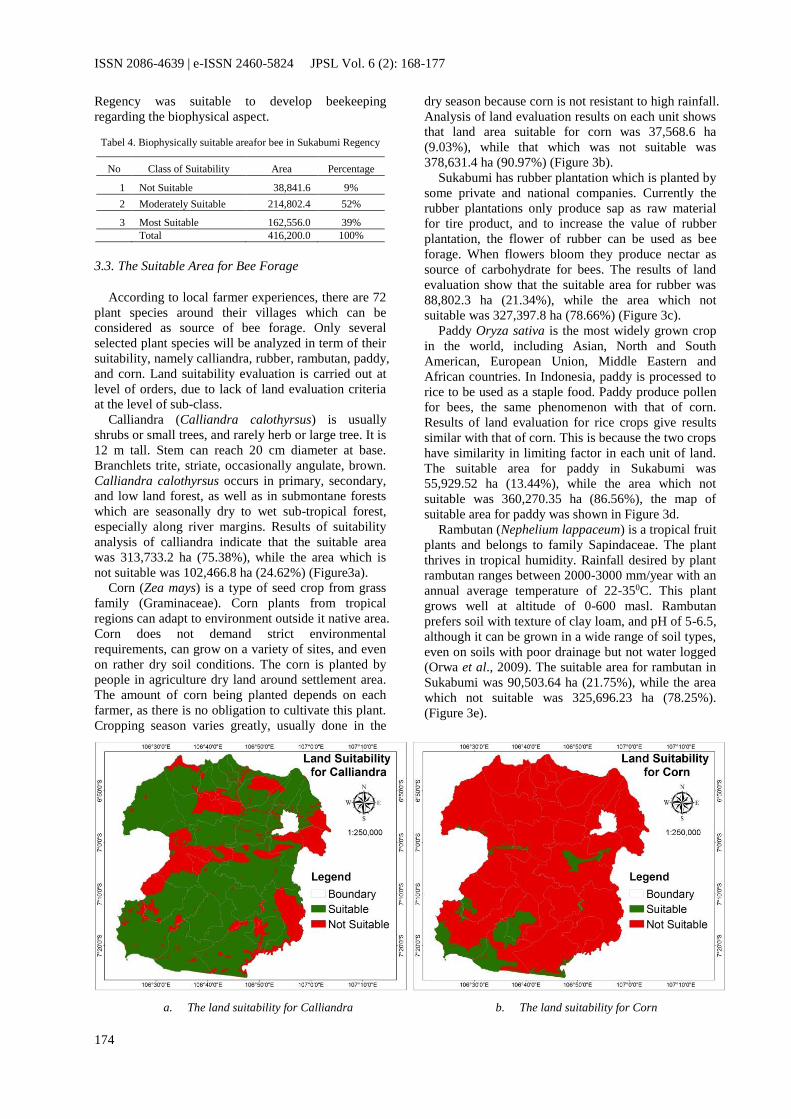
Calliandra (Calliandra calothyrsus) is usually
shrubs or small trees, and rarely herb or large tree. It is
12 m tall. Stem can reach 20 cm diameter at base.
Branchlets trite, striate, occasionally angulate, brown.
Calliandra calothyrsus occurs in primary, secondary,
and low land forest, as well as in submontane forests
which are seasonally dry to wet sub-tropical forest,
especially along river margins. Results of suitability
analysis of calliandra indicate that the suitable area
was 313,733.2 ha (75.38%), while the area which is
not suitable was 102,466.8 ha (24.62%) (Figure3a).
Corn (Zea mays) is a type of seed crop from grass
family (Graminaceae). Corn plants from tropical
regions can adapt to environment outside it native area.
Corn does not demand strict environmental
requirements, can grow on a variety of sites, and even
on rather dry soil conditions. The corn is planted by
people in agriculture dry land around settlement area.
The amount of corn being planted depends on each
farmer, as there is no obligation to cultivate this plant.
Cropping season varies greatly, usually done in the
dry season because corn is not resistant to high rainfall.
Analysis of land evaluation results on each unit shows
that land area suitable for corn was 37,568.6 ha
(9.03%), while that which was not suitable was
378,631.4 ha (90.97%) (Figure 3b).
Sukabumi has rubber plantation which is planted by
some private and national companies. Currently the
rubber plantations only produce sap as raw material
for tire product, and to increase the value of rubber
plantation, the flower of rubber can be used as bee
forage. When flowers bloom they produce nectar as
source of carbohydrate for bees. The results of land
evaluation show that the suitable area for rubber was
88,802.3 ha (21.34%), while the area which not
suitable was 327,397.8 ha (78.66%) (Figure 3c).
Paddy Oryza sativa is the most widely grown crop
in the world, including Asian, North and South
American, European Union, Middle Eastern and
African countries. In Indonesia, paddy is processed to
rice to be used as a staple food. Paddy produce pollen
for bees, the same phenomenon with that of corn.
Results of land evaluation for rice crops give results
similar with that of corn. This is because the two crops
have similarity in limiting factor in each unit of land.
The suitable area for paddy in Sukabumi was
55,929.52 ha (13.44%), while the area which not
suitable was 360,270.35 ha (86.56%), the map of
suitable area for paddy was shown in Figure 3d.
Rambutan (Nephelium lappaceum) is a tropical fruit
plants and belongs to family Sapindaceae. The plant
thrives in tropical humidity. Rainfall desired by plant
rambutan ranges between 2000-3000 mm/year with an
annual average temperature of 22-350C. This plant
grows well at altitude of 0-600 masl. Rambutan
prefers soil with texture of clay loam, and pH of 5-6.5,
although it can be grown in a wide range of soil types,
even on soils with poor drainage but not water logged
(Orwa et al., 2009). The suitable area for rambutan in
Sukabumi was 90,503.64 ha (21.75%), while the area
which not suitable was 325,696.23 ha (78.25%).
(Figure 3e).
a. The land suitability for Calliandra b. The land suitability for Corn

JPSL Vol. 6 (2): 168-177, Desember 2016
175
c. The land suitability for Rubber d. The land suitability for Paddy
e. The land suitability for Rambutan
Figure 3. Land suitability for each bee forage
Results of combination of bee forages, obtained
nine combinations. The combinations are
differentiated on the basis of limiting factors. In this
study, the analysis only displays two combinations:
suitable area for four plants and suitable area for five
plants. These combinations mean that on a land unit
which was suitable, there can be planted, four or five
selected plants.
The area which suitable for four combinations was
22,428.67 ha, located in Ciemas, Ciracap, Jampang
Kulon, Jampang Tengah, Pabuaran, Surade,
Sagaranten, Pelabuhan Ratu and Tegalbuleud. The
area which suitable for five combinations was
11,660.69 ha, located in Jampang Tengah, Nyalindung,
Ciracap, Surade and Palabuhan Ratu. The Map of
suitable area for bee forage was shown in Figure 4.
3.4. Proposed Suitable Area for Beekeeping
Beekeeping development in protected areas can be
done especially in protected forest and conservation
forest, with regards to preserve the forest function.
This circumstance is in accordance with the Govern-
ment Regulation No. 6 Year 2007 about Forest Gov-
ernance, Preparation of Forest Management Plan and
Forest Utilization, which explained in detail by Minis-
ter of Forestry Regulation No. P.47/Menhut-II/2013
about the Guidance of Criteria and Standard of Forest
Utilization in Specific Area on Protected Forest Man-
agement Unit and Production Forest Management
Unit.
Figure 4.Map of suitable area for bee forage
Based on the regulation of protected forest and con-
servation forest which not allowed to be planted with
fruit tree and season plant, thus for the land suitability
analysis for beekeeping in protected area and conser-

ISSN 2086-4639 | e-ISSN 2460-5824 JPSL Vol. 6 (2): 168-177
176
vation area only overlaid to biophysical suitability for
beekeeping.
The cultivated area on Regional Spatial Planning of
Sukabumi Regency consists of 9 types. Dry land agri-
culture is possible to develop beekeeping, with regards
this area is suitable to be planted with five selected
species of bee forage. Overlaid done from the analysis
of suitable area for beekeeping with dry land agricul-
ture. The recommendation area for beekeeping was
shown in figure 5.
The protected forest area is 51,750.74 ha, this is
representing 12.43% of Sukabumi Regency. Overlay
proses give result that the first priority area for bee-
keeping in protected area was 3,335.52 ha (6.4%),
while second priority was 48,415.22 ha (93.6%) that
covered 14 sub-districts namely Cibadak, Cicurug,
Cidahu, Ciemas, Cikidang, Ciracap, Cisolok, Kaban-
dungan, Kadudampit, Kalapanunggal, Nagrak,
Pelabuhan Ratu, Sukabumi, Sukaraja.
The dry land agriculture area was representing the
cultivated area. The dry land agriculture area was
124,606.62 ha or 29.94% of Sukabumi regency. The
result of analysis was done give us three priorities area
for beekeeping in cultivated area. The first priority
area was 1,163.92 ha, second priority area was
6,044.98 ha, and third priority area was 2,651.21 ha
that covered 9 sub districts namely Ciemas, Ciracap,
Jampang Kulon, Jampang Tengah, Nyalindung, Pabu-
aran, Sagaranten, Surade, Tegalbuleud.
Figure 5. The Purposed development area for beekeeping
Based on result of analysis with the existing
beekeeping in Sukabumi regency, local government of
Sukabumi regency or local farmer could develop
program for beekeeping in such as sub
district:Cibadak, Cicurug, Cidahu, Ciemas, Cikidang,
Ciracap, Cisolok, Kabandungan, Kadudampit,
Kalapanunggal, Nagrak, Pelabuhan Ratu, Sukabumi,
Sukaraja, Jampang Kulon, Pabuaran, Sagaranten,
Surade, and Tegalbuleud.
4. Conclusion
The existing land use and land cover of Sukabumi
Regency were classified into several classes including
dry land agriculture, forest area, plantation, paddy
field, settlement, bare land, shrub land, water body
and fish pond. Overall accuracy was 90% and 88.6%
according to Kappa accuracy.
Based on biophysical aspects and sets of criteria,
the main factors to be considered in beekeeping were
land use and land cover, distance to the road, distance
to the river, temperature, elevation and rain fall. All of
these factors indicating the potency of Sukabumi
Regency for beekeeping and development.
There are five plant has selected namely Calliandra,
corn, paddy, rubber and rambutan. The four
combinations area is 20,623.1 ha, spread into five sub
district namely Ciemas, Ciracap, Jampang Kulon,

JPSL Vol. 6 (2): 168-177, Desember 2016
177
Surade and Tegalbuleud. The five combinations area
was 11,450.5 ha which were located in Jampang
Tengah, Nyalindung, Ciracap, Surade and Palabuhan
Ratu.
The recommended area for beekeeping in
Sukabumi regency consists of two areas: protected and
cultivation area. The protected area has two priorities:
The first priority area for beekeeping was 3,335.52 ha
(6.4%), while second priority was 48,415.22 ha
(93.6%) that covered 14 sub-districts. The
cultivation area has three priorities: First priority area
was 1,163.92 ha, second priority area was 6,044.98 ha,
and third priority area was 2,651.21 ha that covered 9
sub-districts.
References
[1] Abou-Shaara, H. F., A. A. Ahmad, A. M. Abdelsalam, 2013.
A Suitability Map for Keeping Honey Bees Under Harsh
Environmental Conditions Using Geographical Information System. World Applied Science Journal 22 (8), pp. 1099-1105.
[2] Abou-Shaara, H.F., 2014. The Foraging Behavior of Honey
Bees, Apismellifera: a review. VeterinarniMedicina 59, pp. 1-
10.
[3] Amiri, F., A. R. B. Shariff, 2011. Application of Geographic
Information System in Land Use Suitability Evaluation for
Beekeeping: A Case Research of Vahregan Watershed (Iran).
Africal Journal of Agriculture Research 7(1), pp. 89-97.
[4] [BPS] National Statistic Agency, 2016. Statistical Yearbook of
Indonesia. Indonesia National Statistic Agency, Jakarta.
[5] Bohart, G. E., W P. Nye, 1956. Bees. Foraging for Nectar and
Pollen. Gleanings Bee Cult 84 (10), pp. 602-606.
[6] [CICRED] Committee for International Cooperation in
National Research in Demography, 1974.The Population of
Indonesia.CICRED Series.
[7] [FAO] Food and Agriculture Organization, 2011. Forest and
floods, Drowning in fiction or thriving on facts?. Food and
Agriculture Organization of The United Nation, Rome.
[8] Girling, R. D., I. Lusebrink, E. Farthing, T. A. Newman, and
G. M. Poppy, 2013. Diesel exhaust rapidly degrades floral
odours used by honeybees. Scientific Reports 3, 2779.
DOI:10.1038/srep02779.
[9] Hardjowigeno, S., Widiatmaka, 2007. Kesesuaian Lahandan
Perencanaan Tata Guna Lahan. Gajah Mada Unisversity Press,
Yogyakarta.
[10] Hilmi, M., N. Bradbear, D. Mejia, 2011.Beekeping and
Sustainable Livelihoods. Rural Infrastructure and Agro-
Industries Division FAO, Rome
[11] Irmansyah N, 2016. Produksi madu Indonesia 5000 setahun.
Retrieved from http://www.antaranews.com [2016, June 1].
[12] Janssen, L. L. F, 2000. Visual Image Interpertation. Principles
of Remote Sensing (ITC Educational Textbook Series 2)
pp.125-139.
[13] Karunaratne, W. A.I.P., J.P. Edirisinghe, 2008. Diversity of
bees at different altitudes in the Knuckles forest reserve.
Ceylon Journal of Science (Biological Science) 37, pp. 61-72.
[14] Kuhnholz, S., T. D. Seeley, 1997.The control of water
collection in honey bee colonies. Behav. Ecol. Sociobiol 41,
pp. 407-422.
[15] Kuntadi, 2013. Honey Bee Farming Development and Issues.
Retrieved fromhttp://www.forda-mof.org [2014, March 20].
[16] Liliesand, T. M., R. W. Kiefer, J. W. Chipman, 1987. Remote
sensing and Image Interpretation. Second Edition.Jhon Wiley
and Sons Inc, USA.
[17] Marimin, 2008. Pengambilan Keputusan Kriteria Majemuk.
Grisindo, Jakarta.
[18] [MoEF] Ministry of Environment and Forestry. 2014. Statistik
Kementrian Lingkungan Hidup dan Kehutanan. Pusat Data
dan Informasi Kementrian Lingkungan Hidup dan Kehutanan.
[19] [MoF] Ministry of Forestry, 2012. Rekalkulasi Penutupan
Lahan Indonesia Tahun 2011.Direktorat Inventarisasi dan
Pemantauan Sumber Daya Hutan. Direktorat Jendral Planologi
Kehutanan, Jakarta.
[20] [MoT] Ministry of Transmigration, 1989. Regional Physical
Planning Program Transmigration (RePProt), Jakarta.
[21] Muhidin, S., 2002. The Population of Indonesia, Regional
Demographic Scenarios Using A Multiregional Method and
Multiple Data Sources. Rozenberg Publisher.
[22] Novandra, A., W. Made. 2013. Beekeeping Products Market
Opportunities Indonesia. Event Presented at Technology
Transfer, Research Institute for Non-Timber Forest Products
Technology. Retrieved from http://www.forda-mof.org [2014,
March 17].
[23] Orwa, C., A. Mutua, R. Kindt, R. Jamnadass, S. Anthony,
2009.Agroforestree Database: a tree reference and selection
guide version 4.0. Retrieved from
http://www.worldagroforstry.org [2014, March 17].
[24] [APIARI] Pusat Perlebahan APIARI Pramuka, 2003. Lebah
Madu: Cara beternak dan pemanfaatan. Penebar Swadaya,
Jakarta.
[25] Rachmawati, N., K. Munibah, Widiatmaka, 2014. Evaluasi
Multi-kriteria untuk kesesuaian lahan budidaya lebah madu di
Cianjur.GLOBE 16 (1).
[26] Saepudin, R., 2011. Produktivitas Lebah Madu (Apiscerena)
pada penerapan system integrasi dengan kebun Kopi.
Dissertation. Graduate School.Bogor Agricultural University,
Bogor.
[27] Saaty, L. T., 1980. The Analytic Hierarchy Process. McGraw-
Hill, New York.
[28] Sihombing, D. T. H., Animal Science of Honeybee. Gajah
Mada University Press, Yogyakarta.
[29] Simorangkir, D., M. A. Sardjono, 2006. Implications of Forest
utilization, conversion policy and tenure dynamics on resource
management and poverty reduction, case study from Pasir
District, East Kalimantan, Indonesia. Food and Agriculture
Organization., Rome.
[30] Somerville, D., 1999. Pollination of Apples by honey bees.
NSW Agriculture, Goulburn.
[31] Subharani, R., V. Sivaram, P. Roopa, 2012. Assesment of
Honey Plant Resources through Pollen Analysis in Coorg
Honeys of Karnataka State. The International Journal of Plant
Reproductive Biology 4 (1), pp. 31-39.
[32] Van Der Steen, J. J. M., 2015. The Foraging Honey Bee.The
British Bee Journal, pp. 43-46.
[33] Widiatmaka, W. Ambarwulan, C. E. Sjamsudin and L.
Syaufina, 2015. Geographic Information System and
Analytical Hierarchy Process for Land Use Planning of
Beekeeping in Forest Margin of Bogor Regency, Indonesia.
The 1st International Seminar on Tropical Silviculture, 21
August 2015.