Embed Size (px)
Citation preview
13 Milesto Helena
11 Miles to Townsend
§̈¦15
£¤12
4011
164
4016
4031
TIZERLAKE ROAD
225
360
294
405
164
4032
517
491
258
226
¬«518
Copyright:© 2013 National Geographic Society, i-cubed
Ü0 2 41
Miles
Elkhorns Geographic Area BoundaryOwnership
National Forest SystemCountyPrivate
Land OwnershipElkhorns Geographic Area
Spring 2020
Helena - Lewis and Clark National Forest2020 Forest Plan
Map E-1
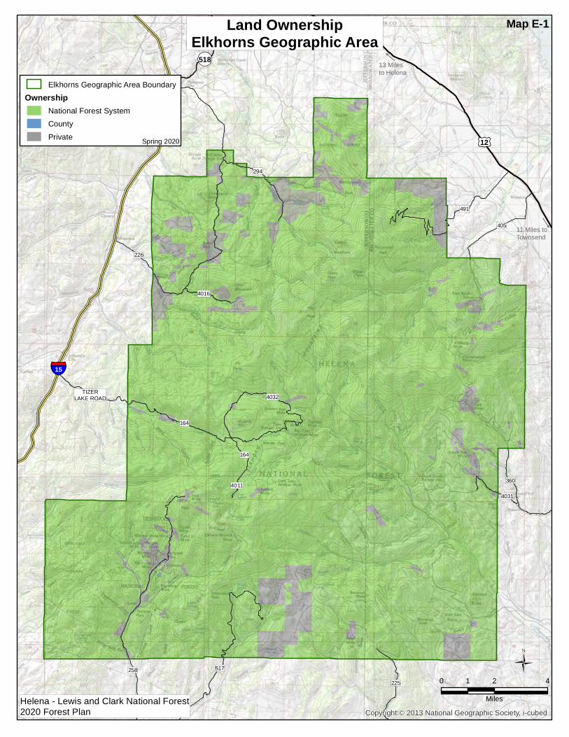
&3
&3
§̈¦15
£¤12
Townsend
Helena
ElkhornCreek
IndianCreek
MuskratCreek
JohnnyGulch
UpperPrickley
Pear Creek
WhitehorseCreek-Canyon
Ferry Lake
McClellanCreek
MiddlePrickley
Pear Creek
McCartyCreek-Boulder
River
LowerBeaverCreek
WarmSpringsCreek
MiddleCrowCreek
Kelly SpringsGulch-Canyon
Ferry Lake
HeadwatersCrow Creek
UpperCrowCreek
SouthFork Crow
Creek
UpperBeaverCreek
DryCreek
Slim SamCreek
HeadwatersPrickley
Pear Creek
UpperSpokane
Creek
Lower CrowCreek-Missouri
River
LowerSpokane
Creek
Sevenmile Creek
x
DeepC reek
x
x
x
Missouri R iver
Missouri RiverMissouri River
Co
nfederate Gulch
Missouri River
C row Creek
Missou r i Rive
r
Missou
r i River
Montana Di tch
Dry Creek
Prickly Pear Creek
Missouri River
Mis s our i
Rive
r
Missou r iRive
r
Little BoulderRiver
Beaver Cree
k
Trout Creek
Silver Creek
Boulder RiverMi
ssouri
River
Littl e Whitetail Creek
Broadwater Misso uri Canal
M issou
r i Rive
r
Tizer Creek
Whitetail Creek
TostonC anal East Fork
Tenmile Creek
Warm Springs Cree
k
Avalanc
he Creek
Lump Gulch
Broa
dwate
r Miss
ouri C
anal
Lake Helena
Helena ValleyRegulatingReservoir
Hauser Lake Hauser Lake
CanyonFerry Lake
Ü0 4 82
Miles
Elkhorns Geographic Area BoundaryMajor StreamsLakes/ReservoirsMcClellan Creek Municipal WatershedConservation Watershed Network
Watershed Condition ClassFunctioning ProperlyFunctioning at RiskImpaired FunctionWatershed Not Rated
WatershedsElkhorns Geographic Area
Spring 2020
Helena - Lewis and Clark National Forest2020 Forest Plan
Map E-2
&3
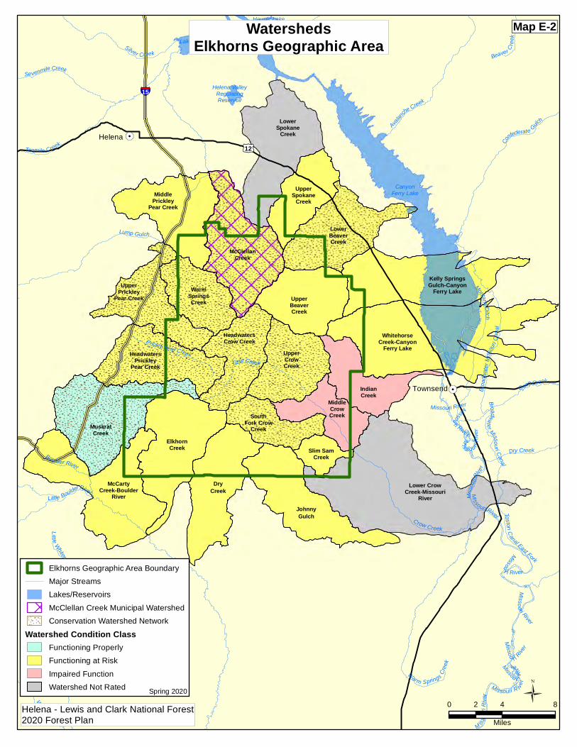
10 Milesto Helena
11 Miles to Townsend
226
§̈¦15
£¤12
EL-03
EL-02
EL-04
EL-01
4011
164
225
4031
TIZERLAKE ROAD
294
360
405
164
517
4032
258
491
226
¬«518
Ü0 2 41
Miles
Elkhorns Geographic Area BoundaryNon-National Forest System LandLynx Analysis UnitPotential Lynx Habitat
Lynx Analysis Units and Potential HabitatElkhorns Geographic Area
Spring 2020
Helena - Lewis and Clark National Forest2020 Forest Plan
Map E-3
&3
10 Milesto Helena
11 Miles to Townsend
226
§̈¦15
£¤12
4011
164
225
4016
4031
TIZERLAKE ROAD
294
360
405
164
517
4032
258
491
226
¬«518
Ü0 2 41
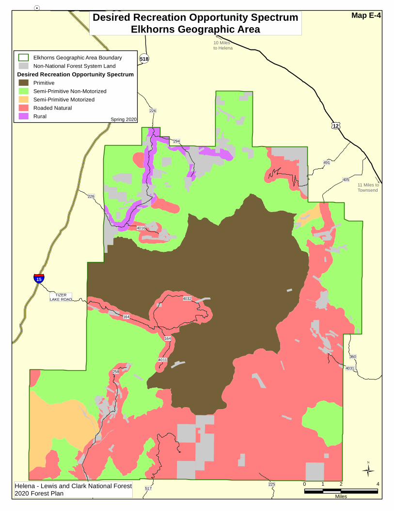
Miles
Elkhorns Geographic Area BoundaryNon-National Forest System Land
Desired Recreation Opportunity SpectrumPrimitiveSemi-Primitive Non-MotorizedSemi-Primitive MotorizedRoaded NaturalRural
Desired Recreation Opportunity SpectrumElkhorns Geographic Area
Spring 2020
Helena - Lewis and Clark National Forest2020 Forest Plan
Map E-4
&3
10 Milesto Helena
11 Miles to Townsend
§̈¦15
£¤12
4011
164
225
4016
4031
TIZERLAKE ROAD
294
360
405
164
517
4032
258
491
226
¬«518
Ü0 2 41
Miles
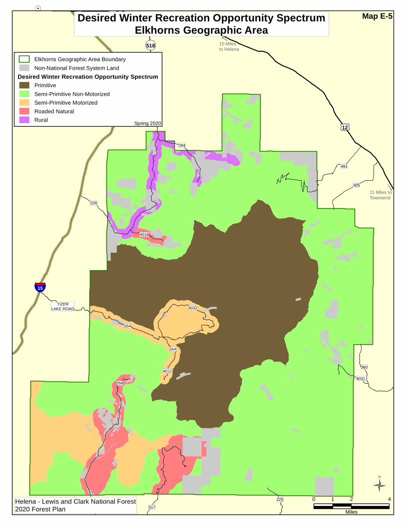
Elkhorns Geographic Area BoundaryNon-National Forest System Land
Desired Winter Recreation Opportunity SpectrumPrimitiveSemi-Primitive Non-MotorizedSemi-Primitive MotorizedRoaded NaturalRural
Desired Winter Recreation Opportunity SpectrumElkhorns Geographic Area
Spring 2020
Helena - Lewis and Clark National Forest2020 Forest Plan
Map E-5

13 Milesto Helena
11 Miles to Townsend
226
§̈¦15
£¤12
4011
164
4016
4031
TIZERLAKE ROAD
225
360
294
405
164
4032
517
491
258
226
¬«518
Ü0 2 41
Miles
Elkhorns Geographic Area BoundaryNon-National Forest System Land
Scenic Integrity ObjectivesVery HighHighModerateLow
Scenic Integrity ObjectivesElkhorns Geographic Area
Spring 2020
Helena - Lewis and Clark National Forest2020 Forest Plan
Map E-6

13 Milesto Helena
11 Miles to Townsend
226
§̈¦15
£¤12
4011
164
4016
4031
TIZERLAKE ROAD
225
360
294
405
164
4032
517
491
258
226
¬«518
Ü0 2 41
Miles
Elkhorns Geographic Area BoundaryNational Forest System LandNon-National Forest System LandElkhorn Wildlife Mgmt UnitPoe-Manley Research Natural Area (Candidate)
Designated AreasElkhorns Geographic Area
Spring 2020
Helena - Lewis and Clark National Forest2020 Forest Plan
Map E-7

13 Milesto Helena
11 Miles to Townsend
226
§̈¦15
£¤12
4011
164
4016
4031
TIZERLAKE ROAD
225
360
294
405
164
4032
517
491
258
226
¬«518
Ü0 2 41
Miles
Elkhorns Geographic Area BoundaryOther National Forest System LandNon-National Forest System Land
Inventoried Roadless AreasElkhorn
Inventoried Roadless AreasElkhorns Geographic Area
Spring 2020
Helena - Lewis and Clark National Forest2020 Forest Plan
Map E-8
13 Milesto Helena
11 Miles to Townsend
226
§̈¦15
£¤12
4011
164
4016
4031
TIZERLAKE ROAD
225
360
294
405
164
4032
517
491
258
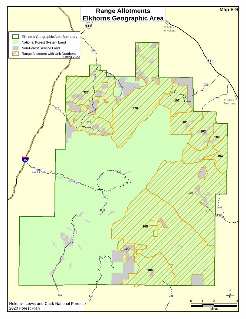
226
107
108
104
101
109
327
105
331
326
102
103
106
¬«518
Ü0 2 41
Miles
Elkhorns Geographic Area BoundaryNational Forest System LandNon-Forest Service LandRange Allotment with Unit Numbers
Range AllotmentsElkhorns Geographic Area
Spring 2020
Helena - Lewis and Clark National Forest2020 Forest Plan
Map E-9
13 Milesto Helena
11 Miles toTownsend
226
§̈¦15
£¤12
4011
164
4016
4031
TIZERLAKE ROAD
225
360
294
405
164
4032
517
491
258
226
¬«518
Ü0 2 41
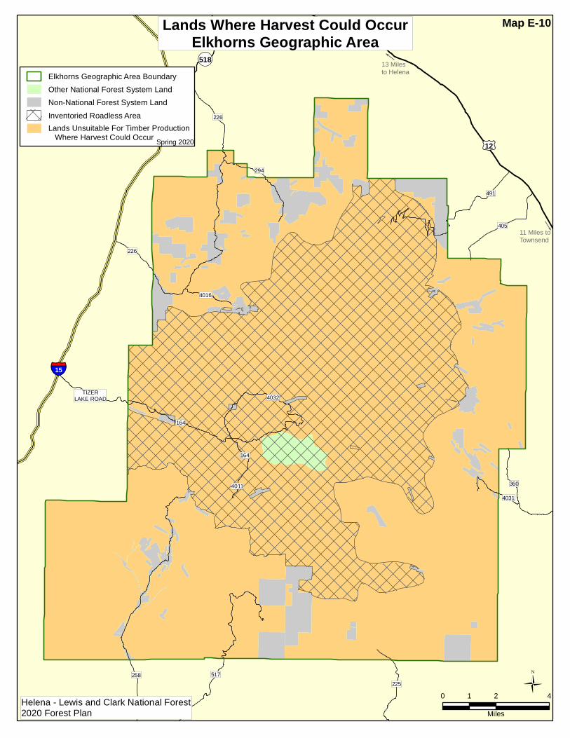
Miles
Elkhorns Geographic Area BoundaryOther National Forest System LandNon-National Forest System LandInventoried Roadless AreaLands Unsuitable For Timber Production Where Harvest Could Occur
Lands Where Harvest Could OccurElkhorns Geographic Area
Spring 2020
Helena - Lewis and Clark National Forest2020 Forest Plan
Map E-10