Embed Size (px)
Citation preview
LISTING #466
LAND FOR SALE 314 ACRES M/L
BERG, WORTH COUNTY, IOWA
DOUGLAS R. YEGGE
C: 563-320-9900
O: 563-659-8185
ALAN MCNEIL
C: 563-321-1125
O: 563-659-8185
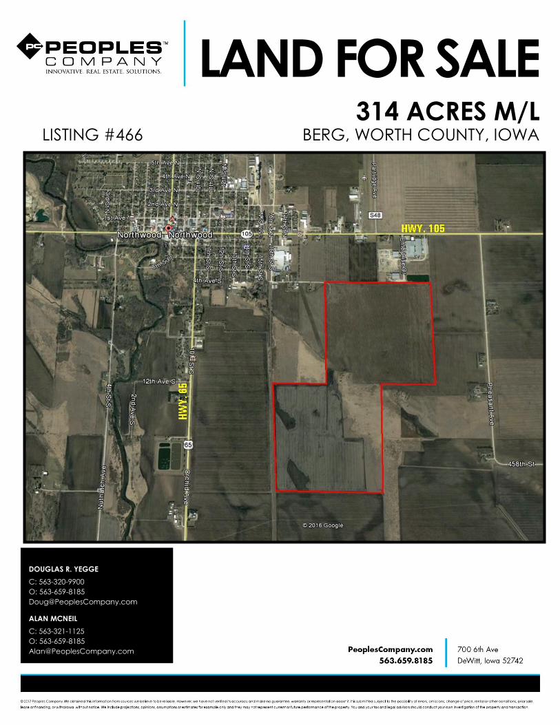
LEGAL DESCRIPTION:
Located in Part of the South 1/2 of
the Southeast 1/4 of Section 33,
Township 100 North, Range 20 West of
the 5th P.M. and the North fractional
1/2 of the Northeast 1/4, east of the
RR ROW, in Section 4, Township 99
North, Range 20 West of the 5th P.M.
COMMENTS & BUILDING INFORMATION:
Offering 314 acres MOL of productive
Worth County, Iowa, farmland.
Consisting of approximately 264
tillable acres and 40 acres enrolled in
CRP. The tillable land carries a CSR
52.4.
LEASE/FSA INFORMATION:
The 40 acres of CRP carry an average
payment of $265.91/acre and expires
in 2031.
The farm is leased for the 2017 crop
year.
TOTAL ACRES: 314
PRICE: $1,794,000.00
Price Per Acre: $5,750.00
Owner: Delano Berg
Operator: Prestegard
County & State: Worth Co., IA
Location: Southeast side of Northwood, IA
Possession Date: To be determined
Drainage Info: Natural & Tile
Average Productivity: 52.4 CSR2
Taxable Acres: $5,656
Net RE Taxes: 312.42
Taxes Payable In: 2016-2017
Topography: Level
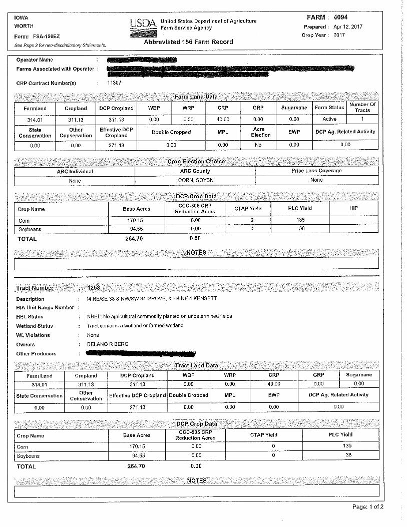
APPROXIMATE BREAKDOWN OF ACRES: F.S.A. INFORMATION:
Farmland: 314.01
Crop Acres: 311.13
CRP Acres: 40
Wheat Base:
Wheat Yield:
Corn Base: 170.15
Corn Yield: 135
Soybean Base: 94.55
Soybean Yield: 38
Total Acres: 314
Tillable Acres: 274
CRP Acres: 40
Farmstead:
Roads:
Waterways:
Timber:
Pasture:
Berg, 314 Acres M/L, Worth County, IA
LAND FOR SALE
DOUGLAS R. YEGGE
C: 563-320-9900
O: 563-659-8185
ALAN MCNEIL
C: 563-321-1125
O: 563-659-8185


Worth CountyIowa
4/19/2017
map center: 43° 25' 59.43, -93° 12' 13.86
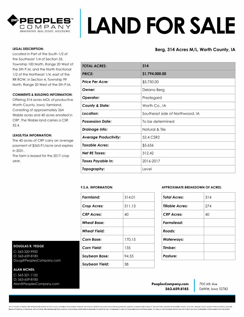
Aerial Map ~ Berg Total Acres
33-100N-20W
0ft 807ft 1614ft
Field borders provided by Farm Service Agency as of 5/21/2008.

State: IowaWorthCounty:33-100N-20WLocation:
Township: GroveAcres: 314.01Date: 4/19/2017
Soils data provided by USDA and NRCS.
Soils Map ~ Berg Total Acres
Area Symbol: IA195, Soil Area Version: 20Area Symbol: IA195, Soil Area Version: 20Code Soil
DescriptionAcres Percent
of fieldCSR2Legend
NonIrrClass*c
*iCorn
*iAlfalfa
*i Soybeans *i Bluegrass *i TallGrasses
CSR2** CSR Corn Oats Soybeans NCCPIOverall
1177 Saude loam,0 to 2 percentslopes
116.88 37.2% IIs 177.6 5 51.5 3.2 5.3 60 75
560 Talcot clayloam, 0 to 2percentslopes, rarelyflooded
55.85 17.8% IIw 182.4 3.8 52.9 3.3 5.5 53 155 62 45 66
335 Harcot loam,0 to 2 percentslopes, rarelyflooded
52.20 16.6% IIw 134.4 2.8 39 2.4 4 37 63 140 56 41 68
1226 Lawler loam,0 to 2 percentslopes, rarelyflooded
34.92 11.1% IIs 164.8 4.3 47.8 3 4.9 59 70 86
521B Klossnermuck, 1 to 4percentslopes
21.97 7.0% IIIw 176 3.7 51 3.2 5.3 43 148 59 43 98
1152 Marshan clayloam, 0 to 2percentslopes, rarelyflooded
19.58 6.2% IIw 182.4 3.8 52.9 3.3 5.5 54 66 84
740C2 Hawick sandyloam, 2 to 9percentslopes,moderatelyeroded
6.88 2.2% IVs 128 3.6 37.1 2.3 3.8 27 105 42 30 24

177B Saude loam,2 to 5 percentslopes, rarelyflooded
3.32 1.1% IIs 177.6 5 51.5 3.2 5.3 55 60 160 64 46 67
1177B Saude loam,2 to 5 percentslopes
2.41 0.8% IIs 177.6 5 51.5 3.2 5.3 55 75
Weighted Average 168.9 4.1 49 3 5.1 52.4 * 65.2 26.1 19 74.4
**IA has updated the CSR values for each county to CSR2.
*- CSR weighted average cannot be calculated on the current soils data, use prior data version for csr values.
*i Yield data provided by the ISPAID Database version 8.1 developed by IA State University.
*c: Using Capabilities Class Dominant Condition Aggregation Method
Soils data provided by USDA and NRCS.

State: IowaWorthCounty:33-100N-20WLocation:
Township: GroveAcres: 314.01Date: 4/19/2017
Soils data provided by USDA and NRCS.
Soils Map ~ Berg Tillable Acres
Area Symbol: IA195, Soil Area Version: 20Area Symbol: IA195, Soil Area Version: 20Code Soil
DescriptionAcres Percent
of fieldCSR2Legend
NonIrrClass*c
*iCorn
*iAlfalfa
*i Soybeans *i Bluegrass *i TallGrasses
CSR2** CSR Corn Oats Soybeans NCCPIOverall
1177 Saude loam,0 to 2 percentslopes
116.88 37.2% IIs 177.6 5 51.5 3.2 5.3 60 75
560 Talcot clayloam, 0 to 2percentslopes, rarelyflooded
55.85 17.8% IIw 182.4 3.8 52.9 3.3 5.5 53 155 62 45 66
335 Harcot loam,0 to 2 percentslopes, rarelyflooded
52.20 16.6% IIw 134.4 2.8 39 2.4 4 37 63 140 56 41 68
1226 Lawler loam,0 to 2 percentslopes, rarelyflooded
34.92 11.1% IIs 164.8 4.3 47.8 3 4.9 59 70 86
521B Klossnermuck, 1 to 4percentslopes
21.97 7.0% IIIw 176 3.7 51 3.2 5.3 43 148 59 43 98
1152 Marshan clayloam, 0 to 2percentslopes, rarelyflooded
19.58 6.2% IIw 182.4 3.8 52.9 3.3 5.5 54 66 84
740C2 Hawick sandyloam, 2 to 9percentslopes,moderatelyeroded
6.88 2.2% IVs 128 3.6 37.1 2.3 3.8 27 105 42 30 24

177B Saude loam,2 to 5 percentslopes, rarelyflooded
3.32 1.1% IIs 177.6 5 51.5 3.2 5.3 55 60 160 64 46 67
1177B Saude loam,2 to 5 percentslopes
2.41 0.8% IIs 177.6 5 51.5 3.2 5.3 55 75
Weighted Average 168.9 4.1 49 3 5.1 52.4 * 65.2 26.1 19 74.4
**IA has updated the CSR values for each county to CSR2.
*- CSR weighted average cannot be calculated on the current soils data, use prior data version for csr values.
*i Yield data provided by the ISPAID Database version 8.1 developed by IA State University.
*c: Using Capabilities Class Dominant Condition Aggregation Method
Soils data provided by USDA and NRCS.

Worth CountyIowa
4/19/2017
map center: 43° 25' 59.43, -93° 12' 13.86
Aerial Map ~ Berg CRP Acres
33-100N-20W
0ft 807ft 1614ft
Field borders provided by Farm Service Agency as of 5/21/2008.

State: IowaWorthCounty:33-100N-20WLocation:
Township: GroveAcres: 40.04Date: 4/19/2017
Soils data provided by USDA and NRCS.
Soils Map ~ Berg CRP Acres
Area Symbol: IA195, Soil Area Version: 20Area Symbol: IA195, Soil Area Version: 20Code Soil Description Acres Percent
of fieldCSR2Legend
NonIrrClass*c
*iCorn
*iAlfalfa
*i Soybeans *i Bluegrass *i TallGrasses
CSR2** CSR Corn Oats Soybeans NCCPIOverall
521B Klossner muck,1 to 4 percentslopes
19.20 48.0% IIIw 176 3.7 51 3.2 5.3 43 148 59 43 98
335 Harcot loam, 0to 2 percentslopes, rarelyflooded
14.59 36.4% IIw 134.4 2.8 39 2.4 4 37 63 140 56 41 68
560 Talcot clayloam, 0 to 2percent slopes,rarely flooded
2.54 6.3% IIw 182.4 3.8 52.9 3.3 5.5 53 155 62 45 66
1226 Lawler loam, 0to 2 percentslopes, rarelyflooded
1.90 4.7% IIs 164.8 4.3 47.8 3 4.9 59 70 86
177B Saude loam, 2to 5 percentslopes, rarelyflooded
1.81 4.5% IIs 177.6 5 51.5 3.2 5.3 55 60 160 64 46 67
Weighted Average 160.8 3.5 46.6 2.9 4.8 42.7 * 139 55.5 40.5 83.1
**IA has updated the CSR values for each county to CSR2.
*- CSR weighted average cannot be calculated on the current soils data, use prior data version for csr values.
*i Yield data provided by the ISPAID Database version 8.1 developed by IA State University.
*c: Using Capabilities Class Dominant Condition Aggregation Method
Soils data provided by USDA and NRCS.