Embed Size (px)
Citation preview

LAKE NEWLAND CONSERVATION PARK Opportunities for Implementation of the WildEyre Conservation Action Plan
Produced for the WildEyre Working Group, Oct 2009

Produced By Mick Durant Greening Australia Aug 2009 Citation: Durant, M.D. 2009 ‘Lake Newland Conservation Park: Opportunities for Implementation of the WildEyre Conservation Action Plan’, Report to the WildEyre project group, Greening Australia SA Updated 22nd March 2010
2Lake Newland Conservation Park, Opportunities for Implementation of the WildEyre Conservation Action Plan 2009

CONTENTS Summary………………………………………………………………………………………… 3 Glossary of Terms and Abbreviations………………………………………………………... 4 1 Background and Scope………………………………………………………………. 5
1.1 The WildEyre Project……………………………………………………….. 5 1.2 Aims and Scope…………………………………………………….……… 6
2 Lake Newland Conservation Park…………………………………………………… 7
2.1 Description and Overview………………………………………………… 7 2.2 Topography, Hydrology and Climate……………………………………. 7 2.3 Wildlife ………………………………………………………………………. 7
2.4 Vegetation…………………………………………………………………… 7 2.4.1 Open Areas………………………………………………………… 8 2.4.2 Vegetation of Swamps and Lake Margins……………………… 8 2.4.3 Coastal Shrublands and Woodlands……………………………. 8 2.4.4 Semi-saline Swamps…………………………………………….. 8 2.5 Access, Fencing and Infrastructure……………………………………… 8
2.6 Photographs………………………………………………………………… 10 3 Restoration Opportunities……………………………………………………………. 12
3.1 Managing Total Grazing Pressure and Feral Predators………………… 13 3.2 Recreation Infrastructure and Signs………………………………………. 15 3.3 Weed Control………………………………………………………………… 15 3.4 Revegetation………………………………………………………………… 15 3.5 Monitoring……………………………………………………………………. 17 3.6 Fire Management…………………………………………………………… 17 3.7 Indigenous Engagement and Involvement………………………………. 17
4 Revegetation Plan………………………………………………………………. 18 4.1 Benefits of Establishing Native Vegetation at Lake Newland………….. 18 4.2 Revegetation Method……………………………………………………….. 18 4.3 Seed Requirements and Collection……………………………………….. 18 4.4 Adapting to a Drying Climate………………………………………………. 19 4.5 Snail and Red-legged Earthmite Control…………………………………. 19
4.6 Site Preparation/Weed Control……………………………………………. 19 4.7 Targeted Weed Control…………………………………………………….. 20
4.8 Monitoring and Adaptive Management…………………………………… 20 5 Implementation and Indicative Costs…………………………………………………. 21 5.1 Implementation Plan………………………………………………………… 21 5.2 Indicative Costings…………….……………………………………………. 22 Tables Table 1: Wild Eyre Goals Supported at Lake Newland……….………………………….. 12 Table 2: Key Structural and Floristic Species for Sheoak Restoration………………… 19 Table 3: A Typical Revegetation Calendar………………………………………………. 20 Table 4: Specific Measurables Relating to Revegetation……………………………… 20 Table 5: A Basic Implementation Plan…….……………………………………………. 21 Table 6: Indicative Costs for Restoration…………………………………………………. 23 Maps Map 1: Dakalanta Sanctuary, Location and Landscape Context…………………… 6 Map 2: Vegetation Associations within Lake Newland as Mapped by DEH……….. 9 Map 3: Revegetation and Regeneration Areas………………………………………. 14 Map 4: Adjacent Landholdings………….……………………………………………... 16
Lake Newland Conservation Park, Opportunities for Implementation of the WildEyre Conservation Action Plan 2009 i

Lake Newland Conservation Park, Opportunities for Implementation of the WildEyre Conservation Action Plan 2009 ii

Summary This document is one of 5 plans produced in 2009 seeking to guide the implementation of the WildEyre Conservation Action Plan (CAP) using funding from the Commonwealth Government Caring for Our Country Program, administered through the Eyre Peninsula Natural Resources Management Board. The Wild Eyre project has been developing since 2007 and now has a 1st iteration Conservation Action Plan (CAP) for an area covering around 1.2 million hectares on the western Eyre Peninsula. The CAP identified 12 conservation assets to become the focus of conservation efforts in the region and at least 6 of these are protected within Lake Newland Conservation Park. Opportunities exist to develop a strong partnership between the managers of the park (DEH), the WildEyre Working Group and the traditional owners of the land through the Wirangu #2 native title claimant group. The WildEyre Working Group is particularly interested in achieving a number of regional conservation goals at Lake Newland in a way that is consistent with the Lake Newland Conservation Park Management Plan (DEH 2003) and the interests of the traditional owners. The relevant goals are as follows:
2.1 Measurable improvement in condition of coastal areas regularly used for recreational activities through appropriate infrastructure and signage by 2013 3.1 Protect high priority coastal dunes and cliff-tops from African Boxthorn and other significant weed infestations by 2015 4.1 Revegetate 1,500 ha of Sheoak Grassy Woodlands on non-regenerative sites to ensure adequate and representative areas and create buffers for linear ecosystems by 2015. 4.2 Protect high priority sub-coastal wetlands with vegetation buffers to improve habitat diversity and linkages by 2015 4.3 Protect and buffer high priority coastal dunes and cliff-tops from stock grazing to allow measurable improvement in native vegetation condition by 2015 9.1 Maximise the distribution and populations of native fauna species threatened by feral predators (foxes, cats) by 2020. 9.2 Regeneration of palatable native plant species and stabilisation of soil structure in areas not grazed by stock by 2020.
This plan identifies a number of areas in which the WildEyre Working Group can assist the current and traditional managers of the park to achieve common goals. The principle areas of assistance could include:
Revegetation of Sheoak grassy woodland on limestone low hills along the eastern boundary Funding for interpretive signage which conveys biological, ecological, recreational and cultural
information Funding for fencing to maintain stock exclusion, protect revegetation and protect the natural values
of the park as identified in the park management plan (DEH 2003) Liaison with adjacent landholders on the eastern boundary with the goal of undertaking buffer
revegetation and reducing agricultural run-off Feral animal control Boxthorn control and other weed management activities Planning Monitoring and survey
Lake Newland Conservation Park, Opportunities for Implementation of the WildEyre Conservation Action Plan 2009 3

Glossary of Terms and Abbreviations DEH Department for Environment and Heritage (Government of South Australia) CAP Conservation Action Plan (or Planning) NRM Natural Resources Management Native Pine refers to Southern Cypress-pine (Callitris gracilis) Sheoak refers to Drooping Sheoak (Allocasuarina verticillata) Acknowledgements The Author would like to acknowledge the input of the WildEyre Working Group in the production of this plan, and in particular Rob Coventry and Andrew Freemen of the Eyre Peninsula Natural Resources Management Board for all the background and technical information and comments on the draft, Todd Berkinshaw for input into the format and content and Emma Coates and Amber Clarke for the DEH perspective. The Author and the WildEyre Working Group also wish to thank additional DEH staff (particularly Lee Amey) for their interest in the planning and to Adrian Simpson, Alan Wilson and Mitch Dunnett for meeting the WildEyre group on site and sharing their perspectives and insights on the area.
Toothed Velleia (Velleia arguta) growing amongst Black Grass (Gahnia lanigera) on rocky outcrops in the
paddocks of Lake Newland Conservation Park
Lake Newland Conservation Park, Opportunities for Implementation of the WildEyre Conservation Action Plan 2009 4

1 Background and Scope This document is one of 5 plans produced in 2009 seeking to guide the implementation of the WildEyre Conservation Action Plan using funding from the Commonwealth Government Caring for Our Country Program, administered through the Eyre Peninsula Natural Resources Management Board. This plan has come about through discussions between the Eyre Peninsula Natural Resources Management (NRM) Board, the WildEyre working group, the Department for Environment and Heritage and the Wirangu #2 Native Title Claimant Group under the WildEyre project banner. 1.1 The WildEyre Project The WildEyre project began in 2007 as a small and diverse group of natural resource managers on Eyre Peninsula (non-government, State agencies and the Eyre Peninsula Natural Resources Management Board) undertaking a series of facilitated planning workshops with a goal of conserving significant environments on the west coast of Eyre Peninsula. The workshops were based around a Conservation Action Planning (CAP) framework which has been developed by the US-based The Nature Conservancy (TNC) and which is currently being applied to many large conservation projects in Australia and worldwide (see www.nature.org ). The WildEyre project has been developing since 2007 and the group now has a 1st iteration Conservation Action Plan for an area of western Eyre Peninsula covering around 1.2 million hectares from Mount Hope in the south to around Streaky Bay in the north and including the large habitat areas of Hinks and Hambidge Wilderness Areas in the east. The Plan identified 12 assets to become the focus of conservation efforts in the region including 3 which are currently protected within Lake Newland Conservation Park, 2 that were formerly present and 1 which occurs immediately adjacent to the Park, these are listed below. 1) Sandy Coasts and Dunes (present within Lake Newland CP) 2) Rocky Coasts and Clifftops (occur north and south of Lake Newland CP) 3) Sheltered Coastal Bays 4) Sub-coastal and Inland Wetlands (present within Lake Newland CP) 5) Coastal and Inland Limestone Plains Mallee 6) Sand Mallee Communities 7) Sand Mallee Dune-top Remnants 8) Red Gum Floodplain Woodland 9) Mallee Box and Native Pine Woodlands (formerly present within Lake Newland CP) 10) Sheoak Grassy Woodlands (formerly present within Lake Newland CP) 11) Native Grasslands and Low Sedgelands (present within Lake Newland CP) 12) Granite Outcrops 1.2 Aims and Scope The principle aim of this plan is identify management and restoration activities which meet common goals shared by the WildEyre Working Group, the Department for Environment and Heritage, the traditional owners of the site (principally represented by the Wirangu #2 claimant group) and other interest groups. In this way the WildEyre Working Group hopes to assist with the management and restoration of the site to help meet wider regional conservation targets. The scope is not to produce a comprehensive management plan as such a plan already exists (DEH 2003), but to briefly outline the restoration possibilities and provide some indicative costings for undertaking the work. It is hoped that the plan can provide a framework for pursuing future funding opportunities. Fieldwork was undertaken on 20th August 2009. The major components of this plan are:
To describe the natural values of the site Identify restoration opportunities which link to WildEyre CAP objectives Identify risks and management issues with the potential to impact restoration efforts Provide indicative costs for undertaking the work
Lake Newland Conservation Park, Opportunities for Implementation of the WildEyre Conservation Action Plan 2009 5

Map 1: Lake Newland Conservation Park, Location and Landscape Context
Lake Newland Conservation Park, Opportunities for Implementation of the WildEyre Conservation Action Plan 2009 6

2 Lake Newland Conservation Park 2.1 Description and Overview Lake Newland Conservation Park is located on the west coast of Eyre Peninsula, approximately 20 km north of Elliston between the coast and Flinders Highway (refer to Map 1). The park was proclaimed in 1991 with some additional areas added around Walkers Rock in 1996 (DEH 2003). The park currently covers around 8,912 hectares of tall mobile sand dunes and low-lying sub-coastal wetlands. The key values as recognised in the existing management plan for the park are:
The range of wetlands, freshwater springs, soaks and seepages and the associated wildlife species dependent on this system which have international, national and state significance
The range of waders, shorebirds and other waterbirds. The presence of animal species of conservation significance. The coastal dune system and its vegetation, particularly the remnant sheoak woodlands. The remoteness of the area and limited access to major sections of the park. The beach at Walkers Rock, popular for swimming and other family beach activities. Remote beaches prized for their recreational fishing opportunities.
2.2 Topography Hydrology and Climate A baseline survey of Lake Newland by V & C Semeniuk Research Group (2007) suggests a relatively recent geological history of Holocene sands forming a barrier between the sea and a shallow depression in older Pleistocene limestone (the Bridgewater Formation which is common throughout western Eyre Peninsula). The current topography is a result of the dune system encroaching eastwards into a series of lagoons sitting on the Bridgewater limestone. The variable encroaching edge of the dunes has formed unique and variable habitats on the western shores of the lagoons. Other major components of the system include a number of freshwater springs which fill the lagoons from rain-fed groundwater with origins in the Bridgewater limestone to the east and north. There are also suggestions that some seepage of sea water may occur on the western side of the lakes. Leakage from the system is predominantly from evaporation and downward into the limestone. The mean annual rainfall at nearby Elliston is 427.3 mm and occurs predominantly in winter (Bureau of Meteorology www.bom.gov.au ). 2.3 Wildlife The management plan for Lake Newland produced by DEH has the best available overview of the wildlife for the site. One of the most conspicuous features of the fauna assemblage is the number of birds that use the area including masses of migratory waders and waterfowl. Birds of conservation significance include the State Vulnerable Slender-billed Thornbill (Acanthiza iredalei), Hooded Plover (Thinornis rubricollis) and Fairy Tern (Sterna nereis) and the Nationally Vulnerable Blue Petrel (Halobaena caerulea). Western Grey Kangaroo and Mitchell’s Hopping Mouse are reported as the most conspicuous mammals in the park and it is highly likely that echidna also occur. The DEH also report that 8 species of reptile, 1 frog species and at least 1 fish, the Small-mouthed Hardyhead (Atherinasoma microstoma) can also be found. Included in the reptile assemblage is the State rare Beach Slider (Lerista arenicola) which, when discovered here in 1997 represented a significant eastward extension of its known range (DEH 2003). Feral animals in the park include rabbits, cats, mice and foxes and domestic sheep may enter occasionally through damaged fences. Goats are not known in the park by DEH staff but it is possible that they are present. 2.4 Vegetation Native vegetation on the property is mapped by the Department for Environment and Heritage (DEH) and is shown on Map 2.
Lake Newland Conservation Park, Opportunities for Implementation of the WildEyre Conservation Action Plan 2009 7
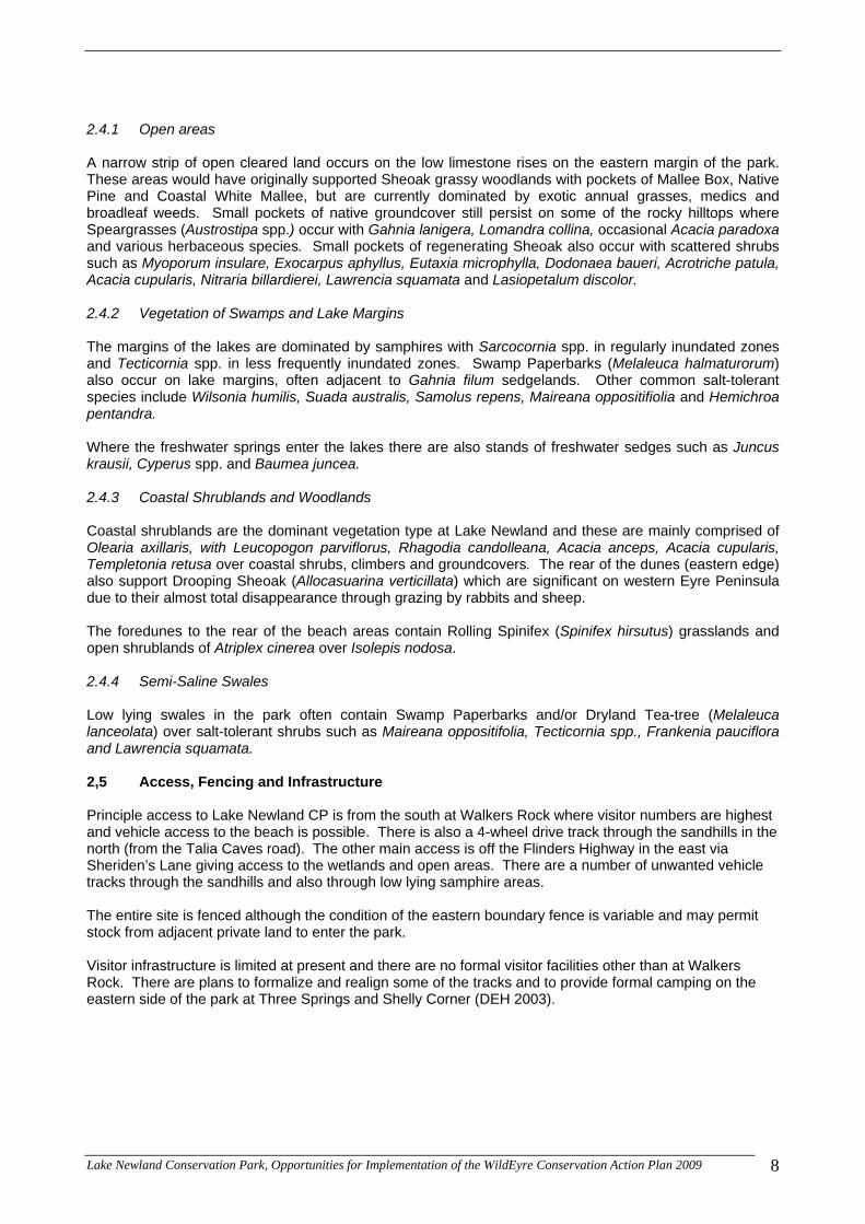
2.4.1 Open areas A narrow strip of open cleared land occurs on the low limestone rises on the eastern margin of the park. These areas would have originally supported Sheoak grassy woodlands with pockets of Mallee Box, Native Pine and Coastal White Mallee, but are currently dominated by exotic annual grasses, medics and broadleaf weeds. Small pockets of native groundcover still persist on some of the rocky hilltops where Speargrasses (Austrostipa spp.) occur with Gahnia lanigera, Lomandra collina, occasional Acacia paradoxa and various herbaceous species. Small pockets of regenerating Sheoak also occur with scattered shrubs such as Myoporum insulare, Exocarpus aphyllus, Eutaxia microphylla, Dodonaea baueri, Acrotriche patula, Acacia cupularis, Nitraria billardierei, Lawrencia squamata and Lasiopetalum discolor. 2.4.2 Vegetation of Swamps and Lake Margins The margins of the lakes are dominated by samphires with Sarcocornia spp. in regularly inundated zones and Tecticornia spp. in less frequently inundated zones. Swamp Paperbarks (Melaleuca halmaturorum) also occur on lake margins, often adjacent to Gahnia filum sedgelands. Other common salt-tolerant species include Wilsonia humilis, Suada australis, Samolus repens, Maireana oppositifiolia and Hemichroa pentandra. Where the freshwater springs enter the lakes there are also stands of freshwater sedges such as Juncus krausii, Cyperus spp. and Baumea juncea. 2.4.3 Coastal Shrublands and Woodlands Coastal shrublands are the dominant vegetation type at Lake Newland and these are mainly comprised of Olearia axillaris, with Leucopogon parviflorus, Rhagodia candolleana, Acacia anceps, Acacia cupularis, Templetonia retusa over coastal shrubs, climbers and groundcovers. The rear of the dunes (eastern edge) also support Drooping Sheoak (Allocasuarina verticillata) which are significant on western Eyre Peninsula due to their almost total disappearance through grazing by rabbits and sheep. The foredunes to the rear of the beach areas contain Rolling Spinifex (Spinifex hirsutus) grasslands and open shrublands of Atriplex cinerea over Isolepis nodosa. 2.4.4 Semi-Saline Swales Low lying swales in the park often contain Swamp Paperbarks and/or Dryland Tea-tree (Melaleuca lanceolata) over salt-tolerant shrubs such as Maireana oppositifolia, Tecticornia spp., Frankenia pauciflora and Lawrencia squamata. 2,5 Access, Fencing and Infrastructure Principle access to Lake Newland CP is from the south at Walkers Rock where visitor numbers are highest and vehicle access to the beach is possible. There is also a 4-wheel drive track through the sandhills in the north (from the Talia Caves road). The other main access is off the Flinders Highway in the east via Sheriden’s Lane giving access to the wetlands and open areas. There are a number of unwanted vehicle tracks through the sandhills and also through low lying samphire areas. The entire site is fenced although the condition of the eastern boundary fence is variable and may permit stock from adjacent private land to enter the park. Visitor infrastructure is limited at present and there are no formal visitor facilities other than at Walkers Rock. There are plans to formalize and realign some of the tracks and to provide formal camping on the eastern side of the park at Three Springs and Shelly Corner (DEH 2003).
Lake Newland Conservation Park, Opportunities for Implementation of the WildEyre Conservation Action Plan 2009 8

Map 2: Vegetation Associations within Lake Newland CP as Mapped by DEH
Lake Newland Conservation Park, Opportunities for Implementation of the WildEyre Conservation Action Plan 2009 9

2.6 Photographs
Photo 1: Open limestone areas near Hamps Monument
Photo 2: Swamp Paperbark surrounding a Gahnia filum sedgeland near Freshwater Creek.
Photo 3: Sheoaks growing over coastal shrubs on the eastern side (rear) of the dune complex.
Lake Newland Conservation Park, Opportunities for Implementation of the WildEyre Conservation Action Plan 2009 10

Photo 4: Semi saline swales in the northern end of the park containing samphire and Salt Bluebush (Maireana oppositifolia).
Photo 5: Motorbike tracks through the swales west of Freshwater Creek
Photo 6: Regenerating Sheoak in the open limestone areas
Lake Newland Conservation Park, Opportunities for Implementation of the WildEyre Conservation Action Plan 2009 11

3 RESTORATION OPPORTUNITIES Lake Newland Conservation Park is considered to provide excellent opportunities for the implementation of WildEyre objectives in 5 main areas: 1) Measurable improvements in vegetation condition through reducing total grazing pressure (principally stock exclusion and rabbit control) and managing recreational impacts (through infrastructure and signage); 2) Protection of high priority coastal dune vegetation from the impacts of Boxthorn and other significant weed infestations; 3) Maximising the distribution of native fauna species through habitat improvements (condition improvements) and feral predator control; 4) Revegetation of the highly depleted vegetation types (particularly Drooping Sheoak grassy woodlands) which buffer sub-coastal wetlands, and assistance with revegetation of sand blowouts; and 5) Monitoring of vegetation condition and recording of flora and fauna species. Specifically, the relevant objectives are listed in Table 1 below. Table 1: Wild Eyre Goals Supported at Lake Newland Conservation Park Objective/Goal Relevance 2.1 Measurable improvement in condition of coastal areas regularly used for recreational activities through appropriate infrastructure and signage by 2013
There is the potential to assist with the design and funding of interpretive signs and infrastructure to help minimise recreation impacts
3.1 Protect high priority coastal dunes and cliff-tops from the impacts of African Boxthorn and other significant weed infestations by 2015
There are potential opportunities to assist the DEH with Boxthorn and other weed control where necessary. Weed mapping would also be useful
4.1 Revegetate 1,500 ha of Sheoak Grassy Woodlands on non-regenerative sites to ensure adequate and representative areas and create buffers for linear ecosystems by 2015.
Good opportunities exist on the eastern boundary of the park and these areas support vegetation buffers on the eastern margins of the lakes
4.2 Protect high priority sub-coastal wetlands with vegetation buffers to improve habitat diversity and linkages by 2015
Good opportunities exist on the eastern boundary to restore Sheoak woodlands and buffer the sub-coastal wetlands. Opportunities may be extended to adjacent landholders also
4.3 Protect and buffer high priority coastal dunes and cliff-tops from stock grazing to allow measurable improvement in native vegetation condition by 2015
The WildEyre group would support action by the DEH to upgrade the boundary fence and can liaise with adjacent landholders to ensure stock do not enter the park
9.1 Maximise the distribution and populations of native fauna species threatened by feral predators (foxes, cats) by 2020.
Feral predators are a high threat to a range of native fauna at the site
9.2 Regeneration of palatable native plant species and stabilisation of soil structure in areas not grazed by stock by 2020.
The cumulative effect of minimising grazing pressure and recreation impacts should be an increase in native plant regeneration with possible soil stabilisation effects
Lake Newland Conservation Park, Opportunities for Implementation of the WildEyre Conservation Action Plan 2009 12
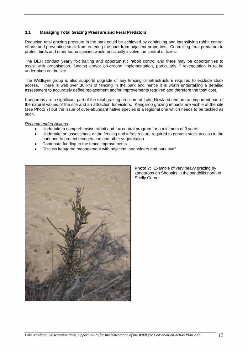
3.1 Managing Total Grazing Pressure and Feral Predators Reducing total grazing pressure in the park could be achieved by continuing and intensifying rabbit control efforts and preventing stock from entering the park from adjacent properties. Controlling feral predators to protect birds and other fauna species would principally involve the control of foxes. The DEH conduct yearly fox baiting and opportunistic rabbit control and there may be opportunities to assist with organisation, funding and/or on-ground implementation, particularly if revegetation is to be undertaken on the site. The WildEyre group is also supports upgrade of any fencing or infrastructure required to exclude stock access. There is well over 30 km of fencing in the park and hence it is worth undertaking a detailed assessment to accurately define replacement and/or improvements required and therefore the total cost. Kangaroos are a significant part of the total grazing pressure at Lake Newland and are an important part of the natural values of the site and an attraction for visitors. Kangaroo grazing impacts are visible at the site (see Photo 7) but the issue of over-abundant native species is a regional one which needs to be tackled as such. Recommended Actions
Undertake a comprehensive rabbit and fox control program for a minimum of 3 years Undertake an assessment of the fencing and infrastructure required to prevent stock access to the
park and to protect revegetation and other vegetatation Contribute funding to the fence improvements Discuss kangaroo management with adjacent landholders and park staff
Photo 7: Example of very heavy grazing by kangaroos on Sheoaks in the sandhills north of Shelly Corner.
Lake Newland Conservation Park, Opportunities for Implementation of the WildEyre Conservation Action Plan 2009 13

Map 3: Revegetation and Regeneration Areas
Lake Newland Conservation Park, Opportunities for Implementation of the WildEyre Conservation Action Plan 2009 14

3.2 Recreation Infrastructure and Signs The management plan for the park recognised that the current road and track network and park signs do not clearly outline the opportunities, rights and responsibilities of visitors to the park. There are already plans to rationalise access tracks for beach access in the north of the site and there are number of unwanted tracks through samphire areas which could be blocked off to protect wildlife and vegetation. While the majority of infrastructure and visitor management is one of the core functions of the DEH park managers, there may be opportunities to assist with funding and/or coordination to address recreation-related impacts where appropriate. In particular assistance could be provided to install signs or physical barriers to direct traffic. Recommended Actions
Work with DEH park staff to identify strategic sign locations and appropriate information Work with DEH park staff to identify tracks requiring barriers or signs to prevent access to sensitive
sites Assist with funding
3.3 Weed Control Boxthorn is one of the principal coastal and sub-coastal weeds on western Eyre Peninsula and, although still present, the park managers have done an excellent job of minimising the infestation at Lake Newland. Opportunities exist however to maintain the momentum and attempt to eradicate the weed from the park. Another weed species highlighted in the park management plan is South African Beach Daisy (Arctotheca populifolia) which is an aggressive invader of bare sand. Assistance could be provided to target this weed if park managers saw it as useful. Weed survey and mapping would be useful to help inform weed control activities and identify high threat weeds at the site. Recommended Actions
Undertake weed survey and mapping and develop an action plan for high threat weeds Target boxthorn in areas adjacent to revegetation activities Assist DEH staff with funding and/or coordination and/or contracting for weed control activities
3.4 Revegetation Revegetation was highlighted in the park management plan for 2 areas: 1) Open areas on the eastern boundary of the park prior to installing camping and visitor infrastructure; and 2) The rehabilitation of sand dune blowouts. Both were attributed a high priority. The revegetation of open areas in the east of the park is particularly relevant to the WildEyre objectives to reinstate Sheoak grassy woodlands in the region and also to help buffer sub-coastal wetlands. Approximately 220 ha is considered suitable for revegetation along the eastern boundary of the park (see Map 3) although there are small areas within this that are naturally regenerating and would not require vegetation establishment. Some areas will also become visitor facilities and camping infrastructure. The WildEyre Working Group could also investigate the possibilities of further revegetation on private land on the eastern boundary of the park to strengthen buffer areas and increase the restoration of Sheoak grassy woodland. There are 11 landholdings which abut the eastern boundary of the park (Map 4). Revegetation on private properties to the north and east of Lake Newland may also have benefits for reducing the threat of long term salinisation effects in the freshwater spring catchment V & C Semeniuk Research Group (2007) and for reducing impacts from contaminated agricultural run-off and sedimentation.
Lake Newland Conservation Park, Opportunities for Implementation of the WildEyre Conservation Action Plan 2009 15

Map 4: Adjacent Landholdings
Lake Newland Conservation Park, Opportunities for Implementation of the WildEyre Conservation Action Plan 2009 16

Rehabilitation of sand blowouts could involve local community groups (which have expressed an interest in participating) and there may be opportunities for the WildEyre group to support these activities through co-ordination, promotion and community engagement. Recommended Actions
Undertake revegetation of Sheoak and associated species in the open paddock areas in the east of the park (2-3 year implementation)
Project officer to engage adjacent landholders and discuss possibilities of undertaking revegetation Assist park staff with revegetation of sand blowouts – potential to provide funding and/or
coordination (possibly engaging local community groups which are interested) 3.5 Monitoring Monitoring of many kinds is recommended in the management plan for the park (recreation impacts, visitors, wildlife, habitats, introduced plant and animal populations). The WildEyre Working Group is interested in region-wide monitoring of flora and fauna and has already set up a number of vegetation monitoring sites in the park (Bushland Condition Monitoring or BCM sites). Wetland monitoring is also currently undertaken by the EP NRM Board and Vic Seminuk (R. Coventry pers comm.). Assistance could be sought for further studies and surveys to better understand the ecology and condition of the park. Recommended Actions
Continue yearly monitoring of existing BCM sites (and project officer time to collate and interpret results)
Continue wetland and water quality monitoring and support the collation and interpretation of results
3.6 Fire Management All restoration efforts should be mindful of fire management. The main restoration activity that may have implications for wildfire is the revegetation of the open areas in the east. The principle response is to maintain firebreaks and access along the eastern boundary of the park by not planting too close to the fence. Recommended Actions
Maintain firebreaks on the eastern boundary of the park 3.7 Indigenous Engagement and Involvement The Lake Newland Conservation Park is currently the focus of formal Native Title negotiations with the Wirangu #2 Native Title Claimant Group and hence the nature of the relationships between stakeholders is yet to be resolved. However, informal advisory relationships have been formed to inform the WildEyre group of significant cultural sites within the park and the WildEyre group acknowledges that the native title process is on-going and eagerly awaits the outcomes of this process so that further relationships can be developed.
Lake Newland Conservation Park, Opportunities for Implementation of the WildEyre Conservation Action Plan 2009 17

4 Revegetation Plan This section gives some detail regarding the potential for revegetation at the site and the appropriate methods. 4.1 Benefits of Establishing Native Vegetation at Lake Newland The main benefits of revegetation at Lake Newland are seen to be:
Consistency with the park management plan and the concept of revegetation prior to the establishment of camping areas on the eastern boundary of the park
Buffering of the sub-coastal wetlands by providing continuous fringing vegetation An increase in the extent of native vegetation and habitat The restoration of a habitat/ecosystem type which is now highly depleted in the region (Sheoak
Woodland) and which historically was more widespread at the site An increase in the capacity for Sheoak systems to regenerate naturally (by introducing a seed
source) The facilitation of natural regeneration from the soil seed bank and natural seed dispersal (creation
of suitable microclimatic conditions) Potentially assist species which prefer Sheoak habitats to move through the landscape
4.2 Revegetation Method It is important to define the goals of the restoration/revegetation in order to select the appropriate methodology. An appropriate aim for revegetation in the open limestone areas is to establish a planting which has the following characteristics.
spatially heterogenous (uneven spacings, clumping and open areas) structural diversity (trees, large and small shrubs and various plant life forms where possible) a moderate level of species diversity (to begin with and only limited by feasibility) an ability to self sustain into the future (through seed production and natural regeneration).
Surface and sheet limestone presents a challenge for revegetation, particularly for direct seeding machinery. However, machine direct seeding is still the most cost effective and suitable methodology for undertaking revegetation on this scale. Using a direct seeding methodology in the pockets of suitable soil may also help with maintaining the open character of the vegetation and creating a natural appearance (both by the patchiness and the lack of uniform rows). The main hindrance that the limestone presents is in slowing the speed of establishment and increasing the likelihood of mechanical breakdowns and damage to equipment. Natural regeneration could be expected to occur in rockier areas, particularly when seed begins to be produced in the revegetation. Local experience estimates that an upper limit of 300 grams of seed per km (8-15 species) and 1.5km per hectare is a realistic goal which will allow for some losses to grazing pressure and result in a vegetation of open character. This is a relatively low figure which takes into account the presence of rocky ground unsuitable for machinery. 4.3 Seed Requirements and Collection Using the methodology above would result in a total seed requirement of around 100 kg to complete the project. It makes sense that this could be achieved over a number of years in order to reduce the impacts on local seed stocks and to allow for adaptive management. If the revegetation project was spread over 3 years there would be a yearly requirement of around 33 kg of seed to undertake around 73 ha of direct seeding in each year. This would be easily achievable and could be shortened to a 2 year implementation if desired (50 kg seed, 110 ha per year).
Lake Newland Conservation Park, Opportunities for Implementation of the WildEyre Conservation Action Plan 2009 18

Table 2: Key Structural and Floristic Species for Sheoak Restoration Species Name Common Name Approximate % of Seed Mix Trees/Overstorey
Allocasuarina verticillata Drooping Sheoak 20% Melaleuca lanceolata Dryland Tea-tree 10% Pittosporum angustifolia Native Apricot <5% Callitris gracilis Southern Cypress-pine 10% Tall Shrubs
Acacia brachybotrya Silver Mulga Bush 10% Acacia cupularis Coast Umbrella Bush 10% Acacia triquetra Mallee Wreath Wattle 10% Exocarpus aphyllus Leafless Cherry <5% Alyogyne huegelii Native Hibiscus <5% Myoporum insulare Common Boobialla <5% Small Shrubs
Dodonaea baueri Crinkled Hop-bush <5% Rhagodia crassifolia Sea Berry Saltbush 10% Eutaxia microphylla Common Eutaxia <5% Other Lifeforms
Dianella revoluta ssp. revoluta Black-anther Flax-lily <5% Note that these lists may be added to or modified according to local conditions, seasonal seed availability, opportune seed collection (additional species) and additional species encountered in the paddock. 4.4 Adapting to a Drying Climate Elliston receives a mean annual rainfall of around 427 mm which is probably in the middle of the natural rainfall range of Sheoak and well within the natural range for associated species such as Native Pine, thus Sheoaks could be expected to persist in the landscape under a slight drying effect. However, seed collectors should still be mindful of the rainfall zones in which key structural species are collected and where possible should look to collect from similar or lower rainfall areas (eg. to the west of Lake Newland around Bramfield and into the Polda Basin). 4.5 Snail and Red-legged Earthmite Control Snails and Red-legged Earth Mite can both damage and kill young seedlings as they emerge. Control can be assessed on a site by site basis and there are a number of relatively cheap pellets and sprays for these pests. Snail pelleting over 200 ha or more is not commonly undertaken and the need and feasibility of undertaking control at Lake Newland should be investigated further. 4.6 Site Preparation/Weed Control In this type of country it is recommended that site preparation (herbicide weed control) occur immediately AFTER direct seeding. This achieves a number of objectives:
Avoids unnecessarily spraying areas which are unsuitable for seeding Easy to follow the area requiring spraying Weed die-off is timed to occur immediately prior to germination which prolongs the period in which
weed competition is absent The minimum width of the boom spray used for herbicide control should be around 60cm (20-30cm either side of the seeding furrow) and no more than 1.5m in total width (grass cover should be maintained between seeding lines to avoid broadleaf weeds proliferating and to avoid bare ground exposed to wind). There may also be a need for slashing annual grasses if the season is good and the grasses grow tall. Slashing may be undertaken on a needs basis.
Lake Newland Conservation Park, Opportunities for Implementation of the WildEyre Conservation Action Plan 2009 19

Lake Newland Conservation Park, Opportunities for Implementation of the WildEyre Conservation Action Plan 2009 20
4.7 Targeted Weed Control Undertaking revegetation does disturb the soil and can allow new weeds to become established. Targeted weed control is therefore recommended in all newly established revegetation areas. This may involve targeted boom or handline spraying as necessary. Table 3: A Typical Revegetation Calendar Activity J F M A M J J A S O N D Seed Collection (prior to Year 1 of revegetation)
Year 1
Seed Collection Rabbit Control Fox Control Site Visit (assess soil moisture and weed management requirements)
Direct seeding Stage 1 (timing dependant on soil moisture and site access)
Site Preparation/Weed Control (immediately following direct seeding)
Site Visit (assess germination, grazing impacts and weed impacts)
Undertake any necessary actions identified in Site Visit (eg. extra weed control)
Fox Control (additional if deemed necessary)
Seed Collection 4.8 Monitoring and Adaptive Management The multi-year implementation of this project allows on-going monitoring and adaptive management to be applied. Specific parameters related to the revegetation are summarised in the Table below. The most important step in this type of monitoring is to define the project goals and to be clear about what the desired result is (see Section 4.2). Table 4: Specific Measurables Relating to Revegetation Parameter Response Grazing impacts from wombats and kangaroos Asses the need for animal deterrents or control Vegetation structure (emerging) – ie. the balance of species resulting from the seed mix used
Adjust seed mix (ie. too many overstorey then lower percentage of overstorey species in the mix)
Spacings and establishment success resulting from the seeding rate (ie. 300g/km too high or too low)
Adjust the seeding rate
Weed infestations (new weeds, spreading of existing weeds) and requirements for additional control
Develop a weed control plan and implement.

6 IMPLEMENTATION AND INDICATIVE COSTS 6.1 Implementation Plan The following implementation plan is a suggestion for implementing parts of the WildEyre CAP plan at Lake Newland and is based on a logical series of events over 2 years. Timings may be changed to accommodate the plans of the park managers, variability in seed availability and other variables such as stakeholder consultation and sign production times. Table 5: A Basic Implementation Plan Activity
Timing
Seed Collection (prior to Year 1 of revegetation)
Oct - Dec
Year 1 Identify signs and infrastructure needs (barriers etc), consult with relevant stakeholders and develop designs etc
Jan - July
Rabbit Control
Jan – Feb
Fencing (replace and/or upgrade eastern boundary fence
Jan - April
Fox Control
March - April
Site Visit (assess soil moisture and weed management requirements prior to initial revegetation)
May
Revegetation activities (direct seeding, site preparation)
June - July
Undertake weed survey and mapping (produce action plan)
July - Sept
Finalise and produce signs and infrastructure needs
Aug - Sept
Monitoring (revisit established BCM sites)
Sept
Fox Control
Sept - Oct
Install appropriate infrastructure and signs
Oct - Dec
Seed Collection
Oct - Dec
Year 2 Rabbit Control
Jan – Feb
Fox Control
March - April
Site Visit (assess soil moisture and weed management requirements prior to initial revegetation)
May
Revegetation activities (direct seeding, site preparation)
June - July
Monitoring (revisit established BCM sites)
Sept
Fox Control
Sept - Oct
Lake Newland Conservation Park, Opportunities for Implementation of the WildEyre Conservation Action Plan 2009 21

6.2 Indicative Costings Feral Animal Control A full rabbit and fox control program would involve a baiting program in late summer for rabbits and autumn and spring baiting for foxes. Indicative figures for similar projects in the region, as suggested by the EP NRM Board (Rob Coventry pers. com.) amount to $1200 per year for rabbit control and $3000 for fox baiting. Hence the total annual costs would be around $4,200 for fox and rabbit control. Fencing and Infrastructure A fence inspection to accurately cost the fencing requirements is estimated to take around 1.5 days of project officer time or $1,200. Fencing upgrades are at the discretion of the DEH managers so costs have not been calculated at this stage. Costs for signs are very difficult to estimate due to the number of variables (number of signs, locations, time taken to agree on content, materials, consultant and manufacture cost etc). Hence it is recommended that this activity be treated as a separate project and costed separately. Site Preparation/Weed Control A knockdown spray using a glyphosate-based herbicide and a wetting agent or penetrant is estimated to cost between $30 and $40 per hectare for an average small job. In order to cover variations in costs between contractors and to cover any unforseen costs a figure of $50 per ha is considered reasonable for undertaking site preparation herbicide control. Seed Collection Seed collection is figured into the direct seeding cost (seed supply) as it simplifies costing and allows flexibility in the time taken to complete the quoted kilometres of seeding (see direct seeding costs below). Direct Seeding From local experience a commercial rate of $300 per km would be applicable. Working on an average of 1.5km per hectare, this results in a seeding cost of $450 per hectare for a very basic method of establishment. Targeted Weed Control Weed control to specifically target weeds within the direct seeding areas may be based on 2 days/visits per year at $500 per year ($1,000) per year. Assistance with Boxthorn control is difficult to cost without a survey to identify the extent. However a nominal allocation of 2 contractor days per year may assist DEH staff in staying on top of the issue ($1000 per year). Weed Survey and Mapping Weed survey and mapping would require comprehensive coverage of the site during fieldwork in order to identify and mark GPS locations for significant weed infestation, and office time to produce the map and report. Using a standard consultant rate the cost for the survey and mapping are estimated at around $5,000 based on 2 days fieldwork and 3 days mapping and reporting. Site Visits Site visits and monitoring time is often overlooked in revegetation planning even though it is a very important component and informs much of the implementation. A project officer or technical consultant costs around $800 per day and this is applied in Table 6.
Lake Newland Conservation Park, Opportunities for Implementation of the WildEyre Conservation Action Plan 2009 22

Consultation with Adjacent Landholders Consulting with and undertaking site visits to discuss revegetation and run-off issues is estimated to take around 3 days of project officer time or approximately $2,400. Total Costs Table 6 below contains estimated costs for undertaking the range of proposed activities. The costs are indicative only and will be subject to change as more accurate costings are undertaken. Table 6: Indicative Costs for Restoration Activity Timing Cost/ha or
cost/year Total Cost (over 2 yrs)
Feral Animal Control 1) Rabbit control: Four visits in summer, 3 free feeds, 1 poison feed @ $300 per visit)
2) Fox control: Autumn and spring, approx $3000 (1 bait run every two weeks for three month period, for two periods per year, based on $250 per day including fuel and wage)
$4,200 /yr $12,600*
Fencing/boundary inspection
As soon as practicable and prior to the commencement of revegetation
$1,200 (one off cost for inspection)
$1,200
Fencing Prior to the commencement of revegetation
~ ~
Signs and barriers
A soon as practicable ~ ~
Site Visits - Revegetation (2 days per year)
May/June and September $1,600 /yr $3,200
Direct Seeding
Late May through to mid-July $450 /ha $99,000
Site Preparation Immediately following direct seeding
$50 /ha $11,000
Weed Survey Mid-winter to spring $5,000 (one off cost)
$5,000
Targeted Weed Control
Mid-winter to spring $2,000 /yr $6,000*
Consultation with adjacent landholders
Anytime $2,400 $2,400
Totals ~ $140,400
* Feral animal control and weed control should extend at least to the year following revegetation
Lake Newland Conservation Park, Opportunities for Implementation of the WildEyre Conservation Action Plan 2009 23

Lake Newland Conservation Park, Opportunities for Implementation of the WildEyre Conservation Action Plan 2009 24
References Department for Environment and Heritage 2003, Lake Newland Conservation Park Management Plan, Adelaide, South Australia V & C Semeniuk Research Group 2007, Lake Newland Baseline Survey and Literature Review, Eyre Peninsula, Report to the Eyre Peninsula Catchment Water Management Board, Western Australia