Embed Size (px)
Citation preview

Lake Narracan
March 2015
Development Contributions Plan
2 LAKE NARRACAN DEVELOPMENT CONTRIBUTIONS PLAN
1.0 INTRODUCTION 41.1 Report Structure 51.2 Strategic Basis 51.3 Planning & Environment Act 1987 51.4 Strategic Planning for Lake Narracan 71.5 Lake Narracan Precinct Structure Plan 71.6 The area to which the Development
Contributions Plan applies 71.7 Related Infrastructure Agreements 71.8 Project & Property Identification 8
2.0 INFRASTRUCTURE PROJECT JUSTIFICATION 82.1 Items not included in the Development Contributions Plan 92.2 Infrastructure projects 9
2.2.1 Transport Projects 9 2.2.2 Recreation Projects 16 2.2.3 Community Facility Projects 16 2.2.4 Drainage Projects 19
2.3 Project Timing 222.4 Distinction between Development and
Community Infrastructure 22
3.0 CALCULATIONS OF CONTRIBUTIONS 233.1 Calculation of Net Developable Area and Demand Units 23
3.1.1 Net Developable Area 23 3.1.2 Land Budget and Demand Units 24
3.2 Calculation of Contribution Charges 24 3.2.1 Calculation of Costs 24 3.2.2 Road Construction and Intersection Works 24 3.2.3 Culvert works 25 3.2.4 Recreation works 25 3.2.5 Community Centre Projects 25 3.2.6 Temporary works 25 3.2.7 Valuation of Land 25
3.3 Cost Apportionment 25 3.3.1 Charge Areas 25 3.3.2 Non-Government Schools 25 3.3.3 Schedule of Costs 25 3.3.4 Summary of Charges per Hectare 25
CONTENTS

3LAKE NARRACAN DEVELOPMENT CONTRIBUTIONS PLAN
4.0 ADMINISTRATION 294.1 Collecting Agency (Agency Responsible
for Collecting Infrastructure Levy) 294.2 Development Agency (Agency
Responsible for Works) 294.3 Payment of Contribution Levies and Payment Timing 29
4.3.1 Development Infrastructure 29 4.3.2 Community Infrastructure Levy 30 4.3.3 Works in Kind 30 4.3.4 Credit for Over Provision 30 4.3.5 Non Government Schools 31
4.4 Funds Administration 314.5 Construction and Land Value Costs Indexation 314.6 Development Contributions Plan Review Period 314.7 Adjustment to Infrastructure Scope 32
5.0 OTHER INFORMATION 325.1 Acronyms 325.2 Glossary 32
TABLES Table 1 Summary of Charges 4Table 2 Intersection Projects 11Table 3 Road Projects 13Table 4 Culvert Projects 15Table 5 Recreation Projects 18Table 6 Community Facility Projects 19Table 7 Drainage Projects 21Table 8 Community Infrastructure Levy Projects 22Table 9 Summary Land Use Budget 23Table 10a Calculation of Costs
– Development Infrastructure Levy (DIL) 26Table 10b Calculation of Costs
– Community Infrastructure Levy (CIL) 28 PLANS Plan 1 Future Urban Structure 6Plan 2 Intersection Projects 10Plan 3 Road Projects 12Plan 4 Culvert Projects 14Plan 5 Recreation & Community Facility Projects 17Plan 6 Drainage Projects 20
4 LAKE NARRACAN DEVELOPMENT CONTRIBUTIONS PLAN
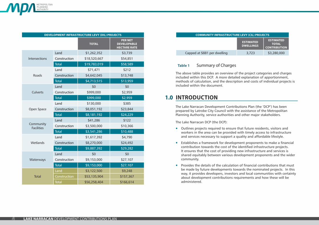
The above table provides an overview of the project categories and charges included within this DCP. A more detailed explanation of apportionment, methods of calculation, and the description and costs of individual projects is included within the document.
Table 1 Summary of Charges
1.0 INTRODUCTIONThe Lake Narracan Development Contributions Plan (the ‘DCP’) has been prepared by Latrobe City Council with the assistance of the Metropolitan Planning Authority, service authorities and other major stakeholders.
The Lake Narracan DCP (the DCP):
• Outlines projects required to ensure that future residents, visitors and workers in the area can be provided with timely access to infrastructure and services necessary to support a quality and affordable lifestyle.
• Establishes a framework for development proponents to make a financial contribution towards the cost of the identified infrastructure projects. It ensures that the cost of providing new infrastructure and services is shared equitably between various development proponents and the wider community.
• Provides the details of the calculation of financial contributions that must be made by future developments towards the nominated projects. In this way, it provides developers, investors and local communities with certainty about development contributions requirements and how these will be administered.
DEVELOPMENT INFRASTRUCTURE LEVY (DIL) PROJECTS
TOTALPER NET
DEVELOPABLE HECTARE RATE
Intersections
Land $1,262,352 $3,739
Construction $18,520,667 $54,851
Total $19,783,019 $58,589
Roads
Land $71,471 $212
Construction $4,642,045 $13,748
Total $4,713,515 $13,959
Culverts
Land $0 $0
Construction $999,000 $2,959
Total $999,000 $2,959
Open Space
Land $130,000 $385
Construction $8,051,192 $23,844
Total $8,181,192 $24,229
Community Facilities
Land $41,286 $122
Construction $3,500,000 $10,366
Total $3,541,286 $10,488
Wetlands
Land $1,617,392 $4,790
Construction $8,270,000 $24,492
Total $9,887,392 $29,282
Waterways
Land $0 $0
Construction $9,153,000 $27,107
Total $9,153,000 $27,107
Total
Land $3,122,500 $9,248
Construction $53,135,904 $157,367
Total $56,258,404 $166,614
COMMUNITY INFRASTRUCTURE LEVY (CIL) PROJECTS
ESTIMATED DWELLINGS
ESTIMATED TOTAL
CONTRIBUTION
Capped at $881 per dwelling 3,723 $3,280,000

5LAKE NARRACAN DEVELOPMENT CONTRIBUTIONS PLAN
1.1 Report structureThis document comprises five parts:
1.2 Strategic basisThe strategic basis for the DCP is established by the State and Local Planning Policy Framework of the Latrobe Planning Scheme. The key documents are the:
• Municipal Strategic Statement
• Gippsland Regional Growth Plan (2014)
• Plan Melbourne: Metropolitan Planning Strategy (2014)
• Moe and Newborough Structure Plan (updated 2015)
• Lake Narracan Precinct Structure Plan
• Relevant Precinct Structure Plan supporting documents.
These documents set out a broad, long term vision for the sustainable development of the DCP area and its surrounds.
The Moe and Newborough Structure Plan (updated 2015) illustrates the planned extent of residential, employment and other development associated with the townships of Moe and Newborough.
1.3 Planning & Environment Act 1987The DCP has been prepared in accordance with Part 3B of the Planning and Environment Act 1987 (the Act) as well as other relevant legislation and has been developed in line with the State and Local Planning Policy Framework of the Latrobe Planning Scheme. It is consistent with the Minister for Planning’s Direction on Development Contributions made under section 46M(1) of the Act and has had regards to the Victorian Government’s Development Contributions Guidelines (the ‘DCP Guidelines’).
The DCP provides for the charging of a Development Infrastructure Levy pursuant to section 46J(a) of the Act towards works, services and facilities. It also provides for the charging of a Community Infrastructure Levy pursuant to section 46J(b) of the Act as some items are classified as community infrastructure by reference to the Act, the Minister’s Direction on Development Contributions and the DCP guidelines.
The DCP forms part of the Latrobe Planning Scheme pursuant to section 46I of the Act and is an incorporated document under Clause 81 of the Latrobe Planning Scheme.
The DCP is implemented in the Latrobe Planning Scheme through Schedule 1 to the Development Contributions Plan Overlay which applies to the ‘DCP area’ shown in Plan 1.
PART 1 - Strategic Basis
Part 1 clearly explains the strategic basis for the Development Contributions Plan
PART 4 - Administration
Part 4 focuses on administration of the Development Contributions Plan
PART 5 - Other Information
Part 5 provides other supporting information
PART 2 - Justification
Part 2 sests out the justification for the various infrastructure projects included in the Development Contributions Plan.
PART 3 - Calculation of Contributions
Part 3 sets out how the development contributions are calculated and costs apportioned.

6 LAKE NARRACAN DEVELOPMENT CONTRIBUTIONS PLAN
Nar r
acan
Cre
ek
Moe Drain
Sandy C
reek
Tanjil River
BECKS BRID
GE ROAD
MO
OR
E ST
REE
T
HAIGH STREET
SULL
IVA
NS
TRA
CK
THOMPSONS ROAD
HA
YES
RO
AD
JOHN FIELD DRIVE
OLD SALE ROAD
OLD
SALE
ROAD
La Trobe River
Becks Bay
FernleaChannel
TurrasReach
LAKE NARRACAN
ThompsonsBay
HallsBay La Trobe R
iver
WASTE WATER TREATMENT FACILITY
YALLOURNPOWER STATION
NARRACAN DRIVE
SOUTH
SHORE
CENTREWAY
ROAD
WAY
BROAD
MAC
PHER
SON
ROA
D
MOENEWBOROUGH
4
1
2 3 5
32 3327
10
1112
13
14
1516
17
18
19
2021
22
23 24 25 26
28
29 30
31
48
49 50 51 52
5354
55
56 57 5859R1 60 61 62
63 64
34
35
36
3738 39
4041
6
7
8 9
42 43 44 45
46
4767
75
66
65
68
69
75
70
71
73
72
7677
79
78
80
81
82
83
84
85
74
42
linear open space (encumbered)drainage open space (encumbered)existing native vegetation reserve (encumbered)existing open spaceexisting naval cadetswaterwaysexisting vegetation to be retainededge of existing terracearterial road feature boulevardconnector streetlocal access street level 2existing urbanfuture urbanpropery boundary & number
DCP areavillage centreresidentialgovernment primary schoolcommunity facilitiesexisting golf course (future residential)holiday parklocal sporting reserveslocal parks (unencumbered)foreshore open space
1:25,000 @A4 NTS @A3 0 200 400 600 800 1,000
Lake Narracan Development Contribution PlanPlan 1 Future Urban Structure
V150213
Futureresidential
investigation area
7LAKE NARRACAN DEVELOPMENT CONTRIBUTIONS PLAN
1.4 Strategic planning for Lake NarracanThe Lake Narracan area includes around 604 hectares of land which will be zoned to Urban Growth Zone at the time of the approval of this DCP.
The need for the infrastructure included within the DCP has been determined according to the anticipated development of the Lake Narracan area. The DCP has been prepared in conjunction with the Lake Narracan Precinct Structure Plan as it provides the rationale and justification for infrastructure items that have been included. Accordingly, the DCP is an implementation based planning tool which identifies the infrastructure items required by the new community and apportions the cost of this infrastructure in an equitable manner across the plan area.
The Lake Narracan Background Report provides an overview of the planning process.
1.5 Lake Narracan Precinct Structure PlanThe Lake Narracan Precinct Structure Plan (the PSP) set out the vision for how land should be developed, illustrates the future urban structure and describe the objectives to be achieved by the future development. It also outlines projects required to ensure that future residents, visitors and workers within the area are provided with timely access to services and transport infrastructure necessary to support a quality affordable lifestyle.
The PSP enables urban development and the future urban structure of the new community is depicted through a number of networks, including transport, open space and sporting reserves, social infrastructure, village centres, housing and places for local employment.
The Lake Narracan PSP will ultimately accommodate approximately 8,935 people and 3,723 dwellings.
1.6 The area to which the Development Contributions Plan appliesIn accordance with section 46K(1)(a) of the Planning and Environment Act 1987 the DCP applies to land shown in Plan 1. The area is also shown on Development Contributions Plan Overlay Schedule 1 in the Latrobe Planning Scheme.
The DCP applies to approximately 338 Net Developable Hectares of land and is covered by one charge area (residential).
The DCP clearly demonstrates the infrastructure required to service the Lake Narracan area. The charge area also defines the Main Catchment Area (‘MCA’) for the various infrastructure projects. The MCA is the geographic area from which a given item of infrastructure will draw most of its use.
In selecting items, consideration has been given to ensure they are not already wholly funded through another contribution mechanism, such as a mandatory infrastructure construction requirement of the Lake Narracan PSP, an existing local development contributions plan, an agreement under Section 173 of the Act or as a condition on an existing planning permit. Identified overlap in funding has been addressed, for example by adjusting other relevant development contributions plans or other suitable means provided for in the Planning and Environment Act.
1.7 Related infrastructure agreementsThere are no existing infrastructure agreements that relate to the Lake Narracan DCP area.

8 LAKE NARRACAN DEVELOPMENT CONTRIBUTIONS PLAN
1.8 Project & property identification
1.8.1 Project identification
The project identification system used in the DCP has been designed to assist in understanding of and navigation through the document. Road, culvert, intersection, and community facility projects use the identification system of project category and a sequential project number. As an example, a road project will have the project identifier similar to RD-01.
The project categories are summarised as:
• IN – Intersections
• RD – Roads
• CV – Culverts
• OS – Open space
• CF – Community facilities
• WL – Stormwater quality treatment wetlands
• CW – Constructed waterways
1.8.2 Property identification
Each of the properties across the Lake Narracan area has been given a unique property identification number that reflects the property numbers included in the PSP, and is shown in Plan 1.
2.0 INFRASTRUCTURE PROJECT JUSTIFICATIONThe need for infrastructure included in the DCP has been determined according to the anticipated development of the Lake Narracan area.
Items can be included in a development contributions plan if they will be used by the future community of an area. New development does not have to trigger the need for new items in its own right. The development is charged in line with its projected share of use. An item can be included in a development contributions plan regardless of whether it is within or outside the DCP area.
Before inclusion in the DCP, all items have been assessed to ensure they have a relationship or nexus to proposed development in the DCP area. The cost apportionment methodology adopted in the DCP relies on the nexus principle. A new development is deemed to have a nexus with an item if its future residents or employees are expected to make use of that item.
A summary of how each item is related to proposed development within the DCP area is set out below and individual item apportionments are identified in Table 10a and 10b.
The items that have been included in the DCP all have the following characteristics:
• They are essential to the health, safety and well being of the community.
• They will be used by a broad cross-section of the community.
• They reflect the vision and objectives expressed in the Lake Narracan PSP.
• They are not recurrent items.
• They are the basis for the future development of an integrated network.

9LAKE NARRACAN DEVELOPMENT CONTRIBUTIONS PLAN
2.1 Items not included in the Development Contributions PlanThe following items are not included in the DCP, as they are considered to be normal to the construction of a development and are not considered to warrant cost sharing arrangements beyond those set out in this DCP. These items must be provided by developers as a matter of course and in implementing the PSPs:
• Internal streets (including connector streets) including creek and drainage line crossings and associated traffic management measures (except where nominated in this DCP).
• Waterway management works and drainage systems (except where nominated in this DCP).
• Intersections connecting the development to the existing road network (except where nominated in this DCP).
• Water, sewerage, underground power, gas and telecommunications services.
• Local pathways and connections to the regional and / or district pathway network.
• Basic levelling and water tapping of local parks.
• Preparation of local park master plans and any associated works required by the PSP.
• Council’s plan checking and supervision.
• Bus stops.
These items may be further addressed and defined by an agreement under s173 of the Act and / or conditions in planning permits.
Construction of the following items has not been included within the DCP as they are determined to be State Infrastructure items:
• Government primary schools.
The delivery of the State Infrastructure items will be provided as warranted and as funds become available.
2.2 Infrastructure projectsThe following four types of projects are included in the DCP:
• Transport
• Recreation
• Community
• Drainage
2.2.1 Transport projects
The transport related projects in the DCP are based on the transport network depicted in Plan 1 which is supported by the Lake Narracan PSP. The transport projects include a combination of:
• Construction of controlled intersections and associated works
• Road construction
• Construction of waterway crossings
Land required for widening and realignment of arterial roads and associated intersections have been included in the DCP. Construction of arterial roads and intersections has also been included in the DCP.
Land and construction of connector roads that pass through smaller properties have also been included in the DCP. This affects properties 23, 36, 38 and 48.
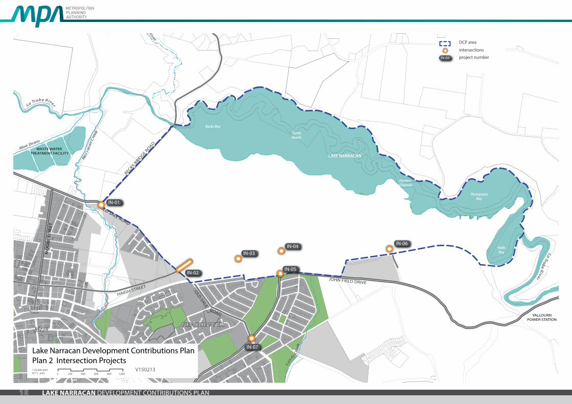
The intersection projects funded by the DCP are shown in Plan 2 and described in Table 2.
The road projects funded by the DCP are shown in Plan 3 and described in Table 3.
The culvert projects funded by the DCP are shown in Plan 4 and described in Table 4.
10 LAKE NARRACAN DEVELOPMENT CONTRIBUTIONS PLAN
Nar r
acan
Cre
ek
Moe Drain
Sandy C
reek
Tanjil River
BECKS BRID
GE ROAD
MO
OR
E ST
REE
T
HAIGH STREET
SULL
IVA
NS
TRA
CK
THOMPSONS ROAD
HA
YES
RO
AD
JOHN FIELD DRIVE
OLD SALE ROAD
OLD
SALE
ROAD
La Trobe River
Becks Bay
FernleaChannel
TurrasReach
LAKE NARRACAN
ThompsonsBay
HallsBay La Trobe R
iver
WASTE WATER TREATMENT FACILITY
YALLOURNPOWER STATION
NARRACAN DRIVE
SOUTH
SHORE
CENTREWAY
ROAD
WAY
BROAD
MAC
PHER
SON
ROA
D
MOENEWBOROUGH
IN-06
IN-07
IN-01
IN-03IN-04
IN-05IN-02
IN-04
DCP area
intersections
project number
Lake Narracan Development Contributions PlanPlan 2 Intersection Projects1:25,000 @A4 N T S @A3 0 200 400 600 800 1,000
V150213
11LAKE NARRACAN DEVELOPMENT CONTRIBUTIONS PLAN
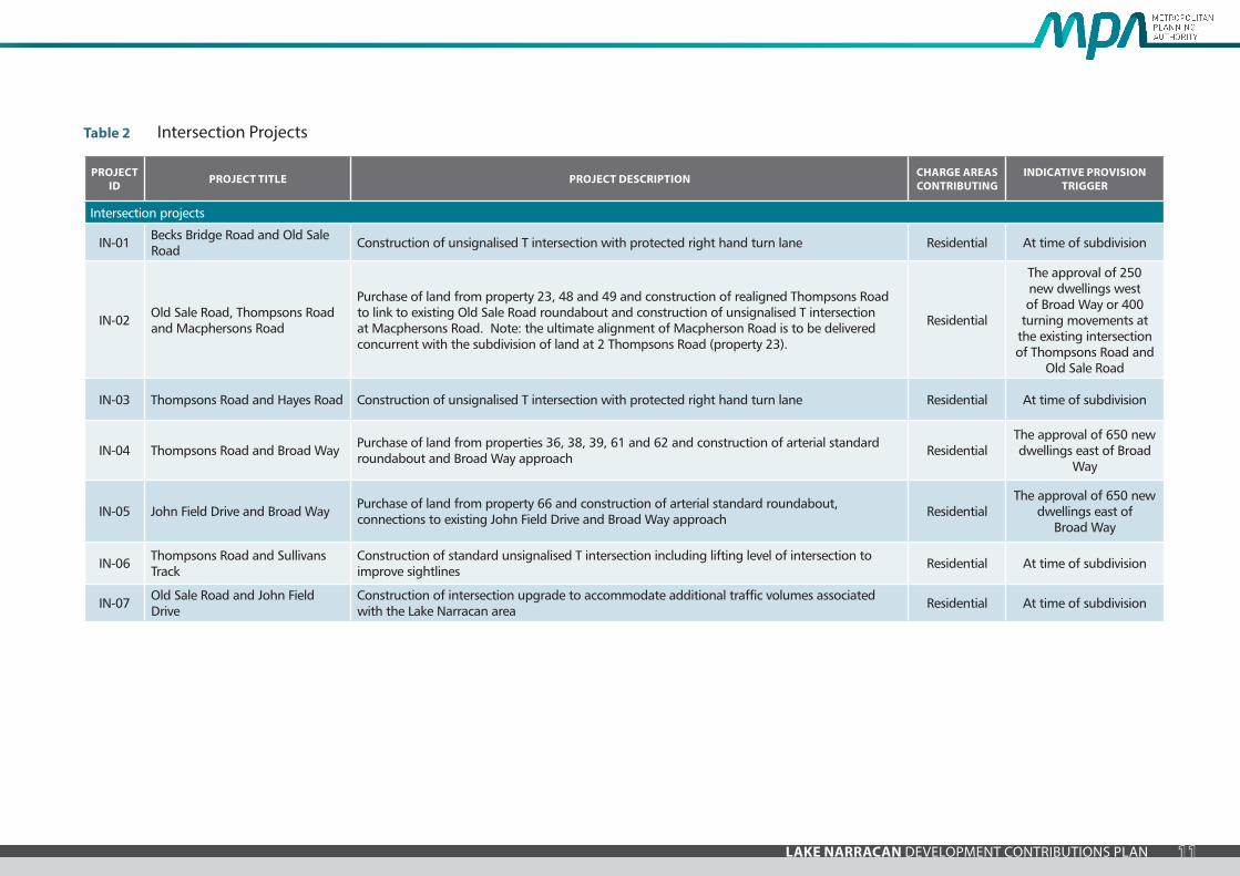
PROJECT ID PROJECT TITLE PROJECT DESCRIPTION CHARGE AREAS
CONTRIBUTINGINDICATIVE PROVISION
TRIGGER
Intersection projects
IN-01 Becks Bridge Road and Old Sale Road Construction of unsignalised T intersection with protected right hand turn lane Residential At time of subdivision
IN-02 Old Sale Road, Thompsons Road and Macphersons Road
Purchase of land from property 23, 48 and 49 and construction of realigned Thompsons Road to link to existing Old Sale Road roundabout and construction of unsignalised T intersection at Macphersons Road. Note: the ultimate alignment of Macpherson Road is to be delivered concurrent with the subdivision of land at 2 Thompsons Road (property 23).
Residential
The approval of 250 new dwellings west of Broad Way or 400
turning movements at the existing intersection of Thompsons Road and
Old Sale Road
IN-03 Thompsons Road and Hayes Road Construction of unsignalised T intersection with protected right hand turn lane Residential At time of subdivision
IN-04 Thompsons Road and Broad Way Purchase of land from properties 36, 38, 39, 61 and 62 and construction of arterial standard roundabout and Broad Way approach Residential
The approval of 650 new dwellings east of Broad
Way
IN-05 John Field Drive and Broad Way Purchase of land from property 66 and construction of arterial standard roundabout, connections to existing John Field Drive and Broad Way approach Residential
The approval of 650 new dwellings east of
Broad Way
IN-06 Thompsons Road and Sullivans Track
Construction of standard unsignalised T intersection including lifting level of intersection to improve sightlines Residential At time of subdivision
IN-07 Old Sale Road and John Field Drive
Construction of intersection upgrade to accommodate additional traffic volumes associated with the Lake Narracan area Residential At time of subdivision
Table 2 Intersection Projects

12 LAKE NARRACAN DEVELOPMENT CONTRIBUTIONS PLAN
Nar r
acan
Cre
ek
Moe Drain
Sandy C
reek
Tanjil River
BECKS BRID
GE ROAD
MO
OR
E ST
REE
T
HAIGH STREET
SULL
IVA
NS
TRA
CK
THOMPSONS ROAD
HA
YES
RO
AD
JOHN FIELD DRIVE
OLD SALE ROAD
OLD
SALE
ROAD
La Trobe River
Becks Bay
FernleaChannel
TurrasReach
LAKE NARRACAN
ThompsonsBay
HallsBay La Trobe R
iver
WASTE WATER TREATMENT FACILITY
YALLOURNPOWER STATION
NARRACAN DRIVE
SOUTH
SHORE
CENTREWAY
ROAD
WAY
BROAD
MAC
PHER
SON
ROA
D
MOENEWBOROUGH
RD-04
RD-02RD-01 RD-03
RD-07
DCP area
road projects
project number
Lake Narracan Development Contributions PlanPlan 3 Road Projects1:25,000 @A4 N T S @A3 0 200 400 600 800 1,000
V150213

13LAKE NARRACAN DEVELOPMENT CONTRIBUTIONS PLAN
PROJECT ID PROJECT TITLE PROJECT DESCRIPTION CHARGE AREAS CONTRIBUTING
INDICATIVE PROVISION TRIGGER
Road projects
RD-01 Thompons Road (Macpherson Road to Hayes Road)
Purchase of land adjacent from property 29 and 31 for widening of Thompsons Road and construction of 24.0m wide 2 lane arterial boulevard (as per Cross Section 3 of the Lake Narracan PSP)
Residential At time of subdivision
RD-02 Thompons Road (Hayes Road to Broad Way)Purchase of land from property 32, 33 and 37 for widening of Thompsons Road and construction of 24.0m wide 2 lane arterial boulevard (as per Cross Section 3 of the Lake Narracan PSP)
Residential At time of subdivision
RD-03 Thompons Road (Broad Way to Sullivans Track) Construction of 21.5m wide 2 lane connector road (as per Cross Section 6 of the Lake Narracan PSP) Residential At time of subdivision
RD-04 South Shore Road (Broad Way to Golf Club eastern boundary) Construction of 2 lane connector road (as per Cross Section 9 of the Lake Narracan PSP) Residential At time of subdivision
Table 3 Road Projects

14 LAKE NARRACAN DEVELOPMENT CONTRIBUTIONS PLAN
Nar r
acan
Cre
ek
Moe Drain
Sandy C
reek
Tanjil River
BECKS BRID
GE ROAD
MO
OR
E ST
REE
T
HAIGH STREET
SULL
IVA
NS
TRA
CK
THOMPSONS ROAD
HA
YES
RO
AD
JOHN FIELD DRIVE
OLD SALE ROAD
OLD
SALE
ROAD
La Trobe River
Becks Bay
FernleaChannel
TurrasReach
LAKE NARRACAN
ThompsonsBay
HallsBay La Trobe R
iver
WASTE WATER TREATMENT FACILITY
YALLOURNPOWER STATION
NARRACAN DRIVE
SOUTH
SHORE
CENTREWAY
ROAD
WAY
BROAD
MAC
PHER
SON
ROA
D
MOENEWBOROUGH
CV-01 CV-02CV-03 CV-04
CV-07
DCP area
bridge / culvert projects
project number
Lake Narracan Development Contributions PlanPlan 4 Culvert Projects1:25,000 @A4 N T S @A3 0 200 400 600 800 1,000
Nar r
acan
Cre
ek
Moe Drain
Sandy C
reek
Tanjil River
BECKS BRID
GE ROAD
MO
OR
E ST
REE
T
HAIGH STREET
SULL
IVA
NS
TRA
CK
THOMPSONS ROAD
HA
YES
RO
AD
JOHN FIELD DRIVE
OLD SALE ROAD
OLD
SALE
ROAD
La Trobe RiverBecks Bay
FernleaChannel
TurrasReach
LAKE NARRACAN
ThompsonsBay
HallsBay La Trobe R
iver
WASTE WATER TREATMENT FACILITY
YALLOURNPOWER STATION
NARRACAN DRIVE
SOUTH
SHORE
CENTREWAY
ROAD
WAY
BROAD
MAC
PHER
SON
ROA
D
MOENEWBOROUGH
RD-04
RD-02RD-01 RD-03
RD-07
DCP area
road projects
project number
Lake Narracan Development Contributions PlanPlan 3 Road Projects1:25,000 @A4 N T S @A3 0 200 400 600 800 1,000
V150213
Nar r
acan
Cre
ek
Moe Drain
Sandy C
reek
Tanjil River
BECKS BRID
GE ROAD
MO
OR
E ST
REE
T
HAIGH STREET
SULL
IVA
NS
TRA
CK
THOMPSONS ROAD
HA
YES
RO
AD
JOHN FIELD DRIVE
OLD SALE ROAD
OLD
SALE
ROAD
La Trobe RiverBecks Bay
FernleaChannel
TurrasReach
LAKE NARRACAN
ThompsonsBay
HallsBay La Trobe R
iver
WASTE WATER TREATMENT FACILITY
YALLOURNPOWER STATION
NARRACAN DRIVE
SOUTH
SHORE
CENTREWAY
ROAD
WAY
BROAD
MAC
PHER
SON
ROA
D
MOENEWBOROUGH
CF-01
CF-02OS-01
OS-02
OS-03
OS-03
CF-01
DCP area
community facility
project number
Lake Narracan Development Contributions PlanPlan 5 Recreation & Community Facilities1:25,000 @A4 N T S @A3 0 200 400 600 800 1,000
V150213
Nar r
acan
Cre
ek
Moe Drain
Sandy C
reek
Tanjil River
BECKS BRID
GE ROAD
MO
OR
E ST
REE
T
HAIGH STREET
SULL
IVA
NS
TRA
CK
THOMPSONS ROAD
HA
YES
RO
AD
JOHN FIELD DRIVE
OLD SALE ROAD
OLD
SALE
ROAD
La Trobe RiverBecks Bay
FernleaChannel
TurrasReach
LAKE NARRACAN
ThompsonsBay
HallsBay La Trobe R
iver
WASTE WATER TREATMENT FACILITY
YALLOURNPOWER STATION
NARRACAN DRIVE
SOUTH
SHORE
CENTREWAY
ROAD
WAY
BROAD
MAC
PHER
SON
ROA
D
MOENEWBOROUGH
WL1
WL2
CW2CW3
WL3
WL4
CW4
WL5
CW5
CW6
WL6
CW7WL7
WL8
WL9
CW1
Lake Narracan Development Contributions PlanPlan 6 Drainage Projects1:25,000 @A4 N T S @A3 0 200 400 600 800 1,000
V150213
DCP area
stormwater quality treatment wetland
constructed waterway corridor
project number
natural waterway corridorWL4
Nar r
acan
Cre
ek
Moe Drain
Sandy C
reek
Tanjil River
BECKS BRID
GE ROAD
MO
OR
E ST
REE
T
HAIGH STREET
SULL
IVA
NS
TRA
CK
THOMPSONS ROAD
HA
YES
RO
AD
JOHN FIELD DRIVE
OLD SALE ROAD
OLD
SALE
ROAD
La Trobe RiverBecks Bay
FernleaChannel
TurrasReach
LAKE NARRACAN
ThompsonsBay
HallsBay La Trobe R
iver
WASTE WATER TREATMENT FACILITY
YALLOURNPOWER STATION
NARRACAN DRIVE
SOUTH
SHORE
CENTREWAY
ROAD
WAY
BROAD
MAC
PHER
SON
ROA
D
MOENEWBOROUGH
RD-04
RD-02RD-01 RD-03
RD-07
DCP area
road projects
project number
Lake Narracan Development Contributions PlanPlan 3 Road Projects1:25,000 @A4 N T S @A3 0 200 400 600 800 1,000
V150213
Nar r
acan
Cre
ek
Moe Drain
Sandy C
reek
Tanjil River
BECKS BRID
GE ROAD
MO
OR
E ST
REE
T
HAIGH STREET
SULL
IVA
NS
TRA
CK
THOMPSONS ROAD
HA
YES
RO
AD
JOHN FIELD DRIVE
OLD SALE ROAD
OLD
SALE
ROAD
La Trobe RiverBecks Bay
FernleaChannel
TurrasReach
LAKE NARRACAN
ThompsonsBay
HallsBay La Trobe R
iver
WASTE WATER TREATMENT FACILITY
YALLOURNPOWER STATION
NARRACAN DRIVE
SOUTH
SHORE
CENTREWAY
ROAD
WAY
BROAD
MAC
PHER
SON
ROA
D
MOENEWBOROUGH
CF-01
CF-02OS-01
OS-02
OS-03
OS-03
CF-01
DCP area
community facility
project number
Lake Narracan Development Contributions PlanPlan 5 Recreation & Community Facilities1:25,000 @A4 N T S @A3 0 200 400 600 800 1,000
V150213
Nar r
acan
Cre
ek
Moe Drain
Sandy C
reek
Tanjil River
BECKS BRID
GE ROAD
MO
OR
E ST
REE
T
HAIGH STREET
SULL
IVA
NS
TRA
CK
THOMPSONS ROAD
HA
YES
RO
AD
JOHN FIELD DRIVE
OLD SALE ROAD
OLD
SALE
ROAD
La Trobe RiverBecks Bay
FernleaChannel
TurrasReach
LAKE NARRACAN
ThompsonsBay
HallsBay La Trobe R
iver
WASTE WATER TREATMENT FACILITY
YALLOURNPOWER STATION
NARRACAN DRIVE
SOUTH
SHORE
CENTREWAY
ROAD
WAY
BROAD
MAC
PHER
SON
ROA
D
MOENEWBOROUGH
WL1
WL2
CW2CW3
WL3
WL4
CW4
WL5
CW5
CW6
WL6
CW7WL7
WL8
WL9
CW1
Lake Narracan Development Contributions PlanPlan 6 Drainage Projects1:25,000 @A4 N T S @A3 0 200 400 600 800 1,000
V150213
DCP area
stormwater quality treatment wetland
constructed waterway corridor
project number
natural waterway corridorWL4
V150213

15LAKE NARRACAN DEVELOPMENT CONTRIBUTIONS PLAN
PROJECT ID PROJECT TITLE PROJECT DESCRIPTION CHARGE AREAS CONTRIBUTING
INDICATIVE PROVISION TRIGGER
Culvert projects
CV-01 Thompsons Road (between Hayes Road to Broad Way) Construction of basic culvert crossing of waterway Residential At time of subdivision
CV-02 Thompsons Road (between Broad Way and Golf Club eastern boundary) Construction of basic culvert crossing of waterway Residential At time of subdivision
CV-03 Thompsons Road (between Golf Club eastern boundary and Sullivans Track) Construction of basic culvert crossing of waterway Residential At time of subdivision
CV-04 Thompsons Road (between Golf Club eastern boundary and Sullivans Track) Construction of basic culvert crossing of waterway Residential At time of subdivision
Table 4 Culvert Projects
16 LAKE NARRACAN DEVELOPMENT CONTRIBUTIONS PLAN
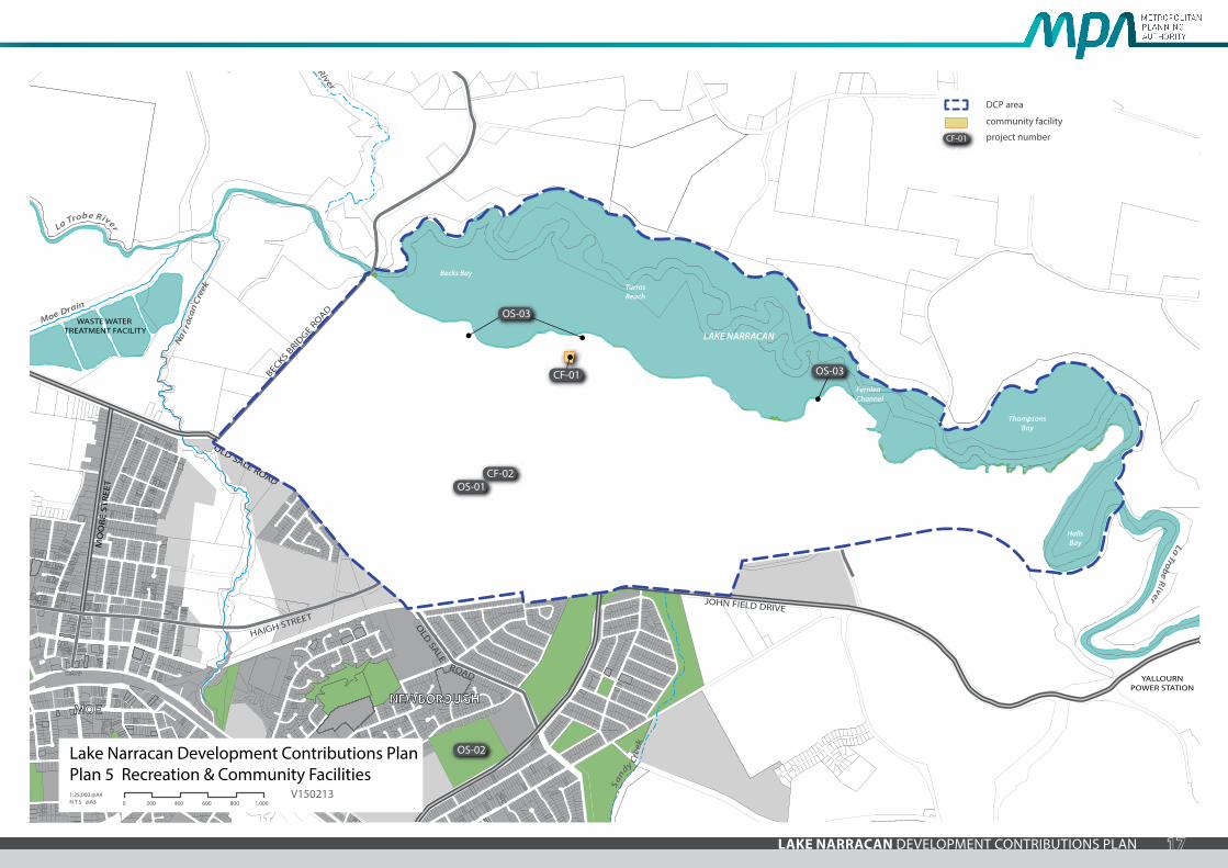
2.2.2 Recreation projects
The recreation contributions include:
• Contribution towards construction of facilities in foreshore parks and sporting reserves.
• Contribution towards environmental improvements to Lake Narracan.
All land owners must provide a public open space contribution equal to 5.29% of the Net Developable Area (NDA) upon subdivision of land in accordance with Clause 52.01 of the Latrobe Planning Scheme (as outlined in the Lake Narracan PSP). Purchase of land for local open space reserves has therefore not been included in the DCP.
The DCP provides a separate contribution per hectare for basic construction, surfacing and landscaping of foreshore parks and sporting reserves outlined in the Lake Narracan PSP. The calculation of these rates is explained in the Lake Narracan Background Report.
Council will have the ability to determine how the DCP funds collected are allocated to each foreshore park and sporting reserve. In determining the scope of DCP funded projects within each foreshore park and sporting reserve, Council will have regard to matters such as changing provision standards and models, the immediate needs of the community, current regulations and best practice and may seek to adjust and refine the scope of the projects to respond to these matters.
The recreation projects funded by the DCP are shown in Plan 5 and described in Table 5.
2.2.3 Community facility projects
The community projects include:
• Land and construction of a community centre incorporating a double kindergarten.
The community projects are based on the population projections determined through the planning process. The community facilities defined in these projects are the best estimates of the future requirements and specifications of the future Lake Narracan community.
The detailed design and scope (as defined in Table 6) of each of the community projects will be reviewed by the Development Agency closer to the time that they are constructed.
In reviewing the scope of the facility, the Development Agency will have regard to matters such as changing provision standards and models, the immediate needs of the community, current regulations and best practice and may adjust and refine the scope of the facility to respond to these matters.
The Development Agency may also adjust and refine the scope of a facility to reflect the capacity of any non-DCP funds that can be made available (for example from a grant or other funding streams).
In adjusting and refining any final project scope the Development Agency must ensure that the funds levied from developers/land owners do not exceed the value nominated in this DCP (inclusive of any indexing provisions as allowed for by the DCP).
The community facility projects funded by the DCP are shown in Plan 5 and described in Table 6.
17LAKE NARRACAN DEVELOPMENT CONTRIBUTIONS PLAN
Nar r
acan
Cre
ek
Moe Drain
Sandy C
reek
Tanjil River
BECKS BRID
GE ROAD
MO
OR
E ST
REE
T
HAIGH STREET
SULL
IVA
NS
TRA
CK
THOMPSONS ROAD
HA
YES
RO
AD
JOHN FIELD DRIVE
OLD SALE ROAD
OLD
SALE
ROAD
La Trobe River
Becks Bay
FernleaChannel
TurrasReach
LAKE NARRACAN
ThompsonsBay
HallsBay La Trobe R
iver
WASTE WATER TREATMENT FACILITY
YALLOURNPOWER STATION
NARRACAN DRIVE
SOUTH
SHORE
CENTREWAY
ROAD
WAY
BROAD
MAC
PHER
SON
ROA
D
MOENEWBOROUGH
CF-01
CF-02OS-01
OS-02
OS-03
OS-03
CF-01
DCP area
community facility
project number
Lake Narracan Development Contributions PlanPlan 5 Recreation & Community Facilities1:25,000 @A4 N T S @A3 0 200 400 600 800 1,000
V150213
18 LAKE NARRACAN DEVELOPMENT CONTRIBUTIONS PLAN
PROJECT ID PROJECT TITLE PROJECT DESCRIPTION CHARGE AREAS CONTRIBUTING
INDICATIVE PROVISION TRIGGER
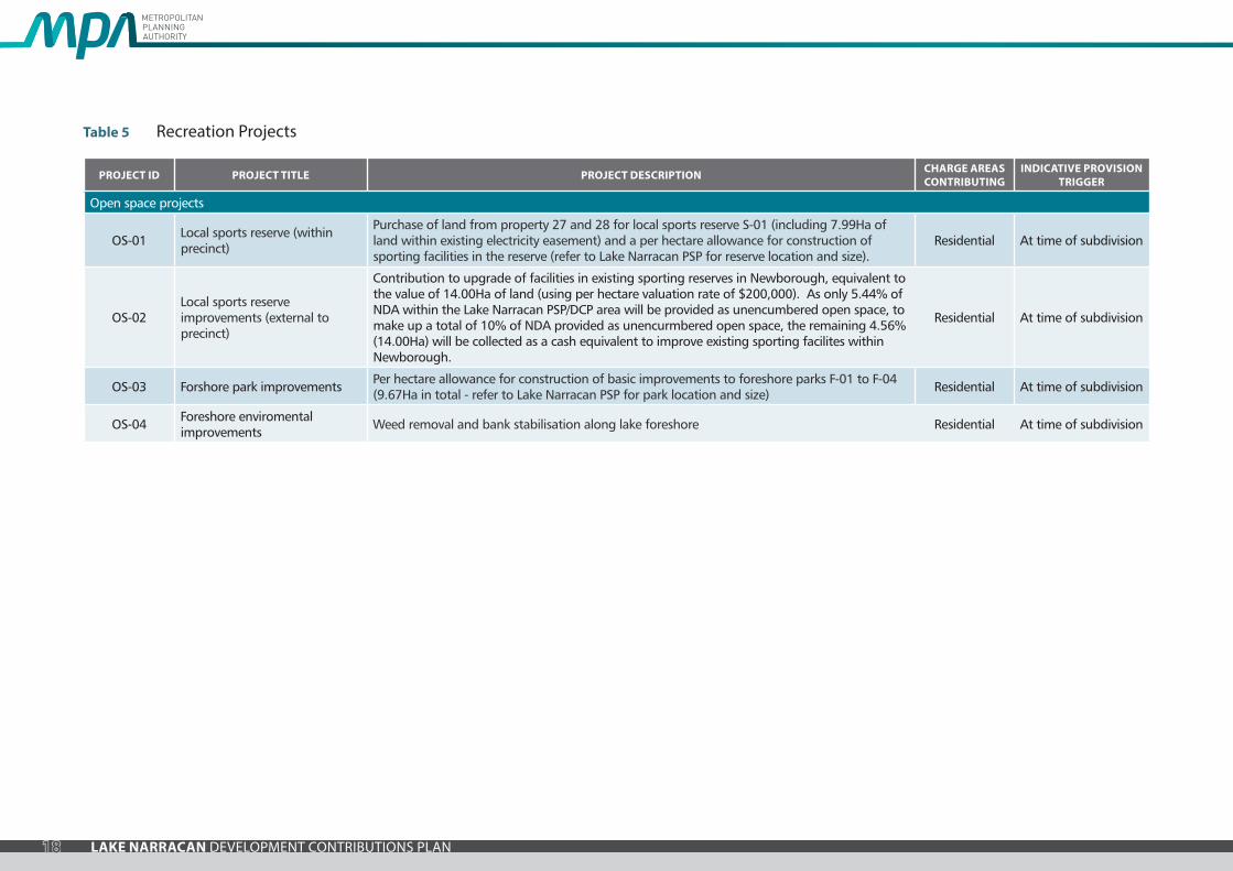
Open space projects
OS-01 Local sports reserve (within precinct)
Purchase of land from property 27 and 28 for local sports reserve S-01 (including 7.99Ha of land within existing electricity easement) and a per hectare allowance for construction of sporting facilities in the reserve (refer to Lake Narracan PSP for reserve location and size).
Residential At time of subdivision
OS-02Local sports reserve improvements (external to precinct)
Contribution to upgrade of facilities in existing sporting reserves in Newborough, equivalent to the value of 14.00Ha of land (using per hectare valuation rate of $200,000). As only 5.44% of NDA within the Lake Narracan PSP/DCP area will be provided as unencumbered open space, to make up a total of 10% of NDA provided as unencurmbered open space, the remaining 4.56% (14.00Ha) will be collected as a cash equivalent to improve existing sporting facilites within Newborough.
Residential At time of subdivision
OS-03 Forshore park improvements Per hectare allowance for construction of basic improvements to foreshore parks F-01 to F-04 (9.67Ha in total - refer to Lake Narracan PSP for park location and size) Residential At time of subdivision
OS-04 Foreshore enviromental improvements Weed removal and bank stabilisation along lake foreshore Residential At time of subdivision
Table 5 Recreation Projects
19LAKE NARRACAN DEVELOPMENT CONTRIBUTIONS PLAN
PROJECT ID PROJECT TITLE PROJECT DESCRIPTION CHARGE AREAS CONTRIBUTING
INDICATIVE PROVISION TRIGGER
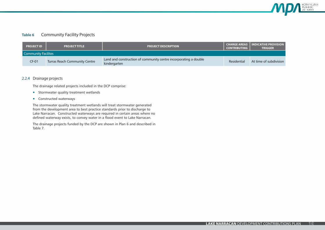
Community Facilites
CF-01 Turras Reach Community Centre Land and construction of community centre incorporating a double kindergarten Residential At time of subdivision
Table 6 Community Facility Projects
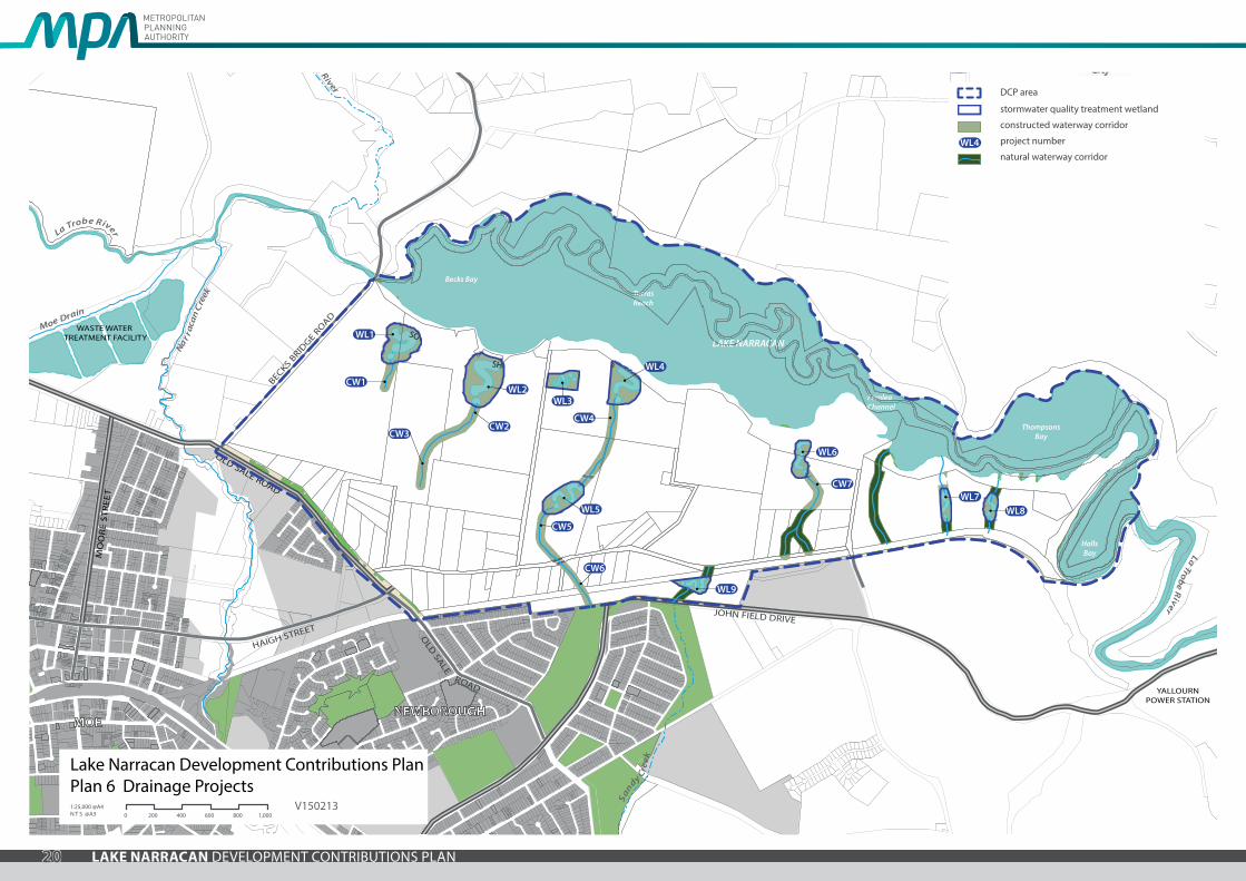
2.2.4 Drainage projects
The drainage related projects included in the DCP comprise:
• Stormwater quality treatment wetlands
• Constructed waterways
The stormwater quality treatment wetlands will treat stormwater generated from the development area to best practice standards prior to discharge to Lake Narracan. Constructed waterways are required in certain areas where no defined waterway exists, to convey water in a flood event to Lake Narracan.
The drainage projects funded by the DCP are shown in Plan 6 and described in Table 7.
20 LAKE NARRACAN DEVELOPMENT CONTRIBUTIONS PLAN
Nar r
acan
Cre
ek
Moe Drain
Sandy C
reek
Tanjil River
BECKS BRID
GE ROAD
MO
OR
E ST
REE
T
HAIGH STREET
SULL
IVA
NS
TRA
CK
THOMPSONS ROAD
HA
YES
RO
AD
JOHN FIELD DRIVE
OLD SALE ROAD
OLD
SALE
ROAD
La Trobe River
Becks Bay
FernleaChannel
TurrasReach
LAKE NARRACAN
ThompsonsBay
HallsBay La Trobe R
iver
WASTE WATER TREATMENT FACILITY
YALLOURNPOWER STATION
NARRACAN DRIVE
SOUTH
SHORE
CENTREWAY
ROAD
WAY
BROAD
MAC
PHER
SON
ROA
D
MOENEWBOROUGH
WL1
WL2
CW2CW3
WL3
WL4
CW4
WL5
CW5
CW6
WL6
CW7WL7
WL8
WL9
CW1
Lake Narracan Development Contributions PlanPlan 6 Drainage Projects1:25,000 @A4 N T S @A3 0 200 400 600 800 1,000
V150213
DCP area
stormwater quality treatment wetland
constructed waterway corridor
project number
natural waterway corridorWL4

21LAKE NARRACAN DEVELOPMENT CONTRIBUTIONS PLAN
PROJECT ID PROJECT TITLE PROJECT DESCRIPTION CHARGE AREAS CONTRIBUTING
INDICATIVE PROVISION TRIGGER
Wetlands
WL-01 Stormwater quality treatment wetland Purchase of land from property 1 and 3 (beyond 60m waterway corridor) and construction of stormwater quality treatment wetland Residential At time of subdivision
WL-02 Stormwater quality treatment wetland Purchase of land from property 3 (beyond 60m waterway corridor) and construction of stormwater quality treatment wetland Residential At time of subdivision
WL-03 Stormwater quality treatment wetland Purchase of land from property 5 (beyond 60m waterway corridor) and construction of stormwater quality treatment wetland Residential At time of subdivision
WL-04 Stormwater quality treatment wetland Purchase of land from property 5 (beyond 60m waterway corridor) and construction of stormwater quality treatment wetland Residential At time of subdivision
WL-05 Stormwater quality treatment wetland Purchase of land from property 32 (beyond 60m waterway corridor) and construction of stormwater quality treatment wetland Residential At time of subdivision
WL-06 Stormwater quality treatment wetland Purchase of land from property 7 (beyond 60m waterway corridor) and construction of stormwater quality treatment wetland Residential At time of subdivision
WL-07 Stormwater quality treatment wetland Purchase of land from property 8 (beyond 60m waterway corridor) and construction of stormwater quality treatment wetland Residential At time of subdivision
WL-08 Stormwater quality treatment wetland Purchase of land from property 8 (beyond 60m waterway corridor) and construction of stormwater quality treatment wetland Residential At time of subdivision
WL-09 Stormwater quality treatment wetland Purchase of land from property 66 (beyond 60m waterway corridor) and construction of stormwater quality treatment wetland Residential At time of subdivision
Waterways
CW-01 Constructed waterway Construction of waterway and associated landscaping Residential At time of subdivision
CW-02 Constructed waterway Construction of waterway (north of Centre Way) and associated landscaping Residential At time of subdivision
CW-03 Constructed waterway Construction of waterway (south of Centre Way) and associated landscaping Residential At time of subdivision
CW-04 Constructed waterway Construction of waterway (north of Centre Way) and associated landscaping Residential At time of subdivision
CW-05 Constructed waterway Construction of waterway (between Thompsons Road and Centre Way) and associated landscaping Residential At time of subdivision
CW-06 Constructed waterway Construction of waterway (south of Thompsons Road) and associated landscaping Residential At time of subdivision
CW-07 Constructed waterway Construction of waterway (within Property 7) and associated landscaping Residential At time of subdivision
Table 7 Drainage Projects
22 LAKE NARRACAN DEVELOPMENT CONTRIBUTIONS PLAN
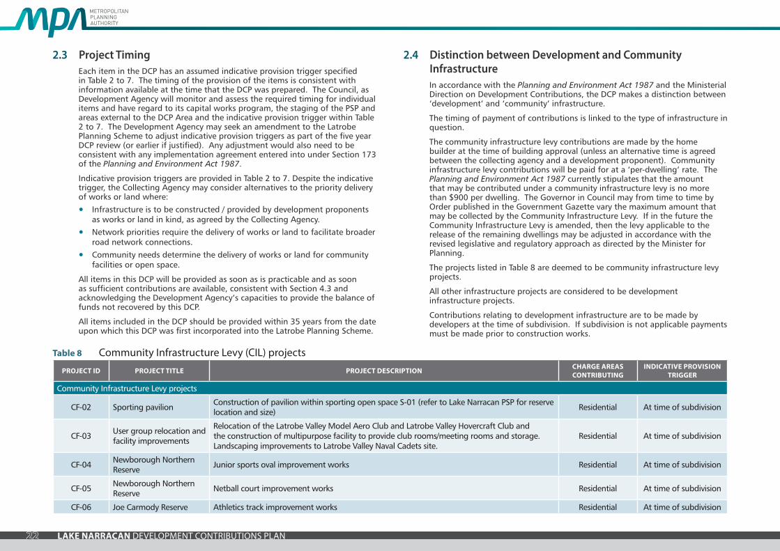
2.3 Project TimingEach item in the DCP has an assumed indicative provision trigger specified in Table 2 to 7. The timing of the provision of the items is consistent with information available at the time that the DCP was prepared. The Council, as Development Agency will monitor and assess the required timing for individual items and have regard to its capital works program, the staging of the PSP and areas external to the DCP Area and the indicative provision trigger within Table 2 to 7. The Development Agency may seek an amendment to the Latrobe Planning Scheme to adjust indicative provision triggers as part of the five year DCP review (or earlier if justified). Any adjustment would also need to be consistent with any implementation agreement entered into under Section 173 of the Planning and Environment Act 1987.
Indicative provision triggers are provided in Table 2 to 7. Despite the indicative trigger, the Collecting Agency may consider alternatives to the priority delivery of works or land where:
• Infrastructure is to be constructed / provided by development proponents as works or land in kind, as agreed by the Collecting Agency.
• Network priorities require the delivery of works or land to facilitate broader road network connections.
• Community needs determine the delivery of works or land for community facilities or open space.
All items in this DCP will be provided as soon as is practicable and as soon as sufficient contributions are available, consistent with Section 4.3 and acknowledging the Development Agency’s capacities to provide the balance of funds not recovered by this DCP.
All items included in the DCP should be provided within 35 years from the date upon which this DCP was first incorporated into the Latrobe Planning Scheme.
2.4 Distinction between Development and Community InfrastructureIn accordance with the Planning and Environment Act 1987 and the Ministerial Direction on Development Contributions, the DCP makes a distinction between ‘development’ and ‘community’ infrastructure.
The timing of payment of contributions is linked to the type of infrastructure in question.
The community infrastructure levy contributions are made by the home builder at the time of building approval (unless an alternative time is agreed between the collecting agency and a development proponent). Community infrastructure levy contributions will be paid for at a ‘per-dwelling’ rate. The Planning and Environment Act 1987 currently stipulates that the amount that may be contributed under a community infrastructure levy is no more than $900 per dwelling. The Governor in Council may from time to time by Order published in the Government Gazette vary the maximum amount that may be collected by the Community Infrastructure Levy. If in the future the Community Infrastructure Levy is amended, then the levy applicable to the release of the remaining dwellings may be adjusted in accordance with the revised legislative and regulatory approach as directed by the Minister for Planning.
The projects listed in Table 8 are deemed to be community infrastructure levy projects.
All other infrastructure projects are considered to be development infrastructure projects.
Contributions relating to development infrastructure are to be made by developers at the time of subdivision. If subdivision is not applicable payments must be made prior to construction works.
PROJECT ID PROJECT TITLE PROJECT DESCRIPTION CHARGE AREAS CONTRIBUTING
INDICATIVE PROVISION TRIGGER
Community Infrastructure Levy projects
CF-02 Sporting pavilion Construction of pavilion within sporting open space S-01 (refer to Lake Narracan PSP for reserve location and size) Residential At time of subdivision
CF-03 User group relocation and facility improvements
Relocation of the Latrobe Valley Model Aero Club and Latrobe Valley Hovercraft Club and the construction of multipurpose facility to provide club rooms/meeting rooms and storage. Landscaping improvements to Latrobe Valley Naval Cadets site.
Residential At time of subdivision
CF-04 Newborough Northern Reserve Junior sports oval improvement works Residential At time of subdivision
CF-05 Newborough Northern Reserve Netball court improvement works Residential At time of subdivision
CF-06 Joe Carmody Reserve Athletics track improvement works Residential At time of subdivision
Table 8 Community Infrastructure Levy (CIL) projects

23LAKE NARRACAN DEVELOPMENT CONTRIBUTIONS PLAN
3.0 CALCULATION OF CONTRIBUTIONSThe general cost apportionment method includes the following steps:
• Calculation of the Net Developable Area (‘NDA’) and demand units (refer Table 9).
• Calculation of project costs (refer Table 10a and 10b).
• Identification and allowance for external use (refer Table 10a and 10b).
• Cost apportionment and catchments (refer Table 10a and 10b).
• Identification of development types required to pay the levy (refer Table 10a and 10b).
• Summary of costs payable for each infrastructure project (refer Table 10a and 10b).
• The development infrastructure charge per hectare for each development type (refer Table 10a) and the community infrastructure levy per dwelling (refer Table 10b).
3.1 Calculation of Net Developable Area and Demand UnitsThe following section sets out how NDA is calculated and outlines the development projections anticipated for the area. Calculations of NDA for each individual property is outlined in the property specific land budget included within the Lake Narracan PSP.
3.1.1 Net Developable Area
In this DCP, all development infrastructure contributions are payable on the net developable area of land on any given development site.
For the purposes of this DCP the NDA is defined as the total amount of land within the precinct that is made available for development of housing and employment buildings, including lots and all local streets. It is the total precinct area minus community facilities, educational facilities, open space, encumbered land, existing road reserves and arterial roads. Any additional small local parks defined at the subdivision stage are included in the NDA.
It is important to note that the number of Net Developable Hectares in each charge area is based on the land budget outlined in Table 9. The ‘per Net
DESCRIPTION HECTARES % OF PRECINCT
% OF NDA
TOTAL PRECINCT AREA (ha) 908.93 100%
TRANSPORT
Arterial Road widening / realignment 3.20 0.35% 0.95%
Existing road reserves 20.12 2.21% 5.96%
SUB-TOTAL 23.31 2.56% 6.90%
OPEN SPACE
ENCUMBERED LAND AVAILABLE FOR RECREATION
Lake Narracan* 305.30 33.59% 90.42%
Foreshore open space 14.78 1.63% 4.38%
Waterways & drainage 46.52 5.12% 13.78%
Conservation / native vegetation retention 54.76 6.02% 16.22%
Existing native vegetation reserve 3.11 0.34% 0.92%
Electricity easements 43.40 4.78% 12.85%
Moe - Yallourn Rail Trail reserve 10.27 1.13% 3.04%
Moe Golf Course 46.65 5.13% 13.82%
Existing Naval Cadets 0.91 0.10% 0.27%
SUB-TOTAL 525.69 57.84% 155.69%
UNENCUMBERED LAND AVAILABLE FOR RECREATION
Local sporting reserves 0.50 0.06% 0.15%
Local parks 17.87 1.97% 5.29%
SUB-TOTAL 18.37 2.02% 5.44%
SUB-TOTAL ALL OPEN SPACE 544.06 59.86% 161.13%
EDUCATION & COMMUNITY
Schools - government 3.50 0.39% 1.04%
Community centres 0.40 0.04% 0.12%
SUB-TOTAL 3.90 0.43% 1.16%
TOTAL 571.28 62.85% 169.19%
TOTAL NET DEVELOPABLE AREA (NDA) Ha 337.66 37.15% 100.00%
* Area occupied by lake water body at normal water level
DESCRIPTION HECTARES DWELL/Ha DWELLINGS
RESIDENTIAL & VILLAGE CENTRES
Village centres 2.10 15.00 31
Residential 335.56 11.00 3691
TOTAL AGAINST NET DEVELOPABLE AREA (NDA) 337.66 11.02 3723
Table 9 Summary Land Use Budget

24 LAKE NARRACAN DEVELOPMENT CONTRIBUTIONS PLAN
Developable Hectare’ contributions will not and must not be amended to respond to minor changes in land budgets that may result from the subdivision process. In other word, the DCP is permanently linked to the calculation of Net Developable Area set out in Table 9.
The property specific land budget included in the Lake Narracan PSP is to be used to determine the number of Net Developable Hectares (for DCP purposes) on individual properties.
3.1.2 Land Budget and Demand Units
Net Developable Hectare is the demand unit for this DCP.
Based on the Lake Narracan PSP, there is one development type included in this DCP: Urban Development. Urban Development is defined broadly to include all forms of development, including residential subdivision, development within town/village centres and employment areas. Urban Development also includes any non-residential uses within the residential area such as a place of worship, education centre, retirement village, nursing home, child care centre, medical centre or convenience store or any other approved use. There is a total of 338 Net Developable Hectares in the DCP area.
3.2 Calculation of Contribution Charges
3.2.1 Calculation of Costs
Each project has been assigned a land and / or construction cost. These costs are listed in Table 10a and 10b. The costs are expressed in 2015 dollars and will be indexed in accordance with the indexation method specified in Section 4.5.
3.2.2 Road Construction and Intersection Works
The scope for arterial intersection projects was established by Latrobe City Council, VicRoads and the MPA. The design and costing of these intersections was undertaken by GTA Consultants.
Reserves required for arterial and connector roads have been calculated consistent with the road cross sections provided in the Lake Narracan PSP. Per metre road construction rates were developed by GHD and were used to calculate road construction costs.
The intersection layout was agreed with the relevant road authority as were the scope of works. The general assumptions used were:
• No land acquisition costs have been allowed for unless stated (these are separately identified in each DCP project costing in Table 10a).
• No trunk services have been allowed for.
• Drainage allowance is for ‘road reserve or project land’ areas i.e. no external catchments. However, major drainage items such as culverts consistent with the Lake Narracan PSP have been included as separate projects.
• A standard excavation depth has been allowed for. Final pavement requirements will be determined at construction stage responding to actual ground conditions.
• Where required an allowance has been made for existing services adjustment or relocation (e.g. electricity poles, water fittings, manholes etc)
• Allowance for preparation of road safety audits (at functional design, detailed design and post opening) for arterial road intersection projects has been included.
Additional percentage based costs tailored to each individual project have been included for:
• Traffic Management
• Site Establishment
• Survey and Design
• Supervision and Project Management
• Council and VicRoads Fees
• Contingency.
The level of contingency for each project reflects the level of design resolution achieved at the time the DCP was prepared.
With respect to road / intersection construction:
• Design generally follows natural terrain.
• Existing service alterations have been included and would be minimal.
• Major cost items such as drainage culverts have been allowed for as separate items.
25LAKE NARRACAN DEVELOPMENT CONTRIBUTIONS PLAN
3.2.3 Culvert works
Where there is a road crossing of a waterway the cost estimated for the culverts required has been prepared on a site by site basis.
3.2.4 Recreation works
Open space recreation cost estimates have been prepared on a per hectare basis instead of itemised cost estimates. The per hectare rate has been derived from an analysis of previous recreation project cost estimates. The use of a per hectare rate allows Council a greater degree of flexibility to meet the needs of the future community.
Costs for environmental works to Lake Narracan (weed management and bank stabilisation) have been calculated by Latrobe City Council based on previous experience with such works.
3.2.5 Community Centre Projects
The costing of the facility is based on cost estimates prepared by CDCE for the Wyndham West DCP and applied to the Lake Narracan DCP.
3.2.6 Temporary works
Temporary works are not allowed as costs against this DCP unless expressly listed in the DCP, unless to the satisfaction of the Collecting Agency.
3.2.7 Valuation of Land
The area of land to be acquired for each DCP project on each property was identified based on information drawn from the Lake Narracan PSP. A description of the area of land was provided to Lee Property Valuers and Advisors as a registered valuer to prepare a valuation which determined the value for each area of land required by the DCP.
Each parcel where land is required for a DCP project was individually assessed using a ‘before and after’ methodology to ensure fair compensation for each affected land owner. These values have then been used to calculate the cost of the land component for all relevant projects included in this DCP.
3.3 Cost ApportionmentThe DCP apportions a charge to new development according to its projected share of use of identified infrastructure items. Since development contribution charges are levied ‘up-front’, a measure of actual use by individual development sites is not possible. Therefore costs must be shared in accordance with the estimated share of use.
This is expressed as a percentage in Table 10a and 10b. Projects that are 100% apportioned to the DCP area are considered to be wholly required for the future development of the DCP area. Projects that are less than 100% apportioned to the DCP are shared with other areas and funding sources.
3.3.1 Charge Areas
The DCP contains one charge area shown as the ‘DCP area’ in Plan 1.
3.3.2 Non-Government Schools
The development of land for a non government school is exempt from the requirement to pay a development infrastructure levy and a community infrastructure levy under this Development Contribution Plan.
3.3.3 Schedule of Costs
Tables 10a and 10b calculate the amount of contributions payable by each charge area for each infrastructure category.
3.3.4 Summary of Charges per Hectare
Tables 10a and 10b shows the quantum of funds to be contributed by each charge area towards each infrastructure project. This adds up to the total amount of funds recoverable under the DCP.
Table 10a and 10b sets out a summary of costs for each charge area.

26 LAKE NARRACAN DEVELOPMENT CONTRIBUTIONS PLAN
DCP ID PROJECT WORKS DESCRIPTION INFRASTRUCTURE CATEGORY LAND AREA
ESTIMATED PROJECT COST:
LAND
ESTIMATED PROJECT COST:
CONSTRUCTION
TOTAL ESTIMATED PROJECT COST
APPORTIONMENT TO DCP
TOTAL COST RECOVERED BY
DCP
INTERSECTION PROJECTS
IN-01 Becks Bridge Road and Old Sale Road Construction of unsignalised T intersection with protected right hand turn lane Development 0.00 $- $1,468,500 $1,468,500 100% $1,468,500
IN-02 Old Sale Road, Thompsons Road and Macphersons Road
Purchase of land from property 23, 48 and 49 and construction of realigned Thompsons Road to link to existing Old Sale Road roundabout and construction of unsignalised T intersection at Macphersons Road. Note: the ultimate alignment of Macpherson Road is to be delivered concurrent with the subdivision of land at 2 Thompsons Road (property 23).
Development 1.20 $500,000 $5,150,500 $5,650,500 100% $5,650,500
IN-03 Thompsons Road and Hayes Road Construction of unsignalised T intersection with protected right hand turn lane Development 0.00 $- $502,500 $502,500 100% $502,500
IN-04 Thompsons Road and Broad Way Purchase of land from properties 36, 38, 39, 61 and 62 and construction of arterial standard roundabout and Broad Way approach Development 1.36 $718,000 $7,001,500 $7,719,500 100% $7,719,500
IN-05 John Field Drive and Broad Way Purchase of land from property 66 and construction of arterial standard roundabout, connections to existing John Field Drive and Broad Way approach Development 0.50 $44,352 $2,368,500 $2,412,852 100% $2,412,852
IN-06 Thompsons Road and Sullivans Track Construction of standard unsignalised T intersection including lifting level of intersection to improve sightlines Development 0.00 $- $603,572 $603,572 100% $603,572
IN-07 Old Sale Road and John Field Drive Construction of intersection upgrade to accommodate additional traffic volumes associated with the Lake Narracan area Development 0.00 $- $1,952,870 $1,952,870 73% $1,425,595
SUB-TOTAL 3.06 $1,262,352 $19,047,942 $20,310,294 $19,783,019
ROAD PROJECTS
RD-01 Thompons Road (Mcpherson Road to Hayes Road) Purchase of land adjacent from property 29 and 31 for widening of Thompsons Road and construction of 24.0m wide 2 lane arterial boulevard (as per Cross Section 3 of the Lake Narracan PSP) Development 0.14 $50,000 $457,823 $507,823 100% $507,823
RD-02 Thompons Road (Hayes Road to Broad Way) Purchase of land from property 32, 33 and 37 for widening of Thompsons Road and construction of 24.0m wide 2 lane arterial boulevard (as per Cross Section 3 of the Lake Narracan PSP) Development 0.14 $21,471 $572,279 $593,750 100% $593,750
RD-03 Thompons Road (Broad Way to Sullivans Track) Construction of 21.5m wide 2 lane connector road (as per Cross Section 6 of the Lake Narracan PSP) Development 0.00 $- $2,491,312 $2,491,312 100% $2,491,312
RD-04 South Shore Road (Broad Way to Golf Club eastern boundary) Construction of 2 lane connector road (as per Cross Section 9 of the Lake Narracan PSP) Development 0.00 $- $1,120,631 $1,120,631 100% $1,120,631
SUB-TOTAL 0.28 $71,471 $4,642,045 $4,713,515 $4,713,515
CULVERT PROJECTS
CV-01 Thompsons Road (between Hayes Road to Broad Way) Construction of basic culvert crossing of waterway Development 0.00 $- $459,000 $459,000 100% $459,000
CV-02 Thompsons Road (between Broad Way and Golf Club eastern boundary) Construction of basic culvert crossing of waterway Development 0.00 $- $269,000 $269,000 100% $269,000
CV-03 Thompsons Road (between Golf Club eastern boundary and Sullivans Track) Construction of basic culvert crossing of waterway Development 0.00 $- $152,000 $152,000 100% $152,000
CV-04 Thompsons Road (between Golf Club eastern boundary and Sullivans Track) Construction of basic culvert crossing of waterway Development 0.00 $- $119,000 $119,000 100% $119,000
SUB-TOTAL 0.00 $- $999,000 $999,000 $999,000
OPEN SPACE PROJECTS
OS-01 Local sports reserve (within precinct)Purchase of land from property 27 and 28 for local sports reserve S-01 (including 7.99Ha of land within existing electricity easement) and a per hectare allowance for construction of sporting facilities in the reserve (refer to Lake Narracan PSP for reserve location and size).
Development 8.49 $130,000 $3,896,484 $4,026,484 100% $4,026,484
OS-02 Local sports reserve improvements (external to precinct)
Contribution to upgrade of facilities in existing sporting reserves in Newborough, equivalent to the value of 14.00Ha of land (using per hectare valuation rate of $200,000). As only 5.44% of NDA within the Lake Narracan PSP/DCP area will be provided as unencumbered open space, to make up a total of 10% of NDA provided as unencurmbered open space, the remaining 4.56% (14.00Ha) will be collected as a cash equivalent to improve existing sporting facilites within Newborough.
Development 0.00 $- $2,800,000 $2,800,000 100% $2,800,000
OS-03 Forshore park improvements Per hectare allowance for construction of basic improvements to foreshore parks F-01 to F-04 (9.67Ha in total - refer to Lake Narracan PSP for park location and size) Development 0.00 $- $610,398 $610,398 100% $610,398
OS-04 Foreshore enviromental improvements Weed removal and bank stabilisation along lake foreshore Development 0.00 $- $1,488,620 $1,488,620 50% $744,310
SUB-TOTAL 8.49 $130,000 $8,795,502 $8,925,502 $8,181,192
COMMUNITY FACILITY PROJECTS
CF-01 Turras Reach Community Centre Land and construction of community centre incorporating a double kindergarten Development 0.40 $41,286 $3,500,000 $3,541,286 100% $3,541,286
SUB-TOTAL 0.40 $41,286 $3,500,000 $3,541,286 $3,541,286
Table 10a Calculation of Costs – Development Infrastructure Levy (DIL)

27LAKE NARRACAN DEVELOPMENT CONTRIBUTIONS PLAN
DCP ID PROJECT WORKS DESCRIPTION INFRASTRUCTURE CATEGORY LAND AREA
ESTIMATED PROJECT COST:
LAND
ESTIMATED PROJECT COST:
CONSTRUCTION
TOTAL ESTIMATED PROJECT COST
APPORTIONMENT TO DCP
TOTAL COST RECOVERED BY
DCP
WETLAND PROJECTS
WL-01 Stormwater quality treatment wetland Purchase of land from property 1 and 3 (beyond 60m waterway corridor) and construction of stormwater quality treatment wetland Development 4.90 $370,421 $1,508,000 $1,878,421 100% $1,878,421
WL-02 Stormwater quality treatment wetland Purchase of land from property 3 (beyond 60m waterway corridor) and construction of stormwater quality treatment wetland Development 6.50 $554,579 $2,010,000 $2,564,579 100% $2,564,579
WL-03 Stormwater quality treatment wetland Purchase of land from property 5 (beyond 60m waterway corridor) and construction of stormwater quality treatment wetland Development 2.00 $207,047 $603,000 $810,047 100% $810,047
WL-04 Stormwater quality treatment wetland Purchase of land from property 5 (beyond 60m waterway corridor) and construction of stormwater quality treatment wetland Development 4.10 $251,667 $1,234,000 $1,485,667 100% $1,485,667
WL-05 Stormwater quality treatment wetland Purchase of land from property 32 (beyond 60m waterway corridor) and construction of stormwater quality treatment wetland Development 3.30 $125,029 $1,005,000 $1,130,029 100% $1,130,029
WL-06 Stormwater quality treatment wetland Purchase of land from property 7 (beyond 60m waterway corridor) and construction of stormwater quality treatment wetland Development 2.00 $25,000 $603,000 $628,000 100% $628,000
WL-07 Stormwater quality treatment wetland Purchase of land from property 8 (beyond 60m waterway corridor) and construction of stormwater quality treatment wetland Development 1.30 $6,259 $402,000 $408,259 100% $408,259
WL-08 Stormwater quality treatment wetland Purchase of land from property 8 (beyond 60m waterway corridor) and construction of stormwater quality treatment wetland Development 1.30 $20,741 $402,000 $422,741 100% $422,741
WL-09 Stormwater quality treatment wetland Purchase of land from property 66 (beyond 60m waterway corridor) and construction of stormwater quality treatment wetland Development 1.40 $56,648 $503,000 $559,648 100% $559,648
SUB-TOTAL 26.80 $1,617,392 $8,270,000 $9,887,392 $9,887,392
WATERWAY PROJECTS
CW-01 Constructed waterway Construction of waterway and associated landscaping Development 0.00 $- $734,000 $734,000 100% $734,000
CW-02 Constructed waterway Construction of waterway (north of Centre Way) and associated landscaping Development 0.00 $- $1,318,351 $1,318,351 100% $1,318,351
CW-03 Constructed waterway Construction of waterway (south of Centre Way) and associated landscaping Development 0.00 $- $827,649 $827,649 100% $827,649
CW-04 Constructed waterway Construction of waterway (north of Centre Way) and associated landscaping Development 0.00 $- $2,261,765 $2,261,765 100% $2,261,765
CW-05 Constructed waterway Construction of waterway (between Thompsons Road and Centre Way) and associated landscaping Development 0.00 $- $1,583,235 $1,583,235 100% $1,583,235
CW-06 Constructed waterway Construction of waterway (south of Thompsons Road) and associated landscaping Development 0.00 $- $1,438,000 $1,438,000 100% $1,438,000
CW-07 Constructed waterway Construction of waterway (within Property 7) and associated landscaping Development 0.00 $- $990,000 $990,000 100% $990,000
SUB-TOTAL 0.00 $- $9,153,000 $9,153,000 $9,153,000
SUMMARY
TOTAL COST Development Infrastructure Levy (DIL) projects $56,258,404
TOTAL Net Developable Hectares 337.66
TOTAL Development Infrastructure Levy (DIL) rate per Net Developable Hectare $166,614

28 LAKE NARRACAN DEVELOPMENT CONTRIBUTIONS PLAN
ESTI
MAT
ED P
ROJE
CT
COST
: LA
ND
ESTI
MAT
ED P
ROJE
CT
COST
: CO
NST
RUC
TIO
N
TOTA
L ES
TIM
ATED
PRO
JEC
T CO
ST
APP
ORT
ION
MEN
T TO
DCP
TOTA
L CO
ST
ATTR
IBU
TAB
LE T
O D
CP
DCP ID PROJECT WORKS DESCRIPTION INFRASTRUCTURE CATEGORY LAND AREA
Community facility projects
CF-02 Sporting pavilion
Construction of pavilion within sporting open space S-01 (refer to Lake Narracan PSP for reserve location and size)
Community 0.00 $- $1,760,000 $1,760,000 100% $1,760,000
CF-03 User group relocation and facility improvements
Relocation of the Latrobe Valley Model Aero Club and Latrobe Valley Hovercraft Club and the construction of multipurpose facility to provide club rooms/meeting rooms and storage. Landscaping improvements to Latrobe Valley Naval Cadets site.
Community 0.00 $- $500,000 $500,000 100% $500,000
CF-04 Newborough Northern Reserve
Junior sports oval improvement works Community 0.00 $- $400,000 $400,000 60% $240,000
CF-05 Newborough Northern Reserve
Netball court improvement works Community 0.00 $- $1,000,000 $1,000,000 60% $600,000
CF-06 Joe Carmody Reserve
Athletics track improvement works Community 0.00 $- $300,000 $300,000 60% $180,000
SUB-TOTAL 0.00 $- $3,960,000 $3,960,000 $3,280,000
SUMMARY
TOTAL Community Infrastructure Levy (CIL) per dwelling $881
TOTAL estimated dwellings 3,723
TOTAL Community Infrastructure Levy (CIL) estimated to be collected by DCP $3,280,000
Table 10b Calculation of Costs – Community Infrastructure Levy (CIL)

29LAKE NARRACAN DEVELOPMENT CONTRIBUTIONS PLAN
4.0 ADMINISTRATIONThis section sets out how this DCP will be administered and covers the timing of payment, provision of works and land in kind and how funds generated by this DCP will be managed in terms of reporting, indexation and review periods.
The DCP Development Infrastructure Levy applies to subdivision and / or development of land.
The DCP Community Infrastructure Levy applies to the construction of dwellings and must be paid prior to the issue of a Building Permit.
4.1 Collecting Agency (Agency Responsible for Collecting Infrastructure Levy)Latrobe City Council is the Collecting Agency pursuant to section 46K(1)(fa) of the Planning and Environment Act 1987 which means that it is the public authority to whom all levies are payable. As the Collecting Agency, Latrobe City Council is also responsible for the administration of this DCP and also its enforcement pursuant to Section 46QC of the Act.
4.2 Development Agency (Agency Responsible for Works)Latrobe City Council is the Development Agency and is responsible for the provision of all of the DCP projects identified in this DCP.
4.3 Payment of Contribution Levies and Payment Timing
4.3.1 Development Infrastructure
For subdivision of Land
• A development infrastructure levy must be paid to Council for the land within the following specified time, namely after certification of the relevant plan of subdivision but not more than 21 days prior to the issue of a Statement of Compliance with respect to that plan under the Subdivision Act 1988, or may be paid at a later date if agreed by Council in writing.
• Where the subdivision is to be developed in stages, the infrastructure levy for the stage to be developed may only be paid to Council within 21 days prior to the issue of a Statement of Compliance for that stage provided
that a Schedule of Development Contributions is submitted with each stage of plan of subdivision. This Schedule must show the amount of the development contributions payable for each stage and the value of the contributions for prior stages to the satisfaction of Council.
If Council agrees to works or provision of land in lieu of the payment of the infrastructure levy, the land owner must enter into an agreement under Section 173 of the Planning and Environment Act 1987 in respect of the proposed works or provision of land in lieu to specific requirements.
For development of land where no subdivision is proposed (such as retirement homes)
• Provided a development infrastructure levy has not already been paid on subject land, an infrastructure levy must be paid to Council in accordance with the provisions of the approved DCP for each demand unit (Net Developable Hectare) proposed to be developed prior to the commencement of any development (i.e. development includes buildings, car park, access ways landscaping and ancillary components). Council may require that contributions be made at either the planning or building permit stage for Development Infrastructure.
If Council agrees to works or provision of land in lieu of the payment of the infrastructure levy, the land owner must enter into an agreement or other suitable arrangement under Section 173 of the Planning and Environment Act 1987 in relation to the proposed works or land in lieu.
Where no planning permit is required
The following requirements apply where no planning permit is required. The land may only be used and developed subject to the following requirements being met:
• Unless otherwise agreed to by Council in a Section 173 agreement, a development infrastructure levy must be paid to Council prior to the commencement of any development in accordance with the provision of this approved Development Contributions Plan for the land.
If Council agrees to works or provision of land in lieu of the payment of the infrastructure levy, the land owner must enter into an agreement under Section 173 of the Planning and Environment Act 1987 in respect of the proposed works or provision of land in lieu.

30 LAKE NARRACAN DEVELOPMENT CONTRIBUTIONS PLAN
The Development Infrastructure Levy or Community Infrastructure Levy does not apply to the following:
• Renovations or alterations to existing dwellings
• Demolition of a dwelling followed by construction of a replacement dwelling on the same land
• Outbuildings normal to an existing dwelling and fences
4.3.2 Community Infrastructure Levy
Contributions relating to community infrastructure are to be made by the home builder prior to the issue of a building permit. However, development proponents are encouraged to pay the levy prior to the issue of a statement of compliance to reduce the administrative burden of collection from individual home builders.
Levies for ‘residential buildings’ will be calculated at the rate for a single dwelling. In all other forms of accommodation, the dwelling is the individual unit (such as each dwelling in a residential village, retirement village, serviced apartment complexes and so on). Corrective institutions are exempt.
A community infrastructure levy is not payable for a dwelling on a lot which was created prior to the date that this DCP was first incorporated into the Latrobe Planning Scheme.
4.3.3 Works in Kind
Under Section 46P of the Act, Council as the Collecting Agency may accept the provision of land, works, services or facilities by the applicant in part, or in full, in lieu of the amount of levy payable. This can be agreed with Council before or after the application for the permit is made or before the development is carried out. The agreement must include a list of the DCP infrastructure which Council has agreed in writing to allow to be provided as works in lieu providing that:
• The works constitute project(s) funded by this DCP.
• Council agrees that the timing of the works would be consistent with priorities in this DCP.
• The works are defined and agreed in a Section 173 agreement.
• Works must be provided to a standard that accords with this DCP to the satisfaction of Council, unless an alternative is agreed by Council.
• Detailed design must be approved by Council and must generally accord with the expectations outlined in this DCP unless an alternative is agreed by Council.
• The construction of works must be completed to the satisfaction of Council.
• There should be no negative financial impact on this DCP to the satisfaction of Council.
• In particular, the works will only be accepted in lieu of a financial contribution required by this DCP to the extent that they constitute part or all of the design of the infrastructure item and reduce the cost to complete that design, to Council’s satisfaction. Temporary works will not be accepted as works in kind.
Where Council agrees that works are to be provided by a development proponent in lieu of cash contributions (subject to the arrangements specified above):
• The credit for the works (unless an alternative approach is agreed with Council) provided shall equal the value identified in the Development Contributions Plan, taking into account the impact of indexation.
• The value of the works provided in accordance with the principle outlined above, will be off-set against the development contributions liable to be paid by the development proponent.
• Credit for the provision of works in kind shall be at a time to be negotiated between the development proponent and Council.
4.3.4 Credit for Over Provision
Where Council agrees that a development proponent can provide works in kind (either works and/or land) the situation may arise where the developer makes a contribution that exceeds that required by the Development Contributions Plan for the individual development.
In such a case the developer is entitled to a cash reimbursement for that amount that has been over contributed.
The details of credits and reimbursements will need to be negotiated with, and agreed to by Council.
31LAKE NARRACAN DEVELOPMENT CONTRIBUTIONS PLAN
4.3.5 Non Government Schools
Where land is subdivided or developed for the purpose of a government school, non government school or any other use that is partly or wholly exempt from development contributions and the land is subsequently used for a purpose other than as one of those exempt uses , the owner of that land must pay to Council development contributions in accordance with the provisions of the DCP. The development infrastructure levy and where applicable, the community infrastructure levy must be paid within 28 days of the date of the commencement of the construction of any buildings or works for that alternative use.
4.4 Funds AdministrationThe administration of the contributions made under this DCP will be transparent and development contributions will be held in accounts for each class of infrastructure until required for provision of items in that class. Details of funds received and expenditures will be held by Council in accordance with the provisions of the Local Government Act 1989 and the Planning and Environment Act 1987.
The administration of contributions made under this DCP will be transparent and demonstrate:
• The amount and timing of funds collected.
• The sources of the funds collected.
• The amount and timing of expenditure on specific projects.
• The project on which the expenditure was made.
• The account classes or individual project classes.
• Details of any works-in-kind arrangements for project provision.
• Any pooling or quarantining of funds to deliver specific projects where applicable.
Council will provide for regular monitoring, reporting and review of the monies received and expended in accordance with this DCP.
Council will establish interest bearing accounts and all monies held in these accounts will be used solely for the provision of infrastructure as specified in this DCP.
Should Council achieve savings on any project, or resolve not to proceed with any of the infrastructure projects listed in this DCP, the funds collected for these items will be used for alternative works in the same infrastructure class as specified by this DCP. Such funds may also be used for the provision of additional works, services or facilities where approved by the Minister responsible for the Planning and Environment Act, or will be refunded to developers and / or owners of land subject to these infrastructure charges.
4.5 Construction and Land Value Costs IndexationCapital costs of all infrastructure items are in 2015 dollars and will be indexed by Council annually to take account of inflation. The costs of infrastructure items will be adjusted by applying the Building Price Index, as published in the latest edition of Rawlinsons Australian Construction Handbook.
Land values will be re-valued annually by a registered valuer based on a ‘before and after’ methodology for each lot that includes land for a DCP project.
Within 14 days of the adjustments being made, Council will publish the amended capital costs for each infrastructure item on Council’s website.
The Community Infrastructure Levy projects are not indexed as the value of the contribution is set by the Planning and Environment Act 1987.
If in the future the Community Infrastructure Levy is amended, then the levy applicable to the release of any remaining dwellings may be adjusted in accordance with the revised legislative and regulatory approach as directed by the Minister for Planning.
4.6 Development Contributions Plan Review PeriodThis DCP adopts a long-term outlook for development. It takes into account planned future development in the Lake Narracan precinct. A ‘full development’ horizon of land within Lake Narracan area within 35 years of gazettal of this DCP has been adopted.
This DCP commences on the date of incorporation into the Latrobe Planning Scheme. This DCP will end when development within the DCP area is complete, which is projected to be 35 years after gazettal, or when the DCP is removed from the Planning Scheme.
The DCP is expected to be revised and updated every 5 years (or more frequently if required). This will require an amendment to the Latrobe

32 LAKE NARRACAN DEVELOPMENT CONTRIBUTIONS PLAN
Planning Scheme to replace this document with an alternative, revised document. Any review will need to have regard to any arrangements (for example an agreement under s173 of the Act) for the implementation of this DCP.
This review is anticipated to include:
• Updates to any aspect of the plan as required;
• Review of projects required, as well as their costs and scope (as relevant) and indicative provision trigger;
• Review of estimated net developable area (this will also be required if the Precinct Structure Plan is subject to a substantive amendment); and
• Review of land values for land to be purchased through the plan.
4.7 Adjustment to Infrastructure Scope During the implementation of the DCP a development proponent may propose material changes to the use and development of land from that contemplated in the PSP, leading to increased requirement for infrastructure. In these cases there should be no negative impact on the DCP by requiring the developer to bear the additional costs associated with the provision of the infrastructure item over and above the standard required by the DCP.
Where Council or another agency seeks to change the scope of a DCP infrastructure item to meet changing standards imposed by adopted policy or by a public regulatory agency, such changes of standards and the resulting cost changes should normally be made through a change to the DCP at the time of a regular review of the DCP.
Where Council or another agency seeks to change the scope of a DCP infrastructure item for reasons other than changes in standards imposed by policy or regulation, the net cost increases resulting from the changes should normally be met by the agency requesting the change.
5.0 OTHER INFORMATION
5.1 Acronyms‘the Act’ Planning and Environment Act 1987
CIL Community Infrastructure Levy
DCP Development Contributions Plan
DIL Development Infrastructure Levy
GDA Gross Developable Area
Ha Hectare
MCA Main Catchment Area
MCH Maternal & Child Health
MSS Municipal Strategic Statement
NDA Net Developable Area
NDHa Net Developable Hectare
PSP Precinct Structure Plan
Sqm Square Metres
UGZ Urban Growth Zone
5.2 GlossaryArterial RoadA higher order road providing for moderate to high volumes at relatively high speeds typically used for journeys between towns and linking to freeways, and identified under the Road Management Act 2004. All declared arterials are managed by the State Government.
Co-LocationAdjoining land uses to enable complementary programs, activities and services and shared use of resources and facilities. For example, the co-location of schools and open space.
Community FacilitiesInfrastructure provided by government or non-government organisations for accommodating a range of community support services, programs and activities. This includes facilities for education and learning (e.g. government

33LAKE NARRACAN DEVELOPMENT CONTRIBUTIONS PLAN
and non-government schools, universities, adult learning centres); early years (e.g. preschool, maternal and child health, childcare); health and community services (eg. hospitals, aged care, doctors, dentists, family and youth services, specialist health services); community (e.g. civic centres, libraries, neighbourhood houses); arts and culture (e.g. galleries, museums, performance space); sport, recreation and leisure (e.g. swimming pools); justice (e.g. law courts); voluntary and faith (e.g. places of worship) and emergency services (e.g. police, fire and ambulance stations).
Connector StreetA lower order street providing for low to moderate volumes and moderate speeds linking local streets to the arterial network Managed by the relevant local council. (See Table C1 in clause 56)
Conventional Density HousingHousing with an average density of 1O to 15 dwellings per net developable hectare.
Development Contributions PlanDocument that sets out the contributions expected from each individual landowner to fund infrastructure and services. Refer to Part 3B of the Planning and Environment Act l987.
Encumbered LandLand that is constrained for development purposes. Includes easements for power/transmission lines, sewers, gas, waterways, drainage, retarding basins/wetlands, landfill, conservation and heritage areas. This land may be used for a range of activities (e.g. walking trails, sports fields).
FreewayA high speed and high volume road with the highest level of access control and typically used for longer distance journeys across the metropolitan area and country Victoria. All freeways are managed by VicRoads.
High Density HousingHousing with an average density of more than 30 dwellings per net developable hectare.
Housing Density (Net)The number of houses divided by net developable area
Linear Open Space Network
Corridors of open space, mainly along waterways that link together, forming a network.
Land Budget TableA table setting out the total precinct area, net developable area and constituent land uses proposed within the precinct.
Local Open SpaceOpen space that is set aside for local parks and gardens that are made available for passive recreation, play and unstructured physical activity including walking, cycling, hiking, revitalisation, contemplation and enjoying nature.
LotA part (consisting of one or more pieces) of any land (except a road, a reserve, or common property) shown on a plan, which can be disposed of separately and includes a unit or accessory unit on a registered plan of strata subdivision and a lot or accessory lot on a registered cluster plan.
Lower Density HousingHousing with an average density of less than 10 dwellings per hectare.
Medium Density HousingHousing with an average density of 16 to 30 dwellings per net developable hectare.
Native VegetationPlants that are indigenous to Victoria, including trees, shrubs, herbs, and grasses.
Net Developable AreaTotal amount of land within the precinct that is made available for development of housing and employment buildings, including lots and local streets. Total precinct area minus community facilities, schools and educational facilities, open space, existing road reserves, arterial roads and encumbered land. Small local parks defined at subdivision stage are included in net developable area.
Precinct Structure PlanA statutory document that describes how a precinct or series of sites within a growth area will be developed over time. A precinct structure plan sets out

34 LAKE NARRACAN DEVELOPMENT CONTRIBUTIONS PLAN
the broad environmental, social and economic parameters for the use and development of land within the precinct.
Public Open SpaceLand that is set aside in the precinct structure plan for public recreation or public sport, or as parklands, or for similar purposes. Incorporates sporting and local open space.
Sporting ReserveLand set aside for the specific purpose of formal/organised club based sports.
Urban Growth ZoneStatutory zone that applies to land that has been identified for future urban development. The UGZ has four purposes: (1) to manage transition of non-urban land into urban land; (2) to encourage development of well-planned and well-serviced new urban communities in accordance with an overall plan; (3) to reduce the number of development approvals needed in areas where an agreed plan is in place; and (4) to safeguard non-urban land from use and development that could prejudice its future urban development.

35LAKE NARRACAN DEVELOPMENT CONTRIBUTIONS PLAN
Lake Narracan Development Contributions Plan - March 2015