Embed Size (px)
Citation preview

Lake County
All Natural Hazards
Mitigation Plan
Lake County, Illinois
August 2017 Agency Review Draft
Update of 2012 Countywide All Natural Hazards Mitigation Plan
Developed by:
Lake County Hazard Mitigation Planning Committee
Plan Coordinated by:
Lake County Stormwater Management Commission
and the
Lake County Emergency Management Agency
Planning Assistance:

Lake County All Natural Hazards Mitigation Plan
Table of Contents TOC-1 Review Draft August 2017
Contents
Table of Exhibits ........................................................................................................ TOC-7
Table of Figures ......................................................................................................... TOC-7
Table of Tables ........................................................................................................... TOC-8
Executive Summary ...................................................................................................... ES-1
Planning Process ........................................................................................................................ ES-3
Natural Hazard Risk Assessment ............................................................................................... ES-3
Hazard Mitigation Goals and Guidelines ................................................................................... ES-4
Hazard Mitigation Strategies ..................................................................................................... ES-4
Mitigation Action Plan ............................................................................................................... ES-6
Plan Adoption ............................................................................................................................ ES-7
Summary .................................................................................................................................... ES-7
Chapter 1: Introduction ................................................................................................... 1-1
1.1 Purpose of the Plan ................................................................................................................... 1-2
1.2 Organization of the Plan ............................................................................................................ 1-2
1.3 Lake County Overview ............................................................................................................... 1-3
1.4 Lake County Land Use and Development ................................................................................ 1-12
1.5 Lake County Critical Facilities .................................................................................................. 1-17
Chapter 2: Planning Process .......................................................................................... 2-1
2.1 Planning Approach .................................................................................................................... 2-1
2.2 Update Process – Organization and Coordination .................................................................... 2-2
2.3 Plan Adoption and Implementation .......................................................................................... 2-5
Chapter 3: Risk Assessment .......................................................................................... 3-1
3.1 Natural Hazards in Lake County ................................................................................................ 3-1
3.2 Summary of Lake County Assets ............................................................................................... 3-4
3.3 Flood .......................................................................................................................................... 3-7
3.3.1 Lake County Watersheds .................................................................................................... 3-9
3.3.2 Flood Hazard Profile ......................................................................................................... 3-16
3.3.3 Repetitive Flood Loss Properties ...................................................................................... 3-22
3.3.4 Past Floods and Future Flood Frequency ......................................................................... 3-26
3.3.5 Vulnerability - Impacts of Flooding................................................................................... 3-28

Lake County All Natural Hazards Mitigation Plan
Table of Contents TOC-2 Review Draft August 2017
3.4 Tornado ................................................................................................................................... 3-30
3.4.1 Tornado Hazard Profile .................................................................................................... 3-34
3.4.2 Vulnerability – Tornado Impact ....................................................................................... 3-37
3.5 Severe Summer Storms ........................................................................................................... 3-39
3.5.2 Vulnerability –Severe Summer Storms Impact ................................................................ 3-49
3.6 Severe Winter Storms ............................................................................................................. 3-50
3.6.1 Severe Winter Storm Hazard Profile ................................................................................ 3-51
3.6.2 Vulnerability - Winter Storm Impact ................................................................................ 3-53
3.7 Drought ................................................................................................................................... 3-54
3.7.1 Drought Hazard Profile .................................................................................................... 3-56
3.7.2 Vulnerability – Drought Impacts ...................................................................................... 3-58
3.8 Earthquake .............................................................................................................................. 3-58
3.8.1 Earthquake Hazard Profile ............................................................................................... 3-59
3.8.2 Vulnerability – Earthquake Impact .................................................................................. 3-60
3.9 Dam Failure ............................................................................................................................. 3-62
3.9.1 Hazard Profile ................................................................................................................... 3-63
3.9.2 Vulnerability – Dam Failure Impact.................................................................................. 3-66
3.10 Temperature Extremes ......................................................................................................... 3-66
3.10.1 Extreme Temperature Hazard Profile ............................................................................ 3-69
3.10.2 Vulnerability – Extreme Temperature Impact ............................................................... 3-71
3.11 Erosion - Shoreline, Coastal and Ravine................................................................................ 3-72
3.11.1 Shoreline Erosion Hazard Profile ................................................................................... 3-72
3.11.2 Coastal Erosion Hazard Profile ....................................................................................... 3-73
3.11.3 Ravine Erosion Hazard Profile ........................................................................................ 3-74
3.11.4 Vulnerability - Erosion Hazard Impact ........................................................................... 3-75
3.12 Power Outage ....................................................................................................................... 3-76
3.13 Summary of Natural Hazards Risk Assessment .................................................................... 3-78
3.13.1 Impact of the Hazards .................................................................................................... 3-78
Chapter 4: Mitigation Goals ............................................................................................. 4-1
4.1 Community Priorities and Plan Direction .................................................................................. 4-1
4.2 Goals and Guidelines................................................................................................................. 4-2
4.3 Consistent with Other Plans...................................................................................................... 4-3
Chapter 5: Mitigation Strategies and Capability Assessment....................................... 5-1

Lake County All Natural Hazards Mitigation Plan
Table of Contents TOC-3 Review Draft August 2017
5.1 Preventive Measures ................................................................................................................. 5-2
5.1.1 Planning and Zoning ........................................................................................................... 5-3
5.1.2 Watershed Development Regulations ............................................................................... 5-4
5.1.3 Best Management Practices ............................................................................................... 5-8
5.1.4 Building Codes .................................................................................................................... 5-9
5.1.5 Standards for Manufactured Homes ................................................................................ 5-11
5.1.6 Critical Facility Construction ............................................................................................. 5-11
5.1.7 Other Preventive Measures.............................................................................................. 5-12
5.1.8 Preventive Measure Recommendations .......................................................................... 5-13
5.2 Property Protection ................................................................................................................. 5-14
5.2.1 Building Acquisition/Relocation ....................................................................................... 5-15
5.2.3 Building Structural Retrofitting ........................................................................................ 5-21
5.2.5 Repetitive Flood Loss Properties ...................................................................................... 5-26
5.2.6 Property Protection Recommendations ........................................................................... 5-28
5.3 Resource Protection ................................................................................................................ 5-29
5.3.1 Open Space Preservation ................................................................................................. 5-30
5.3.3 Stream Restoration ........................................................................................................... 5-32
5.3.4 Groundwater Protection .................................................................................................. 5-35
5.3.5 Urban Forestry .................................................................................................................. 5-36
5.3.6 Historic and Natural Area Protection ............................................................................... 5-37
5.3.7 Resource Protection Recommendations .......................................................................... 5-38
5.4 Emergency Services ................................................................................................................. 5-38
5.4.1 Emergency Planning ......................................................................................................... 5-39
5.4.2 Threat Recognition ........................................................................................................... 5-39
5.4.3 Warning ............................................................................................................................ 5-41
5.4.4 Response ....................................................................................................................... 5-43
5.4.5 Critical Facility Protection ................................................................................................. 5-44
5.4.6 Recovery and Mitigation .................................................................................................. 5-45
5.4.7 Emergency Services Recommendations ........................................................................... 5-46
5.5 Structural Measures ................................................................................................................ 5-48
5.5.1 Watershed Planning ......................................................................................................... 5-48
5.5.2 Regional Flood Control ..................................................................................................... 5-49
5.5.3 Management of Existing Dams ......................................................................................... 5-50
5.5.4 Improving Crossings and Roadways ................................................................................. 5-50
Lake County All Natural Hazards Mitigation Plan
Table of Contents TOC-4 Review Draft August 2017
5.5.5 Drainage System Maintenance ........................................................................................ 5-51
5.5.6 Structural Measure Recommendations ........................................................................... 5-52
5.6 Public Information .................................................................................................................. 5-53
5.6.1 Library and Website Resources ........................................................................................ 5-54
5.6.2 Outreach Projects ............................................................................................................ 5-54
5.6.3 Technical Assistance ........................................................................................................ 5-55
5.6.4 Public Information Recommendations ............................................................................ 5-56
5.7 Capability Assessment Summary ............................................................................................ 5-56
Chapter 6: Action Plan ..................................................................................................... 6-1
6.1 Development of Current Action Plan ........................................................................................ 6-1
6.2 Lake County ANHMP Priority Action Items ............................................................................... 6-2
6.3 Action Items by Community.................................................................................................... 6-21
Lake County ............................................................................................................................... 6-21
Village of Antioch ...................................................................................................................... 6-22
Village of Bannockburn ............................................................................................................. 6-23
Village of Barrington ................................................................................................................. 6-24
Village of Beach Park ................................................................................................................. 6-25
Village of Buffalo Grove ............................................................................................................ 6-26
Village of Deer Park ................................................................................................................... 6-27
Village of Deerfield .................................................................................................................... 6-28
Village of Fox Lake ..................................................................................................................... 6-29
Village of Fox River Grove ......................................................................................................... 6-30
Village of Grayslake ................................................................................................................... 6-31
Village of Green Oaks ................................................................................................................ 6-32
Village of Gurnee....................................................................................................................... 6-33
Village of Hainesville ................................................................................................................. 6-34
Village of Hawthorn Woods ...................................................................................................... 6-35
City of Highland Park ................................................................................................................. 6-36
Village of Highwood .................................................................................................................. 6-37
Village of Indian Creek .............................................................................................................. 6-38
Village of Island Lake ................................................................................................................. 6-39
Village of Kildeer ....................................................................................................................... 6-40
Village of Lake Bluff ................................................................................................................... 6-42

Lake County All Natural Hazards Mitigation Plan
Table of Contents TOC-5 Review Draft August 2017
City of Lake Forest ..................................................................................................................... 6-43
Village of Lake Villa .................................................................................................................... 6-44
Village of Lake Zurich ................................................................................................................. 6-45
Village of Libertyville ................................................................................................................. 6-46
Village of Lincolnshire ................................................................................................................ 6-48
Village of Lindenhurst ................................................................................................................ 6-49
Village of Long Grove ................................................................................................................. 6-50
Village of Mundelein ................................................................................................................. 6-52
Village of North Barrington ....................................................................................................... 6-53
City of North Chicago ................................................................................................................. 6-54
Village of Old Mill Creek ............................................................................................................ 6-55
Village of Port Barrington .......................................................................................................... 6-56
Village of Riverwoods ................................................................................................................ 6-58
Village of Round Lake ................................................................................................................ 6-59
Village of Round Lake Beach ..................................................................................................... 6-60
Village of Round Lake Heights ................................................................................................... 6-61
Village of Round Lake Park ........................................................................................................ 6-62
Village of Third Lake .................................................................................................................. 6-63
Village of Tower Lakes ............................................................................................................... 6-64
Village of Vernon Hills ............................................................................................................... 6-65
Village of Volo ............................................................................................................................ 6-66
Village of Wadsworth ................................................................................................................ 6-67
Village of Wauconda .................................................................................................................. 6-68
City of Waukegan ...................................................................................................................... 6-69
Village of Winthrop Harbor ....................................................................................................... 6-70
City of Zion ................................................................................................................................. 6-71
Naval Station Great Lakes .......................................................................................................... 6-72
6.4 Implementation Strategy ........................................................................................................ 6-73
Chapter 7: Plan Maintenance ......................................................................................... 7-1
7.1 Plan Adoption ............................................................................................................................ 7-1
7.2 Maintenance and Monitoring ................................................................................................... 7-1
7.3 Continued Public Participation .................................................................................................. 7-2
7.4 Evaluating the Plan’s Success .................................................................................................... 7-2
Lake County All Natural Hazards Mitigation Plan
Table of Contents TOC-6 Review Draft August 2017
Appendix A: HMPC Participation and Documentation ................................................. A-1
Appendix B: Public Information Activities .................................................................... B-1
Appendix C: Progress on 2012 Action Plan & Comparison to Current Action Plan .. C-1
Appendix D: Resolutions and FEMA Approval ............................................................ D-1

Lake County All Natural Hazards Mitigation Plan
Table of Contents TOC-7 Review Draft August 2017
Table of Exhibits
Exhibit 1: Lake County Municipalities ...................................................................... 1-4
Exhibit 2: Lake County Townships .......................................................................... 1-5
Exhibit 3: Lake County Elementary School Districts ............................................. 1-10
Exhibit 4: Lake County High School Districts ........................................................ 1-11
Exhibit 5: Lake County Current Land Use ............................................................. 1-15
Exhibit 6: Lake County Environmental Resources Inventory ................................ 1-16
Exhibit 7: Lake County Critical Facilities ............................................................... 1-19
Exhibit 8: Lake County Watersheds and Subwatersheds ..................................... 3-10
Exhibit 9: Lake County 100 Year Floodplain and Floodway .................................. 3-17
Exhibit 10: Lake County “Flood Problem Areas” ................................................... 3-20
Exhibit 11: Lake County Repetitive Flood Loss Areas .......................................... 3-24
Exhibit 12: Lake County Tornado Touch Downs ................................................... 3-35
Exhibit 13: Lake County Hail over 0.75” ................................................................ 3-43
Exhibit 14: Lake County Lightning Events ............................................................. 3-47
Exhibit 15: Lake County Dams .............................................................................. 3-65
Exhibit 16: Lake County SMC Flood Audit and Floodplain Buyout Locations ....... 5-16
Exhibit 17: Lake County Wetlands ........................................................................ 5-33
Table of Figures
Figure 1: Lake County Employment ........................................................................ 1-9
Figure 2: Lake County Current Land Use ............................................................. 1-13
Figure 3: Lake County Future Land Use Percentiles ............................................ 1-14
Figure 4: Planning Steps ......................................................................................... 2-1
Figure 5: Description of a Floodplain ...................................................................... 3-8
Figure 6: Stratton Lock and Dam (Source: IDNR-OWR) ....................................... 3-11
Figure 7: Operational Constraints Stratton Lock and Dam .................................... 3-12
Figure 8: Upper Midwest Wind Zones ................................................................... 3-44
Figure 9: Flash Density Associated with Lightning Strike ...................................... 3-45
Figure 10: July 2011 Northern Illinois Storm ......................................................... 3-48
Figure 11: 1954 Lake Michigan Seiche ................................................................. 3-49
Figure 12: “Did You Feel It” Reports for April 18, 2008 Earthquake ...................... 3-61
Figure 13: NOAA’s National Weather Service Heat Index .................................... 3-67
Figure 14: Wind Chill ............................................................................................. 3-68
Figure 15: Ravine and Tableland Preservation ..................................................... 3-74
Figure 16: Example Garden from the Landowner’s Guide .................................... 5-35
Figure 17: Flood Forecast and Rain and Stream Gage Links ............................... 5-41

Lake County All Natural Hazards Mitigation Plan
Table of Contents TOC-8 Review Draft August 2017
Table of Tables
Table 1: Lake County Township Population Data ......................................................... 1-7
Table 2: Lake County Municipalities Population Data ................................................... 1-7
Table 3: Current Land Use ......................................................................................... 1-13
Table 4: Planned Future Land Uses ........................................................................... 1-14
Table 5: All Lake County Critical Facilities .................................................................. 1-18
Table 6: Lake County Critical Facilities Located in the 100-year Floodplain ............... 1-18
Table 7: Defined Risk Assessment Terms .................................................................... 3-1
Table 8: Local Planning Committee Hazard Exercise Ranking ..................................... 3-2
Table 9: Presidential Disaster (DR) & Emergency Declarations (EM) .......................... 3-3
Table 10: Evaluation of Hazards for Inclusion in 2017 Risk Assessment ..................... 3-4
Table 11: Summary of Lake County Assets .................................................................. 3-5
Table 12: Summary of Lake County Buildings and Building Value ............................... 3-6
Table 13: Fox River Watershed in Lake County ......................................................... 3-13
Table 14: Des Plaines River Watershed in Lake County ............................................ 3-14
Table 15: North Branch of the Chicago River Watershed in Lake County .................. 3-15
Table 16: Lake Michigan Watersheds in Lake County ................................................ 3-16
Table 17: Lake County Floodplain Land Use .............................................................. 3-18
Table 18: Lake County Estimate of Flood Prone Land ............................................... 3-18
Table 19: Lake County Flood Problem Area Inventory Summary - 2016 .................... 3-19
Table 20: Lake County NFIP Flood Insurance Active Policies & Claims (2015) ......... 3-21
Table 21: Lake County Repetitive Loss Structures ..................................................... 3-23
Table 22: Lake County Repetitive Flood Loss Area Numbers and Names ................. 3-25
Table 23: “Flood Audited” Repetitive Loss Properties in Lake County ........................ 3-25
Table 24: Past Occurring Flood Events in Lake County, ............................................ 3-27
Table 25: Structures Located in Lake County Floodplains.......................................... 3-29
Table 26: Estimated Market Value of Structures ........................................................ 3-29
Table 27: Enhanced Fujita Scale and Associated Damage ........................................ 3-31
Table 28: Institutional Buildings .................................................................................. 3-32
Table 29: Educational Institutions (Elementary Schools, High Schools) ..................... 3-32
Table 30: Metal Building Systems .............................................................................. 3-33
Table 31: Electric Transmission Lines ........................................................................ 3-33
Table 32: Lake County Tornado History (1957-2016) (NCDC) ................................... 3-36
Table 33: Hail Size Reference .................................................................................... 3-40
Table 34: Lake County Hail Events (1963-2016) (NCDC) .......................................... 3-41
Table 35: High Wind Events in Lake County (2011-2016) .......................................... 3-42
Table 36: Lightning Strikes in Lake County (1995-2011) (NCDC) .............................. 3-46
Table 37: Severe Winter Storms in Lake County (1994-2016) (NCDC) ...................... 3-52
Table 38: Drought Severity Classification ................................................................... 3-56
Table 39: Modified Mercalli Intensity .......................................................................... 3-59

Lake County All Natural Hazards Mitigation Plan
Table of Contents TOC-9 Review Draft August 2017
Table 40: Recent Earthquakes in Illinois .................................................................... 3-60
Table 41: Class I and II Dams in Lake County ........................................................... 3-64
Table 42: Relationship between Heat Index and Heat Disorders ............................... 3-67
Table 43: Cold Weather Threat Levels ....................................................................... 3-69
Table 44: Extreme Heat Events in Lake County (1995-2016) .................................... 3-70
Table 45: Extreme Cold Events in Lake County (1996-2016) .................................... 3-71
Table 46: Summary of Lake County Natural Hazards ................................................ 3-79
Table 47: Lake County Hazard Identification Summary ............................................. 3-80
Table 48: IEMA Hazard Ratings for Lake County ....................................................... 3-82
Table 49: Natural Hazard Mitigation Activities .............................................................. 5-2
Table 50: Lake County Plans and Ordinances ............................................................. 5-4
Table 51: Lake County WDO Certified Communities ................................................... 5-7
Table 52: Lake County Flood Insurance Status ......................................................... 5-25
Table 53: Historic Bridges in Lake County ................................................................. 5-37
Table 54: NWS Flood Forecast Points ....................................................................... 5-40
Table 55: Lake County Flood Response Assignments ............................................... 5-44
Table 56: Summary of 2017 ANHMP Hazard Mitigation Action Items ........................ 6-19
Table 57: Summary of 2012 Action Items and ANHMP Goals ................................... 6-20


Lake County All Natural Hazards Mitigation Plan
Executive Summary ES-1 Review Draft August 2017
Executive Summary In 2006, Lake County and participating Lake County municipalities developed and adopted the first Lake County Countywide All Natural Hazards Mitigation Plan (ANHMP). The Federal Emergency Management Agency (FEMA), through the Disaster Mitigation Act of 2000 (DMA 2000) and the Stafford Act require that a community develop and adopt a FEMA-approved natural hazard mitigation ANHMP in order to be eligible for hazard mitigation grant funds. DMA 2000 and the Stafford Act require that the mitigation ANHMP be updated and re-adopted every five years to maintain grant eligibility. This 2017 ANHMP is the second update of the 2006 ANHMP. The ANHMP is multi-jurisdictional, meaning the County and the municipalities must adopt the ANHMP.
This ANHMP meets all FEMA planning requirements including those of the FEMA National Flood Insurance Program’s (NFIP) Community Rating System (CRS). The ANHMP allows Lake County and the participating communities to receive Hazard Mitigation Assistance Program (HMA) grant funding from FEMA to fund mitigation projects. More can be learned about these programs at: http://www.fema.gov/hazard-mitigation-grant-program. CRS allows participating communities to earn credit towards discounts in flood insurance premiums.
While this ANHMP meets federal planning requirements, it has also been prepared to protect life, health and safety, and to reduce damage to property and infrastructure from natural hazards. This ANHMP assesses the natural hazards that affect Lake County, sets mitigation goals, considers mitigation efforts currently being implemented, evaluates additional
mitigation strategies, and recommends mitigation actions to be implemented over the next five years. The mitigation actions are designed to protect the people and assets of Lake County, and designed to be undertaken by both the public and the private sectors.
ANHMP Development The ANHMP update was conducted with the input of the Lake County Hazard Mitigation Planning Committee (HMPC), which includes Lake County departments and agencies, Lake County municipalities and other stakeholders. The HMPC has been in place since the development of the 2006 ANHMP and has been meeting annually. The efforts of the HMPC were coordinated by the Lake County Stormwater Management Commission (SMC) and Lake County Emergency Management Agency (LCEMA).
“Hazard mitigation is defined as
any sustained action taken to
reduce or eliminate long-term
risk to life and property from a
hazard event.”
FEMA
Lake County All Natural Hazards Mitigation Plan
Executive Summary ES-2 Review Draft August 2017
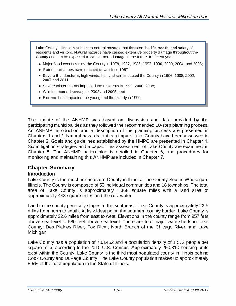
The update of the ANHMP was based on discussion and data provided by the participating municipalities as they followed the recommended 10-step planning process. An ANHMP introduction and a description of the planning process are presented in Chapters 1 and 2. Natural hazards that can impact Lake County have been assessed in Chapter 3. Goals and guidelines established by the HMPC are presented in Chapter 4. Six mitigation strategies and a capabilities assessment of Lake County are examined in Chapter 5. The ANHMP action plan is detailed in Chapter 6, and procedures for monitoring and maintaining this ANHMP are included in Chapter 7.
Chapter Summary Introduction
Lake County is the most northeastern County in Illinois. The County Seat is Waukegan, Illinois. The County is composed of 53 individual communities and 18 townships. The total area of Lake County is approximately 1,368 square miles with a land area of approximately 448 square miles and the rest water.
Land in the county generally slopes to the southeast. Lake County is approximately 23.5 miles from north to south. At its widest point, the southern county border, Lake County is approximately 22.6 miles from east to west. Elevations in the county range from 957 feet above sea level to 580 feet above sea level. There are four major watersheds in Lake County: Des Plaines River, Fox River, North Branch of the Chicago River, and Lake Michigan.
Lake County has a population of 703,462 and a population density of 1,572 people per square mile, according to the 2010 U.S. Census. Approximately 260,310 housing units exist within the County. Lake County is the third most populated county in Illinois behind Cook County and DuPage County. The Lake County population makes up approximately 5.5% of the total population in the State of Illinois.
Lake County, Illinois, is subject to natural hazards that threaten the life, health, and safety of residents and visitors. Natural hazards have caused extensive property damage throughout the County and can be expected to cause more damage in the future. In recent years:
• Major flood events struck the County in 1979, 1982, 1986, 1993, 1996, 2000, 2004, and 2008;
• Sixteen tornadoes have touched down since 1957;
• Severe thunderstorm, high winds, hail and rain impacted the County in 1996, 1998, 2002, 2007 and 2011
• Severe winter storms impacted the residents in 1999, 2000, 2008;
• Wildfires burned acreage in 2003 and 2005; and
• Extreme heat impacted the young and the elderly in 1999.

Lake County All Natural Hazards Mitigation Plan
Executive Summary ES-3 Review Draft August 2017
Planning Process
The HMPC followed a 10-step planning
process to update the ANHMP. The
HMPC met three times from June to
October 2016. The HMPC reviewed the
hazards and their effects on people and
property, considered a variety of ways
to reduce and prevent damage, and
recommended the most appropriate
and feasible measures for
implementation. Existing plans and
programs were reviewed during the
planning process. It should be
underscored that this ANHMP does not
replace other planning efforts, such as
community comprehensive plans, or the
Lake County Comprehensive
Stormwater Management Plan. This
ANHMP complements those efforts.
The public was invited to participate through several concurrent means, including the HMPC meetings, online surveys, paper surveys, press releases, newsletter articles, and the Lake County website. A public meeting was held on October 21, 2016 at the Lake County Administration Building in Waukegan, Illinois. The public comment period extended from October 21 to November 21, 2016.
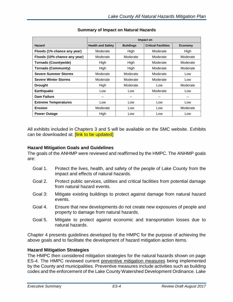
Natural Hazard Risk Assessment
The HMPC reviewed all potential natural hazards that could impact Lake County, and evaluated them based on their causes, their likelihood of occurring, and their impact on people, property, critical facilities, and the local economy. The information was based on available technical studies and reports by the participating agencies and communities and on their past experiences. The table below shows the natural hazards that are the focus of this ANHMP and provides a summary of the hazards’ potential impact on Lake County’s health and safety, total assets, and economy from the risk assessment.
The Planning Process
Lake County All Natural Hazards Mitigation Plan
Executive Summary ES-4 Review Draft August 2017
Summary of Impact on Natural Hazards
Impact on
Hazard Health and Safety Buildings Critical Facilities Economy
Floods (1% chance any year) Moderate High Moderate High
Floods (10% chance any year) Moderate Moderate Moderate Moderate
Tornado (Countywide) High High Moderate Moderate
Tornado (Community) High High Moderate Moderate
Severe Summer Storms Moderate Moderate Moderate Low
Severe Winter Storms Moderate Moderate Moderate Low
Drought High Moderate Low Moderate
Earthquake Low Low Moderate Low
Dam Failure -- -- -- --
Extreme Temperatures Low Low Low Low
Erosion Moderate Low Low Moderate
Power Outage High Low Low Low
All exhibits included in Chapters 3 and 5 will be available on the SMC website. Exhibits can be downloaded at: [link to be updated]
Hazard Mitigation Goals and Guidelines
The goals of the ANHMP were reviewed and reaffirmed by the HMPC. The ANHMP goals are:
Goal 1. Protect the lives, health, and safety of the people of Lake County from the impact and effects of natural hazards.
Goal 2. Protect public services, utilities and critical facilities from potential damage from natural hazard events.
Goal 3: Mitigate existing buildings to protect against damage from natural hazard events.
Goal 4. Ensure that new developments do not create new exposures of people and property to damage from natural hazards.
Goal 5. Mitigate to protect against economic and transportation losses due to natural hazards.
Chapter 4 presents guidelines developed by the HMPC for the purpose of achieving the above goals and to facilitate the development of hazard mitigation action items.
Hazard Mitigation Strategies
The HMPC then considered mitigation strategies for the natural hazards shown on page ES-4. The HMPC reviewed current preventive mitigation measures being implemented by the County and municipalities. Preventive measures include activities such as building codes and the enforcement of the Lake County Watershed Development Ordinance. Lake

Lake County All Natural Hazards Mitigation Plan
Executive Summary ES-5 Review Draft August 2017
County is very strong in preventive measures through floodplain regulations and sustainable projects.
Property protection mitigation measures are used to modify buildings or property subject to existing damage. The HMPC agreed that special attention should be given to floodplain areas and designated repetitively flooded areas. SMC should continue with their voluntary floodplain acquisition program. Many measures can be implemented by the property owners, such as dry and wet floodproofing. Appropriate government activities include public information, technical assistance and financial support. Emphasis has also been placed on critical facilities; understanding their vulnerability to wind and severe storm hazards.
Natural resource protection activities are aimed at preserving (or in some cases restoring) natural areas. They include preserving wetlands, control of erosion and sedimentation, stream restoration, and urban forestry. Urban forestry programs are encouraged to protect utility lines during wind and ice storms.
The HMPC called for a better understanding of flood and other hazards to improve emergency management – preparedness, response and recovery.
Structural mitigation projects, such as the regional detention basins are still important within the County’s comprehensive watershed management program. Additional watershed studies are still needed. The HMPC also recommended that each community establish a formal and regular program of drainage system maintenance and examine drainage improvements.
The HMPC identified numerous subject areas that would benefit from a coordinated public information program to focus on residents and property owners obtaining proper insurance and ways for people to protect themselves and their property from natural hazards.
Source: Daily Herald
Case Study: Lake County’s Flood Hazard Mitigation Program
The Lake County Stormwater Management Commission began purchasing repetitively damaged homes and properties in 1998 utilizing funds from FEMA’s Pre-Disaster Mitigation, Hazard Mitigation Grant, and Severe Repetitive Loss Grant programs.
Grant funding received to date amounts to over $9 million for the purchase of 198 structures and properties in the Village of Gurnee, the Village of Round Lake Heights, unincorporated Wauconda Township and other areas throughout the county. A mix of local cost-share funding has included Lake County’s Capital Improvement Program, local municipalities and SMC.
Lake County All Natural Hazards Mitigation Plan
Executive Summary ES-6 Review Draft August 2017
Mitigation Action Plan
The action plan outlines the recommended activities and initiatives to be implemented over the next five years. It is understood that implementation is contingent on the availability of resources (staff and funding). The action plan identifies those responsible for implementing the action items, and when they are to be completed.
Mitigation actions are not limited to those listed in the action plan. Other recommendations in this ANHMP (Chapter 5) should be implemented as opportunities arise.
There are 33 action items included in this ANHMP update. The first two action items are administrative. The first action item calls for the formal adoption of this ANHMP. Formal adoption is a requirement for recognition of the ANHMP by mitigation funding programs. The HMPC will provide the mechanism and a vehicle for the ANHMP to be implemented, monitored, evaluated and updated, and for continued public involvement. The HMPC will report to the County Board and municipal councils and boards, annually, and participate in the next five-year update.
The other action items are mitigation program items. Many are ongoing activities of stormwater management and emergency management offices and agencies. The action items were prioritized by the HMPC based on action that they felt should be implemented countywide and which each municipality should undertake. Below is a list summarizing the action items included in Chapter 6. Action items are also presented as community-specific action items in Chapter 6.
2017 ANHMP Action Items – for All Agencies and All Communities
• Adoption
• Monitor & Maintain
• Incorporate ANHMP in Other Plans
• Implement WDO & NFIP
• Public Information
• Alternate Power Sources
• Mitigation of Critical Facilities
• Capacity of Drainage Systems
• Maintain Drainage Systems
• Property Protection Projects
• Reduce Inflow and Infiltration
• Wind Mitigation & Safe Rooms
• Tree City USA
• NIMS Compliance
• Improve Building Codes
• Seek Grant Funding
• StormReady
• Emergency Response
• Response & Recovery Information
• CRS Participation
• Continue To Map Natural Hazard Impacts and Continue Vulnerability Assessments
• SMC Flood Mitigation Projects
• Development of Flood Stage Maps
• Snow Removal Plan
• Utility Tree Trimming

Lake County All Natural Hazards Mitigation Plan
Executive Summary ES-7 Review Draft August 2017
• Sump Pump Disconnects
• Local Drainage Studies
• Increase Detention
• Investigate Countywide Warning System
• Investigate Future Conditions and the Impacts on Depth and Frequency of Flooding
• Lincolnshire Creek Improvements
• Mitigate Septic Discharge; Leaching into Waterways
• Implement the FFRMS
Plan Adoption
This ANHMP serves to recommend mitigation measures for Lake County. Adoption is also a requirement for recognition of the ANHMP by FEMA for mitigation funding programs.
The adoption of this Lake County All Natural Hazards Mitigation Plan will be done by resolution of the County Board, the city councils, and boards of trustees of each participating municipality. The municipal resolutions will adopt each action item that is pertinent to the community and a person responsible for it will be assigned. With adoption, the County and each municipality are individually eligible to apply for FEMA mitigation grant funding.
Summary
This 2017 update to the ANHMP was developed by the Lake County HMPC as a multi-jurisdictional ANHMP to meet federal mitigation planning requirements. This ANHMP updated the examination of natural hazards facing Lake County, establishes mitigation goals, evaluates and highlights the existing mitigation activities underway in Lake County, and recommends a mitigation action plan for the County and municipalities to undertake in the next five years. The mitigation efforts included in this ANHMP are for protecting people, property and other assets of Lake County. Some action items are ongoing efforts; others are new. Implementation of all action items is contingent on the availability of staff and funding.
This ANHMP will be adopted by resolution by the County and each participating municipality. This ANHMP will be implemented and maintained through both countywide and individual initiatives, as funding and resources become available.

Lake County All Natural Hazards Mitigation Plan
Executive Summary ES-8 Review Draft August 2017
[This page intentionally left blank.]

Lake County All Natural Hazards Mitigation Plan
Planning Process 2-1 Review Draft August 2017
Chapter 1: Introduction Lake County, located in northeastern Illinois, is subject to natural hazards. Flooding, severe summer and winter storms, extreme cold and heat, and tornadoes are the most significant natural hazards that affect Lake County. These are some of the natural hazards that have the potential to threaten both life and property.
Significant tornadoes have struck the County in 1965, 1996, 1997. In the past, flooding is the natural hazard that has created the most damage and disruption to Lake County. Historical flooding in the Des Plaines watershed in 1986 caused over $6 million in property damage. Large flood events were also experienced in 1993, 1996, 2000, 2004 and 2013. Lake County can also experience dangerous winds. High winds reaching 66 miles per hour were recorded as recently as 2002 and 100 miles per hours in July 2011. The County is also susceptible to severe winter storms. The latest, in early 2011 where parts of Lake County received over 20 inches of snow. During this storm, winds over 60 miles per hour were recorded causing snow drifts as high as 7 feet and resulting in numerous traffic accidents and hundreds of stranded motorists. In April 2013, severe storms with intense rainfall created substantial flooding in urban areas; areas outside of the mapped floodplains. caused flood damage throughout much of northeastern Illinois.
Lake County understands the importance of addressing these natural hazards, as well as others, to minimize their damages and reduce chances for possible loss of life. Lake County mitigation programs include the implementation of the countywide Lake County Watershed Development Ordinance, developed by the Stormwater Management Commission (SMC) in 1992 to regulate new development so that flood problems do not increase and to limit building activities in the floodplain. Also, the SMC established a flood prone property buyout program to remove structures of high flood risk from flood problem areas. Since its establishment in 1997, this program had bought over 60 high-risk homes using Federal Emergency Management Agency (FEMA) mitigation
grant funds, State funds and local funds. Lake County and Lake County municipalities enforce building codes to protect structure from wind and seismic hazards.
Lake County and the planning committee developed and adopted the Lake County All Natural Hazards Mitigation Plan (ANHMP) in 2006 as a multi-jurisdictional plan. The ANHMP was updated in 2012. This Lake County ANHMP is an update to the 2012 plan.
STORMWATER MANAGEMENT COMMISSION

Lake County All Natural Hazards Mitigation Plan
Planning Process 2-2 Review Draft August 2017
1.1 Purpose of the Plan
The ANHMP allows Lake County and the participating communities eligible for hazard mitigation grant funding through the FEMA the Hazard Mitigation Assistance (HMA) program. The HMA program includes the Hazard Mitigation Grant Program, the Pre-Disaster Mitigation Program, and the Flood Mitigation Assistance funds. The HMA program administers the hazard mitigation components of the Disaster Mitigation Act of 2000 (Public Law 106-390) and the Stafford Act. Both Acts require communities to develop and adopt a FEMA-approved natural hazard mitigation plan before mitigation grant funds can be awarded.
This ANHMP meets all of FEMA’s hazard mitigation planning requirements including those of the FEMA National Flood Insurance Program’s (NFIP) Community Rating System (CRS). CRS allows participating communities to earn credit towards discounts in flood insurance premiums. HMA requires that mitigation plans be updated and readopted every five years. The Lake County SMC has received mitigation grant dollars from FEMA as a result of the ANHMP and the grants have benefited property owners in incorporated and unincorporated communities in Lake County.
The ANHMP has also been prepared so that Lake County and participating communities can take a proactive approach to reduce the impact of natural hazards. The ANHMP identifies the hazards affecting the County, assesses vulnerability to the hazards, determines those hazards that have the greatest effect, determines the capability of local government to implement mitigation actions, and then recommends actions that will avoid or minimize the vulnerabilities to the hazards.
Mitigation, as defined by the FEMA, is “sustained action to reduce or eliminate the long-term risk to people and property from hazards and their effects.” By evaluating the County’s geography, geology, climatology, economics, infrastructure, land use controls, development regulations and expected growth, we can understand natural hazard vulnerabilities. By exercising foresight when evaluating new development and redevelopment, and by taking actions to reduce the risk to the existing built environment, harm to people and damage to property from natural hazards can be reduced.
1.2 Organization of the Plan
This update of the ANHMP has been organized into seven chapters:
▪ Chapter 1 – Introduction - includes the ANHMP’s purpose and organization, provides an overview of County, a summary of Lake County land use, base maps, and a summary of critical facilities.
▪ Chapter 2 – Planning Process – presents the planning process followed for this update and summarized the changes made since the 2012 ANHMP. This chapter includes communities represented on the Lake County Hazard Mitigation Planning Committee.
▪ Chapter 3 – Risk Assessment - discusses the natural hazards that can impact Lake County as well as the summary of changes to these hazards found during the update process.

Lake County All Natural Hazards Mitigation Plan
Planning Process 2-3 Review Draft August 2017
▪ Chapter 4 – Mitigation Goals – presents the Lake County mitigation goals and guidelines.
▪ Chapter 5 – Mitigation Strategies and Capabilities Assessment – provides a description of six mitigation strategy categories and summarized mitigation activities already underway in Lake County and recommendations for additional activities. The Chapter also considers the current capabilities of the County and each municipality for implementing additional mitigation measures.
▪ Chapter 6 – Action Plan – discusses the consideration of countywide and community-specific mitigation action items to be implemented as staff and funding resources allow.
▪ Chapter 7 – Plan Maintenance – discussed plan adoption, outlines the ANHMP maintenance and monitoring efforts, continued public participation, and evaluating the plan.
1.3 Lake County Overview
Lake County is the most northeastern County in Illinois, and is part of the Chicago metropolitan area along with Cook, Will, Kane and DuPage Counties. The County Seat is Waukegan, Illinois. The total area of Lake County is approximately 1,368 square miles; with a land area of approximately 448 square miles and the rest water. Elevations in the county range from 957 feet above sea level to 580 feet above sea level. Land in the county generally slopes to the southeast. Much of the water area in Lake County is Lake Michigan.
The County is composed of 53 individual communities (some partially in other counties) and 18 townships. Lake County borders McHenry County to the west, Cook County to the south, and Lake Michigan to the east. Lake County is approximately 23.5 miles from north to south. At its widest point, the southern county border, Lake County is approximately 22.6 miles from east to west. A map of Lake County and municipalities is provided in Exhibit 1: Lake County Municipalities, and a map of the townships is provided in Exhibit 2: Lake County Townships.

Lake County All Natural Hazards Mitigation Plan
Planning Process 2-4 Review Draft August 2017
Exhibit 1: Lake County Municipalities

Lake County All Natural Hazards Mitigation Plan
Planning Process 2-5 Review Draft August 2017
Exhibit 2: Lake County Townships

Lake County All Natural Hazards Mitigation Plan
Planning Process 2-6 Review Draft August 2017
Watersheds: The Lake County has four main watersheds; the Fox River, the Des Plaines River, Lake Michigan and the North Branch Chicago River Watersheds. The Fox River and the Des Plainer River originate in Wisconsin. The Fox River flow travels south west into McHenry County. Des Plaines River and North Branch Chicago River flow south into Cook County. There are many lakes within the County, and the natural landscape is prairie grasses and hardwood forests.
Climate: Lake County has a temperate climate. Mean daily average temperatures during the winter in Lake County range from 20 to 32 degrees Fahrenheit. During the summer, this range is between 60 and 70 degrees Fahrenheit. July is the hottest month in Lake County with an average temperature of approximately 72.3 degrees Fahrenheit, while January is the coldest at 19.6 degrees Fahrenheit. The highest recorded temperature in the Chicago Metro area was 105 degrees Fahrenheit in 1934. The total average annual precipitation is 36.5 inches. Of this, 23.61 inches, or about 65%, will fall between April and September in Lake County.
Population: Lake County has a population of 703,462 and a population density of 1,572 people per square mile (2010 U.S. Census). There are approximately 260,310 housing units within the County. Lake County is the third most populated county in Illinois behind Cook County and DuPage County. The Lake County population makes up approximately 5.5% of the total population in the State of Illinois. The most populated municipality is the City of Waukegan with 89,078 people in the 2010 U.S. Census.
Population growth continues in the County, although the rate of growth has decreased since the 2000 census. Lake County and has grown in population 9.2% from 2000 to 2010; a higher percent change in the last decade then both Cook and DuPage Counties. This rate of growth is much higher than the growth rate of the entire state of Illinois, which was 3.3%. The Chicago Metropolitan Agency has projected population growth to continue for Lake County, with a projected population of over 950,000 by the year 2040, with nearly 327,000 households. This would represent population growth rate of over 30% from 2010 figures, and a 25% housing growth rate. Population data from the 2000 and 2010 Census are presented in Table 1: Lake County Township Population Data and Table 2: Lake County Municipalities Population Data.
Employment: The 2009 estimated a workforce in Lake County was 359,335. The County’s manufacturing sector employs the most people, accounting for 19.2% of the total workforce. Other notable sectors include retail trade (13.6%), heath care and social assistance (11.3%) and finance and insurance (7.8%). Figure 1: Lake County Employment demonstrates the employment break down by sector in Lake County.
The top employer in Lake County is the Great Lakes Naval Station operated by the U.S. Department of Navy. Great Lakes Station employs approximately 26,200 people. Great Lakes serve as the Navy’s largest training center, as is the biggest military installation of any kind in the state of Illinois. The second largest employer in Lake County is Abbott Laboratories, which employs approximately 13,000 people.

Lake County All Natural Hazards Mitigation Plan
Planning Process 2-7 Review Draft August 2017
Table 1: Lake County Township Population Data
Township
Lake County
2000 Population
2010 Population
2040 Population (Projected)
Antioch Township 21,878 27,745 44,400
Avon Township 54,950 65,001 91,008
Benton Township 17,229 18,951 29,434
Cuba Township 15,728 16,826 18,765
Ela Township 39,688 42,654 50,724
Fremont Township 23,955 32,337 43,646
Grant Township 17,277 26,523 36,679
Lake Villa Township 33,693 40,276 53,306
Libertyville Township 48,876 53,139 64,852
Moraine Township 34,508 34,129 49,232
Newport Township 4,120 6,770 9,701
Shields Township 43,484 39,062 31,506
Vernon Township 65,379 67,095 86,024
Warren Township 59,618 64,841 79,332
Wauconda Township 16,384 21,730 35,089
Waukegan Township 92,693 90,893 105,419
West Deerfield Township 31,846 31,077 39,942
Zion Township 23,050 24,413 27,283
Total: 644,356 703,462 896,341
Sources: 2000 and 2010 U.S. Census
Table 2: Lake County Municipalities Population Data
Lake County
Population Population
Community 2000 2010 2040
(Projected) Community 2000 2010
2040 (Projected)
Village of Antioch 8,788 14,430 20,325 Village of Libertyville 20,742 20,315 24,113
Village of Bannockburn 1,429 1,583 - Village of Lincolnshire 6,108 7,275 8,341
Village of Barrington* 4,461 4,996 1,528 Village of Lindenhurst 12,539 14,462 15,771
Village of Barrington Hills* 503 595 5,141 Village of Long Grove 6,735 8,043 15,413
Village of Beach Park 10,072 13,638 703 Village of Mettawa 367 547 1,492
Village of Buffalo Grove* 28,491 27,852 18,152 Village of Mundelein 30,935 31,064 39,558
Village of Deer Park* 3,093 3,183 29,134 Village of North Barrington 2,918 3,047 3,051
Village of Deerfield* 18,109 8,053 3,566 City of North Chicago 35,918 32,574 23,346

Lake County All Natural Hazards Mitigation Plan
Planning Process 2-8 Review Draft August 2017
Lake County
Population Population
Community 2000 2010 2040
(Projected) Community 2000 2010
2040 (Projected)
Village of Fox Lake* 8,969 10,082 25,151 Village of Old Mill Creek 251 178 1,711
Village of Fox River Grove* 173 487 12,663 City of Park City 6,637 7,570 4,910
Village of Grayslake 18,506 20,957 530 Village of Port Barrington* 177 594 954
Village of Green Oaks 3,572 3,866 28,233 Village of Riverwoods 3,843 3,660 3,285
Village of Gurnee 28,834 31,295 5,188 Village of Round Lake 5,842 18,289 25,465
Village of Hainesville 2,129 3,597 34,714 Village of Round Lake Beach 25,859 28,175 35,225
Village of Hawthorn Woods 6,002 7,663 5,937 Village of Round Lake Heights 1,347 2,676 2,463
City of Highland Park 31,365 29,763 40,994 Village of Round Lake Park 6,038 7,505 9,794
City of Highwood 4,143 5,405 7,771 Village of Third Lake 1,355 1,182 547
Village of Indian Creek 194 462 - Village of Tower Lakes 1,310 1,283 1,468
Village of Island Lake* 3,131 3,319 3,863 Village of Vernon Hills 20,120 25,113 27,040
Village of Kildeer 3,460 3,968 6,279 Village of Volo 180 2,929 8,077
Village of Lake Barrington 4,757 4,973 5,202 Village of Wadsworth 3,083 3,815 4,827
Village of Lake Bluff 6,056 5,722 6,512 Village of Wauconda 9,448 13,603 13,580
City of Lake Forest 20,059 19,375 25,777 City of Waukegan 87,901 89,078 106,991
Village of Lake Villa 5,864 8,741 13,643 Village of Winthrop Harbor 6,670 6,742 10,609
Village of Lake Zurich 18,104 19,631 21,201 City of Zion 22,866 24,413 27,283
Village of Lakemoor* 986 3,468 4,119 Unincorporated Lake County
83,917 82,220 144,974
Total: 644,356 703,462 896,341
* Municipalities with corporate limits in either Cook or McHenry Counties Sources: 2000 and 2010 U.S. Census

Lake County All Natural Hazards Mitigation Plan
Planning Process 2-9 Review Draft August 2017
Figure 1: Lake County Employment
Source: Workforce Strategies, Inc., US Bureau of Labor Statistics, US Census Bureau
Schools: Lake County has about 55 elementary and high school districts. They are shown in Exhibit 3: Lake County Elementary School Districts and Exhibit 4: Lake County High School Districts. Colleges include: College of Lake County in Grayslake (also in Vernon Hills and Waukegan), Lake Forest College in Lake Forest, Trinity International University in Deerfield, and Rosalind Franklin University in North Chicago.

Lake County All Natural Hazards Mitigation Plan
Planning Process 2-10 Review Draft August 2017
Exhibit 3: Lake County Elementary School Districts

Lake County All Natural Hazards Mitigation Plan
Planning Process 2-11 Review Draft August 2017
Exhibit 4: Lake County High School Districts

Lake County All Natural Hazards Mitigation Plan
Planning Process 2-12 Review Draft August 2017
1.4 Lake County Land Use and Development
Current Land Use: Lake County covers approximately 448 square miles of land area. Approximately 11.7 % of Lake County is in the 100-year floodplain according to 2009 FEMA estimates. The most current Lake County land use data is presented in Figure 2: Lake County Current Land Use and Table 3: Current Land Use. Total residential land use is the largest land use in Lake County, accounting for over 26% of the land. Public and private open space is also a large land usage, accounting for over 19% of the total land area. Exhibit 5: Lake County Current Land Use shows current land use in Lake County.
Future Land Use: Figure 3: Lake County Future Land Use Percentiles and Table 4: Planned Future Land Uses demonstrate the estimated future lands uses within Lake County. The time table for these future estimates is approximately 2020 to 2030. Areas to be designated for public and private open space utilize the most land area in Lake County, accounting for over 20% of land. Single family residential lots from 0.25 to 1 acre account for nearly 12% of future use, while single family medium residential lots from 1 to 3 acres’ account for over 16%. Future land used for transportation purposes is estimated at over 10%.
Development Trends: Development is expected to continue throughout Lake County. As mentioned above, the Chicago Metropolitan Agency has projected that Lake County will grow to 327,000 households by the year 2040, from the current estimate of 260,310. This would represent over a 25% housing growth rate from 2010 figures.
Lake County places high importance on protecting their environmental resources, including the lakes, rivers and open spaces. Many communities have identified green space as an important quality of life factor in Lake County. Exhibit 6: Lake County Environmental Resources Inventory presents Lake County Environmental Resource Inventory Map, which shows the location of developed areas, Illinois Natural Areas Inventory Areas, Illinois Biological Survey Stream Corridors, Protected Conservation-Oriented Open Space, Other Public and Private Open Space, Surface Water including Floodplains, Floodways, Wetlands, and Stormwater Management Commission Flood Hazard Mitigation Areas, areas of Steep Slopes and areas of Hydric Soils. This data has been used by Lake County in the development of future comprehensive plans to allow for policies and actions by county agencies and the municipalities that respect environmental and cultural resources, while accommodating desirable development.

Lake County All Natural Hazards Mitigation Plan
Planning Process 2-13 Review Draft August 2017
Figure 2: Lake County Current Land Use
Table 3: Current Land Use
Land Use Acres Percent
Agricultural 35,021 11.63%
Disturbed Land 4,938 1.64%
Forest/Grassland 27,970 9.29%
Government/Institutional 7,931 2.63%
Industrial 6,874 2.28%
Office/Research 2,046 0.68%
Public/Private Open Space 57,745 19.17%
Residential 78,748 26.14%
Retail/Commercial 6,318 2.10%
Transportation 31,945 10.60%
Utility/Waste Facilities 4,298 1.43%
Water (excluding Lake Michigan) 21,032 6.98%
Wetlands 16,369 5.43%
Total 301,234 100.00%
Agricultural11.63%
Disturbed Land1.64%
Forest/Grassland/Beach
9.29%
Government/Institutional
2.63%
Industrial2.28%
Office/Research0.68%
Public/Private Open Space
19.17%
Residential26.14%
Retail/Commercial2.10%
Transportation10.60%
Utilities/Waste Facilities
1.43%
Water (excluding Lake Michigan)
6.98%Wetlands
5.43%

Lake County All Natural Hazards Mitigation Plan
Planning Process 2-14 Review Draft August 2017
Figure 3: Lake County Future Land Use Percentiles
Table 4: Planned Future Land Uses
Land Use Acres Percent
Agriculture 16,648 5.53%
Gateway 798 0.26%
Government and Institutional 9,458 3.14%
Industrial 11,651 3.87%
Mixed Use 2,640 0.88%
Office and Research Parks 6,721 2.23%
Proposed Public and Private Open Space 14,659 4.87%
Public and Private Open Space 49,972 16.60%
Residential Single Family (0.25 - 1 acre) 34,944 11.60%
Retail 13,636 4.53%
Residential Single Family Large Lot (> 3 acres) 15,536 5.16%
Residential Multifamily 4,301 1.43%
Residential Single Family Medium Lot (1 -3 acres) 49,202 16.34%
Residential Single Family Small Lot (< 0.25 acres) 16,775 5.57%
Transportation (Including ROW) 31,483 10.46%
Utility/Waste 3,869 1.28%
Water 18,830 6.25%
Total 301,122 100%
Agriculture, 5.53% Gateway, 0.26% Government and Institutional, 3.14%
Industrial, 3.87%
Mixed Use, 0.88%Office and
Research Parks, 2.23%Proposed Public and
Private Open Space, 4.87%
Public and Private Open Space,
16.60%
Residential Single Family (0.25 - 1 acre),
11.60%
Retail, 4.53%
Residential Single Family Large Lot (> 3
acres), 5.16%
Residential Multifamily, 1.43%
Residential Single Family Medium Lot (1 -3 acres),
16.34%
Residential Single Family Small Lot (< 0.25 acres), 5.57%
Transportation (Including ROW),
10.46%
Utility/Waste, 1.28%
Water, 6.25%

Lake County All Natural Hazards Mitigation Plan
Planning Process 2-15 Review Draft August 2017
Exhibit 5: Lake County Current Land Use

Lake County All Natural Hazards Mitigation Plan
Planning Process 2-16 Review Draft August 2017
Exhibit 6: Lake County Environmental Resources Inventory
Lake County All Natural Hazards Mitigation Plan
Planning Process 2-17 Review Draft August 2017
1.5 Lake County Critical Facilities
Critical facilities are buildings and infrastructure whose exposure or damage can affect the wellbeing of a large group. The continued operation of critical facilities is vital to preparedness, response and recovery from any sort of event. Critical facilities are generally placed into two categories:
– Buildings or locations vital to public safety and the disaster response and recovery effort, such as police and fire stations and communication systems, and
– Buildings or locations that, if damaged, would create secondary disasters. Examples of such buildings or locations are hazardous materials facilities and nursing homes.
Critical facilities are not strictly defined by any agency. For this mitigation planning effort, categories of critical facilities were used, including County, municipal and township facilities, police and fire stations, public, educational/school facilities, places of assembly, medical and health care, facilities for special needs populations, transportation, and infrastructure.
Critical facilities were identified by the County and each municipality for the ANHMP update. Lake County GIS Department maintained a database and GIS layers for critical facilities, however the County made use of this planning opportunity to update the critical facilities list.
Table 5: All Lake County Critical Facilities and Exhibit 7: Lake County Critical Facilities present the critical facility data for Lake County. Table 5 summarizes critical facilities located in the 100-year floodplain. There are 21 critical facilities in the 100-year floodplain
Further investigation into critical facility locations, use of critical facility mapping, and protection of critical facilities is discussed in Chapters 3 and 5 of this ANHMP.
Critical Facilities
(FEMA definition)
Hospitals, nursing homes, and housing likely to contain
occupants who may not be sufficiently mobile to avoid
death or injury during a flood.
Police stations, fire stations, vehicle and equipment
storage facilities, and emergency operations centers
that are needed for flood response activities before
during and after a flood.
Public and private utilities that are vital to maintaining or
restoring normal services to impacted areas before
during and after an event.
Structures or facilities that produce, use or store highly
volatile, flammable, explosive, toxic and/or water
reactive materials.
Other Critical Facilities
(Lake County additions)
Schools and institutions

Lake County All Natural Hazards Mitigation Plan
Planning Process 2-18 Review Draft August 2017
Table 5: All Lake County Critical Facilities
Table 6: Lake County Critical Facilities Located in the 100-year Floodplain
Critical Facility Category Number
Airports 7
City Halls 45
Colleges/Universities 21
Day Care Facilities 814
Fire Departments 65
Government Buildings 17
Health Department Offices 18
Helipads 11
Hospitals 7
Libraries 30
Metra Rail Stations 31
Museums 38
Nursing Homes/Long Term Care Facilities 53
Police Stations 40
Schools 335
Township Offices 25
1557
Critical Facility Category Number
Airports 2
City Halls 1
Colleges/Universities 0
Day Care Facilities 10
Fire Departments 1
Government Buildings 0
Health Department Offices 0
Helipads 1
Hospitals 0
Libraries 0
Metra Rail Stations 0
Museums 2
Nursing Homes/Long Term Care Facilities 1
Police Stations 2
Schools 1
Township Offices 0

Lake County All Natural Hazards Mitigation Plan
Planning Process 2-19 Review Draft August 2017
Exhibit 7: Lake County Critical Facilities

Lake County All Natural Hazards Mitigation Plan
Planning Process 2-20 Review Draft August 2017
[This page intentionally left blank.]

Lake County All Natural Hazards Mitigation Plan
Planning Process 2-1 Review Draft August 2017
Chapter 2: Planning Process
2.1 Planning Approach
The Lake County ANHMP was first developed in 2006 utilized the four phases or steps of hazard mitigation planning as recommended by FEMA in the “State and Local Mitigation Planning How-To Guides” (FEMA 386-1 to 4) for the Disaster Mitigation Act (DMA) and the Hazard Mitigation Assistance (HMA) program. The 2012 update of the ANHMP expanded the planning phases to the 10-step approach recommended by FEMA through the Community Rating System (CRS) program, shown in Figure 4.
Figure 4: Planning Steps
FEMA “How-To Process (2006) FEMA 10-Step Process (current)

Lake County All Natural Hazards Mitigation Plan
Planning Process 2-2 Review Draft August 2017
For the 2017 update to the ANHMP, the FEMA 10-step process was again utilized, while ensuring that the requirements for DMA/HMA were met. The FEMA 10-step process allows provides Lake County with a more tailored approach to the ANHMP update and allows the ANHMP to qualify for credit under the CRS program.
The update to the ANHMP was conducted with the input of the Lake County Hazard Mitigation Planning Committee. In the 2006 and 2012 plan, the committee was called the Local Planning Committee, or LPC. The LPC was re-named in 2016 to avoid confusion with the Lake County Local Emergency Management Committee, or LEPC.
The Lake County Hazard Mitigation Planning Committee (HMPC) includes several
Lake County departments and agencies and Lake County municipalities. The HMPC
has been has been meeting annually since 2006. Regional, state and federal agencies
were invited to join the HMPC for the update of the ANHMP, and all meetings were
open to the public. Participating members of the HMPC as well as all participants who
attended one or more meetings is presented in Appendix A. Some small municipalities
were represented by the Lake County staff.
A kickoff meeting with Lake County staff was held in April 2016. The HMPC met three times from June to October 2016 for the 2017 update of the ANHMP. The efforts of the HMPC were coordinated by the Lake County Stormwater Management Commission (SMC), Lake County Emergency Management Agency (LCEMA) and the Department of Planning, Building and Development. Other County departments participated and provided support for the plan update. Technical support for the HMPC and the ANHMP update was provided by Molly O’Toole & Associates, Ltd. (MO&A). MO&A is an engineering consulting firm that specializes in hazard mitigation. The update of the 2017 risk assessment was provided by Knight Engineers and Architects, Inc. (Knight E/A) and they also assisted at the HMPC meetings and with other efforts.
2.2 Update Process – Organization and Coordination
Organization (Step 1) for the 2017 update began with the County and the MO&A in
April 2016. The HMPC was brought
together for the first meeting in
ANHMP update process in June
2016. Note that Lake County village
boards and city councils provided
SMC with “letters of intent” for
participation in the 2012 ANHMP
update at the time of the SMC grant
application to the Illinois Emergency
Management Agency, and they were
asked to pass a resolution of
participation. This intent and participation was carried over to the 2017 update effort.

Lake County All Natural Hazards Mitigation Plan
Planning Process 2-3 Review Draft August 2017
Opportunities for neighboring counties in both Illinois and Wisconsin, agencies, nonprofits, and other interested parties to be involved in the planning process were made available, including:
• U.S. State Geological Survey
• National Weather Service
• Federal Emergency Management Agency
• Illinois Emergency Management Agency
• Illinois Department of Natural Resources, Office of Water Resources
• Illinois Department of Natural Resources, State Water Survey
• American Red Cross
• Fox Waterway Agency
Coordination (Step 3) with these organizations was accomplished through meetings, phone conversations and/or e-mail exchanges. During the planning process, the interested agencies were kept informed and invited to provide any comments in time for the public meeting.
Existing plans and programs of other agencies were reviewed throughout the planning process. Plans reviewed and incorporated are discussed further in Chapters 3 -5.
Public Involvement: Step 2 of the planning process was to obtain input from the public, particularly property owners that have been affected by natural hazards. The public was invited to participate through several concurrent means, including:
• Contact with HMPC members and their organizations
• A standing invitation to attend HMPC meetings
• Property owner survey
• Press releases provided to local newspapers and included in the Lake County “E-Newsletter” and newspaper coverage
HMPC meetings and the ANHMP update process were publicized through media and the Lake County SMC website, community newsletters, and local newspapers. Examples of public involvement efforts are provided in Appendix B.
Lake County residents were invited to provide public input to the planning process through “Survey Monkey,” an online survey tool. The web link was included in news releases and promoted by HMPC members. Printed copies of the survey were also made available at village/city halls. The survey was open from June through October 2016. Ten questions were presented and results were used to evaluate the prioritization of natural hazards and to develop a sense of citizens’ understanding of their mitigation needs. The questions were the same as those used in 2012 to look for changes and trends.

Lake County All Natural Hazards Mitigation Plan
Planning Process 2-4 Review Draft August 2017
Residents from 35 communities participated in the survey. Respondents ranked tornadoes, high wind/microbursts, snow storms, floods and severe winter and ice storms, and severe summer storms as hazard events of the greatest concern. Drought and groundwater issues were of notable concern, along with shoreline erosion. Overall, people feel more prepared for hazards. In 2012, 15% of respondents felt “not at all prepared.” In 2016, this number dropped to less than 10%. About 50% of respondents felt “somewhat prepared” for hazard events and 26% felt “adequately prepared.” Nearly 66% of respondents answered “websites” for the question of effective ways to receive information on how to protect yourself. Respondents rely on social media, television, and radio and their local government for hazard information and information on how to protect themselves.
Public meeting: The 2017 draft Lake County All Natural Hazards Mitigation Plan was made available at the SMC website. Per SMC's own policies, adjacent jurisdictions and state and regional agencies were invited to review the draft plan a 30-day comment period. Press releases included where the public could view the plan and forward comments. The public comment period extended from October 21 to November 21, 2016.
A public meeting was held on October 21, 2016 at the Lake County Administration Building in Waukegan, Illinois, for review and comments on the ANHMP update. This public meeting included an HMPC meeting to discuss the 2017 action plan (Chapter 6).
Hazard Assessment and Problem Evaluation: Steps 4 and 5 make up the updated ANHMP risk assessment (Chapter 3). The natural hazards identified are based on previous plans, a 2011 HMPC prioritization exercise, and hazard events that occurred in Lake County between 2012 and 2016. During the June 2016 HMPC meeting, the hazard prioritization was re-confirmed from the previous plans.
Chapter 3 examines the hazards, including a hazard assessment (what causes the hazard and the likelihood of occurrence), and provides a vulnerability assessment that estimates the impact of the hazard on life, health, property (e.g., homes, businesses and critical facilities). The tasks involved with conducting the risk assessment for this plan included; hazard identification, inventory of community assets vulnerable to the hazards, hazard events profile, magnitude, history, probability, impacts, flood insurance claims, repetitive losses, flood audits, future development trends, and
Lake County All Natural Hazards Mitigation Plan
Planning Process 2-5 Review Draft August 2017
mapping these components. Data was collected from all participating communities from June through October 2016 for the update of Chapter 3.
Developing Goals: Mitigation planning goals were developed by the HMPC for the update of the ANHMP. A goal setting exercise was conducted for the 2012 plan update. The goals and guidelines (objectives) presented in Chapter 3 were reaffirmed at the June 2016 HMPC meeting.
Mitigation Strategy: For the 2012 update of the ANHMP, mitigation strategies were developed for all priority natural hazards discussed in the risk assessment, and presented in Chapter 5. The mitigation strategies are organized into six general categories and all measures were reviewed in relationship to the goals guidelines. The six mitigation categories include: preventive measures, property protection, resource protection, emergency services, structural measures, and public information activities. The mitigation strategy recommendations and the capabilities of Lake County presented in Chapter 5 were updated based on the HMPC discussion at the July 2016 meeting, and the data collected from all participating communities from June through October 2016.
Action Plan: At the July 2016 and October 2016 HMPC meetings, an updated action plan was formulated. Both countywide and community-specific action items were considered. The 2012 ANHMP action items were evaluated along with new action items formulated because of recent hazard events, and based on new opportunities. Appendix C provides a summary of changes made from the 2012 action plan to the current action plan.
2.3 Plan Adoption and Implementation
The County Board will adopt the 2017 ANHMP for the unincorporated areas of Lake County and the individual municipalities will adopt the plan for the incorporated areas (Action Item 1). Implementation of the updated ANHMP and the implementation steps were discussed at the October 2016 meeting of the HMPC. Plan maintenance approach is discussed in Chapter 7 (and Action Item 2).

Lake County All Natural Hazards Mitigation Plan
Planning Process 2-6 Review Draft August 2017
[This page intentionally left blank.]

Lake County All Natural Hazards Mitigation Plan
Risk Assessment 3-1 Review Draft August 2017
Chapter 3: Risk Assessment This chapter provides a risk assessment of natural hazards that could impact Lake County. The risk assessment is a continuation of the assessment provided in the 2006 ANHMP and the 2012 update. Hazards have been evaluated based on HMPC input provided at the June and July 2016 meetings and questionnaires. Hazard information has also been updated based on natural hazard events over the past five years, and available data and mapping. The risk assessment for priority hazards such as severe storms and floods, include a hazard analysis and a vulnerability assessment. Other hazards, such as earthquakes and dam failure, include only a hazard profile in this ANHMP update. The hazard profile includes a description of the nature of the hazard, past occurrences and damages, and the likelihood or probability of the hazard occurring in the future. Lake County assets when applicable have been examined to estimate potential exposure and potential losses attributable to these natural hazards for use in the vulnerability assessment. A summary of the risk assessment for Lake County is provided at the end of this Chapter.
3.1 Natural Hazards in Lake County
A key step in preventing disaster losses in Lake County is developing a comprehensive understanding of the hazards that pose risks to its communities. The risk assessment terms in Table 7 can be found throughout this ANHMP. The hazard profile includes a description of the nature of the hazard, past occurrences and damages, and the likelihood or probability of the hazard occurring in the future. Lake County assets when applicable have been examined to estimate potential exposure and potential losses attributable to these natural hazards for use in the vulnerability
assessment.
Table 7: Defined Risk Assessment Terms
HAZARD Event or physical conditions that have the potential to cause fatalities, injuries, property damage, infrastructure damage, agricultural loss, damage to the environment, interruption of business, other types of harm or loss
RISK Product of a hazard’s likelihood of occurrence and its consequence to society
VULNERABILITY Degree of susceptibility and resilience of the community and environment to hazards
Source: Federal Emergency Management Agency, 2001
The local risk assessment summary is a process or application of a methodology for evaluating risk as defined by probability and frequency of occurrence of a hazard event, exposure to people and property to the hazard, and consequences of that exposure. Different methodologies exist for assessing the risk of hazard events, ranging from qualitative to quantitative.
A list of potential hazards was reviewed by the HMPC at the May 2011 meeting to determine if the classification of high, moderate and low-risk hazards described in the 2006 ANHMP were still applicable. The HMPC completes a natural hazard screening worksheet. This worksheet allowed the committee to view a list of potential hazards

Lake County All Natural Hazards Mitigation Plan
Risk Assessment 3-2 Review Draft August 2017
that could affect Lake County. Committee members were asked to then rank the impact on their community (low, medium or high), assess the frequency (never, occasional or frequent), impact or consequences (none, low, moderate or serious), and area of vulnerability (none, neighborhood, community or county) for each hazard.
• Low – means an event with minor impact on people, property and/or
community operations and recovery is within the individual and/or
community capabilities.
• Moderate – means an event that will impact people, property and/or
community operations such that people need community assistance. A
moderate amount of time will be needed for recovery. County, state or
federal assistance may be required.
• High or Serious – means an event that will severely impact people,
property and/or community operations. A significant amount of time will
be needed for recovery. County, state and federal assistance will be
required.
Exercise scores were evaluated and regardless of emphasis put on the impact of the hazard or the area of vulnerability, the highest ranked hazards were Tornado, severe summer and severe winter storms, flood and extreme heat. The results are included in Table 8. Priority natural hazards were selected for analysis from that review. Hazards were ranked to provide structure and prioritize the mitigation goals and actions discussed in this ANHMP. At the June 2016 meeting, the HMPC was polled and indicated that it was in general agreement that these hazards should be included in the 2017 ANHMP.
Table 8: Hazard Mitigation Planning Committee Hazard Exercise Ranking
Total Impact of Hazard Area of Vulnerability
Severe Winter Storm Tornado Tornado
Tornado Severe Summer Storm Severe Summer Storm
Severe Summer Storm Severe Winter Storm Severe Winter Storm
Extreme heat Flood Extreme heat
Flood Extreme heat Flood
Drought Groundwater Drought
Groundwater Drought Groundwater
Earthquake Earthquake Earthquake
Erosion Erosion Erosion
Dam Failure Dam Failure Dam Failure
Seiche Seiche Seiche
Wildfire Wildfire Wildfire

Lake County All Natural Hazards Mitigation Plan
Risk Assessment 3-3 Review Draft August 2017
Table 9 presents a list of all disaster and emergency declarations that have occurred in Lake County, according to the FEMA through October 2016. This list presents the foundation for identifying what hazards pose the greatest risk within Lake County.
Table 9: Presidential Disaster (DR) & Emergency Declarations (EM)
in Lake County
Declaration Number
Declaration Date Event Details
FEMA DR-194 April 25, 1965 Tornadoes, Severe Storms, and Flooding
FEMA DR-227 April 25, 1967 Tornadoes
FEMA DR-373 April 26, 1973 Severe Storms, Flooding
FEMA EM-3068 January 16, 1979 Blizzards and Snowstorms
FEMA DR-776 October 7, 1986 Severe Storms and Flooding
FEMA DR-997 July 9, 1993 Great Midwest Flood
FEMA DR-1110 April 23, 1996 Tornadoes, Severe Storms
FEMA EM-3134 January 8, 1999 Winter Snow Storm
FEMA EM-3161 January 17, 2001 Severe Winter Storm
FEMA EM-3230 September 7, 2005 Hurricane Sheltering
FEMA DR-1729 September 25, 2007 Severe Storms and Flooding
FEMA EM-3283 March 13, 2008 Snow
FEMA DR-1771 June 24, 2008 Severe Storms and Flooding
FEMA DR-1960 March 17, 2011 Severe Winter Storm and Snowstorm
FEMA DR-4116 May 10, 2013 Severe Storms, Straight-Line Winds and Flooding
Note that five federal disasters were declared in Lake County since the adoption of the 2006 ANHMP. Also, while Lake County was not included, Cook County to the south of Lake County had two disasters declared: DR 1800 for flooding on September 13, 2008 and DR 1935 for flooding in July-August 2010. Lake County was impacted by these events, but damage did not warrant the county being included in the declaration.
Based on the input from the HMPC and the record of hazard events in Lake County, the priority hazards for the 2012 ANHMP were determined. These priorities were reevaluated at the June 2016 meeting and it was decided that power outages should be added to the list of priority hazards. More attention should also be given to ravine erosion. Lake County priority hazards include:
• Flood • Shoreline and Coastal Erosion
• Tornado • Ravine Erosion
• Severe Summer Storms • Drought
• Severe Winter Storms • Earthquake
• Dam Failure • Power Outages
• Extreme Temperatures

Lake County All Natural Hazards Mitigation Plan
Risk Assessment 3-4 Review Draft August 2017
Some of these hazards can be interrelated. For example, severe thunderstorms can produce high winds which can cause tornado activity. Thus, discussion of these hazards may overlap where necessary throughout this risk assessment. Also, some hazardous elements include lightning and hail activity; discussion of seiche and derechos. The risk assessment for priority hazards such as severe storms and floods, include a hazard analysis and a vulnerability assessment. Other hazards, such as earthquakes and dam failure, include only a hazard profile in this ANHMP update. While the HMPC understands that power outage is most often a secondary hazard to natural hazards, they felt it should be evaluated and mitigation strategies should be identified.
Table 10 summarized the status of hazards considered in the ANHMP risk assessment from the 2006 to this update. As shown, hazards were either continued, deleted, changed, or new hazards were identified.
Table 10: Evaluation of Hazards for Inclusion in 2017 Risk Assessment
Year Added
HAZARD Status 2017 Hazard
2006 Flood Continued Flood
2006 High Wind Changed in 2012
Severe Summer Storms 2006 Severe Thunderstorm Changed in 2012
2006 Hail Changed in 2012
2006 Severe Winter Storm Continued Severe Winter Storm
2006 Tornado Continued Tornado
2006 Dam Failure Continued Dam Failure
2006 Wildfire Deleted
2006 Ravine Bank Erosion Changed in 2012 and 2017 Riverine and Ravine
2006 Lake Erosion Changed in 2012 and 2017 Shoreline Erosion
2006 Extreme Heat Changed in 2012 Temperature Extremes (Heat and Cold)
2012 Drought Continued Drought
2012 Earthquake Continued Earthquake
2017 Power Outages New Hazard Power Outages
3.2 Summary of Lake County Assets
Lake County assets include people, buildings, infrastructure, businesses and institutions, the land and natural resources. Chapter 1 of this ANHMP presents population, workforce, land use, development trend and critical facility data. Lake County assets are summarized in Table 11. Table 11 was developed from Lake County data and 2010 Census data. Table 12 summarized the number of building in the Lake County municipalities and the unincorporated portion of the County.
According to the 2010 Census, the 2005-2009 median value for Lake County was $288,600. This higher median value will be used in this risk assessment. The economy had not changed substantially since 2010, so this median value is used in this risk assessment. The 2010 Census has the total number of housing units estimated to be 260,310. Table 12 shown the total number of structures in Lake County at 301,574. The total

Lake County All Natural Hazards Mitigation Plan
Risk Assessment 3-5 Review Draft August 2017
market value for all structures in Lake County was estimated to be approximately $60.2 billion (see Table 12). This figure was determined using a 3.2 multiplier on the assessed or taxable value of buildings. It should be noted that for the SMC’s floodplain buyout program, a multiplier of 3.4 is used to estimate property acquisition costs. This is to say, that the building value in Lake County exceeds $60.2 billion. Note that estimates of assets and values used in this risk assessment are for the purpose of evaluating and ranking potential hazards against the potential damage or loss of assets.
Table 11: Summary of Lake County Assets
Population1 (People) 703,462
No. of
Structures2
No. of Named Facilities4
Buildings (Total) 301,574 --
General/Residential 294,229 --
Government Owned (Local, County, State, Federal) 2,584 212
Medical, Education and Other Non-Residential 4,650 --
Medical (Total) 241 78
Hospitals 10 7
Other (Clinics, Care Centers, Public Health) 231 71
Education (Total) 901 248
Elementary 151 142
Middle School 34 34
High School 42 41
College/University 207 10
Other (Montessori, Day School, etc.) 467 21
Other Non-Residential (Total) 3,508 729
Commercial 635 193
Religious 821 310
Recreation 1,802 81
Cultural/Heritage (includes libraries and museums) 90 58
Hotels 119 64
Community Centers 41 23
Transportation3 No. of miles or facilities
Roads (miles) 3,918
Bridges 878
Airports 2 2
Rail Stations 29 29
Resources3 Acres
Forest Preserves (Acres) 30,524
State Parks (4) (Acres) 8,051
Community Parks (743) (Acres) 8,910
Golf Courses (58) (Acres) 9,568
Agricultural (Acres) 35,022
1 2010 Census 2 Estimate for 2016 ANHMP 3 Other County or Municipal or Township Sources 4 This number is a subset of the Number of Structures and represents the actual number of facilities (i.e. There is one College of Lake County, but the campus may have several buildings on site).

Lake County All Natural Hazards Mitigation Plan
Risk Assessment 3-6 Review Draft August 2017
Table 12: Summary of Lake County Buildings and Building Value
Municipality # of
Structures1
% of Total
County Building Value2 Market Value3
City of Highland Park 13,457 4.46% $1,524,926,103 $4,879,763,530
City of Highwood 1,640 0.54% $104,246,827 $333,589,846
City of Lake Forest 8,838 2.93% $1,473,004,446 $4,713,614,227
City of North Chicago 7,326 2.43% $126,721,999 $405,510,397
City of Park City 2,849 0.94% $33,770,493 $108,065,578
City of Waukegan 32,028 10.62% $870,687,962 $2,786,201,478
City of Zion 10,940 3.63% $248,701,824 $795,845,837
Unincorporated 57,254 18.99% $2,098,801,291 $6,716,164,131
Village of Antioch 5,809 1.93% $280,363,197 $897,162,230
Village of Arlington Heights 0 0.00% $0 $0
Village of Bannockburn 513 0.17% $100,273,826 $320,876,243
Village of Barrington 2,073 0.69% $217,499,437 $695,998,198
Village of Barrington Hills 534 0.18% $62,686,882 $200,598,022
Village of Beach Park 8,221 2.73% $173,199,214 $554,237,485
Village of Buffalo Grove 7,809 2.59% $989,032,873 $3,164,905,194
Village of Deer Park 1,470 0.49% $196,712,474 $629,479,917
Village of Deerfield 7,381 2.45% $961,751,924 $3,077,606,157
Village of Fox Lake 5,188 1.72% $198,530,998 $635,299,194
Village of Fox River Grove 150 0.05% $19,940,128 $63,808,410
Village of Grayslake 7,727 2.56% $440,055,539 $1,408,177,725
Village of Green Oaks 1,928 0.64% $185,566,118 $593,811,578
Village of Gurnee 11,100 3.68% $902,814,534 $2,889,006,509
Village of Hainesville 1,070 0.35% $50,816,710 $162,613,472
Village of Hawthorn Woods 2,890 0.96% $351,494,922 $1,124,783,750
Village of Indian Creek 280 0.09% $18,512,958 $59,241,466
Village of Island Lake 1,627 0.54% $56,761,607 $181,637,142
Village of Kildeer 1,665 0.55% $237,533,822 $760,108,230
Village of Lake Barrington 1,856 0.62% $262,723,376 $840,714,803
Village of Lake Bluff 2,894 0.96% $333,157,921 $1,066,105,347
Village of Lake Villa 3,256 1.08% $181,152,064 $579,686,605
Village of Lake Zurich 8,050 2.67% $689,262,164 $2,205,638,925
Village of Lakemoor 1,245 0.41% $59,053,249 $188,970,397
Village of Libertyville 8,820 2.92% $809,936,386 $2,591,796,435
Village of Lincolnshire 2,251 0.75% $451,516,461 $1,444,852,675
Village of Lindenhurst 5,883 1.95% $282,281,123 $903,299,594
Village of Long Grove 3,550 1.18% $467,504,603 $1,496,014,730
Village of Mettawa 486 0.16% $78,168,693 $250,139,818
Village of Mundelein 13,244 4.39% $634,625,945 $2,030,803,024
Village of North Barrington 1,587 0.53% $204,726,437 $655,124,598
Village of Northbrook 0 0.00% $0 $0
Village of Old Mill Creek 251 0.08% $5,251,857 $16,805,942
Village of Palatine 0 0.00% $0 $0
Village of Port Barrington 178 0.06% $14,403,687 $46,091,798
Village of Riverwoods 1,846 0.61% $252,709,797 $808,671,350
Village of Round Lake 5,365 1.78% $248,957,332 $796,663,462
Village of Round Lake Beach 11,044 3.66% $278,045,975 $889,747,120

Lake County All Natural Hazards Mitigation Plan
Risk Assessment 3-7 Review Draft August 2017
Municipality # of
Structures1
% of Total
County Building Value2 Market Value3
Village of Round Lake Heights 1,169 0.39% $26,542,692 $84,936,614
Village of Round Lake Park 4,303 1.43% $41,083,587 $131,467,478
Village of Third Lake 536 0.18% $30,689,127 $98,205,206
Village of Tower Lakes 483 0.16% $46,733,375 $149,546,800
Village of Vernon Hills 6,165 2.04% $884,737,990 $2,831,161,568
Village of Volo 1,954 0.65% $110,081,910 $352,262,112
Village of Wadsworth 2,656 0.88% $99,287,699 $317,720,637
Village of Wauconda 6,212 2.06% $285,425,999 $913,363,197
Village of Wheeling 7 0.00% $2,675,799 $8,562,557
Village of Winthrop Harbor 4,516 1.50% $111,689,181 $357,405,379
Naval Station Great Lakes
Lake County Totals 301,574 100.00% $18,816,832,537 $60,213,864,118 1number of structures based off 2002 aerials and updated with 2011 aerials 2based on the tax assessed value as of September 27, 2016 3using 3.2 as a multiplier
3.3 Flood
A flood is a natural event for rivers and streams and occurs when a normally dry area is inundated with water. Excess water from snowmelt or rainfall accumulates and overflows onto the stream banks and adjacent floodplains. As illustrated in Figure 5, floodplains are lowlands, adjacent to rivers, streams and creeks that are subject to recurring floods. Flash floods, usually resulting from heavy rains or rapid snowmelt, can flood areas not typically subject to flooding, including urban areas. Extreme cold temperatures can cause streams and rivers to freeze, causing ice jams and creating flood conditions.
Floods are considered hazards when people and property are affected. In Illinois, flooding occurs commonly and can occur during any season of the year from a variety of sources. Pipelines, bridges, and other infrastructure can be damaged when high water combines with flood debris. Basement flooding can cause extensive damage. Flooding can cause extensive damage to crop lands. Several factors determine the severity of floods, including rainfall intensity and duration, topography and ground cover.
Riverine flooding originates from a body of water, typically a river, creek, or stream, as water levels rise onto normally dry land. Water from snowmelt, rainfall, freezing streams, ice flows, or a combination thereof, causes the river or stream to overflow its banks into adjacent floodplains. Winter flooding usually occurs when ice in the rivers creates dams or streams freeze from the bottom up during extreme cold spells. Spring flooding is usually the direct result of melting winter snow packs, heavy spring rains, or a combination of the two.

Lake County All Natural Hazards Mitigation Plan
Risk Assessment 3-8 Review Draft August 2017
Flash floods can occur anywhere when a large volume of water flows or melts during a brief period, usually from slow moving thunderstorms or rapid snowmelt. Because of the localized nature of flash floods, clear definitions of hazard areas do not exist. These types of floods often occur rapidly with significant impacts. Rapidly moving water, only a few inches deep, can lift people off their feet, and only a depth of a foot or two, is needed to sweep cars away. Most flood deaths result from flash floods.
Figure 5: Description of a Floodplain
Urban flooding or local drainage problems can occur anywhere in Lake County. Most local drainage problems result in shallow flooding on roads, yards and, sometimes, in buildings.
In some areas, a development is located in a drainage way or in a depressional ponding area. Inadequately maintained drainage ditches, undersized storm sewers, and failing tile drains or storm sewers are common causes of local flooding.
Local drainage problems have the greatest damage impact on homes with drive-down basement garages and split-level homes in low lying areas. In the case of drive-down garages, water accumulating on the street finds a low driveway and fills a home’s
Houses with drive-down garages are susceptible
to street flooding and local drainage problems

Lake County All Natural Hazards Mitigation Plan
Risk Assessment 3-9 Review Draft August 2017
basement. Split-level homes provide easy access for surface floodwaters to enter through the ground level windows.
Since much of Lake County was once tiled to provide drainage for farmland, failed or inadequate drain tiles are a large problem in the developing areas of the county. Many tiles are old and were not designed to handle the stormwater loads that development produces. The same is also true for older storm sewer systems. Most storm drains and road culverts are not designed to carry more than the 10-year storm.
Depressional flooding is common in Lake County. Lake County has a gently rolling landscape that includes many depressional areas left from the Wisconsin Glacial Period. The widespread problem with development in many of these depressional areas is that there is no natural outlet for runoff. Some depressions are former wetlands that are drained with field tiles originally installed to make them farmable. In many cases the tiles are old, in disrepair, and often have limitations for handling the increased volumes of runoff that result from development. When the drainage system for depressional areas becomes overloaded, runoff will simply fill up a depression. Without an adequate outlet, the floodwater will remain until it evaporates, seeps into the ground or trickles through a tile.
Sanitary Sewer Backups. There are few combined sewers in Lake County where stormwater and wastewater discharges are transported in the same pipe system. Therefore, most of the sanitary sewer backups are caused by infiltration of stormwater into the sanitary sewer pipes, leaky manholes and inappropriate connections from residential storm drains, roof drains and sump pumps to sanitary sewer lines. In some places, excess stormwater in sanitary sewers causes manhole covers to lift off, and sewage finds its way into rivers and lakes via the storm drainage system. The contamination of surface waters with sewage degrades water quality by adding fecal coliform and excess nutrients that reduce dissolved oxygen in the water and can lead to the spread of communicable diseases. Beach closures and swimming bans are a common result.
Erosion and Sedimentation. Areas prone to the most erosion damage are the bluffs and ravines, lake shores, and high energy flow streams. Channelized stream reaches are less stable and more erosive than meandering sections. Erosion will be discussed in 3.11 Erosion - Shoreline, Coastal and Ravine.
3.3.1 Lake County Watersheds
There are four major watersheds in Lake County, which are shown in Exhibit 8 along with 26 subwatersheds:
The Fox River Watershed located on the western side of Lake County. The Fox River originates in Wisconsin and flows into the Fox Chain O’ Lakes. A summary of the Fox River Watershed is presented in Table 13: Fox River Watershed in Lake County.
The water surface elevations in the Chain O’ Lakes are controlled by the Stratton Lock and Dam (McHenry Lock and Dam, which is located in McHenry County and operated by the IDNR-OWR. Most days, discharge at McHenry Lock and Dam allow for lake

Lake County All Natural Hazards Mitigation Plan
Risk Assessment 3-10 Review Draft August 2017
levels for boat navigation and property protection. During flood events, sluice gates are opened to allow flood flows to pass downstream, however discharges must be balanced between potential flood damage in Lake County and potential flood damage in McHenry County. The construction activities involving the replacement of the existing sluice gates have been temporarily suspended as of the date of this this plan update and are awaiting construction funding appropriation.
Exhibit 8: Lake County Watersheds and Subwatersheds
Figure 6: Stratton Lock and Dam (Source: IDNR-OWR)and Figure 7: Operational Constraints Stratton Lock and Dam are from the January 2012 “Operation of the Stratton and Algonquin Dams” report prepared by IDNR-OWR.
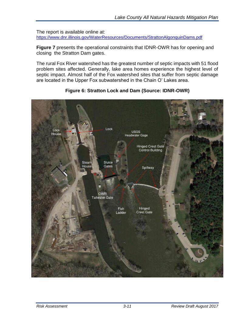
Lake County All Natural Hazards Mitigation Plan
Risk Assessment 3-11 Review Draft August 2017
The report is available online at: https://www.dnr.illinois.gov/WaterResources/Documents/StrattonAlgonquinDams.pdf
Figure 7 presents the operational constraints that IDNR-OWR has for opening and closing the Stratton Dam gates.
The rural Fox River watershed has the greatest number of septic impacts with 51 flood problem sites affected. Generally, lake area homes experience the highest level of septic impact. Almost half of the Fox watershed sites that suffer from septic damage are located in the Upper Fox subwatershed in the Chain O’ Lakes area.
Figure 6: Stratton Lock and Dam (Source: IDNR-OWR)
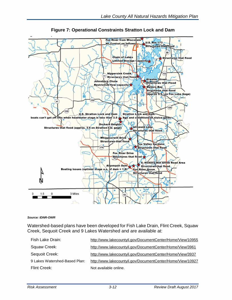
Lake County All Natural Hazards Mitigation Plan
Risk Assessment 3-12 Review Draft August 2017
Figure 7: Operational Constraints Stratton Lock and Dam
Source: IDNR-OWR
Watershed-based plans have been developed for Fish Lake Drain, Flint Creek, Squaw Creek, Sequoit Creek and 9 Lakes Watershed and are available at:
Fish Lake Drain: http://www.lakecountyil.gov/DocumentCenter/Home/View/10955
Squaw Creek: http://www.lakecountyil.gov/DocumentCenter/Home/View/3961
Sequoit Creek: http://www.lakecountyil.gov/DocumentCenter/Home/View/3937
9 Lakes Watershed-Based Plan: http://www.lakecountyil.gov/DocumentCenter/Home/View/10927
Flint Creek: Not available online.

Lake County All Natural Hazards Mitigation Plan
Risk Assessment 3-13 Review Draft August 2017
Table 13: Fox River Watershed in Lake County
Fox River Watershed:
Area: Municipalities: 163 square miles Antioch Lakemoor Round Lake Park
35% of County Barrington Lake Barrington Tower Lakes
Barrington Hills Lake Villa Volo
Public Land: Fox Lake Lake Zurich Wauconda
12,816 acres Fox River Grove North Barrington
Hainesville Round Lake
Wetlands: Hawthorn Woods Round Lake Beach
35,196 acres Island Lake Round Lake Heights
Subwatersheds: Area (mi2): Townships:
Upper Fox 32.7 Antioch
Sequoit Creek 15.3 Avon
Lower Fox 8.4 Cuba
Fish Lake Drain 38.4 Ela
Squaw Creek 9.4 Fremont
Mutton Creek 10.9 Grant
Slocum Lake Drain 11.0 Lake Villa
Tower Lake Drain 10.2 Wauconda
Flint Creek 26.7
The Upper Des Plaines River watershed is located in northeastern Illinois, Lake and Cook Counties, and Kenosha and Racine Counties in southeastern Wisconsin. A summary of the watershed is presented in Table 14: Des Plaines River Watershed in Lake County. The Upper Des Plaines is subject to significant flooding caused by lack of channel capacity of the mainstem of the Des Plaines River and tributaries to carry major flows during storms. Historical flooding in 1986 and 1987 resulted in over $100 million in damages.
The main stems of the Fox and Des Plaines Rivers have flood characteristics that are very different from the other two major watersheds of the county. The Fox and Des Plaines Rivers experience their worst floods from rain events that last a few days, or from a series of small rain events over a longer duration. The greatest flooding along the Fox and Des Plaines occurs following longer rain events. The floods of 1960 and 1986 resulted from long steady rains which eventually overwhelmed the available floodplain storage and set new flood stage records on the Fox and Des Plaines Rivers respectively.
The 1986 event resulted from 10 days of widespread steady rain. It took the Des Plaines 4 weeks to pass this floodwater. For the larger Fox River, the time to pass this flood was 6 weeks. In comparison, the smaller watershed of the Skokie River drained

Lake County All Natural Hazards Mitigation Plan
Risk Assessment 3-14 Review Draft August 2017
down to normal only a few days after the rains ended. Long-duration rain events on snow packs can also cause major flooding on the larger rivers.
Exhibit 8 and Exhibit 1 of Chapter 1 of this ANHMP show the lakes located within the Fox River and Des Plaines River Watersheds. The lakes are a resource and a concern when the Fox River and Des Plaines Rivers are at flood stage for extended periods and lake levels are elevated as a result.
Table 14: Des Plaines River Watershed in Lake County
Des Plaines River Watershed
Area: Municipalities:
202 mi2 Antioch Indian Creek Mundelein
42% of County Beach Park Kildeer Old Mill Creek
Buffalo Grove Lake Villa Riverwoods
Public Land: Deer Park Lake Zurich Round Lake Beach
11,730 acres Grayslake Libertyville Round Lake Park
Green Oaks Lincolnshire Third Lake
Wetlands: Gurnee Lindenhurst Vernon Hills
20,595 acres Hainesville Long Grove Wadsworth
Hawthorn Woods Mettawa Wheeling
Subwatersheds: Area (mi2): Townships:
North Mill Creek 21.5 Antioch Lake Villa Waukegan
Newport Drain 8.4 Avon Libertyville West Deerfield
Mill Creek 3.1 Benton Newport Zion
Upper Des Plaines 53 Ela Vernon
Bull Creek/Bull's Brook 12.3 Freemont Warren
Indian Creek 37.7
Lower Des Plaines 18.2
Buffalo Creek 13.7
Aptakisic Creek 6.3
Watershed-based plans have been developed for Mill Creek, Buffalo Creek, North Mill Creek, Bull Creek and Indian Creek and are available at:
Mill Creek: http://www.lakecountyil.gov/documentcenter/view/12203
Buffalo Creek: http://www.lakecountyil.gov/documentcenter/view/12897
North Mill Creek: http://www.lakecountyil.gov/documentcenter/view/12897
Bull Creek: http://www.lakecountyil.gov/documentcenter/view/11017
Indian Creek: http://www.lakecountyil.gov/documentcenter/view/11363
North Branch Chicago River Watershed is noted for three long and narrow subwatersheds surrounding the 3 forks of the North Branch of the river. A summary of the watershed is presented in Table 15. Floods on these long and narrow

Lake County All Natural Hazards Mitigation Plan
Risk Assessment 3-15 Review Draft August 2017
watersheds are affected by the direction taken by a storm. On the three forks, the worst flooding is caused by storms that move from north to south. The runoff moves under the storm front and concentrates as it goes downstream. Storms that pass east to west produce smaller floods, and storms that pass south to north produce the smallest floods.
The worst floods are caused by day-long rain events, but, because the watershed is so narrow, short intense rain events can also cause severe local flooding. The flood of record on the Skokie River in Highland Park was caused by a thunderstorm that rained only in the southern end of the watershed. Because of the channelization of these three forks, floodwaters usually drain away in just a few days.
For more information on the North Branch Chicago River Watershed, see the “North Branch Chicago River Watershed-Based Plan” (2008) for Lake and Cook Counties, Illinois, which is available the SMC website at:
North Branch Chicago River: http://www.lakecountyil.gov/DocumentCenter/Home/View/10615
Table 15: North Branch of the Chicago River Watershed in Lake County
North Branch Chicago River Watershed
Area: Municipalities:
202 square miles Bannockburn Highwood North Chicago
11% of County Deerfield Lake Bluff Park City
Public Land: Green Oaks Lake Forest Riverwoods
1,655 acres Gurnee Lincolnshire Waukegan
Wetlands: Highland Park Mettawa
4,390 acres
Subwatersheds: Area (mi2): Townships: Vernon
West Fork 8.6 Deerfield Warren
Middle Fork 19.8 Libertyville Waukegan
Skokie River 21.9 Shields West Deerfield
Along Lake Michigan there are several small subwatersheds dominated by urban conditions. In these watersheds, systems of storm drains deliver runoff to the ravines that drain into the lake. A Summary of the watershed is presented in Table 16. Intense rain events overwhelm the storm drains and can cause significant localized flooding problems. The rapid rise and fall of water levels and velocities in the ravines have resulted in severe erosion.

Lake County All Natural Hazards Mitigation Plan
Risk Assessment 3-16 Review Draft August 2017
Table 16: Lake Michigan Watersheds in Lake County
Lake Michigan Watersheds
Area: Municipalities:
59.3 square miles Beach Park North Chicago
12% of County Highwood Winthrop Harbor
Public Land: Highland Park Waukegan
5,215 acres Lake Bluff Zion
Wetlands: Lake Forest *Naval Station
12,532 acres Great Lakes
Subwatersheds: Area (mi2): Townships:
Kellogg Creek 8.9 Benton
Dead River 18.7 Deerfield
Waukegan River 17.6 Shields
Pettibone Creek 4.2 Waukegan
Bluff/Ravine 9.9 West Deerfield
Zion
Watershed-based management plans have been developed for Kellogg Creek, Dead River and the Waukegan River by the Lake County SMC. They are available at the Lake County SMC website. Also, more information on the all the Lake County watersheds can be found at:
Kellogg Creek: http://www.lakecountyil.gov/DocumentCenter/Home/View/10571
Dead River: http://www.lakecountyil.gov/DocumentCenter/Home/View/10891
Waukegan River: http://www.lakecountyil.gov/DocumentCenter/View/10904
3.3.2 Flood Hazard Profile
Exhibit 9 shows mapped regulatory floodplains and floodways in Lake County, which cover 57,168 acres. Mapped regulatory floodplains are defined as the area of land, which is inundated with water during 100-year flood events. For a historical comparison of flooding in Lake County, the USGS Hydrologic Atlas (1963, 1968) places 52,898 acres within areas inundated as part of today’s regulatory floodplains and floodways. Lake County has also identified 428 areas that cover 7,956 acres of land with local drainage and flooding problems. Over half of these areas reside outside of regulatory floodways and floodplains. Table 17 shows the percent of area land use in the Lake County 100-year floodplain, and a summary of the floodplain land area is shown in
Table 18.

Lake County All Natural Hazards Mitigation Plan
Risk Assessment 3-17 Review Draft August 2017
Exhibit 9: Lake County 100 Year Floodplain and Floodway
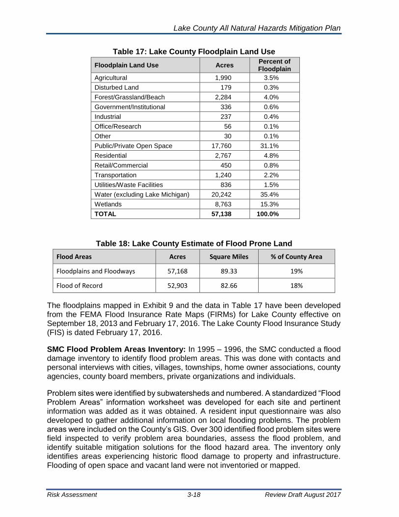
Lake County All Natural Hazards Mitigation Plan
Risk Assessment 3-18 Review Draft August 2017
Table 17: Lake County Floodplain Land Use
Floodplain Land Use Acres Percent of Floodplain
Agricultural 1,990 3.5%
Disturbed Land 179 0.3%
Forest/Grassland/Beach 2,284 4.0%
Government/Institutional 336 0.6%
Industrial 237 0.4%
Office/Research 56 0.1%
Other 30 0.1%
Public/Private Open Space 17,760 31.1%
Residential 2,767 4.8%
Retail/Commercial 450 0.8%
Transportation 1,240 2.2%
Utilities/Waste Facilities 836 1.5%
Water (excluding Lake Michigan) 20,242 35.4%
Wetlands 8,763 15.3%
TOTAL 57,138 100.0%
Table 18: Lake County Estimate of Flood Prone Land
Flood Areas Acres Square Miles % of County Area
Floodplains and Floodways 57,168 89.33 19%
Flood of Record 52,903 82.66 18%
The floodplains mapped in Exhibit 9 and the data in Table 17 have been developed from the FEMA Flood Insurance Rate Maps (FIRMs) for Lake County effective on September 18, 2013 and February 17, 2016. The Lake County Flood Insurance Study (FIS) is dated February 17, 2016.
SMC Flood Problem Areas Inventory: In 1995 – 1996, the SMC conducted a flood damage inventory to identify flood problem areas. This was done with contacts and personal interviews with cities, villages, townships, home owner associations, county agencies, county board members, private organizations and individuals.
Problem sites were identified by subwatersheds and numbered. A standardized “Flood Problem Areas” information worksheet was developed for each site and pertinent information was added as it was obtained. A resident input questionnaire was also developed to gather additional information on local flooding problems. The problem areas were included on the County’s GIS. Over 300 identified flood problem sites were field inspected to verify problem area boundaries, assess the flood problem, and identify suitable mitigation solutions for the flood hazard area. The inventory only identifies areas experiencing historic flood damage to property and infrastructure. Flooding of open space and vacant land were not inventoried or mapped.

Lake County All Natural Hazards Mitigation Plan
Risk Assessment 3-19 Review Draft August 2017
A summary of the problems area inventory is provided in Table 19 for the major Lake County watersheds and Exhibit 10 shows the mapped flood problem areas. The inventory is updated as watershed plans are developed or updated. Note that a flood problem site may include multiple buildings, roads or other infrastructure, and more than one type of flooding may occur at a problem site.
Table 19: Lake County Flood Problem Area Inventory Summary - 2016
Type of Flooding & Number of Sites
Fox River Des
Plaines River
Lake Michigan
North Branch Chicago
River Total
Overbank Flooding 87 46 3 17 153
Local Drainage Problems 58 65 27 22 172
Depressional Flooding 68 39 4 5 116
Sanitary Sewer/ Septic Failure 7 11 4 3 25
Associated Erosion 1 2 3 0 6
Total: 221 163 41 47 472
Flood Problem Site Locations: Fox River Des
Plaines River
Lake Michigan
North Branch Chicago
River Total
Floodplain 133 72 6 25 236
(Floodway) (27) (44) (4) (18) (93)
Outside Floodplain 88 91 35 22 236
Critical Facilities Subject to Flooding or Closure
19 9 6 4 38
Roads and Bridges Threatened by Flooding
170 93 34 41 338
* Sites reported multiple problems in these categories
An examination of National Flood Insurance Policies and Flood Insurance claims highlights the number of communities that have been impacted by past flooding. Table 20 shows Lake County community flood insurance coverage and flood insurance claims from 1978 to 2015. Note that policies are show for an entire community, including the portions of communities that are in other counties. The policy coverage in Lake County is about the same as it was in the 2012 ANHMP, but the total claims paid amount increase by $6 million, and are most likely due to the April 2013 flood. Since several Lake County municipalities are within other counties, it is difficult to separate claims for properties in Lake County verses other counties.
More information is available about the Lake County flooding at:
http://www.lakecountyil.gov/3510/Flood-Information

Lake County All Natural Hazards Mitigation Plan
Risk Assessment 3-20 Review Draft August 2017
Exhibit 10: Lake County “Flood Problem Areas”

Lake County All Natural Hazards Mitigation Plan
Risk Assessment 3-21 Review Draft August 2017
Table 20: Lake County NFIP Flood Insurance Active Policies & Claims (2015)
Community NFIP CID
Number of Active Policies
Total Premium
Total Coverage Number
of Claims*
Total Paid
Village of Antioch 170358 79 $80,203 $16,801,200 71 $ 788,569
Village of Bannockburn 170359 3 $1,195 $ 1,050,000 0 $ -
Village of Barrington* 170057 36 $18,330 $ 8,713,600 20 $ 320,931
Village of Barrington Hills* 170058 13 $13,823 $ 3,680,700 4 $53,648
Village of Beach Park 171022 31 $31,584 $ 6,158,300 10 $96,438
Village of Buffalo Grove* 170068 63 $46,324 $15,664,300 3 $ 3,149
Village of Deer Park* 171028 5 $4,183 $ 1,725,000 4 $26,319
Village of Deerfield* 170361 144 $108,783 $39,742,600 124 $ 1,304,698
Village of Fox Lake* 170362 303 $323,156 $60,926,500 200 $ 2,068,425
Village of Fox River Grove* 170477 31 $38,051 $ 6,966,100 1 $ 3,712
Village of Grayslake 170363 61 $56,852 $13,419,800 4 $14,412
Village of Green Oaks 170364 14 $16,936 $ 3,317,000 2 $ 3,689
Village of Gurnee 170365 119 $188,636 $34,587,300 68 $ 2,372,380
Village of Hainesville 1 333 $ 280,000
Village of Hawthorn Woods 170366 14 16433 $ 3,795,000 1 $ 4,309
City of Highland Park 170367 161 $167,868 $45,566,100 61 $ 217,120
City of Highwood 171033 0 $ - $ - 0 $ -
Village of Indian Creek 170369 0 $ - $ - 0 $ -
Village of Island Lake* 170370 35 $24,526 $ 7,955,700 1 $ 743
Village of Kildeer 170371 19 $22,694 $ 5,520,000 1 $27,352
Village of Lake Barrington 170372 17 $12,504 $ 4,568,400 3 20,807
Village of Lake Bluff 170373 10 $3,660 $ 2,871,800 0 $ -
City of Lake Forest 170374 68 $63,553 $18,716,100 18 $85,980
Village of Lake Villa 170375 14 $10,270 $ 3,239,600 10 $25,827
Village of Lake Zurich 170376 15 $6,291 $ 3,980,000 6 $54,425
Village of Lakemoor* 170915 31 $24,331 $ 4,368,300 0 $ -
Village of Libertyville 170377 149 $199,286 $35,587,000 45 $ 488,974
Village of Lincolnshire 170378 113 $113,929 $32,609,800 27 $ 1,167,991
Village of Lindenhurst 170379 10 $4,910 $ 2,599,000 7 $78,790
Village of Long Grove 170380 39 $38,345 $12,166,200 3 $13,267
Village of Mettawa 170381 5 5059 $ 1,530,000 1 $ 8,558
Village of Mundelein 170382 48 $49,580 $11,808,700 11 $59,544
Village of North Barrington 170383 19 $14,713 $ 5,395,900 2 $25,381
City of North Chicago 170384 10 $4,540 $ 1,641,500 7 $31,161
Village of Old Mill Creek 170385 0 $ - $ - 1 $ 7,433
City of Park City 170386 30 $13,835 $ 4,973,300 0 $ -
Village of Port Barrington* 170478 44 $47,485 $ 9,757,600 38 $ 390,094
Village of Riverwoods 170387 90 $86,894 $28,749,100 20 $ 218,401
Village of Round Lake 170388 15 $14,672 $ 2,548,700 10 $22,465
Village of Round Lake Beach 170389 218 $201,300 $32,868,600 67 $417,458
Village of Round Lake Heights 170390 6 $9,751 $ 1,323,500 8 $63,899
Village of Round Lake Park 170391 17 $9,991 $ 4,024,900 1 $11,642

Lake County All Natural Hazards Mitigation Plan
Risk Assessment 3-22 Review Draft August 2017
Community NFIP CID
Number of Active Policies
Total Premium
Total Coverage Number
of Claims*
Total Paid
Village of Third Lake 170392 4 $3,849 $ 1,090,000 0 $ -
Village of Tower Lakes 170393 5 $7,507 $ 1,305,000 0 $ -
Village of Vernon Hills 170394 24 $10,135 $ 4,360,900 1 $ 245
Village of Volo 171042 1 $1,440 $ 500,000 0 $ -
Village of Wadsworth 170395 8 $7,412 $ 1,986,400 1 $ 3,699
Village of Wauconda 170396 36 34052 $ 7,705,600 21 $ 156,817
City of Waukegan 170397 77 $83,218 $17,610,200 10 $ 410,921
Village of Wheeling 170173 813 $921,455 $ 172,221,300 126 $ 1,174,048
Village of Winthrop Harbor 170398 10 $4,219 $ 2,596,000 2 $21,534
City of Zion 170399 9 $10,253 $ 1,851,600 11 $94,665
Unincorporated Lake County 170357 964 $901,931 $ 197,120,500 412 $ 4,412,615
Naval Station Great Lakes n/a
TOTALS 4051 $4,080,280 $ 909,544,700 1444 $ 16,772,535
* Since 1978
3.3.3 Repetitive Flood Loss Properties
FEMA uses several definitions for repetitive loss structures. Since Lake County and many Lake County municipalities participate in the CRS, the CRS definition of repetitive loss is used in the plan. A “repetitive loss structure” is a flood-insured structure that has received two or more flood insurance claim payments of more than 25% of the market value within any 10-year period. Repetitive loss data was provided to Lake County through the CRS program in 2015. A summary repetitive loss in provided in Table 21.
The repetitive flood loss structures are located throughout the county, but are more concentrated in the Fox River Watershed.
The repetitive loss properties were examined for this ANHMP update. The repetitive loss areas are shown in Exhibit 11. Repetitive flood loss areas include 1 or more repetitive loss properties and the neighboring or nearby properties subject to similar flood damage. The repetitive loss areas numbers and names are shown in Table 22.
The naming convention used for the repetitive flood loss areas in Table 22 are the [Community Name – Subwatershed (or Lake) Name]. Each repetitive loss area has additional properties within the area. Neighboring or nearby properties with similar flood problems are will included in the area. The total number of properties within a repetitive loss area are identified by the Lake County Planning, Building and Development Department for the CRS. PB&D also maintains the description of the cause of flooding at each area and the CRS-required list of addresses. The SMC assists the PB&D with this effort.

Lake County All Natural Hazards Mitigation Plan
Risk Assessment 3-23 Review Draft August 2017
Table 21: Lake County Repetitive Loss Structures
Community Number of Repetitive Loss Properties as of
6/30/2015 Mitigated Mitigation Status
Remaining Repetitive
Losses
Village of Antioch 1 0 1
Village of Beach Park 3 0 3
Village of Fox Lake* 27 4 1 Non-FEMA, 2 FMA, 1 HMGP 23
Village of Fox River Grove* 2 0 2
Village of Gurnee 10 4 1-PDM, 2-HMGP, 1-GGS 6
City of Highland Park 6 0 6
City of Lake Forest 4 1 1-Non FEMA 3
Village of Lakemoor* 1 0 1
Village of Libertyville 3 1 1-Non-FEMA 2
Village of Lincolnshire 1 0 1
Village of Lindenhurst 2 1 1-HMGP 1
Village of Port Barrington* 5 0 5
Village of Riverwoods 1 1 1-Non FEMA 0
Village of Round Lake 1 0 1
Village of Round Lake Beach 5 1 1-HMGP 4
Village of Round Lake Heights 1 1 1-HMGP 0
Village of Wauconda 1 0 1
City of Waukegan 1 0 1
Unincorporated Lake County 47 0 47
TOTALS 122 14 108
Since 2000, Lake County has been conducting “flood audits” in repetitive loss areas. Table 23 shows the number of repetitive loss properties that have received a flood audit in each community. Many of the properties included in the 108 properties in Table 23 that are shown as “To Be Audited” are within areas that did have other flood audits conducted between 2000 and 2006. Mitigation of repetitive flood loss structures are discussed further in Chapter 5.

Lake County All Natural Hazards Mitigation Plan
Risk Assessment 3-24 Review Draft August 2017
Exhibit 11: Lake County Repetitive Flood Loss Areas

Lake County All Natural Hazards Mitigation Plan
Risk Assessment 3-25 Review Draft August 2017
Table 22: Lake County Repetitive Flood Loss Area Numbers and Names
Rep. Loss Area
Number
Rep. Loss Area Name
Number of Rep. Loss Properties
in Area
Rep. Loss Area
Number
Rep. Loss Area Name
Number of Rep. Loss
Properties in Area
1 Antioch - Channel Lake 1 29 Fox Lake - Fox Lake 3 9
2 Beach Park - Dead River 3 30 Fox Lake - Fox Lake 4 1
3 County - Channel Lake 3 31 Fox Lake - Pistakee Lake 1 8
4 County - Countryside Lake 1 32 Fox Lake - Pistakee Lake 2 2
5 County - Flint Creek 1 34 Gurnee - Des Plaines River 9
6 County - Forest Lake 1 35 Highland Park - Middle Fork 1
7 County - Fox Lake 1 1 36 Highland Park - Skokie River 1 1
8 County - Grass Lake 1 37 Highland Park - Skokie River 2 1
9 County - Lake Marie 10 38 Highland Park - Skokie River 3 1
10 County - Local 1 1 39 Highland Park - Skokie River 4 1
11 County - Local 2 1 40 Lake Forest - Bluff/Ravine 1
12 County - Lower Des Plaines 2 2 41 Lake Forest - Skokie River 1
13 County - Lower Fox River 1 3 42 Libertyville - Lower Des Plaines 1
14 County - Lower Fox River 2 2 43 Libertyville - Minear Lake 1
15 County - Lower Fox River 3 1 44 Libertyville -Des Plaines River 3
16 County - Nippersink Lake 1 1 45 Lincolnshire - Des Plaines River 1
17 County - Nippersink Lake 2 1 46 Lindenhurst - Local 1 1
18 County - Petite Lake 1 47 Lindenhurst - Local 2 1
20 County - Skokie River 1 48 Riverwoods - Local 1
21 County - Slocum Lake 4 49 Round Lake - Local 1
22 County - Upper Des Plaines 1 2 50 Round Lake - Round Lake Drain 2
23 County - Upper Des Plaines 2 1 51 Round Lake Beach - Local 1
24 County - Upper Des Plaines 3 1 52 Round Lake Beach - Round Lake Drain 1 1
25 County - Upper Fox River 2 53 Round Lake Beach - Round Lake Drain 2 1
26 Fox Lake - Duck Lake 1 5 54 Round Lake Heights - Round Lake Drain 1
27 Fox Lake - Duck Lake 2 2 55 Wauconda - Bangs Lake 1
28 Fox Lake - Fox Lake 2 1 56 Waukegan - Dead River 1
Table 23: “Flood Audited” Repetitive Loss Properties in Lake County
Community Audited Repetitive
Loss Properties Repetitive Loss
Properties to Be Audited
Village of Antioch 0 1
Village of Beach Park 0 3
Village of Fox Lake 7 21
Village of Gurnee 1 8
City of Highland Park 3 2
City of Lake Forest 2 0
Village of Libertyville 0 5
Village of Lincolnshire 1 0
Village of Lindenhurst 1 1
Village of Riverwoods 1 0
Village of Round Lake 1 2
Village of Round Lake Beach 1 2
Village of Round Lake Heights 0 1
Village of Wauconda 0 1
City of Waukegan 1 0
Lake County (Unincorporated Areas) 12 30
Totals: 31 77
Total Properties = 108

Lake County All Natural Hazards Mitigation Plan
Risk Assessment 3-26 Review Draft August 2017
3.3.4 Past Floods and Future Flood Frequency
The National Climate Data Center (NCDC), maintained by the National Oceanic and Atmospheric Administration, records weather events as they are submitted for record. The NCDC has a record of the flooding in Lake County from 1996 to 2016, which are shown in Table 24. Other small floods most likely occurred that did not get recorded. The NCDC data recorded no injuries or deaths with these events.
The May 2004 event attracted national attention and was destructive on a wide scale. River flooding was recorded across Lake County and portions of Cook and Lake Counties, as well as local flash flooding from individual storms that occurred during this month. The river flooding, mainly on the Des Plaines River, had some of its origin in southern Wisconsin, but affected the river channel through Lake County and into Cook County. Monthly rainfall totals peaked over 10 inches across Lake and Lake Counties, while 6 inches or more were common further south including northwest Indiana.
Throughout Lake County, overbank flooding is most extensive along the Des Plaines River with the highest historical floods occurring in 1938, 1960, 1979, 1986, 2004, 2009, 2010, 2011,2013, and 2014
1986 Flood: Northeastern Illinois received almost one inch of rain daily from September 21 through October 4. On some days, there was as much as three inches. Over this two-week period, the Des Plaines watershed received up to 12.9 inches of rain compared to the normal monthly amount of 3 inches. The flooding in Lake County killed four people. One person drowned when his boat capsized and three people had heart attacks fighting the flood.
On September 25, 2004, the river was two feet over flood stage and high enough to reach buildings. This flooding along with flooding in the Fox River/Chain of Lakes watershed resulted in a disaster declaration by the President on October 7 for Cook, Lake, Kane, and Lake Counties. The worst flooding in Lake County was in the Village of Gurnee, where approximately 100 buildings were flooded. Based on the flood insurance claims, they suffered an average of $10,000 in damage.
Most severely affected were the public properties. Gurnee Grade School suffered structural damage when the northern half settled, cracking the walls and the roof. The Viking Junior High School was flooded. The police station basement floor buckled from hydrostatic pressure. The fire station was not damaged, but it was surrounded by flood water and due to the closing of the Grand Avenue Bridge over the Des Plaines River part of the equipment had to be moved to the other side of the River.

Lake County All Natural Hazards Mitigation Plan
Risk Assessment 3-27 Review Draft August 2017
Table 24: Past Occurring Flood Events in Lake County,
National Climatic Data Center (NCDC)
Location Date Type Property Damage
Knollwood 9/18/2015 Flash Flood $0
Knollwood 5/12/2014 Flood $0
North Chicago 5/12/2014 Flood $0
Gurnee 5/12/2014 Flash Flood $0
Park City 5/12/2014 Flash Flood $0
Rondout 5/12/2014 Flash Flood $0
Forest Lake 10/05/2013 Flood $0
Barrington 6/26/2013 Flash Flood $0
Williams Park 6/26/2013 Flash Flood $0
Forest Lake 6/26/2013 Flash Flood $0
Barrington 6/26/2013 Flash Flood $0
Channel Lake 4/17/2013 Flash Flood $4,700,000
Grass Lake 7/18/2012 Flood $0
Winthrop Harbor 7/27/2011 Flash Flood $0
Bonnie Brooks 7/22/2011 Flash Flood $0
Forest Lake 5/29/2011 Flash Flood $0
Deerfield 5/25/2011 Flash Flood $0
Channel Lake 5/13/2010 Flash Flood $500,000
Knollwood 5/13/2010 Flash Flood $0
Leithton 6/19/2009 Flood $0
Gurnee 6/19/2009 Flash Flood $0
Russell 8/23/2007 Flood $100,000
Lake Bluff 8/7/2007 Flash Flood $10,000
Lake Bluff 7/18/2007 Flood $0
Zion 6/8/2007 Flash Flood $0
Knollwood 3/21/2007 Flash Flood $50,000
Libertyville 3/21/2007 Flood $0
Lake Bluff 7/27/2006 Flood $0
Libertyville 7/27/2006 Flood $0
Lake Villa 5/30/2006 Flood $0
Hawthorne Woods 5/30/2006 Flood $0
Countywide 2/14/2005 Flood $0
Countywide 6/11/2004 Flood $0
Gurnee 5/30/2004 Flash Flood $0
Countywide 5/22/2004 Flood $0
Mundelein 5/18/2004 Flash Flood $0
Countywide 8/22/2002 Flood $0
Countywide 8/22/2002 Flash Flood $0
Countywide 6/4/2002 Flood $0
Countywide 10/23/2001 Urban Flood $0
Lake Forest 10/13/2001 Flash Flood $180,000
Countywide 6/12/2000 Flood $0
Total $5,540,000

Lake County All Natural Hazards Mitigation Plan
Risk Assessment 3-28 Review Draft August 2017
The Village government estimated its cost for flood fighting and reconstruction to be over $200,000. Damage to the Gurnee Grade School, the Viking Junior High School and the school district offices were estimated at $1.2 million. Damage to Park District property was estimated at $43,000. For additional historical and flooding information reference the draft Gurnee Flood Mitigation Plan at the Village of Gurnee. The average annual damage in Lake County for the flood was $9.2 million.
Reported flood events over the past 31 years provide an acceptable framework for determining the future occurrence in terms of frequency for such events. The probability of the County and its municipalities experiencing a flood event can be difficult to quantify, but based on historical record of 45 flood events since 1986, it can reasonably be assumed that a flooding event has occurred every 8 months (0.67 years) from 1986 through 2016.
[(Current Year) 2016] subtracted by [(Historical Year) 1986] = 30 Years on Record
[(Years on Record)30] divided by [(Number of Historical Events) 45] = .67
Furthermore, the historic frequency calculates that there is at least a 100% chance of this type of event occurring each year.
3.3.5 Vulnerability - Impacts of Flooding
Lake County’s population is expected to continue to grow and for development to continue. Lake County is currently susceptible to flooding and it should be anticipated that flood risk will continue to grow. Lake County is undertaking several activities to abate this potential increase in flood risk, including the implementation of the Lake County Watershed Development Ordinance and comprehensive planning to protect against new flood damages (these efforts are summarized in Chapter 4). However, Lake County is part of two large watersheds and cannot regulate development in Wisconsin. Life, health and safety, buildings, critical facilities, infrastructure and the economy are all affected by flooding in Lake County
Health and safety: Safety during a flood, whether from overbank flooding or groundwater flooding (basements), is a concern. If clean-up after a flood is not properly done, then health problems can develop due to mold. Flooding roads and viaducts are dangerous. People continue to be at risk when driving through floodwaters; fast moving waters are a hazard to people in and out of cars. The highest flood depths are at the Fox River, but stormwater flooding away from the floodplain in
Village of Gurnee-2004

Lake County All Natural Hazards Mitigation Plan
Risk Assessment 3-29 Review Draft August 2017
Lake County can also threaten lives, as emphasized in the death during the 1982 flood event.
Impact to health and safety due to flooding is considered moderate.
Damage to Buildings: The Lake County estimate of structures located in the floodplain and floodway is shown in Table 25
Table 25: Structures Located in Lake County Floodplains
Watershed
Number of Structures in Floodplain
Number of Structures in
Floodway
Fox River 5,914 390
Des Plaines River 2,786 901
North Branch Chicago River 1,249 423
Lake Michigan 447 27
Total: 10,396 1,741
* Source: SMC GIS
The number of structures in the floodplain and floodway has changed since the 2012 ANHMP due to new effective FIRMs for Lake County. Using the old FIRMs (2012 ANHMP) 10,903 structures were in the 1% annual chance, or 100-year floodplain. The value of these structures is estimated in Table 26.
Table 26: Estimated Market Value of Structures
Located in Lake County Floodplains
Land Use Estimated Market
Value
Agricultural $6,351,450
Forest/Grassland/Beach $9,109,127
Government/Institutional $3,223,011
Industrial $275,881,667
Office/Research $74,766,111
Public/Private Open Space $46,432,865
Residential $1,209,426,702
Retail/Commercial $188,217,209
Transportation $963,034
Utilities/Waste Facilities $29,201,791
Total Estimated Value: $1,843,572,967
The range of flood damage to buildings is likely to be 5% to 50%, or a range $85 million to $850 million. Impact to buildings due to flooding is considered high.

Lake County All Natural Hazards Mitigation Plan
Risk Assessment 3-30 Review Draft August 2017
Critical Facilities and Infrastructure: SMC data shows 21 of 1,557 critical facilities are located within the 100-year (1% change of flooding each year) floodplain. It is assumed that all critical facilities in the floodplain could be closed due to flooding.
Impact to critical facilities due to flooding is considered moderate.
Economic Impact: Flood damage to businesses is difficult to estimate. Businesses that are disrupted by floods often must be closed. They lose their inventories, customers cannot reach them, and employees are often busy protecting or cleaning up their flooded homes. Business can be disrupted regardless of the business being in the floodplain when customers and clients cannot reach their location. As with flooded roads, public expenditures on flood fighting, sandbags, fire department calls, clean-up and repairs to damaged public property affect all residents of the County, not just those in the floodplain.
Therefore, overall economic impact to businesses is high.
Multi-Jurisdictional Differences: From data presented in section 3.3.2 Flood Hazard Profile, most of Lake County is vulnerable to flooding. The Village of Indian Creek does not have mapped floodplain but may be subject to local flooding problems. The communities of Lake Bluff, Highwood, Highland Park, North Chicago and Winthrop Harbor are subject to coastal flooding from Lake Michigan.
3.4 Tornado
Wind can be defined as the motion of air relative to the earth’s surface. The horizontal component of the three-dimensional flow and the near-surface wind phenomenon are the most significant aspects of the hazard. Extreme windstorm events are associated with extratropical and tropical cyclones, winter cyclones, and severe thunderstorms and accompanying mesoscale offspring such as tornadoes and downbursts. Winds vary from zero at ground level to 200-mph in the upper atmospheric jet stream at 6 to 8 miles above the earth’s surface.
The damaging effects of windstorms associated with hurricanes may extend for distances in excess of 100 miles from the center of storm activity. For coastal areas from Texas to Maine, tropical cyclone winds may exceed 100 mph. Severe thunderstorms can produce wind downbursts and microbursts, as well as tornadoes. Severe windstorms result in as many as 1,000 tornadoes annually.
A tornado is a violent windstorm characterized by a twisting, funnel-shaped cloud extending to the ground. Tornadoes are most often generated by thunderstorm activity (but sometimes result from hurricanes or tropical storms) when cool, dry air intersects and overrides a layer of warm, moist air forcing the warm air to rise rapidly. The damage caused by a tornado is a result of high wind velocities and wind-blown debris. According to the National Weather Service, tornado wind speeds can range between 30 to more than 300 miles per hour. They are more likely to occur during the spring and early summer months of March through June and are most likely to form in the late afternoon and early evening. Most tornadoes are a few dozen yards wide and touchdown briefly, but even small, short-lived tornadoes can inflict tremendous

Lake County All Natural Hazards Mitigation Plan
Risk Assessment 3-31 Review Draft August 2017
damage. Destruction ranges from minor to catastrophic depending on the intensity, size, and duration of the storm. Structures made of light materials such as mobile homes are most susceptible to damage. Each year, an average of over 800 tornadoes is reported nationwide, resulting in an average of 80 deaths and 1,500 injuries (NOAA, 2002).
The Enhanced Fujita Scale, also known as the “EF-Scale,” measures tornado strength and associated damages. The EF-Scale, shown in Table 27, is an update to the earlier Fujita scale that was published in 1971. It classifies United States tornadoes into six intensity categories based upon the estimated maximum winds occurring within the wind vortex. The EF-Scale has become the definitive metric for estimating wind speeds within tornadoes based upon the damage done to buildings and structures since it was implemented through the National Weather Service in 2007.
Table 27: Enhanced Fujita Scale and Associated Damage
The Storm Prediction Center has developed damage indicators to be used with the
Enhanced Fujita Scale for different types of buildings but can be also be used to
classify any high wind event. Some of the indicators for different building types are
shown in Table 28 through Table 30 below.
EF-Scale Number
Wind Speed (MPH)
Type of Damage Possible
EFO 65-85
Minor damage: Peels surface off some roofs; some damage to gutters or siding; branches broken off trees; shallow-rooted trees pushed over. Confirmed tornadoes with no reported damage (i.e., those that remain in open fields) are always rated EF0.
EF1 86-110 Moderate damage: Roofs severely stripped; mobile homes overturned or badly damaged; loss of exterior doors; windows and other glass broken.
EF2 111-135
Considerable damage: Roofs torn off well-constructed houses; foundations of frame homes shifted; mobile homes destroyed; large trees snapped or uprooted; light-object missiles generated; cars lifted off ground.
EF3 136-165
Severe damage: Entire stories of well-constructed houses destroyed; severe damage to large buildings such as shopping malls; trains overturned; trees debarked; heavy cars lifted off the ground and thrown; structures with weak foundations blown away some distance.
EF4 166-200 Devastating damage: Well-constructed houses and whole frame houses completely leveled; cars thrown and small missiles generated.
EF5 >200
Extreme damage: Sturdy frame houses leveled off foundations and swept away; automobile-sized missiles fly through the air in excess of 100 m (300 ft.); steel reinforced concrete structure badly damaged; high-rise buildings have significant structural deformation.

Lake County All Natural Hazards Mitigation Plan
Risk Assessment 3-32 Review Draft August 2017
Table 28: Institutional Buildings
Damage Description Wind Speed Range
(Expected in Parentheses)
Threshold of visible damage 59-88 MPH (72 MPH)
Loss of roof covering (<20%) 72-109 MPH (86 MPH)
Damage to penthouse roof & walls, loss of rooftop HVAC equipment 75-111 MPH (92 MPH)
Broken glass in windows or doors 78-115 MPH (95 MPH)
Uplift of lightweight roof deck & insulation, significant loss of roofing material (>20%)
95-136 MPH (114 MPH)
Façade components torn from structure 97-140 MPH (118 MPH)
Damage to curtain walls or other wall cladding 110-152 MPH (131 MPH)
Uplift of pre-cast concrete roof slabs 119-163 MPH (142 MPH)
Uplift of metal deck with concrete fill slab 118-170 MPH (146 MPH)
Collapse of some top building envelope 127-172 MPH (148 MPH)
Considerable damage to building envelope 178-268 MPH (210 MPH)
Source: Storm Prediction Center, 2009
Table 29: Educational Institutions (Elementary Schools, High Schools)
Damage Description Wind Speed Range
(Expected in Parentheses)
Threshold of visible damage 55-83 MPH (68 MPH)
Loss of roof covering (<20%) 66-99 MPH (79 MPH)
Broken windows 71-106 MPH (87 MPH)
Exterior door failures 83-121 MPH (101 MPH)
Uplift of metal roof decking; significant loss of roofing material (>20%); loss of rooftop HVAC
85-119 MPH (101 MPH)
Damage to or loss of wall cladding 92-127 MPH (108 MPH)
Collapse of tall masonry walls at gym, cafeteria, or auditorium 94-136 MPH (114 MPH)
Uplift or collapse of light steel roof structure 108-148 MPH (125 MPH)
Collapse of exterior walls in top floor 121-153 MPH (139 MPH)
Most interior walls of top floor collapsed 133-186 MPH (158 MPH)
Destruction of a large section of building envelope 163-224 MPH (192 MPH)
Source: Storm Prediction Center, 2009

Lake County All Natural Hazards Mitigation Plan
Risk Assessment 3-33 Review Draft August 2017
Table 30: Metal Building Systems
Damage Description Wind Speed Range
(Expected in Parentheses)
Threshold of visible damage 54-83 MPH (67 MPH)
Inward or outward collapsed of overhead doors 75-108 MPH (89 MPH)
Metal roof or wall panels pulled from the building 78-120 MPH (95 MPH)
Column anchorage failed 96-135 MPH (117 MPH)
Buckling of roof purlins 95-138 MPH (118 MPH)
Failure of X-braces in the lateral load resisting system 118-158 MPH (138 MPH)
Progressive collapse of rigid frames 120-168 MPH (143 MPH)
Destruction of building 132-178 MPH (155 MPH)
Source: Storm Prediction Center, 2009
Table 31: Electric Transmission Lines
Damage Description Wind Speed Range
(Expected in Parentheses)
Threshold of visible damage 70-98 MPH (83 MPH)
Broken wood cross member 80-114 MPH (99 MPH)
Wood poles leaning 85-130 MPH (108 MPH)
Broken wood poles 98-142 MPH (118 MPH)
Broken or bent steel or concrete poles 115-149 MPH (138 MPH)
Collapsed metal truss towers 116-165 MPH (141 MPH)
Source: Storm Prediction Center, 2009
Intense winds can also occur outside of tornadoes, severe thunderstorms, and winter storms. These winds typically develop with intense pressure gradients and gusty frontal passages. The closer and stronger two systems (one high pressure, one low pressure) are, the stronger the pressure gradient, and therefore, the stronger the winds are.
Downburst winds, which can cause more widespread damage than a tornado, occur when air is carried into a storm’s updraft, cools rapidly, and comes rushing to the ground. Cool air is denser than warm air, and therefore, wants to fall to the surface. On warm summer days, when the cool air can no longer be supported up by the storm’s updraft, or an exceptional downdraft develops, the air crashes to the ground in the form of strong winds. These winds are forced horizontally when they reach the ground and can cause significant damage. These types of strong winds can also be referred to as straight-line winds. Downbursts with a diameter of less than 2.5 miles are called microbursts and those with a diameter of 2.5 miles or greater are called macrobursts. A derecho, or bow echo, is a series of downbursts associated with a line of thunderstorms. This type of phenomenon can extend for hundreds of miles and contain wind speeds greater than 100 mph.

Lake County All Natural Hazards Mitigation Plan
Risk Assessment 3-34 Review Draft August 2017
3.4.1 Tornado Hazard Profile
Next to flooding and winter storms, tornadoes are the most prevalent natural hazard in Lake County. The southeast half of Lake County is in a belt of high tornado frequency. Warnings for Lake County come from the National Weather Service office in Romeoville, IL. Peak tornado occurrences are in March through May as past records further indicate in Table 32. According to the University of South Carolina’s Hazards and Vulnerability Research Institute (SHELDUS) as well as the National Climatic Data Center, Lake County has been impacted by 17 tornado events since 1957. Tornado touchdown locations are shown in Exhibit 3-5.
Past Occurrences: In April 1965, a tornado caused considerable property damage estimated around $500,000 in the western part of Gurnee. A tornado that struck Zion on April 19, 1996, caused enough damage to result in a federal disaster declaration for the county. Two people were injured and damage was estimated at $ 6.6 million. It was rated an F2 with a path between Lindenhurst and Gurnee in Lake County.
On May 18, 1997, Gurnee had another F2 touch down. No damage or injuries were reported. Adequate prediction methods have not been developed for tornadoes, so a good warning system is the only defense. The most devastating was the March 28, 1920, F3 tornado that killed 8 people and injured 100. This tornado went through 3 counties, Kane, Cook, and Lake. It followed a path from southeast of La Fox to the south side of Elgin to Wauconda. A second notable event occurred on April 11, 1965, when Lake and McHenry Counties were struck by an F4 tornado. The tornado killed 6 people and injured 75. The tornado began in Crystal Lake and went on an 11-mile path that was as wide as 400 yards. Damage was estimated at $1.5 million.
Other notable tornado events occurred on April 21, 1967, when an F4 killed one person and injured 100, the tornado struck Fox River Grove, Barrington Hills, and Lake Zurich, producing a damage path nine miles long. Lake Zurich was hardest hit with 140 homes destroyed and 463 damaged, and damage was estimated at $10 million (USA Today Weather, January 6, 1999). On September 28, 1972, an F4 tornado injured 20 people in Lake County, the tornado followed a 5-mile path and damage was estimated at $1 million.
According to local historians on June 3, 1860, a destructive tornado swept the southern end of Lake County.
Tornado Frequency
Source: Illinois Emergency Management Agency

Lake County All Natural Hazards Mitigation Plan
Risk Assessment 3-35 Review Draft August 2017
Exhibit 12: Lake County Tornado Touch Downs

Lake County All Natural Hazards Mitigation Plan
Risk Assessment 3-36 Review Draft August 2017
Table 32: Lake County Tornado History (1957-2016) (NCDC)
Location Date Magnitude Death Injuries Property Damage
Crop Damage
Countywide 3/14/1957 F1 0 0 $3000 $0
Countywide 10/9/1958 F2 0 0 $2,500,000 $0
Countywide 4/11/1965 F4 0 0 $0 $0
Countywide 4/11/1965 F2 0 0 $250,000 $0
Countywide 4/11/1965 F1 0 0 $250,000 $0
Countywide 4/21/1967 F4 1 97 $2,500,000 $0
Countywide 9/28/1972 F4 0 20 $2,500,000 $0
Countywide 6/20/1974 F0 0 0 0K $0
Countywide 11/10/1975 F1 0 0 $25,000 $0
Countywide 4/20/1976 F2 0 2 $25,000 $0
Countywide 8/9/1979 F1 0 0 $25,000 $0
Countywide 7/6/1986 F0 0 0 $0 $0
Countywide 6/29/1990 F1 0 0 $25,000 $0
Zion 4/19/1996 F2 0 2 $6,600,000 $0
Lindenhurst 5/18/1997 F2 0 0 $0 $0
Zion 4/18/2002 F0 0 0 $0 $0
Round Lake 9/02/2015 F0 0 0 $1,000,000 $0
Totals: 1 121 15,703,000 $0
There have been significant tornadoes in the Chicago metropolitan area. The deadliest tornado occurred on April 21, 1967, during an outbreak of 5 significant tornadoes. One tornado formed in Palos Hills in Cook County and traveled through Oak Lawn and the south side of Chicago. Thirty-three people died and 500 people were injured by this 200-yard wide tornado that traveled 16 miles and caused over $50 million in damage. A second tornado in this weather system ripped through the southwest portion of Lake County destroying around 50 homes, damaging over 200 others, and demolishing the Seth Paine Elementary School. The funnel began above the Police Headquarters of the Village of Barrington Hills at around 4:50 p.m. At 5:05 p.m. it struck Seth Paine at Miller Road and Route 22. It continued to the Acorn Acres Estates and severely damaged the Old Zeman Brewery on Gilmer Road east of Route 63. The only F5 tornado in the Chicago metropolitan area was on August 28, 1990. This tornado formed near Oswego and passed through Plainfield and Joliet (a 16-mile path). The tornado killed 29, injured 350, and caused $165 million in damage.
Additional information was provided by the Village of Antioch regarding the April 19, 1996 Zion tornado. The wind damage that occurred in Antioch and along Highway 173 from Harvard to Zion (with the wind storm finally called a tornado in Zion) resulted in major damage throughout the Village of Antioch and Antioch Township. Several roofs were ripped off buildings, numerous trees went down, at least one house had the

Lake County All Natural Hazards Mitigation Plan
Risk Assessment 3-37 Review Draft August 2017
entire side of it removed, and numerous other damage occurred as a result of this tornado.
Future Probability: With 17 occurrences over a 59-year period, the likelihood of a tornado hitting somewhere in the county is .288 (29%) in any given year, and from 1957 to 2016 a tornado has occurred once every 3.5 years.
[(Current Year) 2016] subtracted by [(Historical Year) 1957] = 59 Years on Record
[(Years on Record) 59] divided by [(Number of Historical Events) 17] = 3.47
Assuming a tornado affects one square mile and there are 470.55 square miles in Lake County, the odds of a tornado hitting any particular square mile in the County is 1 in 1,633 tornadoes each year or a 0.0006% chance. FEMA notes that approximately 1,000 tornadoes occur each year in the United States. Illinois is ranked number 8 in the United States in terms of tornadoes and 6 in terms of number of killer tornadoes between January 1, 1950 and September 30, 2003. Tornadoes are most likely to occur between March and June, but a tornado can occur at any time. Over half of the tornadoes hit between 3:00 and 7:00 PM. Therefore, the probability of a tornado occurring in Illinois is high.
3.4.2 Vulnerability – Tornado Impact
All of Lake County is vulnerable to tornadoes. Past tornadoes have been deadly and have led to disaster declarations in Lake County. The potential for loss of life and significant property damage in growing in Lake County as the population and number of buildings increases. All assets located in Lake County can be considered at risk from tornadoes and wind events. This includes 703,462 people based on 2010 census, or 100% of the County’s population and all critical facilities, structures, and infrastructure.
Health and Safety: Vulnerability to residents and buildings is as the county grows in population and building counts. Fifteen deaths and over 200 injuries have been attributed to tornadoes in Lake County. On average, Illinois experiences 4 tornado–related deaths each year. Based on tornado history in Illinois, advanced warning and taking appropriate shelter appears to be the best mitigation method for preventing death and injury.
Based on national statistics for 1970-1980, for every person killed by a tornado, 25 people were injured and 1,000 people received some sort of emergency care.
Residents living in mobile homes are more vulnerable than people in permanent homes. People can inadvertently put their lives in danger during a tornado, or have little or no warning.
Impact to health and safety for severe winter storms is considered high.
Damage to Buildings: Structures within the direct path of a tornado vortex are often reduced to rubble. However, structures adjacent to the tornadoes path are often severely damaged by high winds flowing into the tornado vortex, known as inflow

Lake County All Natural Hazards Mitigation Plan
Risk Assessment 3-38 Review Draft August 2017
winds, or by debris. The buildings adjacent to the tornado path can be significantly impacted depending on the design and materials used in the building construction. Although tornadoes strike at random, making all buildings vulnerable, three types of structures are more likely to suffer damage:
• Mobile homes
• Homes on crawlspaces (more susceptible to lift)
• Buildings with large spans, such as airplane hangars, gymnasiums and
factories
To assess this potential for building damage, several tornado scenarios have been developed and presented below. Based on an analysis conducted by the State of Illinois for 2010 Illinois Natural Hazard Mitigation Plan, Lake County has a median value of $198,200. The scenarios assume a tornado damage area of 5 square miles.
1. Average Lake County building density: 5 mi2 x 581 houses/mi2 = 2,905 homes damaged
2,905 homes x $228,600 per home x 50% of value damaged = $419 million 2. Rural area average building density:
5 mi2 x 80 houses/mi2 = 400 homes damaged 400 homes x $228,600 per home x 50% of value damaged = $58 million
3. Urban area (Waukegan) average building density: 5 mi2 x 1,208 houses/mi2 = 6,040 homes damaged
6,040 homes x $228,600 per home x 50% of value damaged = $872 million
For a 5-square mile area the County’s average exposure to tornado damage ranges from $50 to $60 million. Impact to buildings due to tornadoes is considered high.
Damage to Critical Facilities: Because a tornado can hit anywhere in the County, all categories of critical facilities are susceptible to being hit. Schools are a concern due to their large numbers of people present, either during school or as a storm shelter, and due to having large span areas, such as gyms and theaters. Impact to critical facilities for tornadoes is moderate, since facilities are spread throughout the county.
Economic Impact: The major impact of a tornado on the local economy is damage to businesses and infrastructure. A heavily damaged business, especially one that was barely making a profit, often must be closed.
Infrastructure damage is usually limited to above ground utilities, such as power lines. Damage to roads and railroads is also localized. If it can’t be repaired promptly, alternate transportation routes are usually available. Public expenditures include search and rescue, shelters, and emergency protection measures. The large expenses are for repairs to public facilities and clean-up and disposal of debris. Most public facilities are insured, so the economic impact on the local funds may be moderate.

Lake County All Natural Hazards Mitigation Plan
Risk Assessment 3-39 Review Draft August 2017
Economic impact due to tornadoes is considered moderate.
Multi-Jurisdictional Differences: Each municipality in the County has an equal susceptibility to high winds from tornadic activity. The deteriorating condition of older homes and the use of aluminum-clad mobile homes continue to remain highly susceptible to wind events.
3.5 Severe Summer Storms
Dangerous and damaging aspects of severe storms are tornadoes, hail, lightning strikes, flash flooding, and winds associated with downbursts and microbursts. Thunderstorms, associated with strong winds, heavy precipitation, and lightning strikes can all be hazardous under the right conditions and locations. Strong winds and tornadoes can take down trees, damage structures, tip high profile vehicles, and create high velocity flying debris. Large hail can damage crops, dent vehicles, break windows, and injure or kill livestock, pets, and people. Severe storm weather conditions can exist during any season in Lake County, but they are referred to as severe summer storms to distinguish them from the severe winter storms addressed in this ANHMP.
Thunderstorms affect relatively small areas when compared with hurricanes and winter storms. Despite their small size, all thunderstorms are dangerous. The typical thunderstorm is 15 miles in diameter and lasts an average of 30 minutes. Of the estimated 100,000 thunderstorms that occur each year in the United States, about 10 percent are classified as severe. The National Weather Service considers a thunderstorm severe if it produces hail at least 3/4 inch in diameter, winds of 58 MPH or stronger, or a tornado. Every thunderstorm needs three basic components: (1) moisture to form clouds and rain (2) unstable air which is warm air that rises rapidly and (3) lift, which is a cold or warm front capable of lifting air to help form thunderstorms.
Lightning, although not considered severe by the National Weather Service definition, can accompany heavy rain during thunderstorms. Lightning develops when ice particles in a cloud move around, colliding with other particles. These collisions cause a separation of electrical charges. Positively charged ice particles rise to the top of the cloud and negatively charged ones fall to the middle and lower sections of the cloud. The negative charges at the base of the cloud attract positive charges at the surface of the Earth. Invisible to the human eye, the negatively charged area of the cloud sends a charge called a stepped leader toward the ground. Once it gets close enough, a channel develops between the cloud and the ground. Lightning is the electrical transfer through this channel. The channel rapidly heats to 50,000 degrees
Waukegan, July 11, 2011
Source: Chicago Tribune

Lake County All Natural Hazards Mitigation Plan
Risk Assessment 3-40 Review Draft August 2017
Fahrenheit and contains approximately 100 million electrical volts. The rapid expansion of the heated air causes thunder.
Hail develops when a super cooled droplet collects a layer of ice and continues to grow, sustained by the updraft. Once the hail stone cannot be held up any longer by the updraft, it falls to the ground. Hail up to 2.75 inches in diameter, nearly the size of a baseball, was reported in Lake County in 1967, according to the NCDC. Nationally, hailstorms cause nearly $1 billion in property and crop damage annually, as peak activity coincides with peak agricultural seasons. Severe hailstorms also cause considerable damage to buildings and automobiles, but rarely result in loss of life.
3.5.1 Severe Storm Hazard Profile
Lake County is subject to severe storms ranging from thunderstorms to hurricane related rain, such as with Hurricane Ike in September 2008. Severe storms which have the potential to cause flash flooding, tornadoes, downbursts, and debris. The severe storms profile in this section is primarily concerned with damage from hail, high winds, lightning, and other storm affects such as seiches.
Reported severe weather events over the past 57 years provide an acceptable framework for determining the magnitude of such storms that can be expected and planned for accordingly. FEMA places this region in Zone IV (250 MPH) for structural wind design (FEMA, 2004. Large hail can damage structures, break windows, dent vehicles, ruin crops, and kill or injure people and livestock. Based on past occurrences, hail sizes greater than 3 inches in diameter are possible and should be accounted for in future planning activities. Non-tornadic, thunderstorm and non-thunderstorm winds over 100 mph should also be considered in future planning initiatives. These types of winds can remove roofs, move mobile homes, topple trees, take down utility lines, and destroy poorly-built or weak structures. There have been 93 recorded hail events associated with thunderstorms that have either directly or indirectly impacted Lake County since 1963. These events are listed in Table 34: Lake
County Hail Events (1963-2016) (NCDC) and mapped in Exhibit 13: Lake County Hail over 0.75”.
Table 33: Hail Size
Reference Table 3-27: Hail Size Reference
Common
Object
Size In
Diameter
Pea 0.25 inch
Penny or Dime 0.75 inch
Quarter 1.00 inch
Half Dollar 1.25 inches
Golf Ball 1.75 inches
Tennis Ball 2.50 inches
Baseball 2.75 inches
Grapefruit 4.00 inches

Lake County All Natural Hazards Mitigation Plan
Risk Assessment 3-41 Review Draft August 2017
Table 34: Lake County Hail Events (1963-2016) (NCDC)
Location Date Magnitude Location Date Magnitude LAKE 7/19/1963 2.00 in. Buffalo Grove 5/20/2004 0.75 in.
LAKE 4/14/1967 1.75 in. Round Lake 5/23/2004 0.75 in.
LAKE 7/18/1967 2.75 in. Waukegan 5/23/2004 0.75 in.
LAKE 6/29/1969 2.00 in Barrington 5/19/2005 0.75 in.
LAKE 7/3/1975 1.75 in. Gurnee 9/22/2005 1.00 in.
LAKE 6/8/1977 1.75 in. Lindenhurst 10/2/2005 0.75 in.
LAKE 6/20/1979 0.75 in. Grayslake 4/13/2006 0.75 in.
LAKE 8/5/1979 1.00 in. Wauconda 4/13/2006 1.00 in.
LAKE 6/5/1980 0.75 in. Mundelein 4/13/2006 0.75 in.
LAKE 6/15/1985 1.00 in. Hainesville 4/13/2006 0.75 in.
LAKE 5/11/1987 0.75 in. Gages Lake 4/13/2006 1.75 in.
LAKE 4/25/1989 0.75 in. Grayslake 4/13/2006 1.00 in.
LAKE 5/30/1989 0.75 in. Waukegan 4/13/2006 1.75 in.
LAKE 6/30/1990 0.75 in. North Chicago 4/13/2006 1.00 in.
LAKE 5/5/1991 0.75 in. Wauconda 5/17/2006 1.00 in.
LAKE 4/15/1992 1.75 in. Wadsworth 7/9/2006 0.88 in.
Lake Zurich 8/23/1993 0.75 in. Winthrop Harbor 8/24/2006 0.88 in.
Batavia 7/27/1995 0.88 in. Aptakisic 10/2/2006 0.75 in.
Waukegan 4/12/1996 0.75 in. Zion 10/2/2006 0.88 in.
Wauconda 5/12/1998 1.00 in. Aptakisic 10/2/2006 1.00 in.
Libertyville 5/12/1998 1.75 in. Lake Zurich 10/2/2006 1.00 in.
Zion 5/16/1999 1.00 in. Lake Zurich 10/2/2006 0.75 in.
Buffalo Grove 6/9/1999 1.50 in. Forest Lake 3/21/2007 0.88 in.
Winthrop Harbor 3/8/2000 0.75 in. Forest Lake 3/21/2007 0.88 in.
Libertyville 5/18/2000 1.00 in. Libertyville 4/3/2007 0.88 in.
Mundelein 5/18/2000 0.75 in. Round Lake 6/27/2007 0.75 in.
North Chicago 5/18/2000 1.00 in. Deerfield Estates 8/4/2008 0.88 in.
Halfday 5/18/2000 1.25 in. Lake Zurich 5/13/2009 0.88 in.
Lake Zurich 5/18/2000 1.75 in. Grass Lake 6/8/2009 1.00 in.
Vernon Hills 5/18/2000 0.75 in. Lake Zurich 6/19/2009 0.88 in.
Barrington Hills 5/18/2000 1.75 in. Vernon Hills 3/20/2011 0.88 in.
Lake Zurich 5/18/2000 1.75 in. Libertyville 3/20/2011 0.75 in.
Libertyville 5/18/2000 0.75 in. Buffalo Grove 4/03/2011 0.75 in.
Vernon Hills 5/18/2000 0.75 in. Waukegan 5/22/2011 0.88 in.
Lake Forest 5/18/2000 1.00 in. North Barrington 5/22/2011 0.88 in.
Grayslake 5/18/2000 0.75 in. Mundelein 5/22/2011 0.75 in.
Countywide 10/23/2001 2.00 in. Gurnee 6/08/2011 0.75 in.
Lake Villa 4/18/2002 1.75 in. Lake Zurich 8/20/2011 1.00 in.
Mundelein 4/30/2003 1.00 in. North Barrington 4/17/2013 1.00 in.
North Chicago 4/30/2003 0.75 in. Waukegan 4/17/2013 1.00 in.
Antioch 5/28/2003 1.00 in. Round Lk Hts. 8/30/2013 .75 in.
Buffalo Grove 7/6/2003 1.75 in. Shaw 8/30/2013 1.00 in.
Deerfield 7/6/2003 1.75 in. Grayslake 8/30/2013 1.00 in.
Lake Bluff 7/6/2003 1.75 in. Gages Lake 8/30/2013 0.75 in.
Fox Lake 7/8/2003 1.00 in. Antioch 4/12/2013 0.75 in.
Antioch 7/17/2003 1.00 in. Hainesville 4/12/2014 1.00 in.
Fox Lake 7/17/2003 2.00 in. Grayslake 4/12/2014 1.00 in.
Ingleside 7/17/2003 1.75 in. Lake Zurich 4/12/2014 1.75 in.
Round Lake 7/17/2003 1.25 in. Long Grove 4/12/2014 1.25 in.
Wauconda 7/17/2003 1.00 in. Buffalo Grove 4/12/2014 1.50 in
Fox Lake 7/17/2003 2.50 in. Deerfield 4/12/2014 1.00 in
Mundelein 7/17/2003 2.00 in. Lake Villa 5/20/2014 .75 in.
Vernon Hills 7/17/2003 0.75 in. Russell 6/08/2015 1.50 in.
Long Grove 7/20/2003 0.75 in. Russell 6/08/2015 1.00 in.
Wadsworth 8/1/2003 0.75 in. Winthrop Harbor 6/08/2015 1.00 in
Long Grove 8/1/2003 0.75 in. Zion 6/08/2015 1.25 in.
Zion 3/1/2004 0.75 in. Lindenhurst 6/08/2015 1.00 in
Vernon Hills 4/17/2004 0.75 in. Round Lk. Hts 6/08/2015 1.00 in
Grayslake 4/17/2004 0.75 in. Zion 6/08/2015 1.25 in
Ingleside 4/17/2004 0.75 in. Fox Lake 6/08/2015 1.00 in
Lake Villa 4/17/2004 0.75 in. Grayslake 6/09/2016 1.00 in
Waukegan 4/17/2004 0.75 in.

Lake County All Natural Hazards Mitigation Plan
Risk Assessment 3-42 Review Draft August 2017
Lake County has been fortunate in that no deaths or injuries have been reported because of hail. In addition, there has been no property or crop damage attributed to hail within the county.
There have been 169 recorded severe wind events associated with thunderstorms that have either directly or indirectly impacted Lake County since 1960. The specifics of these events are shown in Table 35. Lake County, along with the rest of Illinois, is classified into Upper Midwest Wind Zone IV, as shown in Figure 8. Zone IV is classified by winds to potential to reach up to 250 mph.
Table 35: High Wind Events in Lake County (2011-2016)
with Recorded Deaths, Injuries or Damages (NCDC)
Location Date Magnitude Death Injuries Property Damage
Winthrop Harbor 6/30/2011 65 kts. 0 0 $5,000
Zion 6/30/2011 70 kts. 0 0 $5,000
Beach Park 6/30/2011 65kts. 0 0 $40,000
Unincorporated Lake County 6/30/2011 78 kts. 0 0 $500,000
Highland Park 6/21/2011 60 kts. 0 0 $5,000
Deerfield 6/21/2011 65 kts. 0 0 $2,000
Mundelein 6/21/2011 60 kts. 0 0 $2,000
Libertyville 6/21/2011 60 kts. 0 0 $10,000
Unincorporated Lake County-SE Crooked Lake
7/11/2011 55 kts. 0 0 $1,000
Antioch 7/11/2011 55 kts. 0 0 $10,000
Riverwoods 7/11/2011 60 kts. 0 0 $30,000
Lindenhurst 8/30/2013 50 kts. 0 0 $5,000
Antioch 11/17/2013 50 kts. 0 0 $1,000
Lakemoor 6/21/2014 60 kts. 0 0 $10,000
Unincorporated Lake County- E. of Old Oak Lake
6/21/2014 60 kts. 0 0 $20,000
TOTALS: 0 0 $646,000

Lake County All Natural Hazards Mitigation Plan
Risk Assessment 3-43 Review Draft August 2017
Exhibit 13: Lake County Hail over 0.75”

Lake County All Natural Hazards Mitigation Plan
Risk Assessment 3-44 Review Draft August 2017
On April 19, 1996, a storm system moved into northern Lake County around 11:00 PM. These storms downed power lines and trees at Fox Lake, Chain O’Lakes, and West of Antioch. Multiple buildings in the County were damaged, including homes and barns. Twenty-six homes in Wadsworth were damaged, as well as multiple planes at the Waukegan Regional Airport. This storm led to two injuries, including a 5-year old boy being taken to the hospital. The storm caused damages of $5,000,000 to properties. The July 2011 wind event is discussed in section 3.13 Summary of Natural Hazards Risk Assessment.
Reported high wind events strikes over the past 56 years provide an acceptable framework for determining the future occurrence in terms of frequency for such events. The probability of the County and its municipality experiencing a high wind event associated with damages or injury can be difficult to quantify, but based on historical record of 168 high wind events since 1960 that have either caused damages to buildings and infrastructure or resulted in an injury or death, it can reasonably be assumed that this type of event has occurred once every 0.33 years from 1960 through 2016 – or a frequency of 4 months.
Figure 8: Upper Midwest Wind Zones
[(Current Year) 2016] subtracted by [(Historical Year) 1960] = 56 Years on Record
[(Years on Record) 56] divided by [(Number of Historical Events) 169 [severe wind events] = 0.33
Furthermore, the historic frequency calculates that there is a 100% chance of this type of event occurring each year.

Lake County All Natural Hazards Mitigation Plan
Risk Assessment 3-45 Review Draft August 2017
Lightning: Except in cases where significant forest or range fires are ignited, lightning generally does not result in disasters. For the period of 1995 to 2011, NOAA reported one death, 3 injuries, and 18 damage reports in Lake County, as shown in Table 36. The property damage losses were primarily the result of lightning strikes to houses. The $500,000 loss in 1998 was the result of a strike to a home with a million-dollar value. The strike resulted in serious damage to the roof and attic of the building. Lake County recorded lightning strikes are mapped in Exhibit 14.
Figure 9: Flash Density Associated with Lightning Strike
Source: www.lightningsafety.noaa.gov (NOAA)
Reported lightning strikes over the past 16 years provide an acceptable framework for determining the future occurrence in terms of frequency for such events. The probability of the County and its municipality experiencing a lightning strike associated with damages or injury can be difficult to quantify, but based on historical record of 20 lightning strikes since 1995 that have either caused damages to buildings and infrastructure or resulted in an injury or death, it can reasonably be assumed that this type of event has occurred once every year (1.05 years) from 1995 through 2016.
[(Current Year) 2016] subtracted by [(Historical Year) 1995] = 21 Years on Record
[(Years on Record) 21] divided by [(Number of Historical Events) 20] = 1.05
Furthermore, the historic frequency calculates that there is a 100% chance of this type of event occurring each year.
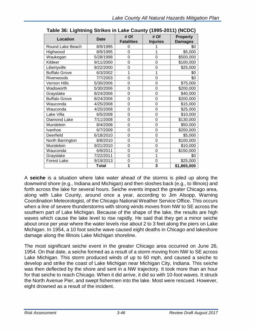
Lake County All Natural Hazards Mitigation Plan
Risk Assessment 3-46 Review Draft August 2017
Table 36: Lightning Strikes in Lake County (1995-2011) (NCDC)
Location Date # Of
Fatalities # Of
Injuries Property Damages
Round Lake Beach 8/9/1995 0 1 $0
Highwood 8/9/1995 0 1 $5,000
Waukegan 5/28/1998 0 0 $500,000
Kildeer 9/11/2000 0 0 $100,000
Libertyville 9/22/2000 0 0 $25,000
Buffalo Grove 6/3/2002 1 1 $0
Riverwoods 7/7/2003 0 0 $0
Vernon Hills 5/30/2006 0 0 $75,000
Wadsworth 5/30/2006 0 0 $200,000
Grayslake 8/24/2006 0 0 $40,000
Buffalo Grove 8/24/2006 0 0 $200,000
Wauconda 4/25/2008 0 0 $15,000
Wauconda 4/25/2008 0 0 $25,000
Lake Villa 6/5/2008 0 0 $10,000
Diamond Lake 7/11/2008 0 0 $130,000
Mundelein 8/4/2008 0 0 $50,000
Ivanhoe 6/7/2009 0 0 $200,000
Deerfield 6/18/2010 0 0 $5,000
North Barrington 8/8/2010 0 0 $100,000
Mundelein 9/21/2010 0 0 $10,000
Wauconda 6/9/2011 0 0 $150,000
Grayslake 7/22/2011 0 1 $0
Forest Lake 9/19/2013 0 0 $25,000
Total 1 3 $1,865,000
A seiche is a situation where lake water ahead of the storms is piled up along the downwind shore (e.g., Indiana and Michigan) and then sloshes back (e.g., to Illinois) and forth across the lake for several hours. Seiche events impact the greater Chicago area, along with Lake County, around once a year, according to Jim Alsopp, Warning Coordination Meteorologist, of the Chicago National Weather Service Office. This occurs when a line of severe thunderstorms with strong winds moves from NW to SE across the southern part of Lake Michigan. Because of the shape of the lake, the results are high waves which cause the lake level to rise rapidly. He said that they get a minor seiche about once per year where the water levels rise about 2 to 3 feet along the piers on Lake Michigan. In 1954, a 10 foot seiche wave caused eight deaths in Chicago and lakeshore damage along the Illinois Lake Michigan shoreline.
The most significant seiche event in the greater Chicago area occurred on June 26, 1954. On that date, a seiche formed as a result of a storm moving from NW to SE across Lake Michigan. This storm produced winds of up to 60 mph, and caused a seiche to develop and strike the coast of Lake Michigan near Michigan City, Indiana. This seiche was then deflected by the shore and sent in a NW trajectory. It took more than an hour for that seiche to reach Chicago. When it did arrive, it did so with 10-foot waves. It struck the North Avenue Pier, and swept fishermen into the lake. Most were rescued. However, eight drowned as a result of the incident.

Lake County All Natural Hazards Mitigation Plan
Risk Assessment 3-47 Review Draft August 2017
Exhibit 14: Lake County Lightning Events

Lake County All Natural Hazards Mitigation Plan
Risk Assessment 3-48 Review Draft August 2017
In July 2011, Northern Illinois was impacted by a derecho (also known as a land hurricane). A derecho is a widespread, long-lived windstorm that is associated with a band of rapidly-moving showers or thunderstorms. The storm radar is shown in Figure 10.
Figure 10: July 2011 Northern Illinois Storm
Source: National Weather Service
This derecho, as it moved across Lake Michigan, produced recorded wind speeds in excess of 80 MPH. The result of these excessive winds was the movement of water from the west side of Lake Michigan, to the East side of the Lake. Once this storm cleared the lake, and the winds subsided, the water began to rush back towards the west bank of Lake Michigan. As a result, a seiche warning was issued for the Chicago Lakefront, and areas north, up into Wisconsin. There was an expected 2-foot rise in the waters on the western edge of the Lake, once the water began returning, and settling. Figure 11 shows a schematic of a 1954 Lake Michigan seiche.

Lake County All Natural Hazards Mitigation Plan
Risk Assessment 3-49 Review Draft August 2017
Figure 11: 1954 Lake Michigan Seiche
3.5.2 Vulnerability –Severe Summer Storms Impact
Lake County is subject to severe “summer” storms throughout the year. Severe storms which have the potential to cause flash flooding, tornadoes, downbursts, and debris. The severe storms profile in this section (3.5 Severe Summer Storms) is primarily concerned with damage from hail, high winds, lightning, and other storm affects.
All assets located in Lake County can be considered at risk from severe summer storms. This includes 703,462 people, or 100 percent of the County’s population and all buildings and infrastructure within the County.
Health and Safety: Three deaths and 27 injuries have been attributed to severe storms in Lake County. The threat to life and safety is present with severe thunder, lighting and wind storms. Hail rarely causes loss of life. No special health problems are attributable to thunderstorms, other than the potential for tetanus and other diseases that arise from injuries and damaged property. Impact to health and safety for severe summer storms is considered moderate.
Damage to Buildings and Critical Infrastructure: Damage to roofs and siding and cars is frequently reported as a result of hail events. Depending on the hail size and wind

Lake County All Natural Hazards Mitigation Plan
Risk Assessment 3-50 Review Draft August 2017
severity, damage to awnings, glass, and siding can also occur. Critical facilities tend to be as vulnerable to severe storm damage as residences.
The critical infrastructure typically of most concern during a severe storm is the electrical supply. Winds, lightning, falling branches and trees can damage substations, transformers, poles, and power lines.
Impact to buildings and critical facilities for severe summer storms is considered moderate.
Economic Impact: Communications can be disrupted by lightning. Signal disruptions due to lightning are common. In addition, communication lines, antennas, and towers can suffer damage from lightning and downed branches/trees. However, with the common occurrence of severe summer storms, recovery is relatively quick by utility companies. Economic impact for severe summer storms is considered low.
Multi-Jurisdictional Differences: Each municipality in the County has an equal susceptibility to severe storms and lightning. Predictability again causes a great problem when discussing the probability of damage from high wind events. There is really no way to pinpoint exactly where, when, and to what extent a thunderstorm or other severe weather event will cause damage. However, we know that thunderstorm events, with high wind and dangerous lightning, are highly possible in the county. These storms are prominent in the early spring and continue through late fall. If located in a densely-populated area of the county, it is easy to estimate damages in the millions of dollars from these events.
3.6 Severe Winter Storms
Lake County has been impacted by varying degrees of winter weather over the last century; however; the occurrence of severe winter weather in the county is relatively infrequent, even during winter months. Severe winter weather can cause hazardous driving conditions, communications and electrical power failure, community isolation and can adversely affect business continuity. This type of severe weather may include one or more of the following winter factors:
Blizzards, as defined by the National Weather Service, are a combination of sustained winds or frequent gusts of 35 mph or greater and visibilities of less than a quarter mile from falling or blowing snow for 3 hours or more. A blizzard, by definition, does not indicate heavy amounts of snow, although they can happen together. The falling or blowing snow usually creates large drifts from the strong winds. The reduced visibilities make travel, even on foot, particularly treacherous. The strong winds may also support dangerous wind chills. Ground blizzards can develop when strong winds lift snow off the ground and severely reduce visibilities.
Lake County
Source: David Christensen

Lake County All Natural Hazards Mitigation Plan
Risk Assessment 3-51 Review Draft August 2017
Heavy snow, in large quantities, may fall during winter storms. Six inches or more in 12 hours or eight inches or more in 24 hours constitutes conditions that may significantly hamper travel or create hazardous conditions. The National Weather Service issues warnings for such events. Smaller amounts can also make travel hazardous, but in most cases, only results in minor inconveniences. Heavy wet snow before the leaves fall from the trees in the fall or after the trees have leafed out in the spring may cause problems with broken tree branches and power outages.
Ice storms develop when a layer of warm (above freezing), moist air aloft coincides with a shallow cold (below freezing) pool of air at the surface. As snow falls into the warm layer of air, it melts to rain, and then freezes on contact when hitting the frozen ground or cold objects at the surface, creating a smooth layer of ice. This phenomenon is called freezing rain. Similarly, sleet occurs when the rain in the warm layer subsequently freezes into pellets while falling through a cold layer of air at or near the Earth’s surface. Extended periods of freezing rain can lead to accumulations of ice on roadways, walkways, power lines, trees, and buildings. Almost any accumulation can make driving and walking hazardous. Thick accumulations can bring down trees and power lines.
3.6.1 Severe Winter Storm Hazard Profile
The science of meteorology and records of severe weather are not quite sophisticated enough to identify what areas of the county are at greater risk for damages. Therefore, all areas of the county are assumed to have the same winter weather risk countywide. Severe winter weather can result in the closing of primary and secondary roads, particularly in rural locations, loss of utility services, and depletion of oil heating supplies. Environmental impacts often include damage to shrubbery and trees due to heavy snow loading, ice build-up, and/or high winds which can break limbs or even bring down large trees. Gradual melting of snow and ice provides excellent groundwater recharge; however, high temperatures following a heavy snowfall can cause rapid surface water runoff and severe flash flooding.
The State of Illinois has an extensive history of severe winter weather. In the winter of 2011, the state was hit by a series of winter storms. These storms included ice storms, followed by unseasonably high temperatures and high rainfall totals, all of which resulted in extensive flooding and mudslides. This series of storms resulted in Presidential Declaration FEMA-DR-1960-IL. This declaration provided over eighty-four million dollars in recovery funds. These funds included Public Assistance and Hazard Mitigation Grant funds.

Lake County All Natural Hazards Mitigation Plan
Risk Assessment 3-52 Review Draft August 2017
Table 37: Severe Winter Storms in Lake County (1994-2016) (NCDC)
Event Type Date Event Type Date
Winter Storm 12/6/1994 Heavy Snow 12/31/2007
Heavy Snow 1/18/1995 Winter Storm 1/29/2008
Winter Storm 12/8/1995 Winter Storm 1/31/2008
Winter Storm 1/9/1997 Winter Storm 2/1/2008
Winter Storm 1/15/1997 Winter Storm 2/5/2008
Heavy Snow 11/14/1997 Winter Storm 3/21/2008
Heavy Snow 1/8/1998 Winter Storm 12/19/2008
Heavy Snow 3/9/1998 Winter Storm 1/9/2009
Heavy Snow 1/1/1999 Winter Storm 3/28/2009
Heavy Snow 3/8/1999 Winter Storm 12/26/2009
Heavy Snow 2/8/2000 Winter Storm 1/7/2010
Blizzard 12/11/2000 Winter Storm 2/9/2010
Winter Storm 1/31/2002 Winter Storm 12/11/2010
Winter Storm 3/2/2002 Winter Storm 1/31/2011
Winter Storm 3/4/2003 Blizzard 2/1/2001
Heavy Snow 1/4/2005 Winter Storm 1/20/2012
Winter Storm 1/20/2006 Winter Storm 2/23/2012
Winter Storm 11/30/2006 Heavy Snow 2/7/2013
Winter Storm 12/1/2006 Heavy Snow 2/26/2013
Blizzard 2/13/2007 Winter Storm 3/5/2013
Blizzard 2/25/2007 Heavy Snow 2/4/2014
Winter Storm 12/4/2007 Blizzard 2/1/2015
Heavy Snow 12/15/2007 Heavy Snow 11/20/2015
Winter weather is a common occurrence in Illinois throughout the winter, and early spring months. According to the National Climatic Data Center, there have been 35 winter events in Lake County since 1994 (Table 37). The potential severities of winter storms are often difficult to predict, but through identifying various indicators of weather systems, and tracking these indicators, it provides means of monitoring winter weather. Understanding the historical frequency, duration, and spatial extent of winter weather assists in determining the likelihood and potential severity of future occurrences.
Heavy Snow Storms can immobilize a region and paralyze a city. These events can strand commuters, close airports, stop supplies from reaching their destinations and disrupt emergency and medical services. Accumulations of snow can cause roofs to collapse and knock down trees and power lines. Homes and farms may be isolated and unprotected livestock may be lost. The cost of snow removal, repairing damages, and the loss of business can have economic impacts on cities and towns.
Reported heavy snow events over the past 22 years provide an acceptable framework for determining the future occurrence in terms of frequency for such events. The probability of the County and its municipalities experiencing a flood event can be difficult to quantify, but based on historical record of 47 winter storm events since 1994, it can reasonably be assumed that this type of event has occurred once every 0.46 years from 1994 through 2016.
[(Current Year) 2016] subtracted by [(Historical Year) 1994] = 22 Years on Record
[(Years on Record) 22] divided by [(Number of Historical Events) 47] = 0.46

Lake County All Natural Hazards Mitigation Plan
Risk Assessment 3-53 Review Draft August 2017
The historic frequency calculates that there is a 100% chance of a severe winter storm event occurring each year.
Ice accumulations can lead to downed trees, utility poles and communication towers. Ice can disrupt communications and power while utility companies repair significant damage. Even small accumulations of ice can be extremely dangerous to motorists and pedestrians. Bridges and overpasses are particularly dangerous because they freeze before other surfaces. An ice storm is a type of winter storm characterized by freezing rain. The US National Weather Service defines an ice storm as a storm which results in the accumulation of at least 0.25 inch of ice on exposed surfaces.
Three ice storms were recorded in the NCDC, including ones on January 26, 1997, December 1 and December 11, 2007. The December 1, 2007 event had $1,000 of recorded damage.
The probability of the County and its municipalities experiencing an ice event can be difficult to quantify, but based on historical record of 3 ice events since 1994, it can reasonably be assumed that this type of event has occurred once every 7.33 years from 1950 through 2016.
[(Current Year) 2016] subtracted by [(Historical Year) 1994] = 22 Years on Record
[(Years on Record) 22] divided by [(Number of Historical Events) 3] = 7.33
The historic frequency calculates that there is a 18% chance of this type of event occurring each year, but it is recognized that ice storm conditions that may be coupled with snow storm events may mean that the frequency may be greater than the data presents.
3.6.2 Vulnerability - Winter Storm Impact
All of Lake County is vulnerable to severe winter storms. Severe winter storms can lead to power outages, downed trees and branches, hypothermia, injuries and loss of life. Climate data maintained by the Illinois State Water Survey indicates that between 1900 and 2000, Illinois can expect to receive a six inch or more snowfall within a 48-hour period at least twice a year. In Illinois, severe winter storm losses since 1950 average an estimated $102 million, annually. Severe weather storms can immobilize large areas with rural areas being particularly impacted by impassable roads.
Health and Safety: Health hazards related to walking and snow removal are frequent and life-threatening. Falls, particularly to the elderly, can result in serious injury including fractures, broken bones, and shattered hips. Middle-aged and older adults are susceptible to heart attacks from shoveling snow. An average of six deaths per year are attributable to winter storms in Illinois.
While vehicular accidents are often caused by the driver’s lapse in judgment, the weather and its impact on roads are also a major factor. Blowing snow, ice and slush create slippery pavement making vehicle travel less safe during and immediately following winter storms. The injuries and deaths that occur when winter storms are present could be reduced through mitigation.

Lake County All Natural Hazards Mitigation Plan
Risk Assessment 3-54 Review Draft August 2017
While most injuries caused by snow and ice storms result from vehicle accidents, about 25% of all winter storm injuries occur to people caught outside in a storm. The effect of cold on people is magnified by wind. As the wind increases, heat is carried away from the body at an accelerated rate, driving down body temperature. Frostbite (damage to tissue) to hands, feet, ears, and nose, and hypothermia (lowering of body temperature below 95° F) are common winter storm injuries.
Impact to health and safety for severe winter storms is considered moderate.
Damage to Buildings and Critical Infrastructure: Information gathered from residents of Lake County indicates snow and ice accumulations on communication, power lines, and key roads pose the most frequent infrastructure problems. Accumulations on above-ground electrical lines often create power outages. These power outages vary from several hours to several days.
Dangerous driving conditions frequently occur during and shortly after severe winter storms. State and county roads in Lake County that experience repeated drifting result in road closures and greater susceptibility to accidents. When transportation is disrupted, schools close, emergency services are delayed, some businesses close, and some government services are delayed.
There is a financial cost to road departments. An average snow storm is defined as requiring 12 hours of work each day for two days, consuming approximately 40 tons of road salts, and 600 gallons of fuel to maintain County roads in Lake County. Highway departments and road district budget for snow removal, but budgets can easily be exceeded.
Impact to buildings and critical facilities for severe winter storms is considered moderate.
Economic Impact: Loss of power means businesses and manufacturing concerns must close. Loss of access due to snow or ice covered roads has a similar effect. There are also impacts when people cannot get to work, to school, or to the store.
Economic impact for severe winter storms is considered low.
Multi-Jurisdictional Differences: Each municipality in the County has an equal susceptibility to severe winter storms and most storms impact the entire county and the northeastern Illinois region.
3.7 Drought
Drought is a normal part of virtually all climates, including areas with high and low average rainfall. It is caused by a deficiency of precipitation and can be aggravated by other factors such as high temperatures, high winds, and low relative humidity.
Droughts can be grouped as meteorological, hydrologic, agricultural, and socioeconomic. Representative definitions commonly used to describe the types of drought are summarized below.

Lake County All Natural Hazards Mitigation Plan
Risk Assessment 3-55 Review Draft August 2017
Meteorological drought is defined solely on the degrees of dryness, expressed as a departure of actual precipitation from an expected average or normal amount based on monthly, seasonal, or annual time scales.
Hydrologic drought is related to the effects of precipitation shortfalls on streamflow, reservoir, lake, and groundwater levels.
Agricultural drought is defined principally in terms of soil moisture deficiencies relative to water demands of plant life, usually crops.
Socioeconomic drought associates the supply and demand of economic goods or services with elements of meteorological, hydrologic, and agricultural drought. Socioeconomic drought occurs when the demand for water exceeds the supply because of a weather-related supply shortfall. The incidence of this type of drought can increase because of a change in the amount of rainfall, a change in societal demands for water (or vulnerability to water shortages), or both.
The Standardized Precipitation Index (SPI) is a drought index based on the probability of an observed precipitation deficit occurring over a given prior time period. The assessment periods considered range from 1 to 36 months. The variable time scale allows the SPI to describe drought conditions important for a range of meteorological, agricultural, and hydrological applications. For example, soil moisture conditions respond to precipitation deficits occurring on a relatively short time scale, whereas groundwater, streamflow, and reservoir storage respond to precipitation deficits arising over many months.
The Palmer Drought Severity Index (PDSI) was developed by Wayne Palmer in the 1960s and uses temperature and rainfall information in a formula to determine dryness. It has become the semi-official drought index. The Palmer Index is most effective in determining long term drought—a matter of several months—and is not as good with short-term forecasts (a matter of weeks). It uses a 0 as normal, and drought is shown in terms of minus numbers; for example, minus 2 is moderate drought, minus 3 is severe drought, and minus 4 is extreme drought. The index is shown in Table 38.

Lake County All Natural Hazards Mitigation Plan
Risk Assessment 3-56 Review Draft August 2017
Table 38: Drought Severity Classification
Drought
Severity
Return
Period
(Years)
Description of Possible Impacts
DROUGHT MONITORING INDICES
Standardized
Precipitation
Index (SPI)
NDMC*
Drought
Category
Palmer
Drought
Index
Minor
Drought 3 to 4
Going into drought; short-term dryness
slowing growth of crops or pastures; fire risk
above average. Coming out of drought;
some lingering water deficits; pastures or
crops not fully recovered.
-0.5 to -0.7 D0 -1.0 to -1.9
Moderate
Drought 5 to 9
Some damage to crops or pastures; fire risk
high; streams, reservoirs, or wells low, some
water shortages developing or imminent,
voluntary water use restrictions requested.
-0.8 to -1.2 D1 -2.0 to -2.9
Severe
Drought 10 to 17
Crop or pasture losses likely; fire risk
very high; water shortages common;
water restrictions imposed
-1.3 to -1.5 D2 -3.0 to -3.9
Extreme
Drought 18 to 43
Major crop and pasture losses; extreme
fire danger; widespread water shortages
or restrictions
-1.6 to -1.9 D3 -4.0 to -4.9
Exceptional
Drought 44 +
Exceptional and widespread crop and
pasture losses; exceptional fire risk;
shortages of water in reservoirs,
streams, and wells creating water
emergencies
Less than -2 D4 -5.0 or less
Source: National Drought Mitigation Center
3.7.1 Drought Hazard Profile
There is no commonly accepted approach for assessing risk associated with droughts given the varying types and indices. Drought risk is based on a combination of the frequency, severity, and spatial extent (the physical nature of drought) and the degree to which a population or activity is vulnerable to the effects of drought. The degree of Lake County’s vulnerability to drought depends on the environmental and social characteristics of the region and is measured by its ability to anticipate, cope with, resist, and recover from drought.
Mapping of the current drought status is published by the National Integrated Drought Information System (NIDIS): U.S. Drought Portal which can be found online at: www.drought.gov
Due to the nature of drought, it is extremely difficult to predict, but through identifying various indicators of drought, and tracking these indicators, it provides us with a crucial means of monitoring drought. Understanding the historical frequency, duration, and spatial extent of drought assists in determining the likelihood and potential severity of future droughts. The characteristics of past droughts provide benchmarks for projecting similar conditions into the future. The probability of Lake County and its municipalities experiencing a drought event can be difficult to quantify, but based on historical record of 9 droughts since 2005, it can reasonably be assumed that this type of event has occurred once every 1.22 years from 2005 through 2016.
Lake County All Natural Hazards Mitigation Plan
Risk Assessment 3-57 Review Draft August 2017
The following summarizes the previous occurrences as well as the extent or severity of the drought events in Lake County. Information obtained from the Storm Events Database and the Illinois Emergency Management Agency show three reported drought events in Lake County between 1983 and August 31, 2009. Comprehensive damage information was either unavailable or none was recorded for any of the events. Also, no drought-related injuries or deaths were reported.
• In 1983, all 102 Illinois counties were proclaimed state disaster areas because of high temperatures and insufficient precipitation beginning in mid-June.
• In 1988, approximately half of the counties in Illinois (including Lake County) were impacted by drought conditions, although none of the counties were proclaimed state disaster areas. Disaster relief payments exceeding $382 million were paid to landowners and farmers as a result of this drought.
• In 2005, drought conditions impacted much of the state, including Lake County. Dry conditions reached a historic level of severity in some parts of Illinois and ranked as one of the three most severe droughts in Illinois based on 112 years of data. According to the National Climatic Data Center this drought, listed from June 2005 to February 2006, had no significant property damage loss since 2005, and no significant damages to agriculture have occurred either.
The odds of a drought in any year are most likely less than 10 percent, but it is recognized that droughts can extend over multiple years.
The National Oceanic and Atmospheric Administration Paleoclimatology Program studies drought by analyzing records from tree rings, lake and dune sediments, archaeological remains, historical documents, and other environmental indicators to obtain a broader picture of the frequency of droughts in the United States. According to their research, “…paleoclimatic data suggest that droughts as severe as the 1950’s drought have occurred in central North America several times a century over the past 300-400 years, and thus we should expect (and plan for) similar droughts in the future. The paleoclimatic record also indicates that droughts of a much greater duration than any in the 20th century have occurred in parts of North America as recently as 500 years ago.” Based on this research, the 1950’s drought situation could be expected approximately once every 50 years or a 20% chance every ten years. An extreme drought, worse than the 1930’s “Dust Bowl,” has an approximate probability of occurring once every 500 years or a 2% chance of occurring each decade. (National Oceanic and Atmospheric Administration, 2003). A 500-year drought with a magnitude similar to that of the 1930’s that destroys the agricultural economy and leads to Earthquake/Seismic Activities is an example of a high magnitude event.
Impacts to vegetation and wildlife can include death from dehydration and spread of invasive species or disease because of stressed conditions. However, drought is a natural part of the environment in Illinois and native species are likely to be adapted to surviving periodic drought conditions. It is unlikely that drought would jeopardize the existence of rare species or vegetative communities.

Lake County All Natural Hazards Mitigation Plan
Risk Assessment 3-58 Review Draft August 2017
Environmental impacts are more likely at the interface of the human and natural world. The loss of crops or livestock due to drought can have far-reaching economic effects. Wind and water erosion can alter the visual landscape and dust can damage property. Water-based recreational resources are affected by drought conditions.
3.7.2 Vulnerability – Drought Impacts
Health and Safety: Drought events affect the entire County in any one of the four drought categories discussed above. Much of the county and municipalities rely on groundwater for their source of drinking water. With the anticipated growth in the total County population, this will be a growing concern. The agricultural community will continue to be affected by droughts. All communities in Lake County are subject to drought-related impacts. A drought, however, evolves slowly over time and the population typically has ample time to prepare for its effects. Should a drought affect the water available for public water systems or individual wells, the availability of clean drinking water could be compromised. This situation would require emergency actions and could possibly overwhelm the local government and financial resources.
Damage to Buildings and Critical Infrastructure: Drought had little impact on buildings. Possible losses/impacts to critical facilities include the loss of critical function due to low water supplies. Severe droughts can negatively affect drinking water supplies. Should a public water system be affected, the losses could total into the millions of dollars if outside water is shipped in. Private springs/wells could also dry up. Possible losses to infrastructure include the loss of potable water.
Economy Impact: The largest economic impact of drought is to agriculture. While livestock can be impacted, the greatest concern is for row crops and produce.
Multi-Jurisdictional Differences: Due to the nature of drought, all jurisdictions within Lake County are expected to be impacted equally due to drought conditions.
3.8 Earthquake
An earthquake is the motion or trembling of the ground produced by sudden displacement of rock usually within the upper 10–20 miles of the Earth’s crust. Earthquakes can affect hundreds of thousands of square miles, cause damage to property measured in the tens of billions of dollars, result in loss of life and injury to hundreds of thousands of persons, and disrupt the social and economic functioning of the affected area. Most property damage and earthquake-related deaths are caused by the failure and collapse of structures due to ground shaking which is dependent upon amplitude and duration of the earthquake (FEMA, 1997).
The impact an earthquake event has on an area is typically measured in terms of earthquake intensity. Intensity is most commonly measured using the Modified Mercalli Intensity (MMI) Scale based on direct and indirect measurements of seismic effects. A detailed description of the Modified Mercalli Intensity Scale is shown in Table 39.

Lake County All Natural Hazards Mitigation Plan
Risk Assessment 3-59 Review Draft August 2017
Table 39: Modified Mercalli Intensity
Scale Intensity Description of Effects
Corresponding
Richter Scale
Magnitude
I Instrumental Detected only on seismographs
<4.2 II Feeble Some people feel it
III Slight Felt by people resting; like a truck rumbling by
IV Moderate Felt by people walking
V Slightly
Strong Sleepers awake; church bells ring <4.8
VI Strong Trees sway; suspended objects swing; objects fall off
shelves <5.4
VII Very Strong Mild alarm, walls crack, plaster falls <6.1
VIII Destructive Moving cars uncontrollable, masonry fractures, poorly
constructed buildings damaged <6.9
IX Ruinous Some houses collapse, ground cracks, pipes break
open
X Disastrous Ground cracks profusely, many buildings destroyed,
liquefaction and landslides widespread <7.3
XI Very
Disastrous
Most buildings and bridges collapse, roads, railways,
pipes and cables destroyed, general triggering of
other hazards
<8.1
XII Catastrophic Total destruction, trees fall, ground rises and falls in
waves >8.1
One way to express an earthquake’s severity is to compare its acceleration to the normal acceleration due to gravity. Peak ground acceleration (PGA) measures the strength of ground movements in this manner. PGA represents the rate in change of motion of the earth’s surface during an earthquake as a percent of the established rate of acceleration due to gravity.
The lack of noticeable activity in Lake County can be partly attributed to the PGA. PGA is partly determined by what soils and bedrocks are present in the area. In Lake County, the PGA is relatively low. Lake County is in the border area of eight (8) to six (6) PGA. This is interpreted as the area having the possibility of eight (8) percent to six (6) percent of gravities acceleration listed as 1g. These numbers would be denoted as 0.08g and 0.06g respectively. When the peak acceleration nears 0.1g, damage may be caused to poorly constructed buildings while acceleration nearing 0.2 would create loss of balance and greater damage to lesser quality structures.
3.8.1 Earthquake Hazard Profile
Southern Illinois lies on the immediate boundary of the New Madrid fault, centrally located at New Madrid, Missouri. This fault has created significant activity over the last 200 years. The most intense activity occurred in the years 1811-1812. Two earthquakes

Lake County All Natural Hazards Mitigation Plan
Risk Assessment 3-60 Review Draft August 2017
estimated to be 7’s on the Richter scale hit the New Madrid Fault. However, Lake County is located on the edge of the New Madrid fault area. According to the USGS-National Seismic Hazard Mapping Project (NSHMP), Lake County is predicted to have only a 2-3% chance of a magnitude 5.0 or greater earthquake over a 100-year period.
Illinois has recorded 364 earthquakes over the last two centuries. Most earthquakes have had epicenters in the Southern portion of the state and have not been felt in Lake County. Recent Earthquakes in Illinois are shown in Table 40.
An earthquake in northern Illinois occurred on February 10, 2010 at around 4:00 a.m. USGS recorded the earthquake as 3.8 in magnitude with the epicenter at Pingree Grove in Kane County and was felt in Lake County. Prior to that, a 5.2 earthquake on April 18, 2008, with epicenter in Wabash County, Illinois, was felt in Lake County. As shown in Figure 12, people in Lake County reported feeling the earthquake. People can report to USGS through their “Did You Feel It” website. USGS classified the Lake County reports from the April 2008 earthquake as “II” or weak.
The future probability of earthquakes in Illinois is 100%, however the probability for a seismic event with the epicenter within Lake County is low. A large magnitude event in southern Illinois will be felt in Lake County, though the event would most likely cause limited structural damage in Lake County. Primarily historic and masonry building would be damaged.
Table 40: Recent Earthquakes in Illinois
Richter Scale
Date Epicenter
5 May 10, 1987 Near Lawrenceville, IL
4.5 Sep. 28, 1989 15 miles south of Cairo, IL
4.7 Apr. 27, 1989 15 miles SW of Caruthersville, MO
4.6 Sep. 26, 1990 10 miles south of Cape Girardeau, MO
4.6 May 3, 1991 10 miles west of New Madrid, MO
4.2 Feb. 5, 1994 Lick Creek-Goreville Area
4.2 June 28, 2004 10 miles NNW of Ottawa, IL
5.2 April 18, 2008 Wabash County, Illinois
3.8 February 10, 2010 Pingree Grove, Kane County, IL
3.2 November 4, 2013 Summit, Cook County, IL
2.9 March 25, 2015 Lake in the Hills, McHenry County
3.4 May 29, 2015 Fairfield, Wayne County, IL
Sources: 2010 and 2013 Illinois Natural Hazard Mitigation Plan, and USGS
3.8.2 Vulnerability – Earthquake Impact
As mentioned previously, Lake County has peak acceleration much below that number, thus providing a buffer from most seismic activity. However, to the proximity to the New Madrid Fault Line, the State of Illinois could be subject to an earthquake with a magnitude of 7.0 or more. Northern Illinois has had earthquakes with magnitudes of four and five in

Lake County All Natural Hazards Mitigation Plan
Risk Assessment 3-61 Review Draft August 2017
the previous century. These events are infrequent, and thus, predicting the amount of damage would be difficult due to a lack of history of events with epicenters in Lake County. The most active seismic county in proximity to Lake is Cook County, with eight events.
Health and Safety: Health and safety concerns due to earthquakes for the people of Lake County is low.
Damage to Buildings and Critical Infrastructure: As mentioned, historic and masonry building could be damaged by a large southern Illinois. Most other building, and especially those built under a building code would have little or no damage. Some content damage can be expected where items fall from shelves.
Figure 12: “Did You Feel It” Reports for April 18, 2008 Earthquake
in Wabash County, Illinois

Lake County All Natural Hazards Mitigation Plan
Risk Assessment 3-62 Review Draft August 2017
Economic Impacts: Potential for business loss due to earthquakes is low, however environmental impacts of earthquakes can be numerous, particularly if indirect impacts are considered. Some examples are shown below, but are unlikely to occur in Lake County:
• Induced tsunamis and flooding or landslides;
• Poor water quality;
• Damage to vegetation;
• Breakage in sewage or toxic material containment, and
• Breakage of natural gas and other pipelines that serve Lake County
Multi-Jurisdictional Differences: All Lake County jurisdictions can be impacted by earthquakes.
3.9 Dam Failure
A dam is defined as a barrier constructed across a watercourse for the purpose of storage, control, or diversion of water. Dams typically are constructed of earth, rock, concrete, or mine tailings. A dam failure is the collapse, breach, or other failure, often resulting in down-stream flooding.
A dam impounds water in the upstream area, referred to as the reservoir. The amount of water impounded is measured in acre-feet. An acre-foot is the volume of water that covers an acre of land to a depth of one foot. As a function of upstream topography, even a very small dam may impound or detain many acre-feet of water. Two factors influence the potential severity of a full or partial dam failure: the amount of water impounded, and the density, type, and value of development and infrastructure located downstream.
Dam failures typically occur when spillway capacity is inadequate and excess flow overtops the dam, or when internal erosion (piping) through the dam or foundation occurs. Complete failure occurs if internal erosion or overtopping results in a complete structural breach, releasing a high-velocity wall of debris-laden water that rushes downstream.
Dam failures can result from any one or a combination of the following causes:
• Prolonged periods of rainfall and flooding, which cause most failures;
• Inadequate spillway capacity, resulting in excess overtopping flows;
• Internal erosion caused by embankment or foundation leakage or piping;
• Improper maintenance, including failure to remove trees, repair internal seepage problems, replace lost material from the cross section of the dam and abutments, or maintain gates, valves, and other operational components;
• Improper design, including the use of improper construction materials and construction practices;

Lake County All Natural Hazards Mitigation Plan
Risk Assessment 3-63 Review Draft August 2017
• Negligent operation, including the failure to remove or open gates or valves during high flow periods;
• Failure of upstream dams on the same waterway;
• Landslides into reservoirs, which cause surges that result in overtopping;
• High winds, which can cause significant wave action and result in substantial erosion; and
• Earthquakes, which typically cause longitudinal cracks at the tops of the embankments, which can weaken entire structures.
Dam failure hazards are considered to be localized impact and affect specific inundation areas downstream of the dam. Discharge from a dam breach is usually several times the 1% chance flood, called the probable maximum flood, and require a dam breach analysis (hydraulic modeling study).
Determining the impact of flooding is difficult to accomplish, especially for estimating loss of life. Loss of life is a function of the time of day, warning time, awareness of those affected and particular failure scenarios. Many dam safety agencies have used “population at risk”, a more quantifiable measurement of the impact to human life, rather than “loss of life”. Population at risk is the number of people in structures within the inundation area that would be subject to significant personal danger, if they took no action to evacuate. The impacts of a dam failure are contingent on many factors and, therefore, cannot be concisely described.
When they do occur, dam or levee failures can have a greater environmental impact than that associated with a flood event. Large amounts of sediment from erosion can alter the landscape changing the ecosystem. Hazardous materials can be carried away from flooded out properties and distributed throughout the floodplain. Industrial and agricultural chemicals and wastes, solid wastes, raw sewage, and common household chemicals comprise the majority of hazardous materials spread by flood waters along the flood zone, polluting the environment and contaminating private property and the community’s water supply.
3.9.1 Hazard Profile
Dam safety laws are embodied in the Dam Safety and Encroachments Act ("DSE Act") -enacted July 1, 1979 and last amended in 1985. Rules pertaining to dam safety are found in Title 25-Rules and Regulations; Part I-Department of Environmental Resources; Subpart C-Protection of Natural Resources; Article II-Water Resources; Chapter 105-Dam Safety and Waterway Management ("the Rules")-adopted Sept. 16, 1980. (www.damsafety.org)
Dams are categorized in one of three classes according to the degree of threat to life and property in the event of dam failure.
• According to 17 Illinois Administrative Code (IAC), Class I dams are: “dams that are located where failure has a high probability for causing loss of life or substantial economic loss in excess of that which would naturally occur downstream of the dam if the dam had not failed. A dam has a high probability for

Lake County All Natural Hazards Mitigation Plan
Risk Assessment 3-64 Review Draft August 2017
causing loss of life or substantial economic loss if it is located where its failure may cause additional damage to such structures as a home, hospital, a nursing home, a highly-traveled roadway, a shopping center, or similar type facilities where people are normally present downstream of a dam.”
• 17 IAC defines Class II dams as: “dams located where failure has a moderate probability for causing loss of life or may cause substantial economic loss in excess of that which would naturally occur downstream of the dam if the dam had not failed. A dam has a moderate probability for causing loss of life or substantial economic loss if it is located where its failure may cause additional damage to such structures as a water treatment facility, a sewage treatment facility, a power substation, a city park, a U.S. Route, or Illinois Route highway, a railroad or similar type of facilities where people are downstream of the dam for only a portion of the day or on a more sporadic basis.”
• 17 IAC defines Class III dams as: “dams located where failure has a low probability for causing loss of life, where there are no permanent structures for human habitation, or minimal economic loss in excess of that which would naturally occur downstream of the dam if the dam had not failed. A dam has a low probability for causing loss of life or minimal economic loss if it is located where its failure may cause additional damage to agricultural fields, timber areas, township roads or similar type areas where people are seldom present and where there are few structures.”
Class I and II dams in Lake County are listed in the Table 41. The location of all Lake County Dams is also mapped in Exhibit 15.
Table 41: Class I and II Dams in Lake County
Class Name Stream
I Forest Lake Dam Tributary to Indian Creek
I St. Mary’s Lake Dam Bull Creek
I Countryside Lake Dam Indian Creek
I Lake Charles Dam Seavey Drainage Ditch
I Buffalo Creek Dam Buffalo Creek
I Tullamore Dam Seavey Drainage Ditch
I Hawthorn Parkway Dam Seavey Drainage Ditch
II Round Lake Dam Tributary to Squaw Creek
II Sylvan Lake Dam Tributary to Indian Creek
II Loch Lomond Dam Bull Creek
II Lake Zurich Retail Center Dam No name
Not listed in Table 41 is the Stratton Lock and Dam in McHenry. A potential failure of the Stratton Dam at the Stratton Lock and Dam would have a large impact on the Fox Chain O’ Lakes in Lake County, but the condition of the dam and the locks are closely monitored by IDNR-OWR.

Lake County All Natural Hazards Mitigation Plan
Risk Assessment 3-65 Review Draft August 2017
Exhibit 15: Lake County Dams
A dam can fail at any time, given the right circumstances. However, the probability of future occurrence is for regulated dams can be reduced due to proactive preventative action in compliance with IDNR-OWR’s dam safety program. Illinois’ dam safety program provides for safety recommendations for signs, buoys, and short- and long-term structural modifications – including dam removal.
As a dam ages, the likelihood for failure increases as undesirable woody vegetation on the embankment, deteriorated concrete, inoperable gates, and corroded outlet pipes

Lake County All Natural Hazards Mitigation Plan
Risk Assessment 3-66 Review Draft August 2017
become problems. Since dam failures are often exacerbated by flooding, the probability of dam failures can be associated with projected flood frequencies. Lake County is currently removing the MacArthur Woods Dam and the Wright Woods Dam, the last two dams on the Des Plaines River in Lake County.
3.9.2 Vulnerability – Dam Failure Impact
A vulnerability analysis for dam failure has not been conducted for the dams listed in Table 42 due to insufficient data. Dam-breach analyses and the mapping of potential dam breach inundation areas is the most appropriate means for examining the impact to people and to property. As individual dam failure analyses and inundation mapping become more available, Lake County intends to add this information, and include a vulnerability analysis, in future updates of the ANHMP.
Multi-Jurisdictional Differences: Most Lake County communities have a dam located within their jurisdiction, as shown in Exhibit 3-8. Nine of the eleven Class I and II dams listed in Table 42 are in the Des Plaines River Watershed (Buffalo Creek, Bull Creek, Indian Creek and Seavey Drainage Ditch). The other two dams (Class II) are within the Fox River Watershed (Squaw Creek and unnamed).
3.10 Temperature Extremes
Extreme temperatures can be dangerous due to the way that they affect individuals who are exposed to them. Extreme heat is usually defined through a combination of temperature and humidity. Extreme cold is based on the temperature with wind chill. The recorded extreme heat events have occurred from June through September. Recorded extreme cold events in Northern Illinois have occurred from December through February. Extreme temperatures can be dangerous to people, and crops.
Extreme heat is characterized by temperatures that hover 10 degrees or more above the average high temperature of a region for several days to several weeks. In comparison, a heat wave is generally defined as a period of at least three consecutive days above 90°F.
Extreme heat is the number one weather-related killer in the United States. It causes more fatalities each year than floods, lightning, tornadoes and hurricanes combined.
In the Midwest, summers tend to combine both high temperature and high humidity. Heat disorders generally have to do with a reduction or collapse of the body’s ability to shed heat by circulatory changes and sweating or a chemical (salt) imbalance caused by too much sweating. When the body heats too quickly to cool itself safely, or when too much fluid is lost through dehydration or sweating, the body temperature rises, and heat-related illnesses may develop.

Lake County All Natural Hazards Mitigation Plan
Risk Assessment 3-67 Review Draft August 2017
The most significant extreme heat event recorded by the NCDC occurred in 1995. According to NOAA, an intense heat wave affected northern Illinois from Wednesday, July 12 through Sunday, July 16, 1995. The heat wave tied or broke several temperature records at Rockford and Chicago. But what set this heat wave apart from others was the extremely high humidity. Dew point temperatures peaked in the lower 80s late Wednesday the 12th and Thursday the 13th and were generally in the middle and upper 70s through the rest of the hot spell. The combined and cumulative effects of several days of high temperatures, high humidity, intense July sunshine (100% possible sunshine recorded at O'Hare Airport in Chicago July 13) and light winds took their toll. 583 people died as a result of the heat in Chicago and surrounding areas. Lake County recorded 1 death in Ingleside as a result of this heat wave.
Figure 13: NOAA’s National Weather Service Heat Index
Table 42: Relationship between Heat Index and Heat
Disorders
Heat Index (°F) Heat Disorders
80°F – 90°F Fatigue is possible with prolonged exposure
and/or physical activity.
90°F – 105°F
Heat cramps, heat exhaustion and heat stroke
possible with prolonged exposure and/or
physical activity.
105°F – 130°F
Heat cramps, heat exhaustion and heat stroke
likely; heat stroke possible with prolonged
exposure and/or physical activity.
130°F or Higher Heat stroke highly likely with continued
exposure.
Source: NOAA
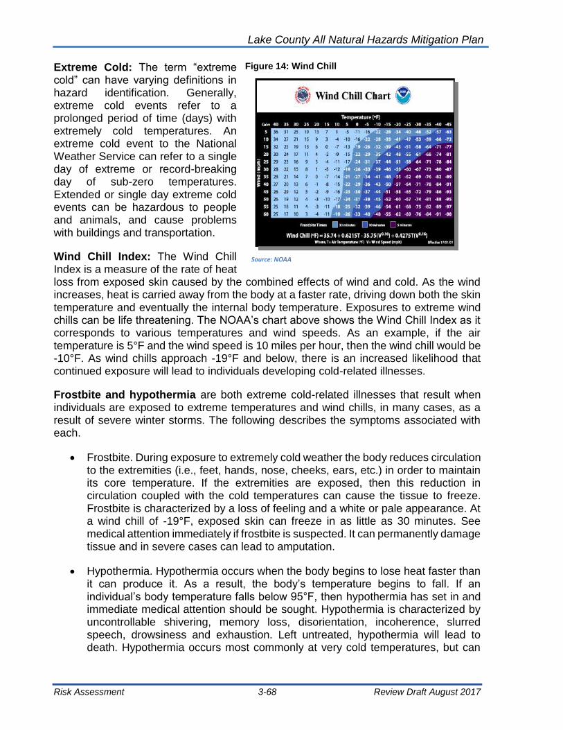
Lake County All Natural Hazards Mitigation Plan
Risk Assessment 3-68 Review Draft August 2017
Extreme Cold: The term “extreme cold” can have varying definitions in hazard identification. Generally, extreme cold events refer to a prolonged period of time (days) with extremely cold temperatures. An extreme cold event to the National Weather Service can refer to a single day of extreme or record-breaking day of sub-zero temperatures. Extended or single day extreme cold events can be hazardous to people and animals, and cause problems with buildings and transportation.
Wind Chill Index: The Wind Chill Index is a measure of the rate of heat loss from exposed skin caused by the combined effects of wind and cold. As the wind increases, heat is carried away from the body at a faster rate, driving down both the skin temperature and eventually the internal body temperature. Exposures to extreme wind chills can be life threatening. The NOAA’s chart above shows the Wind Chill Index as it corresponds to various temperatures and wind speeds. As an example, if the air temperature is 5°F and the wind speed is 10 miles per hour, then the wind chill would be -10°F. As wind chills approach -19°F and below, there is an increased likelihood that continued exposure will lead to individuals developing cold-related illnesses.
Frostbite and hypothermia are both extreme cold-related illnesses that result when individuals are exposed to extreme temperatures and wind chills, in many cases, as a result of severe winter storms. The following describes the symptoms associated with each.
• Frostbite. During exposure to extremely cold weather the body reduces circulation to the extremities (i.e., feet, hands, nose, cheeks, ears, etc.) in order to maintain its core temperature. If the extremities are exposed, then this reduction in circulation coupled with the cold temperatures can cause the tissue to freeze. Frostbite is characterized by a loss of feeling and a white or pale appearance. At a wind chill of -19°F, exposed skin can freeze in as little as 30 minutes. See medical attention immediately if frostbite is suspected. It can permanently damage tissue and in severe cases can lead to amputation.
• Hypothermia. Hypothermia occurs when the body begins to lose heat faster than it can produce it. As a result, the body’s temperature begins to fall. If an individual’s body temperature falls below 95°F, then hypothermia has set in and immediate medical attention should be sought. Hypothermia is characterized by uncontrollable shivering, memory loss, disorientation, incoherence, slurred speech, drowsiness and exhaustion. Left untreated, hypothermia will lead to death. Hypothermia occurs most commonly at very cold temperatures, but can
Figure 14: Wind Chill
Wind Chill
Source: NOAA

Lake County All Natural Hazards Mitigation Plan
Risk Assessment 3-69 Review Draft August 2017
occur at cool temperatures (above 40°F) if an individual isn’t properly clothed or becomes chilled.
Extreme cold is also responsible for a number of fatalities each year. Threats, such as hypothermia and frostbite, can lead to loss of fingers and toes or cause permanent kidney, pancreas and liver injury and even death. Major winter storms can last for several days and be accompanied by high winds, freezing rain or sleet, heavy snowfall and cold temperatures. Fifty percent of cold-related injuries happen to people over sixty years of age. More than seventy-five percent happen to males, and almost twenty percent occur within the home.
Extreme cold, in extended periods, although infrequent, could occur throughout the winter months in Lake County. Heating systems compensate for the cold outside. Most people limit their time outside during extreme cold conditions, but common complaints usually include pipes freezing and cars refusing to start. When cold temperatures and wind combine, dangerous wind chills can develop.
Table 43: Cold Weather Threat Levels
Excessive Cold Threat Level
Threat Level Descriptions
Extreme “An extreme threat to life and property from excessive cold.” It is likely that wind chill values will drop to -35F or below for 3 hours or more. Or, lowest air temperatures less than or equal to -20F
High “A high threat to life and property from excessive cold.” It is likely that wind chill values will drop to -28F to -35F for 3 hours or more. Or, lowest air temperature -15F to -20F.
Moderate “A moderate threat to life and property from excessive cold.” It is likely that wind chill values will drop to -20F to -28F or below for 3 hours or more. Or, lowest air temperature -10F to -15F.
Low “A low threat to life and property from excessive cold.” It is likely that wind chill values will drop to -15F to -20F or below for 3 hours or more. Or, lowest air temperature -5F to -10F.
Very Low “A very low threat to life and property from excessive cold.” It is likely that wind chill values will drop to -10F to -15F or below for 3 hours or more. Or, lowest air temperature zero to -5F.
Non-Threatening “No discernable threat to life and property from excessive cold.” Cold season weather conditions are non-threatening.
3.10.1 Extreme Temperature Hazard Profile
Extreme Heat: Table 44 shows the past extreme heat events in northeastern Illinois. The most severe event was in July 1995, which resulted in 583 fatalities. The majority of the deaths occurred in Cook County. The temperatures soared to record highs in July with the hottest weather occurring from July 12 to July 16. The high of 106°F (41°C) on

Lake County All Natural Hazards Mitigation Plan
Risk Assessment 3-70 Review Draft August 2017
July 13 was the second warmest July temperature (warmest being 110°F (43°C) set on July 23, 1934) since records began at Chicago Midway International Airport in 1928. Nighttime low temperatures were unusually high; in the upper 70s and lower 80s°F (about 26°C)—as well. Record humidity levels also accompanied the hot weather. The heat index reached 119°F (48°C) at O'Hare airport, and 125°F (52°C) at Midway Airport.
Table 44: Extreme Heat Events in Lake County (1995-2016)
Location Date # of
Fatalities # of
Injuries
Northeast Illinois July 12, 1995 583 0
Northeast Illinois July 21, 1999 13 0
Northeast Illinois July 28, 1999 99 0
Northeast Illinois July 04, 2012 0 0
TOTALS 695 0
No damages were reported with the recorded extreme heat events. Reported high heat events over the past 16 years provide an acceptable framework for determining the future occurrence in terms of frequency for such events. The probability of the County and its municipalities experiencing a high heat event can be difficult to quantify, but based on historical record of 4 heat events since 1995, it can reasonably be assumed that this type of event has occurred once every 5.25 years from 1995 through 2016.
[(Current Year) 2016] subtracted by [(Historical Year) 1995] = 21 Years on Record
[(Years on Record) 21] divided by [(Number of Historical Events) 4] = 5.25
The historic frequency calculates that there is an 18% chance of an extreme heat event occurring each year.
Extreme Cold: Table 45 shows the recorded extreme cold events for northeastern Illinois.
Reported extreme cold events over the past 15 years provide an acceptable framework for determining the future occurrence in terms of frequency for such events. The probability of the County and its municipalities experiencing an extreme cold event can be difficult to quantify, but based on historical record of 9 extreme cold events since 1996, it can reasonably be assumed that this type of event has occurred once every 2.33 years from 1996 through 2016.

Lake County All Natural Hazards Mitigation Plan
Risk Assessment 3-71 Review Draft August 2017
Table 45: Extreme Cold Events in Lake County (1996-2016)
Location Date # of
Fatalities # of
Injuries
Northeast Illinois 2/2/1996 3 0
Northeast Illinois 1/23/2003 1 0
Northeast Illinois 1/29/2004 0 0
Northeast Illinois 2/18/2006 1 0
Northeast Illinois 2/3/2007 0 0
Northeast Illinois 2/10/2008 0 0
Northeast Illinois 12/21/2008 0 0
Northeast Illinois 1/15/2009 0 0
Northeast Illinois 1/06/2014 0 0
TOTALS 5 0
[(Current Year) 2016] subtracted by [(Historical Year) 1996] = 21 Years on Record
[(Years on Record) 21] divided by [(Number of Historical Events) 9] = 2.33
The historic frequency calculates that there is a 43% chance of an extreme cold event occurring each year.
3.10.2 Vulnerability – Extreme Temperature Impact
In Illinois, vulnerability to extreme heat has primarily impacted the elderly and persons with pre-existing health problems who live in high-rise buildings or other housing with inadequate ventilation or cooling systems. Since these housing conditions are not prevalent in Lake County, extreme heat is considered a lower priority hazard. If land-use changes elevate the risk from extreme heat, a vulnerability analysis can be conducted when this Plan is updated. Extreme cold can affect all ages.
Health and Safety: Lake County, like most areas of the Midwest, is very vulnerable to extreme heat. Urban areas are exposed more acutely to the dangers of extreme heat due to heat being retained in asphalt and concrete and being released at night. This effect brings little relief to the area even in the nighttime. People are at risk for heat stroke or sun stroke, heat exhaustion, and dehydration. Children and the elderly are most at risk. Loss of life is common with extreme heat events.
Loss of life is also common with extreme cold events. Safety is also a large concern during extreme cold events, and numerous injuries can occur, including frost bite and other accidents. Therefore, impact on people due to extreme heat and extreme cold is high.

Lake County All Natural Hazards Mitigation Plan
Risk Assessment 3-72 Review Draft August 2017
Damage to Buildings: Heat has little or no impact on structures. Extreme cold can cause water pipes to burst, but there is limited other damage. Impact on buildings is low.
Damage to Critical Facilities: Extreme heat can have an impact on the demand on electric utilities, otherwise the impact to critical facilities due to extreme heat is low. Extreme cold can have an impact of community owned water mains that can burst.
Economic Impact: Economic impact of extreme heat and extreme cold is low.
Multi-Jurisdictional Differences: All of Lake County is at risk with extreme temperature.
3.11 Erosion - Shoreline, Coastal and Ravine
Erosion is a natural process. Streams, river banks and lake shorelines in their natural state erode slowly, and then often re-stabilize with vegetative growth. Changes in shorelines due to development, changed or removed vegetation, or higher frequencies of floods, destabilize shorelines and erosion is accelerated. Erosion can be destructive to property and put structures at risk. Lake County is affected by three types of erosion:
1. Shoreline 2. Coastal 3. Ravine
3.11.1 Shoreline Erosion Hazard Profile
Shoreline erosion, for purposes of this discussion, includes the erosion conditions associated with rivers, streams, and inland lakes in of Lake County. The impact of erosion in primarily loss of streambanks or shorelines and the accumulation and/or deposit of sediment downstream or within the lake. Shoreline erosion can but into streambanks and can alter the location of the stream (centerline). The flow velocities in eroded streams are also altered and can exacerbate the erosion conditions.
These conditions can be created due to an alteration of the shoreline or due to the changing water levels in the stream or the lake. Development and urbanization create more runoff – and create runoff more often. This means that streams must carry more water and carry it more often, and at higher velocities. The higher velocity flows are able to strip vegetation and carry soils and sediment. Scour along the banks and in the stream or river is created by the higher velocity flows. The fluctuating stream levels impact the vegetation along the streams and the vegetation can be lost. Channelized stream reaches are less stable and more erosive than meandering sections.
“Erosion may be the result of naturally occurring inputs, such as precipitation, or human intervention
in the form of urban development, forestry, mining, flow diversions, flood regulation, navigation, and
other activities. The basic premise is that streams are constantly attempting to attain a state of
balance involving the stream geometry (dimensions, pattern, profile), the properties of the stream
bed, the bank material, and the external inputs imposed. “
FEMA Riverine Erosion Hazard Areas, 9/99

Lake County All Natural Hazards Mitigation Plan
Risk Assessment 3-73 Review Draft August 2017
Along lakes, higher lake levels can impact both the vegetation and the soils along the shoreline. Velocity is not a concern alone inland lake shores, but wave action from wind or boats can compound the impact of higher lake levels.
When eroded, soils are transported downstream and the sediment can reduce the carrying capacity of streams and can fill culverts. The rate of shoreline erosion is difficult to estimate. Water quality is impacted by erosion.
All eroded sediment is eventually deposited where water flow slows: i.e., in lakes, wetlands, stream channels or floodplains. The site where sediment accumulates may be far from the eroded area. Sedimentation can block culverts and ditches, cause the loss of channel conveyance and reduce floodplain storage, thereby creating or worsening flooding problems. In addition to exacerbating flood problems, excessive sediment loads degrade water quality and recreational assets. Sediment removal can be very expensive and may be cost prohibitive.
3.11.2 Coastal Erosion Hazard Profile
Illinois is included in the 34 coastal states of the United States due to Lake Michigan and Lake County is subject to coastal erosion. Coastal Erosion is measured as the rate of change in the position or horizontal displacement of a shoreline over a period of time. It is generally associated with storm surges, hurricanes, windstorms, and flooding hazards, and may be exacerbated by human activities such as boat wakes, shoreline hardening, and dredging.
Coastal erosion is a hydrologic hazard defined as the wearing away if land and loss of beach, shoreline, or dune material as a result of natural coast processes or manmade influences. It can be manifested as recession and degradation of major dune systems or development of steep scarps along the near shore beach face. Natural coastal processes that cause coastal erosion include the actions of winds, waves, and currents. Human influences include construction of seawalls, jetties, navigation inlets and dredging, boat wakes and other interruptions of physical processes. Natural or human caused, coastal erosion is a “destroyer hazard,” meaning that the land is lost or destroyed because of the erosion.
Coastal erosion is the landward displacement of the shoreline caused by the forces of waves and currents (as defined by the US National Oceanic and Atmospheric Administration). It is the process that affects the landmass of an area as a consequence of a body of water acting upon it. Lake County is bordered entirely on the east by Lake Michigan, and the southern two-thirds of the Lake Michigan shoreline included steep slopes that are affected by erosion. Other areas of the Lake Michigan shoreline can be impacted by changing lake levels.
The shoreline of Lake Michigan is not static. “The historical record of coastal change along the Illinois shore of Lake Michigan indicates that the most dynamic coastal area in the state of Illinois is located between the Illinois-Wisconsin state line and the Waukegan Harbor” (ISGS, 1998:1). Erosion and accretion creates a constant need to dredge harbor areas and fill along the shoreline.

Lake County All Natural Hazards Mitigation Plan
Risk Assessment 3-74 Review Draft August 2017
3.11.3 Ravine Erosion Hazard Profile
The steeper the channel and the greater the runoff volume, then the higher the flow velocity and the greater the erosion potential.
Similarly, the steeper the bank, the more potential there is for instability and erosion. Areas prone to the most erosion damage are the ravines. Ravine erosion is of particular concern to Lake County’s Lake Michigan Watershed. Flowing water has the energy to erode most of the soils in Lake County.
Figure 15 is from the Openlands’ “Landowner’s Guide: Ravine and Tableland Preservation,” (2013). It shows the tree growth that, with potentially shallow roots, can tear away the ravine bank should flood velocities tear it way. The graphic also shows an outfall pipe well above the ravine floor that can erode the bank even when the ravine is dry with the flow that can come from the pipe.
Figure 15: Ravine and Tableland Preservation

Lake County All Natural Hazards Mitigation Plan
Risk Assessment 3-75 Review Draft August 2017
3.11.4 Vulnerability - Erosion Hazard Impact Erosion in the ravines commonly threatens sanitary sewers, roads, and building foundations. Lake erosion affects boat facilities, septic systems and building foundations. Erosion on fast flowing streams may threaten bridges and roads, and may also encroach on septic systems and
foundations. Bank erosion impacts can potentially affect 4.58% of Lake County. This consists of areas with slopes 8% or greater, which translates to approximately 13,900 acres out of a total of approximately 303,600 acres in Lake County. This percentage is for all of Lake County, both inland and coastal slopes.
The greatest potential for erosion occurs on steep slopes. According to the Lake County Regional Framework Plan, steep slopes, 8% and greater in Lake County cover approximately 16,895 acres, or 18.52 square miles, which translates into approximately 4% of the County area.
A coastal erosion hazard can potentially affect 4% of the communities within Lake County (per the Regional Framework Plan). In order to provide the most accurate information for each affected community in Lake County, aerial maps should be overlaid with coastal erosion maps to determine the location of potentially impacted structures. The information should then be ground-proofed to determine the number and type of impacted structures. This information will identify the magnitude of potential impacts that coastal erosion can cause to the County, specifically determining the number of structures located along the shoreline of Lake Michigan. This activity should be considered during the next the 5-year update. Highland Park, Highwood, Lake Bluff, Lake Forest and North Chicago are potentially affected by coastal erosion; however, the risk is low to structures in these communities.
Property in several communities, including Beach Park, are being impacted by ravine erosion. Heavy rainfall and flooding events have created unstable slopes along Bull Creek. These slopes continue to slump and slide. Foundations can potentially be compromised by a slope failure. The homes could potentially be destroyed and injury or the loss of life could result.
The potential of bank erosion in Lake County is relatively high due to the number of steep ravine and coastal slopes, streams, and channels in the Lake Michigan Watersheds. There has been no recorded history, however, of landslides in Lake County.
2016-Beach Park, Illinois

Lake County All Natural Hazards Mitigation Plan
Risk Assessment 3-76 Review Draft August 2017
Multi-Jurisdictional Differences: The communities of Lake Bluff, Lake Forest, Highwood, Highland Park, North Chicago and Winthrop Harbor are subject to coastal flooding from Lake Michigan.
3.12 Power Outage
Overview: Although power outages are classified as technological disasters, they are a common secondary effect of natural disasters and were chosen to be included in the 2017 update to the ANHMP.
A power outage is the loss of electrical power in a facility or community. Power outages can cause the failure of key systems such as lighting, heating, air conditioning, ventilation, computer systems, life support, and water pumping stations, sewage treatment, telecommunications, and many others. Failure of one or more of these systems in jurisdictions can cause life safety or health concerns.
Power outages may be the cause of several natural disasters; most commonly wind events, or the cause of a manmade incident such as accidental cutting of a power line. The most common scenarios of natural disasters resulting in power outages include:
• Winds may blow down trees or tree limbs which fall onto power lines, breaking them (most common)
• High winds may blow down utility poles snapping power lines
• Ice and snow may weigh down power lines causing breakage
Construction or maintenance operations may also accidentally cut power lines. Most of these incidents are localized to a small area.
A power outage may last anywhere from several minutes to weeks. The duration of the outage depends on several factors including: size and scope of the disaster, type of facilities affected, availability of response resources by the utility owner. Within Lake County ComEd owns the vast majority of the electrical utility infrastructure.
Measurements: Power outages are measured by the number of facilities, or percent of a jurisdiction, without electrical power. A power outage may affect only one single family house, or be jurisdiction wide spanning entire states, in extreme cases.
The size and scope of the natural disaster affects the numbers of customers. Existing utility infrastructure may also affect the quantity of outages throughout the jurisdiction
Historical Events: A July 11, 2011 wind event was termed a “derecho” by the National Weather Service. A derecho is “a widespread, long-lived wind storm. Derechos are associated with bands of rapidly moving showers or
Lake County All Natural Hazards Mitigation Plan
Risk Assessment 3-77 Review Draft August 2017
thunderstorms variously known as bow echoes, squall lines, or quasi-linear convective systems.”
The National Weather Service provided the following description of the July 2011 event:
Derecho brings widespread wind damage to northern Illinois. During the morning hours of July 11, 2011, a line of severe thunderstorms moved very quickly across northern Illinois and southern Lake Michigan, producing widespread wind damage. In addition, the strong thunderstorm winds with this system generated a classic seiche event on the lake.
See Figure 10 for the National Weather Service radar image of the storm event. Estimates say that more than 860,000 people in the greater Chicago were without electricity due to the derecho. Generators were needed for critical facilities, and available equipment was limited. Many facility owners learned that they were not readily equipped to hook up to generators. Many business and homeowners were also in need and in search of generators.
The July 2011 derecho downs hundreds of trees throughout Lake County. Communities instituted special plans for coordinating the clean-up efforts of property owners and for collecting and removing trees and other debris.
Property Damage: Lack of power rarely causes damage to facilities. Secondary effects due to lack of power, such as freezing pipes may cause extreme localized property damage.
Damage to Critical Facilities: Many critical facilities throughout Lake County have partial or complete backup power sources such as standby generators which will automatically start up when electrical power is lost. Facilities that typically have back up power generation include: Hospitals, Police and Fire Stations, and Emergency Operations Centers (EOCs).
Smaller systems such as computers, life support, alarm and telecommunications systems may have a local Uninterrupted Power Supply (UPS) directly attached to maintain power during a disaster.
Health and Safety: Loss of electrical power can cause an immediate significant threat to life safety and public health. Critical facilities such as hospitals, nursing homes, and long term care facilities are dependent upon electricity to maintain life support systems. First responder facilities such as police and fire department require power to ensure effective emergency response efforts. Lack of power at these facilities can potentially place residents within the jurisdiction in immediate danger.
Public health may be negatively affected due to the sanitation systems that require electricity to function. Water treatment facilities and restaurants require sufficient power to ensure drinking water and food are treated properly. Lack of electricity at these locations may cause both short- and long-term health issues.
Downed live power lines also pose an immediate life safety issue. Live power lines on the ground or close to the ground as a result of a storm can kill or severely injure anyone who comes in contact with them. Vehicles or facilities in contact with live downed power

Lake County All Natural Hazards Mitigation Plan
Risk Assessment 3-78 Review Draft August 2017
lines are also susceptible to damage and the people within them are susceptible to injury or death.
Economic Impact: Businesses without power may be unable to process transactions, or maintain adequate heating/cooling regulations, and therefore be forced to close until power is restored. The actual dollar amount of economic impact is dependent upon the size, scope, and duration of the power outage.
3.13 Summary of Natural Hazards Risk Assessment
This risk assessment examines natural hazards that could impact Lake County. This section summarized the impact of the hazards on Lake County and presents conclusions that can be drawn from the assessment.
3.13.1 Impact of the Hazards
The impacts of the hazards are summarized according to the four major concerns:
1. Health and safety
2. Damage to buildings
3. Damage to critical facilities and infrastructure
4. Economic impact
The Low-Moderate-High ratings discussed on page 3-2 of this Chapter were used to classify the impacts of the hazards for the four major areas of concern. This approach allows for a better understanding of the risk or vulnerability, and also allows for updates or refinements to the ANHMP risk assessment in future plans. The HMPC discussed the findings to determine the overall impact the priority hazards on the County and the municipalities. The hazards and their impact are shown in Table 46, “Summary of Lake County Natural Hazards.” The different columns on the table represent the following:
Annual Chance or Frequency: The annual chance column in the table shows the likelihood of occurrence in any given year. These numbers are discussed in the “Frequency” section of each hazard.
Impact Location: The location and area affected by a single occurrence is shown.
Square Miles Impacted: The portion of the County that is vulnerable to the hazard.
Value of vulnerable property: The property damage exposure computed in 3.2 Summary of Lake County Assets of this Chapter.
Potential Damage: The range of potential damage that could occur for the square miles impacted and the value of exposed property.
Impact on Health and Safety: This category relates to health and safety hazards. Ratings of high, medium, or low are shown.
Impact on Buildings: The vulnerability of structural damage to buildings or other property damage.
Critical Facilities: The types of critical facilities and infrastructure that are affected are listed.
Economic Impact: Typical impacts on businesses and utilities are listed in this column.

Lake County All Natural Hazards Mitigation Plan
Risk Assessment 3-79 Review Draft August 2017
Table 46: Summary of Lake County Natural Hazards
Hazard Annual Chance
Impact Location
Square miles
Affected
Value of Vulnerable Property
Potential Damage (Millions)
Impact on Health
and Safety
Buildings Critical
Facilities Economy
Floods 1% Floodplains 89.3 $3 B $85-$850 M Moderate High Moderate High
Floods 10% (Local
Drainage) 448 --- --- Moderate Moderate Moderate Moderate
Tornado 0.01% Countywide 10 $60 B $872 M High High Moderate Moderate
Tornado 30% Community 5 $60 B $419 M High High Moderate Moderate
Severe Summer Storms
100% Communities 448 $60 B --- Moderate Moderate Moderate Low
Severe Winter Storms
100% Countywide 448 $60 B --- Moderate Moderate Moderate Low
Drought 1% Countywide 448 $60 B --- High Moderate Low Moderate
Earthquake 100% Countywide 448 $60 B Low Low Moderate Low
Dam Failure 0% Countywide 448 $60 B -- -- -- --
Extreme Temperatures
18% Countywide 448 $60 B --- High Low Low Low
Erosion -- Countywide 36 $8 B
Power Outage Countywide $60 B
The County, all municipalities, other agencies and institutions involved in this ANHMP are exposed to all identified hazards. This is due to the relatively flat topography of the County. While the County still has agricultural use, the residents and business are equally impacted by the identified natural hazards as the urban areas. Flooding in the floodplain has been considered, for example, but it is understood that flooding is not limited to floodplain areas. Community impact does vary by degree between larger and smaller communities based on population and number of buildings.
Table 47 shows the Lake County hazard identification by community and township for the natural hazards evaluated in Table 46. The findings of the hazard analysis and profile of Chapter 2 and the vulnerability assessment were used as the foundation of goals and guidelines and mitigation activities developed in Chapter 5.
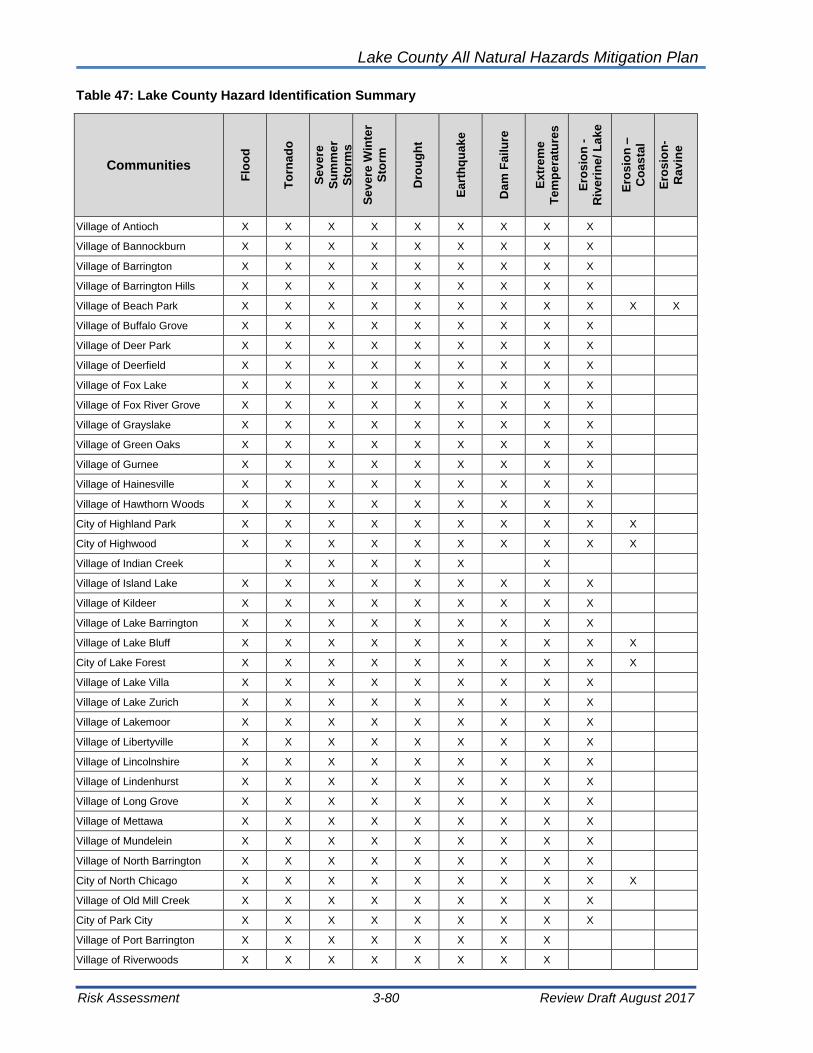
Lake County All Natural Hazards Mitigation Plan
Risk Assessment 3-80 Review Draft August 2017
Table 47: Lake County Hazard Identification Summary
Communities
Flo
od
To
rna
do
Se
ve
re
Su
mm
er
Sto
rms
Se
ve
re W
inte
r
Sto
rm
Dro
ug
ht
Ea
rth
qu
ak
e
Da
m F
ailu
re
Ex
tre
me
Te
mp
era
ture
s
Ero
sio
n -
Riv
eri
ne
/ L
ak
e
Ero
sio
n –
Co
as
tal
Ero
sio
n-
Ra
vin
e
Village of Antioch X X X X X X X X X
Village of Bannockburn X X X X X X X X X
Village of Barrington X X X X X X X X X
Village of Barrington Hills X X X X X X X X X
Village of Beach Park X X X X X X X X X X X
Village of Buffalo Grove X X X X X X X X X
Village of Deer Park X X X X X X X X X
Village of Deerfield X X X X X X X X X
Village of Fox Lake X X X X X X X X X
Village of Fox River Grove X X X X X X X X X
Village of Grayslake X X X X X X X X X
Village of Green Oaks X X X X X X X X X
Village of Gurnee X X X X X X X X X
Village of Hainesville X X X X X X X X X
Village of Hawthorn Woods X X X X X X X X X
City of Highland Park X X X X X X X X X X
City of Highwood X X X X X X X X X X
Village of Indian Creek X X X X X X
Village of Island Lake X X X X X X X X X
Village of Kildeer X X X X X X X X X
Village of Lake Barrington X X X X X X X X X
Village of Lake Bluff X X X X X X X X X X
City of Lake Forest X X X X X X X X X X
Village of Lake Villa X X X X X X X X X
Village of Lake Zurich X X X X X X X X X
Village of Lakemoor X X X X X X X X X
Village of Libertyville X X X X X X X X X
Village of Lincolnshire X X X X X X X X X
Village of Lindenhurst X X X X X X X X X
Village of Long Grove X X X X X X X X X
Village of Mettawa X X X X X X X X X
Village of Mundelein X X X X X X X X X
Village of North Barrington X X X X X X X X X
City of North Chicago X X X X X X X X X X
Village of Old Mill Creek X X X X X X X X X
City of Park City X X X X X X X X X
Village of Port Barrington X X X X X X X X
Village of Riverwoods X X X X X X X X

Lake County All Natural Hazards Mitigation Plan
Risk Assessment 3-81 Review Draft August 2017
Table 47: Lake County Hazard Identification Summary
Communities
Flo
od
To
rna
do
Se
ve
re
Su
mm
er
Sto
rms
Se
ve
re W
inte
r
Sto
rm
Dro
ug
ht
Ea
rth
qu
ak
e
Da
m F
ailu
re
Ex
tre
me
Te
mp
era
ture
s
Ero
sio
n -
Riv
eri
ne
/ L
ak
e
Ero
sio
n –
Co
as
tal
Ero
sio
n-
Ra
vin
e
Village of Round Lake X X X X X X X X
Village of Round Lake Beach X X X X X X X X
Village of Round Lake Heights X X X X X X X X
Village of Round Lake Park X X X X X X X X
Village of Third Lake X X X X X X X X
Village of Tower Lakes X X X X X X X X
Village of Vernon Hills X X X X X X X X
Village of Volo X X X X X X X X
Village of Wadsworth X X X X X X X X
Village of Wauconda X X X X X X X X
City of Waukegan X X X X X X X X X X
Village of Wheeling X X X X X X X X
Village of Winthrop Harbor X X X X X X X X X X
City of Zion X X X X X X X X X X
Naval Station Great Lakes X X X X X X X X X X
Lake County X X X X X X X X X X X
3.13.2 Comparison to State of Illinois 2013 Natural Hazard Mitigation Plan
The Illinois Natural Hazard Mitigation Plan prepared by the Illinois Emergency Management Agency (IEMA) hazard rating system has five levels:
IEMA Hazard Rating ANHMP Rating
Low Low
Guarded Moderate
Elevated
High High
Severe
The IEMA hazard rating levels are based on historical/probability, vulnerability, severity of impact and population. The 2013 Illinois Natural Hazard Mitigation Plan, utilized better historical and damage information in the risk assessment and hazard rating levels were adjusted for many counties. IEMA’s hazard ratings for Lake County identified natural hazards in the 2010 and 2013 Illinois Natural Hazard Mitigation Plan and are shown in Table 48.

Lake County All Natural Hazards Mitigation Plan
Risk Assessment 3-82 Review Draft August 2017
Table 48: IEMA Hazard Ratings for Lake County
Hazard IEMA Rating 2010 IEMA Rating 2013
(Rank of All Counties)
ANHMP Rating
Floods Elevated Elevated (99 of 102) High/Moderate
Tornado High Elevated (51 of 102) High
Severe Storms and Wind Severe Severe Moderate
Severe Winter Storms Severe High Moderate
Drought Guarded Guarded Moderate
Earthquake Guarded Guarded Low
Extreme Heat Elevated Guarded Low
The 2013 Illinois Natural Hazard Mitigation Plan lowered the rating for tornado for Lake County (rank of 51 or 102 counties) from high to elevated. The rating for severe winter storms was also reduced to high, and extreme heat reduced to guarded. The 2013 IEMA ratings for Lake County are somewhat comparable with the summary of impacts in Table 46 of this Chapter for all hazards shown in Table 48 .
IEMA’s 2013 analysis placed Lake County 99th of 102 counties for loss estimation for floods. However, the 2013 Illinois Natural Hazard Mitigation Plan shows Lake County having 5 flood-related disaster declarations from 1981 to 2013, and Lake County is number 11 on the list of counties with the most repetitive flood loss properties. IEMA used a risk assessment software called HAZUS. HAZUS relies on default building data and other factors that may have led to a poor analysis for Lake County.
The risk assessment for this ANHMP plan places severe summer storms as “moderate” and IEMA rates them as “severe.” This difference may due to the ANHMP associating flooding that results from severe summer storms with floods and IEMA makes use of the information from disaster declarations that may be for severe storms, but the result of the severe storm is flooding.
All in all, IEMA’s risk assessment for the State is a generalized examination of counties. IEMA’s assessment certainly serves as a means to provide a review of the Lake County risk assessment provided in this ANHMP.

Lake County All Natural Hazards Mitigation Plan
Risk Assessment 3-83 Review Draft August 2017
[This page intentionally left blank.]


Lake County All Natural Hazards Mitigation Plan
Mitigation Goals 4-1 Review Draft August 2017
Chapter 4: Mitigation Goals The Hazard Mitigation Planning Committee (HMPC) established the goals for this ANHMP. The goals were developed to reflect community priorities, to be consistent with current countywide planning efforts, and in consideration of the impact of each natural hazard that affects Lake County. In June 2011, the HMPC participated in three exercises to outline the mitigation goals and for mitigation guidelines. The results of the exercise are summarized below for the purpose of showing how the ANHMP goals and guidelines were developed. The goals and guidelines included in this chapter were reviewed in June 2016 by the HMPC and re-affirmed as appropriate for Lake County and its municipalities through 2022.
4.1 Community Priorities and Plan Direction
To better understand community priorities, HMPC members selected their top five choices to create a list of potential priorities. For community priorities, the top 5 selected responses were:
• Improve employment opportunities
• Improve roads and highways
• Improve/get more businesses
• Provide a safe place to live and work
• Improve water quality
For the second and third exercises, “What to Focus On” and “How to Fund and Implement,” HMPC members worked in groups and the top five choices of each table were shared with the entire group. The results from group to group for each of the exercises were very similar.
For the exercise “What to Focus On,” the top five responses given by the small groups included:
• Protecting people’s lives
• Protecting public health
• Protecting streets and utilities
• Protecting public services
• Protecting existing buildings
For the exercise “How to Fund and Implement,” the top five responses given by the small groups included:
• Make people aware of how they can protect themselves
• Make people aware of the hazards they face
• Develop public/private partnerships
• Help people protect themselves
• New developments should pay full cost of protection measures

Lake County All Natural Hazards Mitigation Plan
Mitigation Goals 4-2 Review Draft August 2017
4.2 Goals and Guidelines
From the above responses, the goals and guidelines listed below were developed. The goals represent the mitigation activity outcome and the guidelines represent the best methods to work towards the goals. At the July 2011 meeting, the HMPC reviewed the goals and guidelines. The goals and guidelines presented in this chapter are the foundation of the Action Plan, presented in Chapter 6. The ANHMP goals are:
Goal 1: Protect the lives, health, and safety of the people of Lake County from the impact and effects of natural hazards.
Goal 2: Protect public services, utilities and critical facilities from potential damage from natural hazard events.
Goal 3: Mitigate existing buildings to protect against damage from natural hazard events.
Goal 4. Ensure that new developments do not create new exposures of people and property to damage from natural hazards.
Goal 5. Mitigate to protect against economic and transportation losses due to natural hazards.
The following guidelines are for the purpose of achieving the goals and to facilitate the development of hazard mitigation action items:
Guideline 1: Focus natural hazards mitigation efforts on floods, tornadoes, severe summer and winter storms, dam failure, erosion, extreme temperatures, and drought.
Guideline 2: Make people aware of the hazards they face and focus mitigation efforts on measures that allow property owners and service providers to help themselves.
Guideline 3: Identify specific projects to protect lives and mitigate damage where cost-effective and affordable.
Guideline 4: Use available local funds, when necessary, to protect public services, critical facilities, lives, health and safety from natural hazards.
Guideline 5: Develop and foster public agency and private property owner partnerships to fund and implement mitigation measures, and examine equitable approaches for the local cost of mitigation, such as user fees.
Guideline 6. Strive to improve and expand business, transportation and education opportunities in Lake County in conjunction with planned mitigation efforts.

Lake County All Natural Hazards Mitigation Plan
Mitigation Goals 4-3 Review Draft August 2017
4.3 Consistent with Other Plans
The developed goals and guidelines were compared to the goals included in the following plans, and found to be consistent and supporting:
• 2016 Comprehensive Stormwater Management Plan
• Lake County Regional Framework Plan, amended in October 2014
• Draft Flood Mitigation Plan
Goals from the ANHMP should be incorporated into other plans of the County and municipalities, as deemed appropriate.

Lake County All Natural Hazards Mitigation Plan
Mitigation Goals 4-4 Review Draft August 2017
[This page intentionally left blank.]

Lake County All Natural Hazards Mitigation Plan
Mitigation Strategies & Capabilities Assessment 5-1 Review Draft August 2017
Chapter 5: Mitigation Strategies and Capability Assessment This Chapter examines the hazard mitigation activities that are currently being implemented in Lake County, examines various hazard mitigation strategies that can be undertaken in the future, and assesses the capabilities of Lake County and the municipalities for implementing some of these future mitigation measures.
As described in Chapter 1, Lake County is a growing county in both population and development. Chapter 3 presents the priority hazards identified in this ANHMP (Table 46) as flood, tornado, severe summer and winter storms and drought. The HMPC concluded that these are priority hazards from both a countywide and a community specific perspective. For example, while there are no mapped floodplains in the Village of Indian Creek, flooding impacts the residents of Indian Creek as they travel to work or school, and mitigation efforts undertaken by Lake County for severe winter storms benefits the entire County as people travel to work or school. This Chapter presents a comprehensive list of hazard mitigation recommendations that provide a menu of options for the development of the action plan presented in Chapter 6 of this ANHMP, and presents an assessment of Lake County and the municipalities’ capability of implementing these measures. These alternatives are consistent with the ANHMP goals presented in Chapter 4. All mitigation strategies recommended in this Chapter are available to all communities, and communities are not specifically identified for each particular strategy. Throughout this Chapter reference is made to the Lake County Stormwater Management Commission (SMC) and the Lake County Watershed Development Ordinance (WDO). The SMC has regulatory, project and funding authority for stormwater, floodplain, wetland and water quality management in both the corporate and unincorporated areas of Lake County. The WDO sets watershed development standards that exceed NFIP and state minimum requirements. The technical committee of the SMC includes SMC staff and municipal staff. They meet monthly to evaluate the implementation of and compliance with the WDO, and to provide input of watershed planning efforts undertaken by the SMC. The Lake County Emergency Management Agency (LCEMA) hosts a similar committee to foster countywide approaches to hazard mitigation and emergency response.
Six basic strategies may be applied to mitigate the potential damage to property and impact to health and safety from natural hazards. Each strategy includes mitigation measures that are appropriate for different conditions, as shown in Table 49. For instance, planning and regulation measures, as preventative strategies are more appropriate for developing areas, while property protection strategies are approaches for existing development and buildings.
A significant number of hazard mitigation measures are already being implemented either throughout Lake County or with certain areas of the County. For example, the
Mitigation Strategies:
➢ Preventative Measures
➢ Property Protection
➢ Natural Resource Protection
➢ Emergency Services
➢ Structural Measures
➢ Public Information

Lake County All Natural Hazards Mitigation Plan
Mitigation Strategies & Capabilities Assessment 5-2 Review Draft August 2017
administration and enforcement of building codes provides protection of buildings from wind, flood and earthquake events. Preventive and natural resources protection measures are provided through the implementation of the Lake County stormwater management program.
Table 49: Natural Hazard Mitigation Activities
Natural Hazards: Preventive Property
Protection Emergency
Resource Protection
Structural Measures
Public Information
Floods (100-year/10-year) X X X X X X
Tornado/High Wind X X X X
Severe Summer Storms/Hail
X X X X X X
Severe Winter Storms X X X
Dam Failure X X X X X
Wildfire X X X X X
Erosion X X X X X
Extreme Heat X
Extreme Cold X X X
Sewer Backup X X X
Drought X X X
Groundwater X X X
Both the ongoing Lake County mitigation efforts and additional mitigation approaches are discussed below. At the end of each section relevant recommendations are listed. Note that specific project locations are not identified with many of the recommendations. For many recommendations, numerous project locations exist. Selection of specific project areas, for floodplain acquisition projects for example, is related to the voluntary interest of property owners and the commitment of community funds. It is understood that project locations will be included in various project scopes of work as they are developed.
The following sections provide more detailed discussions of the six hazard mitigation strategies.
5.1 Preventive Measures
As the name implies, preventive measures are designed to keep flooding problems from getting worse. They insure that future development does not increase flood damage, and include actions that maintain the drainage system’s capacity to carry away floodwaters. The cost of implementing most prevention measures is relatively low in comparison to most remedial measures to reduce future damage. Preventive measures include activities such as:
• Planning and Zoning
• Watershed Regulations
• Building Codes
• Standards for Manufactured Homes
• Critical Facility Construction Requirements
• Lake County Green Guide

Lake County All Natural Hazards Mitigation Plan
Mitigation Strategies & Capabilities Assessment 5-3 Review Draft August 2017
5.1.1 Planning and Zoning
“Planning” can cover a variety of community plans including, but not limited to, comprehensive plans, land use plans, transportation plans, capital improvement plans, and economic development plans. While plans generally have limited authority, they reflect what the community would like to see happen in the future. Plans also guide other local measures such as capital improvements and the development of ordinances.
Comprehensive and land use plans generally identify how a community should be developed. Use of the land can be tailored to match flooding hazards, typically by reserving flood prone areas for parks, recreational trails, open space, golf courses, or similar compatible uses. Lake County adopted the Lake County Regional Framework Plan in 2007 and is currently in the process of updating that plan.
Development in Lake County is also directed by the 2002 Lake County Comprehensive Stormwater Management Plan adopted by the Lake County Stormwater Management Commission (SMC) to address county-wide stormwater planning needs and watershed regulations. The first countywide County Comprehensive Stormwater Management Plan was adopted in 1990 in response to worsening flooding, drainage and water quality problems. SMC has developed a number of watershed-based plans for four major watersheds of the county including:
Fox River Watershed: Fish Lake Drain, Flint Creek, Squaw Creek and Sequoit Creek
Des Plaines River Watershed: North Mill Creek, Bull Creek and Indian Creek.
North Branch Chicago River Watershed: North Branch of the Chicago River
(Lake and Cook Counties)
Lake Michigan Watershed: Kellogg Creek, Dead River and the Waukegan River.
Adopted and draft plans and other information on the ongoing SMC planning efforts are available at: Lake County Watershed Plans
A zoning ordinance regulates development by dividing the community into zones or districts and setting development criteria for each district. Zoning can be used to control development so that existing flood problems are not worsened and new flood problems are not created.
The Lake County zoning ordinance, applicable to the unincorporated areas of Lake County, uses the overlay zoning approach. The Lake County ordinance classifies floodplains, wetlands, lakes, ponds, drainage ways and drainage way soils with other natural resources as “natural resource protection areas.” This classification requires that a pre-determined ratio of open space be met for developments impacting the designated natural resources.
Planning & Zoning
Activities Address:
• Flood
• Drought
• Groundwater

Lake County All Natural Hazards Mitigation Plan
Mitigation Strategies & Capabilities Assessment 5-4 Review Draft August 2017
In addition, site development regulations limit the uses allowed in floodplains. Allowable uses, depending upon the underlying zoning district, may include parks, golf courses, boating facilities, parking lots, roads, nurseries and others.
A number of Lake County municipalities have incorporated floodplain development restrictions into their zoning ordinances. A review of municipal zoning ordinances for development of the 1990 Comprehensive Stormwater Management Plan found that 19 of 29 zoning ordinances reviewed included floodplain districts/requirements. (Forty ordinances were collected for the county’s 51 municipalities, but only the 29 that were dated 1970 or later were reviewed.) Since the adoption of the WDO in 1992, additional municipalities and the County of Lake have incorporated the floodplain development restrictions of the WDO into their zoning and development ordinances.
Subdivision ordinances specifically govern how land will be subdivided into lots, and regulate standards for infrastructure provided by the developer including roads, sidewalks, utilities, stormwater detention, storm sewers and drainage ways. Building codes should establish flood protection standards for all structures. Table 50 provides a list of community plans and ordinances.
5.1.2 Watershed Development Regulations
As noted above, the WDO has been in place in Lake County since 1992. The goal of the WDO is to ensure that new development does not increase existing stormwater problems or create new ones. The WDO establishes minimum countywide standards for stormwater management, including floodplains, detention, soil erosion/sediment control, water quality treatment, and wetlands.
The WDO is implemented by the SMC or by “Certified Communities.” Forty-one of the 52 municipalities in the county are standard Certified Communities. The designation allows those communities to enforce WDO standards within their own jurisdictions, except for isolated wetlands. SMC reviews isolated wetlands unless a community becomes "Wetland Certified." Table 51 shows the Lake County “Certified Communities”.
Table 50: Lake County Plans and Ordinances
Community Comprehensive
Plan Stormwater Mgmt. Plan
Capital Improvement
Plan
Land Use Plan Only
Zoning Ordinance
Subdivision Ordinance
Historical Preservation Ordinance
Village of Antioch Yes Yes Yes Yes Village of Bannockburn Yes Yes Yes
Village of Barrington Yes Yes Yes Yes Yes Village of Barrington Hills Yes
Village of Beach Park Yes Village of Buffalo Grove Yes Yes Yes Yes Yes Yes
Village of Deer Park Yes Yes Village of Deerfield Yes Yes Yes Yes Yes Yes
Watershed Development Regulations
Reduce Damages Related to:
➢ Floods ➢ Severe Storms ➢ Dam Failure ➢ Erosion ➢ Sewer Backup ➢ Drought ➢ Groundwater

Lake County All Natural Hazards Mitigation Plan
Mitigation Strategies & Capabilities Assessment 5-5 Review Draft August 2017
Community Comprehensive
Plan Stormwater Mgmt. Plan
Capital Improvement
Plan
Land Use Plan Only
Zoning Ordinance
Subdivision Ordinance
Historical Preservation Ordinance
Village of Fox Lake Yes Yes Village of Fox River Grove Yes Yes Yes Yes
Village of Grayslake Yes Yes Yes Yes Yes Yes Village of Green Oaks Yes Yes Yes Yes Yes
Village of Gurnee Yes Yes Yes Yes Village of Hainesville Yes Yes Yes
Village of Hawthorn Woods Yes Yes Yes Yes City of Highland Park Yes Yes Yes Yes Yes Yes
Village of Highwood Yes Village of Indian Creek Yes
Village of Island Lake Yes Yes Yes Yes Yes Village of Kildeer Yes Yes Yes Yes
Village of Lake Barrington Yes Yes Yes Yes Yes Yes Village of Lake Bluff Yes Yes Yes Yes Yes Yes Yes
City of Lake Forest Yes Yes Yes Yes Yes Yes Yes
Village of Lake Villa Yes Yes Yes Yes
Village of Lake Zurich Yes Yes Yes Yes
Village of Lakemoor Yes Yes Yes Yes Yes Yes Yes
Village of Libertyville Yes Yes Yes Yes Yes Village of Lincolnshire Yes Yes Yes Yes Yes
Village of Lindenhurst Yes Yes Yes Village of Long Grove Yes Yes Yes
Village of Mettawa Yes Village of Mundelein Yes Yes Yes Yes Yes Yes
Village of North Barrington Yes Yes Yes City of North Chicago Yes Yes Yes
Village of Old Mill Creek Yes Yes City of Park City Yes Yes
Village of Port Barrington Yes Yes Yes Village of Riverwoods Yes Yes Yes
Village of Round Lake Yes Yes Yes Yes Yes Village of Round Lake Beach Yes Yes Yes Yes
Village of Round Lake Heights Yes Yes Yes Village of Round Lake Park Yes Yes Yes Yes Yes Yes
Village of Tower Lakes Yes Yes Yes Yes Village of Third Lake Yes
Village of Vernon Hills Yes Yes Yes Yes Yes Village of Volo Yes Yes Yes
Village of Wadsworth Yes Yes Yes Village of Wauconda Yes Yes Yes Yes Yes Yes
Village of Winthrop Harbor Yes Village of Wheeling Yes Yes
City of Zion Yes Yes Naval Station Great Lakes
Lake County Yes Yes Yes Yes Yes

Lake County All Natural Hazards Mitigation Plan
Mitigation Strategies & Capabilities Assessment 5-6 Review Draft August 2017
For unincorporated areas, the Lake County Planning, Building and Development Department (PB&D) is the permitting agency. SMC is the permitting agency for Non-Certified Communities. Even in Certified Communities, however, certain floodway and floodplain development applications are forwarded to SMC for review and approval. A WDO Permit is required for major and minor development, and public road construction. Table 51 shows the Certified Community status for the WDO, and also provided the Community Identification Numbers (CID) for the Lake County communities that participate in the National Flood Insurance Program (NFIP).
The NFIP sets the minimum floodplain regulation requirements for local floodplain ordinances. The State of Illinois enforces floodway standards that go beyond the NFIP minimum standards. Standards in the WDO reflect state and federal requirements for floodplain regulation and address specific Lake County flooding problems that occur in depressional storage areas and in unmapped floodplains/floodways.
To address flooding in unmapped floodplains, the WDO definition of a regulatory floodplain includes smaller tributaries subject to more than one square mile of drainage, and depressional areas, not associated with streams, that have a storage volume of 0.75 acre feet or more when inundated by the base flood.
Many Lake County municipal ordinances exceed the WDO standards in one aspect or another. The WDO insures minimum requirements are met, but does not prohibit individual communities from implementing stricter standards to protect their property owners from flooding. The WDO includes detention requirements that control the rate of stormwater release from developments. The allowable release rate is the determinant of the volume of stormwater that needs to be detained. The WDO specifies a uniform release rate for the entire County regardless of watershed. Although the WDO addresses the rate of stormwater release, it does fully regulate the increased volume of runoff. The increased volume of runoff ultimately collects in these large river basins resulting in higher flood elevations. Some runoff volume is addressed through the water quality requirement in the WDO.
The WDO requires major improvements to existing buildings and all new building to have the lowest floor
including the basement elevated to the Flood Protection Elevation (FPE), which is 2 feet above the base
flood (or 100-year) elevation.
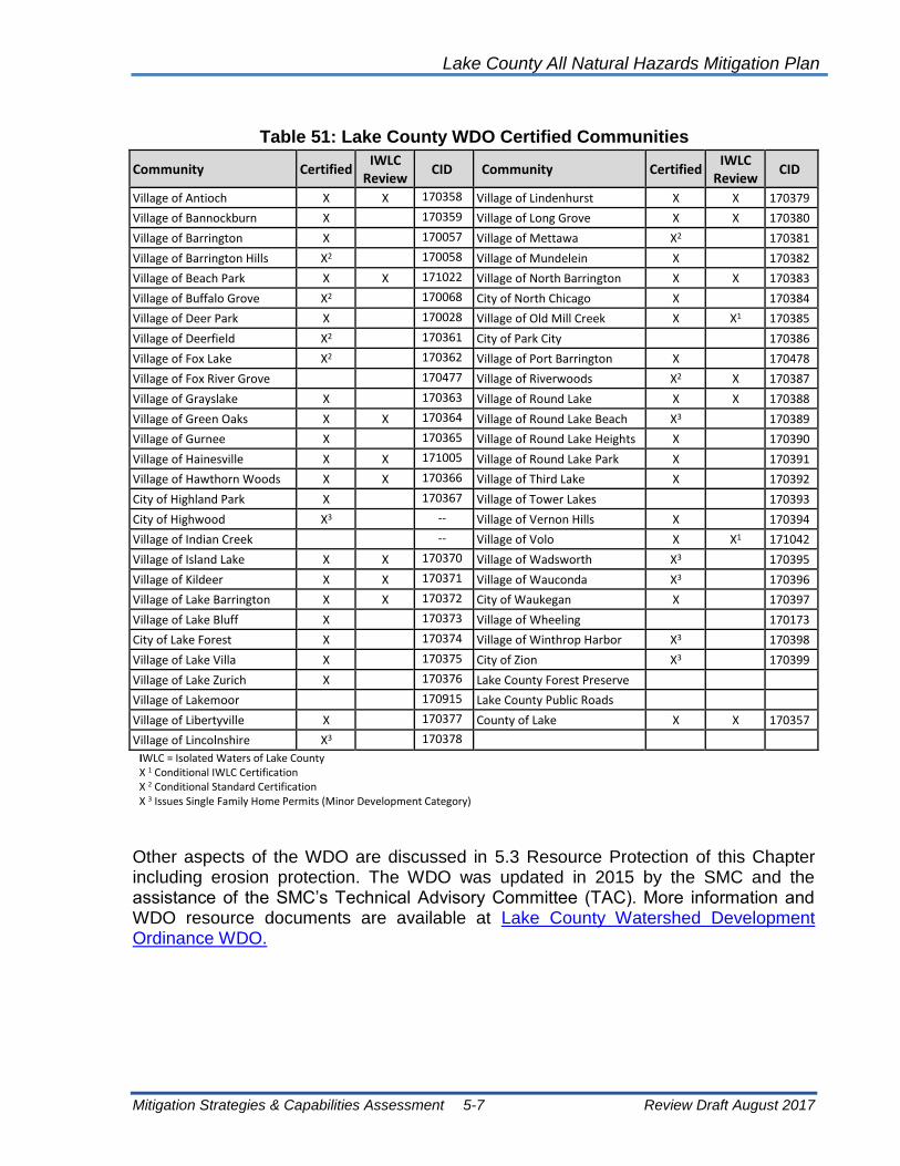
Lake County All Natural Hazards Mitigation Plan
Mitigation Strategies & Capabilities Assessment 5-7 Review Draft August 2017
Table 51: Lake County WDO Certified Communities
Community Certified IWLC
Review CID Community Certified
IWLC Review
CID
Village of Antioch X X 170358 Village of Lindenhurst X X 170379
Village of Bannockburn X 170359 Village of Long Grove X X 170380
Village of Barrington X 170057 Village of Mettawa X2 170381
Village of Barrington Hills X2 170058 Village of Mundelein X 170382
Village of Beach Park X X 171022 Village of North Barrington X X 170383
Village of Buffalo Grove X2 170068 City of North Chicago X 170384
Village of Deer Park X 170028 Village of Old Mill Creek X X1 170385
Village of Deerfield X2 170361 City of Park City 170386
Village of Fox Lake X2 170362 Village of Port Barrington X 170478
Village of Fox River Grove 170477 Village of Riverwoods X2 X 170387
Village of Grayslake X 170363 Village of Round Lake X X 170388
Village of Green Oaks X X 170364 Village of Round Lake Beach X3 170389
Village of Gurnee X 170365 Village of Round Lake Heights X 170390
Village of Hainesville X X 171005 Village of Round Lake Park X 170391
Village of Hawthorn Woods X X 170366 Village of Third Lake X 170392
City of Highland Park X 170367 Village of Tower Lakes 170393
City of Highwood X3 -- Village of Vernon Hills X 170394
Village of Indian Creek -- Village of Volo X X1 171042
Village of Island Lake X X 170370 Village of Wadsworth X3 170395
Village of Kildeer X X 170371 Village of Wauconda X3 170396
Village of Lake Barrington X X 170372 City of Waukegan X 170397
Village of Lake Bluff X 170373 Village of Wheeling 170173
City of Lake Forest X 170374 Village of Winthrop Harbor X3 170398
Village of Lake Villa X 170375 City of Zion X3 170399
Village of Lake Zurich X 170376 Lake County Forest Preserve
Village of Lakemoor 170915 Lake County Public Roads
Village of Libertyville X 170377 County of Lake X X 170357
Village of Lincolnshire X3 170378
IWLC = Isolated Waters of Lake County X 1 Conditional IWLC Certification X 2 Conditional Standard Certification X 3 Issues Single Family Home Permits (Minor Development Category)
Other aspects of the WDO are discussed in 5.3 Resource Protection of this Chapter including erosion protection. The WDO was updated in 2015 by the SMC and the assistance of the SMC’s Technical Advisory Committee (TAC). More information and WDO resource documents are available at Lake County Watershed Development Ordinance WDO.

Lake County All Natural Hazards Mitigation Plan
Mitigation Strategies & Capabilities Assessment 5-8 Review Draft August 2017
5.1.3 Best Management Practices
Stormwater Best Management Practices (BMPs) are used to help ensure longevity and improve the health of Lake County's watersheds. BMPs can be implemented by all stakeholders, including homeowners, businesses, organizations and municipalities. BMPs can be as simple as using phosphorous-free fertilizer to a more complex activity like a project restoring a large section of degraded streambank. The SMC website provides specific BMPs for different stakeholder groups: Lake County Stormwater-Best-Practices
BMPs slow stormwater runoff and improve water quality
BMPs can be integrated before, during, and after development. BMPs will not only help the environment, but in many cases, they also can save you time and money. Every BMP is beneficial to the environment regardless of its relative cost, but it is the unique combination of BMPs for each property that truly will establish a healthy watershed.
The WDO includes a number of water quality provisions that are within the site development, detention, erosion control and wetland standards. The picture above shows the goal of the water quality impacts that can occur without water quality provisions incorporated into site design.

Lake County All Natural Hazards Mitigation Plan
Mitigation Strategies & Capabilities Assessment 5-9 Review Draft August 2017
The Lake County Central Permit Facility Green Roof in Libertyville
5.1.4 Building Codes
The administration and enforcement of building codes is one of the most effective approaches for addressing natural hazard mitigation. Building codes protect new structures from damage by tornadoes, high winds, snow storms, and earthquakes. When properly designed, and constructed according to code, the average building can withstand the impacts of most of these natural events.
Additional hazard protection standards for all new, improved or repaired buildings can be incorporated into the local building code. Provisions that should be included are:
• Making sure roofing systems will handle high winds and expected snow loads.
• Providing special standards for tying the roof, walls and foundation together to resist the effects of wind.
• Requiring new buildings to have tornado “safe rooms.”
• Including insulation standards that ensure protection from extreme heat and cold as well as energy efficiency.
• Regulating overhanging masonry elements that can fall during an earthquake.
• Ensuring that foundations are strong enough for earth movement and that all structural elements are properly connected to the foundation.
• Mandating overhead sewers for all new basements to prevent sewer backup.

Lake County All Natural Hazards Mitigation Plan
Mitigation Strategies & Capabilities Assessment 5-10 Review Draft August 2017
• Includes NFIP minimum standards for structures built in A Zones (riverine flooding) and V Zones (coastal flooding).
The predominate model building codes being adopted by communities are the International Code series (I-Codes), including the International Residential Code (IRC) and the International Building Code (IBC). The I-Codes require buildings to be built to the “design flood elevation” or DFE, which in effectively the base flood elevation (BFE) or 100-year elevation. Note that the WDO establishes a flood protection elevation (FPE), which is 2 feet above the BFE, so the WDO requirements exceed the I-Codes.
The most recent version of the I-Codes is 2015. Some Lake County communities enforce the BOCA code, but the majority of communities administer and enforce the IRC and IBC.
Fortified Homes: The Institute for Business and Home Safety (IBHS) has a set of recommendations to strengthen a building to better resist the impacts of natural hazards that go beyond building codes. The specific requirements for a protected or a “Fortified” home are available through the IBHS website at https://disastersafety.org/ (see previous page). On the web site, a postal code (zip code) can be entered and regional recommendations are made for maintenance, new construction and businesses.
New construction should also include the construction of an underground shelter or “safe room” at the first-floor level to protect the lives of the occupants. A building code could require them in new construction. Tornado safe rooms are discussed further in section 5.2 Property Protection of this Chapter.
Code Administration: Enforcement of code standards is very important. Adequate inspections are needed during the course of construction to ensure that the builder understands and implements the requirements. The Building Code Effectiveness Grading Schedule (BCEGS) is a national program used by the insurance industry to determine how well new construction is protected from wind, earthquake and other non-flood hazards. The BCEGS is similar to the National Flood Insurance Program (NFIP) Community Rating System and the century-old fire insurance rating scheme. With BCEGS, building permit programs are reviewed and scored, a class 1 community is the best, and a class 10 community has little or no program.
Code Official Training: Training of code officials is also very important for code enforcement. Training of code officials and inspectors is a large part of the BCEGS rating for a community. Courses are offered through the building code associations to help local officials understand standards that apply to seismic, wind and flood hazards.
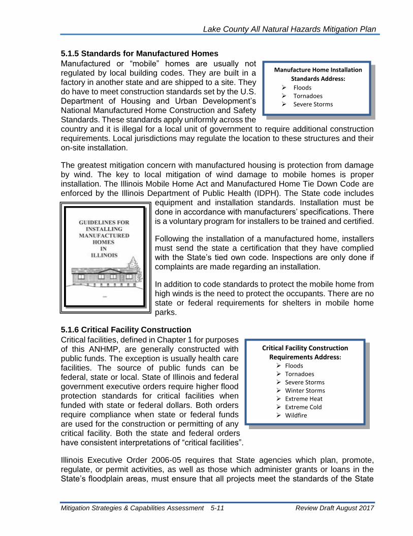
Lake County All Natural Hazards Mitigation Plan
Mitigation Strategies & Capabilities Assessment 5-11 Review Draft August 2017
5.1.5 Standards for Manufactured Homes
Manufactured or “mobile” homes are usually not regulated by local building codes. They are built in a factory in another state and are shipped to a site. They do have to meet construction standards set by the U.S. Department of Housing and Urban Development’s National Manufactured Home Construction and Safety Standards. These standards apply uniformly across the country and it is illegal for a local unit of government to require additional construction requirements. Local jurisdictions may regulate the location to these structures and their on-site installation.
The greatest mitigation concern with manufactured housing is protection from damage by wind. The key to local mitigation of wind damage to mobile homes is proper installation. The Illinois Mobile Home Act and Manufactured Home Tie Down Code are enforced by the Illinois Department of Public Health (IDPH). The State code includes
equipment and installation standards. Installation must be done in accordance with manufacturers’ specifications. There is a voluntary program for installers to be trained and certified.
Following the installation of a manufactured home, installers must send the state a certification that they have complied with the State’s tied own code. Inspections are only done if complaints are made regarding an installation.
In addition to code standards to protect the mobile home from high winds is the need to protect the occupants. There are no state or federal requirements for shelters in mobile home parks.
5.1.6 Critical Facility Construction
Critical facilities, defined in Chapter 1 for purposes of this ANHMP, are generally constructed with public funds. The exception is usually health care facilities. The source of public funds can be federal, state or local. State of Illinois and federal government executive orders require higher flood protection standards for critical facilities when funded with state or federal dollars. Both orders require compliance when state or federal funds are used for the construction or permitting of any critical facility. Both the state and federal orders have consistent interpretations of “critical facilities”.
Illinois Executive Order 2006-05 requires that State agencies which plan, promote, regulate, or permit activities, as well as those which administer grants or loans in the State’s floodplain areas, must ensure that all projects meet the standards of the State
Manufacture Home Installation
Standards Address:
➢ Floods ➢ Tornadoes ➢ Severe Storms
Critical Facility Construction Requirements Address:
➢ Floods ➢ Tornadoes ➢ Severe Storms ➢ Winter Storms ➢ Extreme Heat ➢ Extreme Cold ➢ Wildfire

Lake County All Natural Hazards Mitigation Plan
Mitigation Strategies & Capabilities Assessment 5-12 Review Draft August 2017
floodplain regulations or the NFIP, whichever is more stringent. The State Executive Order also guarantees the State’s eligibility for certain types of federal disaster assistance. Critical facilities must be protected to the 500-year level (see box on following page).
The Illinois Department of Natural Resources-Office of Water Resources is required by the Order to assist state agencies with flood hazard information and assistance to carry out the Executive Order. Unfortunately, no agency has the authority to enforce the Executive Order.
The Federal Executive Order 11988 has similar floodplain standards for federal agencies. Compliance with Federal Executive Order 11988 must be met for all “pass through” federal funding. These standards ensure that federal and state resources and funds are not being used for inappropriate and dangerous floodplain development. The 500-year flood protection level is also used for critical facilities in Executive Order 11988.
5.1.7 Other Preventive Measures
Many times, after a flood, flood victims say they would have taken steps to protect themselves if only they had known they had a flood prone property. Three regulations, one federal and two state, require that a potential buyer of a parcel be told of any flood hazard.
Federal law: Federally regulated lending institutions must advise applicants for a mortgage or other loan that is to be secured by an insurable building that the property is in a floodplain as shown on the Flood Insurance Rate Map (FIRM). Flood insurance is required for buildings located within the 100-year floodplain if the mortgage or loan is federally insured. This program does not apply to flood prone areas that are not mapped
Excerpt from Illinois Executive Order 5 (2006):
2. All State Agencies engaged in any development within a Special Flood Hazard Area shall undertake such development in
accordance with the following:
A. All development shall comply with all requirements of the National Flood Insurance Program (44 C.F.R. 59-79) and with all
requirements of 92 Illinois Administrative Code Part 700 or 92 Illinois Administrative Code Part 708, whichever is applicable.
B. In addition to the requirements set forth in preceding Section A, the following additional requirements shall apply where
applicable:
1. All new Critical Facilities shall be located outside of the floodplain. Where this is not practicable, Critical Facilities shall be
developed with the lowest floor elevation equal to or greater than the 500-year frequency flood elevation or structurally
dry flood proofed to at least the 500-year frequency flood elevation.
2. All new buildings shall be developed with the lowest floor elevation equal to or greater than the Flood Protection Elevation
or structurally dry flood proofed to at least the Flood Protection Elevation.
3. Modifications, additions, repairs or replacement of existing structures may be allowed so long as the new development
does not increase the floor area of the existing structure by more than twenty (20) percent or increase the market value of
the structure by fifty (50) percent, and does not obstruct flood flows. Floodproofing activities are permitted and
encouraged, but must comply with the requirements noted above.
3. State Agencies which administer grants or loans for financing development within Special Flood Hazard Areas shall take all steps
within their authority to ensure that such development meets the requirements of this Order.
4. State Agencies responsible for regulating or permitting development within Special Flood Hazard Areas shall take all steps within
their authority to ensure that such development meets the requirements of this Order.

Lake County All Natural Hazards Mitigation Plan
Mitigation Strategies & Capabilities Assessment 5-13 Review Draft August 2017
on the FIRMs. Flood prone areas that are frequently not mapped include the floodplains of smaller channels and many depressional areas. Depressional area flooding is a significant problem. The use of older flood studies in rapidly developing areas also results in outdated floodplain maps that do not reflect the actual flood risk.
Illinois Compiled Statutes: Chapter 55, Section 5/3-5029 requires that all subdivision plats must show whether any part of the subdivision is located in a Special Flood Hazard Area.
Illinois Residential Real Property Disclosure Act: This law, which went into effect on October 1, 1994, requires a seller to tell a potential buyer if the seller is aware of any flooding or basement leakage problem, if the property is located in a floodplain, or if the seller has flood insurance. The law is not wholly reliable because the seller must be aware of a problem and willing to state it on the disclosure form. Due to the sporadic occurrence of flood events, a property owner may legitimately not be aware of potential flooding problems with a property being sold or purchased.
5.1.8 Preventive Measure Recommendations
1. Complete current and accurate floodplain maps for all Lake County watersheds and submit to FEMA for adoption.
2. The County and municipalities that participate in the NFIP should ensure that they fully and properly administer and enforce the requirements of the NFIP.
3. The County and municipalities should ensure that they fully enforce all provisions of the WDO and the forthcoming amendments.
4. Communities that have not adopted the International Series of Codes should do so, and on a regional basis, municipal and County code enforcement staffs should work together to develop building code language to strengthen new buildings against damage by high winds, tornadoes and hail,
5. All communities should work to improve code administration and enforcement, and should also be trained on implementing the codes that are applicable to hazard mitigation.
6. The adequacy or current requirements for manufactured home and recreational vehicle parks for protection from natural hazards should be examined, especially concerns pertaining to placement in flood prone areas, tie downs and sheltering.
7. On a regional basis, municipal and county planning and engineering staff should develop example subdivision ordinance language that requires new infrastructure to have hazard mitigation provisions, such as secondary access to subdivisions.

Lake County All Natural Hazards Mitigation Plan
Mitigation Strategies & Capabilities Assessment 5-14 Review Draft August 2017
8. Offices responsible for design, construction or permitting critical facilities should ensure that the design accounts for natural hazards and adjacent land uses.
9. Communities (certified and non-certified) need to understand and consistently enforce the WDO, and the TAC should continue their efforts in these areas.
10. Communities should consider joining the NFIP’s CRS program. For the municipalities already involved in CRS, they should work to improve their CRS class.
11. Communities should encourage the use of back-up power sources or generators to address power outages.
5.2 Property Protection
Property protection measures are used to modify or remove buildings subject to flood damage rather than to keep floodwaters away. Because of the widespread extent of flood damage caused by shallow, low velocity flooding in Lake County, traditional flood control structures such as levees and reservoirs are generally not economically justifiable in most areas. Individual property protection measures are usually the most preferred and cost-effective flood mitigation measures in these circumstances. Many property protection measures do not affect a building’s appearance or uses, making them particularly appropriate for historical sites and landmarks.
Although most property protection measures are paid for and implemented by individual property owners, there is increasing government interest and cost-share funding available for building relocation and acquisition, which are seen as permanent solutions to flood damage. While property protection is viewed as the property owner’s responsibility, local governments can actively support and promote private efforts by providing technical assistance and incentives. Property protection measures include activities such as:
• Building Acquisition/Relocation
• Building Elevation, Floodproofing or Barriers
• Building Structural Retrofitting
• Insurance

Lake County All Natural Hazards Mitigation Plan
Mitigation Strategies & Capabilities Assessment 5-15 Review Draft August 2017
5.2.1 Building Acquisition/Relocation
Acquisition ensures that buildings in a flood prone area will cease to be subject to damage. The major difference is that acquisition is undertaken by a government agency, so the cost is not borne by the property owner, and the land is converted to an appropriate public use such as a park. Acquiring and clearing buildings from the floodplain, or severe ravine or other erosion areas, is not only the best long-term flood protection measure, it also is a way to convert a problem area into a community asset that can provide environmental and recreational benefits.
The Village of Gurnee purchased properties in the 1990s when they came up for sale in the floodway. In 1997, the SMC began coordinating the county’s acquisition projects in Sturm Subdivision and William’s Park, two of the most repetitively flood damaged locations in the county. Acquisition funds were provided though the FEMA Hazard Mitigation Assistance Programs. Since then SMC has coordinated several additional FEMA Hazard Mitigation grant applications for the acquisition of flood prone properties in Fox Lake, Gurnee, Lake Forest, Lindenhurst, Round Lake Beach, and areas of unincorporated Lake County.
To date, dozens of repetitive flood loss and other floodplain properties have been acquired throughout Lake County. The FEMA funds are provided through IEMA to cover 75% of project costs. Cost share funds (25%) have been provided by the participating municipalities and the SMC. The structures on the acquired properties have been demolished and the property converted to open space.
Exhibit 16 shows the location of SMC flood audit and floodplain buyout locations. SMC currently has two grant applications under review with FEMA which includes sixteen properties throughout the county.
Building Acquisitions Address:
➢ Floods ➢ Severe Storms ➢ Dam Failure ➢ Erosion
This home was acquired by the SMC and the site was returned to open space.

Lake County All Natural Hazards Mitigation Plan
Mitigation Strategies & Capabilities Assessment 5-16 Review Draft August 2017
Exhibit 16: Lake County SMC Flood Audit and Floodplain Buyout Locations
Building Relocation: Moving a building to higher ground is the surest and safest way to protect it from flooding. While almost any building can be moved, the cost goes up for heavier structures, such as those made of brick, and for large or irregularly shaped buildings. Building relocation is generally cost-effective where flooding is relatively severe and/or frequent. Buildings that have suffered structural damage or contamination from frequent or long duration flooding should not be considered for relocation.
While relocation is typically the responsibility of the building owner, government-sponsored loans or grants may be available for cost-share. Communities and county-wide agencies could play a greater role in building relocation by improving public and local official awareness of this option, identifying and prioritizing buildings or properties well-suited for relocation, and by locating potential cost-share funds to assist individual property owners.

Lake County All Natural Hazards Mitigation Plan
Mitigation Strategies & Capabilities Assessment 5-17 Review Draft August 2017
5.2.2 Building Elevation, Floodproofing or Barriers
Elevation: Raising or elevating a house above the flood level protects the structure and contents from flood damage. When flooding occurs, water levels stay below the main floor, causing no damage to the structure or its contents. Raising a building above the flood level is less expensive than acquiring it or moving it, and can be less disruptive to a neighborhood. Commonly practiced in flood prone areas nationwide, this protection technique is required by law for new and substantially damaged residences located in a 100-year floodplain.
Although flood damage can be reduced significantly or eliminated through building elevation, there are some limitations to remaining in a flood prone location. While the building itself is elevated sufficiently to be protected from flood damage, flooding may isolate the building making it inaccessible. In addition, flood waters can result in a loss of utility service in flooded areas making the building uninhabitable even though it isn’t damaged, and pollutant contamination in floodwaters will still threaten health and safety.
As with acquisitions, structural elevation projects are voluntary. SMC has determined that cost-share for elevation projects is required from the homeowner and are best pursued by municipalities rather than the county.
Barriers: Constructing barriers, such as floodwalls and berms, can keep floodwaters from reaching a building. Berms are commonly used in areas subject to shallow flooding. Not considered engineered structures, berms are made by regrading or filling an area. Low floodwalls may be built around
stairwells to protect the basement and lower floor of a split-level home.
By keeping water away from the building walls, the problems of seepage and hydrostatic pressure are reduced.
This house was elevated one foot above the base flood
elevation of the Des Plaines River (prior to the adoption of the
WDO).
This f loodwal l is in L incolnshi re .
Elevation & Floodproofing
Activities Address:
➢ Floods ➢ Severe Storms ➢ Sewer Backup

Lake County All Natural Hazards Mitigation Plan
Mitigation Strategies & Capabilities Assessment 5-18 Review Draft August 2017
Use of floodwalls and berms must also include a plan to install drain pipes and/or sump pumps to handle leaks and water seepage through or under the barrier, and to get rid of water that may collect inside the barrier. Care must be taken in the design, location and installation of berms or floodwalls to ensure that floodwaters are not inadvertently pushed onto an adjacent property.
Floodproofing: Floodproofing covers measures that provide either wet floodproofing or dry floodproofing. In areas where there is shallow flooding, dry floodproofing measures can be used to prevent water from entering some buildings. A wet floodproofing strategy will allow water to enter the building, but moves damageable belongings, appliances and utilities out of harm’s way
Dry Floodproofing: Dry floodproofing is a combination of practices that are used to seal a building against floodwaters. Walls, floors and all openings must be sealed and made watertight. Buildings with crawlspaces generally cannot be dry flood proofed because water can seep under walls into the crawlspace. However, buildings on slabs and buildings with basements can benefit from dry floodproofing.
Dry Floodproofing - Buildings on slab
Walls are coated with waterproofing compounds or plastic sheeting.
Openings, such as doors, windows, sewer lines and vents, are closed either permanently, with
removable shields, or with sandbags.
Dry Floodproofing - Buildings with basements
Waterproofing compound is applied to the
walls before fill is placed against the side of
the house.
Installation of a subsurface drain tile and
sump pumps is a must to handle water that
will naturally seep through the fill.
Surface water is kept away from the walls with backfill (see illustration)
A structural engineer should be consulted to design the dry floodproofing measures due to the need to address hydrostatic pressure against foundation walls that occur during floods.

Lake County All Natural Hazards Mitigation Plan
Mitigation Strategies & Capabilities Assessment 5-19 Review Draft August 2017
Wet Floodproofing: Wet floodproofing provides damage protection from floodwaters that cannot be kept out of a building. It is a relatively simple means of making sure that nothing gets damaged when floodwaters enter the building. Wet floodproofing includes some of the least expensive and easiest mitigation practices to install.
Wet floodproofing approaches range from moving valuable items to a higher floor to rebuilding the floodable area. At the very least, several low-cost steps can be taken to wet flood proof a structure. Simply moving furniture and electrical appliances out of the flood prone area of the building can prevent thousands of dollars in damages.
Wet floodproofing measures work wherever there is a level above the flood zone to which items can be relocated; in general, wet floodproofing does not work for one-story houses where living areas get flooded.
Sewer backup protection: Basement flooding can occur when the sanitary system overloads with stormwater and backs sewage up into the basement through the sanitary line. Even when sanitary and storm waters are carried in separate pipes, and they are though nearly all of Lake County, sewer backup can occur when cross connections between the storm and sanitary sewers exist, or if there are infiltration or inflow problems into the lines.
Houses which have downspouts, footing drain tile, and/or a sump pump connected to the sanitary sewer service may be inundated when heavy rains overload the system. Installing secondary power systems including back-up battery or generator powered pump systems will ensure that the pumps continue to function during power outages. In addition to these sources, sanitary lines can also be inundated by stormwater by way of runoff infiltration into old leaky pipes or where the sanitary manholes are not properly sealed. Several Lake County communities experience very high sewage flows following heavy rain events. As in the case of Wauconda, some wastewater treatment plants cannot adequately treat the heavy volume of combined stormwater and sewage, so the plant is by-passed and sewage is discharged directly to surface waters untreated.
Wet Floodproofing:
Everything subject to damage by
water or sediment is moved to a
higher level or out of the building.
For example, the electrical panel
and the furnace should be
relocated to an upper floor.
Where flooding is not expected to
be deep, items needing protection
may be placed on platforms or
blocks.
Lighter items, such as lawn
furniture or bicycles, are evacuated
after a flood warning is issued.

Lake County All Natural Hazards Mitigation Plan
Mitigation Strategies & Capabilities Assessment 5-20 Review Draft August 2017
If allowed by the local code, sump pumps, downspouts and footing drains should be disconnected from the sanitary sewer line and the rain and groundwater directed out onto the ground, away from the building. The solution to stormwater overload of the sanitary system also includes the need for timely maintenance of sanitary lines, including periodic televising and cleaning of the sanitary sewer lines to remove tree roots and other blockages, repairing or replacing pipe where it leaks, and upgrading old waste water treatment facilities that are inadequate for the existing level of use. Until sanitary infiltration is fixed, a property owner may use four approaches to protect sanitary sewer openings from backup. Floor drain plugs or floor drain standpipes can be installed to keep water from flowing out of the floor drain into the building. However, these may not be effective if water gets deep enough in the sewer system to flow out of the next lowest opening, which is likely to be a toilet or utility sink.
Overhead sewers and backup valves are more expensive, but more secure for this circumstance. An overhead sewer keeps water in the sewer line during a backup. A backup valve allows sewage to flow out, while preventing backups from entering the building.
Septic system modification: In Lake County, septic failure is a common secondary result of flooding. Having septic tanks pumped as needed during periods of ponding, soil saturation or following a flood is one method of maintaining the usefulness of septic systems. In cases where the size of a single septic tank is inadequate, a second tank should be installed
Automatic Floor Drain Plug
ug
Overhead Sewer Arrangement

Lake County All Natural Hazards Mitigation Plan
Mitigation Strategies & Capabilities Assessment 5-21 Review Draft August 2017
A second strategy to improve septic usefulness during high water periods would be to install an alternative system. The Wisconsin Mound septic system is constructed in soil, gravel and sand layers above the existing grade. The Wisconsin Mound may function better than traditional systems during high groundwater periods, but even their usefulness is limited under flood conditions.
5.2.3 Building Structural Retrofitting
Tornado Retrofitting: Tornado retrofitting measures include constructing an underground shelter or “safe room” at the first-floor level to protect the lives of the occupants. Safe rooms are built by connecting all parts of the shelter together (walls, roof and foundation) using adequate fasteners or tie downs. This helps hold the safe room together when the combination of high wind and pressure differences work to pull the walls and ceiling apart. The walls of the safe room are constructed out of plywood and metal sheeting to protect people from windborne missiles (flying debris) with the strong winds of a tornado. More information on safe rooms can be found in FEMA Publication 320.
Another retrofitting approach for tornadoes and high winds is to secure the roof, walls and foundation with adequate fasteners or tie downs. This helps hold the building together when the combination of high wind and pressure differences work to pull the building apart. This measure also applies to manufactured homes.
A third tornado and high wind protection modification is to strengthen garage doors, windows and other large openings. If winds break the building’s “envelope,” the pressures on the structure are greatly increased. Impact-resistant glass is also recommended for high wind or tornado protection.
Severe Storm Retrofitting: Retrofitting approaches to protect private or public buildings from the effects of thunderstorms include:
• Shelters
• Storm shutters
• Lightning rods
• Strengthening connections and tie-downs
(similar to tornado retrofitting)
• Impact-resistant glass in window panes
• Surge protectors at electrical outlets
Also, roofs can be replaced with materials less susceptible to damage by hail, such as modified asphalt or formed steel shingles.
Building Retrofit Activities Address:
➢ Tornadoes ➢ Severe Storms ➢ Winter Storms ➢ Wildfire

Lake County All Natural Hazards Mitigation Plan
Mitigation Strategies & Capabilities Assessment 5-22 Review Draft August 2017
Winter Storm Retrofitting: Winter storm retrofitting measures include improving insulation on older buildings and relocating water lines from outside walls to interior spaces. Windows can be sealed or covered with an extra layer of glass (storm windows) or plastic sheeting. Roofs can be retrofitted to shed heavy loads of snow and prevent ice dams that form when snow melts.
Earthquake Retrofitting–Buildings: Earthquakes, or seismic events, present two hazards for buildings and people – a hazard for the structure itself and a hazard for the building’s contents (non-structural hazard). Earthquake retrofitting measures for the structure include:
• Removing masonry overhangs that will fall onto the street during shaking
• Bracing the walls of the building provides structural stability
• Bolting sill plates to the foundation
These measures can be very expensive and should be considered for buildings on a case by case basis. Measures that protect against non-structural seismic hazards typically involve small modifications. Retrofitting activities for non-structural hazards include:
• Tying down appliances, water heaters, bookcases, and fragile furniture so they won’t fall over during a quake
• Installing latches on drawers and cabinet doors
• Mounting picture frames and mirrors securely
• Installing flexible utility connections for water and gas lines
• Anchoring and bracing propane tanks and gas cylinders
These approaches can be very cost effective and have little or no impact on the appearance of a building, yet they are important measures for keeping buildings safer and protecting lives during earthquake events.
While these simple and inexpensive measures may be cost effective for a home or business, they may not be sufficient for protection of critical facilities. Fire stations need to be sure that they can open their doors and hospitals must be strong enough to continue operating during the shocks and aftershocks. Again, critical facilities should be evaluated on a case by case basis.
Earthquake Retrofitting–Infrastructure and Lifelines: Infrastructure hardening, attention to lifelines and bridge strengthening are important elements of earthquake mitigation. From FEMA Publication Number 271, Seismic Design Guidelines and Standards for Lifelines (1996):
Lifelines are the public works and utility systems that support most human activities: individual, family, economic, political, and cultural. The various lifelines can be classified

Lake County All Natural Hazards Mitigation Plan
Mitigation Strategies & Capabilities Assessment 5-23 Review Draft August 2017
under the following five systems: electric power, gas and liquid fuels, telecommunications, transportation, and water supply and sewers.
The first step in protecting lifeline systems is the prioritization of critical facilities, utility systems, and other infrastructure. The involvement of state agencies, such as the Illinois Department of Transportation, is important. The involvement of private owners of utility systems is also important. FEMA, through the National Earthquake Hazard Reduction Program (NEHRP) and the Central United States Earthquake Consortium offer technical guidance on retrofitting approaches.
5.2.4 Insurance
Insurance does not prevent flooding or flood damage; it helps an owner protect his/her property investment by paying for repairs and replacement of items damaged in a flood. While a typical homeowner’s insurance policy does not cover a property for flood damage, flood insurance coverage is available through the National Flood Insurance Program, as is additional basement backup insurance.
National Flood Insurance: In Lake County forty-three municipalities and the County participate in the National Flood Insurance Program (NFIP). Flood insurance is required as a condition of certain types of federal aid and most bank loans and mortgages for buildings located in the 100 year floodplains identified on the FEMA Flood Insurance Rate Maps.
While the NFIP requires flood insurance for those at greatest risk, there are several weaknesses in the program. Many of the buildings subject to flooding in Lake County are not located in the 100-year floodplain as identified on the FEMA maps. In addition, many policy holders drop flood insurance following a period of dry years or after their mortgage is paid off, and/or do not buy enough insurance to cover their total risk (for instance for building contents).
In spite of the federal law, it is estimated that fewer than 1 in 4 floodplain properties are covered under NFIP (Flood Hazard Mitigation in Northeastern Illinois, 1995). Nationally, 25% of NFIP claims are for flood damage to buildings located outside of the 100-year floodplain (the insurance requirement zone). In Lake County, approximately 30% of the flood insurance policies are for properties outside the floodplain.
Table 52 shows the number of insurance policies for each Lake County community. CID in is the NFIP community identification number.
Flood insurance is available for anyone, regardless of building location, and premiums are lower if your structure is not in a mapped floodplain. For this reason, if there is any risk of flood damage to a property, it is prudent to have flood insurance.
Insurance Addresses:
➢ Floods ➢ Tornadoes ➢ Severe Storms ➢ Winter Storms ➢ Wildfire ➢ Sewer Backup

Lake County All Natural Hazards Mitigation Plan
Mitigation Strategies & Capabilities Assessment 5-24 Review Draft August 2017
There are ramifications for not having insurance required by the NFIP when future flood damage occurs. If property owners who were required to purchase insurance as a condition of receiving disaster assistance for a previous flood dropped the policy, they would lose their right to any future disaster assistance. In addition, under-insured public buildings will have the amount of flood insurance they should have carried deducted from any disaster assistance they may be eligible for after a flood. Community Rating System (CRS): FEMA created the NFIP’s CRS program in 1990. It is designed to recognize floodplain management and other watershed management activities that go beyond NFIP minimum requirements. Communities that participate in the NFIP can apply for the CRS. When appropriate applications and reviews are completed, a community is awarded a CRS class rating. Residents and property owners of that community then qualify for a flood insurance premium rate reduction that ranges from 5 to 45 percent. CRS credit is provided for 18 creditable activities, organized under four categories:
• Public Information
• Mapping and Regulations
• Flood Damage Reduction
• Flood Preparedness
The CRS is a voluntary program and is modeled after the fire insurance rating system. Insurance premiums are adjusted based on the rating of the community. Numerous watershed and floodplain management activities in Illinois and Lake County exceed the minimum NFIP requirements and therefore earn communities notable CRS credit.
Community Rating System
CRS Premium Reduction
Class Credit Points SFHA* Non-SFHA
1 4,500+ 45% 10%
2 4,000 – 4,499 40% 10%
3 3,500 – 3,999 35% 10%
4 3,000 – 3,499 30% 10%
5 2,500 – 2,999 25% 10%
6 2,000 – 2,499 20% 10%
7 1,500 – 1,999 15% 5%
8 1,000 – 1,499 10% 5%
9 500 – 999 5% 5%
10 0 – 499 0 0
*SFHA = Special Flood Hazard Area
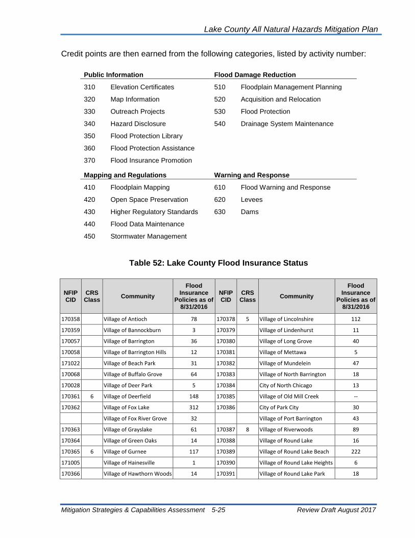
Lake County All Natural Hazards Mitigation Plan
Mitigation Strategies & Capabilities Assessment 5-25 Review Draft August 2017
Credit points are then earned from the following categories, listed by activity number:
Public Information Flood Damage Reduction
310 Elevation Certificates 510 Floodplain Management Planning
320 Map Information 520 Acquisition and Relocation
330 Outreach Projects 530 Flood Protection
340 Hazard Disclosure 540 Drainage System Maintenance
350 Flood Protection Library
360 Flood Protection Assistance
370 Flood Insurance Promotion
Mapping and Regulations Warning and Response
410 Floodplain Mapping 610 Flood Warning and Response
420 Open Space Preservation 620 Levees
430 Higher Regulatory Standards 630 Dams
440 Flood Data Maintenance
450 Stormwater Management
Table 52: Lake County Flood Insurance Status
NFIP CID
CRS Class
Community
Flood Insurance
Policies as of 8/31/2016
NFIP CID
CRS Class
Community
Flood Insurance
Policies as of 8/31/2016
170358 Village of Antioch 78 170378 5 Village of Lincolnshire 112
170359 Village of Bannockburn 3 170379 Village of Lindenhurst 11
170057 Village of Barrington 36 170380 Village of Long Grove 40
170058 Village of Barrington Hills 12 170381 Village of Mettawa 5
171022 Village of Beach Park 31 170382 Village of Mundelein 47
170068 Village of Buffalo Grove 64 170383 Village of North Barrington 18
170028 Village of Deer Park 5 170384 City of North Chicago 13
170361 6 Village of Deerfield 148 170385 Village of Old Mill Creek --
170362 Village of Fox Lake 312 170386 City of Park City 30
Village of Fox River Grove 32 Village of Port Barrington 43
170363 Village of Grayslake 61 170387 8 Village of Riverwoods 89
170364 Village of Green Oaks 14 170388 Village of Round Lake 16
170365 6 Village of Gurnee 117 170389 Village of Round Lake Beach 222
171005 Village of Hainesville 1 170390 Village of Round Lake Heights 6
170366 Village of Hawthorn Woods 14 170391 Village of Round Lake Park 18

Lake County All Natural Hazards Mitigation Plan
Mitigation Strategies & Capabilities Assessment 5-26 Review Draft August 2017
NFIP CID
CRS Class
Community
Flood Insurance
Policies as of 8/31/2016
NFIP CID
CRS Class
Community
Flood Insurance
Policies as of 8/31/2016
170367 8 City of Highland Park 8 170392 Village of Third Lake 4
171033 City of Highwood -- 170393 Village of Tower Lakes 5
170369 NO
SFHA Village of Indian Creek -- 170394 Village of Vernon Hills 23
170370 Village of Island Lake 36 171042 Village of Volo 1
170371 Village of Kildeer 17 170395 Village of Wadsworth 8
170372 Village of Lake Barrington 18 170396 Village of Wauconda 35
170373 Village of Lake Bluff 11 170397 City of Waukegan 77
170374 7 City of Lake Forest 67 170173 7 Village of Wheeling 808
170375 Village of Lake Villa 13 170398 Village of Winthrop Harbor 10
170376 Village of Lake Zurich 14 170399 City of Zion 10
170915 Village of Lakemoor 31 170357 6 Lake County 966
170377 Village of Libertyville 151
Table 52 shows the CRS class for Lake County and the Lake County municipalities that currently participate in the CRS. The CRS class rating and insurance premium reductions are shown in the table below. Properties in the FEMA Special Flood Hazard Areas (SFHAs), or the 100-year floodplain, receive a 5 percent premium reduction for every improvement in the CRS class. Properties outside the SFHA already have a reduced premium (since they are outside the floodplain), and therefore have a lower premium reduction than properties in the SFHA.
Basement Backup Insurance: The NFIP will cover seepage and sewer backup for an additional deductible provided there is a general condition of flooding in the area that was the proximate cause of the basement getting wet. Several insurance companies offer coverage for damages incurred should a sump pump fail or sewer line back up. Most exclude damage from surface flooding that would be covered by the NFIP.
Other Insurance: Insurance is also available for earthquakes other hazards such as sinkholes. Most of these coverages are included to a property policy as a policy rider.
5.2.5 Repetitive Flood Loss Properties
Chapter 3 discusses the Lake County and Lake County community repetitive loss properties (properties with two federal flood insurance claims of at least $1,000 in any 10-year period). Protecting repetitive loss buildings is a priority with FEMA and IEMA mitigation funding programs.
The factors listed below should be used to determine appropriate property protection measures for repetitive loss properties. The criteria used are based on several studies that have identified appropriate measures based on flood and building conditions. While a cost/benefit study was not conducted on each property, these guidelines show which measures are cost-effective.

Lake County All Natural Hazards Mitigation Plan
Mitigation Strategies & Capabilities Assessment 5-27 Review Draft August 2017
• “High hazard areas” are areas in the floodway or where the 100-year flood is two or more feet over the first floor.
• Buildings in high hazard areas or in less than good condition should be acquired and demolished.
• Buildings with basements and split-level foundations in high hazard areas should be acquired and demolished. They are too difficult to elevate and the hydrostatic pressures on the walls from deeper flooding make them too risky to protect in place.
• Buildings subject to shallow flooding from local drainage should be protected through area-wide flood control or sewer improvement projects.
• Buildings in good condition on crawlspaces should be elevated or relocated.
• Buildings in good condition on slab, basement or split-level foundations subject to shallow flooding (less than 2 feet) can be protected by barriers and dry floodproofing.
• Recent flood claims. Some properties have not had a flood insurance claim for 30 years, indicating that some measure has probably been put in place to protect the property from repetitive flooding.
These criteria are general, and recommendations for individual structures should be made only after a site inspection. Other extenuating circumstances may also alter the recommendations. Lake County has used the above direction in the development of “flood audits” that have been performed in repetitive loss areas. Repetitive loss areas were first identified during the development of the 2004 Draft Lake County Flood Mitigation Plan (around 2000). Letters were sent to property owners within selected repetitive loss areas to determine their interest in having a flood audit done for their property. Combined, SMC and Gurnee have conducted over 400 flood audits.
As discussed in section 3.3.3 Repetitive Flood Loss Properties, and shown in Table 21 and Exhibit 11 of Chapter 3 of this ANHMP, there are 108 properties on the Lake County repetitive loss list, located in 18 municipalities and unincorporated Lake County. The repetitive loss properties were grouped into 42 Repetitive Loss Areas (see Table 22). Several repetitive loss properties have a pending mitigation project (acquisition). Of the remaining repetitive loss properties, about half have had flood audits (see Table 23). A flood audit also means that SMC at one time coordinated with the property owners about the flood audit process and the potential for mitigation project funding.
Though a number of repetitive loss properties have not been audited, a number of them are in areas that nearby properties were audited. All of the properties are single family homes. Of the 30 plus audited properties, all but two are single family residential.
A notable number of unmitigated repetitive loss properties are located on or near major Lake County lakes. When flooding occurs on the Fox Chain of Lakes, the flooding lasts for weeks. Long flood periods can also be experienced for properties along the Des

Lake County All Natural Hazards Mitigation Plan
Mitigation Strategies & Capabilities Assessment 5-28 Review Draft August 2017
Plaines River. During the flood audit, the range of flood mitigation options presented in the ANHMP will be investigated.
5.2.6 Property Protection Recommendations
1. All buildings and critical facilities in the floodplain, SMC problem areas and depressional storage areas, with priority given to buildings or facilities in the floodway, should be mitigated, to the extent that the measures are cost effective and feasible.
2. All buildings and critical facilities in or out of the floodplain and subject to damage due to erosion, should be mitigated, to the extent that the measures are cost effective and feasible. For example, the homes being impacted in the Bull Creek Watershed in Beach Park.
3. Identified repetitive flood loss areas should be further investigated through flood audits, and flood prone structures should be mitigated.
4. SMC should continue to conduct flood audits and to pursue hazard mitigation grants for the acquisition of properties that are cost effective and have interested property owners.
5. Investigate property-owner incentives for elevations, barriers and floodproofing.
6. Establish and disseminate guidelines for local officials for determining what mitigation measures are appropriate to protect property for various circumstances for floods, severe storms, wind events (microbursts), tornadoes and other priority hazards in Lake County.
7. Available property protection public education materials for all priority hazards should be consolidated and tailored for Lake County. Materials should address measures that can help owners reduce their exposure to damage by natural hazards and the various types of insurance coverage that are available.
8. Critical facilities, including lift stations and other infrastructure facilities, should be audited to determine their vulnerability and hazard mitigation needs, including back-up power needs during power outages.
9. Mitigation projects should be pursued for vulnerable critical facilities, including public facilitates and health-care related facilities. Each public entity should protect its own publicly-owned facilities with appropriate mitigation measure(s), except where efficiencies allow for joint funding and joint projects.
10. The availability of tornado shelters or safe rooms in Lake County should be investigated.
11. Safe rooms should be constructed wherever needed in Lake County with priority given to schools and critical faculties.

Lake County All Natural Hazards Mitigation Plan
Mitigation Strategies & Capabilities Assessment 5-29 Review Draft August 2017
12. Develop action plan to identify and remedy illicit hook ups and sewer infiltration that maps and prioritizes problem areas for remediation. This can be done as a county coordinated community program in conjunction with NPDES Phase 2 requirements.
13. Encourage business recovery plans.
14. Feasible mitigation projects should be funded through grants or through capital funding.
15. All property owners should be encouraged to determine if they are adequately insured for natural hazards.
16. Each public entity (county, community, schools and other agencies) should evaluate its own properties, with a priority given to critical facilities, to determine vulnerabilities to damage from natural hazards.
5.3 Resource Protection
Natural resource protection measures serve to restore or preserve the natural functions of the floodplain and other components of the watershed storage and drainage system. These measures are implemented by a variety of public and private parties ranging from local park districts, forest preserves and regulatory agencies to land developers and farmers. Resource protection measures include activities such as:
• Open space preservation
• Wetland protection
• Erosion and sediment control
• Streambank restoration
• Groundwater protection
• Urban forestry
• Historic and natural area protection
Resource Protection Address:
➢ Floods
➢ Tornadoes
➢ Severe Storms
➢ Winter Storms
➢ Extreme Heat
➢ Dam Failure
➢ Wildfire
➢ Erosion
➢ Drought
➢ Groundwater

Lake County All Natural Hazards Mitigation Plan
Mitigation Strategies & Capabilities Assessment 5-30 Review Draft August 2017
5.3.1 Open Space Preservation
Open space preservation throughout a watershed is important for a variety on natural hazard and environmental reasons. Preserving floodplains and natural sites of water storage, such as wetlands and low-lying areas maintain the existing stormwater storage capacities of an area. These sites can also serve as recreational areas, greenway corridors, provide habitat for local flora and fauna, and improve water quality. Open space may also be maintained as a park, golf course, or in agricultural use.
Upland areas within a watershed may be key to limiting runoff that will worsen flooding problems, important for water quality and groundwater recharge. Purchase of land is the most common approach to open space preservations; however, other methods can be considered in addition. Several more affordable examples of open space preservation practices include the purchase or dedication of an easement that limits use of the parcel in exchange for a tax abatement or as a condition of development approval, and the purchase of development rights for a property.
In Lake County, the Forest Preserve District, local park districts and townships have prevented millions of dollars of flood damage through the foresighted acquisition of floodplain. The Lake County Forest Preserve District alone owns nearly 7,000 acres of
land adjacent to the Des Plaines River, over 1,000 acres along the Skokie, Middle and West Forks of the North Branch of Chicago River, and about 300 acres adjacent to the Fox River.
Parks and golf courses follow the course of the Skokie River providing areas of floodplain storage. Private not-for-profit organizations are also active in preserving open space in Lake County. These groups include Lake Forest Open lands, Lake Bluff Open lands, Liberty Prairie Conservancy and the Lake County Land Conservancy.
Liberty Prairie Reserve
The Liberty Prairie Reserve is located in the
area bordered by Routes 120 and 137 from
north to south, and Route 21 and Prairie
Crossing on Route 45 from east to west. The
Reserve is a unique example of open space
preservation that is a combination of public
and private ownership. Approximately 1,500
acres of the 2,500-acre reserve is currently
protected as open space. The natural
landscape of the Reserve, combined with
agricultural and residential land uses, has
been protected through both outright
acquisition and conservation easements.
The Des Plaines River Trail is an excellent example of floodplain open space that serves the entire community.
Source: Lake County Forest Preserve District.

Lake County All Natural Hazards Mitigation Plan
Mitigation Strategies & Capabilities Assessment 5-31 Review Draft August 2017
5.3.2 Wetland Protection Regulations & Soil Erosion and Sediment Control
Wetlands are usually found in floodplains or depressional areas. They provide numerous natural and beneficial functions that warrant protection. Exhibit 17 shows the open water and lake areas of Lake County wetland protection along rivers and around the lakes is critical for water quality and ecosystem protection.
Wetlands located in the Waters of the U.S. (WOUS) are regulated by the U.S. Army Corps of Engineers (Corps). Local wetland programs are important for addressing gaps in the federal regulations, particularly for smaller wetlands, unregulated activities, and indirect hydrologic impacts. Local wetland programs can require undisturbed buffers be maintained around wetlands.
The WDO provides standards for the isolated wetlands no longer under the jurisdiction of the
Corps. If your project may impact a wetland, you are required to submit a Jurisdictional Determination to determine if the wetland is an Isolated Waters of Lake County (IWLC) or a WOUS.
As rain hits the ground, especially where there is bare soil as on farm fields and at construction sites, soil is picked up and washed downstream. This erosion of soil produces sediment that may end up in waterways far from the eroded area. Erosion also occurs along streambanks and shorelines as the volume and velocity of flow or wave action destabilize and wash away the soil.
Sediment suspended in the water tends to settle out where flowing water slows down. It can clog storm sewers, drain tiles, culverts and ditches and reduce the water transport and storage capacity of river and stream channels, lakes and wetlands.
SMC, Corps, and USDA - Natural Resources Conservation Service have intergovernmental agreements in place to ensure proper and appropriate soil erosion and sediment control measures are installed and maintained on development sites. The three agencies meet quarterly to coordinate on potential site violations.
Wetlands
➢ Store large amounts of floodwater
➢ Reduce downstream flood peaks
➢ Reduce flood velocities
➢ Protect shorelines from erosion
➢ Filter water making it cleaner
➢ Are groundwater recharge and discharge sites
➢ Provide habitat for species that cannot live or breed anywhere else
The impact of erosion from construction sites is
controlled by straw bales and silt fences. Proper
emplacement and maintenance of these measures is
vital to keep channels clear.

Lake County All Natural Hazards Mitigation Plan
Mitigation Strategies & Capabilities Assessment 5-32 Review Draft August 2017
BMP discussed in section 5.1.3 Best Management Practices of this Chapter are also important for wetland protection and erosion and sediment control.
5.3.3 Stream Restoration
Our understanding of the need for stream, streambank and riparian environment protection has grown significantly in past decades. Eroding streambanks negatively
impact our infrastructure (bridges and culvert blockages), impact property, and degrade the water quality. Terminology for “stream restoration” can differ, but the objective is to return streams, streambanks and adjacent land to a more natural condition, including the natural meanders. Term such as ecological restoration encourages the restoration of native indigenous plants and animals to an area.
A key component of these efforts is to use appropriate native plantings along the banks that resist erosion. This may involve retrofitting the shoreline with willow cuttings, wetland plants, and/or rolls of landscape material covered with a natural fabric that decomposes after the banks are stabilized with plant roots.
In all, restoring the right vegetation to a stream has the following advantages:
• Reduces the amount of sediment and pollutants entering the water
• Enhances aquatic habitat by cooling water temperature
• Provides food and shelter for both aquatic and terrestrial wildlife
• Can reduce flood damage by slowing the velocity of water
• Increases the beauty of the land and property value
• Prevents property loss due to erosion
• Provides recreational opportunities, such as hunting, fishing, and bird watching
• Reduces long term maintenance costs
The last bullet deserves special attention. Studies have shown that after establishing the right vegetation, long term maintenance costs are lower than if the banks were concrete. The Natural Resources Conservation Service estimates that over a 10-year period, the combined costs of installation and maintenance of a natural landscape may be one-fifth of the cost for conventional landscape maintenance, e.g., mowing turf grass.
Stream Restoration Activities
Address:
➢ Floods ➢ Severe Storms ➢ Winter Storms ➢ Erosion

Lake County All Natural Hazards Mitigation Plan
Mitigation Strategies & Capabilities Assessment 5-33 Review Draft August 2017
Exhibit 17: Lake County Wetlands

Lake County All Natural Hazards Mitigation Plan
Mitigation Strategies & Capabilities Assessment 5-34 Review Draft August 2017
It is worth noting that rivers will take the most efficient or shortest path as the waters flows downstream. Because of debris, scour and other factors, a stream might meander through an area. During a flood, though, the stream will attempt to straighten itself or adjust its course. This is a natural occurrence, but manmade influences on this cycle should be minimized.
5.3.4 Erosion Protection
The Lake County WDO includes provision for address erosion with new development or redevelopment. Existing developments and property owners can take steps to reduce the potential for erosion.
The “Landowner’s Guide to Ravine and Tableland Preservation,” (2013) by the Open lands organization is one resource guide available to help. A link to this guide is available on the Lake County website (SMC and Lake Michigan Watershed). The guide encourages limiting runoff to the ravine, ensuring that sewer outfalls are at the ravine floor, and the planting and maintenance of native vegetation and trees in buffer areas along the ravine. Though written for ravine and tableland, the recommendations in the guide for good practices and vegetation are applicable to any shoreline or streambank in the County. Figure 16 is an example garden from the Landowner’s Guide.
Aquatic and Riparian Buffer Plant Zones
Different types of plants are used in different buffer zones along a channel. Zone 1 plants are normally
submerged while zone 2 plants are inundated during much of the growing season. Zone 3 plants are water
tolerant, but are flooded only during high water. By using the proper plants in each zone, they stabilize
streambanks, filter polluted runoff, and provide habitat.
Source: Banks and Buffers – A Guide to Selecting Native Plants for Streambanks and Shorelines, Tennessee Valley Authority
Erosion Protection
Activities Address:
➢ Shoreline ➢ Coastal ➢ Ravine

Lake County All Natural Hazards Mitigation Plan
Mitigation Strategies & Capabilities Assessment 5-35 Review Draft August 2017
Figure 16: Example Garden from the Landowner’s Guide
The Illinois Department of Natural Resources, Office of Water Resources (IDNR-OWR) have developed the “Illinois Coastal Management Program.” Their 2011 report includes a section on “Coastal Erosion Assessment and Planning.” Permit from IDNR-OWR are required for coastal projects. Small projects fall under General Permits. Hardening of the coastline or other structures require a regular permit.
5.3.4 Groundwater Protection
Groundwater concerns in Lake County pertain to both groundwater quantity (or groundwater availability) and groundwater quality. The quantity of groundwater and groundwater recharge depends on the ability of runoff to reach a pervious surface where it can become seepage. Urban runoff reaching a storm sewer, for example, which discharges into a stream, is effectively lost from the groundwater system.
The quantity and the rate that water that seeps into the ground, and becomes stored groundwater, varies based on land use, soils, season, temperature, and more. The quality of the groundwater is influenced by a number of factors. Different types of ground cover, soils and aggregate layers have differing abilities to filter the infiltrating waters. Because of human activity, much of the rain or snow melt runoff that becomes seepage has many opportunities to collect pollutants. Pollutants need to be filtered back out either while the water is still above ground, or when it is seeping through the ground. Because
Groundwater Protection
Activities Address:
➢ Drought ➢ Groundwater

Lake County All Natural Hazards Mitigation Plan
Mitigation Strategies & Capabilities Assessment 5-36 Review Draft August 2017
soils and aggregate layers may not have the ability to fully “treat” the seepage before it becomes groundwater, it is essential to reduce the human-caused pollutants
All groundwater was at one-time surface water. Rain and snow melt seeps or infiltrates into the ground. Water that infuriates through the soil can eventually reach aquifers where groundwater is stored. Aquifers can be shallow, perched, deep, confined, unconfined, etc. Aquifer types and estimates of sizes can be mapped. Often the mapping of aquifer recharge areas is similar in shape and size as surface watershed boundary maps.
5.3.5 Urban Forestry
The majority of damage caused by wind, ice and snow storms is to trees. Downed trees and branches break utility lines and damage buildings, parked vehicles and anything else that was under them. A forestry program (urban or rural) can reduce the damage potential of trees.
Urban foresters or arborists can select hardier trees which can better withstand high wind and ice accumulation. Only trees that attain a height less than the utility lines should be allowed along the power and telephone line rights-of-way.
By having stronger trees, programs of proper pruning, and on-going evaluation of the trees, communities can prevent serious damage to their tree population. A properly written and enforced urban forestry plan can reduce liability, alleviate the extent of fallen trees and limbs caused by wind and ice build-up, and provide guidance on repairs and pruning after a storm. Such a plan helps a community qualify to be a Tree City USA. To qualify as a Tree City USA community must meet four standards established by The Arbor Day Foundation and the National Association of State Foresters:
1. A Tree Board or Department
2. A Tree Care Ordinance
3. A Community Forestry Program with an Annual Budget of at Least $2 Per Capita
4. An Arbor Day Observance and Proclamation
The following Lake County communities participate in Tree City USA:
Communities Participating in Tree City USA
Village of Antioch Village of Lake Zurich
Village of Bannockburn Village of Libertyville
Village of Barrington Village of Lincolnshire
Village of Buffalo Grove Village of Lindenhurst
Village of Deer Park Village of Mundelein
Village of Deerfield Village of North Barrington
Village of Grayslake Village of Port Barrington
Urban Forestry Activities Address:
➢ Tornadoes ➢ Severe Storms ➢ Winter Storms ➢ Erosion

Lake County All Natural Hazards Mitigation Plan
Mitigation Strategies & Capabilities Assessment 5-37 Review Draft August 2017
Communities Participating in Tree City USA
Village of Gurnee Village of Tower Lakes
Village of Hawthorne Woods Village of Vernon Hills
City of Highland Park Village of Wauconda
Village of Lake Bluff Village of Wheeling
City of Lake Forest
5.3.6 Historic and Natural Area Protection
Lake County has over 90 homes, hotels, other buildings and districts included on the National Register of Historic Places. Additional sites are maintained by the Lake Forest/Lake Bluff Historical Society, the Fox Lake-Grant Township Historical Society, the Grayslake Historical Society and the Waukegan Historical Museum. The historic sites are vulnerable to hazards. It is difficult to protect the structures from hazards due to their historic nature, but it is important to consider should any mitigation opportunities be presented.
There are also ten historic bridges in Lake County that are listed in the “Historic Bridges of the U.S.” list as shown in Table 53.
Table 53: Historic Bridges in Lake County
Community and Crossing
Road or Path Bridge Type Status Year Built Year of Rehab.
Highland Park - Ravine Bridges
Central Avenue Concrete Arch Open to Traffic 1935 --
Dean Avenue Bridge Truss Open to Traffic 1928 1965
South Deere Park Drive Arch Open to Traffic -- --
Lake Forest - Ravine Bridges
Bluffs Edge Drive Steel arch Open to Pedestrians
1896 --
Lake Road Arch Open to Traffic 1912 1978
Ringwood Road Arch Open to Traffic 1913 1995
Walden Lane (1 & 2) Steel Arches Open to Traffic 1914 1995
Long Grove - Buffalo Creek Crossing
Coffin Road Truss Open to Traffic 1925 1981
Waukegan - Waukegan River Crossing
Genesee Street Three-span Arch Open to Traffic 1913 1984
Source: Bridgehunter.com

Lake County All Natural Hazards Mitigation Plan
Mitigation Strategies & Capabilities Assessment 5-38 Review Draft August 2017
5.3.7 Resource Protection Recommendations
1. Municipal comprehensive plans, land use plans and zoning ordinances should incorporate open space provisions that will protect properties from flooding and preserve wetlands, groundwater quality and recharge, and farmland.
2. An open space network should be designated and mapped based on the information collected in data layers for the area-wide conservation and development map. Soils, historic, archeological or cultural sites and recreation potential should also be added as considerations for designation of land in the open space network.
3. Communities should implement an urban forestry program that qualifies them to become a Tree City, USA.
4. The public and decision makers should be informed about the hazard mitigation benefits of restoring rivers, wetlands and other natural areas.
5. Better monitoring and enforcement of BMP performance.
6. Complete watershed assessments and plans that incorporate specific BMPs based on watershed condition for all 26 of Lake County’s subwatersheds.
5.4 Emergency Services
Emergency services measures protect people during and after a flood. The primary responsibility for protecting lives and property from natural hazards lies with the local government. Lake County and many cities and villages have emergency management offices to coordinate warning, response, and recovery during a disaster. Lake County Emergency Management Agency (LCEMA) is operated through the County Administrator’s Office. At the state level, local emergency management programs are coordinated by the Illinois Emergency Management Agency (IEMA).
In Illinois, all counties and those communities with populations greater than 10,000 are required by law to have a state-accredited emergency services and disaster program. Municipal emergency management programs respond to disaster situations that occur in their corporate boundaries. The LCEMA is responsible for all unincorporated areas in the county and incorporated communities that do not implement their own emergency management program. Emergency management programs include activities such as:
• Emergency Planning • Response
• Threat Recognition • Recovery and Mitigation
• Warning • Critical Facility Protection
Emergency Service
Activities Address:
➢ Floods
➢ Tornadoes
➢ Severe Storms
➢ Winter Storms
➢ Extreme Heat
➢ Extreme Cold
➢ Dam Failure
➢ Wildfire

Lake County All Natural Hazards Mitigation Plan
Mitigation Strategies & Capabilities Assessment 5-39 Review Draft August 2017
5.4.1 Emergency Planning
An emergency operations plan (EOP) ensures that all response needs are addressed and that all response activities are appropriate for the expected threat. EOPs require frequent reviews to keep contact names and telephone numbers current and to make sure that supplies and equipment that will be needed are still available. EOPs should be critiqued and revised after disasters and exercises to take advantage of the lessons learned and changing conditions. The end result is a coordinated effort implemented by people who have experience working together so that available resources will be used in the most efficient manner.
The LCEMA maintains and implements the County’s EOP, and is responsible for the review of EOPs developed by the municipalities. LCEMA also facilitates emergency management exercises with the municipalities. Lake County has a Local Emergency Planning Committee (LEPC) that meets quarterly. The LEPC has a number of County departments represented, several municipalities, the American Red Cross, heath care, area employers, and other members.
All Lake County municipalities have emergency management personnel, and the majority of municipalities have either developed and adopted EOPs or are developing EOPs. All communities are working towards National Incident Management System (NIMS) compliance. Most communities have rooms that are converted into EOCs.
Mutual aid agreements are in place throughout the county for fire, police, emergency management, public health, and public works. These agreements (MABAS, ILEAS, IPWMAN, IEMMAS, PHMAS) can be utilized in any phase of an emergency or disaster.
5.4.2 Threat Recognition
The first step in responding to a flood, tornado, storm or other natural hazard is to know when weather conditions are such that an event could occur. With a proper and timely threat recognition system, adequate warnings can be disseminated. Effective threat recognition is key for emergency managers and local officials in order to protect life, health, safety and property from the impact of natural hazards.

Lake County All Natural Hazards Mitigation Plan
Mitigation Strategies & Capabilities Assessment 5-40 Review Draft August 2017
Floods: A complete flood threat recognition system measures rainfall, snow conditions, soil moisture, and stream flows upstream in order to calculate the time and height of the flood crest downstream.
The National Weather Service (NWS) tracks precipitation, monitors river stages and issues flood crest forecasts during potential flood situations. The NWS continuously relays weather information through radio transmissions, and flood forecasts are also available via the Internet. A system of stream and rain gages jointly operated by the United States Geological Survey (USGS) and the SMC supplement that data available to the NWS.
Table 54 shows NWS prediction locations for the Des Plaines and Fox Rivers. Stages are unique to a particular location and sometime difficult to relate to upstream or downstream locations. The creation of flood stage maps is one alternative to understanding a predicted flood stage and the extent of a flood inundation area.
Tornadoes and Thunderstorms: The NWS is the prime agency for detecting meteorological threats, such as tornadoes and thunderstorms. Severe weather warnings are transmitted through the Illinois State Police’s Law Enforcement Agencies Data System (LEADS) and through the NOAA Weather Radio System. For tornadoes and thunderstorms, local emergency managers can provide more site-specific and timely recognition by sending out NWS trained spotters to watch the skies when the NWS issues a watch or warning. Winter Storms: The NWS is again the prime agency for predicting winter storms. Severe snow storms can often be forecasted days in advance of the expected event, which allows time for warning and preparation. Though more difficult, the NWS can also forecast ice storms.
Table 54: NWS Flood Forecast Points
River/Location Action Stage
(ft.)
Flood Stage
(ft.)
Des Plaines River
Russell 6.5 7.0
Gurnee 6.5 7.0
Lincolnshire 11.5 12.5
Des Plaines 4.5 5.0
Fox River
Antioch -- 739
Stratton L&D 3.5 4.0
Algonquin 2.5 3.0

Lake County All Natural Hazards Mitigation Plan
Mitigation Strategies & Capabilities Assessment 5-41 Review Draft August 2017
Other Hazards: Lake County dispatch centers receive other severe weather alerts from the LEADS system. These alerts are issued by the Illinois State Police who monitor the NOAA Weather Wire, or through their monitoring of NOAA weather radios. Police and fire stations, schools, county and municipal buildings, and some private facilities have been issued Weather Radios, or they are notified over the EAS from the LCEMA.
Figure 17: Flood Forecast and Rain and Stream Gage Links
5.4.3 Warning
Earlier and accurate warning leads to better response. Most warning programs have two levels of notification:
• A flood watch: conditions are right for flooding.
• A flood warning: a flood has started or is expected to occur in the community.
Warning notifications may be disseminated by the community in a variety of ways, including:
• Outdoor warning sirens
• Sirens on public safety vehicles
• Commercial or public radio or TV stations
• The Weather Channel
• Cable TV emergency news inserts
• Reverse 911
• Telephone trees/mass telephone notification
• NOAA Weather Radio
• Tone-activated receivers in key facilities
• Door-to-door contact
• Mobile public address systems
• Cellular phone text messages
• E-mail or social media notifications
Multiple or redundant systems are most effective if people do not hear one warning, they may still get the message from another part of the system. Just as important as issuing a warning is telling people what to do. Warning programs should have a public information aspect. For example, people need to know the difference between a tornado warning (when they should seek shelter in a basement) and a flood warning (when they should stay out of basements). The Village of Lake Zurich recently dedicated $500,000 in its 2015-2016 budget to install a system that sends text or email alerts warning of potential flood conditions.
IL Dept. of Natural Resources (IDNR): https://www.dnr.illinois.gov/WaterResources/Pages/Surveillance.aspx
National Weather Service (NWS): http://www.weather.gov
United States Geological Service (USGS): https://waterdata.usgs.gov/il/nwis/rt

Lake County All Natural Hazards Mitigation Plan
Mitigation Strategies & Capabilities Assessment 5-42 Review Draft August 2017
The Lake County Administrator is the officially designated Public Information Officer during an emergency. The Emergency Management Coordinator (EMC) assists him. The Lake County Sheriff’s Office is responsible for operating a dispatch center. The dispatch center communicates with all county departments, and is responsible for disseminating warning information to the public and notifying key response personnel during an emergency.
The County has its own radio network for emergencies called the Radio Amateur Civil Emergency Services (RACES) that maintains a school warning system and can also tie into hospitals and nursing homes in an emergency. Lake County schools, businesses and a number of County agencies have installed 156.210 MHz warning radio receivers for early notification. If the situation warrants, the County Board Chairman, or his alternate, notify the EMC to activate the Emergency Alert System (EAS). The public warning system for natural and technological disasters includes the Outdoor Warning Siren Alert Tone.
Outdoor warning sirens have been installed in a number of locations throughout the county. (Areas in the county where the outdoor warning sirens are insufficient have been identified by Emergency Services.)
A number of the designated sirens can be activated manually at the siren site during a disaster. Community EMA coordinators, fire chiefs, mayors and police chiefs are authorized to activate these systems. The siren is a signal to the public to turn on televisions or radios to an emergency broadcast station where emergency public information and instructions on the type of protective actions that need to be taken are broadcast.
There is also a Lake County Public Emergency Notification System (PENS) that uses tone activated police radios. In addition to the EAS and radio system, the EMC also passes flood warning information to affected communities and townships by telephone. The fire and police departments provide mobile sirens and public address systems, and door-to-door notifications when necessary. The EMC is responsible for notifying the IEMA Communications Center of all disaster warnings.
StormReady: The NWS established the StormReady program to help local governments improve the timeliness and effectiveness of hazardous weather-related warnings for the public. To be officially StormReady, a community must:
• Establish a 24-hour warning point and emergency operations center.
• Have more than one way to receive severe weather warnings and forecasts and
to alert the public.
• Create a system that monitors weather conditions locally.
• Promote the importance of public readiness through community seminars.
• Develop a formal hazardous weather plan, which includes training severe weather
spotters and holding emergency exercises.
Lake County All Natural Hazards Mitigation Plan
Mitigation Strategies & Capabilities Assessment 5-43 Review Draft August 2017
Being designated as a StormReady community by the NWS is a good measure of a community’s emergency warning program for weather hazards. Currently, the following Lake County communities are StormReady communities:
• Village of Gurnee
• Village of Hawthorne Woods
• Village of Libertyville
5.4.4 Response The protection of life and property is the goal of effective emergency response. Concurrent with threat recognition and issuing warnings, a community should respond with actions that can prevent or reduce damage and injuries. Typical actions and responding parties include the following:
• Activating the emergency operations center (emergency management)
• Closing streets or bridges (police or public works)
• Shutting off power to threatened areas (utility company)
• Passing out sand and sandbags (public works)
• Ordering an evacuation (chief elected official)
• Holding children at school/releasing children from school (school district)
• Opening evacuation shelters (Red Cross)
• Monitoring water levels (engineering)
• Security and other protection measures (police)
Once a threat is recognized, the first priority is to alert others through the warning system. The second priority is to respond with actions that can prevent or reduce damage or injury. When resources at the local level and state level are insufficient to deal with a large-scale flood emergency, assistance is available from the federal government. Response plans ensure that all response activities are appropriate for the expected hazard. The Lake County Emergency Operations Plan (EOP) was updated in 2014. Table 55 identifies, as an example, the typical flood response assignments in Lake County.

Lake County All Natural Hazards Mitigation Plan
Mitigation Strategies & Capabilities Assessment 5-44 Review Draft August 2017
Table 55: Lake County Flood Response Assignments
Activating the emergency operations center:
Lake County Emergency Management Agency (EMA) Coordinator coordinates emergency response of all county agencies
Sandbagging certain areas:
EMA office provides bags and has Sandbagger machine, public works or township road department coordinate operations with citizen volunteers
Maintaining highway system: storm sewers, streets, bridges:
Lake County Division of Transportation (signs/marking, debris removal, storm sewer and drainage structure repair)
Closing streets or bridges:
Police/sheriff’s department coordinated with appropriate road authority
Protecting water supplies & wastewater treatment facilities:
Department of Public Works
Shutting off power to threatened areas:
Utility companies
Releasing children from school:
School districts Ordering an evacuation:
Lake County Board Chairman, Sheriff’s Office, Mayor, local police
Opening evacuation shelters - providing welfare services:
EOC, Townships, Red Cross, Salvation Army, Lake County Chaplains, Catholic Charities
Guarding sandbag walls, evacuated areas & other protection measures:
Local police/Sheriff
However, the HMPC feels that the EOP should be supplemented with emergency response teams for issues relating to the health department and mitigation opportunities.
Various county departments and agencies are responsible for maintaining their own emergency management procedures and response equipment. The EOP identifies and describes the activities of county departments and agencies responsible for event response. The LCEMA supports and coordinates municipal disaster response. As mentioned above, about 30 Lake County municipalities maintain and implement their own EOPs.
5.4.5 Critical Facility Protection
A summary of Lake County critical facilities is presented in Chapter 1. Protecting critical facilities during a disaster is the responsibility of the facility owner or operator. However, if they are not prepared for an emergency, the rest of the community could be impacted. If a critical facility is damaged, workers and resources may be unnecessarily drawn away

Lake County All Natural Hazards Mitigation Plan
Mitigation Strategies & Capabilities Assessment 5-45 Review Draft August 2017
from other disaster response efforts. If such a facility is adequately prepared by the owner or operator, it will be better able to support the community’s emergency response efforts.
Protecting critical facilities during a hazard event is a vital part of any emergency service effort. If a critical facility is flooded, for example, workers and resources may be unnecessarily drawn away from protecting the rest of the community. If such a facility is prepared, it will be better able to support the community’s flood response efforts.
Most critical facilities have full-time professional managers or staff is responsible for the facility during a disaster. These people often have their own emergency response plans. State law requires hospitals, nursing homes, and other public health facilities to develop such plans.
The LCEMA maintains lists of critical facilities in the County, but the information is not compiled for all critical facilities. It is the individual community or township’s responsibility to plan for critical facility response within their jurisdiction.
5.4.6 Recovery and Mitigation
Preventing dangers to health and safety is critical after a hazard event. Recovery plans should identify appropriate measures to take. Recovery plans also should identify which agencies will be responsible for carrying out these measures.
Appropriate measures for protecting public health and safety include:
• Patrolling evacuated areas to prevent looting
• Providing safe drinking water
• Inspection of shelter food preparation and distribution facilities
• Inspection of food facilities prior to re-opening after flooding
• Insure adequate sanitary facilities for sheltered population
• Providing appropriate inoculations
• Clearing streets
• Cleaning up debris and garbage
• Regulating reconstruction to ensure that it meets all code requirements
The EOP covers responsibilities for most of these measures. Within Lake County, the police, sheriff or reserves are responsible for protecting evacuated areas. Depending on road authority, the Tollway Authority, Illinois Department of Transportation (395 miles), Lake County Department of Transportation (270 miles) or the Township highway departments (530 miles) are responsible for clearing roads. A response and recovery checklist is included in the Highways Appendix of the EOP.

Lake County All Natural Hazards Mitigation Plan
Mitigation Strategies & Capabilities Assessment 5-46 Review Draft August 2017
The Lake County Health Department, in cooperation with the Public Works Department and the appropriate water treatment agencies (including JAWA), test the water supply throughout the emergency to insure it has not been contaminated. The Health Department is also responsible for inspection of food services, runs necessary inoculation programs, and will check private wells and septic systems that have been flooded within 14 days of request. The Public Health Appendix of the EOP includes a response and recovery checklist that covers all of these responsibilities excluding the checking of private wells and septic systems. The Lake County Red Cross is responsible for the operation of shelters.
While the EOP is silent on the subject of flood clean up responsibilities, the LCEMA office supports community efforts at cleanup and debris removal from curbside (citizens are required to get the trash and debris to the curb).
Appropriate post-disaster mitigation actions include, but are not limited to:
• Conducting a public information effort to advise residents about mitigation measures they can incorporate into their reconstruction work
• Evaluating damaged public facilities to identify mitigation measures that can be included during repairs
• Acquiring substantially or repeatedly damaged properties from willing sellers
• Planning for long-term mitigation activities
• Applying for post-disaster mitigation funds
5.4.7 Emergency Services Recommendations
1. All communities should strive to obtain a StormReady designation.
2. Continue to update emergency operations plans for the County, and continue to develop municipal emergency operations plans with a NIMS compliant template.
3. Continue work for NIMS compliance for the County and all municipalities, and provide training on NIMS and Incident Command Structure (ICS) for all first responders and other identified personnel for compliance.
4. Improve information sharing between Lake County, municipal/township agencies and services providers, such as ComEd, during and after natural hazard events. Systems should be put in place to help ensure that response and recovery efforts are coordinating and well communicated.
5. Add a “Flood Annex” to the Lake County Emergency Operations Plan.
6. Establish an emergency response assessment teams, including a mitigation team and a health department team.
7. Response procedures for severe storm and high wind hazards should be incorporated in all emergency operations planning and response where appropriate.

Lake County All Natural Hazards Mitigation Plan
Mitigation Strategies & Capabilities Assessment 5-47 Review Draft August 2017
8. Incorporate more proactive flood response activities in emergency plans. (i.e. identify and closely monitor known problem constrictions in drainage system; system of monitoring lake levels by lake associations for lakes with associated flood problem areas; guidance to property owners on when and how to turn off utilities during flood)
9. Standardize and improve system of flood damage reporting by the county, townships and municipalities in computerized database format.
10. The County and communities should ensure that alternative power sources are available at critical structures and shelters.
11. Establish a “You Are Not Alone” program for seniors and the handicapped.
12. Install and maintain lightning detection systems for population and/or active sites.
13. Emergency operations centers at the County and in municipalities should be evaluated for effectiveness and functionality, and modified appropriately. The County and all municipalities should have a fully operational emergency operations center and a secondary location.
14. Conduct annual emergency response training exercises and table-top exercises. Look for multi-jurisdiction training opportunities.
15. Develop a disaster recovery strategy for the County and municipalities that includes the identification of mitigation efforts.
16. Investigate adequacy and research funding opportunities for emergency warning and response equipment, including outdoor weather warning sirens, generators for critical facilities, and other warning systems.
17. Develop flood stage maps for the County’s major streams to make use of gaging networks, warning systems and GIS mapping capabilities.
18. The County should provide more information to communities regarding stream gage readings and emergency response actions.
19. Research funding for additional rainfall and river gages. Also the County and community should look to expand the National Weather Service observer’s network.
20. Continue use and funding of the County’s Reverse-911 system and utilize other applications of that system for natural hazard warning and response.
21. Develop emergency transportation plans that allow for emergency coordination and evacuation (routing).
22. Maintain and update snow removal plans.

Lake County All Natural Hazards Mitigation Plan
Mitigation Strategies & Capabilities Assessment 5-48 Review Draft August 2017
5.5 Structural Measures
Structural projects are projects that are constructed to protect people, buildings and infrastructure from damage due to natural hazards. Preventing damage due to flooding is the primary focus of structural projects. Structural projects are usually funded by public agencies. Structural measures include activities such as:
• Watershed Planning
• Regional Flood Control
• Management of Existing Dams
• Improving Crossings/Roadways
• Drainage and Storm Sewer Improvements
5.5.1 Watershed Planning
A watershed is an area of land draining to a river or stream. It includes rivers, streams, lakes and wetlands. Everyone lives in a watershed and everyone contributes to the health of the watershed. Communities are often time in more than one watershed. Exhibit 8 in Chapter 1 shows the Lake County Watersheds. The major watersheds of Lake County are the Fox River Watershed, the Des Plaines River Watershed, the Lake Michigan Watershed and the North Branch of the Chicago River Watershed.
In the 1970s and 1980s the watershed was studies by state and federal agencies (IDNR-OWR, the Corps and NRCS) for purposes of FEMA floodplain mapping and for purposes of identifying flood control projects to address existing flooding. Watershed studies are based on hydrologic (rainfall-runoff) models and hydraulic (extent and depth of flooding) models. As development has expanded throughout Lake County, these models have become less and less reliable for depicting full extent of the 100-year flood, for example.
As funds become available, SMC has been remodeling watershed sub-basins and developing watershed plans. Completed and underway watershed studies in Lake County include:
1. SMC and County Board Adopted Watershed Plans:
• Des Plaines River Watershed-Based Plan (Des Plaines) (In Progress)
• Bull Creek/Bull's Brook Watershed-Based Plan (Des Plaines) (Adopted March 2009)
• Fish Lake Drain Watershed-Based Plan (Fox River) (Adopted March 2009)
• Indian Creek Watershed-Based Plan (Des Plaines River) (Adopted March 2009)
• North Branch of the Chicago River Watershed-Based Plan (Chicago River) (Adopted May 2008)
• Sequoit Creek Watershed Plan (Fox River) (Adopted July 2004)
• Squaw Creek Watershed Plan (Fox River) (Adopted May 2004)
Regional Flood Control
Activities Address:
➢ Floods ➢ Severe Storms ➢ Winter Storms ➢ Dam Failure ➢ Erosion ➢ Sewer Backup
Lake County All Natural Hazards Mitigation Plan
Mitigation Strategies & Capabilities Assessment 5-49 Review Draft August 2017
2. SMC Watershed Plans under Development
• North Mill Creek/Dutch Gap Watershed-Based Plan (Des Plaines) (2012 adoption)
• Dead River Watershed-Based Plan (Lake Michigan)
• Kellogg Creek Watershed-Based Plan (Lake Michigan)
• Newport Drain Watershed Plan (Des Plaines)
3. Other Watershed Plans
• Flint Creek Watershed-Based Plan (Fox River)
• Waukegan River Watershed Plan (Lake Michigan)
Watershed studies conducted in the 1970s and 1980s did not examine wetlands, critical environmental areas or water quality. Current watershed plans examine these issues as well as flood issues. A number of the watershed plans list homes that should be further examined for flood proofing. Other plans collected flooding questionnaire from residents within the projects. These efforts expand the database of SMC flood problem areas (shown in Exhibit 10 in Chapter 3), and adds to the list of properties that need a flood audit from the SMC.
5.5.2 Regional Flood Control
Structural flood control measures are used to prevent floodwaters from reaching properties, thus preventing damage. These measures generally involve construction of man-made structures to control water flows. Because of their size and cost, structural projects typically are implemented with the help of state or federal flood control agencies such as the IDNR-OWR, the Corps, and the NRCS.
Since structural flood control is generally the most expensive type of mitigation measure in terms of installation costs, maintenance requirements and environmental impacts, a thorough alternative assessment should be conducted before choosing a structural flood control measure. In some circumstances, smaller structural flood control measures may be included in a package of several recommended measures for a project area where non-structural measures would not be practical or effective.
Because larger structural flood control projects have regional or watershed-wide implications, they are often planned at a regional level by the state and federal agencies that provide the majority of project funding. Nonetheless, communities should participate in and coordinate with regional flood control studies to insure they are practical, effective and have community acceptance.
Flood control studies have been done by federal and state agencies on the North Branch of the Chicago, Des Plaines and Fox Rivers. Some recommendations from these studies for reservoirs and levees have been constructed, others have not.
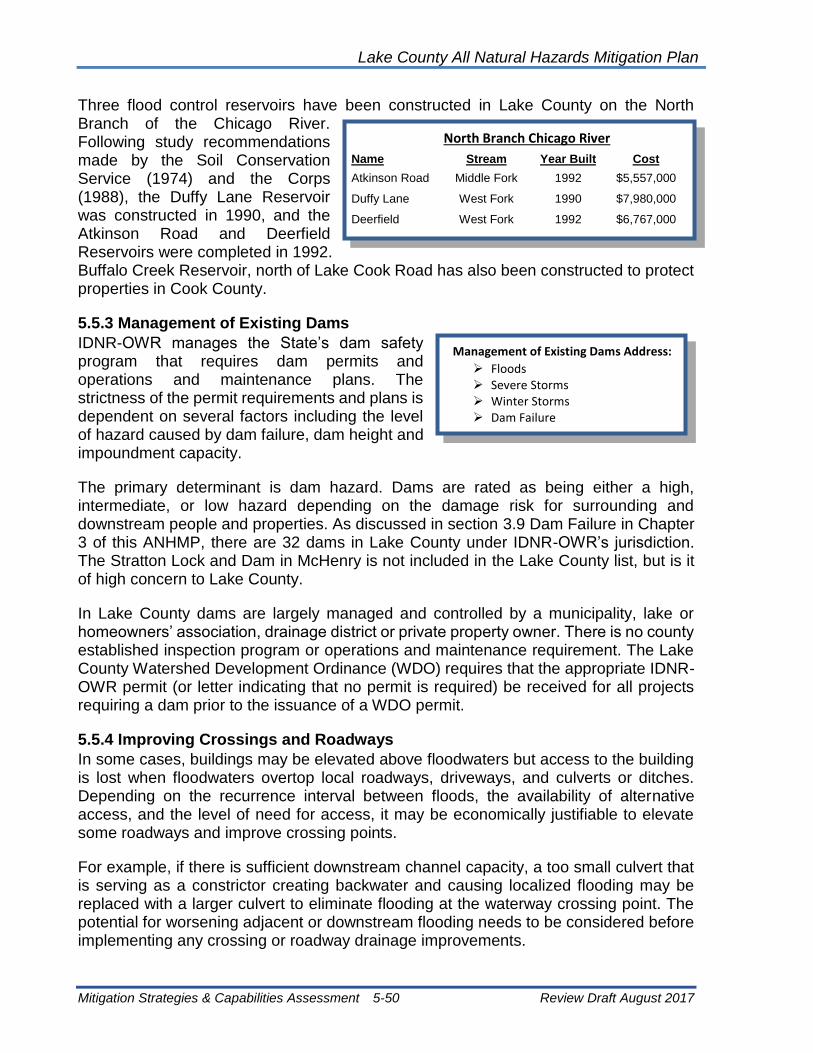
Lake County All Natural Hazards Mitigation Plan
Mitigation Strategies & Capabilities Assessment 5-50 Review Draft August 2017
Three flood control reservoirs have been constructed in Lake County on the North Branch of the Chicago River. Following study recommendations made by the Soil Conservation Service (1974) and the Corps (1988), the Duffy Lane Reservoir was constructed in 1990, and the Atkinson Road and Deerfield Reservoirs were completed in 1992. Buffalo Creek Reservoir, north of Lake Cook Road has also been constructed to protect properties in Cook County.
5.5.3 Management of Existing Dams
IDNR-OWR manages the State’s dam safety program that requires dam permits and operations and maintenance plans. The strictness of the permit requirements and plans is dependent on several factors including the level of hazard caused by dam failure, dam height and impoundment capacity.
The primary determinant is dam hazard. Dams are rated as being either a high, intermediate, or low hazard depending on the damage risk for surrounding and downstream people and properties. As discussed in section 3.9 Dam Failure in Chapter 3 of this ANHMP, there are 32 dams in Lake County under IDNR-OWR’s jurisdiction. The Stratton Lock and Dam in McHenry is not included in the Lake County list, but is it of high concern to Lake County.
In Lake County dams are largely managed and controlled by a municipality, lake or homeowners’ association, drainage district or private property owner. There is no county established inspection program or operations and maintenance requirement. The Lake County Watershed Development Ordinance (WDO) requires that the appropriate IDNR-OWR permit (or letter indicating that no permit is required) be received for all projects requiring a dam prior to the issuance of a WDO permit.
5.5.4 Improving Crossings and Roadways
In some cases, buildings may be elevated above floodwaters but access to the building is lost when floodwaters overtop local roadways, driveways, and culverts or ditches. Depending on the recurrence interval between floods, the availability of alternative access, and the level of need for access, it may be economically justifiable to elevate some roadways and improve crossing points.
For example, if there is sufficient downstream channel capacity, a too small culvert that is serving as a constrictor creating backwater and causing localized flooding may be replaced with a larger culvert to eliminate flooding at the waterway crossing point. The potential for worsening adjacent or downstream flooding needs to be considered before implementing any crossing or roadway drainage improvements.
North Branch Chicago River
Name Stream Year Built Cost
Atkinson Road Middle Fork 1992 $5,557,000
Duffy Lane West Fork 1990 $7,980,000
Deerfield West Fork 1992 $6,767,000
Management of Existing Dams Address:
➢ Floods ➢ Severe Storms ➢ Winter Storms ➢ Dam Failure

Lake County All Natural Hazards Mitigation Plan
Mitigation Strategies & Capabilities Assessment 5-51 Review Draft August 2017
5.5.5 Drainage System Maintenance
The drainage system may include detention ponds, stream channels, swales, ditches and culverts. Drainage system maintenance is an ongoing program to clean out blockages caused by an accumulation of sediment or overgrowth of weedy, non-native vegetation or debris, and remediation of streambank erosion sites.
“Debris” refers to a wide range of blockage materials that may include tree limbs and branches that accumulate naturally, or large items of trash or lawn waste accidentally or intentionally dumped into channels, drainage swales or detention basins. In addition to sediment, debris and weedy vegetation removal, drainage maintenance can also involve using best management practices (BMPs) to stabilize eroding shorelines or streambanks. Maintenance of detention ponds may also require revegetation or repairs of the restrictor pipe, berm or overflow structure.
Maintenance activities normally do not alter the shape of the channel or pond, but they do affect how well the drainage system can do its job.
In Lake County, parks, public works or highway departments, the Forest Preserve District or the drainage districts where rights-of-way are established or easements have been granted generally perform channel maintenance activities. Channel maintenance and restoration have also been a part of several river/stream projects such as the pool/riffle installation of the Waukegan River restoration project, and streambank stabilization using bioengineering along sections of Flint Creek in Barrington and Lake Zurich and the West Fork of the North Branch of the Chicago River in Deerfield.
In the case of detention ponds, generally a property owners’ association is responsible for maintenance at residential developments. Detention ponds on public properties are maintained by the appropriate government jurisdiction.
Lake County allocated money for fiscal year 1998 to establish a drainage improvement fund for small projects in unincorporated Lake County. The Lake County Planning and Development Department (PB&D) is establishing the procedure for expenditure of these funds.
In addition to this fund, Watershed Management Board (WMB) and Community Development Block Grant (CDBG) funding have been used for drainage system improvements in the past. WMB funding is administered by the SMC and awarded on a competitive basis as 50% cost-share funding for projects sponsored by communities. CDBG funds are administered by the PB&D based on recommendations by the Community Development Commission.
Drainage System
Maintenance Addresses:
➢ Floods ➢ Severe Storms ➢ Winter Storms ➢ Erosion ➢ Sewer Backup

Lake County All Natural Hazards Mitigation Plan
Mitigation Strategies & Capabilities Assessment 5-52 Review Draft August 2017
There is currently no coordinated program or maintenance standards established at the county-level to consistently perform on-going drainage maintenance. Maintenance is typically done on an as-needed basis in response to problems or complaints about blockages or erosion. In many cases property owners must consent to the maintenance program. This may require legal negotiations to obtain maintenance easements.
In Illinois, the responsibility for drainage way maintenance on private property, when no easements have been granted, is with the individual private property owner. This generally results in very little maintenance being accomplished.
The SMC developed “A Citizen’s Guide for Riparian Area Management,” which educates landowners about debris removal and riparian landscaping. SMC anticipates adopting stream maintenance standards in the future to provide guidance and consistency for maintenance in Lake County.
5.5.6 Structural Measure Recommendations
1. SMC and communities should investigate the need and ability to improve the capacity of drainage systems.
2. Drainage studies, for both system capacity and detention needs, should be conducted for local drainage problem areas, as identified, and areas should be included in the SMCs mapping of flood problem areas.
3. Communities should undertake steps to reduce inflow and infiltration into sewer system to reduce sewer backups.
4. Develop, adopt and implement protocol for drainage system maintenance standards countywide (waterways, swales, detention basins, levees, reservoirs).
5. Study the feasibility of structural flood control projects within Lake County watersheds and pursue funding for feasible projects.
6. Provide preventative maintenance for susceptible landslide areas.
7. Pursue funding for studies and construction of feasible local and regional drainage projects.
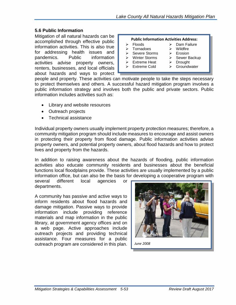
Lake County All Natural Hazards Mitigation Plan
Mitigation Strategies & Capabilities Assessment 5-53 Review Draft August 2017
5.6 Public Information
Mitigation of all natural hazards can be accomplished through effective public information activities. This is also true for addressing health issues and pandemics. Public information activities advise property owners, renters, businesses, and local officials about hazards and ways to protect people and property. These activities can motivate people to take the steps necessary to protect themselves and others. A successful hazard mitigation program involves a public information strategy and involves both the public and private sectors. Public information includes activities such as:
• Library and website resources
• Outreach projects
• Technical assistance
Individual property owners usually implement property protection measures; therefore, a community mitigation program should include measures to encourage and assist owners in protecting their property from flood damage. Public information activities advise property owners, and potential property owners, about flood hazards and how to protect lives and property from the hazards.
In addition to raising awareness about the hazards of flooding, public information activities also educate community residents and businesses about the beneficial functions local floodplains provide. These activities are usually implemented by a public information office, but can also be the basis for developing a cooperative program with several different local agencies or departments.
A community has passive and active ways to inform residents about flood hazards and damage mitigation. Passive ways to provide information include providing reference materials and map information in the public library, at government agency offices and on a web page. Active approaches include outreach projects and providing technical assistance. Four measures for a public outreach program are considered in this plan.
Public Information Activities Address: ➢ Floods ➢ Dam Failure ➢ Tornadoes ➢ Wildfire ➢ Severe Storms ➢ Erosion ➢ Winter Storms ➢ Sewer Backup ➢ Extreme Heat ➢ Drought ➢ Extreme Cold ➢ Groundwater
June 2008

Lake County All Natural Hazards Mitigation Plan
Mitigation Strategies & Capabilities Assessment 5-54 Review Draft August 2017
5.6.1 Library and Website Resources
Community libraries are an obvious place for residents to seek information about flooding and flood protection. Maintaining and updating library resources with this information is an effective public information strategy, since most people turn to the library when they want to research a topic.
In addition to maintaining a resource file, libraries also frequently sponsor their own public information campaigns that might include displays, lectures and newsletter articles. Arranging one of these types of activities with the library can support and augment county or municipal public information campaigns on flooding.
In Lake County, information on flood awareness and response is currently available at the SMC, LCEMA and other Lake County department websites, and at the American Red Cross office in Mundelein.
SMC has developed and distributes a number of brochures to other agencies and the public that address flood mitigation and response, and also serves as a clearinghouse for flood information available from the state and federal government and other agencies. Examples of SMC publications include:
• Guides for homeowners on riparian area management and maintenance of subdivision stormwater Best Management Practices; and
• A “who to call” list for drainage and flooding problems.
SMC also maintains flood hazard information on its homepage through the Lake County website. The American Red Cross, the Federal Emergency Management Agency and the Illinois Department of Natural Resources Office of Water Resources also have print materials available in their office libraries.
5.6.2 Outreach Projects
In addition to supplying information in a passive manner through library resources, a community may want to engage in several more proactive approaches directed to those people at greatest risk. Proactive approaches reach out to people and give them information, even when they don’t ask for it. Outreach projects are designed to encourage people to seek out more information on flood protection. They may include:
• Mailing notices to flood prone property owners to introduce the idea of property
protection;
• Holding workshops, “open houses” or other special events;
There are many references on flood protection for
property owners.

Lake County All Natural Hazards Mitigation Plan
Mitigation Strategies & Capabilities Assessment 5-55 Review Draft August 2017
• Distribution of “how to” brochures, videos or handbooks to property owners’
associations, (or to individuals upon request);
• Presentations at meetings of neighborhood groups;
• Providing programs and information at public venues such as malls or fairs; and
• Media blitzes, including newspaper articles, and radio and television news releases
and interview shows, and Lake County TV cable channel.
To be most effective, outreach projects should include information on property protection measures that homeowners can apply, and be locally designed and tailored to meet local conditions.
The County sponsored its first official “Flood Awareness Week” in 1997. SMC organized weeklong activities that were co-sponsored by various County departments and agencies involved in flood hazard awareness and response. A day-long workshop was held for planners, realtors and insurance agents. Other events included an evening program for the general public that included several segments including an overview of the County’s flood hazard; an introduction of all of the local players in flood response, flood protection and mitigation; and “where to go” or “who to call” for help. Flood awareness and safety messages and publications are permanently featured on SMC’s website.
5.6.3 Technical Assistance
In one-on-one sessions with property owners, community officials such as code enforcement staff or building inspectors can provide advice and information on identifying flood hazards at the site, correcting local drainage problems, floodproofing, dealing with contractors, and funding. More intensive assistance for highly flood prone properties may include conducting a “flood audit” that includes a written report covering remedial measures. Formal “flood audits” are currently not provided as a county service.
Several county agencies advise residents on flood risk and flood protection. The SMC provides advice and technical assistance to property owners associations, municipal governments and other local government units for areas that experience flooding on a watershed or regional scale. The PB&D offers technical assistance to property owners in unincorporated Lake County that experience relatively minor drainage and flooding problems.
Municipalities are responsible for providing this assistance within their jurisdictions, although not all have a system to do so, leaving some municipal residents without help. The appropriate municipal contact is generally the public works department.
The Lake County Health Department provides technical guidance related to septic system failure and well contamination. Because flood events occur on an unpredicted and often infrequent basis, a good public information program is necessary for a successful flood mitigation program. When flood mitigation measures involve multiple partners or property owners, the acceptance of a flood mitigation proposal may rely upon an educated partnership and public. A public information program is also necessary to

Lake County All Natural Hazards Mitigation Plan
Mitigation Strategies & Capabilities Assessment 5-56 Review Draft August 2017
make private property owners aware of the options available to protect themselves from future flood damage, and to convince them that flood mitigation is a good expenditure of their funds.
5.6.4 Public Information Recommendations
1. LCEMA, SMC and other county agencies should build a county-wide partnership for coordinated delivery of public information materials and activities.
2. Communities in the NFIP should provide floodplain information for property owners.
3. Communities in the NFIP should promote flood insurance to residents and property owners.
4. Develop and implement a system to coordinate the distribution of flood mitigation and response guidance materials for pre-flood outreach to at risk property owners.
5. Increase outreach to community plan departments and commissions to strengthen local understanding and review of development proposals and their compliance with WDO standards.
6. Educate property owners on safe rooms. Prepare informational material how to construct safe rooms in homes and other buildings.
7. Develop a method that helps identify safe rooms and encourages their use.
8. Education property owners and residents about safety during severe summer and winter storms.
9. Provide information to property owners and residents about safe use of generators and safe cooking during power outages.
10. Provide information that identifies location of cooling and warming shelters.
5.7 Capability Assessment Summary
Lake County and the municipalities have notable existing capabilities to minimize future vulnerabilities to hazards. Section 5.1 Preventive Measures discusses the plans, ordinances, and programs that can help prevent or minimize possible future impacts of hazards. The WDO addressed new development, but also strives to mitigate the impact of existing development. Tables throughout this Chapter also summarize and highlight community activities, and other sections of this Chapter depict activities underway to address existing vulnerabilities.
The Lake County government arrangement allows communities to take individual mitigation projects or to participate with the county. For example, communities can pursue their own buyouts, or they can participate with the SMC to address environmental and demolition/restoration needs. Municipalities have the choice of relying on the county for watershed development issues or making their own determinations through the WDO

Lake County All Natural Hazards Mitigation Plan
Mitigation Strategies & Capabilities Assessment 5-57 Review Draft August 2017
Certified Community approach. Communities have numerous mutual aid agreements, and LCEMA is working to reduce overall vulnerability.
The constraints facing Lake County and the communities include both limited staff resources and funds that can be directed toward implementing hazard mitigation actions. To a great extent, communities will need to rely on technical and financial assistance from regional, state and federal resources to effectively implement hazard mitigation actions over the next five years. The current economy has severely limited funding throughout Lake County.
During the development of this draft Hazard Mitigation Plan and after reviewing other recent planning initiatives, it is readily apparent that the municipalities have the capability to bring together citizens, government representatives, and local officials to work closely together in crafting a better future for their communities. That same cooperative effort, if joined with the appropriate technical and financial assistance from regional, state and federal resources, can be harnessed to implement the priority hazard mitigation actions described in Section 6 on this plan. A sustained effort by the citizens, staff, and local officials can create a more sustainable and disaster resistant future for Lake County.

Lake County All Natural Hazards Mitigation Plan
Mitigation Strategies & Capabilities Assessment 5-58 Review Draft August 2017
[This page intentionally left black.]

Lake County All Natural Hazards Mitigation Plan
Action Plan 6-1 Review Draft August 2017
Chapter 6: Action Plan This chapter contains the 2017 ANHMP Action Plan. The action items presented in this Chapter were developed from the action items presented in the 2012 ANHMP, from the HMPC meetings and discussions, and the list of mitigation recommendations presented in Chapter 5.
6.1 Development of Current Action Plan
The Action Plan included in this Chapter was developed by the HMPC as part of this ANHMP update and the 2012 update.
All action items, whether listed specifically for a community or not, and all recommendations included with the mitigation strategies in Chapter 5 of the ANHMP should be considered for funding should IEMA or FEMA mitigation grant opportunities arise for any community that participated in this 2017 update.
Action Items: For this 2017 update, the HMPC discussed the effectiveness of the 2012 action plan and action items. Most all 2012 action times applied to most all communities. For the 2017 plan development, the County and communities identified action items applicable to the County and to the communities. Next the communities identified action items to be undertaken with the update. The community specific action items are listed in Section 6.3 Action Items by Community of this Chapter.
Similar to the recommendations made with the mitigation strategies presented in Chapter 5, all action items presented in this Chapter are available to all communities. All action items in this Chapter and all recommendations in Chapter 5 should be taken to be elements of this ANHMP, and therefore eligible items for funding with FEMA mitigation grant funds.
Prioritization: Action items are prioritized within this Chapter in the order that they are presented, beginning with Action Item 5. The Action Items 1 through 4 are called for in the FEMA mitigation planning guidance. The prioritization remaining action times was established based on the HMPC discussions and the number of communities included in the action item. Table 56shows the action items in priority order. The action items address the priority hazards discussed in Chapter 3 and the goals and guidelines presented in the Chapter 4. Table 57 shows the action items in priority order as associates them with the hazard mitigation goals of this ANHMP.
Action item format: Action items assign responsibilities and deadlines to the appropriate agencies. Each action item contains a short description and a section for the responsible agency, the deadline for accomplishing the action item, the costs (and potential funding sources), and the benefits. Potential funding sources include the FEMA Hazard Mitigation Assistance programs: The Hazard Mitigation Grant Program (HMGP), the Pre-

Lake County All Natural Hazards Mitigation Plan
Action Plan 6-2 Review Draft August 2017
Disaster Mitigation Grant Program (PDM), and the Flood Mitigation Assistance Program (FMA).
The action items are summarized in Table 56 and show the agency assignments. While this Chapter provides the action items in a priority order, any and all action items should be implemented if staff time and/or funding becomes available ahead of other action times. The relationship between the goals and guidelines are shown in Table 57.
Please note, based on a hazard event, opportunity, property owner interest or available funding, the County or the communities may choose to implement a lower priority action prior over a higher priority action, or implement a recommendation included in Chapter 5 of this ANHMP that is not included in this action plan, and request grant funding. All mitigation opportunities should be considered.
Appendix C presents a comparison of the 2012 action plan and to current action plan.
6.2 Lake County ANHMP Priority Action Items
Lake County and Lake County municipalities and other appropriate agencies will work to implement the following action items in the next five years as staff and funding resources allow:
Action Item 1: Plan Adoption
The County Board, City Councils, Boards of Trustees, and other governing boards, as appropriate, will adopt this Lake County All Natural Hazards Mitigation Plan (ANHMP) update by resolution. Each agency resolutions should adopt the pertinent action items contained in this Chapter of the ANHMP.
Responsible Agency: County Board, City Councils, Village Boards, Boards of Trustees.
Deadline: 6 months.
Cost: Staff time.
Benefits: Adoption of the updated ANHMP ensures that County, municipalities, and other agencies are authorized to implement the action items with available resources.
Plan Reference: Chapters 2 and 7.
Action Item 2: Participation on the Hazard Mitigation Planning Committee and
Plan Monitoring and Maintenance
A Lake County Local Planning Committee (HMPC) meeting will be held at least once a year to evaluate and monitor progress on implementation of the ANHMP, and to organize for the next update of this ANHMP. An annual report should be submitted to the County Board by the HMPC as an information item.
Responsible Agency: Lake County Stormwater Management Commission (SMC) and Lake County Emergency Management Agency (LCEMA) and the HMPC.

Lake County All Natural Hazards Mitigation Plan
Action Plan 6-3 Review Draft August 2017
Deadline: HMPC to meet each year. A five-year update is required for FEMA’s mitigation funding programs.
Cost: Staff time.
Benefits: A monitoring system helps ensure that responsible agencies continue to be aware of their assignments. The Plan should be evaluated in light of progress, changed conditions, and new opportunities.
Plan Reference: Chapters 2 and 7.
Action Item 3: Incorporate ANHMP into Other County and Municipal Plans
As noted in Table 50, Lake County communities have a variety of plans and ordinances in place. Actions identified in this ANHMP should be incorporated into comprehensive, stormwater management, capital improvement, land-use and emergency management plans, zoning ordinances, building codes, and post-disaster mitigation policies and procedures. Each jurisdiction participating in this ANHMP will be responsible for reviewing their plans, ordinances and policies and, as appropriate, revising those documents.
Each community that has adopted this mitigation plan will take the following actions to facilitate the incorporation of mitigation actions into their plans and ordinances:
Within one year of the adoption of the ANHMP by the community, the lead individual for each community (emergency manager, public works director, engineer or planner) will lead a local committee that will complete an evaluation of the Villages Plans, Codes and Ordinances to determine those that need to be modified to incorporate the action items of the ANHMP.
When the plans, codes or ordinances are updated or modified for any purpose, a recommendation will be made to make the modifications noted in number 1 above.
Next time the ANHMP is updated or modified, a review will be completed within one year of adoption to determine if any additional modifications must be made to local plans, codes or ordinances.
Responsible Agency: County Board, City Councils, Village Boards, Boards of Trustees, and County and municipal offices.
Deadline: 5 years.
Cost: Staff time.
Benefits: Adoption of the updated ANHMP ensures that County, municipalities, townships and other agencies are authorized to implement the action items with available resources.
Plan Reference: Chapter 5, Section 5.1 Preventive Measures .
Action Item 4: Continued Implementation of the WDO and NFIP Requirements

Lake County All Natural Hazards Mitigation Plan
Action Plan 6-4 Review Draft August 2017
Lake County and municipalities, whether certified or non-certified, should continue to fully implement and enforce the Lake County Watershed Development Ordinance (WDO) for all applicable developments. The WDO incorporates the NFIP minimum standards, and while the Planning, Building and Development (PB&D) administers the WDO for unincorporated Lake County, all NFIP municipalities are still ultimately responsible for ensuring that development within the regulatory floodplain meets the NFIP minimum standards.
Responsible Agency: SMC, PB&D, and municipal NFIP coordinators.
Deadline: Ongoing.
Cost: Staff time.
Benefits: Community compliance with the NFIP is essential.
Plan Reference: Chapter 5, Section 5.1 Preventive Measures.
Action Item 5: Improve Natural Hazards Public Information Efforts with focus on
the Promotion of Flood Insurance and How People Can Protect Themselves and
Their Property
Education regarding natural hazards that can impact Lake County should be provided to all Lake County property owners and residents. A number of public information efforts have been implemented, but these efforts should be improved to more effectively reach people and to provide effective messages regarding life, health and safety and property protection. Public information and education efforts should focus on severe summer and winter storms, floods and tornadoes and materials should be developed specifically for Lake County and tailored to Lake County needs. [Expand this discussion.]
Responsible Agency: LCEMA, SMC, HMPC, Lake County Health Department (LCHD), LCDOT and municipalities.
Cost: Staff time and publication costs.
Benefits: A county-based approach is the most cost effective approach and will offer the greatest benefit. Public information efforts can address nearly every natural hazard and more than one hazard can be discussed with an audience at one time.
Plan Reference: Chapter 5.
Action Item 6: Identify Needs and Obtain Alternate Power Sources for Critical
Facilities and Shelters
The July 2011 storms in Lake County highlighted the need for alternate power sources at critical facilities. The HMPC recognizes that FEMA mitigation funds are not available for this action item, but recognizes the importance of all agencies and facility and shelter owners determining back-up power source needs and obtaining equipment and/or service.

Lake County All Natural Hazards Mitigation Plan
Action Plan 6-5 Review Draft August 2017
Responsible Agency: Emergency management agencies and facility and shelter owners.
Deadline: 36 months.
Cost: Variable.
Benefits: Adoption of the updated ANHMP ensures that County, municipalities, townships and other agencies are authorized to implement the action items with available resources.
Plan Reference: Chapter 5, Section 5.4 Emergency Services.
Action Item 7: Review of Critical Facilities and Implement of Appropriate
Mitigation Measures
Critical facilities should be evaluated to determine their vulnerability to tornadoes, severe storms and floods. The availability of safe rooms and sheltering should be reviewed. Critical facilities have been mapped in the County’s GIS. As the County further examines building footprints and floodplains as part of the stormwater management program, the review of critical facilities should be included. Approximately 20 Lake County critical facilities are located in the floodplain, and other critical facilities are vulnerable to wind and severe storms. Where necessary, critical facilities should be mitigated and protected from identified natural hazards.
Responsible Agency: SMC, LCEMA, GIS Division, municipalities, critical facility owners.
Deadline: 24 months.
Cost: Staff time. Potential funding sources include HMGP, PDM, and FMA.
Benefits: Critical facilities that can function during hazard events allow for better protection of people and property. Shelters and safe rooms save lives. Review and mitigation of critical facilities will benefit Lake County through preparedness, response and recovery.
Plan Reference: Chapter 5, Section 5.2 Property Protection and 5.4 Emergency Services.
Action Item 8: Improve Capacity of Drainage Systems and/or Provide Additional
Storage of Flood Waters
When opportunities arise and when downstream areas are not adversely impacted (or mitigated), communities should strive to increase the capacity of drainage systems. Drainage improvements may include opening up restrictive culverts or bridges, storm sewer improvements, etc. When appropriate and when opportunities are identified, the systems should be augmented with additional detention or retention to reduce runoff rates and runoff volumes.
Responsible Agency: SMC, LCDOT, municipal public works and engineering.
Deadline: Ongoing.

Lake County All Natural Hazards Mitigation Plan
Action Plan 6-6 Review Draft August 2017
Cost: Staff time and project-specific costs.
Benefits: Local flooding outside of the floodplain and riverine (floodplain) flooding can be reduced.
Plan Reference: Chapter 5, Section 5.5 Structural Measures.
Action Item 9: Implement Maintenance Programs for Drainage Systems,
Including Streambank and Ravine Stabilization Efforts
The County, municipalities, and townships should develop and implement formal and regular drainage system maintenance programs. This effort should include the inspection of privately maintained drainage facilities. It is understood that each municipality and township will make these considerations based on available staffing and financial resources. Both urban and rural streams need maintenance. Also, bridges and culverts (active or abandoned) that restrict flood flows should be evaluated. The removal or enlargement of stream crossings, in cases were a modification will not cause an increase in downstream flooding, should be considered and funded. Streambank and ravine or shoreline stabilization efforts should also be evaluated and implemented. Public information should be provided to property owners on how best to protect streambanks and shorelines.
Responsible Agency: Lake County, municipalities and townships. This can include public works departments, township road districts, or other appropriate departments or offices.
Deadline: 36 months.
Cost: Staff time and equipment.
Benefits: Development and agriculture have led to a reduction of stream capacity, and upstream flooding as a result may be increasing. A restoration of stream capacity may mitigate upstream damage, and enhance stream and water quality. Regular maintenance can protect both structures and property. Regular maintenance can also be more cost effective than major maintenance efforts that are done on an as-needed basis.
Plan Reference: Chapter 5, Section 5.5 Structural Measures.
Action Item 10: Implement Property Protection Projects for Flood Mitigation
Properties that are exposed to flood damage, severe storms, and severe erosion throughout Lake County should be protected through property protection measures where regional structural projects are not feasible. Property protection measures should include, but not be limited to, acquisition, elevation, floodproofing, or retrofitting. Priority should be given to repetitive loss properties and homes subject to the impacts of severe erosion, however, all flood prone properties (floodplain, depressional storage or SMC problem areas) including critical facilities should be included.

Lake County All Natural Hazards Mitigation Plan
Action Plan 6-7 Review Draft August 2017
Responsible Agency: SMC, municipal NFIP coordinators.
Community Specific Action Item for: Lake County and NFIP municipalities, including (by watershed):
Des Plaines River: Antioch, Beach Park, Buffalo Grove, Deer Park, Grayslake, Green Oaks, Gurnee, Hainesville, Hawthorn Woods, Kildeer, Lake Villa, Lake Zurich, Libertyville, Lincolnshire, Lindenhurst, Long Grove, Mettawa, Mundelein, Old Mill Creek, Riverwoods, Round Lake Beach, Third Lake, Vernon Hills, and Wadsworth
Fox River: Antioch, Fox Lake, Fox River Grove, Hainesville, Hawthorn Woods, Island Lake, Lake Barrington, Lake Villa, Lake Zurich, Lakemoor, North Barrington, Round Lake, Round Lake Beach, Round Lake Heights, Round Lake Park, Tower Lakes, Volo, and Wauconda
North Branch Chicago River: Bannockburn, Deerfield, Green Oaks, Gurnee, Highland Park, Highwood, Lake Bluff, Lake Forest. Lincolnshire, Mettawa, North Chicago, Park City, Riverwoods, and Waukegan
Lake Michigan: Beach Park, Highland Park, Lake Bluff, Lake Forest, North Chicago, Winthrop Harbor, Waukegan, and Zion
Deadline: Ongoing.
Cost: Identified per project. Potential funding sources include HMGP, PDM, and FMA.
Benefits: Properties will be protected from future flooding and from severe erosion. Also, the exposure of the NFIP will be reduced for insured and repetitive loss buildings. There will also be a reduction in emergency response as structures are protected or removed from flood prone areas.
Plan Reference: Chapter 5, Section 5.2 Property Protection.
Action Item 11: Reduce Inflow and Infiltration to Protect Against Sewer Backups
Municipalities should evaluate options and implement programs to reduce the inflow and infiltration of stormwater into the sanitary sewer system to reduce the waste water treatment plant flow during severe storm and flood events. Efforts can be undertaken on a regional basis.
Responsible Agency: Municipalities.
Deadline: 36 months.
Cost: Staff time and equipment.
Benefits: When inflow and infiltration is reduced, the risk of sewage overflows or untreated discharge into the Lake County river system are avoided. Also, sewer backups can be avoided and damage to buildings can be reduced.
Plan Reference: Chapter 5, Section 5.2 Property Protection and 5.5 Structural Measures.

Lake County All Natural Hazards Mitigation Plan
Action Plan 6-8 Review Draft August 2017
Action Item 12: Identify Wind Mitigation Opportunities for the Protection of
Buildings, and to Provide Safe Rooms and Sheltering
Wind mitigation, and safe rooms and sheltering, needs can arise though planning efforts, building design efforts, and retrofitting opportunities. When needs, safety, and sheltering deficiencies are identified, alternatives for providing mitigation should be developed and funding sought.
Responsible Agency: All Lake County agencies and municipal departments.
Deadline: 5 years.
Cost: Project specific.
Benefits: Prevent loss of life.
Plan Reference: Chapter 5, Section 5.1 Preventive Measures, 5.2 Property Protection and 5.4 Emergency Services.
Action Item 13: Continue Participation or Consider Participation in Tree City USA
(Urban Forestry)
Lake County municipalities that are Tree City USA communities will maintain their status in the nationwide program, and communities that are not in the program will consider joining the program. It is understood that each municipality will make these considerations based on available staffing and financial resources.
Responsible Agency: Public works department or other appropriate municipal department.
Deadline: 24 months.
Cost: $2 per capita, staff time.
Benefits: Urban forestry programs provide mitigation against severe winter and summer storms, and high wind events. The loss of trees is prevented along with the protection of power, telephone and cable services. Damage to vehicles and buildings from falling limbs is also prevented.
Plan Reference: Chapter 5, Section 5.3 Resource Protection.
Action Item 14: Continue Work for NIMS Compliance
The county and all municipalities should ensure that they are NIMS compliant. Training opportunities for all first responders and other identified personnel on NIMS and ICS should be shared will all agencies.
Responsible Agency: County Board, City Councils, Village Boards, Boards of Trustees, County and municipal offices.
Deadline: Ongoing.

Lake County All Natural Hazards Mitigation Plan
Action Plan 6-9 Review Draft August 2017
Cost: Staff time.
Benefits: All officials trained in NIMS allows for better hazard preparedness, response and recovery.
Plan Reference: Chapter 5, Section 5.4 Emergency Services.
Action Item 15: Improve Building Codes and Building Code Enforcement
Communities that have not adopted the International Code series of building codes should do so, and for all communities, future code revisions should be pursued to strengthen new buildings against damage by high winds, tornadoes, hail, earthquakes, and flooding. The Building Code Effectiveness Grading Schedule (BCEGS) program is designed to evaluate the code adoption and enforcement efforts of a community, with particular emphasis on natural hazard mitigation. The County and most municipalities participate in BCEGS and communities should strive to improve their rating to a 4/4, if not already attained. Requiring tornado “safe rooms” in certain structures should be considered. The floodplain provisions (design flood elevation) should also be considered in conjunction with the Lake County WDO.
Training should be developed and conducted for building department staff on building code administration, enforcement, the natural hazards aspects of the International Codes, regulation of mobile home installation, flood provisions, and any other provisions applicable to hazard mitigation.
Responsible Agency: County and municipal building code departments.
Deadline: Ongoing.
Cost: Staff time and cost of training.
Benefits: Effective implementation and enforcement of building codes provides mitigation for severe summer and winter storms, including wind events, floods and earthquakes. Through rigorous enforcement of the latest available codes, utilizing adequately staffed and trained code enforcement professionals; these efforts will be reflected through more favorable BCEGS classifications.
Plan Reference: Chapter 5, Section 5.1 Preventive Measures
Action Item 16: Seek Mitigation Grant Funding for Additional Mitigation Planning
and Cost Beneficial Projects
The County, municipalities, other agencies and institutions should apply for mitigation grant funding through available IEMA and FEMA programs for mitigation planning and mitigation projects. As required by IEMA and FEMA programs, projects must be cost beneficial. FEMA hazard mitigation funding including PDM, HMGP, FMA and Section 406 of the Stafford Act (for facilities and infrastructure damaged due to a presidentially declared disaster) should be considered.
Responsible Agency: Lake County, municipalities, other agencies, and institutions.
Community Specific Action Item for: Lake County and ALL interested municipalities.

Lake County All Natural Hazards Mitigation Plan
Action Plan 6-10 Review Draft August 2017
Deadline: As needed.
Cost: 25% of plan or project cost (non-federal share). Potential funding sources include HMGP, PDM, and FMA.
Benefits: The County, municipalities, townships, other agencies and institutions, along with residents and property owners, would benefit from the available grant funding. The request for grant funding also allows the HMPC to benefit from the mitigation planning effort.
Plan Reference: Chapter 5
Action Item 17: Continue Participation or Consider Participation in StormReady
Lake County municipalities that are National Weather Service StormReady communities will maintain their status in the nationwide program, and Lake County communities, other agencies, and colleges should consider joining the StormReady program. The StormReady program has been developed to provide communities guidelines to improve the timeliness and effectiveness of hazardous weather-related warnings for the public.
Responsible Agency: LCEMA, municipal EMA, police and fire, other agencies, and institutional emergency managers.
Deadline: 24 months.
Cost: Staff time, and equipment purchases for some communities.
Benefits: By meeting StormReady requirements, the County, communities and institutions will be better able to detect impending weather hazards and disseminate warnings as quickly as possible. Given the County’s population, all efforts to prevent injury, save lives, and protect property are of high value.
Plan Reference: Chapter 5, Section 5.4 Emergency Services
Action Item 18: Improve Emergency Response and Develop Assessment Teams
Lake County and the municipalities should work to improve emergency response and to develop assessment teams for emergency management response, health department concerns and needs and for post-disaster mitigation.
If a community waits until a disaster occurs to plan post-disaster mitigation policies and procedures, they are too late. The time to prepare is before the disaster occurs. Preparation includes assigning post disaster tasks to:
• Determine the extent of the damages, including whether the structures are substantially damaged as defined in the WDO
• Determine the health and safety needs

Lake County All Natural Hazards Mitigation Plan
Action Plan 6-11 Review Draft August 2017
• Ensure that the public is aware of actions that they should be taking and that the community is taking to mitigate damages, as well as encouraging property owners and renters to work with their insurance agents to help cover their losses
• Ensuring that residents have the proper permits before repairing structures and ensuring that the repair is completed according to code
• Determine what mitigation actions are appropriate given the extent of damages
• Determine whether any temporary permit and construction moratoriums need to be put in place subsequent to the disaster
Response teams should be developed through the LCEMA and other county agencies and the HMPC. Individuals that may be needed for post disaster activities should be trained, should be aware of their potential assignments and should prepare documents that they may need to use after the disaster occurs.
Responsible Agency: LCEMA, LCHD, SMC, PB&D, municipalities, and other agencies.
Deadline: 18 months.
Cost: Staff time.
Benefits: This action ensures that the needs of the county can be addresses quickly after a hazard event and to pursue mitigation opportunities as the earliest possible time.
Plan Reference: Chapter 5, Section 5.4 Emergency Services.
Action Item 19: Enhance Response and Recovery Information Sharing and
Collaboration and Identify Additional Training Opportunities
Improve information sharing between Lake County, municipal/township agencies and services providers, such as ComEd, during and after natural hazard events. Systems should be put in place to help ensure that response and recovery efforts are coordinating. Additional training opportunities should be identified, including annual exercises and tabletop exercises.
Responsible Agency: LCEMA, municipal EMAs, utility companies.
Deadline: Ongoing.
Cost: Staff time.
Benefits: Regular maintenance of streams, drainage ways and stormwater Best Management Practices will help reduce localized flooding problems.
Plan Reference: Chapter 5, Section 5.4 Emergency Services.
Action Item 20: Continue Participation or Consider Participation in the NFIP’s
Community Rating System

Lake County All Natural Hazards Mitigation Plan
Action Plan 6-12 Review Draft August 2017
Municipalities that participate in the NFIP should consider participating in the Community Rating System (CRS). Lake County and a number of communities already participate in CRS, and they should also continue their participation.
Responsible Agency: Municipal NFIP administrators.
Deadline: Ongoing.
Cost: Staff time.
Benefits: The CRS program saves property owners money on flood insurance premiums and it has been shown to be effective for both comprehensive watershed management and emergency response planning. Lake County and the municipalities enforce higher regulatory standards than FEMA and participate in many creditable CRS activities.
Plan Reference: Chapter 5, Section 5.2 Property Protection.
Action Item 21: Continue to Map Natural Hazard Impacts and Continue
Vulnerability Assessments
Lake County should continue to identify the number and type of existing structures, infrastructure and critical facilities at risk to natural hazards and to map available data and information. Also, the potential dollar losses from vulnerable hazards should be assessed and used to evaluate potential hazard mitigation projects.
Responsible Agency: SMC and LCEMA.
Deadline: Ongoing.
Cost: Staff time.
Benefits: This will ensure that Lake County takes a consistent approach to hazard mitigation, and develops other plans with the protection of life, health, safety, business and property in mind.
Plan Reference: Chapter 5, Section 5.1 Preventive Measures and 5.4 Emergency Services.
Action Item 22: Continue with Identification and Implementation of SMC Flood
Mitigation Projects
Based on the findings in Chapter 3 of this ANHMP, it is important for the Lake County SMC to continue with their watershed management efforts for the purpose of flood mitigation in unincorporated Lake County and within the Lake County municipalities. The SMC should continue making use of their annual funding and available FEMA grant funding to provide flood mitigation. Based on the number of SMC flood problem areas identified (see Table 19), the SMC recognized the Des Plaines River and the Fox River watersheds as priority areas.
1. Priority actions for the Des Plaines River Watershed in the next five years include:

Lake County All Natural Hazards Mitigation Plan
Action Plan 6-13 Review Draft August 2017
• Floodplain buyout program, including the acquisition of the Gurnee Grade School in Gurnee and the residential property acquisitions in the Village of Lindenhurst with HMGP funds
• Floodplain remapping/studies for Newport Creek, Indian Creek, Bull Creek and Mill Creek
• Watershed planning/coordination for Des Plaines River - Phase II, North Mill Creek, Newport Creek, Bull Creek and Indian Creek
Involved communities: Antioch, Beach Park, Buffalo Grove, Green Oaks, Grayslake, Gurnee, Hainesville, Hawthorn Woods, Indian Creek, Kildeer, Lake Forest, Lake Zurich, Libertyville, Lincolnshire, Lindenhurst, Long Grove, Mettawa, Mundelein, Old Mill Creek, Park City, Riverwoods, Round Lake Beach, Round Lake Park, Third Lake, Vernon Hills, Wadsworth, Wheeling, Zion
2. Priority actions for the Fox River Watershed in the next five years include:
• Floodplain buyout program
• Floodplain remapping/studies for Fish Lake Drain, Sequoit Creek, Squaw Creek, and Round Lake Drain/Eagle Creek/Long Lake
• Watershed planning/coordination for Fish Lake Drain
Involved communities: Antioch, Barrington, Barrington Hills, Deer Park, Fox Lake, Fox River Grove, Grayslake, Hainesville, Hawthorn Woods, Island Lake, Lake Barrington, Lake Villa, Lake Zurich, Lakemoor, Lindenhurst, Mundelein, North Barrington, Port Barrington, Round Lake, Round Lake Beach, Round Lake Heights, Round Lake Park, Tower Lakes, Wauconda, Volo.
3. Priority actions for the North Branch of the Chicago River Watershed in the next five years include:
• Increase flood storage capacity and detention
• Floodplain buyout program
• Watershed planning/coordination for Skokie River
• Flood response/damage assessments
Involved communities: Bannockburn, Deerfield, Green Oaks, Gurnee, Highland Park, Highwood, Lake Bluff, Lake Forest, Lincolnshire, Mettawa, Park City, North Chicago, Riverwoods, Waukegan.
4. Priority actions for the Lake Michigan Watershed in the next five years include:
• Floodplain buyout program
• Floodplain remapping/studies for Kellogg Creek
• Watershed planning/coordination for Dead Creek and Kellogg Creek
• Flood response/damage assessments
Involved communities: Beach Park, Highland Park, Highwood, Lake Forest, Lake Bluff, North Chicago, Wadsworth, Waukegan, Winthrop Harbor, Zion.
Lake County All Natural Hazards Mitigation Plan
Action Plan 6-14 Review Draft August 2017
5. Ongoing and anticipated efforts of the SMC in the next five years for all four major watersheds include:
• Flood response/damage assessments
• Local drainage project cost-share program
• Rain gauge program
• GIS mapping and countywide base flood elevation layer, LOMA/LOMRs
• Implementation of Watershed Development Ordinance (WDO)
Responsible Agency: SMC.
Deadline: Based on SMC annual budget and available grant funding.
Cost: Project specific.
Benefits: All of Lake County benefits from the continuation of the SMC’s countywide efforts for the protection of property, transportation, and health and safety during minor and major flood events.
Plan Reference: Chapter 3, Section 3.3 Flood, and Chapter 5.
Action Item 23: Develop of Flood Stage Maps
Flood stage maps should be developed to show varying depths of flooding and the respective area of inundation for floodplain areas within Lake County’s major watersheds. The maps should be developed by watershed based on available hydrologic and hydraulic models. Flood stage maps can be used by all agencies to determine early protection actions.
Responsible Agency: SMC, LCEMA, and GIS Division.
Deadline: Based on available grant funding.
Cost: Approximately, $100,000. Potential funding sources include HMGP, PDM, and FMA.
Benefits: Flood stage mapping would provide a depiction of the most at-risk structures, intersections, and utilities in the floodplain. They would aid in mitigation project planning. Most importantly, they would provide data for emergency response (and response planning) and allow communities to assess and identify needed resources.
Plan Reference: Chapter 5, Section 5.4 Emergency Services.
Action Item 24: Develop or Enhance the Community's Snow Removal Plan
Severe winter storms are a priority hazard for Lake County. People and businesses are impacted by heavy snow and blizzard conditions. Impassable roads are a problem for emergency services. Products and techniques for clearing roads or dealing with icy conditions are changing. Some of the newer approaches help protect the environment.
Responsible Agency: Municipalities, Townships.

Lake County All Natural Hazards Mitigation Plan
Action Plan 6-15 Review Draft August 2017
Deadline: Based on available grant funding.
Cost: Staff time for the development of enhanced plans.
Benefits: Reduced community costs if efficiencies are found. Savings for businesses that can remain open are some of the other benefits. Emergency services should also be improved.
Plan Reference: Chapter 5, Section 5.4 Emergency Services.
Action Item 25: Utility Tree Trimming
Trees and branches on power lines is a common hazard. Down power lines can impact significant areas. More attention and better scheduling (rotation) of tree trimming would benefit communities and unincorporated Lake County.
Responsible Agency: Communities and utility companies.
Deadline: Ongoing.
Cost: Community staff time to coordinate with utility companies.
Benefits: Safety and fewer power outages.
Plan Reference: Chapter 5, Section 5.2 Property Protection.
Action Item 26: Sump Pump Disconnects
Sump pumps, when operating property can keep basements dry from rainwater that collects around foundations. In many areas of the county, sump pumps discharge directly into the underground sewer system. The discharge contributes to the amount of sanitary sewage that needs to be treated at waste water treatment plants, or contributes to the total runoff that storm sewers need to carry. This action item calls for the disconnection of sump pump discharge from the sewer system(s), and for the discharge to be above ground. This could be to lawns or French drains. Communities should consider changes in regulations to accomplish the disconnects; other communities could consider rebate or other incentive programs.
Responsible Agency: Communities.
Deadline: Next five years.
Cost: Staff time, and funding of potential rebate efforts.
Benefits: Less runoff allowed in the sanitary or combined sewer system reduces the potential for sewage backup. Less pump discharge in the stormwater system reduces flood heights.
Plan Reference: Chapter 5, Section 5.2 Property Protection.

Lake County All Natural Hazards Mitigation Plan
Action Plan 6-16 Review Draft August 2017
Action Item 27: Conduct Local Drainage Studies
Urban flooding and local drainage issues should be investigated by communities and by the SMC to determine alternatives to reduce the impact of flooding to buildings and infrastructure.
Responsible Agency: Municipalities and SMC.
Deadline: A study typically has a year’s timeframe.
Cost: Dependent on the size of the area to be studies or the number of buildings in the area.
Benefits: Reduced flood losses and community disruption.
Plan Reference: Chapter 5, Section 5.2 Property Protection and 5.5 Structural Measures.
Action Item 28: Increase Stormwater Detention Capacity
Where opportunities are identified, additional stormwater detention capacity should be created. This may include the expansion of storage capacity at existing sites or new sites. While the Lake County WDO required storage of runoff due to developed, a large remedial effort is needed to detain and retain stormwater from older development.
Responsible Agency: Municipalities and SMC.
Deadline: Based on opportunities that arise.
Cost: Varies by project.
Benefits: Reduced flood losses and community disruption.
Plan Reference: Chapter 5, Section 5.5 Structural Measures
Action Item 29: Investigate Countywide Warning System
Warning dissemination for natural hazard events is key to protecting life and safety. Some areas of the County have some warning systems in-place. Additional warning systems should be investigated that would be effective for various seasons and various patterns of populated locations (e.g., daytime or nighttime). The investigation should examine alternatives, costs, potential phasing, and so forth.
Responsible Agency: Lake County EMA and municipal EMA (LEPC).
Deadline: 5 years.
Cost: Staff time and potential study costs.
Benefits: Better protected population.
Plan Reference: Chapter 5, Section 5.4 Emergency Services.

Lake County All Natural Hazards Mitigation Plan
Action Plan 6-17 Review Draft August 2017
Action Item 30: Investigate Future Conditions and the Impact on Depth and
Frequency of Flooding
Future conditions can include new development, redevelopment or changing weather and weather patterns, and should be investigated with new studies or updates to existing studies to determine potential increases in flood characteristics (depth and extent) and in frequency.
Responsible Agency: SMC.
Deadline: Ongoing.
Cost: Incremental cost to future study efforts.
Benefits: Flood damage resilience.
Plan Reference: Chapter 5, Section 5.5 Structural Measures.
Action Item 31: Lincolnshire Creek Improvements
Lincolnshire Creek in Lincolnshire should be studied to identify alternatives to reduce flood losses.
Responsible Agency: Village of Lincolnshire.
Deadline: To be determined.
Cost: To be determined.
Benefits: Reduced flood losses and impact to residents.
Plan Reference: Chapter 5, Section 5.5 Structural Measures.
Action Item 32: Mitigate Septic Discharge; Leaching into Waterways
Maintenance of septic systems is important for the protection of water quality for both surface water and groundwater. Preventing ground water pollution from failing septic systems should be a priority of every community and every homeowner. Contamination of the ground water source can lead to pollution of local wells, lakes, streams and ponds – exposing family, friends and neighbors to waterborne diseases and other health risks. When a septic system fails, inadequately treated domestic waste can reach the ground water. Bacteria and viruses from human waste can cause dysentery, hepatitis, and typhoid fever. Many serious outbreaks of these diseases have been caused by contaminated drinking water. Nitrates and phosphates, also found in domestic wastewater, can cause excessive algae growth in lakes and streams called algal blooms. These blooms cause aesthetic problems and impair other aquatic life. Nitrate is also the cause of methemoglobinemia, or blue baby syndrome, a condition that prevents the normal uptake of oxygen in the blood of young babies.
Responsible Agency: SMC.
Deadline: Ongoing.
Cost: Staff time and printing of outreach information.

Lake County All Natural Hazards Mitigation Plan
Action Plan 6-18 Review Draft August 2017
Benefits: Water quality…
Plan Reference: Chapter 5, Section 5.2 Property Protection and 5.5 Structural Measures.
Action Item 33: Implement the Federal Flood Risk Management Standard
(FFRMS)
Executive Order 13690 calls for a flood protection standard for projects implemented with federal funds. New construction and substantial improvements implemented through private developers or property owners must meet the flood standard with in the Lake County WDO, which is the base flood elevation plus 2 feet of freeboard. If a federal agency sets a standard as a result of the FFRMS, that exceeds the WDO standard, then communities must meet the higher standard when federal dollars are included in a community project.
Responsible Agency: All agencies.
Deadline: Ongoing.
Cost: Project specific.
Benefits: Lower flood insurance premiums (better insurance rating) and additional flood resiliency.
Plan Reference: Chapter 5, Section 5.1 Preventive Measures.

Lake County All Natural Hazards Mitigation Plan
Action Plan 6-19 Review Draft August 2017
Table 56: Summary of 2017 ANHMP Hazard Mitigation Action Items
Action Item to Be Implemented By:
No. Action Item: Lake
County Board
Lake County
Municipal Boards & Councils
Municipal Staff
Other Stakeholders
1 Adoption ✓
✓
2 Monitor & Maintain ✓
✓
3 Incorporate ANHMP in Other Plans ✓ ✓ ✓ ✓ ✓
4 Implement WDO & NFIP ✓
✓
5 Public Information ✓
✓ ✓
6 Alternate Power Sources ✓ ✓
7 Mitigation of Critical Facilities ✓
✓ ✓
8 Capacity of Drainage Systems ✓
✓
9 Maintain Drainage Systems ✓
✓
10 Property Protection Projects ✓
✓ ✓
11 Reduce Inflow and Infiltration ✓
12 Wind Mitigation & Safe Rooms ✓ ✓ ✓
13 Tree City USA ✓
14 NIMS Compliance ✓ ✓ ✓ ✓ ✓
15 Improve Building Codes ✓
✓
16 Seek Grant Funding ✓
✓
17 StormReady ✓
✓
18 Emergency Response ✓
✓
19 Response & Recovery Information ✓ ✓
✓ ✓
20 CRS Participation ✓
✓
21 Continue to map natural hazard impacts and continue vulnerability assessments
✓
22 SMC Flood Mitigation Projects ✓
23 Development of Flood Stage Maps ✓
24 Snow removal plan ✓
✓
25 Utility tree trimming ✓
✓
26 Sump Pump Disconnects ✓
✓
27 Local Drainage Studies ✓
✓
28 Increase Detention ✓
✓
29 Investigate Countywide Warning System ✓
✓
30 Investigate Future Conditions and the Impact on Depth and Frequency of Flooding
✓
✓
31 Lincolnshire Creek Improvements ✓
32 Mitigate Septic Discharge; Leaching into Waterways
✓
✓
33 Implement the FFRMS ✓
Other ✓
✓

Lake County All Natural Hazards Mitigation Plan
Action Plan 6-20 Review Draft August 2017
Table 57: Summary of 2012 Action Items and ANHMP Goals
ANHMP Goals (Chapter 4)
Action Item:
Goal 1: Goal 2: Goal 3: Goal 4: Goal 5:
No.
Protect the lives, health, &
safety of people
Protect public services,
utilities & critical
facilities
Mitigate existing
buildings
Ensure that new
developments do not create
new exposures
Mitigate to protect against
economic & transportation
losses
1 Adoption ✓ ✓ ✓ ✓ ✓
2 Monitor & Maintain ✓ ✓ ✓ ✓ ✓
3 Incorporate ANHMP in Other Plans ✓ ✓ ✓ ✓ ✓
4 Implement WDO & NFIP ✓ ✓ ✓ ✓ ✓
5 Public Information ✓ ✓ ✓ ✓ ✓
6 Alternate Power Sources ✓ ✓ ✓ ✓
7 Mitigation of Critical Facilities ✓ ✓ ✓ ✓
8 Capacity of Drainage Systems ✓ ✓ ✓ ✓ ✓
9 Maintain Drainage Systems ✓ ✓ ✓ ✓ ✓
10 Property Protection Projects ✓ ✓ ✓ ✓
11 Reduce Inflow and Infiltration ✓ ✓ ✓ ✓
12 Wind Mitigation & Safe Rooms ✓ ✓ ✓ ✓ ✓
13 Tree City USA ✓ ✓ ✓ ✓ ✓
14 NIMS Compliance ✓ ✓ ✓
15 Improve Building Codes ✓ ✓ ✓ ✓ ✓
16 Seek Grant Funding ✓ ✓ ✓ ✓ ✓
17 StormReady ✓ ✓ ✓ ✓ ✓
18 Emergency Response ✓ ✓ ✓
19 Response & Recovery Information ✓ ✓ ✓ ✓ ✓
20 CRS Participation ✓ ✓ ✓ ✓ ✓
21 Continue to map natural hazard impacts and continue vulnerability assessments
✓ ✓ ✓ ✓ ✓
22 SMC Flood Mitigation Projects ✓ ✓ ✓ ✓ ✓
23 Development of Flood Stage Maps ✓ ✓ ✓ ✓ ✓
24 Snow removal plan ✓ ✓ ✓ ✓ ✓
25 Utility tree trimming ✓ ✓ ✓ ✓
26 Sump Pump Disconnects ✓ ✓ ✓ ✓
27 Local Drainage Studies ✓ ✓ ✓ ✓
28 Increase Detention ✓ ✓ ✓ ✓
29 Investigate Countywide Warning System ✓ ✓ ✓
30 Investigate Future Conditions and the Impact on Depth and Frequency of Flooding
✓ ✓ ✓ ✓ ✓
31 Lincolnshire Creek Improvements ✓ ✓ ✓ ✓ ✓
32 Mitigate Septic Discharge; Leaching into Waterways
✓ ✓ ✓ ✓
33 Implement the FFRMS ✓ ✓ ✓ ✓ ✓

Lake County All Natural Hazards Mitigation Plan
Action Plan 6-21 Review Draft August 2017
6.3 Action Items by Community
Community-specific action items are listed below for each participating community in Lake County. These are action items that the communities will strive to implement in the next five years. As part of each community’s adoption and implementation of this ANHMP, any action item listed in this chapter and any recommendation in Chapter 5 may be implemented should resources, including grant funds become available.
Lake County
Action Item 1: Plan Adoption
Action Item 2: Participation on the Hazard Mitigation Planning Committee and Plan Monitoring and Maintenance
Action Item 3: Incorporate ANHMP into Other County and Municipal Plans
Action Item 4: Continued Implementation of the WDO and NFIP Requirements
Action Item 5: Improve Natural Hazards Public Information Efforts with focus on the Promotion of Flood Insurance and How People Can Protect Themselves and Their Property
Action Item 6: Identify Needs and Obtain Alternate Power Sources for Critical Facilities and Shelters
Action Item 7: Review of Critical Facilities and Implement of Appropriate Mitigation Measures
Action Item 8: Improve Capacity of Drainage Systems and/or Provide Additional Storage of Flood Waters
Action Item 9: Implement Maintenance Programs for Drainage Systems, Including Streambank and Ravine Stabilization Efforts
Action Item 10: Implement Property Protection Projects for Flood Mitigation
Action Item 12: Identify Wind Mitigation Opportunities for the Protection of Buildings, and to Provide Safe Rooms and Sheltering
Action Item 14: Continue Work for NIMS Compliance
Action Item 15: Improve Building Codes and Building Code Enforcement
Action Item 16: Seek Mitigation Grant Funding for Additional Mitigation Planning and Cost Beneficial Projects
Action Item 20: Continue Participation or Consider Participation in the NFIP’s Community Rating System
Action Item 21: Continue to Map Natural Hazard Impacts and Continue Vulnerability Assessments
Action Item 22: Continue with Identification and Implementation of SMC Flood Mitigation Projects
Action Item 23: Develop of Flood Stage Maps
Action Item 29. Investigate Countywide Warning System
Action Item 30. Investigate Future Conditions and the Impact on Depth and Frequency of Flooding

Lake County All Natural Hazards Mitigation Plan
Action Plan 6-22 Review Draft August 2017
Village of Antioch
Action Item 1: Plan Adoption
Action Item 2: Participation on the Hazard Mitigation Planning Committee and Plan Monitoring and Maintenance
Action Item 3: Incorporate ANHMP into Other County and Municipal Plans
Action Item 4: Continued Implementation of the WDO and NFIP Requirements
Action Item 5: Improve Natural Hazards Public Information Efforts with focus on the Promotion of Flood Insurance and How People Can Protect Themselves and Their Property
Action Item 10: Implement Property Protection Projects for Flood Mitigation
Action Item 12: Identify Wind Mitigation Opportunities for the Protection of Buildings, and to Provide Safe Rooms and Sheltering

Lake County All Natural Hazards Mitigation Plan
Action Plan 6-23 Review Draft August 2017
Village of Bannockburn
Action Item 1: Plan Adoption
Action Item 2: Participation on the Hazard Mitigation Planning Committee and Plan Monitoring and Maintenance
Action Item 3: Incorporate ANHMP into Other County and Municipal Plans
Action Item 4: Continued Implementation of the WDO and NFIP Requirements
Action Item 5: Improve Natural Hazards Public Information Efforts with focus on the Promotion of Flood Insurance and How People Can Protect Themselves and Their Property
Action Item 6: Identify Needs and Obtain Alternate Power Sources for Critical Facilities and Shelters
Action Item 7: Review of Critical Facilities and Implement of Appropriate Mitigation Measures
Action Item 10: Implement Property Protection Projects for Flood Mitigation
Action Item 11: Reduce Inflow and Infiltration to Protect Against Sewer Backups
Action Item 12: Identify Wind Mitigation Opportunities for the Protection of Buildings, and to Provide Safe Rooms and Sheltering
Action Item 13: Continue Participation or Consider Participation in Tree City USA (Urban Forestry)
Action Item 14: Continue Work for NIMS Compliance
Action Item 15: Improve Building Codes and Building Code Enforcement
Action Item 16: Seek Mitigation Grant Funding for Additional Mitigation Planning and Cost Beneficial Projects
Action Item 17: Continue Participation or Consider Participation in StormReady

Lake County All Natural Hazards Mitigation Plan
Action Plan 6-24 Review Draft August 2017
Village of Barrington
Action Item 1: Plan Adoption
Action Item 2: Participation on the Hazard Mitigation Planning Committee and Plan Monitoring and Maintenance
Action Item 3: Incorporate ANHMP into Other County and Municipal Plans
Action Item 4: Continued Implementation of the WDO and NFIP Requirements
Action Item 5: Improve Natural Hazards Public Information Efforts with focus on the Promotion of Flood Insurance and How People Can Protect Themselves and Their Property
Action Item 6: Identify Needs and Obtain Alternate Power Sources for Critical Facilities and Shelters
Action Item 7: Review of Critical Facilities and Implement of Appropriate Mitigation Measures
Action Item 8: Improve Capacity of Drainage Systems and/or Provide Additional Storage of Flood Waters
Action Item 9: Implement Maintenance Programs for Drainage Systems, Including Streambank and Ravine Stabilization Efforts
Action Item 10: Implement Property Protection Projects for Flood Mitigation
Action Item 11: Reduce Inflow and Infiltration to Protect Against Sewer Backups
Action Item 12: Identify Wind Mitigation Opportunities for the Protection of Buildings, and to Provide Safe Rooms and Sheltering
Action Item 13: Continue Participation or Consider Participation in Tree City USA (Urban Forestry)
Action Item 14: Continue Work for NIMS Compliance
Action Item 15: Improve Building Codes and Building Code Enforcement
Action Item 16: Seek Mitigation Grant Funding for Additional Mitigation Planning and Cost Beneficial Projects
Action Item 17: Continue Participation or Consider Participation in StormReady
Action Item 18: Improve Emergency Response and Develop Assessment Teams
Action Item 19: Enhance Response and Recovery Information Sharing and Collaboration and Identify Additional Training Opportunities
Action Item 20: Continue Participation or Consider Participation in the NFIP’s Community Rating System
Action Item 24. Develop or Enhance the Community's Snow Removal Plan
Action Item 25. Utility Tree Trimming
Action Item 26. Sump Pump Disconnects
Action Item 27. Conduct Local Drainage Studies
Action Item 28. Increase Stormwater Detention Capacity

Lake County All Natural Hazards Mitigation Plan
Action Plan 6-25 Review Draft August 2017
Village of Beach Park
Action Item 1: Plan Adoption
Action Item 2: Participation on the Hazard Mitigation Planning Committee and Plan Monitoring and Maintenance
Action Item 3: Incorporate ANHMP into Other County and Municipal Plans
Action Item 4: Continued Implementation of the WDO and NFIP Requirements
Action Item 5: Improve Natural Hazards Public Information Efforts with focus on the Promotion of Flood Insurance and How People Can Protect Themselves and Their Property
Action Item 6: Identify Needs and Obtain Alternate Power Sources for Critical Facilities and Shelters
Action Item 7: Review of Critical Facilities and Implement of Appropriate Mitigation Measures
Action Item 8: Improve Capacity of Drainage Systems and/or Provide Additional Storage of Flood Waters
Action Item 10: Implement Property Protection Projects for Flood Mitigation
Action Item 11: Reduce Inflow and Infiltration to Protect Against Sewer Backups
Action Item 12: Identify Wind Mitigation Opportunities for the Protection of Buildings, and to Provide Safe Rooms and Sheltering
Action Item 16: Seek Mitigation Grant Funding for Additional Mitigation Planning and Cost Beneficial Projects
Action Item 17: Continue Participation or Consider Participation in StormReady
Action Item 18: Improve Emergency Response and Develop Assessment Teams
Action Item 19: Enhance Response and Recovery Information Sharing and Collaboration and Identify Additional Training Opportunities
Action Item 20: Continue Participation or Consider Participation in the NFIP’s Community Rating System
Action Item 32. Mitigate Septic Discharge; Leaching into Waterways

Lake County All Natural Hazards Mitigation Plan
Action Plan 6-26 Review Draft August 2017
Village of Buffalo Grove
Action Item 1: Plan Adoption
Action Item 2: Participation on the Hazard Mitigation Planning Committee and Plan Monitoring and Maintenance
Action Item 3: Incorporate ANHMP into Other County and Municipal Plans
Action Item 4: Continued Implementation of the WDO and NFIP Requirements
Action Item 5: Improve Natural Hazards Public Information Efforts with focus on the Promotion of Flood Insurance and How People Can Protect Themselves and Their Property
Action Item 6: Identify Needs and Obtain Alternate Power Sources for Critical Facilities and Shelters
Action Item 7: Review of Critical Facilities and Implement of Appropriate Mitigation Measures
Action Item 8: Improve Capacity of Drainage Systems and/or Provide Additional Storage of Flood Waters
Action Item 9: Implement Maintenance Programs for Drainage Systems, Including Streambank and Ravine Stabilization Efforts
Action Item 10: Implement Property Protection Projects for Flood Mitigation
Action Item 12: Identify Wind Mitigation Opportunities for the Protection of Buildings, and to Provide Safe Rooms and Sheltering
Action Item 14: Continue Work for NIMS Compliance
Action Item 16: Seek Mitigation Grant Funding for Additional Mitigation Planning and Cost Beneficial Projects
Action Item 17: Continue Participation or Consider Participation in StormReady
Action Item 18: Improve Emergency Response and Develop Assessment Teams
Action Item 19: Enhance Response and Recovery Information Sharing and Collaboration and Identify Additional Training Opportunities
Action Item 24. Develop or Enhance the Community's Snow Removal Plan
Action Item 25. Utility Tree Trimming
Action Item 26. Sump Pump Disconnects
Action Item 27. Conduct Local Drainage Studies
Action Item 28. Increase Stormwater Detention Capacity
Action Item 29. Investigate Countywide Warning System
Lake County All Natural Hazards Mitigation Plan
Action Plan 6-27 Review Draft August 2017
Village of Deer Park
Action Item 1: Plan Adoption
Action Item 2: Participation on the Hazard Mitigation Planning Committee and Plan Monitoring and Maintenance
Action Item 3: Incorporate ANHMP into Other County and Municipal Plans
Action Item 4: Continued Implementation of the WDO and NFIP Requirements
Action Item 5: Improve Natural Hazards Public Information Efforts with focus on the Promotion of Flood Insurance and How People Can Protect Themselves and Their Property
Action Item 6: Identify Needs and Obtain Alternate Power Sources for Critical Facilities and Shelters
Action Item 7: Review of Critical Facilities and Implement of Appropriate Mitigation Measures
Action Item 8: Improve Capacity of Drainage Systems and/or Provide Additional Storage of Flood Waters
Action Item 9: Implement Maintenance Programs for Drainage Systems, Including Streambank and Ravine Stabilization Efforts
Action Item 10: Implement Property Protection Projects for Flood Mitigation
Action Item 12: Identify Wind Mitigation Opportunities for the Protection of Buildings, and to Provide Safe Rooms and Sheltering
Action Item 13: Continue Participation or Consider Participation in Tree City USA (Urban Forestry)
Action Item 14: Continue Work for NIMS Compliance
Action Item 17: Continue Participation or Consider Participation in StormReady
Action Item 18: Improve Emergency Response and Develop Assessment Teams

Lake County All Natural Hazards Mitigation Plan
Action Plan 6-28 Review Draft August 2017
Village of Deerfield
Action Item 1: Plan Adoption
Action Item 2: Participation on the Hazard Mitigation Planning Committee and Plan Monitoring and Maintenance
Action Item 3: Incorporate ANHMP into Other County and Municipal Plans
Action Item 4: Continued Implementation of the WDO and NFIP Requirements
Action Item 5: Improve Natural Hazards Public Information Efforts with focus on the Promotion of Flood Insurance and How People Can Protect Themselves and Their Property
Action Item 6: Identify Needs and Obtain Alternate Power Sources for Critical Facilities and Shelters
Action Item 7: Review of Critical Facilities and Implement of Appropriate Mitigation Measures
Action Item 8: Improve Capacity of Drainage Systems and/or Provide Additional Storage of Flood Waters
Action Item 9: Implement Maintenance Programs for Drainage Systems, Including Streambank and Ravine Stabilization Efforts
Action Item 10: Implement Property Protection Projects for Flood Mitigation
Action Item 11: Reduce Inflow and Infiltration to Protect Against Sewer Backups
Action Item 12: Identify Wind Mitigation Opportunities for the Protection of Buildings, and to Provide Safe Rooms and Sheltering
Action Item 13: Continue Participation or Consider Participation in Tree City USA (Urban Forestry)
Action Item 15: Improve Building Codes and Building Code Enforcement
Action Item 16: Seek Mitigation Grant Funding for Additional Mitigation Planning and Cost Beneficial Projects
Action Item 19: Enhance Response and Recovery Information Sharing and Collaboration and Identify Additional Training Opportunities
Action Item 20: Continue Participation or Consider Participation in the NFIP’s Community Rating System
Action Item 26. Sump Pump Disconnects
Action Item 27. Conduct Local Drainage Studies

Lake County All Natural Hazards Mitigation Plan
Action Plan 6-29 Review Draft August 2017
Village of Fox Lake
Action Item 1: Plan Adoption
Action Item 2: Participation on the Hazard Mitigation Planning Committee and Plan Monitoring and Maintenance
Action Item 3: Incorporate ANHMP into Other County and Municipal Plans
Action Item 4: Continued Implementation of the WDO and NFIP Requirements
Action Item 5: Improve Natural Hazards Public Information Efforts with focus on the Promotion of Flood Insurance and How People Can Protect Themselves and Their Property
Action Item 11: Reduce Inflow and Infiltration to Protect Against Sewer Backups
Action Item 12: Identify Wind Mitigation Opportunities for the Protection of Buildings, and to Provide Safe Rooms and Sheltering

Lake County All Natural Hazards Mitigation Plan
Action Plan 6-30 Review Draft August 2017
Village of Fox River Grove
Action Item 1: Plan Adoption
Action Item 2: Participation on the Hazard Mitigation Planning Committee and Plan Monitoring and Maintenance
Action Item 3: Incorporate ANHMP into Other County and Municipal Plans
Action Item 4: Continued Implementation of the WDO and NFIP Requirements
Action Item 5: Improve Natural Hazards Public Information Efforts with focus on the Promotion of Flood Insurance and How People Can Protect Themselves and Their Property
Action Item 10: Implement Property Protection Projects for Flood Mitigation
Action Item 12: Identify Wind Mitigation Opportunities for the Protection of Buildings, and to Provide Safe Rooms and Sheltering
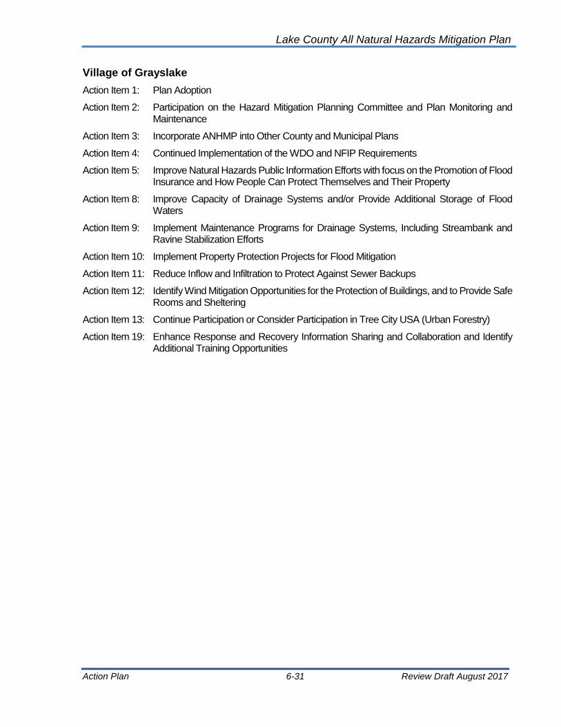
Lake County All Natural Hazards Mitigation Plan
Action Plan 6-31 Review Draft August 2017
Village of Grayslake
Action Item 1: Plan Adoption
Action Item 2: Participation on the Hazard Mitigation Planning Committee and Plan Monitoring and Maintenance
Action Item 3: Incorporate ANHMP into Other County and Municipal Plans
Action Item 4: Continued Implementation of the WDO and NFIP Requirements
Action Item 5: Improve Natural Hazards Public Information Efforts with focus on the Promotion of Flood Insurance and How People Can Protect Themselves and Their Property
Action Item 8: Improve Capacity of Drainage Systems and/or Provide Additional Storage of Flood Waters
Action Item 9: Implement Maintenance Programs for Drainage Systems, Including Streambank and Ravine Stabilization Efforts
Action Item 10: Implement Property Protection Projects for Flood Mitigation
Action Item 11: Reduce Inflow and Infiltration to Protect Against Sewer Backups
Action Item 12: Identify Wind Mitigation Opportunities for the Protection of Buildings, and to Provide Safe Rooms and Sheltering
Action Item 13: Continue Participation or Consider Participation in Tree City USA (Urban Forestry)
Action Item 19: Enhance Response and Recovery Information Sharing and Collaboration and Identify Additional Training Opportunities

Lake County All Natural Hazards Mitigation Plan
Action Plan 6-32 Review Draft August 2017
Village of Green Oaks
Action Item 1: Plan Adoption
Action Item 2: Participation on the Hazard Mitigation Planning Committee and Plan Monitoring and Maintenance
Action Item 3: Incorporate ANHMP into Other County and Municipal Plans
Action Item 4: Continued Implementation of the WDO and NFIP Requirements
Action Item 5: Improve Natural Hazards Public Information Efforts with focus on the Promotion of Flood Insurance and How People Can Protect Themselves and Their Property
Action Item 6: Identify Needs and Obtain Alternate Power Sources for Critical Facilities and Shelters
Action Item 7: Review of Critical Facilities and Implement of Appropriate Mitigation Measures
Action Item 8: Improve Capacity of Drainage Systems and/or Provide Additional Storage of Flood Waters
Action Item 9: Implement Maintenance Programs for Drainage Systems, Including Streambank and Ravine Stabilization Efforts
Action Item 10: Implement Property Protection Projects for Flood Mitigation
Action Item 12: Identify Wind Mitigation Opportunities for the Protection of Buildings, and to Provide Safe Rooms and Sheltering
Action Item 13: Continue Participation or Consider Participation in Tree City USA (Urban Forestry)
Action Item 15: Improve Building Codes and Building Code Enforcement
Action Item 17: Continue Participation or Consider Participation in StormReady
Action Item 20: Continue Participation or Consider Participation in the NFIP’s Community Rating System

Lake County All Natural Hazards Mitigation Plan
Action Plan 6-33 Review Draft August 2017
Village of Gurnee
Action Item 1: Plan Adoption
Action Item 2: Participation on the Hazard Mitigation Planning Committee and Plan Monitoring and Maintenance
Action Item 3: Incorporate ANHMP into Other County and Municipal Plans
Action Item 4: Continued Implementation of the WDO and NFIP Requirements
Action Item 5: Improve Natural Hazards Public Information Efforts with focus on the Promotion of Flood Insurance and How People Can Protect Themselves and Their Property
Action Item 6: Identify Needs and Obtain Alternate Power Sources for Critical Facilities and Shelters
Action Item 7: Review of Critical Facilities and Implement of Appropriate Mitigation Measures
Action Item 8: Improve Capacity of Drainage Systems and/or Provide Additional Storage of Flood Waters
Action Item 9: Implement Maintenance Programs for Drainage Systems, Including Streambank and Ravine Stabilization Efforts
Action Item 10: Implement Property Protection Projects for Flood Mitigation
Action Item 11: Reduce Inflow and Infiltration to Protect Against Sewer Backups
Action Item 12: Identify Wind Mitigation Opportunities for the Protection of Buildings, and to Provide Safe Rooms and Sheltering
Action Item 13: Continue Participation or Consider Participation in Tree City USA (Urban Forestry)
Action Item 14: Continue Work for NIMS Compliance
Action Item 15: Improve Building Codes and Building Code Enforcement
Action Item 16: Seek Mitigation Grant Funding for Additional Mitigation Planning and Cost Beneficial Projects
Action Item 17: Continue Participation or Consider Participation in StormReady
Action Item 18: Improve Emergency Response and Develop Assessment Teams
Action Item 19: Enhance Response and Recovery Information Sharing and Collaboration and Identify Additional Training Opportunities
Action Item 20: Continue Participation or Consider Participation in the NFIP’s Community Rating System
Action Item 23: Develop Flood Stage Maps
Action Item 24. Develop or Enhance the Community's Snow Removal Plan

Lake County All Natural Hazards Mitigation Plan
Action Plan 6-34 Review Draft August 2017
Village of Hainesville
Action Item 1: Plan Adoption
Action Item 2: Participation on the Hazard Mitigation Planning Committee and Plan Monitoring and Maintenance
Action Item 3: Incorporate ANHMP into Other County and Municipal Plans
Action Item 4: Continued Implementation of the WDO and NFIP Requirements
Action Item 5: Improve Natural Hazards Public Information Efforts with focus on the Promotion of Flood Insurance and How People Can Protect Themselves and Their Property
Action Item 10: Implement Property Protection Projects for Flood Mitigation
Action Item 12: Identify Wind Mitigation Opportunities for the Protection of Buildings, and to Provide Safe Rooms and Sheltering

Lake County All Natural Hazards Mitigation Plan
Action Plan 6-35 Review Draft August 2017
Village of Hawthorn Woods
Action Item 1: Plan Adoption
Action Item 2 Participation on the Hazard Mitigation Planning Committee and Plan Monitoring and Maintenance
Action Item 3: Incorporate ANHMP into Other County and Municipal Plans
Action Item 4: Continued Implementation of the WDO and NFIP Requirements
Action Item 5: Improve Natural Hazards Public Information Efforts with focus on the Promotion of Flood Insurance and How People Can Protect Themselves and Their Property
Action Item 6: Identify Needs and Obtain Alternate Power Sources for Critical Facilities and Shelters
Action Item 7: Review of Critical Facilities and Implement of Appropriate Mitigation Measures
Action Item 8: Improve Capacity of Drainage Systems and/or Provide Additional Storage of Flood Waters
Action Item 9: Implement Maintenance Programs for Drainage Systems, Including Streambank and Ravine Stabilization Efforts
Action Item 10: Implement Property Protection Projects for Flood Mitigation
Action Item 12: Identify Wind Mitigation Opportunities for the Protection of Buildings, and to Provide Safe Rooms and Sheltering
Action Item 14: Continue Work for NIMS Compliance
Action Item 16: Seek Mitigation Grant Funding for Additional Mitigation Planning and Cost Beneficial Projects
Action Item 17: Continue Participation or Consider Participation in StormReady
Action Item 25. Utility Tree Trimming

Lake County All Natural Hazards Mitigation Plan
Action Plan 6-36 Review Draft August 2017
City of Highland Park
Action Item 1: Plan Adoption
Action Item 2: Participation on the Hazard Mitigation Planning Committee and Plan Monitoring and Maintenance
Action Item 3: Incorporate ANHMP into Other County and Municipal Plans
Action Item 4: Continued Implementation of the WDO and NFIP Requirements
Action Item 5: Improve Natural Hazards Public Information Efforts with focus on the Promotion of Flood Insurance and How People Can Protect Themselves and Their Property
Action Item 6: Identify Needs and Obtain Alternate Power Sources for Critical Facilities and Shelters
Action Item 8: Improve Capacity of Drainage Systems and/or Provide Additional Storage of Flood Waters
Action Item 9: Implement Maintenance Programs for Drainage Systems, Including Streambank and Ravine Stabilization Efforts
Action Item 10: Implement Property Protection Projects for Flood Mitigation
Action Item 11: Reduce Inflow and Infiltration to Protect Against Sewer Backups
Action Item 12: Identify Wind Mitigation Opportunities for the Protection of Buildings, and to Provide Safe Rooms and Sheltering
Action Item 20: Continue Participation or Consider Participation in the NFIP’s Community Rating System
Action Item 23: Develop Flood Stage Maps
Action Item 24. Develop or Enhance the Community's Snow Removal Plan
Action Item 32. Mitigate Septic Discharge; Leaching into Waterways
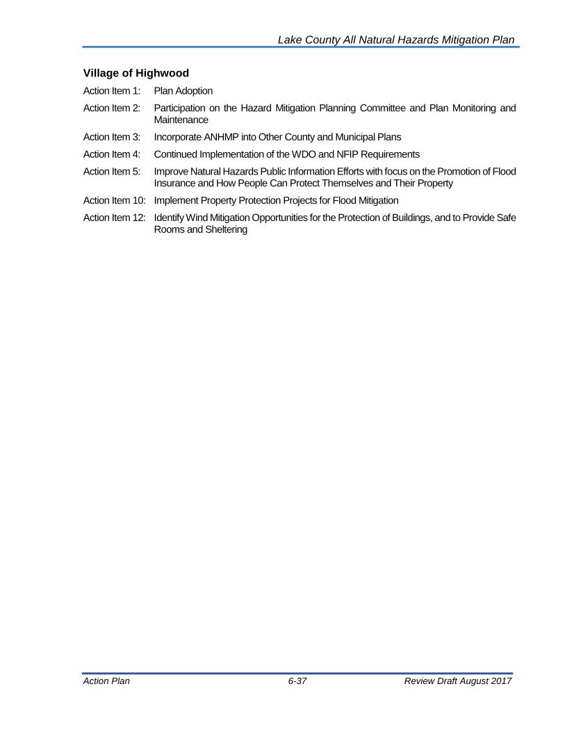
Lake County All Natural Hazards Mitigation Plan
Action Plan 6-37 Review Draft August 2017
Village of Highwood
Action Item 1: Plan Adoption
Action Item 2: Participation on the Hazard Mitigation Planning Committee and Plan Monitoring and Maintenance
Action Item 3: Incorporate ANHMP into Other County and Municipal Plans
Action Item 4: Continued Implementation of the WDO and NFIP Requirements
Action Item 5: Improve Natural Hazards Public Information Efforts with focus on the Promotion of Flood Insurance and How People Can Protect Themselves and Their Property
Action Item 10: Implement Property Protection Projects for Flood Mitigation
Action Item 12: Identify Wind Mitigation Opportunities for the Protection of Buildings, and to Provide Safe Rooms and Sheltering

Lake County All Natural Hazards Mitigation Plan
Action Plan 6-38 Review Draft August 2017
Village of Indian Creek
Action Item 1: Plan Adoption
Action Item 2: Participation on the Hazard Mitigation Planning Committee and Plan Monitoring and Maintenance
Action Item 3: Incorporate ANHMP into Other County and Municipal Plans
Action Item 4: Continued Implementation of the WDO and NFIP Requirements
Action Item 5: Improve Natural Hazards Public Information Efforts with focus on the Promotion of Flood Insurance and How People Can Protect Themselves and Their Property
Action Item 10: Implement Property Protection Projects for Flood Mitigation
Action Item 12: Identify Wind Mitigation Opportunities for the Protection of Buildings, and to Provide Safe Rooms and Sheltering

Lake County All Natural Hazards Mitigation Plan
Action Plan 6-39 Review Draft August 2017
Village of Island Lake
Action Item 1: Plan Adoption
Action Item 2: Participation on the Hazard Mitigation Planning Committee and Plan Monitoring and Maintenance
Action Item 3: Incorporate ANHMP into Other County and Municipal Plans
Action Item 4: Continued Implementation of the WDO and NFIP Requirements
Action Item 5 Insurance and How People Can Protect Themselves and Their Property
Action Item 10: Implement Property Protection Projects for Flood Mitigation
Action Item 12: Identify Wind Mitigation Opportunities for the Protection of Buildings, and to Provide Safe Rooms and Sheltering

Lake County All Natural Hazards Mitigation Plan
Action Plan 6-40 Review Draft August 2017
Village of Kildeer
Action Item 1: Plan Adoption
Action Item 2: Participation on the Hazard Mitigation Planning Committee and Plan Monitoring and Maintenance
Action Item 3: Incorporate ANHMP into Other County and Municipal Plans
Action Item 4: Continued Implementation of the WDO and NFIP Requirements
Action Item 5: Improve Natural Hazards Public Information Efforts with focus on the Promotion of Flood Insurance and How People Can Protect Themselves and Their Property
Action Item 6: Identify Needs and Obtain Alternate Power Sources for Critical Facilities and Shelters
Action Item 7: Review of Critical Facilities and Implement of Appropriate Mitigation Measures
Action Item 9: Implement Maintenance Programs for Drainage Systems, Including Streambank and Ravine Stabilization Efforts
Action Item 10: Implement Property Protection Projects for Flood Mitigation
Action Item 12: Identify Wind Mitigation Opportunities for the Protection of Buildings, and to Provide Safe Rooms and Sheltering
Action Item 15: Improve Building Codes and Building Code Enforcement
Action Item 16: Seek Mitigation Grant Funding for Additional Mitigation Planning and Cost Beneficial Projects
Action Item 18: Improve Emergency Response and Develop Assessment Teams
Action Item 24. Develop or Enhance the Community's Snow Removal Plan
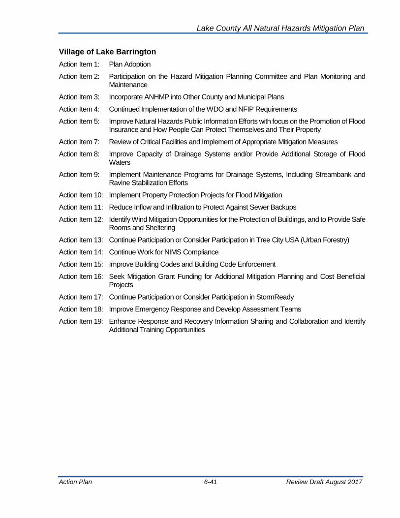
Lake County All Natural Hazards Mitigation Plan
Action Plan 6-41 Review Draft August 2017
Village of Lake Barrington
Action Item 1: Plan Adoption
Action Item 2: Participation on the Hazard Mitigation Planning Committee and Plan Monitoring and Maintenance
Action Item 3: Incorporate ANHMP into Other County and Municipal Plans
Action Item 4: Continued Implementation of the WDO and NFIP Requirements
Action Item 5: Improve Natural Hazards Public Information Efforts with focus on the Promotion of Flood Insurance and How People Can Protect Themselves and Their Property
Action Item 7: Review of Critical Facilities and Implement of Appropriate Mitigation Measures
Action Item 8: Improve Capacity of Drainage Systems and/or Provide Additional Storage of Flood Waters
Action Item 9: Implement Maintenance Programs for Drainage Systems, Including Streambank and Ravine Stabilization Efforts
Action Item 10: Implement Property Protection Projects for Flood Mitigation
Action Item 11: Reduce Inflow and Infiltration to Protect Against Sewer Backups
Action Item 12: Identify Wind Mitigation Opportunities for the Protection of Buildings, and to Provide Safe Rooms and Sheltering
Action Item 13: Continue Participation or Consider Participation in Tree City USA (Urban Forestry)
Action Item 14: Continue Work for NIMS Compliance
Action Item 15: Improve Building Codes and Building Code Enforcement
Action Item 16: Seek Mitigation Grant Funding for Additional Mitigation Planning and Cost Beneficial Projects
Action Item 17: Continue Participation or Consider Participation in StormReady
Action Item 18: Improve Emergency Response and Develop Assessment Teams
Action Item 19: Enhance Response and Recovery Information Sharing and Collaboration and Identify Additional Training Opportunities

Lake County All Natural Hazards Mitigation Plan
Action Plan 6-42 Review Draft August 2017
Village of Lake Bluff
Action Item 1: Plan Adoption
Action Item 2: Participation on the Hazard Mitigation Planning Committee and Plan Monitoring and Maintenance
Action Item 3: Incorporate ANHMP into Other County and Municipal Plans
Action Item 4: Continued Implementation of the WDO and NFIP Requirements
Action Item 5: Improve Natural Hazards Public Information Efforts with focus on the Promotion of Flood Insurance and How People Can Protect Themselves and Their Property
Action Item 8: Improve Capacity of Drainage Systems and/or Provide Additional Storage of Flood Waters
Action Item 9: Implement Maintenance Programs for Drainage Systems, Including Streambank and Ravine Stabilization Efforts
Action Item 10: Implement Property Protection Projects for Flood Mitigation
Action Item 11: Reduce Inflow and Infiltration to Protect Against Sewer Backups
Action Item 12: Identify Wind Mitigation Opportunities for the Protection of Buildings, and to Provide Safe Rooms and Sheltering
Action Item 13: Continue Participation or Consider Participation in Tree City USA (Urban Forestry)
Action Item 15: Improve Building Codes and Building Code Enforcement
Action Item 16: Seek Mitigation Grant Funding for Additional Mitigation Planning and Cost Beneficial Projects
Action Item 18: Improve Emergency Response and Develop Assessment Teams
Action Item 19: Enhance Response and Recovery Information Sharing and Collaboration and Identify Additional Training Opportunities

Lake County All Natural Hazards Mitigation Plan
Action Plan 6-43 Review Draft August 2017
City of Lake Forest
Action Item 1: Plan Adoption
Action Item 2: Participation on the Hazard Mitigation Planning Committee and Plan Monitoring and Maintenance
Action Item 3: Incorporate ANHMP into Other County and Municipal Plans
Action Item 4: Continued Implementation of the WDO and NFIP Requirements
Action Item 5: Improve Natural Hazards Public Information Efforts with focus on the Promotion of Flood Insurance and How People Can Protect Themselves and Their Property
Action Item 10: Implement Property Protection Projects for Flood Mitigation
Action Item 12: Identify Wind Mitigation Opportunities for the Protection of Buildings, and to Provide Safe Rooms and Sheltering

Lake County All Natural Hazards Mitigation Plan
Action Plan 6-44 Review Draft August 2017
Village of Lake Villa
Action Item 1: Plan Adoption
Action Item 2: Participation on the Hazard Mitigation Planning Committee and Plan Monitoring and Maintenance
Action Item 3: Incorporate ANHMP into Other County and Municipal Plans
Action Item 4: Continued Implementation of the WDO and NFIP Requirements
Action Item 5: Improve Natural Hazards Public Information Efforts with focus on the Promotion of Flood Insurance and How People Can Protect Themselves and Their Property
Action Item 6: Identify Needs and Obtain Alternate Power Sources for Critical Facilities and Shelters
Action Item 7: Review of Critical Facilities and Implement of Appropriate Mitigation Measures
Action Item 8: Improve Capacity of Drainage Systems and/or Provide Additional Storage of Flood Waters
Action Item 9: Implement Maintenance Programs for Drainage Systems, Including Streambank and Ravine Stabilization Efforts
Action Item 10: Implement Property Protection Projects for Flood Mitigation
Action Item 11: Reduce Inflow and Infiltration to Protect Against Sewer Backups
Action Item 12: Identify Wind Mitigation Opportunities for the Protection of Buildings, and to Provide Safe Rooms and Sheltering
Action Item 13: Continue Participation or Consider Participation in Tree City USA (Urban Forestry)
Action Item 14: Continue Work for NIMS Compliance
Action Item 15: Improve Building Codes and Building Code Enforcement
Action Item 16: Seek Mitigation Grant Funding for Additional Mitigation Planning and Cost Beneficial Projects
Action Item 18: Improve Emergency Response and Develop Assessment Teams
Action Item 19: Enhance Response and Recovery Information Sharing and Collaboration and Identify Additional Training Opportunities
Action Item 20: Continue Participation or Consider Participation in the NFIP’s Community Rating System
Action Item 24. Develop or Enhance the Community's Snow Removal Plan

Lake County All Natural Hazards Mitigation Plan
Action Plan 6-45 Review Draft August 2017
Village of Lake Zurich
Action Item 1: Plan Adoption
Action Item 2: Participation on the Hazard Mitigation Planning Committee and Plan Monitoring and Maintenance
Action Item 3: Incorporate ANHMP into Other County and Municipal Plans
Action Item 4: Continued Implementation of the WDO and NFIP Requirements
Action Item 5: Improve Natural Hazards Public Information Efforts with focus on the Promotion of Flood Insurance and How People Can Protect Themselves and Their Property
Action Item 6: Identify Needs and Obtain Alternate Power Sources for Critical Facilities and Shelters
Action Item 8: Improve Capacity of Drainage Systems and/or Provide Additional Storage of Flood Waters
Action Item 9: Implement Maintenance Programs for Drainage Systems, Including Streambank and Ravine Stabilization Efforts
Action Item 10: Implement Property Protection Projects for Flood Mitigation
Action Item 11: Reduce Inflow and Infiltration to Protect Against Sewer Backups
Action Item 12: Identify Wind Mitigation Opportunities for the Protection of Buildings, and to Provide Safe Rooms and Sheltering
Action Item 13: Continue Participation or Consider Participation in Tree City USA (Urban Forestry)
Action Item 14: Continue Work for NIMS Compliance
Action Item 15: Improve Building Codes and Building Code Enforcement
Action Item 16: Seek Mitigation Grant Funding for Additional Mitigation Planning and Cost Beneficial Projects
Action Item 24. Develop or Enhance the Community's Snow Removal Plan
Action Item 27. Conduct Local Drainage Studies

Lake County All Natural Hazards Mitigation Plan
Action Plan 6-46 Review Draft August 2017
Village of Lakemoor
Action Item 1: Plan Adoption
Action Item 2: Participation on the Hazard Mitigation Planning Committee and Plan Monitoring and Maintenance
Action Item 3: Incorporate ANHMP into Other County and Municipal Plans
Action Item 4: Continued Implementation of the WDO and NFIP Requirements
Action Item 5: Improve Natural Hazards Public Information Efforts with focus on the Promotion of Flood Insurance and How People Can Protect Themselves and Their Property
Action Item 10: Implement Property Protection Projects for Flood Mitigation
Action Item 12: Identify Wind Mitigation Opportunities for the Protection of Buildings, and to Provide Safe Rooms and Sheltering

Lake County All Natural Hazards Mitigation Plan
Action Plan 6-47 Review Draft August 2017
Village of Libertyville
Action Item 1: Plan Adoption
Action Item 2: Participation on the Hazard Mitigation Planning Committee and Plan Monitoring and Maintenance
Action Item 3: Incorporate ANHMP into Other County and Municipal Plans
Action Item 4: Continued Implementation of the WDO and NFIP Requirements
Action Item 10: Implement Property Protection Projects for Flood Mitigation
Action Item 12: Identify Wind Mitigation Opportunities for the Protection of Buildings, and to Provide Safe Rooms and Sheltering

Lake County All Natural Hazards Mitigation Plan
Action Plan 6-48 Review Draft August 2017
Village of Lincolnshire
Action Item 1: Plan Adoption
Action Item 2: Participation on the Hazard Mitigation Planning Committee and Plan Monitoring and Maintenance
Action Item 3: Incorporate ANHMP into Other County and Municipal Plans
Action Item 4: Continued Implementation of the WDO and NFIP Requirements
Action Item 5: Improve Natural Hazards Public Information Efforts with focus on the Promotion of Flood Insurance and How People Can Protect Themselves and Their Property
Action Item 6: Identify Needs and Obtain Alternate Power Sources for Critical Facilities and Shelters
Action Item 7: Review of Critical Facilities and Implement of Appropriate Mitigation Measures
Action Item 8: Improve Capacity of Drainage Systems and/or Provide Additional Storage of Flood Waters
Action Item 9: Implement Maintenance Programs for Drainage Systems, Including Streambank and Ravine Stabilization Efforts
Action Item 10: Implement Property Protection Projects for Flood Mitigation
Action Item 12: Identify Wind Mitigation Opportunities for the Protection of Buildings, and to Provide Safe Rooms and Sheltering
Action Item 13: Consider Participation in Tree City USA (Urban Forestry)
Action Item 14: Continue Work for NIMS Compliance
Action Item 16: Seek Mitigation Grant Funding for Additional Mitigation Planning and Cost Beneficial Projects
Action Item 20: Continue Participation in the NFIP’s Community Rating System
Action Item 24. Develop or Enhance the Community's Snow Removal Plan
Action Item 31. Lincolnshire Creek Improvements
Action Item 34: Des Plaines River Neighborhood Flood Protection

Lake County All Natural Hazards Mitigation Plan
Action Plan 6-49 Review Draft August 2017
Village of Lindenhurst
Action Item 1: Plan Adoption
Action Item 2: Participation on the Hazard Mitigation Planning Committee and Plan Monitoring and Maintenance
Action Item 3: Incorporate ANHMP into Other County and Municipal Plans
Action Item 4: Continued Implementation of the WDO and NFIP Requirements
Action Item 5: Improve Natural Hazards Public Information Efforts with focus on the Promotion of Flood Insurance and How People Can Protect Themselves and Their Property
Action Item 10: Implement Property Protection Projects for Flood Mitigation
Action Item 12: Identify Wind Mitigation Opportunities for the Protection of Buildings, and to Provide Safe Rooms and Sheltering

Lake County All Natural Hazards Mitigation Plan
Action Plan 6-50 Review Draft August 2017
Village of Long Grove
Action Item 1: Plan Adoption
Action Item 2: Participation on the Hazard Mitigation Planning Committee and Plan Monitoring and Maintenance
Action Item 3: Incorporate ANHMP into Other County and Municipal Plans
Action Item 4: Continued Implementation of the WDO and NFIP Requirements
Action Item 5: Improve Natural Hazards Public Information Efforts with focus on the Promotion of Flood Insurance and How People Can Protect Themselves and Their Property
Action Item 6: Identify Needs and Obtain Alternate Power Sources for Critical Facilities and Shelters
Action Item 7: Review of Critical Facilities and Implement of Appropriate Mitigation Measures
Action Item 8: Improve Capacity of Drainage Systems and/or Provide Additional Storage of Flood Waters
Action Item 10: Implement Property Protection Projects for Flood Mitigation
Action Item 11: Reduce Inflow and Infiltration to Protect Against Sewer Backups
Action Item 12: Identify Wind Mitigation Opportunities for the Protection of Buildings, and to Provide Safe Rooms and Sheltering
Action Item 13: Continue Participation or Consider Participation in Tree City USA (Urban Forestry)
Action Item 14: Continue Work for NIMS Compliance
Action Item 15: Improve Building Codes and Building Code Enforcement
Action Item 16: Seek Mitigation Grant Funding for Additional Mitigation Planning and Cost Beneficial Projects
Action Item 19: Enhance Response and Recovery Information Sharing and Collaboration and Identify Additional Training Opportunities
Action Item 20: Continue Participation or Consider Participation in the NFIP’s Community Rating System

Lake County All Natural Hazards Mitigation Plan
Action Plan 6-51 Review Draft August 2017
Village of Mettawa
Action Item 1: Plan Adoption
Action Item 2: Participation on the Hazard Mitigation Planning Committee and Plan Monitoring and Maintenance
Action Item 3: Incorporate ANHMP into Other County and Municipal Plans
Action Item 4: Continued Implementation of the WDO and NFIP Requirements
Action Item 5: Improve Natural Hazards Public Information Efforts with focus on the Promotion of Flood Insurance and How People Can Protect Themselves and Their Property
Action Item 10: Implement Property Protection Projects for Flood Mitigation
Action Item 12: Identify Wind Mitigation Opportunities for the Protection of Buildings, and to Provide Safe Rooms and Sheltering

Lake County All Natural Hazards Mitigation Plan
Action Plan 6-52 Review Draft August 2017
Village of Mundelein
Action Item 1: Plan Adoption
Action Item 2: Participation on the Hazard Mitigation Planning Committee and Plan Monitoring and Maintenance
Action Item 3: Incorporate ANHMP into Other County and Municipal Plans
Action Item 4: Continued Implementation of the WDO and NFIP Requirements
Action Item 5: Improve Natural Hazards Public Information Efforts with focus on the Promotion of Flood Insurance and How People Can Protect Themselves and Their Property
Action Item 6: Identify Needs and Obtain Alternate Power Sources for Critical Facilities and Shelters
Action Item 7: Review of Critical Facilities and Implement of Appropriate Mitigation Measures
Action Item 8: Improve Capacity of Drainage Systems and/or Provide Additional Storage of Flood Waters
Action Item 9: Implement Maintenance Programs for Drainage Systems, Including Streambank and Ravine Stabilization Efforts
Action Item 10: Implement Property Protection Projects for Flood Mitigation
Action Item 11: Reduce Inflow and Infiltration to Protect Against Sewer Backups
Action Item 12: Identify Wind Mitigation Opportunities for the Protection of Buildings, and to Provide Safe Rooms and Sheltering
Action Item 13: Continue Participation or Consider Participation in Tree City USA (Urban Forestry)
Action Item 14: Continue Work for NIMS Compliance
Action Item 15: Improve Building Codes and Building Code Enforcement
Action Item 16: Seek Mitigation Grant Funding for Additional Mitigation Planning and Cost Beneficial Projects
Action Item 18: Improve Emergency Response and Develop Assessment Teams
Action Item 19: Enhance Response and Recovery Information Sharing and Collaboration and Identify Additional Training Opportunities
Action Item 20: Continue Participation or Consider Participation in the NFIP’s Community Rating System

Lake County All Natural Hazards Mitigation Plan
Action Plan 6-53 Review Draft August 2017
Village of North Barrington
Action Item 1: Plan Adoption
Action Item 2: Participation on the Hazard Mitigation Planning Committee and Plan Monitoring and Maintenance
Action Item 3: Incorporate ANHMP into Other County and Municipal Plans
Action Item 4: Continued Implementation of the WDO and NFIP Requirements
Action Item 5: Improve Natural Hazards Public Information Efforts with focus on the Promotion of Flood Insurance and How People Can Protect Themselves and Their Property
Action Item 6: Identify Needs and Obtain Alternate Power Sources for Critical Facilities and Shelters
Action Item 7: Review of Critical Facilities and Implement of Appropriate Mitigation Measures
Action Item 8: Improve Capacity of Drainage Systems and/or Provide Additional Storage of Flood Waters
Action Item 9: Implement Maintenance Programs for Drainage Systems, Including Streambank and Ravine Stabilization Efforts
Action Item 10: Implement Property Protection Projects for Flood Mitigation
Action Item 11: Reduce Inflow and Infiltration to Protect Against Sewer Backups
Action Item 12: Identify Wind Mitigation Opportunities for the Protection of Buildings, and to Provide Safe Rooms and Sheltering
Action Item 13: Continue Participation or Consider Participation in Tree City USA (Urban Forestry)
Action Item 14: Continue Work for NIMS Compliance
Action Item 15: Improve Building Codes and Building Code Enforcement
Action Item 16: Seek Mitigation Grant Funding for Additional Mitigation Planning and Cost Beneficial Projects
Action Item 17: Continue Participation or Consider Participation in StormReady
Action Item 18: Improve Emergency Response and Develop Assessment Teams
Action Item 20: Continue Participation or Consider Participation in the NFIP’s Community Rating System

Lake County All Natural Hazards Mitigation Plan
Action Plan 6-54 Review Draft August 2017
City of North Chicago
Action Item 1: Plan Adoption
Action Item 2: Participation on the Hazard Mitigation Planning Committee and Plan Monitoring and Maintenance
Action Item 3: Incorporate ANHMP into Other County and Municipal Plans
Action Item 4: Continued Implementation of the WDO and NFIP Requirements
Action Item 5: Improve Natural Hazards Public Information Efforts with focus on the Promotion of Flood Insurance and How People Can Protect Themselves and Their Property
Action Item 10: Implement Property Protection Projects for Flood Mitigation
Action Item 12: Identify Wind Mitigation Opportunities for the Protection of Buildings, and to Provide Safe Rooms and Sheltering

Lake County All Natural Hazards Mitigation Plan
Action Plan 6-55 Review Draft August 2017
Village of Old Mill Creek
Action Item 1: Plan Adoption
Action Item 2: Participation on the Hazard Mitigation Planning Committee and Plan Monitoring and Maintenance
Action Item 3: Incorporate ANHMP into Other County and Municipal Plans
Action Item 4: Continued Implementation of the WDO and NFIP Requirements
Action Item 5: Improve Natural Hazards Public Information Efforts with focus on the Promotion of Flood Insurance and How People Can Protect Themselves and Their Property
Action Item 10: Implement Property Protection Projects for Flood Mitigation
Action Item 12: Identify Wind Mitigation Opportunities for the Protection of Buildings, and to Provide Safe Rooms and Sheltering

Lake County All Natural Hazards Mitigation Plan
Action Plan 6-56 Review Draft August 2017
City of Park City
Action Item 1: Plan Adoption
Action Item 2: Participation on the Hazard Mitigation Planning Committee and Plan Monitoring and Maintenance
Action Item 3: Incorporate ANHMP into Other County and Municipal Plans
Action Item 4: Continued Implementation of the WDO and NFIP Requirements
Action Item 5: Improve Natural Hazards Public Information Efforts with focus on the Promotion of Flood Insurance and How People Can Protect Themselves and Their Property
Action Item 10: Implement Property Protection Projects for Flood Mitigation
Action Item 12: Identify Wind Mitigation Opportunities for the Protection of Buildings, and to Provide Safe Rooms and Sheltering

Lake County All Natural Hazards Mitigation Plan
Action Plan 6-57 Review Draft August 2017
Village of Port Barrington
Action Item 1: Plan Adoption
Action Item 2: Participation on the Hazard Mitigation Planning Committee and Plan Monitoring and Maintenance
Action Item 3: Incorporate ANHMP into Other County and Municipal Plans
Action Item 4: Continued Implementation of the WDO and NFIP Requirements
Action Item 5: Improve Natural Hazards Public Information Efforts with focus on the Promotion of Flood Insurance and How People Can Protect Themselves and Their Property
Action Item 6: Identify Needs and Obtain Alternate Power Sources for Critical Facilities and Shelters
Action Item 7: Review of Critical Facilities and Implement of Appropriate Mitigation Measures
Action Item 9: Implement Maintenance Programs for Drainage Systems, Including Streambank and Ravine Stabilization Efforts
Action Item 10: Implement Property Protection Projects for Flood Mitigation
Action Item 11: Reduce Inflow and Infiltration to Protect Against Sewer Backups
Action Item 12: Identify Wind Mitigation Opportunities for the Protection of Buildings, and to Provide Safe Rooms and Sheltering
Action Item 14: Continue Work for NIMS Compliance
Action Item 15 Improve Building Codes and Building Code Enforcement
Action Item 16: Seek Mitigation Grant Funding for Additional Mitigation Planning and Cost Beneficial Projects
Action Item 18: Improve Emergency Response and Develop Assessment Teams
Action Item 19: Enhance Response and Recovery Information Sharing and Collaboration and Identify Additional Training Opportunities
Action Item 20: Continue Participation or Consider Participation in the NFIP’s Community Rating System
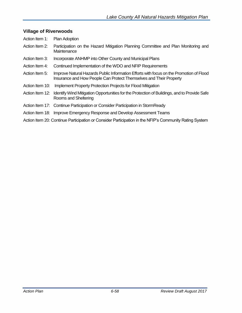
Lake County All Natural Hazards Mitigation Plan
Action Plan 6-58 Review Draft August 2017
Village of Riverwoods
Action Item 1: Plan Adoption
Action Item 2: Participation on the Hazard Mitigation Planning Committee and Plan Monitoring and Maintenance
Action Item 3: Incorporate ANHMP into Other County and Municipal Plans
Action Item 4: Continued Implementation of the WDO and NFIP Requirements
Action Item 5: Improve Natural Hazards Public Information Efforts with focus on the Promotion of Flood Insurance and How People Can Protect Themselves and Their Property
Action Item 10: Implement Property Protection Projects for Flood Mitigation
Action Item 12: Identify Wind Mitigation Opportunities for the Protection of Buildings, and to Provide Safe Rooms and Sheltering
Action Item 17: Continue Participation or Consider Participation in StormReady
Action Item 18: Improve Emergency Response and Develop Assessment Teams
Action Item 20: Continue Participation or Consider Participation in the NFIP’s Community Rating System

Lake County All Natural Hazards Mitigation Plan
Action Plan 6-59 Review Draft August 2017
Village of Round Lake
Action Item 1: Plan Adoption
Action Item 2: Participation on the Hazard Mitigation Planning Committee and Plan Monitoring and Maintenance
Action Item 3: Incorporate ANHMP into Other County and Municipal Plans
Action Item 4: Continued Implementation of the WDO and NFIP Requirements
Action Item 5: Improve Natural Hazards Public Information Efforts with focus on the Promotion of Flood Insurance and How People Can Protect Themselves and Their Property
Action Item 8: Improve Capacity of Drainage Systems and/or Provide Additional Storage of Flood Waters
Action Item 9: Implement Maintenance Programs for Drainage Systems, Including Streambank and Ravine Stabilization Efforts
Action Item 10: Implement Property Protection Projects for Flood Mitigation
Action Item 11: Reduce Inflow and Infiltration to Protect Against Sewer Backups
Action Item 12: Identify Wind Mitigation Opportunities for the Protection of Buildings, and to Provide Safe Rooms and Sheltering
Action Item 13: Continue Participation or Consider Participation in Tree City USA (Urban Forestry)
Action Item 19: Enhance Response and Recovery Information Sharing and Collaboration and Identify Additional Training Opportunities

Lake County All Natural Hazards Mitigation Plan
Action Plan 6-60 Review Draft August 2017
Village of Round Lake Beach
Action Item 1: Plan Adoption
Action Item 2: Participation on the Hazard Mitigation Planning Committee and Plan Monitoring and Maintenance
Action Item 3: Incorporate ANHMP into Other County and Municipal Plans
Action Item 4: Continued Implementation of the WDO and NFIP Requirements
Action Item 5: Improve Natural Hazards Public Information Efforts with focus on the Promotion of Flood Insurance and How People Can Protect Themselves and Their Property
Action Item 10: Implement Property Protection Projects for Flood Mitigation
Action Item 12: Identify Wind Mitigation Opportunities for the Protection of Buildings, and to Provide Safe Rooms and Sheltering

Lake County All Natural Hazards Mitigation Plan
Action Plan 6-61 Review Draft August 2017
Village of Round Lake Heights
Action Item 1: Plan Adoption
Action Item 2: Participation on the Hazard Mitigation Planning Committee and Plan Monitoring and Maintenance
Action Item 3: Incorporate ANHMP into Other County and Municipal Plans
Action Item 4: Continued Implementation of the WDO and NFIP Requirements
Action Item 5: Improve Natural Hazards Public Information Efforts with focus on the Promotion of Flood Insurance and How People Can Protect Themselves and Their Property
Action Item 6: Identify Needs and Obtain Alternate Power Sources for Critical Facilities and Shelters
Action Item 7: Review of Critical Facilities and Implement of Appropriate Mitigation Measures
Action Item 10: Implement Property Protection Projects for Flood Mitigation
Action Item 12: Identify Wind Mitigation Opportunities for the Protection of Buildings, and to Provide Safe Rooms and Sheltering
Action Item 13: Continue Participation or Consider Participation in Tree City USA (Urban Forestry)
Action Item 14: Continue Work for NIMS Compliance
Action Item 15: Improve Building Codes and Building Code Enforcement
Action Item 17: Continue Participation or Consider Participation in StormReady
Action Item 18: Improve Emergency Response and Develop Assessment Teams
Action Item 19: Enhance Response and Recovery Information Sharing and Collaboration and Identify Additional Training Opportunities
Action Item 20: Continue Participation or Consider Participation in the NFIP’s Community Rating System

Lake County All Natural Hazards Mitigation Plan
Action Plan 6-62 Review Draft August 2017
Village of Round Lake Park
Action Item 1: Plan Adoption
Action Item 2: Participation on the Hazard Mitigation Planning Committee and Plan Monitoring and Maintenance
Action Item 3: Incorporate ANHMP into Other County and Municipal Plans
Action Item 4: Continued Implementation of the WDO and NFIP Requirements
Action Item 5: Improve Natural Hazards Public Information Efforts with focus on the Promotion of Flood Insurance and How People Can Protect Themselves and Their Property
Action Item 6: Identify Needs and Obtain Alternate Power Sources for Critical Facilities and Shelters
Action Item 10: Implement Property Protection Projects for Flood Mitigation
Action Item 11: Reduce Inflow and Infiltration to Protect Against Sewer Backups
Action Item 12: Identify Wind Mitigation Opportunities for the Protection of Buildings, and to Provide Safe Rooms and Sheltering
Action Item 13: Continue Participation or Consider Participation in Tree City USA (Urban Forestry)
Action Item 14: Continue Work for NIMS Compliance
Action Item 16: Seek Mitigation Grant Funding for Additional Mitigation Planning and Cost Beneficial Projects

Lake County All Natural Hazards Mitigation Plan
Action Plan 6-63 Review Draft August 2017
Village of Third Lake
Action Item 1: Plan Adoption
Action Item 2: Participation on the Hazard Mitigation Planning Committee and Plan Monitoring and Maintenance
Action Item 3: Incorporate ANHMP into Other County and Municipal Plans
Action Item 4: Continued Implementation of the WDO and NFIP Requirements
Action Item 5: Improve Natural Hazards Public Information Efforts with focus on the Promotion of Flood Insurance and How People Can Protect Themselves and Their Property
Action Item 6: Identify Needs and Obtain Alternate Power Sources for Critical Facilities and Shelters
Action Item 7: Review of Critical Facilities and Implement of Appropriate Mitigation Measures
Action Item 8: Improve Capacity of Drainage Systems and/or Provide Additional Storage of Flood Waters
Action Item 9: Implement Maintenance Programs for Drainage Systems, Including Streambank and Ravine Stabilization Efforts
Action Item 10: Implement Property Protection Projects for Flood Mitigation
Action Item 11: Reduce Inflow and Infiltration to Protect Against Sewer Backups
Action Item 12: Identify Wind Mitigation Opportunities for the Protection of Buildings, and to Provide Safe Rooms and Sheltering
Action Item 14: Continue Work for NIMS Compliance
Action Item 15: Improve Building Codes and Building Code Enforcement
Action Item 16: Seek Mitigation Grant Funding for Additional Mitigation Planning and Cost Beneficial Projects
Action Item 17: Continue Participation or Consider Participation in StormReady
Action Item 18: Improve Emergency Response and Develop Assessment Teams
Action Item 19: Enhance Response and Recovery Information Sharing and Collaboration and Identify Additional Training Opportunities

Lake County All Natural Hazards Mitigation Plan
Action Plan 6-64 Review Draft August 2017
Village of Tower Lakes
Action Item 1: Plan Adoption
Action Item 2: Participation on the Hazard Mitigation Planning Committee and Plan Monitoring and Maintenance
Action Item 3: Incorporate ANHMP into Other County and Municipal Plans
Action Item 4: Continued Implementation of the WDO and NFIP Requirements
Action Item 5: Improve Natural Hazards Public Information Efforts with focus on the Promotion of Flood Insurance and How People Can Protect Themselves and Their Property
Action Item 10: Implement Property Protection Projects for Flood Mitigation
Action Item 12: Identify Wind Mitigation Opportunities for the Protection of Buildings, and to Provide Safe Rooms and Sheltering

Lake County All Natural Hazards Mitigation Plan
Action Plan 6-65 Review Draft August 2017
Village of Vernon Hills
Action Item 1: Plan Adoption
Action Item 2: Participation on the Hazard Mitigation Planning Committee and Plan Monitoring and Maintenance
Action Item 3: Incorporate ANHMP into Other County and Municipal Plans
Action Item 4: Continued Implementation of the WDO and NFIP Requirements
Action Item 5: Improve Natural Hazards Public Information Efforts with focus on the Promotion of Flood Insurance and How People Can Protect Themselves and Their Property
Action Item 6: Identify Needs and Obtain Alternate Power Sources for Critical Facilities and Shelters
Action Item 9: Implement Maintenance Programs for Drainage Systems, Including Streambank and Ravine Stabilization Efforts
Action Item 10: Implement Property Protection Projects for Flood Mitigation
Action Item 11: Reduce Inflow and Infiltration to Protect Against Sewer Backups
Action Item 12: Identify Wind Mitigation Opportunities for the Protection of Buildings, and to Provide Safe Rooms and Sheltering
Action Item 13: Continue Participation or Consider Participation in Tree City USA (Urban Forestry)
Action Item 15: Improve Building Codes and Building Code Enforcement
Action Item 17: Continue Participation or Consider Participation in StormReady
Action Item 18: Improve Emergency Response and Develop Assessment Teams

Lake County All Natural Hazards Mitigation Plan
Action Plan 6-66 Review Draft August 2017
Village of Volo
Action Item 1: Plan Adoption
Action Item 2: Participation on the Hazard Mitigation Planning Committee and Plan Monitoring and Maintenance
Action Item 3: Incorporate ANHMP into Other County and Municipal Plans
Action Item 4: Continued Implementation of the WDO and NFIP Requirements
Action Item 5: Improve Natural Hazards Public Information Efforts with focus on the Promotion of Flood Insurance and How People Can Protect Themselves and Their Property
Action Item 6: Identify Needs and Obtain Alternate Power Sources for Critical Facilities and Shelters
Action Item 7: Review of Critical Facilities and Implement of Appropriate Mitigation Measures
Action Item 10: Implement Property Protection Projects for Flood Mitigation
Action Item 12: Identify Wind Mitigation Opportunities for the Protection of Buildings, and to Provide Safe Rooms and Sheltering
Action Item 13: Continue Participation or Consider Participation in Tree City USA (Urban Forestry)
Action Item 15: Improve Building Codes and Building Code Enforcement
Action Item 19: Enhance Response and Recovery Information Sharing and Collaboration and Identify Additional Training Opportunities

Lake County All Natural Hazards Mitigation Plan
Action Plan 6-67 Review Draft August 2017
Village of Wadsworth
Action Item 1: Plan Adoption
Action Item 2: Participation on the Hazard Mitigation Planning Committee and Plan Monitoring and Maintenance
Action Item 3: Incorporate ANHMP into Other County and Municipal Plans
Action Item 4: Continued Implementation of the WDO and NFIP Requirements
Action Item 5: Improve Natural Hazards Public Information Efforts with focus on the Promotion of Flood Insurance and How People Can Protect Themselves and Their Property
Action Item 6: Identify Needs and Obtain Alternate Power Sources for Critical Facilities and Shelters
Action Item 8: Improve Capacity of Drainage Systems and/or Provide Additional Storage of Flood Waters
Action Item 9: Implement Maintenance Programs for Drainage Systems, Including Streambank and Ravine Stabilization Efforts
Action Item 10: Implement Property Protection Projects for Flood Mitigation
Action Item 12: Identify Wind Mitigation Opportunities for the Protection of Buildings, and to Provide Safe Rooms and Sheltering
Action Item 14: Continue Work for NIMS Compliance
Action Item 15: Improve Building Codes and Building Code Enforcement
Action Item 16: Seek Mitigation Grant Funding for Additional Mitigation Planning and Cost Beneficial Projects
Action Item 18: Improve Emergency Response and Develop Assessment Teams
Action Item 19: Enhance Response and Recovery Information Sharing and Collaboration and Identify Additional Training Opportunities

Lake County All Natural Hazards Mitigation Plan
Action Plan 6-68 Review Draft August 2017
Village of Wauconda
Action Item 1: Plan Adoption
Action Item 2: Participation on the Hazard Mitigation Planning Committee and Plan Monitoring and Maintenance
Action Item 3: Incorporate ANHMP into Other County and Municipal Plans
Action Item 4: Continued Implementation of the WDO and NFIP Requirements
Action Item 5: Improve Natural Hazards Public Information Efforts with focus on the Promotion of Flood Insurance and How People Can Protect Themselves and Their Property
Action Item 10: Implement Property Protection Projects for Flood Mitigation
Action Item 12: Identify Wind Mitigation Opportunities for the Protection of Buildings, and to Provide Safe Rooms and Sheltering

Lake County All Natural Hazards Mitigation Plan
Action Plan 6-69 Review Draft August 2017
City of Waukegan
Action Item 1: Plan Adoption
Action Item 2: Participation on the Hazard Mitigation Planning Committee and Plan Monitoring and Maintenance
Action Item 3: Incorporate ANHMP into Other County and Municipal Plans
Action Item 4: Continued Implementation of the WDO and NFIP Requirements
Action Item 5: Improve Natural Hazards Public Information Efforts with focus on the Promotion of Flood Insurance and How People Can Protect Themselves and Their Property
Action Item 6: Identify Needs and Obtain Alternate Power Sources for Critical Facilities and Shelters
Action Item 7: Review of Critical Facilities and Implement of Appropriate Mitigation Measures
Action Item 9: Implement Maintenance Programs for Drainage Systems, Including Streambank and Ravine Stabilization Efforts
Action Item 10: Implement Property Protection Projects for Flood Mitigation
Action Item 11: Reduce Inflow and Infiltration to Protect Against Sewer Backups
Action Item 12: Identify Wind Mitigation Opportunities for the Protection of Buildings, and to Provide Safe Rooms and Sheltering
Action Item 14: Continue Work for NIMS Compliance
Action Item 15: Improve Building Codes and Building Code Enforcement
Action Item 16: Seek Mitigation Grant Funding for Additional Mitigation Planning and Cost Beneficial Projects
Action Item 17: Continue Participation or Consider Participation in StormReady
Action Item 18: Improve Emergency Response and Develop Assessment Teams
Action Item 19: Enhance Response and Recovery Information Sharing and Collaboration and Identify Additional Training Opportunities
Action Item 20: Continue Participation or Consider Participation in the NFIP’s Community Rating System
Action Item 24. Develop or Enhance the Community's Snow Removal Plan
Action Item 25. Utility Tree Trimming
Action Item 26. Sump Pump Disconnects
Action Item 27. Conduct Local Drainage Studies
Action Item 30. Investigate Future Conditions and the Impact on Depth and Frequency of Flooding

Lake County All Natural Hazards Mitigation Plan
Action Plan 6-70 Review Draft August 2017
Village of Winthrop Harbor
Action Item 1: Plan Adoption
Action Item 2: Participation on the Hazard Mitigation Planning Committee and Plan Monitoring and Maintenance
Action Item 3: Incorporate ANHMP into Other County and Municipal Plans
Action Item 4: Continued Implementation of the WDO and NFIP Requirements
Action Item 5: Improve Natural Hazards Public Information Efforts with focus on the Promotion of Flood Insurance and How People Can Protect Themselves and Their Property
Action Item 10: Implement Property Protection Projects for Flood Mitigation
Action Item 12: Identify Wind Mitigation Opportunities for the Protection of Buildings, and to Provide Safe Rooms and Sheltering

Lake County All Natural Hazards Mitigation Plan
Action Plan 6-71 Review Draft August 2017
City of Zion
Action Item 1: Plan Adoption
Action Item 2: Participation on the Hazard Mitigation Planning Committee and Plan Monitoring and Maintenance
Action Item 3: Incorporate ANHMP into Other County and Municipal Plans
Action Item 4: Continued Implementation of the WDO and NFIP Requirements

Lake County All Natural Hazards Mitigation Plan
Action Plan 6-72 Review Draft August 2017
Naval Station Great Lakes
Action Item 1: Plan Adoption
Action Item 2: Participation on the Hazard Mitigation Planning Committee and Plan Monitoring and Maintenance
Action Item 3: Incorporate ANHMP into Other Plans
Action Item 4: Continued Implementation of the WDO and NFIP Requirements
Action Item 6: Identify Needs and Obtain Alternate Power Sources for Critical Facilities and Shelters
Action Item 7: Review of Critical Facilities and Implement of Appropriate Mitigation Measures
Action Item 8: Improve Capacity of Drainage Systems and/or Provide Additional Storage of Flood Waters
Action Item 14: Continue Work for NIMS Compliance
Action Item 17: Continue Participation or Consider Participation in StormReady
Action Item 18: Improve Emergency Response and Develop Assessment Teams
Action Item 19: Enhance Response and Recovery Information Sharing and Collaboration and Identify Additional Training Opportunities
Action Item 21: Continue to Map Natural Hazard Impacts and Continue Vulnerability Assessments
Action Item 23: Develop of Flood Stage Maps
Lake County All Natural Hazards Mitigation Plan
Action Plan 6-73 Review Draft August 2017
6.4 Implementation Strategy
It is the goal of Lake County, the participating municipalities and the HMPC to pursue the action items listed in this Chapter. However, as mentioned in Section 6.1 Development of Current Action Plan, the other recommendations included in the ANHMP (i.e., in Chapter 5) are no less important and should be implemented as opportunities arise.
Specific communities and/or neighborhoods are not identified with the action items. This was intentional to ensure that all mitigation efforts with private property owners are indeed voluntary and not perceived as dictated.
A number of the action items are best pursued as countywide efforts. Those action items are noted in Table 56. Also, the HMPC should continue to build partnerships and explore opportunities to leverage funds among state, federal, local, and private sources. “Stakeholders” in Table 56 refers to other local, regional, state or federal agency, and/or the American Red Cross or the Lake County Forest Preserve District.
Plan monitoring and maintenance are discussed in Chapter 7 of this ANHMP.
Lake County All Natural Hazards Mitigation Plan
Action Plan 6-74 Review Draft August 2017
[This page intentionally left blank]
Lake County All Natural Hazards Mitigation Plan
Plan Maintenance 7-1 Review Draft August 2017
Chapter 7: Plan Maintenance
As discussed in Chapter 2, the Lake County Hazard Mitigation Planning Committee (HMPC) was created for the purpose of plan monitoring and maintenance. The membership of the HMPC included representative from the participating communities. The HMPC has been meeting annually and annual meeting reports are posted on the SMC and County websites. The HMPC meetings and reports proved useful in the development of the ANHMP and the HMPC efforts fostered mitigation in Lake County.
The HMPC is coordinated by the SMC and the LCEMA. At the onset of the 2012 update, communities were asked to pass resolutions of participation in the HMPC (then the LPC), and the 2012 ANHMP adoption resolutions included a statement by the communities for continued participation on the HMPC and at annual meetings.
7.1 Plan Adoption
Action Item 1 calls for all communities to adopt the 2017 ANHMP by resolution of the governing body within 6 months of the Lake County Boards adoption of this update. Adoption of the Plan ensures that County, municipalities, and other agencies are authorized to implement the action items with available resources. Adoption is also a requirement for recognition of the Plan by mitigation funding programs, including the Disaster Mitigation Act of 2000, the FEMA Flood Mitigation Assistance Program and the National Flood Insurance Program’s Community Rating System.
7.2 Maintenance and Monitoring
Maintenance and monitoring of the Lake County Natural Hazards Mitigation Plan are addressed in Action Item 2. This action item explains how and when this ANHMP will be reviewed, revised, and updated. The HMPC will continue to meet at least annually to discuss implementation of this ANHMP:
• Act as a forum for hazard mitigation issues
• Disseminate hazard mitigation ideas and activities to all participants
• Allow for continued public participation in the implementation and future revisions
• Ensure incorporation of ANHMP’s goals and guidelines into other planning documents
• Investigate mitigation opportunities
• Report on progress and recommended changes to the County Board and each municipality
Reports on progress should be both submitted (in writing) to SMC and LCEMA, and also presented and discussed at the annual HMPC meeting. The annual reports will facilitate the 5-year ANHMP update.
Lake County All Natural Hazards Mitigation Plan
Plan Maintenance 7-2 Review Draft August 2017
Mitigation plans are required by FEMA to be updated every five years (44 Code of Federal Regulations, Part 201). Mitigation plans may be updated sooner if any substantial revisions are recommended to the Action Plan in any year. If substantial revisions are by the HMPC to the ANHMP, then the plan must be re-adopted by the county and the participating communities. The 2017 ANHMP will be updated within 5 years of FEMA’s final approval. Final FEMA approval comes in the form of a letter that is issued once a community submits IEMA and FEMA a copy of their adoption resolution.
7.3 Continued Public Participation
Public participation of the ANHMP has included print articles, printed and online surveys, HMPC meetings open to the public and a public meeting. Comments on the planning process and the draft ANHMP were encouraged and welcome. The adopted ANHMP will be posted on the SMC website and links to exhibits (maps) included in the ANHMP will also be available. This will allow the public to view the maps at a better scale and more closely examine their community and their property. Public input and participation will be welcomed at the HMPC annual meetings. Other public information materials will be posted on the SMC and LCEMA websites and provided to the municipalities for website postings or print materials. Also, a public meeting will precede any amendments or updates to the plan.
7.4 Evaluating the Plan’s Success
Evaluation of the ANHMP will not only include checking whether mitigation actions are implemented or not, but also assess their degree of effectiveness and assess whether other hazards need to be addressed. This will be accomplished by reviewing the qualitative benefits (or avoided losses) of the mitigation activities, to the extent possible. These findings will be compared with the mitigation goals the plan sets out to achieve. The HMPC will also evaluate whether mitigation actions need to be discontinued, or modified in any way in light of new developments in the community. The progress will be documented by the HMPC and submitted to the County Board and municipal councils on an annual basis.

Lake County All Natural Hazards Mitigation Plan
Plan Maintenance 7-3 Review Draft August 2017
[This page intentionally left blank]


Lake County All Natural Hazards Mitigation Plan
Appendix A A-1 Review Draft August 2017
Appendix A: HMPC Participation and Documentation
1. Lake County Hazard Mitigation Planning Committee (HMPC) and Participants
Lake County HMPC & Participants Community Representative Title
Village of Antioch Lee Shannon EMA Coordinator
Village of Bannockburn Maria Lasday Administrator
Village of Barrington Jim Arie Fire Chief
Village of Barrington Paul Hunt Village Trustee
Village of Barrington Geoff Perry GHA/Village Engineer
Village of Barrington Hills Geoff Perry GHA/Village Engineer
Village of Beach Park Gina Nelson Administration
Village of Buffalo Grove Mike Reynolds Dir. Public Works
Village of Buffalo Grove Darren Monico Village Engineer
Village of Deer Park Dia-Min Lin EMA Coordinator
Village of Deerfield Barbara Little Dir. Public Works
Village of Deerfield Justin Keenan Public Works
Village of Fox Lake Annette Wolf EMA Coordinator
Village of Fox River Grove Frank Furland EO
Village of Grayslake Kurt Baumann B&W/Village Engineer
Village of Green Oaks Bill Rickert RHMG/Village Engineer
Village of Gurnee Dave Ziegler EO
Village of Gurnee Fred Friedl GFD, Fire Chief
Village of Hainseville Steve Zehner Village Engineer
Village of Hawthorn Woods Neil Morgan Village Trustee
Village of Hawthorn Woods Erika Frable Dir. Public Works
City of Highland Park Ramesh Kanapareddy Dir. Public Works
City of Highland Park Manny Gomez City Engineer
City of Highland Park Joe Pasquesi City Engineer
City of Highland Park Edgar Jones City Engineer
Village of Indian Creek* Represented by County
Village of Island Lake Kurt Baumann B&W/Village Engineer
Village of Kildeer Geoff Perry GHA/Village Engineer
Village of Kildeer Michael Talbett Administrator
Village of Lake Barrington Geoff Perry GHA/Village Engineer
Village of Lake Barrington Chris Martin Village Administrator
Village of Lake Bluff Jeff Hansen Village Engineer
City of Lake Forest Brian Joyce City Engineer
Village of Lake Villa Chris Williams EO
Village of Lake Villa Pat Bleck Bleck Engineering/Village Engineer

Lake County All Natural Hazards Mitigation Plan
Appendix A A-2 Review Draft August 2017
Lake County HMPC & Participants Community Representative Title
Village of Lake Zurich Mike Brown Manhard/Village Engineer
Village of Lake Zurich Chris Gheysen Manhard/Village Engineer
Village of Lakemoor Peter Stoehr Manhard/Village Engineer
Village of Libertyville Paul Kendzior Dir. Public Works
Village of Lincolnshire Mike Jesse Building Inspector
Village of Lincolnshire Scott Pippen Village Supervisor
Village of Lincolnshire Wally Ditrich Village Engineer
Village of Lindenhurst Kurt Baumann, B&W B& W/Village Engineer
Village of Long Grove Geoff Perry GHA/Village Engineer
Village of Mettawa* Represented by County
Village of Mundelein Adam Boeche Dir., Public Works & Engineering
Village of North Barrington Jacob Wellbank Robinson Eng./Village Engineer
City of North Chicago Ed Wilmes Dir. Public Works
Village of Old Mill Creek* Represented by County
City of Park City Ken Magnus Village Engineer
Village of Port Barrington Mark Rooney Village Engineer
Village of Port Barrington Donna Erfort Village Trustee
Village of Riverwoods Geoff Perry GHA/Village Engineer
Village of Round Lake Kurt Baumann B&W/Village Engineer
Village of Round Lake Beach Richard W. Chiarello Emergency Manager
Village of Round Lake Beach Chris Gheysen Manhard/Village Engineer
Village of Round Lake Beach Scott Hilts Director of Public Works
Village of Round Lake Heights Pat Blecke Bleck Engineering/Village Engineer
Village of Round Lake Park Scott Firnbach Public Works
Village of Round Lake Park Frank Furlan Village Engineer
Village of Third Lake Gary Beggen Village Mayor
Village of Tower Lakes Steve Zehner Village Engineer
Village of Vernon Hills Joe Carey Asst. Village Manager
Village of Volo Jonathan Meyer Management Assistant
Village of Volo Peter Stoehr Manhard/Village Engineer
Village of Wadsworth Moses Amedei Village Administrator
Village of Wauconda Brad Fink Dir. Public Works
City of Waukegan Mathew Burleson Waukegan Fire Department
Wheeling**
Village of Winthrop Harbor Kurt Baumann/B&W B&W/Village Engineer
City of Zion Chris Nikkinen Engineering Technician
Lake County Cameron Davis Asst. Administrator
Lake County Matt Meyers LCPBD
Lake County Mea Blauer LCPBD

Lake County All Natural Hazards Mitigation Plan
Appendix A A-3 Review Draft August 2017
Lake County HMPC & Participants Community Representative Title
Lake County Brian Frank LCPBD
Lake County Eric Steffen LCPBD
Lake County Kent McKenzie LCEMA
Lake County Rob Scaramella LCHD
Lake County Kevin Kerrigan LCDOT
Lake County Mike Warner LCSMC
Lake County Patty Werner LCSMC
Lake County Sharon Østerby LCSMC
Lake County Susan Vancil LCSMC
Antioch Township Doug Lindon
Great Lakes Naval Station Molly Schoblcoker
Plan Consultant Molly O’Toole Molly O'Toole & Associates, Ltd.
Plan Consultant Robert Mack Knight Engineers and Architects, Inc.
CRS FMP Step 3 - Coordination
Illinois Department of Natural Resources, Office of Water Resources (IDNR-OWR)
Rita Lee
Illinois Emergency Management Agency (IEMA)
Ron Davis & Jared Owen
Illinois State Water Survey Jim Alsopp
* Small unicorporated communities which are below the population threshold of 2,000
** Community included in Cook County Plan with a very small portion of community in Lake County.

Lake County All Natural Hazards Mitigation Plan
Appendix A A-4 Review Draft August 2017
2. HMPC Meeting Agendas
June 9th, 2016 Meeting Agenda:

Lake County All Natural Hazards Mitigation Plan
Appendix A A-5 Review Draft August 2017
July 19th, 2016 Meeting Agenda:
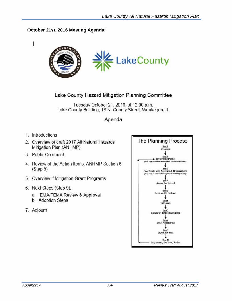
Lake County All Natural Hazards Mitigation Plan
Appendix A A-6 Review Draft August 2017
October 21st, 2016 Meeting Agenda:

Lake County All Natural Hazards Mitigation Plan
Appendix A A-7 Review Draft August 2017
LAKE COUNTY HAZARD MITIGATION PLANNING COMMITTEE PARTICIPATION
Community Representative June 9, 2016
July 19, 2016
Oct. 21, 2016
Action Items
Survey
Village of Antioch Lee Shannon
Village of Bannockburn Geoff Perry
Village of Bannockburn Maria Lasday
Village of Barrington Jim Arie
Village of Barrington Paul Hunt
Village of Barrington Hills Geoff Perry, GWA
Village of Beach Park Gina Nelson
Village of Buffalo Grove Darren Monico
Village of Buffalo Grove Mike Reynolds
Village of Deer Park Dia-Min Lin
Village of Deerfield Barbara Little
Village of Deerfield Justin Keenan
Village of Fox Lake Annette Wolf
Village of Fox River Grove Frank Furlan
Village of Grayslake Kurt Baumann, B&W
Village of Green Oaks Bill Rickert, RHMG
Village of Gurnee Chief Fred Friedl, GFD
Village of Gurnee Dave Ziegler
Village of Hainseville Steve Zehner
Village of Hawthorn Woods Erika Frable
Village of Hawthorn Woods Neil Morgan
City of Highland Park Edgar Jones
City of Highland Park Joe Pasquesi
City of Highland Park Manny Gomez
City of Highland Park Ramesh Kanapareddy
Village of Island Lake Kurt Baumann, B&W
Village of Kildeer Geoff Perry, GHA
Village of Kildeer Mike Talbett
Village of Lake Barrington Chris Martin
Village of Lake Barrington Geoff Perry, GWA
Village of Lake Bluff Drew Irvin
Village of Lake Bluff Jeff Hansen
City of Lake Forest Bob Ells
City of Lake Forest Brian Joyce
Village of Lake Villa Chris Williams

Lake County All Natural Hazards Mitigation Plan
Appendix A A-8 Review Draft August 2017
LAKE COUNTY HAZARD MITIGATION PLANNING COMMITTEE PARTICIPATION
Community Representative June 9, 2016
July 19, 2016
Oct. 21, 2016
Action Items
Survey
Village of Lake Villa Pat Blecke
Village of Lake Zurich Chris Gheysen, Manhard
Village of Lake Zurich Mike Brown
Village of Lakemoor Peter Stoehr, Manhard
Village of Libertyville Paul Kendzior
Village of Lincolnshire Mike Jesse
Village of Lincolnshire Scott Pippen
Village of Lincolnshire Wally Ditrich
Village of Lindenhurst Kurt Baumann, B&W
Village of Long Grove Geoff Perry, GHA
Village of Mundelein Adam Boeche
Village of North Barrington Jacob Wellbank, Robinson Eng.
Village of North Barrington Steve Zehner
City of North Chicago Ed Wilmes
City of Park City Ken Magnus
Village of Port Barrington Mark Rooney
Village of Riverwoods Goeff Perry, GWA
Village of Round Lake Kurt Baumann, B&W
Village of Round Lake Beach Chris Gheysen, Manhard
Village of Round Lake Beach Richard W. Chiarello
Village of Round Lake Beach Scott Hilts
Village of Round Lake Heights Pat Bleck
Village of Round Lake Park Frank Furlan
Village of Round Lake Park Scott Firnbach
Village of Third Lake Gary Beggen, Mayor
Village of Tower Lakes Steve Zehner
Village of Vernon Hills Joe Carey
Village of Volo Jonathan Meyer
Village of Volo Peter Stoehr, Manhard
Village of Wadsworth Moses Amedei
Village of Wauconda Brad Fink
City of Waukegan Mathew Burleson
Village of Winthrop Harbor Kurt Baumann, B&W
City of Zion Chris Nikkinen
Great Lakes Naval Station Molly Schoblocher

Lake County All Natural Hazards Mitigation Plan
Appendix A A-9 Review Draft August 2017
LAKE COUNTY HAZARD MITIGATION PLANNING COMMITTEE PARTICIPATION
Community Representative June 9, 2016
July 19, 2016
Oct. 21, 2016
Action Items
Survey
Lake County PB&D Brian Frank
Lake County CAO Cameron Davis
Lake County PB&D Eric Steffen
Lake County SMC Jeff Laramy
Lake County LCEMA Kent McKenzie
Lake County DOT Kevin Kerrigan
Lake County PB&D Matt Meyers
Lake County PB&D Mea Blauer
Lake County SMC Mike Warner
Lake County SMC Patty Werner
Lake County Health Dept. Rob Scaramella
Lake County SMC Sharon Østerby
Lake County SMC Susan Vancil
Plan Consultant Bob Mack
Plan Consultant Molly O'Toole
56 44 37 25 20


Lake County All Natural Hazards Mitigation Plan
Appendix C C-1 Review Draft August 2017
Appendix B: Public Information Activities Below are samples of public information and public involvement activities that were used during the development of the 2017 ANHMP update, including:
1. Press releases 2. Web site information 3. Lake County e-Newsletter 4. Public Survey via Survey Monkey 5. Survey Monkey Summary 6. Public meeting and public comment announcements 7. Public meeting held on October 21, 2016 8. Frequently asked questions
Public Information Materials:
1. Press Releases:
For Immediate Release
“Public Meeting to Be Held on the Lake County All Natural Hazards Mitigation Plan”
The Lake County Hazard Mitigation Planning Committee is in the process of updating the Lake County All
Natural Hazards Mitigation Plan. An update to the Plan is required every five years by the Federal
Emergency Management Agency. A public meeting will be held on October 21 in Waukegan to review the
proposed changes to the Plan.
The public is invited to attend this meeting and to provide comments on the Plan. The Plan identifies
activities that can be undertaken by both the government and the private sector to reduce the safety
hazards, health hazards, and property damage caused by floods, severe summer and winter storms,
tornadoes, and other natural hazards.
The public meeting on Friday, October 21 at noon at the Lake County Building at 18 North County Street in
Waukegan in the 10th Floor Assembly Room.
"Hazard mitigation" means doing everything that can be done to reduce the impact of the natural hazards
on people and property. It does not necessarily mean controlling floodwaters or stopping tornadoes. These
hazards are natural phenomena and, in many cases, mitigation means adjusting what people do in the face
of this natural activity.
Lake County is subject to natural hazards that threaten life and health and have caused extensive property
damage in the past. Again, while these hazards are acts of nature, the impacts on residents, public facilities,
businesses, and private property can be reduced through hazard mitigation.
The update to the Lake County All Natural Hazards Mitigation Plan will be considered by the Lake County
Board for adoption, and also for adoption by the Lake County municipalities that participated on the
planning process. After the Plan is adopted, Lake County and the participating municipalities will continue
to be eligible for hazard mitigation grant funding through the Illinois Emergency Management Agency and
the Federal Emergency Management Agency.
For more information, contact Sharon Østerby of Lake County SMC at 847-377-7706.
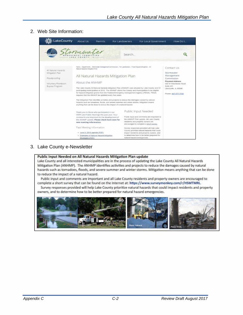
Lake County All Natural Hazards Mitigation Plan
Appendix C C-2 Review Draft August 2017
2. Web Site Information:
3. Lake County e-Newsletter

Lake County All Natural Hazards Mitigation Plan
Appendix C C-3 Review Draft August 2017
4. Public Survey via Survey Monkey:
5. Public Survey Summary:
Summary of “Survey Monkey” Findings
A ten-question survey was provided to Lake County residents online and on paper in 2011 and 2016. The online version was available at “Survey Monkey” and the paper survey was provided at municipal buildings. A summary of the survey results are provided after the questions below. Q1. What community do you live in?
16 responses from 23 municipalities and unincorporated Lake County. Q2. In approximately the past 10 years, have you or someone in your household
experienced a natural disaster? Check all that apply.
Answer Options 2016 2011
Severe Summer Storm 71% 59%
Winter Storm 70% 80%
Extreme Heat 46% 45%
Flood 32% 25%
Drought 17% 7%
Sewer Backup 14% 7%
Tornado 13% less than 5%

Lake County All Natural Hazards Mitigation Plan
Appendix C C-4 Review Draft August 2017
Other 5% less than 5%
Earthquake 2% less than 5%
Q3. What natural hazards concern you the most FOR YOUR FAMILY? Results shown
by most concern to least concern.
Answer Options 2016 2011
Tornado 57% 66%
High wind/microburst 52% 55%
Snow storm 40% 40%
Flood 37% 39%
Ice storm 35% 33%
Extreme cold 32% 22%
Hail 28% 22%
Sewer backup 25% 19%
Extreme heat 24% 20%
Groundwater 22% 35%
Lightning 22% 36%
Thunderstorm 21% 25%
Drought 12% 4%
Severe shoreline erosion 9% 1%
Earthquake 4% 4%
Other 3% 0%
Dam Failure 1% 0%
Q4. What natural hazards concern you the most FOR YOUR COMMUNITY? Results
shown by most concern to least concern.
Answer Options 2016 2011
Tornado 62% 67%
High wind/microburst 50% 57%
Flood 48% 61%
Snow storm 39% 45%
Ice storm 33% 33%
Groundwater 29% 30%
Extreme cold 28% 15%
Hail 23% 13%
Extreme heat 22% 19%
Lightning 20% 32%
Sewer backup 18% 17%
Thunderstorm 18% 26%
Severe shoreline erosion 18% 3%
Drought 14% 8%
Earthquake 5% 7%
Dam Failure 3% 3%
Other 2% 1%
Q5. How prepared do YOU feel for natural hazards likely to occur within Lake County?

Lake County All Natural Hazards Mitigation Plan
Appendix C C-5 Review Draft August 2017
Response 2016 2011
Not at all prepared 10% 15%
Somewhat prepared 51% 45%
Adequately prepared 26% 26%
Well prepared 11% 6%
Very well prepared 2% 8%
Q6. What steps have you or someone in your household taken to prepare for a natural disaster? Check all that apply.
Answer Options 2016 2011
Flashlight 91% 97%
Batteries 78% 86%
Fire extinguisher 73% 73%
Medical supplies (First Aid Kit) 63% 63%
Battery-powered radio 53% 46%
Water 51% 56%
Food 43% 51%
Received First Aid/CPR training 39% 38%
Discussed utility shutoffs 29% 26%
Practiced a fire escape plan 22% 27%
Other 7% 11%
Q7. What are the most effective ways for you to receive information on how to protect
your household and property from damage due to natural disasters? Check all that apply.
Answer Options 2016 2011
Websites 66% 72%
Television 44% 58%
Twitter/Facebook 41% 8%
Mail 39% 35%
How prepared do YOU feel for natural hazards likely to occur within Lake County?
Not at all prepared
Somewhat prepared
Adequately prepared
Well prepared
Very well prepared

Lake County All Natural Hazards Mitigation Plan
Appendix C C-6 Review Draft August 2017
Fact sheet/brochure 39% 40%
Radio 33% 40%
Municipal/County Government 32% 37%
Fire Department/Law Enforcement 26% 24%
Newspapers 20% 21%
Public Health Department 15% 15%
Public Workshops/Meetings 14% 9%
Schools 13% 15%
Extension Service 3% 1%
Other 3% 6%
Q8. How do you feel your community is doing to make people aware of the natural
hazards that they may face?
Response 2016 2011
Excellent 7% 7%
Good 37% 40%
Fair 40% 32%
Poor 11% 12%
None 5% 9%
Q9. Lake County and participating municipalities are currently updating the Lake County
All Natural Hazards Mitigation Plan. Do you have any questions or comments about the Plan or the process?
There were 44 responses in the 2016 survey to this question (25 in 2011). Several people
noted that their community is working on flood projects, including drainage and levees. Sirens and warning were also included multiple times. Manmade hazard concerns included derailments, hazardous waste, radon gas, lead paint and mold.
In 2011, many respondents noted that they had never heard of hazard mitigation or that
How do you feel your community is doing to make people aware of the natural hazards that they may face?
Excellent
Good
Fair
Poor
None

Lake County All Natural Hazards Mitigation Plan
Appendix C C-7 Review Draft August 2017
the topic was very new to them. Numerous people were interested is seeing the ANHMP. People requested more information on warnings and sirens. Other folks requested text alerts or social media information about hazards and mitigation.
Q10. If you would like to learn more about the All Natural Hazards Mitigation Plan update process, please provide your e-mail address below.
Sixty respondents provided their e-mail address (compared to thirty-two in 2011).

Lake County All Natural Hazards Mitigation Plan
Appendix C C-8 Review Draft August 2017
6. Public meeting and public comment announcements:
7. Public meeting held:

Lake County All Natural Hazards Mitigation Plan
Appendix C C-9 Review Draft August 2017

Lake County All Natural Hazards Mitigation Plan
Appendix B B-10 Review Draft August 2017
8. Frequently asked questions:
Lake County All Natural Hazards
Mitigation Plan – 2017 Update
Frequently Asked Questions
(ANHMP Update FAQs)
January 2017
• What is the Lake County All Natural Hazards Mitigation Plan?
The Lake County All Natural Hazards Mitigation Plan (ANHMP) is a plan that addresses natural hazards that may impact Lake County, such as floods, severe summer storms, winter storms and tornadoes, and identifies activities that can be undertaken by both the public and the private sectors to reduce safety hazards, health hazards, and property damage caused by natural hazards. While the ANHMP was developed countywide, it is considered to be a “multi-jurisdictional plan.”
• Why was the ANHMP developed? Having an adopted mitigation plan allows Lake County and participating Lake County municipalities to be eligible for mitigation grant funds from the Federal Emergency Management Agency (FEMA). The ANHMP was developed to fulfill the federal mitigation planning requirements of Section 104 of the Disaster Mitigation Act of 2000 and the Stafford Act for funding under the FEMA Hazard Mitigation Assistance (HMA) grant programs. The ANHMP is also eligible for credit for communities that participate in FEMA’s Community Rating System (CRS) under the National Flood Insurance Program.
• Who developed the ANHMP? The ANHMP was developed through a mitigation planning committee that included Lake County, participating Lake County municipalities and other stakeholders, and through the assistance of a planning consultant. The mitigation planning committee (now called the Hazard Mitigation Planning Committee or HMPC) was established as a permanent advisory body to Lake County in 2006 and has been meeting annually.
• Why update the ANHMP? FEMA requires hazard mitigation plans to be updated and re-adopted every five (5) years.
• What was the update “process”? Our update process included four meetings of the HMPC to review the ANHMP’s goals and action items, and the draft updated plan. We also requested information from municipalities regarding mitigation activities of the past five years. A draft of the updated ANHMP was made available for public review and a public hearing/meeting was held on October 21, 2016. Public comments were collected and IEMA and FEMA have reviewed and approved the plan. The County and participating municipalities must adopt the updated ANHMP. The final plan is available at: https://www.lakecountyil.gov/2369/All-Natural-Hazards-Mitigation-Plan.
• The ANHMP is considered multi-jurisdictional. Is this the same as “countywide”? No, the ANHMP is not a countywide plan like the Lake County Stormwater Management Plan. FEMA allows for the multi-jurisdictional development of hazard mitigation plans. Each government agency

Lake County All Natural Hazards Mitigation Plan
Appendix C C-11 Review Draft August 2017
must adopt and implement the ANHMP for its own purposes. The County Board adoption of the ANHMP is for unincorporated areas of the County. Each municipality must adopt the ANHMP for themselves.
• How do we adopt the ANHMP? By resolution. Communities have been provided with a sample adoption resolution and instructions on where to send a copy of the resolution for IEMA and FEMA’s records.
• If we don’t adopt the 2017 ANHMP will our community is eligible for IEMA/FEMA disaster assistance following a disaster declaration for Lake County? Yes. This ANHMP is for the mitigation grant purposes. It is not tied to disaster assistance. Recognize that often mitigation projects come to light following a disaster. It is prudent to have an adopted mitigation plan.
• Who will implement the Mitigation Plan? Each municipality, agency and institution that adopts the Mitigation Plan will implement the Mitigation Plan, according to the resolution passed, and as resources (staff time and funding) become available. Ideally, there will be some joint efforts, through the HMPC, with the County, municipalities and townships to implement mitigation actions.
• What are the types of mitigation grants available? Planning grants and project grants. Examples of mitigation planning grants would be for the study of repetitive flood loss areas, or the evaluation of critical facilities to determine if they are disaster resistant. Examples of mitigation project grants would be for floodplain property acquisitions, or construction of a tornado shelter at a senior care facility. All plans and projects are funded 75% by FEMA and 25% by the community or agency.
• How do we apply for a mitigation grant? Mitigation grants are applied for through the IEMA. An online “eGrant” application is used. Communities can contact Ron Davis, the State Hazard Mitigation Officer at IEMA, at 217-782-8719 ([email protected]) for more information.
• What is the FEMA web site for hazard mitigation grants programs? For more information about FEMA mitigation grant programs, or HMA, visit: https://www.fema.gov/hazard-mitigation-assistance Also, visit IEMA’s web site at: https://www.illinois.gov/iema/Mitigation/Pages/default.aspx
• How can I learn more about the Community Rating System (CRS)? Information on the CRS can be found at FEMA’s web site: https://www.fema.gov/national-flood-insurance-program-community-rating-system
• Who do we contact about the ANHMP update?
Feel free to contact Sharon Østerby of the SMC at [email protected] or 847-377-7706.


Lake County All Natural Hazards Mitigation Plan
Appendix C C-1 Review Draft August 2017
Appendix C: Progress on 2012 Action Plan & Comparison to
Current Action Plan
The 2012 All Natural Hazards Mitigation Plan (ANHMP) contained 22 action items that all communities included in their adoption of the ANHMP. The 2012 action items were developed by the Local Planning Committee, which is now the Hazard Mitigation Planning Committee (HMPC). Most action items from 2012 were carried over into the 2017 update of the ANHMP by the HMPC, however the HMPC did reprioritize a number of action items.
Error! Reference source not found.Appendix C-Table 1 gives a status of the 2012 Action items and shows a comparison to the 2017 action items. Community representatives were asked to submit specific community action items, and these items were addressed the items in of the 2017 ANHMP.

Lake County All Natural Hazards Mitigation Plan
Appendix C C-2 Review Draft August 2017
Appendix C
Table 1: 2012 Action Plan Status and 2017 Action Plan Updates
2012 Plan Action Item Status/Progress
2017 Plan Action Item Change/Update
1. Plan Adoption Ongoing 1. Plan Adoption Continued
2. Plan Monitoring and Maintenance Ongoing 2. Participation on the Hazard Mitigation Planning Committee and Plan
Monitoring and Maintenance Continued
3. Improve Natural Hazards Public Information Efforts Ongoing 5
Improve Natural Hazards Public Information Efforts with focus on
the Promotion of Flood Insurance and How People Can Protect
Themselves and Their Property
Continued
4. Development of Flood Stage Maps Not yet
implemented 23 Develop of Flood Stage Maps Reprioritized
5. Property Protection Checklist Retired
6. Improve Emergency Response and Develop Assessment
Teams Ongoing 18 Improve Emergency Response and Develop Assessment Teams Continued
7. Incorporate ANHMP into Other County and Municipal Plans Ongoing 3 Incorporate ANHMP into Other County and Municipal Plans Continued
8. Property Protection Projects Ongoing 10 Implement Property Protection Projects for Flood Mitigation Continued
9. Continue to map natural hazard impacts and continue vulnerability assessments
Ongoing 21 Continue to Map Natural Hazard Impacts and Continue Vulnerability Assessments
Continued
10. Review and Mitigation of Critical Facilities Not yet
implemented 7
Review of Critical Facilities and Implement of Appropriate Mitigation Measures
Continued
11. Seek Mitigation Grant Funding for Additional Mitigation
Planning and Cost Beneficial Projects Ongoing 16
Seek Mitigation Grant Funding for Additional Mitigation Planning
and Cost Beneficial Projects Continued
12. Continued Implementation of the WDO and NFIP
Requirements Ongoing 4 Continued Implementation of the WDO and NFIP Requirements Continued
13. Improve Capacity of Drainage Systems Ongoing 8 Improve Capacity of Drainage Systems and/or Provide Additional
Storage of Flood Waters Continued
14. Implement Maintenance Programs for Drainage Systems Ongoing 9 Implement Maintenance Programs for Drainage Systems, Including
Streambank and Ravine Stabilization Efforts Continued
15. Improve Response & Recovery Information Sharing and Collaboration
Ongoing 19 Enhance Response and Recovery Information Sharing and Collaboration and Identify Additional Training Opportunities
Expanded
16. Continue Work for NIMS Compliance Ongoing 14 Continue Work for NIMS Compliance Continued
17. Alternate Power Sources for Critical Facilities and Shelters Ongoing 6 Identify Needs and Obtain Alternate Power Sources for Critical
Facilities and Shelters Continued
18. Improve Building Codes and Building Code Enforcement Ongoing 15. Improve Building Codes and Building Code Enforcement Continued
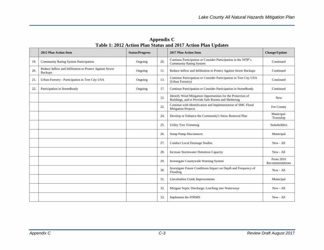
Lake County All Natural Hazards Mitigation Plan
Appendix C C-3 Review Draft August 2017
Appendix C
Table 1: 2012 Action Plan Status and 2017 Action Plan Updates
2012 Plan Action Item Status/Progress
2017 Plan Action Item Change/Update
19. Community Rating System Participation Ongoing 20. Continue Participation or Consider Participation in the NFIP’s
Community Rating System Continued
20. Reduce Inflow and Infiltration to Protect Against Sewer
Backups Ongoing 11. Reduce Inflow and Infiltration to Protect Against Sewer Backups Continued
21. Urban Forestry - Participation in Tree City USA Ongoing 13. Continue Participation or Consider Participation in Tree City USA
(Urban Forestry) Continued
22. Participation in StormReady Ongoing 17. Continue Participation or Consider Participation in StormReady Continued
12.
Identify Wind Mitigation Opportunities for the Protection of
Buildings, and to Provide Safe Rooms and Sheltering New
22.
Continue with Identification and Implementation of SMC Flood
Mitigation Projects For County
24. Develop or Enhance the Community's Snow Removal Plan Municipal-
Township
25. Utility Tree Trimming Stakeholders
26. Sump Pump Disconnects Municipal
27. Conduct Local Drainage Studies New - All
28. Increase Stormwater Detention Capacity New - All
29. Investigate Countywide Warning System From 2010
Recommendations
30. Investigate Future Conditions Impact on Depth and Frequency of
Flooding New - All
31. Lincolnshire Creek Improvements Municipal
32. Mitigate Septic Discharge; Leaching into Waterways New - All
33. Implement the FFRMS New - All


Lake County All Natural Hazards Mitigation Plan
Appendix D D-1 Review Draft August 2017
Appendix D: Resolutions and FEMA Approval
[To be inserted.]