Embed Size (px)
Citation preview

CHARACTERIZING SUBSTRATE AND CHANNEL MORPHOLOGY OF THE KOOTENAI RIVER WHITE STURGEON CRITICAL HABITAT, BOUNDARY COUNTY, IDAHO: ANALYSIS FOR ECOSYSTEM RESTORATION
Gary J. Barton, Rhonda J. Weakland, Ryan L. Fosness, and Marshall L. Williams1
The Kootenai Tribe of Idaho, in cooperation with local, State, Federal, and Canadian agency co-managers and scientists, is accessing the feasibility of a Kootenai River habitat restoration project, Boundary County, Idaho. This project is oriented toward recovery of the endangered Kootenai River white sturgeon (Acipenser transmontanus) population, and simultaneously targets habitat-based recovery of other native river biota. Projects under consideration include modifying the channel and floodplain, installing in-stream structures and creating wetlands to improve the physical and biological functions of the ecosystem. River restoration is a complex undertaking that requires a thorough understanding of the river and floodplain landscape. To assist in evaluating the feasibility of this endeavor, the U.S. Geological Survey has characterized the substrate and channel morphology of the Kootenai River white sturgeon critical habitat. Geohydrologic sections of the Kootenai River and floodplain show the types of sediments available in the river for constructing habitat and location of shallow bedrock that could pose challenges in reconfiguring the channel. The U.S. Geological Survey Idaho Water Science Center uses a 480-channel multibeam echo sounder, an underwater video camera system, and sonic- and vibra-coring technology to characterize substrate and channel morphology. Data from the multibeam echo sounder is used to create bathymetric maps and animations. The animations provide a three-dimensional fly-over of the river channel and show dune bedforms, gravel bars, clay terraces, clay steps, and bedrock, and clearly show where alluvial sand is transported along river bottoms. Videography, titled with precise position, date, and depth, of the river bottoms and photos of exposed substrate are collected with the aid of geographic information software. 1U.S. Geological Survey Idaho Water Science Center
BACKGROUND
The Kootenai Tribe of Idaho, in cooperation with local, State, Federal, and Canadian agency co-managers and scientists, is accessing the feasibility of a Kootenai River habitat restoration project. This project is oriented toward recovery of the endangered Kootenai River white sturgeon (Acipenser transmontanus) population, and simultaneously targets habitat-based recovery of other native river biota (River Design Group, 2009). Projects under consideration include modifying the channel and floodplain, installing in-stream structures and creating wetlands to improve the physical and biological functions of the ecosystem. River restoration is a complex undertaking that requires a thorough understanding of the river and floodplain landscape. To assist in evaluating the feasibility of this endeavor, the U.S. Geological Survey has been developing geohydrologic sections of the Kootenai River and floodplain that show the types of shallow valley-fill sediments available in the river for constructing habitat and the location of shallow bedrock that could pose challenges in reconfiguring the channel. For this study, the criterion for shallow valley-fill sediments and bedrock is less than 15 m below the riverbed and less than 20 m below land surface. Complementing the geohydrologic sections are bathymetric maps of the straight reach and three short segments in the meander reach based on 2008 multibeam echosounder surveys. These maps show in detail the major morphological features in the river in the study area and are used to describe the relation between geology and channel morphology (fig. 2).
The Kootenai River white sturgeon is a naturally landlocked, locally-adapted population that has been isolated since the last glacial age approximately 10,000 years ago. There has been a well-documented decline in sturgeon recruitment over the past 50 years (Partridge, 1983; U.S. Fish and Wildlife Service, 1999; Paragamian and others, 2005). The sturgeon was listed as endangered under the Endangered Species Act (ESA) in 1994.
Kootenai River white sturgeon spawn near Bonners Ferry, Idaho. A graph of spawning events per unit of monitoring effort during 1994-2001 shows that the sturgeon spawn in the meander reach between river kilometer (RKM) 228 and 240, with a few events observed in the straight reach between RKMs 245.0 and 245.8 (fig. 1). Kootenai River white sturgeon critical habitat (WSCH) includes a small portion of the meander reach, the straight reach, and a portion of the braided reach from RKM 228 to 252.7 (U.S, Fish and Wildlife Service, 2000 and 2006; and 2008 final ruling in 73 FR 39505).Sedimentation has been presented as a likely cause of mortality for sturgeon embryos (Kock and others, 2006). A series of research investigations determined that sturgeon were spawning over
unsuitable incubation and rearing habitat—sand–in the meander reach, and that survival of eggs and larvae was minimal (Paragamian and others, 2002). Currently, less than 30 percent of tagged sturgeon spawners swim upstream of the meander and straight reach into the braided reach where substrate better for egg incubation, only to briefly inhabit the lowermost part of the reach, before swimming back downstream to the meander or straight reach to spawn (Pete Rust, Idaho Department of Fish and Game, oral commun., 2008).
GEOLOGIC HISTORY During the Pleistocene age the Kootenai Valley experienced multiple glacial advances and retreats, resulting in
the periodic formation of glacial ice-dams that temporarily blocked drainages causing inundation of large areas within and adjacent to an unknown number of ancestral drainages (Alden, 1953). During glacial maximums, ice filled the Kootenai River valley and overrode much of the Purcell and Selkirk Mountains in northern Idaho. The most recent glacial retreat from the valley occurred about 10,000 years ago. Glaciation was dynamic and changed with time because the glaciers were not constant in their properties nor fixed in position (Ritter, 1978). This glacial history created a complex sequence of deposition and erosion that formed heterogeneous, interbedded valley-fill sediments along the valley bottom. These sediments are of both glacial and inter-glacial origin. Depositional environments in the study area likely included ice-contact deposition, proglacial outwash and lake deposition, and inter-glacial alluvial settings.
The present day course of the Kootenai River in the study area is controlled by Precambrian and Cretaceous bedrock at several locations and by Quaternary lacustrine clay (fig. 2). The river courses through valley-fill sediment composed of interbedded silts and clays of glaciolacustrine origin and sands, gravels, and cobbles of fluvial and glaciofluvial origin. Most gravels and sand were deposited during the cyclic retreat of the Purcell Trench Lobe (Atwater, 1986; Buchanan, 1989). As the Purcell Trench Lobe retreated to the north, Glacial Lake Kootenay was formed behind the ice dam and silts and clays were deposited in the lake. Some gravels and cobbles occur in the alluvial fan deposits associated with tributaries flowing off the flank of the Selkirk Mountains. Lacustrine clays and silts are common in the Kootenai Flats and along the flanks of the mountains bordering the valley.
MAPPING BATHYMETERY AND SEDIMENT FACIES, AND CORING SUBSTRATE An Odom ES3 multibeam echo sounder (MBES) was used to map the elevation of the Kootenai River channel
during 2008 at several locations in the straight and meander reaches (fig. 2). This MBES system has a flat-array transducer that sends out a 240 kHz pulse over a 120 degree swath width and consists of 120 to 480 beams, and the beam widths range from 0.75 to 3.0 degrees. The MBES operates in water depths from 0.5 to 60 m. The MBES is coupled to a (1) DMS-10 motion sensor with a dynamic accuracy of 0.07 degrees, (2) pair of differential GPS antennas that measure heading with an accuracy of 0.25 degrees, (3) real-time kinematic GPS for positioning with a vertical accuracy of 4 cm, and (4) velocimeter that measures sound velocity at the MBES transducer head with an accuracy of 0.2 m/s. In most areas the MBES survey collected several soundings per square meter of river bottom. Data acquisition and processing was accomplished using Odom and Hypack software systems. MBES data was also processed into animations that provide a three-dimensional fly-over of the river channel.
An underwater, high resolution, color video camera with adjustable light intensity and a 79° field of view was suspended vertically in the water column and used to capture the video imagery of the sediment facies. Two underwater laser pointers were mounted on the outside of the camera housing, positioned in parallel, and pointed downward to illuminate a reference scale of 10.2 cm on the river bottom. Pinnacle Studio video software was used to make the recordings. A NEMA 0183 GGA signal from a mapping-grade GPS receiver was output to a video titler in order to add date, time, and geographic coordinates to the recordings. Video imagery was captured at discrete points across the reach. The facies map was created with geographic information software using the following substrate categories: bedrock, boulder (>256 mm), cobble (>64-256 mm), gravel (>2-64 mm), sand/fines (<2 mm), clay, and riprap. More than 1,200 images of the river bottom were analyzed (fig. 3).
Sediment cores were taken at 24 locations in 2007 (fig. 1, table 1). Core depths ranged from 4.6 to 15.2 m with 21 cores reaching a depth of 15.2 m. A maximum coring depth of 15.2 m below the riverbed was established for the coring program because channel modifications under consideration are not likely to extend to depths much greater than 15.2 m (Dave Rosgen, Wildland Hydrology, written commun., 2007). Sediment and bedrock was cored from a 6 m by 12 m drill barge. A track-mounted sonic drill was mounted on the drilling barge and collected continuous cores of the sediments beneath the riverbed with a 15.2-cm ID stainless steel core barrel (fig. 4). Site locations for the sediment cores were established by aligning sites with a conceptual river design provided by KTOI and choosing sites near bedrock that could impede realigning the channel. The spacing of the cores was not evenly distributed, but

focused on key areas where examination of the geology would provide the most necessary insight. Previous core samples collected by the U.S. Geological Survey (USGS) during 2000 and 2004 (Barton, 2004; Berenbrock and Bennet, 2005) provided insight into the geology within the meander reach and some insight into the straight reach; an important goal of the 2007 coring effort was to learn more about the geology of the straight and braided reach.
GEOHYDROLOGIC SECTIONS OF THE KOOTENAI RIVER AND FLOODPLAIN USGS has developed 34 geohydrologic sections of the Kootenai River braided, straight, and meander reaches,
and six sections are presented in this report, three are located where MBES bathymetric surveys also were conducted (figs. 5). The geographic information system based software Arcmap (ESRI) and associated module CrossView (A-prime, Inc) were used to generate the geohydrologic sections. These geohydrologic sections integrate several data sets: (1) land surface elevations from a 2005 light detection and ranging (LiDAR) survey that the KTOI contracted; (2) channel bathymetry mapped by the USGS in 2002, 2003, and 2005 using a single-beam echo sounder (Barton and others, 2009) and mapped in 2008 using a MBES system; (3) a regional surficial geology map (Miller and Burmester, 2004); (4) USGS lithologic logs from the 2002and 2004 (Barton, 2004; Berenbrock and Bennett, 2005), and 2007 Kootenai River coring program that range in depth from less than 1 m to 15.2 m; (5) Idaho Department of Water Resources (IDWR) driller logs for water wells that range in depth from 8 to greater than 30 m; (6) river bottom sediment facies data; and, (7) river stage (Barton and others, 2009). Considering the heterogeneous and interbedded nature of the valley-fill sediments and lack of wells, the geology between lithologic strip logs in the geohydrologic sections is not mapped.
KOOTENAI RIVER SUBSTRATE AND CHANNEL MORPHOLOGY
The braided reach is actively changing course and flows over gravel, cobbles, some sand, and a few areas of bedrock. This 11.1 kilometer reach extends from RKM 257 below the Moyie River to RKM 245.9 at Bonners Ferry. This reach is mostly a multi-threaded channel with about 3 kilometers as a single-threaded channel (fig.1). The channel has many gravel bars, sloughs, and islands. Many of the side sloughs are dry during periods of low flow. The course of the Kootenai River in the upper part of the braided reach near Crossport is constrained by bedrock outcrops along the left bank between RKM 256. 3 and 255.8 with scour pool, along the right bank from RKM 254.1 to 253.8 and from RKM 253.6 to 253.25 with scour pool, and along the left bank between RKM 252.8 and 252 (fig. 1). Bedrock along the left bank, roughly located between RKM 246.6 and 246.9, is mostly concealed by sediment and soil and provides a fixed lateral boundary that redirects the river’s southwesterly course to a northwesterly course. The braided reach has the most extensive gravel and cobble riverbed in the study area. Gravel and cobble form a massive layer beneath the braided reach channel (fig. 5, sections A-A’ and B-B’), the source of most of the gravel and cobble is upstream in the canyon reach (Fosness and Williams, 2009). At each of eight 2007 core sites in this reach, the gravel and cobble deposits extend to depths greater than the total core depth of 15.2 m. At RKM 245.9, gravel extends more than 30 m below the riverbed. This layer is considered massive because sand forms only a few thin layers in 5 of the 8 braided reach 2007 cores and clay formed a thin layer in one 2007 core. Maximum thickness for all these minor sand and clay layers is only 1.5 m. When stream flow is 850 cubic meters per second (m3/s), the average water depth in the braided reach is about 3 m (meters) is generally less than other parts of the river, and the average and maximum velocity is about 1.2 and 2.8 meters per second (m/s; Barton and others, 2009).
Downstream of the braided reach is a short straight reach that lies completely in the WSCH between RKMs 245.9 and 244.5 and forms a transition zone between the braided reach and meander reach. The channel is single threaded except the upstream half of the reach during low flow when gravel bars are exposed. Substrate in the straight reach consists of gravel, sand, traces of cobble, and bedrock. Bedrock crops out at several small areas along the right bank. Ambush Rock, a large outcrop along the left bank at the downstream end of this reach, provides a fixed lateral boundary that redirects the river’s westerly course to a northwesterly course resulting in a large permanent scour hole (figs. 2d and 5, section C-C’). At the base of the outcrop is rock rubble on the riverbed (fig. 3a). MBES bathymetry (fig. 2d) shows that the upstream half of the straight reach has large gravel bars. Downstream of these bars the gravel riverbed becomes progressively more embedded till at about RKM 244.8 where it is completely embedded with sand. MBES bathymetry also shows sand bedforms, dunes, forming part of the channel predominantly along the left side of the channel between RKM 244 and 245.5 (fig. 2d) and below 244.8 sand covers most of the channel except the deepest parts of the scour hole at Ambush Rock. Cores in the straight reach generally show alternating layers of sand and gravel-cobble beneath the riverbed with sand tending to become more dominant in the downstream direction (fig. 5, section C-C’). When stream flow is 850 m3/s the average and maximum depth and velocity in this reach are about 4 and 23 m and 0.9 and 1.3 m/s (Barton and others, 2009).
The WSCH meander reach is located downstream of the straight reach. Bedrock outcrops at RKM 240.8 and RKM 240.9. Less than a kilometer upstream of Deep Creek, granodiorite outcrops are in the center of the channel at RKM 240.9, and on the left bank at RKM 240.8 (fig. 1). Both outcrops are inundated except during low streamflows. Next to the outcrop on the left bank is a large scour hole. When stream flow is 850 m3/s the average and maximum depth and velocity in the meander reach is about 7 and 23 m and 0.6 and 1.1 m/s (Barton and others, 2009).
The WSCH meander reach is mostly a sand riverbed entrenched in the lacustrine clay valley (fig. 3a). The MBES bathymetry show sand forms a mobile streambed consisting mainly of dune bedforms (fig. 2). Dune amplitudes are sometimes greater than 1 m (Barton and others, 2005). The alluvial sand forms a laterally extensive layer. For example, a MBES survey in a straight segment between RKM 241 and 241.5 shows sand dunes across the entire width of the channel (fig.2c). Core TB-21, located just upstream of Myrtle Creek near RKM 235, penetrated sand extending from the riverbed to beyond the total core depth of 14.2 m (fig. 1). Cores TB-23 and TB-1 at RKM 231.5 and 243.7 penetrated 10 and 8 m of sand. Many of the 2000 and 2004 vibracores penetrated sand that extended from the riverbed to beyond the total core depth of 3.5 m (Barton, 2004; Berenbrock and Bennett, 2005). In general, sand layers are generally thicker along the insides of meander bends where sand point bars are deposited as compared to the outside of meander bends where the thalweg and cut banks are often incised into lacustrine clay.
In the WSCH meander reach, lacustrine clay is generally exposed in the channel as a series of steep steps and narrow flat shelves with clay rubble at the base of clay steps (figs. 3b, c, and d). The rubble often has the appearance of gravel and cobble. The clay is most frequently found in meander bends at cut banks and the thalweg. Downstream of Myrtle Creek near RKM 243.2, MBES bathymetry shows large clay steps that straddle both sides of the thalweg and videography showed clay rubble at the base of these clay steps (figs. 2b and 5, section E-E’). Further downstream, MBES bathymetry shows a large clay shelf with a very steep clay step in the major channel near Shortys Island between RKM 231.5 and 230.2 (figs. 2a and 5, section F-F’) and there is a somewhat smaller clay shelf between RKM 229.3 and 229.7; the clay at each location is between the center of the channel and the right bank. The 2007 core TB-23 at RKM 231.5, upstream of the clay shelf at Shortys Island, penetrated 10 meters of sand and then 5 m of lacustrine clay and did not penetrate through the clay layer. Several of the 2000 and 2004 vibracores penetrated clay that extended from the riverbed to beyond the total core depth of 3.5 m (Barton, 2004; Berenbrock and Bennett, 2005; fig. 5, sections D-D’ and F-F’).
The WSCH meander reach has few small patches of gravel riverbed. Much of the gravel in the meander reach is in lag deposits left behind after the finer silt and sand have been transported downstream and the river lacks sufficient energy to move the coarser sediment (Barton and others, 2005 and 2009). Video taken of the riverbed during the past 3 years and the USGS 2000 and 2004 vibracoring show gravel lag deposits in the meander reach can be heavily embedded or buried with sand and silt during periods of low streamflow and flushed free of the fine sediment during periods of sustained high flow (McDonald and others, 2006). Rip-rap consisting of shot rock, boulders and cobble placed on dikes in select locations form bank armoring.
In the WSCH meander reach, the 2007 coring program has identified two locations where the riverbed substrate has gravel and cobble layers that are several meters thick or greater. Less than 1 kilometer downstream of the straight reach at RKM 243.7, core TB-1 (fig. 1) penetrated a massive gravel layer that is more than 6 meters thick and buried by about 9 m of alluvial sand. This gravel extends to a depth beyond the total core depth of 14.2 m below the riverbed. About a half kilometer downstream of Myrtle Creek at RKM 234.3 along the valley margin, core TB-22 penetrated a massive layer of gravel and cobble that extends to a depth beyond the total core depth of 14.2 m below the riverbed (fig. 5). Roughly 0.5 km to the northeast and east is the equally deep IDWR water well 62N 01W 12BA and core TB-21 and both only penetrate sand, silt and clay (figs. 1 and 5, section E-E’). Based on the local geologic data, it appears that the massive gravel-cobble layer at TB-21 has a limited lateral extent. The subrounded nature of gravel and cobble in core TB-22 and the limited lateral extent suggests that a proglacial stream deposited these coarse-grained sediments.
ACKOWLEDGEMENTS Project is supported by funding from the Kootenai Tribe of Idaho and the Bonneville Power Administration, and
the USGS Cooperative Water Program. Authors thank the people of the Kootenai River Valley who provided access to the river for surveying. Kootenai Tribe of Idaho contracted the 2007 coring barge and drill rig and provided storage facilities for USGS boats and equipment and provided logistical support.
REFERENCES Alden, W.C., 1953, Physiography and glacial geology of Western Montana and adjacent areas: U.S. Geological
Survey Professional Paper 231, 200 p. Atwater, F.A., 1986, Pleistocene glacial-lake deposits of the Sanpiol River valley, northeastern Washington: U.S.
Geological Survey Bulletin 1661, 39 p. Barton, G.J., 2004, Characterization of channel substrate, and changes in suspended sediment transport and channel
geometry in white sturgeon spawning habitat in the Kootenai River near Bonners Ferry, Idaho, following the closure of Libby Dam: U.S. Geological Survey Water-Resources Investigations Report 03-4324, 102 p. Available at http://id.water.usgs.gov/PDF/wri034324/new034324-5_19.pdf
Barton, G.J., McDonald, R.R., Nelson, J.M., and Dinehart, R.L, 2005, Simulation of flow and sediment mobility using a multidimensional flow model for the white sturgeon critical-habitat reach, Kootenai River near Bonners Ferry, Idaho: U.S. Geological Survey Scientific Investigations Report 2005-5230, 54 p. Available at http://pubs.usgs.gov/sir/2005/5230/pdf/sir20055230.pdf
Barton, G.J., McDonald, R.R., and Nelson, J.M., 2009, Simulation of streamflow using a multidimensional flow model for white sturgeon habitat, Kootenai River near Bonners Ferry, Idaho—A supplement to Scientific Investigations Report 2005–5230: U.S. Geological Survey Scientific Investigations Report 2009-5026, 34 p.
Berenbrock, Charles, and Bennett, J.P., 2005, Simulation of flow and sediment transport in the white sturgeon spawning habitat of the Kootenai River near Bonners Ferry, Idaho: U.S. Geological Survey Scientific Investigations Report 2005-5173, 43 p. http://pubs.usgs.gov/sir/2005/5173/
Buchanan, J.P., 1989, Reconnaissance hydrogeologic study of the Kootenai River valley near Bonners Ferry, Idaho: Upper Columbia United Tribes Fisheries Center Fisheries Technical Report no. 25, variously paged.
Fosness, R.L., and Williams, M.L., 2009, Sediment characteristics and transport in the Kootenai River white sturgeon critical habitat near Bonners Ferry, Idaho: U.S. Geological Survey Scientific-Investigations Report 2009-5228, 40 p.
Kock, T. J., Congleton, J.L., and Anders, P.J., 2006, Effects of sediment cover on survival and development of white sturgeon embryos: North American Journal of Fisheries Management 26:1, 134-141.
McDonald, R.R., Barton, G.J., Nelson, J.M., and Paragamian, V., 2006, Modeling hydraulic and sediment transport processes in white sturgeon spawning habitat on the Kootenai River: proceeding in the Joint 8th Federal Interagency Sedimentation and 3rd Federal Interagency hydrologic modeling conference, 8 p. http://pubs.usgs.gov/misc_reports/FISC_1947-2006/pdf/1st-7thFISCs-CD/8thFISC/8thFISC_McDonald.pdf
Miller, F.K. and Burmester, R.F., 2004, Geologic map of Bonners Ferry 30 minute by 60 minute quadrangle, Idaho and Montana: U.S. Geological Survey misc. field studies map, MS-2426.
Paragamian, V. L., Kruse, G., & Wakkinen, V. D. 2002. Spawning locations and movement of Kootenai River white sturgeon. Journal of Applied Ichthyology 18:608-616.
Paragamian, V.L., Beamesderfer, R.C., and Ireland, S.C., 2005, Status, population dynamics, and future prospects of the endangered Kootenai River white sturgeon population with and without hatchery intervention–Spawning locations and movement of Kootenai River white sturgeon: Transactions of the American Fisheries Society, v. 134, 14 p.
Partridge, F., 1983, Kootenai River fisheries investigation: Idaho Department of Fish and Game General Aid to Fish and Wildlife Restoration Job Completion Report F-73-R-5, variously paginated.
Ritter, D.F., 1978, Glacial erosion, deposition and landforms, in process geomorphology: Dubuque, Iowa, Wm C. Brown, 404 p.
River Design Group, Inc., 2009, Kootenai River habitat restoration master plan: Whitefish, Montana, variously paginated.
U.S. Fish and Wildlife Service, 1999, Recovery plan for the Kootenai River population of the white sturgeon (Acipenser transmontanus): Portland, Oregon, variously paginated.
U.S. Fish and Wildlife Service, 2000, Biological opinion on effects to listed species from operation of the Federal Columbia River Power System: Portland, Oreg., U.S. Fish and Wildlife Service, variously paginated.
U.S. Fish and Wildlife Service, 2006, Biological opinion on effects to listed species from operation of the Federal Columbia River Power System: Portland, Oreg., U.S. Fish and Wildlife Service, variously paginated.

Libby Dam
EXPLANATION River kilometer
Upstream boundary for Kootenai River white sturgeon critical habitat reach, downstream boundary shown as thinner line.
U.S. Geological Survey permanent gaging station, streamflow, velocity, and temperature, and identifier. Yellow triangle indicates stage only gaging station Location and identifier of substrate core sites and water wells. Details all 2007 sonic cores and all cores and water wells presented in geohydrologic sections are provided in table 1. Some 2007 cores are not shown. Line of geohydrologic section.
Figure 1. Location of white sturgeon critical habitat, sturgeon spawning events during 1994-2001, coring substrate sites, water wells, and stream-gaging stations, Kootenai River near Bonners Ferry, Idaho.
116o 13’
Braided Reach
Meander Reach
+ 230
255 +
+ 240
12309500
12310100
+ 255
+ 230
Straight Reach
48o
43’ 48o 43’
Figure location
12310100
48o 47’
116o 13’
48o
47’ Kootenay Lake
+ 235
*TB‐20
TB‐17*
*TB‐16
TB‐23*
TB‐1 *
*TB‐21 *TB‐22
TB‐1**TB‐5
*TB‐12+2457‐RB, 7‐C*
61N 01E 27BB*
C
C’
E
E’
F’
F
B’
* 62N 01W 12BA
*KK6‐TH, K6‐RB
K6‐LB* SI‐4
*
* 62N 01E 23BA
* 62N 01E 23AD
62N 01E 25BC *B
62N 02E 20CC *
62N 02E 29BB *A
A’
62N 01E 19CB D
D’*K16‐C2K16‐LB
**
Purcell Mountains
Selkirk Mountains
* 21‐TH
+ 250
Ambush Rock
Crossport
Bonners Ferry
Deep Creek
Myrtle Creek
Kootenai River
A‐‐‐A’
*TB‐21


Figure 3. Underwater photographs showing types of substrate that form the bed of the Kootenai River, near Bonners Ferry, Idaho, 2007‐09. Information displayed on photographs include coordinates as NAD83, date, time, and one photograph has depth to bottom in meters (DBT). Laser scale is 10.5 centimeters.
A. Bedrock and rock rubble.
H. Logs and other organic debris. G. Sand forming dunes and ripples.
F. Gravel embedded with sand. E. Clean, poorly sorted gravel and cobble.
D. Clay rubble at base of clay step. C. Nearly vertical lacustrine clay step.
B. Nearly horizontal lacustrine clay shelf.

Figure 4. Coring substrate with sonic drill mounted on drilling barge, Kootenai River, Idaho, 2007. (Photos by Gary Barton)
4

Location of hydrogeologic sections is shown in figure 1. Summary information on the river substrate cores and water wells shown in hydrogeologic cross sections is provided in table 1. Figure 5. Hydrogeologic sections of the Kootenai River near Bonners Ferry, Idaho.
A A’
Modeled stage for high flow of 1,730 cubic-meets per second on 6/18/2006 (Barton and others, 2009)
Modeled stage for low flow of 144 cubic-meets per second on 2/16/2009 (Barton and others, 2009)
Modeled stage for mean annual peak flow of 983 cubic-meets per second during 10/01/1993 to 9/30/2007 (Barton and others, 2009)
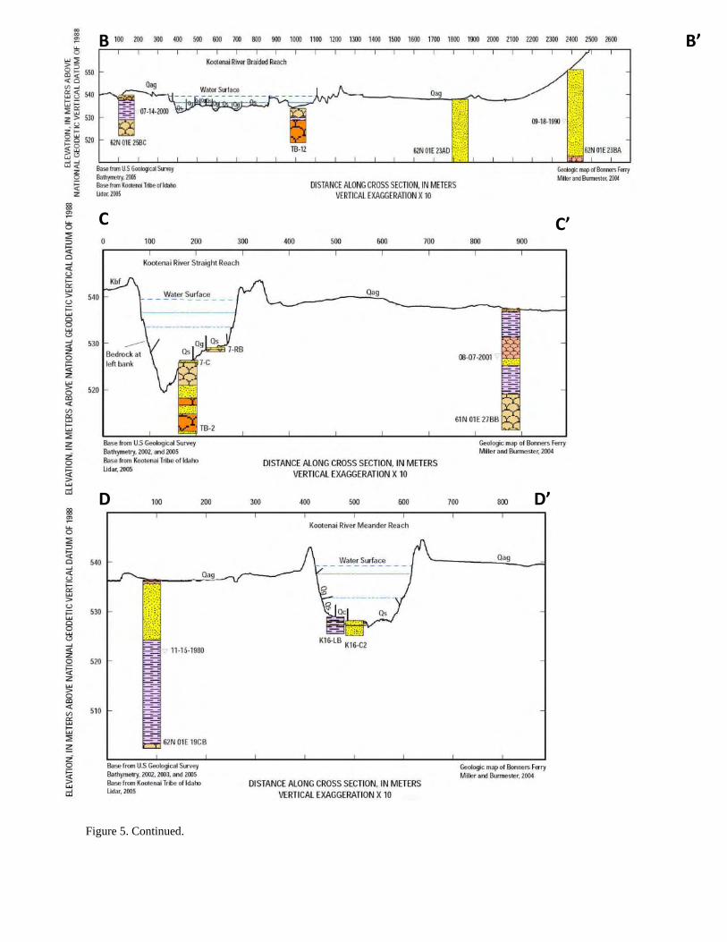
Figure 5. Continued.
B B’
D D’
C C’

Figure 5. Continued.
E E’
F’ F


![Influence of mesoporous substrate morphology on the ... · [29]. In order to study the effect of PS substrate on the physical and transport characteristics of ZnO, thin films were](https://img.dokumen.tips/doc/110x75/5fa8b57eccc7c62a0110677f/influence-of-mesoporous-substrate-morphology-on-the-29-in-order-to-study.jpg)