Embed Size (px)
Citation preview
JANUARY 2014 1
Knife River Flint and Other Siliceous Rocks in Western North Dakota
Ed Murphy
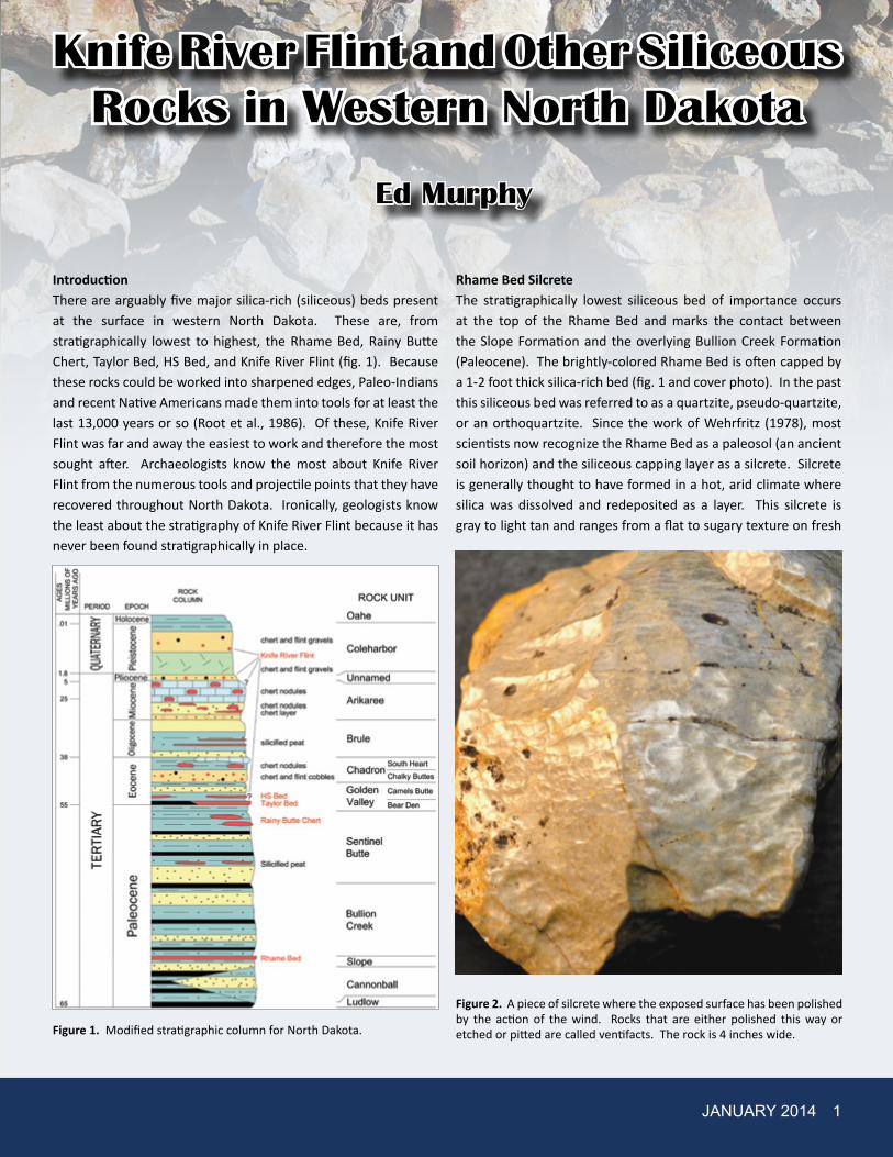
IntroductionThere are arguably five major silica-rich (siliceous) beds present at the surface in western North Dakota. These are, from stratigraphically lowest to highest, the Rhame Bed, Rainy Butte Chert, Taylor Bed, HS Bed, and Knife River Flint (fig. 1). Because these rocks could be worked into sharpened edges, Paleo-Indians and recent Native Americans made them into tools for at least the last 13,000 years or so (Root et al., 1986). Of these, Knife River Flint was far and away the easiest to work and therefore the most sought after. Archaeologists know the most about Knife River Flint from the numerous tools and projectile points that they have recovered throughout North Dakota. Ironically, geologists know the least about the stratigraphy of Knife River Flint because it has never been found stratigraphically in place.
Rhame Bed SilcreteThe stratigraphically lowest siliceous bed of importance occurs at the top of the Rhame Bed and marks the contact between the Slope Formation and the overlying Bullion Creek Formation (Paleocene). The brightly-colored Rhame Bed is often capped by a 1-2 foot thick silica-rich bed (fig. 1 and cover photo). In the past this siliceous bed was referred to as a quartzite, pseudo-quartzite, or an orthoquartzite. Since the work of Wehrfritz (1978), most scientists now recognize the Rhame Bed as a paleosol (an ancient soil horizon) and the siliceous capping layer as a silcrete. Silcrete is generally thought to have formed in a hot, arid climate where silica was dissolved and redeposited as a layer. This silcrete is gray to light tan and ranges from a flat to sugary texture on fresh
Figure 1. Modified stratigraphic column for North Dakota.
Figure 2. A piece of silcrete where the exposed surface has been polished by the action of the wind. Rocks that are either polished this way or etched or pitted are called ventifacts. The rock is 4 inches wide.
2 GEO NEWS
surfaces and from earthy to waxy on exposed surfaces. The waxy appearance occurs when wind-driven sand grains polish the exposed surface (fig. 2). Stems, some that can be identified as Equisetum (horsetail), are common in this bed. It is extremely difficult to break apart this silcrete with an Estwing rock hammer, let alone an elk antler or other tools Paleo-Indians used when working this stone. However, Gregg and Bleier (2008) noted that when the silcrete was fine grained it could be “flaked with a well-controlled conchoidal fracture,” but when coarse grained it was “barely knappable.” Archaeologists refer to this silcrete as Tongue River Silicified Sediment (Keyser and Fagan, 1987).
Rhame Bed silcrete and the other tens of millions of years old siliceous layers that will be discussed in this paper survived to this day because they were so much more resistant to the forces of weathering than were the surrounding rocks. As a result, these siliceous rocks were let down to the present day surface while hundreds of feet of softer rock beneath them eroded away. When that happens those rocks are referred to as lag or float.
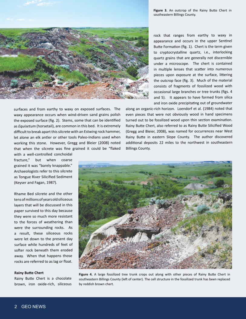
Rainy Butte Chert Rainy Butte Chert is a chocolate brown, iron oxide-rich, siliceous
rock that ranges from earthy to waxy in appearance and occurs in the upper Sentinel Butte Formation (fig. 1). Chert is the term given to cryptocrystalline quartz, i.e., interlocking quartz grains that are generally not discernible under a microscope. The chert is contained in multiple lenses that scatter into numerous pieces upon exposure at the surface, littering the outcrop face (fig. 3). Much of the material consists of fragments of fossilized wood with occasional large branches or tree trunks (figs. 4 and 5). It appears to have formed from silica and iron oxide precipitating out of groundwater
along an organic-rich horizon. Loendorf et al. (1984) noted that even pieces that were not obviously wood in hand specimens turned out to be fossilized wood upon thin section examination. Rainy Butte Chert, also referred to as Rainy Butte Silicified Wood (Gregg and Bleier, 2008), was named for occurrences near West Rainy Butte in eastern Slope County. The author discovered additional deposits 22 miles to the northwest in southeastern Billings County.
Figure 3. An outcrop of the Rainy Butte Chert in southeastern Billings County.
Figure 4. A large fossilized tree trunk crops out along with other pieces of Rainy Butte Chert in southeastern Billings County (left of center). The cell structure in the fossilized trunk has been replaced by reddish brown chert.
JANUARY 2014 3
Taylor BedThe Taylor Bed is a silcrete that caps the Bear Den Member of the Golden Valley Formation in some areas of western North Dakota (fig. 1). It was named for occurrences in and around the town of Taylor in Stark County. The Taylor Bed ranges in thickness from 0.5 - 3 feet. It is gray to cream in color and is occasionally iron-stained (fig. 6). It commonly contains molds of wood and horsetail (Equisetum). Occasionally pieces of petrified wood are preserved in this rock (fig. 7). The top of the Taylor Bed is often rough and pitted while the base tends to be bulbous to undulating and smooth. It has the outward appearance of having formed from silica-rich gelatinous ooze at the base of a cattail swamp,
rich with saplings and discarded tree branches; but may well have been an organic-rich horizon where Eh/pH conditions caused groundwater to deposit silica. Float from the Taylor Bed has been found throughout southwestern North Dakota; from Fort Yates to the Montana line and from Mountrail County to the South Dakota line. Taylor Bed float is much more prevalent than is Rhame Bed silcrete, even in areas where the surface is older than the Rhame Bed. Some of the most heavily concentrated areas of Taylor Bed float occur in south-central Adams County (north of the towns of Hettinger and Haynes - Pearl Buttes), western Grant County (north of New Leipzig, south of Elgin, and Pretty Rock Butte), and western Morton County (Ramsland Hills). Because the Taylor Bed is more abundant throughout southwestern North Dakota than Rhame Bed silcrete, it stands to reason that most archaeological tools that have been identified as Tongue River Silicified Peat (Rhame Bed) were actually made from the Taylor Bed.
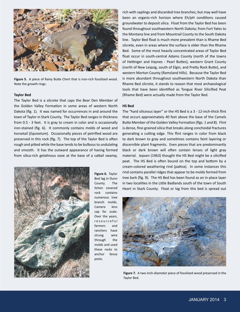
HS BedThe “hard siliceous layer” or the HS Bed is a 3 - 12-inch-thick flint that occurs approximately 40 feet above the base of the Camels Butte Member of the Golden Valley Formation (figs. 1 and 8). Flint is dense, fine-grained silica that breaks along conchoidal fractures generating a cutting edge. This flint ranges in color from black to dark brown to gray and sometimes contains faint layering or discernible plant fragments. Even pieces that are predominantly black or dark brown will often contain lenses of light gray material. Jepsen (1963) thought the HS Bed might be a silicified peat. The HS Bed is often bound on the top and bottom by a cream-colored weathering rind (patina). In some instances this rind contains parallel ridges that appear to be molds formed from tree bark (fig. 9). The HS Bed has been found as an in-place layer in two localities in the Little Badlands south of the town of South Heart in Stark County. Float or lag from this bed is spread out
Figure 5. A piece of Rainy Butte Chert that is iron-rich fossilized wood. Note the growth rings.
Figure 6. Taylor Bed lag in Dunn County. The lichen covered rock contains numerous tree branch molds. Camera lens cap for scale. Over the years, r e s o u r c e f u l farmers and ranchers have strung wire through the molds and used these rocks to anchor fence posts.
Figure 7. A two-inch-diameter piece of fossilized wood preserved in the Taylor Bed.

over an area of at least 50 square miles southwest of the town of Dickinson as witnessed by its presence in numerous rock piles. The HS lag typically occurs as blocks that are 4 - 18 inches wide and long.
Knife River FlintWithout question, Knife River Flint was the most important western North Dakota stone to Paleo-Indians because it breaks with a conchoidal fracture (curved fractures often seen on the broken bottom of an old-fashioned coke bottle) and could be made into projectile points, blades, and scrapers. Knife River Flint is a jet black to dark chocolate brown to gray flint that ranges in thickness from 2 - 16 inches (figs. 1 and 10). This flint is characterized by a well-developed cream colored patina and its texture ranges from glassy to waxy. As previously noted, Knife River Flint has never been found in place, but only in secondary deposits such as gravels that range in age from Eocene (40 million years old) to Recent, or as lag deposits on
the modern surface. Most pieces of Knife River Flint are found along terraces of the Knife River and Spring Creek in Dunn, Mercer, and Oliver Counties. Paleo-Indians dug numerous shallow pits into these deposits to obtain this flint, which are easily identifiable on aerial photographs. In addition, most preglacial and glacial gravel deposits in southwestern North Dakota contain pebbles or cobbles of Knife River Flint. For example, aggregate from gravel pits in the Bismarck-Mandan area (from both the Missouri River and the Heart River valleys) routinely contain dark brown to black pieces of flint.
In the 1980s, some of the largest pieces of Knife River Flint could be
found lying on the Sentinel Butte Formation just north of the town of Killdeer in Dunn County. In contrast, Knife River Flint was not present on top of the adjacent Killdeer Mountains suggesting it was younger than the Sentinel Butte Formation, but as old or older than the Miocene-aged caprock of the Killdeer Mountains. The presence of flint pebbles in the Chalky Buttes Member of the Chadron Formation further constrains the maximum age of
Figure 9. A piece of HS Bed with multiple bark imprints in an HS rock pile in southwestern Stark County.
4 GEO NEWS
Figure 8. Outcrop of the HS Bed (arrow) in the Little Badlands, Stark County. Thicker pieces of the HS Bed are visible downslope (to the left) of the bed.
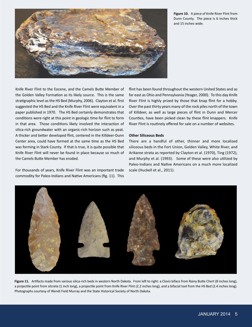
Figure 10. A piece of Knife River Flint from Dunn County. The piece is 6 inches thick and 15 inches wide.
Figure 11. Artifacts made from various silica-rich beds in western North Dakota. From left to right: a Clovis biface from Rainy Butte Chert (8 inches long), a projectile point from silcrete (1 inch long), a projectile point from Knife River Flint (2.2 inches long), and a bifacial tool from the HS Bed (2.4 inches long). Photographs courtesy of Wendi Field Murray and the State Historical Society of North Dakota.
JANUARY 2014 5
Knife River Flint to the Eocene, and the Camels Butte Member of the Golden Valley Formation as its likely source. This is the same stratigraphic level as the HS Bed (Murphy, 2006). Clayton et al. first suggested the HS Bed and the Knife River Flint were equivalent in a paper published in 1970. The HS Bed certainly demonstrates that conditions were right at this point in geologic time for flint to form in that area. Those conditions likely involved the interaction of silica-rich groundwater with an organic-rich horizon such as peat. A thicker and better developed flint, centered in the Killdeer-Dunn Center area, could have formed at the same time as the HS Bed was forming in Stark County. If that is true, it is quite possible that Knife River Flint will never be found in place because so much of the Camels Butte Member has eroded.
For thousands of years, Knife River Flint was an important trade commodity for Paleo-Indians and Native Americans (fig. 11). This
flint has been found throughout the western United States and as far east as Ohio and Pennsylvania (Yeager, 2000). To this day Knife River Flint is highly prized by those that knap flint for a hobby. Over the past thirty years many of the rock piles north of the town of Killdeer, as well as large pieces of flint in Dunn and Mercer Counties, have been picked clean by these flint knappers. Knife River Flint is routinely offered for sale on a number of websites.
Other Siliceous BedsThere are a handful of other, thinner and more localized siliceous beds in the Fort Union, Golden Valley, White River, and Arikaree strata as reported by Clayton et al. (1970), Ting (1972), and Murphy et al. (1993). Some of these were also utilized by Paleo-Indians and Native Americans on a much more localized scale (Huckell et al., 2011).

Uses for StoneAs previously noted, Paleo-Indians and Native Americans valued these rocks (fig. 11) and enterprising, pioneer farmers and ranchers used them as building stone (fig. 12). Understandably, farmers who have had to clear these rocks from their fields or have had to negotiate a horse or pickup
through a rocky pasture have little use for them (Figs. 13 and 14). However, even these farmers and ranchers might develop a grudging respect for these rocks if they come to realize they survived for tens of millions of years even though up to 1,000 feet of rock that once lay beneath them eroded away.
Figure 12. A building in Stark County made out of lag from the HS Bed that was collected from the surrounding fields. Aside from admiring the craftsmanship, a building such as this gives the geologist an excellent opportunity to compare and contrast numerous rock specimens at one time.
6 GEO NEWS
Figure 13. Numerous blocks of the Taylor Bed litter the surface in Grant County south of the town of Elgin.

We continue to search for useful purposes for silcrete, which is plentiful in localized areas of western North Dakota. In 2010 more than 10,000 tons of Taylor Bed float was collected near the town of Hettinger in Adams County and used as riprap on Department of Transportation projects in northern South Dakota. The South Dakota DOT contract paid approximately $50 per ton for riprap in the 1- to 2-foot-diameter range.
ReferencesClayton, L., Bickely, W.B., Jr., and Stone, W.J., 1970, Knife River Flint: Plains
Anthropologist, Journal of the Plains Conference, pp. 282-290.
Gregg, M.L., and Bleier, A., 2008, The Cannonball River Study Unit: In Historic Preservation in North Dakota, II: A Statewide Comprehensive Plan, pp. 2.1-2.38. State Historical Society of North Dakota, Bismarck.
Huckell, B.B., Kilby, J.D., Boulanger, M.T., and Glascock, M.D., 2011, Sentinel Butte: neutron activation analysis of White River Group chert from a primary source and artifacts from a Clovis cache in North Dakota, USA: Journal of Archaeological Science, vol. 38, pp. 965-976.
Jepsen, G.L., 1963, Eocene vertebrates, coprolites, and plants in the Golden Valley Formation of Western North Dakota: Geological Society of America Bulletin, v. 74, pp. 673-684.
Keyser, J.D. and Fagan, J.L., 1987, ESP: Procurement and processing of Tongue River Silicified Sediment: Plains Anthropologist, v. 32, no. 117, pp. 233-256.
Loendorf, L.L., Kuehn, D.D., and Forsman, N.F., 1984, Rainy Buttes Silicified Wood: A Source of Lithic Raw Material in Western North Dakota. Plains Anthropologist 29, pp. 335-338.
Murphy, E.C., Hoganson, J.W., and Forsman, N.F., 1993, The Chadron, Brule, and Arikaree Formations in North Dakota: The buttes of western North Dakota: North Dakota Geological Survey Report of Investigation no. 96, 144 p.
Murphy, E.C., 2006, Knife River Flint and the Lynch Quarry in Manz, L.A., ed., Quaternary Geology of the Missouri River Valley and Adjacent Areas in Northwest-Central North Dakota: North Dakota Geological Survey Geologic Investigations no. 24, pp. 60-68.
Root, M.J., Ahler, S.A., Falk, C.R., Foss, J.E., Haas, H., and Artz, J.A., 1986, Archaeological investigations in the Knife River Flint primary source area, Dunn County, North Dakota: 1982-1986 program, University of North Dakota Department of Anthropology Contribution 234, 759 p.
Ting, F.T.C., 1972, Petrified peat from a Paleocene lignite in North Dakota: Science, v. 177, pp.165-166.
Wehrfritz, B.D., 1978, The Rhame bed (Slope Formation, Paleocene), a silcrete and deep-weathering profile in southwestern North Dakota: unpublished Master’s Thesis, University of North Dakota, 158 p.
Yeager, C.G., 2000, Arrowheads & stone artifacts: a practical guide for the amateur archaeologist: 2nd ed., Pruett Publishing, Boulder, Colorado, 227 p.
JANUARY 2014 7
Figure 14. Blocks of Taylor Bed are so prevalent south of Pretty Rock Butte (Grant County) that it is difficult to walk across some areas.