Embed Size (px)
Citation preview
4/24/2015 10:03 AM 1 | P a g e
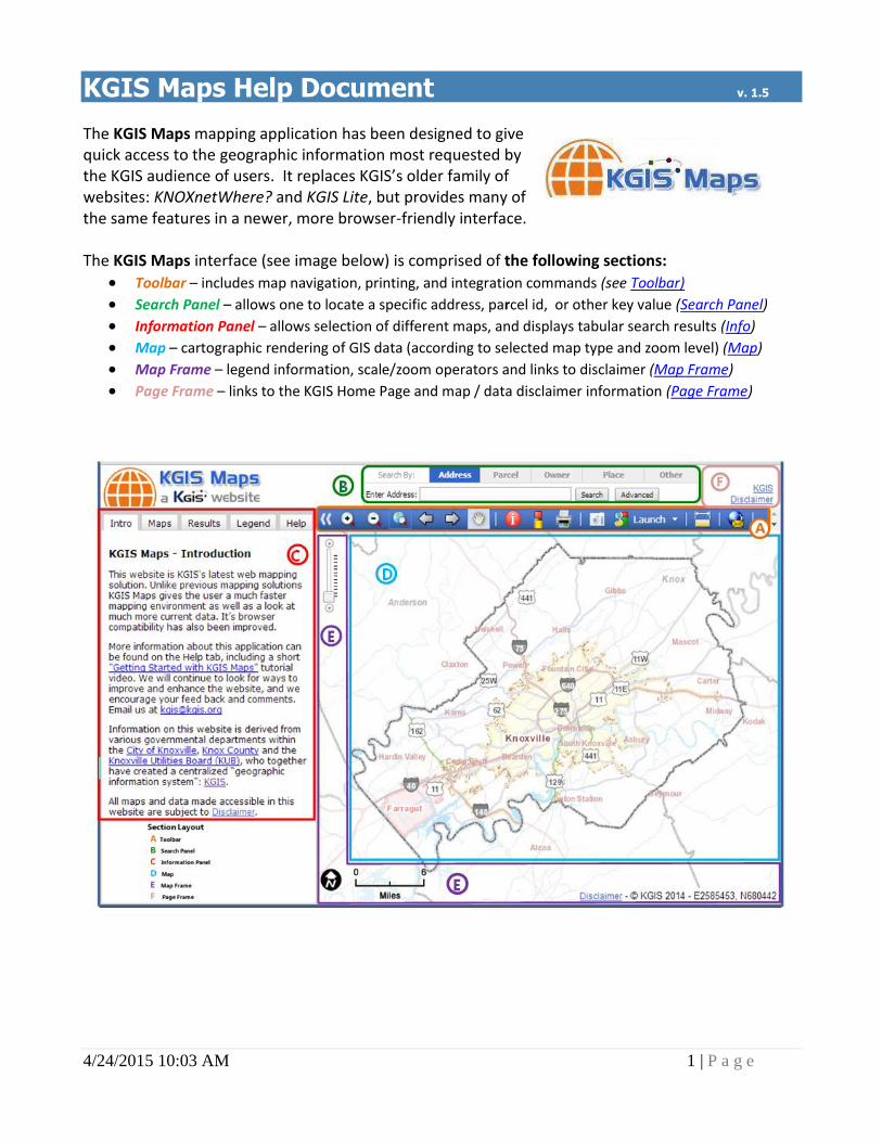
KGIS Maps Help Document v. 1.5
The KGIS Maps mapping application has been designed to give quick access to the geographic information most requested by the KGIS audience of users. It replaces KGIS’s older family of websites: KNOXnetWhere? and KGIS Lite, but provides many of the same features in a newer, more browser-friendly interface. The KGIS Maps interface (see image below) is comprised of the following sections:
Toolbar – includes map navigation, printing, and integration commands (see Toolbar)
Search Panel – allows one to locate a specific address, parcel id, or other key value (Search Panel)
Information Panel – allows selection of different maps, and displays tabular search results (Info)
Map – cartographic rendering of GIS data (according to selected map type and zoom level) (Map)
Map Frame – legend information, scale/zoom operators and links to disclaimer (Map Frame)
Page Frame – links to the KGIS Home Page and map / data disclaimer information (Page Frame)
4/24/2015 10:03 AM 2 | P a g e
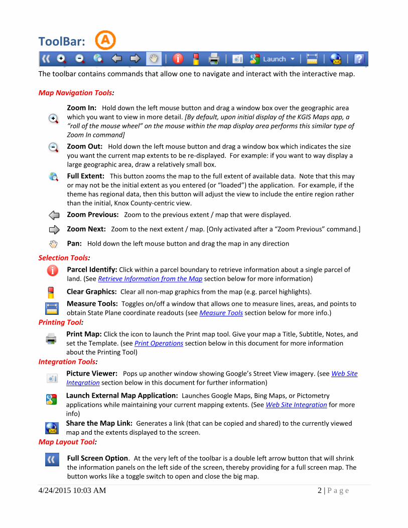
ToolBar:
The toolbar contains commands that allow one to navigate and interact with the interactive map.
Map Navigation Tools:
Selection Tools:
Parcel Identify: Click within a parcel boundary to retrieve information about a single parcel of land. (See Retrieve Information from the Map section below for more information)
Clear Graphics: Clear all non-map graphics from the map (e.g. parcel highlights).
Measure Tools: Toggles on/off a window that allows one to measure lines, areas, and points to obtain State Plane coordinate readouts (see Measure Tools section below for more info.)
Printing Tool:
Print Map: Click the icon to launch the Print map tool. Give your map a Title, Subtitle, Notes, and set the Template. (see Print Operations section below in this document for more information about the Printing Tool)
Integration Tools:
Picture Viewer: Pops up another window showing Google’s Street View imagery. (see Web Site Integration section below in this document for further information)
Launch External Map Application: Launches Google Maps, Bing Maps, or Pictometry applications while maintaining your current mapping extents. (See Web Site Integration for more info)
Share the Map Link: Generates a link (that can be copied and shared) to the currently viewed map and the extents displayed to the screen.
Map Layout Tool:
Zoom In: Hold down the left mouse button and drag a window box over the geographic area which you want to view in more detail. [By default, upon initial display of the KGIS Maps app, a “roll of the mouse wheel” on the mouse within the map display area performs this similar type of Zoom In command]
Zoom Out: Hold down the left mouse button and drag a window box which indicates the size you want the current map extents to be re-displayed. For example: if you want to way display a large geographic area, draw a relatively small box.
Full Extent: This button zooms the map to the full extent of available data. Note that this may or may not be the initial extent as you entered (or “loaded”) the application. For example, if the theme has regional data, then this button will adjust the view to include the entire region rather than the initial, Knox County-centric view.
Zoom Previous: Zoom to the previous extent / map that were displayed.
Zoom Next: Zoom to the next extent / map. [Only activated after a “Zoom Previous” command.]
Pan: Hold down the left mouse button and drag the map in any direction
Full Screen Option. At the very left of the toolbar is a double left arrow button that will shrink the information panels on the left side of the screen, thereby providing for a full screen map. The button works like a toggle switch to open and close the big map.
4/24/2015 10:03 AM 3 | P a g e
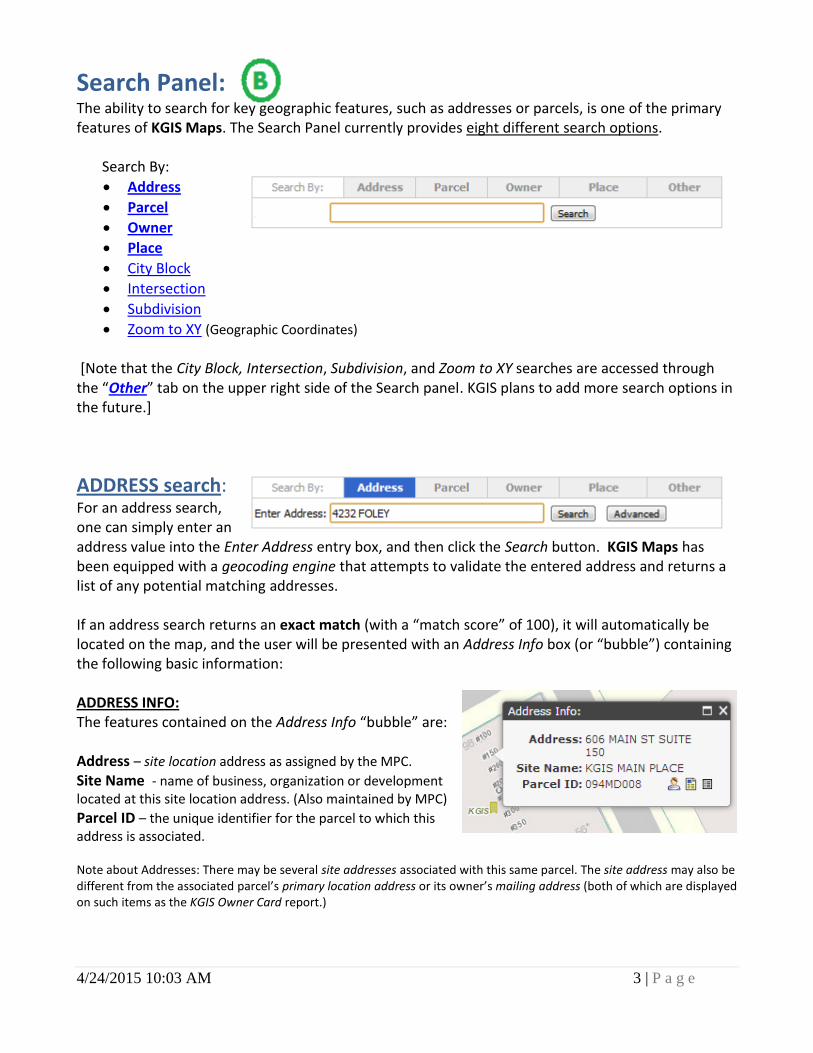
Search Panel: The ability to search for key geographic features, such as addresses or parcels, is one of the primary features of KGIS Maps. The Search Panel currently provides eight different search options. Search By:
Address
Parcel
Owner
Place
City Block
Intersection
Subdivision
Zoom to XY (Geographic Coordinates)
[Note that the City Block, Intersection, Subdivision, and Zoom to XY searches are accessed through the “Other” tab on the upper right side of the Search panel. KGIS plans to add more search options in the future.]
ADDRESS search: For an address search, one can simply enter an address value into the Enter Address entry box, and then click the Search button. KGIS Maps has been equipped with a geocoding engine that attempts to validate the entered address and returns a list of any potential matching addresses. If an address search returns an exact match (with a “match score” of 100), it will automatically be located on the map, and the user will be presented with an Address Info box (or “bubble”) containing the following basic information: ADDRESS INFO: The features contained on the Address Info “bubble” are: Address – site location address as assigned by the MPC.
Site Name - name of business, organization or development located at this site location address. (Also maintained by MPC) Parcel ID – the unique identifier for the parcel to which this address is associated. Note about Addresses: There may be several site addresses associated with this same parcel. The site address may also be different from the associated parcel’s primary location address or its owner’s mailing address (both of which are displayed on such items as the KGIS Owner Card report.)
4/24/2015 10:03 AM 4 | P a g e
Owner Card Link – by clicking on this icon, an Owner Card Report will be presented to the user in a “pop-up” window
Property Map/Details Link – by clicking on this icon, a Property Map & Details Report will be presented to the user in a “pop-up” window
Full Detail Link – by clicking on this icon, a complete set of attributes about this parcel will be presented in the Results pane of the Information Panel on the far left side of the web page
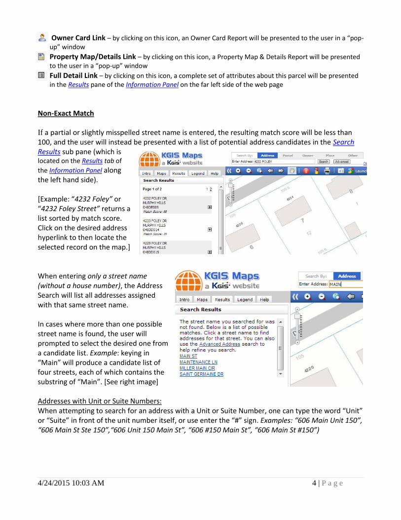
Non-Exact Match If a partial or slightly misspelled street name is entered, the resulting match score will be less than 100, and the user will instead be presented with a list of potential address candidates in the Search Results sub pane (which is located on the Results tab of
the Information Panel along the left hand side). [Example: “4232 Foley” or “4232 Foley Street” returns a list sorted by match score. Click on the desired address hyperlink to then locate the selected record on the map.] When entering only a street name (without a house number), the Address Search will list all addresses assigned with that same street name. In cases where more than one possible street name is found, the user will prompted to select the desired one from a candidate list. Example: keying in “Main” will produce a candidate list of four streets, each of which contains the substring of “Main”. [See right image] Addresses with Unit or Suite Numbers: When attempting to search for an address with a Unit or Suite Number, one can type the word “Unit” or “Suite” in front of the unit number itself, or use enter the “#” sign. Examples: “606 Main Unit 150”, “606 Main St Ste 150”,“606 Unit 150 Main St”, “606 #150 Main St”, “606 Main St #150”)
4/24/2015 10:03 AM 5 | P a g e
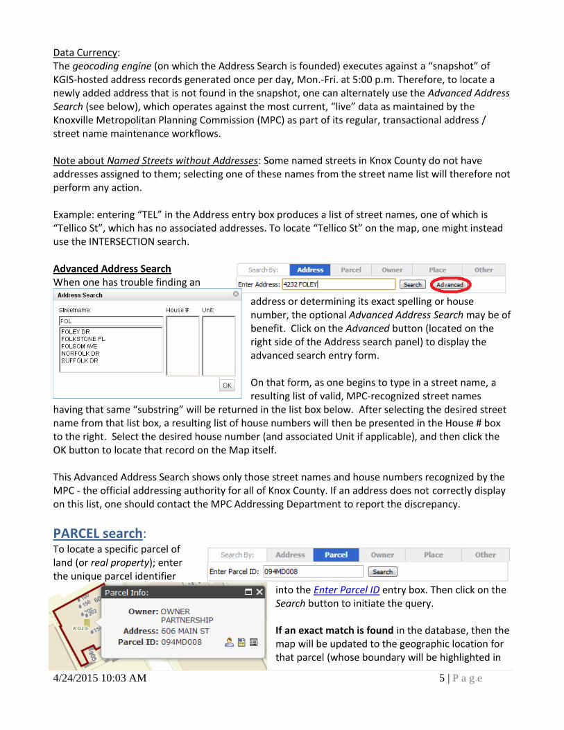
Data Currency: The geocoding engine (on which the Address Search is founded) executes against a “snapshot” of KGIS-hosted address records generated once per day, Mon.-Fri. at 5:00 p.m. Therefore, to locate a newly added address that is not found in the snapshot, one can alternately use the Advanced Address Search (see below), which operates against the most current, “live” data as maintained by the Knoxville Metropolitan Planning Commission (MPC) as part of its regular, transactional address / street name maintenance workflows. Note about Named Streets without Addresses: Some named streets in Knox County do not have addresses assigned to them; selecting one of these names from the street name list will therefore not perform any action. Example: entering “TEL” in the Address entry box produces a list of street names, one of which is “Tellico St”, which has no associated addresses. To locate “Tellico St” on the map, one might instead use the INTERSECTION search. Advanced Address Search When one has trouble finding an
address or determining its exact spelling or house number, the optional Advanced Address Search may be of benefit. Click on the Advanced button (located on the right side of the Address search panel) to display the advanced search entry form. On that form, as one begins to type in a street name, a resulting list of valid, MPC-recognized street names
having that same “substring” will be returned in the list box below. After selecting the desired street name from that list box, a resulting list of house numbers will then be presented in the House # box to the right. Select the desired house number (and associated Unit if applicable), and then click the OK button to locate that record on the Map itself. This Advanced Address Search shows only those street names and house numbers recognized by the MPC - the official addressing authority for all of Knox County. If an address does not correctly display on this list, one should contact the MPC Addressing Department to report the discrepancy.
PARCEL search: To locate a specific parcel of land (or real property); enter the unique parcel identifier
into the Enter Parcel ID entry box. Then click on the Search button to initiate the query. If an exact match is found in the database, then the map will be updated to the geographic location for that parcel (whose boundary will be highlighted in
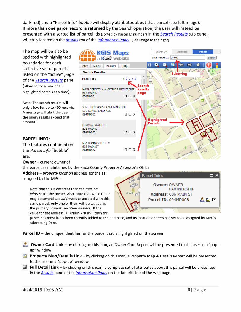
4/24/2015 10:03 AM 6 | P a g e
dark red) and a “Parcel Info” bubble will display attributes about that parcel (see left image). If more than one parcel record is returned by the Search operation, the user will instead be presented with a sorted list of parcel ids (sorted by Parcel ID number) in the Search Results sub pane, which is located on the Results tab of the Information Panel. [See image to the right] The map will be also be updated with highlighted boundaries for each collective set of parcels listed on the “active” page of the Search Results pane (allowing for a max of 15
highlighted parcels at a time). Note: The search results will only allow for up to 400 records. A message will alert the user if the query results exceed that amount.
PARCEL INFO: The features contained on the Parcel Info “bubble” are: Owner – current owner of the parcel, as maintained by the Knox County Property Assessor’s Office
Address – property location address for the as assigned by the MPC.
Note that this is different than the mailing address for the owner. Also, note that while there may be several site addresses associated with this same parcel, only one of them will be tagged as the primary property location address. If the value for the address is “<Null> <Null>”, then this parcel has most likely been recently added to the database, and its location address has yet to be assigned by MPC’s Addressing Dept.
Parcel ID – the unique identifier for the parcel that is highlighted on the screen
Owner Card Link – by clicking on this icon, an Owner Card Report will be presented to the user in a “pop-up” window
Property Map/Details Link – by clicking on this icon, a Property Map & Details Report will be presented to the user in a “pop-up” window
Full Detail Link – by clicking on this icon, a complete set of attributes about this parcel will be presented in the Results pane of the Information Panel on the far left side of the web page
4/24/2015 10:03 AM 7 | P a g e
PARCEL ID FORMAT
A valid “Parcel ID” may consist of up to 13 characters in length, where spaces are important. The format used on this KGIS website may be different from other City or County websites, which sometimes use hyphens and other forms of nomenclature. (This site will strip out any hyphens keyed into the search entry box).
The Parcel ID format is listed below:
CCCIGPPPSSL CCC = CLT Map # I = Insert G = Group PPP = Parcel Number SS = Parcel Number Subunit L = Condo Letter
The Insert and Group fields may be blank. However, you will need to insert a space for these.
The Parcel Number consists of three numeric digits (where zeros are important).
Two-digit Sub Unit values are required for approx. 15% of Knox County’s parcels.
A single alphabetic Condo Letter is associated with most "non-land" parcels. Data Currency:
“LIVE” The parcel id search executes against the “live”, transactional database that is maintained by the Knox County Property Assessor. On the resulting Parcel Info bubble and on the Search Results pane, the Address and Parcel ID values are also “live”. On the map itself, the highlighted boundaries in dark red are also “live”.
“SNAPSHOT” Some of the related parcel record attributes and maps displayed within KGIS Maps are “snapshots” in that they are copies of the “live” data. For instance, the Owner Names (as displayed on the Parcel Info bubble and on the Search Results pane) reflect 24-hour “snapshots” retrieved nightly (M-F) from the Assessor’s appraisal (CAMA) system.
And depending upon the map type being viewed, the underlying map images may or may not be “live”. [See the Maps section of this document for more details about the currency for each Map type.] Example: the image to the right displays a parcel whose “live” highlighted boundary does not match with the boundaries (grey) in the underlying “snapshot” map that was generated one week prior.
Parcel ID Examples KGIS on City/County websites
094LE041 094LE-041
030 211 030-211
116 04206 116-04206
059OB01107 059OB-01107
066 13219Q 066-13219Q
131KA02261A 131KA-02261A

4/24/2015 10:03 AM 8 | P a g e
Retired Parcels. Users should note that “retired” parcels will not be searchable via the Parcel ID search utility in KGIS Maps (since their boundaries no longer exist). Nevertheless, some of attributes about those old, retired parcels can be accessed via KGIS’ Owner Card search utility (click here for example) from the KGIS Home page at www.kgis.org .
4/24/2015 10:03 AM 9 | P a g e
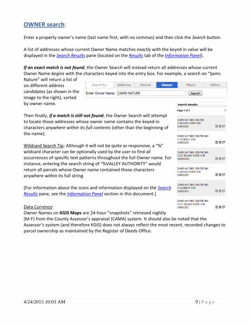
OWNER search: Enter a property owner’s name (last name first, with no commas) and then click the Search button. A list of addresses whose current Owner Name matches exactly with the keyed in value will be displayed in the Search Results pane (located on the Results tab of the Information Panel). If an exact match is not found, the Owner Search will instead return all addresses whose current Owner Name begins with the characters keyed into the entry box. For example, a search on “Ijams Nature” will return a list of six different address candidates (as shown in the image to the right), sorted by owner name. Then finally, if a match is still not found, the Owner Search will attempt to locate those addresses whose owner name contains the keyed-in characters anywhere within its full contents (other than the beginning of the name). Wildcard Search Tip: Although it will not be quite as responsive, a “%” wildcard character can be optionally used by the user to find all occurrences of specific text patterns throughout the full Owner name. For instance, entering the search string of “%VALLEY AUTHORITY” would return all parcels whose Owner name contained those characters anywhere within its full string. [For information about the icons and information displayed on the Search Results pane, see the Information Panel section in this document.]
Data Currency: Owner Names on KGIS Maps are 24-hour “snapshots” retrieved nightly (M-F) from the County Assessor’s appraisal (CAMA) system. It should also be noted that the Assessor’s system (and therefore KGIS) does not always reflect the most recent, recorded changes to parcel ownership as maintained by the Register of Deeds Office.
4/24/2015 10:03 AM 10 | P a g e
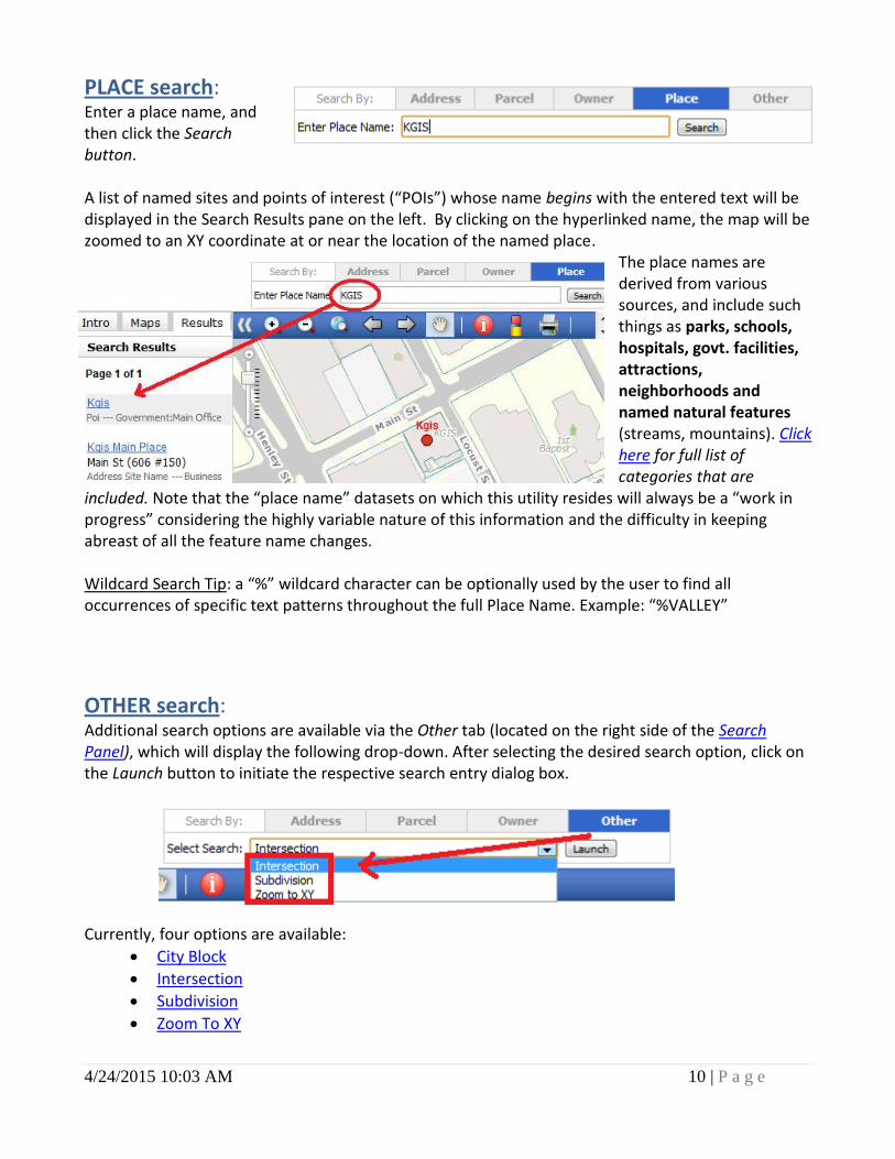
PLACE search: Enter a place name, and then click the Search button. A list of named sites and points of interest (“POIs”) whose name begins with the entered text will be displayed in the Search Results pane on the left. By clicking on the hyperlinked name, the map will be zoomed to an XY coordinate at or near the location of the named place.
The place names are derived from various sources, and include such things as parks, schools, hospitals, govt. facilities, attractions, neighborhoods and named natural features (streams, mountains). Click here for full list of categories that are
included. Note that the “place name” datasets on which this utility resides will always be a “work in progress” considering the highly variable nature of this information and the difficulty in keeping abreast of all the feature name changes. Wildcard Search Tip: a “%” wildcard character can be optionally used by the user to find all occurrences of specific text patterns throughout the full Place Name. Example: “%VALLEY”
OTHER search: Additional search options are available via the Other tab (located on the right side of the Search Panel), which will display the following drop-down. After selecting the desired search option, click on the Launch button to initiate the respective search entry dialog box.
Currently, four options are available:
City Block
Intersection
Subdivision
Zoom To XY
4/24/2015 10:03 AM 11 | P a g e
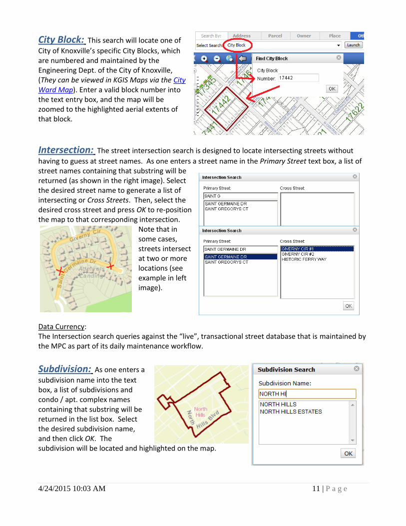
City Block: This search will locate one of
City of Knoxville’s specific City Blocks, which are numbered and maintained by the Engineering Dept. of the City of Knoxville, (They can be viewed in KGIS Maps via the City Ward Map). Enter a valid block number into the text entry box, and the map will be zoomed to the highlighted aerial extents of that block.
Intersection: The street intersection search is designed to locate intersecting streets without
having to guess at street names. As one enters a street name in the Primary Street text box, a list of street names containing that substring will be returned (as shown in the right image). Select the desired street name to generate a list of intersecting or Cross Streets. Then, select the desired cross street and press OK to re-position the map to that corresponding intersection.
Note that in some cases, streets intersect at two or more locations (see example in left image).
Data Currency: The Intersection search queries against the “live”, transactional street database that is maintained by the MPC as part of its daily maintenance workflow.
Subdivision: As one enters a
subdivision name into the text box, a list of subdivisions and condo / apt. complex names containing that substring will be returned in the list box. Select the desired subdivision name, and then click OK. The subdivision will be located and highlighted on the map.
4/24/2015 10:03 AM 12 | P a g e
Data Currency: The Subdivision search queries against the “major subdivisions” dataset that is updated bi-monthly by KGIS. The subdivision and apartment complex names used in this dataset are not the officially recorded subdivision names, and therefore do not always match with those sources.
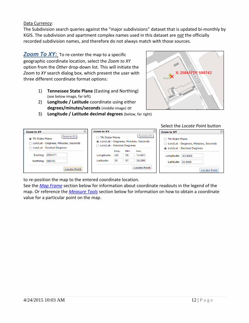
Zoom To XY: To re-center the map to a specific
geographic coordinate location, select the Zoom to XY option from the Other drop-down list. This will initiate the Zoom to XY search dialog box, which present the user with three different coordinate format options:
1) Tennessee State Plane (Easting and Northing) (see below image, far left).
2) Longitude / Latitude coordinate using either degrees/minutes/seconds (middle image) or
3) Longitude / Latitude decimal degrees (below, far right)
Select the Locate Point button
to re-position the map to the entered coordinate location. See the Map Frame section below for information about coordinate readouts in the legend of the map. Or reference the Measure Tools section below for information on how to obtain a coordinate value for a particular point on the map.
4/24/2015 10:03 AM 13 | P a g e
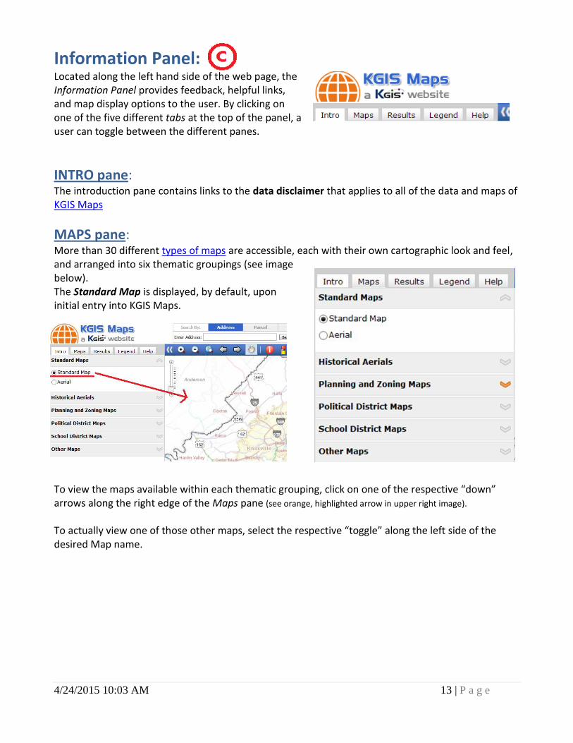
Information Panel: Located along the left hand side of the web page, the Information Panel provides feedback, helpful links, and map display options to the user. By clicking on one of the five different tabs at the top of the panel, a user can toggle between the different panes.
INTRO pane: The introduction pane contains links to the data disclaimer that applies to all of the data and maps of KGIS Maps
MAPS pane: More than 30 different types of maps are accessible, each with their own cartographic look and feel, and arranged into six thematic groupings (see image below). The Standard Map is displayed, by default, upon initial entry into KGIS Maps.
To view the maps available within each thematic grouping, click on one of the respective “down” arrows along the right edge of the Maps pane (see orange, highlighted arrow in upper right image). To actually view one of those other maps, select the respective “toggle” along the left side of the desired Map name.
4/24/2015 10:03 AM 14 | P a g e
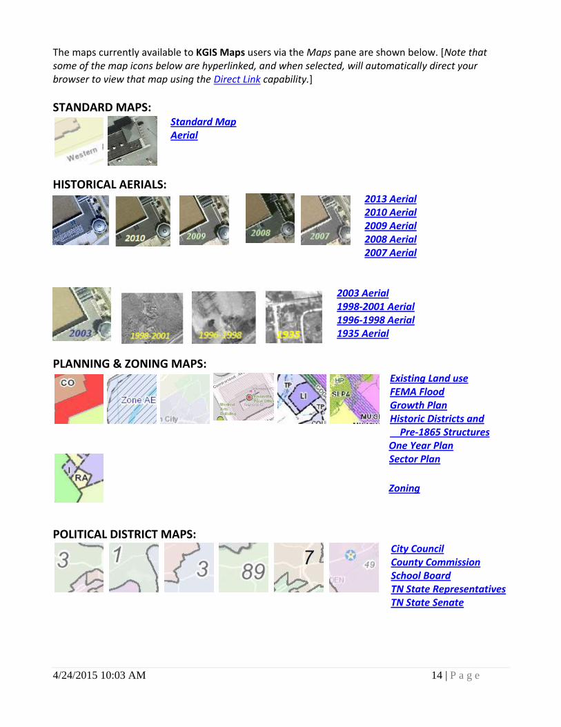
The maps currently available to KGIS Maps users via the Maps pane are shown below. [Note that some of the map icons below are hyperlinked, and when selected, will automatically direct your browser to view that map using the Direct Link capability.]
STANDARD MAPS: Standard Map Aerial
HISTORICAL AERIALS:
2013 Aerial 2010 Aerial 2009 Aerial 2008 Aerial 2007 Aerial
2003 Aerial 1998-2001 Aerial 1996-1998 Aerial 1935 Aerial
PLANNING & ZONING MAPS:
Existing Land use FEMA Flood Growth Plan
Historic Districts and Pre-1865 Structures
One Year Plan Sector Plan
Zoning
POLITICAL DISTRICT MAPS:
City Council County Commission School Board TN State Representatives
TN State Senate

4/24/2015 10:03 AM 15 | P a g e
SCHOOL DISTRICT MAPS: Voting Precincts
Elementary Schools & Zones Intermediate Schools & Zones Middle Schools & Zones High Schools & Zones
OTHER MAPS:
Census Tracts (2010) Census Tracts (2000) City Ward Map
Neighborhoods Property Tax Sale Knox Co. Surplus Property Auction
Soil Types
TCA Restriction Zones
Topography Traffic Counts
Watersheds
Zip Codes
RESULTS pane: The Results pane is where the user is presented with textual results of a user-initiated search (via the Search Panel) or attributes details resulting from a Parcel Identify command (via the Toolbar).
How the pane is organized: The pane is divided into two sub-sections (called sub-panes): the Search Results sub-pane and the Details sub-pane. The sub-panes function as “accordion-like” toggles – when one is selected, its contents are made visible, while the other sub-pane’s contents become hidden (and vice-versa).
In the top image, the Search Results sub-pane is active (as indicated by the bolded heading), while the Details sub-pane is de-active. The right image shows that when the Details sub-pane is made active, then the Search Results sub-pane is hidden from view.
4/24/2015 10:03 AM 16 | P a g e
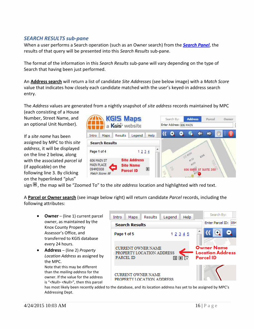
SEARCH RESULTS sub-pane When a user performs a Search operation (such as an Owner search) from the Search Panel, the results of that query will be presented into this Search Results sub-pane. The format of the information in this Search Results sub-pane will vary depending on the type of Search that having been just performed. An Address search will return a list of candidate Site Addresses (see below image) with a Match Score value that indicates how closely each candidate matched with the user’s keyed-in address search entry. The Address values are generated from a nightly snapshot of site address records maintained by MPC (each consisting of a House Number, Street Name, and an optional Unit Number). If a site name has been assigned by MPC to this site address, it will be displayed on the line 2 below, along with the associated parcel id (if applicable) on the following line 3. By clicking on the hyperlinked “plus”
sign , the map will be “Zoomed To” to the site address location and highlighted with red text. A Parcel or Owner search (see image below right) will return candidate Parcel records, including the following attributes:
Owner – (line 1) current parcel owner, as maintained by the Knox County Property Assessor’s Office, and transferred to KGIS database every 24 hours.
Address – (line 2) Property Location Address as assigned by the MPC. Note that this may be different than the mailing address for the owner. If the value for the address is “<Null> <Null>”, then this parcel has most likely been recently added to the database, and its location address has yet to be assigned by MPC’s Addressing Dept.
4/24/2015 10:03 AM 17 | P a g e
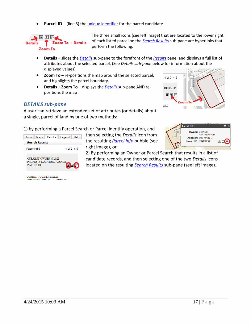
Parcel ID – (line 3) the unique identifier for the parcel candidate
The three small icons (see left image) that are located to the lower right of each listed parcel on the Search Results sub-pane are hyperlinks that perform the following:
Details – slides the Details sub-pane to the forefront of the Results pane, and displays a full list of attributes about the selected parcel. (See Details sub-pane below for information about the displayed values)
Zoom To – re-positions the map around the selected parcel, and highlights the parcel boundary.
Details + Zoom To – displays the Details sub-pane AND re-positions the map
DETAILS sub-pane A user can retrieve an extended set of attributes (or details) about a single, parcel of land by one of two methods: 1) by performing a Parcel Search or Parcel Identify operation, and
then selecting the Details icon from the resulting Parcel Info bubble (see right image), or 2) By performing an Owner or Parcel Search that results in a list of candidate records, and then selecting one of the two Details icons located on the resulting Search Results sub-pane (see left image).
4/24/2015 10:03 AM 18 | P a g e
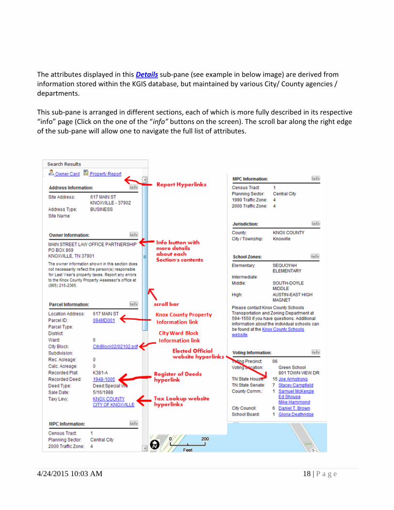
The attributes displayed in this Details sub-pane (see example in below image) are derived from information stored within the KGIS database, but maintained by various City/ County agencies / departments. This sub-pane is arranged in different sections, each of which is more fully described in its respective “info” page (Click on the one of the “info” buttons on the screen). The scroll bar along the right edge of the sub-pane will allow one to navigate the full list of attributes.
4/24/2015 10:03 AM 19 | P a g e
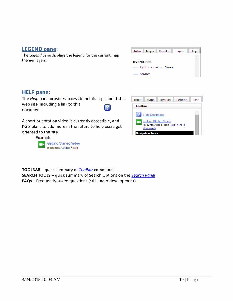
LEGEND pane: The Legend pane displays the legend for the current map themes layers.
HELP pane: The Help pane provides access to helpful tips about this web site, including a link to this document. A short orientation video is currently accessible, and KGIS plans to add more in the future to help users get oriented to the site.
Example:
TOOLBAR – quick summary of Toolbar commands SEARCH TOOLS – quick summary of Search Options on the Search Panel FAQs – Frequently-asked questions (still under development)
4/24/2015 10:03 AM 20 | P a g e
Map: The maps displayed in KGIS Maps are rendered from a geographical information system that is comprised of more than one hundred different feature classes. To obtain a list of the different maps available for viewing, click on the Maps tab of the Information Panel along the left hand side of the screen. To expand the size of the map, click on the Full Screen Option “double arrows” command on the Toolbar above the map.
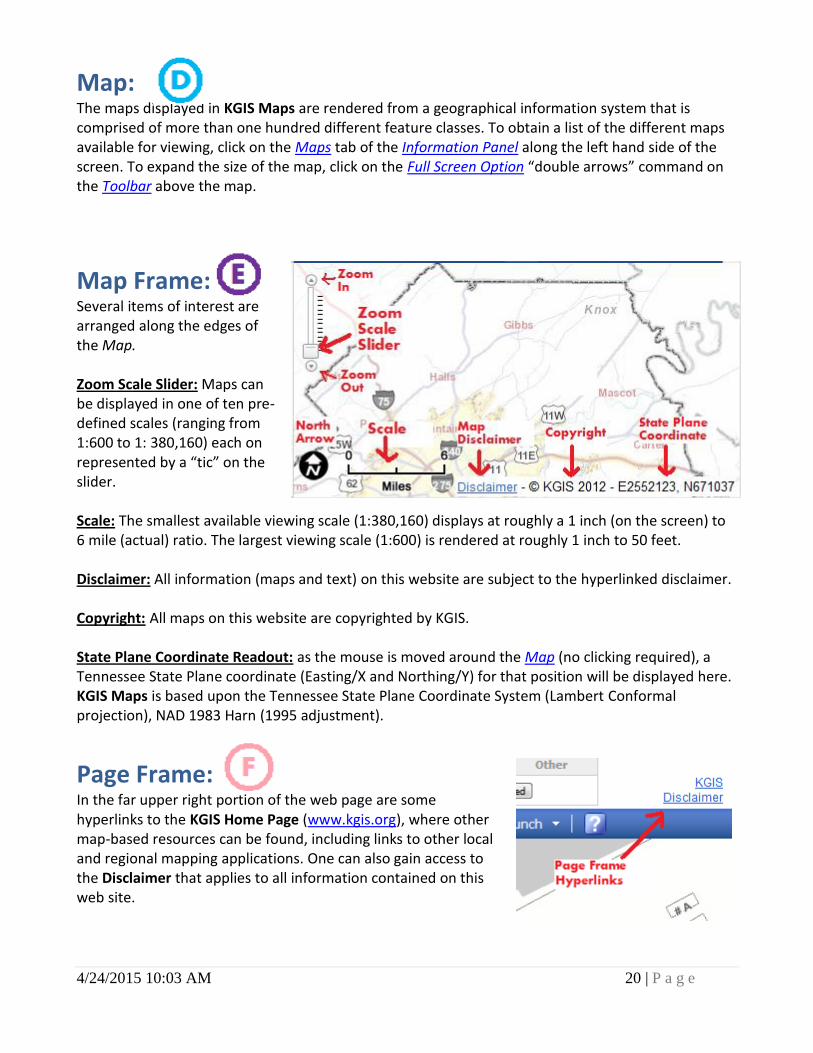
Map Frame: Several items of interest are arranged along the edges of the Map. Zoom Scale Slider: Maps can be displayed in one of ten pre-defined scales (ranging from 1:600 to 1: 380,160) each on represented by a “tic” on the slider. Scale: The smallest available viewing scale (1:380,160) displays at roughly a 1 inch (on the screen) to 6 mile (actual) ratio. The largest viewing scale (1:600) is rendered at roughly 1 inch to 50 feet. Disclaimer: All information (maps and text) on this website are subject to the hyperlinked disclaimer. Copyright: All maps on this website are copyrighted by KGIS. State Plane Coordinate Readout: as the mouse is moved around the Map (no clicking required), a Tennessee State Plane coordinate (Easting/X and Northing/Y) for that position will be displayed here. KGIS Maps is based upon the Tennessee State Plane Coordinate System (Lambert Conformal projection), NAD 1983 Harn (1995 adjustment).
Page Frame: In the far upper right portion of the web page are some hyperlinks to the KGIS Home Page (www.kgis.org), where other map-based resources can be found, including links to other local and regional mapping applications. One can also gain access to the Disclaimer that applies to all information contained on this web site.
4/24/2015 10:03 AM 21 | P a g e
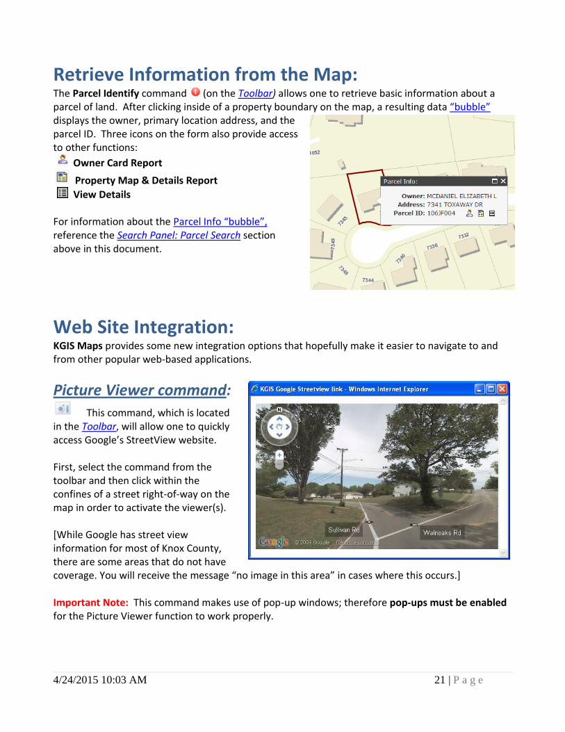
Retrieve Information from the Map: The Parcel Identify command (on the Toolbar) allows one to retrieve basic information about a parcel of land. After clicking inside of a property boundary on the map, a resulting data “bubble” displays the owner, primary location address, and the parcel ID. Three icons on the form also provide access to other functions:
Owner Card Report
Property Map & Details Report
View Details For information about the Parcel Info “bubble”, reference the Search Panel: Parcel Search section above in this document.
Web Site Integration: KGIS Maps provides some new integration options that hopefully make it easier to navigate to and from other popular web-based applications.
Picture Viewer command:
This command, which is located in the Toolbar, will allow one to quickly access Google’s StreetView website. First, select the command from the toolbar and then click within the confines of a street right-of-way on the map in order to activate the viewer(s). [While Google has street view information for most of Knox County, there are some areas that do not have coverage. You will receive the message “no image in this area” in cases where this occurs.]
Important Note: This command makes use of pop-up windows; therefore pop-ups must be enabled for the Picture Viewer function to work properly.
4/24/2015 10:03 AM 22 | P a g e
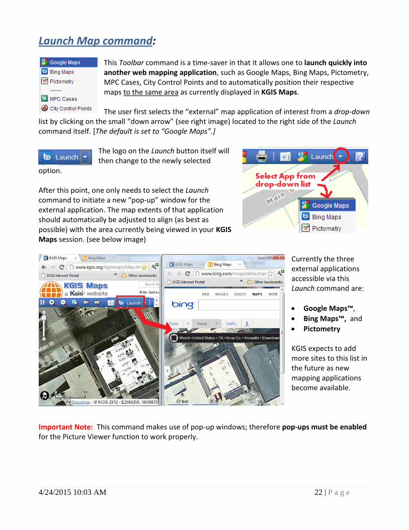
Launch Map command:
This Toolbar command is a time-saver in that it allows one to launch quickly into another web mapping application, such as Google Maps, Bing Maps, Pictometry, MPC Cases, City Control Points and to automatically position their respective maps to the same area as currently displayed in KGIS Maps. The user first selects the “external” map application of interest from a drop-down
list by clicking on the small “down arrow” (see right image) located to the right side of the Launch command itself. [The default is set to “Google Maps”.]
The logo on the Launch button itself will then change to the newly selected
option. After this point, one only needs to select the Launch command to initiate a new “pop-up” window for the external application. The map extents of that application should automatically be adjusted to align (as best as possible) with the area currently being viewed in your KGIS Maps session. (see below image)
Currently the three external applications accessible via this Launch command are:
Google Maps™,
Bing Maps™, and
Pictometry KGIS expects to add more sites to this list in the future as new mapping applications become available.
Important Note: This command makes use of pop-up windows; therefore pop-ups must be enabled for the Picture Viewer function to work properly.
4/24/2015 10:03 AM 23 | P a g e
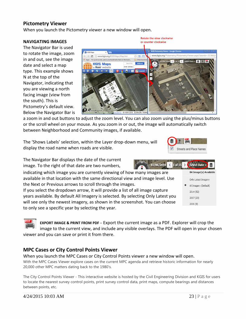
Pictometry Viewer When you launch the Pictometry viewer a new window will open. NAVIGATING IMAGES The Navigator Bar is used to rotate the image, zoom in and out, see the image date and select a map type. This example shows N at the top of the Navigator, indicating that you are viewing a north facing image (view from the south). This is Pictometry’s default view. Below the Navigator Bar is a zoom in and out buttons to adjust the zoom level. You can also zoom using the plus/minus buttons or the scroll wheel on your mouse. As you zoom in or out, the image will automatically switch between Neighborhood and Community images, if available. The ‘Shows Labels’ selection, within the Layer drop-down menu, will display the road name when roads are visible. The Navigator Bar displays the date of the current image. To the right of that date are two numbers,
indicating which image you are currently viewing of how many images are available in that location with the same directional view and image level. Use the Next or Previous arrows to scroll through the images. If you select the dropdown arrow, it will provide a list of all image capture years available. By default All Imagery is selected. By selecting Only Latest you will see only the newest imagery, as shown in the screenshot. You can choose to only see a specific year by selecting the year.
EXPORT IMAGE & PRINT FROM PDF – Export the current image as a PDF. Explorer will crop the image to the current view, and include any visible overlays. The PDF will open in your chosen
viewer and you can save or print it from there.
MPC Cases or City Control Points Viewer When you launch the MPC Cases or City Control Points viewer a new window will open. With the MPC Cases Viewer explore cases on the current MPC agenda and retrieve historic information for nearly
20,000 other MPC matters dating back to the 1980's.
The City Control Points Viewer - This interactive website is hosted by the Civil Engineering Division and KGIS for users
to locate the nearest survey control points, print survey control data, print maps, compute bearings and distances
between points, etc.
4/24/2015 10:03 AM 24 | P a g e
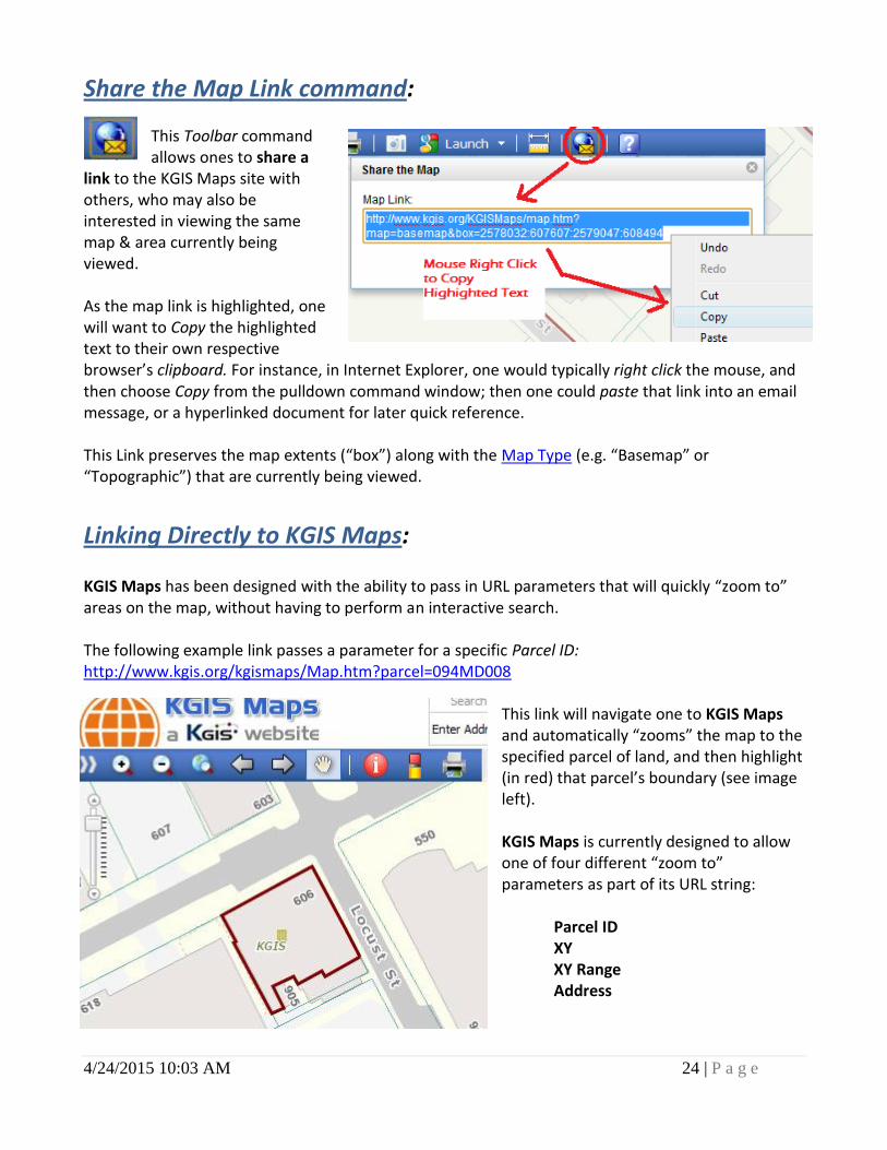
Share the Map Link command: This Toolbar command allows ones to share a
link to the KGIS Maps site with others, who may also be interested in viewing the same map & area currently being viewed. As the map link is highlighted, one will want to Copy the highlighted text to their own respective browser’s clipboard. For instance, in Internet Explorer, one would typically right click the mouse, and then choose Copy from the pulldown command window; then one could paste that link into an email message, or a hyperlinked document for later quick reference. This Link preserves the map extents (“box”) along with the Map Type (e.g. “Basemap” or “Topographic”) that are currently being viewed.
Linking Directly to KGIS Maps: KGIS Maps has been designed with the ability to pass in URL parameters that will quickly “zoom to” areas on the map, without having to perform an interactive search. The following example link passes a parameter for a specific Parcel ID: http://www.kgis.org/kgismaps/Map.htm?parcel=094MD008
This link will navigate one to KGIS Maps and automatically “zooms” the map to the specified parcel of land, and then highlight (in red) that parcel’s boundary (see image left). KGIS Maps is currently designed to allow one of four different “zoom to” parameters as part of its URL string:
Parcel ID XY XY Range Address
4/24/2015 10:03 AM 25 | P a g e
ZOOM TO parameters Parcel ID - ?parcel=
A Parcel search operation (see Search Panel section above) will automatically be initiated using the values keyed in for this parameter. Example: ?parcel=094MD or ?parcel=094MD008
XY - ?xy= A Zoom to XY search operation (see Search Panel: Other Search section above) will automatically be initiated using the Tennessee State Plan Coordinate Easting and Northing values keyed in for this parameter. (Note: the coordinates must be separated by a “:”). Example: ?xy=2584171:598743
XY Range - ?box= The map will be fitted (as best as possible) around a rectangular geographic area (or “box”) that can be defined by a lower left xy coordinate and an upper right xy coordinate. (Note: the coordinates must be separated by a “:”, and must be arranged by the following: Lower Left X: Lower Left Y: Upper Right X: Upper Right Y). Example: ?box=2573919:619719:2575919:621719
Address - ?address= An Address search operation (see Search Panel section above) will automatically be initiated using values keyed in for this parameter. Example: ?address=606 Main St Ste 150 or ?address=Main St
Tip: State Plane coordinate values can be obtained by using the Coordinate Readout capability (see Map Frame section above. Or, if the Latitude, Longitude is known, one can use the Zoom To search capability (see Search Panel above) to locate that Lat/Long location on the map, then determine the State Plane value by reviewing the Coordinate Readout value on the Map Frame. Another optional way to obtain a Coordinate location is to select the Measure Location command from the Measure Tools window (which is accessed from the Measure Tools button on the Toolbar).
CHANGE MAP parameter While more than thirty different maps are available for viewing from within KGIS Maps (see Information Panel: Maps pane section above for a list of available maps), its default is the Standard Map. However, users have the option of initiating the web site with a map other than the default via the use of the Change Map parameter. Similar to the Zoom To parameters described above, the Change Map parameter is passed to the application as part of the initial URL string, using the following syntax: ”?map=“, following by a MapName value associated with the map of interest. Example: http://www.kgis.org/kgismaps/Map.htm?map=zoning By initiating the web site in this manner, it will save the user several clicks in those cases when the desired map is one other than the default.
4/24/2015 10:03 AM 26 | P a g e
To obtain the valid MapName value for a particular map, click on its associated (and hyperlinked) map image as displayed in the Information Panel: Maps pane section of this document above.
Use of Multiple parameters When passing multiple parameters as part of the KGIS Maps URL call, separate them by the “&” character. The following example will initiate automatically switch the map (to one other than the default) and zoom to a specific parcel location. Example: http://www.kgis.org/kgismaps/Map.htm?map=topography&parcel=094MD008
Map Navigation using Mouse “Scroll Wheel”
Some computer mice have a scroll wheel that allows the user to navigate the KGIS map (“zoom in” or “zoom out”) depending upon the navigation tool that has been selected.
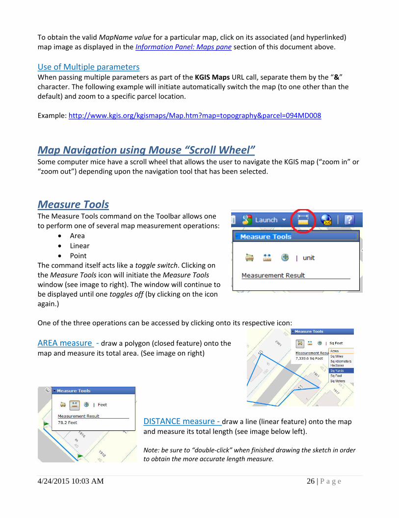
Measure Tools
The Measure Tools command on the Toolbar allows one to perform one of several map measurement operations:
Area
Linear
Point The command itself acts like a toggle switch. Clicking on the Measure Tools icon will initiate the Measure Tools window (see image to right). The window will continue to be displayed until one toggles off (by clicking on the icon again.) One of the three operations can be accessed by clicking onto its respective icon:
AREA measure - draw a polygon (closed feature) onto the
map and measure its total area. (See image on right)
DISTANCE measure - draw a line (linear feature) onto the map
and measure its total length (see image below left). Note: be sure to “double-click” when finished drawing the sketch in order to obtain the more accurate length measure.

4/24/2015 10:03 AM 27 | P a g e
LOCATION measure – place a point on the map, and retrieve its
respective State Plane coordinate and Lat/Long value (image below right)
Unit of Measure One also has the option of changing the respective measurement units from the drop down list on the right side of the Measure Tools window. Options include: Miles, Kilometers, Feet, Meters, and Yards.
Print Operations
This website has been designed primarily for viewing on a computer screen, and therefore the layout, colors, and resolutions are not always ideal for print operations, especially grayscale or high-resolution. KGIS hopes to had better print options in future releases.
PRINT command The standard way to produce a printed product of the map contents being viewed in KGIS
Maps is via the Print command, located on the Toolbar. The Print command initiates a Print Dialog box (see right image): Title: User has the Option to include a title
that will appear within the legend of the print product.
Subtitle: Optional sub-title line to appear on printed map.
Notes: Optional description text to appear on printed map.
Template: Option to choose a print template other than the default “Letter – Portrait” style. When finished with the dialog box options, select the PRINT button on the Dialog box to initiate a new Print Frame browser window. (See Example image below).
4/24/2015 10:03 AM 28 | P a g e
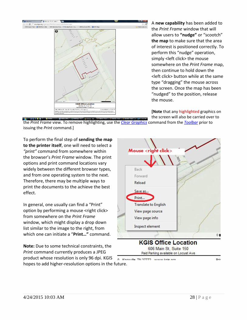
A new capability has been added to the Print Frame window that will allow users to “nudge” or “scootch” the map to make sure that the area of interest is positioned correctly. To perform this “nudge” operation, simply <left click> the mouse somewhere on the Print Frame map, then continue to hold down the <left click> button while at the same type “dragging” the mouse across the screen. Once the map has been “nudged” to the position, release the mouse. [Note that any highlighted graphics on the screen will also be carried over to
the Print Frame view. To remove highlighting, use the Clear Graphics command from the Toolbar prior to issuing the Print command.]
To perform the final step of sending the map to the printer itself, one will need to select a “print” command from somewhere within the browser’s Print Frame window. The print options and print command locations vary widely between the different browser types, and from one operating system to the next. Therefore, there may be multiple ways to print the documents to the achieve the best effect. In general, one usually can find a “Print” option by performing a mouse <right click> from somewhere on the Print Frame window, which might display a drop down list similar to the image to the right, from which one can initiate a “Print…” command. Note: Due to some technical constraints, the Print command currently produces a JPEG product whose resolution is only 96 dpi. KGIS hopes to add higher-resolution options in the future.
4/24/2015 10:03 AM 29 | P a g e
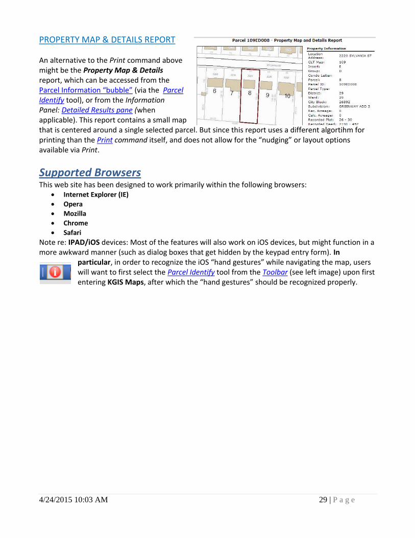
PROPERTY MAP & DETAILS REPORT An alternative to the Print command above might be the Property Map & Details report, which can be accessed from the Parcel Information “bubble” (via the Parcel Identify tool), or from the Information Panel: Detailed Results pane (when applicable). This report contains a small map that is centered around a single selected parcel. But since this report uses a different algortihm for printing than the Print command itself, and does not allow for the “nudging” or layout options available via Print.
Supported Browsers This web site has been designed to work primarily within the following browsers:
Internet Explorer (IE)
Opera
Mozilla
Chrome
Safari
Note re: IPAD/iOS devices: Most of the features will also work on iOS devices, but might function in a more awkward manner (such as dialog boxes that get hidden by the keypad entry form). In
particular, in order to recognize the iOS “hand gestures” while navigating the map, users will want to first select the Parcel Identify tool from the Toolbar (see left image) upon first entering KGIS Maps, after which the “hand gestures” should be recognized properly.