Embed Size (px)
Citation preview

Kennecott Canada Exploration Inc.
2002 REPORT OF AIRBORNE GEOPHYSICS, GROUND TRUTHING and SAMPLINGon the
EVA KITTO PROPERTY
NTS: 052H-09
Thunder Bay Mining Division, Ontario
- Prepared by: - ^,,..--; Kennecott Canada Exploration *hc.
354 - 200 Granville StreetX " Vancouver, British Columbia, Canada\V6C 1S4
Phone: (604)669-1880 Fax: (604) 669-5255
- Author - Steven Coombes, P.Geo.
- Date of report - December 9, 2002
52H09SE2005 2.24671 EVA 010

- CONTENTS -Page No.
INTRODUCTION .............................................................................................................1Project Description ...................................................................................................... 1Geology ............................................................................................................. 1Location and Access.................................................................................................... 1Claim Information ........................................................................................................ 2
EXPLORATION PROGRAM................................................................................................2
Airborne Geophysical Survey....................................................................................... 2
Ground Truthing and Sampling.................................................................................... 2
EXPLORATION RESULTS.................................................................................................. 3
RECOMMMENDATIONS..................................................................................................... 3
REFERENCES .............................................................................................................3
STATEMENT OF QUALIFICATIONS................................................................................... 4
- LIST OF FIGURES - Figure No. Page No.
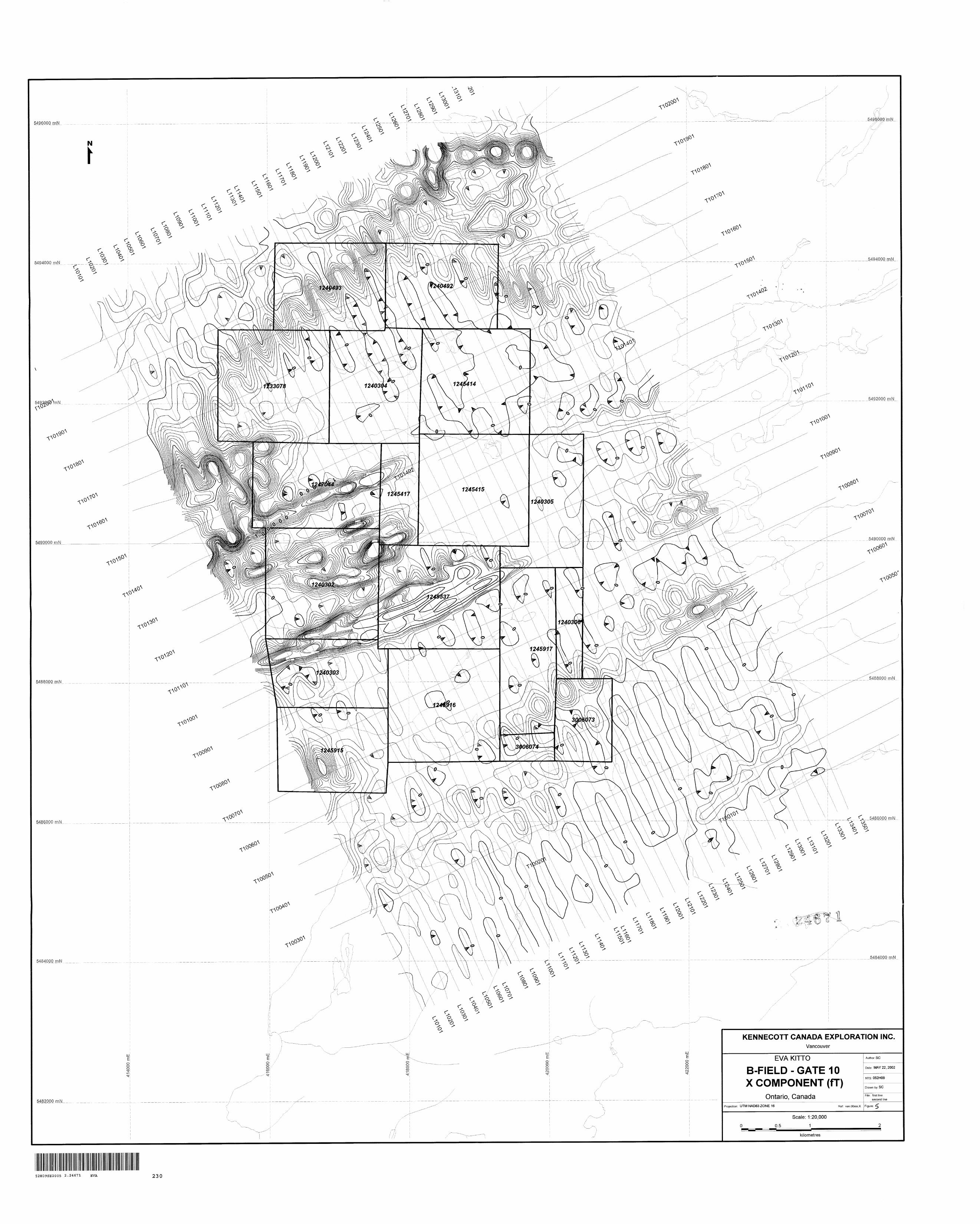
1 Location Map....................................................................................... after page 12 Sample Locations................................................................................ after page 23 Interpreted Geology and 2002 Ground Truthing Results.......................... in pocket4 TMI Magnetics.......................................................................................... in pocket5 B-Field, Gate 10, X-Component............................................................... in pocket6 B-Field, Gate 10, Z-Component................................................................ in pocket7 B-Field, Gate 16, X-Component............................................................... in pocket8 B-Field, Gate 16, Z-Component................................................................ in pocket
- LIST OF APPENDICES -
A Project Personnel
B Sample Information, Results and Analytical MethodsC Airborne Geophysical Survey Areas and SpecificationsD Airborne Geophysical Survey Technical Specifications
E Cost Statement and Distribution of Costs to Claims
INTRODUCTION
Project Description
The Eva Kitto property was the subject of an airborne MegaTEM and magnetics survey on March 29, 2002. The work was performed by Fugro Airborne Surveys Corp. and supervised by Theo Aravanis, Project Geophysicist, and Steven Coombes, Project Geologist, both employees of Kennecott Canada Exploration Inc.
In September and October 2002, areas chosen from the airborne survey and geology maps were visited for sampling and further evaluation. Evaluation included prospecting for outcrop in areas of magnetic and EM features delineated by the airborne survey and confirmation of anomalous results and mapping of other workers. Work was supervised by Dean Rossell of Kennecott Minerals Inc.
Two new claims were staked on the strength of the airborne survey and ground truthing.
Prior to Kennecott Canada Exploration Inc.'s joint venture with East-West Minerals, anomalous lake sediments containing chromium, nickel and copper were discovered. Geophysics, including EM and magnetics, outlined conductive and magnetic bodies within the structurally favourable area. Mapping in 2001 by the OGS revealed a showing with weak copper, nickel and platinum group element mineralization in a creek on the property.
A option agreement for the Eva Kitto property, held equally by East West Resources of Vancouver, B.C., and Maple Minerals of Toronto, Ontario, was signed by Kennecott Canada Exploration l ne on March 27, 2002.
Geology
The Eva-Kitto property, situated within the Nipigon plate, encompasses a 10 km diameter ultramafic cone intrusive body cutting Quetico metasedimentary/iron formation rock and overlain and intruded by diabase sills. The failed arm of the Keweenawan (-1.1 Ga) North American Midcontinent Rift system, a plume induced growth rift, is interpreted to pass through the Nipigon plate.
Hart et al. (2001) describe the ring-shaped perodotite intrusion as roughly concentrically zoned with an outer margin of wehrlite and a larger inner zone of lherzolite. Dominant mineralogy of the core includes massive, medium-grained cumulus olivine, orthopyroxene and clinopyroxene with areas of up to 507o coarse-grained subhedral orthopyroxene and plagioclase appearing more frequently towards the contact with the wehrlite. The outer wehrlite infrequently contains very coarse-grained poikilitic orthopyroxene phenocrysts. Contacts are not definitive and the body may not be a cone sheet dyke.
Similarities in age, structure (i.e. faulting) and geochemistry between the Eva Kitto rocks and those of the famed Noril'sk region of Siberia are documented in literature; the property is an exploration target for Noril'sk type magmatic Cu-Ni-PGE deposits.
Location and Access
The Eva Kitto Claim Group is on the south-east shore of Lake Nipigon on NTS sheet 052H09, approximately 14 km west of the town of Beardmore, shown in Figure 1.

5434000 mH
Scale: 1:40.0001
!fc kilometres
KENNECOTT CANADA EXPLORATION INC.
Vancouver
Thunder Bay Mining Division
Eva Kitto Claims
Ontario, Canada
Dale: 05/12/02 | Author: SG
File: EvaKittoClaims.Dec2002.wor
Ref: van.00722.MFigure: 1

Access during the airborne geophysical survey was by DeHavilland Dash 7 aircraft from Thunder Bay.
Sample sites and ground check locations were accessed by via logging road or walking through the bush after driving from Nipigon or Beardmore. Samples were collected by boat where practical.
Claim Information
The Eva Kitto claim group is comprised of 18 claims covering 3248 hectares. Claim numbers and particulars are detailed in the following table.
Table 1: Claim Information, Eva Kitto Property
Claim Number124030212403031240304124030512403061245414124541512454171245915124591612459171247044124049212404931233078124953730060733006074
Record Date5/24/20005/24/20006/14/20006/14/20006/14/20007/20/20007/20/20007/20/20001/22/20011/22/20011/22/20015/14/20013/13/20003/13/20002/17/20003/1/200211/04/0211/04/02
Expiry Date
5/24/20035/24/20036/14/20036/14/20036/14/20037/20/20037/20/20037/20/20031/22/20031/22/20031/22/20035/14/20033/13/20033/13/20032/17/20033/1/2004
11/04/200411/04/2004
Units16101211416135121612121212161662
Required Assessment6400.004000.004800.004400.001600.006400.005200.002000.004800.006400.004800.004800.004800.004800.006400.006400.002400.00800.00
EXPLORATION PROGRAM
Airborne Geophysical Survey
The survey specifications and equipment descriptions are included as appendices C and D. The survey was conducted on March 29, 2002 at a total cost of CDNS111,665.00. A portion of this total cost has been applied to new claims staked.
Ground Truthing and Sampling
A total of 47 samples were collected - 46 rock samples and 1 weathered rock sample. Rock samples included of peridotite, pyroxenite, gabbro and diabase. Sample locations are shown in the following figure; descriptions and results are included as appendix B.

5494000 mN
Nipigon
.54SSWO/71N l-jScale: 1:40,000
0 1
kilometres
KENNECOTT CANADA EXPLORATION INC.
Vancouver
Thunder Bay Mining Division
Eva Kitto Sample Locations
Ontario. Canada
Date: 09/12/02 lAulhor: SGFile: EvaKttoClaims.Dec2002.wor
Ref: van.00722.MFigure: 2
Samples were collected to duplicate previously identified highly anomalous areas and to verify mapping done in past years while investigating surficial expressions of airborne anomalies. Traverses were made by truck as far as possible, then continued on foot or boat where warranted. Where outcrop was seen, rock samples were collected using a hammer and chisel, identified and given sample numbers. The rocks were then placed in drawstring cloth bags with a sample tag and sealed. Rock types and contacts were noted where seen to verify mapping and the relative age of the peridotite. A summary of ground truthing data is shown in Table 2; Figure 3 illustrates the traverses and the prospecting results.
The samples were brought to the exploration office in Thunder Bay and reviewed. On the basis of visual identification of sulphides, seven samples were analysed for gold, platinum, palladium, copper, zinc, nickel, cobalt, chromium, titanium and sulphur. Specific gravity was also measured. Rocks not selected for analysis at this time are stored at Kennecott's Tucson office.
Samples were processed by ALS Chemex Laboratories of Thunder Bay, ON. Each rock was crushed and pulverized; 1000 g was used in the analysis. Elements Au, Pt and Pd were determined using ICP-AES after fire assay and elements Cu, Zn, Ni, Co, Cr, Ti and S were determined using ICP-AES after sodium peroxide fusion. Descriptions of the methods used are included in Appendix B.
EXPLORATION RESULTS
Main points from the data interpretation of the airborne survey are as follows:
* There is an intense magnetic low at the southern peridotite, coincident with an E/W fault.
* The mapped peridotite appears to terminate conductors in the southern half of the area. Conductors in the north appear to terminate within the metavolcanics.
* The diabase is reversely magnetized.
* The area is dominated by E/W trending faults.
Ground truthing and sampling results indicate:
* The peridotite trends further southwest than previously mapped.
* Shape of the intrusion is more likely a sill, dipping to the west.
* The peridotite intrudes the sulphide-rich metasedimentary rocks, yielding a source for sulphur.
* Assays reveal anomalous PGM results.

Table 2: Ground Truthing Traverse Notes
Station1234
5678g101112
1314
1516
1718
192021222324252627282930313233343536373839
4041
424344
Date9/26/029/26/029/26/029/26/02
9/26/029/26/029/26/029/26/029/27/029/27/029/27/029/27/02
9/27/029/27/02
9/27/029/27/02
9/27/029/27/02
9/28/029/28/029/28/029/28/029/28/029/28/029/28/029/28/029/29/029/29/029/29/029/29/029/29/029/29/029/29/029/29/029/29/029/29/029/29/029/29/029/29/02
9/30/029/30/02
10/1/0210/1/0210/1/02
Sample #
vr82952avr82953a
vr82954avr82955avr82956a
vr82959a
vr82966avr82967avr82968a
vr82969avr82970avr82971avr82972a
vr82973avr82974a
vr82975a
vr82976avr82977a
Datumnad 27nad 27nad 27nad 83
nad 83nad 83nad 83nad 83nad 83nad 83nad 83nad 83
nad 83nad 83
nad 83nad 83
nad 83nad 83
nad 83nad 83nad 83nad 83nad 83nad 83nad 83nad 83nad 83nad 83nad 83nad 83nad 83nad 83nad 83nad 83nad 83nad 83nad 83nad 83nad 83
nad 83nad 83
nad 83nad 83nad 83
zone16161616
1616161616161616
1616
1616
1616
161616161616161616161616161616161616161616
1616
161616
Easting419181419118419081418728
418647418668418415418057418989418999419011419047
418819418799
418773418744
418612418546
421155421125421100420910420864420742420582420641420563420499420310420294420023420070420009420007420161420350420429420444420381
420631420665
418547418389418389
Northing5491960549195154919355491833
54918705491872549185854920035492309549230954923955492431
54924285492437
54925085492540
54927715492863
548927354892735489229548902354890365488959548877754887585488686548864954885555488572548872154886035488438548836554883315488315548835754880175487952
54873445487319
548726754873155487315
Rock Typeperidotiteperidotiteperidotiteperidotite
gabbrogabbrogabbrogabbroperidotiteperidotiteperidotiteperidotite
ol. gabbrogabbro
gabbrogabbro
gabbrogabbro
ol. gabbrogabbrogabbroperidotitegabbroperidotiteperidotiteperidotiteperidotiteperidotiteperidotiteperidotiteperidotiteperidotiteperidotiteperidotiteperidotiteperidotiteperidotiteperidotiteperidotite
peridotiteperidotite
peridotiteperidotiteperidotite
Sulphidenononono
nononononononono
nono
nono
yesno
nonononoyesyesnoyesnonononononononononononono
nono
nonono
NotesDk, greenish gray, m. g, weakly mag., w/ 40-50'?i fresh oldk gray, msv, porphyritic w/ blk cpx up to 1cm, 30"7o whtt fldspr and cpx pegmatioddk gray, weakly porphyritic, w/ abnt granular ol 0.5cm cpx phenocrysts
It. Gray, m.f.g., msv, strongly mag, w/ S-6% mag in plag matrix w/ subophitic cpx. Also minor granophyre dikese.g. , msv, granophyric w/ var. pink fldspr, rare qtz. Intrudes f.g. oxide rich gabbrowht, e.g. fol. Oxide rich w/ uniform oriented plag laths up to 2cm (very BIG like)f.g.-m.g. oxide rich w/ abnt xenoliths of meta-seds up to 15cm longm. g., porphyritic, cpx rich / 0.25m spaced subhor. Joints, minor biot.small exposure e.g. crumbly cpx rich pegmatoiddk gray, mg, porphyritic, msv, mod. Mag. w/ brownish ol and cpx up to 0.5cm. no jointingdk gray, mg., porphyritic, fldspathic w/ scattered pods of peggmatoid and prominent joints
It. Gray, m.g., msv, w/ 40-5007o fldspr, 207oOl , SO-40% cpx and minor mag. Possibly thick n-s dike0.5m thick dike? Of, wht, eg, anorthosite gabbro cutting ol. Gabbro/peridotite. Might not be otc.0.5m thick dike? Of, wht, eg, anorthosite gabbro cutting ol. Gabbro/peridotite. Nearby bldr of gabbro w/ peridotite clastsIt gray, meg, msv, oxide rich w/ no visible olreddish mfg, oxide rich w/ tr. Py-cpy near base of otc of Archean meta-sed. Contact dips v. gently west.gabbro-sed contact similar to1 7dk gry, fg, ol bearing melagabbro /peridotite w/ 5007oplag, 45"7ocpx, 1 -207oOI? Mod. Mag.(unit below nipigon sill)msv, mg gabbro overlying jointed ol. gabbro. Probable near hor. ContactCg, massive ophitic gabbro w/ cpx up to 2cm.dk gray, fg, msv, w/ 20-2507ool in cpx rich matrix, 25-35"7o fldspar, 1 -207obiot.It.gray, eg, ophitic w/ no visible ol or biot. 1-2"7o mag. tr. Cpydk gray, fg, msv, w/ abnt biot, tr. Fg po and cpy (probable subcrop)dk gray, mfg, msv, w/ prominent sub hor. Jointingmg, msv, mod mag, w/ abnt biot. And one v. small bleb po-cpy.dk gray, mfg, msv, ol rich w/ abnt. Biot. Mod mag.dk gry, mg, msv, biot-ol rich, mod mag.mg, msv, ol rich w/ less biot than 28mg, msv, ol rich w/ less biot than 28mg, msv ol rich w/ 1 07obiot ^0 "54 plagmg, ol rich, mod mag, '\Vo biot.mg, ol rich, mod mag, 1 07o biot.mg, ol rich, mod mag, 1"7o biot., 10-20cm spaced near hor joints some filled w/ glassy serp vnsmfg, msv, ol rich w l-2"7obiot, some ol reddish brown in color (alt. ?)dk gray, mfg, ol. Rich w/ 1 07obiot. 10-20cm spaced sub hor jointingdk gray, fg-mfg, msv. Appears more cpx rich than 36. Patches of saprolite like alt.f.g. peridotite bldrs probable subcropsmall probable otcsdk gray, mg, msv, mod mag, w/ cpx xi\, 1 0-2007oplag, prominent sub hor jointing and cpx rich pegmatoidsimilar to station 40dk grnish gray, mod-strongly serp, w/ vcg biot. Probably only a few meters below contact w/ nipigonsillsaprolite like alt. Of peridotite w/ some igneous texture preserved ~2m below nipigon sill contactmg. Mod. Serp. Peridotite w/ eg biot, strongly mag

Station45
46
47
48495051
5253545556575859606162
63
64656667686970
71
72737475
767778
79808182
Date10/1/02
10/1/02
10/1/02
10/1/0210/1/0210/1/0210/1/02
10/2/0210/2/02
10/19/0210/19/0210/19/0210/19/0210/19/0210/19/0210/22/0210/22/0210/22/02
10/22/02
10/22/0210/23/0210/23/0210/23/0210/23/0210/23/0210/23/02
10/23/02
10/23/0210/23/0210/25/0210/25/02
10/25/0210/25/0210/25/02
10/25/0210/25/0210/25/0210/25/02
Sample #vr82978a
vr82979a
vr82980a
vr82981avr82982avr82983avr82984a
vr82985avr82986a
vr82988a
vr82989avr82994avr82995avr82996a
vr82990
vr82991a
sample
sample
vr32312a
vr32313a
Datumnad 83
nad 83
nad 83
nad 83nad 83nad 83nad 83
nad 83nad 83nad 83nad 83nad 83nad 83nad 83nad 83nad 83nad 83nad 83
nad 83
nad 83nad 83nad 83nad 83nad 83nad 83nad 83
nad 83
nad 83nad 83nad 83nad 83
nad 83nad 83nad 83
nad 83nad 83nad 83nad 83
zone16
16
16
16161616
1616161616161616161616
16
16161616161616
16
16161616
161616
16161616
Easting418389
418372
418311
418300418290418276418186
416829416598420143419764419707419574419419419481416414416297416101
416338
416325416300416420416443416341416271416232
416238
416240416179418758417571
417341417346417289
418368418630418806418983
Northing5487315
5487339
5487396
5487396548740054873945487434
54933685493235548803754881555488235548835754884155488643549241054923005492172
5492662
5492556549238654923625492344549239654925645492599
5492642
5492742549270654874515487184
548726154873195487404
5487336548731254875865487748
Rock Typegabbro
peridotite
peridotite
peridotiteperidotiteperidotitegabbro
gabbroperidotiteperidotiteperidotiteperidotiteperidotiteperidotiteperidotiteperidotiteperidotiteperidotite
peridotite
peridotiteperidotiteperidotitemetasedimentgabbroperidotitegabbro
gabbro
gabbroperidotiteperidotiteperidotite
peridotiteperidotiteperidotite
peridotiteperidotiteperidotiteperidotite
Sulphideno
yes
yes
yesyesyesno
nononoyesnonononoyesnono
no
nonononononono
no
nononono
nonono
yesyesnono
Notesblk, aphanitic chilled contact of nipigon sill, weakly mag.dk grnish gray, mg, strongly serp, w/ tr vfg sulfide. Well developed spheroidal weathering in areas of sap like alt.5mx5mx0.5m thick otc of serp. Peridotite w/ 1 -3"7opo and tr cpy a few meters below nipigon sill contact0.5x0.25x0.25m angular bldr of dk grnish gray, mod serp, biot rich peridotite w/ 1-3"7o po and tr cpy (iregular shaped blebs)0.25x0.25x0.25m angular boulder similar to 46small possible otc serp. Peridotite w/ 1-3"7o diss. Blebs of popossible otc of chilled contact(?) nipigon sill(?) w/ 10-2007omagn-s, near vert, mg.msv melagabbro w/ no visible ol or biot. Tr py-cpy. Cuts Archean seds at high angle to fol.mg, cpx rich, fldspathic w/ only tr biot.porphyritic, cpx rich peridotite w/ abnt biot. Well developed sub-hor jointingweakly serp w/ weakly developed sub-hor jointing, scttered 1cm serp veins and tr. Vfg sulfide(?)dk grnish gray, mg-mfg, ol rich w/ prominent poikolitic cpx and abnt biot, v weakly serpmfg, w/ distinctive lumpy weathering pattern (possibly poikolitic cpx weathering out.mfg, ol rich w/ minor biot.sub-hor jointingdk gray.fg, msv, peridotite/pyroxenitef??) or possibly ol melagabbro(??)fg peridotite w/tr po.( Probably near archean contact.)blk, msv, mgmeg, w/ 3-4mm ol (cpx?)med. Gray, msv, (no obvious jointing) mg, feldspathic w/ 25-35 (54plag, and eg granophyric pods and veinsmed. Gray, msv, (no obvious jointing) mg, feldspathic w/ 25-3507oplag, and eg granophyric pods and veinsdk gray, mg, msv, cpx rich. No granophyre.dk gray, mg, msv, cpx rich w/ patches of e.g. granophyric gabbrogreenish gray, vfg, schist (probably Archean metasediments)mg-cg, gabbro with patchy red fldspar and tr. Qtz(?) (granophyric gabbro)feldpathic peridotitevcg, oxide rich gabbro and granophyre w/ plag xtals up to 2cmvcg, oxide rich gabbro and granophyre w/ prominent sub hor jointing (-5m exposed beneath peridotite-no contact visible)contact between gabbro-granophyre sill and porphyritic peridotite w/ cpx phenocrysts up to 2cm. Gabbro has chilled contactsporphyritic peridotite w/ e.g. cpx phenocrysts similar to 72dk grnish gry, mg, ol and biot rich, mod. Serp. Rusty weathering w/ no obvious jointsdk grnish gry, mg, msv ol and biot rich, mod. Serp. Rusty weathering w/ no obvious jointsdk gry, mg, msv, biot-ol rich. Numerous large bldrs of archean voles, (subcrop???) upslope from peridotite otc.abnt angular bldrs of archean volcs(subcrop???) ~ 10m east of peridottie otcmod. Well exposed mg peridotitedk, greenish gray, m. g, weakly mag., msv, mod serp. W/ 5"7o bright wht plag, abnt biot and 0.207ofg diss po and tr cpyDk gry, fg, msv strongly magnetic rock w/ tr sulfide possibly peridotite or chilled Nipigon diabasedk gry, mg, msv, weakly serp.well exposed otcs along north side of E-W gully

RECOMMENDATIONS
Further work on the Eva-Kitto Claim group is essential to acquire additional data. Mapping and prospecting should be made a priority, with special attention paid to ultramafic units previously not mapped as peridotite. Stripping of outcrops could offer insight into contacts and facilitate more sampling in highly prospective areas.
Petrological studies and age determination analysis should be performed on rock samples taken in the fall of 2002. To characteristize the source magma, the whole rock geochemistry should be studied.
Drill testing of the peridotite is required to sample at depth and to best delineate the body.
REFERENCES
East West Resources, 2002. East West Resources Corporation website; Geology of the Eva Kitto Property; www.eastwestres.com/main.asp?section=properties&page=eva
Hart, T.R., terMeer, M., Jolette, C. 2002. Precambrian Geology of Kitto-Eva-Summers- Dorothea-Sandra Townships, Northwestern Ontario, Phoenix Bedrock Mapping; Ontario Geological Survey, Open File Report 6095.
Hart, T.R., terMeer, M., Jolette, C., Duggan, B.M. 2002. Proterozoic Ultramafic-Mafic Intrusions of the Nipigon Plate, Beardmore, Ontario; abstract in Calgary MEG Society Tenth Annual Calgary Mining Forum, April 18+19, 2001.
Sutcliffe, R.H. 1991. Proterozoic geology of the Lake Superior area; in Geology of Ontario, Ontario Geological Survey, Special Volume 4, Part 1.

STATEMENT OF QUALIFICATIONS
l, Steven Coombes, of the city of Vancouver, Province of British Columbia, DO HEREBY CERTIFY THAT:
1) l am a project geologist employed by Kennecott Canada Exploration Inc. with a business office at 354-200 Granville Street, Vancouver, British Columbia, Canada, V6C 1S4.
2) l am a graduate in Geology with a Bachelor of Science degree from the University of British Columbia in 1983.
3) l am a registered member of the Association of Professional Engineers and Geoscientists of the Province of British Columbia (No. 19713).
4) l am a Fellow of the Geological Association of Canada (No. F5457).
5) l have practiced my profession as a geologist for the past 20 years.
Four years pre-graduate field experience in geology, geochemistry, and geophysics with Noranda Exploration Co. Ltd. (seasonal, 1979 to 1982).Two years as exploration geologist with Rhyolite Resources Inc. (1983 to 1985).Five years as exploration geologist with Searchlight Consultants Inc. (1985 to 1990).
Five years as consulting geologist and proprietor of Summit Geological (1990 to 1995).
Eight years as project and principal geologist for Kennecott Canada Exploration Inc. (1995 to 2002).
6) l supervised the 2002 Eva Kitto airborne survey and wrote this report to document the results of work on the claims.
Dated:
December 9, 2002 Steven Coombes, P.Geo.Project Geologist
APPENDIX A Project Personnel
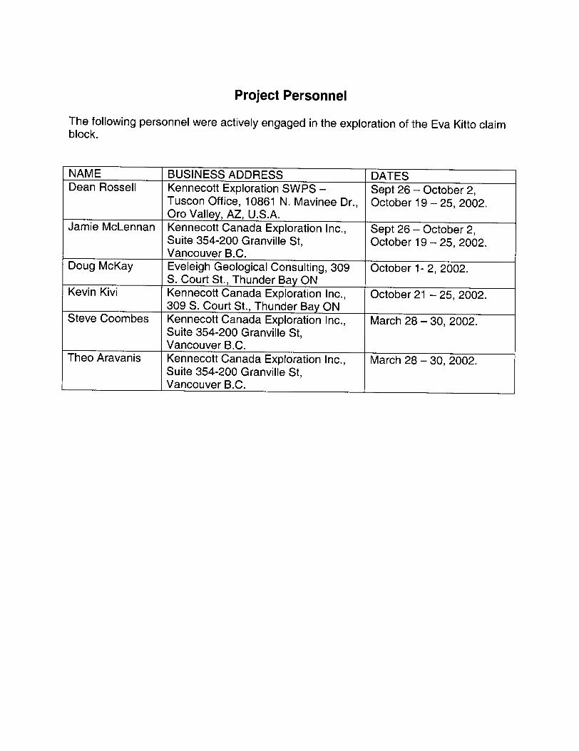
Project Personnel
The following personnel were actively engaged in the exploration of the Eva Kitto claim block.
NAMEDean Rossell
Jamie McLennan
Doug McKay
Kevin Kivi
Steve Coombes
Theo Aravanis
BUSINESS ADDRESSKennecott Exploration SWPS - Tuscon Office, 10861 N. Mavinee Dr., Oro Valley, AZ, U.S.A.Kennecott Canada Exploration Inc., Suite 354-200 Granville St, Vancouver B.C.Eveleigh Geological Consulting, 309 S. Court St., Thunder Bay ONKennecott Canada Exploration Inc., 309 S. Court St., Thunder Bay ONKennecott Canada Exploration Inc., Suite 354-200 Granville St, Vancouver B.C.Kennecott Canada Exploration Inc., Suite 354-200 Granville St, Vancouver B.C.
DATESSept 26 - October 2, October 19 -25, 2002.
Sept 26 - October 2, October 19 -25, 2002.
October 1-2, 2002.
October 21 - 25, 2002.
March 28 - 30, 2002.
March 28 - 30, 2002.

APPENDIX BSample Information, Results and Analytical Methods
Sample Information Table All samples located in Zone 16, NAD 83.Sample Number
VR82951AVR82952AVR82953AVR82954AVR82955AVR82956AVR82957AVR82958AVR82959AVR82960AVR82961AVR82962AVR82963AVR82964AVR82966AVR82967AVR82968AVR82969AVR82970AVR82971AVR82972AVR82973AVR82974AVR82975AVR82976AVR82977AVR82978AVR82979AVR82980AVR82981AVR82982AVR82983AVR82984AVR82985AVR82986AVR82987AVR82988AVR82989AVR82990AVR82991AVR82992AVR82993AVR32309AVR32310AVR32311AVR32312AVR32313A
Easting
419400419081418728418648418668418411418989419016418819418744418612421125421155420910420742420582420641420499420310420294420023420352420429420665418386418386418386418372418311418300418290418276418186418186416829416598419760419483416337416321415921415695415606415758415391417344418368
Northing
54919305491937549183354918735491871549186054923085492398549242754925405492771548927354892735489023548895754887775488758548864954885555488577548872154883205488357548713954873205487320548732054873395487396548740054874005487394548743454874345493368549323554881485488644549265454925635491994549189554924635492133549175154873285487336
Mapsheet
52 H 0952 H 0952 H 0952 H 0952 H 0952 H 0952 H 0952 H 0952 H 0952 H 0952 H 0952 H 0952 H 0952 H 0952 H 0952 H 0952 H 0952 H 0952 H 0952 H 0952 H 0952 H 0952 H 0952 H 0952 H 0952 H 0952 H 0952 H 0952 H 0952 H 0952 H 0952 H 0952 H 0952 H 0952 H 0952 H 0952 H 0952 H 0952 H 0952 H 0952 H 0952 H 0952 H 0952 H 0952 H 0952 H 0952 H 09
Date Sampled26-Sep-0226-Sep-0226-Sep-0226-Sep-0226-Sep-0226-Sep-0227-Sep-0227-Sep-0227-Sep-0227-Sep-0227-Sep-0228-Sep-0228-Sep-0228-Sep-0228-Sep-0228-Sep-0228-Sep-0229-Sep-0229-Sep-0229-Sep-0229-Sep-0229-Sep-0229-Sep-0230-Sep-02
1 -Oct-021-Oct-02
1 -Oct-021 -Oct-021 -Oct-021 -Oct-021 -Oct-021 -Oct-021 -Oct-021 -Oct-022-Oct-022-Oct-02
19-Oct-0219-Oct-0222-Oct-0222-Oct-0223-Oct-0223-Oct-0223-Oct-0223-Oct-0223-Oct-0225-Oct-0225-Oct-02
Sampler
D. RossellD. RossellD. RossellD. RossellD. RossellD. RossellD. RossellD. RossellD. RossellD. RossellD. RossellD. RossellD. RossellD. RossellD. RossellD. RossellD. RossellD. RossellD. RossellD. RossellD. RossellD. RossellD. RossellD. RossellD. RossellD. RossellD. RossellD. RossellD. RossellD. RossellD. RossellD. RossellD. RossellD. RossellD. RossellD. RossellD. RossellD. RossellD. RossellD. Rossell
K. KiviK. KiviK. KiviK. KiviK. Kivi
D. RossellD. Rossell
Sample TypeRockRockRockRockRockRockRockRockRockRockRockRockRockRockRockRockRockRockRockRockRockRockRockRockSoil
RockRockRockRockRockRockRockRockRockRockRockRockRockRockRockRockRockRockRockRockRockRock
Rock Type
PeridotitePeridotiteGabbroGabbroGabbroGabbroPyrox
PeridotiteGabbroGabbroGabbroGabbroGabbro
PeridotitePeridotitePeridotitePeridotitePeridotitePeridotitePeridotitePeridotitePeridotitePeridotite
PyroxSapprolitePeridotiteDiabase
PeridotitePeridotitePeridotitePeridotitePeridotite
Magnetite rich?PeridotiteGabbro
PeridotitePeridotite
PyroxGabbroGabbro
PeridotitePeridotitePeridotitePeridotitePeridotitePeridotitePeridotite

A(AUS)
ALS ChemexAurora Laboratory Services Ltd. Analytical Chemists' Geochemists ' Registered Assayers
212 Brcx)ksbank Ave., North Vancouver British Columbia, Canada V7J 2C1 PHONE: 604-984-0221 FAX: 604-984-0218
To: KENNECOTT CANADA, INC.
354 - 200 GRANVILLE ST. VANCOUVER, BC V6C1S4
Project: Comments:
ONTARIOATTN: PETER ANDEXER
Page Number : 1Total Pages : 1Certificate Date: 17-OCT-2002Invoice No. : 10225536P.O. Number :Account : KAV
GC: DEAN ROSSELL
SAMPLE
VR82976A VR82977A VR82979A VR82980A VR82981A
VRB2982A VR82983A
PREP CODE
9414 9414 9414 9414 9414
9414 9414
234 226 226 226 226
226 226
Spec Gr S. Q.
3.12 2.78 2.97 3.09
2.99 2.92
Au ppbICP
< 2 2
< 2 58 12
12 14
Pt ppb ICP
< 5 < 5 < 5335 105
300 435
Pd ppbICP
2 2 2
556 160
458 630
Cu*
< 0.01 < 0.01 < 0.01
0.22 0.05
0.04 0.07
CERTIFICATE OF ANALYSIS A0225536
Zn*
0.01 0.01
< 0.01 0.01 0.01
< 0.01 < 0.01
Nit
0.120 0.055 0.120 0.265 0.165
0.200 0.250
Co\
0.012 0.008 0.010 0.016 0.014
0.014 0.016
Cr \
0.28 0.12 0.28 0.22 0.22
0.26 0.24
Ti
*
0.28 0.53 0.27 0.27 0.41
0.34 0.29
S*
0.02 0.17 0.07 0.86 0.27
0.43 0.66
\\ - ' i\ t -'.li. -- j - ; .' '
CERTIFICATION:

ALS ChemexAurora Laboratory Services Ltd.Analytical Chemists" Geochemists " Registered Assayers
212 Brooksbank A ve., North Vancouver British Columbia, Canada V7J 2C1 PHON E: 604-984-0221 FAX: 604-984-0218
To: KENNECOTT CANADA, INC.
354 - 200 GRANVILLE ST. VANCOUVER, BC V6C1S4
Comments: ATTN: PETER ANDEXER CC: DEAN ROSSELL
A0225536
CERTIFICATE A0225536
(KAV ) - KENNECOTT CANADA, INC.
Project: ONTARIO P.O. # :
Samples submitted to our lab in Thunder Bay, ON This report was printed on 17-OCT-2002.
SAMPLE PREPARATION
METHODCODE
PUL-32226234
3202
NUMBERSAMPLES
7617
DESCRIPTION
Pulv. lOOOg to ^5V-75 micron0-3 Kg crush and split0-7 Kg splitting chargeRock - save entire reject
ANALYTICAL PROCEDURES
METHOD CODE
OA-GRAOBAU-ICP23Pt-ICP23Pd-ICP23CU-ICP81Zn-ICP81N1-ICP81Co-ICPSlCr-ICP81Ti-ICP81
S-ICP81
NUMBER SAMPLES
e7777777777
DETECTION DESCRIPTION METHOD LIMIT
Specific gravity SG: bulk sample GRAVIMETRIC 0.01
Au ppb: FA ICP package FA-ICP 2
Pt ppb: FA ICP package FA-ICP 5
Pd ppb: FA ICP package FA-ICP 2
Cu *: Fusion - ICP-AES FUSION- ICPAES 0.01
Zn *: Fusion - ICP-AES Fusion - ICP-AES 0.01
Hi *: Fusion - ICP-AES Fusion - ICP-AES 0.005
Co *: Fusion - ICP-AES Fusion - ICP-AES 0.002
Cr Hi Fusion - ICP-AES Fusion - ICP-AES 0.02
Ti9t: Fusion - ICP-AES Fusion - ICP-AES 0.01
S *: Fusion - ICP-AES Fusion - ICP-AES 0.01
UPPER LIMIT
20.0100001000010000
30.030.020.0
10.0010.0030.060.0

ALS
ALS ChemexAurora Laboratory Services Ltd. Analytical Chemists * Geochemists * Registered Assayers
212 Brooksbank A ve., North Vancouver British Columbia, Canada V7J 2C1 PHONE: 604-984-0221 FAX: 604-984-0218
To: KENNECOTT CANADA, INC.
354 - 200 GRANVILLE ST. VANCOUVER, BC V6C 1S4
QC Page #: Tot QC Pg: Date: Invoice #: P.O. #:
Project: Comments:
ONTARIOATTN: PETER ANDEXER
1117-OCT-200210225536
KAV
CC: DEAN ROSSELL
STD/DUP/BLANK DESCRIPTION
ICP-SU1A CHEMEX MEAN
PQMA-95 CHEMEX MEAN
QC PAGE TYPE NO.
Stdl
Stdl
1
1
Spec Gr S. G.
Au ppb ICP
384 377
Pt ppbICP
695 725
Pd ppb ICP
644 672
Cu
0.95
QC DATA OF CERTIFICATE A0225536
Zn
0.02 0.03
Ni
1.230 1.230
Co
0.038 0.041
Cr
0.02
Ti
0.30
s56
9.38 9.35
V
CERTIFICATION^

AAssay Procedure ME-ICP81
Evaluation of Ores and High Grade Materials by Fusion- ICP-AES
Sample Decomposition: Sodium Peroxide FusionAnalytical Method: Inductively Coupled Plasma - Atomic Emission Spectroscopy (ICP - AES)
A prepared sample (0.200 gram) is added to sodium peroxide flux (2.6 grams), mixed well and then fused in a 6500C furnace. The resulting melt is cooled and then dissolved in 250ml of 1007o hydrochloric acid. This solution is then analyzed by inductively coupled plasma - atomic emission spectrometry and the results are corrected for spectral interferences.
ALS ChemexCode
AS-ICP81Co-ICPSlCu-ICPSlFe-ICI'81Ni-lCPSlS-ICP81
Pb-ICP81Zn-ICP8i
ChemexCode
1061105810561060 1057106280688069
Element
Arsenic CobaltCopper Iron NickelSulfurLeadZinc
Symbol
As CoCu FeNiS
PbZn
Detection Limit
0.01 7o 0.002 7o0.005 7o
0.1 7o 0.005 07o0.01 7o
0.02 7oQ.01%
Upper Limit
10 7o10 07o
20 07o 40 7o 20 7o60 7o5 07o
57o
NoveiTTbei; 31, 2002W!

AUS ctiemex
Geochemical Procedure - PGM-ICP23 and.PGM-ICP24 Precious Metals Analysis Methods
Sample Decomposition: Fire Assay FusionAnalytical Method: Inductively Coupled Plasma - Atomic Emission Spectrometry (ICP-AES)
A prepared sample is fused with a mixture of lead oxide, sodium carbonate and borax silica, inquarted with 6 mg of gold-free silver and then cupelled to yield a precious metal bead. The bead is digested for 2 minutes at high power by microwave in dilute nitric acid. The solution is cooled and hydrochloric acid is added. The solution is digested for an additional 2 minutes at half power by microwave. The digested solution is then cooled, diluted to 4 ml with 207o hydrochloric acid, homogenized and then analyzed for gold, platinum and palladium by inductively coupled plasma - atomic emission spectrometry.
PGM-ICP23l ALSi Chemex| Method
ALS I lChemex
Parameter || Code Code1 Au-iCP23 f 975
ElementGold
| pt.Jcp23 i 976 i Platinum| Pd-iCP23 ^ 977 j Palladium
i SampleSymbol
AuPtPd
Weight30 g30 g3P. g ...
Detection UpperLimit LimitIppb | 10,000 ppb5ppb | 10,000 ppbIppb | 10,000 ppb
PGM-ICP24ALS
ChemexMethod
CodeAu-ICP24PMCP24Pd-ICP24
ALSChemex
Code966696649665
ElementGold
PlatinumPalladium
1
i Symbol| Aui Pti Pd
1
j Sample1 Weight1 50 Sj 5Qgi 5Q g
——————
DetectionLimit
........ J.PEb ..........
.......l.ppb
........,..lEpb.,,.......
UpperLimit
10,000 ppb16,660 ppb10,666 ppb
November 14, 2002 l

APPENDIX C SURVEY AREAS AND SPECIFICATIONS
Survey Name: Eva Kitto, OntarioGeneral Location: Approximately 14 kilometers west of Beardmore, OntarioBase of Operations: Thunder bay, Ontario
Survey Type: Fixed WingGeophysical Parameters: Total Magnetic Intensity; Time Domain EM
Survey Boundary: (NAD 27 UTM Zone 16)
Point
A
B
C
D
Easting
417800.0
413573.8
419918.0
424144.2
Northing
5484000.0
5493063.1
5496021 .4
5486958.3
Line Specifications:Transect Lines: Direction 155/335Tie Lines: Direction 065/245
Spacing 200 metres Spacing 500 metres
Mean Terrain Clearance: AircraftEM sensor
Magnetometer
120 metres 70 metres 75 meters
Approximate Data Sample Spacing: Magnetic Field 6 metres or 10 sample/secEM 15 metres or 4 sample/sec
Any infill or extensions to the survey area will have a minimum line length of 8 km.

Eva Kitto survey area
412500 415000 J17500 420000 J22500 425000
Survey line layout
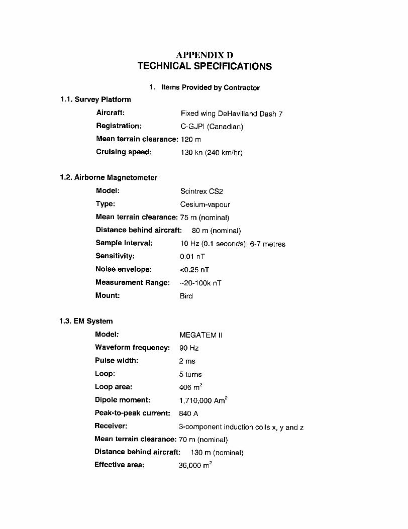
APPENDIX D TECHNICAL SPECIFICATIONS
1. Items Provided by Contractor1.1. Survey Platform
Aircraft: Fixed wing DeHavilland Dash 7
Registration: C-GJPI (Canadian)
Mean terrain clearance: 120 m
Cruising speed: 130 kn (240 km/hr)
1.2. Airborne Magnetometer
Model: Scintrex CS2
Type: Cesium-vapour
Mean terrain clearance: 75 m (nominal)
Distance behind aircraft: 80 m (nominal)
Sample Interval: 10 Hz (0.1 seconds); 6-7 metres
Sensitivity: 0.01 nT
Noise envelope: *:0.25 nT
Measurement Range: -20-100k nT
Mount: Bird
1.3. EM System
Model: MEGATEMII
Waveform frequency: 90 Hz
Pulse width: 2 ms
Loop: 5 turns
Loop area: 406 m2
Dipole moment: 1,710,000 Am2
Peak-to-peak current: 840 A
Receiver: 3-component induction coils x, y and z
Mean terrain clearance: 70 m (nominal)
Distance behind aircraft: 130 m (nominal)
Effective area: 36,000 m2

Vz waveform samp, rate: 128 per pulse
Sample Interval: 4 Hz (0.25 seconds); 15-16 metres
Channels/Gates: 20 channels approximately as specified in the following
table:
Gate No.
1234567891011121314151617181920
ON or
OFF timeONONONONONOFFOFFOFFOFFOFFOFFOFFOFFOFFOFFOFFOFFOFFOFFOFF
Start point
411263752575961646771757984899499
105111119
End Point
10253651565860636670747883889398
104110118128
Width points
7151115522334445555668
10
Start (fjsec)
130.2434.0
1085.01562.42213.42430.42517.22604.02734.22864.43038.0321 1 .63385.23602.23819.24036.24253.24513.64774.05121.2
End (//sec)
434.01085.01562.42213.42430.42517.22604.02734.22864.43038.0321 1 .63385.23602.23819.24036.24253.24513.64774.05121.25555.2
Centre (//sec)
282.1759.5
1323.71887.92321 .92473.82560.62669.12799.32951.23124.83298.43493.73710.73927.74144.74383.44643.84947.65338.2
Approx. Noise level
(pT/s)
25,00015,00015,00015,00025,00015,00010,00010,0008,0008,0008,0007,0007,0007,0006,0006,0006,0005,0005,0005,000
NOTE: The noise levels quoted for each channel were derived from background values measured at altitude, in calm air, with straight and level flying. Actual noise levels while surveying on line may be higher due to aircraft maneuvering and turbulent conditions at low levels above the ground.

Prestack sampling rate: 64 per pulse
Measured response: dB/dt and B-field
Bandwidth: Base frequency to 10 kHz
Stacking rate: 4 stacks per second
Digital recording: all raw data channels
1.4. Altimeters
1.4.1.Radar Altimeter
Model:
Sample Interval:
Accuracy:
Precision:
Range:
King KRA405
Analog output - recorded at 2 Hz
507o
Equal to or better than 3 metres
0-610 metres
1.4.2. Barometric Altimeter
Model:
Sample Interval:
Accuracy:
Precision:
Range:
Rosemount 1241M
Analog output - recorded at 2 Hz
15 metres
Equal to or better than 3 meters
-305 m to 4570 m barometric
The aircraft altitude will be recorded on digital disk as well as displayed on the aircraft chart recorder. The recorded value will be the average of the altimeter output during the previous second.
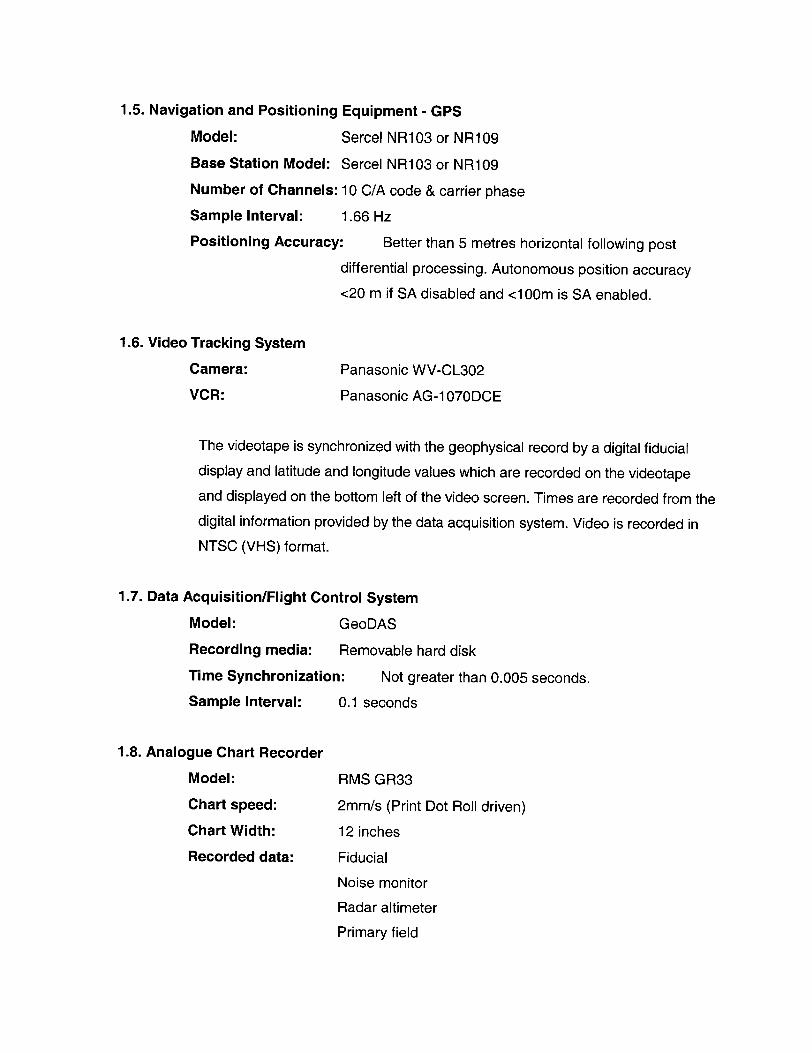
1.5. Navigation and Positioning Equipment - GPS
Model: Sercel NR1 03 or NR1 09
Base Station Model: Sercel NR103 or NR109
Number of Channels: 10 C/A code 8t carrier phase
Sample Interval: 1 .66 Hz
Positioning Accuracy: Better than 5 metres horizontal following post
differential processing. Autonomous position accuracy
m if SA disabled and *c100m is SA enabled.
1.6. Video Tracking System
Camera: Panasonic WV-CL302
VCR: Panasonic AG-1070DCE
The videotape is synchronized with the geophysical record by a digital fiducial
display and latitude and longitude values which are recorded on the videotape
and displayed on the bottom left of the video screen. Times are recorded from the
digital information provided by the data acquisition system. Video is recorded in
NTSC (VMS) format.
1.7. Data Acquisition/Flight Control System
Model: GeoDAS
Recording media: Removable hard disk
Time Synchronization: Not greater than 0.005 seconds.
Sample Interval: 0.1 seconds
1 .8. Analogue Chart Recorder
Model: RMS GR33
Chart speed: 2mm7s (Print Dot Roll driven)
Chart Width: 12 inches
Recorded data: Fiducial
Noise monitor
Radar altimeter
Primary field
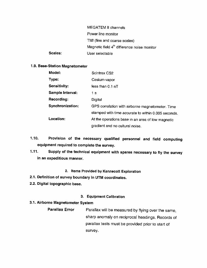
MEGATEM II channels
Power line monitor
TMI (fine and coarse scales)
Magnetic field 4th difference noise monitor Scales: User selectable
1.9. Base-Station Magnetometer
Model: Scintrex CS2
Type: Cesium-vapor
Sensitivity: less than 0.1 nT
Sample Interval: 1 s
Recording: Digital
Synchronization: G PS correlation with airborne magnetometer. Time
stamped with time accurate to within 0.005 seconds. Location: At the operations base in an area of low magnetic
gradient and no cultural noise.
1.10. Provision of the necessary qualified personnel and field computing equipment required to complete the survey.
1.11. Supply of the technical equipment with spares necessary to fly the survey in an expeditious manner.
2. Items Provided by Kennecott Exploration2.1. Definition of survey boundary in UTM coordinates.
2.2. Digital topographic base.
3. Equipment Calibration 3.1. Airborne Magnetometer System
Parallax Error Parallax will be measured by flying over the same,
sharp anomaly on reciprocal headings. Records of
parallax tests must be provided prior to start of
survey.

3.2. EM System
Calibration
Noise check
Bird Motion
The aircraft transient compensation of the MEGATEM II
system will be checked prior to, and at the end of, each
flight at 600 metres terrain clearance. Aircraft flight attitude
will be monitored and a mean standard low level attitude
will be maintained by adjusting aircraft air speed during
high level calibration tests. Zero levels of the MEGATEM II
channels will be verified at the beginning and end of each
flight.
The "primary/compensation" waveforms for each
component (X, Y and Z) will be recorded digitally for each
flight and in-flight data will be corrected for deviations
from these waveforms. The X, Y and Z primary
waveforms for each flight will be included as deliverable
items at the end of the survey, to facilitate possible further
quantitative processing and interpretation.
The in-flight operator views the data on the analog and
digital displays while surveying, terminating flights when
specifications are exceeded. The quality is then checked, post-flight, on the recovered data. A subset of the data (a
"QC" file) will be provided daily for client review.
The magnitude of residual bird motion noise in the off-
time channels (after compensation), can be estimated by examining the high altitude calibration data. After the
initial compensation, done at altitude, bird-motion noise is induced in the channels by putting the aircraft through a
series of severe pitches. The low frequency oscillations
(of a period of 6 to 8 seconds) in the data observed
during these pitches will always reflect the upper limit of residual bird-motion noise that may be expected while
surveying on line, as the pitches done at altitude are more severe than normal turbulence or altitude corrections
experienced on line. The amplitude of bird-motion noise will be greatest near the turn-off of the pulse and

decrease rapidly to sub-noise level by channels 9 or 10.
The following typical bird-motion noise measured during
high altitude pitches can be expected:
Channel Peak-to-peak amplitude (pT/s)1 to 5 Not applicable
6 75,000
7 30,000
8 10,000
9 5,000
10 3,500
11 to 20 Not apparent
Survey Test Line A survey test line at least 8 km in length (4 km for a
helicopter survey) will be flown at the beginning of each flight in a constant direction at the nominal survey altitude to verify that the system is functioning. In addition, the
test line shall be reflown following any subsequent
calibration of the EM system.
At the discretion of Kennecott's representative, further
acquisition of test line data may be undertaken. These
additional test lines will be charged to Kennecott at the
nominal line km charge referred to in Attachment D.
Survey Monitoring Reporting The contractor shall maintain an equipment
log noting all equipment serial numbers, equipment
replacements and repairs throughout the survey. All
appropriate calibration and survey test line data should be
recorded digitally and included as deliverables.
Altimeters Radar and barometric altimeters will normally be
calibrated prior to survey commencement, in the survey
area, unless there have been recent calibrations in the
same area, and no errors were noted.

GPS Navigation DGPS navigation will be checked over known control
points, to verify calculated survey coordinates against
published coordinates.
Survey Monitoring Reporting The contractor shall maintain an equipment
log noting all equipment serial numbers, equipment
replacements and repairs throughout the survey. All
appropriate calibration and survey test line data should be
recorded digitally and included as deliverables.
4. Reflight Specifications
Portions of the survey will be reflown at the sole expense of Contractor under any of the conditions listed below. These thresholds may be relaxed only after discussions with the
Kennecott representative on site.
* Contractor supplied equipment failure prevents magnetic, EM, altimeter data
acquisition and/or real time GPS navigation.
* Transect line spacing exceeds more than 30 percent of the nominal spacing over a
continuous distance exceeding 3000 meters unless, (a) in the opinion of the pilot,
to do so would jeopardize the safety of the aircraft or the crew, or (b) the
equipment or would be in contravention of the aviation authority regulations. The
line spacing measurements to be used in determining such reflights will be made
from the field flight path recovery.
* Aircraft terrain clearance varies from specified mean terrain clearance by more
than 20 meters over a distance of 3 km unless, (a) in the opinion of the pilot, to do
so would jeopardize the safety of the aircraft or the crew, or (b) the equipment or
would be in contravention of the aviation authority regulations.
* Where the noise level of the MEGATEM n system, as indicated on the raw traces of
dB/dt channel 20 (last off-time channel), exceeds 3500 pT/s on either the x or z

coil, over a distance of 3 kilometres or more (approximately 50 seceonds), or where
significant bursts of spheric events interfere with data processing or interpretation.
As a result of Contractor supplied equipment failure, noise envelope of
compensated Total Magnetic Intensity data exceeds 0. l nT for a continuous
distance of l km.
If either or both the magnetometer or EM data are not interpretable as a result of
Contractor supplied equipment failure, in the opinion of both the Kennecott and
Contractor representatives.
The departure of the diurnal magnetic field from a straight-line chord, 30 seconds in
length, exceeds 5 nT where the tie line interval is l km. Or, where the tie line interval
is 2.5 km, the departure of the diurnal magnetic field from a straight-line chord, 75
seconds in length, exceeds 5 nT.
APPENDIX ECost Statement and Distribution of Costs to Claims
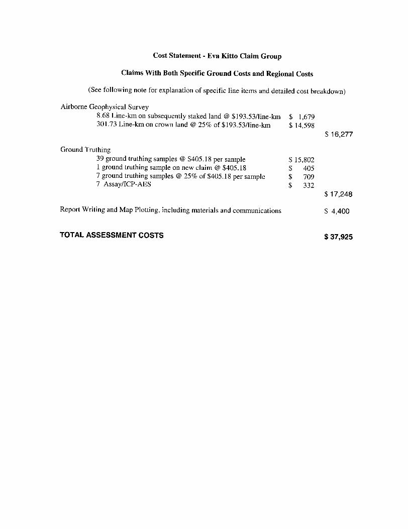
Cost Statement - Eva Kitto Claim Group
Claims With Both Specific Ground Costs and Regional Costs
(See following note for explanation of specific line items and detailed cost breakdown)
Airborne Geophysical Survey8.68 Line-km on subsequently staked land @ Sl93.5371ine-km S 1,679 301.73 Line-km on crown land @ 25*7c of Sl93.5371ine-km S 14,598
S 16,277
Ground Truthing39 ground truthing samples @ S405.18 per sample S 15,802 l ground truthing sample on new claim @ 8405.18 S 405 7 ground truthing samples @ 25 1b of S405.18 per sample S 709 7 Assay/ICP-AES S 332
517,248
Report Writing and Map Plotting, including materials and communications S 4,400
TOTAL ASSESSMENT COSTS S 37,925

Note to Cost Statement
Airborne Geophysical SurveyThe airborne survey cost includes all applicable expenditures for assessment purposes, including salaries of Kennecott and contractor personnel, room and board, supplies, aircraft time and fuel.
line-km cost per unit total on newly staked claims 8.675 193.53 1678.87on adjacent crown land, @
301.725 193.53 14598.21
16277.08
Sampling and Ground Truthing
Sept 26 - Oct 2
unitwages, per man day 19 food+lodging, per man day 19 mileage, per km 210 supplies (bags, marker, ties, tags) SUBTOTAL
cost per unit3001000.35
total5700190073.5200
7873.5
Applicable mobilization/demobilization costs each way unit cost per unit total mileage-truck 1 179 0.35 62.65 mileage-truck 2 179 0.35 62.65 food+lodging, per man day 3 150 450 SUBTOTAL, both directions 1150.60
Oct 19-25
wages, per man day food+lodging mileage boat rental
unit1818455
supplies (bags, marker, ties, tags) SUBTOTAL
cost per unit total 300 5400 100 1800 0.35 15.75 100 500
2007915.75
Applicable mobilization/demobilization costs each way unit cost per unit total mileage -truck 1, per km 262 0.35 91.7 mileage-truck 2 invoiced amount 510 food+lodging, per man day 3 150 450 SUBTOTAL, both directions
Total Cost of Ground Truthing and Sampling100"7o of value of work on claims (40 samples)10007o of value of work on new claim (1 sample)250Xo of value of work on adjacent crown land (7 samples)
Assays 7
2103.4
19043.2515801.85
405.18709.06
332.10
Report Writing and Map Plottingunit
wages, per manday 16 printing, supplies, communications
cost 250
total4000400
17248.18
4400.00
[TOTAL 37925.26

Kennecott-East West JV: Eva Kitto PropertyEva Kitto Claim Group 2002 Assessment Work Completed
Claim #
124591512459161245917123307812404921240493124704412403021240303124030412403051240306124541412454151245417124953730060733006074
TOTALS
Area
12161216121212161012114
16135
1662
203
Expiry
1/22/031/22/031/22/032/17/033/13/033/13/035/14/035/24/035/24/036/14/036/14/036/14/037/20/037/20/037/20/03
3/1/0411/4/0411/4/04
Record Date
1/22/011/22/011/22/012/17/003/13/003/13/005/14/015/24/005/24/006/14/006/14/006/14/007/20/007/20/007/20/00
3/1/0211/4/0211/4/02
Required Assessment
48006400480064004800480048006400400048004400160064005200200064002400
800
Outstanding
1625172336562167379232503792
00000000
64002400
800
Claim Specific Costs
405.184789.081215.543241 .44
0405.18
00000
1620.724456.98
000
1605.07478.80
Associated/ Regional Costs
97.861156.66293.58782.87
097.86
00000
391.441076.45
000
8041 .297769.28
Total Work Done
503.045945.741509.124024.31
0503.04
00000
2012.165533.43
000
9646.368248.07
Applied
1625172336562167379232503792
000000000
2400800
Banked
26000000000000000
7246.367448.07
81200| 29605| 18217.98) 19707.28) 37925.26) 23205) 14720.26
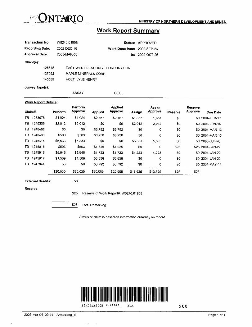
ONTARIO MINISTRY OF NORTHERN DEVELOPMENT AND MINES
Work Report Summary
Transaction No: W0240.01908 Status: APPROVED
Recording Date: 2002-DEC-16 Work Done from: 2002-SEP-26
Approval Date: 2003-MAR-03 to: 2002-OCT-25
Client(s):
128645 EAST WEST RESOURCE CORPORATION
1 37052 MAPLE MINERALS CORP.
145589 HOLT, LYLE HENRY
Survey Type(s):
ASSAY GEOL
Work Report Details:
Claim*
TB
TB
TB
TB
TB
TB
TB
TB
TB
1233078
1240306
1240492
1240493
1245414
1245915
1245916
1245917
1247044
Perform
34,024
82,012
SO
S503
35,533
S503
S5.946
81,509
SO
520,030
External Credits:
Perform Approve
S4.024
S2.012
SO
S503
S5.533
S503
55,946
51,509
SO
520,030
SO
Applied
52,167
SO
53,792
S3.250
SO
51,625
51,723
53,656
53,792
520,005
Applied Approve
S2
S3
S3
S1
S1
S3
S3
520
,167
SO
,792
.250
SO
,625
,723
,656
,792
,005
Assign Reserve Assign Approve Reserve Approve
51,857 1,
52,012 2,
SO
SO
55,533 5,
SO
S4.223 4,
SO
SO
S13.625 513,
857
012
0
0
533
0
223
0
0
625
SO
SO
SO
SO
50
525
SO
SO
SO
S25
SO
SO
SO
50
so525
SO
SO
so
S25
Due Date
2004-FEB-17
2003- J UN- 14
2004-MAR-13
2004-MAR-13
2003-JUL-20
2004-JAN-22
2004-JAN-22
2004-JAN-22
2004-MAY-14
Reserve:S25 Reserve of Work Report#: W0240.01 908
S25 Total Remaining
Status of claim is based on information currently on record.
52H09SE2005 2.24671 EVA 900
2003-Mar-04 09:44 Armstrong-d Page 1 of 1

ONTMIO MINISTRY OF NORTHERN DEVELOPMENT AND MINES
Transaction No:
Recording Date:
Approval Date:
Client(s):
128645
Survey Type(s):
W0240.01922
2002-DEC-16
2003-MAR-03
Work Report Summary
Status: APPROVED
Work Done from: 2002-MAR-20
to: 2002-OCT-25
EAST WEST RESOURCE CORPORATION
AEM AMAG PROSP
Work Report Details:
Claim*
TB 3006073
TB 3006074
External Credits:
Reserve:
Perform Perform Approve
31,605 31,605
S479 S479
S2.084 82,084
315,810
Applied
32,400
3800
33,200
814,694 Reserve of Work
314,694 Total Remaining
Applied Approve
32,400
3800
33,200
Assign
SO
so
SO
Assign Approve
0
0
so
Reserve Reserve Approve
37,246 37,246
37,448 37,448
314,694 314,694
Due Date
2005-NOV-04
2005-NOV-04
Report#: W0240.01922
Status of claim is based on information currently on record.
2003-Mar-04 09:54 ArmstrongjJ Page 1 of 1
Ministry ofNorthern Developmentand Mines
Date: 2003-MAR-03
Ministere du Developpement du Nord et des Mines Ontario
GEOSCIENCE ASSESSMENT OFFICE 933 RAMSEY LAKE ROAD, 6th FLOOR SUDBURY, ONTARIO P3E 6B5
EAST WEST RESOURCE CORPORATION905 WEST RENDERAPT 402VANCOUVER, BRITISH COLUMBIAV6C 1L6 CANADA
Tel: (888) 415-9845 Fax:(877)670-1555
Dear Sir or Madam
Submission Number: 2.24671 Transaction Number(s): W0240.01908
W0240.01922
Subject: Approval of Assessment Work
We have approved your Assessment Work Submission with the above noted Transaction Number(s). The attached Work Report Summary indicates the results of the approval.
At the discretion of the Ministry, the assessment work performed on the mining lands noted in this work report may be subject to inspection and/or investigation at any time.
NOTE: The work start and end dates from the forms have been changed in the Claims database to better reflect the actual work dates, as contained in the report.
If you have any question regarding this correspondence, please contact BRUCE GATES by email at [email protected] or by phone at (705) 670-5856.
Yours Sincerely,
Ron GashinskiSenior Manager, Mining Lands Section
Gc: Resident Geologist
East West Resource Corporation (Claim Holder)
Assessment File Library
East West Resource Corporation (Assessment Office)
Maple Minerals Corp. (Claim Holder)
Lyle Henry Holt (Claim Holder)
Steve Coombes (Agent)
Visit our website at http://www.gov.on.ca/MNDM/LANDS/mlsmnpge.htm Page: 1 Correspondence 10:18021

o o
Dale r Time of Issue 1 Won Mar 03 14-14:10 E3T 2003
TOWNSHIP l AREA PLAN
MARYJANE LAKE AREA G-0080
ADMINISTRATIVE DISTRICTS i DIVISIONS
Mining Division Thunder BayLand Titles/Registry Division THUNDER BAYMinistry of Natural Resources District NIPIGON
LAND TENURE WITHDRAWALS
r- IMPORTANT NOTICES
LAND TENURE WITHDRAWAL DESCRIPTIONS

l.li^-S:!!!!!^ ^11 li l lil l li nil
~7 \\ H ^ lil lil i mi! 11l jljgjgnUMnsij i i iiiiiiiij i iiiliiiiin li! l
vi l) l li! ||| l li l i l j 11 l Ulrica
^i[j i||i;i;; | i! HI linn - -^^-iiiiiiil
l! i!: i !|!|!|i|! ;i iiiilijijiifiij i / -^ ^'^^^ *-^*~" *^ |i| i jjiiijiij l liiljijliijliij l* | ^ 'li i iiijijiji iii ^ ^, ^jiiJjfe^ -
li i i|i|i|i|i ii !ijiii!i!iiiiijiij!i ilHili i il ililHHil i !j^i!i!iii!iiiii i i II i i Ijijiji li ii iliiiitiii |?iil !iiiiliiil!liiiiiili! ii!i!iii iiiiiiii iHiiilli i Hi y lil; ji iHiliili^l i iigHH;.g iiliiii-Jiili^i^!;:;^ iU . :;:h; : :::. i: s&fr-M-lij: - ^. ni-j^.-j;.. .^ij;^______
Thunder Bay Mining Division
Ontario, Canada——- Geologic contact, assumed ~—— Geologic contact, inferred
— — Traverse* m Traverse station
52H09SE2005 2 .24671 EVA 210

5496000 mN. .
N
5494000 rn.N 5494000 mN.
54900.00 .mN.
mN
5486000 mN.....
m.N
LU;
o oo
UJ
o :O;
o; o: co 1
o: o o.
UJ
oo oCM CM '
5482000. mN.
KENNECOTT CANADA EXPLORATION INC.Vancouver
EVA KITTO
TMI MAGNETICS (nT)
Ontario, Canada
Author. SC
Date: MAY 22, 2002
NTS: 052H09
l Drawn by: SC
Projection: UTM NAD83 ZONE 16 Ref: van.OOxxx.X Figi
File: first Sine second iine
gure: (j
0.5
Scale: 1:20,000
1
kilometres
52H09SE2005 2.24671 EVA 220
5436000 mM.
N
5454000. mNmN.
mN.
mN
mJ\L.mN
ft- WlV C" x
mNmJM..
UJ :
o o;
UJEo o
UJ
o ooC0
o oCM!CM
mN.
KENNECOTT CANADA EXPLORATION INC.Vancouver
EVA KITTO
B-FIELD-GATE10 X COMPONENT (fT)
Ontario, Canada
Author SC
Date: MAY 22.2002
i NTS: 052H09
Drawn by: SC
File: first tine second tine
Projection: UTM NAD83 ZONE 16 Ref: van.OQxxx.X \ Figure:
Scale: 1:20,000
0.5 1
kilometres
52H09SE2005 2.24671 EVA 230

5496000 mN.
N
m FM 5494000 mN
mN.
54813000, mN.
mN
LU
o o o)
UJ
Oo
LUE'
oo o oCM
5482000 mN
KENNECOTT CANADA EXPLORATION INC.Vancouver
EVA KITTO
B-FIELD-GATE10 Z COMPONENT (TT)
Ontario, CanadaProjection: UTM NAD83ZONE 16 Ref: van.OOxxx.X
Author SC
Date: MAY 22, 2002
NTS: 052H09
Drawn by: SC
File: first iine second line
Figure: I..
Scale: 1:20,000
0.5 1
kilometres
52H09SE2005 2.24671 EVA 240

mN
N
5494000.mN
5492000 m Psi.
549QQOOjnM.mN..
5488000 mN
mN,
mN..
y j E
o o
o' o
LU,
o: o o o
UJ
CMCM
5482QOQ.m.N
KENNECOTT CANADA EXPLORATION INC.Vancouver
EVA KITTO
B-FIELD-GATE16 X COMPONENT (fT)
Ontario, Canada
Author SG
Date. MAY 22, 2002
NTS: 052H09
Drawn by; SG
Fiie: first tine second tine
Projection: UTM NAD83 ZONE 16 Ref: van.OOxxx.X Figure:
Scale: 1:20,000
0.5 1a
kilometres
52H09SE2005 2.24671 EVA 250

5496000 mN
N
mN mN.
5492000 mN.
mN
5486000. mN .5486000. mN.
CI fmN
mo o o
UJEl
UJ :
o. CQ
O; Oo: o
yj:
o: o 'CM CM-s-:
m.N.
KENNECOTT CANADA EXPLORATION INC.Vancouver
EVA KITTO
B-FIELD-GATE16 Z COMPONENT (fT)
Ontario, Canada
Author SC
Date: MAY 22, 2002
NTS: 052H09
| Drawn by: SC
| File: first tine
! second tine
Projection: UTM NAD83ZONE 16 Ref: van.OOxxx.X j Figure: Q
0.5
Scale: 1:20,000
1
kilometres
52H09SE2005 2.24671 EVA 260