Embed Size (px)
Citation preview

Kafr ad Dik Town Profile
Prepared by
The Applied Research Institute – Jerusalem
Funded by
Spanish Cooperation
2013

Palestinian Localities Study Salfit Governorate
1
Acknowledgments
ARIJ hereby expresses its deep gratitude to the Spanish Agency for International Cooperation for
Development (AECID) for their funding of this project.
ARIJ is grateful to the Palestinian officials in the ministries, municipalities, joint services councils,
village committees and councils, and the Palestinian Central Bureau of Statistics (PCBS) for their
assistance and cooperation with the project team members during the data collection process.
ARIJ also thanks all the staff who worked throughout the past couple of years towards the
accomplishment of this work.

Palestinian Localities Study Salfit Governorate
2
Background
This report is part of a series of booklets, which contain compiled information about each city, town, and
village in the Salfit Governorate. These booklets came as a result of a comprehensive study of all
localities in Salfit Governorate, which aims at depicting the overall living conditions in the governorate
and presenting developmental plans to assist in developing the livelihood of the population in the area. It
was accomplished through the "Village Profiles and Needs Assessment;" the project funded by the
Spanish Agency for International Cooperation for Development (AECID).
The "Village Profiles and Needs Assessment" was designed to study, investigate, analyze and document
the socio-economic conditions and the needed programs and activities to mitigate the impact of the
current unsecure political, economic and social conditions in Salfit Governorate.
The project's objectives are to survey, analyze, and document the available natural, human,
socioeconomic and environmental resources, and the existing limitations and needs assessment for the
development of the rural and marginalized areas in Salfit Governorate. In addition, the project aims at
preparing strategic developmental programs and activities to mitigate the impact of the current political,
social, and economic instability with the focus on the agricultural sector.
All locality profiles in Arabic and English are available online at http://vprofile.arij.org.

Palestinian Localities Study Salfit Governorate
3
Table of Contents
Location and Physical Characteristics __________________________ 4
History ____________________________________________________________ 5
Religious and Archaeological Sites _____________________________ 6
Population ________________________________________________________ 6
Education ________________________________________________________ 7
Health Status _____________________________________________________ 8
Economic Activities ______________________________________________ 9
Agricultural Sector ______________________________________________ 10
Institutions and Services ________________________________________ 13
Infrastructure and Natural Resources _________________________ 13
Environmental Conditions ______________________________________ 15
Impact of the Israeli Occupation _______________________________ 16
Development Plans and Projects _______________________________ 21
Implemented Projects ___________________________________________ 21
Proposed Projects _______________________________________________ 21
Locality Development Priorities and Needs ____________________ 22
References: ______________________________________________________ 23

Palestinian Localities Study Salfit Governorate
4
Kafr ad Dik Town Profile
Location and Physical Characteristics
Kafr ad Dik is a Palestinian town in Salfit Governorate located 9.59 km west of Salfit City. It is
bordered by Bruqin village to the east, Bani Zaid town (in Ramallah Governorate) to the south, Rafat and
Deir Ballut villages to the west, and Biddya and Sarta villages to the north (ARIJ-GIS, 2013) (See Map 1).
Map 1: Kafr ad Dik location and borders
Source: ARIJ - GIS Unit, 2013.
Kafr ad Dik is located at an altitude of 375 m above sea level with a mean annual rainfall of 587.9 mm.
The average annual temperature is 18 Co and the average annual humidity is approximately 61.7% (ARIJ-
GIS, 2013).
Since 1997, Kafr ad Dik has been governed by a Municipal Council which is currently administrated by
8 members appointed by the Palestinian National Authority (PNA). There are 10 employees working in
Palestinian Localities Study Salfit Governorate
5
the council, which owns a permanent headquarters that is included within the „Joint Services Council of
West Salfit.‟ The Council also owns a pickup car but not a vehicle for the collection of solid waste (Kafr
ad Dik Municipality, 2012).
It is the responsibility of the Municipal Council to provide a number of services to the residents of Kafr
ad Dik, including (Kafr ad Dik Municipality, 2012):
The establishment and maintenance of the drinking water and electricity networks.
Road construction, pavement and restoration, street cleaning and social development services.
Organization of construction and licensing processes.
Implementation of projects and studies for the town.
Protection of historical and archeological sites in the town.
Protection of governmental properties.
Provision of transportation.
Provision of educational kindergartens.
History
Kafr ad Dik town is said to be named after a man called “Ad Dik” who is believed to have come from
the Arabian Peninsula and lived in the Jordan Valley area for a period of time before he moved to the
town and settled in it. Prior re to his arrival the region was called “Kafir Ben Muhanna.”
The town was established in 1700 with its residents descending from Arab al Masa‟id tribe from the
Arabian Peninsula (Kafr ad Dik Municipality, 2012).
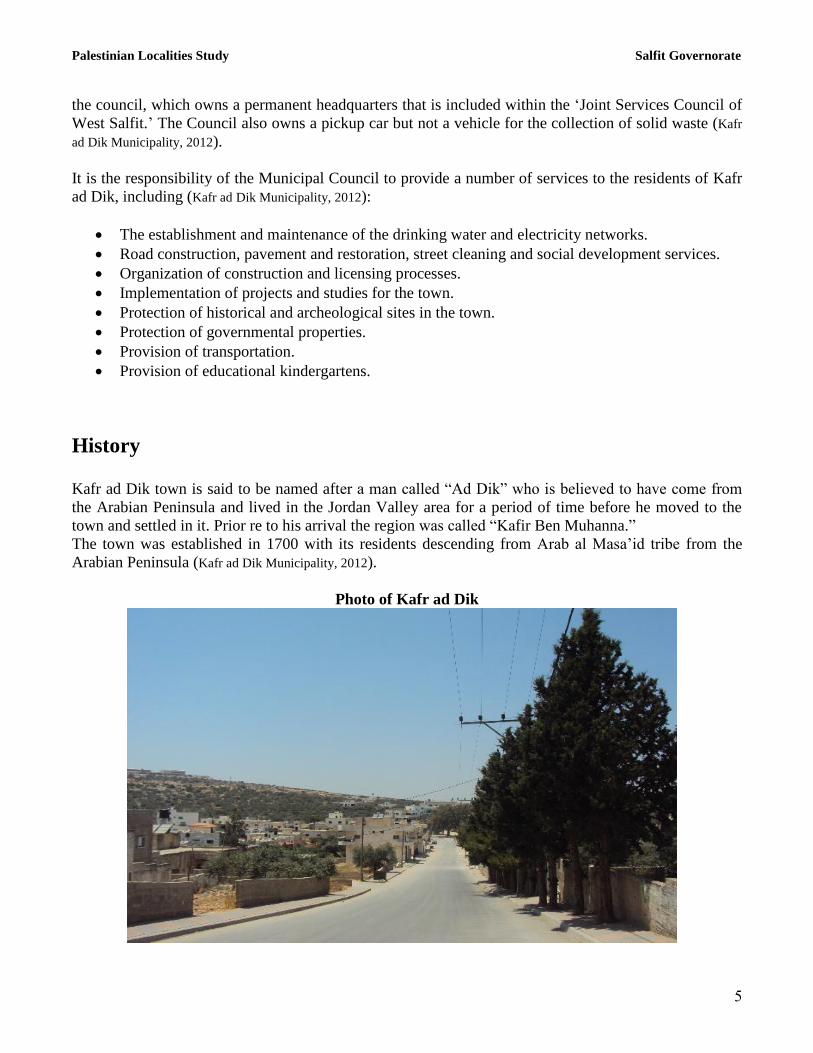
Photo of Kafr ad Dik

Palestinian Localities Study Salfit Governorate
6
Religious and Archaeological Sites
There are four mosques in the town (Abdul Rahman Ben Mubarak, An Nafookh, the Downtown (located
under the Municipality) and the Grand Mosque). The town has several sites of archaeological interest
including: Abu „Etaf Shrine, Hajj „Erman Shrine, Ash Sheikh Khirfan Shrine, Al Wa‟r Mosque, Khirbet
Sweisah, Abu Simon Convent, the Castle Convent, Diriyah area and the Pool, in addition to old city
buildings (Kafr ad Dik Municipality, 2012) (See Map 2).
Map 2: Main locations in Kafr ad Dik Town
Population Source: ARIJ - GIS Unit, 2013.
Population
According to the Palestinian Central Bureau of Statistics (PCBS), the total population of Kafr ad Dik in
2007 was 4,494, of whom 2,259 were male and 2,235 female. There were additionally 884 households
recorded as living in 990 housing units.

Palestinian Localities Study Salfit Governorate
7
Age Groups and Gender
The „General Census of Population and Housing‟ carried out by PCBS in 2007 showed the distribution
of age groups in Kafr ad Dik is as follows: 38.5% were less than 15 years of age, 56.7% were between
15 and 64 years of age, and 4.8% were 65 years of age or older. Data also showed that the sex ratio of
males to females in the town is 101.1:100, meaning that males and females constitute 50.3% and 49.7%
of the population, respectively.
Families
Kafr ad Dik residents are from several families, including Ad Dik, Ali Ahmad and Naji (Kafr ad Dik
Municipality, 2012).
Immigration
The field survey conducted by ARIJ staff showed that around 5 families have left the town since the Al
Aqsa Intifada in 2000 (Kafr ad Dik Municipality, 2012).
Education
According to the results of the PCBS Population, Housing and Establishment Census-2007, the illiteracy
rate among Kafr ad Dik population is approximately 7.8%, of whom 83.7% are females. Of the literate
population, 11.9% could only read and write, with no formal education, 20.1% had elementary
education, 27.7% had preparatory education, 17.3% had secondary education, and 15.3% completed
higher education. Table 1 shows the educational level in the town of Kafr ad Dik by sex and educational
attainment in 2007.
Table 1: Kafr ad Dik population (10 years and above) by sex and educational attainment
S
E
x
Illite-
rate
Can
read &
write
Element-
ary
Preparat-
ory
Second-
ary
Associate
Diploma Bachelor
Higher
Diploma Master
PhD Un-
known Total
M 42 188 334 495 314 91 167 5 30 6 1 376,1
F 217 206 332 423 259 66 136 0 5 0 0 1,644 T 259 394 666 918 573 157 303 5 35 6 1 3,317 Source: PCBS, 2009.
There are five public schools in the town, all of which are run by the Palestinian Ministry of Higher
Education (Directorate of Education in Salfit, 2012) (see Table 2).
Table 2: Schools in Kafr ad Dik by name, stage, sex, and supervising authority (2011/2012)
School Name Supervising Authority Sex
Kafr ad Dik Boys‟ Secondary School Government Male
Martyr Mazen Abu al Wafa School Government Male
Kafr ad Dik Girls‟ Secondary School Government Female
Kafr ad Dik Girls‟ Elementary School Government Female
Kafr ad Dik Girls‟ New Elementary School Government Female Source: Directorate of Education in Salfit, 2012
Palestinian Localities Study Salfit Governorate
8
In the town there are 1,319 students, 84 teachers, and 51 classes. The average number of students per
teacher in the school is nearly 16, whilst the average number of students per class is approximately 26
(Directorate of Education in Salfit, 2012).
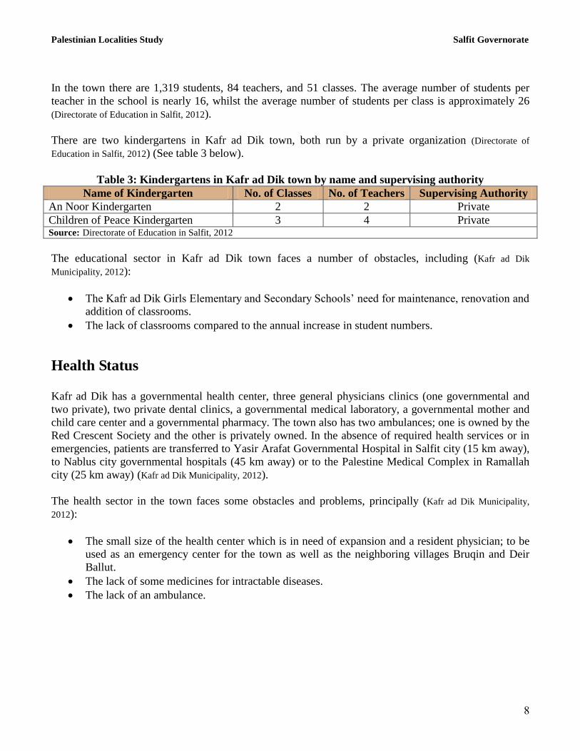
There are two kindergartens in Kafr ad Dik town, both run by a private organization (Directorate of
Education in Salfit, 2012) (See table 3 below).
Table 3: Kindergartens in Kafr ad Dik town by name and supervising authority
Name of Kindergarten No. of Classes No. of Teachers Supervising Authority
An Noor Kindergarten 2 2 Private
Children of Peace Kindergarten 3 4 Private Source: Directorate of Education in Salfit, 2012
The educational sector in Kafr ad Dik town faces a number of obstacles, including (Kafr ad Dik
Municipality, 2012):
The Kafr ad Dik Girls Elementary and Secondary Schools‟ need for maintenance, renovation and
addition of classrooms.
The lack of classrooms compared to the annual increase in student numbers.
Health Status
Kafr ad Dik has a governmental health center, three general physicians clinics (one governmental and
two private), two private dental clinics, a governmental medical laboratory, a governmental mother and
child care center and a governmental pharmacy. The town also has two ambulances; one is owned by the
Red Crescent Society and the other is privately owned. In the absence of required health services or in
emergencies, patients are transferred to Yasir Arafat Governmental Hospital in Salfit city (15 km away),
to Nablus city governmental hospitals (45 km away) or to the Palestine Medical Complex in Ramallah
city (25 km away) (Kafr ad Dik Municipality, 2012).
The health sector in the town faces some obstacles and problems, principally (Kafr ad Dik Municipality,
2012):
The small size of the health center which is in need of expansion and a resident physician; to be
used as an emergency center for the town as well as the neighboring villages Bruqin and Deir
Ballut.
The lack of some medicines for intractable diseases.
The lack of an ambulance.

Palestinian Localities Study Salfit Governorate
9
Economic Activities
The economy in Kafr ad Dik is predominantly dependent on the employees sector (private and
governmental) which absorbs approximately 60% of the town‟s workforce (Kafr ad Dik Municipality, 2012)
(See Figure 1).
The results of a field survey conducted by the ARIJ team in 2012 for the distribution of labor by
economic activity in Kafr ad Dik are as follows:
Government or other employees sector (60%)
Services sector (15%)
Trade sector (15%)
Industry (5%)
Agriculture sector (3%)
Israeli labor market (2%)
Figure 1: The distribution of labor force among main economic activities in Kafr ad Dik
Source: Kafr ad Dik Municipality, 2012
Kafr ad Dik has a concrete factory and a marble factory in addition to 3 groceries, 50 fruits and
vegetables stores, 2 bakeries, a butchery, 12 service stores, 7 different professional workshops, a stone
cutter and 3 olive oil-presses (Kafr ad Dik Municipality, 2012).
In 2012, the unemployment rate in Kafr ad Dik reached 40% and the group most affected economically
by Israeli restrictions has been agricultural workers (Kafr ad Dik Municipality, 2012).

Palestinian Localities Study Salfit Governorate
11
Labor Force
According to the PCBS Population, Housing and Establishment Census-2007, 37.3% of Kafr ad Dik
labor force was economically active, of whom 80% were employed, 62.7% were not economically
active, 55.9% were students, and 29.1% were housekeepers (See Table 4).
Table 4: Kafr ad Dik population (10 years of age and above) by sex and employment status
S
e
x
Economically active Non-economically active
Not
stated Total Employ-
ed
Currently
Unem-
ployed
Un-
employed
(never
worked)
Total Stud-
ent
House-
keeping
Unable
to work
Not
working
& not
looking
for work
Others Total
M 805 103 52 960 554 4 114 18 22 712 1 376,1
F 185 21 71 277 609 602 138 7 11 1,367 0 37611
T 999 124 123 1,237 1163 606 252 25 33 2,079 1 1713, M: Male; F: Female; T: Total.
Source: PCBS, 2009.
Agricultural Sector
Kafr ad Dik has a total area of approximately 15,529 dunums of which 9,014 are „arable‟ land and 621
dunums are registered as „residential‟ (See Table 5 and Map 3).
Table 5: Land use and land cover in Kafr ad Dik town (area in dunum)
Total
Area
Built
up
Area
Agricultural area
(9,014)
Inland
water
Forests Open
Spaces
Area of
Industrial,
Commercial &
Transport Unit
Area of
Settlements,
Military
Bases &
Wall Zone
Permanent
Crops
Green-
houses
Range-
lands
Arable
lands
15,529 621 8,135 0 806 73 0 0 4,594 9 1,291
Source: ARIJ – GIS Unit, 2012.

Palestinian Localities Study Salfit Governorate
11
Map 3: Land use/land cover and Segregation Wall in Kafr ad Dik Town
Source: ARIJ - GIS Unit, 2013.
Table 6 shows the different types of rain-fed and irrigated open-cultivated vegetables in Kafr ad Dik.
The most commonly cultivated crops within this area are spinach, jew‟s melon and cauliflower.
Table 6: Total area of rain-fed and irrigated open cultivated vegetables in Kafr ad Dik (area in dunums)
Fruity
vegetables
Leafy
vegetables Green legumes Bulbs
Other
vegetables Total Area
Rf. Irr. Rf. Irr. Rf. Irr. Rf. Irr. Rf. Irr. Rf. Irr.
14 46.5 0 29 0 12 0 6 0 0 14 93.5 Rf.: Rain-fed; Irr.: Irrigated.
Source: Ministry of agriculture-Salfit, 2010
Table 7 shows the different types of fruit trees planted in the area. Kafr ad Dik is famous for olive
cultivation and there are approximately 3,495 dunums of town lands planted with olive trees.
Table 7: Total area of horticulture and olive trees in Kafr ad Dik (area in dunums)
Olives Citrus Stone-fruits Pome fruits Nuts Other fruits Total Area
Rf. Irr. Rf. Irr. Rf. Irr. Rf. Irr. Rf. Irr. Rf. Irr. Rf. Irr.
3,495 0 0 16 79 0 2 0 2 0 20 0 3,598 16 Rf.: Rain-fed; Irr.: Irrigated.
Source: Ministry of agriculture-Salfit, 2010

Palestinian Localities Study Salfit Governorate
12
In terms of field crops and forage in Kafr ad Dik, cereals (particularly wheat) are the most cultivated,
covering an area of approximately 80 dunums (See Table 8).
Table 8: Total area of horticulture and olive trees in Kafr ad Dik (area in dunums)
Cereals Bulbs Dry
legumes Oil crops
Forage
crops
Stimulatin
g crops
Other
crops Total Area
Rf. Irr. Rf. Irr. Rf. Irr. Rf. Irr. Rf. Irr. Rf. Irr. Rf. Irr. Rf. Irr.
80 0 15 0 28 0 2 0 25 0 0 0 13 0 163 0 Rf.: Rain-fed; Irr.: Irrigated.
Source: Ministry of agriculture-Salfit, 2010
The difference between the two sets of results obtained from the Ministry of Agriculture (MoA) and
ARIJ‟s GIS Unit in terms of the sizes of agricultural areas is explained by the difference in each
organization‟s definition of land coverage and ownership. The MoA and the Palestinian Central Bureau
of Statistics (2011) conducted a survey using a definition of agricultural areas based on land ownership.
Therefore, the areas included in the survey were those of actual holdings of agricultural areas and did
not consider fragmented and small seasonal cultivated areas in residential and agricultural areas. ARIJ‟s
survey, however, indicated the existence of a high proportion of small and fragmented holdings (home
gardens) throughout the occupied Palestinian territories. This therefore accounts for the larger area of
agricultural holdings calculated by ARIJ.
The field survey conducted by ARIJ shows that just 5.5% of the residents in Kafr ad Dik rear and keep
domestic animals such as sheep and goats (See Table 9).
Table 9: Livestock in Kafr ad Dik
Cows* Sheep Camels Poultry Bee Hives - 666 - 41,000 431
*Including cows, bull calves, heifer calves and bulls
Source: Palestinian Ministry of Agriculture - Salfit, 2010
There are approximately 20 kilometers of agricultural roads in the town, divided as follows (Kafr ad Dik
Municipality, 2012):
Table 10: Agricultural Roads in Kafr ad Dik Town and their Lengths
Suitability of Agricultural Roads Length (km)
For vehicles 0.5
For tractors and agricultural machinery only 7.5
For animals only 7
Unsuitable 5 Source: Kafr ad Dik Municipality, 2012
The agricultural sector in the town faces a number of problems, including (Kafr ad Dik Municipality, 2012):
The lack of financial capacities for the development of the agricultural sector due to the farmers‟
poor economic situation.
The confiscation of agricultural lands with occupation soldiers hindering the access of a number
of farmers to their lands.

Palestinian Localities Study Salfit Governorate
13
The lack of economic feasibility for agricultural projects.
The lack of water sources for agricultural production.
Institutions and Services
Kafr ad Dik town has a post office division in addition to a number of local institutions and associations
that provide services to various sectors of society. These include (Kafr ad Dik Municipality, 2012):
Kafr ad Dik Municipal Council: Founded in 1997 by the Ministry of Local Government, with
the aim of taking care of the town‟s issues and providing various services to its population, such
as infrastructure services.
Kafr ad Dik Women Club: Founded in 2011 by the Ministry of Interior. The Club organizes
various training workshops in the fields of awareness, culture, embroidery as well as providing
different women‟s services
Kafr ad Dik Sports Club: Founded in 1982 and was later registered by the Ministry of Youth
and Sports. The Club is interested in sports, cultural and social activities for young persons.
The Child Creativity Society: Established in 1990 by the Palestinian National Liberation
Movement (Fatih). The Society is interested in providing cultural, social and educational services
as it has organized many courses including assisting education, accountancy and others.
Butool Center: Founded in 2004 by UNESCO, and is interested in cultural, social and
educational activities as it has organized many training courses, free medical services days and
others.
Youth Development Society: Founded in 2008 by the Ministry of Interior, and is interested in
agricultural, cultural and social activities.
The Rural Agricultural Society: Founded in 2010 by the Ministry of Interior, and is mainly
interested in providing farmers with agricultural services.
The Agricultural Development Society: Founded in 2010 by the Ministry of Interior, to assist
farmers affected by the occupation through the implementation of various agricultural activities.
Kafr ad Dik Agricultural Society: Founded in 2007 by the Ministry of Interior, and is mainly
interested in providing farmers with agricultural services.
Infrastructure and Natural Resources
Electricity and Telecommunication Services:
Kafr ad Dik has been connected to a public electricity network since 1995. It is served by the Israeli
„Qatariya Electricity Company,‟ which represents the main source of electricity in the town.
Approximately all of the housing units in the town are connected to the network. The town residents
face a number of problems concerning electricity, primarily the weak electrical current due to the lack of
power generators, the poor network and its need for maintenance (Kafr ad Dik Municipality, 2012).

Palestinian Localities Study Salfit Governorate
14
Kafr ad Dik is also connected to a telecommunication network and approximately 95% of the housing
units within the town boundaries are connected to phone lines (Kafr ad Dik Municipality, 2012).
Transportation Services:
There are 14 taxis and 4 public buses in Kafr ad Dik. However, residents suffer from the existence of
earth mounds and/or military checkpoints on roads in addition to the lack of transportation vehicles;
mainly vehicles working on Nablus city line (Kafr ad Dik Municipality, 2012). There are 7 km of main roads
and 9 km of secondary roads in Kafr ad Dik (Kafr ad Dik Municipality, 2012) (See Table 11).
Table 11: Roads in Kafr ad Dik town
Status of Internal Roads Road Length (km)
Main Sub
1. Paved & in good condition 4 2
2. Paved &in poor condition 3 4
3. Unpaved - 3 Source: Kafr ad Dik Municipality, 2012
Water Resources:
Kafr ad Dik is provided with water by the „West Bank Water Department‟ through the public water
network established in 2010. Approximately 99% of the housing units are connected to the water
network (Kafr ad Dik Municipality, 2012)
In 2010, the quantity of water supplied to Kafr ad Dik town in 2010 was approximately 168,000 cubic
meters/year which makes the estimated rate of water supply per capita around 93 liters/day (Kafr ad Dik
Municipality, 2012). However, no Kafr ad Dik citizen consumes this amount of water due to water losses,
which are estimated at 22% (PWA, 2010). These losses happen at the main source, major transport lines,
in the distribution network, and at the household level. Therefore, taking into account water losses, the
rate of water consumption per capita in Kafr ad Dik is 73 liters per day (Kafr ad Dik Municipality, 2012). The
average water consumption of Kafr ad Dik residents is low compared with the minimum quantity of 100
liters per capita per day proposed by the World Health Organization. Each cubic meter of water from the
public network costs 4 NIS (Kafr ad Dik Municipality, 2012).
The town has a water spring with a pumping rate of 10,000 cubic meter/ month, with water being
utilized for agricultural and recreational purposes. In addition, there is a public water reservoir in the
town with a capacity of 500 cubic meters in addition to 800 rainwater harvesting cisterns (Kafr ad Dik
Municipality, 2012).
Sanitation:
Kafr ad Dik lacks a public sewerage network and most of the population use cesspits and septic tanks, as
a main means for wastewater disposal (Kafr ad Dik Municipality, 2012).
Based on the estimated daily per capita water consumption, the approximated quantity of wastewater
generated per day, is 287 cubic meters, or 104,832 cubic meters annually. At the individual level, it is
estimated that the per capita wastewater generation is approximately 58 liters per day. The wastewater

Palestinian Localities Study Salfit Governorate
15
collected by cesspits and septic tanks is discharged by wastewater tankers directly to open areas or
nearby valleys with little regard for the environment. Here it is noted that there is no wastewater
treatment either at the source or at the disposal sites and this poses a serious threat to the environment as
well as to public health (ARIJ - WERU, 2012).
Solid Waste Management:
The Joint Services Council of West Salfit is responsible for the collection and disposal of solid waste
generated by citizens and establishments in the town. As the process of solid waste management is
costly, a monthly fee amounting to 11 NIS/ month is charged to the population served by domestic solid
waste collection and transportation services. All of the fees are collected from the citizens (Kafr ad Dik
Municipality, 2012)
Most of the population in Kafr ad Dik benefits from the solid waste services, whereby waste is collected
from households, institutions, shops, and public squares in plastic bags, and placed in 41 containers (of 1
m3 capacity) located around the municipality. The Joint Council in cooperation with the Municipality
collects the solid waste three times a week and transports it using a waste vehicle to the town‟s dumping
site, 12 km from the town, where it is subsequently burnt and/or buried in a non-environmental way (Kafr
ad Dik Municipality, 2012)
The daily per capita rate of solid waste production in Kafr ad Dik is 1.05kg. Thus the estimated quantity
of solid waste produced per day from the Kafr ad Dik residents is nearly 5.2 tons, or 1,893 tons per year
(ARIJ-WERU, 2012).
Environmental Conditions
Like other towns and villages in the Governorate, Kafr ad Dik experiences several environmental
problems which must be addressed and solved. These problems can be identified as follows:
Water Crisis
Water is cut off by the West Bank Water Department for long periods of time during summer in
numerous neighborhoods of the town for several reasons:
1. Israeli control over Palestinian water resources causes problems in the organization of water
pumping and its distribution among populations. The West Bank Water Department
distributes water to various areas on an interval basis because the amount of water available
is not sufficient to simultaneously supply everyone‟s needs. In addition, the West Bank
Water Department purchases water from Israeli Companies in order to meet the citizens
needs of water.
2. High rate of water losses, because of the water network‟s aged condition in need of
rehabilitation and renovation.

Palestinian Localities Study Salfit Governorate
16
Wastewater Management
The absence of a public sewage network in the town means that Kafr ad Dik residents are forced
to use unhygienic cesspits for the disposal of wastewater, and/or to discharge wastewater in the
streets. This is particularly common in winter, as citizens cannot afford the high cost of sewage
tankers during this period. These methods facilitate environmental damage, health problems, and
the spread of epidemics and diseases in the town. This wastewater also contaminates the
groundwater because most cesspits are built without lining, to avoid the need to use sewage
tankers and thus allow wastewater to enter into the ground. Moreover, the untreated wastewater
collected from cesspits by sewage tankers is disposed of in open areas without concern for the
damage it causes to the environment and to residents' health.
Solid Waste Management:
Zahrat al Finjan landfill in Jenin Governorate (approximately 32 km in distance from the center
of Salfit Governorate), is considered the central sanitary landfill which is supposed to serve Salfit
Governorate. However, the Municipalities and Village Councils in Salfit Governorate do not
transfer the solid waste to Zahrat al Finjan landfill, but rather get rid of waste in random dumps
scattered throughout the Governorate. This is due to the high costs of transporting and disposing
waste in the landfill. As a result, wastes are being disposed randomly in these landfills causing
serious health risks, and leading to the proliferation of harmful flies, insects, and mice, as well as
bad odors, toxic gases and black smoke which emits when burned. All of these have harmful
effects on human health as well as the environment.
The lack of a central sanitary landfill to serve Kafr ad Dik and the other neighboring
communities in the Governorate is due mainly to the obstacles created by the Israeli authorities
for local and national institutions in granting licenses to establish such a landfill. This is due to
the required land for such a landfill site falling on area C regions (Oslo Accords II) and thus
under full Israeli control. Additionally, the implementation of such projects depends on funding
from donor countries. The lack of a sanitary landfill is a source of pollution to the groundwater
and soil through the leachate produced from the solid waste, which produces bad odors and a
distortion of the landscape.
Impact of the Israeli Occupation
Geopolitical status in Kafr ad Dik
According to the Oslo II Interim Agreement signed between the Palestinian Liberation Organization
(PLO) and Israel on 28th
September 1995, Kafr ad Dik was divided into areas “B” and “C.”
Approximately 2,254 dunums (14.5% of the town‟s total area) were assigned as area B, where the
Palestinian National Authority (PNA) has a complete control over civil matters but Israel continues to

Palestinian Localities Study Salfit Governorate
17
have overriding responsibility for security. Area B constitutes most of the inhabited Palestinian areas,
including municipalities, villages and some refugee camps. It is worth mentioning that most of the
town‟s population resides in area B which constitutes a small area compared to the total area of the
town. The rest of the town‟s area, constituting 13,275 dunums (85.5% of the total area), is classified as
area C, where Israel retains full control over security and administration related to the territory (table
12). In area C Palestinian building and land management is prohibited unless through consent or
authorization by the Israeli Civil Administration. Most of the lands lying within area “C” are agricultural
areas, open spaces, Israeli settlements and lands isolated behind the Segregation Wall.
Table 12: The Geopolitical Divisions of Kafr ad Dik – Salfit Governorate
Percent of Total town area Area in dunums Area
0 0 Area A
14.5 2,254 Area B
85.5 13,275 Area C
0 0 Nature Reserve
100 15,529 Total Source: ARIJ-GIS, 2013
The Israeli Occupation Practices in Kafr ad Dik Town
Kafr ad Dik town has been subjected to numerous Israeli confiscations for the benefit of various Israeli
objectives, represented in the construction of Israeli settlements, checkpoints, outposts and bypass roads
on the town territories, in addition to the segregation plan represented by the Segregation Wall. That
which follows is a breakdown of the Israeli confiscations to have negatively affected Kafr ad Dik town
territories.
Throughout the years of occupation, Israel has confiscated 1,444 dunums of Kafr ad Dik town lands
(9.3% of the total town area) for the establishment of four Israeli settlements; Pedu'el, Alei Zahav
(Yoezer), Har Alei Zahav and Industrial Zone (Near Peduel). All of these settlements are located on the
town‟s western lands and are planned to become part of Israel upon the completion of the Wall in the
area. It is noted that these settlements are inhabited by more than 1500 Israeli settlers (See Table 13).
Table 13: Israeli settlements established on lands of Kafr ad Dik town
Population
Lands confiscated
from Kafr ad Dik
town
Establishment
Date
Settlement Name
1,096 594 1984 Pedu'el
458 300 1982 Alei Zahav (Yoezer)
- 144 1983 Har Alei Zahav
- 246 1991 Industrial Zone (Near Peduel)
1,554 1,284 Total Source: The Geo-informatics Department – ARIJ, 2013
Following the outbreak of the second Palestinian Intifada in September 2000, Israeli occupation
authorities established an Israeli military checkpoint on Kafr ad Dik western entrance, which is
represented as an iron gate that the occupation forces used to close at certain periods of political

Palestinian Localities Study Salfit Governorate
18
tensions. On these occasions, Palestinians were forced to walk long distances to reach neighboring
villages to the west, including Deir Ballut and Rafat. Also, the occupation forces established a military
observation tower north of the town on an Israeli bypass road, in addition to another checkpoint (Deir
Ballut Military Checkpoint) near Kafr ad Dik town, which represents a main site of the many violations
against Palestinian citizens. These include harassments, injuries, inspection, arrest and delay and
obstruction to free movement between Palestinian towns and villages.
Moreover, the Israeli Government has confiscated thousands of dunums of agricultural and non-
agricultural lands to open several bypass roads stretching thousands of kilometers from the north to the
south ofthe West Bank. This has been carried out in order to link Israeli settlements, dismember
Palestinian lands and enhance security control over them. Israel has also confiscated more land from
Kafr ad Dik, for the construction of Israeli bypass road no. 446. This road extends for 4km on the town‟s
land dividing it into two northern and southern parts. The real threat of these bypass roads however lies
in the buffer zone formed by the IOF, extending approximately 75 m on each side. These buffer zones
dramatically increase the total area of land affected by the construction of the roads.
Kafr ad Dik town has been exposed to various forms of Israeli attacks such as of the confiscation and
razing of lands, and the demolition of homes and water wells, among others.
An example of settler violence against residents of Kafr ad Dik town can be seen in an unprovoked and
unexpected attack on September 27 2008, whereby approximately 60 Israeli settlers, aided and abetted
by the Israeli army attacked a number of houses in the town. Settlers attacked houses belonging to
citizens Yazid Darwish and his brother Ziad Darwish, located at the entrance of Kafr ad Dik town.
During this assault, settlers threw stones at the houses causing severe damages to the property, including
broken glass and external and internal damages. In addition, settlers repeated xenophobic anti-Arab
phrases in the presence of citizens in a threatening manner. Later on, settlers, guarded by Israeli soldiers,
headed through the main road to the roundabout area located in the middle of town, where they threw
stones towards houses aiming at breaking glass1. The settlers‟ attacks also caused the glass breaking of
4 cars in the attack area.
Additionally, on June 23 2010, the Construction and Organization Committee of the Israeli Civil
Administration distributed notices to six citizens of Kafr ad Dik to stop the construction of their
residential houses. These notifications were issued under the pretext that construction within the area C
has taken place without obtaining the required licenses. However it is noted that within Area C, the
Israeli authority which controls all civil and administrative matters pertaining to the area often make the
process of granting licenses near impossible for Palestinian citizens in a process that is marred in
bureaucracy and lack of transparency. Often legitimate requests for housing extensions or construction
are rejected on non- justified pretexts. The Israeli Civil Administration had given the notified
homeowners until July 8 2010 to provide official documents for the completion of licensing procedures
through the Beit El court. The notified homes belong to citizens Fadi Farahat Abdul Rahim Taha, Nawal
Ali Hamad Ali Ahmad, Samer Othman Omar Naji, Jamal Saleh Hammad Ali Ahmad, Zayed at Taher
Mustafa Dar Ahmad and Khalid Tahseen Hussein Ali Ahmad.
1 Alei Zahav colonists attack Palestinians of Kafr ad Dik village
http://www.poica.org/editor/case_studies/view.php?recordID=1607
Palestinian Localities Study Salfit Governorate
19
In addition, during November 2011, the occupation authorities razed large areas of land in “Abu Simon
Convent” archaeological area northwest of the town in order to expand Alei Zahav Israeli settlement.
Citizens estimated the razed area at 400 dunums of land surrounding the archaeological site which was
included to the previously mentioned settlement.
Moreover, at the end of 2011 and beginning of 2012, Israeli occupation authorities stepped up its
campaign against wells and agricultural facilities. On October 4 2011, they demolished 2 agricultural
wells, two agricultural rooms (storehouses), 4 houses made of tin and burlap and 14 agricultural
barracks in Ath Thahr ash Shami area.
On October 9 2011, the Israeli Civil Administration notified residents of Kafr ad Dik of the demolition
of 6 agricultural rooms. In addition to this notifications were given to halt work on the agricultural road
(approximately 4km in length) connecting “Thuhr Suboh” area with the town which is implemented by
the Palestinian Agricultural Relief Committees PARC with funding from the Dutch Representation. The
notified agricultural rooms are used by Karf ad Dik residents for the storage of storing cereals and
olives, as well as being used as resting rooms for farmers. According to the military notifications issued
by the Civil Administration office, the owners were given until October 31 2011 to initiate the licensing
procedures. Nevertheless, concerning the agricultural road implemented by PARC, the supervising
contractor road was handed notifications twice within a week to stop construction , after the Israeli
occupation forces, on 2nd
October, stopped the works through adding a layer of base course on this
agricultural road connecting Kafr ad Dik town with its lands in Al Wajh ash Shami (Thuhr Suboh) area.
Furthermore, on December 21 2011, Israeli occupation authorities demolished five agricultural wells
and three agricultural rooms in “Thuhr Suboh” area northwest of the town. Also, on April 16 2012, the
Israeli occupation authorities demolished four agricultural wells and three agricultural rooms in the same
area. In all of these cases, Israeli occupation authorities‟ pretext was building without a permit in areas
classified as “C” according to the Oslo II agreement.
The Israeli Segregation Wall Plan in Kafr ad Dik Town
The Israeli Segregation Wall plan has had a negative and destructive impact on Kafr ad Dik residents.
The latest route of the Israeli Segregation Wall Plan, published on the Israeli Ministry of Defense's
website (April 30 2007), shows that planned wall on Kafr ad Dik town‟s land to the west will extend for
9 km on the town lands and thus will confiscate 3,586 dunums, equivalent to 23% of the town‟s total
area, and will isolate more lands for Israeli settlement activities. The majority of lands planned to be
isolated by the Wall includes agricultural areas, open spaces and Israeli settlements constructed on the
town‟s lands (See Table 13).
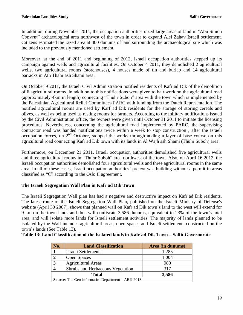
Table 13: Land Classification of the Isolated lands in Kafr ad Dik Town – Salfit Governorate
No. Land Classification Area (in dunums)
1 Israeli Settlements 1,285
2 Open Spaces 1,004
3 Agricultural Areas 980
4 Shrubs and Herbaceous Vegetation 317
Total 3,586 Source: The Geo-informatics Department – ARIJ 2013

Palestinian Localities Study Salfit Governorate
21
Upon the completion of the Segregation Wall plan the Wall will isolate Kafr ad Dik town from villages
and towns north and west of Salfit, aiming at dismembering Palestinian land, restricting Palestinian‟s
movement and confiscating and isolating more lands for Israeli settlement purposes. Furthermore, upon
the implementation of the wall scheme west of Kafr ad Dik, Palestinian farmers in the town will be
deprived by Israeli occupation authorities from accessing their land isolated behind the wall, which will
not be able to be accessed without special permits issued by the Israeli civil administration office (ICA)
and through a special gate to be established on the Wall. One should also note that Salfit Governorate
villages are known for their fertile soil, their beautiful nature and the abundance of water and large trees,
especially olive trees. This makes the region an important target for Israeli settlement activities, in order
to take control over and utilize natural resources. This makes Salfit second Governorate after Jerusalem
in terms of land confiscation, wall and settlement construction (ARIJ-UMD, 2012).
Israeli Military Orders Issued in Kafr ad Dik Town
The Israeli authorities issued a series of military orders to confiscate land or notices to stop construction
or evacuation in Kafr ad Dik town:
1. Israeli Military Order No. (01/07/T): Issued on the 7th
February 2007, confiscating a total area of
404.6 dunums of Kafr ad Dik and Bruqin towns‟ lands in order to construct the Israeli
Segregation Wall.
2. Israeli Military Order No. 82/06/T: Issued on the 20th
of November 2006, confiscating a total
area of 538.7 dunums of Deir Ballut and Kafr ad Dik towns‟ lands in order to construct the
Israeli Segregation Wall.
3. A series of Israeli military orders (27 military order of which are given as an example below)
holding the following numbers: 121725, 121726, 121727, 121728, 121729, 121730, 121731,
121732, 121733, 122297, 122298, 122299, 140141, 140142, 146137, 146139, 146140, 146141,
146142, 147350, 147351, 147360, 147361, 147362 147363, 147364 and 147550. All orders were
issued between 2007 and 2011 and required construction to stop on a number of buildings, most
of which are homes for citizens in Kafr ad Dik. This was ordered under the pretext that the
targeted residents had not obtained a building license from the Israeli authorities for construction
amendments in Area C.
On December 9 2011, the Israeli occupation authorities handed a number residents of Kafr ad Dik town
as well as Deir Ballut town a plan to seize vast areas of agricultural land estimated at more than 1,000
dunums. The main areas targeted are basin No. 2 in Khillet Abu Matar site, Al Hajar, Al Malsa and Abu
Simon Convent, in addition to lands in Deir Ballut; specifically basin no. 6, in Athahrat and Khallit
Sirisiya sites2. The Israeli occupation justified the process of land confiscation under the pretext that the
targeted lands being classified as state property, which cannot be used in any way by Palestinian
farmers. Although they have owned, lived and farmed in these areas for many years.
2 Confiscation orders for tens of dunums in Kafr ad Dik
http://www.poica.org/editor/case_studies/view.php?recordID=5400

Palestinian Localities Study Salfit Governorate
21
Development Plans and Projects
Implemented Projects
Kafr ad Dik Municipal Council has implemented several development projects in Kafr ad Dik during the
past five years (See Table 14).
Table 14: Implemented Development Plans and Projects in Kafr ad Dik during the Last Five Years
Name of the Project Type Year Donor
Developing the electricity network Infrastructure 2008 Municipal Fund
Renovating and outdoor works in Kafr ad Dik
Boys‟ School Educational 2011 ANERA
Constructing additional classrooms in Kafr ad
Dik Girls‟ School Educational 2012 Ministry of Local Government
Source: Kafr ad Dik Municipality, 2012
Proposed Projects
Kafr ad Dik Municipal Council, in cooperation with the town‟s civil society organizations and residents,
hopes to implement several projects in the coming years. The project ideas were developed during the
Participatory Rapid Appraisal (PRA) workshop conducted by ARIJ staff in the town. The projects are as
follows, in order of priority from the viewpoints of the workshop participants:
1. Expanding and developing the water network according to the new organizational chart, in
addition to developing the electricity network and providing it with new power adapters.
2. Rebuilding a school for girls‟ to replace the existing elementary school. Also, maintaining the
town schools and constructing additional classrooms, in addition to developing the existing
municipal stadium.
3. Constructing new agricultural and secondary roads, providing them with infrastructure, paving
and planting trees around them.
4. Developing the existing health center, through making it a qualified health center provided with
necessary medical equipment, an ambulance and a resident physician working throughout the
week.
5. Establishing a sewerage network (approximately 27 km) in addition to a wastewater treatment
unit, providing an additional 60 containers for waste collection, providing the municipality with
a vehicle for waste collection, and fighting harmful insects and reptiles in the town.
6. Activating and developing social centers in the town, with a focus on women‟s groups.
7. Restoring monuments existing on the town‟s outskirts and the old city entrances.
8. Establishing a complex for cars and public buses.

Palestinian Localities Study Salfit Governorate
22
Locality Development Priorities and Needs
Kafr ad Dik suffers from a significant shortage of infrastructure and services. Table 15 shows the
development priorities and needs in the town, according to the Municipal Council‟s perspective.
Table 15: Development Priorities and Needs in Kafr ad Dik
No. Sector Strongly
Needed
Needed Not a
Priority
Notes
Infrastructural Needs 1 Opening and paving roads * 19 km^
2 Rehabilitation of old water networks * 0.5 km
3 Extending the water network to cover new built up
areas *
2 km
4 Constructing new water networks *
5 Rehabilitation/ construction of new wells and/ or
springs *
1 spring
6 Construction of water reservoirs *
7 Construction of a sewage disposal network * 9 km
8 Construction of a new electricity network *
9 Providing containers for solid waste collection * 50 containers
10 Providing vehicles for collecting solid waste * 1
11 Providing a sanitary landfill *
Health Needs 1 Building new clinics or health care centres * 1 health clinic
2 Rehabilitation of old clinics or health care centres * 1 health clinic
3 Purchasing medical equipment and tools *
Educational Needs 1 Building new schools
* 1 elementary
school for girls
2 Rehabilitating old schools *
Kafr ad Dik Girls
Elementary
School
3 Purchasing new equipment for schools *
Agriculture Needs
1 Rehabilitating agricultural lands * 1000 dunums
2 Building rainwater harvesting cisterns * 100 cisterns
3 Constructing livestock barracks * 50 barracks
4 Provision of veterinary services *
5 Provision of seeds and hay for animals * 150 tons per year
6 Construction of new greenhouses * 10 greenhouses
7 Rehabilitation of greenhouses * 2 greenhouses
8 Provision of field crops seeds *
9 Provision of plants and agricultural supplies *
^ 3 km main roads, 4 km secondary roads and 12 km are agricultural roads Source: Kafr ad Dik Municipality, 2012

Palestinian Localities Study Salfit Governorate
23
References:
Applied Research Institute - Jerusalem (ARIJ), 2013. Geographic Information Systems and
Remote Sensing Unit Database. Bethlehem - Palestine.
Applied Research Institute - Jerusalem (ARIJ), 2013. Geographic Information Systems and Remote
Sensing Unit; Land Use Analysis (2012) – Half Meter High Accuracy. Bethlehem - Palestine.
Applied Research Institute - Jerusalem (ARIJ). 2012. Urbanization Monitoring Department
Violations Database (UMD). Bethlehem - Palestine.
Applied Research Institute - Jerusalem (ARIJ). 2012. Water & Environment Research Unit
Database (WERU). Bethlehem - Palestine.
Kafr ad Dik Municipality, 2012.
Ministry of Education & Higher Education (MOHE) - Salfit, 2012. Directorate of Education; A
database of schools (2011/2012). Salfit – Palestine.
Palestinian Central Bureau of Statistics. 2009. Ramallah, Palestine: General Census of Population
and Housing Censuses, 2007.
Palestinian Ministry of Agriculture (MOA), 2010. Directorate of Agriculture data (2009/2010).
Salfit - Palestine.
Palestinian Water Authority. 2012. Ramallah, Palestine: Water Supply Report, 2010.


![[XLS]cpwg.netcpwg.net/wp-content/uploads/sites/2/2015/03/Syria_CP... · Web viewMaaret Atarib Kafr Aleppo Western Kafr Jum Kafr Thoran Rasm Eljahsh Aabad Batranah Eliyeh Tabara Elksheir](https://img.dokumen.tips/doc/110x75/5b1a81277f8b9a1e258dbd46/xlscpwg-web-viewmaaret-atarib-kafr-aleppo-western-kafr-jum-kafr-thoran-rasm.jpg)