Embed Size (px)
Citation preview
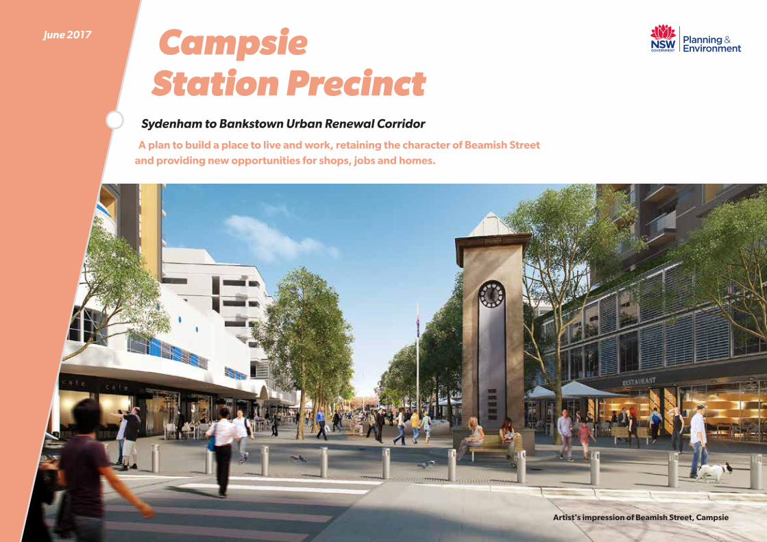
Campsie Station Precinct
Sydenham to Bankstown Urban Renewal Corridor
A plan to build a place to live and work, retaining the character of Beamish Street and providing new opportunities for shops, jobs and homes.
June 2017
Artist's impression of Beamish Street, Campsie
IntroductionThe Sydenham to Bankstown Urban Renewal Corridor Strategy plans for 35,400 new homes and 8,700 jobs over the next 20 years and infrastructure to support the future community’s needs.The Strategy builds on the Sydney Metro City and Southwest project and provides a co-ordinated approach to infrastructure delivery and development across the corridor.
The station precincts are already great places to live and have their own unique qualities. This Strategy will enhance the precincts by valuing neighbourhood character, renewing town centres, providing improved open spaces and community services and facilities.
The initial draft Strategy was released in October 2015. This revised Strategy addresses the feedback received from public submissions, community workshops, meetings, and additional technical studies
Have your sayJoin your neighbours and help shape your precinct. Go to: planning.nsw.gov.au/sydenhamtobankstown
Here you can:
X view the full Corridor Strategy and precinct plans
X register for events and project updates
X view the video
X fill in the survey
X make a submission
Thank you to everyone who has participated in the project to date.
Sydenham to Bankstown Corridor: Campsie Station Precinct
You told us: X New, improved and connected cycleways, walkable neighbourhoods
increased parks and open space are important to you.
X Traffic congestion needs to be addressed, particularly on Wonga Street, Evaline Street, Ninth Avenue, Beamish Street and Brighton Avenue.
X Public transport options in Campsie need to be improved.
X Strong design principles and sustainable building controls need to guide new development.
X Good design of new apartment development is important.
More detailed information on your feedback can be found in the Campsie Station Precinct Plan.
Our vision for Campsie: X Promote growth to reinvigorate the centre and support the
role of Campsie as a District Centre within the Greater Sydney Commission’s Sydney South District.
X Future development is designed well and positively contributes to the public domain.
X Beamish Street will benefit from streetscape improvements.
X New opportunities for open space and community facilities to support the growing population.
X Anzac and Carrington Squares are protected as part of the future growth of the Campsie Station Precinct.
X Enhance connections between Campsie’s Centre and the Cooks River.
X A potential new park along the rail line could provide a new and interesting place for leisure and recreation.
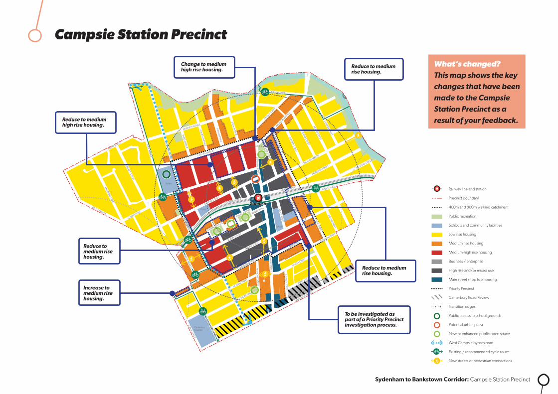
WHAT’S CHANGED FROM THE DRAFT STRATEGY – CAMPSIE
800m
400m
800m
400m
800m
400m
BRANDON AVENUE
OXF
ORD
AVE
NU
E
GRE
ENW
OO
D A
VEN
UE
CH
APEL
RO
AD
PERC
Y ST
REET
STAC
EY S
TREE
T
STANLEY STREET
RAYMOND STREET
CRO
SS STREET
CARNATION AVENUE
NORTH TERRACE
RICKARD ROAD
LAD
Y CU
TLER AVENU
E
JAC
OBS
STR
EET
GRIFFITHS AVENUE
GARDENIA AVENUE
SALVIA AVENUE
VERBENA AVENUE
PETUNIA AVENUE
LEO
NA
RD S
TREE
T
REST
WEL
L STR
EET
VIM
Y ST
REET
NO
RTHAM
AVE
NUECAMBRIDGE AVENUE
CHELMSFORD AVENUE
EGA
N S
TREE
T
WIN
SPEA
R AV
ENU
E
GRE
ENW
OO
D A
VEN
UE
EGA
N S
TREE
T
WIN
SPEA
R AV
ENU
E
MARION STREET
BRA
NC
OU
RT A
VEN
UE
WEI
GA
ND
AVE
NU
E
REYN
OLD
S AV
ENU
E
CA
IRD
S AV
ENU
E
GORDON STREET
CARMEN STREET
FRENCH AVENUE
THE MALL
CH
APEL
RO
AD
KITC
HEN
ER P
ARA
DE
MER
EDIT
H S
TREE
T
SOUTH TERRACE
STAC
EY S
TREE
T
PRAIRIE VALE ROAD
RESTHAVEN ROAD
MYRTLE ROAD
MILTON STREET
SIR
JOSE
PH B
AN
KS S
TREE
T
CO
NW
AY R
OA
D
CH
APE
L RD
STH
GREENFIELD PARADE
MARION STREET
BANKSTOWN CITY PLAZA
MACAULEY AVENUEMACAULEY AVENUE
WATTLE STREET
ACAC
IA A
VEN
UE
HIG
HC
LERE
AVE
NU
E
BROADW
AY
MATTH
EWS STREET
RICKARD ST
ROSEM
ON
T STREET
CARRISBROOK AVENUE
WARATAH STREET
CAT
HER
INE
STR
EET
ARTHUR STREET
CAMPBELL STREET
KELLY STREET
MYALL STREET
SCOTT STREET
SOUTH TERRACE
WATTLE STREET
WARWICK STREET
HEN
RY S
TREE
T
MO
UN
T LE
WIS
AVE
NU
E
NO
BLE
AVEN
UE
NOCKOLDS AVENUE
GRIFFITHS AVENUE
YARRAN STREETMULGA STREET
TURNER STREET
TURNER STREET
PUNCHBOWL ROAD
PUNCHBOWL ROAD
THE BOULEVARDE
VICTORIA RO
AD
VIOLA STREET
LIND
EN AVEN
UE
LIND
EN AVEN
UE
LANCELOT STREETLANCELOT STREET
ROSSM
ORE AVEN
UE
ROSSM
ORE AVEN
UE
HILLCREST STREET
HILLCREST STREET
DUDLEY STREET ROSEM
OUN
T STREET SOUTH
WATTLE STREET
PUN
CH
BOW
L RO
AD
LAN
CAS
TER
AVEN
UE
URUNGA PARADE
THE BOULEVARDE
LAKEMBA STREET
FAIRMO
UNT STREET
BELLEVUE AVENUE
THE BOULEVARDE
ROBIN
SON
STREET NO
RTH
CORN
ELIA STREET
McCO
URT STREET
HILLARD STREET
KING
GEO
RGES RO
AD
KING
GEO
RGES RO
AD
BEAUCHAM
P STREET
RENO
WN
AVENUE DEN
MAN
AVENUE
FAUX STREET
URUNGA PARADE
TUCKER STREET
HILLCREST STREET
HILLCREST STREET
LAKEMBA STREET
LAKEMBA STREET
GILLIES STREET DENN
IS STREET
QUIG
G STREET
CROYDO
N STREET
SPROULE STREET
ERNEST STREET
HALDO
N STREET
ONEATA STREET
MYEE STREET
QUIG
G STREET
HALDO
N STREET
MO
RETON
STREET
MO
RETON
STREET
THE BOULEVARDE RAILWAY PARADE
HAM
DEN RO
AD
GARRO
NG
ROAD
BENARO
ON
ROAD
PUNCHBOWL R
OAD
PUNCHBOWL R
OAD
DENN
IS STREET
TAYLOR STREET
CHALMERS STREET
COLLIN
S STREET
CROYDO
N STREET
WAN
GEE RO
AD
WAN
GEE RO
AD
YANGOORA ROAD
YANGOORA ROAD
THE BOULEVARDE
RAILWAY PARADE
BRIDGE ROAD
COLLINS STREET LEYLANDS PARADE
YORK STREET
CHALMERS STREET
CANTERBURY ROAD
WILSON AVENUE
BURW
OO
D RO
AD
DRUMM
ON
D STREET
ANDERSO
N STREET
SHARP STREET
SHARP STREET
WAVERLEY STREET
TUDOR STREET
PLIMSOLL STREET
COBDEN STREET
RYDGE STREET
EDISON STREET
EDISON STREET
REGINALD AVENUE
BURWO
OD RO
AD
REDMAN PARADE
ST CLAIR STREET
SUDBURY STREET
CECILIA STREET
PASSEY AVENUE
HALL STREET
CLEARY AVENUE
BELMO
RE AVENUEPEEL STREET
CHAPEL STREET
CHAPEL STREET
BENARO
ON
ROAD
DRUMM
ON
D STREET
ANDERSO
N STREET
PEEL STREET
YANGOORA ROAD
YANGOORA ROAD
OXFO
RD STREET
OXFO
RD STREET
BRAND STREET
BRAND STREET
LAKEMBA STREET KENNEDY AVENUE
ALLAN AVENUE
MINNIE STREET
HUGH STREET
KNOX STREET
LUCERNE STREET
BURWO
OD RO
AD
BURWO
OD RO
AD
BURWO
OD RO
AD
PAXTON AVENUE
ETELA STREET
ISABEL STREET
BENARO
ON
ROAD
GLADSTONE STREET
MYALL STREET
ACACIA STREET
CLISSOLD PARADE
BELLOMBI STREET
FREDERICK STREET
NORTH PARADE SOUTH PARADE
EVALINE STREET
CLAREMONT STREET
AMY STREET
ANZAC MALL
HILL STREET
CLAREMONT STREET
HILL STREET
CANTERBURY ROAD
EIGHTH AVENUE
SEVENTH AVENUE
SEVENTH AVENUE
BROW
NIN
G STREET
SHAKESPEARE STREET
NINTH AVENUE
CAMPSIE STREET
WILFRED AVENUE
WILFRED AVENUE
ANZAC SQUARE
CARRINGTON SQ
MA
RLOW
E STREET
STAN
LEY STREET
ORISSA STREET
ORISSA STREET
THO
RNCRAFT PARADE
THO
RNCRAFT PARADE
THO
RNCRAFT PARADE
MCKERN STREET
BEAUMONT STREET
LOCH
STREET
LOCH
STREET
LOCH
STREET
LOCH
STREET
LOFTUS STREET
LOFTUS STREET
BEAM
ISH STREET
BEAM
ISH
HARO
LD STREET
DUKE STREET
PARK STREET
GO
ULD STREET
UNARA STREET
PERRY STREET
REDMAN STREET
SOUTH PARADE
STAN
LEY STREET
PARK STREET
UNARA STREET
REDMAN STREET
BRIGHTON AVENUE
DRYD
EN STREET
BURNS STREET
SHELLEY STREET
BYRON STREETBYRON STREET
MO
ORE STREET
COW
PER STREET
SIXTH AVEN
UE
FIFTH AVEN
UE
FOU
RTH AVEN
UE
THIRD
AVENU
E
SECO
ND
AVENU
E
SECO
ND
AVENU
E
FIRST AVENU
E
FIRST AVENU
E
BRUCE AVENUE
ALBERT STREET
OMAHA STREET
BALTIMO
RE STREET
LINCO
LN STREET
STREET
HIGH STREET
CANTERBURY ROAD
CANTERB
URY RO
AD
JEFF
REY
STRE
ET
CH
URC
H S
TREE
T
FLOSS STREET
MELF
ORD
STREET
HUTTON STREET
FORE STREET
BERNA STREET
CANTON STREET
HOWARD STREET
HIGH STREET
IVY STREET
EMU STREET
WARATAH STREET
WO
NG
A STREET
EMU STREET
WO
NG
A STREET
PHILLIPS AVEN
UE
WAIRO
A STRE
ET
NAPIER STREETNAPIER STREET
CHARLES STREET
BROUGHTO
N STREET
ROBERT STREET
JOHN STREET
JOHN STREET
MIN
TER
STRE
ET
MIN
TER
STRE
ET
TINCOMBE STREET
CLOSE STREETCLOSE STREET
BROUGHTO
N STREET
KING STREET
KING STREET
FREDERICK ST
PRINCESS STREET
CANTERBURY ROAD
FORE STREET
CANTERBURY ROAD
CH
URC
H S
TREE
T
TINCOMBE STREET
CRINAN STREET
MELF
ORD
STREET
MELF
ORD
STREET
DU
NST
AFF
ENAG
E ST
REET
FERN
HILL
STR
EET
DU
NTR
OO
N S
TREE
T
DU
NTR
OO
N S
TREE
T
HAMPDEN STREET
BARTON AVE
MARCIA STREET
WALLACE AVENUE
BARRE STREET
WOODSIDE AVE
THE AVENUE
FLOSS STREET
DU
NST
AFF
ENAG
E ST
REET
DU
NTR
OO
N S
TREE
T
BARTON AVE
MARCIA STREET
WALLACE AVENUE
BARRE STREET
WOODSIDE AVE
THE AVENUE
NEW CANTERBURY ROAD NEW CANTERBURY ROAD
GA
RNET STREET
FLOSS STREET
KEIR
AVE
NU
E
TENNENT PARADE
STA
RKEY
STR
EET
EUSTON ROAD
GOWER STREET
COMMONS STREETCOMMONS STREET
HO
PETO
UN
STR
EET
RAILW
AY S
T
CANTERTON STREET
ACTON STREET
KILBRIDE STREET
HURLSTONE AVENUE
FLOSS STREETFLOSS STREET
FOO
RD A
VEN
UE
FOO
RD A
VEN
UE
KEIR AVENUEKEIR AVENUE
HURLSTONE AVENUE
TENNYSON STREET
RIVERSID
E CRESCENT
WARDELL ROAD
DIBBLE AVENUE
RIVERSIDE CRESCENT
EWART STREET
BRUCE STREET
BRUCE STREET
BAYLEY STREET
WICKS AVENUE
DUDLEY STREET
DUDLEY STREET
SCHOOL PARADE
WARDELL
ROAD
CANONBURY
GROVE
KEITH STREET
MACARTHUR PA
RADE
LIVIN
GSTONE ROAD
LIVIN
GSTONE ROAD
HOLLANDS AVENUE
ROBERT STREET
DAVID ST
REET
MARRICKVILLE ROAD
THE PARADETHE PARADE
MYRA
ROA
D
TERR
ACE
ROA
D
HER
CU
LES
STRE
ETH
ERC
ULE
S ST
REET
NEW CANTERBURY ROAD
KINTO
RE STREET
HERCULES STREET
HERCULES STREET
BEACH ROAD
BEACH ROAD
DURHAM STREET
DURHAM STREET MARRICKVILLE ROAD
PINE STREET
LOFTUS STREET M
ARRICKVILLE ROAD
LOFTUS STREET
JERSEY STREET
JERSEY STREET
SCHWEBEL STREETHARRIET STREET
RUBY STREET
GROVE STREET
WARREN ROADRENWICK STREET
LEOFRENE AVENUE
CHARLOTT
E AVEN
UE
IVANHO
E STR
EET
ILLAW
ARRA ROAD
RICHARDSONS CRESCENT
HILL STREET
GLE
N ST
REET
LIVIN
GST
ON
E RO
AD
LIVIN
GST
ON
E RO
AD
VIEW
STRE
ET
PREMIER STREET
CARY STREET
EXCEL
SIO
R PARA
DE
THORNLEY STREET
CARRIN
GTON
ROAD
CARRIN
GTON
ROAD
ARTHUR STREET
ARTHUR STREET
FRANCIS STREET
ANN STREET
ILLAW
ARRA ROAD
MONCUR STREET
MONCUR STREET
CHURCH STREET
CHURCH STREET
GREENBANK STREET
GREENBANK STREET
MYRTLE STREET
MYRTLE STREET
PETE
RSH
AM
RO
AD
PETE
RSH
AM
RO
AD
FLETC
HER STR
EET
LIVIN
GST
ONE R
OAD
LIVIN
GST
ONE R
OAD
MARRICKVILLE ROAD
MARRICKVILLE ROAD
SILVER
STRE
ET
SILVER
STRE
ETG
LADST
ONE S
TREE
T
CENTRAL AVENUE CALVERT STREET
GARNERS
AVENUE
DESPOIN
TES STR
EET
MALA
KOFF
STREET
SYDENHAM ROAD
SYDENHAM ROAD
NORTH
COTE ST
STANLEY STREET
YABSLEY AVEYABSLEY AVE
LILYD
ALE
STR
EET
O’H
ARA ST
REET
JUNCTIO
N STRE
ETHIGH ST
REET
HAMPD
EN A
VENUE
RIVER
DALE A
VE
MARRICKVILLE ROAD
MEE
KS RO
AD
MEE
KS RO
AD
GER
ALD ST
REET
GER
ALD ST
REET
RAILWAY ROAD
PRINCES HIG
HWAY
UNWINS BRIDGE ROAD
RAILWAY PARADE
BUCKLEY STR
EET
GLEESO
N AVE
BARCLA
Y STREET
SYDNEY STR
EET
SYDNEY STR
EET
VIN
CENT S
TREE
T
VICTO
RIA RO
AD
SYDENHAM ROAD
FAVERSHAM
STREET
SAYWELL STREET
LILIAN FOWLER PLACE
CADOGAN STREET
CADOGAN STREETSLO
ANE STREET
SLOANE STREET
SHIRLOW STREET
SHIRLOW STREETGARDEN STREET
GEORGE STREETFREDERICK STREET
HENRY STREET
HENRY STREET
PARK ROAD
SAMUEL STREET
ROBERT STREET
SILVER STREET
EDINBURGH ROAD
EDINBURGH ROAD
FOREMAN STREET
FOREMAN STREET
FITZROY STREET
HO
PETO
UN
STR
EET
FITZROY STREET
SydenhamSydenham
MarrickvilleMarrickville
Dulwich HillDulwich HillHurlstone ParkHurlstone Park
CanterburyCanterbury
BelmoreBelmore
LakembaLakemba
Wiley ParkWiley Park
BankstownBankstown
Dulwich GroveDulwich Grove
ArlingtonArlington
CampsieCampsie
PunchbowlPunchbowl
ShoppingCentre
School
School
School
Fraser Park
Wicks Park
Tillman Park
School
School
School
School
School
School
Church
School
Fire station & Townhall
School
School
School
Mackey Park
Gough Whitlam Park
McNeilly Park
Marrickville Golf Club
Marrickville Golf Club
Canterbury Park
Tasker Park
School
School
School
Canterbury Park RacecourseCanterbury Park RacecourseCanterbury Park RacecourseCanterbury Park Racecourse
Ewen Park
Beaman Park
Church
Civic
School
School
School
BankstownMemorial Park
School
School
School
School
School
School
Punchbowl Park
School
School
Library
School
School
School
School
School
Wiley Park
School
School
School
Police
School
Canterbury Hospital
School
Church
Belmore Sportsground
Railway line and station
Precinct boundary
400m and 800m walking catchment
Public recreation
Schools and community facilities
Low rise housing
Medium rise housing
Medium-high rise housing
Business / enterprise
High rise and/or mixed use
Main street shop top housing
Priority Precinct
Canterbury Road Review
Transition edges
Public access to school grounds
Potential urban plaza
New or enhanced public open space
West Campsie bypass road
Existing / recommended cycle route
New streets or pedestrian connections
Reduce to medium high rise housing.
Reduce to medium rise housing.
Change to medium high rise housing.
To be investigated as part of a Priority Precinct investigation process.
Increase to medium rise housing.
Reduce to medium rise housing.
Reduce to medium rise housing.
Campsie Station Precinct
Sydenham to Bankstown Corridor: Campsie Station Precinct
What’s changed? This map shows the key changes that have been made to the Campsie Station Precinct as a result of your feedback.
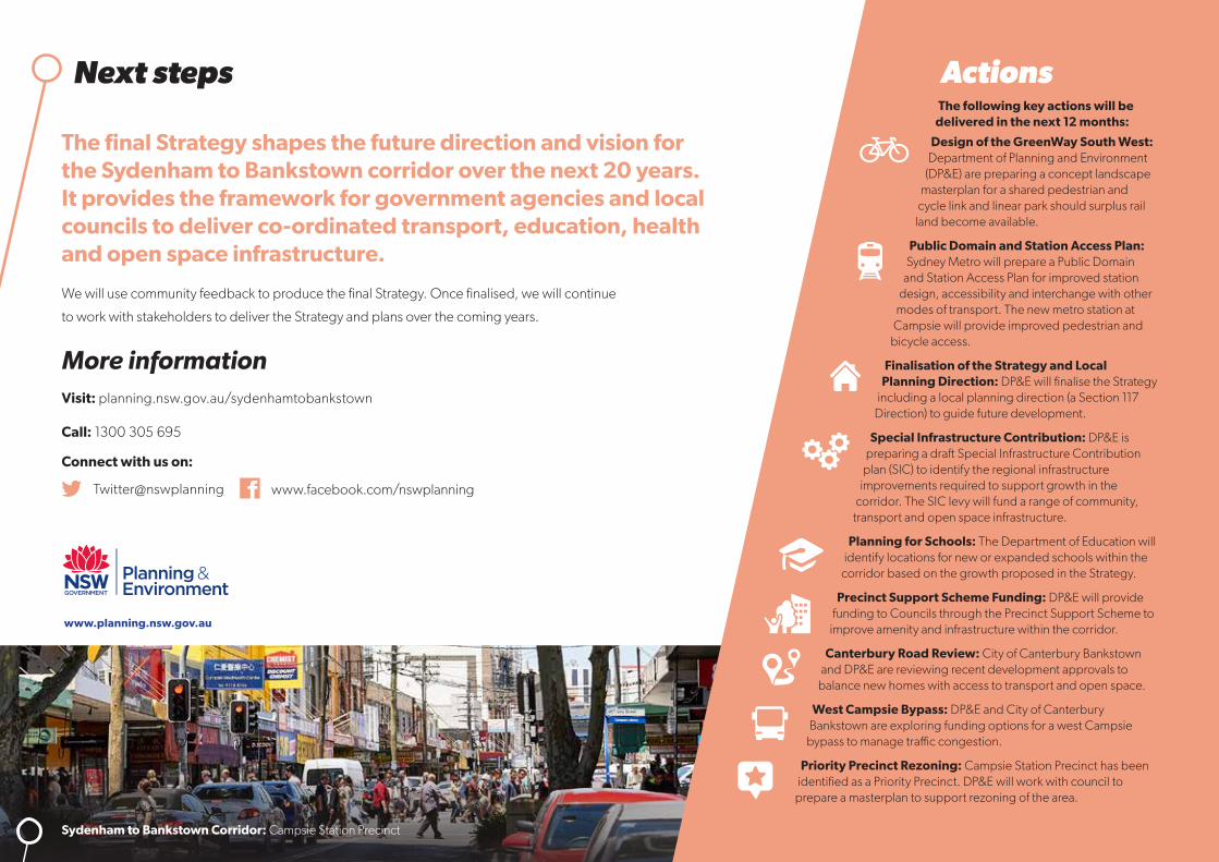
Next steps Actions
www.planning.nsw.gov.au
Sydenham to Bankstown Corridor: Campsie Station Precinct
The following key actions will be delivered in the next 12 months:
Design of the GreenWay South West: Department of Planning and Environment
(DP&E) are preparing a concept landscape masterplan for a shared pedestrian and
cycle link and linear park should surplus rail land become available.
Public Domain and Station Access Plan: Sydney Metro will prepare a Public Domain
and Station Access Plan for improved station design, accessibility and interchange with other
modes of transport. The new metro station at Campsie will provide improved pedestrian and
bicycle access.
Finalisation of the Strategy and Local Planning Direction: DP&E will finalise the Strategy
including a local planning direction (a Section 117 Direction) to guide future development.
Special Infrastructure Contribution: DP&E is preparing a draft Special Infrastructure Contribution
plan (SIC) to identify the regional infrastructure improvements required to support growth in the
corridor. The SIC levy will fund a range of community, transport and open space infrastructure.
Planning for Schools: The Department of Education will identify locations for new or expanded schools within the
corridor based on the growth proposed in the Strategy.
Precinct Support Scheme Funding: DP&E will provide funding to Councils through the Precinct Support Scheme to
improve amenity and infrastructure within the corridor.
Canterbury Road Review: City of Canterbury Bankstown and DP&E are reviewing recent development approvals to
balance new homes with access to transport and open space.
West Campsie Bypass: DP&E and City of Canterbury Bankstown are exploring funding options for a west Campsie
bypass to manage traffic congestion.
Priority Precinct Rezoning: Campsie Station Precinct has been identified as a Priority Precinct. DP&E will work with council to
prepare a masterplan to support rezoning of the area.
The final Strategy shapes the future direction and vision for the Sydenham to Bankstown corridor over the next 20 years. It provides the framework for government agencies and local councils to deliver co-ordinated transport, education, health and open space infrastructure.
We will use community feedback to produce the final Strategy. Once finalised, we will continue
to work with stakeholders to deliver the Strategy and plans over the coming years.
More informationVisit: planning.nsw.gov.au/sydenhamtobankstown
Call: 1300 305 695
Connect with us on:
Twitter@nswplanning www.facebook.com/nswplanning