Embed Size (px)
Citation preview
Chap
ter 31 – References
Chapter 31References


Parsons Brinckerhoff i
Contents
Page number
31. References 31-1
31.1 Reference list 31-1
31.2 Source information 31-12
31.2.1 Traffic, transport and access 31-12 31.2.2 Noise and vibration 31-14 31.2.3 Biodiversity 31-15 31.2.4 Hazard and risk 31-16 31.2.5 Contamination and soils 31-17 31.2.6 Hydrology, groundwater and water quality 31-17 31.2.7 Local air quality 31-20 31.2.8 Regional air quality 31-21 31.2.9 Greenhouse gases 31-22 31.2.10 Aboriginal heritage 31-22 31.2.11 European heritage 31-23 31.2.12 Visual and urban design 31-23 31.2.13 Property and infrastructure 31-24 31.2.14 Social and economic impacts 31-24 31.2.15 Human health risks and impacts 31-25 31.2.16 Waste and resource management 31-25 31.2.17 Cumulative impacts 31-26

Parsons Brinckerhoff ii
List of tables Page number
Table 31.1 Traffic, transport and access source information 31-12 Table 31.2 Noise and vibration source information 31-14 Table 31.3 Biodiversity source information 31-15 Table 31.4 Hazard and risk source information 31-16 Table 31.5 Contamination and soils source information 31-17 Table 31.6 Hydrology, groundwater and water quality source information 31-17 Table 31.7 Local air quality source information 31-20 Table 31.8 Regional air quality source information 31-21 Table 31.9 Greenhouse gas source information 31-22 Table 31.10 Aboriginal heritage source information 31-22 Table 31.11 European heritage source information 31-23 Table 31.12 Visual and urban design source information 31-23 Table 31.13 Property and infrastructure source information 31-24 Table 31.14 Social and economic source information 31-24 Table 31.15 Human health risks and impacts source information 31-25 Table 31.16 Social and economic source information 31-25 Table 31.17 Cumulative impacts source information 31-26

Parsons Brinckerhoff 31-1
31. References
31.1 Reference list
AS 1940-2004, The storage and handling of flammable and combustible liquids.
AS 2419.1: 2005, Fire hydrant installations – System design, installation and commissioning.
AS 2944.1: 2007, Plastics pipes and fittings for gas reticulation – Polyamide fitting.
AS 3961-2005, The storage and handling of liquefied natural gas.
AS4482.1 2005 Guide to the investigation and sampling of sites with potentially contaminated soil – Part 1: Non-volatile and semi-volatile compounds.
AS/NZS ISO 31000: 2009, Risk management – Principles and guidelines.
AS/NZS 1596: 2008, The storage and handling of LP Gas.
Acid Sulfate Soils Management Advisory Committee (ASSMAC) 1998, Acid Sulfate Soils Assessment Guidelines.
AECOM Australia 2010, Weed Management Plan SWS1050 Liverpool Military Area, prepared for Defence Maintenance Management Pty Ltd.
Archaeological and Heritage Management Solutions Pty Ltd (AHMS) 2012, Aboriginal Cultural Heritage Assessment [Final], Appendix U in SIMTA Sydney Intermodal Terminal Alliance Part 3A Concept Application, Hyder Consulting Pty Ltd.
Australia ICOMOS 1987, The Australia Icomos Charter for the Conservation of Places of Cultural Significance (The Burra Charter), Guidelines to the Burra Charter, Cultural Significance and Conservation Policy, Pamphlet, Australia Icomos (Inc).
Australian Bureau of Statistics 2011,, Selected characteristics retrieved from QuickStats, TableBuilder and DataPacks. www.abs.gov.au. Accessed September 2012 and November 2012.
Australian Government House of Representatives Standing Committee on Transport and Regional Services (HRSCTRS) 2007, The Great Freight Task – is Australia’s transport network up to the challenge?, July 2007. Viewed June 2014. www.aph.gov.au/Parliamentary_Business/Committees?House_of_Representative_Committees?url=trs/networks/report.htm.
Australian Greenhouse Office (AGO) 2007, Energy Efficiency in Government Operations Policy (EEGO).
Australian Greenhouse Office (AGO) 2006, Australian Greenhouse Office Factors and Methods Workbook.
Australian New Zealand Environment Conservation Council (ANZECC) 2000, Australian and New Zealand Guidelines for Fresh and Marine Water Quality.
Parsons Brinckerhoff 31-2
Australian Rail Track Corporation (ARTC) 2007, North-South Corridor Strategic Investment Outline, viewed May 2012. www.artc.com.au/library/North-South%20Corridor%20Strategic%20Invest ment%20Outline.pdf.
Australian Rail Track Corporation (ARTC) 2012 Port Botany Rail Yard Enters 21st Century Efficiencies. www.artc.com.au/Article/Detail.aspx?p=6&np=4&id=358.
Australian Weeds Committee 2010, Weeds of National Significance, viewed June 2014, www.weeds.org.au/WoNS/.
Axis Environmental/Australian Museum Business Services Consulting 1995, Holsworthy Training Area Environmental Audit, Main Report and Appendix 1, Report for the Department of Defence.
Baird M and Gay D 2012, Media Release: Green light given for long term lease of Port Botany and Port Kembla.
Bannerman and Hazelton 1990, Soil Landscapes of the Penrith 1:100,000 Map Sheet, Soil Conservation Service NSW, Sydney.
Bannerman SM and Hazelton PA 1990, Soil Landscapes of the Penrith 1:100,000 Sheet map and report.
BBC Consulting Planners, 2011, State Significant Site Study, Heathcote Ridge, West Menai.
Benedict Industries Pty Ltd, 2012, Environmental Impact Statement for Development of Georges Gove Marina.
Bermagui Constructions Pty Ltd 2012, SWS 1938 – Demolition of Moorebank Area Buildings Photographic Archival Record, prepared for Brookfield Multiplex Services for Department of Defence, Defence Support Group.
Bewsher Consulting 2004, Georges River Floodplain Risk Management Study and Plan.
BMT WBM 2008, Anzac Creek Floodplain Risk Management Study and Plan.
Boot P 1990, Archaeological Survey of Proposed Defence Housing Authority Subdivision at Holsworthy, NSW, prepared by South-East Archaeology for Kinhill Engineers Pty Ltd.
Boot P 1992, Archaeological survey of additions to Defence Housing Authority subdivision at Wattle Grove, NSW, prepared by South-East Archaeology for Wattle Grove Development.
Boot P 1993, Artefact scatters at Wattle Grove, NSW. A report on results of archaeological salvage work conducted under the terms and conditions of consent to destroy and permit to salvage No. 514 issued on 26 August 1993 under the provisions of the National Parks and Wildlife Act 1974, prepared for Wattle Grove Development.
Boot P 1994a Archaeological survey of Option 3 land, Defence Housing Authority sub-division at Wattle Grove, NSW. Report to Wattle Grove Development.
Boot P 1994b, Monitoring of tree and topsoil removal from artefact scatters at Wattle Grove, NSW. A report on results of archaeological monitoring conducted under the terms and conditions of consents to destroy and permit to salvage Nos. 506 & 514 issued on 30 June 1993 and 26 August 1993 under the provisions of the National Parks and Wildlife Act 1974, prepared for Wattle Grove Development.
Bureau of Infrastructure, Transport and Regional Economics (BITRE) 2010, Interstate Freight in Australia.
Bureau of Transport Statistics (BTS) 2006, Sydney Strategic Travel Model.

Parsons Brinckerhoff 31-3
Bureau of Transport Statistics (BTS) 2013, Employment Forecasts, viewed 7 July 2013 ,www.bts.nsw.gov.au/Statistics/Employment-Forecasts/default.aspx.
Capell A 1970, ‘Aboriginal Languages in the South Central Coast, New South Wales: Fresh Discoveries’, Oceania, vol. 41, no. 1, pp 20-27.
Council of Australian Governments (COAG) 1992, National Strategy for Ecologically Sustainable Development.
Cultural Heritage Connections 2006, Southern Sydney Freight Line Aboriginal Archaeological Assessment, prepared for Parsons Brinkerhoff.
CSIRO 2012, Australian Soil Resource Information System, www.asris.csiro.au.
CSIRO 1998, Acid Sulfate Soils Management Advisory Committee (ASSMAC) Assessment Guidelines.
Commonwealth Department of Environment and Water (DEW) 2006, Considerations for incorporating energy efficiency into requirements for Australian Government owned and leased buildings.
Commonwealth Department of Environment and Water Resources (DEWR) 2007, ESD Design Guide – Office and Public Buildings (3rd ed).
Commonwealth Department of the Environment (DOE) 2013, Significant Impact Guidelines 1.1 – Matters of National Environmental Significance.
Commonwealth Department of Infrastructure and Transport (DOIT) 2011, Nation Building Program, viewed 30 April 2012. www.nationbuildingprogram.gov.au/.
Commonwealth Department of Infrastructure and Transport (DOIT) 2012, Green Vehicle Guide. www.green vehicleguide.gov.au.
Commonwealth Department of Infrastructure and Transport 2013, Addressing Sydney’s Freight Rail Bottleneck.
Commonwealth Department of Sustainability, Environment, Water, Population and Communities (SEWPaC) 2010, EPBC Act policy statements – Survey Guidelines for Nationally Threatened Species.
Commonwealth Department of Sustainability, Environment, Water, Population and Communities (SEWPaC) 2011, Australia state of the environment report, Canberra.
Commonwealth Department of Sustainability, Environment, Water, Population and Communities (SEWPaC) 2012, Environment Protection and Biodiversity Conservation Act 1999 – Environment Offsets Policy.
Commonwealth Department of Sustainability, Environment, Water, Population and Communities (SEWPaC) 2013, Sustainable Procurement Guide.
Commonwealth Department of Finance and Deregulation (CDFD), 2011, Moorebank Intermodal Terminal – Existing Aboriginal and European Heritage, prepared by Parsons Brinckerhoff, Sydney.
Environment Protection and Heritage Council, the Natural Resource Management Ministerial Council and the Australian Health Ministers’ Conference 2006, Australia Guidelines for Water Recycling: Managing Health and Environmental Risk.
Dallas M and Steele D 2004, Aboriginal Archaeological Survey of Department of Defence Lands at Moorebank. Report to GHD Pty Ltd on behalf of the Department of Defence.

Parsons Brinckerhoff 31-4
Dames and Moore 1996, Environmental Management Plan for Liverpool Base Administrative Support Centre and School of Military Engineering.
DEC National Environmental Protection Council (NEPC) 2003, National Environmental Protection (Ambient Air Quality) Measure (NEPM) (as amended) July 2003 prepared by Commonwealth Government for National Environment Protection Council..
Deloitte 2013, Moorebank Intermodal Terminal Demand Assessment Final Report, 16 December 2013 prepared for Moorebank Intermodal Company Ltd.
Deloitte 2014, Moorebank Intermodal Terminal – Trip Generation Estimate – version 9, 26 May 2014.
Department of Urban Affairs and Planning (DUAP) 1998, SEPP 55 – Managing Land Contamination.
Douglass B Hieken J and Rubesntein G 2010, Characterisation and Breadth of Rail Yard Specific Incentives.
Eades D 1976, The Dharawal and Dhurga Languages of the New South Wales South Coast. Australian Aboriginal Studies Research and Regional Studies No. 8, AIAS, Canberra.
Earth Tech Engineering Pty Ltd (Earth Tech) 2006, Stage 2 Environmental Investigation Moorebank, Sydney, NSW.
Egis Consulting Australia (ECA) 2000, Preliminary Site Investigation, Moorebank Defence Site, NSW, prepared for Department of Defence Property Disposals Task Force.
Energy Australia 2002, Vegetation Safety Clearances (NS179).
EnHealth 2001, Health Impact Assessment Guidelines, published by the Environmental Health Committee (enHealth), which is a subcommittee of the Australian Health Protection Committee (AHPC).
EnHealth2004, The health effects of environmental noise – other than hearing loss, published by the Environmental Health Committee (enHealth).
EnHealth2012a, Environmental Health Risk Assessment: Guidelines for Assessing Human Health Risks from Environmental Hazards, published by the Environmental Health Committee (enHealth).
EnHealth 2012b, Exposure Factors Guide, published by the Environmental Health Committee (enHealth).
Environmental Resource Management (ERM) 2013, Moorebank Unit Relocation (MUR) Project: Steele Barracks, NSW Heritage Impact Assessment. A report to Point Project Management on behalf of the Department of Defence.
Eric Martin and Associates 2011, Steele Barracks and Environs Conservation Management Plan – Built Environment, draft report to NOHC on behalf of Parsons Brinckerhoff.
Fairfull S and Witheridge G 2003, Why do fish need to cross the road? Fish passage requirements for waterway crossings, NSW Fisheries, Cronulla.
Farmer A 1993, ‘The effects of dust on vegetation – a review’, Environmental Pollution, vol. 79, no. 1, pp. 63-75.
Freight Infrastructure Advisory Board (FIAB) 2005, Railing Port Botany’s Containers: Proposals to Ease Pressure on Sydney’s Roads.
Parsons Brinckerhoff 31-5
Gehrke PC Hartley SB and Tyndal JX 2004, Biodiversity of the Georges River Catchment: Aquatic biodiversity – Freshwater Fishes, Department of Primary Industries and Natural Resources (DIFNR), Sydney.
Georges River Combined Councils Committee (GRCCC) 2011, Community River Health Monitoring Program Report Card, viewed 18 May 2012. www.georgesriver.org.au/.
GHD 2004, Department of Defence – Property Disposal Task Force, Groundwater Investigation of the North Western Portion of the Moorebank Defence Land, Factual Report, Tender No. PDTF 10/03.
GHD 2013, Moorebank Vegetated Area 'Bush Block' Part Lot 3001, DP 1125930 Contamination Assessment.
Graham Brooks and Associates Pty Ltd 2004, Moorebank Defence Site, Moorebank: Heritage Assessment, prepared for Department of Defence Property Disposals Task Force.
Haglund L 1994, Current Options for the M5 Motorway (Beverly Hills to St Peters and Padstow to Botany/Mascot) in relation to Aboriginal Heritage Potential – Working Paper, prepared for Manidis Roberts and the (NSW) Roads and Transport Authority.
Harden G 2002, Flora of New South Wales Volume 2 (Revised Edition), 2nd edn, vol. 2, University of New South Wales Press Ltd, Kensington.
Harris P Harris-Roxas B, Harris E and Kemp L 2007, Health Impact Assessment: A Practical Guide, prepared for Health Equity Training, Research and Evaluation (CHETRE), UNSW Research Centre for Primary Health Care and Equity, University of New South Wales, Sydney.
Healthy Rivers Commission (HRC) 2001, Independent Inquiry into the Georges River – Botany Bay System – Final Report.
HLA Envirosciences Pty Ltd 2003, Preliminary Groundwater Study Moorebank Defence Land, prepared for Department of Defence.
HLA Envirosciences Pty Ltd 2002, Soil and Groundwater Investigation Precinct H (DNSDC) Moorebank Defence Land.
Hyder Consulting 2011, Referral of proposed action: SIMTA Moorebank Intermodal Terminal Facility.
Hyder Consulting 2012, SIMTA Moorebank Intermodal Facility – Flora and Fauna Assessment.
Hyder Consulting 2013, Draft Environmental Impact Statement – Sydney Intermodal Terminal Alliance.
Infrastructure Australia 2009, National Infrastructure Priorities – Infrastructure for an economically, socially and environmentally sustainable future.
Infrastructure Australia 2010, National Ports Strategy.
Infrastructure Australia 2011, National Land Freight Strategy Discussion Paper.
International Atomic Energy Agency 1996, Manual for the classification of risks due to major accidents in process and related industries (Revision 1).
Jame, T 1997, Urban bushland biodiversity survey. Native flora in western Sydney. NSW National Parks and Wildlife Service, Hurstville.

Parsons Brinckerhoff 31-6
Koettig M and Hughes P 1983, An archaeological survey of the route of the proposed rail link between East Hills and Glenfield, NSW, prepared for Dames and Moore Pty Ltd.
Kohen J 1986, Prehistoric Settlement in the Western Cumberland Plain: Resources, Environment and Technology, unpublished PhD thesis, Macquarie University.
Kohen J 1988, ‘The Dharug of the western Cumberland Plain: Ethnography and Demography’ in Meehan B and Jones R (eds), Archaeology with Ethnography: An Australian Perspective, Department of Prehistory, Australian National University, Canberra.
Landcom 2004, Managing Urban Stormwater: Soils and Construction Volume 1 (The ‘Blue Book’).
Landcom 2009, Water Sensitive Urban Design Books 1–4.
Lesry K Environmental Consultants 2003, Fauna biodiversity study of part of the Moorebank Defence Area: Site Development Options.
Liverpool City Council (LCC) 2009, Bike Plan 2009.
Liverpool City Council (LCC) 2008a, Development Control Plan: Part 1.2 Additional General Controls for Development.
Liverpool City Council (LCC) 2008b, Liverpool Development Control Plan: Part 2.4 Development in Moorebank Defence Lands.
Liverpool City Council (LCC) 2008c, Liverpool Development Control Plan: Part 7 Development in Industrial Areas.
Mathews R 1901a, ‘The Thurrawal Language’, Journal and Proceedings of the Royal Society of NSW, vol. 35, pp.127-160.
Mathews R 1901b, Thurrawal Grammar Part 1, Australian Institute of Aboriginal Studies, Sydney.
McCotter M 1995, Report on Proposed International Shooting Centre at Holsworthy.
Minister for Infrastructure and Regional Development 2013, Media Release: Moorebank Intermodal Terminal Procurement Process Underway, 13 December 2013.
Moorebank Project Office (MPO) 2011, Information Paper: Moorebank Intermodal Terminal Project.
National Environmental Protection Council (NEPC) 1998, National Environmental Protection (Air Toxics) Measure, prepared by Commonwealth Government for National Environment Protection Council, 2011.
National Environmental Protection Council (NEPC) 2001, National Environmental Protection (Diesel Vehicle Emissions) Measure, prepared by Commonwealth Government for National Environment Protection Council.
National Environment Protection Council (NEPC) 2013, National Environment Protection (Assessment of Site Contamination) Amendment Measure 2013 (No.1), prepared by the Commonwealth Government for National Environment Protection Council (NEPM).
National Environmental Protection Council (NEPC) 2011, National Environmental Protection (Ambient Air Quality) Measure, prepared by Commonwealth Government for National Environment Protection Council, 1998.

Parsons Brinckerhoff 31-7
National Occupational Health and Safety Commission Australia (NOHSC) 2005a, Code of Practice for the Safe Removal of Asbestos, 2nd Edition.
National Occupational Health and Safety Commission Australia (NOHSC) 2005b, Guidance Note on the Membrane Filter Method For the Estimating Airborne Asbestos Fibre, 2nd Edition.
Navin Officer Heritage Consultants 2011, Moorebank Intermodal Freight Terminal Scoping Study, Cultural Heritage Desktop Review, Summary compilation of known and potential constraints. An interim report to Parsons Brinckerhoff, Sydney.
Navin Officer Heritage Consultants 2014a, Moorebank Intermodal Terminal – Liverpool City Council Northern Powerhouse Land; Aboriginal Subsurface Testing. Report to Parsons Brinckerhoff on behalf of Department of Finance and Deregulation.
Navin Officer Heritage Consultants 2014b,Moorebank Intermodal Terminal – Liverpool City Council Northern Powerhouse Land; Aboriginal Subsurface Testing. Report to Parsons Brinckerhoff on behalf of Department of Finance and Deregulation.
NSW Department of Climate Change and Energy Efficiency (DCCEE) 2011, Green Lease Schedule.
NSW Department of Climate Change and Energy Efficiency (DCCEE) 2012, National Greenhouse Accounts (NGA) Factors.
NSW Department of Environment and Conservation (DEC) 2004, Threatened Biodiversity Survey and Assessment: Guidelines for Developments and Activities (Working Draft).
NSW Department of Environment and Conservation (DEC) 2005, Approved Methods for the Modelling and Assessment of Air Pollutants in New South Wales.
NSW Department of Environment and Conservation (DEC) 2006a, Environmental Noise Management, Assessing Vibration: a technical guideline.
NSW Department of Environment and Conservation (DEC) 2006b Managing Urban Stormwater: Harvesting and Reuse, NSW Government.
NSW Department of Environment and Climate Change (DECC) 2006, Guidelines on the Duty to Report Contamination under the Contaminated Land Management Act 1997.
NSW Department of Environment and Climate Change (DECC) 2007a, Floodplain Risk Management Guideline: Practical Consideration of Climate Change.
NSW Department of Environment and Climate Change (DECC) 2007b, Guidelines for the Assessment and Management of Groundwater Contamination.
NSW Department of Environment and Climate Change (DECC) 2008, Principles for the use of biodiversity offsets in NSW. www.environment.nsw.gov.au/biocertification/offsets.htm.
NSW Department of Environment and Climate Change (DECC) 2009, Interim Construction Noise Guideline.
NSW Department of Environment and Climate Change and Water (DECCW) 2005, Interim Guidelines for Aboriginal Consultation.
NSW Department of Environment and Climate Change and Water (DECCW) 2009, Action for Air 2009 Update.
Parsons Brinckerhoff 31-8
NSW Department of Environment, Climate Change and Water (DECCW) 2010, Aboriginal cultural heritage consultation requirements for proponents.
NSW Department of Environment Climate Change and Water (DECCW) 2011, Road Noise Policy.
NSW Department of Infrastructure, Planning and Natural Resources (DIPNR) 2005, Floodplain Development Manual.
NSW Department of Infrastructure Planning and Natural Resources (2005) NSW Floodplain Development Manual.
NSW Department of Land & Water Conservation (DLWC) and Liverpool City Council (LCC) 2000, Upper Georges River Flood Study.
NSW Department of Mineral Resources (DMR) 1991, Penrith 1:100,000 Geological Series Sheet 9030.
NSW Department of Planning 2005, Metropolitan Strategy – City of Cities: A Plan for Sydney’s Future.
NSW Department of Planning 2007, Metropolitan Strategy – South West Subregion: Draft Subregional Strategy.
NSW Department of Planning 2011a, Risk Criteria for Land Use Planning, Hazardous Industry Planning Advisory Paper No 4 (HIPAP No 4) Risk Criteria for Land Use Safety Planning.
NSW Department of Planning 2011b, Guidelines for Hazard Analysis, Hazardous Industry Planning Advisory Paper No 6 (HIPAP No 6) Hazard Analysis.
NSW Department of Planning 2011c, Guidelines for Hazard Analysis, Hazardous Industry Planning Advisory Paper No 10 (HIPAP No 10) Land Use Safety Planning.
NSW Department of Planning 2011d, Applying SEPP 33 – Hazardous and Offensive Development Application Guidelines.
NSW Department of Planning and Infrastructure (DP&I) 2013, Draft Metropolitan Strategy for Sydney to 2031.
NSW Department of Primary Industries (DPI) 2004, Director General’s Policy of Cage Trapping and Animal Care Guidelines for Wildlife Surveys.
NSW Environment Protection Authority 2012, Air Emissions Inventory for the Greater Metropolitan Region in NSW, 2008 Calendar Year On-Road Mobile Emissions: Results. www.environment.nsw.gov.au/air/airinventory2008.htm.
NSW Environmental Protection Agency (EPA) 1994, Guidelines for Assessing Service Station Sites.
NSW Environmental Protection Agency (EPA) 1995, Sampling Design Guidelines.
NSW Environmental Protection Authority (EPA) 2000a, Guidelines for Consultants Reporting on Contaminated Sites.
NSW Environmental Protection Agency (EPA) 2000b, NSW Industrial Noise Policy.
NSW Environmental Protection Agency (EPA) 2013a, Assessing Vibration: a technical guideline.
NSW Environmental Protection Agency (EPA) 2013b, Rail Infrastructure Noise Guideline.

Parsons Brinckerhoff 31-9
NSW Government 2003, NSW Ports Growth Plan.
NSW Government 2007, State Environmental Planning Policy (Infrastructure).
NSW Government State Environmental Planning Policy No. 19 – Bushland in Urban Areas.
NSW Government, State Environmental Planning Policy No. 33 – Hazardous and Offensive Development.
NSW Government, State Environmental Planning Policy No. 44 – Koala Habitat Protection.
NSW Government, State Environmental Planning Policy No. 55 – Remediation of Land.
NSW Government, Greater Metropolitan Regional Environmental Plan No. 2 – Georges River Catchment.
NSW Government 2010, Metropolitan Plan for Sydney 2036.
NSW Government 2011a, NSW 2021: A Plan to Make NSW Number One.
NSW Government 2011b, Infrastructure Australia Submission – Port Botany and Sydney Airport Transport Improvement Program.
NSW Government 2012, NSW Long Term Transport Master Plan.
NSW Government 2013, NSW Freight and Ports Strategy.
NSW Health 2008, New South Wales Population Health Survey 2007-2008. Centre for Epidemiology and Research, viewed 28 March 2012. www.health.nsw.gov.au/publichealth/surveys/hsc/ 0708/toc/t_3_stat_02_asthma.asp.
NSW Heritage Office 2000, Assessing Heritage Significance. Update for NSW Heritage Manual (Final Approved Text August 2000).
NSW Heritage Office and Department of Urban Affairs and Planning (DUAP) 1996, Regional Histories: Regional Histories of New South Wales.
NSW Heritage Office and Department of Urban Affairs and Planning (DUAP) 1996, NSW Heritage Manual.
NSW National Parks and Wildlife Service (NPWS) 1999, Acacia bynoeana threatened species information.
NSW National Parks and Wildlife Service (NPWS) 2001, Persoonia nutans threatened species information.
NSW National Parks and Wildlife Service (NPWS) 2002, Pultenaea parviflora threatened species information.
NSW National Parks and Wildlife Service (NPWS) 2003, Acacia pubescens threatened species information.
National Transport Commission (NTC) 2011, Australian Dangerous Goods Code 7th Edition October 2011.
National Water Commission 2013, Groundwater Dependent Ecosystems Atlas, Australian Government, accessed 5 August 2013. www.bom.gov.au/water/groundwater/gde/map.shtml.

Parsons Brinckerhoff 31-10
NSW Scientific Committee 1998a, Final determination to list Grevillea parvilfora ssp. parviflora as a vulnerable species, NSW National Parks and Wildlife Service, Hurstville.
NSW Scientific Committee 1998b, Final determination to list Persoonia hirsuta as an endangered species, NSW National Parks and Wildlife Service, Hurstville.
NSW Office of Environment and Heritage (OEH) 2008, Managing Urban Stormwater: Soils and Construction – Installation of Services, Volume 2A.
NSW Office of Environment and Heritage (OEH) 2008, Managing Urban Stormwater: Soils and Construction – Main Road Construction, Volume 2D.
NSW Office of Environment and Heritage (OEH) 2011, Coal Mining Benchmarking Study: Measures to Prevent and/or Minimise Emissions of Particulate Matter from Coal Mining.
NSW Office of Environment and Heritage (OEH) 2014, Hourly air quality monitoring data from Chullora and Liverpool monitoring stations, 2012 and 2013.
NSW Office of Environment and Heritage, Application Notes – NSW Industrial Noise Policy.
NSW Roads and Maritime Services 2005, Accident Reduction Guide, Version 1.1.
NSW Road and Transport Authority 1988, Road Design Guide.
NSW Rural Fire Service 2006, Planning for Bush Fire Protection.
Officer K 1984, From Tuggerah to Dharawal: Variation and Function within a Regional Art Style, unpublished Honours thesis, Department of Prehistory and Anthropology, Australian National University, Canberra.
Parsons Brinckerhoff 2006, Sydney Southern Freight Line Environmental Assessment.
Parsons Brinckerhoff 2011a, Referral of proposed action: Moorebank Intermodal Terminal (IMT) Project – Concept.
Parsons Brinckerhoff 2011b, Moorebank Intermodal Freight Terminal – Existing Ecological Values.
Parsons Brinckerhoff 2011c, Moorebank Intermodal Terminal Preliminary Project Overview Report.
Parsons Brinckerhoff 2012, Moorebank Intermodal Terminal Bushfire Risk Assessment.
Patriarca E and Debernardi P 2010, Bats and light pollution, viewed 28 May 2012. www.centro regionalechirotteri.org/download/eurobats/Bats%20and%20light%20pollution.pdf.
Phillips 2003 ‘Why lived in landscapes matter to nature conservation’, in APT Bulletin: The Journal of the Preservation of Technology, Association for Preservation Technology International, Vol XXXIV, No 1, pp 5–10.
Rafter T and Abbs D 2009, Calculation of Australian extreme rainfall within GCM simulations using Extreme Value Analysis.
Regional Development Australia–Sydney 2011, Regional Plan for Sydney – August 2011.
Ross A 1988, ‘Tribal and Linguistic Boundaries: A Reassessment of the Evidence’, in Aplin, G (ed), A Difficult Infant: Sydney before Macquarie, New South Wales Press, Kensington.

Parsons Brinckerhoff 31-11
Royal Botanic Gardens 2011, PlantNet – The Plant Information Network System of Botanic Gardens Trust (version 2.0), plantnet.rbgsyd.nsw.gov.au/.
Seidel and Briggs 2008, BioBanking Assessment Methodology and Credit Calculator Operation Manual (BBAM).
Sefton C 1994, Archaeological Survey of Proposed Drill Sites P1 and P2, Holsworthy Military Training Area, Punchbowl, prepared for Kembla Coal and Coke Pty Ltd.
Serov P Kuginis L and JP 2012, Risk assessment guidelines for groundwater dependent ecosystems, Volume 1 – The conceptual framework, NSW Department of Primary Industries, Office of Water, Sydney.
Sharp R 1994, Cultural Heritage Potential of Army Training Areas in Australia, Undergraduate Report, Charles Sturt University.
South Western Sydney Local Health Network (SWSLHN) 2012, South Western Sydney Local Health District, Community Health Profile.
Stormwater Trust and Upper Parramatta River Catchment Trust 2004, Water Sensitive Urban Design – Technical Guidelines for Western Sydney.
Suters Architects 2012, Moorebank Intermodal Concept Masterplan.
Sydney Catchment Authority (SCA) 2007, Submission to Inquiry into the NSW Southern Coalfields July 2007, Appendix 5 – Draft Water Monitoring Guidelines, viewed 15 February 2012. www.planning.nsw.gov.au/planningsystem/pdf/southerncoalfieldinquiry_sca_1.pdf.
Sydney Ports 2011, PBLIS Overview. www.sydneyports.com.au/port_development/landside_improvement/pblis_overview.
Tindale N 1974, Aboriginal Tribes of Australia, Australian National University Press. Canberra.
Tozer M 2003, 'The native vegetation of the Cumberland Plain, western Sydney: systematic classification and field identification of communities', Cunninghamia, vol. 8, no. 1, pp. 1–75.
Transport for NSW (TfNSW) 2012, Construction Noise Strategy.
United Kingdom Department of Transport 1988, Calculation of Road Traffic Noise.
United States Environment Protection Authority (USEPA) 2012, Final Rule: Control of Emissions of Air Pollution from Locomotives and Marine Compression-Ignition Engines Less Than 30 Liters per Cylinder.
United States Environment Protection Agency (US-EPA) 2008, Idling Vehicle Emissions for Passenger Cars, Light-Duty Trucks, and Heavy-Duty Trucks, Office of Transportation and Air Quality, EPA420-F-08-025.
Urbis 2011, Heathcote Ridge Employment Study
Urbis 2013, Sydney Intermodal Terminal Alliance Environmental Assessment.
US Federal Transit Administration, Transit Noise and Vibration Impact Assessment.
Wilkinson Murray 2011, Southern Sydney Freight Line Operational Noise and Vibration Management Plan, prepared for Australian Rail Track Corporation, Sydney.

Parsons Brinckerhoff 31-12
World Business Council for Sustainable Development/World Resources Institute (WRI/WBCSD) 2004, The GHG Protocol: A Corporate Accounting and Reporting Standard (revised edition).
World Health Organisation 1999, Guidelines for community noise.
World Heritage Committee 2003, Cultural Landscapes, World Heritage Convention. Viewed on 5 August 2003. whc.unesco.org/exhibits/cultland/landscape.htm.
31.2 Source information
31.2.1 Traffic, transport and access
Table 31.1 Traffic, transport and access source information
Impact area Key information
sources Date/how
recent Reliability Uncertainties
IMEX and interstate train and traffic generation and Warehouse heavy vehicle traffic generation
Information provided by Deloitte.
2014 Accurate None
Workforce/staff numbers for IMEX and IS
Moorebank IMT Staffing Requirement provided by Deloitte.
2011 Accurate None
Workforce/staff numbers for warehouse light vehicle traffic generation
Information provided by Parsons Brinckerhoff based on RMS Guide to Traffic Generating Development 2013 Traffic Surveys
2014 Accurate None
Construction traffic generation
Program provided by Parsons Brinckerhoff
Volume of construction vehicles based on volume and quantity of material and vehicle types.
2014 Accurate Dependent on the construction program and scheduling of activities, as well as size and type of vehicles used.
Intersection traffic counts on Moorebank Avenue
Traffic surveys conducted by Austraffic.
2010 Accurate None
Intersection traffic counts on Moorebank Avenue and wider area road network
Traffic surveys conducted by Austraffic
2014 Accurate None
Intersection traffic signal data (SCATS IDM Data and TCS Plans)
Roads and Maritime Services
2014 Accurate None
Seven day classified tube counts
Traffic surveys conducted by Austraffic.
2010 Accurate None
Road network yearly future traffic growth rates
Roads and Maritime Services
2014 Accurate None

Parsons Brinckerhoff 31-13
Impact area Key information
sources Date/how
recent Reliability Uncertainties
Regional road network
Bureau of Transport Statistics: Freight Movements in Sydney
Sydney Freight Movement Model
Sydney Light Commercial Vehicle Model
Sydney Strategic Travel Model.
2006, 2010 Accurate None
Cycle and pedestrian facilities
Liverpool City Council Bike Plan
Site inspection.
2009, 2011 Accurate None
Cycle and pedestrian facilities
Austroads Guide to Road Design Part 3: Geometric Design
2009 Accurate None
Crash data Roads and Maritime Services
2014 Accurate None
Crash reduction treatments
Roads and Maritime Services
2005 Accurate None
SIMTA traffic Traffic Impact Assessment – Sydney Intermodal Terminal Alliance, Hyder
2013 SIMTA EIS None
Residential dwelling densities for Sydney
Landom Residential Density Guide
2011 Accurate None
Container movements at Port Botany
Australian Government Bureau of Infrastructure, Transport and Regional Economics (BITRE)
2010 Accurate None
Parking requirements
Liverpool City Council Development Control Plan (DCP)
2012 Accurate None

Parsons Brinckerhoff 31-14
31.2.2 Noise and vibration
Table 31.2 Noise and vibration source information
Impact area Key information
sources Date/how
recent Reliability Uncertainties
Receiver communities
Site walkover surveys, GIS land use analysis, and land use development zones.
2010 to 2012 Accurate None
Existing noise environment
Baseline noise survey conducted by Parsons Brinckerhoff.
2010, 2011 continuous from 2012.
Accurate None
Source levels for noise and vibration
Suppliers of IMT plant and machinery and SLR Consulting database of measured noise and vibration levels.
2011 and 2012 for suppliers and 2014 for SLR Consulting database.
Accurate One-third octave band noise data not available for all plant.
Meteorological data
Australian Bureau of Meteorology
Data specific to all baseline noise monitoring periods.
Seasonal trends in region meteorological conditions based on full year of data for 2013.
Accurate None
Road traffic movements
Refer Table 31.1 Traffic, transport and access source information.
Refer Table 31.1 Traffic, transport and access source information.
Accurate None specific to the assessment of noise and vibration.
Southern Sydney Freight Line
Operational Noise and Vibration Management Plan.
2011 – most recent publically available assessment
Approved by Australian Rail Track Corporation.
None
SIMTA noise Noise Impact Assessment – Sydney Intermodal Terminal Alliance. PAE Holmes.
2013 SIMTA EIS Provides prediction of noise at broad receiver catchments rather than specific receiver locations.

Parsons Brinckerhoff 31-15
31.2.3 Biodiversity
Table 31.3 Biodiversity source information
Impact area Key information
sources Date/how
recent Reliability Uncertainties
Biodiversity Office of Environment and Heritage 2012a, Bionet Atlas of NSW Wildlife website.
2010 and repeated in 2012 & 2014
Moderately accurate. Location records from a variety of sources including non-experts.
Possibility of incorrect identification for some species and observers. Location accuracy also likely to be variable.
Tozer M 2003, 'The native vegetation of the Cumberland Plain, western Sydney: systematic classification and field identification of communities', Cunninghamia, Vol. 8, no. 1, pp. 1–75.
2003 Tozer’s broad scale vegetation mapping is based on aerial photography, geological maps and limited field verification and hence inaccuracies at fine scale are possible. Vegetation quadrat and transect surveys conducted to check and update vegetation mapping.
Access difficulties due to dense weed thickets meant that some areas were not traversed. Existing mapping and extrapolation from survey locations was used to map these areas.
Office of Environment and Heritage 2012b, threatened species, populations and ecological communities of NSW online database.
2010 and repeated in 2012 & 2014
The database used as a basis for determining the likelihood of occurrence of threatened species. It is accurate but not comprehensive. Additional data sources including books, regional biodiversity reports and journal articles were examined to provide additional information. Field surveys were conducted to search for the actual presence of species.
Precise ecological requirements are not known for all species.
URS 2004, Flora Survey and Assessment for Moorebank Defence Site.
Lesry K Environmental Consultants 2003, Fauna biodiversity study of part of the Moorebank Defence Area: Site Development Options.
2004 These studies covered the project site (with the exception of lands to the west of the Georges River). The field survey results, though informative, were quite old and not detailed enough to fulfil all requirements for the project. Additional field surveys were conducted to provide the required level of detail.
Possible changes in species presence and distribution over intervening time.

Parsons Brinckerhoff 31-16
Impact area Key information
sources Date/how
recent Reliability Uncertainties
Hyder 2013, SIMTA Moorebank Intermodal Facility – Flora and Fauna Assessment.
2013 This study covered the approximate location of the southern railway access option over the Georges River. The field survey results were considered detailed enough to inform the aquatic biodiversity impact assessment for the project. Additional habitat assessment and literature review was conducted to provide additional detail.
Minimal
Department of Environment and Climate Change 2007, Terrestrial Vertebrate Fauna of the Greater Southern Sydney Region: Volume 2 Fauna of Conservation Concern and Priority Pest Species
2007 Moderately reliable information source; based on extensive surveys and habitat modelling; however, now moderately old data.
Possible changes in species presence and distribution over intervening time
31.2.4 Hazard and risk
Table 31.4 Hazard and risk source information
Impact area Key information
sources Date/how
recent Reliability Uncertainties
Hazard and risk
Indicative design to identify approximate locations of dangerous goods’ locations, together with direct communication within the EIS Project Team to determine maximum likely quantities of hazardous materials to be present on the site.
Indicative layout plans 2014.
Advice provided at time of commencing report in October 2011 and subsequently updated in 2014.
Expected to be reasonably reliable.
Storage quantities appear reasonable.
Assessment is not particularly sensitive to changes in storage quantities over a significant range of values due to the significant separation distances available.

Parsons Brinckerhoff 31-17
31.2.5 Contamination and soils
Table 31.5 Contamination and soils source information
Impact area Key information
sources Date/how
recent Reliability Uncertainties
Site history Aerial photographs, local government records, historical land titles site’ dangerous goods register.
2011 to 2012 (aerial photos date back to 1930)
Accurate Aerial photograph review based on interpretation of the reviewer. Where resolution if low, some features may not be visible.
Potential contaminants
Site history, site walkover, previous environmental reports and soil and groundwater field and analytical data (as reported in the Phase 2 Environmental Site Assessment and unexploded ordnance (UXO) survey).
2011 (previous reports data back to 1994)
Accurate None
Acid sulphate soils CSIRO Australian Soil Resource Information System 2012, Acid Sulfate Soils Management Advisory Committee (ASSMAC) Assessment Guidelines (1998)
2011 and 2012 Accurate None
Areas requiring remediation
Site walkover, Phase 1 ESA, soil and groundwater field and analytical data from Phase 2 ESA
2011 Accurate Limited to extent of Phase 2 ESA, some areas were not accessible at the time of previous investigations (access restrictions, heavily vegetated area etc.).
31.2.6 Hydrology, groundwater and water quality
Table 31.6 Hydrology, groundwater and water quality source information
Impact area Key information
sources Date/how
recent Reliability Uncertainties
Existing Defence site
Existing drainage drawings
2009 Detailed survey of all drainage infrastructure considered reliable. Additional surveys to confirm size and location of drainage structure not undertaken.
Condition of buried drainage unknown. Additional surveys and condition assessments required at detailed design stage.

Parsons Brinckerhoff 31-18
Impact area Key information
sources Date/how
recent Reliability Uncertainties
Existing Defence site
Aerial photography 2011 Considered sufficient for concept design purposes and no tested require necessary.
Changes in current land use since concept design issue.
Existing Amiens site M5 tender design drawings
2000 Detailed existing land survey considered accurate for purpose of accessing water body volumes. Additional surveys to confirm size and location of drainage structure were not undertaken.
Condition of inlet and outlet flow controls unknown. Updated surveys of land and condition assessments required for further design integration.
Existing Amiens site Statement of environmental effects – Subdivision of the Amiens Business Park, Bapaume Road, Moorebank.
2000 Description of current land use considered reliable for purpose of concept design.
None
Hydraulic model MIKE11 model provided by Liverpool City Council as part of the Georges River Study.
1999 Approved by Liverpool CC for use in this Project.
Not possible to verify the original model.
Changes to river morphology and manmade structures since 1999.
Changes in peak hydrological techniques and data since 1999.
Flood model Bridge structure details (e.g. piers, deck, abutments)
2014 As per structural concept design.
Possible changes to design of bridge since model submitted.
Proposed drainage infrastructure
Pavement design Infrastructure design
Services design
2012 As per design teams.
Possible changes to other design since submission.
Water quality assessments
ANZECC Guidelines 2000 Highly reliable None

Parsons Brinckerhoff 31-19
Impact area Key information
sources Date/how
recent Reliability Uncertainties
Water quality assessments
Parsons Brinckerhoff Environmental Site Assessment
Fieldworks 2013.
Report 2014
Laboratories used for water samples are NATA accredited.
Equipment used was serviced and calibrated as per the manufacturer requirements.
Equipment was calibrated at the beginning of each day of fieldwork and during the day (as required).
None in lab samples.
Limited in measurements taken with water quality probe.
Flooding, hydrology and water quality
Bureau of Meteorology 2004 and 2007
Climate Data Online provides access to a range of statistics, historical weather observations, climatology maps, and other Australian climate data.
None
Existing water quality
NSW Office of Water 2004 Unknown but considered reliable.
Direct data request from NOW.
Some uncertainties exist in parameters outside of reasonable expected results (e.g. pH levels of 3.12 are highly acidic and questionable).
Existing water quality
NSW Office of Environment and Heritage (CERAT database)
2007 Unknown. Online database accessible via NSW OEH website.
Some uncertainties exist in some parameters outside of reasonable expected results (e.g. pH levels of 4.84 are acidic and questionable).
Existing water quality
NSW Office of Environment and Heritage
2010 Unknown. Direct data request from NSW OEH contact.
None. NATA accredited lab.
Existing water quality
Georges River Combined Council Committee (GRCCC)
2011 Unknown. Data obtained from GRCCC report card available via website.
Unknown.

Parsons Brinckerhoff 31-20
31.2.7 Local air quality
Table 31.7 Local air quality source information
Impact area Key information
sources Date/how
recent Reliability Uncertainties
Receiver communities
Site walkover surveys, GIS land use analysis, and land use development zones.
2010 to 2012 Accurate None
Existing air quality environment
NOx, PM10, PM2.5, SO2, CO and ozone data from Office of Environment & Heritage (OEH) air quality monitoring stations (Liverpool and Chullora stations).
NOx, PM10, dust deposition, benzene, toluene, xylene, ethylbenzene (BTEX) and ozone monitoring at Moorebank IMT air quality monitoring sites by Parsons Brinckerhoff.
2009 to 2013
August to March 2014
Accurate
Accurate
None
None.
Meteorological data OEH Liverpool automatic weather station (AWS) – hourly meteorological data
Australian Bureau of Meteorology (BoM) Bankstown Airport AWS (climate data).
BoM Holsworthy Control Range AWS (hourly meteorological data to confirm representivity of OEH Liverpool data).
2011 to 2013
1968 to 2013
2009 to 2013
Accurate
Accurate
Accurate
None
None
None
Locomotive emissions
Emissions performance information for in-service locomotives from OEH (2012). Locomotive Emissions Project presentation prepared by ENVIRON on behalf of OEH.
United States Environment Protection Authority, 2009, Emission factor for Locomotives – Technical Highlights.
Lilley W B 1996, Quantification and Dispersion Modelling of Diesel Locomotive Emissions. Thesis.
2012
2009
1996
Accurate
Accurate
Indicative of older, uncontrolled locomotive emissions.
None
None
Indicative of older, uncontrolled locomotive emissions.
On-road diesel truck emissions
Office of Environment and Heritage (OEH) 2012, 2008 Calendar Year Air Emissions Inventory for the Greater Metropolitan Region in NSW.
2012 Accurate None

Parsons Brinckerhoff 31-21
Impact area Key information
sources Date/how
recent Reliability Uncertainties
Mobile equipment emissions
US-EPA (2010). Exhaust Emission Factors for Non-Road Engine Modelling - Spark Ignition.
2010 Accurate None
SIMTA air emissions
Indicative SIMTA Warehousing Scenario provided by Parsons Brinckerhoff.
Emission estimations consistent with sources used in Project emission calculations.
2014 Indicative of future use at SIMTA site.
Future use of SIMTA site is unknown.
31.2.8 Regional air quality
Table 31.8 Regional air quality source information
Impact area Key information sources
Date/how recent
Reliability Uncertainties
Air (Regional Air Assessment)
Traffic data and projections from traffic specialist (Parsons Brinckerhoff).
Current at time of assessment
To test this, Todoroski Air Sciences independently developed an approximate traffic model. The estimated traffic data were within ~ 10% of the data provided by Parsons Brinckerhoff for use in the Air assessment.
It is uncertain exactly what the traffic in 2033 will be, but based on understood conventions and technology, the projected numbers are as accurate an estimate as can be reasonably made.
NSW EPA air emissions inventory.
Current at time of assessment – 2008 inventory, (released in late 2012)
Reliable; based on EPA estimated emissions.
Uncertainties exist with any emissions inventory. The NSW Inventory can generally be regarded as more certain relative to similar inventories in most other jurisdictions as it uses the latest estimation technique, and significant site and source specific data.
NSW EPA NEPM monitoring data.
Current at time of assessment.
Undergoes EPA validation, considered to be the most reliable, publicly released data available.
Minor uncertainty related to precision of the monitoring equipment.

Parsons Brinckerhoff 31-22
31.2.9 Greenhouse gases
Table 31.9 Greenhouse gas source information
Impact area Key information
sources Date/how
recent Reliability Uncertainties
Greenhouse gas assessment and accounting process
National Greenhouse Account (NGA) Factors July 2012 (Department of Climate Change and Energy Efficiency, 2012)
2012 Reliable None
Greenhouse gas assessment
Technical analysis of Project undertaken by Parsons Brinckerhoff
2014 Reliable Potential for some uncertainties as Project is only in concept phase.
31.2.10 Aboriginal heritage
Table 31.10 Aboriginal heritage source information
Impact area Key information sources
Date/how recent
Reliability Uncertainties
Aboriginal Cultural Heritage
Desktop research 2010–2012 Moderate to high; in field ground-truthing
nil
Predictive modelling 2010–2012 Moderate Model is predictive
Field survey 2010 & 2013 High; Archaeological subsurface testing
nil
Archaeological subsurface testing
2012 High, peer reviewed
Not all areas able to be tested
Field survey 2014 Moderate Glenfield Landfill unable to be accessed and areas not tested
Parsons Brinckerhoff 31-23
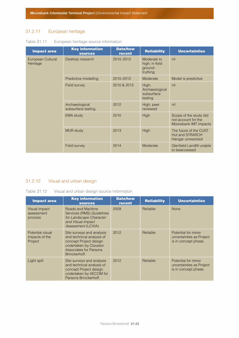
31.2.11 European heritage
Table 31.11 European heritage source information
Impact area Key information
sources Date/how
recent Reliability Uncertainties
European Cultural Heritage
Desktop research 2010–2012 Moderate to high; in field ground-truthing
nil
Predictive modelling 2010–2012 Moderate Model is predictive
Field survey 2010 & 2013 High; Archaeological subsurface testing
nil
Archaeological subsurface testing
2012 High; peer reviewed
nil
EMA study 2010 High Scope of the study did not account for the Moorebank IMT impacts
MUR study 2013 High The future of the CUST Hut and STRARCH Hangar unresolved
Field survey 2014 Moderate Glenfield Landfill unable to beaccessed
31.2.12 Visual and urban design
Table 31.12 Visual and urban design source information
Impact area Key information sources
Date/how recent
Reliability Uncertainties
Visual impact assessment process
Roads and Maritime Services (RMS) Guidelines for Landscape Character and Visual Impact Assessment (LCVIA)
2009 Reliable None
Potential visual impacts of the Project
Site surveys and analysis and technical analysis of concept Project design undertaken by Clouston Associates for Parsons Brinckerhoff.
2012 Reliable Potential for minor uncertainties as Project is in concept phase.
Light spill Site surveys and analysis and technical analysis of concept Project design undertaken by AECOM for Parsons Brinckerhoff.
2012 Reliable Potential for minor uncertainties as Project is in concept phase.

Parsons Brinckerhoff 31-24
31.2.13 Property and infrastructure
Table 31.13 Property and infrastructure source information
Impact area Key information
sources Date/how
recent Reliability Uncertainties
Land use zoning, existing land uses and ownership information
Government planning documents and spatial analysis/mapping
Current as of 2014
Reliable None.
Location of key infrastructure and services
Indicative design undertaken and technical analysis by Parsons Brinckerhoff
Current as of 2014
Reliable None.
31.2.14 Social and economic impacts
Table 31.14 Social and economic source information
Impact area Key information
sources Date/how
recent Reliability Uncertainties
Statistics Australian Bureau of Statistics
2011 Reliable None
Potential environmental, economic and health issues relevant to the assessment of social impacts
Technical reports completed by various specialists for EIS.
2012 Reliable Potential for inherent uncertainties in assessment due to the Project being at a concept stage.
Workforce/staff numbers
Moorebank IMT Staffing Requirement provided by Deloitte.
2011 Accurate None

Parsons Brinckerhoff 31-25
31.2.15 Human health risks and impacts
Table 31.15 Human health risks and impacts source information
Impact area Key information
sources Date/how
recent Reliability Uncertainties
Health impact assessment
Technical reports completed by various specialists for EIS.
2012 Reliable Potential for inherent uncertainties in assessment due to the Project being at a concept stage.
Assessment completed in accordance with best practice guidelines (e.g. by enHealth 2001, 2004 and Harris et al 2007).
2001, 2004 and 2007
Reliable None
Human health risk assessment
Local Air Quality Impact Assessment prepared by Parsons Brinckerhoff.
2012 Reliable Potential for inherent uncertainties in assessment due to the Project being at a concept stage.
Exposure–response relationships for health effects associated with exposures to particulates from peer-reviewed publications.
2002-2010 (current)
Moderate to High (key relationships adopted previously discussed with NSW Health to ensure most current and robust values used).
Uncertainties in relation to the relationships have been identified and addressed in the HHRA report.
31.2.16 Waste and resource management
Table 31.16 Social and economic source information
Impact area Key information
sources Date/how
recent Reliability Uncertainties
Waste management streams and estimates
Technical analysis undertaken by Parsons Brinckerhoff
2014 Reliable Project is still at concept phase with limitations in information availability and thus the level of detail possible for analysis.

Parsons Brinckerhoff 31-26
31.2.17 Cumulative impacts
Table 31.17 Cumulative impacts source information
Impact area Key information
sources Date/how
recent Reliability Uncertainties
Potential impacts of Moorebank IMT Project
Technical reports completed by various specialists for EIS.
2014 Reliable Potential for inherent uncertainties in assessment due to the Project being at a concept stage.
Potential impacts of SIMTA IMT project
SIMTA Draft Commonwealth Environmental Impact Statement (Hyder Consulting 2013).
SIMTA Environmental Assessment Part 3A Concept Application (Urbis 2013).
2013 Assumed to be reliable as will be the basis for regulatory approval
Similar to the Moorebank IMT, the assessment has been undertaken at the concept level with the potential for some uncertainties or limitations in information availability.