Embed Size (px)
Citation preview

June, 2000 1
A Target Vision and Implementation Plan A Target Vision and Implementation Plan for the CGDIfor the CGDI
Glenn Pope -- MacDonald Dettwiler & Associates LtdGlenn Pope -- MacDonald Dettwiler & Associates Ltd
Ron Lake -- Galdos Systems IncRon Lake -- Galdos Systems Inc
.
June, 2000 2
Part 1 -- Target VisionPart 1 -- Target Vision
““What will CGDI be like?”What will CGDI be like?”
.

June, 2000 3
Geographic Information OnlineGeographic Information Online
ConsumersConsumersApplicationsApplications
ProvidersProvidersGeospatial InformationGeospatial Information
CGDICGDI
CGDI will deliver Geographic Information over the InternetCGDI will deliver Geographic Information over the Internet
Online access will be more convenient and less expensive for ConsumersOnline access will be more convenient and less expensive for Consumers.
June, 2000 4
ServicesServicesServices
ProvidersProviders
DataDataData
ProvidersProviders
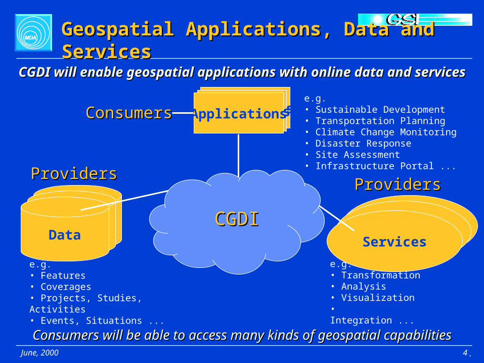
Geospatial Applications, Data and ServicesGeospatial Applications, Data and Services
e.g.• Sustainable Development• Transportation Planning• Climate Change Monitoring• Disaster Response• Site Assessment• Infrastructure Portal ...
e.g.• Features• Coverages• Projects, Studies, Activities• Events, Situations ...
e.g.• Transformation• Analysis• Visualization • Integration ...
ApplicationsApplicationsApplicationsConsumersConsumers
CGDICGDI
CGDI will enable geospatial applications with online data and servicesCGDI will enable geospatial applications with online data and services
Consumers will be able to access many kinds of geospatial capabilitiesConsumers will be able to access many kinds of geospatial capabilities.
June, 2000 5
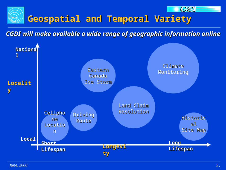
Geospatial and Temporal VarietyGeospatial and Temporal Variety
LocalLocal
NationalNational
LocalityLocality
Short LifespanShort Lifespan Long LifespanLong LifespanLongevityLongevity
CGDI will make available a wide range of geographic information onlineCGDI will make available a wide range of geographic information online
CellphoneCellphoneLocationLocation
EasternEasternCanadaCanada
Ice StormIce Storm
Land ClaimLand ClaimResolutionResolution
ClimateClimateMonitoringMonitoring
HistoricalHistoricalSite MapSite Map
DrivingDrivingRouteRoute
.

June, 2000 6
Distributed Applications, Data, ServicesDistributed Applications, Data, Services
CGDI will enable distributed applications, data and servicesCGDI will enable distributed applications, data and services
CGDICGDIApplications
Services
Data
.

June, 2000 7
Autonomous OrganizationsAutonomous Organizations
CGDICGDI
Federal Govt
Agencies
Municipal Govt
Agencies
Provincial Govt
Agencies
Private Companies
UtilitiesOthers
AutonomousAutonomousOrganizationsOrganizations
That are That are InterdependentInterdependent
CGDI will enable Organizations to remain autonomousCGDI will enable Organizations to remain autonomous
Academia
while working togetherwhile working together
.

June, 2000 8
CGDICGDI
Facilitate PartnershipsFacilitate Partnerships
ApplicationsConsumersConsumers Applications
DataDataData
ProvidersProviders
Services
MGDI
LIO
AltaLISOther
CanadianSDIs
LDBC
ProvidersProviders
CGDI will facilitate Partnerships to build a National InfrastructureCGDI will facilitate Partnerships to build a National Infrastructure
A greater range of data and services will be available to ConsumersA greater range of data and services will be available to Consumers.

June, 2000 9
Enable Global ParticipationEnable Global Participation
CGDI will join with other National SDIs to form a Global SDICGDI will join with other National SDIs to form a Global SDI
CGDICGDIU.S.NSDI
AustralianSDI
GlobalGlobalSDISDI
EuropeanGII
OtherSDI
Canadian data and service providers will have access to global marketsCanadian data and service providers will have access to global markets.

June, 2000 10
CGDICGDI
Catalogues for DiscoveryCatalogues for Discovery
ApplicationsConsumersConsumers Applications
U.S.NSDI
EuropeanGII
AustralianSDI
OtherSDI
International SDIsInternational SDIs
DataDataData
ProvidersProviders
Services
LIO
MGDI
AltaLIS OtherCanadian
SDIs
LDBC
CGDI needs Catalogues to enable DiscoveryCGDI needs Catalogues to enable Discovery
Organizations Other SDIs
Applications Databases Services
CataloguesCatalogues
• • •• • •
Catalogues will make geospatial information easier to findCatalogues will make geospatial information easier to find.

June, 2000 11
CGDICGDI
Gateways for InteroperabilityGateways for Interoperability
ApplicationsConsumersConsumers Applications
U.S.NSDI
EuropeanGII
AustralianSDI
OtherSDI
International SDIsInternational SDIs
DataDataData
ProvidersProviders
Services
LIO
MGDI
AltaLIS OtherCanadian
SDIs
LDBC
CGDI needs Gateways to other SDIs for interoperabilityCGDI needs Gateways to other SDIs for interoperability
Gateways will enable all information to be accessible to a single applicatonGateways will enable all information to be accessible to a single applicaton.

June, 2000 12
Enable Online AccessEnable Online Access
ConsumerConsumer Application
CGDICGDI
DataDataData
ProviderProvider
Service
ProviderProvider
OtherCanadian
SDI
CGDI will enable Direct AccessCGDI will enable Direct Access and Access via Discoveryand Access via Discovery
Application ConsumerConsumer
DataDataData
ProviderProvider
Service
ProviderProvider
.
June, 2000 13
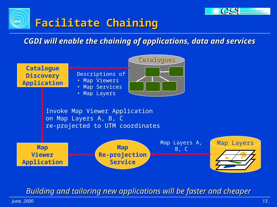
Facilitate ChainingFacilitate Chaining
CGDICGDICataloguesCatalogues
CatalogueDiscovery
Application
MapViewer
Application
Map LayersMap
Re-projectionService
Map Layers A, B, C
Invoke Map Viewer Applicationon Map Layers A, B, C re-projected to UTM coordinates
Descriptions of• Map Viewers• Map Services• Map Layers
Building and tailoring new applications will be faster and cheaperBuilding and tailoring new applications will be faster and cheaper
CGDI will enable the chaining of applications, data and servicesCGDI will enable the chaining of applications, data and services
.
June, 2000 14
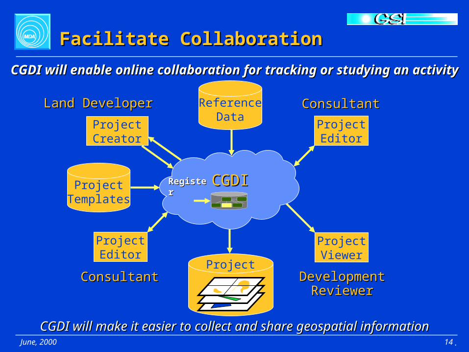
CGDICGDI
Facilitate CollaborationFacilitate Collaboration
Land DeveloperLand Developer
ProjectTemplates
ReferenceData
Project
ProjectCreator
ProjectViewer
DevelopmentDevelopmentReviewerReviewer
ConsultantConsultant
ProjectEditor
ConsultantConsultant
ProjectEditor
RegisterRegister
CGDI will make it easier to collect and share geospatial informationCGDI will make it easier to collect and share geospatial information
CGDI will enable online collaboration for tracking or studying an activityCGDI will enable online collaboration for tracking or studying an activity
.

June, 2000 15
Common Geospatial Framework DataCommon Geospatial Framework Data
AdministrativeBoundaries
GeodeticReference
TopographyHydrology
Road Networks
GeographicNames
CensusUnits
ElectoralUnits
PostalAddresses
Online Framework Data will make information discovery and integration easierOnline Framework Data will make information discovery and integration easier
CGDI will make Framework Data available to allCGDI will make Framework Data available to all
.

June, 2000 16
Common Geospatial SemanticsCommon Geospatial Semantics
Shared semantics will enable geospatial data to be more easily integratedShared semantics will enable geospatial data to be more easily integrated
CGDI will provide geospatial semantics for application communitiesCGDI will provide geospatial semantics for application communities
TransportationDefinitionsTransportation
Sector
Earth SciencesCommunity
BusinessCommunity
National DefenseCommunity
Health SciencesCommunity
LandManagementCommunity
MarineCommunity
CGDICGDIGeospatialGeospatialSemanticsSemantics
.

June, 2000 17
Enable Geospatial IntegrationEnable Geospatial Integration
Enabling seamless views of data across databasesEnabling seamless views of data across databases
CGDI will enable online integration of distributed geospatial informationCGDI will enable online integration of distributed geospatial information
TransportationDefinitions
MapViewer
Application
CalgaryCalgary
Database
VancouverVancouver
Database
WinnipegWinnipeg
Database
SherbrookeSherbrooke
DataIntegration
Service
St. John’sSt. John’s
.
June, 2000 18
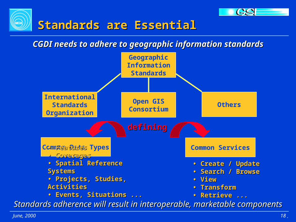
Standards are EssentialStandards are Essential
GeographicInformationStandards
InternationalStandards
Organization
Open GISConsortium
Others
definingdefining
Common Data Types Common Services
• • FeaturesFeatures• Coverages• Coverages• Spatial Reference Systems • Spatial Reference Systems • Projects, Studies, Activities• Projects, Studies, Activities• Events, Situations ...• Events, Situations ...
• • Create / UpdateCreate / Update• Search / Browse• Search / Browse• View• View• Transform • Transform • Retrieve ...• Retrieve ...
Standards adherence will result in interoperable, marketable componentsStandards adherence will result in interoperable, marketable components
CGDI needs to adhere to geographic information standardsCGDI needs to adhere to geographic information standards
.

June, 2000 19
Supportive EnvironmentSupportive Environment
SupportiveSupportiveEnvironmentEnvironment
CGDI
• • ExpertiseExpertise• Partnerships• Partnerships• Policy• Policy• Processes• Processes• Best Practises• Best Practises
• Standards • Applications• Services• Data
CGDI will need a supportive environment in order to succeedCGDI will need a supportive environment in order to succeed
.

June, 2000 20
CGDI VisionCGDI Vision
Enabling effective Enabling effective sharingsharing of Geographic Information over the Internet of Geographic Information over the Internet
CGDICGDI
ApplicationsConsumersConsumers Applications
DataDataData
ProvidersProviders
MGDIAltaLIS
Services
ProvidersProviders
OtherCanadian
SDI
.
GlobalSDI

June, 2000 21
Part 2 -- Reference ArchitecturePart 2 -- Reference Architecture
““What are the CGDI components?”What are the CGDI components?”
.

June, 2000 22
Reference ArchitectureReference Architecture
Our ApproachOur Approach
1. Establish key needs of Business Applications being enabled1. Establish key needs of Business Applications being enabled
5. Identify implementation priorities5. Identify implementation priorities
2. Identify their geospatial aspects2. Identify their geospatial aspects
3. Identify principles for structuring3. Identify principles for structuring
4. Place into an Internet context4. Place into an Internet context
CGDI Target VisionCGDI Target Vision
CGDI Business ObjectsCGDI Business Objects
CGDI ComponentsCGDI Components
Implementation ArchitectureImplementation Architecture
Implementation PlanImplementation Plan
.
June, 2000 23
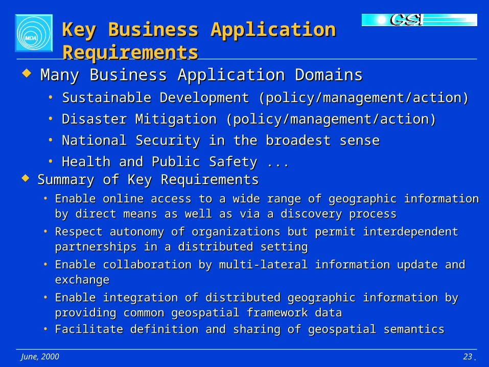
Key Business Application RequirementsKey Business Application Requirements
Many Business Application DomainsMany Business Application Domains• Sustainable Development (policy/management/action)Sustainable Development (policy/management/action)
• Disaster Mitigation (policy/management/action)Disaster Mitigation (policy/management/action)
• National Security in the broadest senseNational Security in the broadest sense
• Health and Public Safety ...Health and Public Safety ... Summary of Key RequirementsSummary of Key Requirements
• Enable online access to a wide range of geographic information by Enable online access to a wide range of geographic information by direct means as well as via a discovery processdirect means as well as via a discovery process
• Respect autonomy of organizations but permit interdependent Respect autonomy of organizations but permit interdependent partnerships in a distributed settingpartnerships in a distributed setting
• Enable collaboration by multi-lateral information update and exchangeEnable collaboration by multi-lateral information update and exchange
• Enable integration of distributed geographic information by providing Enable integration of distributed geographic information by providing common geospatial framework data common geospatial framework data
• Facilitate definition and sharing of geospatial semanticsFacilitate definition and sharing of geospatial semantics
.

June, 2000 24
What is a Spatial Data Infrastructure?What is a Spatial Data Infrastructure?
A wide variety of applications have common spatial needsA wide variety of applications have common spatial needs
Application ApplicationApplication
SDI components and services support spatial applications,SDI components and services support spatial applications,enabling more applications to be built -- faster and cheaperenabling more applications to be built -- faster and cheaper
An SDI provides common spatial components and servicesAn SDI provides common spatial components and services
ComponentComponent
SDISDI = Spatial IT Infrastructure= Spatial IT Infrastructure
Application ApplicationApplication
.

June, 2000 25
HealthClimateMonitoring
Disaster Management
CGDI Drivers and ContextCGDI Drivers and Context
Business Application DriversBusiness Application Drivers
Existing and evolving infrastructure on which to buildExisting and evolving infrastructure on which to build
Other Frameworkse.g. B2B
Other SDIse.g. U.S. NSDI
Internet and World Wide Web
Common Industry IT Services -- Security, Authentication, Compression
BusinessSustainableDevelopment
ClimateMonitoring Health
Disaster Management
BusinessSustainableDevelopment
CGDICGDIA Spatial IT Infrastructure
.
June, 2000 26
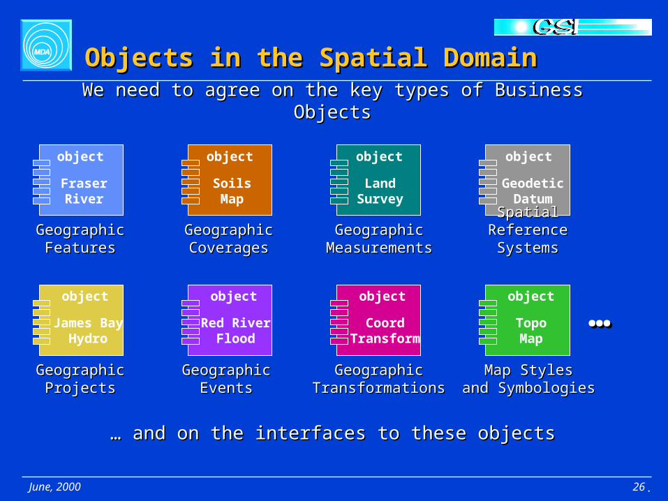
objectobjectobject
object object object object
object
Geographic Geographic MeasurementsMeasurements
GeographicGeographicCoveragesCoverages
GeographicGeographicFeaturesFeatures
Objects in the Spatial DomainObjects in the Spatial Domain
We need to agree on the key types of Business ObjectsWe need to agree on the key types of Business Objects
… … and on the interfaces to these objectsand on the interfaces to these objects
Fraser River
SoilsMap
Land Survey
Geodetic Datum
Red River Flood
James Bay Hydro
CoordTransform
TopoMap
……
Spatial ReferenceSpatial ReferenceSystemsSystems
GeographicGeographicEventsEvents
GeographicGeographicProjectsProjects
GeographicGeographicTransformationsTransformations
Map StylesMap Stylesand Symbologiesand Symbologies
.

June, 2000 27
CGDI ComponentsCGDI Components
Contains functions that act on Objects
Lists Services and Spatial Databases Describe Spatial Database and Service Models
Contains Spatial Objects
ApplicationType Type
DictionaryDictionaryobject
object
Spatial Object Spatial Object DatabaseDatabase
objectobject
CatalogueCatalogue objectobject
Service Service LibraryLibrary
objectobject
Business Objects are organized into collections which form ComponentsBusiness Objects are organized into collections which form Components
objectobject
= Business Objects
.

June, 2000 28
Multiple Component InstancesMultiple Component Instances
CatalogueCatalogue Type Type DictionaryDictionary
objectobject
objectobject
Service Service LibraryLibrary
objectobject Spatial Object Spatial Object
DatabaseDatabaseobject
object
CGDI will have many instances of these componentsCGDI will have many instances of these components
e.g. different Catalogues and Dictionaries for different information communities
e.g. • Coordinate Transformation Services • Routing Services • Overlay Services
e.g. • Geographic Features • Coverages • Reference Systems • Events • Projects
.
June, 2000 29
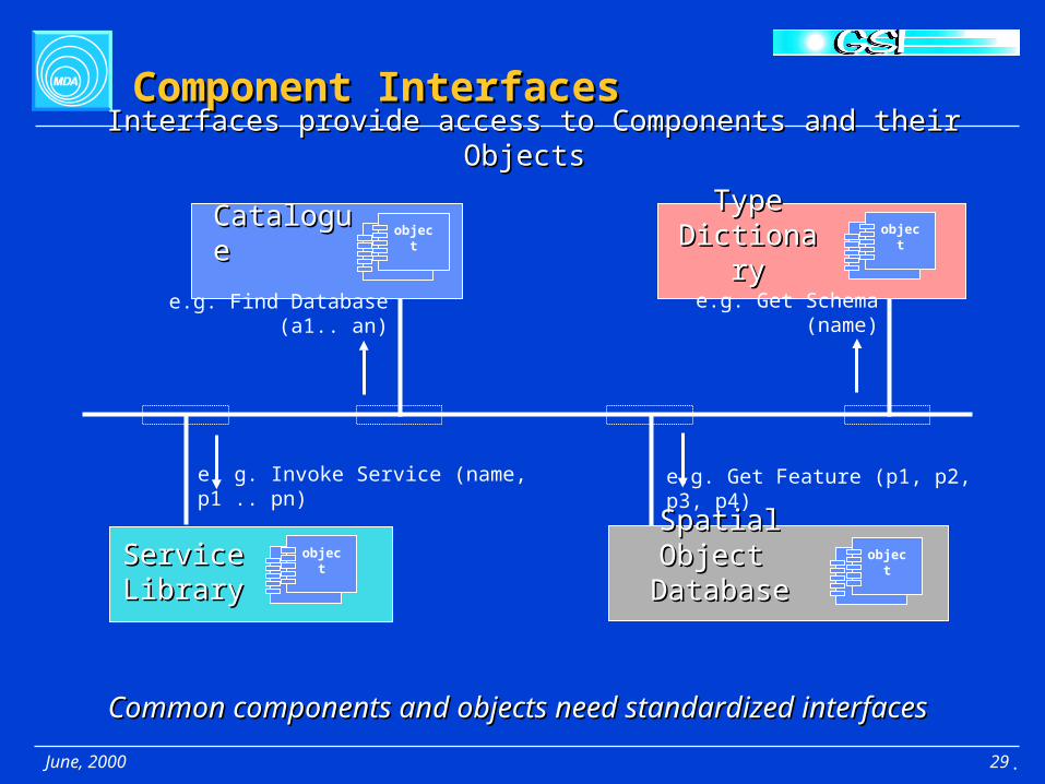
Component InterfacesComponent Interfaces
CatalogueCatalogue
Spatial Object Spatial Object DatabaseDatabase
Type Type DictionaryDictionary
Service Service LibraryLibrary
Common components and objects need standardized interfacesCommon components and objects need standardized interfaces
e.g. Get Feature (p1, p2, p3, p4)
e.g. Find Database (a1.. an) e.g. Get Schema (name)
e. g. Invoke Service (name, p1 .. pn)
objectobject
objectobject
objectobject
objectobject
Interfaces provide access to Components and their Objects Interfaces provide access to Components and their Objects
.

June, 2000 30
Provider’s View of DictionariesProvider’s View of Dictionaries
CGDI Application
Provider maps their private interfaces and schema to the CGDI public Provider maps their private interfaces and schema to the CGDI public interfaces and schema using the CGDI Dictionariesinterfaces and schema using the CGDI Dictionaries
Private Application
CGDI Applications see CGDI Public Interfaces
Local or Private Applications see Private Interface
CGDI Type CGDI Type DictionaryDictionary
Provider Provider Service Service LibraryLibrary
Provider Provider Spatial Object Spatial Object
DatabaseDatabase
objectobject
objectobject
objectobject
Build object interfaces from dictionary definitions
.

June, 2000 31
Provider’s View of CataloguesProvider’s View of Catalogues
Provider Provider Spatial Object Spatial Object
DatabaseDatabase
Provider Provider Service Service LibraryLibrary
CGDI Application
Provider registers their Databases and Service Libraries with CGDI CataloguesProvider registers their Databases and Service Libraries with CGDI Catalogues
Private Application
CGDI Applications see CGDI Public Interfaces
Local or Private Applications see Private Interface
CGDI CGDI CatalogueCatalogue
register
objectobjectobject
object
objectobject
.

June, 2000 32
Consumer’s View of CataloguesConsumer’s View of Catalogues
Provider Spatial Provider Spatial Object Object
DatabaseDatabase
Provider Provider Service Service LibraryLibrary
CGDI Application
Consumers may search Catalogues to locate DatabasesConsumers may search Catalogues to locate Databases and Service Libraries of interest and Service Libraries of interest
CGDI Applications see CGDI Public Interfaces
CGDI CGDI CatalogueCatalogue
search
ConsumerConsumer
objectobject
objectobject
objectobject
.
June, 2000 33
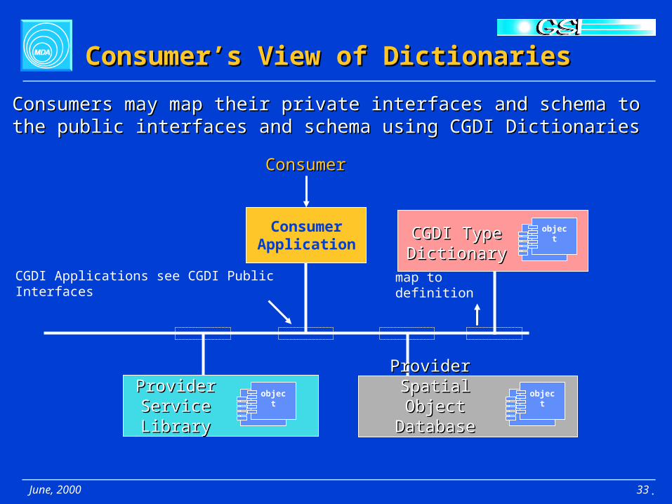
Consumer Application
Consumers may map their private interfaces and schema to the public Consumers may map their private interfaces and schema to the public interfaces and schema using CGDI Dictionariesinterfaces and schema using CGDI Dictionaries
CGDI Applications see CGDI Public Interfaces
CGDI Type CGDI Type DictionaryDictionary
Provider Provider Service Service LibraryLibrary
Provider Provider Spatial Object Spatial Object
DatabaseDatabase
map to definition
Consumer’s View of DictionariesConsumer’s View of Dictionaries
objectobject
objectobject
objectobject
ConsumerConsumer
.
June, 2000 34
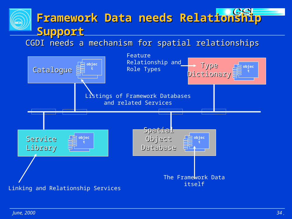
Framework Data needs Relationship SupportFramework Data needs Relationship Support
Spatial Object Spatial Object DatabaseDatabase
Type Type DictionaryDictionary
Service Service LibraryLibrary
objectobject
Feature Relationship and Role Types object
object
objectobject
Linking and Relationship ServicesThe Framework Data itself
CGDI needs a mechanism for spatial relationshipsCGDI needs a mechanism for spatial relationships
Listings of Framework Databasesand related Services
CatalogueCatalogue objectobject
.

June, 2000 35
Implementation ArchitectureImplementation Architecture
Client Application
Application Server
objectobj
objectobjobj
ectobj
‘CGDI Object’ Database
Web Server
CGDI needs to build a distributed network of multi-tiered “portals” CGDI needs to build a distributed network of multi-tiered “portals” offering Interfaces to CGDI Components and Business Objectsoffering Interfaces to CGDI Components and Business Objects
Web Protocol InterfaceOther Standard InternetProtocol Interfaces
Business Objects interact with one another to execute the Business Logic of the Component within the Application Server
Database is typically a lower internal tier that handles the storage of a Component’s Business Objects
Applications are easier to build by leveraginga common pool of Components and Objects
.

June, 2000 36
Integration Across InfrastructuresIntegration Across Infrastructures
Client Application
Application Server
object obj
object obj
object obj
‘CGDI Object’ Database
Web Server
CGDI Componentsand Objects
Application Server
object
obj
objectob
j
objectob
j
‘Business Object’ Database
Web Server
Business Infrastructure
CGDI Components can use components from other Infrastructures CGDI Components can use components from other Infrastructures and CGDI Components can be used by other Infrastructures and CGDI Components can be used by other Infrastructures
CGDI Infrastructure
Client Application
.

June, 2000 37
CGDI Reference ArchitectureCGDI Reference Architecture
Contains functions that act on Objects
Lists Services and Spatial Databases
Contains Spatial Objects
ApplicationType Type
DictionaryDictionary
Spatial Object Spatial Object DatabaseDatabase
CatalogueCatalogue
Service Service LibraryLibrary
Standardized Standardized InterfacesInterfaces
Describe Spatial Database and Service Models
object
CoordTransform
object
CoordTransform
object
Red River Flood
object
Red River Flood
object
FeatureType
object
FeatureType
object
DatabaseListing
object
DatabaseListing
ObjectsObjectsComponentsComponents
.

June, 2000 38
Part 3 -- Implementation PlanPart 3 -- Implementation Plan
““How do we build CGDI?”How do we build CGDI?”
.

June, 2000 39
BuildBuild
Implementation Strategy Implementation Strategy
Reference Architecture, Standards, Open Specifications, Reference Architecture, Standards, Open Specifications,
ApplicationsApplications ComponentsComponents
DataData
10 years -- ubiquitous CGDI10 years -- ubiquitous CGDI
5 years -- self-sustaining CGDI5 years -- self-sustaining CGDI
2 years -- core CGDI2 years -- core CGDI
Today -- nucleus for CGDIToday -- nucleus for CGDI
AnalyzeAnalyze
1. Establish a CGDI nucleus 1. Establish a CGDI nucleus 2. Incrementally build up by pursuing opportunities along several fronts2. Incrementally build up by pursuing opportunities along several fronts 3. Follow a spiral development approach 3. Follow a spiral development approach
IntegrateIntegrate
DesignDesign
PreparePrepare
.
June, 2000 40
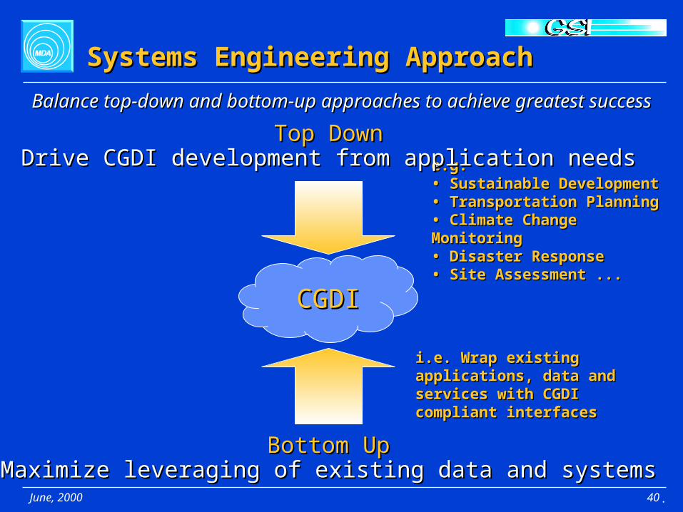
Systems Engineering ApproachSystems Engineering Approach
Balance top-down and bottom-up approaches to achieve greatest successBalance top-down and bottom-up approaches to achieve greatest success
e.g.e.g.• Sustainable Development• Sustainable Development• Transportation Planning• Transportation Planning• Climate Change Monitoring• Climate Change Monitoring• Disaster Response• Disaster Response• Site Assessment ...• Site Assessment ...
Top DownTop DownDrive CGDI development from application needsDrive CGDI development from application needs
CGDICGDI
Bottom UpBottom UpMaximize leveraging of existing data and systemsMaximize leveraging of existing data and systems
i.e. Wrap existing applications, i.e. Wrap existing applications, data and services with CGDI data and services with CGDI compliant interfacescompliant interfaces
.
June, 2000 41
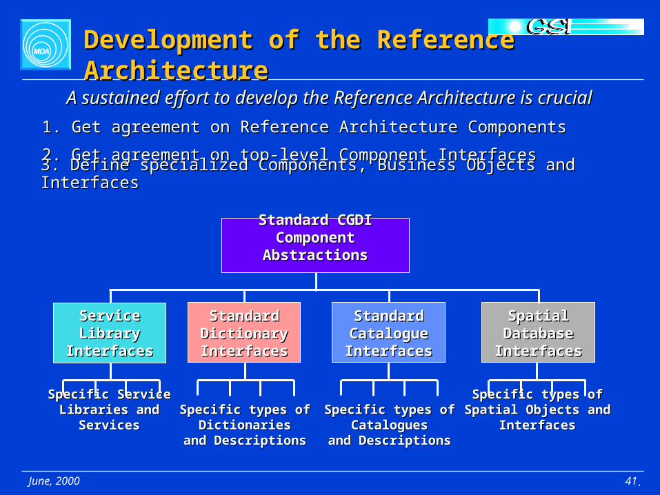
Development of the Reference ArchitectureDevelopment of the Reference Architecture
A sustained effort to develop the Reference Architecture is crucialA sustained effort to develop the Reference Architecture is crucial
1. Get agreement on Reference Architecture Components1. Get agreement on Reference Architecture Components
2. Get agreement on top-level Component Interfaces2. Get agreement on top-level Component Interfaces
3. Define specialized Components, Business Objects and Interfaces3. Define specialized Components, Business Objects and Interfaces
Standard CGDI Standard CGDI Component AbstractionsComponent Abstractions
Service Service Library Library
InterfacesInterfaces
Standard Standard Dictionary Dictionary InterfacesInterfaces
Standard Standard Catalogue Catalogue InterfacesInterfaces
Spatial Spatial Database Database InterfacesInterfaces
Specific ServiceSpecific ServiceLibraries and ServicesLibraries and Services
Specific types of Specific types of DictionariesDictionaries
and Descriptionsand Descriptions
Specific types of Specific types of CataloguesCatalogues
and Descriptionsand Descriptions
Specific types of Spatial Specific types of Spatial Objects and InterfacesObjects and Interfaces
.

June, 2000 42
Establish the CGDI NucleusEstablish the CGDI Nucleus
ImplementedImplementedOpenOpen
SpecificationsSpecifications
Reference Reference ArchitectureArchitecture
ComponentsComponents
e.g.• FGDC Content Standard for Digital Geospatial Metadata• FGDC GEO/Z39.50 Search Protocol• OGC Web Mapping Specification Interfaces ...
e.g.• CSDGM Compliant Catalogues• FGDC GEO/Z39.50 Enabled Spatial Databases• OGC WMSI Services ...
• Catalogues• Spatial Databases• Service Libraries• Dictionaries
Use the Reference Architecture as a guideUse the Reference Architecture as a guide
Select appropriate standardsSelect appropriate standards
Identify participating componentsIdentify participating components
.

June, 2000 43
Two Year Plan -- Part 1Two Year Plan -- Part 1
1. Vision / Reference Architecture1. Vision / Reference ArchitectureObjective: get agreement on vision development process and visionObjective: get agreement on vision development process and vision• Publish initial version online Publish initial version online • Continue process of refinement and publicationContinue process of refinement and publication
2. Applications2. ApplicationsObjective: create some “killer applications”Objective: create some “killer applications”• Model a few key application domains with domain experts from Model a few key application domains with domain experts from
relevant application panelsrelevant application panels• Identify common geospatial needs across models and map to Identify common geospatial needs across models and map to
Components, Objects and Interfaces in the CGDI Reference Components, Objects and Interfaces in the CGDI Reference ArchitectureArchitecture
• Begin building identified operational infrastructure that will support Begin building identified operational infrastructure that will support the building of applicationsthe building of applications
.
June, 2000 44
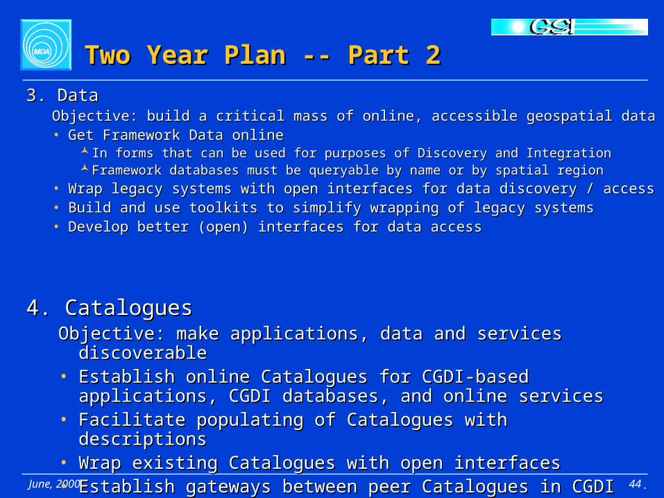
Two Year Plan -- Part 2Two Year Plan -- Part 2
3. Data3. DataObjective: build a critical mass of online, accessible geospatial dataObjective: build a critical mass of online, accessible geospatial data• Get Framework Data onlineGet Framework Data online
In forms that can be used for purposes of Discovery and IntegrationIn forms that can be used for purposes of Discovery and IntegrationFramework databases must be queryable by name or by spatial regionFramework databases must be queryable by name or by spatial region
• Wrap legacy systems with open interfaces for data discovery / accessWrap legacy systems with open interfaces for data discovery / access• Build and use toolkits to simplify wrapping of legacy systemsBuild and use toolkits to simplify wrapping of legacy systems• Develop better (open) interfaces for data accessDevelop better (open) interfaces for data access
4. Catalogues4. CataloguesObjective: make applications, data and services discoverableObjective: make applications, data and services discoverable• Establish online Catalogues for CGDI-based applications, CGDI Establish online Catalogues for CGDI-based applications, CGDI
databases, and online servicesdatabases, and online services• Facilitate populating of Catalogues with descriptionsFacilitate populating of Catalogues with descriptions• Wrap existing Catalogues with open interfacesWrap existing Catalogues with open interfaces• Establish gateways between peer Catalogues in CGDI Establish gateways between peer Catalogues in CGDI
.

June, 2000 45
Two Year Plan -- Part 3Two Year Plan -- Part 3
7. Standards7. StandardsObjective: to get standards in place for core CGDI components Objective: to get standards in place for core CGDI components • Publish online guide of CGDI endorsed geospatial standardsPublish online guide of CGDI endorsed geospatial standards• Work out new CGDI component and interface specifications in Work out new CGDI component and interface specifications in
concert with Standards bodiesconcert with Standards bodies
.
6. Relationships6. RelationshipsObjective: to enable referencing to Framework DataObjective: to enable referencing to Framework Data• Develop Relationship Services Develop Relationship Services • Develop Feature Relationship DictionaryDevelop Feature Relationship Dictionary
5. Services5. ServicesObjective: to provide services that enrich online access Objective: to provide services that enrich online access • Develop Visualization ServicesDevelop Visualization Services• Develop Data Integration ServicesDevelop Data Integration Services

June, 2000 46
Longer Term View -- 5 years and outLonger Term View -- 5 years and out
Reference ArchitectureReference Architecture• Continued refinement will result in standard interfaces being Continued refinement will result in standard interfaces being
published for all major spatial objects and CGDI components.published for all major spatial objects and CGDI components. ApplicationsApplications
• Development using CGDI will be common placeDevelopment using CGDI will be common place Components, Business Objects and InterfacesComponents, Business Objects and Interfaces
• More kinds of components and business objects will emergeMore kinds of components and business objects will emerge• More sophisticated kinds of interfaces will be availableMore sophisticated kinds of interfaces will be available
Specific development objectivesSpecific development objectives• More sophisticated integration capabilitiesMore sophisticated integration capabilities• Collaborative capabilitiesCollaborative capabilities• Online dictionaries describing component and interface semanticsOnline dictionaries describing component and interface semantics• Tools for rapidly building CGDI applicationsTools for rapidly building CGDI applications• Seamless integration with regional SDIsSeamless integration with regional SDIs• Seamless integration with international SDIsSeamless integration with international SDIs
.

June, 2000 47
Evolve the vision Evolve the vision
Development of the CGDI VisionDevelopment of the CGDI Vision
Stakeholder involvement in developing the vision is essential for CGDIStakeholder involvement in developing the vision is essential for CGDI
GeoConnectionsGeoConnectionsPanelsPanels
CGDICGDICommunityCommunity
CGDICGDIVision CustodianVision Custodian
Designate a “keeper”Designate a “keeper”of the vision of the vision
maintainsmaintains
Involve theInvolve thepanels panels presentation,presentation,
working sessions,working sessions,forumsforums
refinerefine
publish, publish, conferences,conferences,workshops,workshops,forumsforums
CGDICGDIVisionVision
refinerefine
Inform CGDIInform CGDIcommunity community
InternationalInternationalGeospatialGeospatialCommunityCommunity
Stay abreast ofStay abreast ofInternational sceneInternational scene
InfluenceInfluence
.
June, 2000 48
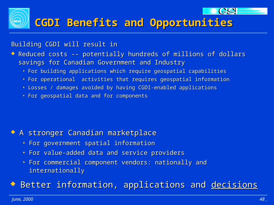
CGDI Benefits and OpportunitiesCGDI Benefits and Opportunities
Building CGDI will result inBuilding CGDI will result in
Reduced costs -- potentially hundreds of millions of dollars savings for Canadian Reduced costs -- potentially hundreds of millions of dollars savings for Canadian Government and IndustryGovernment and Industry
• For building applications which require geospatial capabilitiesFor building applications which require geospatial capabilities
• For operational activities that requires geospatial informationFor operational activities that requires geospatial information
• Losses / damages avoided by having CGDI-enabled applicationsLosses / damages avoided by having CGDI-enabled applications
• For geospatial data and for componentsFor geospatial data and for components
A stronger Canadian marketplaceA stronger Canadian marketplace• For government spatial informationFor government spatial information
• For value-added data and service providersFor value-added data and service providers
• For commercial component vendors: nationally and internationallyFor commercial component vendors: nationally and internationally
Better information, applications and Better information, applications and decisionsdecisions
.

June, 2000 49
The Canadian Geospatial Data InfrastructureThe Canadian Geospatial Data Infrastructure
SupportiveSupportiveEnvironmentEnvironment
CGDI
• • ExpertiseExpertise• Partnerships• Partnerships• Policy• Policy• Processes• Processes• Best Practises• Best Practises
• Standards • Applications• Services• Data
.
Enabling effective sharing of Geographic Information over the InternetEnabling effective sharing of Geographic Information over the Internet
ApplicationType Type
DictionaryDictionary
Spatial Object Spatial Object DatabaseDatabase
CatalogueCatalogue
Service Service LibraryLibrary
objectCoord
Transform
object
CoordTransform
objectRed River Flood
object
Red River Flood
objectFeatu
reType
object
FeatureType
objectDatabase
Listing
objectDatabase
Listing